australasian hydrographer february 2009
DESCRIPTION
Journal of the Australian Hydrographers AssociationTRANSCRIPT

Australasian Hydrographer
Mike Harris and Leith Bowyer of the Department of Water, Western Australia, undertaking surveying of stream cross sections in the Kimberley region of Western Australia, for use in HEC-RAS models for top
end rating development.
Thanks to Frank Davies, DoW, for supplying the photo and article inside.
February, 2009 The Australasian Hydrographer is the Journal of the Australian Hydrographers’ Association Incorporated. ISSN 0812-5090

Visit your site: www.aha.net.au Australasian Hydrographer, Dec 08 – Feb 09
1
This Issue Editorial 1 National Hydrographer Education and Training Program, Paul Langshaw 2 Draft National Hydrography Certification Scheme, Paul Langshaw 10 Information Quality, More than a HYDSTRA Quality Code, Grant Robinson 13 Flow Rating Analysis Using HEC-RAS, Leith Bower. 25 DWE Acoustic Doppler Training, Mic Clayton 28 Australian Hydrographers’ Association Educational Grant 29 Keeping an Extreme Low Profile in New Zealand! 30 Membership Renewals 33 AHA Office Bearers 33
Hydrographers in many parts of the country often work in small isolated work units, possibly even as one person hydrographic units, in small regional offices of water authorities, mining offices, environmental monitoring utiities and so on. Even bigger hydrographic groups can potentially lose contact with what is going on ‘out there’, whatever the reason might be. Sometimes these bigger organisations may know about ‘out there’ but fail to even communicate effectively to their people about what is going on in the hydrographic world! In recent months I have been been lucky to have been involved in wider hydrographic forums than that to which I am subjected to in my everyday work. In recent times I have been involved in the convening of the technical paper side of the last AHA conference, involved in the Hydrographic Advisory Committee (developing new course/training structure for hydrographers), attended a training course where other authority staff were also in attendance and took a short break to visit the Kiwis at their own national conference (what could those guys teach me anyway!) During the course of these events and activities I found that interactions with others about things hydrographic stimulating and refreshing. While the formal sessions can impart new knowledge and ideas, it is often the more animated informal gatherings afterwards where a lot of ideas or thoughts get thrown around. Many things might get discarded into one’s mental dustbin, but some may make it into the ‘that sounds like an interesting idea’ drawer. Through these gatherings you might also meet someone who is having the same hydrographic issues as you and may have an idea on how to address it that you hadn’t thought of. Sometimes you might not have even noticed you had an issue until you saw someone doing something about an issue that looked remarkably like your situation – and now you realise that you might just have an issue! Then there is the flip side where someone from another entity want to learn more about your hydrographic issues and how you addressed them, so
out of the blue makes contact to arrange a fact finding visit of your hydrographic workplace. Keeping in touch with other hydrographers is an important avenue by which we, as hydrographic professionals can keep abreast of recent advances or new ideas in our world. Getting along to a workshop or a conference is an easy first step to experiencing more about the profession you have chosen to work in. Or, if you’ve done that already, how about getting involved in a working group or setting up a training session on something and invite your neighbouring hydrographic authority or company along. It doesn’t have to have all the bells and whistles, it could be as simple as a day down the river getting wet. The information exchanges work both ways. As a certain sports wear company says “Just Do It!” you might be pleasantly surprised. Mic Clayton. Publicity Offer AHA ____________________________________ The Australasian Hydrographer is the Journal of the Australian Hydrographers’ Association Incorporated. The Journal is distributed quarterly to Members. ISSN 0812-5090 ____________________________________________ Visit our Web Site at: http://www.aha.net.au to download a Membership application and to find contact details for your state representative. ____________________________________________ Editorial and advertising enquiries should be directed to the Association’s Publicity Officer, Mic Clayton.
Journal editions are generally produced February, May, August and November. Copy is requested to be with the Publicity Officer by the previous month.
e - mail [email protected] , or PO Box 843, COOMA, NSW, 2630. ____________________________________________ The views expressed in this publication are those of its contributors and do not necessarily represent those of the Australian Hydrographers Association Inc or its office bearers. ____________________________________________

Visit your site: www.aha.net.au Australasian Hydrographer, Dec 08 – Feb 09
2
National Hydrographer Education & Training Program INTRODUCTION Hi fellow AHA members, My name is Paul Langshaw and for the last year I have been working with the BoM, GSA and AHA to develop a National Hydrography Education and Training Program (NHETP). The following is for information to AHA members and all others working in the Hydrographic and associated industries. In August 2007 the Bureau of Meteorology convened a workshop to address standards in the hydrometric discipline. During this workshop emphasis emerged, among other elements, on the standard of education and training of Hydrographers. As a direct outcome of that workshop, the BoM engaged me as a consultant to represent the AHA to explore and report on the current standard of hydrographer education and training on a national basis and provide options to implement improvements. The purpose of this article is to deliver a summary of the process that was adopted to address issues relevant to developing the National Hydrographer Education & Training Program (NHETP) and expressed industry opinion(s). As well as to provide information to current members and potential members of the AHA about the functions, timing and resources required to implement and sustain a NHETP. BACKGROUND A Certificate IV course is currently available for enrolment to students of hydrography through NSW TAFE (OTEN). This course has not been subject to review or update since its inception over 5years ago. The accreditation of the Certificate IV, coursework based qualification was due to expire at the end of 2007. There is now a requirement for training across many professions to conform with the Australian Qualifications Framework (AQF) where qualifications are expected to be delivered in a competency based format. Strong representations by the AHA in seeking extension of accreditation of the existing Certificate IV, resulted in NSW TAFE gaining extensions of the current course accreditation to permit enrolments in the current course until the end of December 2009, while a new competency based qualification is developed in line with the AQF framework. (Students
enrolled in the current course at the end of 2009 have three years available to complete the course work qualification after which the competency based qualification becomes the only approved qualification) Over the past year, the Hydrography Advisory Committee, consisting of representatives from leading State Water Agencies, Private Sector organisations, NSW TAFE, AHA and GSA has been working to upgrade this course with the aim of ensuring its relativity and its alignment to the accreditation requirements of the National Water Industry Training Package. This project must be completed prior to the accreditation expiry date of December 2009. It should be noted that the content of this document is not necessarily the opinions of the Australian Hydrographers Association, Bureau of Meteorology or myself, rather the intent is to relay and report the opinions expressed by representatives of the Australian Hydrographic Industry.
Acronyms – Definitions AHA: Australian Hydrographers
Association AQF Australian Qualifications
Framework BoM: Commonwealth Bureau of
Meteorology CIT Canberra Institute of Technology DNRW: Dept of Natural Resources &
Water (QLD) DoC Dept of Commerce (NSW) DWLBC: Dept of Water, Land &
Biodiversity Conservation (SA) DPIW: Dept of Primary Industry & Water (TAS) DSE Dept of Sustainability &
Environment
DW&E: NSW Dept of Water & Energy GSA: Government Skills Australia HAC Hydrographic Advisory
Committee

Visit your site: www.aha.net.au Australasian Hydrographer, Dec 08 – Feb 09
3
HS: Hydrological Services P/L (NSW) Hydro Tas: Hydro Tasmania IAL: Irrigation Australia Limited ICE WaRM International Centre of
Excellence in Water Resources
NHETP: National Hydrographer
Education and Training Program
NRETA: Natural Resources,
Environment and the Arts (NT) NSW TAFE: NSW Technical and Further
Education NWITP National Water Industry
Training Package OTEN: The distance learning division
of NSW TAFE RPL Recognition of Prior Learning RTO Registered Training
Organisation SWC: Sydney Water Corporation
(NSW) USGS United States Geological
Survey
WADoW: WA Dept of Water (WA) WAWC: WA Water Corporation (WA)
THE PROCESS Detailed results of surveys and other statistical information are contained in reports submitted to BoM as part of this consultancy and are considered too bulky to detail in this article.
1. Surveys and discussions A program of discussions and surveys was undertaken in the early stages of this consultancy. National, State and Private Sector water agencies along with learning institutions and other water industry bodies provided input to this program. Most of these organisations are referred to in the “Acronyms & Definitions” section of this article. The surveys addressed the following issues within leading state water agencies and some
private sector agencies to gather information to carry out a gap analysis: • Number of Hydrographers employed. • Number of employees with qualifications
specific to hydrography. • Number of employees with “other”
qualifications and type of qualification. • Number of employees with no formal
qualifications. • Age bracket of employees. • Current training programs (if any) and
delivery i.e. internal or external. • Requirements of a NHETP. • Type of relevant training material
available. • Opinion of certificate IV content and
delivery. • Opinion on need for a NHETP. • Input to the structure and content of a
NHETP. • Opinion on the need for a national
regulatory body such as AHA to administer a NHETP.
2. Findings from gap analysis In summary the following items were highlighted as a result of the gap analysis: • Low numbers of staff qualified in
hydrography • A recognised acute skills shortage • Low enrolment rates in current cert IV
course offered by NSW TAFE. • Completion of this course is far too long. • Current course structure is inappropriate.
This is being addressed • Lack of career path courses i.e. need for
another level, say diploma • Lack of intense, face to face, hands on
courses. • Lack of re training and ongoing training of
new technology • A current lack of recognition of national
training standards. • No national coordination of training. • Lack of a licensing/certification system to
identify and acknowledge qualifications. • No national regulatory body to over-see,
set and maintain standards of training. • Whilst there is much developed learning
material, there is lack of a coordinated standard process of training delivery.
• Lack of funding for professional development training.
3. National Industry Workshop It was considered that a National Industry Workshop was the most efficient and accurate method to obtain detailed requirements, as seen by industry, of a NHETP. The workshop convened on the 21st July and concluded on the 22nd July 2008.

Visit your site: www.aha.net.au Australasian Hydrographer, Dec 08 – Feb 09
4
The following is a list of participants represented leading state water agencies,
both private and public sector as well as major stakeholders.
Alistair Brooks DPIW (Tas) Bruce Stewart BoM Mark Johnson Hydro Tas Mark Wolf Greenspan Greg May WADoW (WA) Graham Parsons DWE (NSW) Paul Langshaw Consultant to BoM (AHA) Kevin Dennis DWLBC (SA) John Skinner Water for Rivers Michael Briggs THIESS Bill Steen Kisters (AHA) Ian White DNRW Qld) Sarah Hesse DoC (NSW) Andrew Kaar Ecowise Sabine Shrieber DSE (Vic) Allan Russ NRETA (NT) Allan Dean WAWC (WA) Mark Rheinberger Technical writer (GSA) Ross James BoM Alan Baker BoM
BoM provided the following points as desired outcomes from this workshop: • Identify what skills and competencies are
needed on a national basis • Identify what training needs to be set in
place – theory and practical • Identify new skills that will be required to
meet emerging needs • Look at what training is available currently • Identify gaps in available training and
design ways to fill these gaps • Build support for this procedure through
Government, community, industry, education sector, etc. to create a sustainable training and accreditation system
Workshop Recommendations: It should be noted that the “workshop recommendations” are the opinions of the participants of this workshop and are not necessarily those of BoM or this consultant. • Industry and stakeholder need to produce
more suitably trained and qualified Hydrographers to meet future needs.
• Industry and stakeholder need for formal
qualifications. • The minimum content of a NHETP be a
mix of theory and face to face hands on practical training including RPL.
• That in the best interests of the BoM in
their role as national manager of water information to ensure that data is delivered by qualified and competent people.
• That the BoM has acknowledged a need and has demonstrated its willingness to provide support for the industry.
• General satisfaction with the content of the
proposed Cert IV course. • That Cert IV to be accepted as the
minimum qualifications with an aim to develop Diploma and Advanced Diploma in hydrography
• That some agencies require different
levels of qualification. Degree, Diploma, Cert IV, Trade (mature) + 2 or 3 core competency subjects.
• The need for Cert IV and a higher
qualification to provide a defined career path.
• The need to undertake hands on training –
up to 6 weeks per year – in 2 week blocks. • That appropriate training material has
been developed and identified to provide face to face/hands on courses to supplement TAFE and university underpinning theory qualifications.
• Cert of Attainment:
Acknowledgement that 3 core competencies, together with a relevant higher qualification (e.g. Science, Eng Degree) and/or relevant experience (E.g. Hydro 1 & 2, Hydraulics) will provide a hydrographic qualification for certification purposes.
• Need for Certification/Licensing of Hydrographic Practitioners.
• A peak industry body to grant certification
to hydrographers that can demonstrate necessary qualifications and competencies.

Visit your site: www.aha.net.au Australasian Hydrographer, Dec 08 – Feb 09
5
Diagram of Proposed Elements of the NHETP
SYSTEM OF CERTIFICATION
Providing recognition of commitment to high standards
Skill Sets Cert. of
Attainment From Cert IV
(Hydrography) i.e.TAFE
RPL Assessment for Certification
- Qualifications i.e. Degrees, Trade Certificates etc. - On the job experience -
Program of Face to Face Courses
Nationally Coordinated &
Accredited (Professional Development)
CERT IV &
DIPLOMA (Hydrography)
NSW TAFE (OTEN)

Visit your site: www.aha.net.au Australasian Hydrographer, Dec 08 – Feb 09
6
Current Status & Planned Development of Cert IV/Diploma/ Advanced Diploma/Graduate Diploma
Vocational Qualification for Hydrographers (and Hydrologists?) Possible Model to link hydrography and hydrology training programs.
Skills Set in Hydrography - (Being Accredited) AQF Reg.
No. Unit of Competency (name) Study
Req’ment Comment
1 RTD3507A
Undertake sampling & testing of water
Core Existing UOC imported from the RTD02
2 NWP52XA Collect, measure & process
hydrologic stream discharge gauging
Core Writer's brief & Assessment Guide finalised by HAC plus writers draft of Learners Guide developed Jan09
3 NWP52ZA Install, operate & maintain
hydrologic instruments and equipment
Core Writer's brief & Assessment Guide finalised by HAC Jan 09
Diploma in Water Operations - (Being Accredited) AQF Reg. No. Unit of Competency (name) Study
Req’ment Comment
1 NWP505B PSPSOHS501A
Implement & manage environmental management policies, plans, procedures & programs OR Participate in the coordination & maintenance of a systematic approach to managing OHS
Core Compulsory for Water Operations qualification
2 NWP52WA Collect, verify & report hydrologic time
series data Core Writer's brief & Assessment
Guide finalised by HAC Jan 09 3 NWP52YA Develop & maintain rating curves Core Writer's brief & Assessment
Guide finalised by HAC Jan 09 4 NWP410C Coordinate & monitor asset construction
& maintenance Core Writer's brief & Assessment
Guide finalised by HAC Jan 09 5 NWP442A Apply principles of hydraulics to pipe &
channel flow Core Writer's brief & Assessment
Guide finalised by HAC Jan 09 6 NWP5VA Collect & manage hydrologic station
survey data Core Writer's brief & Assessment
Guide finalised by HAC Jan 09 Note:
• Students enrolled in current Cert IV in hydrography may opt into the “new” CertI V and diploma courses with no disadvantage.
• NSW TAFE OTEN will carry out a mapping exercise to recognise the prior learning in current
Cert IV course
• It is envisaged that the above course(s) will begin to come online from May 09

Visit your site: www.aha.net.au Australasian Hydrographer, Dec 08 – Feb 09
7
The following courses will begin to be developed during 2009 Advanced Diploma in Water Operations (Hydrography) - (Being Considered)
AQF Reg. No.
Content Status Study Req’ment
Comment
1 New Develop Theoretical Flow Rating Curves for Open Channels
Core Content scope yet to be decided
2 New Investigate, Design and Manage
Gauging Station Construction Core Content scope yet to be decided
3 New Groundwater hydrology Core Content scope yet to be decided 4 New Develop a Water Monitoring Strategy Elective Content scope yet to be decided ++
New Management units (TBA) Electives Content scope yet to be decided
Graduate Diploma in Physical Hydrology - (Being Investigated by the HAC & BoM) AQF
Reg.No. Content Status Study
Req’ment Comment
1 New Fundamentals of Surface Water
Hydrology (BoM) Core Likely exemption for hydrographers
2 New Fundamentals of Groundwater
Hydrology (BoM) Core Likely exemption for hydrographers
3 New Hydrologic Measurements (BoM) Core Likely exemption for hydrographers
4 New Assessing Australia's Water Resources
(BoM) Core
5 New Water Resource Management Issues
(BoM) Core
6 New Hydrologic Statistics & Manipulating
Hydrologic Data (BoM) Core
7 New Flood Hydrology (BoM) Core 8 New Hydrologic Modelling and Analysis
(BoM) Core
Note:
• The above model is designed to provide a standard of training and qualifications to the hydrography industry & stakeholders while providing a defined professional career path for hydrographers.
• The AHA and HAC would welcome a cohesive association with BoM to develop a Graduate
Diploma.

Visit your site: www.aha.net.au Australasian Hydrographer, Dec 08 – Feb 09
8
WHERE ARE WE NOW & WHAT’S TO DO? Development of Cert IV/Diploma The HAC has developed writer’s briefs, units of competency content & assessment guides developed for Cert IV & Diploma, this material is now with the technical writer. The technical writer has begun developing Learner resources for each unit of competency for Cert IV & Diploma. It is anticipated this material will be available for delivery by the RTO during the first half of this year There is an ongoing process of review & continuous improvement by HAC under the guidance of GSA of the Cert IV & Diploma structure and content. Distance learning delivery of Cert IV/Diploma In December of 2008 the AHA entered into a MOU with TAFE NSW (OTEN) to ensure certainty of delivery of the Cert IV & Diploma in to the future. Face to face delivery Cert IV/Diploma Currently work has begun in designing the development of a program for face to face delivery of elements of Cert IV/Diploma material deemed by industry as requiring intense practical training. To further this program, AHA is assessing Service Agreement Proposals from two RTO’s to provide an AHA coordinated program for delivery of these elements and the mapping of attainments back to the accredited Cert IV/Diploma courses. Vocational training funding The federal government has released funding for some 700,000 traineeships in selected industries. One off traineeships of up to $5K for Cert IV and $10K for Diploma level courses is available to employers. As hydrography has been identified as one of these industries, further investigation by the AHA and water agencies is required to gain maximum benefit to our industry from this program Development of Advanced Diploma & Graduate Certificate The development of such material will require further funding than that currently available. It is envisaged that both state and federal agencies, along with the private sector will benefit from this level of qualification of staff by providing ability to further value add to hydrometric data. Therefore these organisations are pivotal to the development and sustainability of this stage of a national training program.
Sustainability To implement a national training program with the elements identified as vital to the success and sustainability of such a program requires ongoing funding. By far the majority of funding thus far has been from the national agencies. There comes a time when state agencies and the private sector of our industry embrace the obvious gains to be realised from this program and come on board to assist with future funding issues. After all, It is the stakeholders that will benefit from standardisation in such areas as training, instrumentation, telemetry, data management etc.
It’s Your Website! Visit It!!!
www.aha.net.au

Visit your site: www.aha.net.au Australasian Hydrographer, Dec 08 – Feb 09
9
Visit your site: www.aha.net.au Australasian Hydrographer, Dec 08 – Feb 09
10
Draft National Hydrography Certification Scheme Paul Langshaw (This article presents a proposed model of how a certification scheme might be implemented in the Hydrographic profession. It was presented to HAC members in January 2009 for consideration and feedback) It is envisaged that the Australian Hydrographers Association (AHA) initiate and maintain a national register of practicing hydrographers. This is seen as the first step to implement a process of National Certification of Hydrographers. Whilst National Certification is voluntary, the AHA as the peak industry body for hydrographers, the AHA would seek member endorsement, documented support and participation from all stakeholders including leading state and federal water agencies, private sector organisations and AHA members. Certification is an industry owned and managed recognition scheme. Recognition of skills and experience of personnel is essential if we as an industry are to adequately and accurately measure the water resources of Australia. It will also help to manage our water resources in a time of water shortages.Each level of National Certification indicates: 1. An amount of relevant industry experience
2. A nationally recognised set of skills that are considered the minimum required for working in the Hydrographic occupation.
3. Recognition of prior learning (i.e. tertiary qualifications and relevant experience)
4. A requirement and willingness to commit to retaining and further developing skills and knowledge to maintain a standard of currency
A National Certification Scheme will ensure recognition of training to the highest level. Under this scheme, ongoing training courses and programs will be available to provide professional development to the hydrographer. What is Certification? Certification identifies the minimum skills and knowledge for hydrographers so they can perform their job to the satisfaction of all stakeholders that may water resource data, including state and federal agencies, private sector and clients. It also provides clients and end users with traceability to assist in judgement on the confidence levels of data. Certification works regardless of regions, states, public or private sector, urban or rural applications. Certification is a tool to keep “cowboys” out and is the best opportunity to take our industry forward to a more sustainable future. Certification is often confused with qualifications, accreditation and licensing. The following table will assist you to understand these different yet related concepts.
Type of credential
Recipient Credentialing body
Mandatory or voluntary
Example Lifespan Consumer protection
Licensing individual political body mandatory driver’s licence periodic renewal
can be withdrawn
Accreditation programs/organisations
association/ agency
voluntary Quality Assurance programs
Periodical renewals
Regular audits/can be withdrawn
Certification Individuals Association/ Agency (eg AHA)
voluntary National Certification
Periodic renewal
Ongoing skilling/can be withdrawn
Qualification Individual Training group voluntary Diploma/Cert No renewal None Benefits of Certification Certification provides a system for those hydrographers and their employers that are committed to best practice and
professionalism to be recognised by the industry.
Visit your site: www.aha.net.au Australasian Hydrographer, Dec 08 – Feb 09
11
The ability to use certification to identify and recognise skilled and committed hydrographers will benefit:
• Certified individuals – expressing their commitment to excellence by participating in a process to assess and update their knowledge. They can be confident they are doing the job right which may lead to advancement and recognition within the industry. All certified hydrographers will be listed on the AHA database.
• Employers – knowing that staff members that are certified have the appropriate underpinning skills and knowledge for their position and are committed to excellence in their role.
• Job seekers – certification can provide young people and other job seekers with a defined career pathway
• Private industry employers – by insisting on using certified personnel they are practicing sound risk management.
• The Hydrographic industry – can grow more professional as a result of gaining, maintaining, recognising and documenting skills of hydrographers. As more and more people become certified the level of professionalism in the Hydrographic industry will continue to improve.
How would it work? It may be considered viable that organisations make application on behalf of its employees. If this is the case each applicant would still be assessed on an individual basis and be required to provide substantive documents re experience, training and education achievements. Where the AHA considers it is unable, for what ever reasons, to provide an appropriate decision on submitted statements of qualification and experience AHA will engage the services of a third party such as a registered RTO to provide an objective determination. Levels of National Certification and Definition • This level is made up of trainee and/or
assistant hydrographers such as new employees to the Hydrographic industry eg school leavers or employees/students from other disciplines with minimum or no experience in hydrography.
Minimum qualification: Skills Set from Cert IV or enrolment in same.
• This level is made up of employees with
completed qualifications at Diploma level or equivalent in hydrography and appropriate type and length of experience specific to hydrography (assessed by AHA).
Minimum qualification: Diploma or Cert IV (full course) in hydrography with a minimum 5 years experience specific to hydrography
• This level is made up of employees that
have tertiary qualification to Diploma and Advanced Diploma or Graduate Certificate in hydrography or a degree from an associated discipline with a minimum of 5 years experience specifically in hydrography.
Minimum qualifications: Dip (or Cert IV) plus Advanced Dip or Grad Cert in hydrography plus minimum 5 years experience • This level is made up of employees with
more than 5years experience with no tertiary qualification in hydrography (may have tertiary qualification in other disciplines).
Note: This category will have a sunset recognition date of 31st Dec 2010. It is expected that by this time hydrographers should have at least completed the Skill Set at Cert IV in hydrography. It should be noted that the minimum qualification of Skill Set can be gained through the RPL process which would be carried out through an RTO.
Note: It is expected that employees in the 1st level of Certification may assist in the collection and collation of data, only 2nd, 3rd & 4th level Certified Hydrographers shall collect, validate and archive data for inclusion on the National Water Resources Data Base (after 31st Dec 2010 only the 2nd & 3rd levels will apply). Application Process for National Certification
Step 1. Documentation of current position and employer:
The process begins when AHA receives an application for National Certification.
Then assessing substantive documentation provided by applicant so as to determine the appropriate category of certification for each applicant.
Visit your site: www.aha.net.au Australasian Hydrographer, Dec 08 – Feb 09
12
The applicant is requested to provide details of current employment to initiate the assessment process (i.e. position descriptions etc).
Step 2. Documentation of industry experience:
The applicant is requested to document years of relevant experience in the Hydrographic industry with a brief description of work practices carried out (i.e. open channel, closed pipe, groundwater, atmospheric measurement etc.).
This experience statement will be randomly verified by the AHA over time.
The application form for National Certification will be located in “downloads” on the AHA website.
Step 3. Documentation of skills and qualifications.
Where documentation of qualification is not able to be produced or AHA cannot make a determination, a third party assessment by a registered RTO will be engaged by AHA.
RTO’s are the only organisations that can assess, verify and issue “Statements of Attainment” that show an applicant has met the skills requirements for National Certification.
Cost for the RTO assessment service has yet to be finalised between AHA and NSW TAFE. AHA is engaged in ongoing negotiations with NSW TAFE re these costs.
It is envisaged that these fees will be funded from the application fee.
To help deliver certification and to strengthen the alliance, AHA has entered into a MOU with NSW TAFE (OTEN).
Step 4. Application for National Certification
Once the applicant has submitted their documentation to the AHA along with the
application form and the “one off” certification fee.
Applications will only be accepted from hydrographers with current AHA membership.
Subject to AHA assessment, the application will be approved or recommended for assessment by the RTO. If this process is required, on completion, the application will be accompanied by a signed, certified copy of the “Statement of Attainment” from the RTO and recommended for approval for National Certification.
Step 5. Awarding National Certification
When all of the above documents are supplied, and the applicant’s experience and qualifications are validated, Certification is awarded.
The Nationally Certified Hydrographer receives documentation stating the level and currency dates of their Certification. This information will be entered on the AHA National Register of Certified Hydrographers.
Step 6. Annual Renewal of National Certification
To ensure that Nationally Certified Hydrographers keep their skills up-to-date there is a process to renew Certification annually.
Nationally Certified Hydrographers will need to show that they have remained active in the industry and have taken steps to keep up-to-date with new technology and information.
A mandatory number of 10 points must be verified on application for renewal of National Certification.
AHA will provide currently certified hydrographers with guidelines of a points system to assess renewal eligibility. A list of how to gain these points will be made available on the AHA website.

Visit your site: www.aha.net.au Australasian Hydrographer, Dec 08 – Feb 09
13
Information Quality: More Than The Hydstra Quality Code
Grant Robinson NSW Department of Water and Energy
[email protected] Paper presented to 14th Australian
Hydrographers Association Conference Canberra. 21-22 August 2008
Abstract The development of a national water data base by the Bureau of Meteorology is our most recent requirement for consistent data of a known quality. So how will we know whether our data are “good enough”, what are the bench marks we will set, how can we know the quality of data to build a robust and reliable national water information resource?
The hydrographic community is well acquainted with the Hydstra quality code system. When we load our data to Hydstra, and review it we are in a position to assign a code to indicate something about the quality of the data.
But is this the only way we measure the quality of our data? And when we convert our data to information, will it have any relevance to anyone? Indeed what is information quality? How do you define it? How do you measure it?
Information quality is now a growing discipline around the world. A number of thought leaders have provided guidance how to understand and measure information quality.
This presentation will consider what we mean by information quality. It will explore some of the dimensions of information quality and look at some metrics we can use to assess these dimensions.
Data quality metrics delivered through Hydstra’s KPI tools are now a routine part of NSW water data management.
Introduction The NSW Department of Water and Energy (DWE) has a legislative responsibility to undertake water monitoring. Its Water Monitoring Unit takes the issue of quality seriously, having begun a quality program in 2000, appointing a full time Information Quality Coordinator in 2008. The program initially covered a management system for
hydrographic operations, but is now expanding to groundwater monitoring and data system management. One aspect of the program is to maintain ISO9001 Quality Management System certification.
The ISO9001 suite of tools requires us to monitor and improve our management system, and particularly to demonstrate conformity of our products.
Since water information is our major product, as a business we need to identify metrics and set targets to monitor the product we deliver. Traditionally the Hydstra quality code was the metric of choice…
Quality codes in use The current DWE codes were devised in consultation with internal and external clients, particularly the data modellers within the agency.
For stage, DWE hydrographers check their data against reference points (e.g. staff gauges) during station visits. For example at approximate four visits per year, they check the results of a float well or gas based monitoring system against staff gauges. Documented procedures describe how to handle variations.
Monitoring equipment is maintained and kept in calibration by qualified staff. ISO9001 audits are valuable to ensure that calibration is maintained and proper records are kept.
Comparisons between logged data against the reference points together with the precision of deployed instrumentation, determine the appropriate quality code which is recorded in the data archive.
Codes 1-10 represent the quantitative accuracy of our data. However codes 11, 24, 26, 51 and 100 are qualitative descriptions of the data. So this code only partially describes the accuracy of stage measurement:
Hydrographers build rating tables based on a number of gaugings. A rating table is a curve fit to the scatter of flow (y axis) against stage or water level (x axis). Confidence intervals around the curve are used to measure the scatter of gauging points around the resultant rating table.
A similar system is used for other continuously monitored variables such as temperature and electrical conductivity.
Codes 1-7 are quantitative measures, while codes 9, 52, 100 are qualitative.

Visit your site: www.aha.net.au Australasian Hydrographer, Dec 08 – Feb 09
14
The width of the 95% confidence intervals is a measure of precision of a rating table embodied in the quality code.
Table 1. Quality codes for stage and ratings used by NSW Department of Water and Energy Quality codes for stage
Quality codes for ratings
1-10 measured data–decreasing precision
1-7 95% CI bounds–decreasing precision
11 calculated data 9 insufficient gaugings/extrapolated
24-26 accumulated data e.g. daily rainfall
51 estimated data 52 affected by backwater
100 quality unknown 100 quality unknown
130 not yet assessed 130 not yet assessed
>150 unacceptable data >150 unacceptable data
For discharge calculated from stage measurement and a rating table, the quality code is the worse of: • Stage quality code, which is quantitative
for codes 1-10 and qualitative for codes ≥ 11. The quantitative codes describe the accuracy of the measurement
• Rating quality code which is quantitative for codes 1-7, and qualitative for codes ≥ 9. The quantitative codes describe precision of the measurement
How useful is this single code as a description of a datum (i.e. a single data point)? For discharge, the code reduces two separate codes to one number.
When looking at salt movement in a stream, this reduction of information becomes more of a problem as dealing with several more parameters.
So is a single code a good measure of our information quality?
More importantly what do our customers want? Who do they need to know about the quality of our information that we can actually deliver?
A customer reviews its requirements The Murray Darling Basin Commission recently reviewed the codes it requires to describe quality of information it gathers from the states. This is one proposal it considered:
• Best – data can be used confidently for all purposes
• Assumed – data can be used for purposes which do not demand absolute certainty in the data
• Estimated – data can be used, but with caution and an understanding that this data may only approximate actual events.
• Unknown – the quality of the data is presently unknowable (contact data provider for more information), to be used with caution only if other data is unavailable
• Missing – Data is currently unavailable (contact data provider for more information)
But this is still a single measure of information quality. Is this all we need to consider?
With many clients with different expectations, is it even possible to find a single code to meet all needs?
What is Information Quality (IQ)1? Having considered two sets of quality codes, consider: what is “information quality”? How might we assess the quality of a dataset? How can we add to the data we gather so that downstream customers of our data and information products can attain the knowledge and wisdom to manage the resources we monitor?
It’s Your Website!
Visit It!!!
www.aha.net.au
1 In this paper the terms Information Quality and Data Quality are used interchangeably

Visit your site: www.aha.net.au Australasian Hydrographer, Dec 08 – Feb 09
15
Data Information Knowledge Wisdom
English (1999) describes quality as Consistently meeting customers’ requirements. He proceeds to talk about information quality in two broad categories: • Inherent information quality is, simply
stated, data accuracy. Inherent IQ is the degree to which data accurately reflects the real-world that the data represents.
• Pragmatic Information Quality is the degree of usefulness and value data has to support the enterprise processes that enable accomplishing enterprise objectives. In essence, pragmatic information quality is the degree of customer satisfaction derived by the knowledge workers who use it to do their jobs.
Wang (1996) and Pepino, Lee and Wang (2002) suggest four categories
The three thought leaders all recognise that IQ is multidimensional:Table 2. Equivalent categories of IQ dimensions from three IQ thought leaders
Redman (2006)
English (1999)
Wang (1996)
Free of defects
Inherent IQ
Intrinsic IQ
Possess desired features
Pragmatic IQ
Contextual IQ Representational IQ Accessibility IQ
Note that although all authors use different jargon, their categorisation is in broad agreement. So these three experts all see more to data quality than a single quality code!
Dimensions of data quality Redman (2006) notes that there are “literally hundreds of dimensions”. He lists these requirements for customers which help define what dimensions we need to consider: • Find and access data (technology) • Up-to-date and accurate (values) • Understand what data mean (model) • Easy-to-understand (presentation) • Help when needed • Consistent across sources
English (1999) describes a number of dimensions aligned to his two summarised of information quality:
Inherent IQ Pragmatic IQ • Definition
conformance • Accessibility
• Completeness • Timeliness • Business rule
conformance • Contextual
clarity • Accuracy to
surrogate source • Derivational
integrity • Accuracy to reality • Usability

Visit your site: www.aha.net.au Australasian Hydrographer, Dec 08 – Feb 09
16
Table 3. Data quality dimensions identified by Wang (1999) and Pepino, Lee and Wang (2002) Dimension Definitions
Free-of-Error the extent to which data is correct and reliable
Objectivity the extent to which data is unbiased, unprejudiced, and impartial
Reputation the extent to which data is highly regarded in terms of its source or content
Intri
nsic
Believability the extent to which data is
regarded as true and credible
Relevancy the extent to which data is applicable and helpful for the task at hand
Value-Added the extent to which data is beneficial and provides advantages from its use
Timeliness the extent to which the data is sufficiently up-to-date for the task at hand
Completeness
the extent to which data is not missing and is of sufficient breadth and depth for the task at hand
Con
text
ual
Appropriate Amount of Data
the extent to which the volume of data is appropriate for the task at hand
Interpretability
the extent to which data is in appropriate languages, symbols, and units, and the definitions are clear
Understandability the extent to which data is easily comprehended
Consistent Representation
the extent to which data is presented in the same format
Concise Representation
the extent to which data is compactly represented R
epre
sent
atio
nal
Ease of Manipulation
the extent to which data is easy to manipulate and apply to different tasks
Accessibility the extent to which data is available, or easily and quickly retrievable
Acc
essi
bilit
y
Security the extent to which access to data is restricted appropriately to maintain its security
Information quality metrics for hydrometric data
Dimension: Free of error Simple definition: The extent to which data is correct and reliable (Compare English (1999): “Accuracy to reality is the degree to which data accurately reflects the real world object or event being described”)
This dimension is a measure of how well data reflects the real world. • e.g. compare stage to reference point • e.g. ratings have a confidence interval
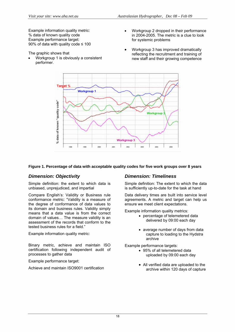
Figure 1 show the percentage of data at given dates which have quality code less than 100, i.e. data whose accuracy we can quantify or identify, for the five work groups.

Visit your site: www.aha.net.au Australasian Hydrographer, Dec 08 – Feb 09
17
Visit your site: www.aha.net.au Australasian Hydrographer, Dec 08 – Feb 09
18
Example information quality metric: % data of known quality code Example performance target: 90% of data with quality code ≤ 100 The graphic shows that • Workgroup 1 is obviously a consistent
performer.
• Workgroup 2 dropped in their performance in 2004-2005. The metric is a clue to look for systemic problems
• Workgroup 3 has improved dramatically
reflecting the recruitment and training of new staff and their growing competence
Figure 1. Percentage of data with acceptable quality codes for five work groups over 8 years
Dimension: Objectivity Simple definition: the extent to which data is unbiased, unprejudiced, and impartial
Compare English’s: Validity or Business rule conformance metric: “Validity is a measure of the degree of conformance of data values to its domain and business rules. Validity simply means that a data value is from the correct domain of values… The measure validity is an assessment of the records that conform to the tested business rules for a field.”
Example information quality metric:
Binary metric, achieve and maintain ISO certification following independent audit of processes to gather data
Example performance target:
Achieve and maintain ISO9001 certification
Dimension: Timeliness Simple definition: The extent to which the data is sufficiently up-to-date for the task at hand
Data delivery times are built into service level agreements. A metric and target can help us ensure we meet client expectations.
Example information quality metrics: • percentage of telemetered data
delivered by 09:00 each day • average number of days from data
capture to loading to the Hydstra archive
Example performance targets: • 95% of all telemetered data
uploaded by 09:00 each day • All verified data are uploaded to the
archive within 120 days of capture
Visit your site: www.aha.net.au Australasian Hydrographer, Dec 08 – Feb 09
19
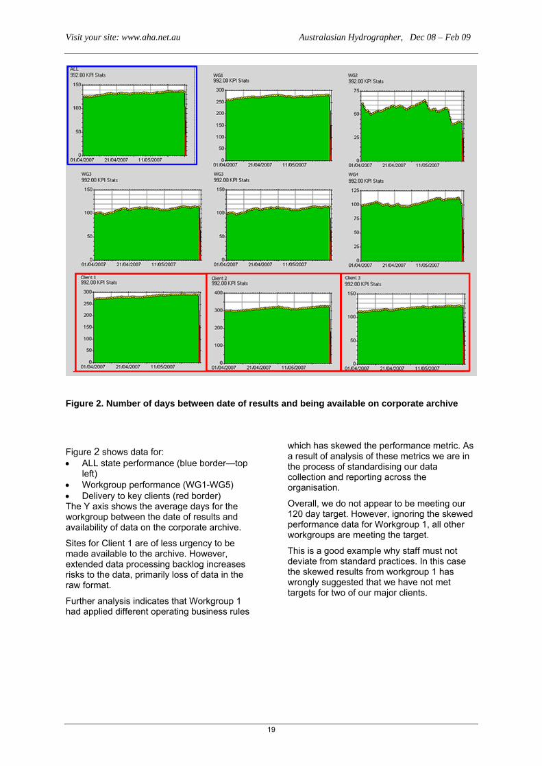
Figure 2. Number of days between date of results and being available on corporate archive
Figure 2 shows data for: • ALL state performance (blue border—top
left) • Workgroup performance (WG1-WG5) • Delivery to key clients (red border) The Y axis shows the average days for the workgroup between the date of results and availability of data on the corporate archive.
Sites for Client 1 are of less urgency to be made available to the archive. However, extended data processing backlog increases risks to the data, primarily loss of data in the raw format.
Further analysis indicates that Workgroup 1 had applied different operating business rules
which has skewed the performance metric. As a result of analysis of these metrics we are in the process of standardising our data collection and reporting across the organisation.
Overall, we do not appear to be meeting our 120 day target. However, ignoring the skewed performance data for Workgroup 1, all other workgroups are meeting the target.
This is a good example why staff must not deviate from standard practices. In this case the skewed results from workgroup 1 has wrongly suggested that we have not met targets for two of our major clients.

Visit your site: www.aha.net.au Australasian Hydrographer, Dec 08 – Feb 09
20
Figure 3. Average time between data capture and load for three hydrometric workgroups, showing performance target
Figure 3 shows data from 1 April to 30 May 2007 for three hydrometric workgroups. The Y axis shows the average days between the date of results and availability of data on the corporate archive. To meet the performance target, all results should be less than 120 days.
This view shows that Workgroup A is having major problems, while two workgroups are meeting the target. Use of the metric has helped improve the performance of Workgroup C, which previously had performance similar to the Workgroup A. Workgroup A was then working below strength and steps have been taken to recruit new staff.
A straight line indicates that no data have been processed and loaded, sudden increases
show data removed from the archive, while decreases show data added to the archive.
Dimension: Completeness Simple definition: The extent to which data is not missing and is of sufficient breadth and depth for the task at hand
Example information quality metrics: • number of days with data lost in any
single gap • % days with data lost in any 6
month period
Example performance targets: • No gaps of more than 5 days
telemetered data • At least 95% of possible data
available in archive

Visit your site: www.aha.net.au Australasian Hydrographer, Dec 08 – Feb 09
21
Figure 4. Percentage of lost data in five different workgroups
Figure 4 shows the percentage of lost data in the five workgroups throughout NSW over a three month period. All workgroups are meeting the 95% availability target for this data
view, but interestingly there are several percentage points of difference between the workgroups. This is being addressed though our quality assurance review process.
Figure 5. Percentage of data lost over a six month period

Visit your site: www.aha.net.au Australasian Hydrographer, Dec 08 – Feb 09
22
Figure 5 shows the percentage of lost data over a 6 month period, with data for: • ALL state performance (blue border—
top left) • Workgroup performance (WG1-WG5) • Delivery to key clients (red border) The Y axis shows the average days for the workgroup between the date of results and availability of data on the corporate archive.
Interestingly, the Workgroup 1 which appeared to perform badly for timeliness (top right) also appears to perform poorly for completeness. Having standardised data collection practices, we expect that future reports will show that results are well within target.
For this metric, we have met the target for our three key clients.
Dimension: Appropriate amount of information Simple definition: The extent to which the volume of data is appropriate for the task at hand
Regular gaugings are required to produce • reliable ratings (reduced standard
errors) • detect change in stream shape
Example information quality metric: number of gaugings taken
Example performance targets: 6 gaugings per year at each site
1996 1997 1998 1999 2000 2001 2002 2003 2004 2005 2006 2007
Gau
ging
s / s
tatio
n / y
ear
Target
Figure 6. Number of gaugings per station per year for ten year period Over a decade the number of gaugings per station per year has remained fairly constant, but still failing to meet the performance target.
Dimension: Consistent representation Simple definition: The extent to which data is presented in the same format
This dimension is important when combining data between systems. In DWE, it involves combining continuously monitored data in Hydstra with data from discrete monitoring in the Enterprise Data Base.
Fields which we need to align include sites, site attributes and variables. Are these data the same between systems? If different, is there a one-to-one relationship?
Example information quality metric: • Binary measure: same
reference data used • Binary measure: one-to-one
relationship exists
Example performance target: One-to-one mapping for all reference data
Unlike dimensions such as accuracy, timeliness and completeness, this dimension is not likely to change on a daily

Visit your site: www.aha.net.au Australasian Hydrographer, Dec 08 – Feb 09
23
basis. Nonetheless it is crucial to enable linking results from different data systems to a single report.
An example is that DWE has several codes in use for some site attributes: • surface water – stream:
Hydstra Codegroup STY – SS, Water Quality Data System (Triton) – SS (and RW, SW not used for new entries).
• surface water – storage: Hydstra Codegroup STY – ST, Water Quality Data System (Triton) – ST (and DW not used for new entries).
These are reasonably simple to resolve, since there is a one to many relationship.
A problematic example is • Hydstra Code group SRELAC value
02 – “Surveyed” • Water Quality Data System (Triton)
value 01 – R.L. at surface, value 02 – R.L. at W.L.M.Pt.
Both the codes in Triton represent survey results. But adopting the Hydstra codes potentially loses information.
This is the dimension which Federal agencies need to work through in collating data from the states and other contributing agencies.
Automating data quality metrics Kisters and DWE are currently refining the development of KPI (key performance indicators) in Hydstra, to produce a tabular report summarising key data metrics in a form suitable for clients.
These reports will be produced regularly for each client demonstrating how the KPI (and hence data quality targets) are being achieved.
The Hydstra KPI reporting tool allows the system manager to define metrics for variable monitored. Hydstra runs a batch task daily to collect sufficient data to report on the metric of interest.
To date DWE has defined 39 metrics, most of which are permutations of the metrics for the dimensions discussed in this paper. Time will determine which metrics prove useful within the hydrometric group and those required by clients.
The software can be configured to examine the database daily and provide management and client reports to determine and facilitate management of information quality problems as they arise.
Conclusion The Hydstra quality code is a single number. Data quality is multi-dimensional. While inherent or intrinsic information quality is relevant to most data customers, information quality must also be considered in the categories of context, representation and accessibility. Many of the dimensions of information quality are easily measured with tools already incorporated into Hydstra.
Agencies which produce hydrometric data must determine the requirements of their customers, set appropriate key performance indicators (KPIs) and determine appropriate data quality metrics assess performance against KPIs.
Client agencies such as the BoM and MDBC need to understand the standards they require in their systems and provide clear guidance to providers, so that they can measure and manage quality of information they produce.
References
English, Larry P: Improving Data Warehouse and Business Information Quality: Methods for Reducing Costs and Increasing Profits, John Wiley & Sons, 1999, ISBN: 0471253839.
Pipino, Leo, Yang W. Lee, Richard Y. Wang: Data quality assessment. Communications of the ACM 45(4): 211-218 (2002)
Redman, Thomas C.: A Comprehensive Approach to Data Quality Governance. White paper, Navesink Consulting Group (2005)
Redman, Thomas C.: Data Quality 101: for IAIDQ Book Club. Powerpoint presentation, Navesink Consulting Group (2006)
Wang, Richard Y.: A Product Perspective on Total Data Quality Management. Communications of the ACM 41(2): 58-65 (1998)
Information Quality Bibliography: http://iaidq.org/main/bibliography.shtml
Acknowledgements
John Hayes and Ray Boyton of NSW Dept Water and Energy did most of the work developing and implementing data quality metrics as Key Performance Indicators (KPI) within the department. A number of the slides in this presentation were originally prepared by John for other presentations.
Peter Heweston and Paul Sheahan of Kisters worked with John while implementing KPI reporting in Hydstra software. Hydstra is used by most Australian state agencies for continuous water monitoring data

Visit your site: www.aha.net.au Australasian Hydrographer, Dec 08 – Feb 09
24
Figure 7. Example Hydstra output reporting on Timeliness, Completeness and Freedom from error IQ dimensions
Visit your site: www.aha.net.au Australasian Hydrographer, Dec 08 – Feb 09
25
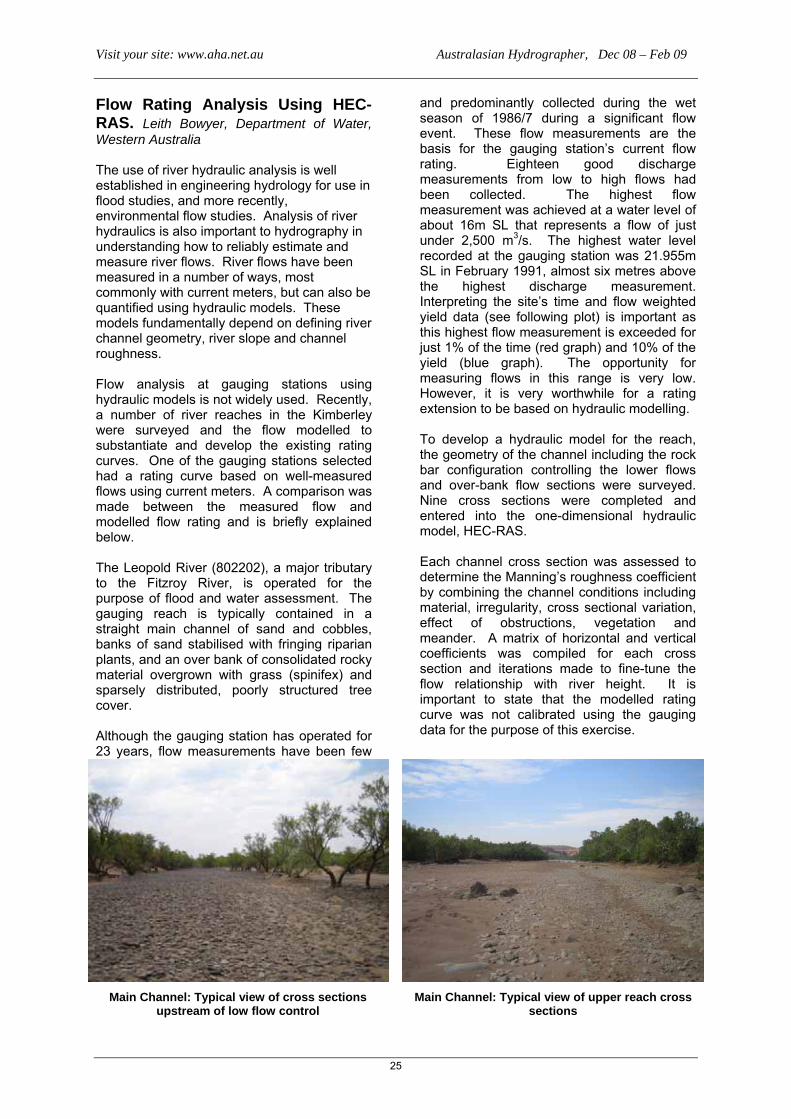
Flow Rating Analysis Using HEC-RAS. Leith Bowyer, Department of Water, Western Australia The use of river hydraulic analysis is well established in engineering hydrology for use in flood studies, and more recently, environmental flow studies. Analysis of river hydraulics is also important to hydrography in understanding how to reliably estimate and measure river flows. River flows have been measured in a number of ways, most commonly with current meters, but can also be quantified using hydraulic models. These models fundamentally depend on defining river channel geometry, river slope and channel roughness. Flow analysis at gauging stations using hydraulic models is not widely used. Recently, a number of river reaches in the Kimberley were surveyed and the flow modelled to substantiate and develop the existing rating curves. One of the gauging stations selected had a rating curve based on well-measured flows using current meters. A comparison was made between the measured flow and modelled flow rating and is briefly explained below. The Leopold River (802202), a major tributary to the Fitzroy River, is operated for the purpose of flood and water assessment. The gauging reach is typically contained in a straight main channel of sand and cobbles, banks of sand stabilised with fringing riparian plants, and an over bank of consolidated rocky material overgrown with grass (spinifex) and sparsely distributed, poorly structured tree cover. Although the gauging station has operated for 23 years, flow measurements have been few
and predominantly collected during the wet season of 1986/7 during a significant flow event. These flow measurements are the basis for the gauging station’s current flow rating. Eighteen good discharge measurements from low to high flows had been collected. The highest flow measurement was achieved at a water level of about 16m SL that represents a flow of just under 2,500 m3/s. The highest water level recorded at the gauging station was 21.955m SL in February 1991, almost six metres above the highest discharge measurement. Interpreting the site’s time and flow weighted yield data (see following plot) is important as this highest flow measurement is exceeded for just 1% of the time (red graph) and 10% of the yield (blue graph). The opportunity for measuring flows in this range is very low. However, it is very worthwhile for a rating extension to be based on hydraulic modelling. To develop a hydraulic model for the reach, the geometry of the channel including the rock bar configuration controlling the lower flows and over-bank flow sections were surveyed. Nine cross sections were completed and entered into the one-dimensional hydraulic model, HEC-RAS. Each channel cross section was assessed to determine the Manning’s roughness coefficient by combining the channel conditions including material, irregularity, cross sectional variation, effect of obstructions, vegetation and meander. A matrix of horizontal and vertical coefficients was compiled for each cross section and iterations made to fine-tune the flow relationship with river height. It is important to state that the modelled rating curve was not calibrated using the gauging data for the purpose of this exercise.
Main Channel: Typical view of cross sections upstream of low flow control
Main Channel: Typical view of upper reach cross sections

Visit your site: www.aha.net.au Australasian Hydrographer, Dec 08 – Feb 09
26
Over-bank channel – typical view of cross sections
802202 flow and time weighted duration curves
Percentage of Samples Equalled or Exceeded
Flow Weighted Yield Curve Stream Discharge in Cubic Metres/Second, Instantaneous Values. Interval 1 Days
Percentage of Total Flow from Discharge rates Equal or Exceeding
Site 802202 MT WINIFRED 11/11/1964..22/05/2008
Time Weighted Stream Discharge Duration Curve
0 20 40 60 80 1000.00001
0.0001
0.001
0.01
0.1
1
10
100
1000
10000
1
10
100
1000
10000
Visit your site: www.aha.net.au Australasian Hydrographer, Dec 08 – Feb 09
27
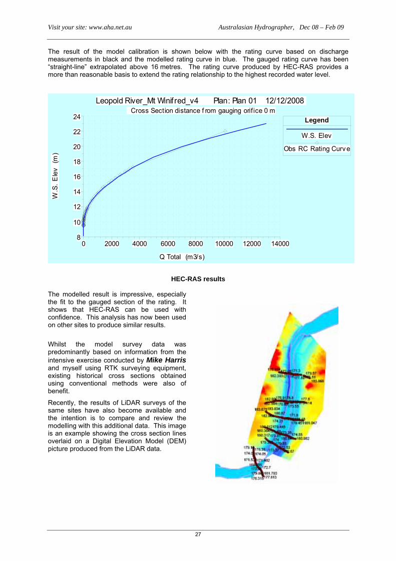
The result of the model calibration is shown below with the rating curve based on discharge measurements in black and the modelled rating curve in blue. The gauged rating curve has been “straight-line” extrapolated above 16 metres. The rating curve produced by HEC-RAS provides a more than reasonable basis to extend the rating relationship to the highest recorded water level.
0 2000 4000 6000 8000 10000 12000 140008
10
12
14
16
18
20
22
24
Leopold River_Mt Winif red_v4 Plan: Plan 01 12/12/2008 Cross Section distance f rom gauging orif ice 0 m
Q Total (m3/s)
W.S
. Ele
v (m
)
Legend
W.S. Elev
Obs RC Rating Curv e
HEC-RAS results The modelled result is impressive, especially the fit to the gauged section of the rating. It shows that HEC-RAS can be used with confidence. This analysis has now been used on other sites to produce similar results.
Whilst the model survey data was predominantly based on information from the intensive exercise conducted by Mike Harris and myself using RTK surveying equipment, existing historical cross sections obtained using conventional methods were also of benefit.
Recently, the results of LiDAR surveys of the same sites have also become available and the intention is to compare and review the modelling with this additional data. This image is an example showing the cross section lines overlaid on a Digital Elevation Model (DEM) picture produced from the LiDAR data.

Visit your site: www.aha.net.au Australasian Hydrographer, Dec 08 – Feb 09
28
DWE Acoustic Doppler Training Mic Clayton The national Water Initiatives program and its associated funding availability has seen an influx of acoustic technology into hydrographic work in the last couple of years. As a result many authorities have recognised a need for consistent training in the correct application and interpretation of information from these types of technologies. In recent months the Department of Water and Energy (New South Wales) has taken delivery of a number of Sontek ADV and ADCP units across the state’s hydrometric units. As a result of this introduction of new technology and techniques in undertaking discharge measurements the decision was made to have consistent training provided to all hydrographers across the state in the use of these units. In December I attended as an observer a DWE training course conducted for 20 DWE staff from the south West and Central West regions of NSW. This was the first of a series of training course in Sontek Flow Tracker and River Cat units, that many of the hydrographers had only taken delivery of in previous weeks. The training program was provided by Arran Corbett and John Sloat from Sontek. The course consisted of a day of practical hands on work, mainly in the operation of the Flowtracker units and the River Cat with the following day and a half spent on content including:
• theory of operation, • interpretation of results • understanding the value of the
ancillary information the units collect • understanding the potential sources of
error and ways of reducing the impact of these sources on the quality of the final measured result.
• Discussion of case stuies and possible scenarios for fixed installation of acoustic equipment
DWE staff understanding the technical operation side of
their new FloTracker units.
While the focus of the training was based around the operation of the Sontek acoustic units purchased by DWE, the way the course was delivered by John and Arran made the concepts and theory applicable to any acoustic technology. John was also able to bring to the training discussion USGS experiences with the technology as well as more traditional gauging processes.
As the River Cats were only recently arrived, tailor made mountings had not been yet setup on boats. DWE staff
demonstrated the usual hydrographic ingenuity that occurs in situations like this!
A session on uncertainties, accuracy and errors and in discharge results was an interesting one, particularly a discussion surrounding the impact of turbulence in a gauging section on discharge result uncertainty, not just for acoustic applications but for any gauging technique. In essence the better the flow conditions in a gauging section the better the quality of the gauging regardless of the technology or technique used. The last session of the training course was focussed on the deployment of fixed acoustic doppler installations, like the Sontek Argonaut. Some of these types of units have been deployed by DWE in wetland studies and the sharing of experiences from these studies gave other participants greater comprehension of the application and use of acoustic technology.

Visit your site: www.aha.net.au Australasian Hydrographer, Dec 08 – Feb 09
29
Acoustic theory and application discussion sessions
The last part of this session also included discussion of potential installation scenarios where the hydrographers were considering establishing monitoring sites in conditions that did not lend themselves to standard gauging station installations. As many hydrographic groups across Australia work in small isolated work teams, or even as lone individuals, one of the great values of conducting co-ordinated hands on training such as this, is that of seeing the sharing of ideas and experiences between hydrographers intent on getting the best possible quality data and information from the work they undertake. Investment in appropriate technical hydrographic/field hydrology training like this will lead to an improving the skills and standards we work to and strengthen the professionalism of hydrography/field hydrology in Australia
Australian Hydrographers’ Association Educational Grant The Committee of the Australian Hydrographers’ Association has instituted a number of awards/grants to encourage younger (and not so young) cadets and hydrographers to undertake studies in the Hydrography Certificate IV. This has been implemented since 2006 and the following information is provided about the AHA Educational Grant.
AHA members are also encouraged to make their employers and others aware of this Educational Grant and that the Association wishes to support the development of cadetships and traineeships within the industry, this grant being one aspect of the Associations support.
The following describes the requirements and conditions for the Educational Grant.
PURPOSE
The purpose of the Educational Grant is to:
• promote the principle objective of the Association to further the development of the science of hydrography/field hydrology and its application to the under-standing monitoring and management of Australia’s water resources, and
• assist students undertaking the Hydrography Certificate IV (accredited under the Australian Qualifications Framework to undertake the final year Project (Subject 8004AA) as required in the course
THE GRANT
The Grant will be of a value of up to $1000 to assist the students undertaking studies in the Hydrography Certificate IV to purchase material/equipment and services necessary to undertake the Project in the final year of the course.
CONDITIONS
• The recipient will supply an initial abstract paper and a final project paper for publication in the Association's Journal “Australasian Hydrographer”, and win advanced consideration for the right to present the Project paper (describing the work undertaken) at the Australian Hydrographers’ Association Conference (at a future date) upon applying for the Conference Educational Travel Grant.
• The recipient will be a financial member of the Australian Hydrographers’ Association.
• The recipient will normally be enrolled in the Hydrography Certificate IV (AQF).
• The recipient’s project will have been approved by OTEN and/or the recipients employer as an appropriate project activity meeting the requirements of the Project (Subject 8004AA) in the Hydrography Certificate IV.
• Applications will include the approved Project proposal, a budget detailing other sources of financial/material support (for example from the employer/supervisor).

Visit your site: www.aha.net.au Australasian Hydrographer, Dec 08 – Feb 09
30
• Application for a Grant does not infer automatic gaining of the grant by the applicant but will be assessed by the Association's Committee who may invite advice from appropriately qualified people. The Committee may liaise with the employer where necessary. More than one grant may be awarded annually, at the Committee's discretion.
• The grant will take the form of a reimbursement to the awarded value, paid to the individual, or may be considered as a rebate to the employer that has initially covered the recipients costs incurred, after presentation of proof of purchase of items/services.
• Items purchased with the Grant will become the property of the recipient's institution/employer or in the case of a stand alone student, the student.
• Proof of purchase of the items/services must be supplied to the Treasurer prior to reimbursement if this grant is awarded.
Further information and application forms can be found on the Associations website at www.aha.net.au
Keeping an Extreme Low Profile in New Zealand! In November I took some time off and wandered across the ditch to visit our counterparts who do things hydrographic and meteorologic in the Land of the Long White Cloud, attending the ‘2008 Joint Annual Conference of the New Zealand Hydrological Society and the Meteorological Society of New Zealand.’ The theme of the conference was ‘Extremes’ and in keeping with the theme it was held at Shantytown on the west coast of the South Island near Greymouth, which is located adjacent to some of New Zealand’s highest areas of annual precipitation. In my youth I cycled the South Island many years ago and experienced some of the extremes that NZ can offer, from the dry and surprisingly hot Canterbury Plains, crossing the Alps over to the West Coast where suddenly it got cold and above all – bloody wet!
In the weeks leading up to my hydrologic trek I noted with interest that power supplies in New Zealand were under threat due to an extended drought as a result of the source being primarily hydro electriv power. Surely this couldn’t be the New Zealand I knew from years gone by! Needless to say though, on the day I flew into Christchurch it was raining and I only caught glimpses of land that might remotely pass as, what we in Oz call, drought ravaged. If paddocks with long brown grass are drought ravaged then that was what I believ I saw! Transport from Christchurch to Shantytown had been organised to take in hydrographic and meteorological aspects of this part of New Zealand as the coach crossed from the Canterbury plains over the Alps and descended rapidly down to the West Coat through Arthurs Pass. Not only did we take in scientific stuff we had the opportunity to visit the lands of ‘Tolkein’ and ‘Narnia’ where scenes from the movies were shot. Departing Christchurch we had on board discussions about the impact of urban development above the Christchurch water supply catchment. Above? I hear you ask – well a substantial amount of the water supply comes from an aquifer under the plains not far to the west of Christchurch’s centre and, with increasing development encroaching on this aquifer comes the issue of maintaining its recharge abilty and drinking water quality. Christchurch’s water supply is basically untreated because of the high quality of its aquifer system. This was just one of the many Kiwi waster issues I was to learn of during my week on the South Island. Along the way we observed the braided river systems common throughout New Zealand that make it difficult to operate gauging stations in lower flows and took in the effects of the rain shadow of the eastern side of the Alps through to the high rainfall gradients of the western side of the Alps. A fascinating geological aspect of this journey was learning that what looks like unstable scree slopes and erosion channels on the sides of the mountains were in fact quite stable landform features that really only get moving during extreme rainfall events.

Visit your site: www.aha.net.au Australasian Hydrographer, Dec 08 – Feb 09
31
An example of a braided river system on the Canterbury Plains – in the Christchurch hinterland.
Lunch on the way over was at Arthurs Pass where I, dressed in only shorts and T-shirt, experienced an icy blast as snow flurries buffeted the surrounding Alps. I was very proud to claim that, as I lived in Cooma at an elevation of 850 metres, I was more than prepared for this dizzying elevation and climate of 737 metres above sea level that was Arthur’s Pass! (which is claimed to be the highest town in New Zealand)
Arthurs Pass Meteorological Station (Note Kea cages in lower right of picture protecting sensors!)
After a rapid descent down hill towards the Western side of the bottom island of Kiwi land we arrived in Greymouth, a town centred on a high quality black coal mining industry as well as tourism. The ice breaker evening in Greymouth was a chance to mix with everyone in a casual atmosphere before the conference proper, where it quickly became known that there was a lone Australian Hydrographer somewhere in the mob – I was now a target! After the
opening event was the question What to do in Greymouth on the evening before the conference proper started? Friendly information pointed me in the direction of the Speights Ale House where (surprise, surprise) many of the other conferencee’s had retired to after the ice breaker. This establishment was to become the centre of hydrographic and meteorologic excellence and knowledge sharing in the southern hemisphere during the week – my only problem was being the solitary Aussie supporter for the cricket as we battled with the New Zealand side live on the TV screens! The conference proper began in Shantytown just to the south of Greymouth, which is a recreated 19th century pioneer town inspired by the West Coast gold rushes of the 1860s. Coaches were organised daily to shuttle attendees who were accommodated between Greymouth and Shantytown to the venue and its other events Before we could begin the conference proper we were given approval and welcome to the local area by the local Maori clan who then ushered us in to the opening session of the conference. After the opening session the conference split into 4 streams, surface water, meteorological, groundwater and joint streams for the next couple of days. I tried to get to a variety of themes throughout the next few days to get a better grip on issues and ideas in the New Zealand professions. As with many multi strand events you sometimes wonder if you were missing out on something more exciting in a another room! Presenters ranged from university post graduates, scientists, meteorologists, regional council land and water officers and consultant involved in catchment projects. A small trade section was also attached to the conference breakout areas where morning teas and lunches were held. Of particular interest to me (as it was more related to my alpine work environment) was the snow and ice session. New Zealand has lots of snow but much of New Zealand’s monitoring network is focussed on the lower agricultural and populated regions of the islands. From the presentations it appeared that because the snow was always up there – it was taken for granted by New Zealanders and it is only in recent years has become a point of interest for answering the questions of how the snow field contribute to

Visit your site: www.aha.net.au Australasian Hydrographer, Dec 08 – Feb 09
32
the hydrology of catchments, particularly in the impact of snow melt in extreme conditions. The snow monitoring network has traditionally been targeted around the ski resorts and generally operated only for the benefit of the tourism industry. In recent years organisations, like NIWA, have begun work on developing a more extensive monitoring network to better understand their alpine snowpacks. The beauty of taking the time of undertaking professional development through attending conferences such as this is the exposure to issues that you thought only happened in your part of the world, you find similar issues exist somewhere else. Seeing how others deal with their similar issues is a great learning experience. My reason for this statement is that I was amazed at the groundwater issues in New Zealand. In a country, where we had perceptions of mighty rivers and the like, the reality of agriculture is that there is a heavy reliance on the extraction of groundwater for production of crops and animal rearing. New Zealand has increasingly been moving from sheep and into milk production agribusinesses.
Introduction session
On the evening of the second day of the conference the official dinner was held with the theme of ‘Extremely Wild Wild West’ held in the Miners hall at Shantytown. Needless to say theme clothing was encouraged. Disguised in my salmon flannelette shirt with attached deputy sherriff star I hid in amongst the dinner group as local entertainers dressed in possum hats (possums are one of Australia’s unwelcome gifts to our Kiwi cousins!) and touting noisy blunderbusses began searching for ‘any Australians here tonight?’ I must have blended in well with the general populace as a Kiwi was plucked from the crowd, mistaken as an Aussie, and placed in the stocks away from the beer. My valour did not come to the fore in an effort to correct
this unfortunate error as I slipped deeper back into the crowd!
Those field hydrologists in NZ sure wear funny clothes!
Conference Dinner in the Miner’s Hall, Shantytown.
The final day of the conference main program saw a variety of field trips conducted in the West Coast region, including a helicopter trip into an area of the Alps where record high intensity rainfall records occur, environmental monitoring in the coal mining areas near Greymouth, a Fox Glacier trip and an excursion to Lake Brunner and its associated water quality issues, hydro electric demands and stream depletion issues. With promise of a fine day suitable for helicopters, I joined a small group on an excursion into the Wanganui River valley and surrounding alpine areas, where as we broke through the scattered cloud we took in the views of the Alps, small glaciers, and west coast gorges.
Ivory Lake in the Southern Alps – easier by helicopter!

Visit your site: www.aha.net.au Australasian Hydrographer, Dec 08 – Feb 09
33
Departing attendees had the choice of returning back to Christchurch by coach or via the Trans Alpine Express. As I had taken the coach over I opted for the train, which traversed a route further north than my journey across. A highlight of this trip (even though you don’t have a view for some time!) was travelling through the 8.55 kilometre long Otira Rail tunnel that cuts through the Alps between Otira nd Arthurs Pass. Also being a bit of a train buff gave me the opportunity to ride on the outdoor carriage – no windows hence heaps of dust and diesl soot in the eyes – what better way to appreciate the many river crossings that give a better hydrological appreciation of the braided river beds in New Zealand.
One of the many river crossings by the Trans Alpine. During my brief week in NZ I was made welcome by many of our hydrological and meteorological counterparts. I would like to express special thanks in particular to Martin Doyle (Tasman District Council) and Michael Ede (Marlborough District Council) for their hospitality and looking after a vulnerable Aussie at the conference! Membership Renewals Membership renewal reminders have been distributed, encouraging your continued participation in the activities of the Association.
Those who have received them will notice that the hard work is done for you and the information you last provided to the Association is already filled in!
Its as simple as correcting the information (if needed) and returning the form with your payment to:
The Treasurer Australian Hydrographers’ Association 14 Kosciusko St, Traralgon, Victoria 3844 Payment Options
The Association accepts payment of subscriptions by cheque, credit card and Electronic Funds Transfer. If you wish to debit from your account direct to the AHA account please the info is on the membership form.
4 levels of Corporate Membership are offered as follows:
Corporate Membership Grade
Annual Cost
Included Membership
Bronze $500 1 Silver $1,000 6 Gold $1,500 12 Platinum $2,000 20
Main features of Australian Hydrographers’ Association Membership (for both Individual and Corporate) include:
• Knowledge and information sharing amongst peers.
• Promotion and sponsorship opportunities at a biennial conference.
• Four journals, Australasian Hydrographer, per year.
• Association Website and peer group mailing list with discussion threads.
• Commitment to supporting continuing education of Hydrographers (Certificate IV Hydrography).
• Travel and educational grant assistance scheme for student/cadet members to attend conferences.
• Job advertisement network to industry.
• Investing funds for educational support for hydrographic industry (Member of National Hydrographic Advisory Committee).
AHA Office Bearers and Contacts
Chairman, Bill Steen, [email protected]
Secretary, Michael Whiting [email protected] Treasurer, Max Hayes
[email protected] Publicity Officer, Mic Clayton [email protected] Committee Members, Bill Barratt, Paul Langshaw Public Officer, John Skinner.