australia pacific lng project 4: lng facility chapter 7: landscape and visual amenity australia...
TRANSCRIPT

Australia Pacific LNG Project Volume 4: LNG Facility Chapter 7: Landscape and Visual Amenity
Volume 4: LNG Facility Chapter 7: Landscape and Visual Amenity
March 2010 Page iii Australia Pacific LNG Project EIS
Contents
7. Landscape and visual amenity..................................................................................................1
7.1 Introduction ...............................................................................................................................1
7.1.1 Purpose ........................................................................................................................1
7.1.2 Scope of work...............................................................................................................1
7.1.3 Legislative framework...................................................................................................2
7.2 Environmental values................................................................................................................9
7.3 Proposed infrastructure.............................................................................................................9
7.4 Methodology............................................................................................................................10
7.5 Existing environment...............................................................................................................11
7.5.1 Character of the landscape ........................................................................................11
7.6 Landscape character zones....................................................................................................12
7.6.1 Landscape character zone A: Curtis Island and surrounding islands........................15
7.6.2 Landscape character zone B: Gladstone Harbour.....................................................15
7.6.3 Landscape character zone C: mainland developed areas.........................................17
7.6.4 Landscape character zone D: mainland natural .......................................................18
7.7 Visual character units..............................................................................................................18
7.7.1 Visual character unit 1 - forested hills and valleys .....................................................19
7.7.2 Visual character unit 2 - mangroves and salt marsh..................................................19
7.7.3 Visual character unit 3 - creeks..................................................................................20
7.7.4 Visual character unit 4 - island villages......................................................................20
7.7.5 Visual character unit 5 - mainland urban development..............................................21
7.7.6 Visual character unit 6 - industrial development ........................................................22
7.7.7 Visual character unit 7 - forested mountains..............................................................22
7.7.8 Visual character unit 8 - wooded hills.........................................................................23
7.8 Potential visual impacts...........................................................................................................23
7.8.1 Western sector ...........................................................................................................25
7.8.2 Northern sector...........................................................................................................27
7.8.3 Eastern sector ............................................................................................................28
7.8.4 Southern sector ..........................................................................................................28
7.8.5 Summary of visual impacts ........................................................................................29
7.9 Mitigation measures ................................................................................................................31

Volume 4: LNG Facility Chapter 7: Landscape and Visual Amenity
March 2010 Page iv Australia Pacific LNG Project EIS
7.10 Conclusion ..............................................................................................................................31
7.10.1 Assessment outcomes ...............................................................................................31
7.10.2 Commitments .............................................................................................................34
Figures
Figure 7.1 LNG facility and associated facilities within the GBRWHA ................................................... 3
Figure 7.2 Great Barrier Reef Marine Park zoning................................................................................. 5
Figure 7.3 Areas of state significance (scenic coastal landscapes)....................................................... 7
Figure 7.4 GSDA precincts..................................................................................................................... 8
Figure 7.5 LNG facility components ..................................................................................................... 10
Figure 7.6 Landscape character zones and visual character units...................................................... 14
Figure 7.7 Curtis Island and surrounding islands LCZ – view of Curtis Island,.................................... 15
Figure 7.8 Curtis Island and surrounding islands LCZ – view of Picnic Island .................................... 15
Figure 7.9 Outer harbour LCZ .............................................................................................................. 16
Figure 7.10 Middle harbour LCZ .......................................................................................................... 16
Figure 7.11 Inner harbour LCZ............................................................................................................. 17
Figure 7.12 Curtis passage LCZ .......................................................................................................... 17
Figure 7.13 Mainland development area LCZ...................................................................................... 18
Figure 7.14 Mainland natural LCZ........................................................................................................ 18
Figure 7.15 Forested hills and valleys VCU ......................................................................................... 19
Figure 7.16 Mangroves and salt marsh VCU ....................................................................................... 20
Figure 7.17 Creeks VCU – Graham Creek........................................................................................... 20
Figure 7.18 Island villages VCU ........................................................................................................... 21
Figure 7.19 Mainland urban development VCU ................................................................................... 21
Figure 7.20 Industrial development VCU ............................................................................................. 22
Figure 7.21 Forested mountains VCU.................................................................................................. 22
Figure 7.22 Woodland hills VCU .......................................................................................................... 23
Figure 7.23 Zone of visual influence .................................................................................................... 24
Figure 7.24 Viewpoint locations ........................................................................................................... 25
Figure 7.25 Location 6.2 - existing visual setting ................................................................................. 26
Figure 7.26 Location 6.2 – LNG facility at day ..................................................................................... 26
Figure 7.27 Location 6.2 – LNG facility at night ................................................................................... 27

Volume 4: LNG Facility Chapter 7: Landscape and Visual Amenity
March 2010 Page v Australia Pacific LNG Project EIS
Figure 7.28 Location 6.4 – existing visual setting ................................................................................ 27
Figure 7.29 Location 6.4 – LNG facility at day ..................................................................................... 28
Figure 7.30 Location 6.4 – LNG facility at night ................................................................................... 28
Figure 7.31 Location 6.7 – Existing visual setting ................................................................................ 29
Figure 7.32 Location 6.7 – LNG facility at day ..................................................................................... 30
Figure 7.33 Location 6.7 – LNG facility at night ................................................................................... 30
Tables
Table 7.1 Visual impact matrix ............................................................................................................. 11
Table 7.2 Summary of environmental values, sustainability principles, potential impacts and mitigation measures............................................................................................................................................... 33

Volume 4: LNG Facility Chapter 7: Landscape and Visual Amenity
March 2010 Page 1 Australia Pacific LNG Project EIS
7. Landscape and visual amenity
7.1 Introduction
7.1.1 Purpose
The visual assessment outlined in this chapter considers the visual impact of the liquefied natural gas (LNG) facility on the landscape settings of the proposed development site on and around Curtis Island and its projection into the regional landscape of Gladstone.
The visual assessment of the LNG facility is based on two factors: visual effect and visual sensitivity. Visual effects are determined by evaluating the condition of the existing landscape and the visual character of the proposed LNG facility, while visual sensitivity considers the impact on views to the LNG facility from potentially sensitive receptors such as urban and rural dwellings. This chapter addresses the landscape character and visual amenity components outlined in Section 3.2.4 of the terms of reference for the Australia Pacific LNG Project (the Project). The assessment of potential impacts of night lighting on terrestrial and marine fauna habitats are addressed separately in Volume 4 Chapter 8 and Volume 4 Chapter 9 respectively.
Australia Pacific LNG is guided by sustainability principles when identifying potential impacts the Project may have on landscape and visual amenity for the Gladstone Region. Of Australia Pacific LNG’s 12 sustainability principles, the principles relevant to landscape and visual amenity are as follows:
• Minimising adverse environmental impacts and enhancing environmental benefits associated with Australia Pacific LNG’s activities, products or services; conserving, protecting, and enhancing where the opportunity exists, the biodiversity values and water resources in its operational areas
• Respecting the rights, interests and diverse cultures of the communities in which Australia Pacific LNG operates
• Identifying, assessing, managing, monitoring and reviewing risks to Australia Pacific LNG’s workforce, its property, the environment and the communities affected by its activities.
These principles have been applied to identify management options to reduce impacts on landscape and visual amenity from the construction and operation of the LNG facility on the Gladstone Region.
The purpose of the visual assessment is to:
• Describe the existing character of the landscape that will be affected by the proposed LNG facility, with particular reference to features which contribute to the visual quality of the area
• Assess the potential impacts upon the landscape character of the site and the surrounding area, particularly from panoramas and outlooks, when viewed from public places
• Propose mitigation measures to reduce the impact on the existing landscape character, visual quality and fauna habitats in the area.
7.1.2 Scope of work
The scope of work of the visual assessment of the proposed LNG facility included:

Volume 4: LNG Facility Chapter 7: Landscape and Visual Amenity
March 2010 Page 2 Australia Pacific LNG Project EIS
• An assessment of the study area and its local and regional context in respect of landscape character and visual elements
• An examination of the proposed development’s potential impact on the landscape and visual amenity of the study area
• An assessment of its locality and the sensitive receptors within it
• The recommendation of measures considered necessary to mitigate potential adverse impacts.
Limitations
The assessment of visibility of the LNG facility’s components was limited to a general evaluation of topographic maps, aerial photography and field evaluation. Detailed dimensions of development components are not yet completed; therefore, calculations were made from conceptual site plans. At the time the assessment was undertaken, two options were under evaluation for the product loading facilities (Option 1b and 2a). Potential visual impacts associated with the two options are considered similar. Therefore, for the purposes of this report, Option 2a has been used as the basis for assessment as more detailed design was available for this option.
7.1.3 Legislative framework
Various legislative provisions contain objectives for the protection of landscape values throughout Port Curtis. These legislative provisions range from provisions in the world heritage listing to local planning scheme requirements. An outline of the relevant legislative provisions which seek to protect and enhance the landscape values of Port Curtis and surrounds is provided below.
World heritage significance
The LNG facility is located within the Great Barrier Reef World Heritage Area (GBRWHA) as shown at Figure 7.1. The GBRWHA extends seaward from the low water mark including the waters and the islands within the Port of Gladstone and including Curtis Island. The GBRWHA is listed as both world heritage and national heritage.
The Great Barrier Reef is the world's largest world heritage property extending over 2,000km and covering approximately 348,000 km2 on the northeast continental shelf of Australia. The Great Barrier Reef was inscribed on the world heritage list in 1981 based on a number of internationally significant values. One of the prescribed criteria attached to its listing is stated below:
“The Great Barrier Reef provides some of the most spectacular scenery on earth and is of exceptional natural beauty. The world heritage values include:
• The vast extent of the reef and island systems which produces an unparalleled aerial vista
• Islands ranging from towering forested continental islands complete with freshwater streams, to small coral cays with rainforest and unvegetated sand cays
• Coastal and adjacent islands with mangrove systems of exceptional beauty
• The rich variety of landscapes and seascapes including rugged mountains with dense and diverse vegetation and adjacent fringing reefs
• The abundance and diversity of shape, size and colour of marine fauna and flora in the coral reefs

Volume 4: LNG Facility Chapter 7: Landscape and Visual Amenity
March 2010 Page 3 Australia Pacific LNG Project EIS
• Spectacular breeding colonies of seabirds and great aggregations of over-wintering butterflies
• Migrating whales, dolphins, dugong, whale sharks, sea turtles, seabirds and concentrations of large fish.”
Figure 7.1 LNG facility and associated facilities within the GBRWHA
Due to the large area contained within the GBRWHA, the above is an overarching criteria rather than being specifically related to Port Curtis or the proposed development site. Therefore, it is recognised that Gladstone Harbour’s industrial influenced landscape has a lower sensitivity than untouched areas of the world heritage area. Even so, the proposed site for the LNG facility is contained within a regional area of exceptional natural beauty, which has been considered as part of the visual assessment.

Volume 4: LNG Facility Chapter 7: Landscape and Visual Amenity
March 2010 Page 4 Australia Pacific LNG Project EIS
Commonwealth significance
Under the Environment Protection and Biodiversity Conservation Act 1999, the national heritage list was created to protect places with outstanding natural, Indigenous or historic heritage value to the nation. The Great Barrier Reef became a listed place on 21 May 2007.
To be listed as national heritage, a place is nominated and assessed by the Australian Heritage Council which assesses its heritage value with respect to nine criteria. Of these nine, five criteria were applicable to the Great Barrier Reef. One criterion, listed below, is specifically related to aesthetic qualities:
“The place has outstanding heritage value to the nation because of the place's importance in exhibiting particular aesthetic characteristics valued by a community or cultural group.”
The great diversity of landscape types across the GBRWHA is part of the recognised value of the area. From Curtis Island, extensive open views across the water to mountain ranges to the west, and views north and east of a tree covered Curtis Island, visually dominate the character of the landscape. Figure 7.2 shows the zoning for the Great Barrier Reef Marine Park. Landscape features surrounding the LNG facility site include enclosed forested hills and valleys and intertidal land systems, such as mangroves, salt marsh and mudflats, contributing to a unique coastal landscape character. These landscape patterns are a major influence on the visual quality of the landscape.

Volume 4: LNG Facility Chapter 7: Landscape and Visual Amenity
March 2010 Page 5 Australia Pacific LNG Project EIS
Figure 7.2 Great Barrier Reef Marine Park zoning
State significance
Curtis Coast Regional Coastal Management Plan
Queensland’s coastal resources are protected and managed under the Coastal Protection and Management Act 1995. The Curtis Coast Regional Coastal Management Plan has been prepared under the Act to provide direction to the implementation of the legislation at a regional level.
Chapter 3 of the plan identifies Curtis Island as a key coastal site within the Curtis Coast. The island is identified as having areas of state significant scenic coastal landscapes. The first of the desired environmental outcomes for Curtis Island is:
“Maintenance of Curtis Island in a generally natural or non-urban state outside existing residential and tourist areas at South End, Black Head, Sea Hill and Station Point while providing opportunities for future development in appropriate locations”.

Volume 4: LNG Facility Chapter 7: Landscape and Visual Amenity
March 2010 Page 6 Australia Pacific LNG Project EIS
Map 10 of the Plan identifies areas of state significance (scenic coastal landscapes). The map, as illustrated in Figure 7.3 identifies the LNG facility site containing wetlands of state significance.
The Plan seeks to protect the scenic and cultural values associated with coastal landscapes. Section 2.7.1 of the Plan states:
“Incompatible development within these areas can adversely impact on their scenic coastal landscape values, particularly in relation to the coastal islands, Mt Larcom and the coastal ranges and remote natural areas as The Narrows.”
It is recognised the proposed LNG facility will have impacts on the existing scenic coastal landscape values of the area. However, the amendments to the Development Scheme for the Gladstone State Development Area (GSDA) have recognised the land between Laird Point and Hamilton Point as areas suitable for industrial development. Therefore, it is considered whilst impacts will occur, it is in an appropriate location for development.
The objectives of the Draft Queensland Coastal Plan 2009 reflect the objectives of the Curtis Coast Regional Coastal Management Plan. The draft plan also sets out a methodology to assess the visual impact. As this study was undertaken previous to the release of the draft plan, the included methodology was not adopted. However, the methodology adopted for this assessment is considered to reflect the objectives of the draft plan.

Volume 4: LNG Facility Chapter 7: Landscape and Visual Amenity
March 2010 Page 7 Australia Pacific LNG Project EIS
Figure 7.3 Areas of state significance (scenic coastal landscapes)

Volume 4: LNG Facility Chapter 7: Landscape and Visual Amenity
March 2010 Page 8 Australia Pacific LNG Project EIS
Local significance
Development scheme for the GSDA
The July 2008 amendments to the development scheme for the GSDA modified the existing development scheme and precinct plans to incorporate the additional areas included in the GSDA. The new Curtis Island Industry precinct provides for the establishment of LNG facilities on the west coast of southern Curtis Island. Figure 7.4 illustrates the current precincts under the development scheme.
Figure 7.4 GSDA precincts
Local planning schemes
The site is located within the rural locality of the former Calliope Shire (now Gladstone Regional Council), as classified by the Calliope Shire planning scheme. However, as the site is located within

Volume 4: LNG Facility Chapter 7: Landscape and Visual Amenity
March 2010 Page 9 Australia Pacific LNG Project EIS
the GSDA, the development scheme for the GSDA takes precedence. The provisions within the scheme are captured by the Curtis Coast Regional Coastal Management Plan.
7.2 Environmental values
Chapter 3 of the Curtis Coast Regional Coastal Management Plan identifies the key values of the south western portion of Curtis Island. From this, environmental values relevant to landscape and visual amenity have been disseminated and are listed below:
• Protection of coastal landscape values
• Protection of biodiversity values and fauna habitats
• Protection of cultural heritage values
• Protection of outdoor recreational values.
7.3 Proposed infrastructure
The visual assessment is focussed on the construction and operation of the LNG facility. The assessment considers the major components of the LNG facility, which comprises the following:
• An LNG plant, comprising of four LNG trains (with a nominal capacity of 4.5Mtpa each), which include cold boxes, air coolers, refrigeration compression areas with associated turbines. The four trains will be co-located, and collectively will span 600m in length, 250m in width and have a height of approximately 32m. The LNG trains will be constructed on-ground with a finished surface level of approximately 8m RL. Trains 1 and 2 will be built as part of the initial construction, with trains 3 and 4 built as demand dictates.
• Three full-containment LNG storage tanks each with a nominal capacity of 160,000m3. The tanks will be positioned on a ground level of approximately 8m RL, and be approximately 90 m in diameter and 45 m high. Two tanks will initially be constructed to cater for product produced by trains 1 and 2, with a third being constructed concurrently with trains 3 and 4. A smaller LPG storage tank with a capacity of 100,000m3 will be provided on the same terrace.
• Two ground flares (wet and dry) which each measure approximately 200m in length, 75m in width and 15m in height and sit on a ground level of 12m RL.
• An option to include the marine flare within the design of the wet/dry ground flare enclosure, thereby eliminating the separate stack marine flare.
• A temporary accommodation facility with associated living and recreational facilities.
• Plant infrastructure and utilities; including administration buildings, chemical and refrigerant storage, power generation, gas receiving infrastructure.
• A loading jetty to transfer product to tankers for shipping to market (final option yet to be determined, however, Option 2a has been used as the basis for assessment as more detailed design was available for this option).
• A materials offloading facility (MOF) for transfer of building materials, heavy equipment and workforce to the LNG facility.

Volume 4: LNG Facility Chapter 7: Landscape and Visual Amenity
March 2010 Page 10 Australia Pacific LNG Project EIS
As detailed design is ongoing, exact positioning and dimensions of the proposed infrastructure is not finalised. However, it is anticipated the proposed site layout and dimensions of infrastructure will not change to an extent which will present a material change to potential visual impact.
The main components of the LNG facility are presented in Figure 7.5.
Figure 7.5 LNG facility components
7.4 Methodology
To assess the visual significance and magnitude of the proposed LNG facility on the landscape, a baseline study was completed to record and analyse the existing character, quality and sensitivity of the landscape and any significant visual features in the vicinity of the facility. The stages of the study included:
Stage 1: A desktop study of relevant background reports, other data and mapped information was undertaken to collect data on topography, land use, landscape and settlement pattern. This allowed the landscape to be divided into homogeneous zones that could then be investigated in the field.
Stage 2: A comprehensive field study was undertaken and photographic record obtained. The field survey was carried out on the study area, by two visual impact assessment specialists to gain a consensus opinion. Field work was completed to collect visual data relating to landform, land use, vegetation, boundaries and more perceptual aspects like scale, enclosure and visual unity. At the same time information was collected on the condition of landscape features and elements that contribute to the overall character of the area.

Volume 4: LNG Facility Chapter 7: Landscape and Visual Amenity
March 2010 Page 11 Australia Pacific LNG Project EIS
Stage 3: Classification of the landscape into landscape character zones (LCZs) and visual character units (VCUs) was completed. The LCZs are broad tracts of landscape which have been determined with consideration of land use patterns, topography and vegetation types.
Stage 4: The visual assessment of the effects of project components on the existing character was completed in two steps. The first step determined the visual impact of both the construction and operation phases using an assessment method that measures both visual effect and visual sensitivity to determine the overall visual impact. The second step comprised development of strategies to mitigate the identified impacts.
The visual effects have been determined by measuring the contrast and integration of the Project components within the existing landscape. The colour, shape and form of the Project components and the topography, vegetation and surrounding landscape features all influence the degree of visual effect. The proportion of a view that includes the Project components will also influence the level of visual effect.
The visual sensitivity has been determined by assessing the views from which the Project components would be seen. There are three levels of sensitivity:
• Low visual sensitivity – components are visible from rural lands and minor roads but may be partially obscured
• Moderate visual sensitivity – components are visible from main roads and areas of public use from and distance or partially obscured
• High visual sensitivity – components are visible and obvious from urban and rural residences, recreational areas and highways
Once the visual sensitivity and visual effect of the Project components have been identified, the visual impact of each component of the facility was determined using the matrix as shown in Table 7.1.
Table 7.1 Visual impact matrix
Visual sensitivity Visual effect
High Moderate Low
High High visual impact High/moderate visual impact Moderate/low visual impact
Moderate High/moderate visual impact Moderate visual impact Moderate/low visual impact
Low Moderate/low visual impact Moderate/low visual impact Low visual impact
Mitigation strategies were subsequently developed to reduce the visual sensitivity and/or visual effect and thereby reduce the overall visual impact of the facility.
7.5 Existing environment
7.5.1 Character of the landscape
The LNG facility site is located on the western shores of Curtis Island, 12km north of the Gladstone central business district. Curtis Island, within a world heritage area, is a large and diverse island forming the northeast protection of the Port of Gladstone, and lies between Gladstone and Rockhampton.

Volume 4: LNG Facility Chapter 7: Landscape and Visual Amenity
March 2010 Page 12 Australia Pacific LNG Project EIS
The area proposed for the LNG facility comprises enclosed forested hills and valleys and intertidal land systems, such as mangroves, salt marsh and mudflats, contributing to a unique coastal landscape character. These landscape patterns are a major influence on the visual quality of the landscape.
There are extensive open views from the proposed site across the water to heavy industry and port facilities and mountain ranges to the west, and views north and east of a tree covered Curtis Island. These views visually dominate the character of the landscape.
Key characteristics of the local and regional landscape character are:
• Landscape of contrast and variety- which includes heavy industry and port related activities
• Large scale water views with extensive vistas to level horizons and huge sky expanses
• Enclosed forested hills and valleys
• Forested mountains
• Mangrove vegetation and associated mudflats.
Public areas which have expansive views throughout the region include:
• Auckland Point - a tourist lookout at the northern end of the Gladstone City Centre
• Round Hill – an informal lookout within a residential area of Gladstone
• Spinnaker Park – a reclaimed park which forms the protective wall of Gladstone marina
• Mt Larcom Range – mountainous range which contains popular public walking tracks.
7.6 Landscape character zones
To assess the landscape character of the proposed LNG facility, the locality is divided into seven LCZs based on geographic and harbour boundaries (Figure 7.6). There are overlapping similarities between the LCZs, as well as some unique variations between the zones. Views across the development area from open water and Gladstone mainland were analysed within the seven LCZs.
The LCZs include:
• Curtis Island LCZ
• Outer harbour LCZ
• Middle harbour LCZ
• Inner harbour LCZ
• Curtis passage LCZ
• Mainland developed LCZ
• Mainland natural LCZ.
Within the LCZs, eight distinctive and recognisable patterns of elements have been identified in the landscape. For the purpose of this assessment, these elements have been labelled as VCUs.
These VCUs have been determined primarily by land cover, topography and water features. VCUs vary throughout each of the LCZs due to topographic and water elements. Landscape character types

Volume 4: LNG Facility Chapter 7: Landscape and Visual Amenity
March 2010 Page 13 Australia Pacific LNG Project EIS
and patterns combined with varying topographic features create the eight VCUs which, together, are generally seen to create the visual diversity and interest of the local setting.

Volume 4: LNG Facility Chapter 7: Landscape and Visual Amenity
March 2010 Page 14 Australia Pacific LNG Project EIS
Figure 7.6 Landscape character zones and visual character units

Volume 4: LNG Facility Chapter 7: Landscape and Visual Amenity
March 2010 Page 15 Australia Pacific LNG Project EIS
7.6.1 Landscape character zone A: Curtis Island and surrounding islands
Curtis Island and surrounding islands are delineated on Figure 7.6 as A. The landscape character throughout the islands is mostly natural, devoid of visible buildings, structures and lighting. This creates natural patterns of land form, vegetation and water elements. The exception to this is the settlement of South End.
The topography of this LCZ is predominately forested undulating hills and valleys. The terrain, however, in the central portion of Curtis Island, becomes hilly due to the forested north to south ridgelines.
There are extensive, open views to the islands from within the surrounding waterways (Figure 7.7 and Figure 7.8). This is due to the open expanse of water within the harbour, uncluttered shorelines and the elevation of the surrounding topography. The LCZ seen from most directions consists of forest covered rolling hills.
Four distinct VCUs have been identified within the Curtis Island and surrounding islands LCZ A.
Figure 7.7 Curtis Island and surrounding islands LCZ – view of Curtis Island,
Figure 7.8 Curtis Island and surrounding islands LCZ – view of Picnic Island
7.6.2 Landscape character zone B: Gladstone Harbour
For the purposes of visual assessment, the Gladstone Harbour LCZ has been divided into four LCZs:
• Outer harbour LCZ
• Middle harbour LCZ
• Inner harbour LCZ
• Curtis passage LCZ.

Volume 4: LNG Facility Chapter 7: Landscape and Visual Amenity
March 2010 Page 16 Australia Pacific LNG Project EIS
LCZ B1 - Outer harbour
The outer harbour is delineated on Figure 7.6 as B1. The western edge of the LCZ runs north to south from View Hill on Curtis Island along the eastern side of Quoin Island. The eastern edge is bounded by Facing Island. Views from this zone onto Curtis Island would largely be unaffected by the proposed LNG facility, except for potential night light glow. For this reason, this zone is outside of the primary visual catchment (Figure 7.9).
Figure 7.9 Outer harbour LCZ
LCZ B2 - Middle harbour
The middle harbour is delineated on Figure 7.6 as B2. This part of the harbour is characterised by a number of small islands that create visual interest and focal points within the waterways (Figure 7.10). These islands support a limited number of residential and recreational nodes. The majority of this zone is outside of the primary visual catchment as it is not affected by the LNG facility, except for potential night light glow. It will be more affected by other proposed developments such as the Shell, GLNG, and QCLNG LNG facilities and the Wiggins Island coal terminal.
Figure 7.10 Middle harbour LCZ
LCZ B3 - Inner harbour
The proposed product offloading facility and MOF are located within this LCZ. This zone is edged by Curtis Island to the east and the generally flat mainland areas flanked by hills and mountains to the west. The Inner Harbour area supports significant areas of industrial development along its western shores and although the Curtis Island shore line is currently covered in natural forest (Figure 7.11), industrial zoning over this section of land indicates it will also be industrial in character.

Volume 4: LNG Facility Chapter 7: Landscape and Visual Amenity
March 2010 Page 17 Australia Pacific LNG Project EIS
Figure 7.11 Inner harbour LCZ
LCZ B4 - Curtis passage
The coastal fringe in this south western section of the island comprises a strip of low swampy coastal plains and mangrove flats extending north into Graham Creek and The Narrows (Figure 7.12). The waters of Port Curtis narrow to form the entrance to The Narrows. The distinctive geological characteristics of The Narrows are recognised in the national estate listing, which identifies the tidal passage landscape between the mainland and Curtis Island as uncommon in Australia. This passage landscape is characterised by a complexity of waterways, fringing mudflats, mangroves, intertidal wetlands and salt marshes.
Figure 7.12 Curtis passage LCZ
7.6.3 Landscape character zone C: mainland developed areas
The mainland development area is delineated on Figure 7.6 as C. The mainland development areas include large scale industrial areas as well as urban residential and commercial areas (Figure 7.13). Long distance views of Curtis Island are available from the various, elevated mainland locations, such as Auckland, Queensland Alumina Limited and Round Hill lookouts within the Gladstone urban area.
The topography throughout is predominantly flat to undulating with the commercial area located along a ridge providing a limited number of elevated views to the north, east and west.
Elevations range from approximately 300m near a tributary of the Weir River along the western field boundary to 430m in the Western Creek State Forest to the south.

Volume 4: LNG Facility Chapter 7: Landscape and Visual Amenity
March 2010 Page 18 Australia Pacific LNG Project EIS
Figure 7.13 Mainland development area LCZ
7.6.4 Landscape character zone D: mainland natural
The mainland natural LCZ is delineated on Figure 7.6 as D. The mainland within the LCZ supports some significant natural areas, such as salt flats / marsh and mangroves as well as rural areas supporting grasslands with scattered trees, woodland and on steeper hills and mountains forest cover (Figure 7.14). Apart from ecological values, the salt marshes create vast flat areas generally fringed by other salt tolerant vegetation species that allow for expansive views, often to Curtis Island. Woodland hills and forested mountains are within this zone and form the western edge of the LCZ for the proposed plant site.
Figure 7.14 Mainland natural LCZ
7.7 Visual character units
The VCUs represent areas that contain consistent landscape character in terms of topography, vegetation and land use. Each VCU contains elements or a combination of elements, which create a particular visual character.
It is important to note that VCUs are defined at a broad scale. Some VCUs can change in character quite distinctly, whilst for others the difference is more subtle.
In field investigation, photographs and aerial photography were analysed to identify the different landscape characteristics of each LCZ within the study area to identify VCUs within each zone. The primary characteristics of the eight VCUs are summarised below with typical photographs shown.

Volume 4: LNG Facility Chapter 7: Landscape and Visual Amenity
March 2010 Page 19 Australia Pacific LNG Project EIS
VCUs identified within the study area include:
• Forested hills and valleys
• Mangroves and salt marsh
• Creeks
• Island villages
• Mainland urban development
• Industrial
• Forested mountains
• Wooded hills.
7.7.1 Visual character unit 1 - forested hills and valleys
The forested hills and valleys VCU (Figure 7.15) occurs in most of the LCZs, including on islands within the various harbour LCZs.
Significant retention of native vegetation contributes to the natural patterns of this VCU, mostly dominated by mixed species of open eucalypt forest and extensive patches of dry rainforest. The landscape within this VCU is generally undulating to moderately hilly.
The most important visual significance of this VCU is its visual screening and integration capacity. Within the eastern and parts of the southern view sectors, the forested hills and valleys VCU provides screening to the proposed facility. To other viewing sectors, it provides partial screening and / or a background visual integration landscape.
Figure 7.15 Forested hills and valleys VCU
7.7.2 Visual character unit 2 - mangroves and salt marsh
The mangroves and salt marsh VCU (Figure 7.16) occurs in LCZ A: Curtis Island and surrounding islands, LCZ B3 inner harbour and LCZ D mainland natural.
The natural pattern of the intact mangrove forests and associated salt marsh are visually dominant along the coastline, creating a significant landscape feature. This is particularly evident with contiguous stands of mangroves, creating distinctive natural landscape character along shoreline visible from waterways and adjoining sections of foreshore.

Volume 4: LNG Facility Chapter 7: Landscape and Visual Amenity
March 2010 Page 20 Australia Pacific LNG Project EIS
Mangrove stands visually define the foreshore. Due to the low lying growth character of mangroves, this vegetation pattern does not provide visual screening to views from surrounding areas.
Figure 7.16 Mangroves and salt marsh VCU
7.7.3 Visual character unit 3 - creeks
The creeks VCU (Figure 7.17) occurs in LCZ A: Curtis Island and surrounding islands and LCZ D mainland natural.
Graham Creek is a visually dominant natural feature of Curtis Island, providing an expanse of flat water and a series of gullies for recreational boats to take refuge. The margins of Graham Creek are met by intact mangrove forests and salt marsh.
The Calliope River is the most significant water element on the mainland and supports recreational boating.
Figure 7.17 Creeks VCU – Graham Creek
7.7.4 Visual character unit 4 - island villages
The island urban development VCU (Figure 7.18 occurs in the LCZ A - Curtis Island and surrounding islands.
The small community of South End is located 8km to the east on the east coast of Curtis Island. Land use on the southern end of Curtis Island is primarily conservation based with limited impacts to native vegetation. The jetty structure is visually prominent contrasting with the natural character of the landscape and scenic waterways.

Volume 4: LNG Facility Chapter 7: Landscape and Visual Amenity
March 2010 Page 21 Australia Pacific LNG Project EIS
Private residential properties are also located on adjacent islands, including Facing, Tide, Turtle and Compigne islands. However, this development is very limited and is dominated by the natural character of the islands. These areas are sensitive to development.
Figure 7.18 Island villages VCU
7.7.5 Visual character unit 5 - mainland urban development
The mainland urban development VCU (Figure 7.19) occurs only in the LCZ C mainland development.
Land use in Gladstone and surrounding areas include urban, residential, industrial, infrastructure and marine uses. The urban areas of Gladstone are generally setback from the waters of Port Curtis, with the Port of Gladstone waterfront forming a buffer between the town centre and the water. Gladstone City Centre is located on higher ground overlooking Gladstone marina, with urban and residential areas extending inland, including in some places across higher elevated land (such as Auckland Point lookout) providing views out across Port Curtis. This grid pattern, the elevation location, extensive views and relative low-rise development in Gladstone form part of the city’s character. The industrialised nature of the port is visually evident in most views from the city.
These areas are visually sensitive to development but are very distant from Laird Point. Long distance views to Curtis Island are generally blocked by development of buildings and infrastructure, except from elevated lookout points such as, Auckland, Queensland Alumina Limited and Round Hill.
Figure 7.19 Mainland urban development VCU

Volume 4: LNG Facility Chapter 7: Landscape and Visual Amenity
March 2010 Page 22 Australia Pacific LNG Project EIS
7.7.6 Visual character unit 6 - industrial development
The industrial development unit Figure 7.20 occurs only in the LCZ C mainland development.
This unit encompasses industrial land use relating to various industries, such as coal exporting facilities and port related industry. Such industry related landscape components include coal stockpiles and conveyors, which form a visually distinctive element in the landscape, as well as jetty structures, moored boats and moving water craft. Night lighting is highly visible from the foreshore and from within the harbour.
These existing large scale water front developments create an industrial setting to parts of Gladstone Harbour and provide a visual context for the LNG facility.
Figure 7.20 Industrial development VCU
7.7.7 Visual character unit 7 - forested mountains
The forested mountains VCU (Figure 7.21) occurs only in the LCZ D mainland natural.
The distinctive ridges and mountainous terrain of Mount Larcom provides a natural vegetated backdrop to the low-lying alluvial coastal plains and the foreshore areas which, although retaining some natural areas, are interspersed by large industrial complexes and reclaimed foreshore areas.
This VCU will have views to the LNG facility from several viewing locations. Due to its prominence in the landscape, this VCU provides reference points throughout the area.
Figure 7.21 Forested mountains VCU
Volume 4: LNG Facility Chapter 7: Landscape and Visual Amenity
March 2010 Page 23 Australia Pacific LNG Project EIS
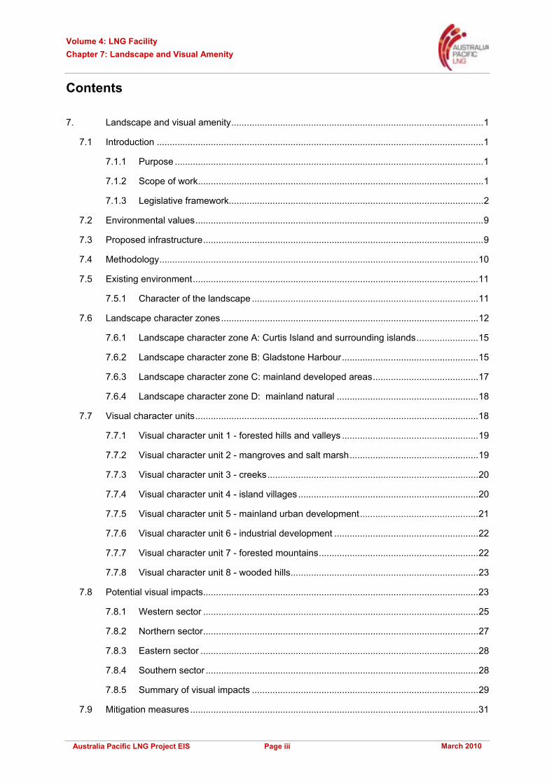
7.7.8 Visual character unit 8 - wooded hills
The woodland hills VCU (Figure 7.22) is not evident on Curtis Island, but is prominent on the mainland of Gladstone within the primary visual catchment.
This unit is best described as semi-enclosed forest with a subtle mosaic of grassland and scrub. Some areas of this VCU have been cleared for grazing purposes creating pockets of open grassland. Vegetation across this VCU area largely consists of the native eucalyptus forests and woodlands of Gladstone. Fringing natural vegetation occurs within the industrialised areas; however, modification of the landscape is visually evident throughout the majority of the view shed. The extensive areas covered by this landscape type provide an important backdrop to the urban and industrialised areas of The Port of Gladstone.
The topography is gently sloping and level land. These gentle slopes of semi-enclosed forest with a subtle mix of grassland and grazing land create a typical landscape of the region.
The woodland is a highly patterned landscape. Diverse vegetation patterns from scattered tree cover to dense pockets of forest, combined with varying flat to undulating land forms, contribute to this highly patterned VCU.
In addition, this VCU supports intermittent urban development contributing to the landscape pattern through built form and planted vegetation.
The woodland unit provides foregrounds to some roadside locations, screening views. In the context of views to the west, the VCU is seen as foot slopes to the more prominent mountains.
Figure 7.22 Woodland hills VCU
7.8 Potential visual impacts
The impact of the LNG facility will vary according to its visual effect and the visual sensitivity of the area from which it is seen. These two factors are considered together to determine impact levels. The area from which the LNG facility can be seen is described as the visual catchment area.
The LNG facility has the potential to create an adverse visual impact on the surrounding area, especially on sensitive visual receptors such as recreational boating areas, residential areas and recreational areas such as lookouts.
The visual impacts are considered in relation to the various sectors around the site, as were visual sensitivity and effects above. The area is broken into four sectors, as described in Figure 7.23.
Figure 7.23 also provides an indication of the zone of visual influence (ZVI) for the LNG facility. The ZVI mapping was prepared to illustrate where the proposed development could be viewed from within

Volume 4: LNG Facility Chapter 7: Landscape and Visual Amenity
March 2010 Page 24 Australia Pacific LNG Project EIS
the region, based purely on topography. It is important to note that the mapping does not take into consideration any screening afforded by existing infrastructure or vegetation.
The map indicates the ZVI spans kilometres, especially in the open waters of Gladstone Harbour. However, while views from distances of over 7.5km are visible, they have been classified as having a low visual sensitivity.
Figure 7.23 Zone of visual influence
To assist with the visual assessment, photomontages were created from a number of viewpoints within the study area. These viewpoints were chosen based on them being a sensitive receptor (such as a public lookout/landmark) and/or being a typical depiction of the landscape. Figure 7.24 below depicts the viewpoint locations.
More photomontages can be found in the visual impact assessment technical report (Volume 5 Attachment 13).

Volume 4: LNG Facility Chapter 7: Landscape and Visual Amenity
March 2010 Page 25 Australia Pacific LNG Project EIS
Figure 7.24 Viewpoint locations
7.8.1 Western sector
The LNG facility faces the west, and therefore the western sector has the most visible views of the facility. However, the surrounding hills provide backgrounding and enclosing effects, thereby increasing the integration status of the facility.
This view zone includes the northern portion of Gladstone Harbour and industrial lands in the vicinity of Landing and Serrant Road. Other areas in the zone include natural foreshore salt marshes and mangroves as well as grazing lands within open woodland and recreational use associated with hiking to Mt Larcom.
Although the Mt Larcom Gladstone Road has a high sensitivity, the separation distances create low visual sensitivity and effects, thereby creating a low impact. Similarly, with Mt Larcom being some 10km away, a low visual effect and sensitivity result in a low impact level.

Volume 4: LNG Facility Chapter 7: Landscape and Visual Amenity
March 2010 Page 26 Australia Pacific LNG Project EIS
This sector will experience the highest visual impacts based on the high visual effect levels occurring in areas of high visual sensitivity to recreational boaters in this part of the harbour. These high impact levels are experienced up to 2.5km with moderate impacts beyond this on all waterways.
As the western sector is predominantly designated for industrial uses within the Gladstone state development area, the effects of night lighting from the facility or vessels on this area is not predicted to be a nuisance. If Fisherman’s Landing is chosen as the mainland facility, vehicular movements are not considered to be an issue as they will be confined to major roads, which are heavily used by industry, and this sector has minimal sensitive receptors. Impacts of night lighting on fauna habitats are assessed in Volume 4 Chapter 8 and Volume 4 Chapter 9.
As recreational boaters are to be the most affected from this sector, a viewpoint from the water was chosen to represent the ‘worst-case’ impact to a sensitive receptor within the western sector. More photomontages from the western sector are presented in Volume 5 Attachment 13.
Figure 7.25 to Figure 7.27 shows the LNG facility’s impact when viewed from open waters north of Fisherman’s Landing.
Figure 7.25 Location 6.2 - existing visual setting
Figure 7.26 Location 6.2 – LNG facility at day

Volume 4: LNG Facility Chapter 7: Landscape and Visual Amenity
March 2010 Page 27 Australia Pacific LNG Project EIS
Figure 7.27 Location 6.2 – LNG facility at night
7.8.2 Northern sector
The waterways of Curtis Inlet, The Narrows and Graham Creek are the main sensitive receptors in the northern sector. When viewed from the north, the entrance to The Narrows or Graham Creek, the foothills between the site and Graham Creek provide some screening, although the storage tanks will be visible.
With high sensitivity up to 2.5km away, a high impact will occur up to 1km with moderate to high impacts to 2km. Beyond this distance, low impacts would occur with moderate to low impacts past this point.
The impact of night lighting and flaring on sensitive receptors (excluding fauna habitats) is not significant due to minimal use of the recreational waterways in this zone at night. Although there will be boats, especially yachts that may moor in Graham Creek waiting for an opportunity to cross the bar in The Narrows at the right tide.
Figure 7.28 to Figure 7.30 illustrates the LNG facility’s impact when viewed from Friend Point. This has been chosen as a typical view of the LNG facility from the northern sector.
Figure 7.28 Location 6.4 – existing visual setting

Volume 4: LNG Facility Chapter 7: Landscape and Visual Amenity
March 2010 Page 28 Australia Pacific LNG Project EIS
Figure 7.29 Location 6.4 – LNG facility at day
Figure 7.30 Location 6.4 – LNG facility at night
7.8.3 Eastern sector
There are no impacts on sensitive receptors (excluding fauna) in this sector created by the LNG facility. The township of South End is located in this sector, but due to distance and topography between the two locations, visual impact is considered negligible.
The exception to this would be attributable to night lighting. There may be a glow in the night sky, attributable to the LNG facility. However, at a distance of 13km, the impacts of night lights would be minimal.
7.8.4 Southern sector
As with the western and northern sector, Gladstone Harbour in this southern sector supports recreational boating that is ascribed a high sensitivity up to 2.5km, decreasing to moderate up to a distance of 7.5km.
The sector also contains the most sensitive land uses in the form of recreational/tourist lookouts and areas and urban residential areas. Urban residential areas are ascribed a high sensitivity up to 7.5km and a moderate sensitivity to 12.5km.
The closest housing adjacent to Auckland Point lookout is approximately 11km away from the LNG facility and will have a moderate sensitivity at this distance. Recreational/tourist areas, such as

Volume 4: LNG Facility Chapter 7: Landscape and Visual Amenity
March 2010 Page 29 Australia Pacific LNG Project EIS
Auckland Point lookout, will have a moderate to low sensitivity at this distance. Other lookouts, such as Round Hill, are even further distant and would have a low sensitivity.
The visual effect of the LNG facility and shipping facilities would be low beyond a distance of 3km.
The visual impact levels will be high on Gladstone Harbour for distances up to 2km for the LNG facility and moderate to 3km with low impacts beyond this.
The urban areas of Gladstone will only experience low impacts due to the facilities location on Curtis Island.
The impact of night lighting is minimal due to the foreground effect of night lighting in Gladstone itself. However, the flares may create a minor focal point in the night sky, when activated.
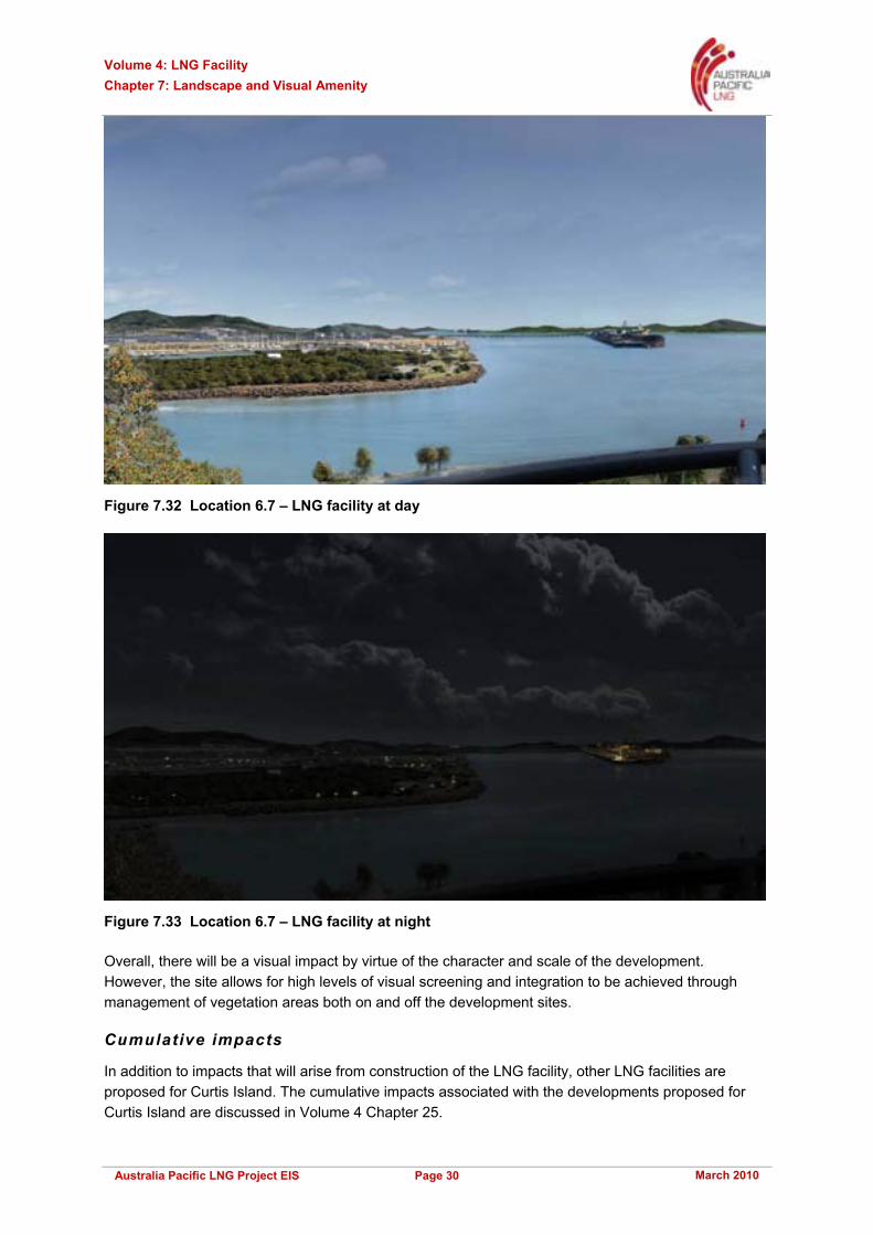
Figure 7.31 to Figure 7.33 depicts visual impacts from Auckland Point lookout. This was chosen as it is one of the most popular lookouts within Gladstone, with views towards Curtis Island.
Figure 7.31 Location 6.7 – Existing visual setting
7.8.5 Summary of visual impacts
The visual impacts of the proposed LNG facility would be highest immediately to the west of the site at Laird Point. In this harbour area, a high visual effect is experienced by high sensitivity recreational boaters, especially by boats navigating The Narrows
The impacts on the sensitive residential and recreational areas in the vicinity of Gladstone are significantly reduced by the distances between the LNG facility and Gladstone, generally over 10km away. This in turn creates a moderate to low impact.
Due to the topography of Curtis Island, the LNG facility is screened from most eastern view locations, eliminating impact. The minor exception to this is night lighting that will create a night glow but not have direct light effects. Night lighting has the potential to affect fauna habitats (refer to Volume 4 Chapter 8 and Volume 4 Chapter 9).
Volume 4: LNG Facility Chapter 7: Landscape and Visual Amenity
March 2010 Page 30 Australia Pacific LNG Project EIS
Figure 7.32 Location 6.7 – LNG facility at day
Figure 7.33 Location 6.7 – LNG facility at night
Overall, there will be a visual impact by virtue of the character and scale of the development. However, the site allows for high levels of visual screening and integration to be achieved through management of vegetation areas both on and off the development sites.
Cumulative impacts
In addition to impacts that will arise from construction of the LNG facility, other LNG facilities are proposed for Curtis Island. The cumulative impacts associated with the developments proposed for Curtis Island are discussed in Volume 4 Chapter 25.

Volume 4: LNG Facility Chapter 7: Landscape and Visual Amenity
March 2010 Page 31 Australia Pacific LNG Project EIS
7.9 Mitigation measures
The implementation of the following visual mitigation strategies will reduce visual effects consistent with the scale of the development. Further, they will achieve a visual integration of the LNG facility into the forested hillsides of the Laird Point location. Light pollution associated with flaring has the largest potential impact on visual amenity. To reduce the visual impact, Australia Pacific LNG has adopted a ground flare into the main dry/wet vapour relief (flare) systems, compared to a more conventional stack flare. The use of the ground flare for these systems is the single largest mitigation measure to reduce visual impact, as flaring will be lower to the ground and shielded by the ground flare enclosures. A vertical stack marine flare has been proposed within the design however, the option of including the marine flare within the ground flare is being investigated.
Additional mitigation measures which will be adopted are as follows:
• Reduce as far as practical the cleared areas needed to support the construction and operation of the LNG facility
• Reduce the penetration of the mangrove fringe at the MOF to the essential width to accommodate the water interface facility
• Where practicable, retain mangroves and develop the wider storage areas behind the mangrove fringe
• Landscape cut and fill batters to reduce colour contrast with adjoining vegetation
• Any building that is not compromised with regard to heat absorption will be painted to lessen the contrast between these elements and the adjoining bushland
• Use a sensitive lighting approach to reduce light spill
• Evaluate the outcomes of more lights that have a lower elevation to achieve the required light levels to assist in lowering the height of light towers
7.10 Conclusion
7.10.1 Assessment outcomes
The development of the LNG facility and associated ship loading facility will create a visual change to the existing visual settings of Curtis Island. However, this area has been zoned industrial by the Queensland Government, so that the development is visually appropriate to the zoning.
While there is major visual change created by the LNG facility, there are many factors that mitigate against it creating major visual impacts.
Firstly, there are very limited sensitive receptors within the foreground and middle-ground zones of the LNG facility site location. These are limited to recreational boating that may use adjoining waterways.
Other sensitive receptors, such as residential areas, recreational areas and major roads, are in the background of the LNG facility site, generally further than 10km away. This reduces both sensitivity and visual effect.
Another impact mitigating element is the topography and vegetation of Curtis Island in the vicinity of Laird Point. The adjoining hills and tree cover limit views from the east and south-east and create landscape integration elements when viewed from the west, south-west and the north.

Volume 4: LNG Facility Chapter 7: Landscape and Visual Amenity
March 2010 Page 32 Australia Pacific LNG Project EIS
The visual effect of night lighting is often created by flaring. The planned incorporation of ground flares for the wet/dry flare systems eliminates a major source of this direct light impact, contributing only to the general ambient light glow effect of the plant as a whole, when the flare is activated. To reduce the visual impact further, Australia Pacific LNG is investigating the option of including the vertical stack marine flare within the ground flare.
Careful management of on-site and off-site vegetation will ensure that the site is visually integrated with the natural setting of the island, being contained within a ring of forested hills. The plant and surrounding facilities will create an industrial character to this part of Curtis Island that emulates development that has already occurred along the eastern shoreline of Gladstone Harbour. However, it should be possible to achieve this development within the strong matrix of the forested hills of Curtis Island.
A summary of the environmental values, sustainability principles, potential impacts and mitigation measures in relation to landscape and visual amenity associated with the LNG facility is presented in Table 7.2. Additionally, Table 7.2 includes the residual risk levels for landscape and visual amenity. Further details on the risk assessment process are presented in Volume 2 Chapter 4.

Volu
me
4: L
NG
Fac
ility
C
hapt
er 7
: Lan
dsca
pe a
nd V
isua
l Am
enity
Mar
ch 2
010
Page
33
Aus
tral
ia P
acifi
c LN
G P
roje
ct E
IS
Tabl
e 7.
2 S
umm
ary
of e
nviro
nmen
tal v
alue
s, s
usta
inab
ility
prin
cipl
es, p
oten
tial i
mpa
cts
and
miti
gatio
n m
easu
res
Envi
ronm
enta
l va
lues
Su
stai
nabi
lity
prin
cipl
es
Pote
ntia
l im
pact
s Po
ssib
le c
ause
s M
itiga
tion
and
man
agem
ent
mea
sure
s R
esid
ual r
isk
leve
l
Coa
stal
land
scap
e va
lues
C
reat
ion
of a
n ad
vers
e vi
sual
im
pact
on
area
s su
rroun
ding
th
e LN
G fa
cilit
y, e
spec
ially
on
sen
sitiv
e vi
sual
rece
ptor
s
Inap
prop
riate
des
ign
and
cons
truct
ion
met
hods
that
ar
e no
t sen
sitiv
e to
the
exiti
ng e
nviro
nmen
t
Unc
ontro
lled
clea
ring
activ
ities
Low
Cul
tura
l her
itage
va
lues
Im
pact
s to
cul
tura
lly
sign
ifica
nt v
ista
s or
are
as
Impl
emen
tatio
n of
des
ign
whi
ch is
not
cul
tura
lly
sens
itive
Low
Out
door
recr
eatio
n va
lues
Min
imis
ing
adve
rse
envi
ronm
enta
l im
pact
s an
d en
hanc
ing
envi
ronm
enta
l ben
efits
as
soci
ated
with
Aus
tralia
P
acifi
c LN
G’s
act
iviti
es,
prod
ucts
or s
ervi
ces;
co
nser
ving
, pro
tect
ing,
an
d en
hanc
ing
whe
re
the
oppo
rtuni
ty e
xist
s,
the
biod
iver
sity
val
ues
and
wat
er re
sour
ces
in
its o
pera
tiona
l are
as
Res
pect
ing
the
right
s,
inte
rest
s an
d di
vers
e cu
lture
s of
the
com
mun
ities
in w
hich
A
ustra
lia P
acifi
c LN
G
oper
ates
Impa
cts
to o
utdo
or
recr
eatio
nal a
reas
Im
plem
enta
tion
of d
esig
n w
hich
is n
ot s
ensi
tive
to
area
s us
ed fo
r out
door
re
crea
tion
Low
Bio
dive
rsity
val
ues
and
faun
a ha
bita
t Id
entif
ying
, ass
essi
ng,
man
agin
g, m
onito
ring
and
revi
ewin
g ris
ks to
A
ustra
lia P
acifi
c LN
G’s
w
orkf
orce
, its
pro
perty
, th
e en
viro
nmen
t and
the
com
mun
ities
affe
cted
by
its a
ctiv
ities
Hab
itat i
mpa
ct to
faun
a sp
ecie
s
Intro
duct
ion
of n
ight
ligh
ting
into
a fa
una
habi
tat
Red
uce,
as
far a
s pr
actic
al, t
he
clea
red
area
s ne
eded
to s
uppo
rt th
e co
nstru
ctio
n an
d op
erat
ion
of th
e LN
G
faci
lity
Red
uce
the
pene
tratio
n of
the
man
grov
e fri
nge
at th
e M
OF
to th
e es
sent
ial w
idth
to a
ccom
mod
ate
the
wat
er in
terfa
ce fa
cilit
y
Whe
re p
ract
icab
le, r
etai
n m
angr
oves
an
d de
velo
p th
e w
ider
sto
rage
are
as
behi
nd th
e m
angr
ove
fring
e
Land
scap
e cu
t and
fill
batte
rs to
re
duce
col
our c
ontra
st w
ith a
djoi
ning
ve
geta
tion
Any
bui
ldin
g th
at is
not
com
prom
ised
w
ith re
gard
s to
hea
t abs
orpt
ion
will
be
pain
ted
to le
ssen
the
cont
rast
be
twee
n th
ese
elem
ents
and
the
adjo
inin
g bu
shla
nd
Use
a s
ensi
tive
light
ing
appr
oach
to
redu
ce li
ght s
pill
Util
ise
grou
nd fl
ares
to re
duce
vis
ual
impa
ct
Act
ive
invo
lvem
ent i
n th
e m
anag
emen
t of t
he C
urtis
Isla
nd
envi
ronm
enta
l man
agem
ent p
reci
nct
Low

Volume 4: LNG Facility Chapter 7: Landscape and Visual Amenity
March 2010 Page 34 Australia Pacific LNG Project EIS
7.10.2 Commitments
Whilst the proposed LNG facility will have an impact to the existing landscape, Australia Pacific LNG is committed to implementing mitigation measures during construction and operation to reduce potential impacts on the existing landscape and visual amenity.
Australia Pacific LNG will:
• Reduce, as far as practical, vegetation clearing required to support the construction and operation of the LNG facility
• Landscape cut and fill batters to reduce colour contrast with adjoining vegetation
• Ensure that the adjoining on-site bushland is managed to achieve effective visual integration with surrounding coastal landscape
• Use a sensitive lighting approach to reduce light spill
• Utilise ground flares to reduce visual impact
• Be actively involved in the management of the Curtis Island environmental management precinct.