automatic identification systems - itf-oecd.org
TRANSCRIPT

BTS Applications of Vessel Automatic Identification System (AIS) Data
Bureau of Transportation Statistics U.S. Department of Transportation
April 24, 2018
5th ITF Transportation Statistics Annual Meeting

What is AIS?
• Automatic Identification System
(AIS) is a vessel tracking system,
operating in the marine radio
band, that is comparable to an
aircraft’s transponder for collision
avoidance.
• Vessel Traffic Service is similar to
Air Traffic Control, using AIS to
provide navigational advice as
vessels transit between open water
and U.S. ports.
2

• The U.S. Coast Guard operates the Nationwide Automatic Identification System (NAIS), which consists of approximately 200 shore stations located throughout the coastal continental United States, inland rivers, Alaska, Hawaii and Guam.
• NAIS is designed to collect AIS transmissions from nearby vessels.
• AIS is a rich, nationally-consistent BIG data source.
Who and Where is AIS Operated?
3

What and When AIS Is Broadcasted?
• Onboard AIS automatically transmits and receives a wealth of vessel information every 2 to 10 seconds while the vessel is underway, or every 3 minutes while at anchor.
• AIS automatically provides the following broadcast information to and from shore stations, other ships, and aircraft:
– vessel’s identity (MMSI #)
– navigational status
– speed
– latitude/longitude
– course
– other safety-related information
4

AIS Depicts a Vibrant Picture of Vessel Movement
5

• The Bureau of Transportation Statistics’ Port Performance Freight Statistics Program provides nationally consistent throughput and capacity measures for the top 25 ports by tonnage, container, and dry bulk.
AIS Application 1:
Port Performance Freight Statistics
6

• BTS is leveraging BIG data sources such as AIS (vessel transponder broadcast) to explain port operations and measure port performance.
• BTS has partnered with the U.S. Army Engineer Research and Development Center (ERDC) to survey ferry service and create port performance metrics.
Leveraging BIG Data Sources
7

• BTS created waterside port boundaries (“boxes”), by using geo-fence technique, around piers and wharves defined in Master Docks Plus by U.S. Army Corps of Engineers.
• Once a containership stops (e.g., speed = 0 and navigational status = anchor) in the “box,” BTS starts to record its dwell time.
• This yielded more than 18,000 records for vessels in container ports and terminals.
Looking Inside the Box
8

An Example of Port Boundary Boxes
9
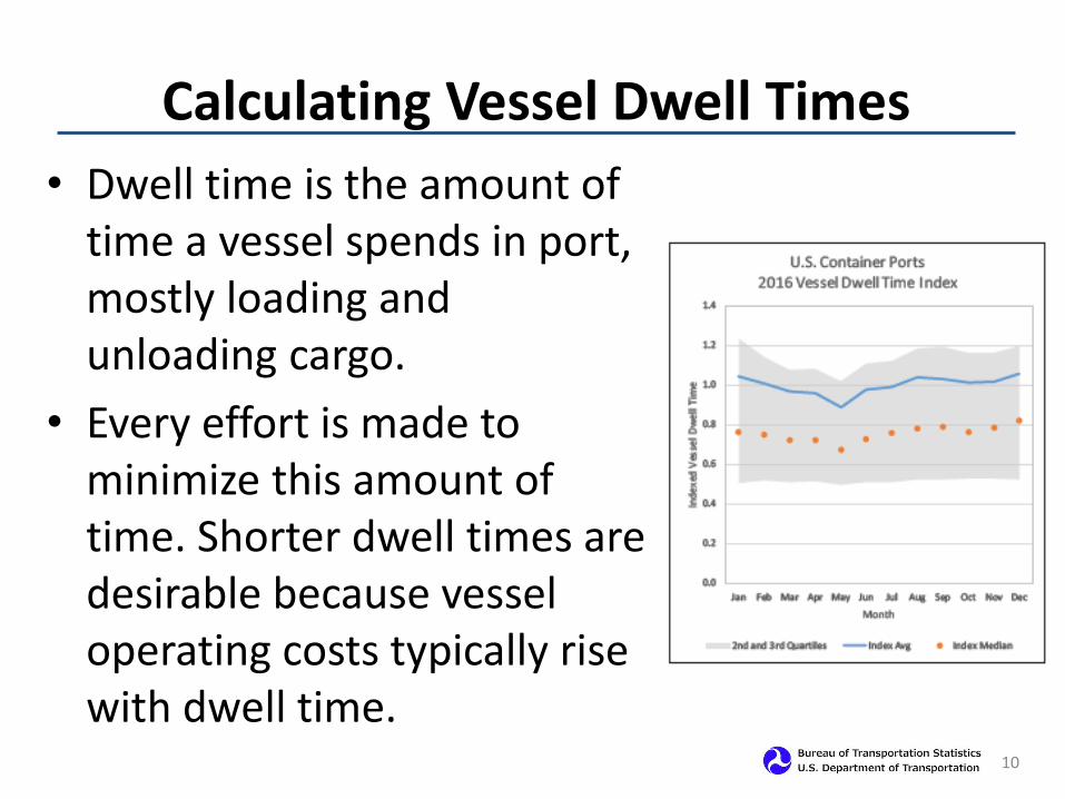
• Dwell time is the amount of time a vessel spends in port, mostly loading and unloading cargo.
• Every effort is made to minimize this amount of time. Shorter dwell times are desirable because vessel operating costs typically rise with dwell time.
Calculating Vessel Dwell Times
10

Dwell times for two out of five container vessels
are within a day of scheduled vessel call.
11 Source: Bureau of Transportation Statistics
0.4%
4.3%
37.8%
25.2%
11.9%
6.3%
3.3% 2.3% 1.8% 1.6% 1.4%
3.6%
0.0%
10.0%
20.0%
30.0%
40.0%
<4 4-8 8-16 16-24 24-32 32-40 40-48 48-56 56-64 64-72 72-80 80+
Shar
e o
f V
esse
l Cal
ls
Vessel Dwell Times in Hours

• Every two years BTS conducts a National
Census of Ferry Operators (NCFO).
• Using AIS data, BTS is able to map, calculate
distances, and visualize individual ferry
routes -- defined as the fixed route service
between passenger and vehicle ferry
terminals in the U.S. that service the public
road network.
AIS Application 2: Ferry Routes
12
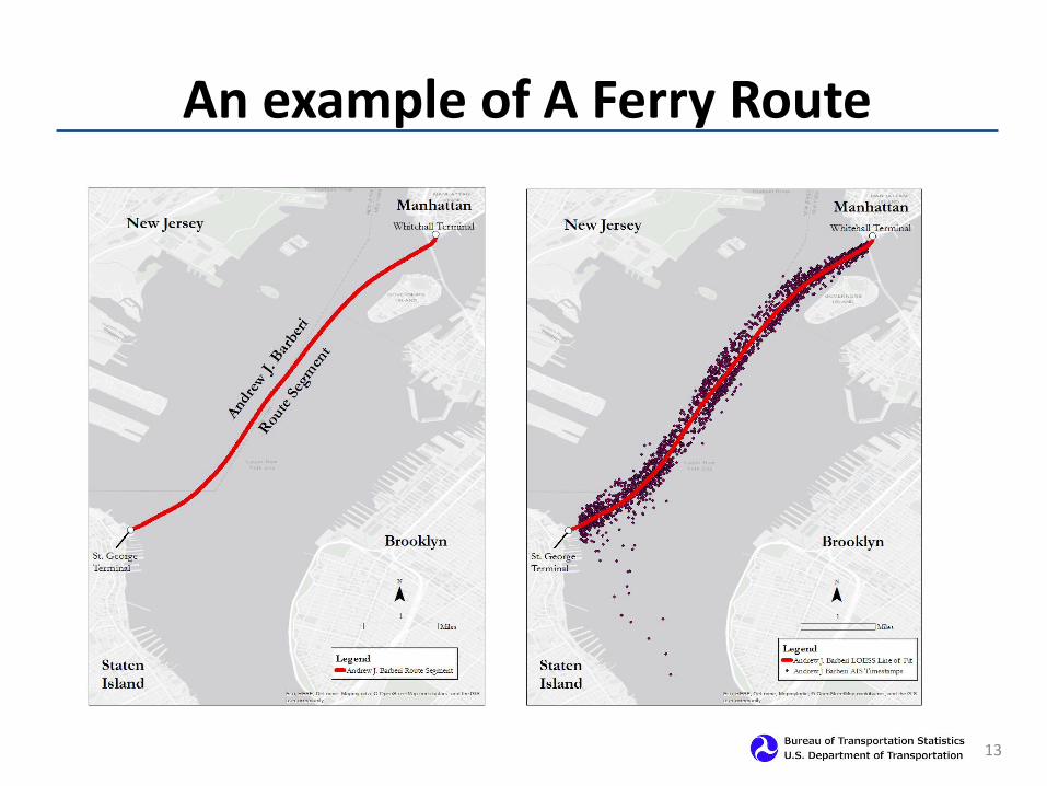
An example of A Ferry Route
13

Final segments are generated by smoothing the AIS data by using the LOESS regression model.
14

• Data Quality
– AIS messages are broadcast over very high frequency (VHF)
radio and can be subject to disruptions from terrain or weather
events.
– Not all AIS messages can be matched with external vessel
attribute systems.
– Some messages are manually entered by the users and could be
subject to keying errors.
• Area coverage
– Data gaps exist (e.g., May 2016 data for the Ports of Long Beach
and Los Angeles) due to system downtime.
Lessons Learned in Using AIS Data
15