avon-by-the-sea municipal public access plan - new jersey · the goals and objectives provided in...
TRANSCRIPT
DRAFT - NJDEP: MPAP Template 09092015
1
Avon-by-the-Sea Municipal Public Access Plan
Submitted by: Borough of Avon-by-the-Sea
Date of Current Submittal: Date
Approved by the New Jersey Department of Environmental Protection: Date of NJDEP approval
Adoption by the City:
Date will be added upon adoption
Prepared By: Name, title, agency, address, phone number

DRAFT - NJDEP: MPAP Template 09092015
2
Index Introduction xx I. Municipal Public Access Vision xx
II. Existing Public Access xx III. Community Needs Assessment xx IV. Implementation Plan xx V. Resolution of Incorporation xx
Appendix 1 Resolution for Incorporating MPAP into Master Plan xx Appendix 2 Tables xx Appendix 3 Recreation and Open Space Inventory xx Appendix 4 Sign Ordinance xx Appendix 5 Public Access Trust Fund Resolution xx Appendix 6 (if needed) xx
DRAFT - NJDEP: MPAP Template 09092015
3
Introduction
The intent of this document is to provide a comprehensive public access plan for the Avon-by-the-Sea which lays out a vision for providing access to tidal waters and shorelines within the municipal boundary. This Municipal Public Access Plan (MPAP) was developed in accordance with the Coastal Zone Management Rules at N.J.A.C. 7:7-16.9. The development and implementation of this MPAP supports the policy of local determination of public access locations and facilities, while safeguarding regulatory flexibility.
The Public Trust Doctrine, first set by the Roam Emperor Justinian around A.D. 500 as part of Roman civil law, establishes the public’s right to full use of the seashore. The Public Trust Doctrine states that natural resources, including, but not limited to, tidal waterways and their shores, air and wildlife in the State of New Jersey are held by the State in trust for the benefit of all of the people. Further, the Public Trust Doctrine establishes the right of the public to fully utilize these natural resources for a variety of public uses. The original purpose of the doctrine was to assure public access to waters for navigation, commerce and fishing. In the past two centuries, State and Federal courts in New Jersey have recognized that public uses guaranteed by the Public Trust Doctrine also include public recreational uses such as swimming, sunbathing, fishing, surfing, sport diving, bird watching, walking and boating along the various tidal shores. Through various judicial decisions, the right of use upheld by the Public Trust Doctrine has been incorporated into many state constitutions and statutes, allowing the public the right to all lands, water and resources held in the public trust by the state, including those in New Jersey. The New Jersey Department of Environmental Protection (NJDEP) adopted new rules governing public access on November 5, 2012 that enable municipalities to develop and adopt MPAPs to govern public access within their municipality. This MPAP consists of an inventory of public access locations and plans to preserve and enhance access based on community needs and State standards.
Authority for Municipal Public Access Plans
The premise of the authorization of MPAPs is that public access to tidal waters is fundamentally linked to local conditions. The development of a MPAP enables the municipality to better plan, implement, maintain, and improve the provision of public access for its residents and visitor. Also, it informs and/or identifies public access requirements associated with any proposed development or redevelopment project.
Avon-by-the-Sea is responsible for ensuring that public access to the tidal waters within the municipality is in accordance with this plan as approved by NJDEP and adopted as part of the municipal Master Plan. For each new project that is required to provide public access through a Department issued Coastal Area Review Act or Waterfront Development permit, Avon-by-the-Sea will provide NJDEP with a letter confirming its consistency with this MPAP. Upon adoption of this MPAP into the municipal Master Plan, NJDEP public access requirement shall be satisfied in accordance with this plan. Avon-by-the-Sea will submit a progress report documenting plan implementation to NJDEP every five (5) years after the date of plan adoption.

DRAFT - NJDEP: MPAP Template 09092015
4
I. Municipal Public Access Vision
A. Overview of Municipality
The Borough of Avon-by-the-Sea is a beautiful residential and recreational resort community located in the southeastern portion of Monmouth County along the Atlantic Ocean and Shark River. It is bound on the north by the Borough of Bradley Beach and on the south by the Borough of Belmar. It has a land area of about four-tenths of one square mile and approximately a half mile of oceanfront.
If you love the sea, Avon-by-the-Sea is the place for you. Avon is surrounded by three different bodies of water. To the north is Sylvan Lake, the quiet home of our famous swans. The southern border of town is the busy Shark River inlet where you can watch our drawbridges and a parade of boats come and go. On the east is the mighty Atlantic Ocean where you can enjoy the rolling surf, laughing gulls and gentle sea breezes.
Avon-by-the-Sea has much to offer vacationers and day visitors. Avon's clean, white sandy beaches are a great place to relax, swim and bask in the summer sun. Our fine restaurants and quaint shops will round out your "day at the beach." In the quiet seasons our non-commercial boardwalk, replete with Victorian lamps, benches and pavilions, is a wonderful place to stroll and unwind. Fishing, boating and scuba diving are year 'round activities in Avon-by-the-Sea.
1. Map 1. Avon-by-the-Sea Tidal Waterways and Lands Map 1 Shows all the tidal waterways within the municipality and all lands held by the municipality. Map 1: Avon-by-the-Sea Tidal Waterways and Lands

DRAFT - NJDEP: MPAP Template 09092015
5
B. Municipal Public Access Goals and Objectives
1. Goals & Objectives
i. Create and enhance open space along the waterfront for the enjoyment of its residents and seasonal visitors.
In addition to those goals outlined within the Master Plan, Avon-by-the-Sea establishes the following State required goals specifically for public access:

DRAFT - NJDEP: MPAP Template 09092015
6
ii. All existing public access shall be maintained to the maximum extent practicable. iii. Maintain safe and adequate access locations for fishing in those areas where fishing is
safe and appropriate. iv. Provide clear informative signage for access locations.
Avon-by-the-Sea Municipal Public Access Plan embraces and reflects these goals and will help preserve, protect, and enhance the public’s ability to access the Public Trust lands which surround the municipality. The previous goals are compliant with the New Jersey Coastal Zone Management Rules broad set of coastal protection goals (see N.J.A.C 7:7-1.1 (c)).
2. Municipal Master Plan Consistency
The goals and objectives provided in this Municipal Public Access Plan have been reviewed and are consistent with Avon-By-The-Sea Master Plan.
II. Public Access
A. Public Access Locations
Avon-by-the-Sea understands the importance of providing public access to the Atlantic Ocean and Shark River. This is why the Borough provides public access at every street end and at a variety of public facilities. These facilities include a boardwalk, marina, designated fishing locations, restrooms and life-guarded beaches. Map 2, Avon-by-the-Sea Public Access Locations, identifies an inventory of all the public access locations within the municipality. The majority of Avon-by-the-Sea’s existing public access locations are utilized by the public with the exception of five locations along Shark River. These locations are limited to visual access due to safety concerns associated with the bulkhead. Instead, the public is encouraged to fish along Shark River at the fishing jetty, NJ Department of Environmental Protection (NJ DEP) lot, and the Avon-By-The-Sea Riverfront Park and Marina.
Map 2 Avon-by-the-Sea Public Access Locations, identifies an inventory of all public access locations within Avon-by-the-Sea, whether they are currently Utilized, Un-utilized, or Restricted to the public, along with their attributes of improvements and activities. See Table 1, located in the Appendix, for detailed information for each location.

DRAFT - NJDEP: MPAP Template 09092015
7
B. Improved Public Access Locations
The Borough plans to enhance open space along tidal waterways and provide an enjoyable atmosphere for residents and seasonal visitors. The following locations are enhanced sites within the municipal boundary: Public access point numbers referenced below correspond to Maps 2 & 3. Avon-by-the-Sea Oceanfront

DRAFT - NJDEP: MPAP Template 09092015
8
The oceanfront is located along the east coast of the Borough. It provides ample access to the ocean with designated surfing, fishing and lifeguarded swimming areas. Beach badges are required during beach operational hours (9:00am – 5:30pm) throughout the summer months. Fishing is allowed outside of beach operational hours. Two restroom facilities are located on the boardwalk at Lincoln Ave, point 12, and Norwood Ave, point 16. The Boardwalk The boardwalk, points 9-16, stretches along the Borough’s boundary along the Atlantic Ocean, from Norwood Avenue to south of Washington Avenue, as shown in Maps 3. The boardwalk provides visual and physical access to the oceanfront while providing additional access to other enhanced public access locations. The boardwalk amenities include:
• Benches • Trash receptacles • Recycling Bins • Bike racks • Showers • Water fountains • Gazebos • Avon Assembly Pavilion • Restroom facilities • Restaurant with takeout counters • Victorian style lights
Figure 1: Avon-by-the-Sea Boardwalk, located on Ocean Avenue.
DRAFT - NJDEP: MPAP Template 09092015
9
Restroom facilities are located on the boardwalk at Lincoln Ave, point 12, and Norwood Ave, between points 15 and 16, on Map 2 & 3. Handicap accessible ramps onto the boardwalk are located at the following streets:
• Washington Avenue • Lincoln Avenue • Garfield Avenue • Sylvania Avenue • Woodland Avenue • Norwood Avenue
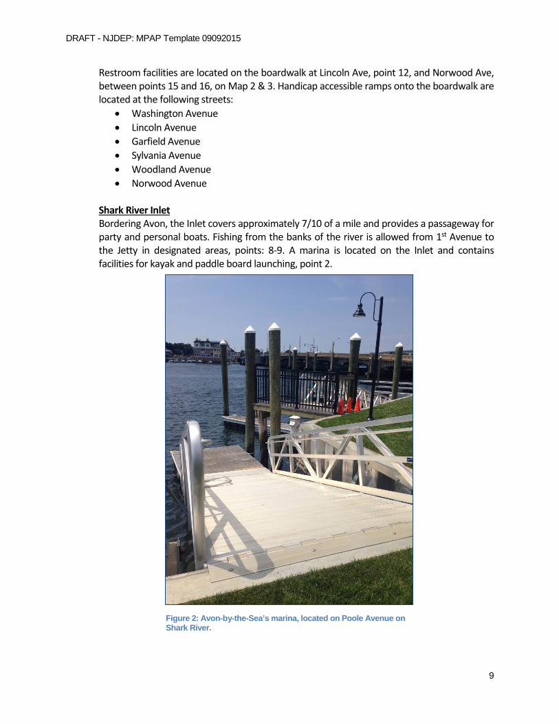
Shark River Inlet
Bordering Avon, the Inlet covers approximately 7/10 of a mile and provides a passageway for party and personal boats. Fishing from the banks of the river is allowed from 1st Avenue to the Jetty in designated areas, points: 8-9. A marina is located on the Inlet and contains facilities for kayak and paddle board launching, point 2.
Figure 2: Avon-by-the-Sea’s marina, located on Poole Avenue on Shark River.
DRAFT - NJDEP: MPAP Template 09092015
10
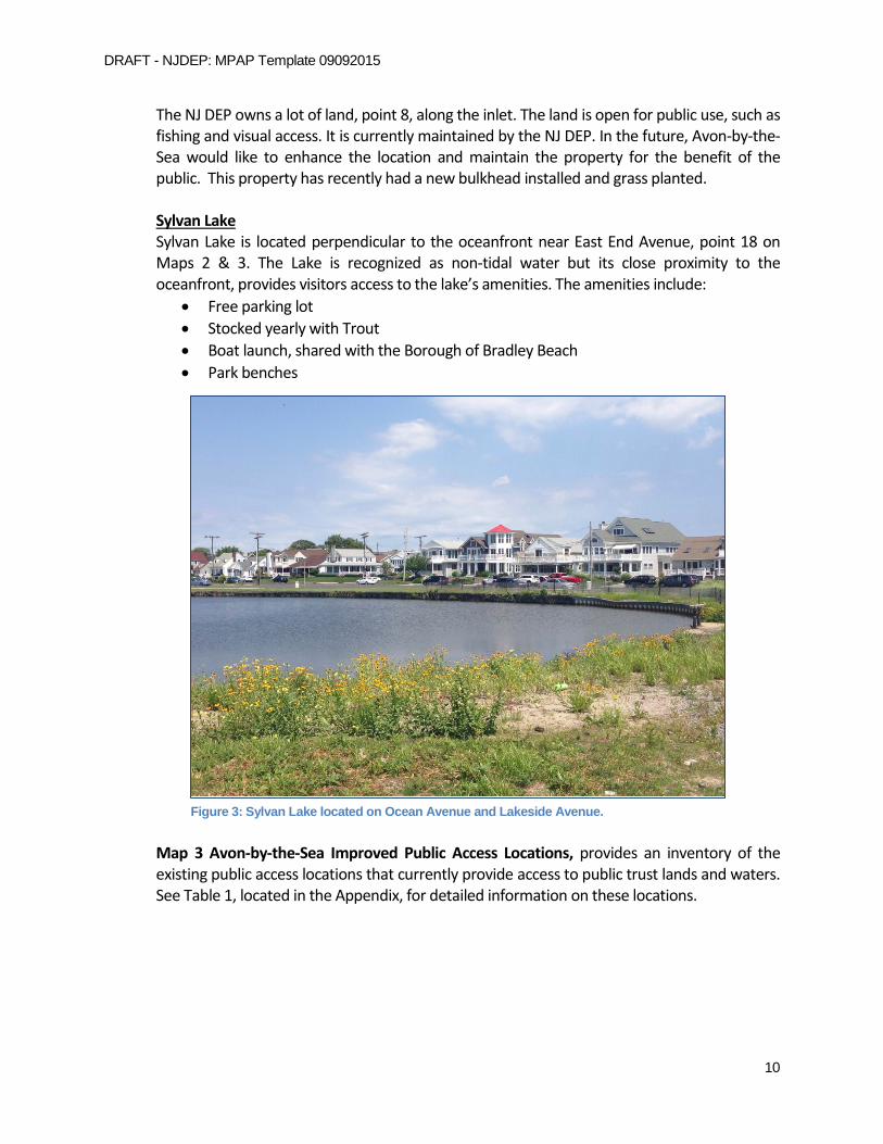
The NJ DEP owns a lot of land, point 8, along the inlet. The land is open for public use, such as fishing and visual access. It is currently maintained by the NJ DEP. In the future, Avon-by-the-Sea would like to enhance the location and maintain the property for the benefit of the public. This property has recently had a new bulkhead installed and grass planted. Sylvan Lake Sylvan Lake is located perpendicular to the oceanfront near East End Avenue, point 18 on Maps 2 & 3. The Lake is recognized as non-tidal water but its close proximity to the oceanfront, provides visitors access to the lake’s amenities. The amenities include:
• Free parking lot • Stocked yearly with Trout • Boat launch, shared with the Borough of Bradley Beach • Park benches
Map 3 Avon-by-the-Sea Improved Public Access Locations, provides an inventory of the existing public access locations that currently provide access to public trust lands and waters. See Table 1, located in the Appendix, for detailed information on these locations.
Figure 3: Sylvan Lake located on Ocean Avenue and Lakeside Avenue.

DRAFT - NJDEP: MPAP Template 09092015
11
Oceanfront View:

DRAFT - NJDEP: MPAP Template 09092015
12
River View:
C. Limitations to Public Access The following limitations to public access currently exist:
1. Temporary Restrictions i. No person is allowed on the beach after the hour of 12:00 midnight, other than
those persons who are actively engaged in surf fishing. ii. Fishing along the beachfront is restricted during beach operational hours through
the seasonal months. iii. Public access of the Avon Assembly Pavilion, located on the boardwalk and south of
Norwood Avenue, is restricted from use during schedule events. iv. Bathing along the beachfront is at the discretion of the Beachfront Supervisor to
the designated bathing beaches where lifeguards are provided. v. Surfing is restricted to designated beaches.
2. Permanent Restrictions
i. Fishing is restricted in the waters of Shark River from any public street, bridge, or thoroughfare, nor from the bulkheads at the following locations:

DRAFT - NJDEP: MPAP Template 09092015
13
a. First Avenue abutting Shark River b. Second Avenue abutting Shark River c. Third Avenue abutting Shark River d. Fourth Avenue abutting Shark River e. River Avenue abutting Shark River f. Fifth Avenue abutting Shark River
III. Community Needs Assessment
Avon-By-The-Sea has performed a community needs assessment. The methods and results are described in the following section:
A Community Needs Assessment was conducted to evaluate Avon-By-The-Sea’s available public access to the Atlantic Ocean, and Shark River. Site visits were conducted at each public access location, which evaluated the following characteristics:
1. Parking 2. Badge Requirement 3. Perpendicular access 4. Existing water dependent and water oriented activities 5. Handicap accessibility 6. Enhancements, such as:
a. Launch b. Marina c. Food and Drinks d. Restroom facilities e. Playground
The Community Needs Assessment indicated the town has 18 public access locations, 13 of which are utilized, and provide ample water oriented activities, parking, and perpendicular access to the tidal waterways and their shores. Due to the size of the town, the Needs Assessment indicated the Borough has enough restroom facilities and handicap locations along the oceanfront. The restroom facilities are located on the boardwalk at Lincoln Ave, point 12, and Norwood Ave, point 16. There is one restroom facility along Shark River, located at the marina. It would be beneficial for the town to install a portable restroom facility at the NJ DEP lot or along the fishing jetty. The handicap accessibility in Avon-by-the-Sea includes 6 ramped entrances, 3 restrooms facilities, beach wheel chairs, and 11 locations with reserved parking. The municipality has public access signage at all of existing locations along the oceanfront except Lincoln Lane, point 11. There is no direct access to the boardwalk from this location; however, the boardwalk can be accessed from the streets north and south of the site. Therefore, no signage is necessary. Along the riverside, signage is needed at the NJ DEP lot.

DRAFT - NJDEP: MPAP Template 09092015
14
Public access along Shark River, points 3-7, is limited to visual access due to safety concerns. No fishing signage is posted at each site. The Borough understands the importance of providing ample water oriented activities, and encourages the public to visit other enhanced locations along the river. Nearby enhanced locations include the marina, the NJ DEP lot, and the fishing jetty.
The increase in seasonal population has warranted an expansion of current facilities throughout the community. Parking during the summer months is limited due to the high influx of seasonal visitors. The public is encouraged to park in the parking lot on Lakeside Avenue, or use the street parking perpendicular to the oceanfront.
The Borough operates and maintains all of the beaches, street ends, jetty, pavilions, boardwalk, and restrooms. The public access locations and their amenities are listed in Appendix 3, Table 1.
IV. Implementation Plan
Avon-By-The-Sea has created an Implementation Plan composed of Priorities, Preservation of Public Access Locations, Signage, Proposed Access Improvements and Facilities, and Municipal Tools for Implementation as described in the following section:
A. Priorities Avon-By-The-Sea developed the following priorities:
1. Maintain Existing Public Access The Borough of Avon-by-the-Sea provides ample public access perpendicular to the Atlantic Oceanfront, and Shark River Inlet. The Borough will continue to manage and maintain existing sites in order to provide the public with optimal access along the tidal waterways.
a. Tools Avon-by-the-Sea maintains their beaches and dunes through a general permit from the Department. The permit allows the Borough to perform routine beach and dune maintenance. Maintenance to entrances is conducted with in house personnel on an annual and as needed basis.
b. Cost and Funding Funding for this maintenance is derived from beach fees and municipal taxes.
2. Preserving Public Access Avon-by-the-Sea’s public access identified in this plan will be preserved perpetuity through:
a. Tools

DRAFT - NJDEP: MPAP Template 09092015
15
Maintenance to entrances is conducted with in house personnel on an annual and as needed basis.
b. Cost and Funding Funding for this maintenance is derived from beach fees and municipal taxes.
3. Proposed Locations and Facilities The following are potential public access improvements that are not required, however may be considered for future implementation as determined by the Community Needs Assessment:
1. Physical improvements to the NJ DEP lot, point 8, along the Shark River. Currently the location is owned and maintained by the State. The lot is ideal for residents and visitors to access the inlet for nature viewing, crabbing and fishing. Avon-by-the-Sea would like to enhance and maintain the site through the addition of, but not limited to, benches, signage, picnic tables, lighting, bike racks, portable restroom facilities, and fish cleaning stations.
2. Approved signage along the oceanfront and inlet. 3. Fish-cleaning stations along Shark River.
a. Tools
Figure 4: New Jersey Department Environmental Protection lot located on First Avenue.

DRAFT - NJDEP: MPAP Template 09092015
16
Once an agreement has been reached rules and ordinances for the use of the property will be developed.
b. Cost and Funding As funding becomes available, the current needs of the town will be assessed to determine what proposed activity will be targeted.
B. Signage The Borough of Avon-by-the-Sea has signage indicating residents and visitors of public access to tidal waterways and their shoreline. Signs are currently located along the oceanfront; however some signage is needed along the riverside to sufficiently accommodate the public. Avon has provided the following signage:
• Signage identifying the rules of certain areas including the boardwalk, bridges, marina and beaches.
• Public Access identification along the oceanfront. • Fishing restrictions • Public Access identification at the marina. • Other miscellaneous signage.
As funding becomes available, Avon-by-the-Sea will implement new signage or improve existing.

DRAFT - NJDEP: MPAP Template 09092015
17
C. Army Corps of Engineers Requirements for Shore Protection Projects Avon-by-the-Sea has met the ACOE Requirements as follows: 1. The beach berm is maintained in accordance with the Engineering and Design Prescribed Procedures for the Maintenance and Operation of Shore Protection Works document provided by the U.S. Army Corps of Engineers. Click here to enter text.
V. Relationship to the Other Regional and State Plans Avon-by-the-Sea MPAP has been reviewed for consistency and has the following relationship to other Regional and State Plans: Click here to enter text.
VI. Resolution of Incorporation
Avon-by-the-Sea has approved a resolution for the incorporation of the MPAP. See Appendix 1 for the resolution. Click here to enter text.
DRAFT - NJDEP: MPAP Template 09092015
18
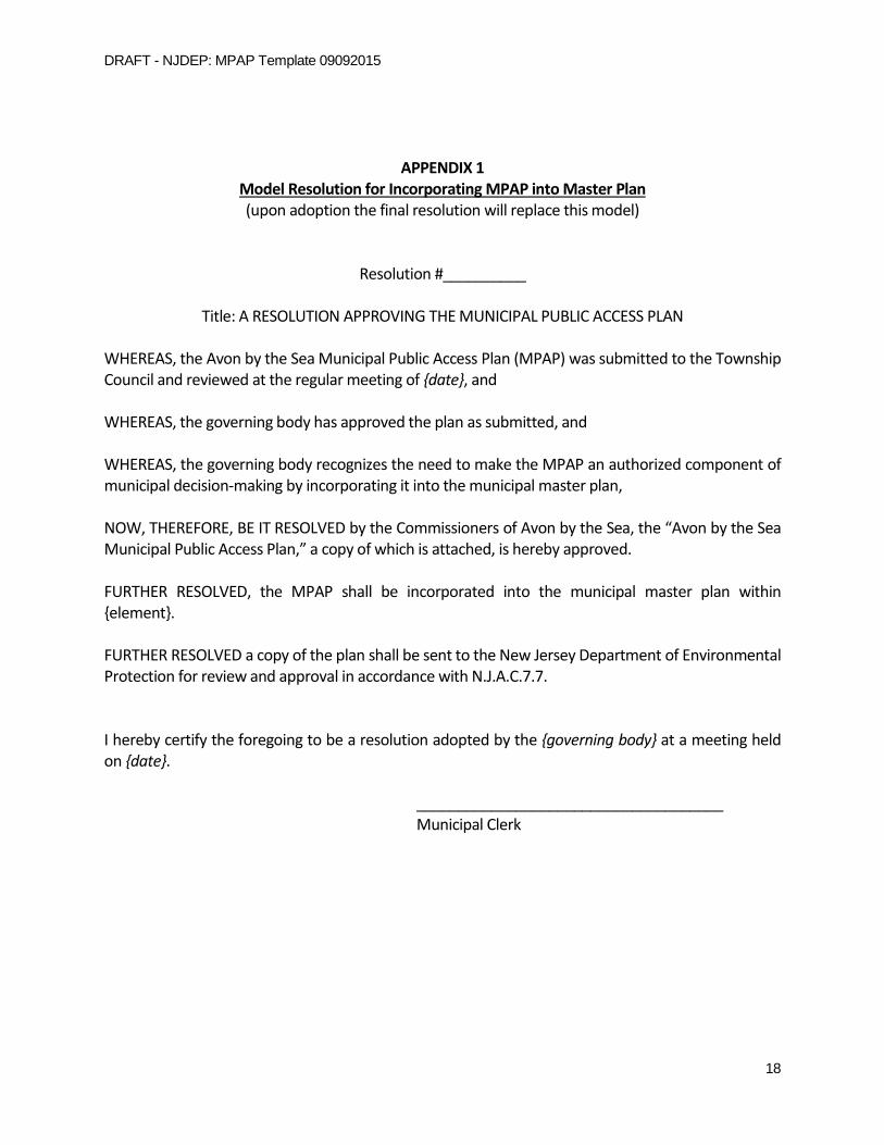
APPENDIX 1 Model Resolution for Incorporating MPAP into Master Plan (upon adoption the final resolution will replace this model)
Resolution #__________
Title: A RESOLUTION APPROVING THE MUNICIPAL PUBLIC ACCESS PLAN
WHEREAS, the Avon by the Sea Municipal Public Access Plan (MPAP) was submitted to the Township Council and reviewed at the regular meeting of {date}, and WHEREAS, the governing body has approved the plan as submitted, and WHEREAS, the governing body recognizes the need to make the MPAP an authorized component of municipal decision-making by incorporating it into the municipal master plan, NOW, THEREFORE, BE IT RESOLVED by the Commissioners of Avon by the Sea, the “Avon by the Sea Municipal Public Access Plan,” a copy of which is attached, is hereby approved. FURTHER RESOLVED, the MPAP shall be incorporated into the municipal master plan within {element}. FURTHER RESOLVED a copy of the plan shall be sent to the New Jersey Department of Environmental Protection for review and approval in accordance with N.J.A.C.7.7. I hereby certify the foregoing to be a resolution adopted by the {governing body} at a meeting held on {date}.
_____________________________________
Municipal Clerk

DRAFT - NJDEP: MPAP Template 09092015
19
20
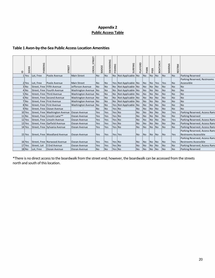
Appendix 2 Public Access Table
Table 1 Avon-by-the-Sea Public Access Location Amenities
*There is no direct access to the boardwalk from the street end; however, the boardwalk can be accessed from the streets north and south of this location.
ID SIG
NS
PARK
ING
STRE
ET
CRO
SS_S
TREE
T
BADG
E
SWIM
MIN
G
FISH
ING
SURF
ING
PLAY
GRD
PARK
PIER
BOAT
LNCH
MAR
INA
REST
RM
1 Yes Lot, Free Poole Avenue Main Street No No No Not Applicable No No No No No No Parking Reserved
2 Yes Lot, Free Poole Avenue Main Street No No Yes Not Applicable No No No Yes Yes NoParking Reserved, Restrooms Accessible
3 No Street, Free Fifth Avenue Jefferson Avenue No No No Not Applicable No No No No No No No4 No Street, Free Fourth Avenue Washington Avenue No No No Not Applicable No No No No No No No5 No Street, Free Third Avenue Washington Avenue No No No Not Applicable No No No No No No No6 No Street, Free Second Avenue Washington Avenue No No No Not Applicable No No No No No No No7 No Street, Free First Avenue Washington Avenue No No No Not Applicable No No No No No No No8 No Street, Free First Avenue Washington Avenue No No Yes Not Applicable No No No No No No No9 No Street, Free Ocean Avenue - No No Yes No No No No No No No No
10 Yes Street, Free Washington Avenue Ocean Avenue Yes Yes Yes No No No No No No Yes Parking Reserved, Access Ramp 11 No Street, Free Lincoln Lane** Ocean Avenue Yes Yes Yes No No No No No No No Parking Reserved 12 Yes Street, Free Lincoln Avenue Ocean Avenue Yes Yes Yes No No No No No No Yes Parking Reserved, Access Ramp 13 Yes Street, Free Garfield Avenue Ocean Avenue Yes Yes Yes No No No No No No No Parking Reserved, Access Ramp 14 Yes Street, Free Sylvania Avenue Ocean Avenue Yes Yes Yes No No No No No No No Parking Reserved, Access Ramp
15 Yes Street, Free Woodland Avenue Ocean Avenue Yes Yes Yes Yes No No No No No YesParking Reserved, Access Ramp Restrooms Accessible
16 Yes Street, Free Norwood Avenue Ocean Avenue Yes Yes Yes No No No No No No YesParking Reserved, Access Ramp Restrooms Accessible
17 Yes Street, Lot E End Avenue Ocean Avenue Yes Yes Yes No No No No No No No Parking Reserved, Access Ramp 18 No Lot, Free Ocean Avenue Ocean Avenue No No Yes No No No No No No No Parking Reserved
21
APPENDIX 3 Recreation and Open Space Inventory
[include here if applicable]
APPENDIX 4 Sign Ordinance
[include here if applicable]
APPENDIX 5 Public Access Trust Fund Resolution
(upon adoption the final resolution will replace this model) [include here if applicable]