background document for tranquille wildlife management area · 2020-06-12 · “an area where...
TRANSCRIPT

Tel. (250) 578-7542 Cell (250) 371-2551 Fax (250) 578-7543 E-mail: [email protected]
environmental services for sustainable development
Aspen Park Consulting 4898 Spurraway Road
Kamloops BC V2H 1M6
Background Document For
Tranquille Wildlife Management Area
Prepared by
Rick Howie RP Bio
March 2007

Aspen Park Consulting Page - 2

Aspen Park Consulting Page - 3
Table of Contents
1.0 Introduction ........................................................................................................................ 4
2.0 Establishment and Administration .................................................................................... 4
3.0 Planning Direction Statements ....................................................................................... 10
4.0 Natural Resources ........................................................................................................... 14
5.0 History of Use ................................................................................................................. 67
6.0 Existing Tenures .............................................................................................................. 69
7.0 Research and Monitoring ................................................................................................ 74
8.0 Adjacent Land Use .......................................................................................................... 74
9.0 Recreational Activities in the Area ................................................................................. 76
10.0 Interests of Adjacent Landowners .................................................................................. 77
11.0 Stakeholders .................................................................................................................... 77
12.0 Key Management Issues and Opportunities .................................................................. 79
13.0 Data Gaps for Management ........................................................................................... 82
14.0 Potential Partnerships ...................................................................................................... 85
References and Citations ................................................................................................ 86
World Wide Web References ........................................................................................ 91
Personal Communications ............................................................................................. 91
List of Figures
Figure 2.2.1 Addition to WMA .......................................................................................8
Figure 2.5.1 Boundaries of Tranquille Wildlife Management Area ................................9
Figure 4.2.1 Deglaciation With Tranquille Under Ice Sheet .........................................18
Figure 4.2.2 Deglaciation With Larger Lake Thompson ...............................................18
Figure 4.2.3 Deglaciation With Tranquille Under Lake Thompson ..............................19
Figure 4.2.4 Deglaciation at Lake Deadman Stage ........................................................19
Figure 4.2.5 Deglaciation at Durand Stage of Lake Deadman ......................................20
Figure 4.2.6 Deglaciation at Cherry Creek Stage of Kamloops Lake ...........................20
Figure 4.5.1 BEC Units in the Kamloops Area .............................................................41
Figure 4.6.1.1 Location Map for Sphemopholis obtusata .................................................43
Figure 6.1.1 Frolek Cattle Co. Grazing Tenure Area ....................................................70
Figure 8.1 Resort Plan.................................................................................................75
Figure 12.1 Frontage Road Development .....................................................................81
Figure 12.2 Frontage Road Boundary ...........................................................................82
List of Tables
Table 3.5.1 Recommendations from Wildlife Viewing Plan and Current Status ............... 13
Table 4.1.1 Temperatures ..................................................................................................... 16
Table 4.1.2 Precipitation ........................................................................................................ 16
Table 4.1.3 Sunshine .............................................................................................................. 16
Table 4.1.4 Wind .................................................................................................................... 16
Table 4.4.1.1 Highest Water Levels Recorded for South Thompson River ........................... 21
Table 4.4.2.1 Maximum Elevations for Kamloops Lake 1979-1995 ..................................... 24
Table 4.4.2.2 Monthly Water Levels – Kamloops Lake 1978-1996 ...................................... 25
Table 4.6.1 Tranquille Plant Species List............................................................................... 44

Aspen Park Consulting Page - 4
Table 4.6.2 Additional Plant Species Recorded in Tranquille WMA .................................. 46
Table 4.7.1 Mammals Observed Within Tranquille Wildlife Management Area ............... 47
Table 4.7.2 Mammals Observed Near Tranquille Wildlife Management Area ................... 47
Table 4.7.3 Mammals That Could Occur Near Tranquille Wildlife Management Area ..... 48
Table 4.8.1 Birds Recorded Within Tranquille Wildlife Management Area ....................... 50
Table 4.8.1.1 Birds of Conservation Concern ........................................................................... 58
Table 4.10.1 Reptiles of Tranquille Wildlife Management Area ........................................... 63
Table 4.11.1 Potential Fishes of Tranquille Wildlife Management Area ............................... 64
Table 14.1 Potential Partners and Project Matching ............................................................ 86
List of Charts
Chart 4.4.1.1 1948 Flood Flows – Kamloops Lake ......................................................22
Chart 4.4.1.2 1972 Flood Flows – Kamloops Lake ......................................................23
Chart 4.4.1.3 Water Level Trend at Kamloops 1910 – 2000 ......................................23
Chart 4.4.2.1 Kamloops Lake Annual Peak Water Levels 1974-1994 .......................25
Chart 4.4.3.1 Total Alkalinity .......................................................................................29
Chart 4.4.3.2 Total Aluminum ......................................................................................29
Chart 4.4.3.3 Total Organic Carbon..............................................................................30
Chart 4.4.3.4 Dissolved Chloride ..................................................................................30
Chart 4.4.3.5 Total Copper ...........................................................................................31
Chart 4.4.3.6 Fecal Coliforms .......................................................................................32
Chart 4.4.3.7 Fecal Coliforms .......................................................................................32
Chart 4.4.3.8 Hardness ..................................................................................................33
Chart 4.4.3.9 Total Iron.................................................................................................33
Chart 4.4.3.10 Total Molybdenum ..................................................................................34
Chart 4.4.3.11 Dissolved Oxygen ...................................................................................34
Chart 4.4.3.12 pH Values ...............................................................................................35
Chart 4.4.3.13 Total Dissolved Phosphorous..................................................................36
Chart 4.4.3.14 Total Phosphorous...................................................................................36
Chart 4.4.3.15 Filterable Residue ...................................................................................37
Chart 4.4.3.16 Non-filterable Residue ............................................................................38
Chart 4.4.3.17 Turbidity..................................................................................................38
Chart 4.4.3.18 Water Temperature .................................................................................39
Chart 4.4.3.19 Total Zinc ................................................................................................39
List of Photos
Photo 6.1.1.1 Part of DL 341, March 20, 2007 .............................................................71
Photo 6.1.1.2 Western Portion of DL 341, March 20, 2007 .........................................71
Photo 8.1 Dyke with Lot 341 on right and city lands on left, March 20, 2007 ......76

Aspen Park Consulting Page - 5
1.0 Introduction
This document is intended to provide a compact source of information about the Tranquille Wildlife
Management Area which will aid in the preparation of a management plan for the site. It is both a
summary of known information as well as a source to identify gaps in knowledge. It is based upon
searches of ministry files, existing planning documents, past field studies, random observations of
wildlife by a variety of citizens and personal interviews with knowledgeable people.
2.0 Establishment and Administration
2.1 Legal Definition, Uses and Prohibitions of Wildlife Management Areas
Part 1 Sec. 4 of the British Columbia Wildlife Act empowers the Minister to designate “Wildlife
Management Areas” (hereafter WMA). There are 22 such areas in British Columbia. The definition
of a WMA in the act is simply “land designated as a wildlife management area.” Land within a
WMA can be further designated as a “wildlife sanctuary” which is similarly defined as “land
designated as a wildlife sanctuary,” Land may also be designated as a “critical wildlife area” within
a WMA if it is necessary to protect a threatened or endangered species. Neither of these two
additional designations has occurred at Tranquille. Before it can be designated as a WMA, the land
must be under the administration of the ministry.
If land has previously been designated as a park, the minister does not have authority to designate a
WMA. In the case of Tranquille, the park designation occurred after the WMA was created. Land
designated as a WMA does not affect any previously granted rights (Sec. 4:3). Despite any other
enactments, no person may use the land or resources within a WMA without the written permission
of the Regional Manager (Sec 4:4).
The Wildlife Act is silent regarding the actual purposes of a WMA or a wildlife sanctuary, but the
Ministry website provides a statement of purpose for a WMA as:
“an area where conservation and management of wildlife, fish and their habitats is the priority land
use but other uses may be permitted.”
The killing of wildlife within a wildlife sanctuary is specifically prohibited .
Sec. 7(1) of the Wildlife Act makes it an offence for any person to damage, alter or deposit a
harmful substance on wildlife habitat within a WMA, except by regulation or permit. Sec. 7(4)
allows a regional manager to make orders to control the following activities:
(a) entering,
(b) cutting, picking, removing, altering, destroying or damaging vegetation in,
(c) disturbing or harassing wildlife in,
(d) releasing or abandoning an animal in, and
(e) allowing an animal to enter a wildlife management area, a critical wildlife area or a wildlife
sanctuary.

Aspen Park Consulting Page - 6
Sec. 7(5) makes it an offence to contravene such orders. Sec. 8 allows the government to take action
against an offender in order to recover costs associated with the rehabilitation of damaged habitat or
the value of habitat permanently lost. Sec. 79(2) allows a conservation officer to kill dogs found
running loose in a WMA. Sec. 108: 2(b) allows for the creation of regulations governing the use and
occupation of WMAs.
Under schedule 3 of the regulations, the Tranquille WMA has been declared a “no shooting or
hunting area” within the following legal boundaries:
Commencing at the northeast corner of Lot 341; thence southerly then easterly following the fence
line to the southeast corner of Lot 341 at the low water mark; thence westerly following the
shoreline at the low water mark to the southwest corner of the Tranquille Wildlife Management
Area on the lakeshore at low water mark; thence northerly and easterly along the western and
northern boundary of the Tranquille Wildlife Management Area following the Tranquille and Red
Lake road right of way to the point of commencement.
2.2 History of Tranquille Designation
On April 21, 1926, a Game Reserve was established by Order-in-council #430. Details of that order
and the boundaries of this reserve were not available at the time of writing this report. On August 5,
1943, the Executive Council recommended to the Lieutenant Governor in Council recommended
that the order establishing the 1926 game reserve be rescinded and a new order under Sec. 68 of the
“Game Act” be created to establish the Tranquille Game Reserve. Its boundaries were to be as
follows:
That parcel or tract of land in the Kamloops Electoral District commencing at the junction of the
south boundary of the right-of-way of the Canadian National Railway and Tranquille River; thence
along the west bank of the said river to its mouth; thence in a southerly and easterly direction along
the actual shoreline of Kamloops Lake for a distance of approximately one mile to a white marker;
thence in a northeasterly direction in a straight line along which white boundary markers have been
placed to the east boundary of lot 342,Group 1, Kamloops Division of Yale District; thence
following along the said boundary of lot 342 in a northerly direction to the southern boundary of the
right-of-way of the Canadian National Railway; thence in a westerly direction along the said
railway to the point of commencement.”
It seems that this order was passed which meant that all of the grounds and buildings of the
Tranquille institution were in the game reserve. Legislative changes to the Game Act resulted in the
term “game reserve” disappearing and along with it, the designation at Tranquille. It is believed that
there was never a formal abandonment of the original reserve (Ritcey, pers com.). Dates for these
latter changes were not researched.
Prior to 1965, land between lots 341, 342 and 343 had been crown granted but were ultimately
conveyed to the provincial government for the Tranquille Sanatorium Reserve under the Ministry of
Agriculture. On March 17, 1965, a letter from L. King, Tranquille Farm Foreman recommended
that lot 341 and the intervening area next to lot 342 be placed in the name of the Ministry of
Agriculture. This intervening area now forms part of the WMA.

Aspen Park Consulting Page - 7
In 1967, Robert and William Gaglardi under the name of Karobil Enterprises applied to lease 1500
acres of foreshore that were part of lots 341, 342 and 343. The plan was to dyke and develop the
property. According to a letter written by B. Beblo, Technical Assistant in the Land Management
Branch (1967), the Director of Lands disallowed the application because:
1. all of lot 341 was required for hay and pasture use by the Tranquille institution
2. flooding was anticipated
3. dyking would adversely affect the river flow pattern
4. Fish & Wildlife Branch was opposed because of waterfowl values
5. the Beef Cattle Growers Association and the District Fish & Game Club were opposed
In November 1971, the District of Brocklehurst applied for lot 341 for recreational purposes but
opposition resulted in denial of this application.
The value of the Tranquille area had been recognized by the earlier designations for wildlife
purposes, but with the disappearance of the older classifications the land was once again in need of
more protection. The concept of designating Tranquille as a Wildlife Management Area was
advanced by Ralph Ritcey soon after legislation was passed that created this new classification of
land use. Ritcey was the Senior Wildlife Biologist in the Kamloops office of the Fish and Wildlife
Branch, Ministry of Environment. Background work to achieve this goal was undertaken by Phil
Holman in the Habitat Protection Section of the same ministry and office. Support for this
designation was recommended by the Lac du Bois – Dewdrop Crown Land Plan.
The creation of the WMA was achieved in stages with 253 ha. of the WMA being designated on
June 12, 1987 under Wildlife Management Area Regulation noted as BC Reg. 161/87. The Order-
in-Council that passed was O.C. 1154/87.
The legal description is as follows:
Those lands and foreshore enclosed by a line commencing at the south western corner of Lot
A, G.2 (Lytton) proceeding easterly along the southern boundary (the dyke) of said Lot to a
point made with the intersection of the southward extension of the western boundary of
Section 20, Township 20, Range 18, W6M, hence 3219 meters on a bearing of 283 degrees
true, then 553 meters on a bearing of 345 degrees true, hence 415 meters on a bearing of 40
degrees true to a point on the high water mark of Lot 342, G.1, K.D.Y.D., hence easterly along
the boundary of L342 to the southeast corner of L342, hence northerly along the east boundary
of L342 to the embankment of Road 4743 (Tranquille Road), hence easterly along the
embankment of Road 4743 to the intersection of the northern boundary of Lot 341, G.1,
K.D.Y.D., hence westerly, southerly and easterly along the boundary of the said Lot to the
point of commencement, as shown in red on the attached 1:20 000 map.
A narrow strip of 1.276 hectares below the road in front of the institution buildings was added
in 1991 by Ministerial Order M30040 which amended Ministerial Order 30007
(Figure 2.2.1). In 1987, a Land Act Sec. 12 reserve was placed over this area as a holding
mechanism pending survey of the area and ultimate disposition to the Ministry of
Environment. The ministry was given permission to manage the area as if it were part of the
WMA. In a letter dated May 14, 1990, Peter Walters of the then BC Lands indicated that a
resurvey of the road to a maximum width of 25 metres measured from the existing north
boundary would put the south boundary of the road near the toe of the slope of the road instead

Aspen Park Consulting Page - 8
of following the natural boundary of the lake. Everything lakeward of the new boundary would
become part of the WMA. It was intended to complete the survey of this area and turn it over
to the Ministry of Environment, which ultimately happened in 1991.
Lot 341, comprising 35 hectares, was not added to the WMA but is included within the Lac du
Bois Grasslands Protected Area boundaries. The WMA was included within the boundaries of
the protected area when the area was created by Order-in Council on April 30, 1996. Under a
Memorandum of Agreement with BC Parks, the Fish and Wildlife section of the ministry is
responsible for managing the WMA.
2.3 Mining
There is a No Staking Reserve in place.
2.4 Hunting
Under schedule 3 of the Wildlife Act regulations, the Tranquille WMA has been declared a “no
shooting or hunting area.”

Aspen Park Consulting Page - 9
Figure 2.2.1 Addition to WMA
2.5 Location and Size of Tranquille Wildlife Management Area
The Tranquille WMA is located within the municipal boundaries of the city of Kamloops
approximately 13 km west of the city centre. The WMA occupies part of the northwest corner
of the floodplain of the Thompson River as it enters Kamloops Lake. Tranquille River (aka
Tranquille Creek) enters the lake near the northwestern boundary of the WMA. The elevation
is approximately 343m above sea level. The WMA totals 254.2 hectares following the
subsequent addition to the original 253 hectares.
Lands immediately to the northwest were once part of a government institution that initially
served as a sanatorium for tuberculosis patients and ultimately as a home for persons with
mental disabilities which closed in 1984. The property and buildings were sold to private
interests and total about 540 hectares. The current owner is BC Wilderness Tours and they are

Aspen Park Consulting Page - 10
in the planning stages for a resort and housing complex on the site. The City of Kamloops
owns the land immediately to the east of the WMA. A composting facility currently occupies
part of the site while the rest of the area is devoted to the growing of hay using treated sewage
effluent and referred to as the Cinnamon Ridge Spray Irrigation Project. One private residence
is located just east of the WMA as well. The Kamloops municipal airport is located east of the
city hay lands and about 3 kilometres due east of the WMA. To the north, there is a right of
way for Tranquille Road, and north of that are the private lands of the Canadian National
Railway. North of the railway, all lands lie within Lac du Bois Grasslands Protected Area.
Figure 2.5.1 Boundaries of Tranquille Wildlife Management Area
2.6 Statutory Jurisdictions
The Tranquille Wildlife Management Area was established under the Wildlife Act and subsequently
incorporated into a protected area which is subject to the Park Act. This appears to be a unique
situation. It is likely that both acts apply to the WMA, so that regulatory processes such as
approving non-conforming uses for example, may require both a letter of approval from the
Regional Manager as well as a Park Use Permit. Fisheries and Oceans Canada have jurisdiction over
fisheries habitat management along the Thompson River and Kamloops Lake and this authority
extends into the WMA and protected area. Tranquille Road immediately north of the WMA is a
dedicated road administered by the City of Kamloops. First Nations groups may desire co-
management options such that appropriate consultation should be undertaken.

Aspen Park Consulting Page - 11
3.0 Planning Direction Statements
3.1 First Management Statement
In the early 1980s, Ritcey prepared the first management direction for the WMA. It was a short, 4
page statement to identify objectives for managing the property along with some prescriptions. The
intent was that further investigations regarding ways to achieve the objectives be undertaken over a
3 year period, followed by the creation of a long-term plan.
The 5 objectives developed for the area were to:
provide opportunities for wildlife viewing
increase the attractiveness of the area for geese in the spring
increase the breeding population of Wood Ducks
improve and protect riparian habitat for nesting songbirds
determine proper cattle grazing levels in order to provide maximum benefits for geese.
Some prescriptions to meet those objectives were contained in the management statement:
maintain the no hunting, no shooting status
provide parking
utilize cattle grazing to condition the grass to benefit geese and fence areas as
necessary
investigate methods to optimize grazing benefits
install nest boxes for Wood Ducks
maintain the perimeter fence to keep cattle out of the riparian areas
investigate the potential to grow more forage plants for geese
conduct regular waterfowl censuses during the spring and fall
organize and compile existing records of waterfowl use
maintain access to the pond for skating and to the area in general for carp fishing
consider denying access if too much activity becomes detrimental to bird nesting
3.2 Second Management Statement
The next management plan was prepared by D. Low (1991). It was a short, 5 page document with
the primary objective of maintaining the biodiversity of the area. Few specific objectives,
prescriptions or management activities were advanced in that plan.
The most instructive management statements were as follows:
the primary focus will be to maintain biodiversity and any activities that impinge on
this goal should be modified or curtailed
the focus of development will be to facilitate wildlife viewing
there should be modifications to the water retention dams proposed in the Wildlife
Viewing Plan (Ritcey, 1990) described in section 3.5

Aspen Park Consulting Page - 12
there should be modification to the grazing plan to provide more diversity in
vegetative structure
3.3 Third Management Statement
An undated, unsigned “management area plan” by Ritcey is believed to post date the previous two
plans (circa 1992), and predates the 2004 document discussed below. It stated two objectives for the
WMA.
protect and enhance the productivity and diversity of habitats including their native
plant species and dependent wildlife populations
enhance wildlife viewing and appreciation of the wildlife management area
A number of strategies were recommended
protect riparian edge from fire, grazing & beavers
maintain HCTF fencing
wrap cottonwood trees with wire barriers
trap and remove beavers
limit haying to DL 341
monitor the effects of eliminating haying in other areas
fence areas of DL 341 at 341.5 m elevation to exclude grazing outside of this area
reduce cattle browsing on willow/dogwood habitats
install experimental sandbag dams to determine potential for increasing he size of
the 2 ponds in the area
place loafing logs
use exclosure plots to examine the effects of cattle grazing on the Equisetum habitats
ensure that there will be no increased public access to the core of the WMA
restrict trails and other facilities to the periphery of the WMA
build no new structures due to vandalism problems
construct a trail along the eastern dyke along DL 341
develop an alternative water source for cattle away from the Culvert Pond
Some of the recommendations were subsequently carried out.
3.4 Fourth Management Statement
Draft Management Direction Statement for Tranquille Special Features
Zone (2004)
This document was intended to apply to both the WMA and DL 341 and is an appendix to the draft
Lac du Bois Grasslands Protected Area Management Plan. It establishes 8 roles for the area:
protect and enhance the productivity and diversity of native habitats and species
with emphasis on the maintenance and enhancement of identified species of concern
such as Dotted Smartweed, Tall Beggarticks, Bobolink, Sharp-tailed Grouse, Great
Blue Heron, Lewis’s Woodpecker, Painted Turtle and Spadefoot Toad
to maintain and present public wildlife viewing opportunities
provide feeding and resting areas for a wide range of migratory bird species

Aspen Park Consulting Page - 13
protect and enhance important wetland and riparian habitats for resident, transient
and occasional bird species
protect natural salmonid rearing habitats
protect and enhance wetland reptile and amphibian habitats
encourage productivity of prey species
protect a significant wetland habitat in the Thompson River drainage
A number of goals, objectives and strategies are stated in the document and they are not repeated
here as they are very numerous. This draft plan is the broadest and most detailed of any documents
produced to date. However, the document seems incomplete as only 3 broad goals are stated
although there are numerous objectives and strategies associated with the goals. There is a need to
relate the goals to the 8 roles that are stated for the WMA. As written, it is difficult to determine
which goals are intended to complement any particular role. There is also the need to more clearly
incorporate the recommendations of the Wildlife Viewing Plan into the goals and strategies of this
direction statement.
The most contentious issues relate to strategies to phase out cattle grazing except in DL 341 and to
reduce the number of cattle being grazed if required for conservation purposes. A review of grazing
was proposed following expiry of the current park use permit. Other strategies relate to changing
cattle and haying use based upon monitoring results. It is not clear that the grazing/haying aspects of
the document were created in consultation with the tenure holder following LRMP policy
guidelines.
Apart from some initiatives around grazing management and vegetation monitoring, most of the
strategies in the document remain incomplete.
3.5 Wildlife Viewing Plan
Between the creation of the previous two management plan statements, Ritcey (1990) developed a
wildlife viewing plan which recommended a number of developments and activities over time.
Funding to undertake all of the recommendations was never forthcoming but a number of objectives
were met. Table 3.5.1 summarizes the recommendations and their status as of 2007.

Aspen Park Consulting Page - 14
Table 3.5.1
Recommendations From Wildlife Viewing Plan
And Current Status
Recommendation Status
create parking, signage, benches & picnic table partially complete
construct a trail on the dyke east of DL 341 complete
construct a trail on the sage bench above the WMA complete
construct various lengths of perimeter trails not complete
develop interpretive media such as maps, a brochure, signs brochure complete
construct a viewing tower not complete
construct a bird viewing blind not complete
construct minor facilities such as benches, vehicle barriers etc. some complete
consider water control structures to retain water
and enlarge the pond
not complete; not feasible
continue cattle grazing and hay harvesting to
slow the intrusion of willows into the sedge-grass meadow area
not continuing outside of
DL341
harvest the hay on DL 341 if the lot was added to the WMA continuing
consider how to eliminate the fire hazard of long grass
in the willow flats area without damaging the basic ecological values
not complete
experiment with planting cottonwoods not complete
plant beneficial wildlife trees and shrubs in the area immediately
below the main access road along the north side of the WMA
not complete
Install waterfowl loafing logs complete
add a narrow strip of land below the northside access road complete
add DL 341 to the WMA not complete
protect the cottonwood stand and understory in the southeast corner of
the WMA from logging and fire
complete
undertake a marketing initiative brochure created
undertake censuses of a number of groups of birds including
waterfowl, shorebirds and breeding birds
limited initiatives
undertake a cover mapping program complete(Hennan, 2001)

Aspen Park Consulting Page - 15
3.6 Kamloops Land and Resource Management Plan
The Kamloops LRMP was approved in 1995 and provides some statements regarding management
of protected areas. The area which became Lac du Bois Grasslands Protected Area was designated
as a Protection Resource Management Zone and also includes the WMA.
the overall objective is to protect viable, representative examples of natural diversity
and recreational opportunities and to protect special natural, cultural and recreational
features
the Tranquille WMA will remain a WMA within the overall bounds of the Lac du
Bois Grasslands Protection Resource Management Zone, subject to the continuation
of currently allowed activities
respect existing uses where these meet the objectives of Protection Resource
Management Zones
existing grazing tenures will be allowed to continue subject to the grazing policy of
the LRMP
livestock grazing may be allowed within protected areas where it is compatible with
long term protected area strategy goals
some protected areas will contain ungrazed benchmarks and some will remain
ungrazed
there will generally be no increases in Animal Unit Months
livestock will not be allowed to degrade environmentally sensitive areas
recommendation to reduce or remove a grazing tenure may occur through a local
level planning process
any changes in grazing patterns or use as a result of protected area management
directions will be introduced over time through direct negotiations with tenure
holders
the management plan requirements should be based on the best scientific
information and expertise available regarding grazing effects on the goals of the
protected area
the Ministry of Forests is responsible for the management and administration of
range resources in Protection Resource Management Zones
3.7 Lac Du Bois Grasslands Park Management Plan Background Document
The Tranquille WMA is mentioned on several occasions in this document in terms of its value as a
wildlife viewing site and for conservation of wildlife. No specific management recommendations or
listing of issues for the WMA are contained in this document.
3.8 Draft Lac du Bois Grasslands Provincial Park Management Plan 2004
The Tranquille WMA along with DL 341 are referred to as the Tranquille Special Features Zone
and are subject to a separate management direction statement contained as an appendix in this plan.

Aspen Park Consulting Page - 16
3.9 Wildlife Viewing Plan for Lac du Bois Area
This 1992 document mentions the WMA for its viewing potential and indicates that it should be
marketed along with promotion of the Lac du Bois area. No management direction statements about
the WMA are contained in this document.
3.10 Land for Nature in the Kamloops Area 1991
Tranquille was mentioned as a site of interest for protection in the aforementioned publication
although no mention was made of it being a WMA. The document purpose was to identify key
areas of conservation concern with no intent to provide management direction for these locations. It
was prepared by the Kamloops Naturalists and has no legal status for management purposes.
3.11 South Thompson River Important Bird Area (IBA)
Tranquille is included in this designation although an IBA has no legal status or management
capacity. IBAs serve to highlight the importance of Tranquille as a special area for bird conservation
in concert with other areas along the South Thompson River. Designation of Important Bird Areas is
an initiative of various non-governmental organizations started by Birdlife International and
supported in Canada by Bird Studies Canada and Nature Canada.
4.0 Natural Resources
4.1 Climate and Weather
Weather observations have been taken regularly at Kamloops since 1895. Sites for the weather
stations were located at various locations around the city until finally moved to the Kamloops
Airport where facilities have been in place since 1951. The station is located at 345m above
seal level (a.s.l.) and about 4 km from the Tranquille WMA.
The general climate for the area is classified as Continental as Kamloops is located 258 km
from the Pacific Ocean. Being on the lee side of the Cascade Mountains results in the area
being in a rain shadow and one of the driest places in southern Canada. It is semi-arid in nature
with the driest areas being on the valley bottom in places like Tranquille. Moisture increases
significantly as one moves higher up the modestly steep valley hillsides. Weather data apply to
the Kamloops weather station which for all intents and purposes would differ little if at all
from conditions at Tranquille.
The average annual precipitation is 270mm, which falls as both rain and snow. June is usually
the wettest month. Winters are usually cold with a mean January temperature of - 6.10
C.
Periodic short periods of very cold weather will occur, with temperatures reaching -300 C.
Summers are hot, with a mean July temperature of 20.80 C and maximums over 38
0 C not
uncommon.
The prevailing ground wind direction at Tranquille is from the east with outflow winds from
the Shuswap following the South Thompson valley. Warming, rising air becomes less dense as
it crosses the Cascade Mountains with Pacific storms that move eastward across the province.

Aspen Park Consulting Page - 17
An area of low pressure forms at the base of the Cascades. As the air moves east, it packs
against the Monashee Mountains and becomes denser, forming a high pressure area. Winds
tend to flow from high pressure areas to low pressure areas and are funneled along the South
Thompson valley. Summer winds have a dominant westerly component. Calm periods are
common, especially during the winter, but gusts up to 137 km/h have been recorded.
The local topography also causes “valley” winds to occur when hot air in the valley rises in late
summer afternoons and encounters cooler, denser air upslope. As the hot air cools, the cold air
rushes down into the valley bottom along creeks and draws, creating gusty conditions. Other
topographically induced conditions such as inversions and cloud layers occur periodically
throughout the year.
Table 4.1.1
Temperatures
Degrees C
Table 4.1.2
Precipitation
All time high 42.2 Avg. annual 270mm
All time low -38.3 Wettest year ever 459 mm
Avg. July maximum 28.3 Driest year ever 143 mm
Avg. July minimum 13.2 Avg. # days with precipitation 102
Avg. January maximum -1.3 Most # wet days in 1 year 124
Avg. January minimum -8.4 Least # wet days in 1 year 20
Avg. # days above 300/ yr 29 Longest wet spell 15 days
Avg. # days below -200/yr 6 Longest dry spell 63 days
Avg. frost free season
Longest
Shortest
149
211
6
Avg. annual snowfall
Most in 1 year
Least in 1 year
86 cm
204 cm
10 cm
Table 4.1.3
Sunshine
Table 4.1.4
Wind
Avg. annual bright sunshine hours 2047 Avg. wind speed 11.9 km/h
Most annual bright sunshine hours 2388 Highest mean wind speed 93 km/h
Least annual bright sunshine hours 1825 Highest gust 137 km/h
Sunniest month ever – July 1985 394 Prevailing direction east
Most # consecutive days with sunshine 190
Most # days with no sunshine 10

Aspen Park Consulting Page - 18
4.2 Physiography and Recent Geographic Setting
The Tranquille WMA lies within the Thompson Plateau at the bottom of an incised valley of
the Thompson River. The plateau has a gently rolling upland of low relief lying mostly
between 1230 and 1540 metres a.s.l. Prominences of more resistant rock near Kamloops rise
to 1916 m at Chuwells Mountain and 1810m at Greenstone Mountain. Rocks of the plateau are
quite diverse with stocks of granitic rock intruding sedimentary and volcanic formations of
Paleozoic age. Early Tertiary (65 to 1.8 million years ago) lavas obscure older rocks in many
areas. The plateau has undergone at least two major periods of volcanism. The first was when
the Kamloops Group of volcanics were laid down 60-30 mya. These subsequently experienced
some erosion prior to the deposition of Miocene basalts ( appx 10-13 mya). Valley basalts
younger than 1 million years are also evident in some areas of the plateau south of Kamloops.
Pleistocene ice covered the entire plateau, leaving a mantle of drift material following a period
of uplift and erosion. During the melting period, temporary glacial lakes were created by the
irregular melting of stagnant ice lobes in the larger valleys. Ice in the South Thompson valley
melted in stages, creating glacial lakes that received heavy silt deposits. These lacustrine
deposits were later eroded by the South Thompson River, creating the silt cliffs visible along
the valley bottom today.
The last ice-free period was the Olympia non-glacial interval and evidence for it is found in the
Bessette sediments. These older sediments can be found at Mission Flats across the river from
Tranquille, and are estimated to have been laid down somewhat more than 34,000 years ago.
The last major accumulation of ice in the area is known as the Fraser Glaciation, which reached
its peak about 15,000 years ago (Clague, 1981). Ice retreat in the interior was underway at least
11,000 years ago (Fulton, 1975) and by 9000 years ago much of the southern interior was ice
free. During deglaciation, an early stage of glacial Lake Thompson formed in the South
Thompson valley between present day Monte Creek and Pritchard. Tranquille was still
beneath the ice sheet as the ice continued to melt and Lake Thompson increased to include the
valley west to Kamloops. Drainage was to the east. As the melt continued, Tranquille became
exposed and was under the lake while a tongue of ice remained in position near Deadman’s
River.
As a block of ice remained stagnant near the Deadman’s River, drainage continued eastward
and glacial Lake Deadman formed to include Tranquille, Kamloops and the lower portions of
the North Thompson River. The area between Kamloops and Monte Creek had become dry as
glacial Lake Thompson drained. Drainage of Lake Deadman and Lake Thompson continued
eastward until the last of the ice melted from the Deadman’s Creek area and drainage reversed
to the west with crustal rebound.
The various phases of deglaciation are shown in Figures 1-6 and were obtained from Fulton
(1975).

Aspen Park Consulting Page - 19
Figure 4.2.1 Deglaciation With Tranquille Under Ice Sheet
Figure 4.2.2 Deglaciation With Larger Lake Thompson

Aspen Park Consulting Page - 20
Figure 4.2.3 Deglaciation With Tranquille Under Lake Thompson
Figure 4.2.4 Deglaciation at Lake Deadman Stage

Aspen Park Consulting Page - 21
Figure 4.2.5 Deglaciation at Durand Stage of Lake Deadman
Figure 4.2.6 Deglaciation at Cherry Creek Stage of Kamloops lake
Johnsen and Brennand (2004) undertook more recent and detailed studies of the late glacial
lakes in the Kamloops area and provided some modifications to the Fulton model. They
postulate an enlarged glacial Lake Deadman retained by an ice plug south of Spences Bridge
and suggest that Fulton’s “Durand” stage would have been too low, forming a river and not a
lake during deglaciation. Drainage of the lowest stage of this lake was catastrophic as the ice
plug failed rather quickly. They suggest that the concept of a Durand Lake stage should be
abandoned.
4.3 Soils
The soil type of the WMA has been described as a gleysol veneer with an underlying landscape
of fine textured fluvial material and some coarse textured gravel seams (Low, 1991).

Aspen Park Consulting Page - 22
4.4 Hydrology and Water Quality
The B.C. Ministry of Agriculture and Lands (MAL) has assigned the South Thompson River
the watershed code 128 and the waterbody identifier 00000STHM. It is not clear that this
includes the “Thompson” River from the confluence with the North Thompson River to
Kamloops Lake. The watershed code for the Thompson River is 120 and it appears to refer to
the river below Kamloops Lake.
The Thompson River receives flows from the North and South Thompson Rivers. They merge
at Kamloops and below that junction the river is referred to as the Thompson. The North
Thompson has a mean annual flow of 400m3/second and the South Thompson has a mean
annual flow of about 300 m3/second (Northwest Hydraulic Consultants, 2004). At Kamloops,
the South Thompson River has a drainage area of approximately 17,000 km2. Between the
junction of the two rivers and Kamloops Lake, the river contains large sandbars and
demonstrates less bank stability than the parent rivers.
4.4.1 River Geomorphology and Flows
Post glacial lake impoundments resulted in extensive lacustrine silt deposits developing in the
ancestral Thompson Valley at Kamloops. The Thompson River has dissected and terraced
these deposits but the bed of the river is still above the pre-glacial valley bottom (Neill and
Morris, 1980). Upstream of Kamloops Lake, the river flows over a wide floodplain with
terraces clearly visible. Large amounts of sand and gravel are transported as bedload with finer
sands and silts moving in suspension. Bed material has been sampled (Dayton and Knight,
1991 and they indicate that the content is more sand than gravel, with little silt. Sand bars
deflect river flows causing erosion of the sandy banks in some areas. The sediment load being
deposited in the lake has increased over time. Degradation of the lake outlet has resulted in the
high water level of the lake being 0.6m lower than it was in 1894.
Peak flows in the Thompson Basin typically occur from mid-May to the end of June.
Snowmelt is the prime reason and most of the water emanates from the North Thompson
drainage. Peak flow elevations for the largest recorded floods including one calculated
elevation are presented in Table 4.4.1.1 (Northwest Hydraulic Consultants, 2004).
Table 4.4.1.1
Highest Water Levels
Recorded for South
Thompson River
Year Elevation a.s.l
1894 346.9m (calculated)
1948 344.99
1972 345.16
1997 344.27
1999 344.52

Aspen Park Consulting Page - 23
The elevation of the meadow lands at Tranquille is about 343 m a.s.l, so water depths would
have ranged about 1.5-5 m during the various peak flood periods. The timing of river
subsidence is partially dependent on summer rainfall and the rate of melting of the high
elevation snowpack in the drainage of the North Thompson River. Much of the WMA may be
underwater until mid July and mud flats do not usually appear until August. Water levels
continue to drop throughout the fall and winter and reach minimums during early February.
Melting of the low elevation snow pack initiates the rising of water levels during March with
water covering the WMA at peak levels during June. Chart 4.4.1.1 and Chart 4.4.1.2 indicate
the flow volumes and patterns at Kamloops Lake during the flood events of 1948 and 1972
(NHC, 2001). One can infer the conditions at Tranquille WMA during such high water events.
Chart 4.4.1.1 1948 flood flows – Kamloops Lake (NHC, 2004)

Aspen Park Consulting Page - 24
Chart 4.4.1.2 1972 flood flows – Kamloops Lake (NHC, 2004)
Water levels at Kamloops have tended to be above average during the period 1920 – 1970 and
below average from 1970 to 2000 (NHC, 2004). Chart 4.4.1.3 represents this trend graphically.
Chart 4.4.1.3 Water level trend at Kamloops 1910-2000 (NHC, 2004)

Aspen Park Consulting Page - 25
4.4.2 Kamloops Lake
Kamloops Lake has been assigned watershed code # 120 and water body identifier
00293THOM. The lake perimeter has been given variously as 87.4 km and 61.1 km. The
following figures were found on the MAL Fisheries Inventory website:
surface area of 5584.8 ha.
volume of 4140799074 m3.
maximum depth is 150.9 metres
99 permanent inlets.
No indication was given as to what lake levels or time of year that these figures represent.
Water levels for Kamloops Lake can be used to determine the history of high water flows at
Tranquille. Table 4.4.2.1 indicates the maximum elevations reached at Kamloops Lake near
Kamloops for the period 1979-1995 (NHC, 2004). To determine the elevation above sea level,
it is necessary to add 335.179 to the gauge heights given in the chart. “Maximum Inst.” refers
to the maximum instantaneous water level for an unspecified time period during the day.
Table 4.4.2.1 Maximum elevations for Kamloops Lake 1979-1995
(NHC, 2004)
Table 4.4.2.2 indicates monthly water levels for Kamloops Lake for the period 1978-1996. To
determine the elevation above sea level, it is necessary to add 335.179 to the gauge heights
given in the chart.

Aspen Park Consulting Page - 26
Table 4.4.2.2 Monthly water levels – Kamloops lake 1978-1996
(Water Survey of Canada)
Chart 4.4.2.1 illustrates the peak elevation levels with the average being 342.2 m a.s.l.
Chart 4.4.2.1 Kamloops Lake annual peak water levels 1947-1994

Aspen Park Consulting Page - 27
4.4.2.1 Hydrology and Biology of Kamloops Lake
The following information about the lake was extracted directly from the world lakes database
of the International Lake Environment Committee Foundation.
Water mixing and thermocline formation are dominated by the Thompson River which has a
mean annual inflow of 720 m3 sec-1. Over 60% of the discharge comes in the early spring
freshet with peak flows near 3,400 m3 sec-1 in June and minimum flows of 120 m3 sec-1 in
February. As a result of the large and variable discharge, bulk residence times are very short
(20-340 days). Throughout summer (June-October), the inflowing, highly turbid Thompson
River water remains cooler than the lake surface water, thus interflowing through the
epilimnion at depths of 10-30 m. Turbulence induced by this interflow effectively mix the
intermediate region of the epilimnion. Only in late summer, with declining river flows and deep
convective mixing of the surface waters, does the lake establish a classical two-layer thermal
structure. Throughout summer, the outflow river remains warmer and less turbid than the
inflow. Direct stratification slowly breaks down through November and December until
complete convective overturn results. During this period, inflowing river water either sinks to
the bottom, or is confined to the eastern end of the lake. Hence the outflow is derived entirely
from surface lake water remaining from the summer. The lake during winter (January-March)
is characterized by weak, reverse temperature stratification and low turbidity; the inflowing
river waters are less dense than the ambient lake water and, therefore, tend to remain at the
surface. In spring (April-May), convective overturn again occurs, followed by direct thermal
stratification. As with the autumn overturn, the spring mixing processes act to retain all the
new inflow water within the lake. Thus, the outflow waters consist of surface lake water
reflecting winter conditions.
FLORA of the Lake
Emerged macrophytes: Equisetum sp.
Submerged macrophytes
Potamogeton pectinatus, P. pusillus, P. perfoliatus, P. perfoliatus, P. gramineus, Najas
flexilis, Ranunculus aquatilis, Chara sp., Callitriche sp., Elodea canadensis, Marsilea vesta
(list not complete).
Phytoplankton (5)
Bacillariophyceae (Tabellaria, Stephanodiscus, Fragilaria, Nitzschia, Asterionella,
Stauroneis, Cymbella, Disploneis, Melosira, Mastogloia, Achnanthes, Amphipleura,
Navicula, Cocconeis, Synedra, Surirella, Cyclotella, Diatoma, Gomphonema, Neidium,
Hannaea, Pinnularia); Chrysophyceae (Dinobryon, Ceratium); Chlorophyceae
(Crucigenia, Onychonema); Cyanophyceae (Borzia); Dinophyceae.
FAUNA of the lake
Zooplankton)
Copepoda (Diaptomus ashlandi, Cyclops bicuspidatus thomasi, Epishura nevadensis);
Cladocera (Daphnia longispina, Bosmina longirostris, Leptodora kindtii, Holopedium
gibberum); Rotifera (Kellicottia longispina, Keratella sp., Notholca sp., Asplancha sp.).
Fish
Salmo gairdneri, Salvelinus malmo, Lota lota, Cottus asper, Prosopium williamsonii,
Ptychocheilus oregonenois, Mylocheilus caurinum, Catostomus macrochelilus, C.
catostomus, Richardsonius balteatus, Acipenser transmontanus, Oncorhynchus
tshawytscha, O. nerka (kokanee and sockeye), O. kisutch.

Aspen Park Consulting Page - 28
4.4.3 Water Quality
Measurements of water quality have not been taken in the WMA, but various reports on the
conditions at Kamloops and in Kamloops Lake provide the nearest source of detailed information
which likely has some relationship to conditions in the WMA. The following passages are excerpted
directly from Nordin (1992) in order to provide a general background to the water quality expected
in the Tranquille area.
The section of the Thompson River between the confluence of the North and South Thompson Rivers
and Kamloops Lake is an important one as it is the location of the two largest point source
discharges to the river system. The municipal discharge for the city of Kamloops has been upgraded
and modified in several ways to reduce phosphorus input to the river. This course of action has been
followed in response to the problems with excessive algal biomass in the lower Thompson
experienced in the early and mid 1970's. At present, the city discharges phosphorus-reduced effluent
directly to the river only in the spring when dilution is high and no downstream algal problems
occur. The city also discharges part of its effluent by way of spray irrigation and rapid infiltration.
As a result of these changes, the phosphorus contribution from the City of Kamloops has been
reduced substantially over the past 15 years.
The other major discharge to the system is the Weyerhaeuser bleached kraft pulp mill. The
components of the discharge which are of concern are nutrients, colour, and chlorinated
organics. Over the period of record, improvements have been made in all of these areas but
concerns still remain as to the effects of these and other discharge components. Increasing
production, in some cases, has reduced the net effectiveness of the improvements made in
effluent quality by increasing the overall amount of these discharge components. There are few
ambient water quality data available for this section of the river because of the difficulties in
obtaining representative samples.
Water quality objectives in this section of the river include microbiological indicators to
protect the water for use as drinking water supply and for recreational use and objectives for
colour, chlorinated dioxins and furans (in water, sediments and in fish tissue) and resin acids.
In this section of the river channel, there is very little mixing of the separate contributions of
river flow from the North and South Thompson. They remain distinct at least until they reach
Kamloops Lake. Because of the flow pattern, the discharges from the two major wastewater
sources at times of low flow are not dispersed quickly into the river and in the case of the pulp
mill can be readily seen as a discrete plume of effluent along the south shore of the river.
The South Thompson has numerous water licenses authorizing withdrawals for a variety of
purposes: drinking water, irrigation, waterworks and industrial use. The river receives a number of
permitted waste discharges (wastewater from small industrial as well as municipal and other
sources) which appear to have only minor effects on water quality based on existing data. Another
concern appears to be non-point sources affecting water quality. These include agriculture, on-site
sewage disposal systems, land erosion and storm drains. As specific sources of pollution are
identified, they will be targeted for attention by the appropriate government agency.
The water quality of the South Thompson, on the basis of the data collected over the past 20
years, is relatively good, and no strong evidence could be found for trends of water quality
deterioration over the period for most characteristics. The characteristic for which some
concern is noted is the microbiological quality of the water, probably originating from non-
point discharges.

Aspen Park Consulting Page - 29
The North Thompson River below McClure has numerous licenses authorizing withdrawal for
domestic use and irrigation. Protection of aquatic life is also a designated use for water in this
reach of the river. There are no direct discharges to the river, but there are a variety of indirect
discharges to ground water. The water quality of the North Thompson is relatively similar to the
South except that it has higher colour and suspended sediments but it is generally of good quality.
The major difference from the South Thompson is that it is basically a free flowing system with a
large contribution from glacial or snow melt sources, whereas the South Thompson originates from
a lake system.
Kamloops Lake is a distinctive component of the Thompson system. Because of the large volume of
river flow compared to the volume of the lake, the lake is strongly influenced by the river. The water
chemistry and biology data for the lake were reviewed to determine if any changes had occurred.
The only possible change noted was in the zooplankton community. Concerns about oxygen
depletion and increase in phytoplankton productivity appear to have few supporting data.
The following passage was extracted from a report on the state of water quality in the South
Thompson River at Kamloops from 1973-1997 (see web reference)
The state of the water quality was assessed by comparing the values to the water quality
objectives for the South Thompson River (Nordin & Holmes, 1992) and to B.C.'s Approved
Guidelines and 1998 Compendium of Working Guidelines for water quality (Nagpal et al.,
1998), and by looking for any obvious trends in the data. Any levels or trends that were found
to be deleterious or potentially deleterious to sensitive water uses, including drinking water,
aquatic life and wildlife, recreation, irrigation, and livestock watering were noted in the
following discussion. The following water quality indicators were not discussed as they easily
met all water quality objectives or guidelines and showed no clearly visible trends: total
barium, total inorganic carbon, total absorbance colour, specific conductivity, magnesium,
total manganese, nitrogen (ammonia, Kjeldahl, nitrate, nitrate/nitrite, total, and total organic),
potassium, dissolved silica, and dissolved silicon.
Flow values showed consistent seasonal patterns, with the highest flows occurring during
freshet in spring and early summer and the lowest flows occurring in late fall and winter. Flow
monitoring should continue because of its importance in interpreting many water quality
indicators.
Total alkalinity and calcium values showed that the river at this location was well buffered
and had a low sensitivity to acid inputs at all times of the year.

Aspen Park Consulting Page - 30
Chart 4.4.3.1 Total Alkalinity
Total aluminum values showed fairly consistent peaks that exceeded the dissolved aluminum
guidelines for aquatic life (0.05 - 0.1 mg/L) and for drinking water and recreation (0.2 mg/L),
but remained well below the 5 mg/L total aluminum guideline for wildlife, livestock, and
irrigation. However, total aluminum cannot be directly compared to the dissolved aluminum
guidelines. The aluminum peaks were largely correlated with high flows and elevated non-
filterable residue during spring freshets. Therefore, most of the aluminum was likely in
particulate form, and probably not biologically available. The dissolved aluminum fraction
was suspected to be much lower. There appears to be a declining trend in peak total aluminum
levels between 1993 and 1996, a trend partly explained by declining peak non-filterable
residue values in 1994-9 .
Chart 4.4.3.2 Total Aluminum

Aspen Park Consulting Page - 31
Total organic carbon values exceeded the 4 mg/L proposed guideline for drinking water
between 1973 and 1975, but decreased to below the guideline since then, although the data are
very sparse.
Chart 4.4.3.3 Total Organic Carbon
Dissolved chloride values appear to have shown an increasing trend between 1991 and 1996.
Levels have remained well below guidelines however, and are not of any current
environmental concern, although a trend towards increasing concentration may signal some
problem or contaminant in the environment, possibly road salt.
Chart 4.4.3.4 Dissolved Chloride

Aspen Park Consulting Page - 32
Total copper measurements may have exceeded the 0.002 mg/L guideline for aquatic life, but
the minimum detectable limits (MDL) were too high to compare the total copper values to the
guideline. The MDL will have to be lowered to at least one-tenth of the guideline to assess any
environmental significance, and future monitoring should include total and dissolved copper to
assess its biological availability.
Chart 4.4.3.5 Total Copper
Fecal coliforms were measured by the multiple-tube fermentation method from 1975 to 1989
and by the membrane filtration method from 1988 to 1997. E. coli, a more specific indicator of
fecal contamination from warm-blooded animals than fecal coliforms, was also measured
during 1993-96 (Figure 13). The E. coli and fecal coliform levels were quite similar during
1993-96. Fecal coliforms and E. coli were not measured frequently enough (e.g., 5 or more
times in 30 days) to permit rigorous comparison to the objectives and guidelines. However, the
data suggest that:
· the objective for raw drinking water receiving disinfection only (90th percentile of 10/100
mL) was probably not met.
· the guideline for raw drinking water receiving partial treatment and disinfection (90th
percentile of 100/100 mL) was probably met.
· the objective for recreation and irrigation (geometric mean of 200/100 mL) was met.
Continued and more frequent monitoring (e.g., 5 or more times in 30 days) of fecal coliforms
and/or E. coli should be done to evaluate the attainment of the objectives more rigorously, but
it appears that reduction of the sources of fecal contamination is needed to meet the objective.
In the following charts, MPN means the “most probable number” and CFU means “colony
forming units.” Both are different measures of bacteria numbers.

Aspen Park Consulting Page - 33
Chart 4.4.3.6 Fecal Coliforms MPN/100ml
Chart 4.4.3.7 Fecal Coliforms CFU/100ml
Hardness values showed that the water was soft and always below the optimum range for
drinking water (80 - 100 mg/L), but still quite acceptable for drinking. Hardness should
continue to be monitored due to its influence on metal toxicity.

Aspen Park Consulting Page - 34
Chart 4.4.3.8 Hardness
About 25% of the total iron values were above the 0.3 mg/L drinking water (aesthetics) and
aquatic life guideline. However, since most of the iron peaks coincided with turbidity or non-
filterable residue peaks, the high iron content in the water was probably due to the iron content
of the suspended sediment. Therefore, much of the iron was probably not in a bio-available
form. Both dissolved and total iron should be monitored in the future.
Chart 4.4.3.9 Total Iron
Total molybdenum met the lowest guideline for irrigation (0.01 mg/L) with the exception of
one value of 0.02 mg/L in 1988, which may have been a false positive value close to the 0.01
mg/L detection limit.

Aspen Park Consulting Page - 35
Chart 4.4.3.10 Total Molybdenum
Dissolved oxygen values met the instantaneous minimum for all aquatic life stages with the
exception of one value in 1974, but the instantaneous minimum for buried embryo/alevin life
stages was often not met in 1974-76. It is not known if there were buried embryos or alevins in
this reach of the South Thompson River at these times. No data have been collected since 1982.
Chart 4.4.3.11 Dissolved Oxygen

Aspen Park Consulting Page - 36
pH values remained within the upper and lower guidelines for drinking water and aquatic life
between 1975 and 1996. We recommend that pH continue to be monitored due to its effect on
organism physiology and its influence on other variables.
Chart 4.4.3.12 pH Values
Total dissolved and total phosphorus did not show any obvious trends and there are no
guidelines for phosphorus in rivers. There was a statistically significant linear decreasing
trend in total phosphorus between 1987 and 1995 (Regnier & Ryan, 1997), but the higher
levels in 1996-97 appear to have nullified this trend. Peak total phosphorus values were well
correlated with peak non-filterable residue values, indicating that much of the phosphorus was
in a particulate form. This is confirmed by the total dissolved phosphorus values which were
significantly lower than total phosphorus values. Phosphorus is generally accepted as the
limiting nutrient for algal growth in the Thompson River system (Nordin & Holmes, 1992),
and, therefore it remains an important environmental indicator. Total and total dissolved
phosphorus should continue to be monitored.

Aspen Park Consulting Page - 37
Chart 4.4.3.13 Total Dissolved Phosphorous
Filterable residue (FR) (i.e., dissolved solids) levels were well below the upper limit for
drinking water (aesthetics) and the irrigation guideline (500 mg/L), and did not show any
obvious trend. Specific conductivity is a more precise and cheaper variable to monitor and
has a reasonably constant relationship to filterable residue. We recommend that conductivity
be used as a surrogate for FR in future monitoring.
Chart 4.4.3.14 Total Phosphorous

Aspen Park Consulting Page - 38
Chart 4.4.3.15 Filterable Residue
Non-filterable residue (NFR) (i.e., suspended solids or sediment) levels and Turbidity levels
are shown. NFR levels were usually below the general fisheries guideline of 25 mg/L
(Newcombe, 1986) during the non-freshet periods, but often exceeded it during the spring
freshet between 1991 and 1998. The 50 NTU turbidity guideline for recreation was never
exceeded, but the 1 NTU guideline for disinfected drinking water (health) was often exceeded
and the 5 NTU guideline for disinfected drinking water (aesthetics) was occasionally exceeded.
As the turbidity levels appear to be the result of human activities, such as forestry on Chase
Creek and agriculture on other tributaries (Holmes, pc 1997), remediation in decreasing the
sources and levels of non-filterable residues and turbidity is recommended. Because of the
increasing trend in suspended solids during the 1987-98 period, mainly due to non-point
sources of pollution such as agriculture, forestry and residential development, NFR and
turbidity should continue to be monitored. Major erosion in tributary streams is another main
cause of this increasing trend.

Aspen Park Consulting Page - 39
Chart 4.4.3.16 Non-filterable Residue
Chart 4.4.3.17 Turbidity
Water temperature values usually remained below the 15 0
C drinking water guideline
(aesthetics) throughout the sampling period between 1974 and 1977, except during the
summers. During the summers, the water temperature usually met or exceeded the lower limit
for recreation (also 15 0
C), indicating that the water was warm enough for swimming.

Aspen Park Consulting Page - 40
Chart 4.4.3.18 Water Temperature
Total zinc values regularly exceeded the chronic effects guideline at 0.0075 mg/L and also the
acute effects guideline at 0.033 mg/L during 1993-96. Many of these values were the product of
suspected contamination due to preservative vial cap liner failures between 1993 and 1996.
Unusually high zinc was found at three unrelated sites (S. Thompson, N. Thompson and
Bonaparte rivers) during this time period, leading to the conclusion that it must have been due
to artificial contamination (Brewer & Webber, 1997a and 1997b). Total and dissolved zinc
should be measured in the future and the detection limit should be at least one tenth of the
average guideline.
Chart 4.4.3.19 Total Zinc

Aspen Park Consulting Page - 41
There was an increasing trend in suspended solids observed through visual appraisal of the
data during 1987-1997. Turbidity and non-filterable residue levels were elevated during
freshet when higher flows resulted in increased runoff and erosion. Remediation of turbidity
sources and levels is needed. The water was well buffered against acid inputs throughout the
year, but yet quite soft for drinking water.
The water was cool or cold enough throughout most of the year to be aesthetically pleasing for
drinking, and usually warm enough during the summer months to permit water-contact
recreation such as swimming.
Fecal coliforms probably did not meet the water quality objective for the South Thompson
River designed to protect raw drinking water for use after only disinfection, and the
remediation of the sources of fecal contamination is probably needed. During freshet, elevated
levels of aluminum and iron occurred. These levels may not have been of concern however,
since they were due to the increased suspended sediment in the water, and thus were probably
mostly biologically unavailable.
During freshet, elevated levels of phosphorus occurred, but the phosphorus was largely in
particulate form, and not readily available for algal growth.
4.5 Biogeoclimatic Ecosystem Classification (BEC units)
The Tranquille WMA lies within the Thompson Very Dry Hot Bunchgrass Variant (BGxh2)
BEC unit (Fig. 4.5.1). This variant occurs in the valley bottoms of the Thompson River from
Pritchard to Spences Bridge. It also extends about 10-15 km up the North Thompson, Deadman
and Bonaparte Rivers. It also extends up the Nicola River to about Skuhun Creek. Depending
upon site and aspect, this unit extends from 200 – 800m a.s.l.
There is generally little in the way of forest cover in the BGxh2. Black Cottonwood (Populus
balsamifera) stands occur on the floodplains and they have been altered by agriculture and
forestry operations over the past 130 years. Next to watercourses above the floodplains, open
Ponderosa Pine (Pinus ponderosa) and Douglas Fir (Pseudotsuga menzeisii) stands occur on
glaciofluvial benches and in gullies where water is more available.
The BGxh2 is dominated by grasslands that have been subject to grazing and other activities
for over 130 years. Depending upon slope, aspect, soil conditions and other variables, the
grassland site associations consist of various combinations of Bluebunch Wheatgrass
(Pseudoregneria spicata), introduced Crested Wheatgrass (Agropyron cristatum), Sandberg’s
Bluegrass (Poa sandbergii), Rough Fescue (Festuca campestris),
Big Sage (Artemisia tridentata), Saskatoon (Amelanchier alnifolia), Snowberry
(Symphoricarpos alba) and Selaginella (Selaginella densa)
Tranquille WMA is not typical of the drier grassland associations due to its location on the
floodplain and presence of an extensive area of introduced grasses. Part of the WMA consists
of a stand of Black Cottonwood with an understory of Red-osier Dogwood (Cornus
stolonifera) corresponding to the Black Cottonwood – Dogwood association typically found on
floodplains within the BGxh2 zone. The slopes immediately above the WMA are a Bluebunch
Wheatgrass – Big Sage association.

Aspen Park Consulting Page - 42
Figure 4.5.1 BEC Units in the Kamloops Area
4.6 Vegetation
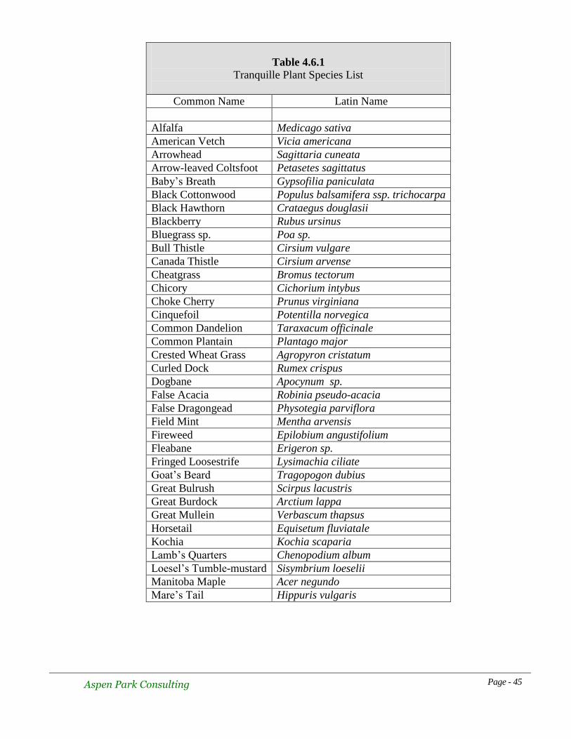
Formal studies of the vegetation community within the WMA are limited. Hennan (2005)
noted 84 species which appears to be the most comprehensive attempt to document plants of
the area. The complete list as transcribed from the Hennan report is provided in Table 4.6.1.
Various descriptions of plant associations may be found in several reports (Ritcey. 1990,
Hennan. 2001 and Zirul. 2006). Ritcey described the following 6 wildlife habitats in a wildlife
viewing plan for the WMA:
1. Pond – includes a variety of aquatic plants
2. Equisetum Flats
3. Sedge-grass Meadows
4. Sandbar Willow Thickets
5. Riparian Edge
6. Cottonwood Bottomland
Hennan listed 10 simplified plant associations:
1. Black Cottonwood
2. Rose
3. Mixed Tree-shrub Riparian
4. Weedy Riparian/Upland
5. Quackgrass
6. Reed Canary Grass
7. Horsetail-Spikerush-Sedge
8. Willow
9. Dogwood
10. Open Water with Submerged & Floating Plants
In the same report, Hennan identified 47 polygons, each with its own group of plants. He
referred to these as plant communities and listed the dominant and sub-dominant species for

Aspen Park Consulting Page - 43
each of the 47 polygons but no botanical reference name is given to each community. Rather, a
polygon number is used. Zirul (2005) referenced the same simplified plant associations
described and mapped by Hennan (2001) in a short report relating to cattle grazing impacts.
The original vegetation on DL 341 was a mix of willow and Black Cottonwood but no detailed
descriptions are available. It may have resembled the willow patches still remaining within the
WMA. Probably by the 1950s, this woody vegetation had been cleared and burned in order to
make the area suitable for hay production and grazing. A root-boring insect has caused
mortality of willows in recent years but the borer populations may be abating. Reed Canary
Grass was planted during the 1950s and 60s. (Scheer, 2004). Natural invasion by native shrubs
in this area is likely being curtailed by grazing, mowing, annual flooding and the ability of the
planted grass species to choke out invaders (Zirul, 2005).
4.6.1 Plants of Conservation Concern
Holmes (2000) listed the following plants as occurring within the WMA:
Awned Cyperus – Cyperus aristatus
Small-flowered Ipomopsis – Ipomopsis minutiflora
Dotted Smartweed – Polygonum punctatum
All three species were “blue listed” by the BC Conservation Data Centre but Ipomopsis is now
yellow-listed or not of concern. Blue-listed species are not immediately threatened, but they are
of concern due to their characteristics which make them vulnerable to human disturbance or
natural threats. Their abundance status in the WMA has not been determined. Hennan (2001)
found two other polygonum species but did not find P. punctatum. Despite a concentrated
effort, Wikeem and Wikeem (2000) were unable to find Awned Cyperus or Small-flowered
Ipomopsis in the WMA. However, they did locate one specimen of Tall Beggarticks (Bidens
vulgatum) within the WMA.
The BC Conservation Data Centre indicates Toothcup Meadowfoam (Rotala ramosior) (red-
listed) as occurring at MacArthur Island several kilometres upstream of the WMA. About
1000 plants were discovered there in 1981, but a subsequent visit in 1995 revealed none. It was
speculated that high water in 1995 may have obscured plants that may emerge as the water
recedes. None of the plant inventories at Tranquille have noted this species but it should be
looked for in the event that seeds have been transported downstream by the Thompson River.
Prairie Wedgegrass (Sphenopholis obtusata) is red-listed by the BC Conservation Data Centre
and E-Flora BC and is shown as occurring along Kamloops Lake to the west of the WMA.
This species has not been found within the WMA.

Aspen Park Consulting Page - 44
Figure 4.6.1.1. Location map for Sphenopholis obtusata
There are no known occurrences of rare plants listed under the Species at Risk Act (SARA).
No rare plant communities are known to occur within the WMA.
4.6.2 Weed Infestations
There were no references to weed infestations or the need for control measures at the
Tranquille WMA mentioned in the weed management plan for Lac du Bois Grasslands
Protected Area (Salm, 2001).
Aspen Park Consulting Page - 45
Table 4.6.1
Tranquille Plant Species List
Common Name Latin Name
Alfalfa Medicago sativa
American Vetch Vicia americana
Arrowhead Sagittaria cuneata
Arrow-leaved Coltsfoot Petasetes sagittatus
Baby’s Breath Gypsofilia paniculata
Black Cottonwood Populus balsamifera ssp. trichocarpa
Black Hawthorn Crataegus douglasii
Blackberry Rubus ursinus
Bluegrass sp. Poa sp.
Bull Thistle Cirsium vulgare
Canada Thistle Cirsium arvense
Cheatgrass Bromus tectorum
Chicory Cichorium intybus
Choke Cherry Prunus virginiana
Cinquefoil Potentilla norvegica
Common Dandelion Taraxacum officinale
Common Plantain Plantago major
Crested Wheat Grass Agropyron cristatum
Curled Dock Rumex crispus
Dogbane Apocynum sp.
False Acacia Robinia pseudo-acacia
False Dragongead Physotegia parviflora
Field Mint Mentha arvensis
Fireweed Epilobium angustifolium
Fleabane Erigeron sp.
Fringed Loosestrife Lysimachia ciliate
Goat’s Beard Tragopogon dubius
Great Bulrush Scirpus lacustris
Great Burdock Arctium lappa
Great Mullein Verbascum thapsus
Horsetail Equisetum fluviatale
Kochia Kochia scaparia
Lamb’s Quarters Chenopodium album
Loesel’s Tumble-mustard Sisymbrium loeselii
Manitoba Maple Acer negundo
Mare’s Tail Hippuris vulgaris

Aspen Park Consulting Page - 46
Table 4.6.1 cont’d
Tranquille Plant Species List
Common Name Latin Name
Marsh Yellow-cress Rorippa palustris
Milkweed Asclepias speciosa
Mountain Ash Sorbus aucuparia
Nootka Rose Rosa nutkana
Pacific Crabapple Malus diversiflora
Pacific Willow Salix lucida lasiandra
Pasture Sage Artemesia frigida
Peachleaf Willow Salix amygdaloides
Pigweed Amaranthus retroflexus
Ponderosa Pine Pinus ponderosa
Portulaca Portulaca oleracea
Prairie Peppergrass Lepidium densiflorum
Prickly-pear Cactus Opuntia fragilis
Quackgrass Agropyron repens
Rabbit Brush Chrysothamnus nauseosus
Redhead Grass Potamogeton perfoliatus
Redtop Agrostis gigantean
Reed Canary Grass Phalaris arundinacea
Sago Pondweed Potamogeton pectinatus
Sand Dropseed Sporobulus cryptandrus
Sandbar Willow Salix exigua
Scorpionweed ? Phacelia sp.
Scouring Rush Equisetum hyemale
Sedge Carex aquatilis
Sedge (Beaked?) Carex rostrata?
Silver Maple? Acer saccharinum?
Slender Beaked Sedge Carex athrostachya
Smartweed Polygonum hydropiperoides?
Smooth Brome Grass? Bromus inermis?
Snowberry Symphoricarpus albus
Spikerush Eleocharis palustris
Spotted Knapweed Centaurea maculosa
Star Duckweed Lemna trisulca

Aspen Park Consulting Page - 47
Table 4.6.1 cont’d
Tranquille Plant Species List
Common Name Latin Name
Storks-bill Erodium ciculatrium
Variable Pondweed Potamogeton gramineus
Walnut Juglans sp.
Water Parsnip Sium suave
Water Plantain Alisma plantago-aquatica
Water Smartweed Polygonum amphibium
Waterwort Elatine liandra
Western Mugwort Artemisia ludoviciana
White Clematis Clematis ligusticfoli
White Cockle Lychnis alba
White Sweet Clover Melilotus alba
White Ash Fraxinus americana
Wild Stawberry Fragaria virginiana
Willow (Bebb’s) Salix bebbiana
Yarrow Achillea millefolium
Yellow Evening Primrose Oenothera villosa
Table After Hennan, 2001
Table 4.6.2
Additional Plant Species Recorded in Tranquille WMA
Common Name Latin Name
Awned Cyperus Cyperus aristatus
Small-flowered Ipomopsis Ipomopsis minutiflora
Dotted Smartweed Polygonum punctatum
4.7 Mammals
No detailed studies of mammals have been undertaken in the WMA but random observations
have occurred by biologists and naturalists over the years. Ritcey (1990) lists 32 species that
occur or may occur at Tranquille. Observers include Ralph Ritcey, Doug Jury, Rick Howie
and Syd Roberts. Tables 4.7.1, 4.7.2 and 4.7.3 list mammals in three categories:
Within WMA – definite observations of the species within WMA boundaries
Nearby – observations close by (within 1 km of WMA) but not inside
boundaries
Possible – species whose range may include Tranquille but have not been
definitely observed in the area

Aspen Park Consulting Page - 48
Many of the species noted as occurring nearby can be seen from various spots in the WMA but
lack of habitat precludes the species from occurring there. They occur on the private lands
nearby or on the park lands above the railway tracks.
Table 4.7.1
Mammals Observed Within the Tranquille Wildlife Management Area
Common Name Latin Name
Big Brown Bat Eptesicus fuscus
Silver-haired Bat Lasionycteris noctivagans
Little Brown Myotis Myotis lucifugus
Snowshoe Hare Lepus americanus
Yellow Pine Chipmunk Tamias amoenus
Beaver Castor canadensis
Muskrat Ondatra zibethicus
Coyote Canis latrans
Ermine Mustela erminea
River Otter Lutra canadensis
Whitetailed Deer Odocoileus virginianus
Moose Alces alces andersoni
Table 4.7.2
Mammals Observed Near the Tranquille Wildlife Management Area
Common Name Latin Name
Yellow-bellied Marmot Marmota flaviventris
Northern Flying Squirrel Glaucomys sabrinus
Red Squirrel Tamiasciurus hudsonicus
Meadow Jumping Mouse Zapius hudsonius tenellus
Bushy-tailed Woodrat Neotoma cinerea
Meadow Vole Microtus pennsylvanicus
House Mouse Mus musculus
Porcupine Erithizon dorsatum
Black Bear Ursus americanus
Mink Mustela vison
Mink Mustela vison
Cougar Felis concolor
Bobcat Lynx rufus
Mule Deer Odocoileus hemionus hemionus
California Bighorn Sheep Ovis Canadensis californiana

Aspen Park Consulting Page - 49
Table 4.7.3
Mammals That Could Occur
Near the Tranquille Wildlife Management Area
Common Name Latin Name
Common Shrew Sorex cinereus
Dusky Shrew Sorex monticolus
Water Shrew Sorex palustris
Vagrant Shrew Sorex vagrans
Townsend’s Big-eared Bat Plecotus townsendii
California Myotis Myotis californicus
Yuma Myotis Myotis yamanensis
Western Small-footed Myotis Myotis ciliolabrum
Fringed Myotis Myotis thysanodes
Western Spotted Bat Euderma maculatum
Deer Mouse Peromyscus maniculatus
Great Basin Pocket Mouse Perognathus parvus
Long-tailed Vole Microtus longicaudus
Montane Vole Microtus montanus
Western Jumping Mouse Zapus princeps
Red Fox Vulpes fulva
Yellow Badger Taxidea taxus
Striped Skunk Mephitis mephitis
4.7.1 Mammals of Conservation Concern
No mammals considered to be at risk under SARA or by the BC Conservation Data Centre
have been observed within the WMA. However, there is a Townsend’s Big-eared Bat
hibernaculum located in an abandoned mine several kilometres west of Tranquille on the north
side of Kamloops Lake. Summer foraging locations for this species are not known, and
Tranquille should not be ruled out as a possible site. Western Small-footed Myotis and Fringed
Myotis are both listed as occurring within the Thompson River drainage (Garcia et al, 1995) so
Tranquille again may be a potential foraging site.

Aspen Park Consulting Page - 50
4.8 Birds
Birds have been documented quite intensively for more than 40 years at Tranquille. All of the
information comes from random sightings by naturalists and biologists. However, only a few
observers seem to have recorded and retained information in a systematic fashion. Ralph
Ritcey, Syd Roberts (deceased) and Rick Howie are noteworthy in this respect. Formal studies
to document bird life have not been conducted but coverage throughout all seasons has been
fairly thorough. Ritcey (1990) lists 216 species as having occurred at Tranquille, but his list
includes portions of Kamloops Lake as well as private property not within the WMA.
Eliminating those observations that were outside the WMA and adding sightings that have
been made since the Ritcey report indicates that 227 species having been observed within the
WMA to date (Table 4.8.1). An additional 22 species have been recorded within 1km of the
WMA.
The variety and abundance of species varies by season, with a complement of permanent
residents, summer visitors, winter visitors, migrants and vagrants. Representatives of many of
the major groups of birds common to the province may be found at Tranquille at one time of
the year or another. The total avifauna of British Columbia including vagrants is 500 species
(Campbell et al, 2007). Forty-five percent of these have been observed on at least one
occasion within the Tranquille WMA. The area is of particular importance to migrating
waterfowl in the spring and fall, as well migrating shorebirds in the late summer and fall.
Migrant passerines use the tree and shrub habitats in good numbers during the spring and fall
migrations. Some migrants may breed nearby but have not been recorded breeding in the
WMA. No other area in the vicinity of Kamloops hosts such a variety of species in such a
small area.

Aspen Park Consulting Page - 51
Table 4.8.1
Birds Recorded within the
Tranquille Wildlife Management Area
Common Name Latin Name Status
Snow Goose Chen caerulescens migrant
Ross’s Goose Chen rossii vagrant
Canada Goose Branta canadensis migrant, breeds
Brant Branta bernicla vagrant
Trumpeter Swan Cygnus buccinator winter visitor, migrant
Tundra Swan Cygnus columbianus winter visitor, migrant
Wood Duck Aix sponsa summer breeder
Gadwall Anas strepera migrant
Eurasian Wigeon Anas Penelope vagrant
American Wigeon Anas americana migrant, breeds
Mallard Anas platyrhynchos migrant, breeds
Blue-winged Teal Anas discors migrant, summer resident
Cinnamon Teal Anas cyanoptera migrant, summer resident
Northern Shoveler Anas clypeata migrant
Northern Pintail Anas acuta migrant
Green-winged Teal Anas crecca migrant, all months
Eurasian race Green-winged Teal Anas crecca migrant
Canvasback Aythya valisineria migrant
Redhead Aythya Americana migrant
Ring-necked Duck Aythya collaris migrant
Greater Scaup Aythya marila migrant
Lesser Scaup Aythya affinis migrant

Aspen Park Consulting Page - 52
Table 4.8.1 cont’d
Birds Recorded within the
Tranquille Wildlife Management Area
Common Name Latin Name Status
Bufflehead Bucephala albeola migrant
Barrow’s Goldeneye Bucephala islandica migrant, breeds
Ruddy Duck Oxyura jamaicensis migrant
Hooded Merganser Lophodytes cucullatus migrant
Common Merganser Mergus merganser migrant
Chukar Alectoris chukar resident
Ring-necked Pheasant Phasianus colchicus resident, rare
Common Loon Gavia immer migrant
Pied-billed Grebe Podilymbus podiceps migrant, breeds
Horned Grebe Podiceps auritus migrant
Eared Grebe Podiceps nigricollis migrant
Red-necked Grebe Podiceps grisegena migrant
Western Grebe Aechmophorus occidentalis migrant
Clark’s Grebe Aechmophorus clarkii migrant, rare
American White Pelican Pelecanus erythrorhynchos migrant
Double-crested Cormorant Phalacrocorax auritus summer vagrant
American Bittern Botaurus lentiginosus summer visitor
Great Blue Heron Ardea herodius summer visitor, breeds near
Great Egret Ardea alba vagrant
Cattle Egret Bubulcus ibis vagrant
Green Heron Butorides virescens vagrant
Black-crowned Night-Heron Nycticorax nycticorax vagrant
Osprey Pandion haliaetus summer visitor, breeds near
Bald Eagle Haliaeetus leucocephalus resident, breeds near
Northern Harrier Circus cyaneus migrant
Sharp-shinned hawk Accipiter striatus migrant, winter
Cooper’s Hawk Accipiter cooperii migrant, winter
Northern Goshawk Accipitergentilis migrant
Red-tailed Hawk Buteo jamaicensis summer visitor, breeds near
Rough-legged Hawk Buteo lagopus winter visitor
Golden Eagle Aquila chrysaetos resident
American Kestrel Falco sparverius migrant, breeds nearby
Merlin Falco columbarius resident

Aspen Park Consulting Page - 53
Table 4.8.1 cont’d
Birds Recorded within the
Tranquille Wildlife Management Area
Common Name Latin Name Status
Gyrfalcon Falco rusticolus winter visitor
Peregrine Falcon Falco peregrinus migrant
Prairie Falcon Falco mexicanus migrant
Sharp-tailed Grouse Tympanuchus phasianellus resident
Sora Porzana carolina summer visitor
American Coot Fulica americana migrant
Sandhill Crane Grus canadensis migrant
Black-bellied Plover Pluvialis squatarola migrant
American Golden Plover Pluvialis dominica migrant
Pacific Golden Pluvialis fulva migrant, rare
Semipalmated Plover Charadrius semipalmatus migrant
Killdeer Charadrius vociferous summer resident
American Avocet Recurvirostra americana vagrant
Spotted Sandpiper Actitus macularius migrant, summer visitor
Solitary Sandpiper Tringa solitaria migrant
Greater Yellowlegs Tringa melanoleuca migrant
Lesser Yellowlegs Tringa flavipes migrant
Whimbrel Numenius phaeopus vagrant
Long-billed Curlew Numenius americanus migrant
Red Knot Calidris canutus vagrant
Sanderling Calidris alba migrant
Semipalmated Sandpiper Calidris pusilla migrant
Western Sandpiper Calidris mauri migrant
Least Sandpiper Calidris minutilla migrant
Baird’s Sandpiper Calidris bairdii migrant
Pectoral Sandpiper Calidris metanotos migrant
Sharptailed sandpiper Calidris acuminata vagrant
Dunlin Calidris alpina migrant
Stilt Sandpiper Calidris himantopus migrant
Buff-breasted Sandpiper Tryngites subruficollis vagrant
Ruff Philomachus pugnax vagrant
Short-billed Dowitcher Limnodromus griseus migrant

Aspen Park Consulting Page - 54
Table 4.8.1 cont’d
Birds Recorded within the
Tranquille Wildlife Management Area
Common Name Latin Name Status
Long-billed Dowitcher Limnodromus scolopaceous migrant
Wilson’s Snipe Gallinago gallinago summer visitor, migrant
Wilson’s Phalarope Phalaropus tricolor migrant
Red-necked Phalarope Phalaropus lobatus migrant
Franklin’s Gull Larus pipixcan migrant
Bonaparte’s Gull Larus philadelphia migrant
Mew Gull Larus canus migrant
Ring-billed Gull Larus delawarensis migrant
California Gull Larus californicus migrant
Herring Gull Larus argentatus migrant
Thayer’s Gull Larus thayeri vagrant
Glaucous-winged Gull Larus glaucescens vagrant
Glaucous Gull Larus hyperboreus vagrant
Sabine’s Gull Xema sabini vagrant
Caspian Tern Sterna caspia vagrant
Black Tern Chlidonias niger migrant
Common Tern Sterna hirundo migrant
Arctic Tern Sterna paradsiaea vagrant
Forster’s Tern Sterna forsteri vagrant
Pomarine Jaeger Stercorarius pomarinus vagrant
Parasitic Jaeger Stercorarius parasiticus vagrant
Long-tailed Jaeger Stercorarius longicaudas vagrant
Rock Pigeon Columba livia resident
Mourning Dove Zenaida macroura summer visitor
Great Horned Owl Bubo virginianus resident
Snowy Owl Bubo scandiacus winter visitor
Barred Owl Strix varia resident, rare
Long-eared Owl Asio otus occasional visitor
Short-eared Owl Asio flammeus winter visitor
Common Nighthawk Chordeiles minor summer visitor
Black Swift Cypseloides niger migrant
Vaux’s Swift Chaetura vauxi summer visitor
White-throated Swift Aeronautes saxatalis summer visitor
Rufous Hummingbird Selasphorous rufus summer visitor

Aspen Park Consulting Page - 55
Table 4.8.1 cont’d
Birds Recorded within the
Tranquille Wildlife Management Area
Common Name Latin Name Status
Calliope Hummingbird Stellula calliope summer visitor
Belted Kingfisher Ceryle alcyon summer visitor
Lewis’s Woodpecker Melanerpes lewis summer visitor, breeds
Red-naped Sapsucker Sphyrapicus nuchalis summer visitor
Downy Woodpecker Picoides pubescens resident
Hairy Woodpecker Picoides villosus resident
Northern Flicker Colaptes auratus resident, some migrate
Pileated Woodpecker Dryocopus pileatus resident
Olive-sided Flycatcher Contopus cooperi migrant
Western Wood Pewee Contopus sordidulus migrant
Willow Flycatcher Empidonax trailii summer visitor
Hammond’s Flycatcher Empidonax hammondii migrant
Dusky Flycatcher Empidonax oberholseri migrant
Pacific-slope Flycatcher Empidonax difficilis migrant, breeds near
Say’s Phoebe Sayornis saya summer visitor
Western Kingbird Tyrannus verticalis summer visitor, breeds
Eastern Kingbird Tyrannus tyrannus summer visitor
Northern Shrike Lanius excubitor winter visitor
Cassin’s Vireo Vireo cassinii migrant
Warbling Vireo Vireo gilvus migrant, breeds near
Red-eyed Vireo Vireo olivaceus migrant, breeds near
Steller’s Jay Cyanocitta stelleri resident
Clark’s Nutcracker Nucifraga columbiana resident
Black-billed Magpie Pica hudsonia resident
American Crow Corvus brachyrhynchos resident
Common Raven Corvus corax resident
Horned Lark Eremophila alpestris migrant
Tree Swallow Tachycineta bicolor summer visitor
Violet-green Swallow Tachycineta thalassina summer visitor
Northern Rough-winged Swallow Stelgidopteryx seripennis summer visitor
Bank Swallow Riparia riparia summer visitor
Cliff Swallow Petrochelidon pyrrhonota summer visitor
Barn Swallow Hirundo rustica summer visitor

Aspen Park Consulting Page - 56
Table 4.8.1 cont’d
Birds Recorded within the
Tranquille Wildlife Management Area
Common Name Latin Name Status
Black-capped Chickadee Poecile atricapilla resident
Mountain Chickadee Poecile gambeli resident
Red-breasted Nuthatch Sitta canadensis resident
Brown Creeper Certhia americana migrant
House Wren Troglodytes aedon summer visitor
Marsh Wren Cistothorus palustris summer visitor
Golden-crowned Kinglet Regulus satrapa resident
Ruby-crowned Kinglet Regulus calendula migrant
Mountain Bluebird Sialia currucoides summer visitor
Townsend’s Solitaire Myadestes townsendi migrant, winter visitor
Veery Catharus fuscescens summer visitor
American Robin Turdus migratorius summer visitor, some winter
Varied Thrush Ixoreus naevius migrant
Gray Catbird Dumetella carolinensis summer visitor
Northern Mockingbird Mimus polyglottos vagrant
European Starling Sturnus vulgarsi resident
American Pipit Anthus rubescens migrant
Bohemian Waxwing Bombycilla garrulous winter visitor
Cedar Waxwing Bombycilla cedrorum summer visitor
Tennessee Warbler Vermivora peregrine migrant
Orange-crowned Warbler Vermivora celata migrant
Nashville Warbler Vermovora ruficapilla migrant
Yellow Warbler Dendroica petechia migrant
Magnolia Warbler Dendroica magnolia migrant
Yellow-rumped Warbler Dendroica coronata migrant
Townsend’s Warbler Dendroica townsendi migrant
Black and White Warbler Mniotilta varia vagrant
American Redstart Setophaga ruticilla migrant, rare
Northern Waterthrush Seiurus noveboracensis migrant
MacGillivray’s Warbler Oporornis tolmei migrant
Common Yellowthroat Geothlypis trichas summer visitor, migrant
Wilson’s Warbler Wilsonia pusilla migrant
Western Tanager Piranga ludoviciana migrant
Spotted Towhee Pipilo maculates winter visitor, migrant
American Tree Sparrow Spizella arborea winter visitor

Aspen Park Consulting Page - 57
Table 4.8.1 cont’d
Birds Recorded within the
Tranquille Wildlife Management Area
Common Name Latin Name Status
Chipping Sparrow Spizella passerine summer visitor, migrant
Clay-colored Sparrow Spizella pallida migrant
Lark Sparrow Chondestes grammacus summer visitor, breeds
Savannah Sparrow Passerculus sandwichensis summer visitor
Fox Sparrow Passerella iliaca migrant
Song Sparrow Melospiza melodia migrant, breeds, winter visitor
Lincoln’s Sparrow Melospiza lincolnii migrant
Swamp Sparrow Melospiza georgiana vagrant
White-throated Sparrow Zonotrichia albicollis migrant
Harris’s Sparrow Zonotrichia querula winter visitor
White-crowned Sparrow Zonotrichia leucophrys migrant
Golden-crowned Sparrow Zonotrichia atricapilla migrant
Dark-eyed Junco Junco hyemalis resident, also migrant
Lapland Longspur Calcarius lapponicus migrant
Snow Bunting Plectrophenax nivalis winter visitor
Black-headed Grosbeak Pheucticus melanocephalus vagrant
Lazuli Bunting Passerina amoena summer visitor
Indigo Bunting Passerina cyanea vagrant
Bobolink Dolichonyx oryzivorus summer visitor
Redwinged Blackbird Agelaius phoenecius migrant
Western Meadowlark Sturnella neglecta summer visitor
Yellow-headed Blackbird Xanthocephalus xanthocephalus migrant
Rusty Blackbird Euphagus carolinus winter visitor, rare
Brewer’s Blackbird Euphagus cyanocephalus migrant, some all year
Brown-headed Cowbird Molothrus ater summer visitor
Bullock’s Oriole Icterus bullockii summer visitor
Pine Grosbeak Pinicola enucleator winter visitor
Cassin’s Finch Carpodacus cassinii summer visitor
House Finch Carpodacus mexicanus resident

Aspen Park Consulting Page - 58
Table 4.8.1 cont’d
Birds Recorded within the
Tranquille Wildlife Management Area
Common Name Latin Name Status
Red Crossbill Loxia curvirostra winter visitor
Common Redpoll Carduelis flammea winter visitor
Hoary Redpoll Carduelis hornemannii winter visitor, rare
Pine Siskin Carduelis pinus migrant
American Goldfinch Carduelis tristis summer visitor
Evening Grosbeak Coccothraustes vespertinus migrant
House Sparrow Passer domesticus resident
4.8.1 Birds of Conservation Concern
Twenty-five species of birds, either listed by SARA or by the BC Conservation Data Centre as
being of conservation concern, have occurred at Tranquille. The WMA provides potential
breeding habitat for 2 of the species, whereas the remaining 14 use the area as a foraging site
on an irregular basis. Bobolink are suspected to have bred in the hayfield in lot 341 but do not
do so on an annual basis. Water levels may influence the availability of breeding habitat.
Lewis’s Woodpeckers nest in cottonwoods along lower Tranquille River and have been seen
foraging along the northern margin of the WMA. Nesting has not been verified in the WMA
and the lack of old cottonwood trees may preclude this from happening. American Bittern are
heard calling almost every year during the breeding season but proof of nesting has not been
obtained. Lark Sparrows have been seen on the dry margins of the WMA near the information
shelter. They likely nest in the dry uplands and forage on the margins of the hayfield.
For the remaining species, Tranquille provides good foraging habitat either during migration or
during the breeding season. Western Grebes occur on Kamloops Lake at the western edge of
the WMA but seldom use the pond area. They are migrants, although at one time a nesting
colony was suspected at the head of Kamloops Lake. Details on this colony are sketchy and it
certainly does not exist today. The nearest known nesting colony of Great Blue Herons is
located along lower Paul Creek 13 kilometres east of Tranquille. Post breeding aggregations of
adults and young birds are a regular occurrence in the WMA each summer and fall. Peregrine
and Prairie Falcons pursue ducks and shorebirds during the fall migration period. A single
Sharp-tailed Grouse was seen on the northern margin of the WMA in the mid 1960s (Ritcey,
1990), but in general the WMA does not provide typical habitat for this species. Barn
Swallows may be seen foraging over the pond area during the summer. The swallows likely
nest on buildings. Red-necked Phalaropes are regular migrants, but visual observations do not
enable the determination of subspecies, or whether individuals of the blue-listed BC breeding
population pass through Tranquille. Sandhill Cranes, Long-billed Curlews and American
Avocets occur periodically during migration for short periods in suitable habitats but do not
remain to breed.

Aspen Park Consulting Page - 59
Table 4.8.1.1
Birds of Conservation Concern
Name CDC SARA Name CDC SARA
Western Grebe Red Long-billed Curlew Blue Special
Concern
American White Pelican Red NAR Short-billed
Dowitcher Blue
Double-crested
Cormorant Blue
Red-necked
Phalarope Blue
Great Blue Heron Blue California Gull Blue
Green Heron Blue Caspian Tern Blue NAR
American Bittern Blue Forster’s Tern Red
Peregrine Falcon
Anatum race Red Threatened Short-eared Owl Blue
Special
Concern
Prairie Falcon Red NAR Lewis’s Woodpecker Red Special
Concern
Gyrfalcon Blue NAR Barn Swallow Blue
Sharp-tailed Grouse Blue Lark Sparrow Red
Sandhill Crane Blue NAR Bobolink Blue
American Golden Plover Blue Rusty Blackbird Blue
American Avocet Red
4.8.2 Birds of Conservation Concern – Annotated List
Western Grebe
This grebe is a migrant in the Kamloops area, with the nearest nesting colony located at
Salmon Arm. Many birds may be bound for the prairie provinces. Birds may be found near the
head of the lake or off the mouth of the Tranquille River from late March through early June
(up to 100) and in some years birds may be found throughout the summer as non-breeders.
Birds also pass through during September and October as well. Occasionally, the odd bird may
be found on the pond in the WMA.
American White Pelican
The only nesting colony of pelicans in BC is at Stum Lake in the Chilcotin area. Migrants pass
through Kamloops from early April through early June, and in the fall from late August
through late October. Increasingly, post-breeding wanderers from unknown locations (possibly
Washington state) have been seen in the Kamloops area during the summer months. Birds may
roost on sand bars at the head of the lake or periodically on the pond in the WMA. Numbers at
any one time tend to be small and range up to 16 birds (Ritcey, 1990).

Aspen Park Consulting Page - 60
Double-crested Cormorant
Non-breeding birds occur most frequently in the Kamloops area from mid- June through late
September. They can be seen perching in the willow shrubs in the WMA or on pilings in front
of the old sewage lagoons on the BC Wilderness property. Ritcey(1990) suggested that they
may feed on Carp (Cyprinus carpio) which can be found in the WMA during high water
periods.
Great Blue Heron
The nearest colony of herons is along lower Paul Creek about 13 kilometres east of the WMA.
Adults may be seen foraging at Tranquille during the early summer but the largest numbers
build up from July onwards. Adults and young presumably from the Paul Creek colony remain
in numbers up to 20 through the late summer and dwindle towards the end of October. Small
numbers attempt to winter at Kamloops when single birds are occasionally seen at Tranquille.
Green Heron
This secretive species does not normally occur in the interior but stray birds appear
unpredictably. There are two records for the WMA at the small pond near the culvert through
the access road west of the parking lot. Single birds were found on 03 Aug, 1983 and 05 Aug,
1990.
American Bittern
Ritcey (1990) suggests that bitterns may have nested in the WMA at one time, but summer
records have declined over the years. They do not necessarily occur each year now, and often
may not be detected until late in the breeding season. Numbers have always been in the order
of 1 or 2 birds and young have not been confirmed.
Peregrine Falcon
Individuals of the both the anatum and tundrius races have been observed with some regularity
during the fall, winter and spring months in the WMA. The anatum birds are seen most
frequently. The many ducks and shorebirds are potential prey species. During April of 2001, an
individual was regularly seen around the cliffs on the south side of Kamloops Lake not far
from Tranquille. A nest was suspected but never proven and no more than 1 adult was ever
seen. Juveniles were not observed.
Prairie Falcon
Prairie Falcons are seen pursuing waterfowl at Tranquille but much less frequently than
Peregrine Falcons. Infrequently, they are observed hunting Chukar in the grasslands nearby.
An eyrie located at Kamloops was apparently active in 2000 but juvenile birds have not been
observed. Birds have been seen at Tranquille during the spring, fall and winter on at least 16
occasions since 1982.

Aspen Park Consulting Page - 61
Gyrfalcon
This large, wide-ranging falcon is a winter visitor to the South Thompson Valley. Birds may be
seen pursuing Chukar over the hillsides or ducks along the river or on the Kamloops sewage
ponds. They hunt the Tranquille area during their extensive forays around the valley.
Sharp-tailed Grouse
Although a species of the grasslands, birds will move to shrub patches in the lower valley
during the winter. Ritcey (1990) mentions several winter sightings in shrubs at the northern
edge of the WMA along the road in front of the old institution buildings. The most recent
sighting was 8 Nov, 2000.
Sandhill Crane
Tens of thousands of Lesser Sandhill Cranes (Grus canadensis canadensis) pass Kamloops
during the spring and fall migration. This subspecies periodically lands at Tranquille during the
fall and less frequently in the spring. The Greater Sandhill Crane, (G.c. tabida) nests on the
plateau just north of Kamloops and west to the Cariboo region. Individuals of this blue-listed
race may put down at Tranquille on occasion, but they have never been identified either within
the flocks of G.c. canadensis or as birds on their own.
American Golden Plover
This species is a rare breeder in northern BC but is more common as a migrant. It occurs in
small numbers during fall migration on the mud flats at Tranquille but occasionally may be
found around the margins of the pond. Spring sightings are much rarer. Field separation from
the very similar, but much rarer, Pacific Golden Plover can be difficult. Both species have been
recorded at Tranquille.
American Avocet
Avocets have been seen observed at Tranquille on 6 occasions since 1982. They remain briefly
to forage as migrants buthave never bred there. They breed sporadically at alkaline ponds on
the plateau just south of Kamloops and sightings have increased considerably since the early
1980s. Migrants at Tranquille may be bound for breeding locations in the southern Cariboo
region.
Long-billed Curlew
Curlews arrive in the Tranquille area in late March or early April and sometimes remain
around the WMA until May. Young curlews were seen in the hay meadow on 17 June, 1989
but may have been migrants rather than having been raised on site. Curlews breed in the
grasslands north of Tranquille. Southbound migration occurs early with most birds having
departed by the end of June.
Aspen Park Consulting Page - 62
Short-billed Dowitcher
This dowitcher is seldom recorded at Kamloops, and has only been confirmed on 2 occasions
at Tranquille. Ritcey (1990) documented sightings on 01 Aug, 1988 and 31 July, 1989. It
should be looked for around the pond, perhaps in the company of the more common Long-
billed Dowitcher.
Red-necked Phalarope
Most sightings of this fairly common migrant are presumed to be individuals of the more
abundant populations that breed outside of B.C. It is likely impossible to separate birds of the
blue-listed B.C. population amongst the fall migrants that occur at Tranquille.
Caspian Tern
This large tern is a summer visitor to the lake and flooded portions of the WMA. Birds are
likely non-breeding wanderers from colonies in Washington state. The earliest recorded arrival
was 17 May, 1984 and birds have been seen as late as 18 September, with records during all
months in between.
Forster’s Tern
Forster’s Tern has been recorded on 5 occasions between 1991 and 1999. The dates were 25
May, 1991, 16 May, 1993, 27 June, 1993, 7 April 1998 and 29-30 May, 1999. The nearest
known nesting location in the province is Creston.
California Gull
This species occurs as a migrant at Tranquille and is blue-listed as a nesting species in BC. It is
not known whether individuals from the few nesting locations in the province migrate past
Tranquille. The majority of migrants nest in other parts of Canada where they are not of
conservation concern.
Short-eared Owl
Although a scarce local breeder, this owl has been seen at Tranquille, but not on an annual
basis. It does not breed there. In some years, wintering birds invade from more northerly
breeding locations and spend the winter in the Kamloops area. Numbers vary annually.
Lewis’s Woodpecker
The lower Tranquille River area is a prime breeding location for Lewis’s Woodpecker. They
utilize older cottonwoods with pre-existing cavities or if the wood is soft enough, this
woodpecker may excavate its own cavity. They may nest in cottonwoods along the southeast
corner of the WMA (Ritcey, 1990). Foraging adults and fledglings may be seen in the trees
along the access road in front of the BC Wilderness Tours buildings. Numbers have declined
since the peak number of 40 seen on 21 Aug, 1986 when large numbers of fledglings were
present.
Aspen Park Consulting Page - 63
Barn Swallow
Along with other swallows, Barn Swallows can be seen hunting over the pond and other
habitats at Tranquille during the summer months. Birds arrive during late April and nest on
structures amongst buildings near the WMA. Most birds have departed by late September.
Lark Sparrow
Lark Sparrows are rare breeders along the base of the hills between Tranquille and Westside
Road in Kamloops. Adult and young birds have been seen on 3 occasions along the road edge
at the north side of the WMA in the vicinity of the information shelter. While birds may forage
inside the WMA to some degree, breeding is likely outside and to the north in the shrubby
grasslands.
Bobolink
Bobolinks arrive in the area late in the season around the end of May or early June. Territorial
males occurred with some regularity on the hayfield in lot 341in the late 1970s and 1980s.
Young were never seen in the WMA but a flock of 15 juveniles were seen on the hayfield west
of the BC Wilderness Tours buildings on 20 Aug, 1978. Occurrences have been less frequent
during the last ten years with nesting probably compromised by hay cutting and flooding.
Rusty Blackbird
This species is a rare winter visitor to Kamloops although it may be found at higher elevation
lakes during the summer. The one record for the WMA was likely a stray from a nearby cattle
feeding yard where this species is often found during the winter.
4.9 Amphibians
There is apparently little written documentation of amphibians within the WMA. Ritcey (1990)
speculated that the Western Toad (Bufo boreas), Great Basin Spadefoot ( Spea intermontana)
and Pacific Treefrog (Hyla regilla) could occur. In a later appendix to a plan for the WMA,
Western Toads were noted as being commonly killed along the roads peripheral to the WMA.
The Spadefoot is blue-listed by the BC Conservation Data Centre. Typically, this species
breeds in small ponds in the grasslands and the large floodplain environment at Tranquille does
not seem to be typical habitat for this toad. However, Ritcey (Aug. 2000) heard 4 calling toads
below the access road near the gate to the buildings owned by BC Wilderness Tours.
Pacific Tree Frogs have been observed in riparian areas near Tranquille so it is expected that
they might occur in the WMA.

Aspen Park Consulting Page - 64
4.10 Reptiles
Five species of reptiles have been recorded in or very close to the WMA (Table 11). Western
Painted Turtles were occasionally seen along the flooded margins of the hay meadows and
basking on logs near the pond (Ritcey, 1990). They have been observed at the now defunct
sewage lagoons that served the old institution on the BC Wilderness Tours property. No egg
laying sites have been found, although an individual was seen crossing the Red Lake Road near
the gravel pit north of Tranquille (Ritcey, 2000). The Racer has been observed on the road
leading down to the lake in front of the old institution buildings, suggesting that individuals
may enter the WMA during their travels. The Gopher Snake has been observed at Tranquille
on rare occasions and is more likely to be found in the sage grasslands above the WMA
(Ritcey, 1990). Western Rattlesnakes are seen much less frequently than in the past. They are
more likely to occur along the Tranquille River than in the WMA.
Table 4.10.1
Reptiles of Tranquille WMA
Common Name Latin Name CDC SARA
Western Painted Turtle Chrysemys picta Blue
Racer Coluber constrictor Blue SC
Gopher Snake Pituophis catenifer Blue Threatened
Western Rattlesnake Crotalus oreganus Blue Threatened
Common Garter Snake Thamnophis sirtalis Yellow
4.11 Fish
Being on the floodplain of the Thompson River provides an opportunity for several species of
fishes to enter the WMA during the high water stages of the river. These include either adults
and /or juvenile age classes. Both salmonids and non-salmonids are expected to be present
(Table 4.11.1). Both Fisheries and Oceans Canada and the Ministry of Environment indicated
that they had not conducted any sampling surveys in the WMA area.

Aspen Park Consulting Page - 65
Table 4.11.1
Potential Fishes of Tranquille
Wildlife Management Area
Common Name Latin Name
Rainbow Trout Oncorhynchus mykiss
Chinook Oncorhynchus tshawytscha
Sockeye Salmon Oncorhynchus nerka
Pink Salmon Oncorhynchus gorbuscha
Coho Oncorhynchus kisutch
Carp Cyprinus carpio
Burbot Lota lota
Bull Trout Salvelinus confluentus
Prickly Sculpin Cottus asper
Largescale Sucker Catostomus macrocheilus
Longnose Sucker Catostomus catastomus
Mountain Whitefish Prosopium williamsoni
Northern Pikeminnow Ptychocheilus oregonensis
Peamouth Chub Mylocheilus caurinus
Redside Shiner Richardsonius balteatus
4.11.1 Salmonids
Five species of salmonids can be found in the South Thompson River system. Rainbow Trout
are resident in the system. The other 4 species are anadromous salmon with adults passing
through Kamloops Lake and entering the Thompson River from mid-June through November,
depending upon the species. Chinook return the earliest (June) and spawn in key areas between
Kamloops and Chase, as well as in tributary drainages in the Shuswap Highlands. Sockeye
Salmon migrate upstream from mid-August through October in varying numbers each year,
depending in part on the cycle year of the Adam’s River spawning population. Pink Salmon are
also fall migrants, and return every second year to the system. Coho are the latest to arrive
(October/November), and are part of the endangered Interior Fraser stock. COSEWIC listed
this species as endangered but it has yet to be listed by SARA despite recommendations to do
so. Sixty percent of the stocks have declined since 1996 (Fisheries & Oceans website, 2007).
Apart from the potential for Rainbow Trout, adults of the anadromous species are not expected
to enter the WMA area during their upstream migration. However, observations of salmon fry
in the out-migration period during high water in the early summer suggests that some or all of
the 4 andromous species may utilize the area during this period. Rearing likely occurs for those
species that spend more than one year in freshwater prior to downstream migration.
4.11.2 Non-salmonids

Aspen Park Consulting Page - 66
Carp are observed annually in the flooded meadow area of the WMA during the summer
period. Other species that occur in Kamloops Lake and the South Thompson River include
Burbot, Bull Trout, Prickly Sculpin, Largescale Sucker, Longnose Sucker, Mountain
Whitefish, Northern Pikeminnow, Peamouth Chub and Redside Shiner. Burbot juveniles move
into shallow waters of the lake perimeter but may not prefer the precise environs of Tranquille
WMA. It is possible that other non-salmonids not listed here may be found in the shallows of
the WMA.
4.11.3 Overall Fisheries Values
Discussions with Fisheries and Oceans Canada (G. Guerin, pers. com.) suggest that there
appears to be no detailed reports about fish use of the WMA area. He agreed that there is the
potential for the area to be used by out-migrating juvenile salmonids. Bill Rublee (pers. com.)
of ARC Environmental indicated that colonization by juvenile salmonids would very likely
occur about 15-20 May, and rearing would occur until water temperatures increased to
tolerance levels. Salmonids would then move into cooler lake waters but non-salmonids would
colonize for breeding, foraging or rearing. He speculated that the area would be well-used by a
variety of fishes.
In general, the WMA should be considered to have high values as a rearing area for salmonids
as well as a breeding, foraging and rearing area for non-salmonids. All of these species, at
different stages of their lives form important components of the diets for a variety of predator
species such as Mergansers, Ospreys, Bald Eagles, Mink and Otter. Rearing areas on the
margins of lakes and streams are under consistent degradation pressures from urban and rural
development such that Tranquille should be managed with the conservation of this function
firmly in mind.
4.12 Invertebrates
As with most of the faunal groups, insects and other invertebrates have been poorly studied at
Tranquille. A Ducks Unlimited field reconnaissance in the WMA circa 1990 indicated the
presence of “water striders (Gerridae), water boatmen (Corixidae), shrimp (Gammaridae),
small diving beetles (Coleoptera), chironomid larvae (Chironomidae), mayflies, damsel flies
(Coenagrionidae) and dragonflies (Aeshnidae).” Mosquitoes (Culicidae) are also found during
the summer season.
Local naturalist Syd Roberts (deceased) periodically reported Monarch (Danaus plexipuss)
butterflies during the 1990s at Tranquille. These were restricted to Showy Milkweed
(Asclepias speciosa) plants that grew intermittently along disturbed road edges and were not
likely seen within the WMA. The Monarch is listed as “special concern” by SARA.
The insect responsible for damage to the willow stands has not been positively identified in any
of the literature available about Tranquille. It is variously referred to as a willow borer or root
borer, and it may be Crptorhynchus lapathi, but this has not been confirmed.

Aspen Park Consulting Page - 67
Wood Ticks (Dermacentor andersoni) are present in the sage grasslands north of the WMA
and likely occur along the dry northerly margins below Tranquille Road. Ticks are most likely
to be encountered from early March through mid-May, with a peak during April.
4.13 Species and Ecosystems Values
There are no protected areas in the southern interior portions of the province that conserve all
or part of sizeable river deltas. The mouth of the Thompson River as it enters Kamloops Lake
is relatively free of development and ranks next to the mouth of the Salmon River and Salmon
Arm Bay as a major stopover for waterfowl and shorebirds. Next to Salmon Arm Bay which
has much more habitat, no other location in the southern interior is known to attract as many
species and numbers of shorebirds as Tranquille. The presence of some remnant riparian tree
and shrub areas adds to the diversity and importance of the site. Large river deltas are relatively
rare in the southern interior.
The low elevation, south facing aspect of Tranquille allows the area to warm up quickly in the
spring and provides early open water conditions for northbound waterfowl while the
surrounding plateau lakes are still frozen. Warmth allows for early insect production, such as
chironomid hatches, that attract the first arriving passerines. During the summer, high water
conditions provide important rearing habitat for salmonids as well as non-salmonid fishes that
form the basis for a predator food chain which includes Otter, Bald Eagles, Osprey, Terns and
Cormorants. The fall migration period is protracted, providing beneficial habitat for waterfowl
as well as shorebirds which have few stopover sites in the interior. The pond and mudflats of
the WMA are rich with invertebrates that provide excellent nutrition for migrating sandpipers
and their relatives that depend upon strategic “re-fueling” sites.
The position and variety of habitats attract a fairly long list of stray migrant birds that find
suitable foraging opportunities. Not all of them are threatened but are locally rare because they
do not normally occur in this area. Thus, for birdwatchers, Tranquille is something of a “rarity
hotspot” which attracts attention during all seasons of the year. No other single location of
comparable size in the Kamloops-Merritt area has attracted so many bird species, whether
common or rare. Tranquille ranks with Salmon Arm Bay and some areas of the Okanagan for
bird diversity.
In terms of threatened or endangered species, Tranquille and the WMA have attracted at least 1
species of insect that is listed as “special concern” by SARA, 1 species of fish considered to be
endangered but not yet listed by SARA, 4 species of reptiles that are “blue-listed,” of which 3
have SARA designations, 1 “blue-listed” amphibian and 24 species of birds which have either
a provincial designation or are listed by SARA. No mammals known to occur at Tranquille
have a conservation designation but further research may indicate that some designated species
occur. Two “blue-listed” species of plants occur at Tranquille. In summary, at least 31 species
of wildlife and 2 species of plants designated as being of conservation concern have been
recorded in the Tranquille WMA. Details of the listed species can be found in the appropriate
section under “Natural Resources” in this report.
No other location in this portion of the southern interior has been documented to host as many
species of conservation concern as Tranquille. Salmon Arm Bay may also have a similarly high

Aspen Park Consulting Page - 68
number of species but documentation is needed. It does not have a protected area status. Some
areas in the South Okanagan may also show such diversity of species of conservation concern.
5.0 History of Use
5.1 First Nations
J. Jules (pers com) stated that use of the Tranquille area by First Nations peoples has likely
been extant for several thousand years, although he was not personally aware of detailed
studies that would separate use of the WMA from other more general use of the Tranquille
area. He indicated that if the Ministry wanted a detailed response from the Kamloops Indian
Band, they would have to pay the band to undertake a search of reports and files. He also
indicated that the developers for Tranquille on the Lake had paid for a research report on First
Nations use of the Tranquille area, and perhaps they would allow the Ministry to examine the
findings.
Teit (1920?) indicated that members of the Kamloops Indian Band wintered on both sides of
the Thompson River and Kamloops Lake for some distance west of Kamloops. Balf (1969)
said that the Tranquille area was “densely populated with Indian homes” and that Chief
Tranquille lived there. It is perhaps reasonable to expect that they may have fished in the area
of the WMA during high water and harvested any resources of value in the area.
Elizabeth Duckworth of the Kamloops Museum and Archives, and Ken Favrholdt were
unaware of any specific studies on the Tranquille area but were certain that there would have
been use made of the area. The Tranquille area in general was used for winter camping by
indigenous peoples up until the 1840s (Ritcey, 1990).
5.2 Recent European Settlement
Tranquille was likely visited by people associated with the Hudson’s Bay Company
developments in the Kamloops area in the early 1800s. But it was the lure of gold that brought
major attention to the area in the 1850s, and a flood of miners in 1861. Gold dredging took
place at the mouth of Tranquille Creek in 1901. The first claiming of land for settlement (pre-
emption) in the area was by James McIntosh in 1868 (Balf, 1969). Along with William
Fortune, they farmed and opened a flour mill, which soon burned, and was replaced with a
lumber mill in 1870. This facility was gone by 1898. Other early pre-emptions around
Tranquille were by Amable St. Germain west of the creek and by Charles Cooney in 1869. The
Hudson’s Bay Company had some hay meadows in the area as well.
The Fortunes operated hay and wheat fields and an orchard as well as serving guests from
steamers that plied Kamloops Lake. In 1907, they sold their property to the Anti-tuberculosis
Society, and over the next 10 years various buildings were erected to house people suffering
from this disease. In 1921, overwhelmed by the magnitude of caring for patients, the society
sold the facilities to the provincial government who expanded and operated them until the mid
1980s. The facilities and portions of the land were sold to private interests soon after that time
but were never developed, and are now owned by Tranquille Wilderness Tours.
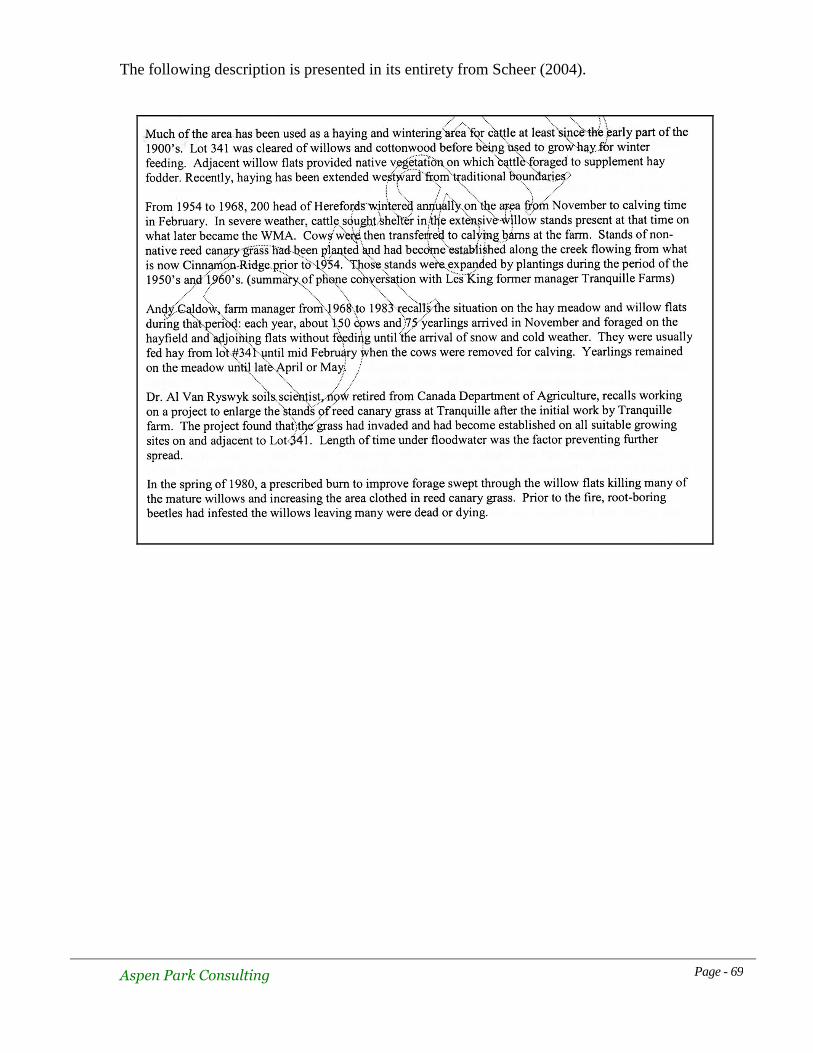
Aspen Park Consulting Page - 69
The following description is presented in its entirety from Scheer (2004).
Aspen Park Consulting Page - 70
6.0 Existing Tenures
6.1 Cattle Grazing and Haying
The Frolek Cattle Company currently possesses a Park Use Permit (TR0310303) to graze cattle
and cut hay in a specified area of the WMA (Fig. 6.1.1). The permit commenced July 1, 2003
and has a term of 10 years, expiring June 30, 2013 with an option to apply for a further 10
years if all of the terms and conditions are met. A fee of $214.00 is associated with the permit
plus additional surcharges for grazing and haying. The permit restricts activities to the
designated area and allows up to 300 head of cattle to be kept in the area “no earlier than
November and no later than April.

Aspen Park Consulting Page - 71
Figure 6.1.1 Frolek Cattle Co.
grazing tenure area
6.1.1 History of Tenure Activities and Discussion
Lot 341 had been used for agricultural purposes since the early 1900s prior to it becoming
incorporated into the WMA. The area was cleared of willow/cottonwood vegetation by the
early 1950s and 200+ head of cattle were wintered there on an annual basis. Haying took place
during the late summer period. When the institution for the mentally disabled was
decommissioned, DL 341 remained in crown ownership and was not sold as part of the
facilities being marketed at that time. The Frolek Cattle Co. obtained a lease from BC Lands in
1983 to graze up to 300 head of cattle and to cut hay on DL 341. No lease was ever issued by
the Ministry of Forests for this activity (M. Dedels, pers com). Permission for Frolek Cattle Co.
to graze on lot 341 as well as adjacent lands had been granted prior to the designation of either
the WMA or the provincial park. When the WMA was created, grazing continued, but was
apparently never formally authorized via a letter under the Wildlife Act, recognizing the new
jurisdiction. The managers of the area at the time recognized some benefits from the grazing in
terms of reducing grass height, making it more valuable for the grazing of Canada Geese in the
spring. The Wildlife Branch also recognized the impacts of grazing on the riparian shrub
communities and a Habitat Conservation Trust Fund grant was used to fence the riparian area
in 1987. The fencing had some benefits but did not completely solve all issues. The acceptance
of the grazing and haying activities was recognized in the Wildlife Viewing Plan (Ritcey,
1990) as well as subsequent brief management plan documents (Ritcey, undated, Low, 1991).
The intention was to modify the agricultural practices so as to eliminate or reduce negative
issues associated with conservation and public perception. In 1995, the Kamloops Land and
Resource Management Plan (LRMP) recognized the continuance of pre-existing grazing
tenures within newly-established protected areas and specifically, the Tranquille WMA.
However, there never was a formal tenure document issued but the practice was maintained by
Aspen Park Consulting Page - 72
verbal agreement. Compatibility with long term goals and ensuring that there would be no
environmental degradation were stated in the LRMP conditions.
When originally established, prior to incorporation into Lac du Bois Grasslands Protected
Area, activities such as grazing required authorization by letter from the Regional Manager
under the Wildlife Act. Such a letter was not issued in the early years, but upon incorporation
into the protected area, local managers enacted a Park Use Permit to authorize the use. Grazing
and haying were restricted to DL 341 as partially depicted in the photos below. The pond is
outside of the grazing permit area.
Photo 6.1.1.1. Part of DL 341. March 20, 2007
Photo 6.1.1.2. Western portion of DL 341. March 20, 2007

Aspen Park Consulting Page - 73
Discussions with Ray Frolek provided a clear picture of the value of these lands to the cattle
operation. About 400 head are grazed in Lac du Bois Grasslands Protected Area at higher
elevations during the summer. About 300 of these animals are turned out at a time such that
when breeding occurs there, pregnant cows must give birth commencing in mid-February. The
cattle company generally operates and owns land at higher elevations in Knutsford where
conditions are unsuitable for calving this early in the season. Tranquille is a critical area that
allows them to calve early, and they have no other place to move these animals. About 100 of
the 400 head herd are turned out later in Lac du Bois and they become pregnant later and are
trucked to Knutsford for calving.
Hay that is harvested from DL 341 provides most but not all of the feed for the 300 head that
are wintered there. Supplemental feeding with grain is required. Being allowed to graze outside
of the currently fenced area and into the WMA would allow about 3 additional weeks of
grazing without having to supply hay from DL 341. In years of lowered hay production, this
can be an important benefit to the ranch. Hay is usually cut commencing 01 September and
cattle are put onto the site about 01 December. Manure and the occasional application of
fertilizer seem to sustain the growth of hay but it is of lower quality and averages 4-5% protein.
Canada Geese also provide nutrients in the form of droppings but their numbers are reduced
over previous years. The sedge flats in the WMA used to be grazed by cattle and this seemed
to leave them in a more attractive condition for geese (Frolek, pers. com.). Goose numbers are
down but there has been development of city-owned hayfields to the east during the last 10
years, so this may attract some geese away from the WMA area. Along with supplemental
grain, the hayfield appears to sustain the current wintering cattle herd but additional grazing in
the WMA would benefit the operation.
Confining of the cows to the currently fenced area does limit the availability of tree/shrub
sheltering locations during inclement weather. Also, the closer confines has increased the
incidence of scour in the herd that used to spread out over a wider area.
While the dollar value of the DL 341/WMA operation was not discussed specifically, Mr. Frolek
was asked what it would mean if the cattle/haying operation was eliminated. He indicated that it
would severely curtail or eliminate his ability to operate cows in the Lac du Bois grasslands portion
of the protected area. The WMA is integral to maintaining a feasible ranching operation in Lac du
Bois area and the Frolek Cattle Company’s private holdings in or near the protected area. There is a
cooperative arrangement regarding the management of threatened or endangered species on these
private inholdings (likely 14 SARA listed species on Frolek Cattle Co. lands in general) and grazing
within the protected area should be considered when developing a plan for the WMA. Loss of a
viable cattle operation may result in sale of the private park inholdings, and uncertainty in
cooperation with future owners. An integrated approach, with consideration of both ranching and
conservation issues, would likely lead to the best overall conservation within the park and WMA.
The conservation values of DL 341 while complementary to the WMA, are unlikely to ever
equal the values of some of the private lands held by the cattle company even if rehabilitated to
a semblance of a natural environment.

Aspen Park Consulting Page - 74
Management of the WMA has been maintained as a function of the Fish & Wildlife Section of
the Ministry via a Memorandum of Agreement with the BC Parks section of the Ministry.
However, park managers have become involved in attempting to rationalize issues surrounding
grazing practices in the park. A draft WMA management plan was prepared in 2004 and it
contained a stated objective to phase out cattle use except in the main hayed area along with
several other strategies that could result in changes to the current cattle/haying regime. In 2005,
the Frolek Cattle Co. applied to graze 100 head of cattle outside of the permit area but within
the WMA, for 2 weeks in December. This was allowed on a trial basis but not legally
permitted. Monitoring was required and subsequently conducted by Dave Zirul (2005) on 9
occasions during the 16 day trial period. He noted a range of use and impacts which he rated
as heavy, moderate, light and nil. A summary of Zirul’s recommendations is as follows:
all parties must develop clear objectives and strategies to reconcile conflicts
develop standards to measure success or failure
improve the distribution of animals in order to spread the impacts
consider the potential to accommodate more animals if that would “support a
greater investment in management.”
consider the development of an alternate water source and the use of salt blocks
to reduce impacts in the culvert pond area.
consider more active intervention to increase the recovery of trees and shrubs in
the hay meadow area.
In a subsequent letter to the Regional Manager in 2006, Zirul reaffirmed his earlier findings
and noted that the Frolek Cattle Company had historically used not only DL 341, but portions
of the WMA before being required to fence off and restrict cattle use to DL 341. It is their
feeling that such use of the WMA should not be unreasonably denied without due process and
in light of the fact that government experts had acknowledged that cattle grazing may benefit
wildlife management objectives.
The permittee again expressed interest in 2006 to continue grazing outside of the existing
tenure area but this was denied. Debate over the intent of previous guiding documents such as
the LRMP, as well as new management direction statements for the area, have left the issue
unresolved at the time of preparing this background document in 2007. No approval to expand
the permit area has been granted. If approval to graze in the WMA was granted, an additional
letter from the Regional Manager under the Wildlife Act would likely be required along with a
Park Use Permit to legalize the entire operation.
Some public concern has been raised over the issue of allowing cattle use in a flood plain due
to the impact of droppings and urine. Fisheries and Oceans Canada have received phone calls
from residents at Frederick concerned about possible impacts to their water systems
(G. Guerin, pers. com.). Fisheries and Oceans do not, at the moment, see enough concern from
a fisheries management perspective to take pro-active steps to remove cattle from the flood
plain. They would support such a move in principle. No studies have been done to determine
whether the vegetation absorbs the nutrients and treats the droppings sufficiently to allay
concerns about water quality and fish habitat impacts. Water quality data taken upstream at
Kamloops and quoted in this report would not provide insight in this regard.

Aspen Park Consulting Page - 75
6.2 Other Tenures
Eighteen Park Use Permits were extant for Lac du Bois Grasslands Protected Area as of
March, 2007. Only the aforementioned TR0310303 applies to the WMA. All other permits are
for activities in areas of the protected area well upland from the WMA area.
7.0 Research and Monitoring
Research on the productivity of the meadow area at Tranquille was conducted by Agriculture
Canada personnel. They also conducted trials to establish the growth potential for Reed Canary
Grass and Foxtail on the mud flats. (Ritcey, 1990).
Vegetation monitoring plots were established by B.C Parks in 2004 and have been continued
through 2006. Six sites were monitored each year. The report is maintained in the BC Parks
office in Kamloops.
Informal observations of wildlife are made by local naturalists but data is not forwarded to or
maintained by the Ministry of Environment.
8.0 Adjacent Land Use
Lot 341 abuts the WMA on the east and is part of Lac du Bois Grasslands Protected Area. It is
essentially managed as part of the WMA but is subject to cattle wintering and haying activities
as discussed earlier.
Immediately north of the WMA, all lands are within Lac du Bois Grasslands Protected Area
except for the CNR Railway strip which is privately owned and the Tranquille Road right-of-
way which is dedicated to the City of Kamloops. Use of the park grasslands in this vicinity is
fairly light and limited to hiking, photography and wildlife viewing.
East of Lot 341, land is owned by the City of Kamloops where they operate a composting
facility and hayfields (Photo #8.1). This operation appears to have minimal impacts on the
WMA. Atop the dyke separating Lot 341 and the composting facility is a walking/cycling trail
owned by the city. The main uses on this trail are walking, exercise, wildlife viewing and
general appreciation of the outdoors but current use seems light. The hayfields attract Canada
Geese in the spring, fall and winter and supplement grazing available at Tranquille.
The former institution and related farm lands lie immediately northwest of the WMA. While
currently not in operation, these lands are being planned for use as a resort, golf course and
housing complex (Figure 8.1). If brought to fruition, these future plans will likely have
negative impacts on the WMA due to the pressures from people looking for places to walk, and
the effects of stray pets and other urban pressures that are not currently present at Tranquille.
Pressures from management of the facility to tidy up or clear brush in front of the old
institution buildings would be negative for the WMA. So long as anticipated sewage treatment
and storm

Aspen Park Consulting Page - 76
water systems function correctly, early development plans do not seem to provide concrete
threats to the WMA in this regard. Conversely, having a sympathetic group of adjacent land
owners may bolster stewardship, public support and protection for the WMA.
Figure 8.1 Resort Plan
West of the WMA and the private lands is a strip of provincial crown lakeshore that becomes
exposed at lower water conditions. It is a popular spot for people to picnic, stroll and generally
enjoy nature. Vehicle access to the beach has been prevented by a gate, but parking is available
close by on a temporary basis. The nature of public access to this area rests with the
development plan for the resort/housing complex. Spill over use from this area into the WMA
has not occurred to any great extent, but atv use occured periodically on the mudflats west of
the WMA. The vehicles gained access from the private property near the old sewage lagoons.
To the south of the WMA is essentially river environment that sees some, but limited, boating
use. Boats are seldom seen entering the WMA at high water.

Aspen Park Consulting Page - 77
Photo 8.1. Dyke with Lot 341 on right and city lands on left.
March 20, 2007.
9.0 Recreational Activities in the Area
Most of the use in the vicinity of the WMA relates to appreciation of the outdoors in one form
or another. A small parking lot at the north side of the WMA accommodates bird watching,
other wildlife viewing, sightseeing, photography, picnicking and evening partying. Gathering
of people around fires to drink alcohol and engage in other covert activities have led to the
destruction of picnic tables and generally lends a negative atmosphere to this facility at times.
This will likely be a major impediment to the successful provision of facilities at this site.
Other members of the public proceed to the lakeshore to the west in order to engage in similar
activities, as well as fishing, dog walking and gold panning. Lack of vehicle access has likely
reduced the cutting of firewood from drift logs that accumulate following high water. Some
kayakers and canoeists use the lakeshore as a launch spot. Cyclists use Tranquille Road with
some frequency and stop at vantage points to enjoy the view and wildlife. Peak use at the
shoreline near the creek mouth prior to the limiting of access was estimated at 200 people per
day on weekends (Ritcey, 1990). The WMA does not experience such high use levels.
Despite the closing of vehicular access, motorbikes and ATV machines do gain access to the
lakeshore west of the institution buildings and have been observed driving on the mud flats of
the WMA during the fall and late winter months. Disturbance has generally been light.
In the past, Carp fishermen have used the WMA to spear these large fish in shallow water, but
this activity seems to have abated in recent years. Winter ice skating on the pond happens
periodically.

Aspen Park Consulting Page - 78
10.0 Interests of Adjacent Land Owners
10.1 City of Kamloops
Kamplan 2004 delineated the Tranquille area as “environmentally sensitive” and recognized its
status as ALR land. No specific mention of the WMA or its potential attractions was made in the
plan.
The Kamloops municipal parks master plan indicates the dyke trail along the river edge west of the
airport and then running along the western boundary of the composting facility and terminating at
Tranquille Road just east of the WMA. The plan does not specifically mention the WMA as a
destination for walkers or cyclists using the trail, but it is an obvious potential attraction. The plan
indicates an interest in the “beach area” at Tranquille but the details are vague as to just where the
city interests lie. Parks Manager, Dave Hilton was unable to be more specific, but agreed that the
WMA had potential as an attraction. Budget limitations prevented the parks department from pro-
actively promoting this as a destination. He also agreed that the potential population of residents and
tourists planned for Tranquille would have an interest in using the WMA. The implications for the
WMA could be increased visitation and disturbance. On the positive side, increased interest by more
stakeholders could lead to higher support for continued protection.
10.2 BC Wilderness Tours
The institutional buildings and associated lots were purchased by this development company with
the intent of creating a destination resort, golf course and residential housing on the property.
Development planning and rezoning applications are currently being undertaken but no on-site
construction has commenced as of the preparation of this report.
The development concept recognizes the values associated with the WMA and the benefits that
these could bring to the visitors and residents of the area. The developer is aware that there could
also be undesirable impacts to the WMA. There could be pressures on the managers of the WMA to
tidy up the tree and shrub vegetation along the access road in order to improve the viewscape and
reduce the fire hazard. The presence of the development could lead to increased visitation and free-
running pets. Final resolution of issues related to the development of this area will likely unfold over
a period of years.
11.0 Stakeholders
11.1 General public
This group is a catch all for those people who currently use the Tranquille area but are not
necessarily aligned with interest groups such as naturalists and fish and game club members. It
includes those who just visit the area for a pleasant drive, picnickers, cyclists, hikers and so forth.
Maintenance of public access, the viewscape and the opportunity to explore the outdoors are
important opportunities that should be maintained.

Aspen Park Consulting Page - 79
11.2 Naturalists
The Kamloops Naturalist Club has a membership of about 60 people and while members visit
Tranquille regularly, the club is not the sole source of people in this category. There are many
people in Kamloops who have similar interests but are not members of an organized club. The
opportunity to study specific components of the environment such as birds, butterflies, plants and so
forth is important to this group. Access to the Tranquille WMA and the diversity that it provides is
very valuable.
11.3 Kamloops and District Fish and Game Club
Members of this club have had a long-standing interest in the Tranquille area despite it being closed
to hunting and not providing significant angling experiences.
11.4 Thompson Rivers University
The natural resources department at TRU could potentially use the WMA as a research location for
a variety of topics. It would be an excellent location to examine details of bird migration, cattle
grazing/vegetation management interactions, the evolution of a floodplain and so forth. Topics are
many and the location is ideal. Some projects have already been undertaken by students and this
could continue (T. Dickenson, pers. com.)
11.5 Frolek Cattle Co.
The implications of cattle management decisions on the financial aspects of this tenured ranching
company are obvious, although they have not likely been quantified. Future management decisions
should involve this company early in the process. They have shown themselves to be willing to
cooperate in achieving the best for the area.
11.6 Kamloops Airport Authority
There have been historic concerns about the potential dangers from waterfowl aggregations and
flight paths in this area. The potential to expand the airport runway westward may have implications
that would rekindle these concerns. Any successful attempts to increase waterfowl numbers in the
WMA may also have safety implications. Discussions should be undertaken with this group. New
legislation recently enacted by Transport Canada requires airports to conduct an assessment of flight
hazards and a wildlife management plan if the hazard is deemed significant. Such a planning
exercise would have to include the Tranquille WMA as a source of birds.
11.7 Ducks Unlimited Canada
DU Canada was involved in assessing the WMA as a potential project to retain water and increase
waterfowl breeding/migration benefits. Initial tests indicated that increased water retention would be
difficult if not impossible due to the porous nature of the soils resulting in water levels in the WMA
responding synchronously with river levels (D. Ouellette, pers. com).
Aspen Park Consulting Page - 80
11.8 Tranquille Wilderness Tours
This development company is relatively new to Tranquille. Their proposed resort/housing complex
has raised concerns amongst the conservation community about potential impacts on the WMA and
the area in general. The proximity of the development and the potential value of the WMA to the
clients and residents of the area suggest that this company should have significant interests in
management of the WMA.
12.0 Key Management Issues and Opportunities
The following issues are not presented in any priority order.
12.1 Delineation of Role
While there have been a number of initiatives to define the role of the WMA, none have seemed to
be complete with all of the details necessary to implement a management plan. This task of role
definition is seen as being a critical first step that will define future initiatives and guide most of the
issues discussed below. Some important roles have been identified to date.
12.2 Wildlife Viewing, Visitation and Education
At present, use of the WMA is likely less than it could be due to a number of factors. Lack of
promotion due to uncertain goals, limited facilities and limited funding has been apparent. But the
level of acceptable use in terms of impact to the resources of the WMA has not been determined.
Some wildlife conservation areas in the USA and Canada sustain significantly high levels of visitor
use and the wildlife appear to adapt to such non-threatening activities.
High water and flooded access routes during the peak summer tourist season provide some barriers
to increasing use during that period, but that is also one of the quieter times to view wildlife at
Tranquille. The spring and fall periods from March through late May and August to November are
likely the periods of highest potential interest to the average public. Dedicated naturalists understand
some of the subtleties of the other seasons and are a group that could be attracted during all seasons.
The public education potential has been alluded to in the Wildlife Viewing Plan for the WMA, but
none of the over-arching management strategies proposed to date have made a clear statement of
how the viewing plan objectives will be integrated within the general management plan for the
WMA. This needs to be done in a way that either validates the viewing plan or modifies it to ensure
that it meets the details for the current management philosophy for the WMA.
12.3 Security
At present, the remote and secluded nature of the area attracts a small segment of the population
who are likely to damage any facilities that are constructed at the parking area. This may change as
the resort complex proceeds and more public use of the area increases.

Aspen Park Consulting Page - 81
12.4 Grazing & Haying
As discussed elsewhere in this report, these activities are ones that least conform to typical
provincial park management strategies and superficially appear to be in conflict with conservation
values. Arguments have been made that the activities enhance some of the wildlife management
objectives while acknowledging that they maintain much of the area in an unnatural condition.
Resolution of this debate will be an important objective of the management plan.
12.5 Desired Habitats
Determining the potential habitats and the mix to be managed for has yet to be completed for the
WMA. Some staff believe that efforts should be made to restore the original ecosystem on adjacent
DL 341 which has implications for management strategies and impacts on the habitats of the WMA.
Maintenance of rare plant species associations is a goal of the WMA but a precise description of
other desired habitat conditions has yet to be crafted. It is unlikely that it will be possible to
eliminate large sections of Reed Canary Grass, such that future desired conditions should anticipate
the presence of this introduced species. Resolution of grazing and haying options is a key factor in
determining which wildlife habitats will be maintained.
12.6 Fire Hazard Abatement
Dry conditions can create a fire hazard amongst the Reed Canary Grass that would threaten the
existing willow habitats as well as the taller tree stands. While there seems to be some existing
breaks that may limit the potential fire damage to neighbouring facilities, this threat should be
evaluated by fire experts, given the population growth expected in the area.
Fire was likely an infrequent occurrence in the natural floodplain environment. The presence of a
flammable, non-native grass coupled with the potential for higher visitation creates the opportunities
for more frequent fires. These would have negative consequences for some wildlife habitats and
could present a public safety hazard that requires greater evaluation. A fire management plan
should be developed.
12.7 Rare Species Management
As noted in earlier sections, the WMA provides habitat for a number of species listed by SARA or
the BC Conservation Data Centre as being of management concern. Goals for rare species
management should be developed and an analysis of each specie’s requirements created in order to
determine implementation strategies that would benefit the maximum number of species. Some
species may be accorded higher priorities than others if there is a potential for conflict in
management objectives.
12.8 Habitat Enhancement
Determining which habitats are in need of enhancement remains to be completed . Some, such as
the hayfields on DL 341, have been identified, with obvious conflicts with the agricultural interests.
Discussions about habitats within the WMA have been less clear, although recommendations for
some initiatives have been made.

Aspen Park Consulting Page - 82
12.9 Research
Limited discussions with staff at TRU indicate the positive potential for the area to be used as a
research site. Details of how this could be achieved and any special concerns should be addressed in
the management plan. For example, a bird banding station has been discussed in the past.
Management planning needs to assure that the limited impacts of this can be accommodated before
planning for such a facility goes ahead.
12.10 Relationship With Potential Resort
The possible impacts of this development on the border of the WMA have been alluded to earlier in
this report. Parks and wildlife staff should develop a working relationship with the resort developer
in order to anticipate impacts and to determine responses to issues. The WMA will be a natural
attraction to future users of the resort and housing complex. Because of shared boundaries,
proximity issues and the potential for large number of people to be attracted to the area, the potential
for conflict also exists.
The precise location of resort housing and related facilities in the area along the frontage road may
need to be clarified. The resort plan seems to show development within Block G of the WMA but
available maps of the resort plans were of insufficient detail to confirm this (Figure 12.1). The
boundaries of the access road right-of -way as shown on the City of Kamloops website (Figure 12.2)
do not reflect the change that was made in 1991 when the zone below the road was added to the
WMA.
Figure 12.1 Frontage Road Development

Aspen Park Consulting Page - 83
Figure 12.2 Frontage Road Boundary
The resort development plan appears to show a boardwalk in the area immediately below the road
which should be in the WMA according to the 1991 Ministerial Order M30040 which added this
area to the WMA.
The ownership of this area may also come into question when any covenants need to be registered
on the Tranquille Resort property in order to meet Fisheries and Oceans requirements. The private
owner would be unable to register a covenant on the WMA land and in reality, this would be
unnecessary because development there would need approval of the Ministry of Environment.
12.11 First Nations Governance
First Nations should be consulted as an extension of any previous consultation associated with Lac
du Bois Grasslands Protected Area. John Jules indicated that he felt that there has been inadequate
consultation regarding the Tranquille area in general but was not specific about the WMA.
13.0 Data Gaps for Management
13.1 Successional Trend of Specific Habitats
One of the stated objectives of the most recent planning document for the WMA area is to manage
towards a healthy native plant community while recognizing the presence and value of beneficial
non-native species already present. While there are monitoring plots established to document the
changes in formerly grazed areas, there is still a gap in knowledge regarding the ability of native
species to invade the dense stands of Reed Canary Grass without management. Such intervention
could include elimination or reduction of the grazing/haying activities along with attempts to create
areas that are free of Reed Canary Grass that could be planted with indigenous species.

Aspen Park Consulting Page - 84
Reed Canary Grass has been managed as an undesirable species in many wildlife management sites
in the USA and Canada and it is a grass whose ecology is reasonably well understood. Hennan
(2001) made specific recommendations regarding the diversification potential for this habitat type.
Black Cottonwood stands in the South Thompson drainage are vestiges of their former abundance
and are under considerable negative pressure such that recruitment is limited. A better understanding
of the recruitment status of the existing stand in the WMA is needed in order to determine whether
active intervention is needed to improve any negative conditions. Hennan (2001) made some
recommendations in this regard and concerns regarding beaver impacts were expressed in an early
management area plan (unsigned, undated).
Recommendations:
Undertake literature research and expert interviews regarding Reed Canary Grass management in
order to bolster the knowledge gained from the local monitoring program. This would enable
managers to develop realistic expectations and goals for a management strategy.
Document the status and recruitment conditions of the Black Cottonwood stand with
recommendations for any necessary management actions.
13.2 Successional Trend of all Habitats
The various reports that have examined vegetation conditions (Hennan 2001, Zirul 2005, Ritcey
1990) have made various recommendations for enhancements and/or protection. None of the reports
have made an objective assessment of the successional stages for all of the habitats within the WMA
and DL 341. Nor have there been any predictions regarding the trajectory that these habitats may
take over time. Descriptions of losses of some habitats (willows) have been made but predictions for
recovery or continued loss have been limited.
Recommendations:
Have a qualified botanist provide an objective, quantified assessment of all habitats and their trends
and future potential based on management options ranging from doing nothing through active
intervention. This project should include mapping of key habitats using detailed orthophotos.
13.3 Wildlife Use of DL 341
The management of this area is integral with the WMA and better documentation of use of this lot
by wildlife is important. This would assist the decision-making process by identifying the species
that may be benefiting from the current management regime, as well as those that may be suffering
due to loss of potential habitat that might be re-created. There have been a variety of point-
counterpoint arguments around the current practices, and some indications of the degree of impact,
but there does not seem to have been a clear written documentation of the benefits and impacts on a
species by species basis. This would allow a more informed decision about managing the landscape
on a holistic basis while recognizing the key components that make up the whole.
Recommendations:

Aspen Park Consulting Page - 85
Undertake a documentation of wildlife use in the grazed/hayed area and compare this against known
use in the ungrazed areas. Make clear recommendations about managing the agricultural use in
order to sustain the maximum diversity of wildlife and those species listed as being of management
concern, while recognizing the socio-economic relationships embodied in the presence of this
operation in concert with past guidance from the LRMP document.
13.4 Pond Management
Concerns have been raised regarding the reduction of pond depth/size and other changes due to
siltation. Recommendations to investigate strategies to reverse the long-term effects have been made
in the most recent draft management document. Limited field studies by Ducks Unlimited Canada
indicate that water levels in the pond are closely-related to river/lake water levels such that Water
Survey of Canada data could provide useful background information to any management decisions.
Recommendations:
Establish monitoring mechanisms to document changes in order to rationalize future actions. Staff
gauges, perimeter marking stakes, water quality measurements and other methods should be used to
determine current baseline conditions over several years and to set targets for future management
actions. These could be compared to past “impressions” of conditions that can be provided by
people with lengthy associations with the area in order to document how conditions have changed.
13.5 Amphibian Management
The abundance, distribution and potential breeding sites for Spadefoot Toads is poorly understood.
Some research could clarify the role and expectations of the WMA with respect to supporting this
blue-listed species.
Recommendations:
Undertake an inventory and habitat use study of Spadefoot Toads at Tranquille.
13.6 Reptile Management
As with amphibian species of concern, additional inventory and analysis of use by the four species
of reptiles of management concern would be valuable in determining just what role that the WMA
should/could play in the future management of these species.
Recommendations:
Undertake an inventory and habitat use study for species of snakes of conservation concern and the
Western Painted Turtle.
13.7 Mammal Management
Knowledge of small mammal use of the area is limited, particularly of bats where some species of
conservation concern could occur. Inventory studies would be of particular benefit in understanding
the role of the WMA in providing habitats for a number of species.

Aspen Park Consulting Page - 86
Recommendations:
Undertake a small mammal survey of the area with particular emphasis on bats and habitat use.
13.8 Vegetation Management
The presence of noxious weed populations or their impacts have not been documented
Recommendations:
Undertake a noxious weed survey to determine the presence/absence of weed species of concern
and to document any impacts that they may be having on native plant communities.
14.0 Potential Partnerships
The most obvious potential for partnerships lies with some of the groups mentioned in the
stakeholders section. Some are already undertaking projects that may benefit from some greater
degree of formalization. In Table 14.1, possible partners are listed alongside the kinds of projects
that might fit with their goals as well as the goals of the WMA. None of the potential partners have
been asked if they are willing to undertake any of the initiatives except for TRU who indicated an
intention to remain involved with Tranquille (T. Dickinson, pers. com.).

Aspen Park Consulting Page - 87
Table 14.1
Potential Partners and Project Matching
Potential Partner Projects
Kamloops Naturalist Club Bird monitoring
Vegetation inventory
Rare plant mapping
Insect inventory
Herptile inventory
Kamloops & Dist. Fish &
Game Goose & duck monitoring
Duck nest box program
Install loafing platforms
TRU Natural Resources Dept. Bird banding station
Student projects & reports
Grazing impact research
Frolek Cattle Co. Grazing impact monitoring
Fencing projects
Kamloops Chamber of
Commerce Marketing & promotion
Tranquille Wilderness Tours Facility development such as picnic tables, benches, signs, trails
Ducks Unlimited Canada Design riparian enhancement projects, fund if appropriate to their
goals
City of Kamloops Promotion & awareness
References and Citations
American Ornithologists Union. 1957 (original publ.) Checklist of the birds of North
America. 7th ed. 45
th Supplement. American Ornithologists Union.
The Auk 117: 847-858 (2000); 119:897-906 (2002); 120:923-932 (2003); 121:985-995
(2004); 122:1026-1031 (2005).
B.C. Conservation Data Centre. 2007. BC Species and Ecosystems Explorer. B.C. Minist.
of Environ. Victoria, BC. Available: http://srmapps.gov.bc.ca/apps/eswp/
Bertram, N. 2004. British Columbia Ministry of Water, Land and Air Protection. 2004.
Accounts and Measures for Managing Identified Wildlife. (Gopher Snake) Version 2004.
Biodiversity Branch, Identified Wildlife Management Strategy, Victoria, B.C. 8 pp.
Balf, M. 1969. Kamloops – A history of the district up to 1914. Kamloops Museum Association,
Kamlops, B.C. 157 pp.

Aspen Park Consulting Page - 88
Burger, A.E. 1997. Status of the Western Grebe in British Columbia. B.C. Minist.
Environ., Lands and Parks, Wildl. Branch. Working Rep. WR-87. 40pp.
Campbell, R.W., M.I. Preston, L.M. Van Damme, T. Greenfield, and M. K. McNicholl (compilers).
2007. Wildlife Checklists of British Columbia – The Birds of British Columbia.
Biodiversity Centre for Wildlife Studies Special Publication No. 3. Victoria, B.C. 14pp.
Cannings, R.J. 1999. Status of the Long-billed Curlew in British Columbia, B.C. Minist.
Environ., Lands and Parks, Wildl. Branch. Working Rep. WR-96. 28pp.
Charland, M.B., K.J. Nelson, and P.T. Gregory. 1993. Status of the Northern Pacific
Rattlesnake in British Columbia. B.C. Minist. Environ., Lands and Parks, Wildl. Branch.
Working Rep. WR-54. 23pp.
Clague, J.J. 1981. Late Quaternary Geology and Geochronology of British Columbia.
Part 2: Summary and Discussion of Radiocarbon-dated Quaternary History.
Paper 80-35. Geological Survey of Canada. Department of Energy, Mines and
Resources, Ottawa, Ontario. 41 pp.
Cooper, J.M. 1996. Status of the Sandhill Crane in British Columbia. B.C. Minist.
Environ., Lands and Parks, Wildl. Branch., Bull. B-83. 40pp.
Cooper, J.M., et al. 1998. Status of the Lewis's Woodpecker (Melanerpes lewis) in
British Columbia. B.C. Minist. Environ., Lands and Parks, Wildl. Branch. Working
Report WR-91. 34pp.
Cooper, J.M., and S.M. Beauchesne. 2003b. Status of the Peregrine Falcon in British
Columbia. Rep. prepared for the Terrestrial Ecosystem Sci. Sect., B.C. Minist. Water,
Land and Air Prot., Victoria. 15 March 2003.
Cooper, J.M., and S.M. Beauchesne. 2004. Status of the Prairie Falcon (Falco mexicanus)
in British Columbia. B.C. Minist. Water, Land and Air Prot., Biodiversity Branch,
Victoria, BC. Wildl. Bull. No. B-116.
Cooper, J.M. and S.M. Beauchesne. 2004. British Columbia Ministry of Water, Land and
Air Protection. 2004. Accounts and Measures for Managing Identified Wildlife. (Short-
eared Owl) Version 2004. Biodiversity Branch, Identified Wildlife Management
Strategy, Victoria, B.C.
COSEWIC. 2002m. COSEWIC assessment and status report on the Long-billed Curlew
Numenius americanus in Canada. Committee on the Status of Endangered Wildlife in
Canada. Ottawa. vii + 31 pp.
Dayton and Knight Ltd. 1991. City of Kamloops north shore flood protection. Phase 1
Preliminary Assessment.

Aspen Park Consulting Page - 89
Douglas, G.W., D.V. Meidinger and J.L. Penny. 2002. Rare Native Vascular Plants of
British Columbia, 2nd
ed. British Columbia Ministry of Sustainable Resource Management
and British Columbia Ministry of Forests, Victoria, B.C. 359pp.
Enns, K.A. and J.M. Ryder. 1992. Lac du Bois Biophysical Habitat Analysis.
Fraser, D.F., and L.R. Ramsay. 1996. Status of the Green Heron in British Columbia.
B.C. Minist. Environ., Lands and Parks, Wildl. Branch. Working rep. WR-78. 28pp.
Fulton, R. J. 1975. Quaternary Geology and Geomorphology, Nicola-Vernon Area
British Columbia. Memoir 380. Geological Survey of Canada, Department
Of Energy, Mines and Resources, Ottawa, Ontario. 50pp
Garcia, P.F.J., S.A. Rasheed and S.L. Holroyd. 1995. Status of the Western Spotted
Bat in British Columbia. Wildlife Working Report No. WR-75. Min . Env.
Lands and Parks, Victoria, B.C. 17 pp.
Garcia, P.F.J., S.A. Rasheed and S.L. Holroyd. 1995. Status of the Western Small-
Footed Myotis in British Columbia. Wildlife Working Report No. WR-74. Min . Env.
Lands and Parks, Victoria, B.C. 22pp.
Garcia, P.F.J., S.A. Rasheed and S.L. Holroyd. 1995. Status of the Fringed Myotis
in British Columbia. Wildlife Working Report No. WR-73. Min . Env.
Lands and Parks, Victoria, B.C. 24 pp.
Gebauer, M.B. 2000. Status of the American Avocet in British Columbia. B.C. Minist.
Environ., Lands and Parks, Wildl. Branch. Working rep. WR-98. 34pp.
Gebauer, M. 2004. British Columbia Ministry of Water, Land and Air Protection. 2004.
Accounts and Measures for Managing Identified Wildlife. Version 2004. (Sandhill
Crane) Biodiversity Branch, Identified Wildlife Management Strategy, Victoria, B.C.
Gebauer, M.B., and I.E. Moul. 2001. Status of the Great Blue Heron in British Columbia.
B.C. Minist. Environ., Lands and Parks, Wildl. Branch. Working rep. WR-102. 66pp.
Harper, W.L. 2004. British Columbia Ministry of Water, Land and Air Protection. 2004.
Accounts and Measures for Managing Identified Wildlife. Version 2004. (White
Pelican) Biodiversity Branch, Identified Wildlife Management Strategy, Victoria, B.C.
Harris, C., S. Macey and H. Parsons. 1992. A wildlife viewing plan for the Lac du Bois
area. Wildlife Branch, Ministry of Environment, Lands and Parks, Kamloops,
B.C. 58 pp.
Hennan, E. 2001. Tranquille Wildlife Management Area Vegetation Community Map
And Management Recommendations. Report for BC Parks, Kamloops. 34 pp.
Holland, S.S. 1976. Landforms of British Columbia. Bulletin 48. British Columbia
Department of Mines and Petroleum Resources, Victoria, B.C. 138pp.
Aspen Park Consulting Page - 90
Holmes, R. 2000. Resource Atlas – Rare Plant and Animal Species of Lac Du Bois
Provincial Park.
Howie, R. 2004. Birds of Kamloops – a checklist. Aspen Park Consulting.
Noran Printing, Kamloops, B.C. 14 pp
Johnsen, T.F. and T.A. Brennand. 2004. Late-glacial Lakes in the Thompson Basin,
British Columbia: paleogeography and evolution. Can. J. Earth Sci. 41:1367-1383
Kamloops LRMP Planning Team. 1995. Kamloops Land and Resource Management
Plan. Ministry of Sustainable Resource Management, Kamloops, B.C. 160 pp.
Krannitz, P.G., and C. Rohner. 2000. Habitat Relationships of Endangered Grassland
Birds in the South Okanagan. Pp. 823-829 in L.M. Darling, ed. 2000. Proc. Conf. on the
Biology and Manage. Species and Habitats at Risk, Kamloops, B.C., 15-19 Feb., 1999. Vol.
2; B.C. Minist. Environ., Lands and Parks, Victoria, BC, and Univ. College of the Cariboo,
Kamloops, BC. 520pp.
Low, D.J. 1991. Management Plan for Tranquille Wildlife Management Area.
Ministry of Environment, Kamloops, B.C. 5 pp.
LRUP Planning Committee. Undated. Lac du Bois LRUP planning report draft.
Ministry of Forests, Kamloops, B.C. 66 pp.
Moul, I.E., and M.B. Gebauer. 2002. Status of the Double-crested Cormorant in British
Columbia. B.C. Minist. Water, Land and Air Prot., Biodiv. Branch, Victoria, BC. Wildl.
Working Rep. WR-105. 44pp.
Nagorsen, D. W. 2005. Rodents and Lagomorphs of British Columbia. Vol. 4
The Mammals of British Columbia. Royal BC Museum Handbook.
Royal BC Museum, 675 Belleville St., Victoria, B.C. 410 pp.
Nagorsen, D.W. 1996. Opossums Shrews and Moles of British Columbia. Vol. 2
The Mammals of British Columbia. Royal BC Museum Handbook.
Royal BC Museum, 675 Belleville St., Victoria, B.C. 169 pp.
Nordin, R.N. 1992. Ambient Water Quality Objectives for the Thompson River.
Overview Report Pursuant to Section 2(e) of the Environment Management
Act, 1981. Water Management Branch, Environment and Resource Division,
Ministry of Environment, Lands and Parks, Victoria, BC.
Norton, W. 1999. A whole little city by itself – Tranquille and tuberculosis.
Plateau Press, Vancouver, B.C.
Northwest Hydraulic Consultants. 2004. Floodplain mapping- city of Kamloops. Draft
Design Brief. North Vancouver, B.C. 34 pp plus maps & appendices.

Aspen Park Consulting Page - 91
Parish, R., R. Coupe and D. Lloyd. 1996. Plants of southern interior British
Columbia. Lone Pine Press, Vancouver, B.C. 463 pp.
Pharo, C.H. and C.E. Carmack. (1979) . Sedimentation processes in a short residence time
intermontane lake. Kamloops Lake, British Columbia. Sedimentology 26 (4), 523–541.
Ritcey, R. 1990. Preliminary Management Plan for Tranquille Wildlife Management
Area. Ministry of Environment, Kamloops, B.C. 4 pp.
Ritcey, R. 1990. Tranquille Wildlife Management Area Viewing Plan. Report for
Ministry of Environment, Kamloops, B.C. 44 pp.
Ritcey, R. 1992? Tranquille Wildlife Management Area Plan. Ministry of Environment,
Kamloops, B.C. 4 pp.
Ritcey, R. 1995. Status of the Sharp-tailed Grouse in British Columbia. B.C. Minist.
Environ., Lands and Parks, Wildl. Branch. Working Rep. WR-70. 52pp.
Salm, L. 2001. Lac du Bois Grasslands Provincial Park Weed Management Plan.
Sarell, M. 2004. British Columbia Ministry of Water, Land and Air Protection. 2004.
Accounts and Measures for Managing Identified Wildlife (Racer). Version 2004.
Biodiversity Branch, Identified Wildlife Management Strategy, Victoria, B.C.
Scheer, R. 2004. Tranquille Special Features Zone Draft Management Direction
Statement. Ministry of Environment, Lands and Parks, Kamloops B.C. 14 pp.
Teit, J. 1920. The Shuswap. In “Indians of North America.”
van Damme, L.M. 1999. Status of the Bobolink in British Columbia. B.C. Minist.
Environ., Lands and Parks, Wildl. Branch. 28 pp. Working Report WR-93.
Vyse, F. and D. Clarke. 2000. Lac du Bois Grasslands Provincial Park management plan
Background document. Ministry of Environment, Lands and Parks,
Kamloops, B.C. 114 pp.
Vyse, F. and D. Clarke. 2004. Draft Lac du Bois Grasslands Provincial Park management
Plan. Ministry of Environment, Lands and Parks, Kamloops, B.C. 69 pp.
Vyse, F. ed. 1991. Land for nature in the Kamloops area. Kamloops Naturalists
Club, Kamlops B.C. 34 pp.
Wikeem, B. and S. Wikeem. 2000. Rare Plant Relocation and Mapping Within
Lac du Bois Grassland Provincial Park. Report to BC Parks, Kamloops,
B.C. 22 pp.

Aspen Park Consulting Page - 92
Zirul, D. 2005. Tranquille Livestock Trial Summary Report. Report for Ministry of
Environment, Kamloops, B.C. 4 pp.
Worldwide Web References
http://www.for.gov.bc.ca/protect/organization/Kamloops/Zones/Kamloops/fireweather/Kamloo
psandAreaClimate.htm
ftp://ftp.for.gov.bc.ca/HRE/external/!publish/becmaps/PaperMaps/field/DKA_Kamloops_Field
http://www.for.gov.bc.ca/ftp/RSI/external/!publish/Dennis_Lloyd_BEC_Materials/BGxh2%20
%20April%202005.pdf
http://www.eflora.bc.ca/
http://www.sararegistry.gc.ca/default_e.cfm
http://www.dfo-mpo.gc.ca/species-especes/species/species_cohoSalmon_e.asp
http://www.env.gov.bc.ca/wat/wq/objectives/thompson/thompson.html
http://srmapps.gov.bc.ca/apps/fidq/
http://www.ilec.or.jp/index.html
http://www.env.gov.bc.ca/wat/wq/quality/sthompson/index.html#TopOfPage
http://www.tc.gc.ca/civilaviation/AerodromeAirNav/Standards/WildlifeControl/plan/menu.htm
http://www.kamloops.ca/business/selectorcriteria.shtml#kamplan
Personal Communications
Dave Carlson Planner, City of Kamloops
Mike Dedels Range Officer, Ministry of Forests
Tom Dickinson Professor, Thompson Rivers University
Elizabeth Duckworth Curator, Kamloops Museum and Archives
Ken Favrholdt Historian,Thompson Rivers University
Ray Frolek Owner, Frolek Cattle Co.
Geoff Guerin Habitat Biologist, Fisheries and Oceans Canada
Tod Haughton Area Supervisor, BC Parks
John Jules Natural Resources Manager, Kamloops Indian Band
Doug Jury Biologist, Ministry of Environment
Steve Maricle Fisheries, Ministry of Environment

Aspen Park Consulting Page - 93
Don Ouellette Engineer, formerly with Ducks Unlimited Canada
Ralph Ritcey Biologist (ret.), Kamloops
Bill Rublee Fisheries Biologist, ARC Environmental
Earl Sinclair Section Head, Parks & Protected Areas, BC Parks, Kamloops
Peter Weilandt Planning Section Head, Ministry of Environment
Report prepared by R. Richard Howie RP Bio
March 28, 2007