background study full version adams river, british
TRANSCRIPT

Background Study –Full VersionAdams River, British Columbia
Proposed National Heritage River Nomination
Prepared for B.C. Ministry of EnvironmentThompson Region
Cal-Eco Consultants Ltd. and Mariposa TrailsMarch 31, 2006
Version 2.11


Adams River Proposed National Heritage River Nomination Background Study–Full Version 2.11Cal-Eco Consultants Ltd. and Mariposa Trails i March 31, 2006
Table of ContentsTable of Contents.................................................................................................................................... i
1 Introduction................................................................................................................................... 1
1.1 Overall project purpose.......................................................................................................... 1
1.2 Detailed Objectives ................................................................................................................ 1
2 Background .................................................................................................................................... 2
2.1 Overview, Adams River.......................................................................................................... 2
2.2 BC Heritage Rivers Status....................................................................................................... 3
2.3 Canadian Heritage Rivers System............................................................................................ 4
Overview map of the Adams.................................................................................................................. 5
3 The CHRS Framework and Features of the Adams River............................................................... 6
3.1 Natural Values........................................................................................................................ 6
3.1.1 Theme 1–Hydrology......................................................................................................... 6
3.1.2 Theme 2–Physiography .................................................................................................... 9
3.1.3 Theme 3–River Morphology.......................................................................................... 12
3.1.4 Theme 4–Biotic Environments....................................................................................... 14
3.1.5 Theme 5–Vegetation ...................................................................................................... 17
3.1.6 Theme 6–Fauna.............................................................................................................. 20
3.2 Cultural Values..................................................................................................................... 23
3.2.1 Theme 1–Resource Harvesting....................................................................................... 23
3.2.2 Theme 2–Water Transport ............................................................................................. 27
3.2.3 Theme 3–Riparian Settlement......................................................................................... 33
3.2.4 Theme 4–Culture and Recreation................................................................................... 37
3.2.5 Theme 5–Jurisdictional Use............................................................................................ 42
4 Assessment ................................................................................................................................... 48
4.1 Natural Heritage Values........................................................................................................ 48
4.2 Cultural Values..................................................................................................................... 50
4.3 Recreational Values............................................................................................................... 51
4.4 Integrity Values..................................................................................................................... 52
5 Boundary for the Proposed Heritage River Corridor .................................................................... 54
6 Personal Contacts......................................................................................................................... 55

Adams River Proposed National Heritage River Nomination Background Study–Full Version 2.11Cal-Eco Consultants Ltd. and Mariposa Trails ii March 31, 2006
7 Organizations and Groups Contacted........................................................................................... 56
8 References.................................................................................................................................... 57
Lloyd, Dennis 2005. Site Classification for 52 Biogeoclimatic Units in the Southern Interior ForestRegion.Draft. Kamloops, BC. ............................................................................................................... 58
Appendix 1–Lists of Flora and Fauna................................................................................................. 61
Appendix 2–Participants at Workshop, March 16, 2006...................................................................... 67
Maps
An overview map of the Adams River showing its location in the province of British Columbia isprovided on Page 8. The overview map also indicates the location of six individual map sheets showinggreater detail for segments of the river. These sheets 1 to 6 are found at the end of this document.
Acknowledgements
The people of Chase, the Adams River and the North Shuswap for their input and help
The Village of Chase for providing the Community Centre for the workshop and open house
All those interviewed as part of this background study and listed in the appendices
The Adams River Salmon Society for their interest and involvement
Greg Witzky, Adams Lake Indian Band, for his extra involvement and help
Jeremy Heighton, Fisheries and Oceans Canada, for going beyond the call of duty
Byril Kurtz for a review of the preliminary document and much more
Blair Borden for many of the photographs
Summit Environmental Consultants, in particular Brian de Jong, for a speedy and first-rate response inpreparing document maps
Advanced Satellite Communications for pulling together a demonstration satellite map of the AdamsRiver Valley on short notice
And last–but not least–Peter Weilandt, Doug Biffard and Pat Moulton of Ministry of Environment,and Don Gibson and Brian Grimsby of the Canadian Heritage Rivers System, all for their guidance andadvice
Cover photo: Adams River Salmon Society

Adams River Proposed National Heritage River Nomination Background Study–Full Version 2.11Cal-Eco Consultants Ltd. and Mariposa Trails 1 March 31, 2006
1 Introduction
This project was carried out for the B.C. Ministry of Environment, Thompson Region, EnvironmentalStewardship Division, Kamloops. It encompassed an overview of the features of the Adams River, BritishColumbia, and an assessment of the degree to which the river meets the requirements for a nationalheritage nomination under the Canadian Heritage Rivers System (CHRS).
The project involved secondary research, as well as contact with numerous individuals and representativesfrom a variety of groups. Contact was made with First Nations, commercial and forestry interests, andLocal, Provincial, and Federal governments. A workshop and open house were held in Chase. The AdamsRiver Salmon Society played a key role in both initiating this project and assisting with its progress.
1.1 Overall project purpose
The broad objectives of the background study, undertaken in two phases, were to:
a) document and assess the river’s human heritage values(cultural/ historical/ archaeological), relatednatural resource values and recreational opportunities, land and water uses/issues, and heritagemanagement and environmental issues associated with the Adams River from a CHRS perspective; and
b) apply this information to the formulation of statements on the degree to which the human heritage,natural heritage, and recreational values of the Adams River meet CHRS selection and integrity guidelines;the role that the river would play in the CHRS; and the feasibility of managing the river according toCHRS objectives.
Initial work was carried out in February and March, 2005. Further work was undertaken in the periodNovember 2005 to Mar 2006.
1.2 Detailed Objectives
The detailed objectives for the first phase of the project, carried out in February - March 2005, were asfollows:
• Review the nomination process for a Canadian Heritage River and requirements for information.• Determine the extent that existing documents (including park planning documents and the British
Columbia Heritage River work, Adams River Salmon Society information) provide information tofulfill the nomination process requirements, including scoping out availability of maps, images,photographs and videos.
• Identify any gaps in information required for CHR nomination and further work required.• Identify key interest groups and individuals with involvement/interest in the Adams River.

Adams River Proposed National Heritage River Nomination Background Study–Full Version 2.11Cal-Eco Consultants Ltd. and Mariposa Trails 2 March 31, 2006
• Make preliminary contact with as many stakeholder groups as feasible in the time available.• Delineate an approximate study area for the river, which encompasses known significant human
heritage and related natural and recreational values.
It was recognized that recommendations on a suitable study area would be fine-tuned based onstakeholder consultation in Phase 2. It was also recognized that, due to the tight timeframe, thepreliminary background study would exclude detailed consultation with stakeholders, and that this wouldcomprise part of the second phase of the project.
Phase 2 objectives were:
• Complete the documentation and assessment of the river’s human heritage values (cultural/ historical/ archaeological), related natural resource values and recreational opportunities, land andwater uses/issues, and heritage management and environmental issues associated with the AdamsRiver from the perspective of the Canadian Heritage Rivers System (CHRS) and their variousplanning documents1;
• Assess the degree to which the human heritage, natural heritage, and recreational values of the AdamsRiver meet CHRS selection and integrity guidelines; the role that the river would play in the CHRS;and the feasibility of managing the river according to CHRS objectives.
• Initiate a consultation process with local stakeholders and relevant government and local governmentagencies to gain input to the planning process, ensure any issues and concerns are addressed early onin the process, and gain support for the program;
• Prepare a CHRS nomination document in cooperation with local stakeholders for the Adams River.
This document outlines and assessesthe river’s heritage values. A separate draft nomination documenthas been prepared.
2 Background
2.1 Overview, Adams River
The Adams River rises in the Columbia Mountains. It flows southward approximately 94 km through adeeply dissected valley which includes a series of wetlands and two lakes (Tumtum and Mica) into AdamsLake, a 72 km long waterbody. The river continues at the south end of Adams Lake and flows for another11 km to enter into Shuswap Lake near Squilax east of Chase (refer to Overview Map, page 8). The
1 These include the follow ing documents: CHRS Principles, Procedures and Operational Guidelines (2002), A CulturalFramew ork for Canadian Heritage Rivers (2nd Edition, 2002), A Framew ork for the Natural Values of Canadian HeritageRivers (2nd Edition, 2001)

Adams River Proposed National Heritage River Nomination Background Study–Full Version 2.11Cal-Eco Consultants Ltd. and Mariposa Trails 3 March 31, 2006
stretch above Adams Lake is referred to as the upper Adams River; the stretch below Adams Lake is thelower Adams River.
Roderick Haig-Brown Provincial Park on the lower river is known internationally for its sockeye salmonrun, and has been recognizedas one of the “World’s Greatest Natural Areas” by the International Unionfor the Conservation of Nature (IUCN) World Commission on Protected Areas.2
2.2 BC Heritage Rivers Status
In 1995 the mainstem of the Adams River was nominated as one of a number of inaugural HeritageRivers by the then newly-established BC Heritage Rivers Board. The BC Heritage Rivers Program has thefollowing overall objectives:
• To raise awareness and promote good stewardship of British Columbia’s rivers.• To encourage public discussion of the heritage values of rivers.• To identify rivers in British Columbia that reflect a diversity of natural heritage, cultural heritage and
recreational values.• To ensure that river stewardship is addressed in existing and future plans and planning processes.
Operating principles of the BC heritage river system are:• To operate within existing legislation, policies and planning processes.• To provide input and guidance that is not regulatory or directive in nature.• To focus on the primary stem of the river.• To reinforce the work of stakeholders and planning tables in addressing river stewardship.• To encourage coordination and collaboration among stakeholders.• To monitor river management, to determine whether river management guidelines are being achieved.
The Adams River (including upper and lower sections, and Adams Lake) was selected for its “critical environment contributing to the sustainability of internationally significant salmon populations. As such itprovides exceptional opportunities to help protect this resource and educate people on the importance ofhabitat quality and sustainability.” 3
In April 1996 the Government provided its response to the Board’s nominations, and accepted the nomination of the Adams River as a BC Heritage River.4
The BCGovernment’s “Vision” and “Management Guidelines” for the Adams River are:
VisionA carefully managed waterway, ensuring its integrity as the premier salmon spawning river in theprovince and enabling its significant contribution to the protection of British Columbia’s natural heritage and contribution to widespread public education.
2 Clarke and Vyse, p. 23 BC Heritage Rivers Board, 1995, pp 12-13.4 British Columbia, 1996, p. 5

Adams River Proposed National Heritage River Nomination Background Study–Full Version 2.11Cal-Eco Consultants Ltd. and Mariposa Trails 4 March 31, 2006
Management Guidelines• To establish and maintain water quality standards required to support salmon production.• To manage forestry and other industrial uses to ensure that the volume, quality and timing of
water flows meet the requirements of salmon production.• To monitor and control recreational use of the river to avoid impacts on fish populations.• To maintain human history values of the river, combined with ongoing industrial and
recreational use.• To implement educational programs that communicate the special value of the Adams River
fish populations.• To manage the river, where it flows through a protected area, to retain its free-flowing
character. Otherwise, to consider maintaining its free-flowing character.• To ensure that river recognition will not diminish or restrict the use and enjoyment of the
river by aboriginal people.• To ensure that these management guidelines are consistent with the management objectives
of the protected area and special resource management zones outlined in the KamloopsLand and Resource Management Plan decision document.
2.3 Canadian Heritage Rivers System
The Canadian Heritage Rivers System (CHRS) is Canada’s national river conservation system, aimed at promoting, protecting and enhancing Canada’s river heritage. The system has been established by the Federal, Provincial and Territorial governments for the purpose of recognizing outstanding rivers ofCanada, and ensuring future management which will protect these rivers and enhance their significantheritage values for the long term benefit and enjoyment of Canadians.
The CHRS operates under a charter that describes rivers as “a priceless and irreplaceable part of our nationalheritage and identity”. In British Columbia, the Fraser, Kickinghorse and Cowichan Rivers have been designated as Heritage Rivers under the CHRS. To qualify for inclusion in the CHRS, a river (or sectionof river) must be of outstanding significance in one or more areas: natural heritage, human heritage, orrecreational values.
The process of nominating a Canadian Heritage River requires an assessment of a river’s natural, cultural and recreational values against criteria set out by the CHRS.
While the CHRS is administered by the Canadian Heritage Rivers Board, a fundamental principle of thesystem is that it depends on voluntary participation, partnership, cooperation and communityinvolvement. The CHRS has no legislative authority, and as such, Local, Provincial and Federalgovernments, and First Nations, retain their traditional jurisdictional powers and managementresponsibilities.

Adams River Proposed National Heritage River Nomination Background Study–Full Version 2.11Cal-Eco Consultants Ltd. and Mariposa Trails 5 March 31, 2006
Overview map of the Adams

Adams River Proposed National Heritage River Nomination Background Study–Full Version 2.11Cal-Eco Consultants Ltd. and Mariposa Trails 6 March 31, 2006
3 The CHRS Framework and Features of the Adams River
The CHRS framework provides a consistent way of assessing the features of rivers being considered fornomination as a Canadian Heritage River. The framework addresses natural, cultural, and recreationalvalues. The features of the Adams River are assessed and presented in terms of this framework.
3.1 Natural Values
Under the CHRS Natural Heritage Framework, six broad themes are identified. Information is presentedin the following sections describing the Adams River under each of these themes.
A key theme that emerges from the natural values framework is that many factors, including hydrology,physiography, and geographical location in relation to both Adams Lake, and the downstream ShuswapLake, work in concert to contribute to the significance of the Adams River for the salmon populationswhich breed in it. The Adams River is near the southern extreme for sockeye salmon in North America; itis the most productive tributary of the Fraser, one writer describes it as the “greatest salmon river on theplanet”.5 Certainly many place it among the best.
3.1.1 Theme 1–Hydrology
Sub theme 1.1 Drainage basins
The Adams River is in the Pacific Ocean Basin; it flows into Shuswap Lake, which empties into the FraserRiver via the Thompson River. The Adams is therefore a lower order river, with a stream number greaterthan 2.
The river’s headwaters are in the Columbia Mountains, at roughly 2,000 m elevation. The Adams rises onevalley to the east of the North Thompson River, and one valley to the west of the Columbia River,separated by the Monashee Range. These mountain ranges have a cooling effect on both the waters andthe air flowing down the valleys, so even though the outlet of the river at Shuswap Lake is in a warmmicro-climate area, the waters of the river stay relatively cool.
Oliver, Sunset and Dudgeon Creeks are three significant tributaries originating in the MonasheeMountains that drain into the upper river. Cayenne Creek flows south from the Monashees and throughthe Momich Lakes into Adams Lake. A number of smaller creeks enter the lake from the surroundinghills. The two main tributaries of the lower river are Hiuihill (Bear) Creek and Nikwikwaia (Gold) Creek.To the south of the Adams River is the Shuswap Lake system and the South Thompson River; directlynorth of the headwaters is the North Thompson River.
5 Hume, p. 71

Adams River Proposed National Heritage River Nomination Background Study–Full Version 2.11Cal-Eco Consultants Ltd. and Mariposa Trails 7 March 31, 2006
The Water Survey of Canada (through Environment Canada) has operated a stream gauge on the lowerAdams River since 1912,at the apex of the river’s alluvial fan, about 3 km upstream of where it entersShuswap Lake.6 The watershed (area drained), at the point where the stream gauge is located, is 3,080km2.7 Hydrometric stations were also located at Hiuihill Creek (lower Adams River valley), and FisherCreek (upper Adams River valley) but data are no longer collected.8 A station on Adams Lake monitorslake levels.
Sub theme 1.2 Seasonal VariationHistorically, flows in the Adams River peak in June and are at their lowest in February or March. Thisflow regime is typical of the BC interior, dominated by snowmelt processes.9 Discharge rates during thesalmon-spawning season are typically about one quarter the size of annual maximum discharge rates.
Water flows on the Adams River weredisrupted between 1907 and 1921 by theconstruction of a 4 ½ m (15 foot) highsplash dam (left). This practice (not commonin BC but more common in Washington andOregon) was carried out to raise the waterlevel in Adams Lake to spring freshet height.Stored water was released in the late summerto flush logs down the river to ShuswapLake for hauling to a mill in Chase. The damwas removed in 1945; historical databetween 1907 and 1946 show the effects of
the dam on flows, particularly in winter.10 There is also a report of a control works dam near the AdamsLake outlet between 1949 and 1952.11
6 Summit Environmental Consultants, 2005, p. 3.7 Summit Environmental Consultants, 2005, p. 3.8 Water Survey of Canada w ebsite, www .scitech.pyr.ec.gc.ca9 Summit Environmental Consultants, 2004, p. 1110 Clarke and Vyse, 2001, p. 8.
The Splash dam built on the river in 1907. Source: RestoringFraser River Salmon.
The Lower Adams RiverPhoto: Blair Borden

Adams River Proposed National Heritage River Nomination Background Study–Full Version 2.11Cal-Eco Consultants Ltd. and Mariposa Trails 8 March 31, 2006
The Adams River supplies over 20 per cent of the water in the South Thompson River ; the effects of thedam had a visible impact on the amount of water flowing in the South Thompson River past Kamloops.
With the removal of the splash dam, there are no current impediments to the natural flow regime in theriver. There is a log“wing dam” or “sheer boom” which was built along the south shore of the river,immediately upstream of the highway bridge (Squilax-Anglemont road). It is a 100 metre long structureconsisting of 13 sets of creosote timber piers fronted and backed by unpreserved logs. This was likelybuilt in order to help in the floating of logs down the river, so they would not get caught on the islandbelow the bridge, and to protect the bridge piers.12
The upstream presence of Adams Lake has a regulating effect on flows in the lower stretches of theAdams River; for example, “instantaneous maximum flows” are on average only 1 per cent larger than thedaily peak flows.13
Sub theme 1.3. Water Content
Summit Environmental Consultants notes that water quality in the lower Adams River is generally verygood. Turbidity levels tend to be elevated during the freshet, as in the majority of B.C. rivers.14 Summitnotes however that agricultural and logging activity in the watershed have the potential to add sedimentsto the river.15
There are no available sediment transport data or studies for the Adams River.16 However, Summit notesthat the two main tributaries of the lower river (Hiuihill and Nikwikwaia Creeks) have experiencederoding banks and potentially can increase sediment to the river.17
Adams Lake is very deep (deepest sounding noted in a 1997 study was 397 metres18); this places its bed atonly a few metres above present day sea level. This feature, combined with its size at 12,800 ha, keepswater cool and helps protect the quality of the water in the lower stretch for spawning. The lake also helpstrap sediments brought into the system by the streams which drain into it, further protecting the quality ofthe lower river. The water draining from the lake flows out over and through coarse gravels, so few finesare added to the river bottom.19 The rate of sediment input to tributary streams means relatively littlesediment is added to the lower stretches of the river, although there have been erosion and avulsions inthe Hiuihill (Bear) Creek valley.20 The low sedimentation contributes to the high quality spawning habitatof the lower Adams River.
11 Summit Environmental Consultants, 2005, p. 4.12 Summit Environmental Consultants, 2004, p. 1413 Summit Environmental Consultants, 2004, p. 1414 Summit Environmental Consultants, 2004, p. 32.15 Ibid, p. 32.16 Summit Environmental Consultants, 2005, p. 6.17 Ibid., p. 8.18 Fisheries and Oceans Canada, September 199719 Clarke and Vyse, 2001, p. 8.20 Summit Environmental Consultants, 2005, p.8

Adams River Proposed National Heritage River Nomination Background Study–Full Version 2.11Cal-Eco Consultants Ltd. and Mariposa Trails 9 March 31, 2006
Clarke and Vyse note that if the temperatureof Adams Lake increases as a result of climatechange, water would warm in the lower AdamsRiver, and affect spawning salmon.21
Tumtum Lake on the upper stretch of river isalso deep, again helping keep water in thesystem cool (65 metres maximum depth).22
Sub-theme 1.4. River Size
The upper river flows for an estimated 94 km;65 km of this length is included in the UpperAdams River Provincial Park. Adams Lake is 72 km long, collecting water from a watershed that stretchesinto the Columbia Mountains. The lower river is a short stretch about 11 km long. The total length of theriver, including the lake, is therefore estimated to be about 177 km.
Summit Environmental Consultants used data from the stream gauge on the lower river to calculatemaximum daily flows in the river. The annual maximum instantaneous discharge rate, 200 year returnperiod, was estimated (at a 95% confidence level) to be between 383 m3/s and 473 m3/s. Minimum dailyflows (generally in February or March) since 1953 (after flow regulation ceased) average 15.7 m3/s.23
Average peak flows (in June) are just over 200 m3/s.24
There is no local information on the potential effects of climate change with respect to precipitation,implications for water volume in the river, and potential for changes in patterns of peak flows. It isunderstood that the next phase for climate change modelling is to “downscale” the global models toregional levels. However, Canadian research in the interior indicates that there is potential for all thesefactors to be influenced; in general, climate models indicate increased precipitation in the winter, withmore of it falling as rain rather than snow, decreased snow packs, increase in glacier melt, and decreasedprecipitation in the summer.25
3.1.2 Theme 2–Physiography
Sub theme 2.1. Physiographic RegionAdams River is located in the Shuswap Highlands of the Canadian Cordilleran Plateau / Mountainsphysiographic region. The Shuswap Highlands are transitional between the Thompson Uplands to thewest and the Monashee Mountains (part of the Columbia Mountain system) to the east. The characteristicfeatures are a gently rolling plateau highly dissected by major river systems and their tributaries. TheAdams River watershed is at the western edge of the Shuswap Highlands, which is generally defined by
21 Clarke and Vyse, p. 922 Mussio, 1997, Reference p. 1623 Summit Environmental Consultants, 2005, p. 5–6.24 Summit Environmental Consultants, 2005, Figure 3.125 Cal-Eco Consultants, 2006.
Tumtum Lake, 1981Photo: Blair Borden

Adams River Proposed National Heritage River Nomination Background Study–Full Version 2.11Cal-Eco Consultants Ltd. and Mariposa Trails 10 March 31, 2006
the Louis Creek fault that runs on the western side of the watershed. Adams River rises at over 2,000metres in some of the remnant glaciers and icefields of the Columbia Mountains; Adams Lake is at anelevation of 404 metres and the river enters Shuswap Lake at 347 metres.
Sub theme 2.2. Geological Processes
The rocks of the Shuswap Highlands are thought to mark the ancient western edge of the Pre-Cambrianrocks of the original North American continent. They were deformed and metamorphosed as theKootenay terrane collided with the continent in the Cretaceous Period about 160 million years ago26.According to Clarke and Vyse, underlying bedrock in the Adams River watershed are some of the oldestrocks found in B.C.27 The result is a very complex geology of highly metamorphosed and very ancientrocks that is still being understood.
The upper Adams River flows from the ancient metamorphosed Precambrian Monashee complex rocksin the headwaters, and through the intensely metamorphosed rocks of the Hunters Range Assemblage ofthe Kootenay Terrane. Adams Lake and the lower area of the river, in Roderick Haig-Brown Park, cutthrough the Eagle Bay Assemblage, the Tsalkom and Sicamous Formations and the Silver CreekAssemblage of the same terrane 28. The northwest side of Adams Lake is composed of a large Cretaceousgranite pluton that intruded through the metamorphics.
On his 1898 map, Shuswap Sheet, George Dawson describes the geology in some detail. For example, inthe section Shuswap Series (now called the Tsalkom and Sicamous Formations):
“The Adams Lake series consists almost entirely of altered volcanic materials. Where bestdisplayed, on Adams and Shuswap Lakes, it comprises a great thickness of chlorite, felspathic,sericitic, and sometimes nacreous schists, with occasional argillites. In the lower part of the seriesthe schists are generally grey, in the upper usually green. The northern edge of the grey schists,crossing Adams Lake north of Skwa-am’ Bay runs to the forks of Scotch Creek and.....but it is noteverywhere well-defined. Irregular beds of limestone appear in the upper part of the series, but noattempt has been made to define these on the map. These schists have resulted from somedynamic metamorphism of more massive volcanic rocks, into which they can be traced.”29
Major fault lines are found along the lower reaches of upper Adams River and Adams Lake, withinRoderick Haig-Brown Park along the river valley, and along the Squilax-Anglemont Road west of thebridge over the Adams River. Erosion of these ancient rocks continued through the Tertiary period andthe general land surface was in place before the ice ages of the Pleistocene.30
Glacial action gave the Adams River its present form through the processes of erosion and deposition.The river and lake valleys were deepened through each successive glaciation, and moraine deposited invarying thicknesses throughout the uplands.
26 Yorath, 1990, pp. 27-31.27 Clarke and Vyse, p. 628 Monger and Price, 2000, map.29 Daw son, 189830 Holland, 1964, pps. 45-46.

Adams River Proposed National Heritage River Nomination Background Study–Full Version 2.11Cal-Eco Consultants Ltd. and Mariposa Trails 11 March 31, 2006
Sub theme 2.3. HydrogeologyIt is not known exactly how the gravel that provides such good spawning beds in the lower river wasdeposited. Multiple glaciations may have raised the fans and deltas; they could also be from kame depositsleft while ice filled the Adams Lake basin.31 Hume writes that the glacial ice in the Adams Lake and rivervalley were the last deposits of ice to melt. Meltwater, dammed by ice in what is now Little Shuswap Lake,initially ran into the Columbia and Okanagan drainage systems. When the ice dam finally melted, thepattern of drainage reversed and the river that is now the Adams swung to the west.32
The lower section of the river, upstream of the bridge, has soils of a gravely texture, derived from fluvialor fluvio-glacial processes. Slopes are steep, soil textures coarse, and drainage is not impeded.33 Soils in thealluvial fan contain a higher proportion of sand, including some areas where a sandy veneer has beendeposited from overbank flooding. This area is imperfectly to poorly drained.34
Large areas of the upper Adams River are gravel beds; due to the damage to the salmon run in the upperriver (discussed later in this document), the gravel beds have not been used for many years. There is someconcern that these gravels are now inferior for spawning because they are covered in a sediment that hascompacted due to lack of use, creating an environment that is not ideal for spawning and salmon frydevelopment. However, salmon themselves are capable of restoring the beds through cleaning, taking offthe surface deposits and uncovering the gravel. 35
Aquifer mapping has been completed for areas in the lower Adams River but not for other sections of thevalley36; there is no information available on hydrogeological processes for the upper Adams River.37
Sub theme 2.4. Topography
The Adams River rises at about 2,000 m and drops about 1,000 m in only a few kilometres while it is stilla small series of headwater creeks. The upper Adams River valley is narrow and steep-sided, with afloodplain in the characteristic shape of formerlyglaciated “U-shaped” valleys.
Below Tumtum Lake the forested valley widens and slopes are gentler with a more rolling topography.The river is joined by a number of creeks from the north as it enters the head of Adams Lake in a broadfloodplain. Steep slopes from a rolling forested plateau form the curving sides towards the north end ofAdams Lake, with the slopes becoming lower and gentler towards the south.
31 Robert Fulton, Pers. Comm.32 Hume, p. 7233 Clarke and Vyse, p. 634 Ibid. This section is draw n directly from Clarke and Vyse.35 Doug Lofthouse, Fisheries and Oceans Canada, Pers. Comm. Kelly Austin, Fisheries and Oceans Canada, Pers. Comm.36 Ministry of Environment aquifer map37 Fulton, Pers. Comm.

Adams River Proposed National Heritage River Nomination Background Study–Full Version 2.11Cal-Eco Consultants Ltd. and Mariposa Trails 12 March 31, 2006
Squaam Bay, on the north side, forms the only major indentation in the lake’s shoreline. The lowerAdams River deeply dissects forested upland of the Adams Plateau on the east side, and Adams Hill andTsalkom Mountain to the west. 38 Below the highway bridge it broadens out to include the extensivealluvial fan before it enters Shuswap Lake.
Tumtum Lake is at about 755 m elevation; between Tumtum and Adams Lake the river descends atroughly 5 m per km, a significant gradient in terms of the CHRS framework evaluative criteria. After theriver leaves Tumtum Lake local users indicate there are about 10 kilometres of Class III–IV paddlingwater. It then slows for about 15 km with a gentler gradient and, and then again narrows and speeds upthrough narrow steep-sided canyon walls for somewhere between 5 to 8 km. Here local users indicate thewater is Class IV–V for paddling. About 3 km downstream of where Sunset Creek enters the river thereare 3 metre (10 foot) falls; a canyon in the area is described as extremely dangerous. This water continuesuntil the big southerly bend before the river goes into the gentle Class I -II delta area at Adams Lake.39
The lower river drops 60 m in the 11 km from Adams Lake (at 404 m) to Shuswap Lake (347 m) and israted ClassII for paddling, with one 75 m section through the gorge (called Devil’s Door) rated Class III–IV for paddling.40
3.1.3 Theme 3 –River Morphology
Sub theme 3.1. Valley TypeThe upper river flows in a narrow valley between steep-sided mountains of the Monashee Range. AdamsLake separates the upper river from the lower section; it too, sits between the steep-sided slopes of theAdams Plateau.
38 Clarke and Vyse, p. 539 Robert Beaudry, Pers. Comm.; Bob MacDonald, Pers. Comm.40 Mussio, 1998, Reference page 37.
The upper Adams River, north of Tumtum LakeSource: Ron VanderZwam, B.C. Min. of Forests

Adams River Proposed National Heritage River Nomination Background Study–Full Version 2.11Cal-Eco Consultants Ltd. and Mariposa Trails 13 March 31, 2006
The upper Adams Valley north of Adams LakeSource: Ron VanderZwam, B.C. Min. of Forests
The 11 km lower river flows rapidly for 8 km, confined to a narrow incised valley (including a bedrockcanyon for approximately 0.25 km) and dropping almost 60metres in this distance (an average of 7.5 m per km). The final 3km of the river is a wide alluvial fan.
Sub theme 3.2. Channel PatternThe upper Adams River meanders in a narrow valley, withextensive wetlands north of Tumtum Lake. The valley bottomwidens out below the lake and the river flows from side to sidein a series of deep meanders, oxbows and side channels. Theriver enters Adams Lake through a main channel and a series ofsmaller channels.
Wing dams were constructed in the upper Adams River by theformer Adams River Lumber Company sometime during theperiod 1911-1925. These structures provided holding places forlogs that were dumped into the river before they were run downto the lake for making into booms. Remnants of the structuresremain in the river, with one visible beside the main roadcrossing.
Adams Lake is situated in a narrow, curved, steep-sided valley.The lower Adams River is relatively straight, with a few bends,until it reaches the last 3 km alluvial fan where it meandersbefore entering Shuswap Lake near Little River, in the area calledSquilax.
Fisheries and Oceans Canada (DFO) recently compiled a set ofhistorical aerial photographs (1951, 1960, 1975, 1980, 1990, and2000) and commissioned the production of orthophotos toexamine changes in the channel of the lower river since 1951,the date of the oldest available aerial photograph. Considerablechanges in channel pattern were identified on theriver’s alluvial fan. Some of these changes includeaggradation in the south channel since 1951, reducing its capacity to carry flow, and thus reducingspawning habitat. This aggradation was likely caused principally by peak flows in the early 1970s and late1990s, but contributing factors were sediment (from the tributaries Hiuhill and Nikwikwaia Creeks),woody debris and past engineering works in the river.41
In 1974 the International Pacific Salmon Fisheries Commission constructed river“training” works in thealluvial fan of the river, in order to partition stream flows between the two main channels and maximizethe available spawning habitat on the fan. However, this project had the opposite effect over the long-term, increasing the flow through one channel, causing a scour hole, and aggradation.42 In addition, these
41 Summit Environmental Consultants, 2005b, p.5142 Summit Environmental Consultants, 2005a, p. 10

Adams River Proposed National Heritage River Nomination Background Study–Full Version 2.11Cal-Eco Consultants Ltd. and Mariposa Trails 14 March 31, 2006
channel adjustments have placed trails in Roderick Haig-Brown Park under increasing risk of erosion.43
One of the options which has been suggested to manage habitat in the alluvial fan, linked to channelissues, is the removal or relocation of a viewing platform in Roderick Haig-Brown Park.44
An important element of the alluvial fan is the role played by large woody debris in stabilizing the channeland contributing to habitat quality. In the past, large woody debris was removed in a misguided attempt tostabilize channels. During the days of the splash dam the river channel was scoured every year by all thelogs pouring down towards Shuswap Lake.
Sub theme 3.3. Channel ProfileKnowledge about the channel profile of the upper riverwas gained through several users of the upper river.Distances and descriptions are imprecise. Extensivesections of the upper Adams River are cataracts andprolonged rapids, with one long section which would becategorized as level water. The lower Adams is “riffle”, with one section of “cataract” whitewater.
Sub theme 3. 4. Fluvial LandformsThe upper Adams River is a large floodplain withextensive areas of wetlands and oxbows throughout itslength. There is a large wetland just before the river entersTumtum Lake and multiple channels as it approachesAdams Lake. Before it enters Shuswap Lake the riveremerges into a wide alluvial fan for 3 km, with manygravel ridges dividing the various channels of the river.Abandoned channels with accompanying ridges arevegetated. The entire valley, including the lower slopesalong the lake edge, is characterized by extensivefluvioglacial deposits. Because the gravels of the lowerriver are immediately downstream of a deep lake,sediment is reduced, which is excellent for fish45.
Canyon, lower Adams RiverPhoto: Blair Borden
3.1.4 Theme 4–Biotic Environments
Sub theme 4.1 Aquatic EcosystemsIn terms of the CHRS guidelines for classifying aquatic ecosystems, the headwaters of the upper AdamsRiver isclassified “headwater” zone, while the rest of the system is “middle zone”.
43 Ibid.44 Summit Environmental Consultants, 2005b, p. 5345 Robert Fulton, Pers. Comm.

Adams River Proposed National Heritage River Nomination Background Study–Full Version 2.11Cal-Eco Consultants Ltd. and Mariposa Trails 15 March 31, 2006
Adams River flows through a diverse range of aquatic habitats. In the upper Adams River the cold, wetand rich riparian forests include a variety of wetlands, oxbows and shrubby areas. The fens typicallyinclude sedges, grasses, reeds and brown mosses on organic soils; cattail and beaked sedge marshes occurin shallow flooded areas; slightly drier swamps have Drummond’s willow, small amounts of other willows, and beaked sedge46. In the uppermost reaches trees have been found that are as much as 1000 years old,indicating that there have been few major disturbances in the area for a very long time. All these habitatsprovide the shade needed for salmon production. Adams Lake is oligotrophic.47 The lake has only a fewareas with deciduous riparian vegetation, primarily where the larger creeks enter the lake, Momich Creekand delta being the most notable. As of September 2004, the lake was free of the invasive aquatic plantEurasian water milfoil48; its present status is unknown. The lower Adams River from Adams Lake toShuswap Lake is noted for the valuable riparian habitats, backwaters and sloughs that again provide theshade along the river for successful salmon spawning.
It is for its aquatic ecosystems related to salmon that the Adams River is most celebrated. Historicallyboth the lower and upper Adams were known for their huge numbers of spawning sockeye salmon, asexemplified in a quote from John Babcock, the first commissioner of fisheries for British Columbia in a1913 report. Babcock was so overwhelmed by thenumbers of fish that he wrote that “the run of sockeyeto Adams Lake in 1901, 1905, and 1909 was so great that every tributary was crowded with spawningsockeye. 49
The Adams River provides important spawning habitat for sockeye, chinook, coho and pink salmon. Thesockeye salmon run in the Adams River is one of the most important of the 30 distinct runs of sockeye inthe Fraser River system.
The splash dam built in 1907 just below the outlet of Adams Lake had the result of impeding the early-summer upper Adams run, so that it was unable to reach its spawning area. It also severely affected thelate run sockeye of the lower river: when logs and water were released, they scoured the river bottom. Inbetween releases, the lower river channel ran almost dry, killing salmon eggs.
DFO, working with First Nations in the area, has been working to re-establish the upper Adams Riversockeye stocks, which are separate from the sockeye that spawn in the lower river. In the fall of 2000, arecord 70,000 adult sockeye salmon returned to spawning grounds in the upper Adams River. Thesenumbers were not attained in subsequent years and work is continuing on ways that the numbers can beincreased.50
46 Dennis Lloyd, 200547 Marge Sidney, Pers. Comm.48 Doug Dymond, Pers. Comm., citing Columbia Shusw ap Regional District, 2004, p. 449 Fisheries and Oceans Canada. Backgrounder on the Upper Adams run December 14, 2000. Posted on their w ebsite(accessed 28-03-05).50 Keri Benner and Doug Lofthouse, Pers. Comm. March 2006

Adams River Proposed National Heritage River Nomination Background Study–Full Version 2.11Cal-Eco Consultants Ltd. and Mariposa Trails 16 March 31, 2006
The salmon play a crucial role in both aquatic and terrestrial ecosystems. Recent research has shown thatthe nutrients salmon bring upstream are important for mammals such as bears, birds of prey like eagles,and even trees in the forest which benefit from the droppings of the predators that consume them. Thedying carcasses, as they decompose, add important nutrients to the water that feed the next generation ofsalmon. With the loss of the upper Adams salmon run, and the nutrients left by the salmon when theydie, DFO began a program to add nutrients to Adams Lake to stimulate the production of the sockeye’s food (plankton).51 This program has not been continued in recent years due to the costs of doing soagainst the benefits achieved. 52There is also anecdotal evidence, for example, that trout populations inShuswap Lake would increase the year after a dominant salmon run, stimulated by the extra nutrientsadded to the lake system by the decomposing salmon carcasses. 53
Shuswap Lake itself provides good habitat for salmon fry intheir first year of life, so between the cool waters of the AdamsRiver, and the warmer shallower waters of Shuswap Lake bays,the area provides excellent salmon habitat. Each year, especiallyafter a dominant run in the Adams, the lake is enriched by thenutrients added by the decomposing carcasses of the salmon.These nutrients stimulate plankton production which providethe food source for the young sockeye salmon fry in their firstyear of life, before they return to the Pacific Ocean for thebalance of their lives, before returning again to the Shuswap andthe Adams to spawn. Thus Shuswap Lake is integral to theimportance of the Adams system for sockeye production. Aftera dominant run, millions of sockeye salmon fry may beswimming within Shuswap Lake.
Sub theme 4.2. Terrestrial EcosystemsThe Adams River represents the Montane Cordillera ecozone.The valley provides important bottom riparian habitat, which isconsidered to be among the most biologically diverse, yet themost threatened in the southern interior.54
The riparian areas along both the upper and lower Adams River are rich in diversity of plant species. Inaddition, the variety of landforms in the lower area helps contribute to a variety of micro-climateconditions which contributes to diversity of plants. The presence of both Adams Lake and ShuswapLakes influence the climatic conditions and support the relatively high biodiversity of the river valley.
51Fisheries and Oceans Canada news release, May 28, 2001. “Remarkable Rebuilding of Upper Adams Sockeye RunContinues”. Posted on their website; accessed 28-03-05.52 Doug Lothouse, Pers. Comm., March 200653 Hume, p. 19.54 Clarke and Vyse, p.2
Salmon carcasses, Adams RiverPhoto: Blair Borden

Adams River Proposed National Heritage River Nomination Background Study–Full Version 2.11Cal-Eco Consultants Ltd. and Mariposa Trails 17 March 31, 2006
3.1.5 Theme 5–Vegetation
Sub theme 5.1. Significant Plant CommunitiesPlant communities in British Columbia have been classified according to the dominant tree species. TheBackground study on Roderick Haig-Brown Park provided considerable detail on the Park’s plant communities. Information for the upper Adams River has been compiled from the unpublished, revisedSite Classification for 52 Biogeoclimatic Units in the southern interior region55, articles about ancientforests, the Interim Management Direction Statement for Upper Adams River Provincial Park,56 anddiscussions with their authors.57.
The higher portions of the upper Adams River valley is one of only a few in the interior of the provincewhere the combination of high precipitation and lack of fire have produced some of the oldest foreststands in the interior. The river rises in the alpine, and quickly emerges into the Wet Cold EngelmannSpruce Subalpine fir Woodland Zone (ESSFwxw). Balsam fir is the dominant tree species in open forestswith a shrub layer of black huckleberry and white-flowered rhododendron. Stands are between 200 and350 years old with disease, root rot and windthrow being the main agents of change. Trees 1000 years oldhave been found. Meadows are common in level areas with valerian, hellebore and showy sedge.
The rest of the upper Adams River valley is in the Interior Cedar Hemlock (ICH) zone, ranging throughthe ICHvk1 (Mica Very Wet Cool variant), north of Tumtum Lake, the ICHwk1 (Wells Gray Wet Coolvariant) and the ICHdw3 (North Thompson Dry Warm variant) south of Gold Creek.
Many of the oldest forest stands in the southern interior are found in the ICHvk1, with western red cedarin the valley bottom spanning 1-2 metres in diameter. Mountain hemlock are only found in these wettestplaces in the province and occur in small stands in the upper Adams River valley. The oldest forest standsare associated with gullies and toe slopes protected from fire.58 The age and size of the trees in this highlyproductive area are thought to result from the lack of fire for 500 -1000 years. The ICHvk1 zone has beenmapped and is shown on Figure 5.0 (small area) and Figure 6.0 (significant area).
These“Antique Forests” (“... that is, forests that have escaped catastrophic disturbance for a period longer than the age of the trees within them.”)59 have many species of plants and lichens that are normallyassociated with coastal forests several hundred kilometres away. The hanging moss (Antirichia curtipendula)creates thick mats on western red cedar and western hemlock while the coastal deer fern (Blechnunt spicant)and red huckleberry (Vaccinium parviflorum) are also found. Many oceanic lichen genera are found in theseforests where they are old-growth dependent60. Two small protected areas have been identified in theupper Adams River valley and are noted as the“OreganaCreek” Protected Areas. The possibility hasbeen raised that some species may be relicts from the "Little Ice Age", when climatic conditions werepresumably more favourable to long-distance dispersal by lichens outside their current primary ranges.61
55 Dennis Lloyd, 2005.56 Ministry of Water, Land and Air Protection, 199957 Arsenault and Goward, 1999.58 Ibid..59 Ibid. p. 438.60 Ibid.61 Gow ard, research posted on: www.for.gov.bc.ca/rni/research/date_creek/Macrolichens.htm

Adams River Proposed National Heritage River Nomination Background Study–Full Version 2.11Cal-Eco Consultants Ltd. and Mariposa Trails 18 March 31, 2006
The largely undisturbed floodplain forests of the 65-kilometre long Upper Adams Park include somepatches of old growth cedar/hemlock stands not found anywhere else in the Interior Cedar Hemlockzone.62 The area is characterized by large areas of deciduous forest with dense shrub layer including red-osier dogwood, thimbleberry and black twinberry. A variety of wetlands occur throughout including fens,marshes and swamps.
The ICH dw3 variant continues south along the base of the steep slopes down to both sides of AdamsLake. ICHmw3 forests occur on the higher slopes on both sides of the lake down to the Spillman Creekarea. The forests contain a mixture of species, with primary species being western red cedar, westernhemlock, Douglas fir, Engelann spruce, lodgepole pine, sup-alpine fir, hybrid white spruce, birch andtrembling aspen. Accessibility from the lake means that these forests have been harvested at least once.
The southern portions of the lake from Honeymoon Bay on the west and Spillman Creek on the east arein the Thompson Moist Warm Interior Douglas-fir variant (IDFmw2). This variant continues through thelower reaches of the lower Adams River. This subzone is transitional between the Interior Douglas-Fir,where the winters are warm and dry, and the cooler and wetter winters of the Interior Cedar Hemlockzone.
Because there are few extensive stands of lodgepole pine in the Adams River valley, infestations ofMountain Pine Beetle are not widespread. There are some localized areas where it has been identified inthe Interfor operating area.63
The physiography of the lower Adams River valley, and its position between two very large lakes,influence the complexity and diversity of vegetation in the lower reaches of the river. Steep north andsouth facing slopes, and cold air drainage from high mountain areas in the upper watershed, create a mixof vegetation communities in the upper portions of this 11 km stretch of river. South-facing slopes arecharacterized by Douglas fir, ponderosa pine and bunchgrass; north-facing slopes by Douglas fir, cedarand birch forests.
The valley bottom of the lower Adams River is characterized by a rich diversity of riparian vegetation. Asthe river approaches Shuswap Lake, the warming influence of the lake further affects the diversity ofvegetation. Bottom land species include Douglas fir, paper birch, trembling aspen and black cottonwood.Western red cedar is found on moister sites, and lodgepole pine on drier sites. Deciduous riparian speciesdominate the small islands in the river and on moister sites along the river. Understorey shrubs in theriparian area include dogwood and rose.64
The last several kilometres of river valley include mixed forests of black cottonwood, western red cedar,Douglas fir and paper birch, with an abundance of shrubs and flowering plants. Forests by the rivermouth are dominated by trembling aspen, black cottonwoods and paper birch. Stands in some areas areage class 6 (100 years) and 7 (120 years).65
62 Ministry of Environment, Lands and Parks, p. 163 Marino Bordin, Pers. Comm. March 200664 Clarke and Vyse, pp. 10 –11. Material draw n directly.65 Clarke and Vyse, p. 11

Adams River Proposed National Heritage River Nomination Background Study–Full Version 2.11Cal-Eco Consultants Ltd. and Mariposa Trails 19 March 31, 2006
A section of the lower river valley (on north slopes facing southwest, on gravely substrates) is in the IDF,Thompson, Very Dry Hot variant (IDFxh2). These slopes are characterized by areas of mixed Douglas firand ponderosa pine, with varying understory depending on slope, aspect and soil texture. Non-nativespecies and weed infestations are a concern in some areas of Roderick Haig-Brown Park, primarily areasthat have previously had human disturbance.66
The Clarke and Vyse report notes that no in-depth scientific studies have been conducted of the flora inthe lower reaches of the river; this observation can be extended to the whole of the Adams River.The upper Adams River corridor is bounded by logging roads; there are roads and cutblocks in manyareas along the length of the upper Adams River and its tributaries. The Clark and Vyse report also notesthat the forests of the lower reaches of the river provide ideal conditions for the establishment of a varietyof mushrooms, a point that can be extended to all the forests along the river. Lichens are also animportant feature of all the forests along the river, with two uncommon lichens found in Roderick Haig-Brown Park and special species found in the ancient forests of the upper reaches.67
Sub theme 5.2. Rare Plant SpeciesRare plants have been noted on the basis of single day studies, plant lists and anecdotal evidence, althougha number of plant species are known to be of interest.68 The following describes only some of thosespecies.
The B.C. Conservation Data Centre lists one rare plant community in the ICH wk1 variant: the WesternHemlock–Vaccinium mytilloides–Paxistima mytilloides. This community occurs along the bottom of the upperAdams River along and north of Tumtum Lake.
Arsenault and Goward mention a number of epiphytic lichengenera that are old-growth dependent and rare or infrequent inthe province: Chaenotheca, Chaenocecopsis, Collema,Fuscopannaria,Lichinoduim, Lobaria, Nephroma, Pameliella,Polychidium, Pseudocyphellaria, Sphaerophorus and Sticta69. They alsomention that the Oregana Creek areas (now Protected Areas)are Specie Richness Hotspots or “ancient botanical civilizations”, of which there are only six in the province.70
Rare plant species found in the Roderick Haig-Brown Parkalong the lower Adams River include Porcupine sedge, crestedwood fern, and giant helleborine.71 The black cottonwoodforest of the valley bottom is a threatened habitat in the BCsouthern interior.
66 Clarke and Vyse, p. 5467 Clarke and Vyse, p. 1268 Clarke and Vyse, 2001,69 Arsenault and Goward, 1999, p. 438.70 Arsenault and Goward, p. 438.71 Clarke and Vyse, p. 2
The lichen Lobaria oregana occurs only in veryold forestsPhoto: Trevor Goward

Adams River Proposed National Heritage River Nomination Background Study–Full Version 2.11Cal-Eco Consultants Ltd. and Mariposa Trails 20 March 31, 2006
3.1.6 Theme 6–Fauna
Sub theme 6.1. Significant Animal PopulationsThe Adams River sockeye salmon run, which peaks every four
years, is one of the most significant remaining natural sockeye salmonspawning channels in North America.72 When European settlers firstarrived in the area, the run was in the millions in a dominant year.The first Fisheries biologist in the Shuswap, David S. Mitchell, isreported by Clarke and Vyse to have found the wide bay in ShuswapLake at the mouth of the river to have been choked with dead fish.“On the 14th of December, 1905, we steamed through the awful stench intothe wide bay at the mouth of the lower Adams River. With mouths tightlyclosed we communicated only by signals. The shore was banked with a wide,deep double bar of putrid salmon, extending around the bay until it fadedout of view in the distance…The lake bottom, where visible near shore, was paved with dead fish.”73
Numbers of returning salmon in peak years of the run havefluctuated in recent years. In 2002 there were over 2 million. The nexttwo dominant runs will be 2006 and 2010; sub-dominant years will be 2007 and 2011. DFO reportsconcern with recent high rates of mortality amongst returning salmon that are dying en route to thespawning areas in the Adams River. This could be associated with a number of possible factors, includinghigh water temperatures in the lower Fraser; research is currently being conducted.
The upper Adams River is considered to be“the most significant sockeye enhancement opportunity in the Fraser Basin”.74 Work that has been carried out periodically to re-establish stocks in the upper AdamsRiver (such as egg-take programs) is continuing. 75
The lower Adams River is also important for chinook; the lower reaches of the tributary Hiuihill Creek(Bear Creek) are important natural coho spawning beds.76 The significance of the salmon to the animalpopulations of the Adams River valley and area is substantial, particularly in years of peak runs. Duringthese years, reported numbers of eagles, ospreys and blue herons increase dramatically. Black bears areresident in the area, as are mule deer and whitetail deer. Other mammals present occasionally in the parkinclude lynx, bobcat and cougar. Small mammals including red squirrel, northwestern chipmunk, deermouse, shrews and voles are abundant.
Detailed inventories of most wildlife species in the upper Adams River valley have not been gathered andinformation presented is based on studies of specific species, species expected in specific ecosystems andanecdotal reports. The lush forested riverine ecosystems of the valley bottom provide habitat for a widevariety of large and small mammals as well as a variety of birds. Logging activity over the past 100 years
72 Clarke and Vyse, 2001, p. 1; Summit Environmental Consultants, 2005b, p. 173 Cited by Clarke and Vyse, 2001, p.1474 Kamloops Interagency Planning Management Committee, 1995, Section 2.3, Protected Area P2175 Doug Lofthouse, March 2006, Pers. Comm.76 Clarke and Vyse, 2001, p. 16
Source: Adams River Salmon Society

Adams River Proposed National Heritage River Nomination Background Study–Full Version 2.11Cal-Eco Consultants Ltd. and Mariposa Trails 21 March 31, 2006
has produced a mix of forest ages with an abundance of berry sources. Red- and blue-listed species arediscussed in Sub-section 6.2.
A healthy population of mountain goats roam the eastern sides of the valley north from Sunset Creek.Black bear77, wolf, cougar, and marten are all found in varying numbers in the upper Adams River valley.Moose, mule deer and white-tailed deer are found in the lower portions of the upper Adams valley. RockyMountain elk were introduced in the valley in about 193478 and continue to thrive as far as up as SunsetCreek. Smaller mammals include: beaver, bobcat, coyote, fisher, lynx, mink, muskrat, otter, red squirrel,ermine, wolf, wolverine79, Columbian ground squirrels and hoary marmots.
Bird species in the riparian areas of Upper Adams River Park may include American dipper, owls,kingfishers, woodpeckers, vireos, swallows, chickadees, nuthatches, wrens, kinglets, thrushes, wood-warblers and finches. Bats may be present in the lower portion of the upper Adams River valley.
Because of the diversity of riparian habitats along the lower river, there is a diversity of wildlife. Somewildlife species are resident in the Roderick Haig-Brown Park, while others use the area seasonally forvarying periods.80 Clarke and Vyse note that the park is important for resident, nesting and migrating birdsbecause of the diversity of habitats. There are also reptiles (including the blue-listed Western paintedturtle), and common and western garter snakes; sitings of the northern alligator lizard have been reportedin the canyon area of the river.81
Sockeye and chinook salmon spawn in the upper Adams River as far as Harbour Creek and Mica Lake,while coho are found as far up as the lower headwaters. There is shore spawning in Tumtum Lake.
The upper river also provides significant rearing opportunities; the significant expanse of river providesopportunities which do not exist in the lower river82 -- for example, chinook and coho are found there, aswell as resident species such as rainbow trout, bull trout and whitefish.
On Adams Lake, sockeye and coho salmon spawn along Sinmax Creek as far as Johnson Creek, and alongMomich River as far as the lower Cayenne Creek. Sockeye spawn at the mouth of Bush Creek, and cohospawn along both shorelines of the lower lake. The lake also contains rainbow trout, Kokanee salmonand bull trout. 83
In addition to the sockeye salmon, several other species of salmon spawn in the lower Adams River, buton different cycles and in much fewer numbers. These include chinook, pink and coho salmon. Otherspecies of fish include the rainbow trout, Rocky Mountain whitefish, large-scale sucker, fine-scale suckerand the blue-listed bull trout (see below).84 Burbot are known to congregate at the mouth of the Adams in
77 Ministry of Environment, Lands and Parks, 1999.78 Don Fraser, Pers. Comm.79 Kurt Kier, Pers. Comm.80 Clarke and Vyse, p. 281 Clarke and Vyse, p. 1382 Kelly Austin, March 2006, Pers. Comm.83 Mussio, Reference p. 584 Clarke and Vyse, p. 2

Adams River Proposed National Heritage River Nomination Background Study–Full Version 2.11Cal-Eco Consultants Ltd. and Mariposa Trails 22 March 31, 2006
the fall to feed on salmon eggs and carcasses; other fish such as sculpins, rainbow and bull trout also takeadvantage of the salmon run.85
Sub theme 6.2. Rare Animal Species
B.C. Conservation Data Centre maps show no individual site records for rare animal species in the upperAdams River. Habitat for the most significant wildlife, blue-listed mountain caribou, in the upper AdamsRiver valley is shown. According to the Regional Ecologist for B.C. Ministry of Forests, no habitatresearch on this upper area has been carried out since its designation as a protected area in the KamloopsLRMP.86
Suitable mountain caribou habitat of old trees with abundant arboreal lichens is found in the mostnortherly reaches of the valley. The tops of all the mountains on each side of the valley north of BurtonCreek and Harbour Creek also have core winter, summer and all year habitat. There is also a movementcorridor north of Tumtum Lake from the upper Adams over to the upper Finn Creek area. Animals wereradio-collared in the Tumtum Lake area as part of the 10-year Kamloops LRMP Study87 and there arereports of caribou being seen in that area.88
Blue-listed grizzly bear are reported on both sides of Tumtum Lake in the middle valley and in the lowerreaches of the river valley, where there is a continuing source of berries. Fisher may be found in smallnumbers and there is a healthy population of wolverine89.
Information on threatened, endangered and vulnerable species in the lower Adams River is from theBackground Study for Roderick Haig-Brown Park, and reported in Appendix 1. Species identified in theBackground Study included great blue heron, flammulated owl, Townsend’s big-eared bat, bull trout andWestern painted turtle.
There is considerable concern about the stocks of the sockeye which come to the Adams River to spawn,including the lower river stock. In some years recently, the normally returning late season spawning fish(October) have returned to the freshwater system early, and proceeded up the Fraser without delay.Associated with this early entry has been a very high mortality rate, the causes of which are not clear. Hightemperatures in the river, associated with lower water levels and higher than normal summertemperatures, may be a factor. The long term forecasts for climate change in the southern interior suggestthat these trends may continue, with implications for the Adams River sockeye.
Coho stocks in the interior Fraser River watershed were designated a species at risk by COSEWIC in2002; a special effort has been made at Roderick Haig-Brown Park to provide new habitat. An artificialspawning channel was built in 1990 and has successfully reared substantial numbers of coho, chinook,
85 Doug Biffard, Ministry of Environment, Pers. Comm.86 Dennis Lloyd, Pers. Comm..87 Kamloops LRMP Caribou Sub-Committee, 2006.88 Phil Holman, Pers. Comm.89 Kurt Kier, Pers. Comm.
Adams River Proposed National Heritage River Nomination Background Study–Full Version 2.11Cal-Eco Consultants Ltd. and Mariposa Trails 23 March 31, 2006
sockeye and rainbow trout.90 Adams Lake Indian Band has been doing restoration work on the interiorFraser coho stock; they note that the lower Hiuihill Creek is one of the streams they are interested in.91
The B.C. 2002 State of the Environment Report on the status of bull trout identified that the populationof the Adams River watershed was at conservation risk; that is, the “population is known to be in decline (data available) and threats are identified”. The main threat to bull trout generally is resource developmentthat alters habitat at the watershed level; in the Adams River watershed, this is logging. Road access alsoopens up watersheds to overfishing and poaching. The BC 2005 - 2006 Freshwater Fishing Regulationsnotes that some bull trout angling is permitted in both Adams Lake and the upper Adams River.92
3.2 Cultural Values
Under the CHRS Cultural Framework, five broad themes are identified. The values of the Adams Riverunder each of these themes are outlined in the following sections.
3.2.1 Theme 1–Resource Harvesting
Sub theme 1.1. Fishing
Aboriginal prehistoric fishingA brochure prepared by the Secwepemc First Nation summarizes that “salmon is the foundation ofsustenance for many First Nations”93. Mark Hume called it the“staff of life”94 for the Shuswap. Thesalmon of the Adams River played a central role in the lives of the First Nations of the area, both forsustenance and for trading dried fish. For example, there is evidence that dried salmon were traded to thesouth, to the west, and across the Rockies into what is now Alberta.
The importance of the salmon and the Adams River for First Nations people was, and is, much morethan fishing; later sections in this background report will identify other ways that point to theirsignificance.
Historic domestic fishing and processingEnough fish were caught by the Secwepemc in their traps that could be dried on racks daily. The driedfish was stored for personal use and for trade purposes. Huge amounts of dried fish were packed inbundles and trekked by foot and on horseback to the Columbia River at Revelstoke and to Okanagan
90 Clarke and Vyse, p. 1691 Secw epemc brochure92 British Columbia Freshw ater Fishing Regulations Synopsis, 2005–2006, p. 3993 Secw epemc brochure94 Hume, p. 68

Adams River Proposed National Heritage River Nomination Background Study–Full Version 2.11Cal-Eco Consultants Ltd. and Mariposa Trails 24 March 31, 2006
Lake. The fish were traded as far south as Colville, Washington.95Hume describes these trails as “salmon trails”.96
Shuswap Indians Drying Fish, Little Shuswap Lake(Vicinity of Adams River)
Commercial fishingThe Adams River sockeye runs provided input to the canneries at the coast which depended greatly onthe sockeye of both the upper and lower Adams runs; the upper Adams stock was lost when the splashdam was put in at the south end of Adams Lake in 1907. That loss, combined with the loss of the lowerAdams run by the Hells Gate rockslides in 1913, contributed to the decline of the coastal canneryindustry.
Collection of shellfish Not applicable
Sub theme 1.2. Shoreline Resource Harvesting
Trapping of fur-bearing animalsThe Adams River area was within the trading area of the fort established in 1812 at the site of what is nowKamloops. References in Hudson’s Bay Company journals indicate trading with Adams Lake Indians97.Local First Nations were encouraged to trap beaver and to trade their furs to the Pacific Fur Companyand the Northwest Fur Company (later amalgamated into the Hudson’s Bay Company). By 1827 over-trapping in the area had decimated the local wildlife population in a large area around the fort and the
95 David Mitchell, p. 8-9.96 Hume, p. 7597 Cooperman, 1989, p.5

Adams River Proposed National Heritage River Nomination Background Study–Full Version 2.11Cal-Eco Consultants Ltd. and Mariposa Trails 25 March 31, 2006
traditional way of life of many First Nations was affected; this included the peoples of the Adams River.98
Local First Nations still hunt and trap in their traditional territories.
Trappers and miners came into the upper Adams area at the end of the 19th and early 20th centuries,setting up homesteads at the end of the lake. One trapper was Oliver Robideau who arrived in 1906 andtrapped north of Tumtum Lake; Abraham (Abe) Anderson came at a similar time, and had a number ofcabins from Adams Lake to Tumtum Lake. A glimpse into the way of life at this time is given in thejournal of Spencer Tuck; a brief excerpt, written in the spring of 1904, follows.
“It is impossible to do any prospecting now. The river is getting higher, and is now a howling raging torrent. Wedare not even put our canoe out on it….Our canoes are simply hewed out of a tree and then hollowed out inside and pointed at both ends and there you are. My canoe is 14 feet long and 18 inches beam and in calm watershe will carry me and about 400 lbs of stuff besides. They are very fast boats to be paddled. When we came upAdams Lake, Billy and I made over 40 miles in one day each with our canoe loaded with as much as it wouldcarry.”99
There are at present six registered traplines throughout the Adams River watershed, with a large onecovering the east side of Adams Lake and the upper Adams River. Species trapped include: beaver,muskrat, mink, coyote and wolverine.
A registered Guide-Outfitter territory covers the east side of Adams Lake to the headwaters. The licenceeis fairly new and there is no information on activities in the area.
Collection of aquatic plantsHume reports on the wide range of plants First Nations used in the area; he notes over 135 species oflocal plants were harvested.100
Hunting of birds and land animalsThe local First Nations divided their territory according to family groupings for food-gathering purposes,a system that seems to be largely intact today.101 For example, the Secwepemc historical website reportsthat hunters from Adams Lake and Neskonlith Indian Bands continue to hunt and pick berries at thenorth end of Adams Lake, an area they call Mumix102.
The 2001 report Significant Trails within Little Shuswap Indian Band’s Area of Interestfor the Little ShuswapIndian Band reports:
“In addition the obvious must be stated, trails provided access to most of the values that belonged to Aboriginal culture, these included, botanicals, ochre sites, sacred sites, hunting areas, berry picking areas, trade, and all related
98 Clarke and Vyse, p. 2499 Diary of Spencer Tuck, Part 1. 1904.100 Hume, p. 10101 Vyse, 2004, p.10.102 www .landoftheshusw ap.com Website accessed 14/03/2006

Adams River Proposed National Heritage River Nomination Background Study–Full Version 2.11Cal-Eco Consultants Ltd. and Mariposa Trails 26 March 31, 2006
uses within a landscape. Trails were the primary path by which Aboriginal people’s relationship with their landscape was defined. In turn the landscape defined the location of many of the trails.”103
Mines and quarries in bed or banks of riverDuring the gold rush of the 19th century there was panning for gold on Nikwikwaia Creek after 1884,particularly by Chinese railway workers.The impact of Chinese settlers on British Columbia’s settlementhistory is only recently being recognized. Mines were established in areas close to tributaries of the Adamssystem, including the Homestake mine on Homestake creek.
Sub theme 1.3. Extraction of Water
Direct drive power generationDoes not exist
Domestic consumptionThere are two domestic water licences on upper Adams River, both of which are in the originalhomesteading parcels. One of the licences has a pending application for power development.104
There are a number of domestic licences in the Brennan Creek area taking water from that and othercreeks. A resort and Girl Guide Camp take water for domestic use from Squaam Bay and the southernend of Adams Lake. Numerous domestic water licences are clustered on both shores of the southern endof Adams Lake on both private land and the Hustalen Indian Reserve.105 The dates licences were issuedgive an indication of the development of lake and riverside properties. One dates from 1945, some fromthe 1960 to 1980s; one at the Indian Reserve was issued in 1994, probably the time at which a communitywater system was installed.
The Clarke and Vyse report indicates that there are no water licences in Roderick Haig-Brown Park, andthat a “Water Reserve” was placed on the Adams Lake and the Adams River in the Park by Order inCouncil 1511 on November 12th, 1919.106The Reserve was for “...the Crown in the public interest.” In 1922 the City of Kamloops is reported to have been interested in the potential for power production atlower Adams Lake as an alternative source from their East Barriere Lake hydro-electric power.107 In spiteof the Water Reserve, the B.C. Ministry of Environment data base of water licences shows over 60licences on Adams Lake and tributaries, and one on Adams River.108 The total domestic withdrawalspermitted by these licences is 44,500 gallons per day (Adams Lake). The licence on the lower AdamsRiver is indicated as 5,475,000 gallons per year for waterworks to Adams Lake Indian Band. There arealso many licences for water removal on Hiuihill Creek, including storage, domestic use, irrigation and atrout farm.109
103 Running Horse Consultants, p.12.104 Water Licences Web Query, Ministry of Environment, Mar, 2006105 Water Licences Web Query, Ministry of Environment, Mar, 2006106 Clarke and Vyse, p. 49107 Kamloops Museum and Archives, #202.108 Ministry of Environment, March, 2006109 Clarke and Vyse,p. 10

Adams River Proposed National Heritage River Nomination Background Study–Full Version 2.11Cal-Eco Consultants Ltd. and Mariposa Trails 27 March 31, 2006
A R Hellen Steamer Sternwheeler on AdamsLake, circa 1918. Photographer WalterMontgomery. Source: Shuswap Chronicles,Vol. 2.
Two Community Watershed Resource Management Zones are identified in the area, on Toops Creek, andCurrie Brook (refer to Map Sheet 3.0).
Agricultural extractionTwo licences totalling 31.6 acre feet for Adams Lake are noted.110
Industrial extractionThe Interfor Forest Products Mill has a licence to take 21,000 gallons per day for its operation dating backto the founding of the mill in 1944. One licence near Brennan Creek is for “Greenhouses”.111
There is a water licence application pending at Squaam Bay for Sun Peaks Corporation for 12,775,000gallons per year.
3.2.2 Theme 2–Water Transport
Sub theme 2.1 Commercial Transportation
Prehistoric trendsShuswap First Nations used cottonwood trees that grow along the lower stretches of the Adams River tobuild dugout canoes.112 Other trees were also used. George Dawson, the geologist, on first noting aShuswap canoe made from white pine, remarked on the shapeand style, and commented that it was “extremely strong andseaworthy to an extraordinary degree”.113
Historic human-powered freightEarly settlers used to paddle up and down the lake with theirpersonal supplies. 114
Powered commercial freightThe paddle wheeler A R Hellen was built by the formerAdams River Lumber Company at the Gold Creek camp atthe south end of the lake in 1909. It was used to transportlogs cut from the surrounding slopes above the lake, downthe lake to the dam at the end of the lake above the lowerriver. It continued in service until 1925.
Mr. George Todd ran light freight on the boat “McLeod” from Squaam Bay around the lake in the 1930s. A tug and
110 Ministry of Environment , March, 2006111 Water Licences Web Query, Ministry of Environment, Mar, 2006112 Hume, p. 75113 Cooperman, Kathi. p. 31114 Fraser, Pers. Comm., Mar. 2006

Adams River Proposed National Heritage River Nomination Background Study–Full Version 2.11Cal-Eco Consultants Ltd. and Mariposa Trails 28 March 31, 2006
barge service is still maintained between either end of the lake, stopping in at Brennan Creek and SquaamBay.
Surface bulk transportationWhen timber became scarce near the shoreline of Adams Lake in 1912, the former Adams Lake LumberCompany built a 7.5 km flume from Skmana Lake in the Hiuihill Creek (Bear Creek) valley to the AdamsRiver. This V shaped flume was about 1 ½ m (5 feet) wide, and mounted on trestles 15 to 25 m (50 to 80feet) above the ground to cross the deep canyons. At the time, this flume was the largest and, at $120,000,possibly the most expensive in North America; it was also very efficient and was able to move logs to theriver in just 15 minutes. Parts of the flume are still visible.115 About the same time a second flume, 4.5 kmlong, was built in the Brennan Creek drainage, further up Adams Lake. The flumes also operated in winterand saved the burden on sleigh horses.
Both the river and the lake played crucial roles in transporting logs in the logging history of the Adamsvalley, as illustrated in the 1912 cartoon from the Chase Tribune (next page). The river drive was a“complex, dangerous operation that required the work of many skilled men”. Some lives were lost during river drives. 116 The lake is still used for floating logs to the mill.
Sub theme 2.1 Transportation Services
Fur trade postsNot applicable to Adams River; closest was Kamloops.
Navigational improvementsDo not exist
ShipyardsDo not existFacilities for loading and provisioning passengers
115 Clarke and Vyse, p. 24116 Cooperman, J. 1989, p. 13
Brennan Creek Log Flume, Adams Lake, circa 1918.
Photographer Walter Montgomery. Source: ShuswapChronicles, Vol. 2.

Adams River Proposed National Heritage River Nomination Background Study–Full Version 2.11Cal-Eco Consultants Ltd. and Mariposa Trails 29 March 31, 2006
The former Adams Lake Lumber Company establishedthree wharfs on the lake. They were located at GoldCreek, Brennan Creek, and at the head of the lake– “The Depot”. At The Depot two 25 metre (80 foot)warehouses were built for storing supplies for the loggingcamps up river. A supply depot was also established atthe Gold Creek wharf.
Two forestry boats were in service in the 1920s and‘30s:the Dominion Forest Service boat plied from BrennanCreek to the south end and the Provincial Forest Service“Aspen” from Brennan Creek north to the head of thelake. Occasionally the boats took residents from place toplace around the lake.117
According to a local historian in Chase, touristsoccasionally were known to boat up the lake. 118
Sub theme 2.3. Exploration and Surveying
French explorationThere is no record of French exploration.
British explorationThere is no record of British exploration.
Historical SurveyingA map in the Kamloops Museum Archives drawn by S. Black in 1835119 shows an unnamed Adams Lakeand Adams River flowing into a crudely-shapedShuswap Lake. A “Barriere” is indicated at the outlet of Adams Lake.
George Mercer Dawson, renowned geologist for the Geological Survey of Canada, who was also surveyorand geographer, ethnologist, naturalist and photographer, surveyed the area three times, in 1877, 1882 and1898, compiling more detailed contour and geological maps with each visit. He indicates an ObservationPoint on the east side of Adams Lake on his 1888 map and routes travelled on his 1898 map120. In 1898he followed old First Nation trails along the lower Adams to reach higher ground on both sides of theriver. In 1898 he followed a route up Hustalen Creek over the headwaters of Spillman Creek andfollowing the height of land northwards. He also travelled up Bush Creek, Sinmax Creek (called PassCreek on his 1888 map121) and Momich Creek.
117 Don Fraser, Pers. Comm.118 Dave Lepsoe, Pers. Comm.119 Black, S. 1835.120 Daw son and McEvoy, 1898121 Daw son and McEvoy, 1888
Source: Shuswap Chronicles, Vol.

Adams River Proposed National Heritage River Nomination Background Study–Full Version 2.11Cal-Eco Consultants Ltd. and Mariposa Trails 30 March 31, 2006
During his travels, Dawson also compiled ethnological information about the Secwepemc.“Dr. George”, as he was known, is referred to today as the Father of Canadian Anthropology.122Dawson’s work became the basis for much of the geological and botanical knowledge of western Canada. According to onesource, his First Nation guide during this work referred to him as, "Skookum Tumtum" meaning “brave,cheery man”.123
George Dawson Geology Map, 1898
Migration and settlementJust as it was important to First Nations, so was salmon important for the early European settlers of thearea. For example, Hume quotes historical journals from the earliest traders in the Thompson River valleyin the mid 19th century which noted years of hunger amongst the traders when the salmon runs werepoor.124 In 1846 there is a report that the food shortage was so serious at Fort Kamloops that the chieftrader refused smallpox vaccination to70 Shuswaps until they delivered a year’s supply of salmon to the fort.125
D.S. Mitchell, a fisheries officer on Shuswap Lake at the turn of the 19th century, reports in his 1925story126, in reference to the decrease in salmon:
122 Cooperman, Kathi, p. 31123 www .peakfinder.com Accessed Mar 27, 2006124 Hume, p. 67. Hume cites reports of the Secw epemc Cultural Society w hich noted that these years included 1829, 1842 -1843; 1850-52, 1855, and 1859.125 Ibid., p. 68.126 Mitchell, 1925, p. 11.

Adams River Proposed National Heritage River Nomination Background Study–Full Version 2.11Cal-Eco Consultants Ltd. and Mariposa Trails 31 March 31, 2006
“The destruction was mostly wrought by visitors on holiday and some settlers who came later. As the country settled up, the demand on the spawning beds became very heavy. It was an unsatisfied demand, as thecanners allowed so few to pass, during three years out of four, that the settlers could only lay in a supply oncein four years, when they used their chances to satisfy.
When the Indian struck at a salmon with his spear he got that salmon, and when he had enough he quit;not so the white men. They got after them with pitchforks, iron spikes, or pieces of thick telegraph wirefastened on poles, and with gaffs. After wounding several they would get one pinned to the bottom then lost itin trying to get it ashore. For each one they got to the bank many got away with holes through them. Forevery ten they got, they injured a hundred that escaped.”
Mitchell also saw a potential for a flourishing agricultural amendment industry:
“... the great quantities of spent salmon could now have been saved for agricultural use by mixing withpulverised gypsum, or sulphate of lime, from the great deposit on the Salmon River, now reached by theGovernment railway between Kamloops and Vernon. The mixing plant could have followed the shore on ascow. A good combination would have been produced as gypsum having an affinity for ammonia would havesaved the manurial properties of the fish, in addition to its own beneficial action in releasing potash lockedup insolublein the soil.”
The area was also affected by the gold rush of the Fraser and Thompson rivers which commenced in1857. Hume quotes a report written by James Douglas, chief factor of the Hudson’s Bay Company, in 1857.
“The native Indian tribes of Thompson’s River…have already taken the high-handed, though probably not unwisecourse, of expelling all the parties of gold diggers….who had forced an entrance into their country….The Indians felt the gold was theirs as it originated from their lands. They also believed the activities of the miners would preventthe salmon from completing their migration up the Fraser and Thompson Rivers…The Indians …blamed the miners for the salmon run being small that year.”127 According to Hume, miners camped on gravel bars throughoutthe Thompson, took over fishing places, and washed silt into streams that fed the salmon rivers.128
Other minerals besides gold were of interest, including silver, lead and zinc. The Homestake mine, in theHomestake Creek area, about 4 km from Squaam Bay operated until 1941.129 In the 20th century,particularly the 1920s and 1930’s, there were claims staked throughout the Adams Lake valley and plateau area.130 Exploration and mining activity continue today in the plateau areas above Adams Lake.131
By the time the gold miners had moved on, permanent settlers had arrived in the area.
In 1887 the Canadian Pacific Railway was built just across Shuswap Lake to the south from where thelower Adams River enters it. This created a new demand on the area’s resources,as huge quantities ofcord wood were cut to supply the steam locomotives. A 64 kilometre wide“Railway Belt” was granted to
127 Quoted by Hume, p. 68128 Ibid.129 Barazzuoland130 Clarke and Vyse, p. 24131 Ministry of Energy, Mines and Petroleum Resources

Adams River Proposed National Heritage River Nomination Background Study–Full Version 2.11Cal-Eco Consultants Ltd. and Mariposa Trails 32 March 31, 2006
Canadian Pacific Railway as an incentive to build the route.132 Once the railway was completed the areareverted to the Federal Government. The Dominion Forest Service administered the land and establisheda Ranger Station at the south end of Adams Lake from 1906 until 1930 when administration wastransferred to the Province.133
The former Adams River Lumber Company established a mill in Chase to process wood from thesurrounding lands, including the Adams River watershed. Logs were felled along the accessible lakeshoreareas of Adams Lake up to about one-third km (half a mile) from the lake. Logs were pulled down to thelake by horses, or by swampers with snow shovels inwinter.134 By 1906 there were four families living atSquaam Bay and in 1917 a school was established,meaning that there were at least 8 children among thefamilies in the area. Brennan Creek had four to fivesettlers and their families by 1908.
As loggers got further away from the shore they had tofind another way to move the trees to the lake. Woodenflumes were built in Hiuihill (Bear) Creek valley and inBrennan Creek in 1912, remnants of which can still beseen in Hiuihill Creek. A dam was built on the outlet ofAdams Lake in 1907 and logs were held above it; theywere released in the fall to float down the lower Adams toShuswap Lake. Horses and sleds were often used to haullogs along sometimes not so gentle slopes to the flumes inwinter.
A series of at least 24 logging camps were established bythe former Adams River Lumber Company throughoutthe Adams watershed, with varying numbers operating atany one time. A major camp was at Brennan Creek on flatground at the top of the flume, and five more wereidentified below Tumtum Lake on upper Adams River.135
Some of these are shown on the map sheets. Camp 18 wassituated 57.6 km (36 miles) up the river from the head ofthe lake and was closed in 1925.136 Logs were floated down the upper Adams River with wing damsproviding guidance to keep them in the middle of the river.
A 12-room hotel and rooming house called the Adams Lake Hotel was built in 1912 by Frank Sturgill atthe south end of the lake for the former Adams River Lumber Company visitors. Mr. Sturgill operated ituntil the 1920’swhen the Potters purchased it.137
132 McLaren, 1981133 Don Fraser, Pers. Comm,134 C. Heather Allen. 1979.135 Don Fraser, Pers. Comm.136 Don Fraser, Pers. Comm.
The size of cedar trees in the upper Adamsvalley, and the hazards of logging, arereflected in this early 20 th century photo.

Adams River Proposed National Heritage River Nomination Background Study–Full Version 2.11Cal-Eco Consultants Ltd. and Mariposa Trails 33 March 31, 2006
Pole-sized timbers were cut and shipped out from the area around Rock Islands from 1938 to 1942 byMr. Fraser. A camp was established at the far end of Momich Lake, with remains still visible in MomichLake Park.138
Between 1911 and 1913 railway construction crews, while blasting a rail bed through the Fraser Rivercanyon, caused a number of slides which led to debris in the Fraser. In 1913 a huge slidein the Hells’s Gate section of the Fraser choked the river; early runs of salmon, returning upstream to spawn, could notpass the bottleneck due to the river’s seasonal low water. This resulted in the complete loss of the upperAdams salmon stock which was unable to return. The late season lower Adams stock was only able tomake itto its spawning grounds because the Fraser’s level was raised by autumn rainsby the time thesalmon were returning.139 Some salmon stocks were helped manually by First Nations, who physicallycarried them past the blocked channel in the canyon.140
3.2.3 Theme 3–Riparian Settlement
Sub-theme 3.1. Siting of Dwellings
Shoreline seasonal dwellingsParts of the Adams River system fall within the traditional territories of the Adams Lake, Neskonlith,Little Shuswap and North Thompson Indian Bands. All groups still live in the area.
Adams Lake and the lower river were very significant for the native peoples; the salmon were central totheir lives. The abundance of salmon that passed upstream every fall provided a reliable food source thatwould help sustain the people over the winter. As well as a food source, the sockeye were a trade good.The gravelled river terraces along the lower Adams River provided flat ground for villages; the mildclimate and low snowfall provided good living conditions for surviving the winter.141
Archaeological sites have been found both along Adams Lake, between Woodpole and McIvor Points(three sites with evidence of dwelling, cache pit, miscellaneous deposits), along lower Momich River (foursites with evidence of dwelling, cache pit, miscellaneous deposits)142 and along the lower Adams River.Winter houses were pit dwellings built into the earth.
It is thought that human occupation of the area dates back to the last ice age; the oldest known site in thearea is at Blind Bay on nearby Shuswap Lake, where materials dating back 9,000 years were found in acave.143 According to one source, prior to 1800, the Shuswap Lake area supported a native population ofupwards of 2,000.144
137 Don Fraser, Pers. Comm..138 Don Fraser, Pers. Comm..139 Ibid., p. 69140The video “Red Run” reports on efforts of the Nicola peoples to help the salmon blocked by the Hell’s Gate slide.141 Clarke and Vyse, p. 23142 Kamloops LRMP Maps143 Hume, p. 74144 Cooperman, Jim, 1988, p. 26

Adams River Proposed National Heritage River Nomination Background Study–Full Version 2.11Cal-Eco Consultants Ltd. and Mariposa Trails 34 March 31, 2006
According to Clarke and Vyse, 54 documented cultural heritage sites have been found in Roderick Haig-Brown Park alone. The area is part of a much larger area of sites that has provincial significance.145 Someof the archaeological features that have been found include depressions remaining from pit houses, cachepits, fire-burned rock, basalt flakes, and lithic scatter. Two “petroforms” at the canyon area were thought to be directional signs. Some of the sites have been dated back to 4000 Before Present146, although pithouses have been dated to 700 years old (one has been dated to 1,500 Before Present)147 . The rectangularstyle of many of the pit dwellings was apparently unique to the Adams Lake First Nations.148
Hume notes that in 1977, provincial archaeologists found evidence of winter village sites at the mouth ofthe river, and at its outlet on Adams Lake. The site at the Adams Lake outlet was spread over 15,000square metres, with dozens of winter houses dug into the earth, each built to accommodate about 25people.149 There were also smaller groups of dwellings down the length of the river.
It is possible that more First Nations cultural heritage sites exist in the area. For example, in the course ofa recent Archaeological Impact Assessment for the Ministry of Transportation’s proposed Adams River Bridge Realignment, three previously unrecorded archaeological / heritage sites were identified over a 400metre stretch of river.150
Seasonal dwellings still exist, particularly along Adams Lake, but they are now associated with recreationaluse. For example, many of the old homestead lots in the Squaam Bay area are now used as seasonalrecreational properties.
Riverside homesteads and farmsThe increase in logging activity in the early 20th century to supply the former Adams River Lumber mill atChase led to the settlement of homesteads on lower Adams Lake, at Squaam Bay, Brennan Creek, and thenorth end of the lake. A hotel and rooming house was built at the south end of the lake for the companystaff.
Trappers and miners also established homesteads on the small amounts of level, low ground at MomichCreek mouth, and the upper Adams River mouth above Adams Lake.
Permanent riverside dwellings sited with respect to riverThe small community of Brennan Creek was established at the time of the Brennan Creek flume in 1912.It survives midway up the west shore of Adams Lake with a few families working in the area and a smallschool.
145 Clarke and Vyse, p. 23146 Clarke and Vyse, p. 23147 Adams River Salmon Society, w ebsite accessed 28-03-05148 Clarke and Vyse, p. 23149 Hume, p. 10150 Equinox, p. ii

Adams River Proposed National Heritage River Nomination Background Study–Full Version 2.11Cal-Eco Consultants Ltd. and Mariposa Trails 35 March 31, 2006
There is a mix of permanent and seasonal residents at Squaam Bay on the west side of the lake. A resortand cabins are located on the north shore of the bay and two cabins on the south shore. A Girl GuideCamp is situated on the south shore of the Adams Lake north of Adams Lake Park (Bush Creek site).
Some people working at the present Interfor-Adams Lake Lumber Mill at the south end of Adams Lakelive in a small community on the south shore of the lake or in newer subdivisions in the forested hillsabove the lake.
There are a number of residents living at the south end of the lake on both shores. Some work at the mill,others in the forest. There are also a number of seasonal dwellings in those areas. A private cabin islocated on Tumtum Lake in Upper Adams Provincial Park.
A number of homesteads and dwellings were located in what is now Roderick Haig-Brown Park. In 1912,the Dempster brothers cleared land, built houses and raised cattle and horses in the area where thepresent parking lot is and at the mouth of the river. Their land reverted to the crown when taxes were notpaid. The gardens produced abundant crops in the riparian soils for a family living on the north side oflower Adams River. Other properties were logged or used for summer vacations. All private propertiesalong the lower river were purchased between 1978 and 1982 by the province and The Nature Trust ofBC (then known as the National Second Century Fund of BC) to protect the lower river for the salmon.
Dispersed dwellings in settlement patternsOnly a very few people still remain in the lower portion of the upper Adams River valley above AdamsLake.
Sub-theme 3.2. River-based CommunitiesPermanent shoreline Aboriginal settlementsThere are four reserves in the area, three on the south end of Adams Lake: the largest is in the area of thepresent IR #1, Hustalen Reserve; the Toops Reserve, # 3 is on the south side of the lake where the riverexits; and the third, IR#2, is on the north shore of Squaam Bay.
The Quaaout IR Reserve #1 extends along the south banks of the river at its outlet with Shuswap Lake.
Fortification-based communitiesDo not exist
River industry-based communitiesBrennan Creek was established as a logging camp in 1912 in association with the expansion of logginghigher up the east side of Adams Lake. Continuing opportunities for forestry activity in the area havehelped maintain a small population at the community until the present day. A small resort is situated onthe shore of Adams Lake.
The current Interfor–Adams Lake Lumber sawmill on the south shore of Adams Lake was establishedas Holdings Mill in 1942. It continues to rely on the lake for the logs it needs. They are barged down thelake from a log sort area at Momich River and held in booming grounds at the south end of the lake.Employees live in houses on or near the lake or in subdivisions above the lake.

Adams River Proposed National Heritage River Nomination Background Study–Full Version 2.11Cal-Eco Consultants Ltd. and Mariposa Trails 36 March 31, 2006
River crossing-based communitiesThe Hustalen and Toops Indian Reserves are across Adams Lake from each other and used to be directlyconnected before the bridge was burned.
Sub-theme 3.3. River-influenced Transportation
Ferries and fordsA tug and barge operation on Adams Lake was converted to a cable ferry service in 1996, operated byB.C. Ferries. The ferry links development on the east side of the lake with the road on the west side justsouth of the Interfor–Adams Lake mill. Crossing time is 6 minutes; the ferry service is available 24 hoursper day, but for emergencies only between 3:00 am and 5:00 am.
Road bridges
The main road to north shore Shuswap Lake communities crosses the lower Adams River at the Squilax–Anglemont single lane road bridge; a bridge planning project is underway to replace the existing bridge forsafety reasons.
A bridge across the lower Adams River at the south end of Adams Lake gave access to 20th centurydevelopment of properties along the north shore of lower Adams Lake. It was burned down in 1995; theferry now provides access.
The road from the North Thompson, south of Barriere arrives at Squaam Bay on Adams Lake. The roadbranches to the north along the lake and crosses the upper Adams River giving access to the east side ofthe river. Turning south it meets the Squilax Road from the Trans Canada Highway.
Three more forest access road bridges cross the upper Adams River: just south of Tumtum Lake, anothersouth of the southern Oregana Protected area, and the last between the south and north OreganaProtected area.
Rail bridges None exist
River-influenced roads and railwaysThe roads in Adams River valley generally follow the river and lake valley.
The lowest portion of the Adams River flows through Roderick Haig-Brown Park in multiple channels.There are many opportunities to appreciate the river all the way from the highway bridge down to themouth from well-made trails. Above the highway bridge an old road leads up river as far as Nikikwaia(Gold) Creek. The road goes down to the river at many points, and especially at the rapids through thecanyon.
There is a road along the lakeshore from south to north on the west side; however, forest planners werecareful to make sure that new roads on the east side of the lake were placed further away from the shore.
In the upper Adams valley, roads were developed as forests were accessed for timber. By 1960 loggingwas taking place beyond Tumtum Lake and a road was constructed to the end of the valley and over the

Adams River Proposed National Heritage River Nomination Background Study–Full Version 2.11Cal-Eco Consultants Ltd. and Mariposa Trails 37 March 31, 2006
height of land into Finn Creek. It was joined up with roads going up Finn Creek from the NorthThompson in the 1970s. 151
The provincial Forest Service built a trail before 1922, from their Depot about one-third km (half a mile)above the mouth of the upper Adams River, along the shore of Adams Lake to the Momich River and upto Momich Lake. The present road follows a similar route today.152
While there are no railways in the Adams River valley, part of thehistoric “Railway Belt”lies within it.This was a swath of land granted to the Canadian Pacific Railway as an incentive to build the rail line,which is currently on the south side of Shuswap Lake.
The road accessing Adams Lake and the upper Adams valley remains an active logging road.
3.2.4 Theme 4–Culture and Recreation
Sub-theme 4.1. Spiritual Associations
Sacred or spiritual sites
“Whenever archaeologists excavate village sites along the South Thompson they find salmon bones. Andwhenever the elders tell stories…, sooner or later, a salmon will swim through them in some prophetic orsymbolic way. They ate salmon, they traded them, they built their mythology around them. Their culture wasliterally built on fish.”153
The Adams River and its salmon are central to the First Nations people who live there. Theirs is an oralhistory culture; as Hume’s quote indicates, the salmon, and the river, are woven throughout the fabric of their culture.
Ritual or ceremonial structures and sitesPictographs are found along rock faces and canyon walls of the lower Adams River. They are also foundon opposite sides of Adams Lake at White Bluffs and north of Tshinakin Point, in the area of limestoneformations first recognised by George Dawson on his 1898 Geology map. Although the meaning of theserock paintings is not known, they indicate the significance of the Adams River and Adams Lake for localFirst Nations peoples. Culturally modified trees are found in Momich Lakes Park on the west side ofAdams Lake.
A source of ochre would have been a small cave above a breach on the shore of the lake. 154 Ochre wasmixed with animal fat and another mineral to create the paint. It was used to protect against rattlesnakesand was also traded.
151 Don Fraser, Pers. Comm..152 Don Fraser, Pers. Comm..153 Hume, p. 74154 Cooperman, 1989. p.4.

Adams River Proposed National Heritage River Nomination Background Study–Full Version 2.11Cal-Eco Consultants Ltd. and Mariposa Trails 38 March 31, 2006
During an archaeological impact assessment for the bridge over the Adams River, a small number ofculturally modified trees (bark stripped) were identified. 155
Aboriginal burial placesThere is anecdotal evidence of gravesites along Squaam Bay where unrecorded aboriginal grave sites haveapparently been unearthed in recent years during construction work.
European burial placesEarly homesteaders may have been buried on their properties at the head of the lake. It is known that atrapper was buried at the “Caribou Hotel” on Adams Lake at the mouth of the Momich River.156
Sub-theme 4.2. Cultural ExpressionRiverside museums, art galleries and commemorative structures
A plaque in Roderick Haig-Brown Parkcommemorates Roderick Haig-Brown, therespected conservationist and author, knownfor his writings, starting in the 1950’s, about the importance or protecting BritishColumbia’s salmon rivers.
BC Parks has established a riverside viewingplatform at Roderick Haig-Brown Park forvisitors to observe spawning salmon. Becauseof erosion concerns, the platform may beremoved and / or relocated.
There is also a natural cottonwood tree in thePark in the shape of an “H” which is considered symbolic.157
The Chase Museum, downstream of theAdams River, has much information on theAdams River system and its history.
The Adams River Salmon Society has embarked on the first stage of an ambitious two-stage project for apermanent Adams River Interpretive Centre Project, to be located near the bank of the lower AdamsRiver in Roderick Haig-Brown Park. The first phase, targeted to open the spring of 2006, is an“Information / Administrative Centre”; the second phase, an “Interpretive Centre”, is planned for a yearor so later. The centre will include a theatre, permanent displays on the sockeye salmon, First Nationscultural information, and material about other heritage features in the park (such as the log flume). Plansare to cater to ecotourism, cultural tourism and recreational tourism, school groups for educational
155 Equinox, 2004, p. 22156 Don Fraser, Pers. Comm.157 Bob Harding, Pers. Comm.

Adams River Proposed National Heritage River Nomination Background Study–Full Version 2.11Cal-Eco Consultants Ltd. and Mariposa Trails 39 March 31, 2006
purposes, and to include opportunities for demonstrations of traditional native fishing practices andcelebrations surrounding the salmon harvest. Plans are also to provide opportunities for workshops andseminars on topics such as snowshoe making, wild animal tracking, fish smoking and winter survival.158
The Centre’s objectives are to:
• Establish a high quality, one of a kind tourism experience for visitors that enriches theirknowledge of the sockeye salmon and the delicate ecosystem in which they live, featuring theShuswap people and the heritage of the region
• Achieve the first objective at a profit level that will allow the Centre to be self-sustaining159
Discussions with various individuals involved with the project have informally indicated a desire to havesomething completed by 2010, the year of the Whistler Olympics in B.C. and also a dominant sockeyerun. Planning is ongoing, along with coordinating with the many agencies involved. For example,construction of the interpretive centre would increase pressure on traffic, and the need for the bridgerealignment would be increased. Some people in the community see the process of nominating the AdamsRiver as a national heritage river could be linked tomovement forward on the interpretive centre; there was alsomention of exploring the feasibility of nominating RoderickHaig-Brown Park as a UNESCO World Heritage CulturalSite. However, it should be noted that there is stiffcompetition from other sites across Canada for thisnomination. It would be subject to national review, andwould likely take many years, even if it is considered insideCanada, before being presented internationally.160
Culturally associated sitesMany features along Adams Lake and tributaries have Anglicised versions of First Nations names or arenamed after early pioneers in the area.
Walter Moberley noted in 1865 that he “made acquaintance of Adam and Eve, an Indian and his wife.” Adams River is called ‘choo-choo ach’ on Archibald MacDonald’s 1827 map of “Thompson River District”. It was renamed Adams River after the Shuswap Indian Chief, Sel-howt-kin who had been giventhe name “Adam” when he was baptised by Father Nobli. 161 Chief Adam’s wife was later called Eve. The couple were apparently the initial First Nations in the area to be converted to the Catholic faith; they livedon the shores of Adams Lake and had winter houses along the river.162
Other examples of the link of place names to history include Woolford Point and McLeod Point at thesouth end of the lake which are named for early pioneers in the area. Hindu Point was named after thegroup of East Indian immigrants who logged in that area in the 1920s.163
158 Adams River Salmon Society, Jan Lingford, March 2005159 Ibid.160 Murray McComb, Pers. Comm., September 2005.161 Akrigg, 1997.162 Hume, p. 71163 Don Fraser, Pers. Comm.
Adams River Salmon SocietySketch of Interpretive Centre

Adams River Proposed National Heritage River Nomination Background Study–Full Version 2.11Cal-Eco Consultants Ltd. and Mariposa Trails 40 March 31, 2006
A significant cultural association is the“Salute to the Sockeye”. This event commenced in 1962 and takesplace beside the banks of the lower Adams River in Roderick Haig-Brown Park. It is a major event everyfour years during the dominant sockeye run. Attractions include river-related food kiosks presented byFirst Nations (smoked salmon and bannock), educational displays by DFO and others, arts and crafts forsale, including many items with a “salmon” theme. Smaller events / displays occur in non-dominant years,especially during sub-dominant runs of salmon which are also on a four year cycle. Estimates ofattendance at Roderick Haig-Brown Park are approximately 20,000 in a non peak salmon run year toapproximately 95,000 in a peak year.164 Others report attendance far in excess of the 95,000.
River-based cultural landscapes
The “Salute to the Sockeye” is a significant event for the local communities of Chase, Salmon Arm andthe First Nations communities in the area. Many teachers in the local school districts, as well as muchfurther away in B.C. and Alberta, plan field trips during this time; busloads of students, from kindergartento Grade 12, come to view the salmon and the educational displays.
Visitors to the peak salmon spawning season come from all over the globe; tour busses and long lines ofother vehicles are a testament to the significance of this event for those who witness it.
Another reflection of the profound influence of the Adams River salmon run is that it has“spawned” atleast two significant video productions (see bibliography).
Architectural responses to river locationsNone known
Sub-theme 4.3. Early Recreation
This section describes what is known about early recreation, as well as current recreational uses of theAdams River.
Little is known about the use of the river recreationally by First Nations, either before or at the time ofEuropean contact.
Recreational boatingForest Service Recreation Sites along the lake have attracted people to the lake for boating over manyyears. It is preferred by many as a quieter recreation area than the adjacent Shuswap Lake. There are somereports of accidents on the river (including deaths) noted in the Park files. Boating activities includetubing, rafting, canoeing and kayaking in both the lower and upper rivers.
The lower river is considered a “great place for beginners to cut their teeth on a bit of whitewater”.165
164 Pat Moulton, Ministry of Environment, pers com. (email, March 3, 2005). This figure excludes users of Upper Canyon andFlume trails. The figure also differs from those provided by the Salmon Society.165 Mussio, 1998, Reference page 37

Adams River Proposed National Heritage River Nomination Background Study–Full Version 2.11Cal-Eco Consultants Ltd. and Mariposa Trails 41 March 31, 2006
Although stretches of the upper river can be paddled by canoe or kayak, its remoteness and suddenchanges in river character make the trip unsuitable for novice paddlers166. (The nearest payphone, forexample, is Vavenby, about 30 km from the south end of the Upper Adams Provincial Park along a forestservice road.) In addition to lengthy sections of rapids and waterfalls, dead heads and sweepers and largevolumes of water in high water periods add to the challenge and make parts of the upper river extremelydangerous. At the same time, however, paddling the upper river has been described as a “fantastic wilderness experience”167.
Angling Angling is an important activity throughout the area, both recreationally and for sustenance toFirst Nations. Fishing is very popular at the mouth of the Adams in Shuswap Lake during spawningseason as the washed down eggs attract trout and burbot, which in turn attracts anglers.
Roderick Haig-Brown published writing about the Adams River, fishing and conservation. An example isthis excerpt from his poem “Pacific Salmon”, now recorded in a plaque installed at Roderick Haig-BrownPark.
…. Fullness spends itself, thrusting forth new lifeTo nurse in the stream’s flow. The old life,Used utterly, yields itself among the river rocks of home.
Land-based touringThere are many trails for both hiking and mountain biking in Roderick Haig-Brown Park. The Salute tothe Sockeye event sees heavy use of the trails along the viewing platform. Huihill Creek trails are popularfor exploring the shady canyon where remnants of the old Bear Creek flume can be seen.
Bear Creek Flume RemnantsPhoto: Blair Borden
Adams Lake and the upper portions of the Adams River are not easy to access and are explored only insummer by people looking for a back-country experience. Momich Lake is a popular summer destinationon the route over to Albas and Seymour Arm.
166 Mussio, 1998, Reference page 43.167 Mussio, 1998, Reference page 43.

Adams River Proposed National Heritage River Nomination Background Study–Full Version 2.11Cal-Eco Consultants Ltd. and Mariposa Trails 42 March 31, 2006
A helicopter skiing operation has recreational licences in the upper Adams River headwaters area, and acommercial licence covering a large area from Adams River to Seymour River and north for helicopteruse.
Organized river recreation facilities and clubsThere is commercial river rafting on the lower Adams River, average 3,000 participants in any year, fromMay to September168. Permits are issued by Adams Lake Indian Band and / or Crown lease.
Adams River Rafting Photo source: www.adamsriverrafting.com
Tourist activities in the area include resorts, guiding activities, and adventure tourism activities.
The Squaam Bay area has hosted a Fishing Derby for fifty years.
3.2.5 Theme 5–Jurisdictional Use
A considerable portion of the land along the Adams River, including Adams Lake, is Crown Land. Themajority of the valley bottom land in both the lower and upper rivers is now protected, through twoprovincial parks–Upper Adams Park (65 km along the upper Adams River) and Roderick Haig-BrownPark which includes almost the entire length of the corridor of the lower 11 km of river. To protect thislower 11 km of the river involved substantial purchase of private property by the Province and theNational Second Century Fund of BC (now known as The Nature Trust of BC).169 Nature Trust lands areleased back to the Ministry of Environment. There are also provincial parks on Adams Lake–AdamsLake Park (Bush Creek site, a former Ministry of Forests Recreation Site) and Adams Lake Marine Park(boat access only, with three separate sites–Spillman Beach, Poplar Point and Refuge Bay). Additionally,Momich Lakes Provincial Park includes the lower reaches of Momich Creek and part of the foreshore ofAdams Lake.
168 Pat Moulton, Ministry of Environment, pers com. (email, March 3, 2005).169 Clarke and Vyse, p. 2

Adams River Proposed National Heritage River Nomination Background Study–Full Version 2.11Cal-Eco Consultants Ltd. and Mariposa Trails 43 March 31, 2006
There are two major Indian Reserves–Quaaout, on the south side of the river at the mouth (LittleShuswap Indian Band) and Hustalen Indian Reserve (Adams Lake Indian Band, at the south end ofAdams Lake, east side of the river). There is also a small reserve, Squaam Bay, on Adams Lake andanother one, Toops, also on Adams Lake. The Adams Lake Indian Band and the Neskonlith Indian Bandhave completed a joint Traditional Use Study that indicates long-time and continuing interest in, and useof, the areas comprised by Roderick Haig-Brown Park. The Little Shuswap Indian Band has completedPhase One of their Traditional Use Study.170
A few people live at the head of Adams Lake, number unknown, and approximately 40 people live atBrennan Creek. There are both Crown and Indian Band leases along Adams Lake for private cottages andresidences. There are also Crown land leases for recreational uses (at least one guide outfitter, and a riverrafting company), and for temporary industrial use on Adams Lake (log impoundment for logs pulled offafter the fires of 2003; this use was granted in 2004). Some Crown leases on the shores of Adams Lakehave been purchased by individuals.
In 1995 a multi-stakeholder planning process was completed for the broader area, resulting in theKamloops Land and Resource Management Plan (LRMP). It was as a result of this planning process thatUpper Adams River Park and Momich Lakes Park were created, as well as an expansion to RoderickHaig-Brown Park. Another element of this plan was the designation of Special Resource ManagementZones for various purposes. Much of the land in the upper Adams River valley adjacent to the park is inthe Special Resource Management Zone for the mountain caribou habitat.
Sub-theme 5.1. Conflict and Military Associations
Aboriginal internecine conflict–none known
Aboriginal / European conflictThere are accounts of conflict between First Nations and gold miners in the mid 19th century. Concernedabout the impact of the miners on their way of life, and the diseases they were thought to be bringingwith them, one account indicated they “threatened anyone with death who went up the (Adams) lake”.171
European internecine conflict–none known
Military expeditions–none known
Sub-theme 5.2. Boundaries
International borders All land within the Adams River watershed is within Canada.
Interprovincial and inter-territorial boundaries All land within the Adams River watershed is within the Provinceof British Columbia.
170 Ministry of Water, Land and Air Protection, 2002. p. 13171 Report by Dr. Henry Featherstone, 1866, noted in Cooperman, Jim, p. 26

Adams River Proposed National Heritage River Nomination Background Study–Full Version 2.11Cal-Eco Consultants Ltd. and Mariposa Trails 44 March 31, 2006
Land use boundaries-- First Nations with interests in the area: Adams Lake Indian Band, Neskonlith Indian Band, and LittleShuswap Indian Band. The North Thompson Indian Band, located in Barriere, may also have interests.
-- Regional Districts: Thompson-Nicola Regional District has jurisdiction for the west side of AdamsLake and upper areas; Columbia Shuswap for the east side of lower Adams and Shuswap Lake.
-- Ministry of Environment
Environmental Stewardship Division:
Roderick Haig-Brown Park: 1076 ha.Roderick Haig-Brown Park was established as the Adams River Recreation Area in 1977 and renamedRoderick Haig-Brown Recreation Area in 1978. It became a Class A Provincial Park in 1991 and wasexpanded after the Kamloops LRMP process.
Adams Lake Provincial Park (Bush Creek): 56 ha on the southwest shore of Adams Lake at the mouth ofBush Creek (a former Forest Service Recreation Site).
Upper Adams Park: 5,733 ha.Upper Adams Park was established in April 1996 after the Kamloops LRMP identified values through theProtected Areas process. This Park includes 5,733 hectares of valley bottom interior cedar-hemlockforests. It extends to either side of the Adams River floodplain, for about 65 km from the Tumtumwetlands to Adams Lake. The Park is confined to areas below forestry roads.
Momich Lakes Park: 1848 ha.Momich Lakes Park was established in April 1996 after the Kamloops LRMP identified values throughthe Protected Areas process. This Park includes three steep-sided lakes along the Momich River withassociated rich riparian areas and wetlands. It has the most northerly stands of Western larch in theprovince. Sockeye salmon spawn all the way through Momich Lake to the lower reaches of CayenneCreek. The valley is in a rainshadow area and is an important corridor for ungulates; it has good mountaingoat habitat and winter range for moose. A white, sandy beach and paddling opportunities make it aregionally important park for recreation. Evidence of pithouses in the lower valley, culturally modifiedtrees, and the remains of a pre-war logging camp are important cultural features.
Adams Lake Marine Park was established in April 1996 after the Kamloops LRMP identified valuesthrough the Protected Areas process. It has three sites:
Poplar Point site: 32 ha.on the east side of Adams Lake.
Spillman Beaches site: 139 ha at the mouth of Spillman Creek on the east side of Adams Lake. TheObservation Point on George Dawson’s 1882 Map is located on the height of land northeastof SpillmanCreek; the Management Direction Statement for the park suggests development of a hiking trail to anexcellent viewpoint.172
172 Ministry of Water, Land and Air Protection. 1999.

Adams River Proposed National Heritage River Nomination Background Study–Full Version 2.11Cal-Eco Consultants Ltd. and Mariposa Trails 45 March 31, 2006
Refuge Bay site: 43 ha on west side of Adams Lake
Adams LakePhoto: Blair Borden
Ministry of Environment:A registered Guide-Outfitter territory covers the east side of Adams Lake to the headwaters. The licenceeis fairly new and there is no information on his activities in the area.
There are six registered traplines that include part of the Adams River watershed, with a large onecovering the east side of Adams Lake and the upper Adams River. Four were originally registered in the1930s, one in 1946 and the other in 1958.
Ministry of Agriculture and Lands:Use, Recreation of the Public (U.R.E.P.) Reserves:There are several UREP reserves along the shores of Adams Lake and many more were absorbed into thenew parks in 1996. The Ministry of Forests initiated many reserve requests on level ground situated at themouths of creeks to protect them from development as log dumps.173 A reserve on the south edge of thecommunity of Brennan Creek was set aside to protect a Canada goose nesting area.174
Mike Weigele Helicopter Skiing:One Commercial Licence covering a large area from Adams River to Seymour River and North forhelicopter use.Five Commercial Recreational Licences in the upper Adams River headwaters area.
Ministry of Forests and Range:
-- Forest Districts: The northern reaches of the watershed, north of Spapilem Creek are in HeadwatersForest District and the remainder of the watershed is in Kamloops Forest District.
173 Phil Holman, Pers. Comm.174 Phil Holman, Pers. Comm.

Adams River Proposed National Heritage River Nomination Background Study–Full Version 2.11Cal-Eco Consultants Ltd. and Mariposa Trails 46 March 31, 2006
Much of the Adams River watershed is in the Operating Area of Interfor - Adams Lake Lumber; theupper river is within the operating area of Gilbert Smith Forest Products Ltd.
The 340 hectare Woodlot 370 is situated on the northern boundary of Roderick Haig-Brown Park. It ismanaged by the Small Business Program of the Salmon Arm Forest District.
Ministry of Transportation and Highways has an active gravel pit adjacent to the north boundary ofRoderick Haig-Brown Park.
BC HydroHas three Rights of Way:The main transmission line from Mica Dam to the Lower Mainland passes through upper Roderick Haig-Brown Park and crosses the river just below the point where Hiuihill Creek enters it.
Two local hydro lines go through the park to the North Shuswap area and to the Interfor Mill.
The Nature Trust of British Columbia:Holds title to ten properties within Roderick Haig-Brown Park that are managed by BC Parks as part ofthe park.
Transboundary riversNone
Sub-theme 5.3. Environmental Regulation
Flood controlThere are no known works along the river for flood control, although a log and timber wing damregulates flow just above the highway bridge. This wing dam is deteriorating and may require removal inthe future.175
Improvements in water managementAs noted earlier, some works were carried out in the 1970s on the alluvial fan for the purposes ofmanaging water to increase spawning habitat. There have also been projects within the Roderick Haig-Brown Park to create spawning channels. An artificial spawning channel that had been built in the Parkwas partially destroyed in a 1999 flood. Bank erosion is a concern in the Park, including the impacts of,and implications for, the concrete viewing platform; the issue is being studied currently and its removal orrelocation has been recommended.
Improvements in aquatic ecosystem managementThe improvements after removing the splash dam at end of Adams Lake, and the Hiuihill Creek flume,provide opportunities for environmental education about both the historical relationships of logging andthe river, and the lessons learned from inappropriate activities. Another opportunity is understanding ofthe negative impacts of some of the so-called “improvements”;for example, the“training” works that
175 Summit Environmental Consultants, 2005, p. 15-16.

Adams River Proposed National Heritage River Nomination Background Study–Full Version 2.11Cal-Eco Consultants Ltd. and Mariposa Trails 47 March 31, 2006
were constructed in the alluvial fan of the river. This also provides an opportunity for environmentaleducation at the Park.
DFO has experimented with nutrient fertilization of Adams Lake to increase fry success (a “fry augmentation” program). Cost benefit analysisindicates that the program needs more spawners to besuccessful.
Regulation of river access and usePark Use Permits are required in Provincial Parks for approved activities.
Lake RegulationLakeshore Guidelines, Thompson-Nicola Regional DistrictThompson-Nicola Regional District has classified Adams Lake and Tumtum Lake as part of a lakeshoredevelopment planning process. Adams Lake has been classified as “General Use”, primarily used for public recreation with some cottaging, in a predominantly natural and rural landscape with conservationalso being an important objective. Adams Lake is also noted as being a “Special Case” lake due to the significance of Native Cultural sites in the area. Tumtum Lake has been classified as “Natural Environment”, recognizing scenic, waterfowl, wildlife, vegetation, fisheries or other values worthy of conservation, with its accessibility providing quality recreational opportunities.
Riparian Areas RegulationThe British Columbia government has establisheda “Riparian Areas Regulation” requiring local governments to follow setback requirements along fish-bearing watercourses and lakeshores.
Forest Practices LegislationThrough the Lakeshore Harvesting Regulations of the Forest Practices Code, the lakeshore of AdamsLake is protected, although the regulations are currently under review.
Agricultural Land Reserve
The lower portion of Roderick Haig-Brown Park (below the bridge) falls within the Agricultural LandReserve.
Climate Change Impacts and Adaptation ResearchThere are a variety of research initiatives proposed or underway in the interior to examine several currentissues relevant to the river corridor. Some of these (such as drought management, fire risk assessment,and pine bark beetle management) are being carried out independently of the federal Climate ChangeImpacts and Adaptation Research program; others are proposed directly through the program.176
Implications of climate change would need to be incorporated into future management planning.
Living Rivers ProgramThis initiative of the province of BC may have implications for the proposed nomination of the AdamsRiver, and particularly for funding related to National Heritage River management.
176 For example, a 2005 –2006 project undertaken by the authors of this report in association w ith the Federation of BCNaturalists to examine community planning tools for protecting shorelines in the Thompson-Nicola-Shusw ap region.

Adams River Proposed National Heritage River Nomination Background Study–Full Version 2.11Cal-Eco Consultants Ltd. and Mariposa Trails 48 March 31, 2006
4 Assessment
The guidelines for the selection of Canadian Heritage Rivers include the following principles:
The outstanding value of Canadian Heritage Rivers shall be determined according to three sets of“SelectionGuidelines”:
Selection guidelines for natural heritage values; Selection guidelines for cultural values; and Selection guidelines for recreational values177
4.1 Natural Heritage Values
The four natural heritage guidelines adhere to the following common preamble: Outstanding Canadiannatural heritage value will be recognized when a river environment meets one or more of the following guidelines:178
The following provides an assessment of the Adams River in terms of these guidelines. Comments followeach relevant criterion.
Guideline 1. Is an outstanding example of river environments as they are affected by the major stages and processes in theearth's evolutionary history which are represented in Canada.
This portion of the Shuswap Highlands that the Adams River system bisects is made up ofmetamorphic rocks that are nationally significant, as they are thought to represent the leadingedge of the original Pre-Cambrian continental basement rock that have been compared withLaurentian Pre-Cambrian rocks by more than one geologist. 179
Guideline 2. Is an outstanding representation of significant ongoing fluvial, geomorphological and biological processes.
The Adams River represents fluvial processes of erosion and deposition at work,from the sub-alpine through a dry forest setting to an alluvial fan. In fact, theseprocesses pose challenges to managing spawning channels and viewing platforms inRoderick Haig-Brown Provincial Park.
Guideline 3. Contains along its course unique, rare or outstanding examples of natural phenomena, formations orfeatures.
The area contains representative examples of some of the oldest bedrock geology in BritishColumbia.
The upper Adams River valley contains examples of interior rain forests, referred to as ancient or“antique” forests, similar in structure and form to those on the coast. Some of the forests have
177 Canadian Heritage Rivers System, 2001a, Section 3.1178 Canadian Heritage Rivers System, 2001, pp 65 - 67179 Yorath, 1990.

Adams River Proposed National Heritage River Nomination Background Study–Full Version 2.11Cal-Eco Consultants Ltd. and Mariposa Trails 49 March 31, 2006
not seen disturbance for over one thousand years. Cedar trees have been found that are over1000 years old, along with many examples of coastal plant and lichen species.
The Adams River is internationally recognized for its dominant sockeye salmon run;also other species of salmon spawn in the system. It is one of the most significanttributaries of the Fraser system for salmon production.
Guideline 4. Contains along its course habitats of rare or endangered species of plants and animals including outstandingconcentrations of plants and animals of Canadian interest and significance.
The habitats of the Adams River have come together to facilitate the production ofhuge numbers of sockeye salmon that return in a dominant cycle every four years tospawn. The coolness and clarity of water are ideal for salmon production. As well assockeye, the river is significant for the interior Fraser coho salmon. The upperAdams River and Adams Lake are also significant, for their dual role as beingintegral to the downstream habitat, and for the potential opportunities afforded forre-establishing stocks in the upper reaches of the river system.
The river and its watershed contain habitats and species at risk that includeporcupine sedge, crested wood fern, giant helleborine and a number of epiphyticlichen genera that are old-growth dependent, bull trout, mountain caribou, grizzlybear, fisher, wolverine, great blue heron, flammulated owl, Townsend’s big-earedbat and Western painted turtle.
The lower Adams RiverPhoto: S. Kipp

Adams River Proposed National Heritage River Nomination Background Study–Full Version 2.11Cal-Eco Consultants Ltd. and Mariposa Trails 50 March 31, 2006
4.2 Cultural Values
A river environment is judged to possess outstanding Canadian human heritage value if it meets one of thefollowing four selection guidelines: 180
Guideline 1: [The river environment] is of outstanding importance owing to its influence, over a period of time, on thehistorical development of Canada through a major impact upon the region in which it is located or beyond; this would includeits role in such significant historical themes as Native people, settlement patterns, and transportation.
The Adams River played a significant role for the Secwepemc (Shuswap) peoplesof the interior of British Columbia. They relied upon the salmon they harvestedfrom it for sustenance, and for trading with other bands and nations. Theirculture was built around the salmon; the salmon in the river continue to be veryimportant for the First Nations bands in the area.
The early fur traders and gold seekers also relied on salmon from the AdamsRiver.
The logging industry which developed in the Adams River valley relied heavilyupon both the lake and the river for its operation. The river was used for runninglogs down to Shuswap Lake, and at one time, a splash dam was built at the outletof Adams Lake and two flumes up tributaries in the valley.
Guideline 2: [The river environment] is strongly associated with persons, events, movements, achievements, ideas or beliefsof Canadian significance;
The great cannery era on the lower Fraser depended greatly on the sockeye of both the upperand lower Adams River; the loss of the upper Adams stock in 1907 and the lower Adams stockin 1913 contributed to the decline of the coastal cannery industry. The cannery era is a significantrecent historical period in Canada.
The Adams and its tributaries were a focus of gold panning activity of Chinese railroad workers.The impact of Chinese immigrants on British Columbia’s settlement history is only recentlybeing recognized.
George Mercer Dawson, renowned geologist for the Geological Survey of Canada, andethnologist, surveyed the area three times, in 1877, 1882 and 1898, compiling more detailedcontour and geological maps with each visit. During his travels, Dawson also compiledethnological information about the Secwepemc. Dawson’s work became the basis for much ofthe geological and botanical knowledge of western Canada.
Roderick Haig-Brown, the respected conservationist and author, had connections to the riverand fought to protect salmon rivers in British Columbia.
180 Canadian Heritage Rivers System, 2001 p. 35

Adams River Proposed National Heritage River Nomination Background Study–Full Version 2.11Cal-Eco Consultants Ltd. and Mariposa Trails 51 March 31, 2006
Guideline 3: [The river environment] contains historical or archaeological structures, works or sites which are unique, rareor of great antiquity;
There are already over 54 identified First Nations cultural heritage orarchaeological sites in the lower reaches of the river and other sites have beenidentified along Adams Lake and the Momich River. Pit houses andpictographs are of interest.
Guideline 4: [The river environment] contains outstanding examples or concentrations of historical or archaeologicalstructures, works or sites which are representative of major themes in Canadian history.
Remnants of an early 20th century log flume are located in the area of Hiuihill Creek insideRoderick Haig-Brown Park. At the time of construction, this log flume was one of Canada’s (in fact, North America’s) largest and probably most expensive.
4.3 Recreational Values
The selection guidelines for recreational values are the following:
Outstanding Canadian recreational value will be recognizedwhen a river and its immediate environment possesses acombination of river-related recreational opportunities andrelated natural and or cultural values which together providea capability for an outstanding recreational experience.
Recreational opportunities include water-basedactivities such as canoeing and other forms ofboating, swimming and angling, and other activitiessuch as camping, hiking, wildlife viewing, andnatural and cultural appreciation which may be partof a river-touring experience.
Natural values include natural visual aesthetics, andphysical assets such as sufficient flow, navigability,rapids, accessibility and suitable shoreline.
Sections of the Adams River systemprovide outstanding, globallysignificant and accessible (especiallythe lower Adams River) opportunitiesfor wildlife viewing of a spectacularnatural event. Along with the wildlifeviewing are opportunities forrecreation, environmental education,wildlife appreciation, culturalappreciation of First Nations and earlyEuropean settlement, and ecotourism.The river’s natural attributes, alongwith those of Adams Lake, providemany recreational opportunities. These
Canoeing, Lower Adams River. Photo: Blair Borden
Adams River Proposed National Heritage River Nomination Background Study–Full Version 2.11Cal-Eco Consultants Ltd. and Mariposa Trails 52 March 31, 2006
include angling (both upper and lower stretches of the river, as well as AdamsLake), hiking, cycling, riding, snowshoeing, cross-country skiing, snowmobiling,canoeing and kayaking (in specific sections only of the upper Adams River dueto some dangerous conditions), white water rafting (lower Adams River),swimming (lower Adams River and Adams Lake), and camping (Adams Lake).
The river’s natural values include visually aesthetic appeal, ecological richness, sufficient flow,navigability for appropriate watercraft, rapids, and accessibility (particularly lower section andparts of Adams Lake).
The river’s recreational values are enhanced by the activities and plans of a local community-based group, the Adams River Salmon Society, which is building an interpretive centre inRoderick Haig-Brown Provincial Park.
4.4 Integrity Values
In addition to meeting specific heritage value guidelines, a river and its immediate environment must meetIntegrity Guidelines in order to be admitted to the Canadian Heritage Rivers System.181 These include:
Natural Integrity ValuesIn addition to meeting one or more of the natural heritage value guidelines (Section 4.1), for a river to bejudged to have outstanding Canadian natural heritage value, it must meet all of the following naturalintegrity guidelines:
The nominated section is of sufficient size to include significant representations of all of the natural processes, features,or other phenomena which give the river its outstanding natural value;
Thenominated sections run from the river’s headwaters in some of the remnant icefields andglaciers of the Columbia Mountains to its mouth at Shuswap Lake; the river’s integral lakesand wetlands, and parts of some major tributaries are included (as outlined in section 5.0“Boundaries”).
The nominated section includes those ecosystem components which contribute significantly to the provision of habitat forspecies in need of protection;
The nominated sections are significant for salmon species, bull trout, antique forest areas,southern interior riparian ecosystems, mountain caribou and other species.
There are no human-made impoundments within the nominated section;
No. In the past, a splash dam acted to impound water in Adams Lake; as well, wing damsimpounded waters in sections of the upper Adams River. However these have all been
181 Canadian Heritage Rivers System, 2001a, section 3.3

Adams River Proposed National Heritage River Nomination Background Study–Full Version 2.11Cal-Eco Consultants Ltd. and Mariposa Trails 53 March 31, 2006
removed and water now flows unimpeded, and this provides educational opportunities under“lessons learned”.
All key elements and ecosystem components are unaffected by impoundments located outside the nominated section;Not relevant; no impoundments.
The water in the nominated section is uncontaminated to the extent that its natural aquatic ecosystem is intact;Water remains of sufficiently good quality for salmon to spawn. The various jurisdictionsinvolved in monitoring and protecting the river for its salmon habitat are assisting inprotecting the river’s natural values future. It is not known what the long term effects ofclimate change will be, but this might be a future concern for all of Canada’s heritage rivers.
The natural aesthetic character of the nominated section is free of, or not adversely affected by, human developments.Human developments exist along limited parts of the river corridor, and the river generallyretains its natural aesthetic character, notwithstanding the presence of cutblocks in thewatershed. There are minimal hardened shorelines along Adams Lake and current forestmanagement practices include visual quality objectives with regard to harvesting.
Cultural Integrity Values.In addition to meeting one or more of the above cultural value guidelines, for a river to be judged to haveoutstanding Canadian cultural value, it must meet all of the following cultural integrity guidelines:
The nominated section is of sufficient size to include significant representations of all of the features, activities or otherphenomena which give the river its outstanding cultural value;
Yes. Within the proposed boundaries there are many existing parks, including linear onesalong the river, as well as two specially protected areas.
The visual character of the nominated section enables uninterrupted appreciation of at least one of the periods of theriver's historical importance;
Elements of the river’s historical importance include First Nations historical sites, salmon spawning, and logging. There are many visually appealing natural areas within the proposedboundary.
The key artifacts and sites comprising the cultural values for which the river is nominated are unimpaired byimpoundments and human land uses;
Generally yes.
The water quality of the nominated section does not detract from the visual character or the cultural experienceprovided by its cultural values.
The quality of water generally is considered excellent. Occasional silting from some tributariesoccurs; however the lake is deep enough to buffer the river and act as a settling pond forupstream tributaries.
Recreational Integrity Values.In addition to meeting both of the recreational value guidelines, for a river to be judged to haveoutstanding Canadian recreational value it must meet all of the following recreational integrity guidelines:

Adams River Proposed National Heritage River Nomination Background Study–Full Version 2.11Cal-Eco Consultants Ltd. and Mariposa Trails 54 March 31, 2006
The river possesses water of a quality suitable for contact recreational activities, including those recreationalopportunities for which it is nominated;
Yes. However, from a safety perspective, in some sections of the river, especially in the upperAdams River, there are severe rapids, waterfalls, an exceptionally dangerous canyon, sweepersand also remains of old wing dams that create hazards to all paddlers.
The river's visual appearance is capable of providing river travellers with a continuous natural experience, or acombined natural and cultural experience, without significant interruption by modem human intrusions;
Yes, provided care is taken as indicated above.
The river is capable of supporting recreational uses without significant loss of, or impact on, its natural and culturalvalues or its visual character.
Yes, with the caveat that recreational, educational and tourism uses are very carefullymanaged.
5 Boundary for the Proposed Heritage River CorridorIt is proposed that the boundaries of the Adams River System as a national heritage river consist of thefollowing elements:
• Lower Adams River, and the lower part of a tributary known as Hiuihill (Bear) Creek, all of which aresituated within Roderick Haig-Brown Provincial Park. Where the river borders on First Nations land,the boundary shall be to the river’s high water mark.
• Adams Lake and its riparian area shoreline and the Lakeshore Management Zone which generally liesbetween the main Adams Lake forestry road and the lake edge and includes the following provincialparks:
Adams Lake Park (Bush Creek site)Adams Lake Marine Park (Poplar Point, Spillman Beaches and Refuge Bay sites)Part of the main tributary that lies within the boundaries of Momich Lakes Park.
• Upper Adams River mainstem including associated lakes (such as Mica and Tumtum) and associatedwetlands, all that lie within the boundaries of Upper Adams River Provincial Park.
• Oregana Creek Protected Areas, and associated Riparian Reserve Zone (as currently designated underforest practices legislation).
• All remaining riparian areas outside of any provincial park or protected area, up to the source of theriver’smainstem.

Adams River Proposed National Heritage River Nomination Background Study–Full Version 2.11Cal-Eco Consultants Ltd. and Mariposa Trails 55 March 31, 2006
6 Personal Contacts
Mark Angelo, Chair, Outdoor Recreation Council of B.C.Felix Arnouse, Chief, Little Shuswap Indian BandKelly Austin, Fisheries and Oceans, KamloopsSean Bennett, Habitat Restoration Biologist, Fisheries and Oceans, KamloopsKeri Benner, Fisheries and Oceans, KamloopsRobert Beaudry, River Adventures, Clearwater, BCDoug Biffard, Ministry of EnvironmentMarino Bordin, Forester, Adams Lake Lumber (Interfor)Vic Calvert, Adams River Salmon SocietyPatricia Carlson, Senior Project Engineer, Fisheries and Oceans, KamloopsPatrick Cochrane, Engineering Technician, Fisheries and Oceans, KamloopsDoug Dymond, Operations Manager, Columbia Shuswap Regional DistrictJennifer Eastwood, Regional Recreation Officer, Ministry of Tourism, Sport and the Arts, Kamloops, BCMichael Flynn, Adams River Salmon SocietyDon Fraser, local resident, historian, retired local Ministry of Forests Ranger (lived and worked in AdamsLake area since 3 years old in 1921)Robert Fulton, retired terrain geology, surficial and landforms specialist, Geological Survey of Canada.Loretta Greenhough, North Shuswap Historical Society, ChaseBob Harding, Habitat Field Technician, Fisheries and Oceans, Salmon ArmJeremy Heighton, Community Liaison Officer, Fisheries and Oceans, KamloopsPhil Holman, Retired Forest resource Planner, Ministry of Environment, Kamloops, BCToby Jeffries, Forester, Gilbert Smith Forest ProductsKurt Kier, Wildlife Technician, (Trapping-Guiding) Ministry of Environment, Kamloops.Byril Kurtz, Retired Fisheries Officer, DFO Salmon ArmDave Lepsoe, Chase Museum, Chase, B.C.Jan Lingford, Adams River Salmon Society, Chase, B.C.Dennis Lloyd, Regional Ecologist, Kamloops Forest District, Ministry of ForestsDoug Lofthouse, Fisheries and Oceans, VancouverMurray McComb, Parks Canada, OttawaEd MacDonald, cabin owner, Tumtum LakeLeith MacKenzie, Ministry of Forests, KamloopsErnie Maynard, Planning Officer, (former) Ministry of Sustainable Resource Management, KamloopsLeith McKenzie, Ministry of Forests, KamloopsPat Moulton, Area Supervisor, Thompson Region, Environmnetal Stewardship Div, Ministry ofEnvironmentBrent Olsen, Stewardship Officer, Kamloops Forest District, Ministry of ForestsBrent Persello, Regional Environmental Manager, Ministry of Transportation, KamloopsHank Shelley, Salmon Arm Fish & Game, Salmon ArmMarge Sidney, Ministry of Environment, KamloopsCarmen Smith, retired owner, Gilbert Smith Forest Products Ltd., Barriere.Adrian Wall, Habitat Partnership Coordinator, Fisheries and Oceans, KamloopsRon VanderZwan, Ministry of Forests, Clearwater

Adams River Proposed National Heritage River Nomination Background Study–Full Version 2.11Cal-Eco Consultants Ltd. and Mariposa Trails 56 March 31, 2006
Peter Weilandt, Senior Regional Planner, Environmental Stewardship Div., Ministry of EnvironmentGreg Witzky, Fisheries Manager, Adams Lake Indian Band
7 Organizations and Groups Contacted
First NationsAdams Lake BandNeskonlith BandLittle Shuswap BandNorth Thompson Band
Federal agenciesFisheries and Oceans Canada (Salmon Arm, Kamloops and Vancouver offices)
Provincial agenciesMinistry of EnvironmentMinistry of ForestsMinistry of Transportation
Regional DistrictsThompson-Nicola Regional DistrictColumbia Shuswap Regional District
Non-government organizationsAdams River Salmon SocietyChase and District Museum and ArchivesKamloops MuseumThompson-Okanagan Tourism Association (Kelowna)Chase and District Chamber of CommerceShuswap Environmental Action SocietyKamloops NaturalistsNorth Shuswap NaturalistsNorth Shuswap Historical SocietyShuswap NaturalistsBC Outdoor Recreation CouncilChase Museum Committee
Commercial / recreational / private interestsAdams River RaftingA Rover’s Rest B&B (TOTA representative) Adams Lake Lumber (Interfor)Gilbert Smith Forest ProductsGuide outfitters in Adams Lake area

Adams River Proposed National Heritage River Nomination Background Study–Full Version 2.11Cal-Eco Consultants Ltd. and Mariposa Trails 57 March 31, 2006
8 References
Adams River Salmon Society website. www.salmonsociety.com
Adams River Salmon Society. 2005. Adams River Interpretive Centre Project. Backgrounder. Prepared byJan Lingford.
Akrigg, GPV and Helen B. Akrigg. 1997. British Columbia Place Names. 3rd. Edition. UBC Press.Vancouver, BC.
Allen, C. Heather. 1979 Lumber and Salmon. A History of the Adams Lake Lumber Company. WildlifeReview.
Arsenault, André and T. Goward, 1999. Ecological Characteristics of Interior Rainforests. Proc. Biologyand Management of Species and Habitats at Risk, Kamloops, BC.
Barazzuoland, Lisa N. and Gregg G. Stewart, P. Geo. 2003. Historic Mine Sites in British Columbia.Ministry of Energy and Mines, Mines Division. Open File 2003-3. Victoria, BC.
British Columbia, Province of. 1996. BC’s First Heritage Rivers – Government’s Response to the BC Heritage Rivers Board’s Nominations.
British Columbia. Freshwater Fishing. Regulations Synopsis, 2005–2006.
British Columbia Heritage Rivers Board. 1995. British Columbia’s Heritage Rivers: Inaugural Candidates for a Provincial System.
Cal-Eco Consultants Ltd. 2006 Review of climate change literature in British Columbia’s southern interior. Unpubl. draft.
Campbell, R.W., N. Dawe and I. McTaggart-Cowan, J. Cooper, G. Kaiser, M. McNeil, 1990. Birds ofBritish Columbia, Volume 1: NonPasserines, Introduction, Loons through Waterfowl. Royal BritishColumbia Museum, Victoria, BC.
Columbia Shuswap Regional District. 2004. Milfoil Control Program 2004 Program Results.
Cooperman, Jim. 1988. The Shuswap Indians–A Brief History. Shuswap Chronicles, Volume 1. NorthShuswap Historical Society, Celista B.C.
Cooperman, Jim. 1989. The History of Adams Lake. Shuswap Chronicles, Volume 2. North ShuswapHistorical Society, Celista, BC.

Adams River Proposed National Heritage River Nomination Background Study–Full Version 2.11Cal-Eco Consultants Ltd. and Mariposa Trails 58 March 31, 2006
Cooperman, Kathi. 1988. George Mercer Dawson: Shuswap Explorer. Shuswap Chronicles, Volume 1.North Shuswap Historical Society, Celista B.C.
Dawson, George M. and James McEvoy. 1898. British Columbia: Shuswap Sheet. Geologically Coloured.Geological Survey of Canada.
Canadian Heritage Rivers System. 2003. Your ….River….Heritage….Future. A guide to establishing a Canadian Heritage River. Canadian Heritage Rivers Secretariat. Parks Canada. Otttawa.
Canadian Heritage Rivers System. 2001a. Principles, Procedures, and Operational Guidelines. Ottawa.
Canadian Heritage Rivers System. 2001b. A Framework for the Natural Values of Canadian HeritageRivers. Ottawa. 2nd Edition.
Canadian Heritage Rivers System. 2001c. A Cultural Framework for Canadian Heritage Rivers. Ottawa.2nd Edition.
Clarke, Debbie and Frances Vyse. 2001. Roderick Haig-Brown Provincial Park. Management PlanBackground Document. Prepared for BC Parks, Ministry of Environment Lands and Parks. Kamloops.
Cooperman, Jim. 1989. The History of Adams Lake. Shuswap Chronicles, Volume 2. North ShuswapHistorical Society, Celista, BC. V0E 1L0
Equinox Research and Consulting. 2004. Archaeological Impact Assessment For The Ministry OfTransportation, Southern Interior Region’s, Proposed Adams River Bridge Realignment Project, Near Chase,B.C. Conducted Under Heritage Inspection Permit No. 2003-404
Fisheries and Oceans Canada. 1997. Institute of Ocean Sciences, Canadian Hydrographic Service.Reconnaissance Bathymetric Survey of Adams Lake, September 1997.
Fisheries and Oceans Canada. 2001. Fish Stocks of the Pacific Coast. Vancouver.
Holland, Stuart S. 1964. Landforms of British Columbia: A Physiographic Outline. British ColumbiaDepartment of Mines and Petroleum Resources Bulletin No. 48, Victoria, BC.
Hume, Mark. 1994. Adam’s River, The mystery of the Adams River Sockeye. Vancouver: New Star Books.
Kamloops Interagency Management Committee. 1995. Kamloops Land and Resource Management Plan.
Kamloops LRMP Caribou Sub-Committee, 2006. Kamloops LRMP Appendix 10: Objectives andConsiderations for Managing Mountain Caribou–Final “agreed-to” version.
Kamloops Museum and Archives. Adams River Lumber Company. “ Perilous Journey”. #202.
Lloyd, Dennis 2005. Site Classification for 52 Biogeoclimatic Units in the Southern Interior ForestRegion.Draft. Kamloops, BC.

Adams River Proposed National Heritage River Nomination Background Study–Full Version 2.11Cal-Eco Consultants Ltd. and Mariposa Trails 59 March 31, 2006
McLaren, Karen and K. Cartwright. 1981. Treasures of Lac du Bois. Peerless Printers Ltd., Kamloops BC.
Ministry of Energy, Mines and Petroleum Resources. 2005. Exploration and Mining in British Columbia,South-Central Region.
Ministry of Environment, Lands and Parks. 1999. Thompson River District. Management DirectionStatement for Upper Adams River Provincial Park.
Ministry of Forests Biogeoclimatic Ecosystem Classification Maps for Kamloops and Headwaters ForestDistricts. Website Accessed March 31, 2005.
Ministry of Water, Land and Air Protection. State of the Environment Reporting, 2002. EnvironmentalTrends in British Columbia–Conservation Risk to Bull Trout. Website accessed March 31, 2005.
Ministry of Water, Land and Air Protection. 1999. Management Direction Statement for Adams LakeMarine Provincial Park, Poplar Point Site.
Ministry of Water, Land and Air Protection. 1999. Management Direction Statement for Adams LakeMarine Provincial Park, Spillman Beaches Site.
Ministry of Water, Land and Air Protection. 1999. Management Direction Statement for Upper AdamsProvincial Park.
Ministry of Water, Land and Air Protection. 2002. Management Plan for Roderick Haig-Brown ProvincialPark.
Ministry of Water, Land and Air Protection. 2003. Management Direction Statement for Adams LakeProvincial Park, Bush Creek Site.
Mitchell, David S. 1925. A Story of the Fraser River’s great sockeye runs and their loss. Being part of a local history for my neighbours of the Shuswaps. International Pacific Salmon Fisheries Commission.Pacific Salmon Commission Library.
Monger, J.W.H. and R.A. Price. 2000. A transect of the southern Cordillera from Vancouver to Calgary.Geological Survey of Canada Open File 3902. Map only.
Mussio, R. 1997. Backroad Mapbook, Volume 5, Cariboo. 2nd Edition, 2002..
Mussio, R. 1998. Backroad Mapbook, Kamloops/Okanagan. 3rd Edition, 2003.
Roos, John F. 1991. Restoring Fraser River Salmon. Pacific Salmon Commission. Vancouver. (Note: it wasnot possible to obtain a copy of this book in the time frame for completing this Preliminary Background Study.)
Province of British Columbia. Kamloops Resource Management Area: Archeological Sites. SoforConsulting.

Adams River Proposed National Heritage River Nomination Background Study–Full Version 2.11Cal-Eco Consultants Ltd. and Mariposa Trails 60 March 31, 2006
Province of British Columbia. Kamloops Resource Management Area: Recreation. Sofor Consulting.
Running Horse Consultants. 2001. Significant Trails within Little Shuswap Indian Band’s Area of Interest. LittleShuswap Indian Band. Chase, BC.
Secwepemc First Nation. 2005. The Secwepemc (Shuswap) First Nation and the Coho Salmon. Handout.
Summit Environmental Consultants. 2004. Adams River Bridge Replacement Fisheries and WildlifeAssessment. Draft report. Prepared for Ministry of Transportation.
Summit Environmental Consultants. 2005a. Geomorphic Assessment of Adams River near the Squilax-Anglemont Road Bridge. Prepared for Ministry of Transportation.
Summit Environmental Consultants. 2005b. Adams River Habitat Assessment. Prepared for Fisheries andOceans Canada.
Thompson-Nicola Regional District. 2004. Lakeshore Development Guidelines. Kamloops.
Tuck, Spencer. 1904. Diary. Excerpted in Shuswap Chronicles, 1990, Vol. 4. North Shuswap HistoricalSociety.
Vyse, Frances. 2004. Pukeashun Provincial Park. Management Plan Background Document. Prepared forBC Parks, Ministry of Land, Water and Air Protection. Kamloops
Yorath, C.J. 1990. Where Terranes Collide. Orca Book Publishers, Victoria, BC
VideosMiracle of the Scarlet Salmon. 1986. Shown on the television program “Nature”. Joint production of BBC and WNET.Adams River Sockeye. 1999. In the “Treasures of the Wild” series Filmwest Associates, Kelowna. 25 minutes.Red Run. 2001. National Film Board of Canada. 25 minutes. (Focuses on the Nicola Band on the FraserRiver).
Historical Maps
Black, S. 1835. Sketch of Thompson River District. Kamloops Museum Archives.
George Dawson Maps:
Department of the Interior. 1888. Dawson Explorations, 1877 and 1882. Geological and Natural HistorySurvey of Canada. Kamloops Museum Archives.
Geological Survey of Canada. 1898. British Columbia: Shuswap Sheet. Geologically Coloured by GeorgeDawson, assisted by James McEvoy. Kamloops Museum Archives.

Adams River Proposed National Heritage River Nomination Background Study–Full Version 2.11Cal-Eco Consultants Ltd. and Mariposa Trails 61 March 31, 2006
Appendix 1 –Lists of Flora and Fauna
Table 1. Plant species within RoderickHaig-Brown Provincial Park.182
Trees
Ponderosa pine Pinus ponderosa
Lodgepole pine Pinus contorta var. latifolia
Western w hite pine Pnus monticola
Western hemlock Tsuga heterophylla
Hybrid w hite spruce Picea glauca x engelmannii
Interior Douglas-fir Pseudotsuga menziesii var. glauca
Western redcedar Thuja plicata
Paper birch Betula papyrifera
Water birch, Betula occidentalis
Trembling aspen Populus tremuloides
Black cottonw ood Populus trichocarpa
Choke cherry Prunus virginiana
Shrubs
Douglas maple Acer glabrum douglasii
Mountain alder Alnus incana ssp tenuifolia
Sitka alder Alnus viridis
182 The source of this list is Appendix 6 of the RoderickHaig-Brow n Provincial Park Management PlanBackground Document (BC Parks, 2001). The follow ingsources w ere used to compile this list:Yeomans, W.C., 1977. Adams River–A Resource Analysis,and Supplement. Resource Analysis Branch, Ministry ofEnvironment, Victoria, BC.Malcolm Martin, 1996–plant lists from slides as part ofa Thompson River District plant survey project forShusw ap Lake Parks.Jim Shaver, 1996 –lists for use by naturalists at 20 spotsalong the trails.Bea Prehara (formerly Gow ard) –former residentGeorge Prehara
Saskatoon Amelanchier alnifolia
Kinnikinnick Archtostaphylos uva-ursi
Redstem ceanothus Ceanothus sanguineus
Snow brush Ceanothus vekutinus
Prince's pine Chimaphila umbellata
Red-osier Dogw ood Cornus sericea
Hazelnut Corylus cornuta
Columbian haw thorn Cretaegus columbiana
Black haw thorn Cretaegus douglasii
Ocean spray Holodiscus discolor
Common juniper Juniper communis
Orange honeysuckle Lonicera ciliosa
Black tw inberry Lonicera involucrata
Tall Oregon-grape Mahonia aquifolia
Devil's club Oplopanax horridus
Falsebox Pachistima myrsinites
Lew is' Mock orange Philadlphus lewisii
Poison ivy Rhus radicans
Black gooseberry Ribes lacustre
Prickly rose Rosa acicularis
Baldhip rose Rosa gymnocarpa
Nootka Rose Rosa nutkana
Red Raspberry Rubus idaeus
Thimbleberry Rubus parviflorus
Peachleaf w illow Salix amygdaloides
Sitka w illow Salix sitchensis
Elderberry Sambucus sp
Soopolallie Shepherdia canadensis
Mountain ash Sorbus scopulina
Sitka mountain ash Sorbus sitchensis
Table A.1 Plant species w ithin Roderick Haig-Brow nProvincial Park (continued).

Adams River Proposed National Heritage River Nomination Background Study–Full Version 2.11Cal-Eco Consultants Ltd. and Mariposa Trails 62 March 31, 2006
Birch-leaved spirea Spiraea betulifolia
Pink spirea Spiraea douglasi
Common snow berry Symphoricarpus albus
High-bush cranberry Viburnum edule
Wildflowers
Yarrow Achillea millefolium
Vanilla-leaf Achlys triphylla
Nodding Onion Allium cernuum
Pearly Everlasting Anaphalis margaritacea
Kneeling Angelica Angelica genuflexa
Field Pussytoes Antennaria neglecta
Spreading Dogbane Apocynum androsaemifolium
Holboell's Rockcress Arabis holboellii
Sarsaparilla Aralia nudicaulis
Burdock Arctium lappa
Heart-leaved Arnica Arnica cordifolia
Northern Wormw ood Artemisia campestris
Aster sp. Aster bracteolatus
Leafy Aster Aster foliaceus
Douglas Aster Aster subspicatus
Aster species Aster sp.
Balsamroot Balsamorhiza sagittata
Pinegrass Calamagrostis rubescens
Mariposa Lily Calochortus macrocarpus
Bluebell Campanula sp.
Common Red Paintbrush Castilleja miniata
Knapw eed Centaurea spp.
Prince's pine Chimaphila umbellata
Chicory Cichorium intybus
Thistle species Cirsium sp.
Western Spring Beauty Claytonia lanceoloata
Queen's Cup Clintonia uniflora
Small-flow ered Blue-eyed Mary Collinsia parviflora
Spotted Coralroot Corallorhiza maculata
Bunchberry Cornus canadensis
Mountain Ladyslipper Cypr ipedium montanum
Upland Larkspur Delphinium nuttallianum
Rough-fruited Fairybells Disporum trachycarpum
Firew eed Epilobium angustifolium
Purple-leaved Willow -herb
(Watson's Willow herb) Epilobium ciliatum
Epilobium watsonii
Giant Hellebore Epipactis gigantea
Common Horsetail Equisetum arvense
Scouring Rush Equisetum hymenale
Marsh Horsetail (Sw amp Horsetail) Equisetum palustre
Fleabane species Erigeron species
Yellow glacier lily Erythronium grandiflorum
Wild straw berry Fragaria virginiana
Chocolate Lily Fritillaria lanceolata
Northern Bedstraw Galium borealis
Brow n eyed Susan, Gaillardia aristata
Rattlesnake Plantain Goodyera oblongifolia
Curly-cup Gumw eed Grindelia squarrosa
Stickseed sp. (Hakelia) Hackelia sp.
Mountain Sneezew eed, Helenium autumnale L. var.grandiflorum
Golden-aster Heterotheca villosa
Round-leaved Alumroot Heuchera cylindrica
Narrow -leaved Hawkw eed Hieracium umbellatum
Purple Peavine Lathyrus nevadensis
Oxeye Daisy Leucanthemum vulgare
Tiger Lily Lilium columbianum
Tw inflow er Linnaeus borealis
Fringe-cup (Small-flow ered Woodland Star)Lithophragma parviflorum
Lemonw eed Lithospernum ruderale
Large-fru ited Desertparsley Lomatium macrocarpum
Lomatium species Lomatium sp.
Skunk Cabbage Lysichiton americanum
Alfalfa Medicago sativa
Smith's Melic, Melica smithii
White Sw eet Clover Melilotus alba
Common Mitrew ort Mitella nuda

Adams River Proposed National Heritage River Nomination Background Study–Full Version 2.11Cal-Eco Consultants Ltd. and Mariposa Trails 63 March 31, 2006
Wild Bergamot Monarda fistulosa
Indian-pipe Monotropa uniflora
Mountain Sw eet Cicely Osmorhiza chilensis
One-sided Wintergreen Orthilia secunda
Field Locow eed Oxytropis campestris
Slender Blue Penstemon Penstemon fruticosus
Shrubby Penstemon Penstemon procerus
Silver-leaf Phacelia Phacelia hastata
Common plantain Plantago major
Round-leaved rein orchid Platanthera orbiculata
Bog-orchid Platanthera sp.
Graceful Cinquefoil Potentilla gracilis
Sulphur Cinquefoil Potentilla recta
Heal-a ll Prunella vulgaris
Pink w intergreen Pyrola asarifolia
Little buttercup Ranunculus uncinatus
Lance-leaved Stonecrop Sedum lanceolatum
Night flow ering Catchfly Silene noctiflora
False Solomon's Seal Smilacina racemosa
Star-flow ered Solomon's Seal Smilacina stellata
Canada Goldenrod Solidago canadensis
Northern Goldenrod Solidago multiradiata
Tw isted Stalk Streptopus amplexifolius
Dandelion Taraxacum officinale
Western Meadow rue Thalictrum occidentale
Foamflow er Tiarella unifoliata
Salsify Tragopogon dubius
Red Clover species Trifolium species
Great Mullein Verbascum thapsus
American Vetch Vicia americana
Round-leaved Violet Viola orbiculata
Meadow Death Camas Zigadenus venenosus
Grasses
Crested Wheatgrass Agropyron cristatum
Quack Grass Agropyron repens
Bluebunch Wheatgrass Agropyron spicatum
Brome grass Bromus spp.
Cheat grass (Drooping Brome) Bromus tectorum
Slimstem Reedgrass(Northern Small Reed) Calamagrostisinexpansa
Pinegrass Calamagrostis rubescens
Sedge species Carex sp.
Sedge Carex cusickii
Porcupine Sedge Carex hystericina
Beaked Sedge Carex utriculata
Orchardgrass Dactylis glomerata
Timber Oatgrass (Poverty Oatgrass) Danthonia spicata
Blue Wildrye (Wild Rye Grass) Elymus glaucus
Idaho Fescue Festuca idahoenisis
Western Fescue Festuca occidentalis
June Grass Koeleria cristata
Rough-leaved Rice Grass Oryzopsis asperifolia
Reed Canary Grass Phalaris arundicadeae
Kentucky Blue Grass Poa pratensis
Blue Grass species Poa sp.
Great Bulrush Scirpus lacustris
Cattail Typha latifolia
Ferns
Lady Fern Athyrus filix-femina
Crested Wood Fern Dryopteris cristata
Oak Fern Gymnocarpium dryopteris
Licorice Fern Polypodium vulgare
Bracken Pteridium aquiliunum
Oregon Woodsia Woodsia oregana
Clubmosses & Mosses
Bracythesiums Brachythecium sp.
Cushion Moss Dicranum sp.
Layered Moss Hylocomium splendens
Mniums Mnium sp.
Schreber's Red Stem Peltigera schreberi
Common Moss Pleurozium spp.
Poganatum Poganatum spp.

Adams River Proposed National Heritage River Nomination Background Study–Full Version 2.11Cal-Eco Consultants Ltd. and Mariposa Trails 64 March 31, 2006
Hairy Cap Moss Polytrichum spp.
(Feather Moss) Ptillium crtista-castrensis
Electrified Cat's Tail Moss ("Pipecleaner Moss")Rhitidiadelphus triquetrus
Compact Selaginella Selaginella densa
Clubmoss species Lycopodium sp.
Mushrooms
Fly agaric Amanita muscaria
Agarica silvicola
Delicious milky cap Lactarius deliciosus
Red juicy milky cap Lactarius rubrilactus
Glistening milky cap Coprinus micaceus
Oyster mushroom Pleurotus ostreatus
Suillus lakei
Russulus spp.
Aspen bolete Leccinum insigne
Black morels Morchella elata group
Shaggy mane Coprinus comatus
Inky cap Coprinus atramentarius

Adams River Proposed National Heritage River Nomination Background Study–Full Version 2.11Cal-Eco Consultants Ltd. and Mariposa Trails 65 March 31, 2006
Table 2 Wildlife species within RoderickHaig-Brown Provincial Park, showingProvincial Status.183
Birds B.C. Provincial Status
Common Loon Yellow
Pied-billed Grebe Yellow
Red-necked Grebe Yellow
Western Grebe Red
Great Blue Heron Blue
Canada Goose Yellow
Mallard Yellow
American Widgeon Yellow
Harlequ in Duck Yellow
Barrow’s Goldeneye Yellow
Common Merganser Yellow
Osprey Yellow
Bald Eagle Yellow
Golden Eagle Yellow
American Kestrel Yellow
Merlin Yellow
Blue Grouse Yellow
Ruffed Grouse Yellow
Sora Yellow
Sandhill Crane Ye llow
Killdeer Yellow
Greater Yellow legs Yellow
Lesser Yellow legs Yellow
Solitary Sandpiper Yellow
Spotted Sandpiper Yellow
Bonaparte’s Gull Yellow
Herring Gull Yellow
183 The source of this list is Appendix 7 of the RoderickHaig-Brow n Provincial Park Management PlanBackground Document (BC Parks, 2001). The originallist w as compiled from a variety of sources of anecdotallists and a study of southern interior bats by S. L.Holroyd in 1992.
Flammulated Ow l Blue
Great Horned Ow l Yellow
Northern Pygmy Ow l Yellow
Northern Saw -w het Ow l Blue
Calliope Hummingbird Yellow
Rufous Hummingbird Yellow
Belted Kingfisher Yellow
Red-naped Sapsucker Yellow
Dow ny Woodpecker Yellow
Hairy Woodpecker Blue
Northern Flicker Yellow
Pileated Woodpecker Yellow
Olive-sided Flycatcher Yellow
Western Wood Peew ee Yellow
Willow Flycatcher Yellow
Dusky Flycatcher Yellow
Pacific-slope Flycatcher Yellow
Western Kingbird Yellow
Eastern Kingbird Yellow
Tree Sw allow Yellow
Violet-green Sw allow Yellow
Northern Rough-w inged Sw allow Yellow
Bank Sw allow Yellow
Cliff Sw allow Yellow
Barn Sw allow Yellow
Gray Jay Yellow
Steller’s Jay Blue
American Crow Yellow
Common Raven Yellow
Black-capped Chickadee Yellow
Mountain Chickadee Yellow
Chestnut-backed Chickadee Yellow
Red-breasted Nuthatch Yellow
Brow n Creeper Yellow
Winter Wren Yellow
Marsh Wren Yellow
American Dipper Yellow

Adams River Proposed National Heritage River Nomination Background Study–Full Version 2.11Cal-Eco Consultants Ltd. and Mariposa Trails 66 March 31, 2006
Golden-crow ned Kinglet Yellow
Ruby-crow ned Kinglet Yellow
Mountain Bluebird Yellow
Townsend’s Solitaire Yellow
Swainson’s Thrush Yellow
Hermit Thrush Yellow
American Robin Yellow
Varied Thrush Yellow
Bohemian Waxw ing Yellow
Cedar Waxw ing Yellow
European Starling Yellow
Solitary Vireo Yellow
Warbling Vireo Yellow
Orange-crow ned Warbler Yellow
Yellow Warbler Yellow
Yellow -rumped Warbler Yellow
Townsend’s Warbler Yellow
Common Yellow throat Yellow
Wilson’s Warbler Yellow
Western Tanager Yellow
Chipping Sparrow Yellow
Song Sparrow Yellow
Lincoln’s Sparrow Yellow
White-crow ned Sparrow Yellow
Dark-eyed Junco Yellow
Red-w inged Blackbird Yellow
Brewer’s Blackbird Yellow
Brow n-headed Cow bird Yellow
Northern Oriole Yellow
Cassin’s Finch Yellow
House Finch Yellow
Red Crossbill Yellow
White-w inged Crossbill Yellow
Pine Siskin Yellow
American Goldfinch Yellow
Evening Grosbeak Yellow
Mammals
Black Bear Yellow
Bobcat Yellow
Cougar Yellow
Coyote Yellow
Deer mice Yellow
Grizzly Bear Blue
Lynx Yellow
Moose Yellow
Mule Deer Yellow
North Western Chipmunk Yellow
Shrew s, Voles
Whitetail Deer Yellow
Reptiles & Amphibians
Painted Turtle Blue
Northern Alligator Lizard Yellow
Common Terrestrial Garter snake Yellow
Western Terrestrial Garter snake Yellow
Long-toed Salamander Yellow
Pacific Tree Frog Yellow
Spotted Frog Yellow
Western Toad Yellow
Bats
Hoary Yellow
Western long-eared myotis Yellow
California myotis Yellow
Big brow n bat Yellow
Long-legged myotis Yellow
Yuma Myotis Yellow
Little brow n myotis Yellow
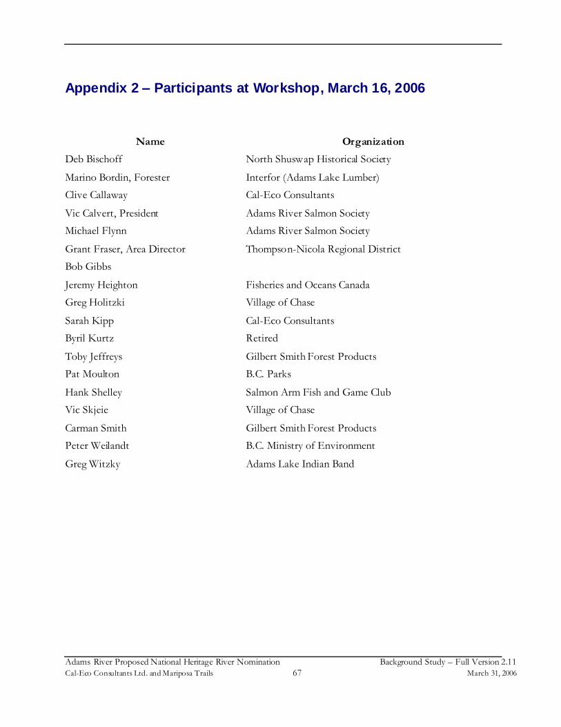
Adams River Proposed National Heritage River Nomination Background Study–Full Version 2.11Cal-Eco Consultants Ltd. and Mariposa Trails 67 March 31, 2006
Appendix 2 –Participants at Workshop, March 16, 2006
Name Organization
Deb Bischoff North Shuswap Historical Society
Marino Bordin, Forester Interfor (Adams Lake Lumber)
Clive Callaway Cal-Eco Consultants
Vic Calvert, President Adams River Salmon Society
Michael Flynn Adams River Salmon Society
Grant Fraser, Area Director Thompson-Nicola Regional District
Bob Gibbs
Jeremy Heighton Fisheries and Oceans Canada
Greg Holitzki Village of Chase
Sarah Kipp Cal-Eco Consultants
Byril Kurtz Retired
Toby Jeffreys Gilbert Smith Forest Products
Pat Moulton B.C. Parks
Hank Shelley Salmon Arm Fish and Game Club
Vic Skjeie Village of Chase
Carman Smith Gilbert Smith Forest Products
Peter Weilandt B.C. Ministry of Environment
Greg Witzky Adams Lake Indian Band