bajalta california: the border that divides brings us...
TRANSCRIPT
Bajalta California: The border that divides brings us togetherAuthor(s): Michael DearSource: Boom: A Journal of California, Vol. 4, No. 1 (Spring 2014), pp. 86-97Published by: University of California PressStable URL: http://www.jstor.org/stable/10.1525/boom.2014.4.1.86 .
Accessed: 07/05/2014 12:38
Your use of the JSTOR archive indicates your acceptance of the Terms & Conditions of Use, available at .http://www.jstor.org/page/info/about/policies/terms.jsp
.JSTOR is a not-for-profit service that helps scholars, researchers, and students discover, use, and build upon a wide range ofcontent in a trusted digital archive. We use information technology and tools to increase productivity and facilitate new formsof scholarship. For more information about JSTOR, please contact [email protected].
.
University of California Press is collaborating with JSTOR to digitize, preserve and extend access to Boom: AJournal of California.
http://www.jstor.org
This content downloaded from 50.131.223.156 on Wed, 7 May 2014 12:38:35 PMAll use subject to JSTOR Terms and Conditions
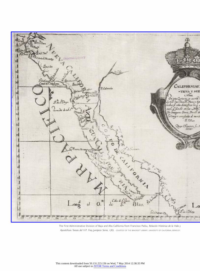
The First Administrative Division of Baja and Alta California from Francisco Palou, Relacion Historica de la Vida y
Apostolicas Tareas del V.P. Fray Junıpero Serra, 1787. COURTESY OF THE BANCROFT LIBRARY, UNIVERSITY OF CALIFORNIA, BERKELEY.
This content downloaded from 50.131.223.156 on Wed, 7 May 2014 12:38:35 PMAll use subject to JSTOR Terms and Conditions
michael dear
Bajalta California
The border that divides brings us together
T he United States–Mexico borderlands are among the most misunderstood
places on Earth. The communities along the line are far distant from the
centers of political power in the nations’ capitals. They are staunchly indepen-
dent and composed of many cultures with hybrid loyalties. Historically, since the
borderline was drawn between the two countries, Texas border counties have been
among the poorest regions in both countries. Those in New Mexico and Arizona were
sparsely populated agricultural and mining districts; and in the more affluent west,
Baja California was always more closely connected to California than to Mexico. Now-
adays, border states are among the fastest-growing regions in both countries. They are
places of economic dynamism, teeming contradiction, and vibrant political and cul-
tural change.
Mutual interdependence has always been the hallmark of cross-border lives. After
the 1848 Treaty of Guadalupe Hidalgo settled the Mexican-American War, a series of
binational ‘‘twin towns’’ sprang up along the line, developing identities that are suffi-
ciently distinct as to warrant the collective title of a ‘‘third nation,’’ snugly slotted in the
space between the two host countries. At the western-most edge of this third nation is
the place I call ‘‘Bajalta California.’’1
The international boundary does not divide the third nation but instead acts as
a connective membrane uniting it. This way of seeing the borderlands runs counter to
received wisdom, which regards the border as the last line of national defense against
unfettered immigration, rapacious drug cartels, and runaway global terrorism. It is
a viewpoint that substitutes continuity and coexistence in place of sovereignty and
difference.
In 2002, I began traveling the entire length of the US-Mexico border, on both sides,
from Tijuana/San Diego on the Pacific Ocean, to Matamoros/Brownsville on the Gulf
BOOM | S P R I N G 2 0 1 4 87
BOOM: The Journal of California, Vol. 4, Number 1, pps 86–97, ISSN 2153-8018, electronic ISSN 2153-764X.
© 2014 by the Regents of the University of California. All rights reserved. Please direct all requests for
permission to photocopy or reproduce article content through the University of California Press’s Rights and
Permissions website, http://www.ucpressjournals.com/reprintInfo.asp. DOI: 10.1525/boom.2014.4.1.86.
This content downloaded from 50.131.223.156 on Wed, 7 May 2014 12:38:35 PMAll use subject to JSTOR Terms and Conditions
of Mexico, a total of 4,000 miles. I voyaged in the footsteps
of giants. Sixteenth-century Spanish explorers Cabeza de
Vaca and Francisco Vasquez de Coronado came this
way. Generals Santa Anna and Zachary Taylor fought
important battles for these lands during the Mexican-
American War.
What began as an impulsive journey of discovery was
rapidly overtaken by events. I had the good (and bad) fortune
to begin before the United States undertook the fortification
of its southern boundary, and so I became an unintentional
witness to the border’s closure, an experience that altered
my understanding of the two countries. My experiences of
the in-between third nation provide a powerful rejoinder to
those who would relegate the borderlands to the status of
surrogate battlefield against migrants, narcotraficantes, and
terrorists.
In his 1787 biography of Fray Junıpero Serra, Francisco
Palou included a map of the first administrative division of
Baja and Alta California, indicating the Spanish allocation of
mission territories between Franciscans to the north and the
Dominicans to the south. That border was recognized on 2
February 1848, when a ‘‘Treaty of Peace, Friendship, Limits,
and Settlement’’ was signed at Guadalupe Hidalgo, thereby
terminating the Mexican-American War, which had begun
in 1846 and was regarded by many (including Ulysses S.
Grant) as a dishonorable action on the part of the United
States. Article V of the Treaty of Guadalupe Hidalgo (as it
came to be called) required the designation of a ‘‘boundary
line with due precision, upon authoritative maps, and to
establish upon the ground landmarks which shall show the
limits of both republics.’’ The line would extend from the
mouth of the deepest channel of the Rio Grande (known in
Mexico as the Rıo Bravo del Norte); up river to ‘‘the town
called Paso’’ (present-day El Paso/Ciudad Juarez); from
thence overland to the Gila River, and down the channel
of the Colorado River; after which it would follow the
administrative division between Upper (Alta) California and
Lower (Baja) California to the Pacific Ocean.2
In a multivolume history of the American West, histo-
rian Carl Wheat refers disparagingly to the post-war bound-
ary survey as the stuff that ‘‘dime novels’’ are made of. To
justify this characterization, he invokes yarns about political
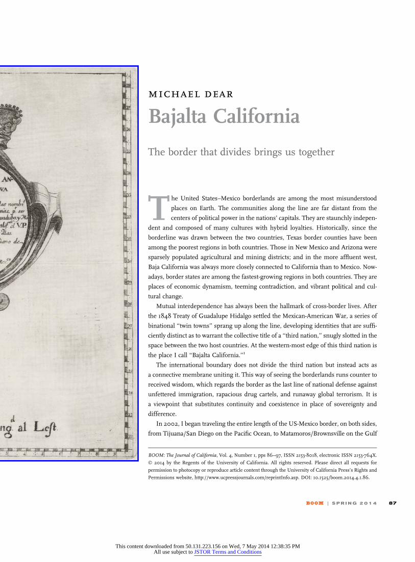
Survey plan for the first boundary point (punto inicial) between San Diego and Tijuana from Jose Salazar Ylarregiu.
Datos de los trabajos astronomicos y topograficos, dispuestos en forma de diario. (MEXICO: IMPRENTA DE JUAN R. NAVARRO, 1850).
88 B O O M C A L I F O R N I A . C O M
This content downloaded from 50.131.223.156 on Wed, 7 May 2014 12:38:35 PMAll use subject to JSTOR Terms and Conditions
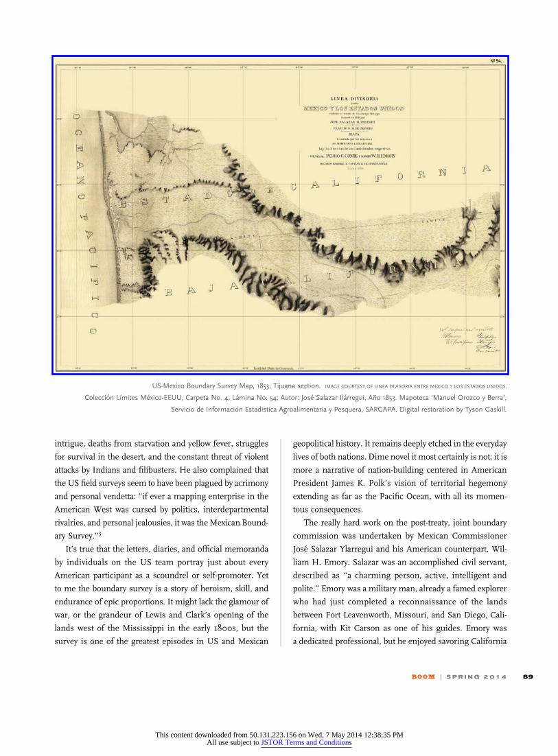
intrigue, deaths from starvation and yellow fever, struggles
for survival in the desert, and the constant threat of violent
attacks by Indians and filibusters. He also complained that
the US field surveys seem to have been plagued by acrimony
and personal vendetta: ‘‘if ever a mapping enterprise in the
American West was cursed by politics, interdepartmental
rivalries, and personal jealousies, it was the Mexican Bound-
ary Survey.’’3
It’s true that the letters, diaries, and official memoranda
by individuals on the US team portray just about every
American participant as a scoundrel or self-promoter. Yet
to me the boundary survey is a story of heroism, skill, and
endurance of epic proportions. It might lack the glamour of
war, or the grandeur of Lewis and Clark’s opening of the
lands west of the Mississippi in the early 1800s, but the
survey is one of the greatest episodes in US and Mexican
geopolitical history. It remains deeply etched in the everyday
lives of both nations. Dime novel it most certainly is not; it is
more a narrative of nation-building centered in American
President James K. Polk’s vision of territorial hegemony
extending as far as the Pacific Ocean, with all its momen-
tous consequences.
The really hard work on the post-treaty, joint boundary
commission was undertaken by Mexican Commissioner
Jose Salazar Ylarregui and his American counterpart, Wil-
liam H. Emory. Salazar was an accomplished civil servant,
described as ‘‘a charming person, active, intelligent and
polite.’’ Emory was a military man, already a famed explorer
who had just completed a reconnaissance of the lands
between Fort Leavenworth, Missouri, and San Diego, Cali-
fornia, with Kit Carson as one of his guides. Emory was
a dedicated professional, but he enjoyed savoring California
US-Mexico Boundary Survey Map, 1853, Tijuana section. IMAGE COURTESY OF LINEA DIVISORIA ENTRE MEXICO Y LOS ESTADOS UNIDOS,
Coleccion Lımites Mexico-EEUU, Carpeta No. 4, Lamina No. 54; Autor: Jose Salazar Ilarregui, Ano 1853. Mapoteca ‘Manuel Orozco y Berra’,
Servicio de Informacion Estadistica Agroalimentaria y Pesquera, SARGAPA. Digital restoration by Tyson Gaskill.
BOOM | S P R I N G 2 0 1 4 89
This content downloaded from 50.131.223.156 on Wed, 7 May 2014 12:38:35 PMAll use subject to JSTOR Terms and Conditions

wines at the end of his expedition (noting with admiration
that ‘‘Many bottles were drunk leaving no headache or acid-
ity on the stomach’’). He also observed that Californians
were excellent horsemen and enjoyed an unusual diet: ‘‘The
fresh meat of a bullock is all that is required by the Califor-
nian for breakfast, dinner, and supper.’’ Bread, tea, and
coffee they rarely used, he wrote, but their ‘‘white teeth’’
and blood ‘‘tingling’’ in their cheeks suggested that they
enjoyed a ‘‘very healthy diet.’’4
The boundary survey officially began on 6 July 1849.
Over the next two years the California survey from San
Diego to the Colorado River was the first to be completed.
Attention was understandably lavished on fixing the initial
points (puntos iniciales) of the line: the beginning marker
was to be one marine league south of the port of San Diego,
and the second at the confluence of the Gila and Colorado
Rivers (though this was later adjusted). A straight line con-
necting the two would mark the international boundary.
Disagreements arose immediately among the survey
teams because there was no standard measure for a marine
league. However, with a generous concordance that marked
their entire collaboration, Salazar and Emory agreed to split
the difference between their respective surveys. A location
for the initial point was fixed at the shoreline west of
present-day Tijuana, and a temporary monument was
erected. Surveying, marking, and mapping of the California
line could begin. After its completion in 1851, the boundary
commissioners subsequently turned attention to the Rio
Grande/Rıo Bravo and the interior surveys, both of which
presented stiffer challenges for the surveyors.5
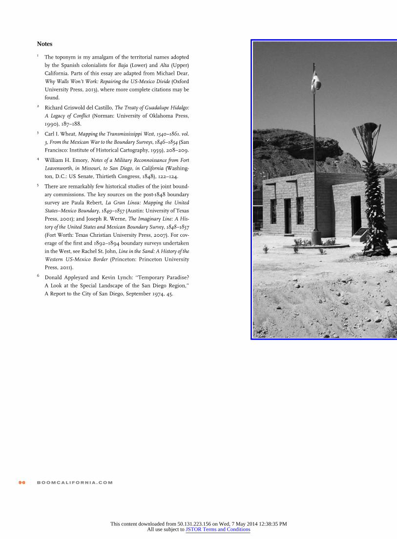
As borderland settlements expanded during the nine-
teenth century, disputes over the exact location of the
Ancient boundary monument No. XVI was a simple pile of stones, early 1850s. From Jacobo Blanco’s Memoria de la Seccion Mexicana de la
Comision Internacional de Lımites entre Mexico y los Estados Unidos que Restablecio los Monumentos de El Paso al Pacıfico. 1901.
90 B O O M C A L I F O R N I A . C O M
This content downloaded from 50.131.223.156 on Wed, 7 May 2014 12:38:35 PMAll use subject to JSTOR Terms and Conditions
boundary line became more frequent. In the last decade of
the nineteenth century, a new boundary commission was
established to undertake a resurvey of the land portion of
the border. Commissioners John Whitney Barlow and
Jacobo Blanco met at El Paso in February 1892, with
instructions to resurvey the line, locate and rebuild the
old monuments, and install additional markers as
necessary.
The second survey team faced nothing like the hardships
of the first. Barlow and Blanco had the original survey maps
and existing monuments as guides, possessed superior
instrumentation, and enjoyed the conveniences of tele-
graphic communication and the Southern Pacific Railway,
which ran just north of the border. However, many of the
original monuments were difficult to find especially in
mountainous terrain, and errors in the first survey meant
that some monuments were incorrectly positioned. Such
mistakes were either quietly adjusted or left unchallenged
so as to avoid the need for renegotiating treaties. Some stone
markers had been deliberately destroyed by Indians as an
expression of antipathy toward US territorial claims. Others
had been dismantled for use as building materials. Also to
blame were ranchers and miners who destroyed or moved
markers in order to gain control over nearby land, water, or
mineral resources.
The work of the resurvey commission was completed
relatively quickly by June 1894, increasing the number of
boundary monuments from 52 to 258. The eighteen maps
produced by the resurvey commission are precise and
workmanlike renderings, though there is nothing of the
artistry and panache of the scribes employed by Emory and
Salazar.
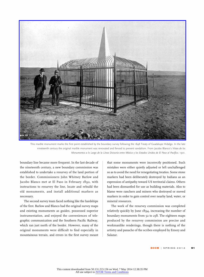
This marble monument marks the first point established by the boundary survey following the 1848 Treaty of Guadalupe Hidalgo. In the late
nineteenth century the original marble monument was renovated and fenced to prevent vandalism. From Jacobo Blanco’s Vistas de los
Monumentos a lo Largo de la Lınea Divisoria entre Mexico y los Estados Unidos de El Paso al Pacıfico. 1901.
BOOM | S P R I N G 2 0 1 4 91
This content downloaded from 50.131.223.156 on Wed, 7 May 2014 12:38:35 PMAll use subject to JSTOR Terms and Conditions
Around the turn of the century, a further eighteen monu-
ments were erected to ‘‘more perfectly mark’’ the line in
congested towns and on new rail bridges or to repair dam-
age. For instance, the International Boundary Commission
erected a new monument to clarify the division between
Calexico and Mexicali, and restored monument 220-A after
the damage occasioned by the human-induced flood of 1905
when the Colorado River burst its banks at Yuma and flowed
north for two years, creating the Salton Sea and destroying
much of Mexicali.
With the completion of 276 monuments, the Boundary
Commission’s official monumentation program ended. Both
countries agreed that any further delimitation would consist of
smaller ‘‘markers’’ (monojeras) of concrete. By 1975, another
442 such markers had been added, principally in and around
sprawling border towns, and another 51 were added in 1984.
For most of the twentieth century, the international
boundary line between Mexico and the United States
remained loosely marked, haphazardly maintained, and
casually observed. Outside the cities, the boundary line
remained a nondescript affair. And in many places the
divide was left unmarked. People in rural areas crossed it
without hindrance. Virtually everyone I met on my border
peregrination had childhood memories of going over to el
otro lado (the other side) to shop, attend school, graze live-
stock, or join a weekend softball game.
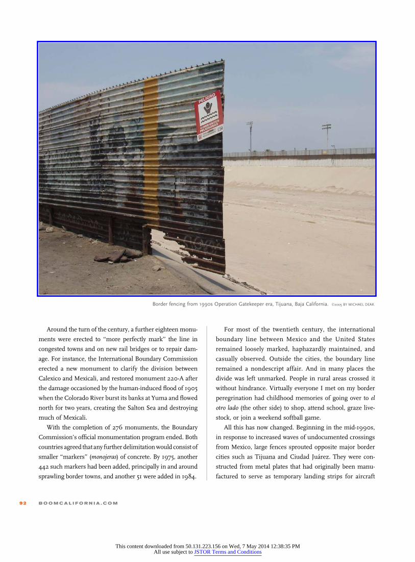
All this has now changed. Beginning in the mid-1990s,
in response to increased waves of undocumented crossings
from Mexico, large fences sprouted opposite major border
cities such as Tijuana and Ciudad Juarez. They were con-
structed from metal plates that had originally been manu-
factured to serve as temporary landing strips for aircraft
Border fencing from 1990s Operation Gatekeeper era, Tijuana, Baja California. ©2005 BY MICHAEL DEAR.
92 B O O M C A L I F O R N I A . C O M
This content downloaded from 50.131.223.156 on Wed, 7 May 2014 12:38:35 PMAll use subject to JSTOR Terms and Conditions
during the Vietnam War and were recycled by turning the
panels upright and clipping them together to form a barrier.
Anyone could easily get fingers and toes into their grooves
and hoist themselves up and over the fence, and it was
common at this time to see people perched atop the fence
awaiting the right moment to cross.
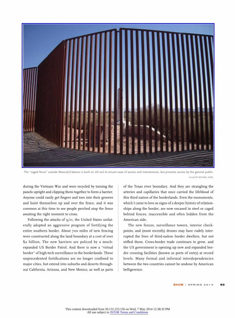
Following the attacks of 9/11, the United States unilat-
erally adopted an aggressive program of fortifying the
entire southern border. About 700 miles of new fencing
were constructed along the land boundary at a cost of over
$2 billion. The new barriers are policed by a much-
expanded US Border Patrol. And there is now a ‘‘virtual
border’’ of high-tech surveillance in the borderlands. These
unprecedented fortifications are no longer confined to
major cities, but extend into suburbs and deserts through-
out California, Arizona, and New Mexico, as well as parts
of the Texas river boundary. And they are strangling the
arteries and capillaries that once carried the lifeblood of
this third nation of the borderlands. Even the monuments,
which I came to love as signs of a deeper history of relation-
ships along the border, are now encased in steel or caged
behind fences, inaccessible and often hidden from the
American side.
The new fences, surveillance towers, interior check-
points, and (most recently) drones may have rudely inter-
rupted the lives of third-nation border dwellers, but not
stifled them. Cross-border trade continues to grow, and
the US government is opening up new and expanded bor-
der crossing facilities (known as ports of entry) at record
levels. Many formal and informal interdependencies
between the two countries cannot be undone by American
belligerence.
The ‘‘caged fence’’ outside Mexicali/Calexico is built on US soil to ensure ease of access and maintenance, but prevents access by the general public.
©2008 BY MICHAEL DEAR.
BOOM | S P R I N G 2 0 1 4 93
This content downloaded from 50.131.223.156 on Wed, 7 May 2014 12:38:35 PMAll use subject to JSTOR Terms and Conditions
The space between Mexico and the United States is not
recognized as a ‘‘nation’’ even though it evinces character-
istics that typically warrant the appellation, such as shared
identity, common history, and joint traditions. Border dwell-
ers in San Diego and Tijuana readily assert that they have
more in common with each other than with their host
nations, describing themselves as ‘‘transborder citizens.’’
One man who crossed daily, living and working on both
sides, told me: ‘‘I forget which side of the border I’m on.’’
In response to fortification and militarization, border
dwellers have made what adjustments they can, demonstrat-
ing a remarkable durability and adaptability based in a long
history of coexistence. The third nation endures under
duress.
One of the earliest imaginings of a shared future for the
twin cities of San Diego and Tijuana appeared in a 1974
report that Donald Appleyard and Kevin Lynch prepared for
the City of San Diego. In it, they identified eight city-
planning principles, one of which was: ‘‘Reach across the
border. Treat San Diego/Tijuana as one unified metropo-
lis.’’6 Their recommendation was based on how residents
perceived themselves and each other, as well as ways in
which they utilized cross-border urban resources. Circum-
stances have changed dramatically since 1974, and the spe-
cifics of the Appleyard/Lynch proposal may have been
forgotten. Nevertheless, their vision of a ‘‘unified metropo-
lis’’ remains firmly ensconced in regional imaginations on
both sides of the line.
From the long perspective of history, the wall (a term
used here as a collective noun for the entire suite of
fortification and police apparatuses along the borderline)
is an unprecedented aberration. The principal reason why
nowadays barriers exist and border tensions are so intense
is that immigration, drugs, and national security are
international problems that do not originate in the bor-
derlands. Yet at a national level, the United States and
Mexico treat the borderlands as the place where these pro-
blems will be confronted, and each nation stands to gain
from the sacrifices of that small minority of their citizens
who reside in border zones. Border communities have
no choice but to bear the burden of shouldering
national responsibilities. They have no capacity for self-
determination in this matter, and suffer the imposition
with limited assistance from their national and local gov-
ernments that rarely extends beyond military and police
intervention.
The borderland dilemma, in a nutshell, is of distributed
benefits versus concentrated costs. That is, an entire
nation benefits from control over national security threats,
illicit drugs, and undocumented migration; but a small
swath of border communities suffer the costs of the
wall—disruptions and delays, the onerous practices of secu-
rity forces, their ubiquitous infrastructure, a pervasive cli-
mate of lawlessness, and a growing distrust of public life
and institutions. Far-distant politicians in Washington,
D.C., and Mexico City seem to pay little heed to the voices
of border dwellers.
My Mexican friends along the border have no good words
for the wall, describing it simply as ‘‘stupid and offensive.’’
On the American side, border dwellers’ demands are clear,
and different from the national conversation about the wall:
provide more ports of entry to reduce crossing times, end
the ‘‘police state’’ conditions along the border, follow the
lead of Tijuana and San Diego mayors in forging a joint
future for twin cities along the border, and take down the
walls.
The future of Bajalta California—and the rest of the bor-
derlands—will depend on altering a mind-set that is pre-
pared to sacrifice this nation in-between on the altar of
geopolitical obsession. The vigor and prosperity of the third
nation may yet prove to be the most important guarantors of
national security. Instead of more walls, why not invest in
The future of Bajalta California will depend on
altering a mind-set that is prepared to sacrifice
this nation in-between on the altar of
geopolitical obsession.
94 B O O M C A L I F O R N I A . C O M
This content downloaded from 50.131.223.156 on Wed, 7 May 2014 12:38:35 PMAll use subject to JSTOR Terms and Conditions

infrastructure that consolidates the collaboration between
the two nations?
In the meantime, even the wall’s makers have lost faith
in their creation. Confronted by criticism of the fortifica-
tions’ effectiveness, the US Department of Homeland Secu-
rity long ago conceded that the wall was never intended to
stop migrants, merely to slow their progress so that they
could be apprehended more easily.
During the peak fence-building frenzy, I met a Border
Patrol agent and project engineer at Smuggler’s Gulch,
a deep canyon west of Tijuana where 1.6 million cubic yards
of landfill had been dumped to block a well-traveled path for
people avoiding the official border crossings nearby. A tun-
nel had been incorporated under the landfill to permit a can-
yon stream to continue flowing north across the border. The
agent gazed at the passageway opened up by the tunnel and
grumbled that migrants undoubtedly would soon start
using the tunnel as a crossing route. The engineer turned
his back on the massive earthworks, sighing: ‘‘Ninety per-
cent of this is politics.’’
We do not have to look far to find places without walls
along the border, where people live amicably and securely.
In 2011, I revisited El Paso/Ciudad Juarez after most of the
fortifications along the land boundary had been completed.
Accustomed by now to the wall’s shadows, I was surprised
and delighted to discover that there was no fence in the
vicinity of Monument #1, where the land boundary meets
the Rio Grande/Rıo Bravo. Instead, the border is marked
only by a shallow earthen berm with a sign announcing the
international boundary. The ambience during my visit that
day was relaxed. Nothing impeded communication across
the line, and I exchanged courtesies in Spanish and English
with people on both sides. Things were as they should be.
Of course, I knew from past experience that someone,
somewhere was observing us. But electronic surveillance
actually may be preferable to more fences. A virtual border
could be the price of border security and amicability without
fences.
Bajalta California is a place of being and becoming
between two nations, where binational lives and values are
being created—organically, readily, and without artifice. It
deserves nurturing. This third nation has strong connecting
tissue that will outlast partition, and, eventually, the wall
separating Mexico and the United States will come down.
Walls always do. B
The vertical stacking of border infrastucture at monument
122-A, viewed from the Avenida Internacional in
Nogales, Sonora, recalls the ‘‘deep archeology’’ of the line.
The top panel reveals present-day electronic surveillance
apparatus; below this is the 1990-era Operation Hold-the-Line
fencing; in the third horizon is a monument from the late
nineteenth-century boundary resurvey; and at its base lies
a concrete retaining wall that has been spray-painted with
symbols of birth and death characteristic of ancient
Mesoamerican cultures.
©2003 BY MICHAEL DEAR.
BOOM | S P R I N G 2 0 1 4 95
This content downloaded from 50.131.223.156 on Wed, 7 May 2014 12:38:35 PMAll use subject to JSTOR Terms and Conditions
Notes
1 The toponym is my amalgam of the territorial names adopted
by the Spanish colonialists for Baja (Lower) and Alta (Upper)
California. Parts of this essay are adapted from Michael Dear,
Why Walls Won’t Work: Repairing the US-Mexico Divide (Oxford
University Press, 2013), where more complete citations may be
found.2 Richard Griswold del Castillo, The Treaty of Guadalupe Hidalgo:
A Legacy of Conflict (Norman: University of Oklahoma Press,
1990), 187–188.3 Carl I. Wheat, Mapping the Transmississippi West, 1540–1861. vol.
3, From the Mexican War to the Boundary Surveys, 1846–1854 (San
Francisco: Institute of Historical Cartography, 1959), 208–209.4 William H. Emory, Notes of a Military Reconnoissance from Fort
Leavenworth, in Missouri, to San Diego, in California (Washing-
ton, D.C.: US Senate, Thirtieth Congress, 1848), 122–124.5 There are remarkably few historical studies of the joint bound-
ary commissions. The key sources on the post-1848 boundary
survey are Paula Rebert, La Gran Lınea: Mapping the United
States–Mexico Boundary, 1849–1857 (Austin: University of Texas
Press, 2001); and Joseph R. Werne, The Imaginary Line: A His-
tory of the United States and Mexican Boundary Survey, 1848–1857
(Fort Worth: Texas Christian University Press, 2007). For cov-
erage of the first and 1892–1894 boundary surveys undertaken
in the West, see Rachel St. John, Line in the Sand: A History of the
Western US-Mexico Border (Princeton: Princeton University
Press, 2011).6 Donald Appleyard and Kevin Lynch: ‘‘Temporary Paradise?
A Look at the Special Landscape of the San Diego Region,’’
A Report to the City of San Diego, September 1974, 45.
96 B O O M C A L I F O R N I A . C O M
This content downloaded from 50.131.223.156 on Wed, 7 May 2014 12:38:35 PMAll use subject to JSTOR Terms and Conditions

The present-day boundary at El Paso and Ciudad Juarez is noteworthy for the absence of fortifications. From the left, panel 1 shows the
Casa de Adobe, the recently restored headquarters of Mexican Revolution leader Francisco Madero; panel 2, a bust of Madero; panel 3, a berm
topped with a sign marking the boundary between the two nations; and panel 4, the ancient monument number 1. ©2011 BY MICHAEL DEAR.
BOOM | S P R I N G 2 0 1 4 97
This content downloaded from 50.131.223.156 on Wed, 7 May 2014 12:38:35 PMAll use subject to JSTOR Terms and Conditions