bamiyan province climatology and temperature extremes … · bamiyan province climatology and...
TRANSCRIPT
DTA Report 343NR 1601ISSN 1175-6594
Bamiyan Province Climatology and Temperature Extremes in Afghanistan
D E Cook
April 2012
DTA Report 343 NR 1601 ISSN 1175-6594
BAMIYAN PROVINCE CLIMATOLOGY AND TEMPERATURE EXTREMES IN AFGHANISTAN
Duncan E. Cook
APRIL 2012
ABSTRACT Afghanistan is susceptible to extremes in surface air temperatures that are of importance to the designers and manufacturers of military hardware. Data mining of all known direct weather observations from the region has identified the highest ambient air temperature recorded in Afghanistan: 54°C, recorded at Asadabad in Konar Province. Extreme heat is not uncommon in Afghanistan; lowland deserts sites examined in this report often exceed 45°C on hot summer days. In addition, there is strong evidence suggesting that temperatures on military tarmacs, in vehicles and in storage facilities may be as much as 20°C higher again. In contrast, high-altitude regions of Afghanistan such as Bamiyan Province experience a dry, mountain climate with mild summers and bitterly cold winters. The few climate records available from Bamiyan Province show that extreme cold and snow is common in the winter months, conditions which could affect the lifespan and performance of military hardware (such as UAS) designed for operation in temperate environments. The Bamiyan data show the presence of strong and highly localised winds each year that can be of sufficient strength as to impact hardware endurance and operability. The findings from this work highlight the need to quantify the environmental conditions of the battlefield and of developing military hardware that will withstand environmental extremes and thus operate reliably in a diverse range of theatres.

Published by Defence Technology Agency Private Bag 32901 Devonport Auckland 0744 New Zealand © Crown Copyright 2011
EXECUTIVE SUMMARY
BACKGROUND
A detailed knowledge of the environmental conditions in which military hardware must operate is
of primary importance to those scientists and engineers planning and creating products for our
militaries. The Defence Technology Agency’s (DTA) Kahu Unmanned Aerial System (UAS) was
designed for use in temperate environment regions such as mainland New Zealand. This hardware
has recently begun operations in other areas of the world. Research undertaken at the DTA has
required knowledge of the range of environmental conditions that exist in Afghanistan, while
related information on the climate of Bamiyan Province in Afghanistan is needed for UAS
planning and operations. This report draws these two research streams together to provide detailed
information on the temperature extremes that can be encountered in Afghanistan while discussing
all known observations of weather from Bamiyan Province and how annual climatic conditions
here may affect Kahu UAS operations.
SPONSOR
A0802 – Unmanned Vehicle Systems
AIMS
The first aim of this work is to document the temperature extremes that exist in Afghanistan. The
secondary aim here is to provide a detailed account of the climatic conditions found in Bamiyan
Province, Afghanistan, in support of Kahu UAS operations here by the NZDF.
RESULTS
Data mining of all known direct weather observations from the region has identified the highest
ambient air temperature recorded in Afghanistan: 54°C, recorded at Asadabad in Konar Province
in 1987 and 1988. Beyond this location, stations in the lowland desert regions of Afghanistan
have recorded maximum air temperatures in excess of 49°C. In addition, there is strong
evidence suggesting that temperatures on military tarmacs, in vehicles and in storage facilities
may be as much as 20°C higher again. And while extreme high temperatures may not be an
issue in high-altitude regions such as Bamiyan Province, other aspects of the operational
environment here present challenges to military planners. Bamiyan Province has a dry, mountain
climate with mild summers and bitterly cold winters. There are direct weather observations from
just two locations. High altitudes and complex terrain further confound climatic analyses, with
individual valleys often having unique microclimates and no direct observations. Analysis of the
available weather records highlights several critical issues for UAS operations here. The
presence of strong and highly-localised winds in the province can be of sufficient strength as to
impact UAS endurance and operability, while extreme cold and snow in the winter months may
equally test military hardware and reduce opportunities for deployment.
DTA Report 343 ii
CONTENTS EXECUTIVE SUMMARY ............................................................................................... ii
BACKGROUND ......................................................................................................... ii
SPONSOR ................................................................................................................. ii
AIMS .......................................................................................................................... ii
RESULTS .................................................................................................................. ii
CONTENTS.................................................................................................................. iii
LIST OF TABLES ..........................................................................................................v
LIST OF FIGURES ........................................................................................................v
1 Introduction.............................................................................................................1
2 Bamiyan Province climate ......................................................................................2
2.1 Location and climate ....................................................................................2
2.2 Regional winds ............................................................................................2
2.3 Data sources................................................................................................4
2.4 Bamiyan.......................................................................................................6
2.4.1 Temperature .........................................................................................6
2.4.2 Wind .....................................................................................................8
2.4.3 Precipitation..........................................................................................8
2.5 Pan Jao......................................................................................................10
2.5.1 Temperature .......................................................................................10
2.5.2 Wind ...................................................................................................11
2.5.3 Precipitation........................................................................................11
2.6 Camp Airborne (Wardak Province) ............................................................12
2.6.1 Temperature .......................................................................................12
2.6.2 Wind ...................................................................................................13
2.6.3 Precipitation........................................................................................14
2.7 Summary: Bamiyan Province climate and UAS operations .......................15
2.7.1 Critical issues for UAS operations ......................................................15
2.7.2 Temperature .......................................................................................15
2.7.3 Wind ...................................................................................................16
2.7.4 Precipitation........................................................................................16
3 Long-term temperature time series in Afghanistan ...............................................17
4 Maximum temperatures from Afghanistan weather stations.................................20
4.1 Introduction ................................................................................................20
DTA Report 343 iii
4.2 Asadabad, Konar Province, eastern Afghanistan ......................................21
4.3 Kundunz, Kunduz Province, northern Afghanistan ....................................21
4.4 Faizabad, Badakhsan Province, northern Afghanistan ..............................21
4.5 Bust, Helmand Province, southern Afghanistan.........................................21
4.6 Farah, Farah Province, southwestern Afghanistan ....................................21
4.7 Zaranj, Nimruz Province, southern Afghanistan.........................................22
4.8 Jalalabad, Nangarhar Province, eastern Afghanistan................................22
4.9 Kandahar Airport, Kandahar Province, southern Afghanistan....................22
4.10 Herat, Herat Province, western Afghanistan ..............................................22
4.11 Farah TMQ-53, Farah Province, western Afghanistan..............................22
4.12 FOB Ramrod, Kandahar Province, southern Afghanistan..........................22
4.13 Kabul Airport, Kabol Province, eastern Afghanistan ..................................23
5 Maximum temperatures in Afghanistan: other observations.................................23
5.1 Runways and tarmacs ..............................................................................23
5.2 Vehicle interior temperatures .....................................................................23
6 Concluding discussions ........................................................................................25
References ..................................................................................................................27
DTA Report 343 iv
DTA Report 343 v
LIST OF TABLES Table 1 Meteorological stations that contributed to the Bamiyan Province climatology ................................. 6 Table 2 Afghanistan meteorological stations contributing data to this study ................................................ 19 LIST OF FIGURES Figure 1 Bamiyan Province, Afghanistan.. .................................................................................................. 3 Figure 2 The Amu Darya River valley near the northern border of Afghanistan. Vertical entrainment of dust along a wind front connected to strong northerly regional winds in summer. ................... 3 Figure 3 True-colour satellite image from by MODIS of a dust storm over Iran, southern Afghanistan and Pakistan, 29 April 2004. ......................................................................................................... 5 Figure 4 Maximum Peak wind gusts measured at Bamiyan and Pan Jao, Bamiyan Province, Afghanistan.................................................................................................................................... 5 Figure 5 Annual wind velocities from sites in south and southwestern Afghanistan................................... 6 Figure 6 Topography of the Bamiyan Valley (trending west to east), Bamiyan Province, Afghanistan ...... 7 Figure 7 Maximum, minimum and mean daily air temperatures at Bamiyan, Bamiyan province,
Afghanistan, 1975-1987.............................................................................................................. 7 Figure 8 Precipitation at Bamiyan, Bamiyan Province, Afghanistan ........................................................... 9 Figure 9 New Zealand PRT in Bamiyan Province, winter 2010 .................................................................. 9 Figure 10 Air temperature recorded at the WMO weather station Pan Jao, Bamiyan Province, 1975-1979…………... ................................................................................................................... 10 Figure 11 Monthly precipitation at Pan Jao, Bamiyan Province, Afghanistan............................................. 11 Figure 12 Camp Airborne, Wardak Province, showing its location relative to Bamiyan Province and Kabul. ................................................................................................................................... 12 Figure 13 A two year record of air temperature from Camp Airborne, Wardak Province, Afghanistan ...... 13 Figure 14 Monthly mean and maximum wind speeds recorded at Camp Airborne, Wardak Province,
Afghanistan, 2008-2010 .............................................................................................................. 14 Figure 15 Daily precipitation received at Camp Airborne, Wardak Province, Afghanistan ......................... 15 Figure 16 Southwest Asia, showing the relationship between Afghanistan and its neighbouring countries. ..................................................................................................................................... 18 Figure 17 Data years of record for each calendar month, Islamabad Airport (Pakistan). ........................... 19 Figure 18 Monthly climate averages for Islamabad International Airport (Pakistan)................................... 19 Figure 19 Mean maximum monthly surface air temperature (°C) for July to December............................. 20
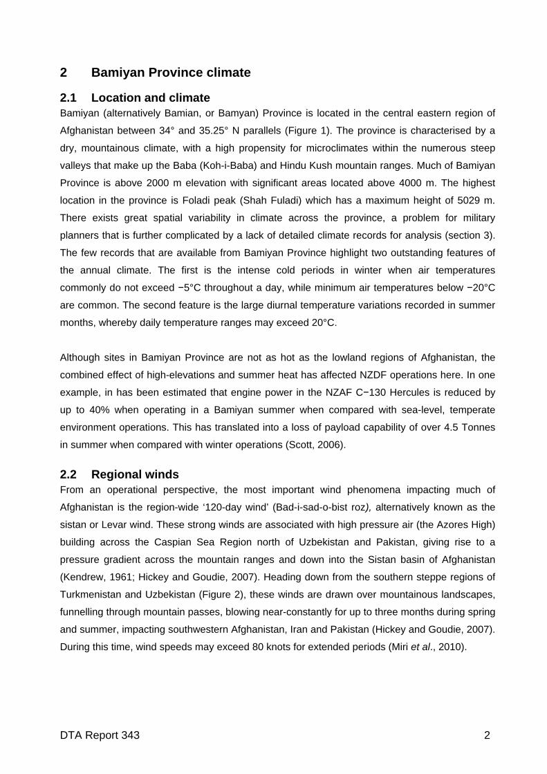
1 Introduction
An understanding of the environmental conditions that military hardware will be operated in is
essential information for scientists and engineers tasked with creating and testing safe and
reliable products. At the genesis of a project, a detailed knowledge of the environmental
conditions that equipment must withstand is necessary to assess the overall feasibility of
projects, and to broadly guide the direction that research and development may take. At later
stages of product development, environmental testing of hardware can be undertaken that
replicates those environments that the operational product will be used in (the Environments of
intended use of MIL-STD-810 or NATO STANAG 2895, for example).
The Defence Technology Agency (DTA) Kahu Unmanned Aerial System (UAS) (Strong and
Brown, 2010) was designed and built for the environmental conditions typically experienced in
mainland New Zealand or similar mid-latitude environments. Current research undertaken at DTA
has focused attention on theatres of operation outside of New Zealand. To assess the ability of
the Kahu hardware to withstand the extreme environmental conditions, this work was initiated to
quantify, in particular, the maximum temperatures that may be experienced in the country of
Afghanistan.
This report will first focus on the climate of Bamiyan Province, Afghanistan, utilising all applicable
data sources currently available. The remainder of this report will examine the long-term climate
history of the region, followed by a study of the hottest air temperatures recorded at weather
stations in Afghanistan. Finally, the implications of operating and storage temperatures in military
vehicles and structures relevant to the Kahu UAS will be explored. Although the climatic
extremes observed in Afghanistan in the past may not be precise predictors of weather
conditions in decades to come (especially under projected global warming scenarios), these data
sets are still the most powerful tool available in assessing environments of intended use for
military hardware.
DTA Report 343 1
2 Bamiyan Province climate
2.1 Location and climate Bamiyan (alternatively Bamian, or Bamyan) Province is located in the central eastern region of
Afghanistan between 34° and 35.25° N parallels (Figure 1). The province is characterised by a
dry, mountainous climate, with a high propensity for microclimates within the numerous steep
valleys that make up the Baba (Koh-i-Baba) and Hindu Kush mountain ranges. Much of Bamiyan
Province is above 2000 m elevation with significant areas located above 4000 m. The highest
location in the province is Foladi peak (Shah Fuladi) which has a maximum height of 5029 m.
There exists great spatial variability in climate across the province, a problem for military
planners that is further complicated by a lack of detailed climate records for analysis (section 3).
The few records that are available from Bamiyan Province highlight two outstanding features of
the annual climate. The first is the intense cold periods in winter when air temperatures
commonly do not exceed −5°C throughout a day, while minimum air temperatures below −20°C
are common. The second feature is the large diurnal temperature variations recorded in summer
months, whereby daily temperature ranges may exceed 20°C.
Although sites in Bamiyan Province are not as hot as the lowland regions of Afghanistan, the
combined effect of high-elevations and summer heat has affected NZDF operations here. In one
example, in has been estimated that engine power in the NZAF C−130 Hercules is reduced by
up to 40% when operating in a Bamiyan summer when compared with sea-level, temperate
environment operations. This has translated into a loss of payload capability of over 4.5 Tonnes
in summer when compared with winter operations (Scott, 2006).
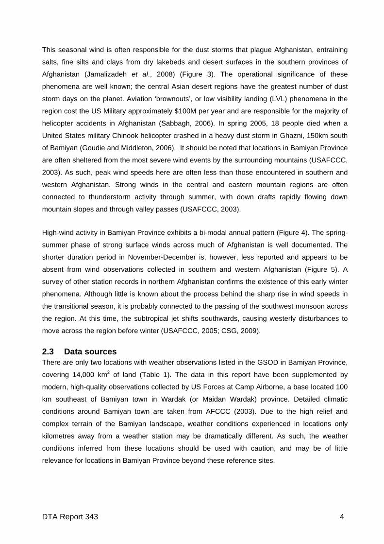
2.2 Regional winds From an operational perspective, the most important wind phenomena impacting much of
Afghanistan is the region-wide ‘120-day wind’ (Bad-i-sad-o-bist roz), alternatively known as the
sistan or Levar wind. These strong winds are associated with high pressure air (the Azores High)
building across the Caspian Sea Region north of Uzbekistan and Pakistan, giving rise to a
pressure gradient across the mountain ranges and down into the Sistan basin of Afghanistan
(Kendrew, 1961; Hickey and Goudie, 2007). Heading down from the southern steppe regions of
Turkmenistan and Uzbekistan (Figure 2), these winds are drawn over mountainous landscapes,
funnelling through mountain passes, blowing near-constantly for up to three months during spring
and summer, impacting southwestern Afghanistan, Iran and Pakistan (Hickey and Goudie, 2007).
During this time, wind speeds may exceed 80 knots for extended periods (Miri et al., 2010).
DTA Report 343 2
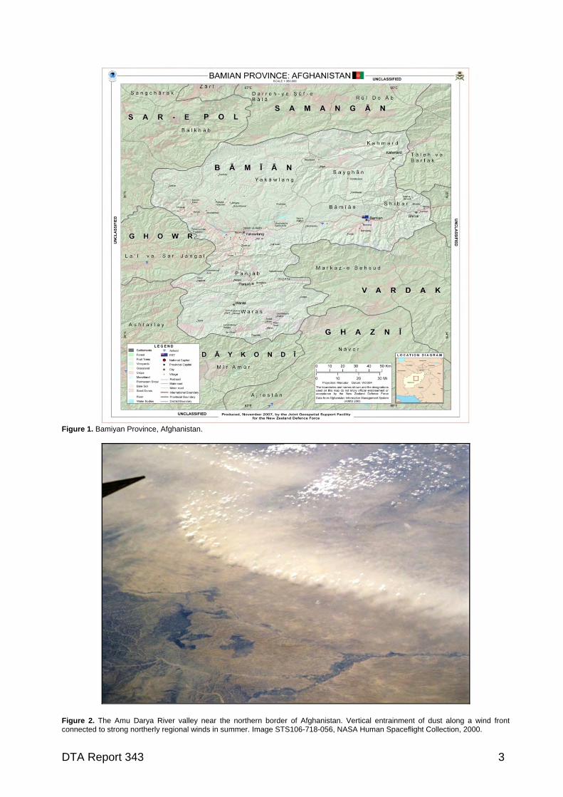
Figure 1. Bamiyan Province, Afghanistan.
Figure 2. The Amu Darya River valley near the northern border of Afghanistan. Vertical entrainment of dust along a wind front connected to strong northerly regional winds in summer. Image STS106-718-056, NASA Human Spaceflight Collection, 2000.
DTA Report 343 3
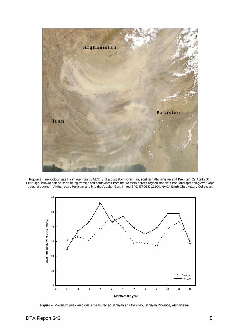
This seasonal wind is often responsible for the dust storms that plague Afghanistan, entraining
salts, fine silts and clays from dry lakebeds and desert surfaces in the southern provinces of
Afghanistan (Jamalizadeh et al., 2008) (Figure 3). The operational significance of these
phenomena are well known; the central Asian desert regions have the greatest number of dust
storm days on the planet. Aviation ‘brownouts’, or low visibility landing (LVL) phenomena in the
region cost the US Military approximately $100M per year and are responsible for the majority of
helicopter accidents in Afghanistan (Sabbagh, 2006). In spring 2005, 18 people died when a
United States military Chinook helicopter crashed in a heavy dust storm in Ghazni, 150km south
of Bamiyan (Goudie and Middleton, 2006). It should be noted that locations in Bamiyan Province
are often sheltered from the most severe wind events by the surrounding mountains (USAFCCC,
2003). As such, peak wind speeds here are often less than those encountered in southern and
western Afghanistan. Strong winds in the central and eastern mountain regions are often
connected to thunderstorm activity through summer, with down drafts rapidly flowing down
mountain slopes and through valley passes (USAFCCC, 2003).
High-wind activity in Bamiyan Province exhibits a bi-modal annual pattern (Figure 4). The spring-
summer phase of strong surface winds across much of Afghanistan is well documented. The
shorter duration period in November-December is, however, less reported and appears to be
absent from wind observations collected in southern and western Afghanistan (Figure 5). A
survey of other station records in northern Afghanistan confirms the existence of this early winter
phenomena. Although little is known about the process behind the sharp rise in wind speeds in
the transitional season, it is probably connected to the passing of the southwest monsoon across
the region. At this time, the subtropical jet shifts southwards, causing westerly disturbances to
move across the region before winter (USAFCCC, 2005; CSG, 2009).
2.3 Data sources There are only two locations with weather observations listed in the GSOD in Bamiyan Province,
covering 14,000 km2 of land (Table 1). The data in this report have been supplemented by
modern, high-quality observations collected by US Forces at Camp Airborne, a base located 100
km southeast of Bamiyan town in Wardak (or Maidan Wardak) province. Detailed climatic
conditions around Bamiyan town are taken from AFCCC (2003). Due to the high relief and
complex terrain of the Bamiyan landscape, weather conditions experienced in locations only
kilometres away from a weather station may be dramatically different. As such, the weather
conditions inferred from these locations should be used with caution, and may be of little
relevance for locations in Bamiyan Province beyond these reference sites.
DTA Report 343 4
A f g h a n i s t a n
P a k i s t a n
I r a n
Figure 3. True-colour satellite image from by MODIS of a dust storm over Iran, southern Afghanistan and Pakistan, 29 April 2004. Dust (light brown) can be seen being transported southwards from the western border Afghanistan with Iran, and spreading over large tracts of southern Afghanistan, Pakistan and into the Arabian Sea. Image SPD-ETOBS-12104, NASA Earth Observatory Collection.
0
10
20
30
40
50
60
0 1 2 3 4 5 6 7 8 9 10 11 12
Month of the year
Ma
xim
um
pe
ak
win
d g
us
t (k
no
ts)
Bamiyan
Pan Jao
Figure 4. Maximum peak wind gusts measured at Bamiyan and Pan Jao, Bamiyan Province, Afghanistan.
DTA Report 343 5
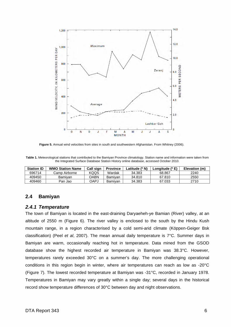
Figure 5. Annual wind velocities from sites in south and southwestern Afghanistan. From Whitney (2006).
Table 1. Meteorological stations that contributed to the Bamiyan Province climatology. Station name and information were taken from
the Integrated Surface Database Station History online database, accessed October 2010. Station ID WMO Station Name Call sign Province Latitude (º N) Longitude (º E) Elevation (m)
696714 Camp Airborne KQQS Wardak 34.383 68.867 2240 409450 Bamiyan OABN Bamiyan 34.810 67.810 2550 409460 Pan Jao OAPJ Bamiyan 34.383 67.033 2710
2.4 Bamiyan
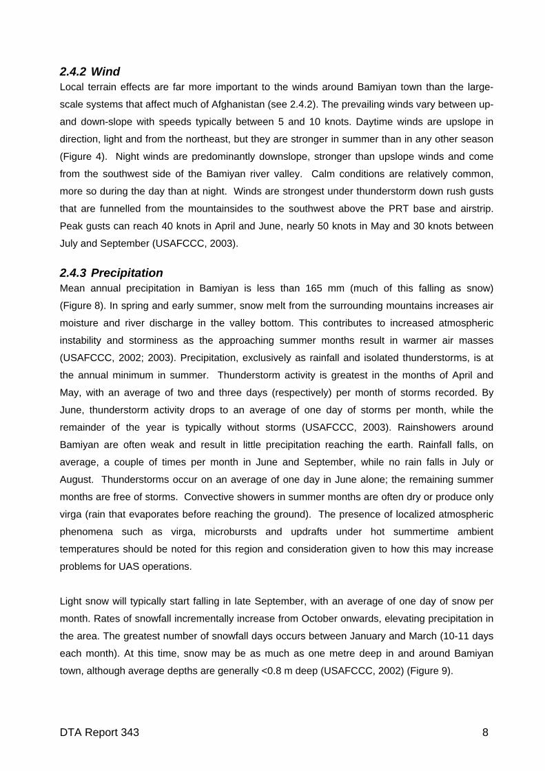
2.4.1 Temperature The town of Bamiyan is located in the east-draining Daryaeheh-ye Bamian (River) valley, at an
altitude of 2550 m (Figure 6). The river valley is enclosed to the south by the Hindu Kush
mountain range, in a region characterised by a cold semi-arid climate (Köppen-Geiger Bsk
classification) (Peel et al, 2007). The mean annual daily temperature is 7°C. Summer days in
Bamiyan are warm, occasionally reaching hot in temperature. Data mined from the GSOD
database show the highest recorded air temperature in Bamiyan was 38.3°C. However,
temperatures rarely exceeded 30°C on a summer’s day. The more challenging operational
conditions in this region begin in winter, where air temperatures can reach as low as -20°C
(Figure 7). The lowest recorded temperature at Bamiyan was -31°C, recorded in January 1978.
Temperatures in Bamiyan may vary greatly within a single day; several days in the historical
record show temperature differences of 30°C between day and night observations.
DTA Report 343 6
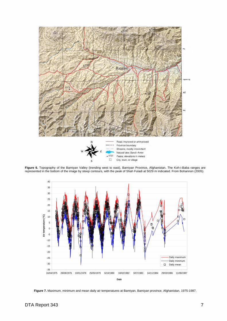
Figure 6. Topography of the Bamiyan Valley (trending west to east), Bamiyan Province, Afghanistan. The Koh-i-Baba ranges are represented in the bottom of the image by steep contours, with the peak of Shah Fuladi at 5029 m indicated. From Bohannon (2005).
-35
-30
-25
-20
-15
-10
-5
0
5
10
15
20
25
30
35
40
16/04/1975 28/08/1976 10/01/1978 25/05/1979 6/10/1980 18/02/1982 3/07/1983 14/11/1984 29/03/1986 11/08/1987
Date
Air
tem
per
atu
re (
°C)
Daily maximum
Daily minimum
Daily mean
Figure 7. Maximum, minimum and mean daily air temperatures at Bamiyan, Bamiyan province, Afghanistan, 1975-1987.
DTA Report 343 7
2.4.2 Wind Local terrain effects are far more important to the winds around Bamiyan town than the large-
scale systems that affect much of Afghanistan (see 2.4.2). The prevailing winds vary between up-
and down-slope with speeds typically between 5 and 10 knots. Daytime winds are upslope in
direction, light and from the northeast, but they are stronger in summer than in any other season
(Figure 4). Night winds are predominantly downslope, stronger than upslope winds and come
from the southwest side of the Bamiyan river valley. Calm conditions are relatively common,
more so during the day than at night. Winds are strongest under thunderstorm down rush gusts
that are funnelled from the mountainsides to the southwest above the PRT base and airstrip.
Peak gusts can reach 40 knots in April and June, nearly 50 knots in May and 30 knots between
July and September (USAFCCC, 2003).
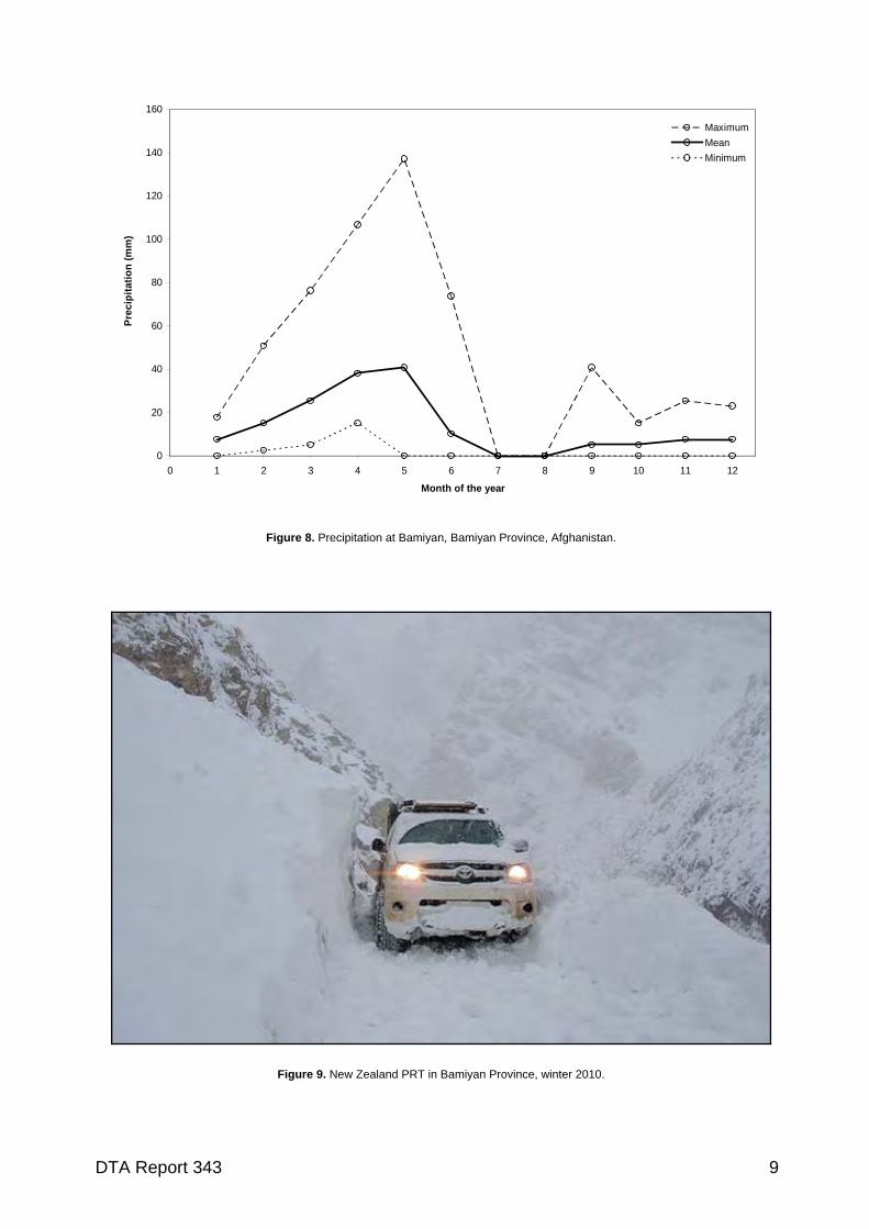
2.4.3 Precipitation Mean annual precipitation in Bamiyan is less than 165 mm (much of this falling as snow)
(Figure 8). In spring and early summer, snow melt from the surrounding mountains increases air
moisture and river discharge in the valley bottom. This contributes to increased atmospheric
instability and storminess as the approaching summer months result in warmer air masses
(USAFCCC, 2002; 2003). Precipitation, exclusively as rainfall and isolated thunderstorms, is at
the annual minimum in summer. Thunderstorm activity is greatest in the months of April and
May, with an average of two and three days (respectively) per month of storms recorded. By
June, thunderstorm activity drops to an average of one day of storms per month, while the
remainder of the year is typically without storms (USAFCCC, 2003). Rainshowers around
Bamiyan are often weak and result in little precipitation reaching the earth. Rainfall falls, on
average, a couple of times per month in June and September, while no rain falls in July or
August. Thunderstorms occur on an average of one day in June alone; the remaining summer
months are free of storms. Convective showers in summer months are often dry or produce only
virga (rain that evaporates before reaching the ground). The presence of localized atmospheric
phenomena such as virga, microbursts and updrafts under hot summertime ambient
temperatures should be noted for this region and consideration given to how this may increase
problems for UAS operations.
Light snow will typically start falling in late September, with an average of one day of snow per
month. Rates of snowfall incrementally increase from October onwards, elevating precipitation in
the area. The greatest number of snowfall days occurs between January and March (10-11 days
each month). At this time, snow may be as much as one metre deep in and around Bamiyan
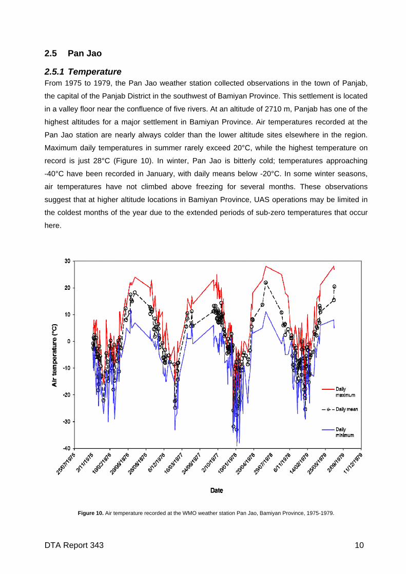
town, although average depths are generally <0.8 m deep (USAFCCC, 2002) (Figure 9).
DTA Report 343 8
0
20
40
60
80
100
120
140
160
0 1 2 3 4 5 6 7 8 9 10 11 12
Month of the year
Pre
cip
itat
ion
(m
m)
Maximum
Mean
Minimum
Figure 8. Precipitation at Bamiyan, Bamiyan Province, Afghanistan.
Figure 9. New Zealand PRT in Bamiyan Province, winter 2010.
DTA Report 343 9
2.5 Pan Jao
2.5.1 Temperature From 1975 to 1979, the Pan Jao weather station collected observations in the town of Panjab,
the capital of the Panjab District in the southwest of Bamiyan Province. This settlement is located
in a valley floor near the confluence of five rivers. At an altitude of 2710 m, Panjab has one of the
highest altitudes for a major settlement in Bamiyan Province. Air temperatures recorded at the
Pan Jao station are nearly always colder than the lower altitude sites elsewhere in the region.
Maximum daily temperatures in summer rarely exceed 20°C, while the highest temperature on
record is just 28°C (Figure 10). In winter, Pan Jao is bitterly cold; temperatures approaching
-40°C have been recorded in January, with daily means below -20°C. In some winter seasons,
air temperatures have not climbed above freezing for several months. These observations
suggest that at higher altitude locations in Bamiyan Province, UAS operations may be limited in
the coldest months of the year due to the extended periods of sub-zero temperatures that occur
here.
Figure 10. Air temperature recorded at the WMO weather station Pan Jao, Bamiyan Province, 1975-1979.
DTA Report 343 10
2.5.2 Wind
Pan Jao’s elevated location means that it does not benefit from the degree of protection from
large-scale wind systems that Bamiyan does. This probably explains why year-round this town
experiences (on average) winds five knots greater in speed (Figure 4). Like Bamiyan, the highest
average wind speeds occur in spring and summer, however peak wind conditions in Pan Jao
typically occur in April. The sharp rise in wind conditions in October and November are very
similar to that recorded in the Bamiyan Valley, and may be driven by similar weather systems.
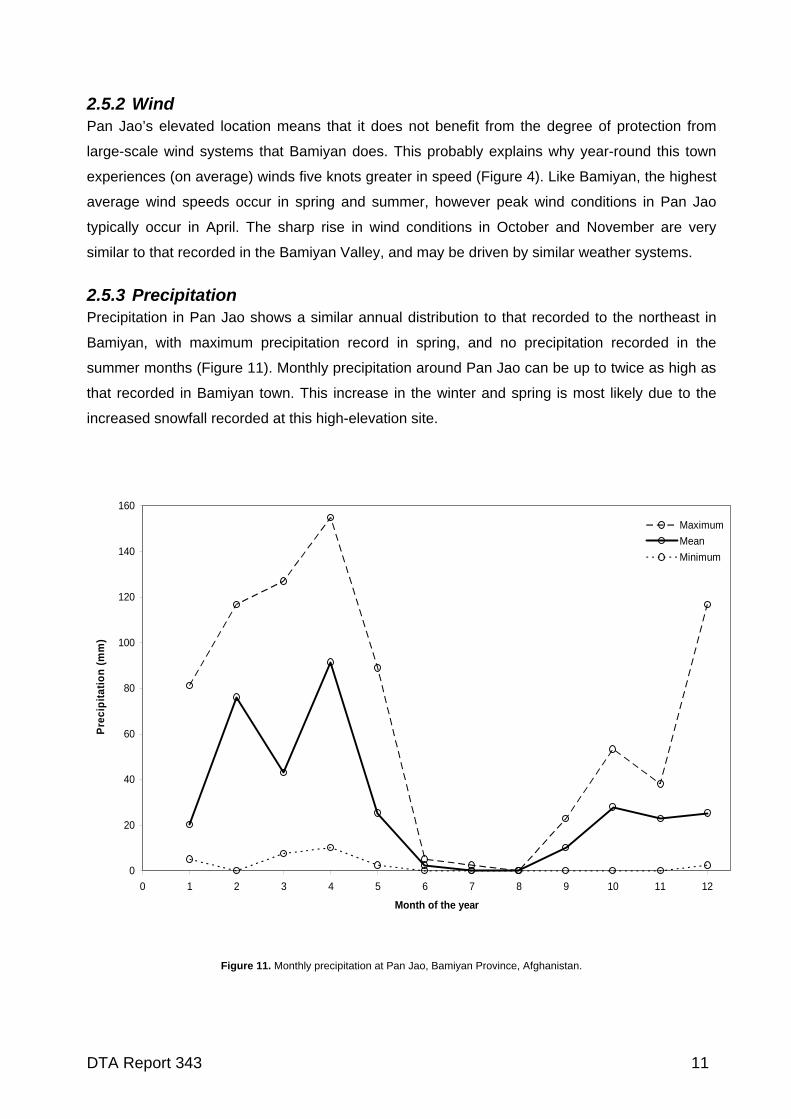
2.5.3 Precipitation Precipitation in Pan Jao shows a similar annual distribution to that recorded to the northeast in
Bamiyan, with maximum precipitation record in spring, and no precipitation recorded in the
summer months (Figure 11). Monthly precipitation around Pan Jao can be up to twice as high as
that recorded in Bamiyan town. This increase in the winter and spring is most likely due to the
increased snowfall recorded at this high-elevation site.
0
20
40
60
80
100
120
140
160
0 1 2 3 4 5 6 7 8 9 10 11 12
Month of the year
Pre
cip
itat
ion
(m
m)
Maximum
Mean
Minimum
Figure 11. Monthly precipitation at Pan Jao, Bamiyan Province, Afghanistan.
DTA Report 343 11
2.6 Camp Airborne (Wardak Province)
2.6.1 Temperature
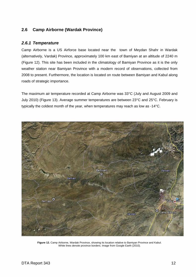
Camp Airborne is a US Airforce base located near the town of Meydan Shahr in Wardak
(alternatively, Vardak) Province, approximately 100 km east of Bamiyan at an altitude of 2240 m
(Figure 12). This site has been included in the climatology of Bamiyan Province as it is the only
weather station near Bamiyan Province with a modern record of observations, collected from
2008 to present. Furthermore, the location is located on route between Bamiyan and Kabul along
roads of strategic importance.
The maximum air temperature recorded at Camp Airborne was 33°C (July and August 2009 and
July 2010) (Figure 13). Average summer temperatures are between 23°C and 25°C. February is
typically the coldest month of the year, when temperatures may reach as low as -14°C.
Figure 12. Camp Airborne, Wardak Province, showing its location relative to Bamiyan Province and Kabul. White lines denote province borders. Image from Google Earth (2010).
DTA Report 343 12
It is difficult to compare the modern observations collected at Camp Airborne with those collected
at Bamiyan and Pan Jao as the most recent data from these dates from the early 1980s. A broad
comparison of monthly trends suggests that average summer temperatures around Camp
Airborne are probably a couple of degrees warmer than in Bamiyan (although maximum
temperatures may be similar). In winter, temperatures in Bamiyan are routinely colder by several
degrees, and minimum winter temperatures may be as much as 10°C lower in Bamiyan town
than those experienced in the eastern part of Wadak Province.
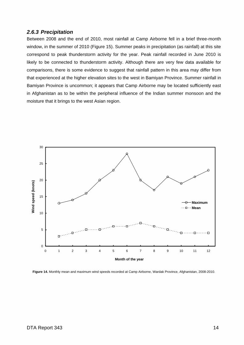
2.6.2 Wind During the late spring and summer months at Camp Airborne, northerly winds reach their annual
peak activity, with velocities in excess of 20 knots recorded in April, May and June (Figure 14).
The second annual phase of elevated wind conditions identified across Bamiyan Province
(section 2.1.2) affects this region too, with elevated wind conditions recorded in the October-
December transitional season. A broad comparison with mean wind conditions recorded at
stations in Bamiyan Province suggests that, on average, peak wind gusts at Camp Airborne will
typically be lower than those experienced in Bamiyan town. This is probably due to the significant
contribution from topographically enhanced winds that can flow up and down the slopes of the
Bamiyan River valley. The terrain surrounding Camp Airborne is lower relief than that found
surrounding Bamiyan, while the valley bottom location is several hundred metres lower in
altitude.
-15
-10
-5
0
5
10
15
20
25
30
35
21/07
/200
8
9/09/
2008
29/1
0/20
08
18/1
2/20
08
6/02
/200
9
28/0
3/20
09
17/0
5/20
09
6/07
/200
9
25/0
8/20
09
14/10
/200
9
3/12/
2009
22/0
1/20
10
13/0
3/20
10
2/05
/201
0
21/0
6/2010
10/08
/201
0
29/09
/201
0
18/1
1/20
10
Date
Te
mp
era
ture
(°C
)
Maximum
Mean
Minimum
Figure 13. A two year record of air temperature from Camp Airborne, Wardak Province, Afghanistan.
DTA Report 343 13
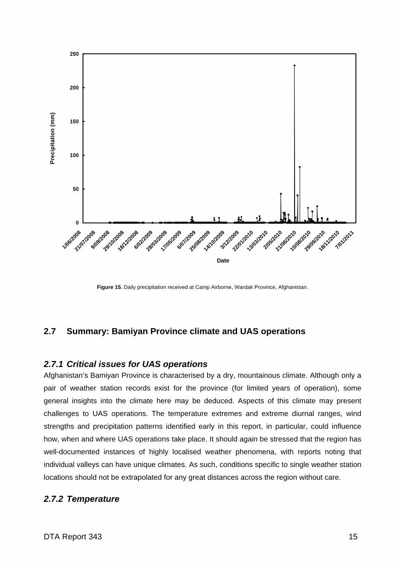
2.6.3 Precipitation Between 2008 and the end of 2010, most rainfall at Camp Airborne fell in a brief three-month
window, in the summer of 2010 (Figure 15). Summer peaks in precipitation (as rainfall) at this site
correspond to peak thunderstorm activity for the year. Peak rainfall recorded in June 2010 is
likely to be connected to thunderstorm activity. Although there are very few data available for
comparisons, there is some evidence to suggest that rainfall pattern in this area may differ from
that experienced at the higher elevation sites to the west in Bamiyan Province. Summer rainfall in
Bamiyan Province is uncommon; it appears that Camp Airborne may be located sufficiently east
in Afghanistan as to be within the peripheral influence of the Indian summer monsoon and the
moisture that it brings to the west Asian region.
0
5
10
15
20
25
30
0 1 2 3 4 5 6 7 8 9 10 11 12
Month of the year
Win
d s
pe
ed (
kno
ts)
Maximum
Mean
Figure 14. Monthly mean and maximum wind speeds recorded at Camp Airborne, Wardak Province, Afghanistan, 2008-2010.
DTA Report 343 14
0
50
100
150
200
250
1/06
/200
8
21/0
7/20
08
9/09
/200
8
29/1
0/20
08
18/1
2/20
08
6/02
/200
9
28/0
3/20
09
17/0
5/20
09
6/07
/200
9
25/0
8/20
09
14/1
0/20
09
3/12
/200
9
22/0
1/20
10
13/0
3/20
10
2/05
/201
0
21/0
6/20
10
10/0
8/20
10
29/0
9/20
10
18/1
1/20
10
7/01
/201
1
Date
Pre
cip
ita
tio
n (
mm
)
Figure 15. Daily precipitation received at Camp Airborne, Wardak Province, Afghanistan.
2.7 Summary: Bamiyan Province climate and UAS operations
2.7.1 Critical issues for UAS operations Afghanistan’s Bamiyan Province is characterised by a dry, mountainous climate. Although only a
pair of weather station records exist for the province (for limited years of operation), some
general insights into the climate here may be deduced. Aspects of this climate may present
challenges to UAS operations. The temperature extremes and extreme diurnal ranges, wind
strengths and precipitation patterns identified early in this report, in particular, could influence
how, when and where UAS operations take place. It should again be stressed that the region has
well-documented instances of highly localised weather phenomena, with reports noting that
individual valleys can have unique climates. As such, conditions specific to single weather station
locations should not be extrapolated for any great distances across the region without care.
2.7.2 Temperature
DTA Report 343 15
Winter months in Bamiyan Province, especially at the higher elevations, are very cold. While the
Kahu UAS has not undertaken extensive cold-climate testing, it is feasible that occasional
exposure to sub-zero temperatures should not lead to any major degradation or damage to
components. Battery discharge performance, however, is reduced in such conditions, and
subsequently, the endurance of Kahu affected. Undertaking mini-UAS operations when air
temperatures remain below freezing (which is common at Pan Jao and Bamiyan during winter)
ould result in decreased sensor performance due to increased start-up times of electrical
components. The impact of condensation on the system may also be of concern in winter.
eeds year-round, and it
possible that any UAS operations in this area would be susceptible to disruption. Peak wind
speeds here appear to blow 5 to 10 knots higher than in Bamiyan town.
rther increased. Rainfall is practically non-existent in the summer months,
nd combined with more favourable air temperatures, no impedance to UAS operations from
precipitation is likely.
c
2.7.3 Wind Small UAS vehicles (such as Kahu) are best suited for operating in lower, less turbulent wind
conditions. When wind speeds begin to blow consistently above 25 knots, UAS operations may
be too difficult to undertake (Cook et al., 2012; Strong and Brown, 2010). Wind gusts in excess of
25 knots during late spring and summer months are common across the three sites analysed in
this report. Due to complex terrain and storm-induced downdrafts, unpredictable wind turbulence
may potentially be of concern to UAS operators. A second peak in high wind speeds appears to
commonly occur in early winter (November and December), decreasing sharply in January. The
site of Pan Jao, in the east of Bamiyan Province, has the greatest wind sp
is
2.7.4 Precipitation The current Kahu airframe is partially resistant to water. However, operations during snowfall or
significant rainfall generally cannot be undertaken. This is not a great problem for UAS operators
because poor visibility during rainfall reduces the need to fly. During winter months in Bamiyan,
when snowfall can be a significant source of moisture in the air, the ability to undertake UAS
operations could be restricted. When combined with temperatures below -20°C, the likelihood of
flight restrictions is fu
a
DTA Report 343 16
3 Long-term temperature time series in Afghanistan
When developing climatic metrics for military hardware design, it is often stipulated that the
climatic data should be sourced from long, continuous, high-quality compilations of direct
observations. In doing so, significant interannual and interdecadel variability (e.g., El Niño-
Southern Oscillation) in climate may be better accounted for than relying on recent observations
alone. Some measure of normal weather conditions (and those conditions that are abnormal),
usually represented as average values of temperature, precipitation and wind parameters are
often called for. When available, best practices, such as that specified by the World
Meteorological Organization, typically utilise average values of weather observations from a 30-
year period to produce ‘climatic normals’ (WMO, 1988).
Climate observations in Afghanistan were first permanently collected in the 1940s. At its zenith,
Afghanistan’s meteorological authority was responsible for over 40 meteorological stations, with
daily and monthly data regularly reported to, and published by, the Meteorological Department in
Kabul (Shobair, 2002). Many of these hardcopy records have since been lost or destroyed
following the degradation of Afghanistan’s central government and the country’s meteorological
capability. Since the mid-1980s, Afghanistan’s ability to collect and archive meteorological data
has been greatly hampered by a lack of functioning central government and civil unrest, and has
essentially ceased following the onset of Taliban rule in 1996. However, it’s likely that airport
weather stations still collected some data during this period (Shobair, 2002).
Despite recent efforts by US government agencies to rescue what remains of Afghanistan’s
climate data (http://docs.lib.noaa.gov/rescue/data_rescue_afghanistan.html), there are now very
few long-term (>10 years duration) climate records available from Afghanistan. The number of
these that are complete and without major discontinuities in their record is fewer again. Indeed
many climate studies in the region have relied on observations collected at stations located
beyond the political boundary of Afghanistan, using data collected in nearby Pakistan, Iran, or
Tajikistan (Daly et al., 2010), depending on the exact region of interest and the length of historical
data required (Figure 16).
Without long and reliable records, assessing the frequency and magnitude of temperature
extremes will be confined to just a few locations within a country. This is especially problematic in
Afghanistan, where an enormous range of climate variability often exists within small regions;
individual valleys can have microclimates and highly localised hydrology (Sprehe, 2010). At
worst, obtaining reliable climatic measurements for some regions, for any significant period of
time, can be close to impossible to achieve (e.g., Yemen (Kopp, 1981)).
DTA Report 343 17
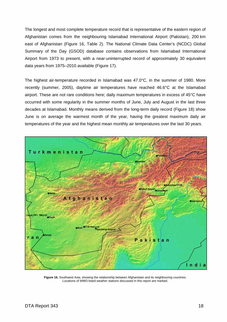
The longest and most complete temperature record that is representative of the eastern region of
Afghanistan comes from the neighbouring Islamabad International Airport (Pakistan), 200 km
east of Afghanistan (Figure 16, Table 2). The National Climate Data Center’s (NCDC) Global
Summary of the Day (GSOD) database contains observations from Islamabad International
Airport from 1973 to present, with a near-uninterrupted record of approximately 30 equivalent
data years from 1975–2010 available (Figure 17).
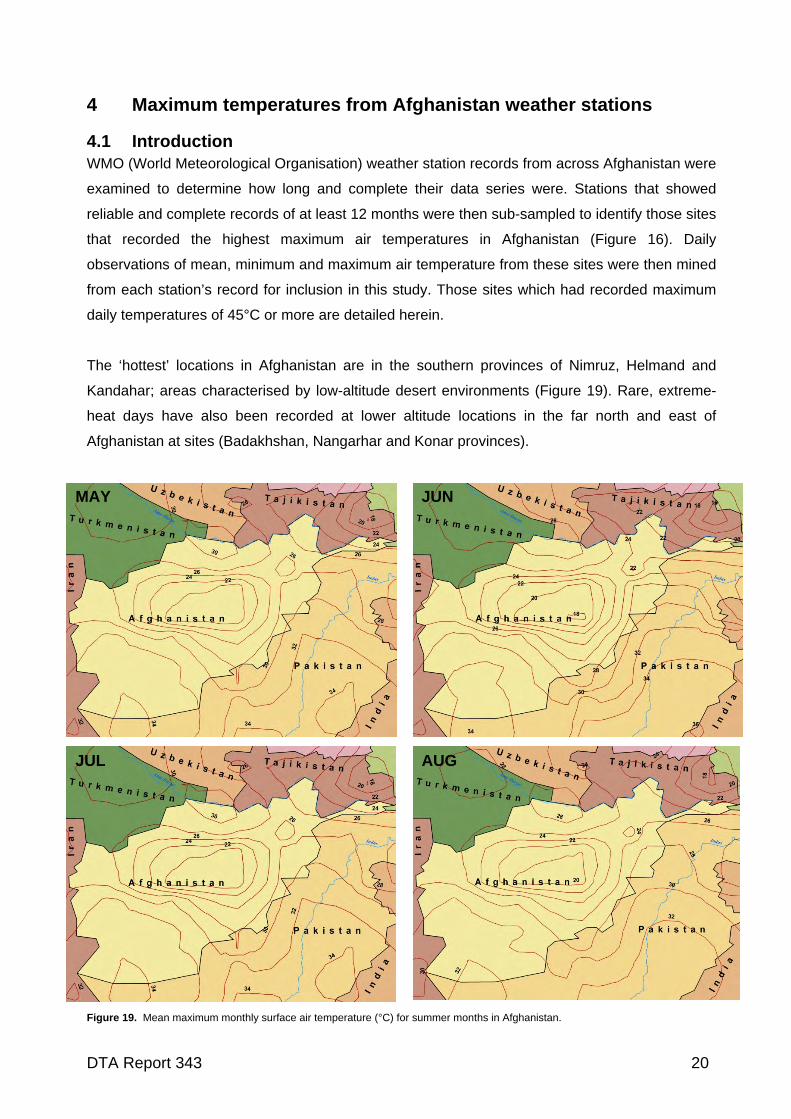
The highest air-temperature recorded in Islamabad was 47.0°C, in the summer of 1980. More
recently (summer, 2005), daytime air temperatures have reached 46.6°C at the Islamabad
airport. These are not rare conditions here; daily maximum temperatures in excess of 45°C have
occurred with some regularity in the summer months of June, July and August in the last three
decades at Islamabad. Monthly means derived from the long-term daily record (Figure 18) show
June is on average the warmest month of the year, having the greatest maximum daily air
temperatures of the year and the highest mean monthly air temperatures over the last 30 years.
Figure 16. Southwest Asia, showing the relationship between Afghanistan and its neighbouring countries. Locations of WMO-listed weather stations discussed in this report are marked.
DTA Report 343 18
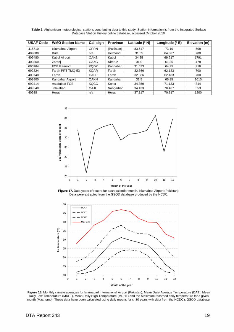
Table 2. Afghanistan meteorological stations contributing data to this study. Station information is from the Integrated Surface Database Station History online database, accessed October 2010.
USAF Code WMO Station Name Call sign Province Latitude (º N) Longitude (º E) Elevation (m)
415710 Islamabad Airport OPRN (Pakistan) 33.617 73.10 508 409880 Bust n/a Helmand 31.55 64.367 780 409480 Kabul Airport OAKB Kabol 34.55 69.217 1791 409860 Zaranj OAZG Nimruz 31.0 61.85 478 690764 FOB Ramrod KQDX Kandahar 31.633 64.95 916 692324 Farah PRT TMQ-53 KQAR Farah 32.366 62.183 700 409740 Farah OAFR Farah 32.366 62.183 700 409900 Kandahar Airport OAKN Kandahar 31.5 65.85 1010 692414 Asadabad FOB KQCC Konar 34.850 71.133 844 409540 Jalalabad OAJL Nangarhar 34.433 70.467 553 40938 Herat n/a Herat 37.117 70.517 1200
28
29
29
30
30
31
31
32
0 1 2 3 4 5 6 7 8 9 10 11 12
Month of the year
Eq
uiv
alen
t d
ata
year
s o
f re
cord
Figure 17. Data years of record for each calendar month, Islamabad Airport (Pakistan).
Data were extracted from the GSOD database produced by the NCDC.
10
15
20
25
30
35
40
45
50
0 1 2 3 4 5 6 7 8 9 10 11 12
Month of the year
Air
tem
per
atu
re (
°C)
MDAT
MDLT
MDHT
Max temp
Figure 18. Monthly climate averages for Islamabad International Airport (Pakistan); Mean Daily Average Temperature (DAT), Mean Daily Low Temperature (MDLT), Mean Daily High Temperature (MDHT) and the Maximum recorded daily temperature for a given
month (Max temp). These data have been calculated using daily means for c. 30 years with data from the NCDC’s GSOD database.
DTA Report 343 19
4 Maximum temperatures from Afghanistan weather stations
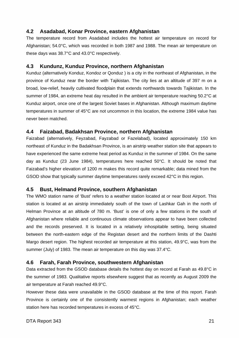
4.1 Introduction WMO (World Meteorological Organisation) weather station records from across Afghanistan were
examined to determine how long and complete their data series were. Stations that showed
reliable and complete records of at least 12 months were then sub-sampled to identify those sites
that recorded the highest maximum air temperatures in Afghanistan (Figure 16). Daily
observations of mean, minimum and maximum air temperature from these sites were then mined
from each station’s record for inclusion in this study. Those sites which had recorded maximum
daily temperatures of 45°C or more are detailed herein.
The ‘hottest’ locations in Afghanistan are in the southern provinces of Nimruz, Helmand and
Kandahar; areas characterised by low-altitude desert environments (Figure 19). Rare, extreme-
heat days have also been recorded at lower altitude locations in the far north and east of
Afghanistan at sites (Badakhshan, Nangarhar and Konar provinces).
MAY JUN
JUL AUG
Figure 19. Mean maximum monthly surface air temperature (°C) for summer months in Afghanistan.
DTA Report 343 20
4.2 Asadabad, Konar Province, eastern Afghanistan The temperature record from Asadabad includes the hottest air temperature on record for
Afghanistan; 54.0°C, which was recorded in both 1987 and 1988. The mean air temperature on
these days was 38.7°C and 43.0°C respectively.
4.3 Kundunz, Kunduz Province, northern Afghanistan Kunduz (alternatively Konduz, Kondoz or Qonduz ) is a city in the northeast of Afghanistan, in the
province of Kunduz near the border with Tajikistan. The city lies at an altitude of 397 m on a
broad, low-relief, heavily cultivated floodplain that extends northwards towards Tajikistan. In the
summer of 1984, an extreme heat day resulted in the ambient air temperature reaching 50.2°C at
Kunduz airport, once one of the largest Soviet bases in Afghanistan. Although maximum daytime
temperatures in summer of 45°C are not uncommon in this location, the extreme 1984 value has
never been matched.
4.4 Faizabad, Badakhsan Province, northern Afghanistan Faizabad (alternatively, Feyzabad, Fayzabad or Fazelabad), located approximately 150 km
northeast of Kunduz in the Badakhsan Province, is an airstrip weather station site that appears to
have experienced the same extreme heat period as Kunduz in the summer of 1984. On the same
day as Kunduz (23 June 1984), temperatures here reached 50°C. It should be noted that
Faizabad’s higher elevation of 1200 m makes this record quite remarkable; data mined from the
GSOD show that typically summer daytime temperatures rarely exceed 42°C in this region.
4.5 Bust, Helmand Province, southern Afghanistan The WMO station name of ‘Bust’ refers to a weather station located at or near Bost Airport. This
station is located at an airstrip immediately south of the town of Lashkar Gah in the north of
Helman Province at an altitude of 780 m. ‘Bust’ is one of only a few stations in the south of
Afghanistan where reliable and continuous climate observations appear to have been collected
and the records preserved. It is located in a relatively inhospitable setting, being situated
between the north-eastern edge of the Registan desert and the northern limits of the Dashti
Margo desert region. The highest recorded air temperature at this station, 49.9°C, was from the
summer (July) of 1983. The mean air temperature on this day was 37.4°C.
4.6 Farah, Farah Province, southwestern Afghanistan Data extracted from the GSOD database details the hottest day on record at Farah as 49.8°C in
the summer of 1983. Qualitative reports elsewhere suggest that as recently as August 2009 the
air temperature at Farah reached 49.9°C.
However these data were unavailable in the GSOD database at the time of this report. Farah
Province is certainly one of the consistently warmest regions in Afghanistan; each weather
station here has recorded temperatures in excess of 45°C.
DTA Report 343 21
4.7 Zaranj, Nimruz Province, southern Afghanistan Located in the lowland (c. 500 m) south-western desert bordering Iran, Zaranj recorded its
highest air temperature, 49.0°C, in the summer (July) of 1979. The mean daily temperature on
this day was 39.8°C. The second hottest day on record was also in July 1979 (48.0°C). The
mean air temperature for this day was 42.0°C.
4.8 Jalalabad, Nangarhar Province, eastern Afghanistan The WMO station of Jalalabad is the best quality climate record available from the eastern
Afghanistan province of Nangarhar, which borders the strategically important Federally
Administered Tribal Areas of western Pakistan. The highest recorded air temperature at this
station was 48.0°C, this being recorded twice (in the summers of 1978 and 1988). The
corresponding mean daily temperatures on those days were 35.3° C and 38.3° C respectively.
4.9 Kandahar Airport, Kandahar Province, southern Afghanistan Like Bost Airport, Kandahar Airport is located on the northern edge of the Registan Desert,
though at the greater altitude of approximately 1000 m. The highest recorded air temperature
here was 48.0°C, in the summer (July) of 1980. The corresponding mean daily temperature on
this day was 33.8°C.
4.10 Herat, Herat Province, western Afghanistan The city of Herat is approximately 70km from the border with Iran in western Afghanistan at an
altitude of 977 m. In the summer of 1977 an extreme heat day resulted in air temperatures
reaching 47°C here, while the average temperature that day was 36°C. Maximum summer
daytime temperatures in Herat, on average, do not exceed 36°C, making the summer 1977 value
exceptional for western Afghanistan.
4.11 Farah TMQ-53, Farah Province, western Afghanistan A TMQ-53 is a US Department of Defence/US Air Force Tactical Meteorological Observing
System. These weather stations are deployed at nearly 300 locations of strategic importance
worldwide (OFCM, 2005). The TMQ-53 station at the Farrah FOB has a modern (though brief)
record of operation that includes direct observations of the summer of 2009, when ambient air
temperature reached a maximum of 46.5°C.
4.12 FOB Ramrod, Kandahar Province, southern Afghanistan A group of modern weather stations located at US Army Forward Operating Base’s (FOB) in the
south, central, south and southeast of Afghanistan have recorded peak maximum air
temperatures of 46°C in the last decade. Forward Operating Base (FOB) Ramrod, for example,
recorded several summer days in 2009 and 2010 that reached between 45 and 46°C.
DTA Report 343 22
4.13 Kabul Airport, Kabol Province, eastern Afghanistan The longest and most complete climate record in the central/north-eastern region of Afghanistan
comes from Kabul Airport. The weather station here is located at 1789 m and is reasonably
typical of the climates experienced across the higher altitude, central-eastern region of the
country between the longitudes of 34 and 35° north. Although it is not one of the hottest locations
in Afghanistan, its strategic importance and hot summer days lead to inclusion in this study. The
highest recorded air temperature from Kabul Airport was 40.4°C, in the summer (August) of
1982. The corresponding mean daily temp on this day was 25.3°C. Typically, summer maximum
daytime temperatures in Kabul rarely exceed 35°C.
5 Maximum temperatures in Afghanistan: other observations
5.1 Runways and tarmacs While ambient air temperatures are the most commonly recorded temperature observations
available, other measures of how hot operating environments can be do exist. Air Force
Magazine (September 2010) recently detailed laser thermometer measurements of up to 70°C
recorded from US air base runways in Afghanistan. This suggests that the temperatures that
military hardware may be exposed to may reach 20°C higher than the recorded maximum daily
air temperature. These data, along with other direct observations of temperatures in the
battlefield may be obtained from the US Army and Airforce, and could help shed light on the
temperature extremes that should be planned for when designing hardware for operations in
Afghanistan and elsewhere in the Middle East region.
5.2 Vehicle interior temperatures Beyond ambient air temperatures, the conditions experienced within vehicles, cases or buildings
in southwest Asia at the height of summer are also of concern to those designing maximum
operating conditions for military hardware. Although there are few data readily available for
vehicle interiors, measurements collected from inside an operating leopard tank, for example,
have exceeded 65°C on an Afghanistan summer’s day (Cadieu, 2008).
Under controlled laboratory conditions with an applied external air temperature of 44°C, internal
air temperatures of up 64°C were recorded inside a Canadian Leopard 2C Tank by Jacobs et al.
(2007). Perhaps of more relevance to the NZDF at present are the findings of Hanna (2006), who
used external laboratory conditions of 49ºC and 20% relative humidity and a solar loading of up
to 1100 W m-2 to demonstrate that air temperatures inside a LAV unit reached 40ºC while the air-
conditioning was fully activated.
DTA Report 343 23
Detailed studies conducted in the USA have demonstrated that air temperatures within closed
vehicles receiving direct solar radiation rapidly increase on warm days. Earlier research
demonstrated that at an ambient air temperature of 36.8°C, the air temperature inside a closed
vehicle climbed to 67°C within 15 minutes (King et al., 1981). Interior vehicle air temperatures in
direct sunlight can climb to 90°C when exposed to direct sunlight for a full day (Grundstein et al.,
2010). Even when external air temperatures are lower (approximately 30°C), the temperatures
inside vehicles may still reach between 55 and 60°C (McLaren et al., 2005).
With maximum air temperatures in excess of 45°C not uncommon in Afghanistan, it is not
inconceivable then that the air temperature within an enclosed vehicle may reach 70°C, though
direct observations collected from relevant vehicles in the battlefield would be required to quantify
this upper design specification limit. Future work in this area might include the direct
measurement of the heat extremes inside vehicles, containers and buildings in the summer in
Afghanistan to ensure that military design specifications have kept pace with the ever-widening
range of environments that forces such as the NZDF operated in today.
DTA Report 343 24
6 Concluding discussions
The landlocked country of Afghanistan is susceptible to extremes in both maximum and minimum
air temperatures that are of direct importance to the designers and engineers of military
hardware. Data mining of all known direct weather observations from the region has identified the
highest ambient air temperatures recorded across the country; an all-time temperature maximum
of 54°C recorded on multiple instances at Asadabad in Konar Province. Beyond this location,
multiple stations in the lowland desert regions of southern and northern Afghanistan have
recorded maximum air temperatures of between 49°C and 52°C. Perhaps of more concern to
military planners and engineers is the evidence that temperatures on military tarmacs, in vehicles
and in storage facilities may be 20°C higher due to solar gain in summer months. For military
hardware deployed in Afghanistan, this may translate to ambient operating temperatures over
60°C. In contrast, in the central-eastern town of Bamiyan, the highest temperature on record
according to the GSOD database was 36°C. And while extreme high temperatures may not be an
issue in Bamiyan, other aspects of the operational environment here are of importance to military
planners. Strong and highly-localised winds may often be of sufficient strength to inhibit UAS
endurance operability, while extreme cold and snow in the winter months may test military
hardware reliability, durability and in some circumstances, limit our ability to operate UAS
entirely.
At its broadest, the spatial pattern of air temperature in Afghanistan may be described as
increasing from north to south (and to a lesser extent, east) and from higher altitude sites to
lower sites. The hottest temperatures ever recorded were collected at weather stations in the
lower altitude desert regions of southern and eastern Afghanistan. Beyond this relationship,
however, the timing and location of extreme high and low temperatures becomes convoluted
because of the complex terrain of much of the country.
Those few, high-quality records of weather that exist for Afghanistan cannot begin to account for
the spatial variability that exists. In Bamiyan Province, for example, it is well known that individual
valleys can be characterised by microclimates that are distinct from those recorded in locations
only several valleys away. As such, it must be noted that climatologies developed using
observations from singular locations should not readily be extrapolated any great distance
beyond the station location. This caveat is most relevant to the mountainous regions in the
central and northern regions of Afghanistan; in open, low-relief desert terrain in the southern
provinces, there is significantly less spatial variation in climate to contend with.
In this report, all known weather observations from Bamiyan Province have been reproduced,
allowing us some insight into the climatic conditions from several locations. A broader discussion
DTA Report 343 25
of the seasonal climate of Bamiyan town can be found in AFCCC (2003), much of which is
beyond the scope of this report.
With so few data from the province, some advancement in developing climatologies for different
regions in central Afghanistan may come from the use of remotely sensed climate observation.
Satellite-inferred temperatures from land surfaces can be difficult to collect, however, due to the
inhomogeneous surfaces reflecting radiance back to Satellite thermal sensors (Menglin, 2004). In
addition, there are complexities involved in gathering remote wind and temperature estimates
from the Earth’s surface in cloudy conditions or in the presence of dust or volcanic atmospheric
aerosols. A final problem which this method would face in central Afghanistan is that the spatial
resolution of satellite-derived observations is greater than 20 km, so these data would typically be
too coarse to characterise the climatic conditions found in the hills and valleys of much of the
country. Future solutions to improve climatic data collection in this region instead may best come
from new weather stations being installed and their observations disseminated, or from the
rejuvenation of older stations that have been abandoned or damaged by war.
DTA Report 343 26
References No Reference 1 Cadieu, T., 2008. Canadian Armour in Afghanistan. Canadian Army Journal 10.4, 5–25. 2 Cook, D.E., Strong, P. and Garrett, S., 2011. Coastal atmospheric research using an Unmanned
Aerial System (UAS): preliminary results from the Bay of Plenty, New Zealand. Journal of the Royal Society of New Zealand.
3 CSG (Climate services group), 2009. METOC environment Brief Afghanistan Version 5.1.
Directorate of Oceanography & Meteorology, Australian Navy, Sydney. 4 Daly, S.F., Baldwin, T. and Vuyovich, C., 2010. Afghanistan Watershed Assessment Average
Annual Precipitation Analysis V.1. USA Engineer Research and Development Center. Hanover, USA.
5 Goudie, A.S. and Middleton, N.J., 2006. Desert Dust in the Global System. Springer, Berlin. 6 Grundstein, A., Dowd, J and Meentemeyer, V., 2010. Quantifying the heat-related hazard for
children in motor vehicles. Bulletin of the American Meteorological Society 91, 1183–1191. 7 Hanna, M., 2006. LAV III climate room solar testing. National Research Council Task Report 54-
A5027. 8 Hickey, B., and Goudie, A.S., 2007. The use of TOMS and MODIS to identify dust storm source
areas: The Tokar delta (Sudan) and the Seistan basin (south west Asia). In, Geomorphological Variations, (Goudie, A. S. and Kalvoda, J., Eds.). P3K, Prague, 37– 57.
9 Jacobs, I., Michas, R., Limmer, R., Kerrigan-Brown, D. and McLellan, T., 2007. Heat stress
mitigation for Leopard 2C tank crew. Technical Report TR 2007-082, Defence Research and Development Canada, Toronto.
10 Jamalizadeh, M.R., Moghaddamnia, A., Piri, J., Arbabi, V., Homayounifar, M., and Shahryari, A.
2008. Dust Storm Prediction Using ANNs Technique (A Case Study: Zabol City). World Academy of Science, Engineering and Technology 43, 512– 520.
11 Kendrew, W.G., 1961, The Climate of the Continents (5th Edition). Oxford University Press, New
York. 12 King, K., Negus, K. and Vance, J.C., 1981. Heat stress in motor vehicles: a problem in infancy.
Pediatrics 68, 579–582 13 Kopp, H., 1981. Agrargeographie der Arabischen Republik Jemen. Erlanger geographische
Arbeiten, Sonderband 11. Selbstverlag der Frankischen Geographischen Gesellschaft. 14 Menglin, J., 2004. Analysis of Land Skin Temperature Using AVHRR Observations. Bullettin of the
American Meteorological Society 85, 587–600. 15 McLaren, C., Null, J. and Quinn, J., 2005. Heat stress from enclosed vehicles: moderate ambient
temperatures cause significant temperature rise in enclosed vehicles. Pediatrics 116, e109–e112. 16 OFCM (Office of the Federal Coordinator for Meteorology), 2005. Department of Defense Weather
Programs. In Estis, F. and Tsugawa, B. (Eds.): The Federal Plan for Meteorological Services and Supporting Research Fiscal Year 2005. FCM-P1-2004, OFCM, Silver Spring, USA.
17 Peel, M.C., Finlayson, B. L., and McMahon, T.A., 2007. Updated world map of the Köppen-Geiger
climate classification. Hydrology and Earth System Sciences 11, 1633–1644. 18 Sabbagh, L., 2006. Flying Blind in Iraq: U.S. Helicopters Navigate Real Desert Storms. Popular
Mechanics, October Issue.
DTA Report 343 27
19 Scott, A., 2006. Fat Albert’s Bamian foray. Air Force News (Royal New Zealand Air Force) 71,
June 2006, 18–19. 20 Shobair, S.S., 2002. Current Drought Situation in Afghanistan. Unpublished report. Food and
Agriculture Organization (FAO), Afghanistan. 21 Sprehe, E., 2010. Weathermen enable special operations forces in Afghanistan. Inside AF.mil,
article posted online 25/4/2010. 22 Strong, P.A. and Brown S.A., 2010. A summary of unmanned aircraft systems research at the
Defence Technology Agency. DTA Technical Note 2010/2, Defence Technology Agency, Auckland, New Zealand, 22 pp.
23 USAFCCC (United State Air Force Combat Climatology Center), 2002. OPERATIONAL CLIMATIC
DATA SUMMARY Bamiyan Afghanistan. United State Air Force Combat Climatology Center, Asheville, North Carolina.
24 USAFCCC (United State Air Force Combat Climatology Center), 2003. Bamyan, Afghanistan - Full
Year Climatology. United State Air Force Combat Climatology Center, Asheville, North Carolina. 25 USAFCCC (United State Air Force Combat Climatology Center), 2005. Afghanistan: A Full Year
Climatology. United State Air Force Combat Climatology Center, Asheville, North Carolina. 26 Whitney, J.W., 2006. Geology, Water, and Wind in the Lower Helmand Basin, Southern
Afghanistan. Scientific Investigations Report 2006–5182. US Geological Survey, Denver, USA. 27 WMO (World Meteorological Organization), 1988. Technical Regulations Volume 1 General
Meteorological Standards and Recommended Practices. WMO Publication No. 49. Geneva, Switzerland.
DTA Report 343 28
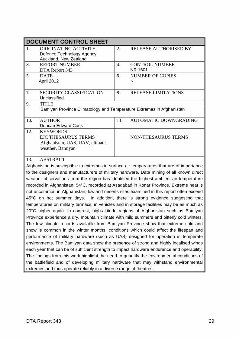
DOCUMENT CONTROL SHEET 1. ORIGINATING ACTIVITY 2. RELEASE AUTHORISED BY: Defence Technology Agency Auckland, New Zealand
3. REPORT NUMBER 4. CONTROL NUMBER DTA Report 343 NR 1601 5. DATE
April 2012 6. NUMBER OF COPIES 7
7. SECURITY CLASSIFICATION 8. RELEASE LIMITATIONS Unclassified 9. TITLE
Bamiyan Province Climatology and Temperature Extremes in Afghanistan 10. AUTHOR 11. AUTOMATIC DOWNGRADING Duncan Edward Cook 12. KEYWORDS EJC THESAURUS TERMS NON-THESAURUS TERMS
Afghanistan, UAS, UAV, climate, weather, Bamiyan
13. ABSTRACT Afghanistan is susceptible to extremes in surface air temperatures that are of importance
to the designers and manufacturers of military hardware. Data mining of all known direct
weather observations from the region has identified the highest ambient air temperature
recorded in Afghanistan: 54°C, recorded at Asadabad in Konar Province. Extreme heat is
not uncommon in Afghanistan; lowland deserts sites examined in this report often exceed
45°C on hot summer days. In addition, there is strong evidence suggesting that
temperatures on military tarmacs, in vehicles and in storage facilities may be as much as
20°C higher again. In contrast, high-altitude regions of Afghanistan such as Bamiyan
Province experience a dry, mountain climate with mild summers and bitterly cold winters.
The few climate records available from Bamiyan Province show that extreme cold and
snow is common in the winter months, conditions which could affect the lifespan and
performance of military hardware (such as UAS) designed for operation in temperate
environments. The Bamiyan data show the presence of strong and highly localised winds
each year that can be of sufficient strength to impact hardware endurance and operability.
The findings from this work highlight the need to quantify the environmental conditions of
the battlefield and of developing military hardware that may withstand environmental
extremes and thus operate reliably in a diverse range of theatres.
DTA Report 343 29
DTA Report 343 30
DISTRIBUTION:
No. of Copies NEW ZEALAND Director, DTA 2 Legal Deposit Office, National Library of New Zealand 2 Defence Library, HQNZDF, Wellington 1 Army ISTAR BL 1 AUSTRALIA DSTO Research Library 1