bandera canyonlands alliance a wildlife management association · bandera canyonlands alliance a...
TRANSCRIPT

Bandera Canyonlands Alliance A Wildlife Management Association
Water Resources of the Bandera Canyonlands, Texas
August 2011
Author
Tyson Broad

2
Tyson Broad prepared this report for Bandera Canyonlands Alliance.
Bandera Canyonlands Alliance, PO Box 164, Vanderpool, Texas, 78885

3
Table of Contents ���������� �����������������������������������������������������������������������������������������������������������������������������������������������������������������
������� �������� ��������������������������������������������������������������������������������������������������������������������������������������������������
����� �������� ��������������������������������������������������������������������������������������������������������������������������������������������������������
������ ��������������������������������������������������������������������������������������������������������������������������������������������������������������������������
���� ��������������������������������������������������������������������������������������������������������������������������������������������������������������������������
������� ������� ���!�"��� ��� #�����! $%%���� �����������������������������������������������������������������������������&

4
Introduction The Bandera Canyonlands region, located along the edge of the Edwards Plateau of Central Texas, is an ecologically significant area. Springs located in the canyons support several unique plant and animal communities, and provide water supply for domestic and exotic livestock, and wildlife.
The springs supplying the Bandera Canyonlands are outflows from the Edwards-Trinity (Plateau) aquifer. Water originating from these springs maintains flow in area rivers during dry periods. During the drought of 2011, downstream reaches of the Sabinal River recorded no flow, yet upper reaches of the river, in proximity to springs, continued to flow.
Understanding the environmental, economic and cultural role that the Bandera Canyonlands region plays in Central Texas is vital to its protection. This report characterizes the area and describes its significance to the Central Texas region.
General Description The Bandera Canyonlands are located in west-central Texas along the southeastern boundary of the Edwards Plateau in western Bandera County and portions of Real County (Figure 1). The Edwards Plateau is a 24,000 square mile upland region extending from the Pecos River on the west to the Balcones Escarpment on the east and south. Capping the Edwards Plateau is thick limestone rock that has dissolved over time to form what is considered the largest continuous karst 1 area in the United States.2
The Bandera Canyonlands are formed by the Sabinal and West Prong of the Medina River dissecting the edge of the plateau to form canyons up to 500 feet deep. Along the bottom of these canyons, water stored in the karst features of the plateau emerge as springs, providing important aquatic and terrestrial habitats.
The Bandera Canyonlands encompasses approximately 53,000-acres or about 83 square miles. Elevation ranges
from 1,600 feet above sea level along the Sabinal River to over 2,300 on the Edwards
to form what is considered the largest continuous karst a
from 1 600 feet above sea level along the Sabinal River to

5
Plateau. Lands within the area can be characterized as agricultural or recreational. The former consists of ranches used for livestock production; the latter consists of ranches used for landowner recreation. A large source of income for these ranches is hunting leases for white tail deer and exotic species as well as nature-tourism related activities.
This area has been the focus of Texas Nature Conservancy’s (TNC’s) conservation efforts in the region, starting with the acquisition of Love Creek Preserve in 2000 and the formulation of a Conservation Area Plan for the Bandera Canyonlands in April 2002. In addition to TNC’s 2,036-acre Love Creek Preserve, the Bandera Canyonlands area also includes Texas Parks and Wildlife’s (TPWD) Lost Maples State Natural Area, which covers 2,200 acres.
Figure 1. Map of Bandera Canyonlands Area.
The 2000 U.S. Census reports that the population of the Bandera Canyonlands area is 161 persons. 3 However, population figures alone do not provide a clear picture of the demographics, as absentee landowners account for a large percentage of the property owners.
The geographic focus of this report will include the upper Sabinal River above the confluence of Mill Creek (just south of Vanderpool) and the upper West Prong of the Medina River above the confluence with Love Creek. While the study area is limited to a small region within western Bandera County, it is geographically and hydrogeologically representative of a larger scale transitional zone that includes eastern Kinney, Uvalde, Bandera, Kerr, Kendall and Gillespie Counties.4

6
Water Resources The spring-fed waters of the Sabinal and West Prong of the Medina River are the lifeblood of the Bandera Canyonlands as well as important recharge to the Edwards Aquifer. The Texas Parks and Wildlife Department classifies the Sabinal River in Bandera County as an Ecologically Significant Stream Segment because of its biological function, riparian conservation area, exceptional aesthetic value, and the fact that it serves as a genetic refuge for pure strain Guadalupe Bass.
The US Geological Survey (USGS) maintains a stream gauge on the Sabinal River above Sabinal, Texas. Information about flows in the upper portion of the Sabinal can be inferred from this gauge, even though it is about 23 miles downstream of Vanderpool. However, similar inference regarding flows in the West Prong of the Medina cannot be made from the USGS stream gauge on the Medina River at Bandera; the North Prong of the Medina provides the majority of flow at this gauge.
The gauge on the Sabinal River was installed in 1943. Figure 2 shows the median monthly discharge for the period 1943-2010 and reflects the area’s rainfall distribution. Average annual precipitation is 24 to 26 inches, with the majority of precipitation occurring in spring and fall. During dry summer months, the majority of the flow at the gauge comes from springs.
Figure 2. Median Monthly Discharge for Sabinal River, 1943-2011 5
The largest recorded flow on the Sabinal is 108,000 cubic feet per second (cfs), 6 which occurred on July 5th, 2002. Since 1943, zero flow has been recorded about 10 percent of the time, with the greatest occurrences of zero flows during the period 1951-1957. The average daily flow for the period 1943 to 2011 is 64 cfs.
'
�
�'
��
('
(�
�'
��
)�� *�� �� +�� �, )�� )�� +�! -�� .� ��/ ��
������������ ���

7
During the summer of 2011, the zero flow was recorded at the Sabinal gauge beginning on June 2. However, field reconnaissance of the Sabinal River at Lost Maples State Natural Area on July 13 showed some flow in the river, visually estimated to be about 1 cfs.
Left: Can Creek in Upper Sabinal Watershed. Right: Upper reach of West Prong of Medina River (photos by author, July 13, 2011).
Three gain-loss studies done during dry periods of the 1950s indicate that the Sabinal River loses flow upstream of the gauge. Two of these studies showed losses of less than 2 cfs, but one study recorded streamflow losses of 31 cfs along a 30-mile segment from 8 miles above Vanderpool to the gauge.7
Three gain-loss studies done during dry periods of the 1950s indicate that the Sabinal River loses flow upstream of the gauge. Two of these studies showed losses of less than 2 cfs, but one study recorded streamflow losses of 31 cfs along a 30-mile segment from 8 miles above Vanderpool to the gauge.8
The recharge zone for the portion of the Edwards Aquifer that supplies water to San Antonio and to Comal and San Marcos Springs, lies just downstream of the gauge above Sabinal. By comparing the flows at this gauge to flows at a gauge in Sabinal (below the recharge zone), the USGS estimates, on average, that 42,900 acre-feet of water annually recharge the Edwards from the Sabinal River. (This amount is equivalent to 60 cfs.) This is about 7 percent of the total recharge to the Edwards. During drier periods, such as 2009, only 1,800 acre-feet annually (2.4 cfs) recharged the Edwards. 9
Springs There are several small springs that contribute to flows within the Bandera Canyonlands. The Texas Springs Database 10 notes 9 springs within the study area; an additional 13 springs, not included in the database, are located on USGS topographic maps (figure 3).
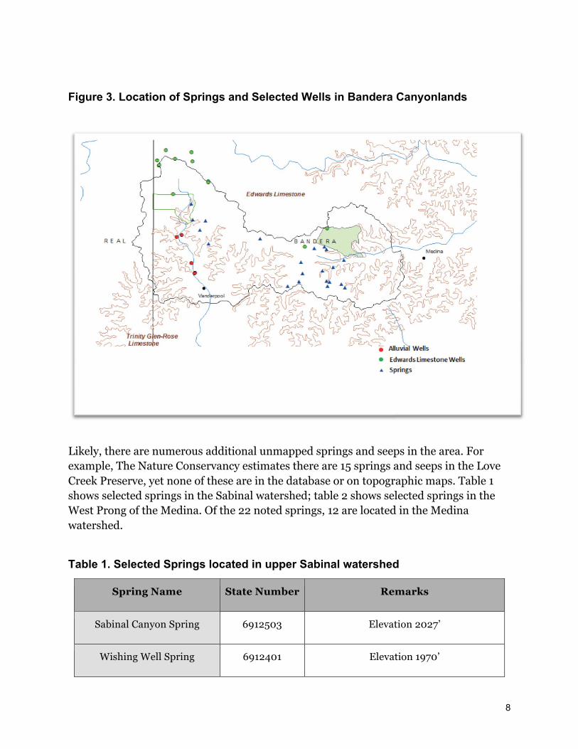
8
Figure 3. Location of Springs and Selected Wells in Bandera Canyonlands
Likely, there are numerous additional unmapped springs and seeps in the area. For example, The Nature Conservancy estimates there are 15 springs and seeps in the Love Creek Preserve, yet none of these are in the database or on topographic maps. Table 1 shows selected springs in the Sabinal watershed; table 2 shows selected springs in the West Prong of the Medina. Of the 22 noted springs, 12 are located in the Medina watershed.
Table 1. Selected Springs located in upper Sabinal watershed
Spring Name State Number Remarks
Sabinal Canyon Spring 6912503 Elevation 2027’
Wishing Well Spring 6912401 Elevation 1970’

9
Wedgeworth Creek South Spring
6912504 Elevation 1892’ a
Murphy’s Spring 6912502 Elevation 2007’
a The elevation of the spring appears to be incorrectly listed in the TWDB database as 2168’
Table 2. Selected Springs of upper West Prong of the Medina Watershed
Spring Name State Number Remarks a
Devil’s Bathtub Spring 6913801 Elevation 1934’
Sutherland Hollow Spring 6921202 Elevation 1944’
Weed Bluff Spring 6921203 Elevation 1935’
The elevation of all springs appear to be incorrectly listed in the TWDB database
Source of the Springs The most likely source of the springs in the Bandera Canyonlands is the Edwards-Trinity (Plateau) Aquifer. The Edwards-Trinity (Plateau) Aquifer is comprised of the Edwards Limestone that caps the Edwards Plateau, as well as the underlying Glen Rose Limestone and Hensel Sands. (Figure 4).
The Edwards limestone, which makes up the Edwards Plateau, is a karst terrain characterized by the presence of caves, sinkholes and subsurface drainage networks. Where the Edwards Plateau exists in the watershed, any precipitation that occurs, tends to fall on thin soils atop limestone bedrock and run off quickly. However, precipitation finds its way through sinkholes, caves, rock fractures, and root zones to enter the Edwards-Trinity (Plateau) aquifer.
Subsurface drainage networks, or conduits, dominate groundwater systems that drain karst terrain.11 Precipitation that recharges the Edwards-Trinity (Plateau) aquifer tends to follows these conduits. Where rivers such as the Sabinal and Medina carve valleys into the Edwards Plateau, these conduits are exposed, resulting in springs. These springs are usually located where the Edwards Limestone rests on top of the denser, less permeable Glen Rose Formation.

10
Figure 4. Cross-section of Edwards-Trinity Aquifer. (Adapted from Brune) 12
Little is known about the exact origin of the source water for these springs. However, some information can be inferred from topography and existing hydrogeological studies. Kuniansky and Holligan 13 note that the potentiometric surface (the elevation of the top of the water table) and the flow of groundwater tend to follow the topography in the Edwards Plateau region. Figure 5 is a map of the potentiometric surface in the Sabinal and Medina River watersheds reproduced from the Kuniansky and Holligan report.
Kuniansky and Holligan suggest that the waters that feed the springs originate from an area located in Real and Kerr Counties. 14 The elevation of the water table in the area to the north and west of the Bandera Canyonlands is over 2,000 feet above sea level. The level of the springs are approximately 1,900 feet, so it can be assumed that groundwater flows ‘down gradient’ towards the springs.15
Without detailed potentiometric surface mapping and tracer testing, however, it is very difficult to accurately depict actual groundwater movement with any certainty. There are many examples where groundwater movement is not coincident with topographic watershed boundaries. 16

11
Figure 5. Historical potentiometric surface of the Edwards-Trinity aquifer system for the Bandera Canyonlands, 1915-69. (From Kuniansky and Holligan, 1993. Arrows added to depict probable direction of groundwater flow)
Water Use Water used for domestic and exotic livestock purposes is by far the largest use in the Bandera Canyonlands. Most of this use is supplied by wells. The Texas Water Development Board Groundwater Database and the Texas Commission on Environmental Quality lists a total of 130 wells in the study area (it is presumed that wells exist that are not included in the database.) All but 22 of the listed wells are located in the Sabinal watershed. About 50 of these well reports are from wells drilled since 2000 (See Appendix 1).
The vast majority of wells in the area draw from the Trinity aquifer through deep wells greater than 600 feet deep. Artesian pressure brings the water level in these wells to within about 350 feet of the surface. Yields from Trinity aquifer wells are less than 100 gallons per minute.
Overlying the Trinity Aquifer, the Edwards Aquifer is the source of about a dozen wells in the Bandera Canyonlands. These wells are located on top of the Edwards Plateau and produce only a few gallons per minute. Figure 6 depicts periodic changes in water level between 1953 and 2010 for a well drilled into the Edwards Aquifer near the northern edge of the study area. Water level measurements show a range of about 12 feet and

12
generally correspond to the drier period of the early 50s and wetter periods of the late 1970s and early 1980s.
Figure 5. Water Level Measurements for Well # 6912103 located in the Edwards Limestone of Edwards-Trinity Aquifer system (from Texas Water Development Board Groundwater Database)
The third source of groundwater in the area is from alluvial aquifers in the bottom of the canyons. About 30 of these shallow wells exist and can yield up to 50 gallons per minute; generally, yields are 10 to 25 gallons per minute. Measured water levels in these alluvial wells can provide insights as to whether a segment of river is gaining water from surrounding lands (where water levels in wells are higher than the level of the river) or losing water to surrounding lands. Such evaluation suggests that the Sabinal is a gaining stream from Lost Maples State Natural Area to just north of Vanderpool.
A water right is required from the Texas Commission on Environmental Quality to use surface water for municipal/domestic uses and irrigation in Texas. There is only one such water right on the upper reaches of the Sabinal River; it belongs to the Texas Parks and Wildlife Department and permits the withdrawal of 7 acre-feet per year. 17 There are seven irrigation water rights on the West Prong of the Medina River; these are believed to be below the confluence with Love Creek and outside the study area.
Water Quality The spring-fed waters of the Bandera Canyonlands are consistently of good quality. There is only one permitted wastewater facility on the study area, an 8,000 gallon per
*��0�&
*��0�'
*��0��
*��0��
*��0�1
*��0&(
*��0&�
*��0&2
*��02�
*��02�
*��02&
*��01'
*��01�
*��01�
*��011
*��0'(
*��0'�
('(�
('(2
('�'
('�(
('��
('��
('�2
('�'
('�(
('��
����� ���� �������������

13
day permit for Lost Maples State Park; effluent from the facility is irrigated on 3.25 acres in the Sabinal watershed. Nueces River Authority (NRA), Edwards Aquifer Authority (EAA), and Bandera County River Authority and Groundwater District (BCRAGD) monitor various constituents of water quality.
NRA has maintained a surface water quality monitoring station on the Upper Sabinal since 1996. The sampling site is at the USGS gauge, located 12.5 miles north of Sabinal. More than 25 samples have been taken. Dissolved Oxygen (DO) at the site has ranged from 5.5 to 13.4 with a median value of 8.8. DO is a metric to measure river health. Fluctuating high and low levels of DO over a 24-hour period may suggest the presence of algae blooms, possibly caused by an increase in nutrients reaching the river. 18 There have been no identified trends for Dissolved Oxygen, Nitrates, Ph, Total Phosphorus, or Escherichia coli (E-coli) bacteria.19
As part of their aquifer protection program, EAA maintains a biannual sampling regime for metals, pesticides, herbicides, and PCBs at the USGS gauging site. No contaminants were found during 2009. 20
E-coli bacteria are sampled for at 34 sites throughout Bandera County by BCRAGD. The most recent sampling report shows no violation of e-coli bacteria limits for contact recreation. 21
Groundwater wells located in Edwards Limestone are assumed to generally be of good quality, however, little monitoring has been done. Of the eight wells historically sampled in the Edwards limestone in the study area three have had nitrate levels in excess of the recommended drinking water standards of ten milligrams per liter. 22 However, no recent test data are available. Elevated levels of nitrates can result from poor well location and construction, agricultural runoff or inadequate septic systems.
Naturally occurring gypsum in the upper Glen Rose formation of the Trinity Aquifer often result in elevated levels of sulfate and total dissolved solids in wells. 23 Efforts should be made to provide casing around wells that penetrate this formation so that underlying aquifer formations are not contaminated.
Habitats The Bandera Canyonlands provide important and unique terrestrial and aquatic habitats. The canyon bottomlands provide enough moisture to support plant species normally found further to the east, while the spring fed creeks in the canyons support endemic salamanders. 24
14
Terrestrial The Nature Conservancy divides terrestrial habitats of the Bandera Canyonlands into Edwards limestone upland, Mesic (moist) canyon system, Riparian forest system and Valley Flats. A variety of grasses, including little and big bluestem, Indiangrass, sideoats gamma, and buffalograss can be found in the uplands, along with Ashe juniper and Lacey Oaks. These juniper and oaks are also found on slopes of the Mesic Canyon system along with Bigtooth Maple and Chinquapin Oak. The riparian forest typically includes Bigtooth Maple, Chinquapin and Lacy Oak, Bald Cypress and Sycamore, along with rare, endemic shrubs such as Texas mock-orange, big red sage, and silverbell. Similar trees are found away from the riparian forest, in the Valley flats, along with Vine mesquite.25
The endangered Golden-cheeked Warbler and Black-capped Vireo are found in the Bandera Canyonlands. It is believed that dense stands of old growth juniper in the Mesic canyons provide nesting habitat for a significant portion of the Warbler population. Vireo populations prefer more open habitat with less juniper cover and more shrubby deciduous cover.
Arundo donax, also known as giant reed or Carrizo cane, is a large, aggressive exotic species that grows along riparian areas, utilizing large amounts of water and monopolizing native riparian vegetation. The Nueces River Authority and Texas Parks and Wildlife are currently working to eradicate Arundo found along eight miles of the Sabinal River in Bandera County. 26
Aquatic The physical characteristics of rivers of the Bandera Canyonlands, such as their very clear water and deep pool and shallow riffle development, provide good habitat for aquatic species. The Texas Parks and Wildlife Department has identified both the Sabinal River and Medina as Ecologically Significant Stream Segments due to their high water quality, exceptional aquatic life, and high aesthetic value.
The Fishes of Texas database 27 list the species that occur in this area including those that serve as ‘Indicator Species’ in the Sabinal River, indicating good ecosystem health. These include Plateau Shiner, Texas Shiner, and Greenthroat darters and Nueces Roundnose Minnow. Both the Plateau Shiner and the Nueces Roundnose Minnow are also listed as species of Special Concern, meaning either that their abundance or range has been so reduced that it may be threatened with extinction, or their range is only peripherally in Texas and could be easily extirpated. 28 The Guadalupe Bass, the state fish of Texas, is also ‘Species of Concern’, due to the potential risk of hybridization with

15
other bass species. A sanctuary population of Guadalupe Bass has been established at Lost Maples State Park. 29 Because it is an introduced species, this Guadalupe Bass population has low genetic diversity.30
The Valinda Farms Salamander, or Sinkhole Salamander was identified as a unique species in 2000. 31 These mostly subterranean blind salamanders have been identified in Bandera County.
Land Use Land use changes have occurred across most of the terrestrial habitats of the Bandera Canyonlands during the last one and a half centuries. Crop and hay production by early settlers along fertile bottomlands, as well as livestock grazing in the bottomlands and uplands, has greatly influenced the current landscape across the Edwards Plateau. In some areas, historical overgrazing and the resulting loss of soil, along with the suppression of fire, have changed the Edwards Plateau and the Bandera Canyonlands from grassland savannah to juniper woodlands. 32
An exception to this land-use change may be found in the mesic canyon sides. These canyons may have been less impacted by grazing and fire suppression as inaccessibility reduced grazing pressure and the steep slopes limited the ability of fire to become a dominant ecological process. 33
As discussed below, the encroachment of woody vegetation may have had significant impacts on the hydrology of the spring-fed canyon systems in the Edwards Plateau. Currently, there are efforts to reverse this impact through land stewardship and brush control. At the same time however, the transformation of large agricultural land holdings to smaller ranchettes is fragmenting the landscape, complicating large-scale land management efforts and resulting in potential impacts to wildlife habitat and water resources.
Land Stewardship and Brush Management 34 Land stewardship utilizes a variety of management practices to balance, preserve and enhance natural ecological systems. Such practices include prescribed burns to enhance grasslands, game management to decrease over-browsing and enhance wildlife populations, and creation of upland water sources to reduce pressure on riparian habitats. One land stewardship technique widely used across the Edwards Plateau is brush control.

16
The control, clearing, and sculpting of brush species, especially Ashe juniper, is a popular technique used to increase spring flows and improve livestock grazing and wildlife habitat. Some studies have shown that because juniper is evergreen and has a high leaf area, the canopy and litter of a juniper tree can intercept as much as 40% of the precipitation falling on a tree. 35 Under grassland cover, precipitation is slowed by grasses and infiltrates into the soils and eventually the underlying water table. With the loss of soil and grasses and an increase in woody species, especially juniper, more precipitation is kept from reaching the ground. What does reach the ground runs off more quickly, rather than infiltrating down to the water table.
Ashe juniper is the primary brush species found in the Bandera Canyonlands. There have been a number of field studies done in Texas in recent years to monitor the effectiveness of using brush clearing to augment water supplies. There is much debate in the scientific community as to whether removal of juniper increases water supply on a large scale. However, there is scientific confidence that increased spring flow and/or groundwater recharge (up to 1.5 inches per year) will result, at least in the near term, from converting Ashe juniper woodlands to grasslands in small catchments with sufficient soil to support grassland development and in areas where drainage is rapid and deep, such as the karst systems associated with the Edwards Plateau. At this small catchment scale, it is estimated that clearing brush from eight acres of land may result in an increased yield of one acre-foot. On a larger scale, it is still uncertain if similar increases would occur, though recent research has indicated that reduced grazing pressure in combination with brush control can increase herbaceous cover and result in increased soil infiltration capacity. In karst regions, this can result in slightly increased volumes of baseflow. 36
Control of Ashe juniper should not be undertaken without serious consideration of the resulting effects. There is little to no benefit to be gained from removing Ashe juniper from moderate to steep slopes or from areas with little to no soil cover. The former is subject to severe erosion during intense rainfall events and the latter will not support the development of continuous grass cover. Indeed, in cases with little to no existing soil cover Ashe juniper actually serves to re-create the lost soil layer through leaf fall and trapping of sediment and organic debris. In addition, mature Ashe junipers serve as the exclusive nesting material of the endangered golden-cheeked warbler.37
Fragmentation There is a growing trend in Texas whereby large-scale land holdings are being sold and subdivided (fragmented) into smaller parcels, or ranchettes. This trend is driven by the influx of new absentee landowners. As with many areas of the Texas Hill Country,

17
people purchase rural land seeking a weekend retreat to escape urban crowds and reconnect with the land through hunting, fishing, or small-scale agriculture. 38 For many, these smaller parcels are, or will become, a place of retirement. Because these new landowners have outside sources of income, they generally do not need to make a living off of the land. This has the potential to take pressure off of grasslands that are usually stressed during times of drought. On the other hand, these changes also result in a marked increase in land values and increased pressure on water resources and wildlife habitat.
As new owners purchase lands for scenic and recreational value, rather than productive value, land prices escalate. Such escalation places pressure on traditional rural agricultural economies, as producers are able to make more money from the sale of land than from production from the land, resulting in less land being utilized for agriculture. The subdividing of large ranches into smaller tracts also increases pressure on wildlife habitat and water resources, as more homes, roads, fences, and more wells and septic systems are introduced to the landscape. It also complicates the efficient implementation of land stewardship practices such as brush control, managed grazing, and controlled burning. 39
The impacts of fragmentation in Bandera County are shown in Table 4. Between 1997 and 2007, the average ranch size in Bandera County decreased 39 percent from 560 acres to 339 acres and the amount of land in agriculture declined by 8 percent. From 1997 to 2007, land values doubled from $1,049/acre to $2,292/acre.
Table 3. Changes in Ranching Acreage and Land Values for Bandera County 40
Avg. Ranch Size
(acres) Ag. Land (million
acres) Ag. Land Value
($/acre)
1997 2007 1997 2007 1997 2007
Bandera County 560 339 0.36 0.33 $1,049 $2,292
Natural Resource Management and Planning Efforts There are a number of agencies and organizations that play a role in the natural resource issues of the Bandera Canyonlands. At the local level, the groundwater conservation district manages the groundwater resources of the county. The district participates in a state-mandated Groundwater Management Area joint planning program. A regional water planning process also provides an opportunity for local

18
stakeholders and the community to develop strategies for meeting regional water needs. At the federal level, the Natural Resources Conservation Service, an agency within the U.S. Department of Agriculture, works with local and state soil and water conservation boards to coordinate land stewardship efforts in the area. Educational programs and activities related to water are provided by governmental and non-governmental organizations.
Groundwater Conservation Districts Groundwater conservation districts are the preferred method for managing groundwater in the State. 41 The Bandera County River Authority and Groundwater District (BCRAGD) has jurisdiction in the Bandera Canyonlands and develops rules and management plans to govern the groundwater resources in the counties. 42 State law does not allow a groundwater district to require or issue permits for wells on tracts larger than five acres, which are used for domestic use and livestock watering and produce less than 25,000 gallons per day. 43 Most of the wells in the district are exempt from permitting, but all wells are to be registered.
The rules of BRAGD prohibit the permitting of wells that withdraw from the Edwards Formation. Since February 24, 2010, District rules prohibit the use of groundwater to supply ponds, lakes, tanks, or reservoirs, as this is considered waste. Wells that supplied water to such impoundments prior to the revised rules are required to obtain a permit to continue to do so and must limit the size of the impoundment to 50,000 gallons. 44
Groundwater Management Area Joint-Planning Process Until recently, the amount of water actually available for withdrawal in each aquifer and groundwater district was not definitively quantified. In an effort to better coordinate the determination of availability, the state initiated a process in 2005 that requires groundwater districts within a designated groundwater management area (GMA) to meet on a regular basis, share management plans, and participate in joint planning for the various aquifers within the GMA boundaries. It also requires that each of the groundwater management areas adopt "desired future conditions" for each aquifer within the GMA. The BCRAGD participates in GMA-9. 45
As part of the process of adopting a desired future condition (DFC) for an aquifer, the GMA member districts determine their goal for the condition of the aquifer 50 years into the future. A goal can be a particular groundwater level, level of water quality, volume of spring flows, etc. Based on this DFC, the Texas Water Development Board (TWDB) determines the physical volume of groundwater available from the aquifer. GMA-9, in order to protect springflows, adopted a desired aquifer condition allowing no

19
net increase in average drawdown in the Edwards Group of the Edward-Trinity (Plateau) Aquifer in Bandera County. The Managed Available Groundwater for Bandera County based on this DFC is shown in Table 4.
According to modeling by TWDB, 683 acre-feet can be withdrawn on average in the Edwards portion of Bandera County. Current pumping is estimated to be 252 acre-feet and is projected to grow to 585 acre-feet by 2060. Thus, 98 acre-feet of groundwater from the Edwards are available for permitting, although as noted, such permitting is prohibited by District Rules.
Table 4. Groundwater Availability in Bandera County 2010-2060 46
Managed Available GW
(acre-feet)
Exempt Use
(acre-feet)
Available GW
(acre-feet)
2010 2060 2010 2060 2010 2060
Bandera County 683 683 252 585 431 98
Regional Water Planning In 1997, the state began a locally driven regional water planning process. As part of this process, the state was divided into sixteen planning regions and representatives from all the water user groups within a particular region were charged with developing a regional water plan that provides for the fifty-year water needs of their region. The resulting water plans evaluate water needs for various categories such as domestic, industrial, irrigation, and livestock based on population projections developed by the TWDB. The regional plans are modified every five years, with the most recent round of planning completed in 2011. At the end of each five-year cycle, the state compiles the regional water plans and prepares a State Water Plan. The Bandera Canyonlands and Bandera County are in Region J (Plateau). 47
Many regions of the state are experiencing water shortages and looking outside their immediate area for water sources. However, the 2011 plan for Region J (Plateau) does not identify any water shortages that require additional water supplies that would significantly impact the Bandera Canyonlands, 48 nor did other regions look to the area

20
for additional water supplies. The Region J planning group specifically notes the potential impact that increased aquifer withdrawals could have on spring flow and baseflow to the rivers, commenting, “…sustaining flow in these important rivers and streams is highly dependent on maintaining an appropriate water level in the aquifer systems that feed the supporting springs”. 49
Nueces River Authority The Nueces River Authority (NRA) is charged to preserve, protect, and develop surface water resources including flood control, irrigation, navigation, water supply, wastewater treatment, and water quality control for the Nueces Basin. NRA does not tax, issue permits, or regulate; income is derived from contracted services. 50
As a part of the Clean Water Program, NRA conducts water quality analysis for the Upper Sabinal River in Bandera County. Through the Riparian Network Project, NRA educates basin residents on the value of riparian habitat.
National Resource Conservation Service In Bandera County, the Natural Resource Conservation Service (NRCS) works with local Soil and Water Conservation Districts to assist local landowners with the conservation, maintenance, and improvement of natural resources. 51 Much of the current effort to improve natural resources is through the Environmental Quality Incentives Program (EQIP). Agricultural producers who participate in the program are eligible for a 75 percent reimbursement from NRCS for up to $300,000. Lands that are in wildlife habitat plans are not eligible for these funds, but may participate in the Wildlife Habitat Incentive Program that provides up to $50,000 in matching funding to complete projects that improve habitat, including brush management. Other NRCS programs designed to promote land stewardship include the Conservation Reserve Program and the Conservation Stewardship Program.
Texas Parks and Wildlife Department The Texas Parks and Wildlife Department (TPWD) ) Watershed Conservation Program works with landowners to plan and implement means of protecting and improving habitat quality and quantity so as to provide environmentally and economically healthy watersheds that benefit the natural resources of the state. They are working with the Nueces River Authority to help eradicate giant river cane (Arundo donax) in the Nueces Basin, including the Sabinal River. TPWD also operates Lost Maples State Natural Area, a 2,200-acre preserve containing a remnant stand of bigtooth maples as well as headwater springs for the Sabinal River. TPWD also operates the Private Lands and

21
Habitat Program to provide assistance to land owners interested in the conservation and development of wildlife habitats. Through the program, TPWD biologists provide services to landowners interested in maintaining sustainable wildlife populations on their lands. TPWD also facilitates the formation of Wildlife Management Associations and Co-ops across the state. 52 These associations consist of groups of interested landowners, wildlife enthusiasts, hunters, and other interested parties who have organized to cooperatively manage their wildlife and its habitat. The association members operate under a non-binding agreement to cooperate on issues such as land stewardship, habitat improvement, and wildlife and game management. The Bandera Canyonlands Alliance is a Wildlife Management Association.
Nature Conservancy
The Nature Conservancy of Texas has implemented the Southern Hill County Project in the Sabinal, Frio, and Nueces rivers. This project provides assistance to landowners and develops voluntary public and private partnerships to conserve terrestrial and aquatic resources in the Edwards Plateau. The Conservancy also manages the 2,036-acre Love Creek Preserve, one of the most diverse habitats in the state. The preserve protects over two miles of Love Creek, which flows into the West Prong of the Medina River.
Notes and References
1 Karst areas include features such as caves, sinkholes, and subsurface drainage networks, or conduits.
2 Roberto Anaya, Conceptual Model for the Edwards-Trinity (Plateau) Aquifer System, Texas. In: Aquifers of the
Edwards Plateau (eds. Robert E. Mace, Edward S. Angle, and William F. Mullican, III). Texas Water Development
Board Report 360, February 2004, available at:
www.twdb.state.tx.us/publications/reports/GroundWaterReports/GWReports/R60AEPC/Ch02.pdf.
3 U.S. Census Bureau; Census 2000, Summary File 1, generated by Tyson Broad; using American FactFinder;
<http://factfinder.census.gov>; (July 2011); 2010 Census data were not available at this level of detail in time for
inclusion in this report.
4 Laura B. Marbury, “Preliminary report – December 2004: Water resources of the Bandera canyonlands”,
Environmental Defense Fund, 2004.

22
5 See U.S. Geological Survey, National Water Information System (NWISWeb) data, accessed June 16, 2011,
available at waterdata.usgs.gov/nwis/dv/?site_no=08198000&referred_module=sw.
6 A cubic foot of water is 7.48 gallons.
7 Raymond M. Slade, Jr, J. Taylor Bentley, and Dana Michaud, “Results of streamflow gain-loss studies in Texas,
with emphasis on gains and losses to major and minor aquifers, Texas, 2000”. U.S. Geological Survey Open-File
Report 2002-68, 2002, available at: pubs.er.usgs.gov/usgspubs/ofr/ofr0268.
8 Raymond M. Slade, Jr, J. Taylor Bentley, and Dana Michaud, “Results of streamflow gain-loss studies in Texas,
with emphasis on gains and losses to major and minor aquifers, Texas, 2000”. U.S. Geological Survey Open-File
Report 2002-68, 2002, available at: pubs.er.usgs.gov/usgspubs/ofr/ofr0268.
9 Edwards Aquifer Authority Hydrologic Data Report for 2009, December 2010, Report No 10-02, available at
http://www.edwardsaquifer.org/files/HydroReport2009.pdf
10
Franklin T. Heitmuller and Brian D. Reece, “Database of historically documented springs and spring flow
measurements in Texas.” US Geological Survey Open-File Report 03-315, 2003, available at:
http://pubs.er.usgs.gov/usgspubs/ofr/ofr03315.
11
Geary Schindel, Chief Technical Officer, Edwards Aquifer Authority, written communication, August 5, 2008.
12
Gunnar Brune, Springs of Texas, volume 1. Forth Worth, Tex., Branch-Smith, Inc., 1981.
13
Eve L. Kuniansky and Kelly Q. Holligan, “Simulations of flow in the Edwards-Trinity aquifer system and
contiguous hydraulically connected units, west-central Texas”. US Geological Survey Water-Resources
Investigations Report 93-4039, 1993, available at http://pubs.er.usgs.gov/usgspubs/wri/wri934039.
14
See plate 3 in Kuniansky and Holligan, 1993.
15
Loyd E. Walker, 1979. “Occurrence, availability, and chemical quality of ground water in the Edwards plateau
region of Texas”. Texas Department of Water Resources, Report 235, available at:
http://www.twdb.state.tx.us/publications/reports/GroundWaterReports/GWReports/Individual%20Report%20htm%
20files/Report%20235.htm.
16
Geary Schindel, written communication, August 5, 2008.
17
An acre-foot is 325,851 gallons and represents the amount of water necessary to cover one acre of land with one
foot of water.
18
Texas Commission on Environmental Quality, 2005, A guide to freshwater ecology, GI-034, revised 8/05,
available at http://www.tceq.state.tx.us/comm_exec/forms_pubs/pubs/gi/gi-034.html.
19
Nueces River Authority, “2008 Basin Summary Report” and “2010 Basin Summary Report”, available at
http://www.nueces-ra.org/CP/CRP/index.php#reports
20
Edwards Aquifer Authority, Hydrologic Data Report, 2009.
23
21 Bandera County River Authority and Groundwater District Surface Water Testing Report, December 13-16, 2010,
Sections 1-4, available at http://www.bcragd.org/upload/aquifer/Surface%20Water%20T.pdf
22
See Texas Water Development Board, Ground Water Data System, accessed July 2011, available at
http://www.twdb.state.tx.us/publications/reports/GroundwaterReports/GWDatabaseReports/Gwdata.
23
Evaluation of Existing Data and Monitoring Systems, November 2006, prepared for Bandera County River
Authority and Groundwater District by LBG-Guyton Associates.
24
The Nature Conservancy of Texas, “Conservation area plan for the Bandera Canyonlands”, April 2002.
25
Ibid.
26
Sky Lewey, Nueces River Autority, personal communication, June, 2011.
27
See Fishes of Texas database, accessed June 2011, available at http://www.fishesoftexas.org
28
Hubbs, C., R. J. Edwards and G. P. Garrett. 2008. An annotated checklist of the freshwater fishes of Texas, with
keys to identification of species. Texas Academy of Science. Available from:
http://www.texasacademyofscience.org/ 29
Robert J. Edwards, Gary P. Garrett, and Nathan L. Allen, “Aquifer-dependent fishes of the Edwards Plateau
region”, in Aquifers of the Edwards Plateau. Texas Water Development Board Report 360, 2004.
30
Preston Bean, Department of Biology, Texas State University, “Range-wide assessment of Guadalupe bass
genetic population structure and implications for species conservation”, presented Guadalupe Bass Restoration
Initiative, Texas Tech University Llano River Field Station, June 28, 2011
31
See Amphiabiaweb.org, accessed June, 2010, available at http://amphibiaweb.org/cgi/amphib_query?where-
genus=Eurycea&where-species=troglodytes
32 Bradford P. Wilcox, Yun Huang, and John W. Walker, “Long-term trends in streamflow from semiarid
rangelands: uncovering drivers of change”, in Global Change Biology, (2008) 14, 1676-1679.
33
The Nature Conservancy of Texas.
34
Much of the information in this section is reprtined from “Land of the living waters” a characterization of the
South Llano River, its springs, and its watershed”. Environmental Defense Fund, 2008
35
Bradford P. Wilcox, M. Keith Owens, William A. Dugas, Darrell N. Ueckert and Charles R Hart, “Shrubs,
streamflow, and the paradox of scale”, in Hydrological Processes, 3245-3259, 2006, available at
http://rangeland.tamu.edu/people/wilcox/Publications/003.pdf.
36
See Wilcox, Huang, and Walker.
37
David Wolfe, Director, Conservation Science, Environmental Defense Fund, written communication, July 27,
2011.
38
American Farmland Trust, “Going, going, gone. Impacts of land fragmentation on Texas agriculture and wildlife”.
A summary study from American Farmland Trust, Texas Regional Office, 2003, available at
http://www.farmland.org/resources/reports/texas/fragmentation_GoingGoingGone.pdf.

24
39 N. Wilkins, A. Hays, D. Kubenka, D. Steinbach, W. Grant, E. Gonzalez, M. Kjelland, and J. Shackelford, “Texas
rural lands: Trends and conservation implications for the 21st Century”. Publication number B-6134. Texas
Cooperative Extension. Texas A&M University System. College Station, Texas, 2003, available at
http://irnr.tamu.edu/pdf/tx_rural_lands.pdf.
40
Data derived from U.S. Census of Agriculture.
41
Texas Water Code, Chapter 36.001.
42
The BCRAGD is different from other groundwater conservation districts in the State, as it also has authority to
monitor the surface water quality of streams in District.
43 Texas Water Code § 36.117.
44
Bandera County River Authority and Groundwater District Rules, February 24, 2010, available at
http://www.bcragd.org/upload/rules/BCRAGD%20Rules.pdf
45
See http://www.twdb.state.tx.us/GwRD/GMA/gma9/gma9home.htm.
46
See Texas Water Development Board, GAM Run 10-049 MAG, January 31, 2011, available at
http://www.twdb.state.tx.us/GAM/GAMruns/GR10-49DRAFT_MAG.pdf
47
See http://www.twdb.state.tx.us/wrpi/rwp/j.htm.
48
Frees and Nichols, Inc., and LBG-Guyton Associates, Inc., Plateau Regional Water Plan-draft, January 2011,
available at http://www.twdb.state.tx.us/rwp/3rdRound/2011_RWP/RegionJ/Complete_Text.pdf.
49
ibid, page 3-16.
50
See “Nueces River Authority: Water for the Future”, available at http://www.nueces-
ra.org/NRA/pdfs/brochure.pdf
51
See http://www.tx.nrcs.usda.gov/
52
See towma.org