bangham pit road / fourlands road, bartley green...
TRANSCRIPT
Page 1 of 13
Committee Date: 30/04/2015 Application Number: 2015/00946/PA
Accepted: 10/02/2015 Application Type: Full Planning
Target Date: 12/05/2015
Ward: Bartley Green
Bangham Pit Road / Fourlands Road, Bartley Green, Birmingham, B31
Erection of 31 dwellings (2 and 3 bed bungalows and houses) for affordable rent and market sale, with associated landscaping, parking and alterations to highway. Applicant: Birmingham City Council
1 Lancaster Circus, Queensway, Birmingham, B4 7DQ Agent: BM3 Architecture Ltd
28 Pickford Street, Digbeth, Birmingham, B5 5QH
Recommendation Approve Subject To Conditions 1. Proposal 1.1. The application is for the erection of 31 two and three bed, affordable bungalows
and houses on a cleared site, previously occupied by flats. The dwellings would comprise of a mixture of detached, semi-detached and terraced, and would predominantly be occupied by people aged over 55. The land is owned by the City Council and it is proposed to develop the site as part of the Council’s Stock Replacement Programme, on behalf of Birmingham Municipal Housing Trust (BMHT). The site area is 1.15 hectares in size, and the density of development on the site would be 27 dwellings per hectare.
1.2. The proposed development would provide 23 affordable dwellings for social rent comprising of:
• 16 no. 2-bed dormer bungalows (Types B/B1/B2) • 1 no. 2-bed split level house (Type A3) • 1 no. 2-bed bungalow (Type D) • 4 no. 2-bed houses (Types 2A/2B) • 1 no. 3-bed house (Type 3A)
It would provide 8 affordable dwellings for sale towards the southern end of the site comprising of:
• 4 no. 2-bed bungalows (Types A/A1) • 4 no. 2-bed dormer bungalows (Types B/B1)
1.3. Plots 1-9 (comprising of nine semi-detached and terraced dormer bungalows) and
Plot 10 (a detached split level house) would front the cul-de-sac end of Bangham Pit Road; Plots 16 and 17 (a pair of semi-detached houses) would front Fourlands Road, Plots 13-15 (a group of three terraced houses) would front the public footpath
Page 2 of 13
which links Bangham Pit Road and Fourlands Road; Plots 11, 12 and 18 (three dormer bungalows) would front the middle section of Bangham Pit Road being located on either side of a group of existing houses, and Plots 19-31 (fourteen semi-detached and detached bungalows and dormer bungalows) would front a new cul-de-sac, which would connect to and run parallel to, the southerly section of Bangham Pit Road.
1.4. Bungalows would have internal floor areas ranging from 62sqm-79sqm, whilst houses would have internal floor areas ranging from 73sqm-87sqm. Each dormer bungalow (Types B/B1/B2) would accommodate a living/dining/kitchen area, a double bedroom, a hallway, and a bathroom at ground floor; and a second double bedroom with en-suite located within the roofspace. Each standard bungalow (Types A/A1) would accommodate as above, with one single bedroom and one double bedroom. Each 2-bed house (Types 2A/2B) would accommodate a living/dining room, kitchen, hall and WC at ground floor, and two double bedrooms and a bathroom at first floor. The proposed 3-bed house (Type 3A) would accommodate as above but with a third single bedroom at first floor. The split level house (Type A3) would have two door entrances: – a lower ground floor entrance fronting Bangham Pit Road and leading on to a hallway/staircase; and an upper ground floor entrance fronting the existing public footpath link and providing access to a living/dining/kitchen area, bathroom, double bedroom and single bedroom.
1.5. The proposed dwellings would be contemporary in design, utilising a plain palette of
facing materials comprising of white render and red multi brick. Roofs would be pitched, and finished in dark grey tiles. Windows would be of dark grey UPVC. Feature timber canopies are proposed to be installed over front doors. The dormer bungalows would have tall pitched roofs with eaves sitting on upper floor window heads. A flat roofed, aluminium clad, dormer window would be positioned on the front roof slope of each dormer bungalow.
1.6. The development has been designed to meet Lifetime Homes, Housing Quality
Indicators and Secured by Design standards.
1.7. The total number of car parking spaces on the site would be 34, equating to 109% on-site parking provision. Each dwelling would have at least one parking space, usually on its frontage.
1.8. The proposed development would necessitate the removal of 13 individual or groups
of trees (as shown on the site layout plan rather than the Tree Survey which has an error in respect of T10/T9):
• 1 no. group of Category B trees (G8-Wild Cherry); • 5 no. groups of Category C trees
(G2-Sycamore, G3–Leyland Cypress, G4–Bird Cherry, G6–Leyland Cypress and G7-Lawson Cypress)
• 1 no. Category B tree (T9–Wild Cherry) • 6 no. Category C trees
(T2–Whitebeam, T3–Goat Willow, T4–Hawthorn, T5–Horse Chestnut, T7-Lawsons Cypress, and T8–Western Red Cedar)
1.9. Two Category A trees (T10–Copper Beech and T1–Lime), one Category B tree (T6–
Ash), and two Category B groups of trees (G5–Manna Ash and G1–Sycamore) are proposed to be retained on the site.

Page 3 of 13
1.10. It is proposed to plant 32 new street/public realm trees and 24 new rear garden trees.
1.11. Front gardens would be laid with grass and enclosed from the highway by low beech
hedging and 0.9m high metal railings. Rear gardens would generally comprise of terraced sections, with patio immediately to the rear of the dwellings and retaining walls and steps linking sections. Rear garden boundaries would comprise of 1.8m high close boarded fencing and 1.5m high palisade fencing with trellis further down the garden. Where rear garden boundaries front the public realm the boundary would be defined by brick walling of 2.1m in height. Each rear garden would accommodate a shed and rotary dryer, with the former large enough to accommodate storage for at least two cycles.
1.12. The existing public footpath between Bangham Pit Road and Fourlands Road would
be re-graded to have a gradient of 1:12, with twelve steps up from Bangham Pit Road initially and a shorter section of steps half way along the path. The footpath would be immediately enclosed on either side by low brick retaining walls with railings.
1.13. The proposed new access road serving Plots 18-31 would have a width of 5.6m for
the most part, although would narrow to 4.2m in width adjacent to Plots 26-28. There would be a turning head, with parking spaces, located at the end of the cul-de-sac. For the most part the road would be shared vehicular/pedestrian space.
1.14. The proposal also includes the widening of the highway at the cul-de-sac end of
Bangham Pit Road adjacent to Plots 3-9 from 4m in width to 6.2m in width and the associated introduction of seven parallel on-street car parking bays within the highway outside Nos. 54-64 Bangham Pit Road. In order to accommodate these new parking bays the existing footway along this section of the highway would be reduced to 1.8m in width.
1.15. A Planning, Design and Access Statement; Transport Statement and Travel Plan;
Ecological Appraisal and Japanese Knotweed Survey; Tree Survey; Geoenvironmental Assessment; and Ground Investigation Report has been submitted in support of the application.
Link to Documents
2. Site & Surroundings 2.1. This is a cleared site, formerly occupied by 56 Council owned flats (in two storey
blocks of four flats), which were demolished in 2007. The site is located on a residential road within a Post-War housing estate in Bartley Green, predominantly comprising of two storey, white rendered, Council owned houses, sited in either short runs of terraced houses or semi-detached houses.
2.2. Running along the northern and western site boundary is Bangham Pit Road, with houses located opposite. Immediately adjoining the site to the south and east are the rear gardens of houses fronting Fourlands Roads and Merritt’s Hill. The southern corner section of the site is set at a higher land level than the highway, with an approximately 2m high stone retaining wall between. There are seven Category B Manna Ash trees located on top of the retaining wall, and these are protected under Tree Preservation Order 1467. There are other groups of trees and individual trees also located on the site. Of most importance are a Category A Copper Beech
Page 4 of 13
and a Category A Lime. There is a public footpath which dissects the site north to south and links Fourlands Road with Bangham Pit Road. Nos. 89-93 Bangham Pit Road are houses retained in the centre of the site.
2.3. There are noticeable ground level differences across the site as the land slopes up
from Bangham Pit Road to the south and east. There is an approximate 5m ground level difference across the south western part of the site, approximate 3m ground level difference across the north eastern part of the site, and approximate 7m ground level difference across the length of the public footpath.
Site Location Map Street View
3. Planning History 3.1. There is no relevant planning history 4. Consultation/PP Responses 4.1. Transportation Development – No objection – Subject to conditions requiring
submission of a package of highway measures, that pavement/highway be built to City specification at the Applicant’s expense, submission of a construction management plan, and details of pedestrian visibility splays
4.2. Regulatory Services – No objection – Recommend contaminated land conditions
4.3. Environment Agency – No response received
4.4. Birmingham Public Health – No response received
4.5. Education – Request Section 106 contribution towards school places
4.6. Employment Access Team – No response received
4.7. Severn Trent Water – No response received
4.8. West Midlands Fire Service – No objection 4.9. Local residents, Ward Councillors, Residents Associations and M.P. notified.
Advertised by press and site notice – Four letters of objection from one local resident and two letters of objection from other local residents. The following relevant planning concerns were raised:
• Over-development of site – too many houses proposed • Overlooking to existing properties • Construction noise and disruption, disruption to utilities • Building new homes but not investing in current Council homes • Foxes/cubs live on the site and will have no habitat • Loss of light • Site once accommodated marsh frogs, crested newts, dragon flies, and owls • Taking land off No. 127

Page 5 of 13
• Would not be able to park cars on-street in the hammerhead – removes on-street parking spaces for existing residents
• Proposed pavement bays would reduce pavement space and create risk to disabled children and parents
• Loss of green amenity space for children to play on • Nowhere for contractors to safely park
Two letters of support from local residents raising the following relevant points:
• Welcome more bungalows • Like the design and appearance • Would improve area and provide much needed social housing
One letter of comment received from Councillor Delaney raising the following concerns:
• Limited amount of space in which cars can turn around at the top of Bangham Pit Road, especially with the extra traffic generated by this new development
• Increase in traffic using Bangham Pit Road would be detrimental to existing residents who either walk on the pavement or drive
• Adequate green open space should be provided to cater for existing and new occupants
5. Policy Context 5.1. The following local policies are relevant:
• The Birmingham Unitary Development Plan • Draft Birmingham Development Plan • Places for Living SPG • Places for All SPG • Car Parking Guidelines SPD • Nature Conservation Strategy for Birmingham SPG • Tree Preservation Order 1467 • Affordable Housing SPG
5.2. The following national policy is relevant:
• National Planning Policy Framework
6. Planning Considerations
Principle of Housing
6.1. The National Planning Policy Framework (NPPF) seeks to ensure the provision of sustainable development, of good quality, in appropriate locations and sets out principles for developing sustainable communities. It promotes high quality design and a good standard of amenity for all existing and future occupants of land and buildings. It encourages the effective use of land by utilising brownfield sites and focusing development in locations that are sustainable and can make the fullest use of public transport, walking and cycling. The NPPF also seeks to boost housing supply and supports the delivery of a wide choice of high quality homes, with a mix of housing (particularly in terms of type/tenure) to create sustainable, inclusive and mixed communities.
Page 6 of 13
6.2. The Birmingham UDP similarly supports a more sustainable pattern of development by re-using brownfield sites in suitable locations with good access to jobs, shops and services by modes other than the car. The UDP emphasises the importance of the City’s housing policies in contributing to the strategy for urban regeneration and economic revitalisation, and states that one of the ways this will be achieved is through a variety of housing to meet the full range of needs throughout the City.
6.3. The UDP requires that new housing developments should provide an appropriate
environment (Paragraphs 5.20-5.20A), a suitable housing density and mix (Paragraph 5.40) and encourages a full range of housing types and sizes including those for people with disabilities and other specific needs (5.35 and 5.37). Paragraph 5.38 recommends a housing density of 40 dwellings per hectare in this location.
6.4. Paragraphs 3.14D and 3.14E of the UDP identify that new housing development
should be designed in accordance with good urban design principles. In addition, ‘Places for Living’ SPG encourages good quality accommodation in attractive environments. It contains a series of urban design principles and makes reference to minimum design and amenity guidance. Particular emphasis is given to assessing context and responding positively to local character.
6.5. Within the Draft Birmingham Development Plan, Policies TP26 and TP27 state that
the location of new housing should be on previously developed land, be accessible to jobs, shops and services by other modes of transport, be sympathetic to natural assets and not conflict with other policies in relation to employment land, green belt and open space. It also states that new housing should offer a choice of type, size and tenure to create more balanced and sustainable communities.
6.6. The site is identified within the City’s Strategic Housing Land Availability
Assessment (SHLAA) as a site suitable for the location of new housing. 6.7. The site previously accommodated 56 flats and as such I consider the principle of
re-developing this brownfield site for residential purposes would be a positive step, in line with national and local policy and its original use as a housing site. The site is within an established residential area, within walking distance of public transport links and a small local parade/public house sited at Taysfield Road. The proposed development would provide 100% on-site affordable housing provision, allowing for the provision of a wider mix of house types in this area to meet the needs of different groups in the community. Although it would be developed at a housing density of 30 dwellings per hectare, lower than the 40 dwellings per hectare recommended in the Birmingham UDP, it would accord with policy guidance in that it would respect the generally low density suburban character of this particular area. The proposal would in no way represent over-development of the site, with fewer dwellings/a lower density of development on the site than was previously the case and generous front gardens and open space maintaining a sense of space and greenery within the streetscene.
Siting, Scale and Appearance
6.8. The siting, scale and appearance of the scheme has been developed in consultation
with Planning, Highway and City Design Officers through extensive pre-application discussions. The siting of dwellings has been shaped by a number of site constraints – most notably the need to accommodate ground level differences across the site; protect existing utility services below ground; protect existing trees of value; and meet setback and separation distances to existing dwellings.

Page 7 of 13
6.9. The proposed dwellings would mostly front on to a highway, creating a strong street
presence and respecting the setback distances of existing properties along the street. To avoid large gaps in the frontage between houses, and aid security, high brick boundary walls would be introduced (incorporating gates to give access to rear gardens). Whilst the proposed development is predominately for bungalows, rather than the typical two storey house form in this locality, I consider the addition of bungalows within this area is welcome in order to increase diversity of housing type and choice, and encourage a mixed and sustainable community. The addition of dormers to the majority of the proposed bungalows would give these properties additional height, allowing them to sit better within the context of surrounding two storey houses. The proposed bungalows would be predominantly semi-detached, reflecting the form of those dwellings in the vicinity.
6.10. I consider the appearance of the proposed bungalows successfully combines
contemporary design e.g. timber canopies, aluminium clad dormer windows, with the local vernacular e.g. red brickwork and white render.
6.11. City Design Team have raised no objection to the proposed development and in light
of the above, I consider that the proposal would enable the creation of a high quality residential environment that would sit comfortably within its surroundings.
Living Conditions
6.12. Bedroom sizes and amenity space sizes would all exceed the minimum size
guidelines set out in the Council’s Places for Living SPG. As such I consider the proposal would provide acceptable living conditions for future occupiers. The proposed bungalows would also be highly sustainable, having been designed to meet Lifetime Homes, Housing Quality Indicators and Secured by Design.
Traffic and Parking
6.13. The Council’s Car Parking Guidelines SPD recommends a maximum of two parking spaces per dwelling in this location. The majority of dwellings would accommodate more than one off-street car parking space and so would comply with the SPD.
6.14. Transportation Development have raised no objection to the proposal. They advise that it is not anticipated there would be any notable increase in traffic upon the surrounding highway network further to this development, and this view is also supported by the analysis provided within the submitted Transport Statement. I concur that with 109% parking provision for the proposed development there is unlikely to be need for occupiers of the proposed dwellings to have to park on street.
6.15. Vehicular tracking indicates that vehicles would be able to adequately manoeuvre
and turn along the proposed new access road, and along the widened section of highway at the cul-de-sac end of Bangham Pit Road in a safe manner.
6.16. Concerns were originally raised by the occupier of No. 127 Bangham Pit Road in respect of being unable to park on the road outside of their house because of potential conflict with the proposed footway crossings to serve the Plots 1 and 2 dwellings. However, the Applicant has liaised with this occupier and amended plans have been submitted which now incorporates an off-street parking space for the occupier of No. 127 outside their property.

Page 8 of 13
6.17. Concerns have been raised by local residents in respect of the proposed reduction in width of the existing footway adjacent to Nos. 54-64 Bangham Pit Road. However, Transportation Development have advised that close to 2m footway width would still be provided which would be more than adequate to allow footway users to pass, including wheelchairs/pushchairs.
Residential Amenity
6.18. The proposed layout has been developed to address the guidance in Places for Living SPG and accords with the separation distances between existing and proposed rear elevations, given most of the proposed dwellings are single storey (or do not have dormer windows at the rear). The layout has been developed to also address setback distances to existing rear gardens along Fourlands Road and Merritt’s Hill i.e. the proposed dwellings being sited more than 5m from the neighbouring boundary. Where dormer bungalows are proposed, the dormer windows are positioned on the front roof slope so as to avoid overlooking into neighbouring rear gardens. Existing differences in ground levels are also in favour of those existing residential properties along Fourlands Road which would sit on higher ground than the proposed dwellings. I am therefore satisfied that the proposal would not result in any overlooking or loss of privacy to existing residential occupiers.
6.19. Although there would only be 6m separation distance between the rear elevation of the Plot 10 dwelling and flank wall of No. 50 Fourlands Road, as opposed to the 12.5m separation distance recommended in Places for Living SPG, the guidance is more aimed at protecting outlook from existing residential properties than new properties. Therefore I am satisfied that living conditions for both the occupiers of the Plot 10 dwelling and No. 50 Fourlands Road would not be compromised by this proposed relationship.
6.20. The Plots 18 and 12 dwellings would comply with the Council’s 45 Degree Code SPG in that that there would be no loss of light to existing habitable room windows in the rear elevations of Nos. 83 and 89 Bangham Pit Road respectively.
6.21. I am satisfied that the Plot 31 dwelling would have no adverse impact on loss of
light, outlook or privacy to the occupier of the adjacent property at No. 7 Bangham Pit Road, given the proposed Plot 31 dwelling would be sited a minimum of 6.6m away from the boundary with this neighbouring property. Notwithstanding, I consider a condition could be attached to any consent requiring the en-suite window located in the side elevation of the Plot 31 dwelling at roof level to remain obscurely glazed.
6.22. Local residents have raised concerns about potential noise, disruption and security
during any construction period. However, any such construction activity would be for a temporary period only, and an approval could not be withheld on this basis. For a relatively small scale housing development of this nature I do not consider it would be necessary to attach a construction management plan condition.
Trees and Landscaping
6.23. The City’s Arboricultural Officer has been involved in pre-application discussions
where it was agreed that the two Category A trees (T10-Copper Beech and T1-Lime) on the site needed to be retained. Although the Plots 10 and 18 dwellings would be positioned very close to these respective trees, and the City’s Arboricultural Officer has some concerns in respect, she is nonetheless satisfied
Page 9 of 13
that, subject to attaching appropriate tree protection and arboricultural method statements, there should be no harmful impact to these trees as a result of the proposal. Whilst the removal of other Category B and C individual trees and groups of trees on the site is unfortunate, their removal would be mitigated to some extent by the planting of 56 new trees across the site, many more than would be lost.
6.24. The City’s Landscape Officer has raised no objection to the proposal, although there are some minor concerns in respect of boundary treatment which could adequately be resolved via a boundary treatment condition. She also queries whether railings would be required along the new access road where this is located adjacent to the existing stone retaining wall along Bangham Pit Road. The City’s Landscape Officer recommends a number of minor adjustments to the soft landscaping scheme and I am satisfied that these can be dealt with by way of a landscaping condition being attached to any consent. She also recommends that higher quality paving slabs be used for front paths, and a hard surfacing condition would adequately resolve this issue.
Ecology
6.25. The submitted Ecological Appraisal concludes that the development of the site
would result in the loss of areas of species poor rough and amenity grassland and scrub of low biodiversity value, various trees and several smaller areas of tall herb vegetation. The Appraisal concludes that no evidence of protected species were found during a survey of the site and that there was limited potential for the site to support protected species, including badgers, bats, great crested newts, reptiles and nesting birds and other protected species. A Japanese Knotweed survey was carried out and found no evidence of this being present on the site.
6.26. The City’s Ecologist has reviewed the submitted Ecological Appraisal. Whilst he advises that the overall scheme could be improved for wildlife he acknowledges that this may impact on the cost of long term management, so raises no objection to the proposal. He advises that the recommendations made for ecological enhancements in the Ecological Appraisal have been incorporated to some extent in the proposed landscaping scheme and that a condition could be attached to any consent to ensure that details of protective measures and sensitive working practices, as set out in the Appraisal, are adhered to during habitat removal. He also advises that the addition of a variety of bird boxes on the proposed dwellings would be beneficial, given the loss of some of the existing tree and ground cover and that this could be secured by way of condition.
Other Issues
6.27. Education have requested a Section 106 contribution be secured towards school
places, as a result of the proposed development. However, I consider such a request would be unreasonable given the likelihood that the proposed bungalows would not be occupied by families with young children, and given that fact that they would replace previous houses on the site.
6.28. The application site is located within Flood Zone 1 (least risk of flooding). The submitted Flood Risk Assessment concludes that the proposed development is unlikely to result in an unacceptable flood risk to the area. Although no response has been received from the Environment Agency, I am satisfied that flooding is unlikely to be an issue on this site, given it is not located close to any watercourses, ground is sloping across the site, there was previously residential on the site, and a condition could be attached to any consent requiring details of sustainable urban
Page 10 of 13
drainage systems. Although no response has been received from Severn Trent Water a drainage condition could be attached to any consent.
6.29. Concerns have been raised about the lack of green open space within the proposed
development. However, there would be an area of green open space of approximately 1400sqm located between Bangham Pit Road and the new access road, which could be used for recreational and amenity purposes. The nearest public open spaces are within walking distance of the site, at Shenley Green Park and Ley Hill Recreation Ground.
6.30. The application site does not incorporate any known contaminated land. It
previously accommodated dwellings and the submitted Geoenvironmental and Geotechnical Assessment concludes that there would be a low to moderate risk to human health as a result of the proposal. Although no response has been received from Regulatory Services, I recommend attaching conditions requiring remediation of any contaminated land, if discovered, prior to first occupation.
6.31. The occupier of No. 127 Bangham Pit Road originally raised concerns in respect of
the red line boundary extending slightly into his front garden. However, amended plans have now been submitted which show a corrected red line boundary.
7. Conclusion 7.1. The redevelopment of this brownfield site for housing would accord with both
national and local planning policy. It would constitute sustainable development, and add to the Council’s stock of affordable housing, for which there is a significant need. The layout and design of the proposed dwellings is appropriate for the area and can be accommodated without any adverse impact on existing residents or the local highway network. The proposals would provide a high quality development, which I consider would make a positive contribution towards the regeneration of the area.
8. Recommendation 8.1. Approve subject to conditions.
1 Requires the scheme to be in accordance with the listed approved plans
2 Requires the prior submission of hard and/or soft landscape details
3 Requires the prior submission of boundary treatment details
4 Requires the prior submission of hard surfacing materials
5 Requires the prior submission of sample materials
6 Requires the prior submission of details of bird/bat boxes
7 Requires the submission of a biodiversity method statement
8 Requires the prior submission of a sustainable drainage scheme
Page 11 of 13
9 Protects retained trees from removal
10 Requires the prior submission of details for tree works
11 Requires the implementation of tree protection
12 Requires the prior submission of an arboricultural method statement
13 Requires the prior submission of a contamination remediation scheme
14 Requires the prior submission of a contaminated land verification report
15 Requires the prior submission details obscure glazing for specific areas of the
approved building
16 Requires pedestrian visibility splays to be provided
17 Grants a personal consent to Birmingham City Council.
18 Requires the prior submission/completion of works under a suitable highways agreement
19 Limits the approval to 3 years (Full) Case Officer: Andrew Conroy

Page 12 of 13
Photo(s)
Figure 1 – Looking south west down Bangham Pit Road to No. 7 Bangham Pit Road with stone retaining wall
Figure 2 – Looking east towards hammerhead of Bangham Pit Road with No. 127 Bangham Pit Road to left
Page 13 of 13
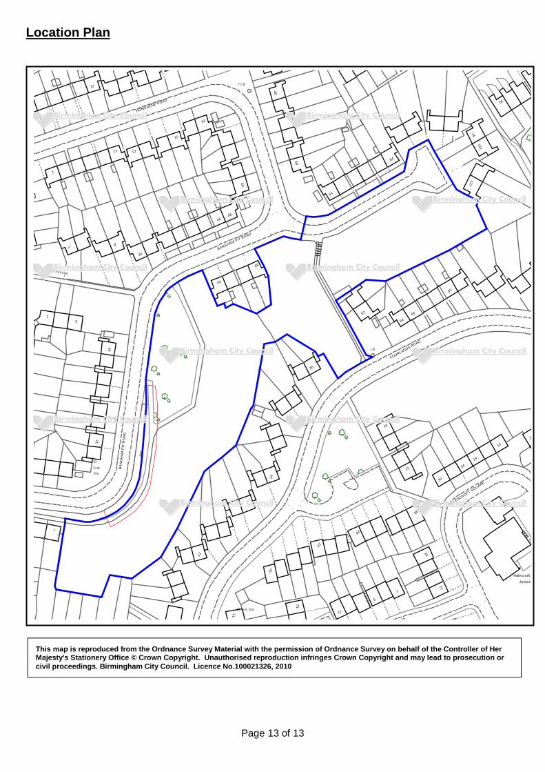
Location Plan
This map is reproduced from the Ordnance Survey Material with the permission of Ordnance Survey on behalf of the Controller of Her Majesty's Stationery Office © Crown Copyright. Unauthorised reproduction infringes Crown Copyright and may lead to prosecution or civil proceedings. Birmingham City Council. Licence No.100021326, 2010
11
Halescroft Y
57
Justice
1512
1
18
39
19
30
34
HALESCROFT SQUARE
62
54
51
56
FOURLANDS ROAD
OAD
15
11El Sub Sta
LB
15
36
23
11
24
5
29
4648
89
52
BANGHAM PIT ROAD
83
5
24
34
8
El
12
12
BA
NG
HA
M P
IT R
OA
D
StaSub
SW
7
Pool Field Avenue
2
1
TCB
HOMEDENE ROAD
74
39
131
54
127
6450
40
33
25
21
1511
12
1