barton le clay appraisal draft - central … · barton-le-clay conservation area appraisal draft...
TRANSCRIPT

BARTON-LE-CLAYCONSERVATION AREA APPRAISAL
DRAFTDECEMBER 2009
A conservation area is an area of special
architectural or historic interest, the character or
appearance of which it is desirable to preserve or
enhance. This document is one of a series of up-to-
date conservation area character appraisals
published by Central Bedfordshire Council.
The purpose of the appraisal is to define which
features contribute to the special interest, what is
significant and what requires preservation.
Opportunities for enhancement are also identified
in the appraisal.

CONSERVATION AREA APPRAISAL
Central Bedfordshire Council 1BARTON-LE-CLAY
CONTENTS
1.0 Introduction 2
2.0 Summary 2
3.0 Location and Setting 2
4.0 Historical Development 3
5.0 Character 5
6.0 Appearance 7
7.0 Boundary Changes 19
8.0 Opportunities for enhancement 21
APPENDICES
1 References
2 Listed Buildings

CONSERVATION AREA APPRAISAL
Central Bedfordshire Council 2BARTON-LE-CLAY
1.0 INTRODUCTION
1.1 The Barton-Le-Clay Conservation Area was designated by Bedfordshire County
Council in 1976. It was reviewed in the Local Plan in 1993 and was extended in
the 1995 South Bedfordshire Local Plan. The designated area presently covers
27.988ha.
1.2 This document assesses the setting, character and appearance of the
conservation area. It also identifies opportunities for improving the character of
the area. The appraisal is, therefore, the basis for the management of the
Barton-Le-Clay Conservation Area through the planning system.
2.0 SUMMARY
2.1 The special interest that justifies designation of the Barton-Le-Clay Conservation
Area derives from a number of architectural, historic and environmental factors,
including:
A large village of well-defined character divided between the busy commercial
centre to the north and the quiet hamlet of Church End to the south
High quality vernacular buildings including many sixteenth – seventeenth
century timber-framed houses
Fields west of and forming the important setting to the Grade I listed, thirteenth
century, Church of St Nicholas, a significant local landmark
Interesting mix of materials including timber-framing, a wide variety of brick
stock, and limestone and flint to the church, giving a strong texture to the area
Distinctive groups of buildings sharing similar building lines with houses either
set on the roadside to the back of pavements, in terraces back from the road or
grouped in medium to large plots along sylvan roads
Important individual and groups of trees
Extensive and far reaching views to the Barton Hills and glimpsed views to open
countryside
3.0 LOCATION AND SETTING
3.1 Barton-Le-Clay lies at the foot of the northern slope of the Barton Hills on what
was once the main Bedford to Luton road. The land rises from north to south,
the village situated on a strong clay soil with clay and chalk subsoil. The church
stands to the southeast of the village centre and with the rectory and group of
houses to the west and north, forms a hamlet known as Church End.

CONSERVATION AREA APPRAISAL
Central Bedfordshire Council 3BARTON-LE-CLAY
3.2 A bypass, opened in 1990, takes the A6 from Luton, 6 miles to the south, past
the village to Bedford.
3.3 The large conservation area comprises two parts. A rectangular area of land in
the south is focused around Old Road, Hexton Road and Church Road including
the hamlet surrounding the Church of St Nicholas and meadows. To the north is
a long narrow area comprising the village centre on Bedford Road and houses on
Sharpenhoe Road.
4.0 HISTORICAL DEVELOPMENT
4.1 Barton-Le-Clay, literally, Barton in the Clay, derives its name from its position
being sited where the clay soil starts under Barton Hill. The overlordship was
vested in the Crown at the date of the Domesday Survey, remaining so until the
Dissolution when the manor was taken in hand by the king and annexed to the
manor of Ampthill in 1542. The manor formerly belonged to the monks of
Ramsey; it was given to the Ramsey abbey, Huntingdonshire in 1044 by Eadnoth,
bishop of Dorchester. The grant was confirmed by Edward the Confessor in
1066, by William the Conqueror in 1078 and again by Edward III in 1334. At the
time of the Domesday in 1086 the manor was assessed at eleven hides worth
ten pounds. Barton had many mills which took advantage of the numerous
streams which rose in the hills.
4.2 The original church of St Nicholas, first mentioned in 1178, consisted of an
aisleless nave and small chancel. Little of this twelfth century building remains,
the church being rebuilt in the thirteenth century with fourteenth century
alterations and the addition of a fifteenth century tower .
4.3 A free school was founded in 1807 by Edward Willes. The village’s population in
1801 was 448 rising to 915 by 1851, dropping to 816 in 1901. The twentieth
century saw continued expansion, the population rising from 1,125 in 1951 to
3,447 in 1991.
4.4 The nineteenth century saw an unusual industry develop in the area digging
coprolites. This involved the extraction of phosphatised clay nodules for
fertiliser. Once a thriving industry, especially in Cambridgeshire, the mining of
coprolites declined in the late nineteenth century, stopping in the early years of
the twentieth century.

CONSERVATION AREA APPRAISAL
Central Bedfordshire Council 4BARTON-LE-CLAY
ORDNANCE SURVEY 1ST EDITION 1882
With Conservation Area Boundary

CONSERVATION AREA APPRAISAL
Central Bedfordshire Council 5BARTON-LE-CLAY
5.0 CHARACTER
5.1 Barton-Le-Clay is a large residential village served by the main shopping area on
Bedford Road, a number of public houses including The Bull, Royal Oak and
Coach and Horses, a youth centre and Methodist Church on Sharpenhoe Road,
the parish church of St Nicholas, Barton village hall and surgery and the Arnold
Middle School.
5.2 The layout and development of the village is key to its character. The
conservation area is divided into four distinct character areas. The commercial
core is focused on the area of shops at the north end of Bedford Road. The
character of this area and its buildings, a mix of modern twentieth century infill,
nineteenth century terraces and shops, dotted with vernacular timber-framed
buildings, continues into Sharpenhoe Road to the west.
Bedford Road looking north
5.3 Where Hexton Road loops around Bedford Road the area has a more intimate
streetscape, away from the busy thoroughfare of Bedford Road. Buildings are
sited in various positions on the roadside or set back from the street in larger
plots. To the south the conservation area’s appearance changes from the close
urban grain of the village core to open fields, large allotments, playing fields,
wide grass verges and tree-lined roads. Manor Road, which loops around to the
east, has a suburban sylvan feel with houses set in regular plots with driveways,
verges, lawns and conifers.

CONSERVATION AREA APPRAISAL
Central Bedfordshire Council 6BARTON-LE-CLAY
Hexton Road looking north
5.4 The hamlet of Church End to the south east is located at the base of the Barton
Hills. Its distance from the busy Bedford Road gives it an altogether different
rural character with good views to the hills, woodlands and surrounding fields.
The hamlet comprises the parish church, hall, rectory, Rectory Farm, The Bury
Farmhouse and numerous timber-framed and brick cottages.
No. 8 Church Road
5.5 The conservation area comprises almost exclusively two-storey buildings with
some single-storey. The modest scale of the buildings is a noticeable feature.
The buildings sit well in their surroundings with a notable absence of large scale
modern infill. Most share a similar scale with no high rise developments

CONSERVATION AREA APPRAISAL
Central Bedfordshire Council 7BARTON-LE-CLAY
dominating the skyline. This makes the grand buildings including The Rectory,
Church Road all the more prominent. The landmark tower of St Nicholas’ is a
striking feature in the landscape to the south east.
The Church of St Nicholas
5.6 There are many attractive groups of buildings which make a positive
contribution to the character and appearance of the conservation area. These
include good survivals of semi-detached nineteenth century villas on
Sharpenhoe Road, vernacular timber-framed houses and cottages on Manor
Road and Church Road, fine houses, for example The Rectory and The Bury,
Church Road and attractive public houses, for example the Royal Oak. These
high quality buildings are interspersed with more modest terraces and semi-
detached houses, many of which have unfortunately lost their original features
including doors, windows and roof coverings.
6.0 APPEARANCE
6.1 Buildings in the conservation area exhibit a wide array of materials. In the
middle ages, the local material for most buildings was timber. In Barton-Le-Clay
its use continued into the eighteenth century. Good examples of timber-framing
survive within the conservation area. No. 32 Sharpenhoe Road, a thatched
cottage of the sixteenth century or earlier has modern timber-framing over the

CONSERVATION AREA APPRAISAL
Central Bedfordshire Council 8BARTON-LE-CLAY
original timber frame which exhibits a full cruck truss. Some timber-framed
buildings were re-fronted in the eighteenth century responding to the fashions
of the time including No. 69 Bedford Road and Church End Cottage, Church
Road. Others were covered in colour washed roughcast including The Bury and
The Rectory, Church Road, and The Bull Inn, Bedford Road. Exposed timber-
framed buildings mostly have colour washed brick noggin. Roofs comprise a mix
of thatch and clay tile. Thatched eyebrow dormers are a particular feature, the
modern No. 2 Mill Lane featuring tiled eyebrow dormers.
No. 154, Manor Road
6.2 Later buildings exhibit a wide variety of brick with a good mix of browns,
yellows, blues, and colour-washed brick. Bonding is mainly Flemish with
occasional English (C & H Barton Chemists, Bedford Road) and irregular Flemish
garden wall bond (garden wall east of The Rectory, Church Road). The garden
wall to No. 4, Lodge Gate Cottage, Church Road has an interesting mix of
irregularly bonded brick, tiles and stone. Some buildings, for example the
Chemists, Bedford Road exhibit polychrome designs or chequered brickwork, for
example No. 1 & 5 Mill Lane and the red and vitreous brick of the Royal Oak.
Others including Nos. 45-55 Sharpenhoe Road have stuccoed details and
dressings. Modern infill buildings often comprise stock bricks laid in stretcher
bond.

CONSERVATION AREA APPRAISAL
Central Bedfordshire Council 9BARTON-LE-CLAY
Illustration of the variety of brick colours, bonding and pointing
6.3 There are also a number of rendered buildings painted in shades of white or
cream. Red brick stacks are common, occasionally yellow brick with yellow or
terracotta clay pots. Roofs comprise natural slate, plain clay tiles, clay pan tiles
or concrete interlocking tiles. It is noticeable that there is considerable loss of
original natural slate roofs, particularly on Sharpenhoe Road.
6.4 The Church of St Nicholas is notable as the only building constructed of stone, an
excellent combination of rubble limestone with a tower constructed of flint and
clunch and limestone chequer-work. The churchyard is bounded by quality
nineteenth century iron railings, listed, together with a lantern, at Grade II.
Chequer-work on the church tower and churchyard railings
CONSERVATION AREA APPRAISAL
Central Bedfordshire Council 10BARTON-LE-CLAY
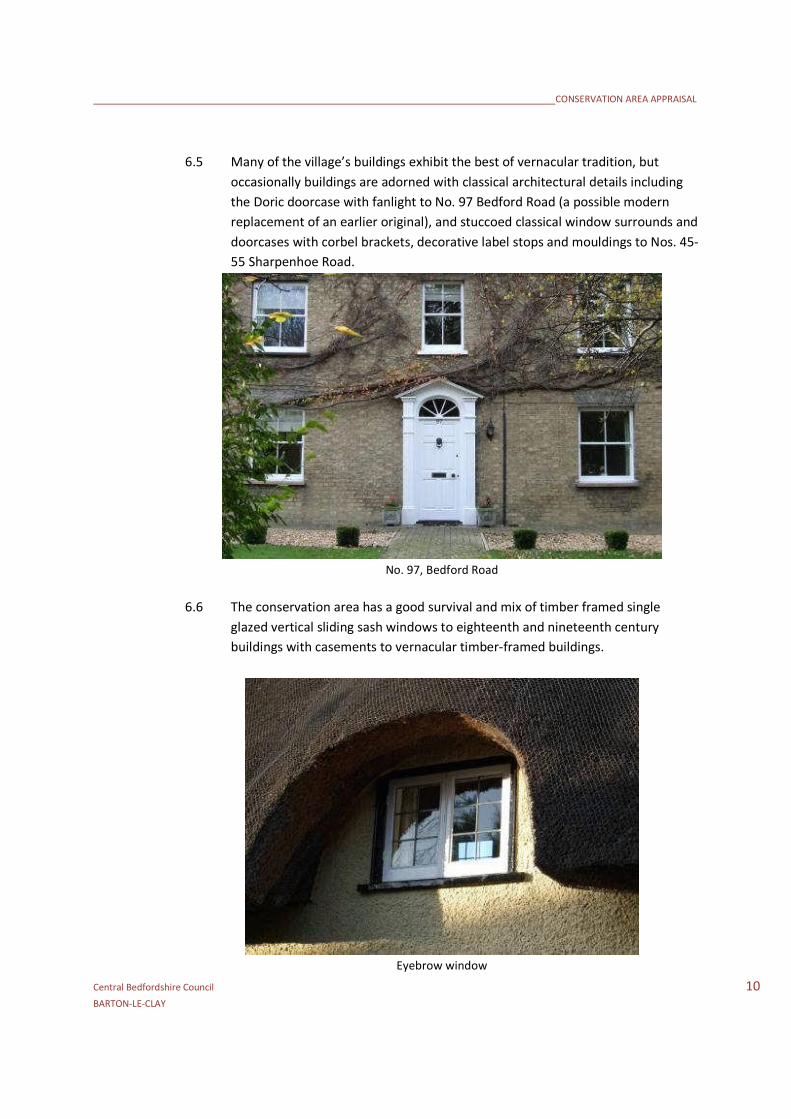
6.5 Many of the village’s buildings exhibit the best of vernacular tradition, but
occasionally buildings are adorned with classical architectural details including
the Doric doorcase with fanlight to No. 97 Bedford Road (a possible modern
replacement of an earlier original), and stuccoed classical window surrounds and
doorcases with corbel brackets, decorative label stops and mouldings to Nos. 45-
55 Sharpenhoe Road.
No. 97, Bedford Road
6.6 The conservation area has a good survival and mix of timber framed single
glazed vertical sliding sash windows to eighteenth and nineteenth century
buildings with casements to vernacular timber-framed buildings.
Eyebrow window

CONSERVATION AREA APPRAISAL
Central Bedfordshire Council 11BARTON-LE-CLAY
Bedford Road North & Sharpenhoe Road
6.7 This character area covers the village’s commercial centre. The Bedford Road
area is busy with vehicle traffic and pedestrians. The area is characterised by its
nineteenth century terraces of shops, interspersed with surviving timber-framed
buildings and modern infill, sited opposite a modern twentieth century parade
of shops and twentieth century semi-detached houses which lie outside the
conservation area. A supermarket is located on the west side of Bedford Road,
outside the conservation area. Generous sized pavements, widening further to
the north, set the buildings back from the west side of the road. There is limited
car parking outside shops and on-street parking on residential closes either side
of the Bedford Road.
6.8 A busy traffic junction north of the Great Oak public house car park leads to
Sharpenhoe Road to the west. This road contains a varied mix of buildings from
the attractive, low two-storey, simple brick terraces of Nos. 5-13 and larger
rendered No. 15 with carriageway arch to the decorative red brick Methodist
Church and semi-detached villas of Nos.45-55. Some buildings have undergone
many alterations including Nos. 21-23 and No. 33. Others, for example No. 45,
The Old Bakery, remain virtually intact.
No. 45, Sharpenhoe Road
CONSERVATION AREA APPRAISAL
Central Bedfordshire Council 12BARTON-LE-CLAY
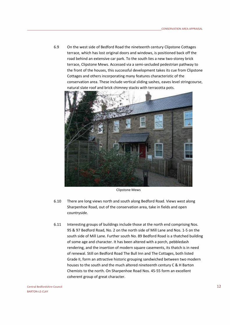
6.9 On the west side of Bedford Road the nineteenth century Clipstone Cottages
terrace, which has lost original doors and windows, is positioned back off the
road behind an extensive car park. To the south lies a new two-storey brick
terrace, Clipstone Mews. Accessed via a semi-secluded pedestrian pathway to
the front of the houses, this successful development takes its cue from Clipstone
Cottages and others incorporating many features characteristic of the
conservation area. These include vertical sliding sashes, eaves level stringcourse,
natural slate roof and brick chimney stacks with terracotta pots.
Clipstone Mews
6.10 There are long views north and south along Bedford Road. Views west along
Sharpenhoe Road, out of the conservation area, take in fields and open
countryside.
6.11 Interesting groups of buildings include those at the north end comprising Nos.
95 & 97 Bedford Road, No. 2 on the north side of Mill Lane and Nos. 1-5 on the
south side of Mill Lane. Further south No. 89 Bedford Road is a thatched building
of some age and character. It has been altered with a porch, pebbledash
rendering, and the insertion of modern square casements, its thatch is in need
of renewal. Still on Bedford Road The Bull Inn and The Cottages, both listed
Grade II, form an attractive historic grouping sandwiched between two modern
houses to the south and the much altered nineteenth century C & H Barton
Chemists to the north. On Sharpenhoe Road Nos. 45-55 form an excellent
coherent group of great character.

CONSERVATION AREA APPRAISAL
Central Bedfordshire Council 13BARTON-LE-CLAY
The Cottages, Bedford Road
6.12 The nineteenth century terrace of shops on the west side of Bedford Road
comprising Post Office, estate agents, bakery and hair dressers, has undergone
many alterations with the loss of original windows, doors, shop fronts and roof
covering.
Bedford Road and Hexton Road Junction
6.13 This area, focused on the loop of Hexton Road has a much more intimate
streetscape with a range of domestic buildings and commercial premises close
to the roadside. The ‘island’ of buildings between Hexton Road and Bedford
Road face east onto Hexton Road having little interaction with Bedford Road to
the west.
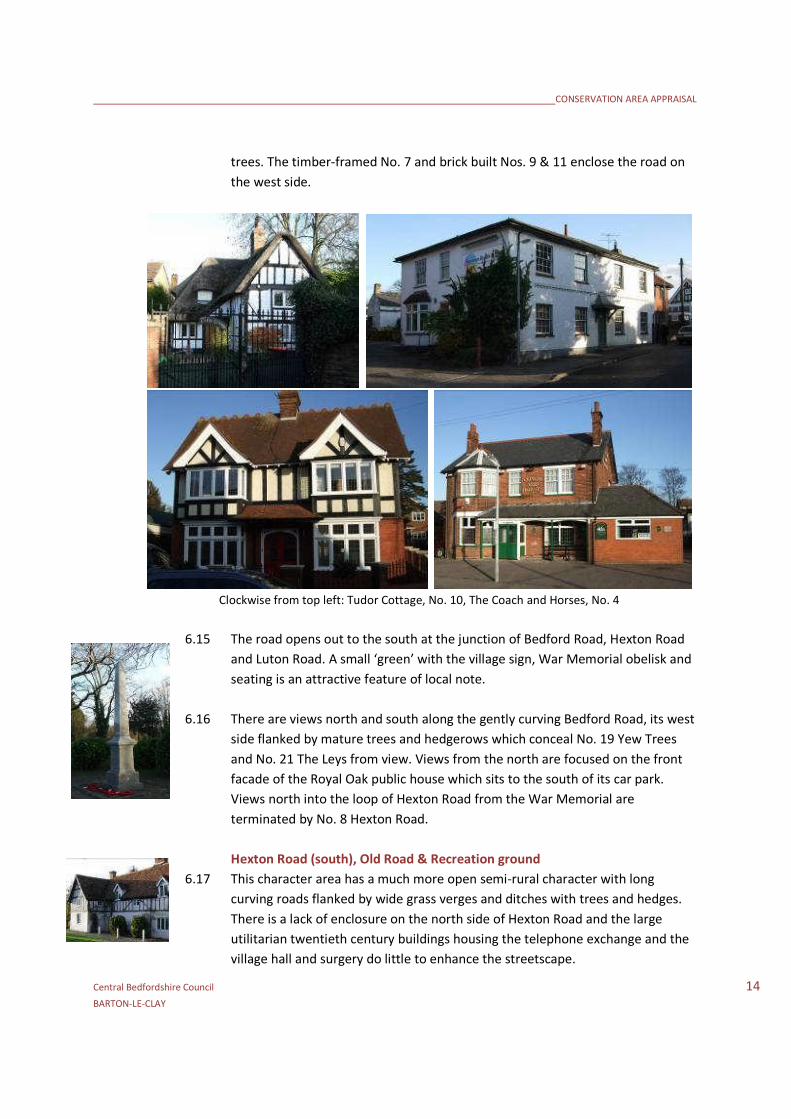
6.14 The loop of Hexton Road has a good range of quality buildings, many of which
are statutorily listed. The east side of the road includes Tudor Cottage, No. 16
(rather hidden from view by clipped hedges and a tall close boarded fence and
gates), No. 10 with its polite west wing with eight over eight pane timber sashes
and swept porch roof concealing the much earlier seventeenth or eighteenth
century timber-framed rear wing, an interesting, but poorly maintained brick
outbuilding to the rear of No. 10, and No. 8 next door, a brick and rendered
building with a mixed plain tile hipped roof and large external chimney stack.
The twentieth century Horsler Close and Clarks Pightle interrupt the building line
which continues with the superb brick and half-timbered No. 4 and red brick
Coach and Horses public house. Further south lie Damson Cottage and other
houses set back off the roadside partially concealed by hedges and large mature
CONSERVATION AREA APPRAISAL
Central Bedfordshire Council 14BARTON-LE-CLAY
trees. The timber-framed No. 7 and brick built Nos. 9 & 11 enclose the road on
the west side.
Clockwise from top left: Tudor Cottage, No. 10, The Coach and Horses, No. 4
6.15 The road opens out to the south at the junction of Bedford Road, Hexton Road
and Luton Road. A small ‘green’ with the village sign, War Memorial obelisk and
seating is an attractive feature of local note.
6.16 There are views north and south along the gently curving Bedford Road, its west
side flanked by mature trees and hedgerows which conceal No. 19 Yew Trees
and No. 21 The Leys from view. Views from the north are focused on the front
facade of the Royal Oak public house which sits to the south of its car park.
Views north into the loop of Hexton Road from the War Memorial are
terminated by No. 8 Hexton Road.
Hexton Road (south), Old Road & Recreation ground
6.17 This character area has a much more open semi-rural character with long
curving roads flanked by wide grass verges and ditches with trees and hedges.
There is a lack of enclosure on the north side of Hexton Road and the large
utilitarian twentieth century buildings housing the telephone exchange and the
village hall and surgery do little to enhance the streetscape.

CONSERVATION AREA APPRAISAL
Central Bedfordshire Council 15BARTON-LE-CLAY
View south along Hexton Road to the junction with Old Road
6.18 A series of large twentieth century detached and semi-detached houses are set
back from the road in large gardens with much tree cover, partially concealing
the extent of the extensive allotments to the north. Some of these buildings
have definite character including the brick and half-timbered Nos. 41-43 and No.
49 Yew Tree Cottage. On the opposite side of the road is the twentieth century,
Arts and Crafts style, butterfly plan No. 52.
No. 52, Hexton Road
6.19 Manor Road, leading north off Hexton Road, has its own particular character
comprising detached houses set in regular garden plots with driveways, hedges
and conifers. The modest twentieth century buildings of the road are
interspersed with three choice, Grade II listed timber-framed cottages on the
west side. Further east on Hexton Road is a short nineteenth century yellow /
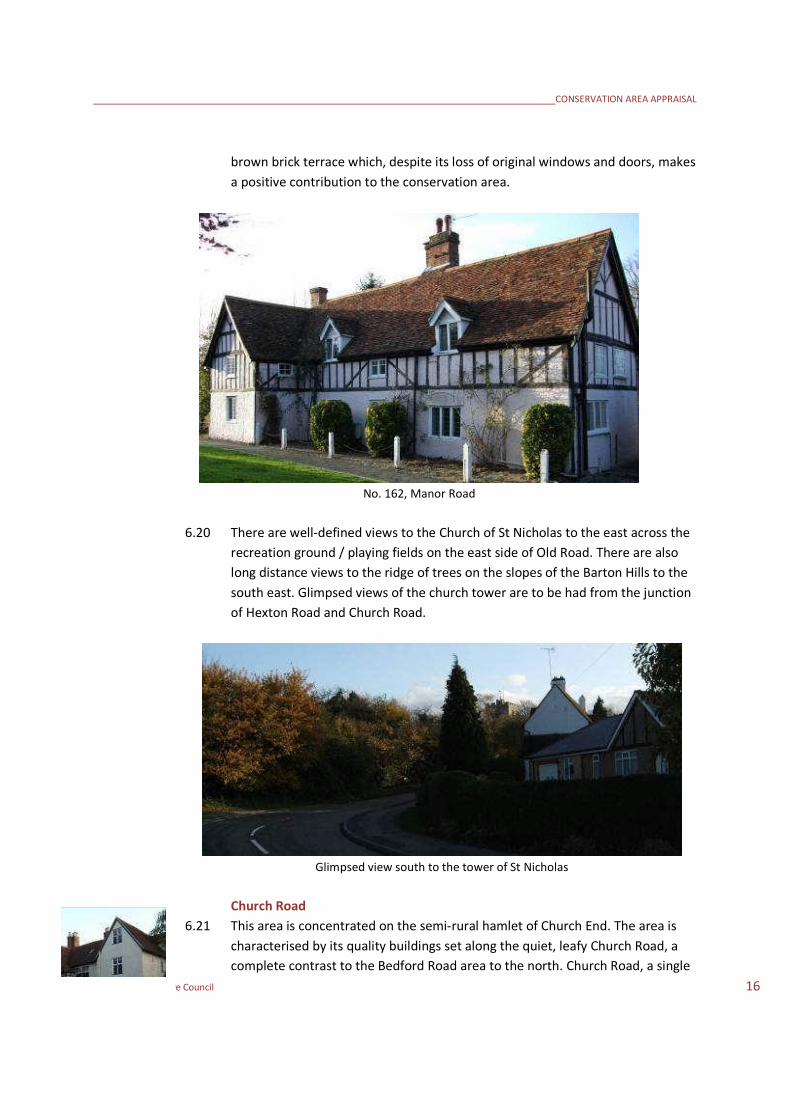
CONSERVATION AREA APPRAISAL
Central Bedfordshire Council 16BARTON-LE-CLAY
brown brick terrace which, despite its loss of original windows and doors, makes
a positive contribution to the conservation area.
No. 162, Manor Road
6.20 There are well-defined views to the Church of St Nicholas to the east across the
recreation ground / playing fields on the east side of Old Road. There are also
long distance views to the ridge of trees on the slopes of the Barton Hills to the
south east. Glimpsed views of the church tower are to be had from the junction
of Hexton Road and Church Road.
Glimpsed view south to the tower of St Nicholas
Church Road
6.21 This area is concentrated on the semi-rural hamlet of Church End. The area is
characterised by its quality buildings set along the quiet, leafy Church Road, a
complete contrast to the Bedford Road area to the north. Church Road, a single

CONSERVATION AREA APPRAISAL
Central Bedfordshire Council 17BARTON-LE-CLAY
carriageway, has a pavement with granite kerbs on its west side and verges or
banks with hedges on its east side.
View south along Church Road
6.22 The well-defined hierarchy of the settlement can clearly be seen. A series of
brick and timber-framed cottages, some thatched, are located on the west side
of the road, set in large gardens which run west to the edge of the recreation
ground. By contrast to the east lies a collection of much grander buildings
including the Grade I listed Church of St Nicholas with its magnificent tower set
within an extensive green churchyard with the imposing Rectory accessed via a
gravel driveway to the south and well-conceived ‘barn-like’ church hall to the
east. To the north east is The Bury farmhouse and courtyard of converted farm
buildings at Rectory Farm as well as New House, accessed via a driveway leading
from Hexton Road.
View east across the churchyard to The Bury
CONSERVATION AREA APPRAISAL
Central Bedfordshire Council 18BARTON-LE-CLAY
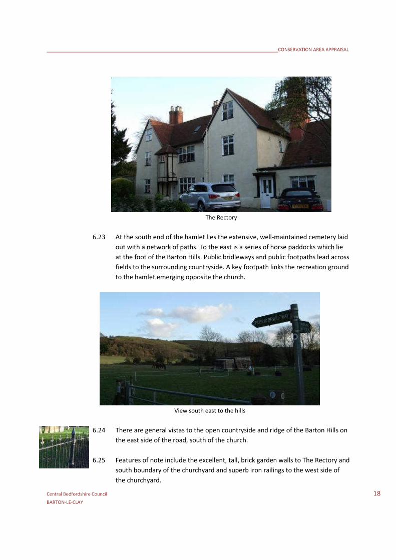
The Rectory
6.23 At the south end of the hamlet lies the extensive, well-maintained cemetery laid
out with a network of paths. To the east is a series of horse paddocks which lie
at the foot of the Barton Hills. Public bridleways and public footpaths lead across
fields to the surrounding countryside. A key footpath links the recreation ground
to the hamlet emerging opposite the church.
View south east to the hills
6.24 There are general vistas to the open countryside and ridge of the Barton Hills on
the east side of the road, south of the church.
6.25 Features of note include the excellent, tall, brick garden walls to The Rectory and
south boundary of the churchyard and superb iron railings to the west side of
the churchyard.

CONSERVATION AREA APPRAISAL
Central Bedfordshire Council 19BARTON-LE-CLAY
7.0 BOUNDARY CHANGES
7.1 Consideration should be given to the following proposed amendments of the
conservation area boundaries as shown on the management map:
1. Suggested extension to include open space enclosed by Bedford Road, Manor
Road and Lime Close
Reason: This important tree lined open space forms part of the setting to
historic buildings which make a positive contribution to this part of the
conservation area and also forms part of the gateway to the older sections of
Barton-Le-Clay from the north. Inclusion would safeguard the spatial quality
of the open space and the trees which line Bedford Road and Manor Road.
2. The east side of Bedford Road adjacent to and including the entrance to Old
School Gardens
Reason: Presently, the conservation area is constrained to the western side
of this principal route through the settlement. By bringing the eastern side of
the road within the conservation area, this will protect the setting of
important groups of older buildings on the western side and provide some
protection for the mature tree to the corner of Old School Gardens which
plays such an important

CONSERVATION AREA APPRAISAL
Central Bedfordshire Council 20BARTON-LE-CLAY
8.0 OPPORTUNITIES FOR ENHANCEMENT
8.1 While the general condition of the conservation area is good, the following are
considered as opportunities to enhance buildings and spaces:
Encouragement to be given for the reinstatement of traditional timber
doors and windows.
Street furniture should respond to the character of the area and be well-
designed and co-ordinated.
Encouragement to be given to the reinstatement of natural slate roofs
and reinstatement of traditional long straw thatch with plain flush
ridges.
Careful consideration of appropriate future boundary treatments
including walls, fences and hedges.
Encouragement to be given for the reinstatement of traditional shop
frontages, or the creation of well-designed new schemes of the correct
proportions.
Careful consideration given to sites where enhancement schemes would
benefit the character and appearance of the conservation area including
the area where Bedford Road splits and loops around and the War
Memorial green at the junction of Luton Road and Hexton Road.
Management of grass verges, ditches and street trees.
Protection of the outbuilding to the rear of No. 10 Bedford Road, a
building at risk.
A specific assessment of change should be established through survey
for Nos. 41-55 Sharpenhoe Road (south side).

CONSERVATION AREA APPRAISAL
Central Bedfordshire Council 21BARTON-LE-CLAY

CONSERVATION AREA APPRAISAL
Central Bedfordshire Council 22BARTON-LE-CLAY

CONSERVATION AREA APPRAISAL
Central Bedfordshire Council 23BARTON-LE-CLAY
APPENDIX 1: REFERENCES
Ed. William Page – A History of the County of Bedford: Volume 2 – Victoria County History 1908
Lewis, S. (ed.) - A Topographical Dictionary of England 1848
Pevsner N – The Buildings of England; Bedfordshire and the County of Huntingdon and
Peterborough 2002 Yale University Press
Maps:
Ordnance Survey – 1882 1:2500
Ordnance Survey – 1901 1:2500
Ordnance Survey – 1924 1:2500

CONSERVATION AREA APPRAISAL
Central Bedfordshire Council 24BARTON-LE-CLAY
APPENDIX 2: LISTED BUILDINGS
GRADE I
CHURCH OF ST NICHOLAS, CHURCH ROAD
GRADE II
7 BEDFORD ROAD
10 BEDFORD ROAD
16 BEDFORD ROAD
TUDOR COTTAGE, 18 BEDFORD ROAD
20 BEDFORD ROAD
69 BEDFORD ROAD
71,72 AND 73 BEDFORD ROAD
THE BULL INN, BEDFORD ROAD
THE ROYAL OAK INN, BEDFORD ROAD
8 AND 10 CHURCH ROAD
CHURCH END COTTAGE, CHURCH ROAD
RAILINGS AND LAMP POST TO WEST OF CHURCH OF ST NICHOLAS, CHURCH ROAD
THE BURY, CHURCH ROAD
THE RECTORY, CHURCH ROAD
WALNUT TREE COTTAGE, 142 MANOR ROAD
PLUM TREE COTTAGE, 154 MANOR ROAD
ELM TREE COTTAGE, 162 MANOR ROAD
32 SHARPENHOE ROAD