basic impact assessment
TRANSCRIPT

Basic Impact Assessment Parks Canada Version IAA 2019
1. PROJECT TITLE & LOCATION
Wetland Walkway Replacement – Hattie Cove, Pukaskwa National Park
2. PROPOSED PROJECT DATES
Planned commencement: 2020-11-01
Planned completion (in-water construction): 2021-08-31
Remediation follow-up monitoring: 2021-2025
3. NOTICES ON REGISTRY
Title for Registry: Wetland Walkway Replacement – Hattie Cove
Project notice posted on Registry 2019-10-28
BIA or any permits approval cannot be taken before 2019-11-27
4. PROJECT FILE NUMBER
Internal: PNP19_01 Registry: 80278
5. PROJECT DESCRIPTION
Objective: This project aims to remove and replace the 180m long low lying boardwalk along the
Coastal Hiking Trail at the east end of Hattie Cove, to improve the overall condition rating and
functionality to meet prevailing design, standards and ensure code compliance and public safety.
Project phases and activities: Project will require staging areas in Borrow Pit and adjacent to the
project area. Staging area adjacent to project area requires vegetation clearing. Alternative access
to Coastal Hiking Trail requires ~70m of temporary trail clearing. Materials will be stored in
Borrow Pit and transported by helicopter to project area. Existing boardwalk infrastructure will
be removed in sections and transported by helicopter to Borrow Pit and disposed of. New
floating boardwalk will be installed in sections and concrete anchors added below the water. New
boardwalk will resume use as section of the Coastal Hiking Trail. Remediation of project area,
temporary staging areas and trails to occur for 5 years post-construction.
Project timing:
Initiation and planning: Completed by March 2021
Construction: April – August 2021
Completion: September 2021

Remediation: October 2021 – October 2025
See project description for further details.
6. VALUED COMPONENTS LIKELY TO BE AFFECTED
Geographical scope of the assessment will include the project area (180 m wetland
walkway), adjacent staging area and access to and from the wetland walkway, staging
area in the Borrow Pit, temporary canoe caches and alternative trail access points, and
helicopter flight path to the project area from the Borrow Pit.
Temporal scope of project will span from construction mobilization on-site to 5 years
post-project to ensure rehabilitation of project impact.
Valued physical components (air, soil and landforms, water, flora, fauna and cultural
resources) have been mostly undisturbed since the installation of existing infrastructure
in 1980s, with the exception of maintenance efforts over the past 2 years to retain the
function of the existing failing infrastructure, and use of the infrastructure May-October
annually by visitors to Pukaskwa National Park.
Valued physical components
o The 180 m boardwalk to be replaced is located within Management Zone II –
Wilderness (Aquatic) zone, identified as an environmentally sensitive site
(Pukaskwa National Park Management Plan 2015). The boardwalk crosses
palustrine marsh wetland, created via a beaver dam on the eastern edge of Hattie
Cove, Lake Superior. Marine substrate is soft silt, and water levels range between
0.5-2 m. Most of the marsh vegetation is grass, sedges and aquatic herbaceous
plants. Adjacent to the boardwalk is aspen-birch hardwood forest, sparse treed
fen and thicket swamp. A beaver lodge is located ~ 15m from the project area, and
a beaver dam is located ~ 30 m away.
o The project and surrounding area provides wetland and fish habitat, as well as
habitat for a range of boreal species, including breeding migratory birds, some of
which are species at risk (see Table 1). The project occurs within critical habitat
for woodland caribou – boreal population.
o The existing infrastructure is not valued as a built cultural resource (Paradis 2019,
pers. comm.). There are no known archeological or sites of cultural importance
within the geographical scope. There is potential for unrecorded archeological
resources within the staging area and access/abutments adjacent to the wetland
(Taylor 2019, pers. comm).
Valued human components
o The northern Superior region that the park falls within encompasses thirteen First
Nations and several Métis groups. The project location is near the main access of
the Park and is in closest proximity to the community of Biigtigong Nishnaabeg.
Given its close proximity to Biigtigong Nishnaabeg, the project area is regularly
used by local Indigenous people from this community to harvest food, medicines
or for other traditional cultural purposes. The project area provides trail access for
traditional use of lands in areas south of Hattie Cove.
o The existing wooden boardwalk provides an immersive visitor experience in a
coastal wetland of Lake Superior, a habitat not otherwise accessible on foot. The

existing infrastructure in the project area provides access to Pukaskwa National
Park’s Coastal Hiking Trail, Mdaabii Miikna, and White River Suspension Bridge
day hike. Approximately 10,000 people per year visit Pukaskwa National Park; a
high percentage of these visitors travel across this walkway. Existing
infrastructure submerges when used by visitors, creating difficult terrain.
Additionally, the wooden walkway becomes extremely slippery when wet, creating
a visitor safety hazard. It is expected that the new infrastructure material will
resolve the visitor safety hazard; there is no request that a railing be added to this
infrastructure. Motorized vessels for the general public are not permitted in this
area of Hattie Cove. However, non-motorized vessels are allowed in all areas of
Hattie Cove. Access to the project area over water is unlikely to occur due to a
beaver dam blocking the route between open water and where the walkway
occurs.
See Appendix 1: Effects Analysis for which project phases are likely to cause direct
effects to valued components. There is very low potential for this project to cause
indirect effects as it is a replacement of existing infrastructure.

Table 1. Potential for PNP19_01_WetlandWalkway to impact Species at Risk within Pukaskwa National Park.
SARA Legal Status Endangered Potential for Impact
Description
Little brown myotis
Myotis lucifugus Low Little brown myotis was recorded at the Visitor Centre (~ 2km from wetland walkway) in 2014. There is no known hibernaculum within the project area. Individuals may use the project area to roost and/or forage.
SARA Legal Status Threatened
Barn swallow Hirundo rustica Low There is no available nesting habitat within the geographical scope of the project. Individuals may forage within the project area.
Bank swallow Riparia riparia Low There is no available nesting habitat within the geographical scope of the project. Individuals may forage within the project area.
Canada warbler Cardellina canadensis Medium
Canada warbler was recorded at the Hattie Cove station of the Forest Bird Measure for the Ecological Integrity Monitoring Program of Pukaskwa National Park in 2009, 2010 and 2015, approximately 900m from the project location. A Canada warbler was observed at the wetland walkway in 1993, and a pair was observed ~ 500 m southwest of the wetland walkway in 2019 (eBird 2019). Removal of shrub layer in breeding habitat is identified as a threat to the recovery of this species (Environment Canada 2016a). Individuals may be nesting or foraging within the project area.
Woodland caribou – boreal population
Rangifer tarandus pop.14
High (critical habitat)
This project occurs within the bounding polygon for Woodland Caribou Critical Habitat for the Coastal Range within the Central Boreal Shield Ecoregion (Environment Canada 2012) and will temporarily destroy forest within critical habitat. Caribou have not regularly occurred in Pukaskwa National Park since 2011, though a transient individual was observed in the frontcountry of Pukaskwa National Park in 2015 (Patterson 2019, pers. Comm.). This project is not expected to negatively impact individuals, but will impact critical habitat.
Shortjaw cisco Coregonus zenithicus None There is no available habitat within the geographical scope of the project.
SARA Legal Status Special Concern
Monarch Danaus plexippus Low Many individuals have been noted in the frontcountry of Pukaskwa National Park, ~ 2 km from the project area. There is no available breeding habitat within the project area. Individuals may forage within the project area during spring or fall migration.
Peregrine falcon anatum/tundrius
Falco peregrinus pop.1
Low There is no available nesting habitat within the project area. Individuals may forage within the project area.
Pitcher’s thistle Cirsium pitcheri None There is no available habitat or individuals present within the project area.
Rusty blackbird Euphagus carolinus Medium
Rusty blackbirds have been observed in the front-country of Pukaskwa National Park in 2010 and 2017 (eBird 2019), and at the wetland walkway in April 2010 (PNP Incidental Sightings database). Suitable breeding habitat exists within the project area. Loss and degradation of breeding habitat (by forestry operations) is identified as a direct threat (COSEWIC 2017). Individuals may breed or forage within the project area.
Snapping turtle Chelydra serpentinae Unknown Presence of snapping turtles within the project area is unknown.
Eastern wood-peewee
Contopus virens Medium Eastern wood-pewee was observed at the White River, ~ 4km from the project site in 2018. Suitable breeding habitat is available within the project area. Loss and degradation of habitat on breeding grounds is a threat affecting this species (COSEWIC 2012). Individuals may breed or forage within the project area.
Common nighthawk
Chordeiles minor Low Common nighthawk was observed within the project area in 1993 (eBird 2019) and adjacent to the project area (~300 m) in August 1994 (PNP Incidental Sightings database). Suitable breeding habitat is unlikely within the project area. Individuals may forage within the project area.
Olive-sided flycatcher
Contopus cooperi Medium
Olive-sided flycatcher has been regularly observed in the frontcountry of Pukaskwa National Park and adjacent to the project area (~500 m) in 2018. Suitable breeding habitat exists within the project area. Changes in breeding habitat are not a known threat to the recovery of this species (Environment Canada 2016b). Individuals may breed or forage within the project area.
Yellow-banded bumblebee
Bombus terricola Medium Yellow-banded bumblebee was observed in the frontcountry of Pukaskwa National Park in 2018 (PNP Incidental Sightings database). There is suitable nesting habitat within the project area. Habitat disturbance is not identified as a threat to this species (COSEWIC 2015). Individuals may nest or forage within the project area.
7. EFFECTS ANALYSIS
Direct Effects
Air
Use of helicopter, machinery and construction personnel will cause increase in ambient noise levels.
Use of machinery, equipment will generate exhaust and other particulate matter.
Soil and landforms
Use of machinery and/or trampling may result in physical damage and increase erosion and sedimentation, especially within riparian zone.
Work in wetlands can lead to loss of wetland function as well as habitat fragmentation and a reduction in flood level protection.
Contamination of subsoil by human waste from use of pit privy.
Leakage of deleterious substances from poorly maintained and/or improper refueling of machinery and/or equipment may pollute and contaminate soils.
Water
Increase in suspended solids in water column (increase in turbidity) due to disturbance of underwater substrate.
Change in sediment concentrations due to sedimentation of water body from use of machinery, canoes and/or trampling (erosion) of riparian zone.
Increase in contaminant concentrations resulting from leakage of deleterious substances from poorly maintained and/or improper refueling of machinery and/or equipment.
Possible change in water quality characteristics (e.g. temperature, dissolved oxygen or nutrient concentrations) due to removal of aquatic vegetation, or increased turbidity.
Increase in contaminant concentrations from leaching of new infrastructure materials. Increase in contaminant concentrations from possible leaching of human waste from pit
privy.
Flora
Advertent removal causing death (e.g. aquatic vegetation removed for installation of infrastructure, terrestrial vegetation cleared for staging area and temporary trails).
Incidental burial, crushing or drowning of vegetation causing harm or death during construction activities.
Indirect effects of alteration to site conditions (e.g. turbidity, light availability) may change community composition.
Possible introduction of non-native and/or invasive plant species (e.g. Phragmites australis australis).
Fauna
Probable change in behaviour as a result of increased ambient noise and personnel. Probable disruption of life-cycle activities (e.g. breeding, foraging, migration) from
proximity to construction. o Possible disruption of breeding activities of species at risk avifauna including Canada
warbler (Cardellina canadensis; SARA: Threatened); rusty blackbird (Euphagus

carolinus; SARA: Special Concern); Eastern wood-pewee (Contopus virens; SARA: Special Concern); olive-sided flycatcher (Contopus cooperi; SARA: Special Concern); common nighthawk (Cordeiles minor; SARA: Special Concern); and other migratory birds protected under Migratory Birds Convention Act, 1994.
o Possible disruption of life-cycle activities of herpetofauna including snapping turtle (Chelydra serpentinae; SARA: Special Concern).
o Possible disruption of other aquatic species (e.g. fish, mammals, invertebrates) due to construction noise, personnel, environmental changes.
o Possible disruption of other terrestrial species (e.g. mammals, invertebrates) due to construction noise, personnel, environmental changes.
Change in habitat (temporary or permanent). o Habitat which meets the biophysical requirements of critical habitat for woodland
caribou – boreal population (Rangifer tarandus pop. 14; SARA: Threatened) (i.e. mature forest) may be removed for the creation of a staging area. And access trails to canoe caches. However, as per the woodland caribou recovery strategy (COSEWIC 2012), critical habitat will not be destroyed because >65% of habitat is still available within the range (ON6 – Coastal Lake Superior). The total area of the ON6 range is 3765.98 km2, 84% of which is undisturbed habitat (COSEWIC, 2012). This project will affect 0.000001% of the habitat in the range because the area cleared will be no more than 50 m2.
o Temporary or permanent change in fish habitat - increased suspended solids, possible removal of aquatic vegetation.
Possible incidental death of wildlife including SAR. Possible introduction of non-native and/or invasive animal species or parasitic disease
(e.g. whirling disease, spiny waterflea). Potential toxicity or bioaccumulation from accidental release of deleterious materials or
leaching of new infrastructure materials.
Wetland and fish habitat
Introduction of fine sediments in a waterbody can have severe negative impacts on all life stages of fish and other aquatic life and their habitats.
Work in wetlands can lead to loss of wetland function as well as habitat fragmentation and a reduction in flood level protection.
Work in wetlands may also result in the direct loss of rare plants as these areas have high potential for rare plant species.
Physical damage/loss of vegetation, contributing to: loss of fish, herptile or any wildlife habitat connectivity, increased flows, and temporary or permanent loss or alteration of habitat (riparian and aquatic).
Disruption to wildlife (e.g. migration, or foraging times).
Cultural resources
Excavation required for pit privy, walkway abutments, restoration plantings could disrupt archeological resources.
Current use of lands and resources for traditional purposes by Indigenous people
Closure of the project area for 2-6 weeks will restrict access to traditional land and resources.
Access to traditional lands and resources south of Hattie Cove via the Coastal Hiking Trail may be impacted if alternative options are not available.
Visitor experience and safety:
Probable closure of access to Coastal Hiking Trail via Hattie Cove wetland walkway for 2-6 weeks; terrestrial access to backcountry campsites and White River Suspension Bridge day hike may be impacted if alternate crossing options are not feasible.
Visitors may encounter construction activities if trail closure is not well communicated/signed.
New infrastructure materials should rectify safety concerns of the current infrastructure, but may cause/maintain slipping hazard if traction is not improved.
Construction may lead to decreased quality of visitor experience and contravene “wilderness feel” due to temporary closures, noise, and presence of people, machinery and/or equipment.
New infrastructure materials (plastic) may contravene “wilderness or natural feel” of backcountry experience.
8. MITIGATION MEASURES
1. A Pukaskwa National Park staff member will be identified as the Environmental
Surveillance Officer (ESO) for the duration of this project and shall conduct weekly
surveillance, being present at the beginning of key steps of construction process (e.g.
staging area clearing, installation of sedimentation control devices, old walkway removal,
aquatic vegetation clearing, installation of new walkway, installation of anchors) to
ensure mitigation measures are respected. The Biigtigong Nishnaabeg Environmental
Coordinator may participate in surveillance activities as desired.
2. The contractor shall submit an Environmental Protection Plan to identify
how their construction plan will meet the below-noted mitigations.
3. Project manager will designate on-site representative (Technical Services Officer I at
Pukaskwa National Park) to coordinate required project logistics.
General
4. In-water work shall be minimized.
5. All work and activities will comply with DFO conditions to Avoid Causing Harm to Fish
and Fish Habitat and won’t release deleterious substances to a waterbody.
6. In-water excavation shall be avoided.
7. Vegetation clearing shall be minimized.
8. Timing windows for spawning fish apply:
a. In-water work shall occur only between July 15 and August 30.
9. Timing windows for migratory birds apply:
a. Vegetation clearing shall occur between August 30 and May 1.
b. If clearing is required between May 1 and August 30, surveys for breeding birds
will be performed by a knowledgeable person prior to vegetation removal. Survey
duration and frequency will be determined by the ESO, in relation to the area
required for clearing, habitat complexity and risk to breeding migratory birds.
10. Contact ESO 2 weeks prior to commencement of work, onsite start-up meeting, arrange
site surveillance, issue Special Activity Permits (e.g. Aircraft Access Permit).
11. All National Park regulations to be observed by the contractors, subcontractors and their
employees (e.g. no feeding wildlife, no littering, no unauthorized camping etc., see
Appendix 3 for list of Rules and Regulations).
Location of facilities
12. Locate staging area 1 – Borrow pit in previously disturbed area; staging area 2 –
Project area in Aspen-Birch Hardwood ecosite, greater than 60 m away from edge of
wetland (Sheldon et al. 2005; Figures 1, 2). Exact staging locations are subject to
approval by the ESO and on-site representative.
13. Minimize area required for staging areas, or avoid using a staging area altogether – in the
event a staging areas cannot be avoided, it may not exceed 50 m2. Staging area 2 –
Project area should be only large enough for deposit of materials by long-line helicopter
and storage. Emergency landing for helicopter will be at staging area 1 – Borrow Pit.
14. Locate pit privy adjacent to staging area 2 - Project area to concentrate human impact.
a. Location of pit privy must be surveyed by PCA Terrestrial Archeology prior to
installation.
b. Pit privy must be installed > 100 m from the coastal wetland, or other water
sources. Pit privy must be installed above groundwater table. Exact location of
facilities shall be subject to approval by project manager, on-site representative
and ESO.
15. Locate potential canoe cache locations on north and south side of Hattie Cove to
minimize length of necessary trail creation and to minimize erosion potential due to
repeated canoe access (i.e. low grade slopes or bedrock). Exact canoe cache locations are
subject to approval by the ESO and Visitor Experience Manager of Pukaskwa National
Park (Figure 3).
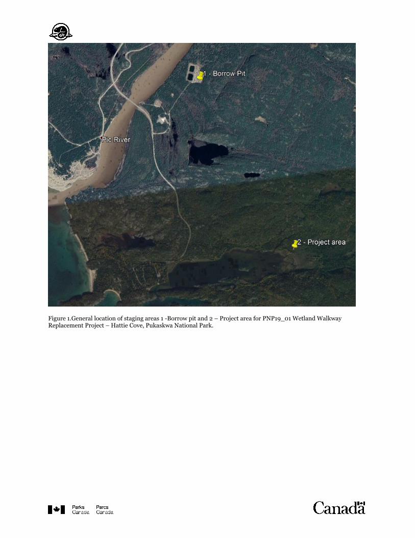
Figure 1.General location of staging areas 1 -Borrow pit and 2 – Project area for PNP19_01 Wetland Walkway Replacement Project – Hattie Cove, Pukaskwa National Park.
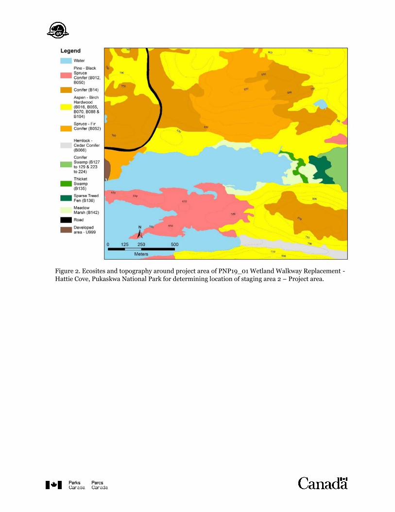
Figure 2. Ecosites and topography around project area of PNP19_01 Wetland Walkway Replacement -
Hattie Cove, Pukaskwa National Park for determining location of staging area 2 – Project area.
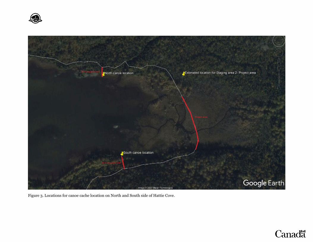
Figure 3. Locations for canoe cache location on North and South side of Hattie Cove.
Equipment
16. Do not idle unnecessarily.
17. All equipment shall be cleaned and dried prior to entry to the Park to prevent
introduction of disease and invasive species.
18. Motorized vessels are not permitted within the Hattie Cove wetland. Non-motorized
vessels (e.g. rowboat, canoe, barge) may be used – all vessels must be cleaned, drained
and dried or disinfected prior to entry into the Park to prevent the introduction of
invasive aquatic species.
19. Whenever possible, operate machinery on land above the high water mark, on ice, or
from a non-motorized vessel in a manner that minimizes disturbance to the banks and
bed of the waterbody (i.e. ensure there is enough water to prevent grounding).
20. Boats, all materials and equipment with potential to come in contact with waterbodies,
must be cleaned and inspected for aquatic invasive alien species (e.g., zebra mussels)
before and following work. Proof this mitigation was applied may be requested before
equipment is permitted into the protected heritage place.
21. All equipment shall be in good working order, free of leaks, well-maintained and fitted
with standard, well-maintained, air emission control devices.
22. Equipment shall be hand-carried to project area on existing foot-trails or slung-in by
helicopter – all sling loads must be identified by the contractor and staged in designated
areas. Transport timing will be coordinated between the contractor, project manager and
on-site representative.
23. Helicopter flying-time shall be minimized.
24. Helicopter operations must not occur within areas of exposed soils where rotor wash will
disturb soils or vegetation.
25. Helicopter operations are not to occur within 100 meters of sighted wildlife, raptor nests
or any identified sensitive features.
26. Helicopter fueling is permitted only at the fueling station or approved by designated
Parks Canada staff
27. Fueling of equipment shall occur in a designated flat area over an impermeable surface
with a berm, >60 m from wetland, > 30 m from other water sources.
28. A Spill Response Plan should be developed prior to work starting. A spill kit shall be
readily available for 110% of fuel on site and all staff trained in its use. Authorities (Park
Duty Officer and Ontario Spill Action Centre 1-800-268-6060) shall be notified
immediately of any fuel spills or leaks
29. Vegetation mats shall be used in sensitive, soft wet areas next to the wetland.
30. A shale stone operating pad may be installed by the contractor in the area authorized by
the on-site representative and ESO to prevent machinery sinking into the soft moist soils
adjacent to the wetland. This pad must be maintained and surrounded by a silt fence to
prevent sediment from entering the watercourse. The pad must be removed at the end of
the project and the site restored to pre-project conditions, to the satisfaction of ESO.
31. Mechanized machinery will not be permitted to enter the wetland.
32. Minimize use of machinery and equipment in riparian zone to minimize disturbance to
the banks of the wetland – restore banks to original condition if any disturbance occurs.
Materials
33. As much as possible, assemble materials off-site.
34. Materials shall be hand-carried on existing trails or slung-in by helicopter – all sling
loads must be identified by the contractor and staged in designated areas. Transport
timing will be coordinated between the contractor, project manager and on-site
representative.
35. No storage of materials will occur on the coastal wetland; storage of all materials will be
at the pre-approved staging areas.
36. All materials shall be treated and handled in a manner to prevent release of deleterious
substances into water.
37. Storage of fuel or other petroleum products must occur > 60 m away from the wetland, >
30 m from other water sources and on an impermeable surface.
38. Concrete mixing activities must take place over tarps and a minimum of 30 m from
waterbodies. Fresh, wet, uncured concrete and concrete dust must not come into contact
with waterbodies. Secondary containment measures such as collection/drip trays and
berms lined with air and water-tight material such as plastic and a layer of sand, and
double-lined fuel tanks are required. Excess concrete must be disposed of at an
appropriate facility outside of the Parks Canada protected heritage place.
39. No treated wood will be used in contact with water (permanently or seasonally). Eastern
white cedar may be used in areas where wood will be in contact with water. Refer to
Parks Canada Treated Wood Management Standard (2017 Draft) and Parks Canada
Treated Wood Management Guide (2017 Draft) for guidance on appropriate use of
treated wood products in areas not in contact with water - provide certification document
from the supplier of any treated wood. No CCA (chromated copper arsenic) treated
lumber will be used on this project.
40. Sawdust, drilling debris and other construction debris is not permitted to enter into the
watercourse – any work which will result in sawdust or debris should occur over land as
much as possible. If drilling or cutting must occur over water, impermeable barriers shall
be used to ensure sawdust or debris does not enter the watercourse. If debris does enter
the watercourse, retrieve to the highest extent possible.
41. Materials for new infrastructure shall be tested to ensure that they do not leach
contaminants when in contact with water.
42. Ensure moorings and floating docks (including anchors and floats) are made of clean,
inert material.
43. Do not use rubber tires as floatation system components for floating dock sections as they
are known to release extracts toxic to fish and aquatic invertebrates.
44. Ensure plastic barrel floats are free of any chemicals inside and outside before they are
placed in water.
45. Materials for new infrastructure shall be tested to ensure that they do not break down
with UV exposure.
46. Materials for new infrastructure shall include traction. New infrastructure shall maintain
traction when wet.
47. Remove existing floating prefabricated structures in a manner that prevents disturbance
and/or sediment generation. Remove debris by hand, where possible.
48. Materials should allow light penetration to the water column and waterbody bed. An
open grid material is preferred, but light penetration can also be accomplished through
spacing of deck materials, or by using porous deck materials which allow 40% of light to
pass through the deck surface to the water column.

Waste management and disposal
49. Waste materials from the old structure shall be removed from wetland and stored in
staging area 2 – Project area, then transported to staging area 1 - Borrow Pit via
helicopter sling load. Transport timing will be coordinated between the contractor,
project manager and on-site representative. Waste materials shall be transported from
staging area 1 – Borrow Pit to an appropriate landfill disposal site via vehicle using
appropriate personal protection equipment. Treated wood shall not be burned,
composted or mulched.
50. All litter, particularly food wastes, must be removed from the site daily and discarded in
appropriate receptacles. Storage of garbage on site is not permitted.
51. Waste materials from construction of new infrastructure shall be stored in staging area
2- Project area, then transported to staging area 1 – Borrow pit via helicopter sling load.
Transport timing will be coordinated between the contractor, project manager and on-
site representative. Waste materials shall be transported from staging area 1 – Borrow Pit
to an appropriate disposal site via vehicle using appropriate personal protection
equipment.
Sediment and erosion
52. Work shall be suspended in the event of weather (and weather forecasts) that increases
flow volumes and the potential for erosion and sedimentation (heavy rain and wind
events; e.g. rain causing pooling water).
53. Site isolation measures for containing suspended sediment (e.g. turbidity curtain) shall
be used where in-water work required; erosion control (e.g. mats) and sedimentation
barriers (e.g. silt fences) are required where sedimentation of water from terrestrial
sources is likely.
54. Control measures shall be maintained until all disturbed ground is permanently
stabilized (re-vegetated) and all suspended sediment re-settled; control measures shall be
regularly inspected and maintained during construction. In the event that erosion and
sediment control measures are not functioning properly, work shall cease until the
measures are adjusted to control the problem.
55. Turbidity curtain shall be installed in a manner that pushes fish, and other aquatic
animal species out of the project area, so no salvage is necessary. If this is not possible,
fish salvage will be completed by Resource Conservation of Pukaskwa National Park
using seine nets and/or minnow traps.
56. Limit disturbance of the approach to water bodies related to the Project and associated
activities, and immediately stabilise and reclaim the site to pre-construction conditions
where possible.
57. Debris shall not enter waterbodies and must be retrieved to the extent possible if it does.
Flora and fauna
58. Review of impacts to fish and fish habitat by Department of Fisheries and Oceans Canada
(DFO) is attached in Appendix 4: DFO Letter of Advice. The following mitigations are
required to protect fish and fish habitat.
a. Plan in-water works, undertakings and activities to respect timing windows to
protect fish, including their eggs, juveniles, spawning adults and/or the organisms
upon which they feed and migrate; meaning no in-water work shall occur
September 1st to July 15th.
b. Develop and implement an erosion and sediment control plan to avoid the
introduction of sediment into any waterbody during all phases of the work,
undertaking or activity; monitor to observe signs of sedimentation during all
phases of the work, and take corrective action when necessary.
59. Avoid additional disturbance to riparian vegetation (use existing trails where possible).
60. Avoid or minimize removal of terrestrial vegetation (i.e. avoid or minimize area required
for staging area; minimize area required for access trails to canoe caches)
a. Vegetation clearing shall occur between August 30 and May 1.
b. If clearing is required between May 1 and August 30, surveys for breeding birds
will be performed by a knowledgeable person prior to vegetation removal. Survey
duration and frequency will be determined by the ESO, in relation to the area
required for clearing, habitat complexity and risk to breeding migratory birds. If
breeding birds are present, vegetation clearing will be delayed or relocated (if
possible).
61. Avoid or minimize removal of aquatic vegetation.
62. Prior to starting work each day, survey project site for any reptiles, amphibians and
mammals – allow any observed animals to vacate the project site before starting work.
63. If a species at risk (SAR) is observed on the work site, cease all work immediately and
report to Park Duty Officer.
a. Guidance for recognizing SAR with potential to occur at the project site will be
provided to the contractor.
b. Survey for SAR will be completed by ESO at the site prior to the start of
construction. Ongoing surveillance for SAR at the site will be completed by the
ESO during site visits.
64. If a nesting bird is observed on the project site, cease work in the area (100m radius) and
report to Park Duty Officer.
a. Guidance for recognizing nesting birds will be provided to the contractor.
b. Survey for nesting birds will be completed by ESO at the site prior to the start of
construction. Ongoing surveillance for nesting birds at the site will be completed
by the ESO during site visits.
65. Any scarring to natural habitat as a result of equipment or foot traffic must be restored as
directed by ESO.
Cultural resources
66. Parks Canada Terrestrial Archeology will review construction techniques for new
abutments. Appropriate mitigations or construction strategies as directed by the
archeologist must be implemented.
67. A test pit survey will be completed in the location of the proposed pit privy to ensure that
no archeological resources will be disturbed by this excavation.
68. All work is subject to the following clause: If unrecorded archaeological resources (e.g.
structural features or artifact concentrations) are encountered during construction
activities, work will cease in the immediate area and the Park Duty Officer informed. The
Manager of Resource Conservation will contact Parks Canada's Terrestrial Archaeology
section and a representative from Biigtigong Nishnaabeg for advice and assessment of
significance, which will in turn determine what will be required to mitigate the find. Any
terrestrial vegetation clearing will be completed only to ground level – roots will be left
intact.
69. Any required restoration plantings will be accomplished using hand tools to minimize
ground disturbance.

Access to lands and resources by Indigenous peoples
70. Requests to access the project area by Indigenous peoples for traditional use during
closures will be accommodated, provided it is safe to do so.
71. Indigenous peoples may continue to access all areas on the south side of Hattie Cove by
personal vessel on Lake Superior or by navigating around Hattie Cove on foot.
72. Additional options for alternative access to the Coastal Hiking Trail on the south side of
Hattie Cove are being explored (i.e. presence of canoe caches on north and south side of
Hattie Cove).
Visitor experience and safety
73. Timing of trail closure shall be minimized. Visitor experience and external relations of
Pukaskwa National Park shall be notified of required trail closures as soon as possible, at
least 2 weeks prior.
74. Additional options for alternative access to the Coastal Hiking Trail on the south side of
Hattie Cove are being explored (i.e. presence of canoe caches on north and south side of
Hattie Cove).
75. Trail closure will be posted in at least 3 physical locations and 1 digital location of
Pukaskwa National Park. A physical barrier will be added to the Coastal Hiking Trail on
either side of the project area.
76. Timing of required trail closure will be made available to visitors, as soon as it is known.
77. Backcountry campsites will be closed for online reservations during the foreseen time of
trail closure.
78. New infrastructure materials shall be tested for traction prior to installation.
Remediation plan
79. Shrubs and tree saplings shall be used to re-vegetate Staging area 2 – Project area post-
construction. Seedlings and cuttings will be obtained from a 300m radius around
Staging area 2 – Project area in fall using hand tools. Cuttings may be rooted in pails of
water for up to 3 weeks. Small holes will be dug using a hand auger and vegetation placed
over the cleared area at a density of 2 plants/m2. As much as possible, the proportion of
vegetation species used in restoration will reflect surrounding site conditions.
80. Pit privy adjacent to Staging area 2 – Project area shall be back-filled with excavated
material post-construction.
81. Aquatic and riparian habitat will be evaluated for damages by the ESO. If deemed
necessary, restoration of those areas will occur. Riparian habitat will be restored using
shrubs and tree saplings in a manner similar to staging area 2 – Project area. Aquatic
habitat restoration will occur as directed by Rehabilitation and Enhancement of Aquatic
Habitat Guide version 1.0 (Kavanagh and Hoggarth, u.d.).
9. OTHER CONSIDERATIONS
☒ Comments received from the public /stakeholder engagement
There were no comments received from the general public. This project was posted on
the Canadian Impact Assessment Registry on October 28, 2019.
☒ Indigenous peoples engagement or consultation
The Director of Sustainable Development of Biigtigong Nishnaabeg reviewed this BIA on
December 18, 2019. Comments were incorporated as requested, and response reviewed
February 4, 2020 with no further concerns.
Biigtigong Nishnaabeg will be kept informed of any changes to the project description,
timing, and mitigations. A representative from Biigtigong Nishnaabeg (e.g. the
Environmental Coordinator) may participate in surveillance of this project at any time. If
archeological resources are discovered as a result of this project, a representative from
Biigtigong Nishnaabeg will be informed.
☒ Surveillance
Surveillance shall be performed at least once weekly by ESO or delegate while
construction is ongoing, to verify that required mitigation measures are implemented.
ESO will be present at the beginning of key steps of construction process (e.g. staging
area clearing, installation of sedimentation control devices, old walkway removal, aquatic
vegetation clearing, installation of new walkway, installation of anchors) to ensure
mitigation measures are respected. The Environmental Coordinator of Biigtigong
Nishnaabeg or representative may participate in surveillance activities at any time.
Water quality measurements (pH, conductivity, dissolved oxygen, turbidity) will be collected and analyzed to determine pre-construction, construction and post-
construction states.
A survey for SAR and breeding birds will be performed prior to construction and during
construction surveillance to ensure no individuals are harmed.
Aerial photos of 180 m boardwalk will be collected via UAV device – pre-construction,
during construction and post-construction.
☒ Follow-up monitoring
Follow-up monitoring of aquatic vegetation and riparian zone may be required, if
remediation of these areas is necessary.
Follow-up monitoring of the staging area adjacent to the project and access trails to
canoe caches shall occur once annually (2021-2025) to ensure that remediation of the
forested area impacted has begun.
☐ SARA Follow-up monitoring
10. SIGNIFICANCE OF RESIDUAL ADVERSE EFFECTS
Impacts to the environment as a result of this project are anticipated to be insignificant
with the implementation of mitigation measures. A large proportion of the anticipated
effects can be reduced by conducting work outside of fish spawning timing windows.
Residual adverse effects to Visitor Experience due to the closure of the Coastal Hiking
Trail will be short-term in duration, expected only during the construction (2-6 weeks).
Upon completion, the new boardwalk is expected to improve visitor experience and
safety.
Access to the project area by local Indigenous people for traditional use will be
accommodated upon request; areas south of the project site remain accessible via an
alternate routes (e.g. personal vessel on Lake Superior or navigating around Hattie Cove).
Pukaskwa National Park is exploring the provision of alternative access to the Coastal
Hiking Trail on the south side of Hattie Cove during trail closure via canoe caches on the
north and south side of the cove.
11. EXPERTS CONSULTED
Department/Agency/Institution: Parks Canada Agency - Indigenous Affairs and Cultural Heritage Directorate
Date of Request: October 3, 2019
Expert's Name & Contact Information: Matthieu Paradis
Title: Cultural Resources Management Advisor
Expertise Requested: Review of impacts to cultural resources Response: Existing infrastructure not a cultural resource. Advised consultation with archeology.
Department/Agency/Institution: Parks Canada Agency - Indigenous Affairs and Cultural Heritage Directorate
Date of Request: October 3, 2019
Expert's Name & Contact Information: Stacey Taylor
Title: Terrestrial Archeologist
Expertise Requested: Review of impacts to archeological resources Response: Added avoidance and mitigation strategies as directed.
Department/Agency/Institution: Parks Canada Agency – Pukaskwa National Park
Date of Request: November 12, 2019
Expert's Name & Contact Information: Daniel Pouliot – Manager of Resource Conservation Lucy Patterson – Park Ecologist Chris Robinson – Park Ecologist
Title: Resource Conservation staff
Expertise Requested: Internal review of BIA Response: Made requested changes throughout
Department/Agency/Institution: Parks Canada Agency – Species Conservation Branch
Date of Request: November 15, 2019
Expert's Name & Contact Information: Joanne Tuckwell
Title: Species Conservation Specialist
Expertise Requested: Review of impacts to SAR and SARA permit decision tool. Response:
Modified text within as suggested.
SARA permit for destruction of critical habitat of woodland caribou not required because critical habitat destruction happens only when the amount of habitat in the polygon for that range (ON6 – Coastal Lake Superior) drops below 65% - current estimate is 84% intact.
SARA permit for Canada warbler not required because of mitigations for vegetation clearing.
Department/Agency/Institution: Parks Canada Agency – Impact Assessment Branch
Date of Request: November 15, 2019
Expert's Name & Contact Information: Marie-Claude Martel
Title: Impact Assessment Specialist
Expertise Requested: General review of BIA Response: General review; modified text within as suggested.
Department/Agency/Institution: Lands and Resources – Biigtigong Nishnaabeg
Date of Request: December 9, 2019
Expert's Name & Contact Information: Juanita Starr [email protected]
Title: Director of Sustainable Development Biigtigong Nishnaabeg
Expertise Requested: Review of impacts to Indigenous people and general review of BIA Response: Modified text within as suggested. See section 10.
Department/Agency/Institution: Department of Fisheries and Oceans, Fisheries Protection Program
Date of Request: October 24, 2019 Date of Review: January 15, 2020
Expert's Name & Contact Information: Amanda Conway 867 Lakeshore Road, Burlington, ON, L7S 1A1 | T: (905) 336-4588 Email/Courriel: [email protected]
Title: Biologist, Fisheries and Oceans Canada Fish and Fish Habitat Protection Program
Expertise Requested: Project review for impacts to fish and fish habitat. Response: See Appendix 4: DFO Letter of Advice. Added and revised mitigation measures as directed.
12. DECISION
Taking into account implementation of mitigation measures outlined in the analysis, the project
is:
☒ not likely to cause significant adverse environmental effects.
☐ likely to cause significant adverse environmental effects.
FOR SARA REQUIREMENTS:
☐ Residual adverse effects to species at risk are not likely, and therefore, the SARA- Permit Decision Tool was not required
OR, the SARA-Permit Decision Tool (Appendix 2) was used and determined:
☒ This activity does not require a SARA permit
☐ This activity requires a SARA permit and one can be issued
☐ This activity requires a SARA permit but one cannot be issued
13. RECOMMENDATION AND APPROVAL
14. REFERENCES
COSEWIC. 2012. COSEWIC assessment and status report on the Eastern Wood-pewee
Contopus virens in Canada. Committee on the Status of Endangered Wildlife in
Canada. Ottawa. x + 39 pp. (www.registrelep-sararegistry.gc.ca/default_e.cfm).
COSEWIC. 2017. COSEWIC assessment and status report on the Rusty Blackbird Euphagus
carolinus in Canada. Committee on the Status of Endangered Wildlife in Canada.
Ottawa. xi + 64 pp. (http://www.registrelep-
sararegistry.gc.ca/default.asp?lang=en&n=24F7211B-1).
eBird. 2019. Explore Species Maps. https://ebird.org/canada/map/. Accessed 15-Nov-2019.

Environment Canada. 2012. Recovery Strategy for the Woodland Caribou (Rangifer
tarandus caribou), Boreal population, in Canada. Species at Risk Act Recovery
Strategy Series. Environment Canada, Ottawa. xi + 138pp.
Environment Canada. 2016a. Recovery Strategy for the Canada Warbler (Cardellina
canadensis) in Canada. Species at Risk Act Recovery Strategy Series. Environment
Canada, Ottawa. vii + 56 pp.
Environment Canada. 2016b. Recovery Strategy for the Olive-sided Flycatcher (Contopus
cooperi) in Canada. Species at Risk Act Recovery Strategy Series. Environment
Canada, Ottawa. vii + 52 pp.
Kavanagh, R. J. and C. T. Hoggarth. u.d. Rehabilitation and Enhancement of Aquatic
Habitat Guide. Fisheries and Oceans Canada, Burlington, Ontario. Vi + 96 pp.
Sheldon, D., T. Hruby, P. Johnson, K. Harper, A. McMillan, T. Granger, S. Stanley and E.
Stockdale. 2005. Wetlands in Washington State, Volume 1: A Synthesis of the Science.
Washington State Department of Ecology. Publication #05-06-006. Olympia WA.
15. ATTACHMENTS See following pages for Appendices.

Appendix 1: Effects Identification Matrix
Table A: Direct effects (Should be used to identify potential direct effects that may result from impacts
of the project to value components)
Revise the associated activities and the valued components for the specific project being reviewed
Valued components potentially directly affected by the proposed project phases (Preparation (P) / Construction (C) / Operation (O) /
Decommissioning (D) Natural Resources Human Cultural Resources
Air
So
il &
la
nd
form
s
Wa
ter
(su
rfa
ce,
gro
un
d,
cro
ssin
gs,
etc
.)
Flo
ra (
spec
ify
, in
clu
din
g
SA
R)
Fa
un
a (
spec
ify
, in
clu
din
g
SA
R,
mig
rato
ry b
ird
s, f
ish
)
Cu
rren
t u
se o
f la
nd
s &
re
sou
rces
fo
r tr
ad
itio
na
l p
urp
ose
s b
y I
nd
igen
ou
s
peo
ple
s
Vis
ito
r ex
per
ien
ce
Vis
ito
r sa
fety
P
ote
nti
al
arc
heo
log
ica
l re
sou
rces
In
sert
cu
ltu
ral
VC
Associated Activities Supply and storage of materials
P C P, C P, C D P
Burning Vegetation clearing P, C C C P, C P, C P, C, O Demolition C C C C C C C Waste disposal C C C C Blasting/ Drilling Dredging Drainage Excavation C C P,C Grading C C C Backfilling Use of machinery/ generators
C C C C C C C C
Transport of materials/ equipment
P P C P, C P, C C C
Building of fire breaks Use of Chemicals/ hazardous material/ Pesticides
C C, O C O
Set up/Use/ Removal of temporary facilities
C C C C P
Demolition/Use of concrete
C C C C
Water Pumping/ Dewatering
Wastewater disposal Paving Maintenance O O O O Use of treated wood Painting/Paint stripping/Sand-blasting
Planting/Seeding D D D D D Culling Vehicle Traffic Other…
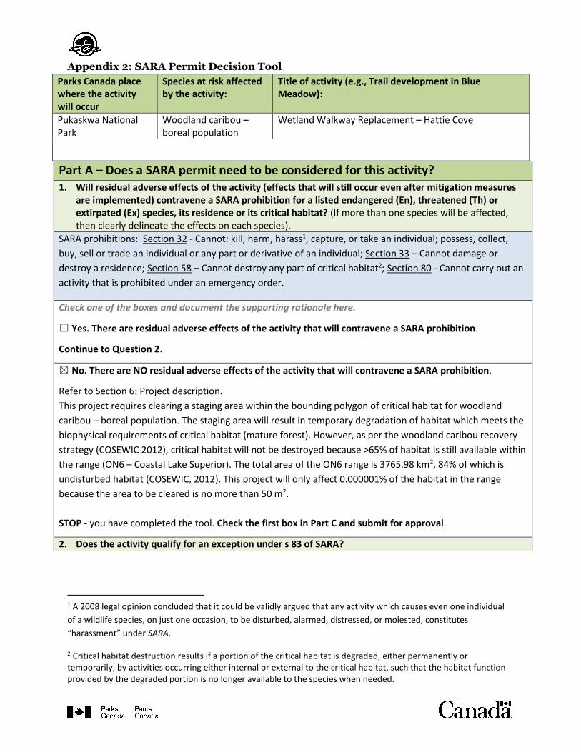
Appendix 2: SARA Permit Decision Tool
Parks Canada place where the activity will occur
Species at risk affected by the activity:
Title of activity (e.g., Trail development in Blue Meadow):
Pukaskwa National Park
Woodland caribou – boreal population
Wetland Walkway Replacement – Hattie Cove
Part A – Does a SARA permit need to be considered for this activity? 1. Will residual adverse effects of the activity (effects that will still occur even after mitigation measures
are implemented) contravene a SARA prohibition for a listed endangered (En), threatened (Th) or extirpated (Ex) species, its residence or its critical habitat? (If more than one species will be affected, then clearly delineate the effects on each species).
SARA prohibitions: Section 32 - Cannot: kill, harm, harass1, capture, or take an individual; possess, collect,
buy, sell or trade an individual or any part or derivative of an individual; Section 33 – Cannot damage or
destroy a residence; Section 58 – Cannot destroy any part of critical habitat2; Section 80 - Cannot carry out an
activity that is prohibited under an emergency order.
Check one of the boxes and document the supporting rationale here.
☐ Yes. There are residual adverse effects of the activity that will contravene a SARA prohibition.
Continue to Question 2.
☒ No. There are NO residual adverse effects of the activity that will contravene a SARA prohibition.
Refer to Section 6: Project description.
This project requires clearing a staging area within the bounding polygon of critical habitat for woodland
caribou – boreal population. The staging area will result in temporary degradation of habitat which meets the
biophysical requirements of critical habitat (mature forest). However, as per the woodland caribou recovery
strategy (COSEWIC 2012), critical habitat will not be destroyed because >65% of habitat is still available within
the range (ON6 – Coastal Lake Superior). The total area of the ON6 range is 3765.98 km2, 84% of which is
undisturbed habitat (COSEWIC, 2012). This project will only affect 0.000001% of the habitat in the range
because the area to be cleared is no more than 50 m2.
STOP - you have completed the tool. Check the first box in Part C and submit for approval.
2. Does the activity qualify for an exception under s 83 of SARA?
1 A 2008 legal opinion concluded that it could be validly argued that any activity which causes even one individual
of a wildlife species, on just one occasion, to be disturbed, alarmed, distressed, or molested, constitutes
“harassment” under SARA.
2 Critical habitat destruction results if a portion of the critical habitat is degraded, either permanently or temporarily, by activities occurring either internal or external to the critical habitat, such that the habitat function provided by the degraded portion is no longer available to the species when needed.
☐ Yes. A SARA permit is NOT required, as the activity is permitted in a published recovery strategy or
action plan and authorized under an Act of Parliament.
OR
☐ Yes. A SARA permit is NOT required, as the activity is required for public safety, health or national
security AND is authorized by or under another Act of Parliament.
STOP - If ALL activities that would contravene a SARA prohibition qualify for an exception under SARA s 83,
check the first box in Part C and submit for approval (Part F).
☐ No. A SARA permit is required. Continue to Part B.
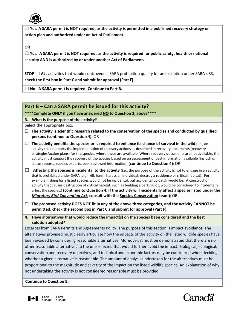
Part B – Can a SARA permit be issued for this activity? ****Complete ONLY if you have answered NO to Question 2, above****
3. What is the purpose of the activity?
Select the appropriate box:
☐ The activity is scientific research related to the conservation of the species and conducted by qualified persons (continue to Question 4); OR
☐ The activity benefits the species or is required to enhance its chance of survival in the wild (i.e., an
activity that supports the implementation of recovery actions as described in recovery documents (recovery strategies/action plans) for the species, where these are available. Where recovery documents are not available, the activity must support the recovery of the species based on an assessment of best information available (including
status reports, species experts, peer-reviewed information) (continue to Question 4); OR
☐ Affecting the species is incidental to the activity (i.e., the purpose of the activity is not to engage in an activity
that is prohibited under SARA (e.g., kill, harm, harass an individual; destroy a residence or critical habitat). For example, fishing for a listed species would not be incidental, but accidental by-catch would be. A construction activity that causes destruction of critical habitat, such as building a parking lot, would be considered to incidentally
affect the species.) (continue to Question 4; If the activity will incidentally affect a species listed under the Migratory Bird Convention Act, consult with the Species Conservation team); OR
☐ The proposed activity DOES NOT fit in any of the above three categories, and the activity CANNOT be permitted; check the second box in Part C and submit for approval (Part F).
4. Have alternatives that would reduce the impact(s) on the species been considered and the best solution adopted?
Excerpts from SARA Permits and Agreements Policy: The purpose of this section is impact avoidance. The
alternatives provided must clearly articulate how the impacts of the activity on the listed wildlife species have
been avoided by considering reasonable alternatives. Moreover, it must be demonstrated that there are no
other reasonable alternatives to the one selected that would further avoid the impact. Biological, ecological,
conservation and recovery objectives, and technical and economic factors may be considered when deciding
whether a given alternative is reasonable. The amount of analysis undertaken for the alternatives must be
proportional to the magnitude and severity of the impact on the listed wildlife species. An explanation of why
not undertaking the activity is not considered reasonable must be provided.
Continue to Question 5.
5. Have all feasible measures been taken to minimize the impact of the activity?
Excerpts from SARA Permits and Agreements Policy: After having determined that impacts on the listed
wildlife species have been avoided to the extent reasonably possible, the applicant must apply all feasible
mitigation measures to minimize the impacts that could not otherwise be avoided despite having selected the
best alternative. Demonstrate that the needs of the species were fully considered during the design of the
activity and for identifying all feasible measures to minimize the impact of the activity. Consideration must be
given to identifying and adopting best practices for the species. Biological, ecological, technical and economic
factors may be considered when considering what measures are feasible.
Continue to Question 6.
6. Will the activity jeopardize the survival or recovery of the species?
Excerpts from SARA Permits and Agreements Policy: An activity will jeopardize the survival or recovery of the
species if it increases threats to the extent that the species is not able to, or may not be able to, survive or
recover. As the degree of uncertainty increases about whether an activity would affect a species to such an
extent that it may not be able to survive or recover, the likelihood decreases that a permit can be issued.
Where data is sufficient to support the completion of quantitative analyses, such as population viability, this
should be done. However, in some cases, such analyses will not be possible and a precautionary approach will
guide the assessment of jeopardy based on the best available information and the weight of available
evidence.
☐ Yes. The activity will jeopardize the survival or recovery of the species and cannot be permitted.
Check the second box in Part C and submit for approval (Part F).
☐ No. The activity will not jeopardize survival or recovery of the species and can be permitted.
☐ Yes. The activity will jeopardize survival or recovery of the species, but an offset will be implemented to ensure survival or recovery of the species is not jeopardized. Append the completed offsetting plan from the Guideline for the Use of Biodiversity Offsets as Part of Species at Risk Act Permits in Parks Canada Places to this decision tool for final approval (Part F).
Check the third box in Part C and submit for approval (Part F).
Part C – SARA Permit Decision
Select the appropriate answer from the options below. Note: if this section addresses multiple species and
the answer varies among species, specify to which species each answer pertains.
☒ This activity does not require a SARA permit, as was documented in the answers to Questions 1 and 2.
Continue to approval of the decision tool (Part F).

☐ This activity requires a SARA permit but one cannot be issued because it does not fit into one of the three
required categories (see response to Question 3), OR it does not meet one of the SARA pre-conditions
(see responses to Questions 4-6). Continue to approval of the decision tool (Part F).
☐ This activity requires a SARA permit and one can be issued (see response to Questions 3-6). Continue to
issuing the permit (Part D).
Part D – Issuing the Permit Select the appropriate section of SARA being used, issue the permit, and continue to Part E.
☐ SARA s 74: This activity is already being permitted under another Act of Parliament (e.g., a research,
collection or restricted activity permit is already being issued for this activity) and therefore that permit
can be made SARA-compliant. Issue the permit for the activity and, below, specify the relevant section(s)
of the other Act of Parliament being used to issue the permit (examples provided).
Either include language in the permit already being issued under another Act of Parliament to indicate
that the permit is also being issued pursuant to s 74 of the Species at Risk Act, or use the SARA Permit
Template to attach a SARA s 74 permit to the other permit being issued.
The terms and conditions of the permit being issued under the other Act or Parliament should refer to or
include any measures required to ensure compliancy with meeting SARA s 73 pre-conditions (e.g.,
mitigations outlined in question 5 of this tool). The permit issued under the other Act of Parliament is the
enforceable permit.
Examples of other Acts of Parliament used by the Parks Canada Agency to permit activities include:
National Parks General Regulations: o Section 7(5): The superintendent may issue a permit authorizing a person to engage in an activity or
use, or enter and travel in an area that is restricted or prohibited…. o Section 11: The superintendent is authorized to issue a permit authorizing the taking of flora or natural
objects for scientific purposes from a park, or for the removal and use of natural objectives for construction purposes within a park….
o Section 12: The superintendent may issue a permit authorizing a person to remove, deface, damage or destroy any flora or natural objects in a park for the purposes of park management….
National Historic Parks General Regulations: o Section 4: A superintendent may issue a permit authorizing a person to remove, damage or destroy
flora, fauna or natural objects in a park for management of the park or scientific purposes
National Historic Parks Wildlife and Domestic Animals General Regulations: o Section 5: The superintendent may issue a permit authorizing the taking or killing of wildlife within a
park for scientific purposes…; and the relocation or destruction of wildlife when considered necessary for park management purposes.
Historic Canal Regulations o Section 14(2): The superintendent may, on receipt of an application, issue a permit authorizing the
applicant to dredge, fill, or dredge and fill in a historic canal.
☐ SARA s 73: This activity is NOT being permitted under another Act of Parliament. Issue the permit using
the SARA Permit Template.
The terms and conditions of the permit should refer to or include any measures required to ensure
compliancy with meeting SARA s 73 pre-conditions (e.g., mitigations outlined in question 5 of this tool).
Part E - Preparing the Explanation of the Permit 7. Provide an explanation of the permit for posting on the SAR Public Registry and continue to Part F.
SARA requires an explanation of any SARA permit issued to be posted on the SARA Public Registry in both
official languages (the Species Conservation team recommends that this be completed within 30 days of the
permit being issued). Prepare the explanation, using the information you entered in the previous sections of
this tool. The Species Conservation team will review the explanation, have it translated and publish it on the
SAR Public Registry.
Regional or Local Number:
Start Date of Permit: End Date of Permit:
Issuing Authority:
Authority Used: SARA s 73
Location of Activity (province, territory or ocean):
Affected Species:
Purpose:
Description of the Activity:
Pre-Conditions:

PART F - TRANSMITTAL FORM
Delete, modify or add rows as required
Tool Completed By Name & Title Date Completed
Specific Comments
Resource Conservation
Courtney Irvine, Resource Management Officer II/ Impact Assessment Officer
19 November 2019
Functional Teams Consulted:
Name & Title Date of Review
Specific Comments
National Office Teams
PAEC (Species Conservation)
Joanne Tuckwell 15 January 2020
Choose an item. (Specify Branch/Team)
Click here to enter a date.
Field Unit Teams
Choose an item. Click here to enter a date.
Choose an item. Click here to enter a date.
Other
☐ Legal Services Click here to enter a date.
☐ Other (specify): Click here to enter a date.
Approved By (FUS, Director of Waterway)
Name & Title Date Approved
Signature
Pamela Jalak, A/ Field Unit Superintendent, Northern Ontario Field Unit
February 7, 2020
Original signed by Pamela Jalak
Appendix 3: Rules and Regulations of Pukaskwa National Park
Rules and regulations
Rules and regulations are in place to protect the ecological and commemorative integrity of
Pukaskwa National Park, as well as ensure the enjoyment of all visitors. It is the responsibility of
visitors to be aware and comply with rules and regulations. Failure to do so may result in fines,
permit cancellations and/or evictions from the park.
While visiting the park, it is prohibited to:
• Collect or disturb plants, animals, rocks, shells or artifacts
• Feed, harass or harm wildlife
• Fish without a valid Ontario fishing license, use or possess lead fishing sinkers or jigs, or
use live fish for bait
• Bring firewood into the park
• Consume alcohol outside of your campsite and at any other location in the park
• Consume cannabis at the Anishinaabe camp and fire circle areas or outside of your
campsite while in the campground
• Drive or park in non-designated areas
• Use recreational vehicles (for example, ATVs, jet skis, over-snow vehicles)
• Use motorized vessels in Hattie Cove beyond the Visitor Centre or in Halfway Lake
• Store boats along Hattie Cove shoreline or other shorelines along the Lake Superior
coast within the park
• Moor overnight in Hattie Cove unless for safe harbour purposes
• Use a drone for filming/recreational purposes without proper permits
• Film and/or take photographs for commercial purposes
• Use, sell, or purchase fireworks, or any other type of explosive
• Allow a pet off-leash, leave a pet unattended on a campsite, or not clean up pet waste
While visiting the frontcountry areas, it is prohibited to:
• Have more than two shelters (tents) and six people per campsite
• Register for a campsite under the age of 18 and to leave any persons under the age of 18
unsupervised at said campsite
• Stay at the same campsite longer than 13 nights, 14 days
• Leave food, garbage or wildlife attractants out when you are away from your campsite
(for any length of time)
• Dump grey water anywhere in the campground except for the comfort station dish sinks
• Create excessive noise at any time of the day and during quiet hours – 11:00 p.m. to 7:00
a.m.
• Start a fire outside of metal fire boxes provided
• Leave a campfire unattended
• Create a fire during restricted fire periods/bans
• Use material from live or dead trees and plants (bark, twigs, or any type of green wood)
for fires
• Go off-trail or fail to use established hiking/walking trails and roadways
• Bicycle on hiking trails or anywhere except roadways
• Use park facilities, like potable water or dumping stations, when not registered to a
campsite
• Remove driftwood from or create/leave
• driftwood structures
• on beaches
While visiting the backcountry, it is prohibited to:
• Not register for overnight excursions
• Have more than 8 people per campsite
• Leave any garbage or gear at campsites or along the trail/water route
• Cache food or gear long-term in food lockers
• Start a fire outside of the provided metal fire box or in locations not previously used for
fires
• Use material from live trees and plants (bark, twigs, or any type of green wood) for fires
• Create a fire during restricted fire periods and/or bans
• Camp outside of designated campsite (except in the case of an emergency)
• Access Otter Island beyond the lighthouse and light keeper dwellings
• Disturb or remove archaeological artifacts or cultural features (i.e. Pukaskwa pits)

Appendix 4: DFO Letter of Advice