battlefield circulation control: hasty route...
TRANSCRIPT

SUBCOURSE EDITION MP1028 C
BATTLEFIELD CIRCULATION CONTROL: HASTY ROUTE RECONNAISSANCE
BATTLEFIELD CIRCULATION CONTROL:
HASTY ROUTE RECONNAISSANCE
EDITION C
United States Army Military Police School
Fort Leonard Wood, MO 65473-8929
4 Credit Hours
Edition Dates March 1993
SUBCOURSE OVERVIEW We designed this subcourse to teach you the procedures involved in the planning, conduct, and supervision of a hasty route reconnaissance. You will also learn about the highway traffic system in support of combat operations and the role of the military police in it. There are no prerequisites for this subcourse. This subcourse reflects the doctrine which was current at the time it was prepared. In your own work situation, always refer to the latest official publications. Unless otherwise stated, the masculine gender of singular pronouns is used to refer to both men and women. TERMINAL LEARNING OBJECTIVE ACTION: You will identify the procedures for planning, reporting,
monitoring, conducting and supervising a hasty route reconnaissance.
CONDITION: You will have access to this subcourse. STANDARD: To demonstrate competency of this task, you must achieve a
minimum of 70 percent on the subcourse examination. i MP1028

TABLE OF CONTENTS Section Page Subcourse Overview ................................................... i Lesson 1: Conduct and Supervise a Hasty Route Reconnaissance ........ 1-1 Part A: Major Elements in a Highway Control System ............. 1-1 Part B: Conduct and Supervise a Hasty Route Reconnaissance ...... 1-19 Part C: Develop a Hasty Route Reconnaissance Overlay ........... 1-43 Practice Exercise ...................................... 1-59 Answer Key and Feedback ................................ 1-62 Lesson 2: Plan Monitor and Report the Results of a Hasty Route Reconnaissance ............................................ 2-1 Practice Exercise ...................................... 2-9 Answer Key and Feedback ................................ 2-10 Appendix: Publication Extract ....................................... A-1 FM 19-4 Military Police Battlefield Circulation Control, Area Security,
and Enemy Prisoner of War Operation, TBP Use the above publication extracts to take this subcourse. At the time we wrote this subcourse, these were current publications. In your own work situation, always refer to the latest publications. MP1028 ii

THIS PAGE INTENTIONALLY LEFT BLANK iii MP1028

LESSON 1
CONDUCT AND SUPERVISE A HASTY ROUTE RECONNAISSANCE
Critical Task: 191-377-4206
OVERVIEW LESSON DESCRIPTION: In this lesson you will learn the organization, function, and procedures used in a highway control system. TERMINAL LEARNING OBJECTIVES: ACTION: Evaluate a highway control system. CONDITION: You will be given this subcourse; Appendix A, FM 19-4, and a
route reconnaissance overlay. STANDARD: Demonstrate your competency in the task by correctly answering
70 percent of the examination questions. REFERENCES: The material contained in this lesson was derived from the
following publications: STP 19-95B 2-4, FM 5-36, FM 19-4, FM 55-1, FM 55-2, FM 55-10, FM 34-1 and FM 101-5-1.
INTRODUCTION One of the most important tasks you will have to do in combat is to conduct and supervise a hasty route reconnaissance. The information you gather and provide may be critical to winning the battle. In order to understand how important this is, you need to know about the total battlefield circulation control system. Then you will understand how and where you fit into the system.
PART A - MAJOR ELEMENTS IN A HIGHWAY CONTROL SYSTEM 1. Battlefield Circulation Control (BCC). a. General. Battlefield circulation control (BCC) is a major military police combat mission. BCC is those steps taken to expedite and control the movement of personnel and vehicles in the area of operations. Think of the worst traffic jam you have ever seen or heard of and imagine what would happen if 1-1 MP1028
you had "grid lock" on the modern, highly mobile battlefield. The enemy would gain a very substantial advantage. Military police play a critical part in keeping that from happening. b. BBC responsibility and authority. Highway movements are a logistics function under the general staff supervision of the Assistant Chief of Staff (ACOS), G4 or his equivalent. Special staff responsibility is held by the transportation staff officer. Although the transportation corps has primary responsibility, many other branches are involved. For example, the military police provide battlefield circulation control services and the engineers are responsible for road and bridge maintenance and construction. 2. Highway Traffic Division (HTD). a. General. (1) At corps and higher levels, there are transportation units that contain an element primarily concerned with highway traffic. Movement management in the division is performed by the division transportation officer (DTO) and the division support command (DISCOM) movement control officer (MCO). Figure 1-1 illustrates the COSCOM transportation organization. (2) The purpose of the HTD is to form a centralized "nerve center." The HTD regulates the highway networks by planning, routing, scheduling and directing road movements. The commander's priorities and the situation will determine how much regulation is required. The HTD is a part of the movement control center (MCC)(Figure 1-1). A transportation officer operates the HTD. (3) The HTD coordinates all highway movement within the corps. The HTD regulates the highway net by planning, routing, scheduling, and directing road movements based on the corps commander's priorities. Subordinate highway regulating point teams (HRPTs) in the field carry out the traffic regulation plan in coordination with the HTD and appropriate host nation civil police and military authorities. (4) A highway plans officer is the chief of the HTD, and movement control, highway traffic engineer, and military police personnel are assigned. Engineer command (ENCOM), MP liaison, and representatives of other services are made available when required to coordinate matters of interest to their respective offices. (5) In the communication zone (COMMZ), highway regulation is normally restricted to main supply routes (MSRs) and to certain essential alternate routes. Any unit or activity requiring use of these routes and designated controlled routes (subject to traffic or movement restrictions), must obtain clearance from the HTD. MP1028 1-2

FIGURE 1-1. TRANSPORTATION MOVEMENT CONTROL CENTER, COSCOM. b. HTD Functions. Now that you have some idea of the make-up of the HTD, you need to understand what it does. The functions of the HTD may vary, depending on the amount of movement expected and the capacity of the road net. It will normally perform most of the following functions and may be given others as well:
Formulates and maintains the highway regulation plan and the traffic circulation plan.
Acts as a clearing house for highway status information.
Implements established priorities for highway routing.
Processes route clearance requests.
Establishes procedures for reporting road conditions, highway construction, damage, etc.
Establishes main supply routes (MSRs) and alternates.
1-3 MP1028
Issues traffic circulation overlays.
Maintains a situation map of the road net to reflect data on such things as obstructions, detours, defiles, capacities, enemy activity, and road conditions.
Consolidates/issues movement credits.
Modifies routings, schedules, and priorities as required by the situation.
Coordinates with the host nation for the use of highways.
Coordinates movements and exchanges information with adjacent HTD.
c. Division Transportation Officer. The division transportation officer performs the same functions (as well as others) as does the MCC at corps. He is a division special staff officer. (See Figure 1-2.) Do not confuse him with the division movements control officer (MCO) at the division support command. The division transportation officer is concerned with overall transportation functions in the division. These include preparing transportation plans and providing technical advice to the commander and staff. The MCO is responsible for the allocation of division transportation assets, and for obtaining additional transportation support. d. Transportation Officer. A transportation officer will be in charge of the HTD. His responsibilities include the following:
Supervising the HTD.
Preparation of the traffic circulation plan.
Scheduling of movements, to include consolidating them, if possible.
Routing of movements over the highway network.
The transportation officer in charge of the HTD plans for highway regulation. The provost marshal implements the plan by providing circulation control. The various commanders have the responsibility for complying with the plans and regulations within their organizations. MP1028 1-4

FIGURE 1-2. DIVISION STAFF ORGANIZATION. 3. BCC Plans. One of the most critical tasks to be accomplished is planning. The HTD and the PM, as well as other staff officers, have a critical role to play in such planning. a. Types of Plans. There are three major types of plans that are used to assist in BCC. These plans, when properly coordinated and distributed, allow all affected units to understand what is going on. The three plans are:
Highway Regulation Plan.
Traffic Circulation Plan. 1-5 MP1028

Traffic Control Plan. In addition to these three plans, there are traffic regulations that must be followed. These regulations are somewhat similar to those that are used in peacetime, except that they are usually found in standard operating procedures (SOPs). b. Coordination of Plans. Probably the most critical step in every plan is that of coordination. Proper staff coordination serves three major purposes. First, it allows specialists in areas other than the action officer to ensure that this special knowledge is used in the plan. For example, a transportation officer needs the special knowledge of the MP in traffic control. The engineer provides information concerning road maintenance and construction. Secondly, staff coordination makes sure that the plan does not conflict with other things that may be going on. Thirdly, it is a way of making sure that all the affected agencies know about the plan. Exactly who the plan, or regulation, is coordinated with will depend on the unit involved, the mission, and the situation. In any case, it is always better to coordinate a plan with too many agencies than to miss one or two that are critical to it. Failure to properly coordinate a plan or regulation fully and properly can result in disaster. The plan might conflict with other operations, or some key agencies may not "get the word." Some of the more important, but certainly not all, of the agencies which might be included, and why, are discussed in the next paragraphs: (1) ACOS, G3 (or equivalent operations officer). The G3 has overall staff responsibility for operations in the organization. It is the central point where all that is going on comes together. His office knows what the combat plans are and can therefore determine if the regulations/plans will support or conflict with those operations. (2) Provost Marshal. A major mission of the military police is BCC. The military police enforce traffic regulations and implement much of the plans. Additionally, military police patrols and posts, because their duties require them to be on the roads constantly, are a major source of information. They also provide an emergency communications link. (3) Engineer. The engineers are responsible for road and bridge maintenance. They also determine bridge and road classifications. Since the engineer also has many other responsibilities in the division area, he must balance his commitments, or perhaps request additional engineer assistance from elsewhere. Coordination allows him to determine his priorities and what engineer support is required. (4) Corps MCC. The corps MCC is responsible for highway traffic movements in the corps area. How the division plans to use the road net in its area has an impact on how the corps will use its net, and vice versa. MP1028 1-6
Both plans must mesh completely to avoid major confusion. The corps MCC also ensures the plan/regulation does not conflict with the adjacent divisions' plans. (5) Host Nation Representatives. Plans and regulations must be closely coordinated with host nation representatives, since civilian traffic may also be using the road. Additionally, the host nation may be able to provide support to the engineer and/or to the military police. Also, they would normally have the most detailed knowledge of the road network. c. Highway Regulation Plan. A highway regulation plan must be prepared before traffic regulating activities begin. This is primarily the responsibility of the transportation officer. The plan concerns the capabilities of the existing road net to handle the traffic that must move over it. It is started well in advance of actual operations. The plan is developed based on the size of the command, the road network, and the logistical situation. The mission, composition, and disposition of tactical units also effect the plan. The plan must be fully coordinated with other staff agencies, and among all levels of commands involved. In a division, for example, it would be coordinated with the division staff, host nation representatives, the brigades and division support command, and with corps. The key word in describing this plan is "capabilities." d. Traffic Circulation Plan. The traffic circulation plan is also prepared and maintained by the transportation officer. It is normally in the form of an overlay showing how the road not is to be used and maintained. The key word here is "used." The plan provides highway regulation information to highway users. Normally, it will include:
Route designators.
The most restrictive route features.
Direction of movement.
Location of boundaries, highway regulating points, traffic control posts, and location of principal units and facilities.
Major geographic features and light lines (if applicable).
Key MP traffic control measures.
An example of a traffic circulation plan is shown in Figure 1-3. 1-7 MP1028
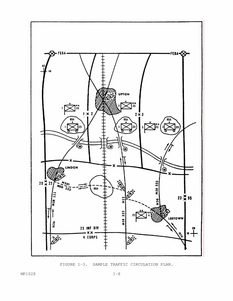
FIGURE 1-3. SAMPLE TRAFFIC CIRCULATION PLAN. MP1028 1-8

e. Traffic Control Plan. The company operations section prepares the traffic control plan. Normally, it is in map overlay form. It shows the control measures to be enforced on the road network. It is similar to the traffic circulation plan, but deals with the measures that will be taken to control traffic circulation. The key word here is "control." It would identify TCP locations, patrol areas, temporary signs, and other MP control measures. Figure 1-4 depicts a sample traffic control plan. It may also show alternate routes and where new control functions will be needed if the MSR is blocked.
FIGURE 1-4. SAMPLE TRAFFIC CONTROL PLAN. The traffic control plan is provided to the HTD/DTO for inclusion in the traffic circulation plan. The MP operations section keeps the plan current and provides changes to the HTD. 1-9 MP1028
In summary, and to keep the three types of plans correctly in mind, it is helpful for you to remember the key word associated with each plan. Highway regulation plan=capabilities. Traffic circulation plan=use. Traffic control plan=control. 4. Movement Credits. a. In addition to plans and regulations, there are other administrative methods used to gain the best use of the road network. One of the most important is movement credits. It allows the HTD to regulate traffic volume over selected routes. The system is so important that it has been standardized among the members of NATO. This is done through a series of standardization agreements (STANAGS), which will be referred to throughout this subcourse. b. Each column moving over certain portions of the road network must request a movement credit. The HTD issues movement credits for supervised, dispatch, and, when needed, reserved routes. Based on the commander's priorities and the situation, movement credits may also be required for certain other movements. When this is the case, it will be directed in local SOPs, orders, or regulations. Movement credits may be issued for one vehicle or a column of vehicles. c. A movement credit carries a movement number, or an identification serial number. This number is used to identify the column during its entire movement. It is often referred to informally as "the convoy number." The number is placed, often in chalk or some similar manner, where it can clearly be seen on the sides and, if possible, on the front of all vehicles in the convoy. Each element of the number provides certain information. These numbers, and their meaning, have been standardized in NATO through STANAG 1059 and STANAG 2154. An example of such a number might be:
25-USV-08. d. The first two figures, in this case 25, show the day of the month on which the movement is to begin. Next are three or more letters that show the authority that organized the move. The first two letters are the symbol for the country involved, in this case the United States. (See Figure 1-5.) These letters may be followed by an identification code of the command that organized the move. In this case, it is the U.S. Fifth Corps. The last two numbers show the number of the movement, in this case the 8th. e. There are several reasons for using such a numbering system. It allows the column to move along selected routes without having to stop at every regulating point and TCP to identify itself and provide authority for its move. Additionally, it allows the regulating point or TCP to more easily report the convoy's passage to the HTD. Should an MP patrol see a column MP1028 1-10
moving on the 24th rather than the 25th with the number given in the example, they would immediately know something was wrong and could take steps to correct the problem. f. A movement credit is the authority for a column, or single vehicle, to move over designated routes. It shows the times when the first and last vehicles of the column are scheduled to pass the entry and exit points on the route. Movement credits are obtained by units through the HTD. How this is accomplished will be covered under the heading REQUEST FOR CONVOY CLEARANCE.
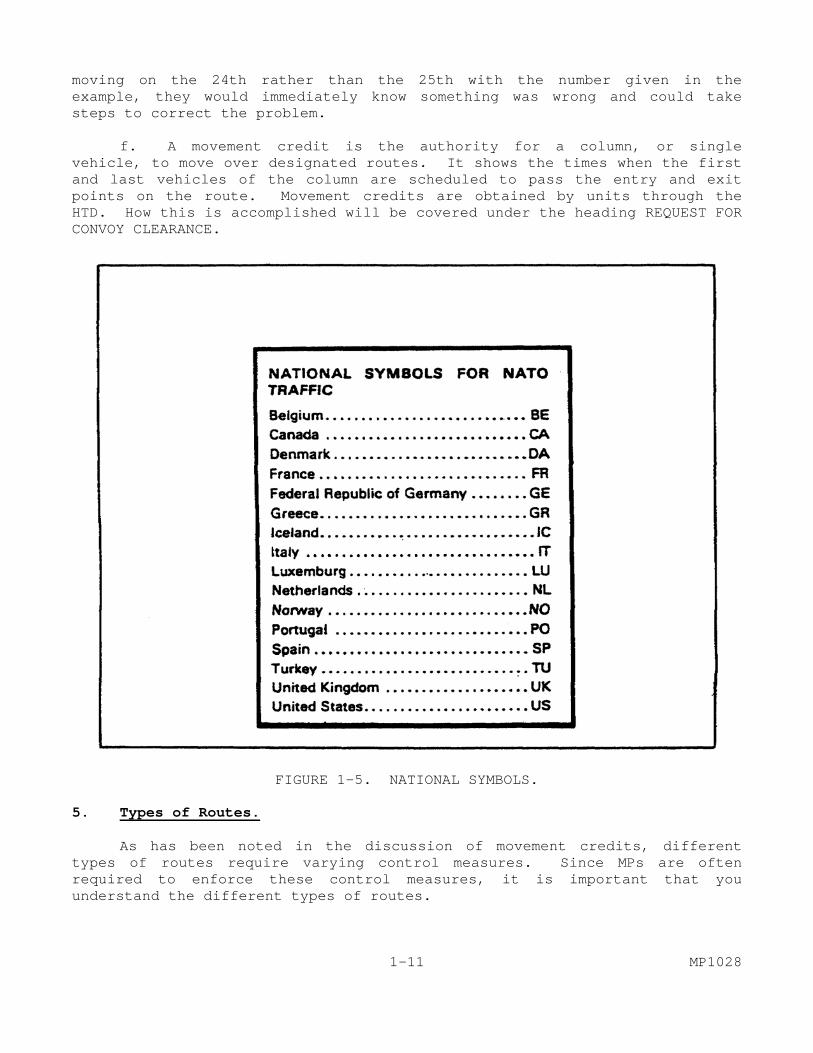
FIGURE 1-5. NATIONAL SYMBOLS. 5. Types of Routes. As has been noted in the discussion of movement credits, different types of routes require varying control measures. Since MPs are often required to enforce these control measures, it is important that you understand the different types of routes. 1-11 MP1028
There are five types of route classifications: open, supervised, dispatch, reserved, and prohibited. Route classification is used to place the minimum amount of control on the road net that will facilitate movement. Each of the five categories indicates a degree of restriction. These definitions have been standardized among NATO members (STANAG 2151). a. Open Route. An "open" route has the least control exercised on it. It is used when the volume of traffic is light to moderate, and/or there is a highly developed all-weather road system. On an open route, a movement credit is not required. Traffic control points will only be provided at the most critical points. Standard traffic regulations will be enforced. b. Supervised Route. A "supervised" route is designated when there are some limitations on the road net, and/or the volume of traffic warrants it. The HTD will exercise a limited amount of control. There will be an increase in the number of TCPs. Access to the route may be regulated. A movement credit will be required for columns of ten or more vehicles. c. Dispatch Route. A "dispatch" route is used when there is a high volume of traffic, a limited road net, and/or a large number of obstructions on the roads. It will be fully controlled by the HTD. Movement credits will be required for all vehicles. Such credits will be granted based on a priority system. Both organizational and area control will be required. d. Reserved Route. The commander, through the HTD, may set aside a specific route. This is called a "reserved" route. It may be set aside for the sole use of a certain unit, for a specific operation, or a specific type of traffic (for example, ammunition resupply). How much control is exercised over the route will depend on the reason for it being designated a reserved route. The degree of control will be determined by the PM or the unit commander if that route is reserved for a unit. e. Prohibited Route. The final type of route classification is prohibited. It is exactly as its name implies. The route is closed to all traffic. There are many reasons for closing a route. For example, parts of it may be impassable or it may have been mined or subjected to NBC attack. 6. Highway Regulating Points. In order to exercise control over these various types of routes, and to provide information, the appropriate transportation unit may establish highway MP1028 1-12
regulating points. They will be manned by highway regulating point teams (HRPT) from the theater army movements control agency (TAMCA) or the corps MCC. They are placed at critical points along the MSR to carry out the traffic regulation plan and to report road and convoy status. HRPTs monitor and report the progress of convoys and relay instructions from the HTD to convoy commanders. They may also be required to perform traffic control functions when MP is not available. When the host nation regulates the highways, they are used to provide liaison. 7. Traffic Control Points (TCP). BCC by the MP is accomplished through the use of mobile patrols, traffic control posts, and temporary road signs. TCP are set up at critical points along the MSR to control the movement of vehicles and personnel. They prevent delays and congestion and ensure that movement priorities are kept. TCP enforce rules and regulations. Often they make adjustments for unscheduled road movements and make minor rerouting if necessary. They also serve as an information post and provide a communication link. They may be required to perform transportation highway regulation duties when HRPTs are not available. In order to effectively perform many of these duties, they must understand the priority system. 8. Highway Traffic Priorities. All highway movements are based on the commander's announced priorities. There are certain principles that almost always apply. Unless the HTD has stated otherwise, these principles should be followed. In general, traffic moving forward has priority over traffic moving to the rear. Forward moving, loaded vehicles have priority over vehicles moving in any direction. In more specific terms:
Emergency movement of combat forces will receive the highest priority. These are tactical, combat-ready forces. An example might be a tank company moving to reinforce an infantry battalion that is under attack.
The next highest priority is the emergency supply of combat forces. Such supplies will normally be ammunition, fuel or rations. Although ammunition usually has precedence, other priorities may be given, based on the commander's decision.
The forward movement of emergency medical supplies receives the next priority.
The highest rearward moving priority is the emergency evacuation of casualties.
Finally, any movement required for the immediate support of combat operations that does not fall into one of the above categories is given priority.
1-13 MP1028

FIGURE 1-6. DD FORM 1265. MP1028 1-14
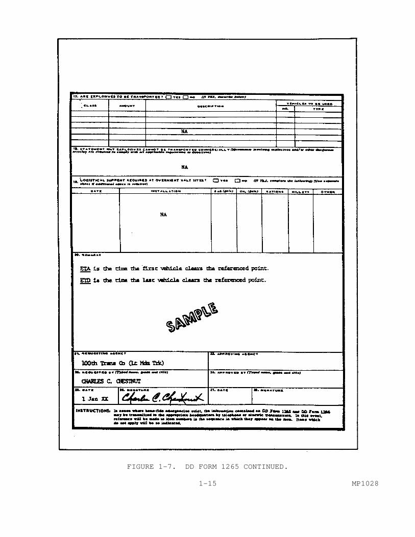
FIGURE 1-7. DD FORM 1265 CONTINUED. 1-15 MP1028
9. Request for Convoy Clearance. a. When moving over selected routes and under certain locally prescribed conditions, it is necessary to obtain a movement credit or "convoy clearance." The unit making the move prepares DD Form 1265 (Request for Convoy Clearance) shown in Figures 1-6 and 1-7. b. The form is submitted through channels to the HTD within whose area the movement will originate. The form itself serves two purposes. It is a request and then becomes the authorization. The HTD uses it to grant clearance and to issue instructions about the movement. The unit that is conducting the move initiates the form. When the HTD approves the request, they issue a movement credit and movement number, plus any additional instructions that may be required. Although normally submitted in writing, in emergencies the information may be transmitted electrically or orally. If the HTD is unable to grant the clearances at the time requested, it will contact the requesting unit to arrange a different time and/or route. 10. Types of Convoy Control. Control of motor movements can be done in two ways. First, it may be done by the unit making the movement. Second, it may be accomplished by the commander through whose area the convoy is moving. It usually is a combination of both. a. Unit Control. This kind of control is always exercised during motor movements. The unit commander whose vehicles are using the road makes sure that his supervisors and drivers obey:
Rules of the road.
Traffic laws and regulations.
Speed limits.
Time and distance gaps in the convoy.
Routing plans.
Schedules.
March discipline. b. Area Control. Convoy commanders will want to learn all they can about control policies in areas through which they will pass. This is an essential part of convoy planning. Area control is planned by the HTD for the area. It is MP1028 1-16
supervised by the military police for traffic control. Area control may be carried out by use of:
Highway regulating points.
Traffic control posts.
Mobile patrols.
Road maintenance patrols. c. Convoy Support Requirements. One of the reasons for establishing an HTD is to ease coordination of convoy movements. The convoy commander is responsible for effecting this coordination. What type of support, and how much, as with most things in a combat environment, will depend on several factors. These would include the type of unit making the move. The kinds of cargo the convoy may be carrying may be important. The priority of the movement must also be considered. Many of these requirements will be covered by unit SOP, including ammunition resupply and messing. These often require internal unit coordination. As with most procedures, when in doubt, it is better to coordinate than miss an element. Some of the elements and the type of support they might provide a convoy commander are discussed below. d. Military/Civil Police. Police agencies are responsible for providing traffic control along the route. Close coordination and cooperation can expedite the movement of the convoy and keep it on schedule. In certain cases, the police may provide an escort for a convoy. This would depend on the convoy's priority, cargo, and the availability of police to conduct the escort. e. Medical. Many units do not have organic medical personnel. Medical support may be attached to the convoy for the movement. Another type of medical support is the use of aid stations along the route. These are established by the area commander. Should neither of these be available, the convoy commander should know where and how to request aid enroute. f. Maintenance. Most units making a convoy move have their own maintenance element. However, the convoy commander should ensure that backup maintenance elements are available. In some situations, the area commander may provide roving maintenance patrols to assist. g. Combat Elements. 1-17 MP1028

If the convoy is moving through an area of high threat, combat units may secure critical points along the route to protect the convoy. This may include the provision of air cover or support. Even when such direct support is not provided, the convoy commander should know how to obtain such support in an emergency. h. Halts. Rest stops must be designated along the way. These must be located so that the convoy does not interfere with other highway movements. Additionally, there may be a requirement for the convoy to remain overnight due to the length of the move. These locations should be selected ahead of time. For reasons both of security and to preclude interference with other highway movements, it is ideal for these locations to be with friendly units along the route. This must be well coordinated ahead of time. i. NBC Decontamination. Provisions must be made ahead of time with support units for the decontamination of both personnel and equipment when operating in an NBC environment. Decontamination of a large, or even medium, sized convoy is a major operation. Where such support is located, and how it can be obtained, must be determined ahead of time. 11. Traffic Scheduling Principles. Any convoy movement, and many individual moves, will be subjected to scheduling. In scheduling highway movements, certain principles are followed. The purpose of these principles is to move the maximum amount of highway traffic as quickly as possible with the minimum amount of confusion, while staying within the commander's priorities. General principles that are followed are discussed below. a. Intra-area Movements. Intra-area movements begin and end in the same area. They are accomplished by the HTD for that area. b. Inter-area Movements. Inter-area movements begin in one area and end in another. Inter-area movements are coordinated between all the HTD involved. The HTD in the area where the movement starts grants the movement credit and assigns the movement number. c. General Rules.
A round-trip that is finished in 24 hours or less is treated as one movement. If the round-trip takes more than 24 hours, it is treated as two different movements.
MP1028 1-18
A movement in one direction, no matter how long it takes, is treated as a single movement. It keeps the same movement number.
When a column is so large that it must be broken into march units, the march units are identified by adding a letter at the end of the movement number. For example, convoy 03-TUV-01 may become 03-TUV-01A and 03-TUV-01B.
Approved schedules and movement numbers are provided the HRPT and the provost marshal so that highway regulation and traffic control can be provided.
PART B - CONDUCT AND SUPERVISE A HASTY ROUTE RECONNAISSANCE
1. Types of Reconnaissance. a. General. There are many types of reconnaissance missions. Some of them are combat operations, such as recon by fire or recon in force. MP often may be required to conduct area and route reconnaissance missions, although they may be required to conduct others on occasion, as well. Area reconnaissance missions are used during combat operations. The most common MP reconnaissance mission is route reconnaissance. b. Area Reconnaissance. This type of reconnaissance obtains specific and detailed information within a clearly defined area. The area may be reconnoitered for enemy activity or to determine an area's suitability for a specific purpose. For example, an area might be checked for use as an assembly area or defensive position. Because it is very detailed, this type of reconnaissance is very time consuming. c. Route Reconnaissance. This subcourse will concentrate on this type of reconnaissance. It is probably the most common of the reconnaissance operations that the MP are asked to perform. Route reconnaissance obtains information about enemy activity, obstacles, route conditions, and critical terrain features along a specific route. 2. Types of Route Reconnaissance. There are two types of route recons, hasty and deliberate. When time and conditions permit, the engineers are tasked to conduct deliberate route recons. Both MP and engineers may be tasked to conduct a hasty route reconnaissance. Due to the differences in skills between the Engr. and MP, there is a slight difference in emphasis on the data they collect; although the basic information that is collected is similar. Engineers may be tasked to gather some more technical data. The emphasis for military police is on 1-19 MP1028
traffic circulation and control. How a hasty reconnaissance is conducted remains essentially the same. a. Deliberate Route Reconnaissance. (1) This type of reconnaissance is made when enough time and qualified engineer personnel are available. It provides the necessary data for a thorough analysis and classification of significant features along a route. Deliberate route reconnaissance is detailed. The reports of a deliberate route reconnaissance differ from hasty in the degree of completeness of the reported information. An overlay is used to point out the exact location of each reconnoitered feature. Enclosures are attached to the overlay. (2) Several different DA report forms are used to provide data and a permanent record. They ensure that a great deal of required data is included. The difference between the two types of reconnaissance can be illustrated by the following example: (3) In a hasty route reconnaissance report concerning a bridge, only the minimum essential data is collected. Much of that data is collected from signs on the bridge. When the engineers conduct a deliberate reconnaissance of a bridge, they take detailed measurements. They examine the structural integrity of the bridge. Information concerning each span, the approaches, bridge surfaces and subsurfaces is gathered. From the data gathered, engineers can then recalculate things like the load classification. b. Hasty Route Reconnaissance. (1) This type of reconnaissance is conducted to determine the immediate military trafficability of a specified route. Such information is vital to all units engaged in planning and executing vehicular movement. It is limited to critical terrain data that is necessary for route classification. Full appreciation of a route's capability cannot be determined until after each factor is analyzed in greater detail. The hasty route provides the information necessary for immediate reconnaissance action until a deliberate reconnaissance can be done. It also verifies information that may be available from earlier reconnaissance operations. The report of a hasty route reconnaissance usually consists of a map overlay supplemented by sketches. This task will deal with these items. (2) As an MP NCO, you may be directed to conduct such a hasty route reconnaissance. The information you gather as a result will be used to make decisions that could affect the outcome of the battle. If you were to provide incomplete or inaccurate data, the commander may make a decision to use a route that is not capable of handling the traffic. As a result, critical reinforcements or supplies may not make it to the combat forces where and when they are needed. MP1028 1-20

3. Route Reconnaissance Methods. a. General. There are four methods of route reconnaissance. These are map, air, ground, and air-ground. Which method is used will depend on mission urgency, enemy activity, weather conditions, and availability of resources. There are advantages and disadvantages to each method. The method used will usually be specified in the mission order. b. Map Reconnaissance. A map recon is made by studying the most current maps and overlays of the route available. It is the easiest recon to perform, but is also the least reliable. Such a recon is only as good as the map used. For this reason a map recon is usually only the first step in preparing for the mission. It is always better to actually observe the route. c. Ground Reconnaissance. A ground recon is conducted by actually driving over the route. Its major disadvantage is that it is the most time-consuming method. Another disadvantage is that it is the in which there is the greatest chance of contact with the enemy. Its major advantage is that it provides the most detailed information about the route. It can also be conducted in all but the most severe weather conditions. Ground recon is the most common method employed by MP. d. Air Reconnaissance. When rapid coverage of a long route is desired, the best method may be to conduct the recon by air. Using aircraft, mainly helicopters, the patrol can fly over a large section of the route very quickly. It may also be used over a short route if time does not permit a ground reconnaissance. There are several disadvantages to this method. Bad weather may keep aircraft from flying. It also requires particularly acute map reading and observation skills on the part of patrol members. The number of personnel may be limited by the type of aircraft available. As noted in the preceding paragraph, helicopters are the aircraft of choice for this type of reconnaissance. This is because of their ability to maneuver and hover. They also are often able to land at or near a particular feature to allow the reconnaissance party to more closely examine that feature. Great care must be exercised to provide security when this is done. e. Air-Ground Reconnaissance. An air-ground recon combines the advantages of the two methods. It also eliminates some of the disadvantages of each. The ground element can take a detailed look at the route while the air element looks at the terrain adjacent to the route. An air-ground recon is especially useful when the 1-21 MP1028
enemy is active in the area. The air element helps locate the enemy and provide warning and support to the ground element. 4. Mission Planning. Whichever method is employed, the key to success in a recon mission is planning and preparation. Most of the problems that may be met when conducting the recon can be eliminated through careful planning. Prior planning prevents poor performance. The first step in planning is to analyze the mission order. a. Mission Analysis. The mission order should follow the format of a field order. If any part of it is not provided or understood, the patrol leader should seek that information from the person issuing the order. (1) Situation. Examine the information given on friendly and enemy forces. If there are friendly units already using the route, or located near it, they can be a source of valuable information. They may also be able to come to your assistance should your patrol come under attack. Information about the enemy is also important. It will determine the maneuver techniques you will use to conduct the patrol. Such information may also cause you to select different weapons or additional ammunition. (2) Mission. This paragraph will contain a clear, concise statement of the task or tasks to be accomplished. It is based on the order from the next higher headquarters. This part of the order will tell who is to do it; what you are to do; when to do it; where to do it; and why you are doing it. (3) Execution. This part of the order will provide you with information on how to proceed. It is here also that you will be told what method will be used to conduct the patrol. Special tasks may also be assigned. Each team will be told what task it is to perform and how the team will do it. If there are special intelligence requirements, they will be included in this part of the order. The rules of engagement for the patrol will be specified. Additionally, the order will tell you what actions to take if the patrol has contact with the enemy. Information concerning fire support will be provided. Coordinating instructions and task priorities will be listed. (4) Service Support. In this section you will be told what support is available. Often it may only state that the current SOP is in effect. There may, however, for example be restrictions on the type of ammunition available. You will also be told what medical support may be available and how to obtain it. (5) Command and Signal. This is the section that will tell you if the current communications-electronic operating instructions (CEOI) is in effect, or if special frequencies and call signs have been set aside for this mission. It will also tell you where, when, and what kind of reports are to MP1028 1-22
be made. Normally the report will be DA Form 1248 and an overlay with enclosures. You will also be told what special control measures are in effect. These might include phase lines, checkpoints, artillery concentrations, and others. b. Gather Information. Once you have examined the order and are sure you understand it, the next step is to gather as much information as possible about the operational environment. Some may have already been provided to you with the mission order. How much you can obtain will be limited by the time available. For the best results, you should coordinate with the local engineers. The engineers may be able to provide current maps and overlays. They also may know the latest route conditions, or have the results of earlier recons. Additional information may be available from the HTD/DTO. An excellent source of information is host nation police and/or other units in the area, to include civilians. More information gathered ahead of time allows for more efficient planning and saves time as the patrol is conducted. Some of the areas to be considered are discussed in the following paragraphs. (1) Enemy Forces. Enemy influence along a route may vary greatly. A route is always vulnerable to attack by air, missiles, and/or artillery. Correlating intelligence reports with overlays and maps can identify possible enemy contact areas. Since your patrol will be small, and often operating at a considerable distance from friendly forces, the threat of attack is always present. This is true no matter how far you may be from the forward edge of the battle area (FEBA). In rear areas you will have to consider the threat of guerrillas and/or infiltrators. The threat of infiltrators includes SPETZNAZ or interdiction by long range reconnaissance patrols. You and your patrol must always be prepared to meet such threats. (2) Terrain. The effects of terrain on traffic flow are extremely important. The effect of terrain on observation is a factor that must be considered. High ground, which will afford line-of-sight observation and good fields of fire, is of particular importance. Areas of cover and concealment must be examined from both a friendly and enemy standpoint. The effects of obstacles will be critical, not only on the road itself, but adjacent to it, due to the effect on rerouting and maneuver. Obstacles may be natural or manmade. They include areas of nuclear, biological, and chemical (NBC) contamination. Key terrain is any locality that affords a marked advantage to either side. It should be located ahead of time. (3) Weather. You should collect climatic data ahead of time. As will be seen later in this subcourse, weather can have a very restrictive effect on traffic flow. What may be a usable ford in the dry season could become an impossible barrier in the wet season, or during a period of heavy rain. The likelihood of severe weather will affect your evaluation of road surfaces and their trafficability. (4) Civil Population. The attitudes, actions, and capabilities of the civil population can significantly affect your mission and your evaluation 1-23 MP1028
of the route. A friendly populace can provide a great deal of data that is only otherwise attainable with great difficulty. This is particularly true of seasonal weather data. They may also know of alternate routes that may not be depicted on maps. A hostile population makes your task more difficult. They may provide assistance to enemy forces, sometimes in very indirect ways. For example, they may alter or destroy the bridge data signs from which you gain a great deal of your information. They may provide other misleading information and find various ways to harass you. Regardless of the civil attitude, care must be taken in using the data obtained from civilian sources. You must also be alert to the flow of refugees. Refugees can greatly impede traffic flow. They also provide excellent cover for the infiltration of enemy agents and soldiers. They can have an adverse effect on the conduct of your patrol as well. The patrol leader should examine the route on the most current map available. Overlays from previous recons should also be examined. In essence, a map recon is conducted. First plot the route on the map. You should then start at the same point each time and examine the map for one category of information at a time. For example, the first time you might look for all the critical points. Then start over and look for information about road surfaces. Once all the information has been collected, it must be assembled. The patrol leader should not examine the maps alone, but should have other patrol members look at the map as well. Another step is to gather all the intelligence reports about enemy activity along the route. Knowledge of the enemy situation allows the patrol leader to anticipate where and what kind of contact might be expected. It also allows him to determine which areas of the route may need closer examination as possible sites of future problems, such as ambushes. Knowledge of the enemy situation also makes the PIR more understandable, so that the patrol can key on essential information. c. Planning. (1) Team Selection. Based on your analysis of the order and the information gathered, you may now complete your plan. A key element is the selection of personnel. Those selected should be familiar with recon methods and techniques. When possible, a person conversant in the local language may be helpful. Consideration should also be given to having a host nation police officer accompany the patrol. If not already stated in the order, you will determine the number of teams that will be required. Normally, one to three mobile teams are used. There are three elements to a recon patrol. They are control, recon, and security. You may have to combine the recon and control element, depending on the number of teams/personnel available. For example, in a one team patrol, the team leader provides control, maintains communications, and records data. The second member concentrates on operating the vehicle. The third member provides security. In a two team patrol, the lead team is usually the recon element. The trail team provides the security. When there are three teams, MP1028 1-24
each is assigned one of the three functions. Once the teams have been selected, make sure that they have the proper equipment. (2) Equipment. The members of the patrol will carry their standard combat load as prescribed in unit SOP. For a recon, other additional items are needed. These will vary based on your analysis of the mission. The following items are almost always required:
Lensatic compass to help plot key terrain features.
Tape measures to determine distances such as road widths, vertical clearances, and curve radii.
Sketch pads to draw diagrams of critical points and other selected features.
Colored pencils/crayons to indicate terrain features. These should be the standard colors listed in FM 21-30.
Overlay materials.
NBC monitoring equipment may be required.
Checklist of the information needed. (See Figure 1-8.)
FM 19-4, Appendix A.
Field glasses, when available.
When available, Field Manuals such as 21-30, 21-31, and 101-5-1 can prove to be of great value.
This is a sampling of some of the more common items that you will need in addition to the normal combat equipment. Your mission analysis may indicate other items that may be needed as well. For example, you may want to modify the basic load of ammunition and the types of weapons to be carried. You must also be prepared to improvise when some of these items are not available. Figure 1-8 is a sample checklist. (3) Tactics. The final step in the process is to determine the appropriate tactics to be used for security. The tactics used will depend mainly on what type of contact with the enemy can be expected. When enemy contact is possible, the patrol uses traveling overwatch (Figure 1-9). When enemy contact is expected, bounding overwatch is used (Figure 1-10). 1-25 MP1028
FIGURE 1-8. TEAM LEADER'S CHECKLIST. MP1028 1-26
FIGURE 1-9. TRAVELING OVERWATCH. 1-27 MP1028
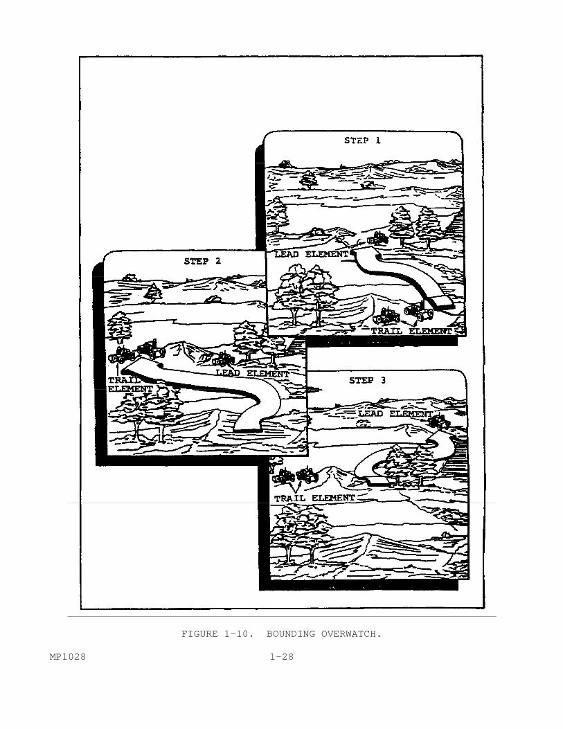
FIGURE 1-10. BOUNDING OVERWATCH. MP1028 1-28
Whatever techniques are used, it must always be remembered that the primary mission of the recon patrol is to gather information; it is not to engage the enemy. The techniques used are those which provide for the patrol's security. (4) Selection of Tactics. (a) Traveling Overwatch. This method is used when contact with the enemy is possible, but not expected. It allows the patrol to move quickly, but with caution. Traveling overwatch gives the patrol time and distance to react if the lead element unexpectedly takes enemy fire. The patrol moves in a column formation. The lead element moves continuously. The trail elements, and vehicles in between, maintain an interval of from 100 to 400 meters from the lead and each other. The distance will depend on the terrain. Visual contact between elements should be maintained. The lead element sets the pace. The lead element should always be prepared to return fire immediately. The last element should be prepared to maneuver to support the lead and to place suppressive fire. (b) Bounding Overwatch. This is the most cautious and deliberate of movement techniques. The overwatch element takes a position where they can observe and provide a field of fire. When possible, the position should offer cover and concealment. The overwatch element covers the forward movement of the bounding element to its new position. When the bounding element reaches and secures its new position, the roles are exchanged. The bounding element then becomes the overwatch element. The length of each bound depends on the terrain, visibility, and the range of the weapons being used. All overwatch elements have basically the same tasks.
Support the bounding element with direct fire.
Maneuver in support of the bounding element.
Call for indirect fire.
Use covered and concealed positions. Overwatch elements should be controlled by one person. He must be able to communicate directly with the bounding element. These communications may be visual. The overwatch element must cover the flanks and rear, as well as the front, of the bounding element. Each element must be assigned specific tasks. For example, each individual is given a specific sector to observe. Now that you have completed the planning, it is time to organize and prepare your team. (5) Organize/Prepare. 1-29 MP1028

Each team member must be assigned specific tasks. On patrols that last a long time, or because of weather conditions, it may be desirable for team members to switch duties periodically. When and how such switches are to happen should be clearly arranged before the patrol departs. Even when such rotation is not appropriate, it is wise for you to designate alternate duties for all team members. If you should then encounter a situation that requires such a change, it is more easily made. Once duty positions have been assigned, the weapons and equipment each patrol member is responsible for becomes apparent. In those cases where doubt may exist, or where there might be duplication of effort, the patrol leader should designate a responsible individual. Weapons and equipment should be gathered at a designated place well before time for departure. After the weapons and equipment have been gathered, the patrol leader must inspect all personnel and equipment thoroughly. Once the patrol departs, it will be too late to discover that an item is missing or doesn't work. It should include ensuring that the appropriate amount of POL has been obtained. The same is true of ammunition and rations. The test firing of weapons will be dictated by the local SOP. (6) Briefing. You must brief the patrol immediately prior to departure so that they each understand their responsibilities. They should also understand how they fit into the larger picture. As with any mission, the patrol leader follows the normal troop leading sequence in briefing patrol members.
(a) Situation. You should pass on to the patrol the information about friendly and enemy forces that you have gained in analyzing the mission. Information concerning the general area of operations should also be conveyed.
(b) Mission. Here you state what your patrol is to do. It is a clear, concise statement of what is to be done; who is to do it; when it is to be done; where it is to be done; and why it is to be done. This is when you tell the patrol the route to be reconnoitered. For example, "tomorrow from 0600 to 1900, the 3d Squad will conduct a hasty route reconnaissance of MSR 34 from MA222033 to MA283053. The route is going to be used to support a movement of the 3d Brigade."
(c) Execution. You must tell the patrol the type of tactics that you expect to use in certain areas or under given circumstances. There may be times when special techniques are required. For example, when moving through a town where there is a possibility of snipers, the patrol uses bounding overwatch. The patrol should not stop in open areas or exposed locations. Specific individuals are tasked to watch windows and rooftops. The more that can be made clear during the briefing, the less confusion there will be when the patrol is being conducted. Ideally, the patrol should function like a championship NFL football team during its two minute drill. You should make sure that each member of the team understands the rules of engagement. Whenever possible, you should establish with the team members what actions are MP1028 1-30

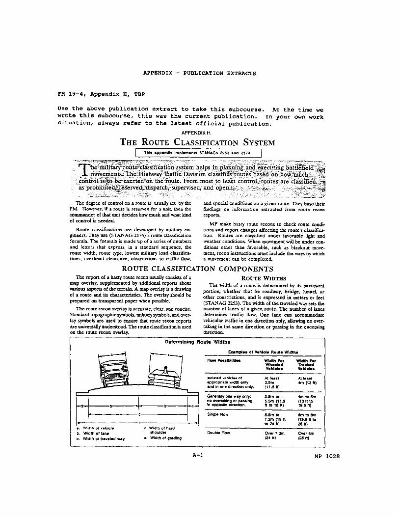
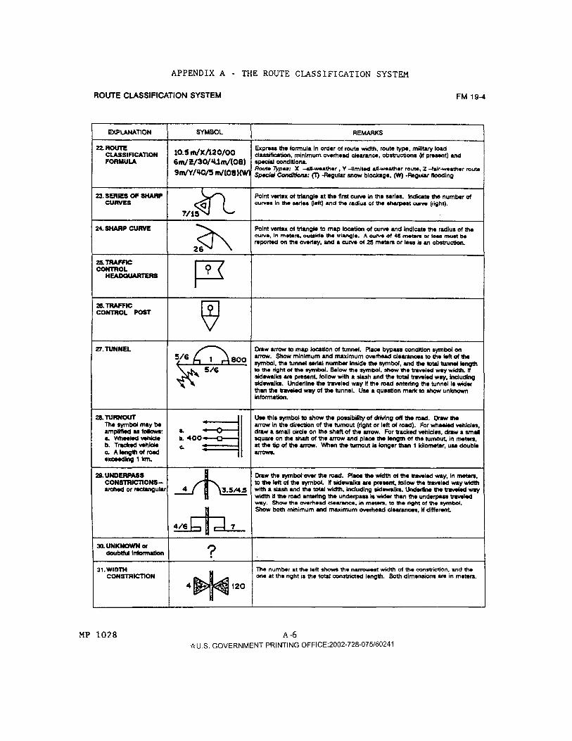
to be taken upon engagement and disengagement. You should also discuss what reinforcement will be done within the patrol. Information concerning fire support and reinforcement from elsewhere should be made clear. (d) Service Support. You must brief the patrol on what weapons and ammunition are available, and where it is located within the patrol. If additional service support is to be made available from outside the patrol, you should tell the team members what it is and when/how it is to be obtained. (e) Command and Signal. Even though the chain of command within the patrol appears obvious, all members should be reminded what it is. You should tell the patrol members where you will be located and where the next in line will be. Patrol members should also be told by you what reports are to be prepared. You must also specify any control measures that may be in effect. The radio frequencies and call signs to be used, to include radio silence if appropriate, should be announced by you. You must also remind everyone of the need for operations security (OpSec) throughout the mission. 5. Conduct a Hasty Route Reconnaissance. a. General. Having analyzed, planned, and organized the mission, you are now ready to lead it. As the patrol leader, you are responsible for conducting it. It is your job to ensure that all of the required information is obtained. Route Classification. One of the primary, if not the primary, reasons that you have been sent on a recon mission is to obtain the route classification. Route classification is concerned with the trafficability of the entire route. It is expressed by a route classification formula that has been standardized in a specific sequence (STANAG 2174). The route classification formula describes a specific route in a sort of shorthand. It will be recorded on the recon overlay. The formula is made up of a series of numbers and letters in a prescribed order. They express, in order, the route width, route type, lowest military load classification, overhead clearance, obstructions, and special conditions. The route classification formula is contained in FM 19-4, Appendix A. Unless specified otherwise, it is established for favorable conditions of light and weather. b. Route Width. The width of the route, including bridges, tunnels, underpasses, and other constrictions, is the narrowest part of the traveled way. It is expressed in meters or feet (STANAG 2253). Route widths are illustrated in Figure 1-11. The width of the traveled way determines the number of lanes. The number of lanes determines the traffic flow. In other words, it determines if a route is one-way or two-way for wheeled or tracked traffic. A width obstruction for single flow, wheeled traffic exists when the traveled way is less than 5.5 meters. For tracked vehicles, it exists when the traveled way 1-31 MP1028
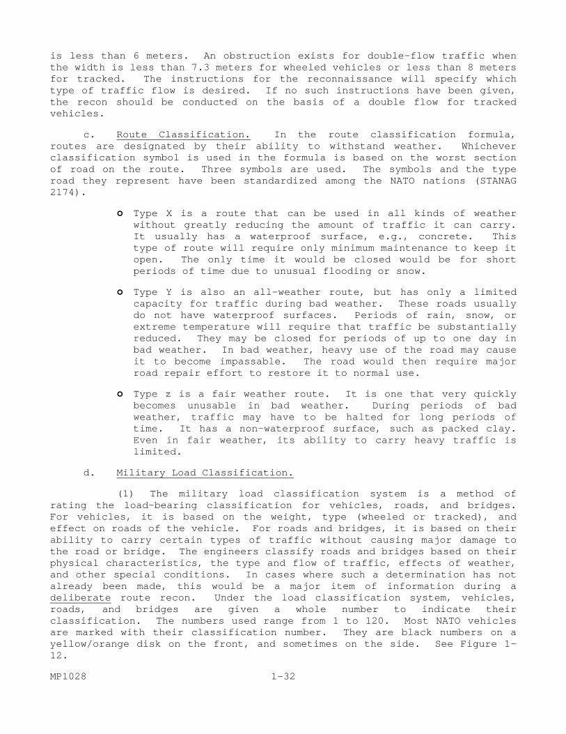
is less than 6 meters. An obstruction exists for double-flow traffic when the width is less than 7.3 meters for wheeled vehicles or less than 8 meters for tracked. The instructions for the reconnaissance will specify which type of traffic flow is desired. If no such instructions have been given, the recon should be conducted on the basis of a double flow for tracked vehicles. c. Route Classification. In the route classification formula, routes are designated by their ability to withstand weather. Whichever classification symbol is used in the formula is based on the worst section of road on the route. Three symbols are used. The symbols and the type road they represent have been standardized among the NATO nations (STANAG 2174).
Type X is a route that can be used in all kinds of weather without greatly reducing the amount of traffic it can carry. It usually has a waterproof surface, e.g., concrete. This type of route will require only minimum maintenance to keep it open. The only time it would be closed would be for short periods of time due to unusual flooding or snow.
Type Y is also an all-weather route, but has only a limited capacity for traffic during bad weather. These roads usually do not have waterproof surfaces. Periods of rain, snow, or extreme temperature will require that traffic be substantially reduced. They may be closed for periods of up to one day in bad weather. In bad weather, heavy use of the road may cause it to become impassable. The road would then require major road repair effort to restore it to normal use.
Type z is a fair weather route. It is one that very quickly becomes unusable in bad weather. During periods of bad weather, traffic may have to be halted for long periods of time. It has a non-waterproof surface, such as packed clay. Even in fair weather, its ability to carry heavy traffic is limited.
d. Military Load Classification. (1) The military load classification system is a method of rating the load-bearing classification for vehicles, roads, and bridges. For vehicles, it is based on the weight, type (wheeled or tracked), and effect on roads of the vehicle. For roads and bridges, it is based on their ability to carry certain types of traffic without causing major damage to the road or bridge. The engineers classify roads and bridges based on their physical characteristics, the type and flow of traffic, effects of weather, and other special conditions. In cases where such a determination has not already been made, this would be a major item of information during a deliberate route recon. Under the load classification system, vehicles, roads, and bridges are given a whole number to indicate their classification. The numbers used range from 1 to 120. Most NATO vehicles are marked with their classification number. They are black numbers on a yellow/orange disk on the front, and sometimes on the side. See Figure 1-12. MP1028 1-32
FIGURE 1-11. ROUTE WIDTHS. (2) Classification numbers for both roads and bridges are usually located at the bridges. This is because the bridge is normally the weakest point on the road. Bridges (and rafts) have circular signs indicating the classification and other information. The circle, or disk, is yellow/orange with the information indicated in black. Figure 1-13 illustrates the most common symbols. More detailed descriptions are in FM 19-4 Appendix H (See Appendix A) and FM 5-36. (3) A full NATO bridge sign will be a large yellow rectangle, with black symbols. In the center will be a large circle divided into three parts. In the upper third of the circle will be a smaller circle. To the left (shaded) side of the circle is the two-way wheeled classification. On the right (unshaded) is the one-way wheeled classification. A small rectangle is centered in the middle third of the circle. This indicates the same information for tracked vehicles. In the bottom third of the symbol is the bridge serial number. The width of the traveled way of the bridge is placed below the large circle. To the left of the circle is the overhead clearance and to the right is the overall bridge length. This type of signing is normally only posted on major double-flow bridges. 1-33 MP1028
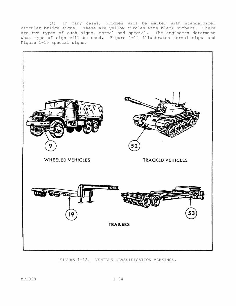
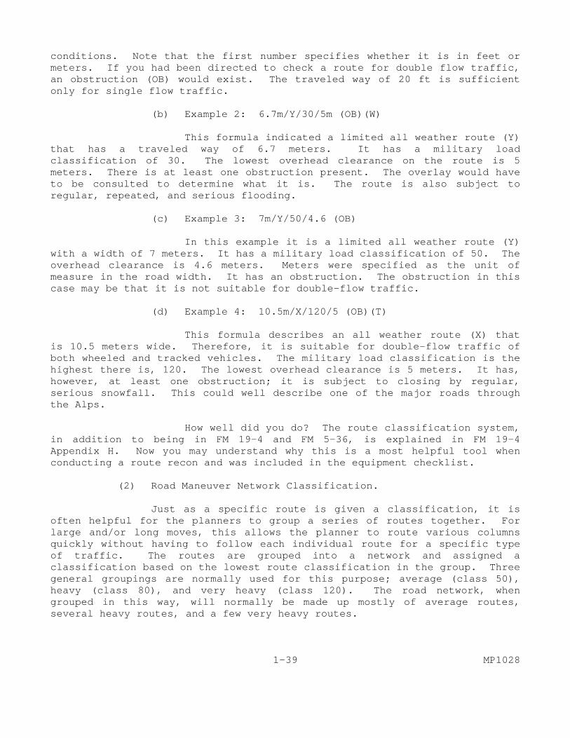
(4) In many cases, bridges will be marked with standardized circular bridge signs. These are yellow circles with black numbers. There are two types of such signs, normal and special. The engineers determine what type of sign will be used. Figure 1-14 illustrates normal signs and Figure 1-15 special signs.
FIGURE 1-12. VEHICLE CLASSIFICATION MARKINGS. MP1028 1-34
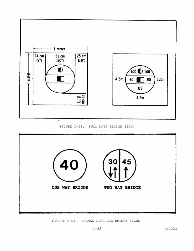
FIGURE 1-13. FULL NATO BRIDGE SIGN.
FIGURE 1-14. NORMAL CIRCULAR BRIDGE SIGNS. 1-35 MP1028

FIGURE 1-15. SPECIAL CIRCULAR BRIDGE SIGNS. (5) All bridges not having the full NATO sign should have one of the circular signs. Normal signs include those for one-way bridges and those for two-way bridges. One-way bridges will have the bridge classification in black numerals on the yellow circle. These are normally found on bridges less than class 50. A two-way bridge sign will be divided in half vertically. On the left half of the circle will be the two-way classification, and on the right the one-way. MP1028 1-36

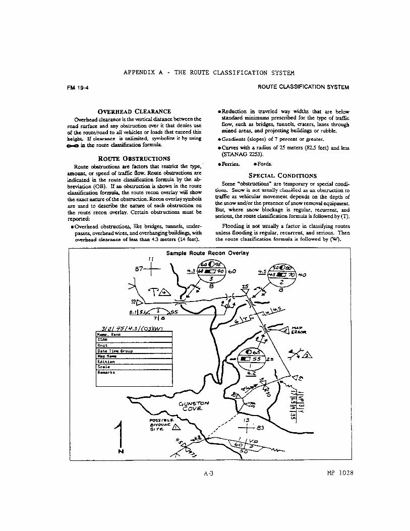
(6) In certain circumstances, the engineers may decide to use special signs. This is often the case in bridges over class 50, since those may be used by the larger tracked vehicles. In those cases, a separate classification is indicated for wheeled and tracked vehicles. For a one-way bridge, the circle will be divided horizontally. The upper half will tell you the wheeled classification and the lower the tracked. They normally contain a silhouette of a wheeled and tracked vehicle, respectively, to prevent confusion. In some cases, it may be desirable to show different classifications for wheeled and tracked vehicles on a two-way bridge. This is done by using two circles, one above the other. The top symbol provides the information for wheeled vehicles and the lower for tracked. (7) You have spent a great deal of time dealing with bridge symbols. This is because they are normally the weakest link in the route. Therefore, in the route classification formula, the lowest bridge classification number is entered. This is regardless of the vehicle type or condition of traffic flow. The smallest number provides the classification for the entire route. When there are no bridges on the route, the worst section of the road sets the route classification. (8) Classifying the route this way keeps it from being overloaded. When vehicles have a higher load classification than the route, the engineers conduct a special recon to determine if it can still be used. They might determine that a two-way route could be used at a higher classification if it was changed to one-way. They may also determine that a risk crossing is possible. (9) Posting of the bridge signs needed for proper control of traffic across a bridge is an engineer responsibility. Special signs are used when necessary to warn vehicles of unusual conditions. When necessary, holding areas, turnouts for parking and unloading, and checkpoints are installed near bridges. Traffic control measures are outlined in the traffic circulation plan and the traffic control plan of the area commander. e. Overhead Clearance. The next entry in the route classification formula indicates the overhead clearance. The overhead clearance is the distance between the road surface and any obstruction above it that restricts traffic flow. It is the clearance that you often see on bridges and overpasses. Vehicles over a certain height, cannot use the road. Some examples are overpasses, tunnels, overhead wires, overhanging buildings, and old city gates. If the clearance on the route is unlimited, the symbol is used. Overhead clearance is considered an obstruction if it is less than 4.3 meters (14 feet). Whatever the overhead clearance, it is noted. As with the other categories of information, the lowest clearance on the route is the one which is listed. f. Obstructions. If there are any obstructions on the route, they are indicated in the formula by the symbol "OB." Anything that restricts the type, amount, or speed of the traffic flow is considered an obstruction. The only exception is bridges. Bridges are considered only in the route classification. Recon symbols are used to show the nature of the obstruction 1-37 MP1028

on the route recon overlay. When the formula indicates an obstruction is present, it must be marked on the recon overlay. In some cases, it may be necessary to illustrate the obstruction with a sketch. Certain obstructions must always be reported. These are as follows:
Overhead obstructions with a clearance of less than 4.3 meters (14 feet). When a clearance is greater than 4.3 meters, it is not considered an obstruction. For example, if there were an overpass with a clearance of 5 meters, it would be listed in the formula, but not listed as an obstruction.
Places where the road width is below standard for the type of traffic flow. Road width dimensions will be discussed later. These types of constriction are usually found at tunnels, craters or rubble, or lanes through minefields.
Gradients (slopes) of 7 percent or more. In other words, steep hills.
Curves that have a radius of 25 meters (82.5 feet) or less. In simple terms, if you extend the curve around to make a circle, the radius of that circle must be more than 25 meters or it is considered a sharp curve and an obstruction.
Any ferry or ford.
g. Special Conditions. The effects of snow are not normally considered an obstruction to traffic flow in route classification. This is because of the variables such as snow depth and the availability of snow removal equipment that are involved. When snow blockage is regular, happens repeatedly, and is serious, it is noted by adding the symbol (T) at the end of the formula. An example of such a situation would be the Donner Pass. Floods are treated in the same manner as snow. They are noted only if they happen regularly and are serious. When that condition exists, it is indicated by adding the symbol (W) at the end of the formula. Such conditions might be anticipated along tidal rivers, for example. (1) Route Classification Formula Examples. A great deal about a route can be told from the route classification formula. It provides a summary of the route's limitations. Here are a few examples with explanations to assist you in putting the previous information together. It might be helpful to attempt to decipher them before reading the explanation. Then read the explanation and check yourself. (a) Example 1: 20ft/Z/40/oo This formula describes a fair weather route (Z). The minimum traveled way is 20 feet. It has a military load classification of 40. The overhead clearance is unlimited and it has no obstructions or special MP1028 1-38
conditions. Note that the first number specifies whether it is in feet or meters. If you had been directed to check a route for double flow traffic, an obstruction (OB) would exist. The traveled way of 20 ft is sufficient only for single flow traffic. (b) Example 2: 6.7m/Y/30/5m (OB)(W) This formula indicated a limited all weather route (Y) that has a traveled way of 6.7 meters. It has a military load classification of 30. The lowest overhead clearance on the route is 5 meters. There is at least one obstruction present. The overlay would have to be consulted to determine what it is. The route is also subject to regular, repeated, and serious flooding. (c) Example 3: 7m/Y/50/4.6 (OB) In this example it is a limited all weather route (Y) with a width of 7 meters. It has a military load classification of 50. The overhead clearance is 4.6 meters. Meters were specified as the unit of measure in the road width. It has an obstruction. The obstruction in this case may be that it is not suitable for double-flow traffic. (d) Example 4: 10.5m/X/120/5 (OB)(T) This formula describes an all weather route (X) that is 10.5 meters wide. Therefore, it is suitable for double-flow traffic of both wheeled and tracked vehicles. The military load classification is the highest there is, 120. The lowest overhead clearance is 5 meters. It has, however, at least one obstruction; it is subject to closing by regular, serious snowfall. This could well describe one of the major roads through the Alps. How well did you do? The route classification system, in addition to being in FM 19-4 and FM 5-36, is explained in FM 19-4 Appendix H. Now you may understand why this is a most helpful tool when conducting a route recon and was included in the equipment checklist. (2) Road Maneuver Network Classification. Just as a specific route is given a classification, it is often helpful for the planners to group a series of routes together. For large and/or long moves, this allows the planner to route various columns quickly without having to follow each individual route for a specific type of traffic. The routes are grouped into a network and assigned a classification based on the lowest route classification in the group. Three general groupings are normally used for this purpose; average (class 50), heavy (class 80), and very heavy (class 120). The road network, when grouped in this way, will normally be made up mostly of average routes, several heavy routes, and a few very heavy routes. 1-39 MP1028
(3) Road Classification. Another element of information you may be asked to gather is the road classification. This should not be confused with route classification. Route classification deals with the overall route while the road classification deals only with the road itself. It provides more detailed information than does the route classification. Road classification data is normally gathered in detail by the engineers. MP must be knowledgeable about it however. They may be provided this information at the outset of the recon mission. Just as the route classification is expressed as a formula, so too is the road classification. This standardized sequence consists of seven parts, as follows: (a) Prefix. The formula is prefixed by the letter "A" if there are no limiting characteristics. If there are limiting characteristics the letter "B" is used. (b) Limiting Characteristics. This is a series of specified small letters, each of which indicates a limiting characteristic.
They are as follows: c Curves with a radius of less than 25 meters. g Gradients of 7 percent or more. d Inadequate drainage. f Unstable foundation. s Rough surface condition. j Camber is excessive.
An unknown or undetermined characteristic is indicated by a question mark following the symbol to which it refers. For example, d? would indicate that there is some question about the adequacy of drainage. (c) Width. The width of the traveled way is listed, followed by a slash and the overall width of the road including the shoulders. For example, 14/16m would describe a road that has a traveled way of 14 meters and an overall width of 16 meters. (d) Road Surface Material. The road surface material is expressed by a small letter symbol as follows:
k Concrete. kb Bituminous/asphalt concrete. p Paving brick or stone. rb Bitumen-penetrated macadam, water bound macadam with
asphalt or tar covering. r Waterbound macadam, crushed rock or coral. l Gravel or lightly metaled surface.
MP1028 1-40

nb Bituminous surface treatment on natural earth, stabilized soil, sand-clay or other select material.
b Used when the type of bituminous construction cannot be determined.
n Natural earth, stabilized soil, sand-clay, shell cinders, disintegrated granite, or other select material.
v Various other type material not mentioned above. (e) Length. The length of the road, or portion to which the formula is being applied may be listed next. It may be omitted. When it is shown, it is placed in parentheses, e.g., (7.2 km). (f) Obstruction. This entry in the formula is identical with the obstruction entry in the route classification formula. (g) Special Conditions. Snow blockage and flooding are entered in the formula at this point, just as they are in the route classification formula. The symbols are the same, i.e., T for snow and W for possible flooding. (h) Road Classification Examples: A 5.4/6.2m k: This road has no limiting characteristics. The traveled way is 5.4 meters. The total width of the road is 6.2 meters. It has a concrete surface. Bcgs 14/16 ft 1 (2.4km)(OB): The road has limiting characteristics of sharp curves, steep grades, and a rough surface. It has a traveled way of 14 feet and a combined width of 26 feet. The surface is gravel or lightly metaled. The length of the road described is 2.4 kilometers and it has obstruction. 6. Record Tactical Intelligence Data. a. General. While you are gathering the information to determine the route and road classification, you must also gather other categories of information. A major category of information that must be obtained is information of a tactical intelligence nature. Certain items of information are of critical importance to the commander. What they are will vary constantly. When you were given the mission order for the patrol, you were told what these items were. They were termed the essential elements of information (EEI). For intelligence purposes, EEI are often broken into two categories. The most important of these is priority intelligence requirements (PIR). The second category is termed information requirements (IR). PIR are the items that must be given priority. It does not mean they are the only elements of information that should be collected. 1-41 MP1028
Whenever you observe something out of the ordinary, it should be reported. Although the item may not seem important to you, when placed with bits of information gathered elsewhere, it may be significant. Intelligence is very like putting together a picture puzzle. That piece of seemingly insignificant information may be the piece that completes the picture. Anything that poses a threat to the traffic flow must be noted. Put yourself in the enemy's position. If you wanted to interfere with the traffic flow, or stop it, what would you do? Some of the more common things to look for during a route recon are discussed below. Enemy influence along a route may vary from none, to nuisance, to stubborn defensive resistance. A route, regardless of its location, is always vulnerable to interdiction by enemy air, missile, and/or artillery attack. Likely target areas include bridges, road junctions, and defiles. b. Enemy Activity. Any enemy activity that you see should be reported. In many cases, it will require an intelligence spot report. What type of report is required will have been specified in your mission order. The information to be gathered is the same as that which you gather for an MP report--who, what, where, when, and how. The most important thing is to remember that yours is not a combat patrol. Unless otherwise specifically instructed, a route recon should avoid contact and engage the enemy only when necessary to defend itself. c. Ambush Sites. Even if not specifically mentioned, you must always look for places that present the enemy the opportunity to ambush vehicles. You should particularly note areas close to the road that provided cover and concealment. Such an area located where vehicles must naturally slow down, such as a hill, curve, or urban area, are particularly well suited as ambush sites. The ideal spot would be one that combined the preceding two with an area that could be easily blocked, such as a defile or bridge. Such a location is a critical point on the route and should be marked on the overlay as such. It is of such importance that it probably will require a sketch as well. d. Mine Activity. Even in rear area mines pose a major threat to the lines of communication (LOC). They are easily laid by saboteurs, sympathizers, or guerrillas. Great care should be exercised and all of your personnel should be reminded to keep a watch out for mines. Your patrol should also be alert for sites the enemy might choose to mine in the future. e. Areas of Cover/Concealment. Any area you observe that provides the enemy with cover or concealment should also be noted. These may or may not be good ambush sites. Areas of cover and concealment may also be areas in which the enemy can move undetected. Equally important, such sites may also provide protection and concealment for friendly vehicles using the road. f. NBC Contaminated Areas. Your mission order should have told you the likelihood of encountering contaminated areas. Based on that information, you should have determined what type NBC monitoring equipment the patrol should MP1028 1-42
carry. Even in areas where the likelihood of contaminated areas is low, you should always be alert for them. The types of intelligence information that you should gather and record are limited only by time. Every item has some value. When you are in doubt, record it. Particular attention must always be given the PIR. 7. Gather/Record Circulation Control Information. While you are gathering route information and intelligence data, you must also gather information for the provost marshal to use to plan BCC. Remember, you may well be the one that has to implement it. Some of the items you might be looking for are listed below:
Possible holding areas.
Location of TCP.
Alternate routes.
Defile operations.
Effect and location of obstacles that may require traffic control.
Points of potential congestion.
Location of existing facilities that might aid traffic control.
PART C -DEVELOP A HASTY ROUTE RECONNAISSANCE OVERLAY
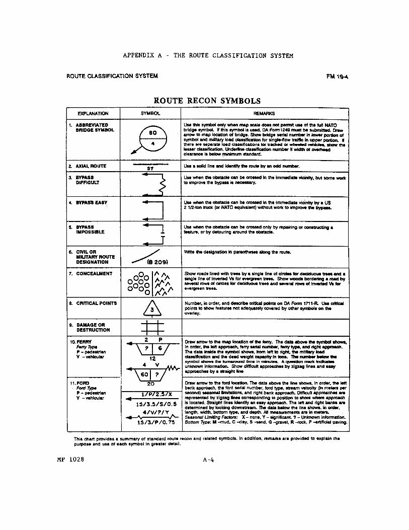
1. General. No matter how well you gather the information, it is of little use if it is not in a form to be used by others. Additionally, it is impossible for you to remember all the information. As you proceed on the patrol, you must keep an overlay. A map overlay (Figure 1-16) is a drawing of a route and its characteristics. The overlay should be prepared on transparent paper when possible. Although clear acetate is often used for overlays, markings on it can easily be rubbed off inadvertently. Markings on paper are less likely to be inadvertently damaged. The overlay must be accurate, clear, and concise. Standard operational terms and symbols (FM 101-5-1) are used to ensure that route reconnaissance reports are universally understood. 1-43 MP1028

FIGURE 1-16. SAMPLE ROUTE RECONNAISSANCE OVERLAY. MP1028 1-44
2. Identification Information. Certain information must always be included on the overlay. Without that information, the overlay is useless. Most of it can be placed on the overlay before the patrol begins. a. Grid References. There are two main reasons for including grid references on an overlay. First, it allows you to orient your overlay on the map the same way every time you use it. It does little good to plot the location of an ambush site if the map doesn't indicate where it really is. Second, when someone else needs to use your overlay, the grid reference allows them to place it on the map the same way that you did. A grid reference on the overlay is represented by a +. It is created by laying the overlay paper over the map. In diagonally opposite corners of the map, trace where two of the grid lines intersect. Both the vertical and horizontal inside arm should indicate the grid line. Magnetic north should also be entered. b. Title Block. In an available corner of the overlay, additional identifying information should be entered. You should enter your name, social security number, and organization. Should there be any questions about the overlay, or should additional information be required, this allows the user to identify who to ask. You will have done so well that you will take pride in your work anyway. The date that the overlay was made should also be noted. This allows others to know how current the information is. The final items of identification are the map reference and scale. These allow the user to be certain of the map being used for the overlay. c. Overlay Data. Now that you have completed the identification data, you must place the overlay over the map and trace the route that you will reconnoiter. The start and end points are indicated by a "V," with the point indicating the location. You also enter the total length of the route in kilometers. The last item of information that you will enter on the overlay is the route classification formula. This is because it cannot be determined until the recon is completed. d. Critical Points. A critical point is any part of the roadway that causes limits to its use. This would include road width, overhead clearance, or vehicle load 1-45 MP1028
class. It also includes any feature that interferes with the crossing of two or more streams of traffic. Critical points include every bridge, overpass, underpass, ferry, ford, road constriction, and sharp turn. Railroad crossings of any kind are critical points. Since these items already have symbols of their own, there is no need to indicate them with an additional special symbol on your overlay. As you conduct your recon, you may find areas that you know are important which do not have a specific map symbol. For example, an ambush site or an area where there has been a rock slide. In order to indicate these on the overlay, the symbol for a critical point is used. This is a number inside a triangle. From the triangle, you extend a line to indicate the specific location. In the legend area of the overlay, you explain what the critical point is. Key terrain is always considered a critical point. e. Curves. Curves with a radius of less than 25 meters are considered sharp curves and are indicated as obstructions (OB). If a curve measures between 25.1 and 45 meters, it must be noted on the overlay, just as a sharp curve is. It is not considered an obstruction. The wider curves are noted since they are sharp enough to cause some traffic to have to slow down. In other words, any curve with a radius of 45 meters (148 feet) or less is noted on the overlay. Curves are indicated on the overlay by a triangle. The point (vertex) of the triangle is located at the curve. The radius of the curve in meters is noted outside the triangle. When a series of curves occur in a short distance, you may indicate it by drawing a second triangle inside the first. The vertex of the triangle is placed on the first curve. Immediately outside the symbol, you indicate the number of curves and the radius of the sharpest one. For example, 3/24 would indicate 3 curves, the sharpest of which as a radius of 24 meters. (1) Formula Method. The formula for determining the radius of
a curve is . R is the radius of a curve. The straightline distance of the centerline of the curve from each outer extremity is represented by C. M is the perpendicular distance of the tape to the centerline of the road. See Figure 1-17. If c is 15 meters and M is 2 meters, the formula becomes:
The result would then be that R, the radius of the curve, is 15 meters. This is a sharp curve and must be indicated as in obstruction (OB). It has the advantage over the other methods in that it is relatively quick and MP1028 1-46

does not require patrol members to leave the roadway. It can be accomplished on any kind of terrain. (2) Tape Method. This method is particularly suited for measuring very sharp curves on relatively level ground. First, you establish points at each end of the curve, along the centerline. These are called the point of tangency (PT) and the point of curvature (PC). See Figure 1-18. One individual stands at the estimated center of the circle and holds one end of a pate measure. A second person walks the arc of the circle from PC to PT. They adjust the length of the tape so that it is the same distance from the center to PT as to PC. That distance is the radius of the curve. (3) Triangle Method. The approximate radius of a curve may be determined by laying out 3:4:5 ratio right triangles. This method may be used when obstructions preclude walking the curve, as is done in the tape method. As with the tape method, first determine PC and PT. Then lay out right triangles as illustrated in Figure 1-19. You then extend the base legs of each triangle until they cross. The distance from where they cross to either PC or PT is the approximate radius of the curve. f. Steep Grades. Grades of 7 percent or more are considered steep grades. For route reconnaissance purposes, they are considered an obstacle (OB). A 7 percent grade is one that rises at a ratio of 7 in 100. For example, if, after traveling 100 feet, the road is 7 feet higher than when you started, it is a 7 percent slope. Any slope of 7 percent or more must be noted on your overlay. There are four symbols on an overlay for steep slopes. All slopes are indicated by an arrow. The arrow points in an uphill direction. If the scale of the map permits, the arrow should be the length of the slope. To the right of the arrow you show the actual percent of slope. A slope of 5-7 percent has a single arrowhead; from 7-10 percent, there are two arrowheads; from 10-14 percent, three; and over 14 percent has four. There are several methods for calculating the percent of slope. Which one you use depends on the time and equipment you have available. There is an instrument called a clinometer that engineer units have that will measure the slope directly. These are not normally found in MP units. When you organize your patrol, you might consider borrowing one from an engineer unit, if possible. 1-47 MP1028

FIGURE 1-17. RADIUS OF A CURVE-FORMULA. MP1028 1-48
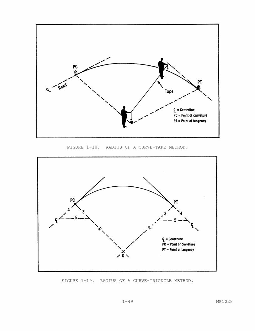
FIGURE 1-18. RADIUS OF A CURVE-TAPE METHOD.
FIGURE 1-19. RADIUS OF A CURVE-TRIANGLE METHOD. 1-49 MP1028
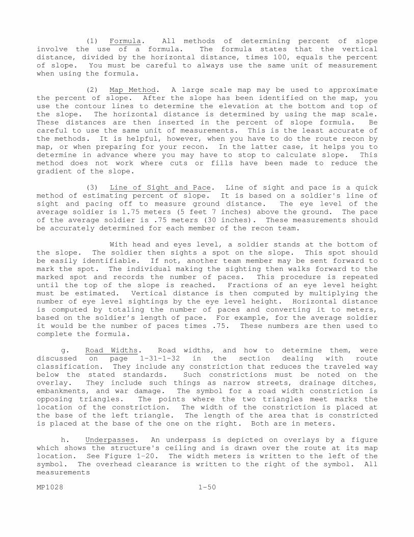
(1) Formula. All methods of determining percent of slope involve the use of a formula. The formula states that the vertical distance, divided by the horizontal distance, times 100, equals the percent of slope. You must be careful to always use the same unit of measurement when using the formula. (2) Map Method. A large scale map may be used to approximate the percent of slope. After the slope has been identified on the map, you use the contour lines to determine the elevation at the bottom and top of the slope. The horizontal distance is determined by using the map scale. These distances are then inserted in the percent of slope formula. Be careful to use the same unit of measurements. This is the least accurate of the methods. It is helpful, however, when you have to do the route recon by map, or when preparing for your recon. In the latter case, it helps you to determine in advance where you may have to stop to calculate slope. This method does not work where cuts or fills have been made to reduce the gradient of the slope. (3) Line of Sight and Pace. Line of sight and pace is a quick method of estimating percent of slope. It is based on a soldier's line of sight and pacing off to measure ground distance. The eye level of the average soldier is 1.75 meters (5 feet 7 inches) above the ground. The pace of the average soldier is .75 meters (30 inches). These measurements should be accurately determined for each member of the recon team. With head and eyes level, a soldier stands at the bottom of the slope. The soldier then sights a spot on the slope. This spot should be easily identifiable. If not, another team member may be sent forward to mark the spot. The individual making the sighting then walks forward to the marked spot and records the number of paces. This procedure is repeated until the top of the slope is reached. Fractions of an eye level height must be estimated. Vertical distance is then computed by multiplying the number of eye level sightings by the eye level height. Horizontal distance is computed by totaling the number of paces and converting it to meters, based on the soldier’s length of pace. For example, for the average soldier it would be the number of paces times .75. These numbers are then used to complete the formula. g. Road Widths. Road widths, and how to determine them, were discussed on page 1-31-1-32 in the section dealing with route classification. They include any constriction that reduces the traveled way below the stated standards. Such constrictions must be noted on the overlay. They include such things as narrow streets, drainage ditches, embankments, and war damage. The symbol for a road width constriction is opposing triangles. The points where the two triangles meet marks the location of the constriction. The width of the constriction is placed at the base of the left triangle. The length of the area that is constricted is placed at the base of the one on the right. Both are in meters. h. Underpasses. An underpass is depicted on overlays by a figure which shows the structure's ceiling and is drawn over the route at its map location. See Figure 1-20. The width meters is written to the left of the symbol. The overhead clearance is written to the right of the symbol. All measurements MP1028 1-50

are in meters. If sidewalks are present, they are indicated on the symbol. They may be used for the emergency passage of wider vehicles. The width of the traveled way is written first and is followed by a slash and the total width with the sidewalks. In structures with arched ceilings and a resulting decrease in clearance, both minimum and maximum clearances are noted. You do this by noting the minimum clearance, a slash, and the maximum clearance. i. Tunnels. Tunnels usually have data posted for them in the same manner as bridges. The essential information for a tunnel includes its serial number, location, overhead clearance, length, width, and bypasses. Engineer personnel will conduct detailed tunnel reconnaissance using a specific form. For MP purposes, limited tunnel information is recorded. Figure 1-21 illustrates some tunnel symbols. An arrow is drawn from the symbol representing the entrance to the tunnel. In the case of a long tunnel, both entrance and exit are located by splitting the arrow. The serial number of the tunnel is placed inside the symbol. The width of the traveled way in meters is placed below the symbol. If the tunnel has sidewalks, the traveled way information is followed by a slash and then the overall width of the tunnel. The overhead clearance is placed to the left of the symbol. As with an underpass, if the minimum and maximum clearances are different, they are divided by a slash. The total length of the tunnel is placed to the right of the symbol. All measurements are in meters. Any information that is unknown is indicated by a question mark. j. Bridges. Information pertaining to bridges was discussed during the discussion of the route classification formula beginning on page 1-31. The symbol for bridge information is the same as that described for the various signs, with one addition. From the symbol containing the data for the bridge, you extend an arrow to show its location. Although the engineers are charged with deliberate bridge recon responsibility, any additional information that you can add is helpful. It should be included on an attached sheet. The engineers use DA Form 1249, Bridge Reconnaissance Report, for bridge recon. Information that you might gather, should time and conditions permit, might include the type of bridge, the number of spans, the length of the spans, and the type material used in construction and surfacing. Types of bridges, and other pertinent bridge data, are included in FM 5-36 Chapter 9. Figure 22 illustrates some of the major bridge types. 1-51 MP1028
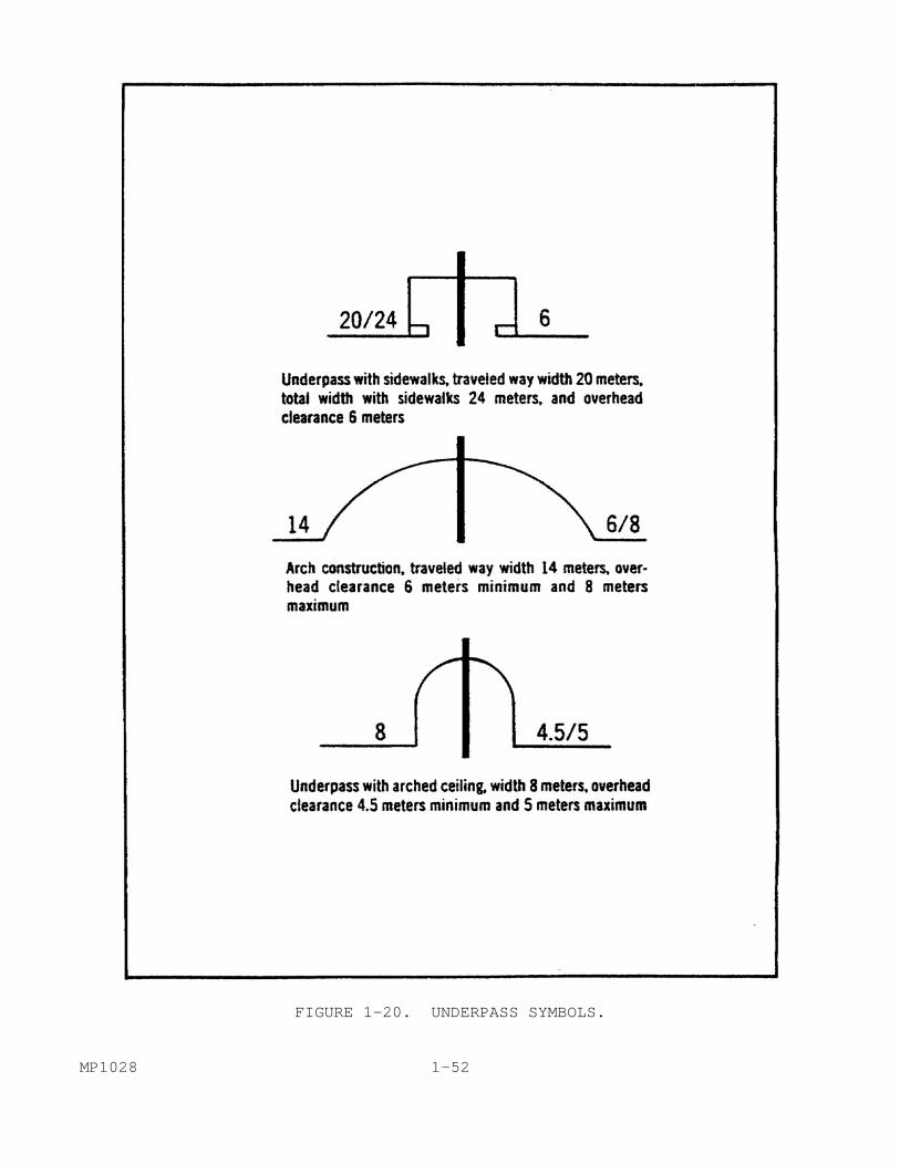
FIGURE 1-20. UNDERPASS SYMBOLS. MP1028 1-52

FIGURE 1-21. TUNNEL SYMBOLS. k. Bypasses. Bypasses are local detours along a specified route that allow traffic to avoid an obstruction. For example, if a bridge is destroyed, is there a place nearby that will allow traffic to get around it without major rerouting? When a bypass is limited to a specific vehicle type, it must be noted on the reconnaissance report. There are three types of bypasses, easy, difficult, and impossible. Each type is represented by a different symbol. These symbols are illustrated in Figure 1-23. 1-53 MP1028

FIGURE 1-22. TYPICAL BRIDGE SPANS. MP1028 1-54
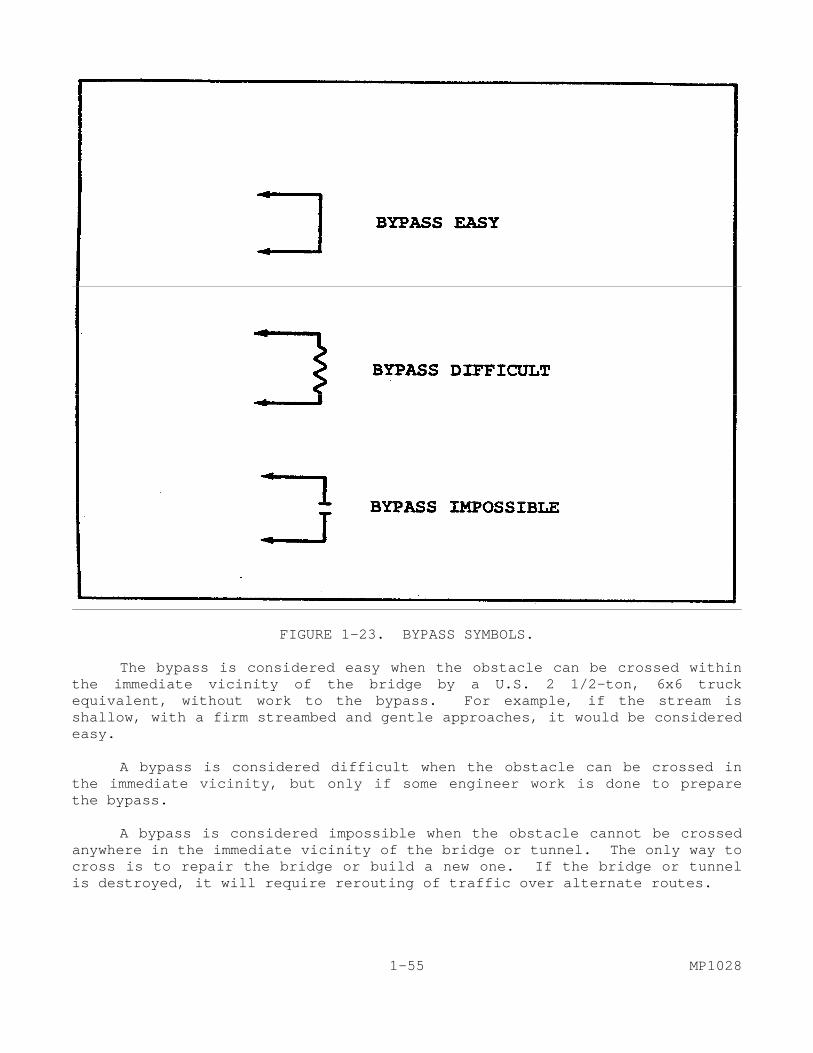
FIGURE 1-23. BYPASS SYMBOLS. The bypass is considered easy when the obstacle can be crossed within the immediate vicinity of the bridge by a U.S. 2 1/2-ton, 6x6 truck equivalent, without work to the bypass. For example, if the stream is shallow, with a firm streambed and gentle approaches, it would be considered easy. A bypass is considered difficult when the obstacle can be crossed in the immediate vicinity, but only if some engineer work is done to prepare the bypass. A bypass is considered impossible when the obstacle cannot be crossed anywhere in the immediate vicinity of the bridge or tunnel. The only way to cross is to repair the bridge or build a new one. If the bridge or tunnel is destroyed, it will require rerouting of traffic over alternate routes. 1-55 MP1028
In some areas of the world, railway bridges parallel highway bridges. They should not be overlooked as possible bypasses. The symbol used is similar to that of highway bridges, with two major exceptions. Above the symbol is placed the letters "RL." The line indicating the location of the bridge indicates whether its use as a bypass would be easy or difficult. Use easy is if an engineer platoon could prepare it in less than four hours for highway use. If it would take longer, it is considered use difficult. Use easy is indicated by drawing a straight line to the bridge location. Use difficult is indicated by drawing a jagged line to the bridge location. Whenever you cannot determine bypass information, it is indicated by placing a question mark where the bypass information would be. l. Fords. Most modern military vehicles have a built-in stream crossing capability. This allows greater use of fords. Many vehicles have the capability to "swim" certain streams. Fords have, therefore, taken on a much greater significance than ever before. You must include fords on your overlay. There are several factors that apply to fording operations. These include stream depth, width, approaches, velocities, and natural and man-made obstacles. (1) Depth. Stream depths can usually be determined by using such expedients as measured poles or weighted ropes. Depth readings are normally taken every three meters. In determining depths, you must be careful that unusual conditions do not exist that might affect the depth. These might include a dam or lock upstream that is open or closed. There may have been a recent heavy rainfall, or a long dry spell. Where such conditions might affect your depth readings, they should be noted separately. (2) Width. MP normally use one of two methods to determine stream width. Where the distance between the banks is relatively short: a tape measure or rope may be used. One member of the team holds the rope on the near shore while a second member crosses the stream with the other end. The rope is then stretched taut and marked. The distance can then be measure on the rope. A second method is to use a compass (Figure 24). Use the compass to take an azimuth from a point on the near shore to one on the far shore. On the near shore, establish another point that is on a line and at a right angle to the azimuth. The azimuth from the second point should be at about a 45 degree angle from the first azimuth. Measure the distance between the two points on the near shore. This distance is equal to the distance across the stream. (3) Velocity. The velocity of a stream is measured in either feet or meters per minute. On your overlays you should use meters. The velocity of the current varies in different parts of the stream. It is usually slower near the shore and swifter in the main channel. It also is slower whenever the channel widens. To determine the velocity of the current, measure a MP1028 1-56
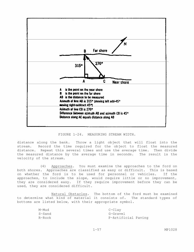
FIGURE 1-24. MEASURING STREAM WIDTH. distance along the bank. Throw a light object that will float into the stream. Record the time required for the object to float the measured distance. Repeat this several times and use the average time. Then divide the measured distance by the average time in seconds. The result is the velocity of the stream. (4) Approaches. You must examine the approaches to the ford on both shores. Approaches are classified as easy or difficult. This is based on whether the ford is to be used for personnel or vehicles. If the approaches, to include the slope, would require little or no improvement, they are considered easy. If they require improvement before they can be used, they are considered difficult. Natural Obstacles. The bottom of the ford must be examined to determine what kind of material it consists of. The standard types of bottoms are listed below, with their appropriate symbol.
M-Mud C-Clay S-Sand G-Gravel R-Rock P-Artificial Paving
1-57 MP1028

You must also determine if there are seasonal variations that will affect the use of the ford. For example, in a monsoon climate, there would be periods of heavy rain that would turn the stream into a raging torrent. A good indicator of such variations is high water marks along the bank. If you are unable to determine this information, you will represent it in the symbol with a question mark. Once you have gathered the information it must be entered on the overlay. The symbol for a ford is an arrow. The head of the arrow points to the location of the ford, and the stem of the arrow is a broken line (---). If the approaches are difficult, the broken line contains a zig-zag. Data for the ford is then entered above and below the line in a set order. Each item is separated from the next by a slash. Above the line is entered serial number/ford type (P for pedestrian, V for vehicular) /stream velocity in meters per second/seasonal limitations (X for none, Y for significant). Below the line the data are length/width/bottom type/depth. All measurements are expressed in meters. m. Civil/Military Road Designations. Many roads have been given numerical designations by civil authorities. For example, the European equivalent of interstate highways are designated by an "E" followed by a number, e.g., E-5. The military authorities may also give roads a designation. Where such a designation is known, it should be marked alongside the route in parentheses; for example, (E-5). n. Turnoffs. You should be on the alert throughout the recon for areas suitable for short halts, bivouacs, and areas of dispersion that offer cover and/or concealment. Areas that offer concealment are indicated based on the type of vegetation involved. Deciduous trees are indicated by a group of circles. Evergreens are indicated by a group of inverted "V's." The possibility of turning off the main road is indicated by an arrow. The arrow points in the direction of the turnoff. If the turnoff is suitable for wheeled vehicles, a circle is drawn on the stem; for tracked vehicles a square is used. The length of the turnoff is written, in meters, at the point of the arrow. If the turnoff involves a side road which is usable and is one kilometer long, a double arrow is used. Most of the symbols and formulae are in FM 5-36. As you can see, a great deal of essential information can be placed on an overlay by using these symbols and formulae. Any of the information can be expanded upon, or drawn in greater detail, by adding sketches on separate pieces of paper. When this done, a note should be made on the overlay. The overlay is critical to the successful accomplishment of your mission. MP1028 1-58
LESSON 1
PRACTICE EXERCISE The following items will test your grasp of the material covered in this lesson. There is only one correct answer for each item. When you complete the exercise, check your answer with the answer key that follows. If you answer any item incorrectly, study again that part of the lesson which contains the portion involved. General Situation You are a squad leader in an MP unit. Your unit is part of a theater of operations engaged in combat. You have been directed to conduct a hasty route reconnaissance of a possible MSR. You have available all proper equipment to complete your mission. 1. In giving you the mission orders, the operations officer states that guerrillas have been active in the area, particularly in an area from about 7 kilometers to 14 kilometers out, and contact is expected. You are told you will have three teams to conduct the mission. Based on this information, which is the correct course of action? A. Plan to avoid the area from 7 to 14 km out. B. Plan to use bounding overwatch from 6 to 15 km out. C. Plan to ensure that you locate and engage the enemy. D. Plan to operate largely off the highway from 7 to 14 km out. 2. Your mission orders state that the route has been used in the past by host nation forces. Most of the civilians in the area are considered as being friendly. The route contains no urban areas. It was a major highway before the current combat operations began. Prior to departure, which of the following actions should you take? A. Plan for the probability of enemy engagement. B. Assume that information provided by civilians will be accurate. C. Plan that bridges along the route will be fully marked and
standing. D. Conduct a detailed map reconnaissance of the route. 3. When you are 4.5 km out, you arrive at the first bridge. The bridge has a military load classification of 120. From engineer reports, you know the depth in the main channel is 8 meters. The banks on both sides of the rive slope to the water gently. The river bottom is a mixture of mud and gravel. What type of bypass would you indicate for this bridge? A. Bypass easy. B. Bypass difficult. C. No bypass is required for a class 120 bridge. D. Bypass impossible. 1-59 MP1028
4. At 18 km out, you arrive at a curve in the road. The traveled way is four lanes wide. Your team gathers the measurements to use the formula to determine the radius of the curve. They have found that C=20 meters and M=2 meters. What is the radius of the curve? A. 26 meters. B. 25.6 meters. C. 20 meters. D. 40 meters. 5. You have obtained an overlay from a previous reconnaissance of the route. It contains the route classification formula 10.5m/X/50/4.6 (OB)(W). This tells you that at the time they conducted the reconnaissance… A. there were no major obstructions. B. the route was 10.5 meters wide at its widest point. C. the route was 4.6 meters wide at its narrowest point. D. the route is subject to regular, recurrent flooding. 6. Using the route classification formula in question 5, you also know that at the time of their reconnaissance, A. the route was an all weather highway with a waterproof surface. B. the route was a limited, all weather highway. C. a portion of the route was unpaved. 7. The same engineer overlay notes a portion of the road as having a road classification formula as A 5.0/6.2k. This tells you that the road in this area has A. a concrete surface. B. an overall length of 6.2 kilometers. C. an overall width of 5.0 meters. D. there were some limiting factors on the road. 8. One of your teams has measured the horizontal and vertical distances of a slope. The horizontal distance was 21 meters. The vertical distance was 3 meters. What is the percent of slope? A. 7 percent. B. 14 percent. C. 9 percent. D. 3 percent. 9. You notice a bridge symbol on the engineer reconnaissance that has the letters "RL" above it. What should you expect to find at that location? A. A bridge with a limited road length. B. The right lane of the bridge blocked. C. The roadway of the bridge is limited. D. Railroad tracks across the bridge. MP1028 1-60
10. At a distance of 21 kilometers out, you find a series of three sharp curves. Your team determines the radii of the curves to be 24, 27, and 18 meters respectively. You enter a double triangle to signify a series of curves. Next to the triangle you enter A. 3/18. B. 24/27/18. C. a 1 in a circle and explain in a note. D. 18. 11. At 14 kilometers out, you discover a location that offers an ideal ambush location for the enemy. This is noted on the overlay as A. drawing of an ambush. B. a number in a circle keyed to attached notes. C. a critical point. D. an E-Am inside a triangle. 12. During the reconnaissance, your patrol is taken under sniper fire. Your lead team immediately returns fire and you report the situation per your orders. Your next action should be to: A. stop the mission and return to base with the information
available. B. maintain contact with the sniper regardless of other tasks. C. ignore the sniper and continue with your primary mission. D. neutralize the sniper and move on with the mission. 1-61 MP1028
LESSON 1
PRACTICE EXERCISE
ANSWER KEY AND FEEDBACK ITEM CORRECT ANSWER AND FEEDBACK 1. B. Plan to use bounding in overwatch from 6 to 15 km out. When enemy contact is expected... (page 1-25, para c (3)). 2. D. Conduct a detailed map reconnaissance of the route. The patrol leader should examine...(page 1-24, para b (4)). 3. D. Bypass impossible. A bypass is considered impossible...(page 1-53, para k). 4. A. 26 meters. The formula for determining the...(page 1-46, para e (1)). 5. D. The route is subject to regular recurrent flooding. The route is also subject to regular...(page 1-39, para g (1)
(b)). 6. A. The route was an all weather highway with a water proof surface. Type X is a route that can be used in...(page 1-32, para 5 c). 7. A. A concrete surface. The road surface material is...(page 1-40 para g (3)(d)). 8. B. 14 percent. All methods of determining percent...(page 1-50, para f (1)). 9. D. Railroad tracks across the bridge. In some areas of the world, railway bridges...(page 1-53, para
k). 10. A. 3/18. When a series of curves occur in a short...(page 1-46, para e). 11. C. A critical point. Such a location is a critical point...(page 1-42, para c). 12. D. Neutralize the sniper and move on with the mission.
Whatever techniques are used, it must...(page 1-29, para c (3)). MP1028 1-62
LESSON 2
PLAN, MONITOR, AND REPORT THE RESULTS OF A HASTY ROUTE RECONNAISSANCE
Critical Task: 191-377-4206
OVERVIEW LESSON DESCRIPTION: In this lesson you will learn to plan, monitor, and report the results of a hasty route reconnaissance. TERMINAL LEARNING OBJECTIVE: ACTION: Plan, monitor, and report the results of a hasty route
reconnaissance. CONDITION: You will be given this subcourse, and a hasty route
reconnaissance overlay. STANDARD: Demonstrate your competency in the task by correctly answering
70 percent of the examination questions. REFERENCES: The material contained in this lesson was derived from the
following publications: STP 19-95 B 2-4, FM 5-36, FM 19-4, and FM 101-5-1.
INTRODUCTION Reconnaissance operations vary with the operational environment and mission. Ground and combined air-ground reconnaissance operations must be closely supervised and monitored. All of your leadership skills must be used. The general principles of reconnaissance operations are discussed in the following paragraphs. It is important that you keep them in mind when conducting a reconnaissance. As the patrol leader, you are responsible for the proper completion of the mission. The information you gather will be used by the appropriate commanders to make decisions that could affect the outcome of the land battle. Units engaged in reconnaissance operations maneuver according to the location of the objective, rather than the location of friendly forces. In a route reconnaissance there are two objectives. The primary objective is terrain; the secondary is enemy forces. This means that you are concerned, normally, with the enemy forces only insofar as they affect the route. As stated in 2-1 MP1028
lesson 1, this can be overridden by the commander's priority intelligence requirements (PIR). That would alter the type of reconnaissance and is highly unusual. To effectively perform your mission, you are allowed a great deal of freedom of action. With this freedom of action goes a great deal of responsibility. During the mission you must avoid decisive engagement with the enemy. Your mission is to gather information within a specific time period. Engagement with the enemy, when not absolutely unavoidable, only hampers completion of your mission. You should engage in combat only if it is necessary to gather critical information, or in self-defense. Such enemy contact should be broken off as quickly as is reasonably possible. The specific rules as to when to engage and disengage with the enemy will be contained in your mission order. When you reach an obstacle, or other location of military significance, you must gather the information quickly, but without compromising accuracy. All information must be reported accurately. A route reconnaissance is conducted to obtain information upon which to base decisions. All items of a military significance should be reported. To be of value, reconnaissance reports must be complete, timely, and accurate. In lesson 1, you learned how to gather and record this information. As the team leader, you must monitor the actions of your team members. This requirement must be balanced against the others that are competing for your time. 1. Timely Completion. One, if not the most important, responsibility you have in leading a route reconnaissance is to ensure that the mission is completed in the time allotted. Timely completion of your mission will depend on how well you plan, prepare, prioritize, and monitor your patrol's execution of the mission. There are several reasons why timely completion of a route reconnaissance is so important. Some of these reasons are discussed in the following paragraphs: The information you are gathering is needed in order to make decisions about the trafficability of the road network. These decisions are in support of impending operations. If the road network is not capable of supporting the operation, the commander must find an alternate way to do so. If your information does not arrive on time, one of two undesirable things may occur. There may not be enough time to find an alternate route, or the operation may have to begin without the needed information. Your reconnaissance mission will probably have been integrated with many other activities. Other patrols may be conducting a reconnaissance on other sectors of the route. Patrols may also be conducting area or zone reconnaissance operations in adjoining sectors. All of these operations must be integrated, so that the information from each reaches the commander and his staff at the proper time. If one of them is not on time, it can seriously affect the ability of others to complete their missions. MP1028 2-2

2. Prioritize Tasks. In order to complete your mission in a timely manner, you must prioritize the tasks involved. In analyzing the mission order, you must determine what items of information are most critical. Normally, anything that will seriously impair traffic flow is going to be critical. If, for example, there are bridges along the route, they will be critical. The items that need to be reconnoitered should be listed and assigned a priority. Such a list need not be from one through the total, but may be grouped. For example, you may group various items together as top priority, medium priority, and low priority. The top priority group consists of those which absolutely must be accomplished. Those in the medium group are those that should be accomplished if at all possible. Low priority are all others. 3. Scheduling. a. Before you depart, you should fully understand how critical time is to the mission. The information may be more important than the time factor. It is important for you to determine how much leeway and under what circumstances it exists. Sometimes the information may be more important than the time. In other cases, the time may be the most critical element. You must have a complete understanding of the situation before you depart. b. As a part of your planning, you should lay out checkpoints along the route. Use those checkpoints to monitor the progress of your patrol. If you begin to fall behind where you should be, you will have to make adjustments. This is the purpose of the priority list. In order to get yourself back on schedule, you will have to determine from your priority list which items to concentrate on. Based on your situation, you may also decide to redistribute tasks to the members of your patrol. On the other hand, if you find you are ahead of schedule, you can take more time to gather more detailed information. How you achieve these goals depends on your leadership ability and good planning. c. Arrangements should be made before you depart as to what action to take should you be unable to complete the reconnaissance in the time specified. What those actions are will depend on the situation. It may be as simple as making a radio report. On the other hand, tactical conditions may dictate radio silence. In such a case, your orders may state you are to abandon the mission at a certain time and return with whatever information is available. Equally, you may have been instructed that if time becomes a critical factor to ignore certain items of information. d. Critical factors in planning your schedule are the information you gathered ahead of time and the personnel available. The more information you gathered, the more familiar you will be with what problems you might encounter along the route. This allows you to more effectively plan the amount of time it will take. If, for example, there are a large number of bridges along the route, it is going to take a greater amount of time than if there were not. 2-3 MP1028
Here is also where close coordination with host nation police forces can be of assistance. They are probably familiar with the route and can tell you areas where there may be possible delays. e. If the personnel you have available are relatively inexperienced at conducting a route reconnaissance, it is going to take longer than with experienced personnel. It also means that you will have to monitor them more closely and provide more assistance to them. These actions will take longer, and you must plan for it. The important factor to remember is that it is of the utmost importance to complete your mission in the time specified. Your ability to plan and lead the mission will ensure that this is accomplished. Information that is late can be almost as useless as no information at all. 4. Monitor Collection of Information. Even the simplest of route reconnaissance operations deals with a wealth of information. The demands on the time of the patrol leader and his responsibilities present a substantial challenge. In addition to monitoring the progress of the mission to keep it on time, you must also be concerned with ensuring the security of your patrol. While accomplishing those tasks, you must also ensure that the information being gathered is correct, and is as complete as time permits. This means you must constantly monitor what is being done. As with most actions, good planning facilitates your ability to accomplish your objectives. When you analyzed the mission, you created a checklist (lesson 1). The more detailed that checklist was, the easier your task will be. That analysis and checklist helps you determine which of your personnel should be assigned which tasks. Before you left, you will have made sure that each member of the patrol understood his tasks and knew how to perform them. As the patrol proceeds, you constantly monitor the tasks being accomplished by the patrol members and check the data they are gathering. As you learned in lesson 1, the accuracy and completeness of the data is critical. In most cases, you will not have the opportunity to go back once you have moved on. Monitoring also allows you to provide assistance if a patrol member is having difficulty. Finally, since time is critical on most reconnaissance operations, close monitoring will allow you to make adjustments if you are beginning to get off schedule before it becomes critical. The purpose of having prepared the checklist is to assist in making sure that no critical item of information is left out. The precise information on your checklist will vary with each mission. The situation and time available will determine how detailed such a list should or can be. As a minimum, it should probably include the following: Route Information.
The types of surface you expect. MP1028 2-4
Where the road may narrow.
Obstructions.
Location of bridges and tunnels.
Weather considerations.
Any other limiting factors. Enemy Situation.
Potential ambush sites.
NBC contaminated areas.
Minefields.
Key terrain. Circulation Control.
Traffic control posts.
Possible holding areas.
Defile locations.
Alternate routes and bypasses.
Route signing. The purpose of the checklist is not to conduct the reconnaissance ahead of time. If that were adequate, you would not be given your mission. Instead, its purpose is to allow you to anticipate the items that must be checked. There will be those, not included on the checklist, that you will discover as the patrol progresses. Where you may observe enemy activity, for example, is unknown. However, good planning may allow you to anticipate where that may most likely occur. The checklist does allow you to monitor more closely the items that need to be checked so that none are missed. 5. Review the Overlay. The most critical document that the patrol prepares is the overlay. The size of the patrol and how you have distributed the tasks will determine who is actually preparing the overlay from the information gathered. Most of the information contained in the overlay will be entered as the patrol proceeds on its mission. In lesson 1, you learned how to prepare an overlay. As the items of information are determined, you must regularly review it to be sure that the information is accurate and complete. As a minimum, the overlay should be reviewed after each major item is entered. A sample overlay is at 2-5 MP1028
Figure 2-25. This includes checking the sketches that are to be attached to it. When the patrol has been completed, you must review the overlay one final time. It should be neat and readable. As a minimum, it should include the items listed below:
Two grid references.
Magnetic north arrow.
Tracing of the route covered.
Title block, including your name, social security number, organization, date, map reference, and scale.
Route reconnaissance classification.
Length of the route in kilometers.
Curves with a radius of 45 meters or less.
Grades of 7 percent or greater.
Road width constrictions.
Underpasses with their limits-height, width.
Classifications of all bridges and tunnels.
Bypasses around obstacles.
Civil or military road numbers.
Turnoffs.
Other critical points-with an explanation.
6. Report Results. Having completed your review of the overlay and sketches, you are now ready to report the results of your mission. Where and to whom you report the results was specified in your mission order. Normally, it will be to the person that issued the order. It is not uncommon, however, for you to be asked to report the results to others, as well. At the conclusion of almost every reconnaissance operation, there is a debriefing. In preparation, you should gather your notes as well as your reports and review them. During the debriefing, you will be asked questions about your mission. Information you provide may trigger some of these questions. The debriefer may desire more MP1028 2-6
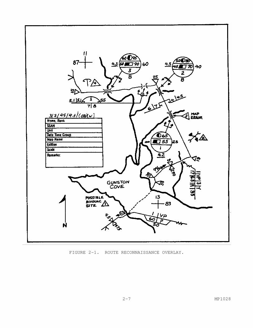
FIGURE 2-1. ROUTE RECONNAISSANCE OVERLAY. 2-7 MP1028
detailed information than that included on the reports. Also, during your absence, information may have been gathered by other patrols/sources that require confirmation. Something that you observed that may not have seemed of significance at the time may now be significant. 7. Conclusion. The purpose of any reconnaissance operation is to gather information. That information is used by the commander and his staff to make decisions that can affect the outcome of the land battle. The information that you provide must be as accurate, complete, and concise as possible. You are the eyes and ears of the commander when you conduct reconnaissance operations. Remember that you will also be the one that has to implement the plans that are based, in part, on the information you provide. The key to conducting a good hasty route reconnaissance is planning and preparation. That planning and preparation starts with your analysis of the mission. The better you plan and prepare, the easier the conduct of the mission will be. In this subcourse, you have learned where route reconnaissance fits in BCC and why it is important. You have learned how to plan, prepare, and conduct a hasty route reconnaissance. A primary mission of the military police in combat operations is BCC. An important part of the BCC mission includes the conduct of route reconnaissance. MP, together with the engineers, are responsible for conducting route reconnaissance operations. MP are ideally suited to this task due to their mobility, communications, and training. MP1028 2-8

LESSON 2
PRACTICE EXERCISE INSTRUCTIONS This practice exercise will show you how much you have learned in this lesson. Answer each question. When you are done, turn the page to check your answers. General Situation You are an MP squad leader who has been given the mission to conduct a hasty route reconnaissance. You have a fully equipped, three team patrol. You are to conduct the reconnaissance of a possible MSR that will have to carry double-flow, wheeled traffic. You have been told that you have 10 hours in which to complete the mission. All of your team members are experienced and your patrol is fully equipped. Enemy activity has been very light, except for one stretch 8 to 12 kilometers out. Civilians in the area are considered friendly. Zone reconnaissance operations are being conducted on both sides of the route. Their nearest boundary to you is 1 kilometer. 1. From your analysis of the mission, you develop a checklist and time schedule. You are going to use bounding overwatch from 7 to 13 km out. Your schedule should A. allow less time 7 to 13 km out since you will be moving more
rapidly. B. not be concerned with the area 7 to 13 km out since your mission
will be to engage the enemy. C. allow greater time throughout the route since you can collect
more information that way with experienced personnel. D. allow more time 7 to 13 km out than in other sectors of the
route. 2. You know that the primary purpose of your mission is to A. gather as much information as possible no matter how long it
takes. B. engage the enemy where ever you find him. C. gather information concerning the route and return within 10
hours. D. verify that the civilian populace is friendly and that there is
little enemy threat anywhere except where specified. 3. While conducting the mission, you arrive at a class 90 bridge with no bypass. In checking the time, you realize that the patrol is about 30 minutes behind schedule. You A. ignore the time since you made-up the schedule. B. gather data on the bridge and determine from your priority list
where to make up the time. C. pass up the bridge since it has a high classification in order to
get back on schedule. D. leave a team behind to reconnoiter the bridge and move on with
the rest of the patrol. 2-9 MP1028
LESSON 2
PRACTICE EXERCISE
ANSWER KEY AND FEEDBACK ITEM CORRECT ANSWER AND FEEDBACK 1. D. Allow more time 7 to 13 km out than in other... Critical factors in planning your...(page 2-4, para d). 2. C. Gather information concerning the route and return... Your mission is to gather information...(page 2-2, introduction,
para 3). 3. B. Gather data on the bridge and determine... If you begin to fall behind where...(page 2-3, para 3 b). MP1028 2-10