bay city ordinance no. 374 - state of oregon€¦ · the bay city development ordinance section...
TRANSCRIPT

BAY CITY ORDINANCE NO. 374
THE BAY CITY DEVELOPMENT
ORDINANCE
Enacted September 1978
Including amendments as of October 1980
July 1982 August 1983
December 1983 May 1984 June 1984
August 1985 April 1986
December 1991 June 1997
October 2001 May 2002
September 2005 January 2006 October 2007
September 2008 _______________________________________________________________________________________________________________________ Prepared by: THE BAY CITY PLANNING COMMISSION (Elwood Stait, Phyllis Wustenberg, Gert Arthur, Terry Griffin, Mike Bradley,
Ira Simonson, and Merton Miller), the staff of the CLATSOP-TILLAMOOK INTERGOVERNMENTAL COUNCIL, and JAMES R. PEASE, Land Use Specialist, OSU Extension Service.
Funding for this project was provided in part by the Oregon Department of Land Conservation and Development and the U.S. Office of Coastal Zone Management.

THE BAY CITY DEVELOPMENT ORDINANCE
TABLE OF CONTENTS ARTICLE 1 INTRODUCTORY PROVISIONS AND INTENSITY ZONES................1
Section 1.1 Introduction......................................................................................1 Section 1.2 Criteria for the Establishment and Alteration of Plan/Zone
Designations, Intensity Zones and Overlay Zones ..........................1 Section 1.26 Zoning of Annexed Areas................................................................3 Section 1.27 Compliance with the Ordinance Provisions and the Comprehensive
Plan ..................................................................................................3 Section 1.28 Location of Zones and Zone Boundaries .........................................3 Section 1.3 Allowable Uses ................................................................................6 Section 1.4 High Intensity Zone (HI) ...............................................................10 Section 1.406 High Intensity Zone Standards.......................................................11 Section 1.5 Moderate Intensity Zone (MI) .......................................................12 Section 1.508 Moderate Intensity Zone Standards ...............................................13 Section 1.6 Low Intensity Zone (LI).................................................................14 Section 1.61 Low Intensity Zone Standards .......................................................15 Section 1.7 Hazards Overlay Zone (HZ) ..........................................................18 Section 1.750 Freshwater Wetland Overlay Zone (FW) ......................................23 Section 1.8 Shoreland Zones (S1, S2,) .............................................................25 Section 1.810 Shoreland Zone 1 Standards ..........................................................25 Section 1.830 Shoreland Zone 2 Standards ..........................................................27 Section 1.860 Estuary Zones, Areas Included, and Uses Permitted Outright.......29 Section 1.870 Estuary Natural Zone (EN) ............................................................30 Section 1.880 Estuary Conservation 1 (EC1) Zone ..............................................33 Section 1.890 Estuary Conservation 2 (EC2) Zone ..............................................37 Section 1.900 Estuary Conservation Aquaculture Zone (ECA) ...........................41 Section 1.910 Estuary Development Zone (ED)...................................................43 Section 1.920 Dredge Material Disposal Site Protection Zone (DMD) ...............48
ARTICLE 2 CONDITIONAL USES .............................................................................50
Section 2.1 Purpose...........................................................................................50 Section 2.105 Conditional Use Procedure ............................................................51 Section 2.2 Conditional Use Standards.............................................................51 Section 2.201 Multifamily, Cluster, or Apartment Dwellings..............................51 Section 2.202 Schools...........................................................................................52 Section 2.203 Public Utility or Communication Facility......................................52 Section 2.205 Recreation Vehicle Parks...............................................................52 Section 2.206 Primary Commercial Uses .............................................................53 Section 2.207 Commercial Uses - High Traffic Generation.................................54 Section 2.208 Commercial Recreation .................................................................54 Section 2.209 Eating or Drinking Establishments ................................................54 Section 2.210 Forest Management Practices ........................................................54 Section 2.211 Industry - Non Water Dependent or Related .................................57 Section 2.212 Meeting Halls, Churches, and Schools ..........................................57 Section 2.213 Mining or Removal of Sand or Gravel ..........................................58

THE BAY CITY DEVELOPMENT ORDINANCE
Section 2.2135 Extensive Excavation and Grading................................................58 Section 2.214 Cottage Industries ..........................................................................58 Section 2.2145 Yurt ................................................................................................60 Section 2.215 General Conditional Use Standards ...............................................62 Section 2.220 Estuarine and Shoreline Standards.................................................63 Section 2.221 Aquaculture Facilities ....................................................................63 Section 2.222 Siting, Design, Construction, Maintenance, or Expansion of Dikes
........................................................................................................65 Section 2.223 Docks and Moorages......................................................................65 Section 2.224 Dredged Material Disposal ............................................................67 Section 2.225 Dredging in Estuarine Waters, Intertidal Areas and Tidal Wetlands
........................................................................................................70 Section 2.226 Energy Facilities and Utilities........................................................72 Section 2.227 Fill in Estuarine Waters, Intertidal Areas, and Tidal Wetlands .....74 Section 2.228 Forestry and the Forest Products Industry .....................................75 Section 2.229 Industrial and Commercial Uses in Estuarine Waters, Intertidal Areas,
and Tidal Wetlands ........................................................................76 Section 2.230 Land Transportation Facilities .......................................................78 Section 2.231 Mining and Mineral Extraction......................................................79 Section 2.232 Mitigation.......................................................................................81 Section 2.233 Navigation Structures and Navigational Aids................................81 Section 2.234 Piling/Dolphin Installation.............................................................82 Section 2.235 Restoration .....................................................................................83 Section 2.236 Shallow Draft Port Facilities and Marinas.....................................84 Section 2.237 Shoreline Stabilization ...................................................................86 Section 2.3 Permissibility of Uses & Activities in Aquatic Areas ...................89 Section 2.310 Regulated Activities and Impact Assessments ..............................91
ARTICLE 3 SUPPLEMENTARY PROVISIONS.........................................................95
Section 3.1 Buffers and Screens .......................................................................95 Section 3.210 Fences ..........................................................................................101 Section 3.25 Grading and Erosion Control Permit ...........................................102 Section 3.3 Setback Requirements..................................................................108 Section 3.5 Parking Standards ........................................................................111 Section 3.6 Design Requirements for Off-Street Parking...............................112 Section 3.7 Accessory Uses ............................................................................113 Section 3.701 Access Requirement - Flag Lots ..................................................114 Section 3.7015 Maintenance of Public Access .....................................................114 Section 3.702 Storage in a Front Yard................................................................114 Section 3.703 Maintenance of Minimum Ordinance Requirements...................115 Section 3.704 Clear Vision Areas.......................................................................115 Section 3.71 Bed and Breakfast Establishments...............................................116 Section 3.75 Standards for Manufactured Dwellings .......................................116 Section 3.751 Single Wide Manufactured Dwellings.........................................117 Section 3.8 Sign Requirements .......................................................................119 Section 3.9 Street Lights or Security Lights ...................................................121

THE BAY CITY DEVELOPMENT ORDINANCE
Section 3.95 Review of Demolition and Building Permits for Historic Structures
......................................................................................................121 Section 3.96 Architectural Review ...................................................................122 Section 3.97 Temporary Uses ...........................................................................123 Section 3.98 Periodic Use of Travel Trailers/Recreational Vehicles ...............124
ARTICLE 4 INFORMATION REQUIRED FOR LAND USE PLANNING
APPLICATIONS .....................................................................................125 Section 4.1 Purpose.........................................................................................125 Section 4.101 Authority ......................................................................................125 Section 4.102 Fees ..............................................................................................125 Section 4.103 Land Use Permit Application Form.............................................125 Section 4.104 Interpretation of Required Information........................................126 Section 4.1045 Survey Required...........................................................................126 Section 4.108 Map Scale.....................................................................................127 Section 4.109 Mapped Information Required.....................................................127 Section 4.110 Written Information Required......................................................128 5ection 4.111 Submission of Final Subdivision Plat ..........................................129 Section 4.112 Proposed findings of fact .............................................................129
ARTICLE 5 SUBDIVISION, PARTITIONING, CLUSTER, AND PLANNED
DEVELOPMENT....................................................................................131 Section 5.1 Purpose.........................................................................................131 Section 5.101 Authority and Review of the Planning Commission ...................131 Section 5.102 Subdivisions.................................................................................132 Section 5.103 Submission and Final Approval...................................................133 Section 5.105 Improvement Requirements.........................................................133 Section 5.106 Partitions ......................................................................................135 Section 5.107 Planned Development ..................................................................136
ARTICLE 6 VARIANCES...........................................................................................138
Section 6.010 Purpose.........................................................................................138 Section 6.020 Conditions ....................................................................................138 Section 6.030 Criteria for Granting Variances ...................................................138 Section 6.035 Variance Standards for Setback Requirements............................139 Section 6.040 Variances to Off-Street Parking and Loading Facilities ..............139 Section 6.060 Variance Procedure......................................................................140
ARTICLE 7 NONCONFORMING USES ...................................................................142 Section 7.010 Purpose.........................................................................................142 Section 7.020 Continuation of Nonconforming Structure or Use.......................142 Section 7.030 Discontinuance of Nonconforming Use.......................................142 Section 7.040 Improvement of Certain Nonconforming Uses............................142 Section 7.050 Change of a Nonconforming Structure ........................................142 Section 7.060 Change of a Nonconforming Use ................................................143

THE BAY CITY DEVELOPMENT ORDINANCE
Section 7.070 Destruction of Nonconforming Structure or Use.........................143 ARTICLE 8 AMENDMENTS .....................................................................................144
Section 8.010 Purpose.........................................................................................144 Section 8.020 Authorization to Initiate...............................................................144 Section 8.030 Application...................................................................................144 Section 8.060 Procedures....................................................................................145 Section 8.070 Criteria .........................................................................................145 Section 8.080 Conditional Zone Amendment.....................................................146 Section 8.090 Limitations on Reapplication.......................................................148
ARTICLE 9 BUILDING PERMITS ............................................................................149 ARTICLE 10 PUBLIC DELIBERATIONS AND HEARINGS....................................150
Section 10.010 Procedure for Mailed Notice.......................................................150 Section 10.015 Procedure for Published Notice ...................................................150 Section 10.020 Notice of Hearing.........................................................................150 Section 10.030 Time of Notice .............................................................................151 Section 10.040 Date of Public Hearing.................................................................151 Section 10.070 Burden and Nature of Proof.........................................................152 Section 10.080 Nature of Proceedings..................................................................152 Section 10.110 Decision .......................................................................................154 Section 10.120 Record of Proceedings .................................................................155 Section 10.130 Notice of Decision .......................................................................155 Section 10.140 Request for Review of a Decision ...............................................156 Section 10.150 Requirements of a Request for Appeal of a Planning Commission
Decision .......................................................................................156 Section 10.200 Notification of State and Federal Agencies .................................159 Section 10.240 Application Information...............................................................160 Section 10.260 Filing Fee .....................................................................................161
ARTICLE 11 MISCELLANEOUS PROVISIONS........................................................162 ARTICLE 12 ENFORCEMENT AND REMEDIES .....................................................163
Section 12.010 Nature of Violation Defined ........................................................163 Section 12.020 Enforcement.................................................................................163 Section 12.030 Permit Revocation Procedure ......................................................163 Section 12.040 Fines.............................................................................................164 Section 12.050 Double Fees .................................................................................164 Section 12.060 Abate Procedure...........................................................................164 Section 12.110 Assessment of Costs ....................................................................166 Section 12.140 Separate Violations ......................................................................167
ARTICLE 13 DEFINITIONS.........................................................................................169

THE BAY CITY DEVELOPMENT ORDINANCE

THE BAY CITY DEVELOPMENT ORDINANCE

THE BAY CITY DEVELOPMENT ORDINANCE

THE BAY CITY DEVELOPMENT ORDINANCE

THE BAY CITY DEVELOPMENT ORDINANCE
ORDINANCE NO. 374 AN ORDINANCE REGULATING THE USE OF LAND AND STRUCTURES; PARTITIONING, SUBDIVISIONS, AND PLANNED DEVELOPMENTS; AND ESTABLISHING INTENSITY ZONES IN THE CITY OF BAY CITY. THE CITY OF BAY CITY ORDAINS AS FOLLOWS: ARTICLE 1 INTRODUCTORY PROVISIONS AND INTENSITY ZONES Section 1.1 Introduction
The Bay City Development Ordinance is intended to regulate land use within the Bay City Corporate Limits in conformance with the goals and policies of the Comprehensive Plan and the Statewide Planning Goals and Guidelines. The Ordinance is designed to address the impacts of land uses partially through the use of performance standards, and by the division of the City into intensity zones, where different levels of land use intensity may take place. It is also intended to unify the zoning, subdivision, partitioning, and planned development ordinances into one document, and to provide a single application form and process for building permits, excavation permits, partitionings, subdivisions, planned developments, conditional uses, variances, and zone and plan changes. The official Plan/Zone Designation Map showing the location of plan designations and intensity zones is on file in the Bay City City Hall.
Section 1.2 Criteria for the Establishment and Alteration of Plan/Zone Designations,
Intensity Zones and Overlay Zones
Plan/Zone Designations or Intensity Zones, hereinafter referred to as Intensity Zones, are areas of land within the City which have different performance standards and criteria in order to separate potentially incompatible uses and to retain the character of the community. Although their boundaries are fixed by law, they are not intended to be static through time. Intensity zones may be changed by amending the Comprehensive Plan and Development Ordinance through the normal amendment process (Article 8), if findings of fact are presented and accepted in support of such a change. In making the decision to amend the boundary of an intensity zone, or the standards or policies within a zone, the following considerations shall be addressed by the Planning Commission and City Council:
Section 1.21 High Intensity (HI)
a. Feasibility of the land for intensive development, such as lack of steep
1

THE BAY CITY DEVELOPMENT ORDINANCE
slopes, flood plains, wetlands, or use of the land for resource purposes such as fisheries, timber or natural values.
b. Proximity of the land to existing high intensity uses, such as commercial,
industrial, or high density residential development.
c. Access to major roads, such as U.S. Highway 101 or arterials.
d. Availability of public services and utilities, including adequate sewer and water capacity and properly sized lines.
e. Consideration of impact on adjacent land use including residential areas,
shorelands, public recreation areas, schools, and historic or scenic resources.
Section 1.22 Moderate Intensity (MI)
a. Proximity to developed areas, such as existing moderate or high intensity zones.
b. Availability of public services and utilities, including adequate sewer and
water capacity for the density or intensity of development proposed, and properly sized lines.
c. Adequacy of the street system to support development, and consideration
of the access onto existing streets.
d. Consideration of impacts on adjacent land uses, including residential areas, shorelands, public recreation areas, schools, and historic or scenic area.
e. Demonstrated need of the area for proposed development or use, rather
than for speculative or long-range future uses. Section 1.23 Low Intensity (LI)
a. Presence of special resource lands, such as agriculture, wetlands, timber lands, or steep slopes.
b. Distance from developed areas of the City, and lack of public utilities or
services; areas of land which may be developed in the future, but are outside the existing built-up areas.
Section 1.24 Hazards Overlay Zone (HZ)
a. Presence of development hazards, such as landslide potential, flooding, subsidence features (sinkholes), or other hazards.
2

THE BAY CITY DEVELOPMENT ORDINANCE
b. Current background or technical information is available, including City
slope or geologic hazards maps, flood maps, the Tillamook Bay Estuary Plan, or other information.
Section 1.25 Shorelands Zones (S1, S2)
a. Frontage on Tillamook Bay. Shoreland areas must be compatible with their adjacent estuarine management unit designation.
b. Policies and criteria for shoreland uses within each zone are contained in
the Comprehensive Plan.
c. Changes of Shoreland Zones must be coordinated with Tillamook County.
d. Consideration of need for water dependent or water related areas, natural or scenic values, public access to the water, potential or availability of dredge spoil disposal sites, need for fill or removal of material in water areas, and other factors of the Comprehensive Plan and other sections of this Ordinance.
Section 1.26 Zoning of Annexed Areas
Areas annexed to the City shall be zoned the same as the contiguous zone within the City Limits, except where the annexed area adjoins two or more zones, the least intensive zone shall apply unless findings of fact are presented in the Planning Commission or City Council and adopted which support the more intensive zoning resignation. In establishing the zoning for annexed areas, the procedure used for Amendments (Article 8) shall be followed.
Section 1.27 Compliance with the Ordinance Provisions and the Comprehensive Plan
A lot may be used and a structure or part of a structure constructed, reconstructed, remodeled, occupied, or used only as this Ordinance permits. All standards established by this Ordinance or required as a condition in granting a conditional use permit must be met within 30 days after occupancy of the building, structure, or addition. Where a provision of this Ordinance is in conflict with the City's adopted Comprehensive Plan, the Plan shall be adhered to.
Section 1.28 Location of Zones and Zone Boundaries
The boundaries for the zones established in this Ordinance referred to as Intensity Zones, Shorelands Zones, or Hazards Overlay Zones are indicated on a map entitled Plan/Zone designations for Bay City, Oregon, which is hereby adopted by reference by the City Council. A certified copy of the map shall be signed
3

THE BAY CITY DEVELOPMENT ORDINANCE
and dated by the Mayor and Chairperson of the Planning Commission, and maintained in City Hall with all current amendments, so long as this Ordinance remains in effect. Unless otherwise specified, zone boundaries are section lines, subdivision lines, lot lines, center lines of streets or such lines of streets or such lines extended.
4

BAY CITY DEVELOPMENT ORDINANCE LAND USE MATRIX
SL1 = Shoreland Subarea 1 SHI = South High IntensityO = Outright Use C = Conditional Use SL2 = Shoreland Subarea 2 EHI = East High Intensity
N/P = Not Permitted N/A = Not Applicable NHI = North High Intensity MI = Moderate IntensityN/P = Not Permitted N/A = Not Applicable LI = Low Intensity
USES ZONES SL1 SL2 NHI SHI EHI MI LI
1 Agriculture N/A N/A N/A N/A C C O
2 Aquaculture, including Oyster Farming C C N/P C C C N/A
3 Boat Storage - Boat Repair or Construction N/P C N/P C C N/P C
4 Commercial - Water Dependent N/P C N/P N/A N/A N/A N/A
5 Commercial - Water Related N/P C N/P C N/A N/A N/A
6 Commercial - Primary Retail or Service Non-Water Dependent or Related N/P N/P O O C C C
7 Commercial - Retail or Service with Large Land Area Needs - High Traffic Generation N/P N/P N/P C N/P C N/P
8 Commercial Recreation - High Traffic Generation N/P N/P N/P N/P N/P C N/P
9 Commercial Recreation - Low Traffic Generation N/P N/P N/P C C C C
10 Dredge Material Disposal N/P C N/P N/P N/P N/P N/A
11 Eating or Drinking Establishments N/P C O O C C C
12 Forest Management C N/A N/A N/A N/A C C
13 Industrial - Water Dependent N/P C N/A N/A N/A N/A N/A
14 Industrial - Water Related N/P C N/P C N/A N/A N/A
15 Industrial - Non-Water Related or Non-Water Dependent** N/P N/P N/P** C C C C
16 Marinas, Piers, Launching Ramps, Docks and Other Boating Facilities N/P C N/A N/A N/A N/A N/A
17 Meeting Halls, Churches, Schools, and Museums N/P N/P C C C C C
18 Mining, Removal of Sand or Gravel N/P N/P N/P C C C C
19 Manufactured Dwelling Subdivision N/P N/P N/P C C C C
19A Manufactured Dwelling Park N/P N/P N/P N/P N/P C C
20 Residential Developments - Single Family or Duplex N/P N/P C O O O O
21 Residential Developments - Multiple Family N/P N/P C O O C C
22 Residential Developments - Planned Development N/P N/P C C C C C
23 Restoration or Mitigation Activities C C N/A C C C C
24 Shoreline Stabilization C C N/A N/A N/A N/A N/A
25 Public or Private Substations, Sewer Ponds and Pump Stations C C C C C C C
26 Cottage Industries N/P N/P C C C C C
27 Temporary Recreation Vehicles/Travel Trailers N/P N/P O O O O O
28 Accessory Buildings N/P N/P O O O O O
29 Extensive Excavation & Grading N/P C C C C C C
30 Bed and Breakfast Establishments N/P N/P C O O O O
31 Mini-Storage Establishments N/P N/P N/P C C C C
32 Motels, Hotels N/P N/P C C C C C
33 Public Recreation Areas C C C C C C C
34 Large Scale Development - Four or More Dwelling Units N/P N/P C C C C C
35 Home Occupations N/P N/P O O O O O
36 Yurts* N/P N/P N/P N/P N/P N/P* N/P
37 Zero Lot Line Development N/P N/P N/P N/P N/P C N/P
* The Coastal Shoreland Area is defined by the Bay City Comprehensive Plan and Oregon Statewide Planning Goal 17 Coast Shorelands as the area westof Highway 101. In the Coastal Shoreland Area Moderate Intensity Zone, a YURT may be permitted as a conditional use only as a recreational use structure.
**Industrial - Non Water Related or Non-Water Dependent is allowed as a conditional use in the area bordered by Hwy. 101, A Street, and 3rd Street.
THE BAY CITY DEVELOPMENT ORDINANCE
Section 1.3 Allowable Uses
The following is an explanation of the allowable uses as listed on the Bay City Development Ordinance Land Use Matrix located on Pages 4A & 4B.
1. Agriculture and Oyster Raising
Farming, pasturing, dairying, mink ranching, nursery activities, horticulture, and similar activities, but not to include processing, slaughtering, large scale poultry raising, and similar high impact uses.
2. Aquaculture
The raising of marine or freshwater organisms for commercial or scientific purposes, including release and recapture operations; not to include processing which could be carried out elsewhere.
3. Boat Storage, Repair and Construction
Commercial storage, repair or construction of boats and trailers, not to include recreation vehicles.
4. Commercial - Water Dependent
Commercial marinas, docks, or moorages.
5. Commercial - Water Related Fish or shellfish retail or wholesale outlets; marine craft or marine equipment sales; sports fish cleaning, smoking or curing establishments; retail trade where the majority of the products are to be used in conjunction with a water-dependent use; restaurants which provide a view of the waterfront and which are in conjunction with a water-dependent or water-related use, such as a seafood processing plant.
6. Commercial - Primary Retail or Service; Non-Water Related or Dependent
Activities such as grocery stores, meat markets, variety stores, antique shops, and similar uses which are normally found in a downtown area; uses which are compatible with the existing downtown commercial uses; motels and hotels.
7. Commercial - Retail or Service with Large Land Needs; Non-Water
Dependent or Related Activities such as service stations, car lots, drive-in restaurants, wholesale businesses with large land requirements, similar activities which might be incompatible with primary retail uses.
8. Commercial Recreation; High Traffic Generation
Recreation vehicle parks, campgrounds, miniature golf courses, bowling alleys, and similar uses.
6

THE BAY CITY DEVELOPMENT ORDINANCE
9. Commercial Recreation; Low Traffic Generation Golf courses, racquet clubs, equestrian stables, and similar uses.
10. Dredging Material Disposal
Disposal of dredging materials on land.
11. Eating or Drinking Establishments Restaurants, taverns, bars, cafeterias, and similar uses. Drive-ins or fast food establishments fall under (7) above.
12. Forest Management
Logging and related management techniques such as slash removal and replanting.
13. Industrial - Water Dependent
Piers, wharves, and other terminal and transfer facilities for water borne commerce, such as fish, shellfish, and timber or timber products; uses where access to water bodies is required as part of the manufacture, assembly, fabrication, or repair of marine equipment due to the size of the craft or equipment.
14. Industrial - Water Related
Fish or shellfish processing; warehousing and/or storage for marine equipment or water borne commerce.
15. Industrial - Non-Water Dependent or Related
Industrial uses which can reasonably be located places other than on the waterfront.
16. Marinas, Piers, Launching Ramps, Docks, and Other Boating Facilities
Boating facilities of a high impact nature, possibly requiring dredging, filling, pile driving, parking area, or storage.
17. Meeting Halls, Churches, and Schools
Public or private meeting facilities, not for commercial purposes, church and related uses, schools, fraternal organizations, and similar uses.
18. Mining, Removal of Sand or Gravel
Activities which require permits from state agencies.
19. Manufactured Dwelling Subdivision A subdivision intended for the placement of manufactured dwellings.
19A. Manufactured Dwelling Park
Any place where four or more manufactured dwellings are located within 500 feet of one another on a lot, tract or parcel of land under the same
7

THE BAY CITY DEVELOPMENT ORDINANCE
ownership, the primary purpose of which is to rent space or keep space for rent to any person for a charge or fee paid or to be paid for the rental or use of facilities or to offer space free in connection with securing the trade or patronage of such person.
"Manufactured dwelling" does not include a lot or lots located within a subdivision being rented or leased for occupancy by no more than one manufactured dwelling per lot if the subdivision was approved by the City of Bay City.
20. Residential Development - Single Family or Duplex
Single family dwellings or duplexes, built singly, not a part of a larger development.
For the purposes of this Ordinance, individual manufactured dwellings are considered a single family dwelling and are subject to the criteria listed in Section 3.75.
21. Residential Development - Multiple Family
Residential structures containing three or more units.
22. Residential Development - Planned Development Planned development is a single development incorporating a variety of housing types and non-residential uses, consisting of individual lots, common building sites or open spaces, or other configurations in order to promote innovative, flexible, and diversified land use under a comprehensive site development plan.
23. Restoration and Mitigation
Activities intended to restore an estuary to a condition of biological productivity, to mitigate (replace) any areas in another part of the estuary being eliminated.
24. Shoreline Stabilization
Structures built to protect shoreline areas from erosion.
25. Utilities - Public or Private; Power Stations, Sewer Ponds, Pump Stations Utilities, including major facilities or structures, which require placement in an area outside of public rights of way.
26. Cottage Industries
Cottage Industries means a home-based business which is carried out by the homeowner, family members living on the premises, and no more than one employee from outside the family. Cottage industries may have clients coming to site if adequate off-street parking is provided. Business may be carried out in outbuildings, although no outdoor storage is permitted. No
8

THE BAY CITY DEVELOPMENT ORDINANCE
off-site environmental impact (noise, lighting, smoke, etc.) is permitted.
27. Manufactured Dwelling/Travel Trailers/Recreation Vehicle A manufactured dwelling, travel trailer or recreational vehicle may be placed on site and occupied as a temporary residence for up to one year provided that: 1) Applicant obtains a temporary placement permit from the City; 2) Applicant holds a valid building permit; 3) Applicant or other person authorized by Applicant who is residing in the temporary structure is actively constructing the building; and 4) Applicant has paid the applicable sewer and water hookup fees and system development charges and all other related fees prior to occupancy. The actual sewer and water connections must be made within 90 days of obtaining the temporary placement permit. No dumping of wastewater or sewage shall be allowed on the property.
28. Accessory Buildings
An accessory building is a structure of which use is incidental and subordinate to the main use of the property and is located on the same lot as the main use. These buildings include detached garages, guest houses, greenhouses, and storage or utility buildings.
29. Extensive Excavation or Grading
Excavation and grading which results in an alteration from the existing grade of more than three feet.
30. Bed and Breakfast Establishments
An owner occupied dwelling where no more than three rooms are available for transient lodging and where a morning meal is provided.
31. Mini-storage establishments. Structures or areas used for storage of
personal belongings, commercial materials or vehicles on a rental or lease basis.
32. Motels, Hotels, Transient rental facilities for overnight accommodations,
including inns or bed and breakfast establishments.
33. Public Recreation Areas. Facilities designed or intended for public recreation, which have constructed facilities, including parks, playgrounds, boat ramps, ballfields, or courts, and parking areas for their use.
34. "Large Scale Development" means the construction of four or more
dwelling units in a twelve-month period by the same developer or contractor within the same area, including the same subdivision, partition or other development.
9

THE BAY CITY DEVELOPMENT ORDINANCE
35. Home Occupation. A home-based business carried out by the resident or residents of a dwelling which has no outward appearance of business activity and no outside employees. Home occupations shall be carried out within the dwelling or in an accessory structure.
36. Zero Lot Line Development. A structure containing two dwelling units
located on separate lots, sharing a common wall, and having independent heating, electrical, water and wastewater systems with separate meters for each unit.
Section 1.4 High Intensity Zone (HI) Section 1.401 Purpose: The purpose of the high intensity area is to provide areas of land in
which intensive types of activities can take place. These include, but are not limited to, commercial, industrial, higher density residential, intensive commercial recreation, and similar types of activities with heavier impacts. These uses are also allowed in the moderate intensity area, but with more restrictive standards.
Section 1.402 General Zoning Policies Section 1.403 North High Intensity Area (The Town Center): It is the intent of this section to
encourage an identifiable town center, in which a variety of primary retail, service, and governmental activities are carried out. It is the area encompassing the post office, City Hall, the Church, grocery stores, cafes and taverns, the main city park, and various shops. Uses allowed and encouraged here are those which are land intensive and do not have large parking needs such as drive-in restaurants. Uses surrounding the historic structures must be architecturally compatible.
Section 1.404 South High Intensity Area (US Highway 101): Uses located in this area may be
more highway oriented than those allowed in the town center, and similar to those uses established there, such as the service station, highway oriented stores, and light industry. Uses anticipated are recreation vehicle parks and additional industrial activities which require larger land areas and access to the highway. Access onto US 101 shall be limited to public streets other than US 101.
Section 1.405 East High Intensity Area: Additional high intensity uses and greater lot
coverages are allowed in this area subject to buffering and screening requirements to separate industrial and residential uses. Performance standards concerning smoke, noise, and glare must be carefully observed in this area.
10

THE BAY CITY DEVELOPMENT ORDINANCE
Section 1.406 High Intensity Zone Standards Section 1.407 Maximum Lot Coverage
a. Residential Uses . . . . . . . . . . . . . . . . . 50%
b. Commercial, Industrial or Other Non-residential Uses . . . . . . . . . 75%
(Refer to Definitions, Article 13)
Section 1.408 Minimum Open Area
a. Residential Uses . . . . . . . . . . . . . . . . 50%
b. Commercial, Industrial, or Other Non-residential Uses . . . . . . . . 25%
Section 1.409 Minimum Landscaped Open Area
A minimum of 5% of the total lot area of a commercial, industrial, or other non-residential use shall be maintained in landscaped open area, located on the street side or in front of the use.
Section 1.410 Maximum Density of Dwelling Units for new Subdivisions, Partitions, and
Planned Developments, 10,000 square feet.
Section 1.411 Minimum lot size for platted lots existing prior to the enactment of this Ordinance.
a. Minimum lot size, single family dwellings. . . . . . 5,000 sq.ft. b. Minimum lot size, duplexes . . . . . . . . . . . . . . . . 10,000 sq.ft. c. Minimum lot width. . . . . . . . . . . . . . . . . . . . . . . . . . . 40 feet d. Minimum lot depth. . . . . . . . . . . . . . . . . . . . . . . . . . . 90 feet
Section 1.412 Minimum Common Open Space
Subdivisions and planned developments of six lots or units or more, subdivided or developed within a calendar year shall devote at least 10% of the net buildable site to common open space. An additional 10% lot coverage of structures or other impervious surfaces is allowed for developments providing the minimum open space requirement. (Amended Ord. #630, 05-07)
11

THE BAY CITY DEVELOPMENT ORDINANCE
Section 1.413 Maximum Height
Maximum of 24 feet, except that the Planning Commission may allow up to 30 feet if 1) views of adjacent properties are not blocked; 2) the structure would not block views from a public street or highway; 3) the structure would not dominate adjacent structures or the neighborhood; and 4) there is a design purpose for the greater height such as solar exposure, maintenance of trees, or view potential.
Section 1.414 Uses Allowed
Refer to Use Matrix, Section 1.3
Section 1.415 Setback Requirements
Refer to Section 3.3
Section 1.416 Parking Requirements
Refer to Section 3.5
Section 1.417 Sign Requirements
Refer to Section 3.8 Section 1.418 Architectural Review
Refer to Section 3.96 Section 1.5 Moderate Intensity Zone (MI) Section 1.501 Purpose: The purpose of the moderate intensity area is to provide a land area
primarily for residential use, but one in which other uses may take place on a conditional use basis. The purpose of the performance standards is to separate non-compatible uses and lessen the overall intensity of use, while allowing for flexibility of development.
Section 1.502 General Zoning Policies Section 1.503 Single family and duplex development is permitted as an outright use in the
moderate intensity zone. Zero Lot Line Developments are permitted as a conditional use in the Moderate Intensity Zone subject to specific standards as long as each lot maintains a minimum lot width of 30 feet and the parent lot is a minimum of 10,000 square feet. Larger developments, including duplexes built as part of a larger Planned Development, and non-residential uses are intended to be reviewed by the Planning Commission. The criteria of a Conditional Use are included in this Ordinance, Article 2 Conditional Uses
12

THE BAY CITY DEVELOPMENT ORDINANCE
and under the Zone standards of this ordinance. (Amended Ord. #640, 09-08) Section 1.504 Commercial activities are permitted which do not detract from the town center
function as the retail center of the City, or detract from the adjacent residential neighborhoods. Buffers and screens are intended to provide protection between potentially incompatible uses, and access standards are intended to locate more intensive uses on arterial or collector streets.
Section 1.505 Cottage industries or small scale manufacturing uses are permitted with proper
buffering, lot coverage, and emission standards which are included in the zone and under conditional use standards.
Section 1.507 Development hazards such as steep slopes, flood hazards, and weak foundation
soils are considerations for limiting densities in the applicable areas, and are included in the Hazards Overlay Zone in Section 1.7.
Section 1.508 Moderate Intensity Zone Standards Section 1.509 Maximum Lot Coverage
a. Residential Uses . . . . . . . . . . . . . . . . . . . . . . . 40%
b. Commercial, Industrial or Other Non-residential Uses . . . . . . . . . . . . . . . 40%
Section 1.510 Minimum Open Area
a. Residential Uses . . . . . . . . . . . . . . . . . . . . . . . 60%
b. Commercial, Industrial or Other Non-residential Uses . . . . . . . . . . . . . . . 60%
Section 1.511 Minimum Landscaped Open Area
A minimum of 10% of the total lot area of a commercial, industrial, or other non-residential use shall be maintained in landscaped open area, located on the street side or in front of a use.
Section 1.512 Minimum lot size in new subdivisions, partitions and planned developments shall
be 10,000 square feet. Section 1.513 Minimum Lot Size for Platted Lots Existing Prior to the Enactment of this
Ordinance
a. Minimum lot size, single family dwellings. . . . . . . 5,000 sq.ft.
13

THE BAY CITY DEVELOPMENT ORDINANCE
b. Minimum lot size, duplexes. . . . . . . . . . . . . . . . . 10,000 sq.ft. c. Minimum lot width . . . . . . . . . . . . . . . . . . . . . . . . . . . . 40 feet d. Minimum lot depth . . . . . . . . . . . . . . . . . . . . . . . . . . . . 90 feet
Section 1.514 Minimum Common Open Space
Subdivisions and planned developments of six lots or units or more, subdivided or developed within a calendar year shall devote at least 15% of the net buildable site to common open space. An additional 10% lot coverage of structures or other impervious surfaces is allowed for developments providing the minimum open space requirement. (Amended Ord. #630, 05-07)
Section 1.515 Maximum Height
Maximum building height permitted is 24 feet.
Section 1.516 Uses Allowed Refer to Use Matrix, Section 1.3
Section 1.517 Setback Requirements
Refer to Section 3.3 Section 1.518 Parking Requirements
Refer to Section 3.5 Section 1.519 Sign Requirements
Refer to Section 3.8 Section 1.520 Architectural Review
Refer to Section 3.96 Section 1.6 Low Intensity Zone (LI) Section 1.601 Purpose: The low intensity zone encompasses those areas with large,
undeveloped tracts of land where full city services are not available. The area includes several active farms and forested areas. It is anticipated that these areas may become more intensively developed in the future as the City grows. At present, however, development shall be at a low intensity level, as reflected in the performance standards.
14

THE BAY CITY DEVELOPMENT ORDINANCE
Section 1.602 General Zoning Policies Section 1.603 Non-residential uses and non-agricultural uses may be permitted in the low
intensity zone as permitted in the Use Matrix, Section 1.3. These uses shall meet the performance standards of the zone, and shall be buffered or screened from less intensive uses as the Planning Commission deems appropriate. Buffer, screen, access, or traffic generation requirements shall be used to lessen the impact of uses which are potentially incompatible with the rural character of this zone.
Section 1.604 Development hazards such as steep slopes, flood hazards, and weak foundation
soils are considerations for limiting densities or requiring special construction practices, and are included in the Hazards Overlay Zone, Section 1.7.
Section 1.61 Low Intensity Zone Standards Section 1.611 Maximum Lot Coverage
a. Residential Uses . . . . . . . . . . . . . . . . . . . . . . . 10% The Planning Commission may adjust this standard, for existing lots of record of less than one acre, up to 25%.
b. Commercial, Industrial, or other
Non-Residential Uses . . . . . . . . . . . . . . . . . . .10% Section 1.612 Minimum Open Area
a. Residential Uses . . . . . . . . . . . . . . . . . . . . . . 90% The Planning Commission may adjust this standard, for existing lots of record of less than one acre, up to 25%.
b. Commercial, Industrial, or other
Non-Residential Uses . . . . . . . . . . . . . . . . . . 90% Section 1.613 Minimum lot size for lots in new subdivisions, partitions, or planned
developments, 40,000 square feet. Section 1.614 Minimum Lot Size for Lots Existing Prior to the Enactment of this Ordinance
a. Minimum lot size for Single Family. . . . . . . . . . . 20,000 sq.ft.
b. Minimum lot size for Duplexes. . . . . . . . . . . . . . 40,000 sq.ft.
15

THE BAY CITY DEVELOPMENT ORDINANCE
c. Minimum lot width. . . . . . . . . . . . . . . . . . . . . . . . . . . 100 feet
d. Minimum lot depth. . . . . . . . . . . . . . . . . . . . . . . . . . . 150 feet
Section 1.615 Minimum Common Open Space
Subdivisions and planned developments of six lots or units or more, subdivided or developed within a calendar year shall devote at least 20% of the net buildable site to common open space. An additional 10% lot coverage of structures or other impervious surfaces is allowed for developments providing the minimum open space requirement. (Amended Ord. #630, 05-07)
Section 1.616 Maximum Height
Maximum building height permitted is 24 feet.
Section 1.617 Uses Allowed
Refer to Use Matrix, Section 1.3 Section 1.618 Setback Requirements
Refer to Section 3.3 Section 1.619 Parking and Sign Requirements
Refer to Sections 3.5 and 3.8 Section 1.620 Architectural Review
Refer to Section 3.96
16
THE BAY CITY DEVELOPMENT ORDINANCE
17

THE BAY CITY DEVELOPMENT ORDINANCE
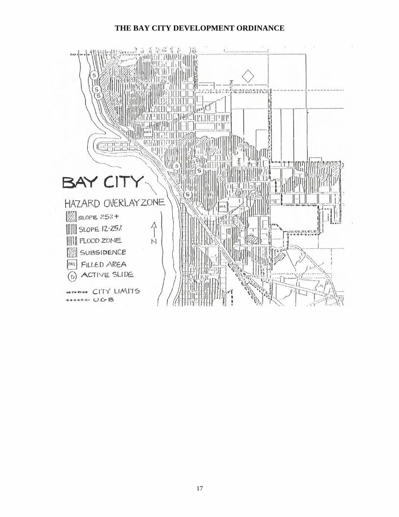
Section 1.7 Hazards Overlay Zone (HZ)
Section 1.701 Purpose. The purpose of this zone is to mitigate potential building hazards and threats to life and property created by flooding, landslides, weak foundation soils, and other hazards as may be identified and mapped by the City of Bay City or other agency. Building hazards exist throughout the other zones of the City, but specific parcels which lie wholly or partially in an area of identified hazards are considered to be in the Hazards Overlay Zone.
These policies and standards are intended to mitigate potential building hazards
by requiring the study of such areas by a qualified person prior to construction, by reducing building intensity in these areas where appropriate, and by requiring special construction techniques for ground disturbing activities.
Section 1.702 Geologic Hazards Areas. Within an identified geologic hazard area or within a site that contains identified
geologic hazards a geologic hazard assessment report and geotechnical engineering report, when required, shall be prepared for any building permit where ground alteration or disturbance is proposed and for any subdivision, partition, or planned development. The City or Planning Commission may require additional boundaries of the study area.
a. The proposed use will be permitted only if: 1) The site investigation provides a finding that there is no significant
building hazard on the property or on surrounding properties which could threaten the safety of a proposed development; or
2) A feasible engineering solution to the building hazard(s) is proposed which could eliminate the hazard to the proposed structure or surrounding properties.
b. The following are specific Geologic Hazards to which the standards of this
Section apply:
c. Slopes less than 12%: Where development is proposed on areas mapped as 12% or less, the
presence of non-engineered fills, sinkholes, identified drainages, adverse drainage conditions, or proposed cuts and fills exceeding 4 feet in height, or landslides will require the submittal of a geologic or geotechnical engineering assessment.
1) Slopes in the 12% to 25% range: A site analysis shall determine the presence of soil creep, fills, or
signs of past instability. If hazards are present, engineering recommendations shall be provided. If conditions require recommendations for foundation construction outside of the
18

THE BAY CITY DEVELOPMENT ORDINANCE
International Building Code (IBC), those recommendations shall be provided by an appropriately qualified professional engineer. If thorough examination of the site determines that no hazards are present, documentation by an appropriately qualified professional shall be submitted with application for development permit.
2) Slopes greater than 25%:
Geologic assessment and engineering plans and recommendations shall be provided. These reports and recommendations shall include: (a) Subsurface exploration of areas above, below, and alongside
known or suspected slides (b) Accurate identification and measurement of the limits of the
slide mass (c) Identification of the stability of the slide mass and the
mechanics of slide movement. (d) Identification of the orientation of bedding planes in relation to
the dip of the surface slope (e) Identification of the soil depth (f) Identification of the water drainage patterns (g) A site specific grading and erosion control plan for site
stabilization and construction (h) The methodology for determining the site stabilization plan (i) Recommendation of suitable setbacks, keeping in mind the
anticipated life of the structure or development. c. Sinkholes:
Areas within 50 feet of areas mapped as having sinkholes or potential sinkholes shall be evaluated by a Certified Engineering Geologist or appropriately qualified Registered Geologist and engineering recommendations provided by an appropriately qualified professional engineer for each identified hazard.
d. Fills:
For ground alteration within areas that contain non-engineered fills a report by an appropriately qualified professional shall perform subsurface exploration to determine and document whether any unsuitable materials exist that may adversely affect building foundations, utilities, or pavements. This documentation shall be submitted with application for building or development permit. If conditions require recommendations for foundation construction outside of the International Building Code (IBC), those recommendations shall be provided by an appropriately qualified professional engineer.
e. Tide Flats:
Due to concern for the presence of peat and the settlement-sensitive nature of the native sandy and silty soils this area requires a subsurface
19

THE BAY CITY DEVELOPMENT ORDINANCE
exploration, soils laboratory testing, settlement analysis, and foundation construction design and recommendations by an appropriately qualified professional engineer.
Section 1.703 Geologic Hazard Zone Standards. a. Report Detail:
The extent and detail of the reports shall be consistent with the requirements of Oregon State Board of Geologist Examiners (OSBGE) and Oregon State Board of Examiners for Engineering and Land Surveying (OSBEELS) and shall be commensurate with the degree of the suspected or mapped hazard, ranging from brief written evaluations of moderate slope hazards to in-depth evaluation of potential landslide areas.
b. Dual Stamping Reports:
In cases where both engineering geology and geotechnical engineering are required, reports shall contain the signatures and stamps of both appropriately qualified professionals and shall define for which portion of the report each professional is responsible.
c. Hazardous Site Conditions:
If hazardous conditions occur during site development, the city may require the property owner and / or developer to provide geologic assessment reports and / or engineering recommendations and plans to mitigate adverse conditions.
If timely submittal of requested reports is not provided, commensurate with
the hazard, the City may hire its own appropriately qualified professional to provide addendum to or review of reports and plans submitted and shall bill the cost to the developer.
d. Required Certifications and Inspections: For any geologic assessment report and geotechnical engineering report
submitted, the registered professional of record shall be required to: 1) Review final plans for development and submit a signed and stamped
certification report that all recommendations have been incorporated into development plans.
2) Review subgrade excavations and fills for structures and stormwater drainage and submit a signed and stamped certification report that all recommendations have been met.
3) Perform a final inspection of the site and submit a signed and stamped certification report that all recommendations have been met.
20

THE BAY CITY DEVELOPMENT ORDINANCE
e. Stormwater Drainage Surface water flowing from an existing property or new development shall
be controlled such that it does not negatively impact adjacent public or private property by increasing flow, concentrating flow, or stimulating erosion that was not present beforehand.
All new construction shall incorporate basement and foundation drainage to
control water and keep it from crawl space, under-slab, and below grade areas. Ground water control can range from perforated PVC pipe for foundation drains to engineered retaining wall drainage systems.
If unanticipated storm water drainage problems arise during or after
development, the City of Bay City may require the property owner to mitigate the situation up to and including the submittal and installation of a detailed engineered storm water drainage plan approved by the city.
f. Flood Hazards
The flood protection requirements of the City Flood Damage Prevention Ordinance shall be adhered to for all development in identified flood areas. In all flood hazard areas, engineered stormwater drainage plans, flood elevation certificates, and post flood elevation certificates shall be required.
g. Peer Review
Where the development has the potential to adversely impact adjacent properties, the city may retain appropriately qualified professionals to review the submitted reports at the cost of the developer. The boundaries of the study area shall be determined by the Planning Commission.
Section 1.704 Application Information Required: a. Geologic Assessment Reports shall include at least the following
information. Additional information, commensurate with the level of hazard shall be submitted.
1) Identification of potential hazards to life, public and private property,
adjacent property, surrounding areas, and the natural environment which may be caused by the proposed development.
2) Mitigation methods for protecting the property and surrounding areas from each potential hazard.
3) Development density shall be as follows unless report findings provide recommendations for higher densities. The density of the underlying zone shall be an additional limiting factor:
(a) 12% - 24% slope: Density should generally not exceed 2 dwelling units per acre.
21

THE BAY CITY DEVELOPMENT ORDINANCE
(b) 25% - 35% slope: Density should generally not exceed 1 dwelling unit per acre.
(c) 35% slope or greater: Construction is permitted only on sites where footings can be anchored in base rock.
4) Identification of soils and bedrock types 5) Identification of soil depth 6) Water drainage patterns 7) Identification of visible landslide activity in the immediate area 8) History of mud or debris flow
9) In areas prone to landslide, mudflow and where slopes exceed 25%, reports shall identify the Orientation of bedding planes in relation to the dip of the surface slope
10) Recommendations for removal, retention, and placement of trees and vegetation
11) Recommendations for placement of all structures, on site drives, and roads
12) Recommendations for protecting the surrounding area from any adverse effects of the development.
b. Site development plans drawn to a measurable scale shall include at least
the following information. Additional information, commensurate with the level of hazard shall be submitted. The city may require that specific items be submitted on separate sheets for clarity and site inspection purposes.
1) Topographical contour maps indicating existing and finished grades the location of structures, on site drives, parking areas, roads, and other site improvements
2) Stormwater Drainage Plans; engineering shall be required where drainage hazards are identified.
3) Grading and Erosion Control Plans consistent with the requirements of Bay City Development Ordinance Section 3.25; engineered plans shall be required where grading and drainage hazards are identified.
4) Foundation design, if design outside of the International Building Code is necessary
5) Road Design; engineering shall be required where drainage hazards are identified.
Section 1.705 Liability. The degree of protection from problems caused by geologic hazards which is
required by this section is considered reasonable for regulatory purposes. This Ordinance does not imply that uses permitted will be free from geologic hazards. This Ordinance shall not create liability on the part of the City or by any agents,
22

THE BAY CITY DEVELOPMENT ORDINANCE
officers, employee, or official thereof for any damages due to geologic hazards that result from reliance on this Ordinance or any administrative decision lawfully made thereunder. (Amended Ord. #630, 05-07)
Section 1.750 Freshwater Wetland Overlay Zone (FW) Section 1.751 Purpose. The purpose of the Freshwater Wetland Zone is to conserve significant
freshwater wetlands, including and especially the shoreland and aquatic environment of Bay City's creeks.
Section 1.752 Zone Boundaries. The boundaries of the Freshwater Wetland Zone shall be those
shown on the map titled "Significant Freshwater Wetlands of Bay City" on file at the City Hall.
Section 1.753 Uses Permitted. In a FW Zone, the following uses are permitted outright subject
to standards listed in Section 1.755:
a. Low intensity recreation. b. Habitat restoration measures. c. Vegetation shoreline stabilization. d. Submerged cable, sewer line, waterline or other pipeline.
Section 1.754 Conditional Uses Permitted. In a FW Zone, the following uses are permitted
subject to the provisions of Article 2.
a. Dredging or grading for purposes of mitigation. b. Structural shoreline stabilization. c. Individual docks for recreation or fishing, including necessary piling. d. Public parks and recreation associated low intensity development such as
docks, raised walkways, and foot paths. e. Stormwater outfalls.
Section 1.755 FW Zone Standards. In a FW Zone the following standards shall apply:
a. All activities involving construction or alteration in wetlands or aquatic areas shall be reviewed by the Oregon Division of State Lands and the U.S. Army Corps of Engineers to determine permit applicability. If these agencies determine that they have jurisdiction over a proposed use or activity, no construction or alteration shall commence until a permit has
23

THE BAY CITY DEVELOPMENT ORDINANCE
been obtained. b. Riparian vegetation shall be maintained consistent with standards of
Section 3.105. c. Fill may be permitted only if all of the following criteria are met:
1) If required for a water-dependent use requiring an aquatic location, or
if specifically allowed in the FW Zone; and 2) A substantial public benefit is demonstrated; and 3) The proposed fill does not unreasonably interfere with public trust
rights; and 4) Feasible upland alternative locations do not exist; and 5) Adverse impacts are minimized.
d. A fill shall cover no more area than the minimum necessary to accomplish
the proposed use.
e. Projects involving fill may be approved only if the following alternatives are examined and found to be infeasible:
1) Construct some or all of the project on piling; 2) Conduct some or all of the proposed activity on existing upland areas; 3) Approve the project at a feasible alternative site where adverse
impacts are less significant.
f. Dredging shall be allowed only:
1) If a substantial public benefit is demonstrated; and 2) If the use or alteration does not unreasonably interfere with public
trust rights; and 3) If no feasible alternative upland locations exist; and 4) If adverse impacts are minimized.
g. When dredging is permitted, the dredging shall be the minimum necessary
to accomplish the proposed use.
24

THE BAY CITY DEVELOPMENT ORDINANCE
h. Piling installation may be allowed only if all of the following criteria are met:
1) A substantial public benefit is demonstrated; and 2) The proposed use does not unreasonably interfere with public trust
rights; and 3) Feasible alternative upland locations do not exist; and
4) Potential adverse impacts are minimized.
i. Shoreline stabilization measures shall meet the criteria in Section 1.755. j. The draining of a wetland area is prohibited except as may be necessary for
a permitted or conditional use.
k. The removal of trees or other vegetation from a wetland area is prohibited except as such removal may be necessary for a permitted or conditional use, for perimeter mowing to remove fire hazards, or in a clear vision area.
Section 1.8 Shoreland Zones (S1, S2,) Section 1.801 Purpose: The purpose of the shoreland zones is to identify and regulate uses
within the City's shoreland areas in order to implement the Coastal Shoreland Goal and the policies of the Bay City Comprehensive Plan. The shoreland area is divided into two subsections or zones, based on their suitability for development or conservation. The uses permitted in each shoreland zone are listed in the Use Matrix, Section 1.3.
Section 1.802 Review by the Planning Commission
All uses in the Shoreland zones, except single-family structures, accessory uses, manufactured homes and duplexes, are conditional uses.
The Planning Commission shall review conditional uses by the procedures of Article 2 of this Ordinance. In addition to the criteria of Article 2, the following standards shall be used by the Planning Commission:
Section 1.810 Shoreland Zone 1 Standards Section 1.811 Purpose: The purpose of the Shoreland 1 Zone is to provide for uses and
activities that are consistent with the area's unique natural values and limited development opportunities.
Section 1.812 Minimum Lot Coverage . . . . . . . . . . . . . none
25

THE BAY CITY DEVELOPMENT ORDINANCE
Section 1.813 Maximum Open Space . . . . . . . . . . . . . . none Section 1.814 Minimum Landscaped Open Area
A minimum of 5% of the total lot area shall be maintained in landscaped open area.
Section 1.815 Minimum Lot Size . . . . . . . . . . . . . . . none Section 1.816 Maximum Building Height . . . . . . . . . . 24 feet Section 1.817 Uses Allowed
Refer to the Use Matrix, Section 1.3
Section 1.818 Setback Requirements . . . . . . . . . . . . . none Section 1.819 Parking Requirements
Refer to Section 3.5
Section 1.820 Sign Requirements
Refer to Section 3.8
Section 1.821 Estuary and Shoreland Standards
All uses and activities shall satisfy the applicable Estuary and Shoreland Standards in Section 2.22.
Section 1.822 Additional Standards
a. Riparian vegetation adjacent to the Larson Cove estuarine area shall be protected and retained with the following exceptions:
1) The removal of dead, diseased, or dying trees which pose an erosion
or safety hazard.
2) Vegetation removal necessary to provide direct water access for a water-dependent use.
3) Vegetation removal necessary to place structural shoreline
stabilization when other forms of shoreline stabilization are shown to be inadequate.
26

THE BAY CITY DEVELOPMENT ORDINANCE
b. Land in this zone shall not be used as part of density calculations for development in adjacent areas.
Section 1.830 Shoreland Zone 2 Standards Section 1.831 Purpose: The purpose of the Shoreland 2 Zone is to manage shoreland areas
which are especially suited for water-dependent industrial, commercial, or recreational use. Water-dependent uses have the highest priority, followed by water-related uses. Uses which are not water-dependent or water-related may be provided for when they do not preclude or conflict with existing or probable future water-dependent uses of the site.
Section 1.832 Water Dependent Zone Standards Section 1.833 Maximum Lot Coverage . . . . . . . . . . . . none Section 1.834 Minimum Open Space . . . . . . . . . . . . . none Section 1.835 Minimum Landscaped Open Area
A minimum of 5% of the total lot area shall be maintained in landscaped open area.
Section 1.836 Minimum Lot Size . . . . . . . . . . . . . . none Section 1.837 Maximum Building Height
A maximum building height of 24 feet.
Section 1.838 Uses Allowed
Refer to the Use Matrix, Section 1.3
Section 1.839 Overall Use Criteria
No use or activity will be allowed in the Shoreland 2 Zone unless it meets one of the following criteria:
a. It is water-dependent, which means that it is a use or activity which can be
carried out only on, in, or adjacent to water areas because the use required access to the water body for water-borne recreation, energy production, or source of water.
b. It is water-related, which means that it provides goods and/or services that
are directly associated with a water-dependent use (supplying materials to, or using products of, or offering commercial or personal service to
27

THE BAY CITY DEVELOPMENT ORDINANCE
water-dependent uses); and if not located near the water, would experience a public loss of quality in the goods and services offered (evaluation of public loss of quality shall involve a subjective consideration of economic, social, and environmental consequences of the use).
c. Uses that are not water-dependent shall be shown not to preclude or
conflict with existing or probable future water-dependent use on the site or in the vicinity.
d. A temporary use which invokes minimal capital investment and no
permanent structures, or a use in conjunction with and incidental to a water-dependent use.
Section 1.840 Setback Requirements . . . . . . . . . . . . . none Section 1.841 Parking Requirements
Refer to Section 3.5
Section 1.842 Sign Requirements
Refer to Section 3.8 Section 1.843 Estuary and Shoreland Standards
All uses and activities shall satisfy the applicable Estuary and Shoreland Standards in Section 2.22.
Section 1.844 Additional Standards
a. Public access to the waterfront shall be provided, except where it is
demonstrated to the satisfaction of the Planning Commission that public access is not feasible due to safety, security, or other valid reason.
b. Riparian Vegetation - All structures and uses shall be set back twenty-five
(25) feet from Patterson Creek unless direct water access is required in conjunction with a water-dependent use. The setback shall be measured from the mean higher high water line in estuarine portions and the ordinary high water line for non-estuarine portions of the stream.
Riparian vegetation shall be protected and retained within twenty-five (25) feet of the creek with the following exceptions:
1) The removal of dead, diseased, or dying trees which pose an erosion
or safety hazard.
28

THE BAY CITY DEVELOPMENT ORDINANCE
2) Vegetation removal necessary to provide direct water access for a water-dependent use.
3) Vegetation removal necessary to place structural shoreline
stabilization when other forms of shoreline stabilization are shown to be inadequate.
Section 1.860 Estuary Zones, Areas Included, and Uses Permitted Outright
Estuary Zones shall be applied to all estuarine water, intertidal areas, submerged and submersible lands, and tidal wetlands up to the line of non-aquatic vegetation of the Mean Higher High Water (MHHW) line, whichever is most landward.
Section 1.861 Uses Permitted Outright (P)
The following uses are permitted outright within all estuary zones:
a. Maintenance and repair of existing structures or facilities not involving a
regulated activity.
For the purpose of the ordinance, "existing structures and facilities" are defined as structures or facilities in current use or good repair as of date of adoption of this ordinance (including structures or facilities which are in conformance with the requirements of this ordinance and nonconforming structures or facilities established prior to October 7, 1977.)
b. Low intensity, water-dependent recreation, including but not limited to
fishing, crabbing, clamming, wildlife observation, swimming, and hunting.
c. Research and educational observation.
d. Passive restoration.
e. Dike maintenance and repair for:
1) Existing serviceable dikes (including those that allow some seasonal inundation.)
2) Dikes that have been damaged by flooding, erosion, or tidegate
failure where the property has not reverted to an estuarine habitat. 3) Dikes that have been damaged by flooding, erosion, or tidegate
failure where the property has reverted to estuarine habitat only if the property is in the Farm F-1 Zone and it has been in agricultural use for 3 of the last 5 years and reversion to estuarine habitat has not occurred more than 5 years prior.
29

THE BAY CITY DEVELOPMENT ORDINANCE
Bay City will rely on the U.S. Army Corps of Engineers and the Division of State Lands to determine whether an area has reverted to estuarine influence.
For the purpose of this subsection, agricultural use means using an area for pasture several months of the year or harvesting this area once a year.
f. Grazing of livestock.
g. Fencing, provided that it is not placed across publicly-owned intertidal
areas so as to restrict public access to, or recreational boating access across said lands and intertidal areas.
Section 1.870 Estuary Natural Zone (EN) Section 1.871 Purpose and Areas Included
The purpose of the EN Zone is to provide for preservation and protection of significant fish and wildlife habitats and other areas which make an essential contribution to estuarine productivity or fulfill scientific, research or educational needs.
The EN Zone includes the following areas within the estuary: major tracts of tidal marsh, intertidal flats, and seagrass and algae beds. The "major tract" determination is made through a consideration of all the following five criteria: size, habitat, value, scarcity, and degree of alteration.
Section 1.872 Uses Permitted with Standards (PS)
The following uses are permitted with standards within the EN Zone, provided that the development standards in Section 2.22 have been met:
a. Maintenance and repair of existing structures or facilities involving
regulated activity.
b. Navigational aids. c. Vegetative shoreline stabilization.
d. Temporary dikes for emergency flood protection.
e. Mooring buoy.
f. Tidegate installation in existing functional dike.
30

THE BAY CITY DEVELOPMENT ORDINANCE
g. Bridge crossings and bridge crossing support structures. Section 1.873 Conditional Uses (C)
The following uses are Conditional within the EN Zone and may be permitted by the Planning Commission, subject to the provisions of Article 2 and the development standards in Section 2.22:
a. Aquaculture and water dependent portions of aquaculture facilities which
do not require dredging or fill.
b. Rip-rap to protect unique natural resources, historical and archaeological values, public facilities and uses existing as of October 7, 1977; and uses allowed by this zone.
c. Water, sewer, gas, or phone lines.
d. Electrical distribution lines and line support structure.
e. Active restoration and estuarine enhancement.
f. Temporary low water bridges.
g. Temporary alterations.
h. Boat ramps for public use where no dredging or fill for navigational access
is needed.
i. Water intake structures for out-bay aquaculture. Section 1.874 Regulated Activities (RA)
The following regulated activities are permitted within the EN Zone, provided that the requirements of Section 2.22 have been met. Regulated Activities shall be reviewed by the procedure provided in Section 2.310:
a. Regulated activities for the purpose of on-site maintenance and repair of
existing structures or facilities, limited to:
1) Dredging for on-site maintenance of:
Drainage tiles. Drainage ditches. Tidegates. Bridge crossing support structures. Water, sewer, gas, or phone lines.
31

THE BAY CITY DEVELOPMENT ORDINANCE
Electrical distribution lines. Outfalls.
2) Fill or rip-rap for on-site maintenance of:
Dikes. Bridge crossing support structures or other land transportation facilities.
b. Rip-rap for structural shoreline stabilization and protection of uses by this
zone.
c. Piling installation for:
1) Navigational aids.
2) Aquaculture facilities permitted as a conditional use.
3) Public boat ramp.
4) Bridge crossing support structures.
d. Dredging for installation of:
1) Water, sewer, gas, or phone lines.
2) Electrical distribution lines.
3) Tidegates in existing functional dikes adjacent to EN Zones.
4) Bridge crossing support structures.
5) Public boat ramps.
e. Regulated activities in conjunction with an approved active restoration or estuarine enhancement project.
f. Regulated activities in conjunction with temporary alterations.
g. Fill for installation of public boat ramps or bridge crossing support
structure.
h. Incidental dredging for harvest of benthic species or removal of in-water structures such as stakes or racks.
Section 1.880 Estuary Conservation 1 (EC1) Zone
32

THE BAY CITY DEVELOPMENT ORDINANCE
Section 1.881 Purpose and Areas Included
a. The purpose of the EC1 Zone is to:
1) Provide for long-term utilization of areas which support, or have the potential to support, valuable biological resources.
2) Provide for long-term maintenance and enhancement of biological
productivity.
3) Provide for the long-term maintenance of the aesthetic values of estuarine areas, in order to promote or enhance the low intensity recreational use of estuarine areas adjacent to rural or agricultural shorelands.
b. The EC1 Zone includes the following areas within the Tillamook Bay
Estuary:
1) Tracts of tidal marshes, tideflats, seagrass, and algae beds which are smaller or of less biological importance than those included in the EN or ECA areas.
2) Productive recreational or commercial shell fish and fishing areas.
3) Areas that are partially altered and adjacent to existing development
of moderate intensity which do not possess the resource characteristics of EN or ED units.
4) Areas with potential for shellfish culture (excluding platted oyster
beds in Tillamook Bay). Section 1.882 Uses Permitted with Standards (PS)
The following uses are permitted with standards with the EC1 Zone, provided that the development standards in Section 2.22 have been met:
a. Maintenance and repair of existing structures or facilities involving a
regulated activity.
b. Navigational aid.
c. Vegetative shoreline stabilization.
d. Structural shoreline stabilization, limited to rip-rap.
33

THE BAY CITY DEVELOPMENT ORDINANCE
e. Boat dock in conjunction with one or more private residences (Single-purpose private docks shall be limited to a maximum of 150 square feet in size.).
f. Water, sewer, gas, or phone lines.
g. Electrical distribution lines and line support structures.
h. Active restoration and estuarine enhancement.
i. Temporary dikes for emergency flood protection.
j. Temporary low water bridge.
k. Tidegate installation in existing functional dikes adjacent to EC1 Zones.
l. Aquaculture and water-dependent portions of aquaculture facilities not
requiring dredge or fill other than incidental dredging for harvest of benthic species or removal of in-water structures such as stakes or racks.
m. Bridge crossings and bridge crossing support structures.
n. Boat ramps for public use where no dredging or fill for navigational access
is needed.
o. Water intake structures for out-bay aquaculture. Section 1.883 Conditional Uses (C)
The following uses are conditional within the EC1 Zone, and may be permitted by the Planning Commission, subject to the provisions of Article 2 and the Development standards in Section 2.22:
a. Water-dependent portion of aquaculture facilities which require dredge or
fill.
b. Water-dependent recreational facilities, including:
1) Boat ramps, requiring dredging or fill for navigational access.
2) Community boat docks in conjunction with a subdivision or planned development.
3) Public or commercial docks and moorages for recreational marine
craft (including seaplanes) and accessory uses not requiring the use of fill or the occupation of additional estuarine surface area.
34

THE BAY CITY DEVELOPMENT ORDINANCE
c. Mining or mineral extraction.
d. Storm water and treated sewer outfall.
e. Bulkheads for structural shoreline stabilization.
f. Temporary alterations.
g. Minor navigational improvements.
Section 1.884 Regulated Activities (RA)
The following regulated activities are permitted within the EC1 Zone, provided that the requirements of Section 2.22 have been met; regulated activities shall be reviewed by the procedure provided in Section 2.310:
a. Regulated activities for the purpose of on-site maintenance and repair of
existing structures or facilities, limited to:
1) Dredging for on-site maintenance of:
Drainage tiles. Drainage ditches. Tidegates. Bridge crossing support structures. Water, sewer, gas, or phone lines. Electrical distribution lines. Outfalls.
2) Fill or rip-rap for on site maintenance of:
Dikes. Bridge crossing support structures or other land transportation facilities.
b. Piling installation for:
1) Water-dependent recreational facilities.
2) Aquaculture facilities.
3) Navigational aids.
4) Bridge crossing support structures or other land transportation
facilities.
35
THE BAY CITY DEVELOPMENT ORDINANCE
5) Bulkheads.
c. Rip-rap for structural shoreline stabilization and protection of uses allowed
by this zone.
d. Dredging for:
1) Bridge crossing support structure installation.
2) Storm water or treated sewage outfall installation.
3) Water, sewer, gas, or phone line installation.
4) Electrical distribution line installation.
5) Mining or mineral extraction.
6) Tidegate installation in existing functional dikes adjacent to EC1 Zones.
7) Water intake facilities.
8) Boat ramps.
9) Minor navigational improvements.
10) Water-dependent portions of aquaculture facilities.
e. Fill for:
1) Bridge crossing support structures.
2) Structural shoreline stabilizations.
3) Boat ramps.
4) Water-dependent portions of aquaculture facilities.
f. Regulated Activities in conjunction with an approved active restoration or
estuarine enhancement project.
g. Incidental dredging for harvest of benthic species or removal of in-water structures such as stakes or racks.
h. Regulated activities in conjunction with temporary alterations.
36

THE BAY CITY DEVELOPMENT ORDINANCE
Section 1.890 Estuary Conservation 2 (EC2) Zone Section 1.891 Purpose and Areas Included
a. The purpose of the EC2 Zone is to:
1) Provide for long-term use of renewable resources that do not require major alterations of the estuary except for purposes of restoration.
2) Other than minor navigational improvements, aquaculture facilities
and water-dependent recreational facilities, provide for new water-dependent industrial and commercial uses only where dredging and filling are not necessary and where consistent with the resource capabilities of the area and purposes of the management unit.
b. The EC2 Zone includes the following areas:
1) Tracts of significant habitat not included in EN or EC1 Zones.
2) Areas containing existing water-dependent facilities which require
periodic dredging to maintain water access.
3) Partially altered estuarine areas or estuarine areas adjacent to existing water-dependent development and which do not otherwise qualify for EN, Estuary, or ED designations.
4) Subtidal channel areas which require minor navigational
improvements. Navigable areas which are adjacent to urbanized areas, which do not qualify for EN, ECA, or EC1 designation and which are not federally authorized and maintained navigation channels.
Section 1.892 Uses Permitted with Standards (PS)
The following uses are permitted with Standards within the EC2 Zone, provided that the development standards in Section 2.22 have been met:
a. Aquaculture and water-dependent portions of aquaculture facilities not
requiring dredging or fill other than incidental dredging for harvest of benthic species or removable in-water structures such as stakes or racks.
b. Navigational aid.
c. Vegetative shoreline stabilization.
37
THE BAY CITY DEVELOPMENT ORDINANCE
d. Structural shoreline stabilization, limited to rip-rap.
e. Boat dock in conjunction with one or more private residences (Single-purpose private docks shall be limited to a maximum of 150 square feet in size).
f. Tidegate installation in existing dikes adjacent to EC2 Zones.
g. Water, sewer, gas, or phone lines.
h. Electrical distribution lines and line support structures.
i. Temporary dikes for emergency flood protection.
j. Active restoration and estuarine enhancement.
k. Temporary low water bridges.
l. Water intake facilities for out-bay aquaculture requiring dredge or fill.
m. Boat ramps for public use where no dredging or fill for navigation access is
needed.
n. Maintenance and repair of existing structures or facilities involving a regulated activity.
o. Bridge crossing and bridge crossing support structures.
Section 1.893 Conditional Uses (C)
The following uses are Conditional within the EC2 Zone and may be permitted by the Planning Commission, subject to the provisions of Article 2 and the development standards in Section 2.2:
a. Water-dependent recreational facilities, including:
1) Boat ramps which require dredging or fill for navigational access.
2) Community boat docks in conjunction with a subdivision or planned
development.
3) Public or commercial docks, moorages, and marinas for recreational marine craft (including seaplanes) and accessory uses not requiring the use of fill or the occupation of additional estuarine surface area.
b. Water-dependent commercial facilities not requiring the use of dredging or
38
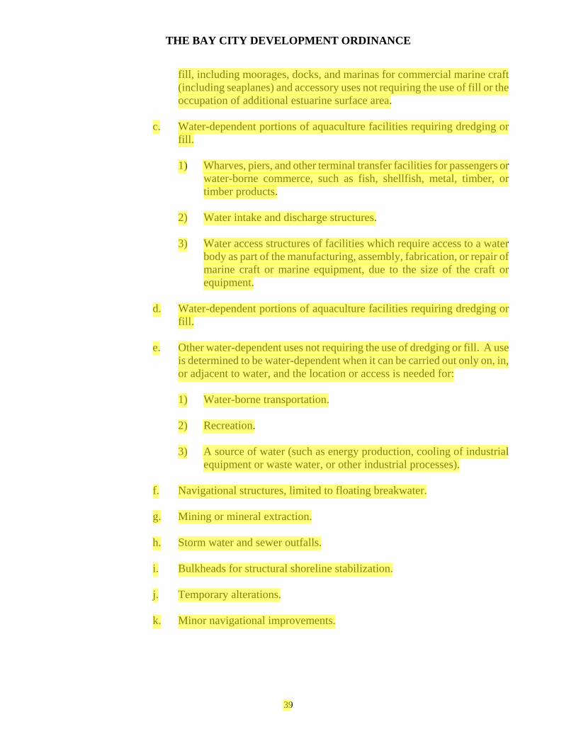
THE BAY CITY DEVELOPMENT ORDINANCE
fill, including moorages, docks, and marinas for commercial marine craft (including seaplanes) and accessory uses not requiring the use of fill or the occupation of additional estuarine surface area.
c. Water-dependent portions of aquaculture facilities requiring dredging or
fill.
1) Wharves, piers, and other terminal transfer facilities for passengers or water-borne commerce, such as fish, shellfish, metal, timber, or timber products.
2) Water intake and discharge structures.
3) Water access structures of facilities which require access to a water
body as part of the manufacturing, assembly, fabrication, or repair of marine craft or marine equipment, due to the size of the craft or equipment.
d. Water-dependent portions of aquaculture facilities requiring dredging or
fill.
e. Other water-dependent uses not requiring the use of dredging or fill. A use is determined to be water-dependent when it can be carried out only on, in, or adjacent to water, and the location or access is needed for:
1) Water-borne transportation.
2) Recreation.
3) A source of water (such as energy production, cooling of industrial
equipment or waste water, or other industrial processes).
f. Navigational structures, limited to floating breakwater.
g. Mining or mineral extraction.
h. Storm water and sewer outfalls.
i. Bulkheads for structural shoreline stabilization.
j. Temporary alterations.
k. Minor navigational improvements.
39

THE BAY CITY DEVELOPMENT ORDINANCE
Section 1.894 Regulated Activities (RA)
The following regulated activities are permitted within the EC2 Zone, provided that the requirements of Section 2.2 have been met. Regulated activities shall be reviewed by the procedure provided in Section 2.310:
a. Regulated activities for the purpose of on-site maintenance and repair of
existing structures or facilities, limited to:
1) Dredging for on-site maintenance of:
Drainage tiles. Drainage ditches. Tidegates. Bridge crossing support structures. Water, sewer, gas, or phone lines. Electrical distribution lines. Outfalls.
2) Fill or rip-rap for on-site maintenance of:
Dikes. Bridge crossing support structures or other land transportation facilities. Shoreline stabilization structures.
b. Piling installation for:
1) Water-dependent industrial, commercial, or recreational facilities.
2) Water-dependent portions of aquaculture facilities or aquaculture
operations.
3) Navigational aids.
4) Bulkheads.
5) Bridge crossing support structures.
c. Dredging for:
1) Maintenance of existing facilities. 2) Minor navigational improvements.
3) Water-dependent recreational activities.
40
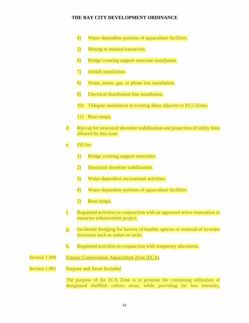
THE BAY CITY DEVELOPMENT ORDINANCE
4) Water-dependent portions of aquaculture facilities.
5) Mining or mineral extraction.
6) Bridge crossing support structure installation.
7) Outfall installation.
8) Water, sewer, gas, or phone line installation.
9) Electrical distribution line installation.
10) Tidegate installation in existing dikes adjacent to EC2 Zones.
11) Boat ramps.
d. Rip-rap for structural shoreline stabilization and protection of utility lines
allowed by this zone.
e. Fill for:
1) Bridge crossing support structures.
2) Structural shoreline stabilization.
3) Water-dependent recreational activities.
4) Water-dependent portions of aquaculture facilities.
5) Boat ramps.
f. Regulated activities in conjunction with an approved active restoration or estuarine enhancement project.
g. Incidental dredging for harvest of benthic species or removal of in-water
structures such as stakes or racks.
h. Regulated activities in conjunction with temporary alterations. Section 1.900 Estuary Conservation Aquaculture Zone (ECA) Section 1.901 Purpose and Areas Included
The purpose of the ECA Zone is to promote the continuing utilization of designated shellfish culture areas, while providing for low intensity,
41

THE BAY CITY DEVELOPMENT ORDINANCE
water-dependent recreation, commercial and recreational fishing and crabbing and protecting the significant biological productivity of major tracts of fish and wildlife habitat and areas needed for scientific research or educational purposes.
a. Areas which are in existing aquaculture use and which are subject to a valid
oyster growing lease from the Division of State Lands pursuant to ORS 509 and 510.
b. Other areas suitable for aquaculture which do not qualify as natural
management units. Section 1.902 Uses Permitted with Standards (PS)
The following uses are permitted with standards within the ECA Zone, provided that the development standards in Section 2.22 have been met:
a. Aquaculture facilities, limited to temporary or easily removable structures
(stakes, racks, trays, long-lines, or rafts) for the culture of oysters or other shellfish.
b. Navigational aids.
Section 1.903 Conditional Uses (C)
The following uses are Conditional within the ECA Zone, and may be permitted by the Planning Commission, subject to the provisions of Article 2 and the development standards in Section 2.22:
a. Active restoration and estuarine enhancement.
b. Structural shoreline stabilization, limited to rip-rap.
c. Temporary alterations.
Section 1.904 Regulated Activities (RA)
The following Regulated Activities are permitted within the ECA Zone, provided that the requirements of Section 2.22 have been met. Regulated activities shall be reviewed by the procedure provided in Section 2.310:
a. Piling installation for:
1) Anchoring of bottom or in-the-water structures used for aquaculture.
2) Navigational aids.
42

THE BAY CITY DEVELOPMENT ORDINANCE
b. Regulated activities in conjunction with an approved active restoration or
estuarine enhancement project.
c. Structural shoreline stabilization limited to rip-rap.
d. Incidental dredging for harvest of benthic species or removal of in-water structures such as stakes or racks.
e. Regulated activities in conjunction with temporary alterations.
Section 1.910 Estuary Development Zone (ED) Section 1.911 Purpose and Areas Included
a. The purpose of the Estuary Development Zone is to:
1) Provide for long-term maintenance, enhancement, expansion, or creation of structures or facilities for navigational and other water-dependent commercial, industrial, or recreational uses.
2) Provide for the expansion or creation of other commercial, industrial
or recreational facilities, subject to the general use priorities outlines in Section 2.22.
b. The ED Zone includes the following areas within Development Estuaries:
1) Areas which contain public facilities which are utilized for shipping,
handling, or storage or water-borne commerce, or for moorage or fueling of marine craft.
2) Subtidal channel areas adjacent or in proximity to the shoreline which
are currently used or needed for shallow draft navigation (including authorized, maintained channels and turning basins).
3) Areas of minimum biologic significance needed for uses requiring
alteration of the estuary not included in EN, ECA, EC1, or EC2 Zones.
Section 1.912 Uses Permitted with Standards (PS)
The following uses are Permitted with Standards within the ED Zone, provided that the development standards in Section 2.2 have been met:
a. Maintenance and repair of existing structures or facilities involving a
regulated activity.
43
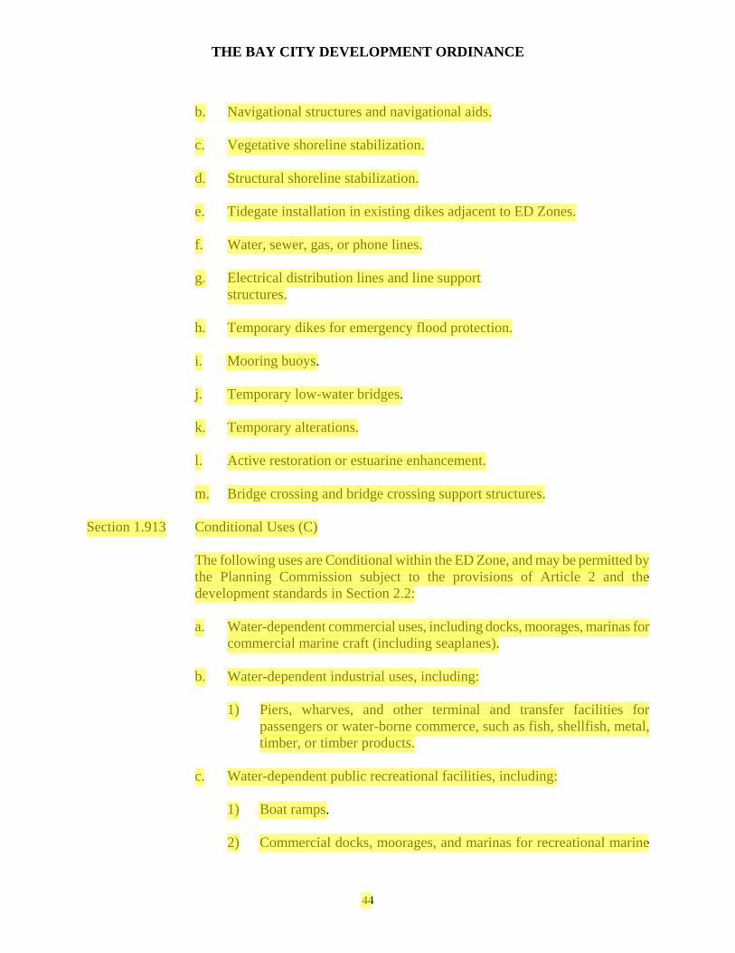
THE BAY CITY DEVELOPMENT ORDINANCE
b. Navigational structures and navigational aids.
c. Vegetative shoreline stabilization.
d. Structural shoreline stabilization.
e. Tidegate installation in existing dikes adjacent to ED Zones.
f. Water, sewer, gas, or phone lines.
g. Electrical distribution lines and line support
structures.
h. Temporary dikes for emergency flood protection.
i. Mooring buoys.
j. Temporary low-water bridges.
k. Temporary alterations.
l. Active restoration or estuarine enhancement.
m. Bridge crossing and bridge crossing support structures. Section 1.913 Conditional Uses (C)
The following uses are Conditional within the ED Zone, and may be permitted by the Planning Commission subject to the provisions of Article 2 and the development standards in Section 2.2:
a. Water-dependent commercial uses, including docks, moorages, marinas for
commercial marine craft (including seaplanes).
b. Water-dependent industrial uses, including:
1) Piers, wharves, and other terminal and transfer facilities for passengers or water-borne commerce, such as fish, shellfish, metal, timber, or timber products.
c. Water-dependent public recreational facilities, including:
1) Boat ramps.
2) Commercial docks, moorages, and marinas for recreational marine
44

THE BAY CITY DEVELOPMENT ORDINANCE
craft (including seaplanes).
d. Aquaculture and water-dependent portions of aquaculture facilities.
e. Other water-dependent uses. A use is determined to be water-dependent when it can be carried out only on, in, or adjacent to the water, and the location of access is needed for:
1) Water-borne transportation.
2) Recreation.
3) A source of water (such as energy production, cooling of industrial
equipment or wastewater, or other industrial processes).
f. Water-related industrial uses not requiring the use of fill, including, but not limited to:
1) Fish or shellfish processing plants.
2) Warehouse and/or other storage areas for marine equipment or
water-borne commerce.
g. Water-related commercial uses not requiring the use of fill, including, but not limited to: 1) Fish or shellfish retail or wholesale outlets.
2) Marine craft or marine equipment sales establishments.
3) Sport fish cleaning, smoking, or canning establishment.
4) Charter fishing offices.
5) Retail trade facilities in which the majority of products are products
such as ice, bait, tackle, nautical charts, gasoline, or other products incidental to or used in conjunction with a water-dependent use.
6) Restaurants which provide waterfront views and which are in
conjunction with a water-dependent or water-related use such as a seafood processing plant or charter office.
h. In-water sorting, storage, and handling of logs in association with
water-borne transportation of logs.
i. Other water-related uses not requiring the use of fill. A use is determined
45

THE BAY CITY DEVELOPMENT ORDINANCE
to be water-related when the use:
1) Provides goods and/or services that are directly associated with water-dependent uses (supplying materials to, or using products of, water-dependent uses).
2) If not located near the water, would experience a public loss of
quality in the goods and services offered. Evaluation of public loss of quality will involve a subjective consideration of economic, social, and environmental consequences of the use.
j. Accessory uses or structures in conjunction with a conditional use listed in
A-H above, limited in size to a maximum of 10% of the lot or parcel size.
k. Mining and mineral extraction.
l. Storm water and sewer outfalls.
m. Non-water-dependent and non-water-related uses not requiring the use of fill.
n. New dike construction if:
1) Required for a water-dependent use for which a substantial public
benefit is demonstrated, the use or alteration does not unreasonably interfere with public trust rights and for which no practicable upland locations exist.
2) Adverse impacts are avoided or minimized to be consistent with the
resource capabilities and purposes of the area. Section 1.914 Regulated Activities (RA)
The following Regulated Activities are permitted within the ED Zone, provided that the requirements of Section 2.2 have been met. Regulated activities shall be reviewed by the procedure provided in Section 2.310:
a. Regulated Activities in association with on-site maintenance and repair of
existing structures or facilities.
b. Dredging for:
1) Maintenance of existing facilities.
2) Navigational improvements.
46

THE BAY CITY DEVELOPMENT ORDINANCE
3) Water-dependent portions of aquaculture operations.
4) Water-dependent uses.
5) Mining and mineral extraction.
6) Bridge crossing support structure installation.
7) Outfall installation.
8) Water, sewer, gas, or phone line installation.
9) Electrical distribution line installation.
10) Tidegate installation in existing dikes adjacent to ED zones.
c. Fill for:
1) Water-dependent uses. 2) Water-dependent portions of aquaculture facilities.
3) Navigational structures or navigational improvements.
4) Structural shoreline stabilization.
5) Bridge crossing support structures.
6) New dike construction.
d. Piling and dolphin installing in conjunction with a Permitted with
Standards or Conditional Use within this zone.
e. Rip-rap for structural shoreline stabilization or protection of utility lines allowed by this zone.
f. Dredged material disposal in an approved DMD site or in conjunction with
an approved fill project, subject to state and federal permit requirements for dredged material disposal.
g. Regulated activities in conjunction with an approved active restoration or
estuarine enhancement project.
h. Flow-lane disposal of dredged material, subject to state and federal permit requirements.
47

THE BAY CITY DEVELOPMENT ORDINANCE
i. Incidental dredging for harvest of benthic species or removal of in-water structures such as stakes or racks.
j. Regulated activities in conjunction with temporary alterations.
Section 1.920 Dredge Material Disposal Site Protection Zone (DMD) Section 1.921 Purpose
The purpose of the Dredge Material Disposal Site Protection Zone is to protect important dredge material that may limit their ultimate use for the deposition of dredge material.
Section 1.922 Designation of Dredge Material Disposal Sites
The DMD overlay zone shall be designated on Bay City's Land Use and Development Map and shall conform to the dimensions of the site(s) specified in the Tillamook/Nehalem Dredge Material Disposal Plan as being acceptable for dredge material disposal. Subsequent revisions to the Tillamook/Nehalem Dredge Material Disposal Plan shall be duly recorded by ordinance amendment to the Land Use and Development Map.
Section 1.923 Uses Permitted in a DMD Zone
In a DMD Zone, only those permitted and conditional uses permitted in the underlying zone which are determined not to pre-empt the site's future use for dredged material disposal are allowed.
Section 1.924 Determination of Pre-Emptive Uses
Incompatible or pre-emptive uses of the dredge material disposal sites are:
a. Uses requiring substantial structural or capital improvements (e.g.
construction of permanent buildings, water and sewer connections).
b. Uses that require alteration of the topography of the site, thereby affecting the drainage of the area or reducing the potential usable volume of the dredge material disposal site (e.g. extensive site grading or excavation, elevation by placement of fill material other than dredge spoils).
c. Uses that include changes made to the site that would prevent expeditious
use of the site for dredge material disposal. Such uses would delay deposition of dredge material on the site beyond the period of time commonly required to obtain the necessary state and local dredge material disposal permits.
48

THE BAY CITY DEVELOPMENT ORDINANCE
Section 1.925 Procedure for Review of Uses in the DMD Zone All uses, including the disposal of dredge material, shall be reviewed as conditional uses.
Section 1.926 Removal of the DMD Designation
After a DMD site has been filled and is no longer available for dredge material disposal, the DMD designation shall be removed.
49
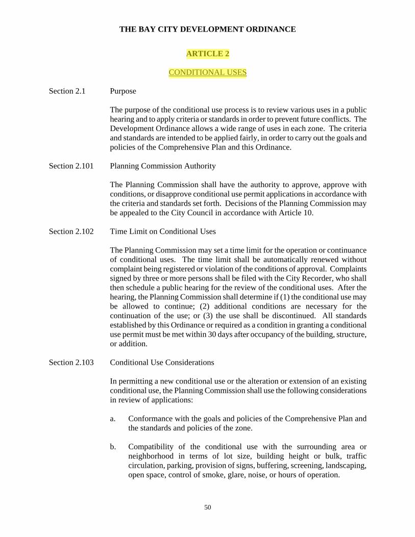
THE BAY CITY DEVELOPMENT ORDINANCE
ARTICLE 2 CONDITIONAL USES Section 2.1 Purpose
The purpose of the conditional use process is to review various uses in a public hearing and to apply criteria or standards in order to prevent future conflicts. The Development Ordinance allows a wide range of uses in each zone. The criteria and standards are intended to be applied fairly, in order to carry out the goals and policies of the Comprehensive Plan and this Ordinance.
Section 2.101 Planning Commission Authority
The Planning Commission shall have the authority to approve, approve with conditions, or disapprove conditional use permit applications in accordance with the criteria and standards set forth. Decisions of the Planning Commission may be appealed to the City Council in accordance with Article 10.
Section 2.102 Time Limit on Conditional Uses
The Planning Commission may set a time limit for the operation or continuance of conditional uses. The time limit shall be automatically renewed without complaint being registered or violation of the conditions of approval. Complaints signed by three or more persons shall be filed with the City Recorder, who shall then schedule a public hearing for the review of the conditional uses. After the hearing, the Planning Commission shall determine if (1) the conditional use may be allowed to continue; (2) additional conditions are necessary for the continuation of the use; or (3) the use shall be discontinued. All standards established by this Ordinance or required as a condition in granting a conditional use permit must be met within 30 days after occupancy of the building, structure, or addition.
Section 2.103 Conditional Use Considerations
In permitting a new conditional use or the alteration or extension of an existing conditional use, the Planning Commission shall use the following considerations in review of applications: a. Conformance with the goals and policies of the Comprehensive Plan and
the standards and policies of the zone.
b. Compatibility of the conditional use with the surrounding area or neighborhood in terms of lot size, building height or bulk, traffic circulation, parking, provision of signs, buffering, screening, landscaping, open space, control of smoke, glare, noise, or hours of operation.
50

THE BAY CITY DEVELOPMENT ORDINANCE
This consideration shall not be applicable to manufactured dwelling parks or other housing that is defined as needed housing type by Statewide Policy Goal 10.
Section 2.104 Construction of a Conditional Use
Work shall commence within six months of the granting of a conditional use permit. Upon application, the Planning Commission may grant one six-month extension.
Section 2.105 Conditional Use Procedure
The following procedures shall be used in applying for and acting on a Conditional Use Application: a. A property owner or his/her agent may request a conditional use or
modification of an existing conditional use by filing an application with the City Recorder using forms prescribed by the City.
b. The City Recorder shall schedule a hearing before the Planning
Commission within thirty (30) days of receipt of the application or at the next regular meeting, if there is sufficient time for the notice of public hearing.
c. The Planning Commission shall make a decision on the request within
thirty (30) days after a public hearing, and shall express in the record of the meeting the findings of fact supporting or rejecting the application, based on the criteria contained in this Ordinance and the goals and policies of the Comprehensive Plan.
d. Within five (5) days after a decision has been reached by the Planning
Commission, the City Recorder shall provide the applicant with written notice of the decision, the criteria used in support or denial of the request, and notice by certified mail, return receipt requested, that the decision of the Planning Commission may be appealed to the City Council within fifteen (15) days of notification of the applicant, and no more than thirty (30) days from the Planning Commission decision.
Section 2.2 Conditional Use Standards Section 2.201 Multifamily, Cluster, or Apartment Dwellings
a. Structures shall meet the lot coverage, open area, and where applicable, common open space requirements of the zone in which they are located.
51

THE BAY CITY DEVELOPMENT ORDINANCE
b. Structures shall be placed to retain existing trees, wherever possible. Buffers and screens, as described in Section 3, may be required by the Planning Commission.
c. At least 50% of the required open area is usable by the residents of the
development. This can be in the form of lawns, outdoor play areas, swimming pools, patios or decks, or natural area.
d. Parking areas are located in an unobtrusive location, are landscaped and
separated into no more than 8 spaces per bay, and are buffered from surrounding residential uses or other low intensity uses.
e. Traffic is routed onto an existing or planned arterial or collector street, and
safety of ingress and egress is considered. Section 2.202 Schools
a. Day care centers or nursery schools shall provide and maintain at least 100 square feet of outdoor play area per child. A sight-obscuring screen or buffer shall separate the play area from abutting lots or streets.
b. Elementary schools shall provide a basic site area of 5 acres plus one
additional acre for each 100 pupils of predicted ultimate enrollment.
c. Secondary schools shall provide a basic site area of 10 acres plus one additional acre for each 100 pupils of predicted ultimate enrollment.
Section 2.203 Public Utility or Communication Facility
a. The proposed site is best located to serve the intended area with a minimal effect on surrounding property.
b. Structures such as towers, tanks, poles, overhead wires, pumping stations,
and similar equipment shall be located so as not to degrade scenic views from a street or private property, particularly along the bayshore.
c. All equipment storage or materials shall be buffered, screened, or fenced, or kept within a structure.
Section 2.205 Recreation Vehicle Parks
a. Recreation Vehicle (RV) parks or camping areas shall be in conformance with the standards of the Oregon Health Department, and in conformance with the standards and policies of the zone in which they are located.
b. RV parks shall be at least 3 acres in size.
52
THE BAY CITY DEVELOPMENT ORDINANCE
c. RV parks shall be connected to city services, including sewer, water, and storm drainage. Parks shall also be connected to power and communications service. The ratio of lavatories and toilet facilities to RV spaces shall be prescribed by state law.
d. The average square footage of RV spaces shall be at least 1500 square feet,
and the individual RV spaces shall not be less than 1000 square feet. Square footage shall be calculated by excluding streets, driveways, restrooms, or common open space areas.
e. Streets or private drives shall be surfaced with asphaltic concrete or oil mat
surfacing material.
f. Buffers and screening in accordance with Article 3 shall be required in order to separate RV parks from surrounding uses or public streets or roads. A sight obscuring fence or plantings shall be required except in clear vision areas.
g. Where existing tree cover is present, it shall be retained on the site.
Camping spaces shall be constructed so as not to harm root systems by fill.
h. Camping spaces, restrooms, parking areas and other structures or alterations shall be at least 50 feet from streams or bodies of water to maintain riparian vegetation and the scenic values of the area. Public access shall be maintained to the water.
i. At least 25% of the overall site shall be maintained in landscaped open area
or natural vegetation. Buffers, screening, forested areas, or common open areas may be considered part of this requirement.
j. All RV Parks in the Moderate and Shoreland 3 Intensity Zones shall abut
U.S. Highway 101, and shall be appropriately buffered from surrounding residences. Landscaping and access control shall be required. Access to RV Parks shall be off of side streets, rather than directly off of U.S. 101.
k. No RV shall be located in a RV Park for more than 120 days in any
calendar year. "Located" means living, repairing, or storing the RV within the RV Park.
Section 2.206 Primary Commercial Uses
a. Primary commercial (non-water dependent or related) uses are defined as small establishments intended to serve daily or frequent trade or service needs of the city or a localized area, as opposed to highway oriented or high traffic impact uses. Such uses include small grocery stores, laundries, repair shops, beauty shops, and similar uses. Excluded are large retail
53

THE BAY CITY DEVELOPMENT ORDINANCE
outlets, automobile service stations, and drive-in eating or drinking establishments.
b. As a guideline, no such establishment shall be permitted closer than 500
feet from a zone in which it is permitted outright, in order to prevent the sprawl of primary commercial centers.
Section 2.207 Commercial Uses - High Traffic Generation
a. Commercial uses requiring large land area or capable of generating high traffic volumes include auto service stations, car lots, lumber yards, manufactured dwelling sales, or large retail outlets.
b. Uses shall be located on an arterial street, or at the intersection of two
collector streets in order to lessen traffic impacts on residential areas. Access shall be designed to provide ingress or egress on non-residential streets.
Section 2.208 Commercial Recreation
a. Commercial recreation with high traffic volumes shall have access onto an arterial street and provide access on non-residential streets.
b. Structures associated with low intensive recreation uses, such as club
houses or indoor tennis courts, shall be designed to be compatible with the surrounding landscape and adjacent uses.
c. Uses which could potentially generate high traffic volumes, such as
spectator events, shall not be allowed. Section 2.209 Eating or Drinking Establishments
Eating or drinking establishments shall be small scale and shall be intended for local or neighborhood use. Restaurants in conjunction with motels may be of a size necessary to accommodate the traveling public. Restaurants with drive-in service shall be permitted only in the South High Intensity Zone. Restaurants with facilities that accommodate late night entertainment shall be reviewed as provided in Section 3.96, Architectural Review.
Section 2.210 Forest Management Practices
a. Purpose. The purpose of this section is to ensure that forest practices are carried out in a manner that will protect soil integrity, water quality, fish and wildlife habitat, riparian vegetation, significant natural resources, scenic values and adjacent urban uses.
54

THE BAY CITY DEVELOPMENT ORDINANCE
b. Applicability. The following activities are considered forest management practices and are subject to the provisions of this section:
1) Harvesting of trees for commercial purposes including but not limited
to falling, bucking, yarding, decking, loading or hauling of such trees.
2) Construction, reconstruction and improvements of roads as part of a forest harvesting operation.
3) Site preparation for reforestation involving clearing or the use of
heavy machinery.
4) Clearing of forest land for conversion to a non-forest use.
5) Disposal and treatment of slash.
6) Precommercial thinning.
c. Exceptions. The removal of trees in accordance with the Bay City Tree Cutting Ordinance is not considered a forest management practice.
d. Forest Management Plan Approval Required.
1) As part of a conditional use application, a forest management plan
prepared by a forester shall be submitted.
2) The written forest management plan shall contain specific information applicable to the proposed operation. Elements of the plan shall include, but not be limited to, the location of roads and landings, road and landing design and construction, drainage systems, disposal of waste material, falling and bucking, buffer strips, yarding system and layout, sensitive resource site protection measures and post operation stabilization measures.
3) The applicant shall select a qualified forester to prepare the plan. The
applicant shall bear the cost of the plan preparation as well as the cost of monitoring the forest management operation.
The City may select a qualified forester to review the plan and pass the cost onto the applicant.
4) The forest management plan shall conform to the standards of subsection 2.210(e) of this section.
5) In the preparation of the forest management plan, the forester shall
consult with state and federal agencies concerned with the forest
55

THE BAY CITY DEVELOPMENT ORDINANCE
environment, such as the Department of Fish and Wildlife, to obtain relevant information.
6) The landowner and/or operator shall comply with the approved forest
management plan.
7) Modifications to the approved plan shall be reviewed by the planning commission. Modification of an approved plan shall be required when, based on information that was not available or known at the time of the approval, the forester determines the approved plan will no longer provide adequate protection to the natural resources of the site.
8) The forester shall monitor the forest operation to ensure that it is
carried out in accordance with the approved plan. Upon completion of the operation the forester shall prepare a report certifying that the operation was carried out in compliance with the approved plan.
e. Standards. Forest management plans shall be prepared in conformance
with the following standards:
1) Only selective harvesting of trees is permitted.
2) A riparian zone shall be maintained adjacent to Type D, Type F, and Type N waters. Section 1.844 and Section 3.103 of the Development Code define the required setbacks in the riparian zone. There shall be no harvesting of trees in the riparian zone. Other activities in conjunction with forest practices, such as road construction, in the riparian zone shall be permitted only where there are no other feasible alternatives. The definitions of Type D, Type F, and Type N waters shall be those established in the Forest Practices Rules.
3) Existing stream courses shall not be altered.
4) No forest management operations shall occur in identified wetland
areas.
5) Where a forest operation is to be located within six hundred feet of a specific site involving a threatened or endangered species (as listed by the U.S. Fish and Wildlife Service or the Oregon Department of Fish and Wildlife) or a sensitive bird nesting, roosting or watering site, a specific habitat protection plan shall be prepared in consultation with the Oregon Department of Fish and Wildlife.
6) There shall be no mining or mineral extraction as part of a forest
operation.
56

THE BAY CITY DEVELOPMENT ORDINANCE
7) Forest practices shall not involve the application of herbicides,
insecticides or rodenticides.
8) Slash shall be controlled in a manner that does not require burning.
9) Road construction shall be in accordance with the criteria of the Oregon Forest Practices Rules.
10) Harvesting of trees shall be in accordance with the criteria of the
Oregon Forest Practices Rules.
11) Reforestation of lands intended to continue in forest use shall be stocked according to the levels specified in the Oregon Forest Practice Rules. The forest management plan shall include specified actions necessary for the maintenance of planted trees. Within one year following the harvest on lands not planned for reforestation, adequate vegetative cover shall be established to provide soil stabilization and to minimize aesthetic impacts within one year following the harvest.
Section 2.211 Industry - Non Water Dependent or Related
a. Industrial uses shall have limited or phased social and fiscal impacts on the community. Adequate public facilities (sewer, water, fire protection, schools, streets) shall be available to serve the industry prior to construction, or assurance shall be given the City in the form of performance bond that public facilities will be installed concurrently at the developer's expense.
b. Industrial uses shall be labor rather than capital intensive.
c. Preference shall be given to industries which are related to the resources of
the area, such as fishing, forest products, the dairy industry, or shipping.
d. Industrial uses shall meet all applicable standards pertaining to buffers, screens, lot coverage, and open area. The Planning Commission may require additional buffer areas where it appears that existing adjacent uses warrant protection.
e. Special attention shall be given to the emission standards pertaining to
noise, smoke, odor, or glare. Section 2.212 Meeting Halls, Churches, and Schools
a. The hours of operation of meeting halls and churches shall be controlled so
57

THE BAY CITY DEVELOPMENT ORDINANCE
as not to disrupt surrounding residential uses.
b. Eating or drinking establishments or entertainment associated with meeting halls or churches shall meet the requirements of 2.209 above.
c. Meeting halls, churches, and schools shall be designed in a manner which
is compatible with the surrounding neighborhoods in terms of height, bulk, and maintenance of existing vegetation.
Section 2.213 Mining or Removal of Sand or Gravel
a. Mining or removal of sand or gravel in wetlands, lowlands, or water areas shall be done only after a permit from the Division of State Lands or U.S. Army Corps of Engineers is issued, if those agencies determine that they have jurisdiction in those areas.
b. Sedimentation and erosion shall be controlled through the use of berms,
catch basins, mulching, and revegetation as may be required by the Planning Commission.
Section 2.2135 Extensive Excavation and Grading
a. All requirements of Chapter 70 of the Uniform Building Code are adhered to.
b. The extent and nature of the proposed grading and/or filling are appropriate
to the use proposed and will not create site disturbances to an extent greater than that required for use.
c. The proposed grading and/or filling, and any related construction, will have
a minimum impact on views from adjacent property.
d. The proposed grading and/or filling will be designed in a manner that minimizes any adverse visual impacts on adjacent property.
e. The proposed grading and/or filling will not have an adverse impact on the
drainage on adjacent property. Section 2.214 Cottage Industries
In the Moderate and Low Intensity Zones, or cottage industries may be allowed in order to promote a local economic base consistent with the character of the City. Allowable uses include crafts, small scale services, and other activities which have little impact on the neighborhoods in terms of traffic generation, noise, appearance, operating hours, or other factors. Activities are to be allowed on a limited conditional use basis, with the primary condition that the permit can
58

THE BAY CITY DEVELOPMENT ORDINANCE
be revoked for violation of the standards. It is intended that full scale or intensive uses be located in the high intensity zones. a. Definition: A cottage industry is a non-residential use carried out by a
resident of a dwelling and no more than one employee, other than members of his or her family.
b. Standards: Standards of the intensity zone and conditional use standards
shall apply to cottage industries. In addition, the following specific standards shall apply: 1) Signs shall be no larger than 1 square foot and shall be no more than
4 feet from ground level.
2) The use shall be carried out in the dwelling or in a structure attached thereto.
3) Uses involving non-resident employees and the delivery of materials
shall limit their hours of operation to between 8:00 a.m. and 6:00 p.m.
4) The use shall be architecturally and aesthetically compatible with the surrounding residential area and the existing structures on the site.
5) There shall be no storage of materials or equipment excess of the lot
coverage requirements of the zone, except for plant materials such as nursery stock.
6) Recreation vehicle or trailer parks, amusement, or gaming operations
are not to be allowed as a home occupation.
c. Complaint Procedure: The Planning Commission shall review cottage industries upon receipt of three written complaints from three separate households within two hundred fifty (250) feet of the boundary of the affected property, or a complaint from the Building Official. The City Recorder shall schedule a public hearing to review the complaints.
d. Action by the Planning Commission: The Planning Commission shall hear
the evidence presented and may, with adequate findings of fact: 1) Approve the use as it exists. 2) Require that it be terminated. 3) Impose restrictions, such as limiting hours of operation or requiring
construction of a fence.
59

THE BAY CITY DEVELOPMENT ORDINANCE
Decisions of the Planning Commission may be appealed to the City Council.
Section 2.145 Yurt
a. Standards: Standards of the development ordinance, the Moderate Intensity Zone, the Flood Damage Prevention Ordinance, the Hazard Overlay Zone, and the Conditional Use standards shall apply to the placement and operation of a yurt. In addition, the following specific standards shall apply:
1) A full-time primary residential use shall be continuously occupied by
the property owner or agent of the property owner who shall ensure on-site management and maintenance of the yurt;
2) Signage shall not exceed 2 square feet. The bottom of the sign shall
be no more than 4 feet from the ground;
3) The use shall be designed and continuously maintained to be aesthetically compatible with the surrounding residential area. Fencing shall consist of attractive natural materials as far as is practicable. Storage shall be screened from view. Landscaped areas shall be maintained in native vegetation. Fencing and mature native plants shall adequately screen the use. Existing native trees shall be retained wherever practicable. Buffers may be required;
4) The maximum square footage of a yurt shall be 768 square feet;
5) Building height of a yurt shall be no more than 16 feet above the elevation required by the Flood Damage Prevention Ordinance and shall not exceed 24 feet in height above existing grade;
6) One parking space shall be provided and maintained for a yurt up to
400 feet in area; two parking spaces shall be provided and maintained for a yurt over 400 square feet in area;
7) A yurt shall have bathroom facilities including a shower, sink and a
toilet. A yurt may have kitchen appliances, but shall not be wired for 220 electrical current;
8) A yurt shall not be used for full-time residential use. All
requirements for transient lodging use of the structure shall be continuously met;
9) A yurt shall be connected to water and sewer service through the
primary residential use;
60

THE BAY CITY DEVELOPMENT ORDINANCE
10) Coastal Shoreland Goals and Policies shall be addressed in the
application for a yurt. Adjacent Estuarine areas shall be protected from potential adverse impacts;
11) A building permit shall be obtained. Prior to approval of the building
permit, all conditions of site development established by this ordinance or required as a condition in granting a conditional use shall be met. The City shall obtain certification and evidence that the following criteria are met, as far as is reasonably practicable:
(a) The yurt shall meet all fire-resistive occupancy requirements
(separations, required fire separation walls, parapet walls, and other fire-resistive requirements);
(b) The yurt has been approved by the Building Code Division and
will be installed and used according to its intended design and purpose as identified by an Oregon Insignia of Compliance;
(c) With application, a site plan, occupancy classification,
construction type, structure size, floor live load, roof live load, wind exposure, seismic area, energy zone, electrical service loads, plumbing fixture loads, number of modules and certification whether it is a permanent or re-locatable structure shall be submitted;
(d) The design and construction of the yurt foundation and
structure shall be consistent with the standards established by the Oregon Building Code Division for prefabricated structures,
(e) The yurt shall comply with Oregon One and Two Family
Dwelling Specialty Code, and shall be certified with an Oregon Insignia of Compliance.
b. Conditions: All conditions of site development established by this
ordinance or required as a condition in granting a conditional use shall be met prior to receiving a building permit to construct a yurt.
c. Maintenance: The use and all site development requirements shall be
continuously maintained consistent with this ordinance.
d. Complaint Procedure: Upon receipt of evidence from staff of non-compliance with yurt conditional use requirements, upon receipt of a complaint signed by three or more persons filed with the City Recorder or a complaint from the Building Official. Upon receipt of any of the above complaints, the City Recorder shall schedule a public hearing before the
61

THE BAY CITY DEVELOPMENT ORDINANCE
Bay City Planning Commission for the Commission to review the complaints.
e. Action by the Planning Commission: The Planning Commission shall hear
the evidence presented and may, with adequate findings of fact: 1) Approve the use as it exists; 2) Require that the use be terminated;
3) Impose additional conditions or restrictions, such as the limiting of hours of operation or requiring the construction of a fence. (Amended Ord. #630, 05-07)
Section 2.215 General Conditional Use Standards
The following conditional use standards shall apply to all activities listed in the Use Matrix as a conditional use: a. Traffic Generation Standards
1) Uses with high traffic generation, as determined by the Planning Commission using acceptable traffic generation documents, shall be located in the high intensity areas of the City or within 100 feet of the intersection of two arterial streets.
2) Uses which would generate moderately greater traffic volumes than
residential uses occupying the same land area at allowable densities shall be located on arterial streets.
3) Uses which would generate no more traffic than a residential use
occupying the same land area at allowable density levels (calculated without bonus density) may be located on residential or collector streets.
4) Uses locating in the vicinity of U.S. Highway 101 shall have their
access onto public streets other than U.S. Highway 101 in order to limit access points along the main highway. New access points may be allowed onto U.S. Highway 101 only where no alternative exists, as determined by the Planning Commission, and with the prior approval of the State Highway Division.
b. Public Facility and Services
1) Public facilities and services, including sewer, water, storm drainage,
fire protection, electrical service, and schools shall have adequate
62

THE BAY CITY DEVELOPMENT ORDINANCE
capacity to serve projected needs of the proposed conditional use.
2) The person(s) requesting the conditional use permit shall be responsible for all costs associated with the extension of public facilities or services, including system improvement charges.
c. General Environmental Standards
1) No noise, smoke, heat, odor, fumes, dust, glare, vibration, or water
pollution shall be detectable beyond the property line of the proposed use, except for occasional maintenance such as lawn care or for normal emissions such as from wood burning stoves or fireplaces. Glare from street lights or floodlights shall be shielded from adjacent uses and shall be the minimum necessary to illuminate the property.
2) Variances from the above standards shall be granted only with the
demonstration that: (a) the discharge would be within current state and federal standards; (b) there is a demonstrated hardship or public need which the variance would satisfy; and (c) adjacent properties or wildlife habitat would not be adversely affected.
Goals and Policies of the Comprehensive Plan and other Standards of this Ordinance shall be adhered to in the granting of Conditional Uses.
Section 2.220 Estuarine and Shoreline Standards Section 2.221 Aquaculture Facilities
a. Evidence shall be provided by the applicant and findings made by the City that aquaculture facilities do not prevent access to navigational channels and that obstruction of access to publicly owned lands and recreation use areas is minimized.
b. Aquaculture facilities should be designed to minimize their visual impact
(view obstruction). Whenever feasible, submerged structures are preferred over floating structures.
c. The design and construction of an aquaculture facility should consider
reclamation and re-use of waste water.
d. Water diversion structures or man-made spawning channels shall be constructed so as to maintain required stream flows for aquatic life in adjacent streams and avoid significant reduction or acceleration of average water flow in an associated marsh. Water Quality policies shall apply.
e. Shellfish culture facilities shall either be located more than 2,000 feet away
63
THE BAY CITY DEVELOPMENT ORDINANCE
from sanitary sewer outfalls so that there will be no potential health hazard or shall make provisions for purification of water used in the aquaculture operation.
f. Water discharge from an aquaculture facility shall meet all federal and state
water quality standards and any conditions attached to a waste discharge permit. Water Quality policies shall apply.
g. All state and federal laws governing environmental quality, resource
protection, public health and safety, and engineering standards shall be met in the design, siting, construction and operation of aquaculture facilities. This determination shall be made by the Oregon Department of Fish and Wildlife or other state or federal agencies with regulatory authority over aquaculture facilities.
h. Aquaculture facilities in Estuary Conservation (EC) Zones and Estuary
Natural (EN) Zones shall be permitted only if evidence can be provided by the applicant and findings made by the City that: 1) Aquaculture facilities in Estuary Development (ED) Zones will not
preclude the provision or maintenance of navigation or other needs for commercial and industrial water-dependent uses and will not pre-empt the use of shorelands especially suited for water-dependent development.
2) Aquaculture facilities in Estuary Natural (EN) Zones will be
consistent with the resource capabilities and purpose of the management unit(s) in which they are to be located. The Oregon Department of Agriculture shall provide these findings for oyster culture and the Oregon Department of Fish and Wildlife shall provide them for other types of aquaculture in instances when Bay City finds that it does not have the technical expertise or resources to make them.
3) Aquaculture facilities in Estuary Conservation (EC) Zones will
require a resource capability determination where dredging, fill, or other alterations of the estuary are needed, other than incidental dredging for harvest of benthic species or removal of in-water structure.
4) Aquaculture facilities in Estuary Natural (EN) Zones will not require
dredging or fill other than incidental dredging for harvest of benthic species or removal of in-water structures.
i. Leasing of publicly-owned estuarine waters, intertidal areas or tidal
wetlands for aquaculture shall be subject to the requirements of the
64
THE BAY CITY DEVELOPMENT ORDINANCE
Division of State Lands.
j. Dredge, fill, shoreline stabilization, piling/dolphin installation or other activities in conjunction with an aquaculture facility shall be subject to the respective standards for these activities.
Section 2.222 Siting, Design, Construction, Maintenance, or Expansion of Dikes
a. Diking policy requirements in the Bay City Comprehensive Plan shall be
met.
b. Proposals for new dike construction or dike maintenance or repair shall be accompanied by a brief statement from the local Soil and Water Conservation Service or a certified engineer stating that: 1) The project is in conformance with good engineering practices and
any applicable rules and regulations set forth by the Oregon Division of State Lands and the U.S. Army Corps of Engineers.
2) Provides for suitable erosion protection for the dike face.
3) Will produce no appreciable flood and erosion potential upstream or
downstream of the proposed project.
c. When temporary dikes are constructed in intertidal areas or tidal wetlands, notice must be given to the Division of State Lands within 24 hours following the start of such activity and their approval for continuation of the project must be obtained (ORS 541.615 (4)). Intertidal areas and tidal wetlands shall be restored by the sponsor of the dike to pre-dike conditions after the removal of temporary dikes.
d. Fill, shoreline stabilization, or other activities in conjunction with new
dikes involving fill in intertidal areas and tidal wetlands is subject to the requirements of the State Fill and Removal Law (ORS 541.605 - 541.665) and the Clean Water Act of 1977 (P.L. 95-217) (applies to fill only).
Section 2.223 Docks and Moorages
a. Docks and Moorages policy requirements in the Bay City Comprehensive Plan shall be met.
b. When new construction or expansion of docks and moorages is proposed,
evidence shall be provided by the applicant and findings made by the City that: 1) The size of the facility is the minimum necessary to accommodate the
65

THE BAY CITY DEVELOPMENT ORDINANCE
number and size of boats using the facility. Maximum size limit for single purpose private dock (excluding walkways) shall be 150 square feet.
2) Alternatives such as dryland storage, launching ramps, or mooring
buoys are impractical.
c. To ensure that consideration is given to the beneficial, economic, and social impacts of moorages on local communities, proposals for new or expanded moorages should include statements on the impacts to local communities derived from increases in employment or increases in commercial or recreational activity.
d. Open pile piers or secured floats shall be used for dock construction. Piers
and floats shall extend no further out into the water than is needed to provide navigational access.
e. Floating docks shall be designed so that they do not rest on the bottom at
low water.
f. Single purpose docks shall be permitted if evidence is provided by the applicant and findings made by the City that cooperative use facilities (marinas or community docks or mooring buoys) are unavailable, impractical or will not satisfy the need.
g. Covered or enclosed moorages shall be limited to 10% (in number) of the
total moorage spaces of a given moorage.
h. To avoid contamination of estuarine water, intertidal areas or tidal wetlands, public docks and moorages should provide enclosed facilities on shorelands for public dumping of oil and emptying of holding tanks.
i. When docks and moorages are proposed in Estuary Conservation 1 or
Estuary Conservation 2 Zones, evidence shall be presented by the applicant and findings made by the City that the proposed dock or moorage is consistent with the resource capabilities of the area and the long-term use of renewable resources and does not constitute a major alteration to the estuary. In assessing the resource capabilities of an area, consideration shall be given to the size or intensity of the proposed facility and its location with respect to adjacent resources.
j. Moorages with a capacity greater than 25 boats shall be subject to Port
Facility and Marina standards.
k. Dredging, fill, poling/dolphin installation, shore-land stabilization, or other activities in conjunction with the construction of docks and moorages shall
66

THE BAY CITY DEVELOPMENT ORDINANCE
be subject to the respective standards for these activities. Section 2.224 Dredged Material Disposal
a. Dredged material disposal shall occur only in approved dredge material disposal sites or for fill of development sites which have received appropriate local, state and federal permits. All Dredged Material Disposal policy requirements and fill standards shall apply.
b. State and federal water quality standards shall be met during all phases of
dredged material disposal. Water Quality policies shall apply.
c. The timing of dredged material disposal shall be coordinated with state and federal resource agencies to ensure adequate protection of wildlife habitat, bird nesting areas, fish runs and fish spawning activity and to minimize interference with fishing activities.
d. Ocean disposal of dredged material shall be permitted only in an ocean
disposal site approved by the U.S. Army Corps of Engineers and the Environmental Protection Agency.
e. With regard to in-water disposal in the river estuary and ocean:
1) Consideration shall be given to the need for the proposed disposal
and the availability and desirability of alternate sites and methods of disposal that might be less damaging to the environment.
2) The physical and chemical characteristics of the dredged material
should be compared with those of the disposal site, and consideration should be given to matching the dredged material to the capabilities of the site.
3) In-water disposal requires either an EPA/DEQ water quality
certification or a short-term exemption. Polluted materials that cannot meet EPA/DEQ requirements for ocean disposal shall be disposed of on non-aquatic sites designed to properly settle out all pollutants prior to discharge back into the aquatic system. Dredged material disposal shall not be permitted in the vicinity of a public water supply intake.
4) Flow-lane disposal of dredged material shall be monitored to assure
that estuarine sedimentation is consistent with the resource capabilities and purposes of affected natural and conservation management units.
f. Ocean disposal of dredged material shall be conducted to assure that U.S.
67

THE BAY CITY DEVELOPMENT ORDINANCE
Army Corps of Engineers and Environmental Protection Agency standards are met, and that: 1) The amount of material deposited at a site will not seriously impact
local ocean resources.
2) Interference with sport and commercial fishing is minimized. 3) Disposal is confined to the authorized disposal site.
4) The sediment transport of the materials after disposal will not return
to the bar or to the estuary.
This determination shall be made by the U.S. Army Corps of Engineers and the Environmental Protection Agency during their review of permit applications for ocean disposal of dredged material.
g. Disposal of dredged materials on ocean beaches for purposes of beach
nourishment shall be conducted to ensure that: 1) The volume and frequency of dredged material disposal are
controlled to avoid excessive fluctuations in beach profile. A stable beach profile shall be maintained as nearly as possible.
2) Adverse impacts on benthic productivity and native plants and
wildlife within and downstream of the disposal site shall be avoided or minimized. Particular care shall be taken to ensure that erosion or smothering of productive habitat areas does not occur.
3) The dredged material is uncontaminated and composed
predominantly of sand with a particle size compatible with material on the receiving shores.
h. Land disposal of dredged materials shall be conducted to ensure that the
integrity of estuarine waters, streams, underground springs, and waterways is maintained. To ensure this: 1) U.S. Army Corps of Engineers guidelines for design of containment
areas at dredged material disposal sites shall be followed. The U.S. Army Corps of Engineers shall be responsible for determining that these guidelines have been met.
2) All surface water runoff from disposed dredged materials shall be
controlled and shall enter the water way or estuary directly as practicable to the main channel or deep water for dilution.
68
THE BAY CITY DEVELOPMENT ORDINANCE
3) When necessary, dikes shall be constructed around land dredged material sites.
4) Dredged material disposal settling ponds shall be designed to
maintain at least one foot of standing water at all times to encourage proper settling of suspended solids. Secondary dredged material disposal settling ponds may be necessary to ensure the proper treatment of overflow waters, particularly in areas used for disposal of spoils containing toxic materials.
5) Runoff from disposed dredged materials must pass over an
appropriately designed and operated weir. Weir design and size shall be dependent upon the size of the disposal site and the physical and chemical characteristics of the dredged material.
i. The final height and slope after each use of land dredged material site shall
be such that: 1) The site does not enlarge itself by sloughing and erosion at the
expense of adjacent aquatic areas.
2) Loss of material from the site during storms and freshets is minimized.
3) Interference with the view from nearby residences, scenic viewpoints,
and parks is avoided. j. Revegetation of land disposal sites shall occur as soon as is practicable in
order to retard water or wind induced erosion and to restore agricultural or wildlife habitat value to the site. Native species or non-native species approved by the Soil Conservation Service shall be used and reference shall be made to the Inter-Agency Seeding Manual prepared by the Soil Conservation Service.
k. Disposal of dredged material should occur on the smallest practicable land
area consistent with the use of the property and the characteristics of the dredged material. Clearing of the land should occur in stages on an as-needed basis. Re-use of existing disposal sites is preferred over creation of new sites in order to minimize the total land area covered by dredged material.
l. Before dredged materials are disposed of on land areas for use as fill in
approved fill projects, a determination shall be made that the structural characteristics of the material are suitable for this use.
69
THE BAY CITY DEVELOPMENT ORDINANCE
m. The use of agricultural lands for dredged material disposal shall occur only when the sponsor of the dredging project can demonstrate that the soils can be restored to agricultural productivity after disposal use is completed.
n. Dredging project proposals shall provide at least a 5-year program for
disposal of dredged material, consistent with the standards listed above. Disposal programs shall provide a mechanism for establishing stockpile sites of fill material suitable for use in approved fill projects.
Section 2.225 Dredging in Estuarine Waters, Intertidal Areas and Tidal Wetlands
a. The following standards shall apply only to dredging in excess of 50 c.y.
within a 12-month period or dredging of 50 c.y. or less which requires a Section 10 permit fee from the U.S. Army Corps of Engineers.
b. When dredging in estuarine waters, intertidal areas or tidal wetlands is
proposed, evidence shall be provided by the applicant and findings made to the City that: 1) The dredging is necessary for navigation or other water-dependent
uses that require an estuarine location or is specifically allowed by the management unit or zone.
2) A need (i.e. a substantial public benefit) is demonstrated and the use
or alteration does not unreasonably interfere with public trust rights.
3) If no feasible alternative upland locations exist.
4) If adverse impacts are minimized.
c. Dredging projects shall meet all requirements of the State Fill and Removal Law (ORS 541.604 - 541.665), Section 10 of the Rivers and Harbors Act of 1899, and other applicable state and federal laws. These requirements shall be enforced by state and federal agencies with regulatory authority over dredging projects.
d. Existing water quality, quantity, and rate of flow shall be maintained or
improved. Minimum stream flow requirements shall be maintained. Water Quality policies shall apply.
e. Flushing capacity of estuaries shall be maintained. A hydrologic report
from a professional registered hydrologist or engineer may be required by the Planning Commission to ensure that this standard has been met.
f. Dredging shall be timed in order to minimize the effects of sedimentation
and turbidity and to minimize impacts on fish, shellfish, and recreational
70

THE BAY CITY DEVELOPMENT ORDINANCE
and commercial fishery activities. The work periods specified in the Oregon Guidelines for Timing of In-Water Work to Protect Fish and Wildlife Resources (ODFW, 1976) shall be followed unless approval of alternative work periods has been obtained from ODFW.
g. Evidence shall be provided by the applicant and findings made by the City
that projects requiring dredging are sited and designed so that initial and maintenance dredging are minimized.
h. Dredging proposals shall provide at least a 5-year program for disposal of
dredged materials. Programs for disposal of dredged material shall be consistent with Dredged Material Disposal standards.
i. Dredging proposals requiring mitigation shall include a mitigation plan
consistent with Mitigation standards.
j. New dredging projects shall not be allowed in areas where insufficient data is available to assess the relative biological value. Under these circumstances, the applicant may arrange to provide the necessary information with the technical assistance of state and federal resource agencies.
k. When dredging for the purpose of on-site maintenance of existing facilities
is proposed, evidence shall be presented by the applicant and findings made by the City that: 1) The dredging is necessary to maintain proper operation of the facility.
2) The amount of dredging proposed is confined to the geographic area
of the existing facility and is the minimum amount necessary to fulfill the need.
l. Excavation to create new water surface area shall be subject to the
standards listed above and to the following standards: 1) Provisions shall be made for the stabilization of new banklines prior
to the connection of the new water body to existing water bodies. Excavation of as much as is practical of the new water body shall be completed before it is connected to existing water bodies.
2) Toxic substances or other pollutants shall not leak into the water as a
result of the excavation.
3) Erosion of adjacent shoreline areas and excessive sedimentation and turbidity in adjacent aquatic areas shall be avoided.
71

THE BAY CITY DEVELOPMENT ORDINANCE
4) Excavation shall occur at a time that will minimize its impact on aquatic life.
5) Excavated materials shall not be disposed of in estuarine water,
intertidal areas, or tidal wetlands, except as part of an approved fill project subject to Fill standards.
m. Dredging for the purpose of bankline or stream alteration (i.e. realignment
of a stream bank or the entire stream either within or without its normal high water boundaries) shall be subject to the standards listed above and to the following standards: 1) Alignments should make maximum use of natural or existing deep
water channels provided that pockets of stagnant water are not created.
2) Erosion of adjacent shoreland areas and excessive sedimentation and
turbidity in adjacent aquatic areas shall be avoided.
3) Temporary stabilization (mulching or sodding), sediment basins or other performance equivalent structures may be required at the discretion of the Planning Commission.
4) Provision shall be made for stabilization of new banklines. Shoreline
Stabilization standards shall apply.
5) Adverse impacts on fish spawning, feeding, migration, and transit routes and wildlife habitat shall be evaluated and minimized.
n. An impact assessment shall be conducted during local, state, and federal
review of permit applications for dredging in estuarine water, intertidal areas, or tidal wetlands. The impact assessment shall follow the procedures outlined in Section 2.315. Identified adverse impacts shall be minimized to be consistent with the resource capabilities and purposes of the area.
Section 2.226 Energy Facilities and Utilities
a. When new energy facilities are proposed within estuarine waters, intertidal areas or tidal wetlands, evidence shall be provided by the applicant and findings made by the City that: 1) A public need (i.e. a substantial public benefit) exists and the use or
alteration does not unreasonably interfere with public trust rights.
2) Alternative non-aquatic locations are unavailable or impractical.
72

THE BAY CITY DEVELOPMENT ORDINANCE
3) Dredging, fill, and other adverse impacts are avoided or minimized.
b. Electrical or communication transmission lines shall be located underground or along existing rights-of-way unless economically unfeasible.
c. Above-ground utilities shall be located to have the least adverse effect on
visual and other aesthetic characteristics of the area. Interference with public use and public access to the estuary shall be minimized.
d. Whenever practical, new utility lines and crossings within estuarine waters,
intertidal areas, or tidal wetlands shall follow the same corridors as existing lines and crossings.
e. Water discharge into estuarine waters, intertidal areas, and tidal wetlands
from an energy facility or utility shall meet EPA and DEQ standards and shall not produce increases in temperature in the receiving waters which would have adverse impacts on aquatic life. Water Quality policies shall apply.
f. When new energy facilities and utilities are proposed in EN Zones,
evidence shall be provided by the applicant and findings made by the City that the proposed use is consistent with the resource capabilities of the area and the preservation of areas needed for scientific, research or educational needs.
g. When storm water and sewer outfalls are proposed in EC2 and EC1 Zones,
evidence shall be provided by the applicant and findings made by the City that the proposed use is consistent with the resource capabilities of the area and the use will not preclude the provision or maintenance of navigation and other public, commercial, and industrial water-dependent uses.
h. When new energy facilities and utilities are proposed in Estuary
Development (ED) Zones, evidence shall be provided by the applicant and findings made by the City that the proposed facility will not preclude the provisions of maintenance of navigation and other public, commercial, and industrial water-dependent uses.
i. Storm water and sewer outfalls shall go out to channels or areas where
flushing will be adequate and shall not empty onto tideflats or intertidal wetlands. Effluent from outfalls must meet DEQ and EPA water quality standards. Water Quality policies shall apply.
j. Dredge, fill, shoreline stabilization or other activities in conjunction with
construction of energy facilities or utilities shall be subject to the respective standards for these activities.
73

THE BAY CITY DEVELOPMENT ORDINANCE
k. Energy facilities and utilities shall be sited so that they do not and will not
require structural shoreline stabilization methods. Section 2.227 Fill in Estuarine Waters, Intertidal Areas, and Tidal Wetlands
a. The following standards shall apply only to fill in excess of 50 c.y. or fill of less than 50 c.y. which requires a Section 10 or 404 permit from the U.S. Army Corps of Engineers.
b. When fill in estuarine water, intertidal areas, or tidal wetlands is proposed,
evidence shall be provided by the applicant and findings made by the City that: 1) The fill is necessary for navigation or other water-dependent uses that
require an estuarine location or is specifically allowed by the management unit or zone.
2) A need (i.e. a substantial public benefit) is demonstrated and the use
or alteration does not unreasonably interfere with public trust rights.
3) No feasible alternative upland locations exist.
4) Adverse impacts are minimized.
c. When fill for the purpose of on-site maintenance of existing facilities is proposed, evidence shall be provided by the applicant and findings made by the City that: 1) There are no alternatives to fill to maintain proper operation of the
facility.
2) The amount of fill proposed is confined to the geographic area of the existing facility and is the minimum amount necessary to fulfill the need.
d. Where existing public access is reduced, suitable access as part of the
development project shall be provided.
e. The fill shall be placed at a time that will minimize sedimentation and turbidity. The work periods specified in the Oregon Guidelines for Timing of In-Water Work to Protect Fish and Wild-life Resources (ODFW, 1976) shall be followed unless approval of alternative work periods has been obtained from the ODFW.
f. Only non-polluted materials may be used for fill. Materials which would
74

THE BAY CITY DEVELOPMENT ORDINANCE
create water quality problems are not permitted.
g. The perimeters of the fill shall be provided with erosion prevention measures consistent with Shore-line Stabilization standards.
h. Fills shall be placed so that adjacent or nearby property is not adversely impacted by increased erosion, shoaling, or flooding produced by changes in littoral drift or other changes in water circulation patterns. An affidavit from a professional registered engineer or hydrologist may be required by the Planning Commission as a result of the impact assessment required in Section 2.315.
i. Fill proposals requiring mitigation shall include a mitigation plan
consistent with Mitigation standards.
j. Fill in estuarine water, intertidal areas, and tidal wetlands shall be subject to the requirements of the State Fill and Removal Law (ORS 541.605-541.665), the Rivers and Harbors Act of 1899, the Clean Water Act of 1977 (PL 95-217), and other applicable state and federal laws. These requirements shall be enforced by state and federal agencies with regulatory authority over fill projects.
k. An impact assessment shall be conducted during the local, state, and
federal review of permit applications for fill in estuarine waters, intertidal areas or tidal wetlands, according to the provision outlined in Section 2.315. Identified adverse impacts shall be minimized to be consistent with the resource capabilities and purposes of the area.
Section 2.228 Forestry and the Forest Products Industry
a. Lot storage, sorting, and processing areas in shorelands adjacent to estuaries or waterways shall be designed, constructed, and operated to control leachates and prevent the loss of bark, chips, sawdust, and other wood debris into public waters.
b. In-water log handling, sorting, and storage areas, and log storage, sorting,
and processing areas in shorelands adjacent to estuaries or other water bodies shall be subject to the requirements of the water quality program administered by the Department of Environmental Quality under the Clean Water Act of 1977 (PL 92-500). DEQ, in conjunction with other affected resource agencies, shall be responsible for determining that the flushing characteristics of in-water log handling, sorting, and storage areas, the number of logs and duration of storage, and the bark and debris controls for both in-water and shoreland sites are such that state and federal clean water standards are met.
c. Leasing of publicly owned aquatic areas for the purpose of in-water log
75

THE BAY CITY DEVELOPMENT ORDINANCE
handling, sorting, and storage shall be subject to the requirements of the Division of State Lands.
d. When new in-water log handling, sorting, and storage areas are proposed in
estuarine waters, evidence must be presented by the applicant and findings made by the City that: 1) The proposed use is an integral part of the process of water-borne
transportation of logs (i.e. is water-dependent).
2) There is a public need (i.e. a substantial public benefit) for the proposed use and the use or alteration does not unreasonably interfere with public trust rights.
3) Alternative non-aquatic locations are unavailable, impracticable, or
do not meet the need.
4) Conflicts with navigation, aquaculture, and commercial and recreational fishing have been avoided or minimized.
5) East leg-down facilities for transfer of logs from land to water have
been provided for (free fall log dumps shall not be permitted).
6) Sites are located to avoid shellfish beds, shallow spawning areas, or areas where grounding of logs will occur.
Section 2.229 Industrial and Commercial Uses in Estuarine Waters, Intertidal Areas, and Tidal
Wetlands
a. Evidence shall be provided by the applicant and findings made by the City that: 1) The amount of estuarine surface area occupied is the minimum
required to meet the need.
2) Provision has been made for public access, viewpoints, and recreational use, consistent with safety and security considerations.
3) Multipurpose and cooperative use of piers, wharves, parking areas, or
handling and storage facilities have been provided for or are impracticable.
4) Floating structures are designed so as not to rest on the bottom at low
water and are protected against currents and waves.
5) Alteration of productive intertidal areas and tidal marshes has been
76

THE BAY CITY DEVELOPMENT ORDINANCE
avoided or minimized.
6) Adverse impacts on the following have been avoided or minimized to be consistent with the resource capabilities and purposes of the area: Water quality. Hydrographic characteristics. Aquatic life and habitat. Bird and wildlife habitat. Fish transit and migration routes.
b. Removal of riparian vegetation shall be permitted only if direct access to
water is required in conjunction with a water-dependent use. Replacement of riparian vegetation shall be required where consistent with water-dependent use to enhance attractiveness or assist in bank stabilization.
c. Visual access to the water shall not be impaired by the placement of signs.
When feasible, signs shall be constructed on or against existing buildings to minimize visual obstruction of the shoreline and water bodies. Off-premise outdoor advertising signs shall not be allowed within estuarine waters, intertidal areas, or tidal wetlands.
d. The design and construction of new industrial and commercial facilities
should consider reclamation and re-use of wastewater.
e. Provision for the prevention and control of contaminants from entering the water shall be made. A contingency plan to provide for containment of cleanup of spills of contaminants shall be provided.
f. Industrial outfalls, sewer outfalls, and storm water outfalls shall go out to
channels or areas where flushing will be adequate and shall not empty onto tideflats or salt marshes. Effluent from outfalls must meet DEQ and EPA water quality standards. Water Quality policies shall apply.
g. When water-dependent industrial and commercial uses are proposed in
Estuary Conservation 2 (EC2) Zones, evidence shall be provided by the applicants and findings made by the City that the proposed use is consistent with the resource capabilities of the area and the long-term use of renewable resources and does not cause a major alteration of the estuary.
h. When water-related or non-dependent, non-related industrial or commercial
uses are proposed in Estuary Development (ED) Zones, evidence must be presented that: 1) The use will not preclude the provision or maintenance of navigation
77

THE BAY CITY DEVELOPMENT ORDINANCE
and other needed public, commercial and industrial water-dependent uses.
2) The use will not pre-empt the use of shorelands especially suited for
water-dependent development.
3) Non-water dependent and non-water related uses which permanently alter estuarine resources and values shall include evidence of the public benefits derived from the project which shall include the beneficial economic impacts generated by increases in employment and/or indirect economic impacts generated by increases in commercial, industrial, or recreational activity within the area.
i. All state and federal laws governing the use, handling, storage, treatment,
and disposal of toxic materials, petroleum, wastewater and organic wastes, and other state and federal laws governing environmental quality, resource protection, or public health and safety shall be met. This determination shall be made by appropriate state or federal agencies with regulatory authority.
j. Dredging, fill, piling/dolphin installation, shoreline stabilization, disposal
of dredged material or other activities in conjunction with industrial and commercial uses shall be subject to the respective standards for these activities.
Section 2.230 Land Transportation Facilities
a. Proposals for new county or state highways or railroads shall provide an evaluation of the proposed project on the following:
1) Land use patterns.
2) Energy use. 3) Air and water quality.
4) Estuarine habitat, functions, and processes.
5) Existing transportation facilities.
6) Physical and visual access to estuaries and shorelands.
b. Evidence shall be provided by the applicant and findings made by the City
that the siting, design, construction and maintenance of land transportation facilities will be conducted to avoid mass soil wasting or excessive surface erosion.
78

THE BAY CITY DEVELOPMENT ORDINANCE
c. Land transportation facility proposals shall include a rehabilitation plan
specifying the method and timing of necessary site rehabilitation. Site rehabilitation plans shall provide for replacement of riparian vegetation.
d. Vegetated buffer strips shall be maintained, whenever practicable, along
roadways to manage storm drainage runoff.
e. When culverts are used in association with bridge crossings, spring line natural bottom culverts are preferred over box culverts.
f. All bridge crossings and culverts shall be positioned and maintained to
allow fish passage, avoid interference with anadromous fish runs, and to prevent any constriction of natural streams which would result in increases in flood or erosion potential. When culverts are used, no fill shall be allowed in streams, rivers, or estuaries.
g. When new bridge crossing support structures are proposed in Estuary
Conservation 2 (EC2), Estuary Conservation 1 (EC1) and Estuary Natural (EN) Zones, evidence shall be provided by the applicant and findings made by the City that the proposed use is consistent with the resource capabilities and purposes of the area.
h. When new land transportation facilities are proposed in Estuary
Development (ED) Zones, evidence shall be presented by the applicant and findings made by the City that the proposed use will not preclude the provision or maintenance of navigation and other needed public, commercial, and industrial water-dependent uses.
i. Dredging, fill, piling/dolphin installation, shoreline stabilization, dredged
material disposal, or other activities in conjunction with land transportation facilities shall be subject to the respective standards for these activities.
Section 2.231 Mining and Mineral Extraction
a. Mining and Mineral Extraction policy requirements in the Bay City
Comprehensive Plan shall be met.
b. Mining and mineral extraction proposals shall include a mining plan and a rehabilitation plan specifying the method and timing of necessary site rehabilitation. Any necessary rehabilitation of mining and/or mineral extraction sites shall be completed within two years of the completion of the mining or mineral extraction operation.
c. Evidence shall be provided by the applicant and findings made by the City
that mining and mineral extraction projects are sited, designed, operated,
79

THE BAY CITY DEVELOPMENT ORDINANCE
and maintained to ensure that adverse impacts on the following are minimized: 1) Aquatic life and habitat, including but not limited to the spawning,
rearing, and passage requirements of anadromous fish.
2) Bird and wildlife habitat.
3) Hydrographic characteristics, including but not limited to the alteration of local currents that may affect adjacent properties by causing erosion, accretion or increased flooding.
4) Water Quality policies shall apply.
d. Temporary removal of riparian vegetation shall be permitted in cases where
direct water access is required as part of a mining or mineral extraction operation. Site rehabilitation plans shall provide for replacement of riparian vegetation.
e. Spoils and stockpiles shall not be placed within estuarine water, intertidal
areas, or tidal wetlands, unless as part of an approved fill project subject to Fill standards.
f. When mining and mineral extraction projects are proposed in Estuary
Conservation 1 (EC1) and Estuary Conservation 2(EC2) Zones, evidence shall be provided by the applicant and findings made by the City that the proposed project is consistent with the resource capabilities of the area and the long-term use of renewable resources and does not cause a major alteration of the estuary.
g. When mining and mineral extraction projects are proposed in Estuary
Development (ED) Zones, evidence shall be presented by the applicant and findings made by the City that the project is consistent with the maintenance of navigation and other needed public, commercial, and industrial water-dependent uses.
h. Dredging, fill, or other activities in conjunction with mining and mineral
extraction shall be subject to the respective standards for these activities.
i. The location and operation of mining and mineral extraction projects shall be in conformance with the requirements of the Division of State Lands (ORS 541.605 - 541.665; ORS 273.551; ORS 273.775 - 273.780), the Department of Geology and Mineral Industries (ORS 520.005 - 520.095) and other applicable state and federal laws governing environmental quality, resource protection and public health and safety. These requirements shall be enforced by state and federal agencies with
80

THE BAY CITY DEVELOPMENT ORDINANCE
regulatory authority over mining and mineral extraction projects. Section 2.232 Mitigation
a. Mitigation for dredge or fill within intertidal areas or tidal marshes shall be required by the Director of the Division of State Lands (under the provisions of ORS 541.605 - 541.665). The suitability of a mitigation proposal for a given proposed project shall be determined by the director of the Division of State Lands according to the procedure established in Administrative Rule 85-245 (Chapter 141).
b. Mitigation projects shall go into effect prior to or at the same time as the
development project. Section 2.233 Navigation Structures and Navigational Aids
a. When navigational structures are proposed, evidence shall be provided by the applicant and finding made by the City that: 1) The amount of estuarine surface area occupied is the minimum
necessary to accomplish the proposed use.
2) The project will not interfere with the normal public use of fishery, recreation, or water resources.
3) The proposed project will not adversely impact adjacent or nearby
property through increased erosion, shoaling, or flooding produced by changes in littoral drift or other changes in water circulation patterns (an affidavit from a professional registered engineer or hydrologist may be required).
4) Non-structural solutions are unavailable, impractical, or do not meet
the need.
b. When floating breakwaters are proposed in Estuary Conservation 1 (EC1) and Estuary Conservation 2 (EC2) Zones, evidence shall be provided by the applicant and findings made by the City that the proposed use is consistent with the resource capabilities of the area and the long-term use of renewable resources and does not cause a major alteration of the estuary.
c. Navigational structures shall meet all applicable U.S. Army Corps of
Engineers engineering standards. The U.S. Army Corps of Engineers shall be responsible for determining that these engineering standards have been met.
d. An impact assessment shall be conducted during local, state, and federal
81

THE BAY CITY DEVELOPMENT ORDINANCE
review of permit applications for navigational structures. The impact assessment shall follow the procedures outlined in Section 2.315. Identified adverse impacts shall be minimized to be consistent with the resource capabilities and purpose of the area.
e. Dredging, fill, or other activities in conjunction with navigational structures
and navigational aids shall be subject to the respective standards for these activities.
Section 2.234 Piling/Dolphin Installation
a. When piling or dolphin installation is proposed, evidence shall be provided by the applicant and findings made by the City that: 1) The amount of estuarine surface area occupied is the minimum
necessary to accomplish the proposed use.
2) The project will not unduly interfere with the normal public use of fishery, recreational, or water resources.
3) The proposed project will not adversely impact adjacent or nearby
property through increased erosion, shoaling, or flooding produced by changes in littoral drift or other changes in water circulation patterns. An affidavit from a professional registered engineer or hydrologist may be required by the Planning Commission as a result of the impact assessment required in Section 2.315.
b. When new piling or dolphin installation is proposed in Estuary Natural
(EN), Estuary Conservation 2 (EC2) or Estuary Conservation 1 (EC1) Zones, evidence shall be provided by the applicant and findings made by the City that the project is consistent with the resource capabilities and purposes of the area.
c. When proposals for new piling or dolphin installation in conjunction with a
non-water-dependent or non-water-related use within Estuary Development (ED) Zones are made, evidence shall be presented by the applicant and findings made by the City that the project is consistent with the maintenance of navigation and other needed public, commercial, and industrial water-dependent uses.
d. Piling/dolphin replacement and new installation shall meet all applicable
U.S. Army Corps of Engineers engineering standards and permit requirements. The U.S. Army Corps of Engineers shall be responsible for determining that these engineering standards and permit requirements have been met.
82

THE BAY CITY DEVELOPMENT ORDINANCE
e. An impact assessment shall be conducted during local, state, and federal review of permit applications for piling/dolphin installation. The impact assessment shall follow the procedures outlined in Section 2.315. Identified adverse impacts shall be minimized to be consistent with the resource capabilities and purposes of the area.
Section 2.235 Restoration
a. Restoration and Enhancement policy requirements in the Bay City Comprehensive Plan shall be met.
b. Proposals for restoration projects shall present evidence that:
1) The restored area is a shallow subtidal or an intertidal or tidal marsh
area after alteration work is performed.
2) The restored area may not have been a functioning part of the estuarine system when alteration work begins.
3) The restored area is revitalizing, returning or replacing original
attributes and amenities which have been diminished or lost by past alterations, activities, or catastrophic events.
c. Estuarine enhancement project proposals shall identify:
1) The original conditions to be enhanced.
2) The cause of the loss of degradation.
3) The location and extent of action necessary to achieve the
enhancement objective.
d. Estuarine enhancement project proposals shall present evidence that the project will result in an overall improvement in the cultural, historic, economic, or navigation features of an estuary, which will outweigh any adverse impacts.
e. When active restoration and enhancement projects are proposed in Estuary
Natural (EN) or Estuary Conservation Aquaculture (ECA) Zones, evidence shall be provided by the applicant and findings made by the City that the project is consistent with the resource capabilities of the area and with the protection of significant fish and wildlife habitats, biological productivity, and of scientific, research and educational needs.
f. When active restoration and enhancement projects are proposed in Estuary
Conservation 1 (EC1) or Estuary Conservation 2 (EC2) Zones, evidence
83
THE BAY CITY DEVELOPMENT ORDINANCE
shall be provided by the applicant and findings made by the City that the proposed use is consistent with the resource capabilities of the area and the long-term use of renewable resources, and does not cause a major alteration of the estuary.
g. When passive or active restoration or enhancement projects are proposed in
Estuary Development (ED) Zones, evidence shall be provided by the applicant and findings made by the City that the project will not interfere with the provision or maintenance of navigation and other needed public, commercial, and industrial water-dependent uses, or with the use of adjacent shorelands especially suited for water-dependent development.
h. When active restoration or enhancement projects are proposed in the
Shoreland 2 Zone, evidence shall be provided by the applicant and findings made by the City that the proposed project does not preclude or conflict with existing or reasonable potential water-dependent use on the site or in the vicinity.
i. Dredge, fill, shoreline stabilization, shoreland development, installation of
energy facilities or utilities, dredged material disposal and other uses and activities proposed as part of a restoration or enhancement project shall be subject to the respective standards for these uses and activities.
Section 2.236 Shallow Draft Port Facilities and Marinas
a. Evidence shall be provided by the applicant and findings made by the City that:
1) Facilities have been sited and designed to minimize initial and
maintenance dredging.
2) Dryland boat storage has been provided for, or is impracticable.
3) Provisions have been made for public access, viewpoints, and recreation uses, consistent with safety and security considerations.
4) Multipurpose and cooperative use of piers, wharves, parking areas,
and cargo handling and storage has been provided for, or is impracticable.
5) Floating structures are designed so as not to rest on the bottom at low
water and are protected against currents and waves.
6) The amount of water surface occupied is the minimum required to meet the need.
84
THE BAY CITY DEVELOPMENT ORDINANCE
7) Provisions have been made for maintenance of riparian vegetation, except where direct access to water is required.
8) Natural or man-made protection from wind, waves, storm or tidal
currents, or ship wakes has been provided for.
9) Adverse impacts on the following have been avoided or minimized:
Navigation. Water quality. Hydrographic characteristics. Natural processes or erosion and sedimentation. Aquatic life and habitat.
In EC2 Zones, a resource capability determination is also required.
b. Marina access channels shall be designed to maximize water circulation and avoid dead spots. Dead-end channels or confined basins should be avoided. Demonstration shall be made that state and federal clean water standards can be maintained. A field study of water circulation patterns may be required by the Planning Commission as a result of the impact assessment required in Section 2.315.
c. Safe navigational access to port facilities and marinas shall be provided and
maintained.
d. Covered or enclosed moorages shall be limited to 10% (in number) of the total moorage spaces of a given port facility or marina.
e. The following provisions for the prevention and control of contaminants
from entering the water shall be made:
1) Enclosed shoreland facilities for public dumping of oil and emptying of holding tanks shall be provided.
2) A contingency plan to provide for containment and clean-up of spills
of contaminants shall be provided.
f. Proposals for expansion or creation of port and marina facilities shall be accompanied by a demonstration of the public benefits derived from the project, which shall include:
1) Information on why the capacity of existing facilities is inadequate.
2) The beneficial economic impacts to local communities derived from
increases in employment.
85
THE BAY CITY DEVELOPMENT ORDINANCE
3) Indirect economic impacts generated by increases in commercial,
industrial, or recreational activity within the area.
g. All state and federal laws governing the use, handling, storage, treatment, and disposal of toxic materials, petroleum, wastewater and organic wastes, and other state and federal laws governing environmental quality, resource protection, or public health and safety shall be met. This determination shall be made by appropriate state or federal agencies with regulatory authority.
h. When marina expansion or development is proposed in Estuary
Conservation 2 (EC2) Zones, evidence shall be provided by the applicant and findings made by the City that the project is consistent with the resource capabilities of the area and the long-term use of renewable resources and does not cause a major alteration of the estuary.
i. Dredge, fill, piling/dolphin installation, navigational structures, shoreline
stabilization, or other activities in conjunction with expansion or creation of new port facilities and marinas shall be subject to the respective standards for these activities.
Section 2.237 Shoreline Stabilization
a. Within estuarine waters, intertidal areas and tidal wetlands, and along shoreland areas, general priorities for shoreline stabilization for erosion control are, from highest to lowest:
1) Proper maintenance of existing riparian vegetation.
2) Planting of riparian vegetation.
3) Vegetated rip-rap.
4) Non-vegetated rip-rap.
5) Groins, bulkheads, or other structural methods.
Shoreline protection proposals shall include justification for the use of a lower priority method over a higher priority method.
b. Vegetative shoreline stabilization shall utilize native species or non-native
species approved by the Soil Conservation Service. Reference shall be made to the Inter-Agency Seeding manual prepared by the Soil Conservation Service.
86

THE BAY CITY DEVELOPMENT ORDINANCE
c. When structural shoreline stabilization methods are proposed, evidence shall be presented by the applicant and findings made by the City that:
1) Flooding or erosion that is threatening an established use on a subject
property or a need (i.e. a substantial public benefit) is demonstrated in conjunction with navigation or a water-dependent use.
2) Land use management practices or non-structural solutions are
inappropriate or will not meet the need.
3) The proposed structural stabilization method is the minimum size needed to accomplish the desired stabilization.
4) The proposed project will not restrict existing public access to
publicly owned lands or interfere with the normal public use of fishery, recreation, or water resources.
5) The proposed project will not adversely impact adjacent aquatic areas
or nearby property through increased erosion, sedimentation, shoaling, or flooding produced by changes in littoral drift or other changes in water circulation patterns. An affidavit from a professional registered engineer, hydrologist, or geologist may be required by the Planning Commission as a result of the impact assessment required in Section 2.315.
A brief statement from the local Soil and Water Conservation Service may serve as evidence that standards 3) and 4) have been met.
d. Shoreline Stabilization projects shall be timed to minimize impacts on
aquatic life.
e. Proposals for rip-rap shall include evidence that the rock to be used will be effective and will provide justification for use of a slope steeper than 1-1/2 feet horizontal to one foot vertical.
f. When bulkheads are proposed, evidence shall be provided by the applicant
and findings made by the City that other forms of structural stabilization are inappropriate or will not meet the need. Bulkheads should be designed to be permeable to groundwater and runoff. Fill policies and standards shall apply to bulkhead projects which involve fill within estuarine waters, intertidal areas, or tidal wetlands.
g. When rip-rap is proposed in Estuary Natural (EN) Zones, for purposes
other than the protection of unique natural resources, historical and archaeological values, public facilities and uses existing as of October 7, 1977, evidence shall be presented by the applicant and findings made by
87

THE BAY CITY DEVELOPMENT ORDINANCE
the City that the project is consistent with the resource capabilities of the area and the protection of significant fish and wildlife habitats and other areas which make an essential contribution to estuarine productivity or fulfill scientific, research, and educational needs.
h. When structural shoreline stabilization is proposed in Estuary Conservation
(EC1) and Conservation 2(EC2) Zones, evidence shall be presented by the applicant and findings made by the City that the project is consistent with the resource capabilities of the area and the long-term use of renewable resources, and does not cause a major alteration of the estuary.
i. When structural shoreline stabilization is proposed in Estuary Development
(ED) Zones, evidence shall be presented by the applicant and findings made by the City that the project is consistent with the maintenance of navigation and other needed public, commercial, and industrial water-dependent uses.
j. An impact assessment shall be conducted during local, state and federal
review of permit applications for structural shoreline stabilization seaward of the line of non-aquatic vegetation or the Mean Higher High Water (MHHW) line. The impact assessment shall follow the procedure outline in Section 2.315. Identified adverse impacts shall be avoided or minimized to be consistent with the resource capabilities and purposes of the area.
88

THE BAY CITY DEVELOPMENT ORDINANCE
Section 2.3 Permissibility of Uses & Activities in Aquatic Areas _________________________________________________________________________________ USES ED EC1 EC2 EC1 EN _________________________________________________________________________________ Aquaculture PS PS/C PS/C PS C Bridge Crossing Support Structures PS PS PS NP PS Minor Navigational Improvements N/A C C NP NP Commercial & Industrial Use Water-Dependent PS NP C NP NP Water-Related C NP NP NP NP Non-Water Dependent C NP NP NP NP Dock, Individual PS PS PS NP NP Moorages PS NP C NP NP Mooring Buoys PS PS PS NP PS Log Sort/Storage Areas (in-water) C NP NP NP NP Low Water Bridge, Temporary PS PS PS NP C Marinas PS NP C NP NP Mining/Mineral Extraction C C C NP NP Navigational Aid PS PS PS PS PS Navigational Structure PS NP C NP NP Recreation, Low Intensity, Water-Dependent P P P P P Recreation, High Intensity, Water-Dependent PS C C NP C Research, Education, Observation (Low Intensity) P P P P P Passive Restoration/Resource Enhancement P P P P P Active Restoration/Resource Enhancement C PS/C PS/C C C Utilities Communication Facilities PS PS PS NP C Storm Water & Treated Waste- water Outfalls C C C NP NP Underwater Cable, Sewer, Water, & Other Pipelines PS PS PS NP C Temporary Alterations PS C C C C
89

THE BAY CITY DEVELOPMENT ORDINANCE
_________________________________________________________________________________ Activities ED EC1 EC2 ECA EN _________________________________________________________________________________ Dikes New Construction PS NP NP NP NP Maintenance/Repair P P P P P Temporary PS PS PS NP PS Tide Gate Installation PS PS PS NP PS Dredging New Projects RA RA RA NP RA Maintenance RA RA RA NP RA Minor Navigational Improvement RA RA RA NP NP Dredge Material Disposal RA RA NP NP NP Fill RA RA RA NP RA Piling/Dolphin Installation RA RA RA RA RA Shoreline Stabilization Vegetative PS PS PS NP PS Rip-Rap RA RA RA RA RA Bulkhead RA RA RA NP NP Definitions: ED - Estuary Development EC1 - Estuary Conservation 1 EC2 - Estuary Conservation 2 ECA - Estuary Conservation Aquaculture EN - Estuary Natural P - Permitted PS - Permitted with standards C - Conditional RA - Regulated activity NP - Not permitted PERMITTED: A use or activity which is permitted as an outright use. PERMITTED WITH STANDARDS: A use or activity which is permitted as an outright use subject to specific standards. CONDITIONAL: A use or activity requiring the approval of the Planning Commission before being permitted in a particular zone. REGULATED ACTIVITY: Actions involving alteration to the estuary which are generally undertaken in conjunction with off-shore uses and for which state and federal permits are required. These activities are reviewed by the Planning Commission for consistency with the plan and
90

THE BAY CITY DEVELOPMENT ORDINANCE
development ordinance. ACTIVITY: A development action generally taken in conjunction with a use and which makes a use possible; activities do not in and of themselves result in specific use of land and water area; often several activities (e.g. dredging, piling, fill) may occur with a single use (e.g. port facility). Most activities take place in conjunction with a wide variety of uses. USE: The end to which a water area is ultimately employed. Section 2.310 Regulated Activities and Impact Assessments Section 2.311 Purpose
The purpose of this section is to provide an assessment process and criteria for local review and comment on state and federal permit applications which could potentially alter the estuarine ecosystem.
Section 2.312 Regulated Activities
Regulated Activities: Re: Are those actions requiring State and/or Federal Permits and include the following:
a. Fill (either fill in excess of 50 c.y. or fill of less than 50 c.y., which requires
a Section 10 or Section 404 permit from the U.S. Army Corps of Engineers).
b. Dredging (either dredging in excess of 50 c.y. within a 12-month period, or
dredging of less than 50 c.y., which requires a Section 10 permit from the U.S. Army Corps of Engineers).
c. Dredged material disposal including flow lane disposal.
d. Piling/dolphin installation.
e. Shoreline stabilization, bankline, or stream alteration involving fill or
dredging in excess of 50 c.y.
f. In-water lot storage. Section 2.313 Procedure for Reviewing Regulated Activities
State and Federal permit notices shall be reviewed by the Planning Commission. The review shall be based on requirements of the zone(s) in which the proposed uses and activities are to be located (Section 1.850 to 1.900), standards relevant to the proposed uses and activities (Section 2.22), an impact assessment (Section 2.315), resource capability and purpose determinations where applicable (Section
91

THE BAY CITY DEVELOPMENT ORDINANCE
2.316), requirements for degradations or reductions of estuarine natural values where applicable (Section 2.317), and comments from State and Federal agencies having responsibility for permit review (Section 2.318). Based on this review, the Planning Commission will decide whether the proposed uses and activities comply with this Ordinance and will forward their decision to the appropriate permitting agencies and the permit applicant prior to the final date set for comments. The decision of the Planning Commission may be appealed (Section 9.030).
Section 2.314 Zone Requirements
Uses and activities shall be allowed only if they are allowed in the zones in which they are to be located. Accessory uses proposed for adjacent upland areas must be allowed in the upland zones in which they are to be located. Uses that are permitted with standards must comply with the standards of Section 2.22. Uses listed as conditional uses shall be reviewed according to the procedures of Article 2 and the standards of Section 2.22. If a conditional use review is required, the City shall notify the applicant and state and federal permitting agencies and shall request an extension of the comment period.
Section 2.315 Impact Assessments
The Planning Commission shall, with the assistance of affected state and federal agencies, develop impact assessments for regulated activities. Federal Environmental Impact Statements or Assessments may be substituted if made available to the Planning Department. The following considerations must be addressed in the impact assessment:
a. The type and extent of alterations expected.
b. The type of resource(s) affected, including but not limited to, aquatic life
and habitats, riparian vegetation, water quality and hydraulic characteristics.
c. The expected extent of impacts of the proposed alteration on water quality
and other physical characteristics of the estuary, living resources, recreation and aesthetic use, navigation and other existing and potential uses of the estuary.
d. The methods which could be employed to avoid or minimize adverse
impacts. Section 2.316 Requirements for Resource Capability Determination
Uses and activities for which a resource capability determination is required, shall be allowed only if they are found to be consistent with the resource
92
THE BAY CITY DEVELOPMENT ORDINANCE
capabilities of the management unit(s) and the purposes of the zone(s) in which they are to be located. An activity will be found to be consistent with the resource capabilities of a management unit (as described in the Estuarine Resources Element of the Bay City Comprehensive Plan) when either (1) the impacts of the use on estuarine species, habitats, biological productivity and water quality are not significant or; (2) that the resources of the area are able to assimilate the use and activity and their effects and continue to function in a manner consistent with the purposes of the zone. The resource capability determination shall be based on information generated by the impact assessment.
Section 2.317 Significant Degradations or Reductions of Estuarine Natural Values
a. Definition: Significant degradation or reduction of estuarine natural values include dredging, fill, and other activities which will cause significant off-site impacts as determined by the impact assessment (Section 2.315).
b. Requirements: Dredging and fill must company with the standards in
Section 2.225 and 2.227 respectively. Other reductions and degradations of estuarine natural values shall be allowed only if: 1) A need (i.e. a substantial public benefit) is demonstrated and the use
or alteration does not unreasonably interfere with public trust rights.
2) No feasible alternative upland locations exist.
3) Adverse impacts are minimized as much as feasible. Section 2.318 State and Federal Reviewing Agency Comments
Where the review of regulated activities involves a resource capability and purpose determination or an impact assessment or a request for a single purpose dock or pier, the City shall notify the following agencies: Oregon Department of Fish and Wildlife; Oregon Division of State Lands; Oregon Department of Land Conservation and Development; Oregon Department of Economic Development; U.S. Fish and Wildlife Service; National Marine Fisheries Service; Environmental Protection Agency; U.S. Army Corps of Engineers. Notice will be mailed within seven (7) days of City receipt of the State or Federal permit notice. The notice will include the permit reference, identification of the local decision to be made, references to applicable policies and standards, and notification of comment and appeal periods. The City shall consider any comments received no later than seven days before the closing date for comments on the State or Federal permit notice.
Section 2.319 Appeals
Planning Commission decisions on regulated activities that involve a conditional
93

THE BAY CITY DEVELOPMENT ORDINANCE
use may be appealed according to the requirements of Section 9.030. If the decision of the Planning Commission is appealed, the City shall notify the appropriate state and federal permitting agencies and shall request an extension to the comment period to allow for the local appeals process. The Planning Commission shall consider comments of the State and Federal agencies made to the Planning Commission prior to Planning Commission consideration. The State and Federal permit notice shall serve as notice to these agencies that the Planning Commission will be performing its review. The City shall notify the following agencies if a conditional use review is necessary: Oregon Department of Fish and Wildlife, Oregon Division of State Lands, Oregon Department of Land Conservation and Development, Oregon Department of Economic Development, U.S. fish and Wildlife Service, National Marine Fisheries Service, Environmental Protection Agency, U.S. Army Corps of Engineers.
94

THE BAY CITY DEVELOPMENT ORDINANCE
ARTICLE 3 SUPPLEMENTARY PROVISIONS Section 3.1 Buffers and Screens Section 3.101 Purpose: The Bay City Development Ordinance allows uses normally considered
to be incompatible within the same zone. To reduce the impacts of adjacent uses on each other, the Planning Commission may require buffers and/or screens in certain circumstances. Generally, more intensive uses require greater amounts of buffering and screening than less intensive uses.
Section 3.102 Buffer and Screen Requirements
a. Planning Commission Authority: The Planning Commission may require buffering and screening of
proposed subdivisions, planned developments, and non-residential uses where they adjoin existing residential uses, undeveloped lands, parks, recreation, or other uses which in the opinion of the Planning Commission, may be incompatible with existing uses.
The Planning Commission shall consider the total common open space or
landscaped area of the proposed use, the purpose and effectiveness of a buffer or screen, and its maintenance. Buffers and screens may constitute part of the required open space, open area, or setbacks of a proposed use. Buffers and screens shall be required where the Planning Commission finds that the proposed use would be incompatible with existing uses, to block or reduce noise, glare or other emissions, or to maintain privacy. Buffers and screens may be required jointly or separately.
b. Planning Commission Review:
The Planning Commission shall review any proposed development within one hundred (100) feet of either side of Larson Creek in order to determine its impact on the creek and its associated riparian and wetland area. Based on this site specific review, the Planning Commission may permit development up to fifty feet from either side of Larson creek where it determines such development will not adversely impact wetlands or necessary riparian vegetation.
c. Buffers:
Buffers may be required where the proposed site is large enough, or where the buffer can be part of required open space. Buffers are preferred in areas where existing trees or vegetation may be retained or other natural features such as streams or the bay and the space can be useful for residents or the public.
95

THE BAY CITY DEVELOPMENT ORDINANCE
d. Screens: Screens may be required in a limited space (10 feet or less) to visually separate incompatible uses. Screens may consist of existing or planted vegetation, attractive sight obscuring fencing, hedges, walls, or similar techniques. Planted screens should be sufficient to obscure the proposed use within two (2) years. Fences or walls should be required where noise reduction is necessary.
e. Riparian Areas:
1) A required setback shall be measured from the ordinary mean high water line of the bank of the stream or from the delineated wetland boundary.
2) Riparian vegetation shall be protected and retained within the
identified setback with the following exceptions:
(a) The removal of dead, diseased or dying trees which pose an erosion or safety hazard. The city may require that a report be submitted by an appropriately qualified forester or arborist. In geologic hazard areas, hazard overlay ordinance requirements apply.
(b) Vegetation removal necessary to provide direct water access for
a water-dependent use with a valid development permit approved by the City.
(c) Prior to the removal of non-native vegetation in a riparian
setback area, a re-planting plan for re-planting native vegetation may be required by the City.
(d) Prior to vegetation removal in wetland areas, a wetland land use
notification form shall be submitted and reply received from the Oregon Department of State Lands. Replanting of native wetland vegetation may be required by the City.
f. Stream Side Setback
All structures and uses shall be set back a minimum of 25 feet from Patterson and Jacoby Creek. A stream side setback shall be measured from the bank or mean high water line of the stream and shall be mapped to measurable scale on a site plan.
g. Density Considerations
Land within designated wetlands shall not be used as part of density calculations in development applications. (Amended Ord. #630, 05-07)
96

THE BAY CITY DEVELOPMENT ORDINANCE
Section 3.103 Appropriateness of buffers and screens: The Planning Commission shall require buffers and screens only in locations and dimensions necessary to perform a stated function. The width of buffers may be adjusted to take into account natural features, traffic volumes, proposed setbacks or design, flow or natural values of streams, or other factors. The general criterion is the more intensive the proposed use and its potential for adverse impact, the greater the buffer or screen requirements.
Section 3.104 Illustrations of Types of Buffers and Screens
1. BUFFERS & SCREENS:
a. Buffers; Horizontal distance from an adjoining use, included on a proposed development property. May be a part of open space or common open space.
97

THE BAY CITY DEVELOPMENT ORDINANCE
98

THE BAY CITY DEVELOPMENT ORDINANCE
99

THE BAY CITY DEVELOPMENT ORDINANCE
100

THE BAY CITY DEVELOPMENT ORDINANCE
Section 3.2 Common Open Space and Buffer Ownership Requirements: Common open space or required buffer space shall be maintained in common, public or private ownership under one of the following methods: a. Property owners within the subdivision or development may be listed as
common owners of the undivided tract of land, with appropriate deed restrictions attached, and shall be jointly responsible for its maintenance.
b. Each owner of property within the proposed development shall retain a
proportionate share of undivided ownership in the open space or buffer under the bylaws of an approved homeowners association, who shall hold title with appropriate deed restrictions and responsibilities.
c. The City, Tillamook County, the State or public service organizations may
accept a dedication of the land for conservation or other use which would maintain its open space characteristics.
d. Conservation easements, access easements, deed restrictions, or other
provisions for maintaining common open space as a part of platted lots. Section 3.201 Common open space shall be continuously maintained by the owners of the
property in the development. Section 3.202 Common open space shall be arranged in such a way that it is usable by the
residents of the development, or by the public, or in such a manner that it serves a design purpose such as screening or buffering. The developer shall indicate the function of the open space in tentative plans or other applications for land use.
Section 3.203 Uses of common open space may include picnic facilities, hiking trails, storm
runoff retention wells or ponds, or natural uses. Section 3.204 Uses prohibited in common open space areas or buffers are structures or
impervious surfaces, disposal of solid waste or clippings, storage of materials or objects, clearing of live trees, placement of signs, or similar uses.
Section 3.210 Fences shall not exceed six (6) feet in height above finished grade. In clear
vision areas and all areas within 25 feet of an existing public way, fences shall be no more than three (3) feet in height above finished grade or, if the fences are constructed of obscured chain link fencing, then the fences may be up to six (6) feet in height. However, open wire or split rail fencing which does not obscure views of oncoming traffic may be permitted up to six feet in height. Fences shall not block views or solar access to adjacent property. Fences shall be constructed of attractive material, such as wood or chain link fencing. Material such as barbed wire or used material originally intended for other purposes shall not be allowed.
101

THE BAY CITY DEVELOPMENT ORDINANCE
Section 3.25 Grading and Erosion Control Permit (Ord. #616, 01-10-06) Section 3.251 Purpose
The purpose of the Grading and Erosion Control Permit is to protect property values and promote the public health, safety, and general welfare. This permit will:
a. Provide accurate institutional tracking of grading, erosion control and fill
activities; b. Minimize public and private losses due to earth movement hazards in
specified areas; c. Minimize erosion and environmental damage caused by the transport of
sediment into the streams and Tillamook Bay within the corporate limits of Bay City and its urban growth boundary area; and
d. Prevent the transport of sediment onto adjacent properties. e. Require all grading and erosion control measures to be in place and
performing to the satisfaction of the City prior to approval of an associated building permit.
Section 3.252 Permits are Required
a. Where the volume of soil or earth material is disturbed, stored, disposed of or used as fill exceeds 12 cubic yards;
b. For excavations below existing grade for foundations of building,
basements, retaining walls or other structure authorized by a valid building permit;
c. Where the slope exceeds 12%; d. For any fill or excavation having an unsupported finished height greater
than five feet; e. For grading which obstructs or alters a drainage course; f. For grading which takes place within 100 feet by horizontal measurement
from the top of the bank of Patterson Creek, Jacoby Creek, or Perkins Creek;
g. For grading which takes place within 100 feet by horizontal measurement
of the mean high watermark (line of vegetation) of Tillamook Bay,
102

THE BAY CITY DEVELOPMENT ORDINANCE
including its estuaries; and h. For grading that takes place within 100 feet by horizontal measurement
from an identified wetlands area.
Section 3.253 Exemptions
a. Driveway and Road Improvement plans approved in writing by the City; b. Exploratory excavations under the direction of a qualified professional
engineer, registered geologist, certified engineering geologist, or geotechnical engineers;
c. Routine agricultural crop management, horticulture or gardening practices
unless subject to the requirements of Bay City Development Ordinance Section 3.252;
d. Emergency response activities intended to reduce or eliminate an
immediate danger to life or property or to mitigate flood or fire hazards; and
e. Forest practices in commercial forest management areas under the
supervision of the Oregon Department of Forestry; and f. Brush removal, mowing or routine property maintenance which does not
disturb the soil.
Section 3.254 Application Information Required
Site Development Plan. Submit a Site Development Plan, drawn to a measurable scale, with sufficient dimensions to show all of the following. The City may require that specific items be submitted on separate plats for clarity and site inspection purposes. a. Survey: Clearly identify property line locations. For Site Review, stake
the fill site proposed and the property corner locations. All property lines shall be verifiable or the City may require that a professional land survey be submitted or a "find and flag" performed;
b. Existing Structures: Identify the location of existing structures, easements,
utilities, roads and driveways. Identify which are to be removed; c. Proposed Structures: Identify the location of proposed structures, utilities,
easements, roads and driveways; d. Structural Fills: Identify all fill areas intended to support roadways or
structures. Provide an analysis of fill material composition, compaction
103

THE BAY CITY DEVELOPMENT ORDINANCE
methods and density specifications; e. Wetlands and Watercourses: Identify all streams, intermittent streams,
creeks, watercourses, and wetland areas on or immediately adjacent to the property;
f. Grading: Identify all areas where clearing, grading, excavation or filling is
to occur, and the proposed location of soil stockpiles. Provide a pre-grading report identifying the specific types and amounts of fill and excavation proposed and the topography of existing slopes. Provide a post excavation report identifying the specific types and amounts of fill and excavation completed and the topography of finished slopes;
g. Trees: Identify the location of all trees. Identify trees proposed for
removal. A Bay City Tree Removal Permit is required prior to tree removal;
h. Vegetation: Outline vegetated and wooded areas. Identify vegetation
proposed for removal; i. Stormwater Drainage: Identify the direction of all drainage flow and sheet
flow on and immediately surrounding the property. Finished grades shall be designed to direct water to the engineered on-site retention/infiltration storage system. Identify the location of all culverts and infrastructure designed to direct the drainage within the property lines. Provide a stormwater drainage system maintenance plan; and
j. Erosion and Sedimentation Control: Identify the types and location of
proposed erosion and sedimentation control measures designed to manage sedimentation in runoff on site. Identify which measures will remain in place permanently and which are temporary measures that will remain until the disturbed area is stabilized.
Section 3.255 Grading and Erosion Control Permit Standards
Approval of the Site Development Plan shall be based on findings that the proposal adequately addresses the following standards. Conditions of approval may be required to assure the design meets these standards. a. Setback Requirements: Fills shall be setback from side and rear property
lines in accordance with lot requirements of the property so as not to endanger or disturb the adjoining property;
b. Existing Structures and Surrounding Property: Grading shall not endanger
surrounding existing structures or property. Whenever damage, erosion, or sedimentation is caused by stripping vegetation, grading or other
104

THE BAY CITY DEVELOPMENT ORDINANCE
development, it shall be the responsibility of the person, corporation or other entity causing such damage, erosion, or sedimentation to remove it from all adjoining surfaces and drainage systems and repair damage to property;
c. Proposed Structures: Temporary graveled entrance roads shall be
constructed of sufficient length, depth, and width and maintained to prevent gravel and sedimentation from being tracked onto streets. An approved Road Approach Permit is required prior to driveway construction;
d. Structural Fills: All structural fills intended to support structures and
streets shall be designed by an appropriately qualified Professional Engineer (PE) in accordance with standard engineering practices;
e. Wetlands and Watercourses: Fills shall not encroach on wetlands or
watercourses unless approved by a joint permit from the Division of State Lands (DSL) and the US Army Corps of Engineers (USACE). All applications with wetlands on the property will require the City to file with DSL, a DSL Notification Form. All applications with excavation and fill proposed in wetland areas will require an approved DSL and USACE Joint Permit. For local wetland reference documentation, see the Bay City Wetland Delineation Map available at City Hall. Prior to vegetation removal please reference Bay City Supplementary Provisions Section 3.102-3.103 and Bay City Comprehensive Plan Goal 5: Policies, Goals, and Objectives;
f. Grading: Cut and fill slopes shall not be steeper than 2 Horizontal: 1
Vertical. Minimize cut or fill operations by conforming to topography. Prepare the ground surface to receive non-structural fill by removing vegetation, non-complying fill, topsoil and other unsuitable materials. Scarify and bench the surface to provide a firm bond between the exposed ground surface and the new fill;
g. Tree and Vegetation Removal: Stripping of vegetation, grading,
excavation, or other soil disturbance shall be done in a manner which will minimize soil erosion, stabilize the soil as quickly as possible, and expose the smallest practical area at any one time during construction. Tree removal requires approval of a Bay City Tree Removal Permit;
h. Proposed Vegetation: Permanent plantings shall be installed by September
30 of the year in which the development is started unless an alternative date is designated on the Building Permit Application and approved by the City;
i. Topographical Contour: The location of roads, driveways, structures and
infrastructure shall complement the natural topography of the site.
105

THE BAY CITY DEVELOPMENT ORDINANCE
j. Stormwater Drainage Systems: The applicant shall improve storm drains as necessary to provide effective retention for on-site runoff caused by altered soil and surface conditions during and after development. Stormwater Drainage systems shall carry runoff to suitable drainage ways utilizing but not limited to storm drains, drainage swales, culverts or an approved drywell system. For local reference documentation, see the Bay City Stormwater Management Plan available for review at City Hall. In addition:
1) Stormwater Drainage System Capacity: Stormwater Drainage
systems shall manage all stormwater runoff on site to avoid sedimentation and flooding to adjacent and downstream properties. The stormwater drainage system shall manage the capacity of a storm of 50-year design frequency;
2) Erosion Management: Stormwater Drainage systems shall
accommodate the volume and velocity of surface runoff to create the least erosion potential, prevent surface water from damaging the cut face of excavations or the sloping surface of fills, and reduce runoff water velocity and control dispersal of water runoff from developed areas over large undeveloped areas; and
3) System Maintenance: Stormwater Drainage systems shall be
consistently maintained in a manner that ensures adequate performance.
k. Erosion and Sedimentation Control Systems: The applicant shall provide
erosion and sedimentation control systems such as sediment or debris basins, silt traps, filter barriers, vegetation and/or mulching, permanent plantings or other measures to protect adjacent and surrounding property. In addition:
1) Cut Banks: All cut banks shall provide temporary or permanent
drainage measures such as mulching, seeding or other suitable stabilization measures to prevent surface water from damaging the cut face of excavations or the sloping surface of fills;
2) Soil Stockpiles: Disposed spoil material or stockpiled topsoil shall be
prevented from eroding into streams or drainage ways by applying mulch or other protective covering; or by location at a distance of more than 100 feet in horizontal distance from streams or drainage ways; or by other sediment reduction measures; and
3) Pollution Control: Permanent and temporary erosion and
sedimentation control devices shall prevent polluting discharges from occurring. Non-erosion pollution associated with construction such as
106

THE BAY CITY DEVELOPMENT ORDINANCE
pesticides, fertilizers, petrochemicals, solid wastes, construction chemicals, or wastewaters shall be prevented from leaving the construction site through the use of temporary erosion control measures and through proper handling, disposal, continuous site monitoring, and clean-up activities;
4) System Maintenance: Erosion and sedimentation control systems
shall be consistently maintained in a manner that ensures adequate performance. Measures shall remain in place until the disturbed area is stabilized. Materials shall be removed from Sediment or Debris Basins, Silt Traps, Filter Barriers, or Other Measures on a schedule submitted with Building Permit Application and approved by the City. The applicant shall ensure that drainage swales are vegetated or protected as required to minimize potential erosion.
Section 3.256 Applicant Responsibility.
The applicant shall be responsible for repairing existing streets, public facilities, and surrounding properties damaged in the development of the property. Whenever damage, erosion, or sedimentation is caused by stripping vegetation, grading or other development, it shall be the responsibility of the person, corporation or other entity causing such damage, erosion, or sedimentation to remove it from all adjoining surfaces and drainage systems and repair damage to property prior to issuance of final approvals for the project.
Section 3.257 Implementation
a. Bond Requirement for Off-Site Infrastructure: A performance bond agreement or similar equivalent, shall be required by the City of Bay City for large scale developments, subdivisions, and planned unit developments. The agreement shall ensure that existing streets and other public facilities damaged in the development of the property are repaired within the time limits set. The bond amount and completion date shall be estimated by the developer and agreed upon by the City Attorney. The bond agreement shall specify that upon City declaration of dissatisfactory project completion, the City may complete the work and recover the full costs, including legal fees and inspection, necessary for the completion of the project. The bond shall be in the form of a personal bond, surety bond, or cash, as may be required by the City Attorney. The bond shall be released upon written determination by the City Public Works Superintendent that work has been completed satisfactorily; and
b. Inspection and Enforcement. The requirements of this ordinance shall be
enforced by the City. The City may make periodic inspections to ascertain that grading and erosion control measures as proposed and approved are implemented, are being maintained effectively and are working effectively.
107

THE BAY CITY DEVELOPMENT ORDINANCE
If inspection by staff reveals erosive conditions which exceed those prescribed by this ordinance or permit, the City may require that work be stopped until appropriate corrective measures are completed. If inspection by staff reveals that the approved grading and erosion control measures are not working effectively, the City shall have the right to require the developer to pay for additional measures to assure compliance with the purpose of this ordinance.
Section 3.3 Setback Requirements Section 3.301 Purpose
Setbacks are required in certain circumstances to insure sufficient open area, sunlight, privacy and visual relief between structures. The following standards are intended to avoid the inflexible standard setbacks typical in some areas, and to promote diversity of design.
Section 3.302 Without Planning Commission Review
Setbacks from lot lines shall be 20 feet in a front yard, 10 feet in a rear yard and 5 feet in a side yard. In the case of a yard abutting a street, with the exception of the front yard, the street yard setback shall be 15 feet and the rear yard setback, with the exception of a rear yard abutting a street, may be reduced to 5 feet. Side yard requirements do not apply to the common property line separating zero lot line development developed in accordance with the zero lot line setback provisions in Section 3.303.
Section 3.303 Zero Lot Line Setback
a. In the High Intensity Commercial Zone, through the Conditional Use Procedure, the Planning Commission may permit setbacks from lot lines to be 0’ feet provided that the development proposal maintains allowable height, allowable lot coverage, provides required parking and landscaping, meets the requirements of the International Fire Code and meets the requirements of the Building Code and meets all other requirements and standards applicable to it.
b. Side yard requirements do not apply to the common property line
established to divide an existing two family dwelling unit into separate parcels to create a new zero lot line development, subject to the following standards:
1) A partition plat has been approved and recorded or an adjusted lot
line is surveyed, monumented and the survey is recorded with the County Surveyor.
108

THE BAY CITY DEVELOPMENT ORDINANCE
2) Deed covenants and restrictions (CC&Rs) applicable to all parcels
be recorded with the Tillamook County Clerk to require uniform exterior physical appearance, characteristics and maintenance standards for structures sharing a common lot line and the open space area of the zero lot line development and referenced on the approved partition plat and/or adjusted lot line with the legal descriptions. Copies of each recorded/filed document shall be provided to the City of Bay City.
3) The property has existing on it a two family dwelling unit:
(a) Sharing a common interior fire wall, extending to the
roofline;
(b) The common interior wall is or will be located on the common boundary line;
(c) The common interior fire wall shall extend for the entire
height and the length or width of the structure for a distance of at least 20 consecutive feet;
(d) The parent lot is comprised of at least 10,000 square foot
minimum lot size prior to partitioning the property or the lot line adjustment;
(e) The structure meets the applicable building and related code
requirements; and
(f) Each dwelling unit shall be connected to an independent electrical, sewer, and water service, including electrical meters and water meters. (Amended Ord. #640, 09-08)
Section 3.305 Distance from Adjacent Building
No development of any sort shall be less than 10 feet from an adjacent dwelling unit, except where development is proposed between two existing structures, and there would be practical difficulty in adhering to this requirement as determined by the Planning Commission except in a zero lot line development.
Section 3.306 Definition of Setback
The minimum allowable horizontal distance to the adjacent property line measured from the farthest projection of a structure, including eaves, decks, chimneys, and other projections.
109

THE BAY CITY DEVELOPMENT ORDINANCE
Section 3.307 Streambank Setback Structures or other improvements shall be set back from all creeks and streams, including intermittent or seasonal streams (Larson, Patterson, and Jacoby Creek) in accordance with the requirements of Section 1.822, 1.844, 3.103 and any other applicable standards.
Section 3.310 Tillamook Bay Setback
Structures or other improvements shall be set back from the mean high waterline of Tillamook Bay a minimum of fifty feet (50'). Riparian vegetation shall be maintained within the fifty-foot setback.
Section 3.311 Meadowcreek Subdivision Setbacks
To ensure protection of significant wetlands, the setbacks for Lots 23 - 39 only of the October 21, 1995 Meadowcreek Partition Plat, shall be: Front yards 10 feet and rear yards 5 feet. The setbacks for Lots 18 - 21 only, of the October 21, 1995 Meadowcreek Partition Plat, shall be: Front yards 15 feet and rear yards 5 feet.
In the event that the final plat varies from the October 21, 1995 Partition Plat, then all normal setbacks for the zone shall apply.
110

THE BAY CITY DEVELOPMENT ORDINANCE
Section 3.5 Parking Standards
Off-street parking spaces shall be provided in the following proportions: Use No. of Spaces Required Single Family Dwelling 2 per dwelling unit
1 of which must be in a garage
Duplex 1.5 per unit Multifamily Dwelling 1 per unit Adult Foster Home or Assisted Living Facility 1 per three bedrooms Hotel/Motel 1.25 per unit Retail 1 per 500 square feet
gross floor area Retail with large floor area requirements 1 per 800 square feet
gross floor area Office 1 per 600 square feet
gross floor area Eating/Drinking Establishment 1 per 200 square feet
gross floor area Churches/Meeting Halls and Lodges 1 per 400 square feet
gross floor area
Auditoriums with fixed seating 1 per three seats Service Stations 1 per 1000 square feet site
area
111

THE BAY CITY DEVELOPMENT ORDINANCE
Use No. of Spaces Required Nurseries or Day Care Centers 1 per 500 square feet
gross floor area Schools 1.25 per classroom Barber, Beauty Shops, or other personal service 1 per 600 square feet
gross floor area Manufacturing 1 per employee on largest
shift Section 3.6 Design Requirements for Off-Street Parking
Whenever off-street parking is required, the parking area and space shall be designed, constructed, and maintained in accordance with the following minimum provisions and standards: a. Except for parallel parking, all parking spaces shall be clearly striped to
facilitate movement and to help maintain an orderly parking arrangement.
b. All parking spaces shall have access from an aisle in the parking area, and each parking area shall be designed so as to eliminate egress by backing out onto any highway, street, or road.
c. In order to insure pedestrian safety, sidewalks of not less than five feet in
width may be required to separate any driveway or parking area from a building or highway, street, or road.
d. Bumper stops, curbing, or wheel chocks shall be provided to prevent any
vehicle from damaging or encroaching upon any required sidewalk or upon any property adjacent to the parking area.
e. The surface of the parking area shall be either asphalt or other suitable
all-weather material.
f. In parking lots with four or more spaces, a maximum of 50% of the spaces may be allotted to compact spaces. Full sized spaces shall be nine by eighteen feet (9' x 18'); compact spaces shall be eight by sixteen feet (8' x 16').
g. Parallel parking spaces shall be nine feet by eighteen feet, plus a six-foot
112

THE BAY CITY DEVELOPMENT ORDINANCE
maneuvering space for each two parking spaces.
h. All parking areas shall have access from a clearly limited and defined driveway not less than fifteen feet wide if for one-way traffic and twenty-two feet wide if for two-way traffic, and not more than twenty-five feet wide.
i. Where parking areas are located adjacent to property boundaries and five or
more spaces are required or provided for the use, a sight-obscuring buffer consisting of a fence and/or evergreen shrubbery at least to a height of three feet shall be provided.
j. Landscaping shall be provided at the entrances to any parking area with
more that four spaces in order to visually separate the area from the street, and shall be provided at intervals of five spaces, and at the ends of the bays. A landscaped buffer shall be installed adjacent to all buildings and property lines, and shall be continuously maintained.
Section 3.61 Off-Street Loading Requirements
At the time a structure is erected or enlarged, or the use of a structure or parcel of land is changed, off-street loading spaces shall be provided.
a. Merchandise, materials or supplies: Buildings or structures to be built or
substantially altered which receive and distribute material or merchandise by truck shall provide and maintain off-street loading berths in sufficient numbers and size to adequately handle the needs of the particular use. If loading space has been provided in connection with an existing use, the loading space shall not be eliminated, if elimination would result in less space than is required, to adequately handle the needs of the particular use. Off-street parking areas used to fulfill the requirements of this Ordinance shall not be used for loading and unloading operations except during periods of the day when not required to take care of parking needs.
b. Passengers: A driveway designed for continuous forward flow of
passenger vehicles for the purpose of loading and unloading passengers shall be located on the site of any school or other meeting place which is designed to accommodate more than 25 persons at one time.
Section 3.7 Accessory Uses
Accessory uses shall comply with all requirements for the principal use except where specifically modified by this ordinance and shall comply with the following limitations:
a. A greenhouse or hothouse may be maintained accessory to a dwelling or
113

THE BAY CITY DEVELOPMENT ORDINANCE
other use, and the Planning Commission may grant the applicant an additional 5% lot coverage for its placement.
b. A guest house without kitchen facilities may be maintained accessory to a
dwelling.
c. A separate storage, utility, or shop building not incorporated into the garage shall be:
1) Placed in the side or rear yard of a lot provided all required setbacks
are met;
2) Be calculated as part of the total lot coverage allowed as determined by the lot coverage requirement of the zone;
3) Shall not exceed a total height of sixteen (16) feet. Storage, utility or
shop buildings incorporated into the garage are governed by the height limitation of the zone; and
4) Shall not be more than 768 square feet in size.
Section 3.701 Access Requirement - Flag Lots
Every lot shall abut a street other than an alley for at least twenty-five (25) feet, except that lots created in the rear of street-fronting lots ("flag lots") shall maintain a thirty (30) foot access with a buffer of ten (10) feet on either side of the access drive. Where such lots are created, the Planning Commission may require screening on either or both sides of the access drive where it abuts an existing residence.
Section 3.7015 Maintenance of Public Access
The City shall review, under ORS 368.326 - 368.366, proposals for which the vacation of public easements or rights-of-way which provide access to estuarine waters. Existing rights-of-way and similar public easements which provide access to coastal waters shall be retained or replaced if they are sold, exchanged or transferred. Rights-of-way may be vacated so long as equal or improved access is provided as part of a development project.
Section 3.702 Storage in a Front Yard
Vehicles which are partially dismantled or do not have a valid state license, and other materials or objects which would detract from the open space character of the yard shall not be stored more than 10 days in a front yard or street side yard. Storage of recreation vehicles shall be in a side yard or rear yard.
114

THE BAY CITY DEVELOPMENT ORDINANCE
Section 3.703 Maintenance of Minimum Ordinance Requirements No lot area, yard, or other open space, or off street parking or loading area shall be reduced by conveyance of otherwise below the minimum requirements of this ordinance, except by dedication or conveyance for a public use, or shall be used as a dual use for another property except where specifically allowed.
Section 3.704 Clear Vision Areas
A clear vision area shall be maintained on the corners of all property at the intersection of two streets, or a street and a railroad. A clear vision area shall contain no planting, fence, wall, structure, or temporary or permanent obstruction exceeding 36 inches in height, except for trees with branches and foliage removed to a height of 8 feet above the ground, and opened wire fencing that does not obscure sight more than 10%.
115
THE BAY CITY DEVELOPMENT ORDINANCE
Section 3.71 Bed and Breakfast Establishments
Bed and Breakfast Establishments shall comply with all requirements of the intensity zone in which they are located and shall also comply with the following. a. The number of guest bedrooms shall be limited to three.
b. The dwelling shall be owner occupied.
c. In addition to required off-street parking for the dwelling, one off-street
parking space for each guest bedroom shall be provided.
d. Signs shall be limited to one non-illuminated sign not to exceed six square feet in area in the Shorelands 3 and Moderate Intensity Zone. No Vacancy signs shall be permitted. In the High Intensity Zones, signs shall conform to the requirements of Section 3.8, Sign Requirements.
e. No Bed and Breakfast Establishments shall be placed within 200 feet of
another Bed and Breakfast Establishment, measured from property line to property line. No variances from this standard shall be granted.
f. Prior to occupancy a Bed and Breakfast Establishment shall be inspected
by the Bay City Volunteer Fire Department to ensure that fire and safety considerations are addressed. The premises shall be inspected on an annual basis thereafter. In addition, establishments with three guest bedrooms shall be licensed and inspected by the State Health Division.
Section 3.75 Standards for Manufactured Dwellings
a. The manufactured dwelling shall be multisectional and enclose a space of not less than 1,000 square feet.
b. The manufactured dwelling shall be placed on an excavated and backfilled
foundation and enclosed at the perimeter with concrete block such that the manufactured dwelling is located not more than 18 inches above grade.
c. The manufactured dwelling shall have a pitched roof with a nominal pitch
of at least three feet in twelve feet.
d. The manufactured dwelling shall have exterior siding and roofing material commonly used on residential dwellings within the community or which is comparable to the predominant materials commonly used on surrounding dwellings as determined by the City Planner.
e. The manufactured dwelling shall be certified by the manufacturer to have
an exterior thermal envelope meeting performance standards which reduce
116
THE BAY CITY DEVELOPMENT ORDINANCE
levels equivalent to the performance standards required of single family dwellings constructed under the state building code as defined in ORS 455.010.
f. For any used manufactured home, prior to approval of any placement
permit, an inspection report by the Building Codes Division shall be submitted to the City certifying that the condition of the Manufactured Home meets building code requirements and that all damaged and deteriorated elements of the structure have been replaced.
g. All improvements to bring the manufactured structure into compliance with
building code standards and to replace damaged and deteriorated elements shall be completed prior to issuance of a placement permit.
h. If additional damage or deterioration of the structure is observed upon
placement, the damaged or deteriorated elements shall be replaced prior to issuance of an occupancy permit.
i. All conditions of approval shall be met prior to issuance of an occupancy
permit. (Amended Ord. #630, 05-07) Section 3.751 Single Wide Manufactured Dwellings
Single wide manufactured dwellings shall be allowed in the area bounded by Williams Avenue on the north, 15th Street on the west, Bewley Avenue on the east and Spruce Street on the south.
a. Manufactured dwellings shall be a minimum of 14 feet wide and a
minimum of 56 feet in length.
b. All manufactured dwellings shall be constructed in conformance with state and federal specifications, and shall be placed in conformance with the standards of the Oregon Building Codes Agency.
c. A storage building of at least 100 square feet shall be provided, unless a
similar amount of space is provided in a common storage facility.
d. Each manufactured dwelling shall be provided with a carport or garage for at least one vehicle, and such carport or garage shall be architecturally compatible with the manufactured dwelling and any accessory buildings. The garage or carport and required storage area shall be constructed within 30 days of placement of the unit.
e. No roof shall be constructed over a manufactured dwelling independent of
the structure. Cabanas and awnings may be added if they are compatible in appearance with the main structure and a building permit is obtained prior
117
THE BAY CITY DEVELOPMENT ORDINANCE
to construction.
f. Manufactured dwellings shall have a roof with a pitch of at least 2 inches in 12 inches, the roofing material shall consist of composition shingles, or other materials used on conventional housing types, and the siding shall be lap siding, or other materials used on conventional housing types. The unit shall have a continuous skirting of non-decaying, non-corroding material extending at least six inches into the ground or to an impervious surface or placed on a foundation. The skirting or continuous foundation shall have provisions for ventilation and access to the space under the unit, but such opening shall be secure against entrance of animals.
g. Unless otherwise stated, manufactured dwellings shall conform to the
performance standards of single family dwellings in the applicable zone.
h. Manufactured dwelling developments, such as manufactured dwelling parks or subdivisions, shall conform to applicable zone requirements with respect to density, common open space, street and utility standards and traffic access requirements.
i. Manufactured dwelling developments shall be buffered from surrounding
uses a distance of 25 feet, and shall be screened to visually separate the development from surrounding uses or streets. Individual manufactured dwelling standards shall apply within developments.
j. Manufactured dwellings shall be set upon a permanent ribbon type footing.
The foundation system shall be permanent and have strength equal to that provided by a cement or concrete block foundation. This foundation system shall include provisions for tie-downs or protect the manufactured dwelling against wind and storm damage.
k. The procedure for submission of a proposed Manufactured Dwelling
Development shall be the same as for a Planned Development (See Section 5.107).
l. For any used manufactured home, prior to approval of any placement
permit, an inspection report by the Building Codes Division shall be submitted to the City certifying that the condition of the Manufactured Home meets building code requirements and that all damaged and deteriorated elements of the structure have been replaced.
m. All improvements to bring the manufactured structure into compliance with
building code and to replace damaged and deteriorated elements shall be completed prior to issuance of a placement permit.
n. If additional damage or deterioration of the structure is observed upon
118

THE BAY CITY DEVELOPMENT ORDINANCE
placement, the damaged or deteriorated elements shall be replaced prior to issuance of an occupancy permit.
o. All conditions of approval shall be met prior to issuance of an occupancy
permit. (Amended Ord. #630, 05-07) Section 3.8 Sign Requirements a. Purpose.
The purpose of this section is to regulate such factors as the size, location, and illumination of signs with the intent of safeguarding and enhancing the City's visual environment, traffic safety and the City's economic well being.
b. General Requirements. The following general requirements shall apply to all signs:
1) Signs shall not contain flashing elements or moving, rotating or other such animated parts.
2) All signs and sign structures shall be erected and attached totally
within the site, except where permitted to extend into a street right-of way.
3) Signs shall not extend into or over or upon any public street or right-
of-way. Except a sign may extend over a public sidewalk provided the bottom of the sign structure shall be at least eight (8) feet above the grade of the sidewalk and the sign does not project more than three (3) feet into the public right-of way.
4) Signs or sign support structures shall not be located so as to detract
from a motorist’s view of vehicular or pedestrian traffic, or a traffic sign.
5) Only one side of a double-faced sign is counted in measuring the area
of a sign. Sign area does not include foundation supports and other essential structures which do not serve as a backdrop or border of the sign.
6) All signs shall be kept in good repair and maintenance. 7) It is the responsibility of the property owner to remove any
abandoned sign within 30 days of the termination of its use. 8) No sign including its supporting structure shall be placed so that its
height exceeds eighteen (18) feet.
119

THE BAY CITY DEVELOPMENT ORDINANCE
9) Permanent signs are not permitted on undeveloped sites, i.e. a lot without a use.
10) Free Standing signs shall not exceed 18’ in height and shall be limited
to one per use and lot. 11) All signs shall be designed and located so as to prevent the casting of
glare or direct light from artificial illumination upon adjacent public streets, the night sky, or adjacent property.
12) Sign lights shall be the minimum lumens necessary to illuminate a
specific area.
13) Sign lighting shall be indirect or internal so that the immediate source of illumination is not visible when the sign is lighted.
14) Signs shall not be lit outside of business hours
c. Additional Sign Requirements.
1) Low Intensity and Moderate Intensity Sign Requirements:
(a) Uses permitted outright shall have permanent signs with an area not exceeding four square feet, and be attached to a building.
(b) Conditional uses shall have permanent signs with an area not
exceeding thirty-two (32) square feet. (c) Temporary signs with an area not exceeding thirty-two (32)
square feet may be permitted by the Planning Commission for a specified time period.
2) High Intensity Zone Sign Requirements:
(a) Permitted and conditional uses shall have permanent signs with an area not exceeding thirty-two (32) square feet unless a larger sign is approved by the Planning Commission.
(b) Temporary signs with an area not exceeding thirty-two (32)
square feet may be permitted by the Planning Commission for a specified time period.
(c) Permitted and conditional uses may apply to the Planning
Commission for a larger permanent sign through Article 2, Conditional Uses.
120

THE BAY CITY DEVELOPMENT ORDINANCE
3) Shoreland and Estuary Zone Requirements:
(a) Shoreland 2 Zone requirements shall be the same as the High Intensity Zone Requirements.
(b) Shoreland 1 and Estuary Zones shall be allowed no signs. (c) There shall be no freestanding signs in the Shoreland 2 Zone. (d) Temporary signs not exceeding 12 square feet may be permitted
in the Shorelands 2 Zone. d. A sign permit issued by the City shall be required prior to construction or
placement of any sign. (Amended Ord. #630, 05-07)
Section 3.9 Street Lights or Security Lights
a. Street lights shall be the minimum necessary wattage to illuminate a specific area, such as an intersection, and shall be at least 200 feet apart.
b. Street lights, security lights, flood lights or spot lights shall be shielded so
as not to cast glare on adjacent property. Section 3.95 Review of Demolition and Building Permits for Historic Structures
a. Purpose: This section has two purposes: 1) to establish a review period during which efforts can be made to protect historic structures from demolition; 2) to review building permit applications for alterations of historic structures to ensure that the proposed alteration is consistent with the building's historic character.
b. Upon receipt of a building permit application to demolish a historic
structure included in the Comprehensive Plan's inventory of Historic Buildings, the City shall place a 45-day hold on the issuance of the permit. During the 45-day period, the City shall: 1) Notify the State Historic Preservation Office of the proposed
demolition.
2) Advertise in a paper of general circulation the nature of the request and the historical values that would be lost by demolition.
3) Inform the applicant of the historic character of the building and the
incentives associated with historic preservation.
If, after 45 days, the Planning Commission finds that substantial progress is
121

THE BAY CITY DEVELOPMENT ORDINANCE
being made in protecting the structure from demolition, the Planning Commission shall continue to hold on the demolition permit.
If, after 45 days, the Planning Commission finds that there is no possibility for protecting the structure, the Planning Commission shall authorize the issuance of the demolition permit.
c. Building permit applications for exterior alteration, or the construction of
new structures or buildings in conjunction with a historic structure included in the Comprehensive Plan's inventory of historic buildings shall be referred to the Planning Commission for its review. The application shall be reviewed at the next regularly scheduled Planning Commission meeting following the receipt of the building permit application. The Planning Commission will review the building permit application to ensure that the proposed alterations are compatible with the building's historic character. In making this determination, the Planning Commission will consider the following criteria: maintenance of the building's predominant architectural character including such features as roof lines, porches, windows, or other exterior elements; compatibility of the materials to be used with existing building materials; and effect of the alterations on relationship of the building to its site. The Planning Commission shall approve or deny the proposed alterations based on the above criteria. The Planning Commission may recommend changes in the proposal which would enable it to be approved.
Section 3.96 Architectural Review
Applications for the construction of new commercial, industrial, or the substantial renovation of existing commercial structures (over 50% market value) shall be reviewed by the Planning Commission to ensure that: a. Design is compatible with the downtown area in terms of height, scale, and
use of materials and colors.
b. Particular attention is given to the impact of proposed structures on historic buildings, such as the Methodist Church, Masonic Temple, and the Simmons' houses.
c. Styles characteristic of the coastal area are used, including the use of
natural wood siding, pitched roofs, and wood signs.
d. A landscaping plan shall be submitted which shows existing and proposed
122

THE BAY CITY DEVELOPMENT ORDINANCE
trees, landscaping materials, and other features, in order to permit the Planning Commission to review the plan.
e. Parking, loading and storage areas shall be located in the rear of buildings
wherever possible, unless it would conflict with adjoining residential uses. Landscaping shall be used to buffer commercial uses.
f. Restaurants with late entertainment facilities shall not have an adverse
noise impact on adjacent residential areas. Section 3.97 Temporary Uses
a. Temporary Uses Permitted. The following temporary uses and structures may be permitted by the Planning Commission within any district in the City: 1) A real estate office used for the sale of lots of housing within a
subdivision or planned development.
2) Temporary housing where there is a valid health reason.
3) Uses involving a minimal amount of capital investment.
b. General Standards. The Planning Commission shall use the following standards in determining whether to grant temporary use permit: 1) The proposed use will be compatible with abutting properties and the
surrounding neighborhood.
2) The height, bulk, and lot coverage of the structure is consistent with that of adjacent structures.
3) Appropriate public services are available.
4) The use will not generate more traffic than other land uses in the area.
5) The use will not create excessive noise, vibration, or odor.
d. Performance. Security for performance of permittee obligations, including
the removal of any structures, shall be posted in all cases. The security may be a performance bond or other vehicle acceptable to the City Attorney.
e. Time. Temporary use permits shall be reviewed by Planning Commission
annually.
123
THE BAY CITY DEVELOPMENT ORDINANCE
f. Public Notices. Public notice shall be give as provided for in Article 10.
g. Procedure. The procedures established in Section 2.31 shall be followed.
h. Right of Hearing. The Planning Commission may hold a public hearing to revoke a temporary use permit for failure to comply with any of the conditions of approval. Either the Planning Commission or an affected property owner may request such a public hearing.
Section 3.98 Periodic Use of Travel Trailers/Recreational Vehicles
Periodic use of travel trailers/recreational vehicles shall be allowed on the following conditions: a. Periodic use of travel trailers/recreational vehicles shall be allowed on all
properties on which an occupied permanent dwelling, not exceeding three dwelling units, or an occupied manufactured home is currently located. The periodic use of the travel trailer/recreational vehicle must be with the consent of the property owner or resident of the property.
b. No more than two travel trailers/recreational vehicles shall be allowed per
each lot provided, however, that adequate space is available for off-street parking of the travel trailers/recreational vehicles on said properties.
c. The periodic use of the travel trailer/recreational vehicle is limited to no
more than fourteen (14) consecutive days.
d. No dumping of wastewater or sewage shall be allowed on the property. All wastewater and sewage must be dumped at approved recreational vehicle dumping stations. No hookups shall be allowed to the Bay City sewer system. Water hookups may be allowed if an approved backflow preventative device is provided on the service connection to the premises. No water hookup shall be allowed without first obtaining the approval of the City Public Works Superintendent.
e. In addition to all other remedies provided in the Bay City Development
Ordinance, a person wilfully violating the terms of this section may be fined up to $50.00 for each day of violation. Any fine that is not so paid may become a lien on the property on which the violation occurred.
f. Any person may apply to the Bay City Council for exceptions to this
Ordinance. Exceptions may be granted where extraordinary circumstances exist, where the application of the Ordinance creates a hardship on the person or where there are other circumstances for which the Council may find an exception just and appropriate.
124

THE BAY CITY DEVELOPMENT ORDINANCE
ARTICLE 4 INFORMATION REQUIRED FOR LAND USE PLANNING APPLICATIONS Section 4.1 Purpose
The purpose of this article is to set out requirements and procedures for land use planning applications, including but not limited to building and excavation permits, minor or major land partitions, subdivisions, planned or clustered developments, conditional uses, variances, and plan and zone changes.
Section 4.101 Authority
The City Recorder and Building Official are responsible for the administration and enforcement of the State Building Code, which regulates building and excavation permits within the City limits. The City Recorder and/or Building Official has the authority to enforce all provisions of the Development Ordinance, the State Building Code and all other applicable laws and regulations, specifically including the authority to issue stop work orders. The City Recorder and Planning Commission are responsible for the administration of the Comprehensive Plan and Development Ordinance, which control minor and major partitions, subdivision, planned or clustered developments, conditional uses, variances, and plan and zone changes. The City Recorder shall utilize the services of the City Engineer, City Planner, Public Works Superintendent, or other qualified person in the administration of the Ordinance.
Section 4.102 Fees
All fees shall be set by the City by way of a resolution after a public hearing on the proposed fees. A public hearing to change any fee shall be advertised in a newspaper of general circulation not less than 4 days before the public hearing and not more than 10 days before the public hearing. The proposed fee schedule shall be available at City Hall at least seven (7) days prior to the public hearing. All fees shall be paid in full at the time of application.
Section 4.103 Land Use Permit Application Form
A land use permit application form shall be available in the City Hall from the City Recorder for all uses listed in Section 4.101, which form shall be periodically updated as circumstances warrant. The Applicant must provide a completed application with all required information together with payment of all fees. Geologic hazard reports shall be submitted at the time the land use permit application form is submitted for all construction in a geologic hazards overlay zone. All completed land use applications shall be processed within the time allowed by law.
125

THE BAY CITY DEVELOPMENT ORDINANCE
Section 4.104 Interpretation of Required Information
Interpretation of information is the responsibility of the Building Official, City Recorder, or Planning Commission, depending on the type of information required. An optional conference with City staff, including the City Planner, Public Works Superintendent, or City Attorney may be requested by the applicant to discuss required information and applicable provisions of the Development Ordinance or Comprehensive Plan. The City Recorder shall schedule such conference to be within 10 days after request of the applicant.
Section 4.1045 Survey Required
A registered survey shall be required for all new construction except where the City Planner determines that there is sufficient survey data present, or the size of the property or size or location of the improvements are such that a new survey is not necessary.
Section 4.105 Information Required for Planning Applications
126

THE BAY CITY DEVELOPMENT ORDINANCE
Section 4.106 Information Required for Planning Applications: The information described in Section 4.107 through 4.114 shall be required in accordance with Section 4.105.
Section 4.107 Optional Requirements
Certain requirements are optional in that they may be required by the Building Official or Planning Commission as circumstances dictate, or may be submitted by the applicant in support of an application.
Section 4.108 Map Scale
Subdivision and Planned or Clustered Development tentative and final plan maps shall be at a scale of 1" = 50', except those larger than 10 acres may be at a scale of 1" = 100'. Plot plans for building permits, minor or major partitions, conditional uses, variances and minor zone changes may be at a scale of 1" = 100'. Maps showing details or additional information may be at various scales.
Section 4.109 Mapped Information Required
a. Base Map A map showing all existing major natural features including contour lines, larger trees, low or swampy areas, streams, Tillamook Bay, wetlands, or geologic features.
b. Tentative Plan
A map showing property boundaries, lot area in acres or square feet, proposed lot lines, lot dimensions, existing and proposed rights-of-way, street dimensions, easements, feasible building sites on each lot, northpoint, scale and date, name of owner or authorized person, and the engineer or surveyor preparing the map(s).
c. Grades
Proposed finished grades of the property and streets, showing all cut and fill areas, general slope of the property, location of proposed retaining walls or slope protection, and proposed culverts or alterations of drainage ways.
d. Drainage
A map showing all culverts and drainage ways including dimensions and depth of the drainage ways.
e. Utilities
Locations and size of proposed utilities, including water and sewer, fire hydrants, storm drains, and electricity and communications lines.
f. Structures
Where applicable, a plan showing the location of proposed structures, their
127

THE BAY CITY DEVELOPMENT ORDINANCE
intended use, driveways, parking areas, storage areas, decks, patios, or other impervious surfaces with square footage indicated on the plan. Building plans and their vicinity maps are acceptable if square footages are indicated.
g. Hazards
Locations of hazards areas as indicated on the City's hazards maps, showing areas subject to flooding, landsliding, wetlands, sinkholes, or other hazards. (Note: a full geologic report may be required by the Building Official or Planning Commission; see (c) below.)
h. Open Space
Location and square footages of open space, including common open space, open areas, setbacks where applicable, buffers, screens, recreation facilities, adjacent City parks, or required landscaped areas.
i. Final Survey
Within one year of approval of the tentative plan, a legal survey by a registered surveyor or engineer must be submitted showing all corners, monuments, computations of all distances, coordinates, street centerlines, tract boundaries, lot and block lines and numbers, easements, dedications, certifications and other information as may be required by the Planning Commission in the course of the approval of the tentative plan.
Section 4.110 Written Information Required
a. Title Report A preliminary title report, indicating any taxes or assessments as a lien against the property.
b. Ownerships
Ownerships of the property or proposed development, adjacent property owners, homeowners association by laws, ownership arrangement of common open space, private streets, and any covenants or deed restrictions.
c. Geologic Report
Site specific geologic investigation report by a licensed engineering geologist, soils engineer, or other qualified expert, indicating the feasibility of any proposed structures, cuts or fills, recommend storm drains both on and off the site, erosion control measures and slope stabilization devices, and trees or other stabilizing vegetation to be retained. A geologic hazards report is required for all construction in a geologic hazard overlay zone.
d. Phasing
A statement describing the phasing of construction of sales of lots or units, including the placement of utilities and construction of streets.
128

THE BAY CITY DEVELOPMENT ORDINANCE
e. Performance Bond
A personal bond, surety bond, or cash bond assuring the completion of improvements, and covering the cost of engineering, inspection, repair of City streets or other public property damaged during construction of a development.
f. Proposed Findings of Fact
Proposed findings of fact or reasons to support a variance, zone change, or plan change. In the case of a zone or plan change, the findings must address the considerations of Section 1.2.
Section 4.111 Submission of Final Subdivision Plat
a. Final Plat Format A final subdivision plat shall be prepared in accordance with the provisions of this Ordinance and state law, including ORS 92.080 and 92.120. The final plat shall include the information on the tentative plan, the final survey and the geologic engineers final report as required by Section 1.702.
b. Certifications
Certifications on the final plat shall include certification by all parties with record title interest in the land consenting to the plat, dedication of lands for common or public use, and certification of the engineer and surveyor.
Section 4.112 Proposed findings of fact required for conditional use applications: Conditional
use applications shall address the standards and criteria of Article 2, Conditional Uses, and shall explain how the proposed use is in conformance with those requirements, other standards of this Ordinance, and the goals and policies of the Comprehensive Plan.
Section 4.113 Proposed findings of fact required to support variance requests: Variance
requests shall address the following criteria, in accordance with Article 6: a. Building Variances
1) Why a strict interpretation of the requirement would result in an
unnecessary hardship.
2) What exceptional circumstances are applicable to the proposed lot which are not applicable to other properties in the same area.
3) How the variance will not be detrimental to the public health, safety,
or welfare, or will not adversely affect adjacent property or the surrounding neighborhood.
129

THE BAY CITY DEVELOPMENT ORDINANCE
4) How the variance would be in conformance with the goals and policies of the Comprehensive Plan.
b. Parking Variances
1) Why neither present nor future traffic volumes require strict
interpretation of the parking standards.
2) How the variance will not result in the parking or loading of vehicles on public streets so as to interfere with the free flow of traffic.
3) How the variance will not create a safety hazard or be inconsistent
with goals or policies of the Comprehensive Plan or the standards of this Ordinance.
Section 4.114 Proposed findings of fact to support zone or plan changes: Findings shall address
the applicable provisions of Section 1.20 to 1.25, (Considerations for the Establishment and Alteration of Plan/Zone Designations, or Intensity and Overlay Zones), and the following additional considerations:
a. How the change will be in conformance with the goals and policies of the
Comprehensive Plan and standards of this Ordinance.
b. What alternatives are available to the applicant, such as other sites within an existing zone or alternative building plans.
c. What the proposed use of the property is, the land area needed, and how the
requested change is the minimum necessary to support the proposed use.
d. What circumstances have changed since the adoption of the Comprehensive Plan or this Ordinance, if any, to warrant such a change.
e. What the impacts will be on the surrounding neighborhood or adjacent properties in terms of traffic generation, noise, visual impacts, or other effects.
130

THE BAY CITY DEVELOPMENT ORDINANCE
ARTICLE 5 SUBDIVISION, PARTITIONING, CLUSTER, AND PLANNED DEVELOPMENT Section 5.1 Purpose
The following sections are intended to provide a single procedure for major and minor partitioning, subdivision, and planned development. The information required for each of these applications is listed in Article 4. These activities may be applied for individually or together, in addition to any required variance, zone, or plan amendment. The goals and policies of the Comprehensive Plan and Development Ordinance standards shall be adhered to unless specific variance is granted by the Planning Commission or City Council. (Amended Ord. #630, 05-07)
Section 5.101 Authority and Review of the Planning Commission
The Planning Commission is responsible for the administration of the Article, with the assistance of the City Recorder, Public Works Superintendent, City Planner, City Engineer, or other City staff. Planning Commission Review shall be carried out at a public hearing consistent with the hearing requirements of Bay City Development Ordinance Article 10. (Amended Ord. #630, 05-07)
Section 5.1015 Required Bond
A performance bond or similar equivalent, shall be required by the City of Bay City for partitions, planned developments, cluster developments, subdivisions and major partitions prior to any work done on the project. The bond shall be sufficient to cover the total cost for street and other public facility improvements as well as any anticipated damage to existing streets and other public facilities in the development of the property. The bond amount and completion date shall be estimated by the developer, agreed upon by the City Attorney and put in the form of a written agreement signed by the owner of the property and the contractor. The bond agreement shall specify that upon City declaration of unsatisfactory project completion, the City may complete the work and recover the full costs, including legal fees, engineering and inspection necessary for the completion of the project. The bond shall be in the form of a personal bond, surety bond or cash. The bond shall be released upon written determination that work has been completed satisfactorily by the City.
The agreement executed by the City and the owner and contractor may also provide for the construction of the improvements in units or phases, and shall specify an extension of time under conditions specified in the agreement. A bond shall be required for each phase, or may extend over the time period of the phases; however, the amount of the bond may vary to cover the entire cost of proposed improvements and anticipated damage to present improvements.
131

THE BAY CITY DEVELOPMENT ORDINANCE
Section 5.102 Subdivisions
a. Definition Subdivision is defined as the division of an area or tract of land into four or more lots during any time period when such area or tract existed as a unit or contiguous units of land under a single ownership. Subdivisions, for the purpose of this Ordinance, includes Series Partitioned Lands as defined in ORS 92.305.
b. Initial Submission
Ten copies of a tentative plan with information required under Article 4 shall be submitted to the City Recorder at least 30 days prior to a hearing before the Planning Commission, together with a deposit of $100.00. The deposit shall be applied toward the actual costs of the City in processing the application, which shall be computed and paid prior to review of the Planning Commission. Fees are non-refundable, regardless of the action of the Planning Commission.
c. An optional conference with the City staff may be arranged by the City
Recorder in accordance with Section 4.104 at the request of the applicant.
d. The City Recorder shall submit copies of the tentative plan to the City Council, City staff, and other agencies as he deems necessary. The City Recorder shall have the City Planner or consultant prepare a written report to the Planning Commission compiling information on applicable Comprehensive Plan and Development Ordinance provisions, availability of the City services or other information deemed necessary. The City Planner, Public Works Superintendent, or Engineer may make field checks on the property to verify that the tentative plan is correct. The City Planner shall afford the subdivider the opportunity to make changes prior to the Planning Commission review.
e. Planning Commission Determination
At a special meeting convened immediately after the public hearing, or at a meeting scheduled within 15 days after the hearing, the Planning Commission shall determine whether the tentative plan is in conformity with the provisions of the Comprehensive Plan and Development Ordinance. The Planning Commission may approve, disapprove, or approve with conditions the tentative plan. If the Planning Commission does not approve the plan, findings of fact shall be included in the record stating reasons for disapproval. The action of the Planning Commission shall be noted on three copies of the tentative plan. One copy shall be returned to the subdivider (with written findings of fact in cases of disapproval), one shall be transmitted to the City Public Works Superintendent, and the other retained by the City Recorder with the
132

THE BAY CITY DEVELOPMENT ORDINANCE
minutes of the meeting. Section 5.103 Submission and Final Approval
a. Within one year after approval of the tentative plan, the subdivider shall submit a final plat to the Planning Commission in conformance with the tentative plan and ORS 92.080, 92.120, and Article 4 of this Ordinance. An original reproducible drawing and five blueline or blackline prints of the plat shall be submitted. Extensions of six months may be granted by the Planning Commission.
b. The City Recorder, prior to review by the Planning Commission, may refer
the plat to the City Engineer, City Planner, City Attorney, or other City staff to insure that the map is correct and in conformance with applicable laws. The City staff shall either certify approval on the plat, or notify the subdivider of the error.
c. The Planning Commission shall examine the plat to determine whether it
conforms with the tentative plan, with all changes permitted and all requirements imposed as a condition of acceptance. If the Planning Commission does not approve the plat, it shall so notify the subdivider and advise him/her of necessary changes, and afford him/her the opportunity to make the same. Final approval of the subdivision shall only take place after installation of improvements, or filing of an agreement and bond to that effect. After approval of the Planning Commission and City Council, filing of an agreement and bond or installation of improvements, the subdivider shall obtain the signatures of the Chairman of the Planning Commission and Mayor, and record the plat within 90 days after the last signature has been obtained.
Section 5.105 Improvement Requirements
a. All improvements shall conform to the requirements of the Comprehensive Plan, this Ordinance and any other improvement specification adopted by the City.
b. Improvement work shall not be commenced until plans have been checked
for adequacy and approved by the City Public Works Superintendent, City Planner and where necessary, the City Engineer.
c. Improvement work shall not be commenced until the City has been notified
in advance. If work has been discontinued for any reason, it shall not be resumed until the City has been notified.
d. All required improvements shall be constructed under the inspection and to
the satisfaction of the City. The City may require changes in typical
133
THE BAY CITY DEVELOPMENT ORDINANCE
section and details if unusual conditions arise during construction to warrant such change.
e. All underground utilities including sanitary and storm sewers, water,
power, and communications shall be constructed prior to street surfacing. Stubs for all services shall be installed so as to service lots without the excavation of streets when service connections are made. "As-builts" maps shall be filed with the City Recorder upon completion showing the precise location of improvements.
f. Improvements to be installed at the expense of the person subdividing,
partitioning or constructing a planned development shall be as follows, in accordance with City Standards: 1) Streets. 2) Sidewalks or bike paths, where required. 3) Curbs or gutters, where required. 4) Sanitary sewers. 5) Storm sewers or adequate ditching. 6) Water lines and fire hydrants. 7) Railroad crossings. 8) Underground utilities, including electricity and communications.
9) Street lighting. 10) Street signs. 11) Easements. 12) Off-site improvements, such as access roads or sewer or water system
improvements.
13) Common open space, where required.
14) Survey monuments.
15) Improvement of City streets or utilities damaged during construction.
g. Design Standards
134

THE BAY CITY DEVELOPMENT ORDINANCE
Standards and specifications for City streets, blocks, lots, density, physical limitations, or other requirements are specified in this Ordinance or in the City's "Standards and Specifications.
Section 5.106 Partitions
a. Partition land means to divide an area or tract of land into two or three parcels within a calendar year when such area or tract of land exists as a unit or contiguous units of land under single ownership at the beginning of such year. "Partition land" does not include divisions of land resulting from foreclosure of recorded contracts for the sale of real property and divisions of land resulting from the creation of cemetery lots; and "partition land" does not include any adjustment of a lot line by the relocation of a common boundary where an additional parcel is not created and where the existing parcel reduced in size by the adjustment is not reduced below the minimum lot size established by an applicable zoning ordinance. "Partition land" does not include the sale of a lot in a recorded subdivision, even though the lot may have been acquired prior to the sale with other contiguous lots or property by a single owner.
b. Major partition is the division of land which includes the creation of a
street.
c. Minor partition is the division of land which does not include the creation of a street.
d. Partition Map. Partition maps shall be drawn at a scale adequate to show
all required detail, and shall be at least 1"-100'. The map shall be drawn in ink, on good quality material, such as bond paper, mylar, or cloth, be suitable for reproduction, and be at least 8 1/2" x 11" in size.
e. Information required. Information as specified in Article 4 shall be
required for partition applications.
f. Standards and Improvements. The standards of the zone in which the partition is located shall apply. Partitions shall be done in accordance with Section 5.102 through 5.106.
g. Procedure. Ten copies of an application and plan map shall be submitted to
the City Recorder, who shall check the partition for conformity with City requirements. The City Recorder may refer the partition request to the City Planner, Public Works Superintendent, or other City Staff as deemed necessary. If the application is for a major partition, the City Recorder shall schedule a public hearing. Public notices shall be published at least seven (7) days in advance of the hearing, and notices shall be posted at three (3) locations in the City. Review of minor partitions shall be done at
135
THE BAY CITY DEVELOPMENT ORDINANCE
a regular Planning Commission meeting with notices of the meeting posted at three (3) locations in the City ten (10) days in advance.
h. Planning Commission Action. The Planning Commission may approve,
approve with conditions, or deny the application for partitioning. The Planning Commission shall include findings of fact in the record for denial of a partition. The City Recorder shall notify the applicant within 5 days of Planning Commission action. Decisions of the Planning Commission may be appealed to the City Council within 15 days of the decision.
i. A performance bond or similar equivalent shall be a requirement of
tentative plat approval for major partitions prior to the commencement of development.
Section 5.107 Planned Development a. Definition and Purpose. A planned development is a single development
incorporating a variety of housing types and non-residential uses, consisting of individual lots, common building sites or open areas, or other configuration in order to promote innovative, flexible, and diversified land use under a comprehensive site development plan.
b. Permitted Uses. Uses permitted in the specific intensity zone, including
single-family, duplex and multifamily dwellings in any architectural configuration subject to the standards of the zone, certain non-residential uses, common open space, and recreation facilities.
c. Standards. The standards of the intensity zone and other sections of this
Ordinance shall apply. The size of the planned development shall be large enough to accommodate the various uses and to preserve the intent of this section.
d. Density and Lot Size. Density shall not exceed the density range of the
zone. Lot size shall be consistent with the minimum lot size of the zone and shall provide adequate area to meet the lot coverage requirement of the zone.
e. Lot Coverage. Lot coverage requirements of the zone shall be applicable to
structures and other impervious surfaces built on individually owned lots. In the case of multifamily dwellings, zero lot line construction, or other situations involving common ownership of land and/or buildings, the lot coverage shall be calculated on the basis of the total site.
f. Procedure. Planned developments shall be done in accordance with
Section 5.102 through 5.106. Application for planned development, subdivision, or partition shall be made concurrently.
136

THE BAY CITY DEVELOPMENT ORDINANCE
g. Information Required. Information necessary for tentative and final
approval shall be included as specified under Article 4 of this Ordinance. h. Final Approval. Planned development final approval shall be in
conformance with Section 5.103 of this Ordinance. (Amended Ord. #630, 05-07)
137

THE BAY CITY DEVELOPMENT ORDINANCE
ARTICLE 6 VARIANCES Section 6.010 Purpose
The purpose of a variance is to provide relief when a strict application of the zoning requirements would impose unusual practical difficulties or unnecessary physical hardships on the applicant. Practical difficulties and unnecessary hardships may result from the size, shape, or dimensions of a site or the location of existing structures thereon; from geographic, topographic, or other conditions on the site or in the immediate vicinity. No variance shall be granted to allow the use of property for a purpose not authorized within the zone in which the proposed use would be located.
Section 6.020 Conditions
Reasonable conditions may be imposed in connection with a variance as deemed necessary to protect the best interests of the surrounding property or neighborhood, and otherwise secure the purpose and requirements of this section. Guarantees and evidence may be required that such conditions will be and are being compiled with.
Section 6.030 Criteria for Granting Variances
Variances to requirements of this ordinance, with respect to lot area and dimensions, yard area, lot coverage, height of structure, vision clearance, decks and walls, and other quantitative requirements, may be granted only if, on the basis of the application investigation and evidence submitted by the applicant, all four expressly written findings are made: a. That a strict or literal interpretation and enforcement of the specified
requirements would result in practical difficulty or unnecessary hardship.
b. That there are exceptional or extraordinary circumstances or conditions applicable to the property involved or to the intended use of the property which do not apply generally to other properties in the same zone.
c. That the granting of the variance will not be detrimental to the public
health, safety, or welfare or materially injurious to properties or improvements in the near vicinity.
d. That the granting of the variance would support goals and policies
contained with the Comprehensive Plan.
Variances in accordance with this subsection should not ordinarily be granted if
138

THE BAY CITY DEVELOPMENT ORDINANCE
the special circumstances on which the applicant relies are a result of the actions of the applicant or owner or previous owners.
Section 6.035 Variance Standards for Setback Requirements
Variances to requirements for setbacks may be granted only if, on the basis of the application, investigation and evidence submitted by the applicant and others, all three expressly written findings are made:
a. The variance will not significantly adversely affect adjacent property,
existing or future views, road expansion or availability of sunlight on adjacent property.
b. Fire regulations are met as determined by the building official.
c. There is a valid design reason for the request, such as the obtaining of
views or solar exposure, or maintenance of trees. Section 6.040 Variances to Off-Street Parking and Loading Facilities
Variances to requirements of this Ordinance with respect to off-street parking and loading facilities may be authorized as applied for or as modified by the City Planning Commission, if, on the basis of the application, investigation, and the evidence submitted by the applicant, all three (3) of the following expressly written findings are made: a. That neither present nor anticipated future traffic volumes generated by the
use of the site or use of sites in the vicinity reasonably require strict or literal interpretation and enforcement of the requirements of this Ordinance.
b. That the granting of the variance will not result in the parking or loading of
vehicles on public streets in such a manner as to materially interfere with the free flow of traffic on the streets.
c. That the granting of the variance will not create a safety hazard or any other
condition inconsistent with the general purpose of this ordinance or policies contained within the Comprehensive Plan.
Section 6.041 Application
Application for a variance shall be filed with the City offices on the form prescribed by the City by any person with a legal interest in the property.
Section 6.050 Investigation and Reports
The designated planning staff shall make or cause to be made an investigation to
139

THE BAY CITY DEVELOPMENT ORDINANCE
provide necessary information to insure that the action on each application is consistent with the variance criteria and shall make a recommendation to the City Planning Commission. Any report of such investigation shall be included in the application file.
Section 6.060 Variance Procedure
a. Before the City Planning Commission may act on a variance request, it shall give notice of a public hearing in the manner prescribed in Article 10.
b. The City Planning Commission shall review the application and
investigation report at the public hearing.
c. The City Planning Commission shall determine whether the evidence supports a finding that the required criteria have been met, and shall approve, approve with conditions, or deny the application accordingly. Their approval or denial shall be in writing and shall include express written findings on each of the applicable criteria. Variance decisions by the Planning Commission shall become final after an elapsed period of 15 days from the date of decision and notification by mail, unless appealed to the City Council within that 15-day period.
d. The Planning Commission decision, with findings, shall be sent by mail to
the applicant within 10 working days of the date of action. If the decision is to deny, the same mail shall include notice of the manner in which an appeal of the decision may be made to the City Council.
e. An application of a variance which is not acted upon by the Planning
Commission within 90 days from the receipt of application may be deemed denied and may be appealed to the City Council in the manner as provided for appeals.
Section 6.070 Compliance with Conditions of Approval
Compliance with conditions imposed in the variance and adherence to the submitted plans, as approved, is required. Any departure from these conditions of approval and approved plans constitutes a violation of this Ordinance.
Section 6.080 Vested Interest in Approved Variances
A valid variance supersedes conflicting provisions of subsequent rezonings or amendment to this Ordinance unless specifically provided otherwise by the provisions of this section or the conditions of approval to the variance.
140
THE BAY CITY DEVELOPMENT ORDINANCE
Section 6.090 Revocation
Variances shall be automatically revoked if not exercised within one year of the date of approval.
Section 6.100 Limitations of Refiling of Application
Applications for which a substantially similar application has been denied shall be heard by the Planning Commission only after a period of six months has elapsed.
141

THE BAY CITY DEVELOPMENT ORDINANCE
ARTICLE 7 NONCONFORMING USES Section 7.010 Purpose
Invariably, at the time a zoning ordinance is adopted or amended, certain uses which existed prior to the adoption or amendment will not conform to the use of dimension regulations for the zone. These are known as nonconforming uses, and in order to feasibly adopt the zoning ordinance and so as not to cause undue economic hardship on owners of nonconforming uses, these uses are allowed to continue under special conditions as outlined in the following sections.
Section 7.020 Continuation of Nonconforming Structure or Use
Subject to the provisions of this article, a nonconforming structure or use may be continued and maintained in reasonable repair, but shall not be altered or extended. The extension of a nonconforming use to a portion of a structure which was arranged or designed for the nonconforming use at the effective date of this Ordinance is not considered an enlargement or expansion of a nonconforming use. Alteration or extensions of nonconforming uses may be allowed when the Planning Commission determines that such alterations or extensions are necessary to comply with other City, State, or Federal requirements.
Section 7.030 Discontinuance of Nonconforming Use
a. If a nonconforming use involving a structure is discontinued for a period of 6 months, further use of the property shall conform to this Ordinance.
b. If a nonconforming use not involving a structure is discontinued for a
period of 6 months, further use of the property shall conform to this Ordinance.
Section 7.040 Improvement of Certain Nonconforming Uses
A use which is nonconforming with respect to provision for screening shall provide screening within a period of 3 years from the effective date of this Ordinance.
Section 7.050 Change of a Nonconforming Structure
Except for signs, a structure conforming as to use but nonconforming as to height, yard requirements, or lot coverage may be altered or extended provided the alteration of extension does not exceed the area, height, or coverage requirements of this Ordinance. A nonconforming sign shall not be altered or
142

THE BAY CITY DEVELOPMENT ORDINANCE
extended except to make it comply with the requirements of this Ordinance. Section 7.060 Change of a Nonconforming Use
a. If a nonconforming use not involving a structure is replaced by another use, the new use shall conform to this Ordinance.
b. If a nonconforming use involving a structure is replaced by another use, the
new use shall conform to this Ordinance unless the Planning Commission determines that such structure is suitable only for another nonconforming use no more detrimental to surrounding properties than the one to be replaced.
Section 7.070 Destruction of Nonconforming Structure or Use
If a nonconforming use structure or a structure containing a nonconforming use suffers damage or is destroyed by any cause, including intentional destruction exceeding 50% of its assessed value and is not returned to use or repaired within 6 months, a future structure or use on the site shall conform to this Ordinance.
143

THE BAY CITY DEVELOPMENT ORDINANCE
ARTICLE 8
AMENDMENTS Section 8.010 Purpose
Periodically, as local goals and needs change and new information is obtained, the zoning ordinances codified in this title should be updated. The purpose of the zoning ordinance amendment process is to provide a method for carefully evaluating potential changes to ensure that they are beneficial to the city.
Section 8.020 Authorization to Initiate
An amendment to the text of the ordinance codified by this title may be initiated by the city council, planning commission, a person owning property in the city, or a city resident. An amendment to a zone boundary may only be initiated by the city council, planning commission, or the owner or owners of the property for which the change is proposed.
Section 8.030 Application
Property owners or local residents which are eligible to initiate an amendment, or their designated representatives, may begin a request for an amendment by filing an application with the city recorder, using forms prescribed by the city.
Section 8.040 Investigation and Report
The City Recorder shall make or cause to be made an investigation to provide necessary information on the consistency of the proposal with the comprehensive plan and the criteria in Section 1.2. The report shall provide a recommendation to the planning commission on the proposed amendment.
Section 8.050 Classification of Actions
a. The following amendment actions are considered legislative under this title:
1) An amendment to the text of the ordinance in this title;
2) A zone change action that the City Recorder has designated as
legislative after finding the matter at issue involves such a substantial area and number of property owners or such broad public policy changes that processing the request as a quasi-judicial action would be inappropriate.
b. The following amendment actions are considered quasi-judicial under this
144

THE BAY CITY DEVELOPMENT ORDINANCE
title: a zone change that affects a limited area or a limited number of property owners.
Section 8.060 Procedures
a. The following procedures shall be followed for amendments determined to be legislative:
1) Notice of public hearings shall be in accordance with Sections 10.010
through 10.030. However, notice of the hearing need not include a mailing to property owners when the matter at issue does not relate to a specific geographic area. Where such mailing is omitted, the city recorder shall prepare a notice program designed to reach persons believed to have a particular interest and to provide the general public with a reasonable opportunity to be aware of the hearings on the proposal.
2) The review of the proposed amendment shall be in accordance with
Article 10. Both the planning commission and the city council shall hold a public hearing on the proposal. After the planning commission hearing, the planning commission shall forward its recommendation to the city council.
b. The following procedures shall be followed for amendments determined to
be quasi-judicial:
1) Notice of public hearing shall be in accordance with Sections 10.010 through 10.030.
2) The review of the proposed amendment shall be in accordance with
Article 10. The planning commission shall hold a public hearing on the proposal. The city council may hold a public hearing on the proposal. After the planning commission hearing, the planning commission shall forward its recommendation to the city council.
Section 8.070 Criteria a. Before an amendment to the text of the ordinance codified in this title is
approved, findings will be made that the amendment is consistent with the City’s Comprehensive Plan.
b. Before an amendment to a zone boundary is approved, findings will be
made that the following criteria are satisfied:
1) The amendment is consistent with the comprehensive plan;
145

THE BAY CITY DEVELOPMENT ORDINANCE
2) The amendment will either:
(a) Satisfy land and water use needs; or
(b) Meet transportation demands; or
(c) Provide community facilities and services.
3) The land is physically suitable for the uses to be allowed, in terms of slope, geologic stability, flood hazard and other relevant considerations.
4) Resource lands, such as wetlands are protected.
5) The amendment is compatible with the land use development pattern
in the vicinity of the request. Section 8.080 Conditional Zone Amendment
Purpose. The purpose of the conditional zone amendment provision is to enable the city council to attach specific conditions to a request for a zone boundary change where it finds that such conditions are necessary to achieve a stated public purpose.
a. The city council shall have the authority to attach conditions to the granting
of amendments to a zone boundary. These conditions may relate to any of the following matters:
1) The uses permitted;
2) Public facility improvements such as street improvements, dedication
of street right-of-way, sewer, storm drainage, and water; 3) That all or part of the development or use be deferred until certain
events, such as the provision of certain public facilities to the property, occur;
4) The time frame in which the proposed use associated with the zone
boundary change is to be initiated.
b. Conditions, applied to potential uses other than needed housing types as defined by OAR 660-08-005, may be imposed upon a finding that:
1) They are necessary to achieve a valid public purpose; and
2) They are designed to achieve their intended purpose and are
146
THE BAY CITY DEVELOPMENT ORDINANCE
reasonably related to the land or its proposed use.
Conditions applied to property with the potential to be used for needed housing types as defined by OAR 660-08-005 may be imposed upon a finding that:
3) They are necessary to achieve a valid public purpose;
4) They are designed to achieve their intended purpose and are
reasonably related to the land or its proposed use; and
5) They shall not have the effect, either singly or cumulatively, of discouraging or preventing the construction of needed housing types.
c. Conditions attached to a zone boundary change shall be completed within
the time limitations set forth. If no time limitations are set forth, the conditions shall be completed within two years from the effective date of the ordinance enacting the zone boundary change.
d. The city council may require a bond from the property owner or contract
purchasers in a form acceptable to the city in such an amount as to assure compliance with the conditions imposed on the zone boundary change. Such a bond shall be posted prior to the issuance of the appropriate development permit.
e. Conditions shall not be imposed which would have the effect of limiting
use of the property to one particular owner, tenant or business. Conditions may limit the subject property as to use, but shall not be so restrictive that they may not reasonably be complied with by other occupants who might devote the property to the same or a substantially similar use.
f. Conditions that are imposed under the provisions of this section shall be
construed and enforced as provisions of this zoning code relating to the use and development of the subject property. The conditions shall be enforceable against the applicant as well as their successors and assigns.
g. Requests for modification of conditions shall be considered by the zone
amendment application and review procedure of Sections 8.010 through 8.070 of this ordinance.
h. Failure to fulfill any condition attached to a zone boundary change within
the specified time limitations shall constitute a violation of this section and may be grounds for the city to initiate a change in the zone boundary pursuant to the procedures of Sections 8.010 through 8.070.
147

THE BAY CITY DEVELOPMENT ORDINANCE
Section 8.090 Limitations on Reapplication
No application of a property owner or local resident for an amendment to the text of the ordinance codified in this title or to the zone boundary shall be considered by the planning commission within the one year period immediately following a previous denial of such request. The planning commission may permit a new application if, in the opinion of the planning commission, substantial new evidence or a change of circumstances warrant reconsideration.
148

THE BAY CITY DEVELOPMENT ORDINANCE
ARTICLE 9
BUILDING PERMITS Section 9.010 No permit shall be issued by the City Recorder or Building Official for the
construction, reconstruction, alteration or change of use of a structure or lot that does not conform to the requirements of this ordinance.
Building permits are required for any change, alteration or addition that affects the foundation, roofline, area of structure, or enclosure of existing porches, decks, patios, or carports.
No building permit shall be issued for any new construction, or any alteration or
addition to an existing structure that increases the structural area toward any lot line, unless an official survey accompanies the application for a building permit. The survey shall also show the elevation of the building site.
Construction on property for which a permit has been issued must be started
within 180 days from the date of issue. Construction must not be abandoned for over 180 days, or a new permit must be obtained at one-half the original fee. Building permits may be renewed only once.
If manufactured dwellings, travel trailers or recreational vehicles are used during
the construction, water and sewer facilities must be installed within 90 days of the placement of the vehicle dwelling on the property. (See Section 1.3(27)).
Premises may not be occupied unless furnished with water and sewer facilities. Areas not addressed by this ordinance shall be governed by the then applicable
State Building Code.
149

THE BAY CITY DEVELOPMENT ORDINANCE
ARTICLE 10
PUBLIC DELIBERATIONS AND HEARINGS Section 10.010 Procedure for Mailed Notice
a. Mailed notice shall be sent to property owners within the following distances from the exterior boundary of the subject property:
1) Legislative change to the zoning ordinance: none;
2) Quasi-judicial change to the zoning ordinance: two hundred fifty feet;
3) Conditional use: two hundred fifty feet;
4) Variance and setback reduction: one hundred feet;
5) Planning Commission review: one hundred feet;
6) Cutting and filling: one hundred feet.
b. Mailed notice shall be sent to the applicant.
c. Addresses for a mailed notice required by this title all be obtained from the
county assessor's Real Property Tax records. The failure of a property owner to receive notice shall not invalidate an action if a good faith attempt was made to comply with the requirements of this title for notice.
d. Mailed notice shall contain the information contained in Section 10.020.
Section 10.015 Procedure for Published Notice
a. Notice for legislative changes shall be given for the proposed actions by publication in a newspaper of general circulation within the City.
b. Published notice shall contain the information contained in Section 10.020.
Section 10.020 Notice of Hearing
Notice of a hearing shall contain the following information:
a. The name of the property owner and applicant, if different from the property owner, and the city's case file number;
b. The date, time, place of the hearing, and who is holding the public
hearing;
150

THE BAY CITY DEVELOPMENT ORDINANCE
c. A description of the location of the property for which a permit or
other action is pending, including the street address and a subdivision lot and block designation, or the tax map designation of the county assessor;
d. A concise description of the proposed action;
e. A listing of the applicable criteria from this title and the
comprehensive plan known to apply to the application at issue;
f. A statement that a failure, by the applicant or other parties to the hearing, to raise an issue in a hearing, in person or by letter, or failure to provide sufficient specificity to afford the decision makers an opportunity to respond to the issue precludes appeal based on that issue;
g. A statement that a copy of the application, all documents and
evidence relied upon by the applicant and applicable criteria are available for inspection at no cost and will be provided at the reasonable cost;
h. A statement that a copy of the staff report will be available for
inspection at no cost at least seven days prior to the hearing and will be provided at reasonable cost;
i. The name of a city representative to contact and the telephone
number where additional information may be obtained; and
j. A general explanation of the requirements for submission of testimony and the procedure for the conduct of hearings.
k. All other information as may be required by law.
Section 10.030 Time of Notice
Where required, notice shall be mailed, published, and posted twenty days prior to the hearing requiring the notice, or as may be required by law, or if two or more evidentiary hearings are allowed, ten (10) days before the first evidentiary hearing.
Section 10.040 Date of Public Hearing
A public hearing shall be held within forty days of the filing of a complete application, or as otherwise required by law.
151

THE BAY CITY DEVELOPMENT ORDINANCE
Section 10.050 All requirements of ORS 197.763 and all time limits imposed by statute shall apply to City land use proceedings adopted by the Council or as otherwise required by law.
Section 10.060 Any staff report used at the hearing shall be available at least seven (7) days prior
to the hearing. If additional documents or evidence are provided by any party, the City may allow a continuance or leave the record open to allow the parties a reasonable opportunity to respond. Any continuance or extension of the record requested by an applicant shall result in a corresponding extension of any state imposed time limitations.
Section 10.070 Burden and Nature of Proof
Except for a determination of the applicability of chapter provisions, the burden of proof is upon the proponent. The proposal must be supported by proof that it conforms to the applicable provisions of this chapter, especially the specific criteria set forth for the particular type of decision under consideration.
Section 10.080 Nature of Proceedings
An order of proceedings for a hearing will depend in part on the nature of the hearing. The following shall be supplemented by administrative procedures as appropriate.
a. Before receiving information on the issue, the following shall be addressed:
1) Any objections on jurisdictional grounds shall be noted in the record
and if there is objection, the person presiding has the discretion to proceed or terminate.
2) Any abstentions or disqualifications, based on conflicts of interest,
personal bias, or ex-parte contacts, shall be determined.
3) A statement by the person presiding that:
(a) Describes the applicable substantiative criteria against which the application will be reviewed,
(b) Testimony and evidence must be directed toward the criteria
described in paragraph (a) above or other criteria in the comprehensive plan or zoning ordinance which a party believes to apply to the land use action, and
(c) Failure to raise an issue or address a criterion with sufficient
specificity to afford the decision makers and parties to the hearing an opportunity to respond to the issue precludes an
152

THE BAY CITY DEVELOPMENT ORDINANCE
appeal based on that issue or criterion,
(d) Describes the review and appeal process provided for by this Chapter.
(e) All other statements required by law.
b. Presentations and Evidence.
1) The presiding officer shall preserve order at the public hearing and
shall decide questions of order subject to a majority vote.
2) The presiding officer may set reasonable time limits for oral presentations. The presiding officer may determine not to receive cumulative, repetitious, immaterial or derogatory testimony.
3) Evidence shall be received from the staff and from proponents and
opponents.
(a) Evidence shall be admissible if it is of a type commonly relied upon by reasonable and prudent persons in the conduct of serious affairs. Erroneous evidence shall not invalidate or preclude action unless shown to have prejudiced the substantial rights of a party to the hearing.
(b) Members of the hearing body may take official notice of
judicially cognizable facts of a general, technical or scientific nature within their specialized knowledge. Such notice shall be stated and may be rebutted.
(c) The presiding officer may approve or deny a request from a
person attending the hearing to ask a question. Unless the presiding officer specifies otherwise, if the request to ask a question is approved, the presiding officer will direct the question to the person submitting testimony.
4) The hearing body may view the area in dispute with notification to
the parties to the hearing, of the time, manner and circumstances of such a visit.
5) The hearing body may recess a hearing in order to obtain additional
information or to serve further notice upon other property owners or persons it decides may be interested in the proposal being considered. The time and date when the hearing is to resume shall be announced.
6) When the hearing has been closed, the hearing body shall openly
153

THE BAY CITY DEVELOPMENT ORDINANCE
discuss the issue and may further question a person submitting information or the staff, if opportunity for rebuttal is provided. No testimony shall be accepted after the close of the public hearing unless the hearing body provides an opportunity for review and rebuttal of that testimony.
7) Prior to the conclusion of the public hearing, any participant may
request and opportunity to present additional evidence or testimony regarding the application. The hearing body may satisfy the request by either 1) leaving the record open for at least 6 or 7 days for additional written evidence or 2) continuing the hearing to a date, time and place certain at least 7 days from the date of the initial evidentiary hearing.
(a) In the event that the record is left open, any participant may file
a written request with the City requesting an opportunity to respond to new evidence submitted during the time the record was open. If the request is made, the person shall be allowed to submit rebuttal evidence to the newly submitted evidence.
(b) In the event that a continuation hearing is set, each party shall
be provided the opportunity to present and rebut new evidence and testimony. If new evidence is submitted at the continuating hearing, any person may request, prior to the conclusion of the continuation hearing, that the record by left open at least 7 days to submit rebuttal evidence or testimony to the new evidence.
(c) Any continuance or extension shall be subject to state imposed
time limitations unless the continuance or extension is requested by or agreed to by the Applicant.
(d) The hearing body shall allow the Applicant at least 7 days after
the record is closed to all other parties to submit final written arguments in support of the application, unless otherwise named by the Applicant. The Applicant's final submittal shall be considered part of the record, but shall not include any new evidence.
Section 10.110 Decision
Following the hearing, the hearing body shall approve, approve with conditions or deny the application or if the hearing is in the nature of an appeal, affirm, affirm with modifications or additional conditions, reverse or remand the decision that is on appeal.
a. The decision of the hearing body shall be by a written order signed by the
154

THE BAY CITY DEVELOPMENT ORDINANCE
chair or his designee.
b. The order shall incorporate finding of facts and conclusions that include:
1) A statement of the applicable criteria and standards against which the proposal was tested;
2) A statement of the facts which the hearing body relied upon in
establishing compliance or noncompliance with each applicable criteria or standards and briefly state how those facts support the decision.
3) In the case of a denial, it shall be sufficient to address only those
criteria upon which the applicant failed to carry the burden of proof or, when appropriate the facts in the record that support denial.
c. The written order is the final decision on the matter and the date of the
order is the date that it is signed. The order becomes effective on the expiration of the appeal period, unless an appeal has been filed.
Section 10.120 Record of Proceedings
The secretary to the hearing body shall be present at each hearing and shall cause the proceedings to be recorded stenographically or electronically. a. Testimony shall be transcribed if required for judicial review or if ordered
by the hearing body.
b. The hearing body shall, where practicable, retain as part of the hearing records each item of physical or documentary evidence presented and shall have the items marked to show the identity of the person offering the same and whether presented on behalf of a proponent or opponent. Exhibits received into evidence shall be retained in the hearing file until after the applicable appeal period has expired, at which time the exhibits may be released to the person identified thereon, or otherwise disposed of.
c. The findings shall be included in the record.
d. A person shall have access to the record of proceedings at reasonable times,
places and circumstances. A person shall be entitled to make copies of the record at the person's own expense.
Section 10.130 Notice of Decision
Notice of a decision by a hearing body shall be provided to all parties to the hearing within five working days of the date that the final order was signed. The
155
THE BAY CITY DEVELOPMENT ORDINANCE
notice of the decision shall include:
a. A brief description of the decision reached.
b. A statement that the decision may be appealed by filing an appeal within twenty calendar days of the date that the final order was signed.
c. A description of the requirements for an appeal, including the type of
appeal that may be requested.
d. A statement that an appeal may only be filed concerning criteria that were addressed at the initial public hearing.
e. A statement that the complete case, including the final order is available for
review at the city. Section 10.140 Request for Review of a Decision
a. A decision on the issuance of a permit concerning a land use matter may be appealed to the planning commission by an affected party by filing an appeal with the city recorder within twenty days of the date that written notice of the decision was mailed. The notice of appeal that is filed with the city shall indicate the nature of the interpretation that is being appealed. The matter at issue will be a determination of the appropriateness of the interpretation of the requirements of this chapter.
b. A decision of the planning commission may be appealed to the city council
by a party to the hearing by filing an appeal within twenty calendar days of the date the final order is signed. The notice of appeal filed with the city shall contain the information outlined in Section 10.150. All appeals must be accompanied by the applicable appeal fee.
Section 10.150 Requirements of a Request for Appeal of a Planning Commission Decision
An appeal of a planning commission decision shall contain the following:
a. An identification of the decision sought to be reviewed, including the date of the decision.
b. A statement of the interest of the person seeking review and that he/she was
a party to the initial proceedings.
c. The specific grounds relied upon for review, including a statement that the criteria against which review is being requested were addressed at the planning commission hearing.
156
THE BAY CITY DEVELOPMENT ORDINANCE
d. If de novo review or review by additional testimony and other evidence is requested, a statement relating the request to the factors listed in Section 10.180.
e. All appeals must be accompanied by the applicable appeal fee.
Section 10.160 Scope of Review
The reviewing body may determine, as a non-public hearing item, that the scope of review, on appeal, will be one of the following:
a. Restricted to the record made on the decision being appealed.
b. Limited to the admission of additional evidence on such issues as the
reviewing body determines necessary for a proper resolution of the matter.
c. Remand the matter to the hearing body for additional consideration.
d. A de novo hearing on the merits. Section 10.170 Review on the Record
a. Unless otherwise provided for by the reviewing body, review of the decision on appeal shall be confined to the record of the proceeding as specified in this section. The record shall include the following:
1) A factual report prepared by the City Planner.
2) All exhibits, materials, pleadings, memoranda, stipulations and
motions submitted by any party and received or considered in reaching the decision under review.
3) The final order and findings of fact adopted in support of the decision
being appealed.
4) The request for an appeal filed by the appellant.
5) The minutes of the public hearing. The reviewing body may request that a transcript of the hearing be prepared.
b. All parties to the initial hearing shall receive a notice of the proposed
review of the record. The notice shall indicate the date, time and place of the review and the issue(s) that are the subject of the review.
c. The reviewing body shall make its decision based upon the record after first
granting the right of argument but not the introduction of additional
157

THE BAY CITY DEVELOPMENT ORDINANCE
evidence to parties to the hearing.
d. In considering the appeal, the reviewing body need only consider those matters specifically raised by the appellant. The reviewing body may consider other matters if it so desires.
e. The appellant shall bear the burden of proof.
Section 10.180 Review Consisting of Additional Evidence or De Novo Review
a. The reviewing body may hear the entire matter de novo; or it may admit additional testimony and other evidence without holding a de novo hearing. The reviewing body shall grant a request for a new hearing only where it finds that: 1) The additional testimony or other evidence could not reasonably have
been presented at the prior hearing; or 2) A hearing is necessary to fully and properly evaluate a significant
issue relevant to the proposed development action; and
3) The request is not necessitated by improper or unreasonable conduct of the requesting party or by a failure to present evidence that was available at the time of the previous review.
b. Hearings on appeal, either de novo or limited to additional evidence on
specific issues, shall be conducted as required by Council Rules of Procedure and as otherwise set forth herein.
c. All testimony, evidence and other material from the record of the previous
consideration shall be included in the record of the review. Section 10.195 Remand Hearings
a. Consistent with ORS 227.181, as may be amended from time to time, the governing body or its designee shall take final action on an application for a permit, limited land use decision or zone change within 90 days of the effective date of the final order issued by the board. The 90 day period may be extended a reasonable period of time at the written request of the applicant. The 90 day period established shall not begin until the applicant requests in writing that the City proceed with the application on remand.
If the Applicant does not request a remand hearing within the one year period from the date of final Land Use Board of Appeals Order, the application shall be deemed null and void and any further request will require a new application and new proceedings.
158

THE BAY CITY DEVELOPMENT ORDINANCE
Section 10.190 Review Body Decision
a. Upon review, the planning commission or city council may affirm, reverse, or modify in whole or part, a determination or requirement of the decision that is under review. When the planning commission modifies or renders a decision that reverses a decision of the staff, the planning commission shall set forth its findings and state its reasons for taking the action and shall be in conformance with the requirements of Section 9.180. When the city council modifies or renders a decision that reverses a decision of the planning commission, the city council shall set forth its findings and state its reasons for taking the action and shall be in conformance with the requirements of Section 9.180. When the city council elects to remand the matter back to the planning commission for further consideration as it deems necessary, it shall include a statement explaining the error found to have materially affected the outcome of the original decision and the action necessary to rectify such.
b. Notice of the city council decision shall be provided to all parties to the
hearing within five working days of the date that the final order was signed. The notice of decision shall include:
1) A brief description of the decision reached;
2) A statement that the decision may be appealed to the Land Use Board
of Appeals by filing a notice of intent to appeal a land use decision within 21 days after the date the decision sought to be reviewed becomes final; and
3) A statement that the complete case, including the final order is
available for review at the city. Section 10.200 Notification of State and Federal Agencies
The city shall forward a copy of the final decision, including the findings and required conditions, within seven working days, to the appropriate state and/or federal agencies where a use or activity involves a state or federal permit which requires a determination of consistency with the local comprehensive plan. The response shall contain a statement of whether or not approval of the permit would be consistent with the comprehensive plan, the reasons the development is or is not so considered, and standards and conditions which should apply if a state or federal permit is granted.
Section 10.210 Final Action on Application for Permit or Zone Change Request
The city shall take final action on an application for a permit or zone change with one hundred twenty days of the receipt of a complete application, or such other
159

THE BAY CITY DEVELOPMENT ORDINANCE
time as required by law. The one hundred twenty-day period does not apply to an amendment to the comprehensive plan or zoning ordinance, or the adoption of a new land use regulation. At the request of the applicant, the one hundred twenty-day period may be extended for a reasonable period of time.
Section 10.220 Enforcement
The City Recorder shall have the power and principal responsibility for enforcing provisions of this title. Neither the building official nor any other public employee or official of the city shall issue any permit or license for any use, activity or structure which violates provisions of this title. Any permit or license issued in conflict with the provisions of this title, intentionally or otherwise, shall be void.
Section 10.230 Building Permits
Before issuing a permit for the construction, reconstruction or alteration of a structure, it will be the responsibility of the City Recorder and his or her designee to make sure that provisions of this title will not be violated.
Section 10.240 Application Information
a. An application for an action or permit provided for by this title shall consist
of: 1) A complete application form and the appropriate application fee.
2) Proof that the property affected by the application is in the exclusive
ownership of the applicant, or that the applicant has the consent of all partners in ownership of the affected property.
3) Legal description of the property affected by the application.
4) Geologic Hazards Report if the property is located in a geologic
hazards overlay zone.
5) Payment of all applicable fees.
b. If the application if complete when first submitted, or the applicant submits the requested additional information within one hundred eighty days of the date the application was first submitted, approval or denial of the application shall be based upon the standards and criteria that were applicable at the time the application was first submitted.
c. If an application for a permit or zone change is incomplete, the city shall
notify the applicant of the additional information required within thirty
160

THE BAY CITY DEVELOPMENT ORDINANCE
days of the receipt of the application. The applicant shall be given the opportunity to submit the additional information required. The application shall be deemed complete upon receipt of additional information required. If the applicant refuses to submit the required additional information, the application shall be deemed complete on the thirty-first day after the governing body first received the application.
Section 10.250 Consolidated Application Procedure
Where a proposed development requires more than one development permit, or a change in zone designation from the city, the applicant may request that the city consider all necessary permit requests in a consolidated manner. If the applicant requests that the city consolidate his permit review, all necessary public hearings before the planning commission shall be held on the same date.
Section 10.260 Filing Fee
It shall be the responsibility of the applicant to pay for the full cost of processing permit application. Minimum fees shall be set by resolution by the Bay City City Council, and the applicant shall pay the minimum fee to the city upon the filing of an application. Such fees shall not be refundable. The applicant shall be billed for costs incurred over and above the minimum permit fee at the conclusion of city action of the permit request. Said costs which will be billed to the Applicant include administrative time for processing the application, engineering fees incurred by the City if required to check information submitted by the Applicant, attorneys fees for legal issues that are directly related to the application, for development of findings and order, and for hearing time and the City Planner's time that is directly attributable to the project. All fees must be paid in full prior to final building inspections where water and sewer are already provided to the property or before water and sewer connections where new service is being provided.
161

THE BAY CITY DEVELOPMENT ORDINANCE
ARTICLE 11 MISCELLANEOUS PROVISIONS Section 11.010 Interpretation
Where the conditions imposed by any provisions of this Ordinance are less restrictive than comparable conditions imposed by any other provisions of this Ordinance or of any Ordinance, resolution, or regulation, the provisions which are more restrictive shall govern.
Section 11.015 Authorization of Similar Use
The Planning Commission may permit a use in a particular district, if that use is not listed in this Ordinance, if it finds that the use is similar to other uses permitted in that district. However, this section does not authorize inclusion in a zone where it is not listed of a use specifically listed in another zone.
Section 11.020 Severability
The provisions of this Ordinance are severable. If any sentence, section, clause, or phrase of this Ordinance is adjudged by a court of competent jurisdiction to be invalid, the decision shall not affect the validity of the remaining portions of this Ordinance.
Section 11.030 Repeal
Ordinance numbers 330, 336, 341, 350, 357, and 374 as amended by ordinances 379, 387, 391, 398, 411, 428, 433, 449, 450, 466, 472, 475, 478, 479, 482, 484, 490, 491, 495, 520, 523, 528, 534, 549, 554, 566, 594, 597, 614, 616, 630 and 633.
162
THE BAY CITY DEVELOPMENT ORDINANCE
ARTICLE 12
ENFORCEMENT AND REMEDIES Section 12.010 Nature of Violation Defined
Any condition, action or use which occurs contrary to the provisions of the Development Ordinance or contrary to any permit or to any approval issued or granted under the requirements of the Development Ordinance and any conditions imposed thereby is hereby declared unlawful and may be abated by appropriate proceedings as specified by this Article or otherwise remedied as set forth in this Article, or as otherwise allowed in law or in equity.
Section 12.020 Enforcement
It shall be the duty of the City Council to enforce this ordinance. All departments, officials, and public employees of the City of Bay City, vested with the duty or authority to issue permits shall conform to the provisions of this ordinance and shall issue no permit, certificate or license for any use, building purpose which violates or fails to comply with conditions or standards imposed by this ordinance. Any permit, certificate, or license issued in conflict with the provisions of this ordinance, intentionally or otherwise, shall be void.
Section 12.030 Permit Revocation Procedure
In the event that a violation of the Development Ordinance is found to exist, then the City Council, at its option, may institute proceedings to revoke any permit which the owner or applicant has received which is interconnected in any way to the violation. a. After all procedures have been followed in Section 12.060(a) - (c) and the
violation still exists, the City Council may elect to revoke any permit which the owner/applicant has which is reasonably connected to the violation. The Council shall direct the City Recorder to send a notice to the person responsible that a hearing will be held at the next regular City Council meeting, or at any special City Council meeting held not less than ten (10) days after the mailing of the notice to the responsible person, to consider revocation of the person's permit.
The procedures for the hearing shall be the City presenting evidence and testimony that a violation does exist and the permittee presenting evidence and testimony in their defense. The City has the burden of proof to determine that a violation does exist.
c. After the hearing, the Council may approve or deny the revocation
163

THE BAY CITY DEVELOPMENT ORDINANCE
procedure or continue it for a time, not to exceed one year upon the granting of specific conditions that the person responsible must do to come into compliance.
Section 12.040 Fines
Any person, firm, or corporation causing the violation of any provisions of this ordinance may be fined up to $500.00 per day the violation exists or continues after hearing as set forth in Section 12.030 (a) - (c) and determination by the Council that the violation exists.
Section 12.050 Double Fees
Any person or entity which applies for a building permit, grading permit, variance, conditional use or any other permit governed by the Development Ordinance after initially proceeding with building, grading, filling or using their property without applying for the required permit(s), shall be charged double the fee required for each permit necessary.
Section 12.060 Abate Procedure
a. Whenever a violation of this Development Ordinance or any permit or approval issued or granted subject to the Development Ordinance is known or suspected to exist, any person may so notify the City Recorder in writing.
b. Upon receipt of a written complaint concerning a potential violation, the
City Recorder shall conduct, or cause to be conducted, an investigation to determine whether the violation described in the written complaint exists or is thought to exist.
c. Where the City Recorder determines that a violation of the development
ordinance exists or is thought to exist, he or she shall issue a stop work order. The owner may appeal the stop work order within 10 days of its issuance to the City Council, but no activity may take place on the property during the appeal period. The City Council shall make a preliminary finding at its next regular Council meeting as to whether or not such a violation exists. If the City Council finds that a violation exists, the City Council shall direct the City Recorder to notify the owner of the property in violation thereof and to post the property directing the owner or other person in charge to abate the violation or to show cause as to why it should not be abated. The notice shall be in the form of certified, return receipt mail. The notice shall indicate at least the following: 1) The location and nature of the violation.
164

THE BAY CITY DEVELOPMENT ORDINANCE
2) The provision or provisions of the Development Code violated or the permit or approval pursuant to the Development Code which has been violated.
3) A direction to abate the violation within a time certain set by the
Council.
4) A statement advising the person that they may protest the abatement by giving notice to the City Recorder within fifteen (15) days from the date of the notice.
5) A statement advising the owner of possible effects of non-compliance
with the Development Ordinance or permit or approval issued pursuant to the Development Code.
6) A statement that unless the violation is corrected, the City may abate
the violation and the cost of abatement shall be charged to the person responsible.
Section 12.070 Abatement by the Owner
Within fifteen (15) days after the posting and mailing of the notice as provided in Section 12.060(c), the person responsible shall correct the violation or show that no violation exists.
Section 12.080 Abatement Protest
a. The person responsible, protesting that no violation exists, shall file with the City Recorder, within 14 days from the date of the notice, a written statement which shall specify the basis for so protesting.
b. The statement shall be referred to the Council as a part of the Council's
regular agenda at its next succeeding meeting. At the time set for consideration of the abatement, the person responsible may appear and be heard by the Council; and the Council shall thereupon determine whether or not a violation in fact exists; and the determination shall be entered in the official minutes of the Council. Council determination shall be required only in those cases where a written protest has been filed as provided.
c. If the Council determines that a violation does in fact exist, the person
responsible shall, within ten (10) days after the Council's determination, abate the violation.
Section 12.090 Abatement by the City
a. If, within the time allowed, the violation has not been abated by the person
165

THE BAY CITY DEVELOPMENT ORDINANCE
responsible, the Council may cause the violation to be abated.
b. The Officer charged with abatement of the violation shall have the right at reasonable times to enter into or upon property to investigate or cause he removal of a violation, with such employees or contractors and equipment as may be necessary, without trespass.
c. The City Recorder shall keep an accurate record of the expense incurred by
the City in physically abating the violation, and shall include therein a charge of 20 percent of the expense for administrative overhead.
Section 12.100 Joint Responsibility
If more than one person is a person responsible, they shall be jointly and severally liable for abating the violation or for the costs incurred by the City in abating the violation.
Section 12.110 Assessment of Costs
a. The City Recorder, by registered or certified mail, postage prepaid, shall forward to the person responsible a notice stating that: 1) The total cost of the abatement, including the administrative
overhead.
2) The cost as indicated will be assessed to and become a lien against the property unless paid within thirty (30) days from the date of the notice.
3) If the person responsible objects to the cost of abatement as indicated,
he/she may file a notice of objection with the City Recorder not more than ten (10) days from the date of the notice.
b. Upon the expiration of ten (10) days after the date of notice, the Council in
the regular course of business shall hear and determine the objections to the costs to be assessed.
c. If the costs of the abatement are not paid within thirty (30) days from the
date of the notice, an assessment of the costs as stated or as determined by the Council shall be made by resolution, and shall thereupon be entered into the docket of City Liens; and, upon such entry being made, shall constitute a lien upon the property from which the violation was removed or abated.
d. The lien shall be enforced in the same manner as liens for street
improvements are enforced, and shall bear interest at the rate of 9 percent
166

THE BAY CITY DEVELOPMENT ORDINANCE
per annum. The interest shall commence to run from date of entry of the lien in the lien docket.
e. An error in the name of the person responsible shall not void the
assessment, nor will a failure to receive the notice of the proposed assessment render the assessment void; but it shall remain a valid lien against the property.
f. The City of Bay City shall not be responsible for the condition or storage of
the component parts of or personal property situated within the structure following abatement by the City.
Section 12.120 Injunctive Relief
The City Council may institute such proceedings for injunctive relief against a violation or continuing violation as may be authorized by the statutes of the State of Oregon. In the enforcement of provisions prohibiting nuisances caused by odor, sound, vibration and the like, the City may seek injunction against the specific device, activity or practice causing the nuisance.
Section 12.130 Non-Exclusive Remedies
The remedies outlined in this Article are cumulative and are not mutually exclusive and are in addition to any other rights, remedies and penalties available to the City under any other provision of law, including injunction. The City Council may cause to be instituted appropriate legal action in any court to enjoin the existence of a structure or to enjoin any principal or accessory, use, occupation, building or structure which is in violation of any provision.
Section 12.140 Separate Violations
a. Each day of violation of a provision of this Ordinance constitutes a separate offense.
b. The abatement of a violation is not a penalty for violating this Ordinance
but is an additional remedy. The imposition of a penalty does not relieve a person of the duty to abate the violation; however, abatement of a violation within fifteen (15) days of the date of notice to abate, or if a written protest has been filed, then within ten (10) days of Council determination that a violation exists, may excuse the person responsible from the imposition of any penalty at the Council’s sole discretion.
167

THE BAY CITY DEVELOPMENT ORDINANCE
Section 12.150. Severability.
If any provision of this Ordinance is held invalid for any reason, such invalidity shall not affect any other provision of this Ordinance which can remain in effect without the invalid provision and to this end, the provisions of this Ordinance are severable.
168

THE BAY CITY DEVELOPMENT ORDINANCE
ARTICLE 13 DEFINITIONS Section 13.010 Definitions
As used in this Ordinance, the following words and phrases shall mean:
1) Access
The place, means, or way by which pedestrians or vehicles shall have safe, adequate, and usable ingress and egress to a property, use, or parking space.
2) Accessory Structure or Accessory Use
A structure or use incidental and subordinate to the main use of property and located on the same lot as the main use.
3) Agriculture
The tilling of the soil, the raising of crops, dairying or animal husbandry.
4) AlleyA minor public right-of-way which is used primarily for vehicular service access to the back side of properties otherwise abutting on a street.
5) Alter
A change, addition, or modification in construction or occupancy of a building or structure.
6) Amendment
A change in the wording, context, or substance of the Development Ordinance, or a change in the zone boundaries or area district boundaries upon the zoning map or plan.
7) Aquaculture
The controlled culture of any marine species for the purpose of commercial harvest.
8) Automobile Service Station
A retail place of business engaged primarily in the sale of motor fuels, but also supplying goods and services required in the operation and maintenance of automotive vehicles.
9) Basement
That portion of a building between floor and ceiling which is partly below and partly above grade but is so located that the vertical distance from grade to the floor below is less than the vertical distance from grade to ceiling.
169

THE BAY CITY DEVELOPMENT ORDINANCE
9.5) BondCash or an instrument given to the City in which a surety agrees to pay for required improvements, as well as damage to existing City improvements, such as streets, water and sewer lines, in the event that the owner or contractor fails to complete all required improvements and repairs satisfactorily. All bonds shall be issued by a corporate surety qualified by law to issue surety insurance defined by ORS 731.186, or a letter of credit issued by an insured institution, as defined by ORS 706.008.
10) Bridge Crossings
The portion of a bridge spanning a waterway not including support structures or fill located in the waterway or adjacent wetlands.
11) Bridge Crossing Support Structures
Piers, piling, and similar structures necessary to support a bridge span, but not including fill for causeways or approaches.
12) Buffer
A horizontal distance intended to provide attractive spaces or distance, to obstruct undesirable views, to serve as an acoustic barrier, to reduce the impact of development on adjacent property or natural features, to maintain existing trees or natural vegetation, to block or reduce noise, glare or other emissions, or to maintain privacy. (Amended Ord. #630, 05-07)
13) Building
A structure built and maintained for the support, shelter, or enclosure of persons, motor vehicles, animals, chattels, or personal or real property of any kind. The word "building" shall include the word "structure".
14) Building Height
The vertical distance above grade, as defined, to the highest point of the structure of the building. Non-habitable projections, such as satellite receiving dishes with a diameter of twenty-four (24") inches or less, chimneys, elevator shaft housings and flagpoles, that satisfy all setback requirements are not subject to the building height limitations of the zoning ordinance.
15) Building Line
A line that coincides with the front side of the main building. 16) Building Official
The superintendent of the building department or his designate. 17) Cellar
That portion of a building between floor and ceiling which is wholly or partly below grade and so located that the vertical distance from grade to the floor below is equal to or greater than the vertical distance from grade
170

THE BAY CITY DEVELOPMENT ORDINANCE
to ceiling. 18) City
The City of Bay City, Oregon. 19) Common Open Space
Publicly or privately owned undeveloped open space intended for aesthetic, recreation, public safety, or other conservation purposes, to be used by the owners or residents of a particular development or the public in general.
20) Comprehensive Plan
The adopted Comprehensive Plan of the City of Bay City, Oregon. 21) Court
An open unoccupied space, other than a yard, on the same lot with a building and bounded on two or more sides by such building.
22) Day Care Center
An institution, establishment, or place in which are commonly received at one time four or more children not of common parentage, for a period not to exceed 12 hours, for the purpose of being given board, care, or training apart from their parents or guardians for compensation or reward.
23) Density, Net
The amount of dwellings per net acre, based on the total area of the parcel, including vacated rights-of-way, and excluding separate or non-contiguous lands, previously designated common open space, and excluding rights-of-way or easements.
24) Dock
A structure built over or floating upon the water, used as a launching place for marine transport or for recreational purposes.
25) Dredge Disposal
The deposition of material removed during dredging operations. 26) Dwelling, Apartment, or Multiple-Family
A building designed and used for occupancy by three or more families, all living independently of each other, and having separate full kitchen facilities for each family.
27) Dwelling, Single FamilyA detached building designed or used exclusively for the occupancy of one family and having housekeeping facilities for only one family.
28) Dwelling, Two Family (Duplex)
A structure containing two dwelling units located on the same lot, sharing a
171

THE BAY CITY DEVELOPMENT ORDINANCE
common interior wall, and having independent heating, electrical, water and wastewater systems with separate meters for each unit.
29) Dwelling Unit
One or more rooms designed for occupancy by one family and not having more than one cooking facility except facilities designed for camping purposes such as tents and recreation vehicles.
30) Estuarine Enhancement
An action which results in a long-term improvement of existing estuarine functional characteristics and processes that is not the result of a creation or restoration action.
31) Family
One person or two or more persons related by blood, marriage, legal adoption, or guardianship; or a group of not more than five persons (excluding servants) all or part of whom are not related by blood, marriage, legal adoption, or guardianship living together as a single housekeeping unit in a dwelling unit.
32) Fence
A protective or confining barrier constructed of wood or wire mesh. Fence does not include hedges or other plantings.
33) Fence, Sight Obscuring
A fence consisting of wood, metal, masonry, or similar materials, arranged in such a way as to obscure vision at least 80 percent.
34) Fill
The deposit of earth material placed by artificial means. 35) Floor Area
The sum of the gross horizontal area of the several floors of a building, measured from the exterior faces of the exterior walls, or from the center line of walls separating two buildings, but not including: a. attic space providing headroom of less than seven feet.
b. basement or cellar.
c. uncovered steps or fire escapes. d. private garages, carports, or porches. e. accessory water towers or cooling towers.
172

THE BAY CITY DEVELOPMENT ORDINANCE
f. accessory off-street parking or loading spaces. 36) Frontage
Property abutting on a street 37) Garage, Private
a) A portion of a residence that measures at least 12 feet by 20 feet in size, has a garage vehicle door and is accessible from the street; or
b) A detached building or portion of a building not more than 500
square feet in area, that measures at least 12 feet by 20 feet in size, has a vehicle garage door and is accessible from the street.
38) Goal
A general statement establishing a direction for City policies, ordinances or actions.
39) Grade, Ground Level
The average of the existing ground level prior to construction at the center of all walls of a building. Where the walls are parallel to and within five feet of a public sidewalk, alley, or public way, the ground level shall be measured at the average elevation of the sidewalk, alley, or public way.
40) Hazards
Threats to life, property, or the environment such as landsliding, flooding, subsidence, erosion, or fire.
41) Home Occupation
A lawful occupation or profession carried on by a resident of a dwelling as an accessory use within the same dwelling, and no more than one employee excluding members of his/her family.
42) Horticulture
The cultivation of plants, garden crops, trees, or nursery stock. 43) Hospitals
Institutions devoted primarily to the rendering of healing, curing, and/or nursing care, which maintain and operate facilities for the diagnosis, treatment, and care of two or more nonrelated individuals suffering from illness, injury, or deformity or where obstetrical or other healing, curing, and/or nursing care is rendered over a period exceeding 24 hours.
44) Hotel (Motel, Motor Hotel, Tourist Court
A building or group of buildings used for transient residential purposes containing guest rooms which are designed to be used, or which are used, rented, or hired out for sleeping purposes.
173

THE BAY CITY DEVELOPMENT ORDINANCE
45) Industrial
Uses involving manufacturing, fabrication, processing, transshipment, storage and distribution.
46) Institution, Higher Educational
A college or university accredited by the State of Oregon. 47) Junk or Wrecking Yard
Any property where a person is engaged in breaking up, dismantling, sorting, storing, distributing, buying, or selling any scrap or waste material.
48) Kennels
A lot or premises on which four or more adult dogs are kept, whether by owners of the dogs or by persons providing facilities and care for compensation. An adult dog is one that has reached the age of six months.
49) Land Use
Any use of the land including, but not limited to, construction, subdivision, agriculture, recreation, public utilities placement, forest management, or natural uses.
50) Loading Space
An off-street space or berth on the same lot, or parcel, with a building or use, or contiguous to a group of buildings or uses, for the temporary parking of a vehicle while loading or unloading persons, merchandise, or materials, and which space or berth abuts upon a street, alley, or other appropriate means of ingress and egress.
51) Lot
For purposes of this Ordinance, a lot is a parcel of land of at least sufficient size to meet minimum zoning requirements for use, coverage, and area and to provide such yards and other open spaces as are herein required. Such lot shall have frontage on an improved public street, or on an approved private street, and may consist of: a. a single lot of record. b. a portion of a lot of record. c. a combination of complete lots of record, of complete lots of record
and portions of lots of record, or of portions of lots of record.
d. a parcel of land described by metes and bounds; provided that in no case of division or combination shall any residual lot or parcel be created which does not meet the requirement of this Ordinance.
174

THE BAY CITY DEVELOPMENT ORDINANCE
52) Lot Area
The total area of a lot measured in a horizontal plane within the lot boundary line exclusive of public streets.
53) Lot Coverage
The portion of a lot or parcel of land which is covered with buildings, parking and maneuvering areas, patios, decks, covered or paved storage areas, or other impervious surfaces.
54) Lot Depth
The property line bounding a lot.
55) Lot Line, FrontFor an interior lot, a line separating the lot from the street; and for a corner lot, a line separating either (but not both) frontage of the lot from the street.
56) Lot Line, Rear
For an interior lot, a line separating one lot from another on the opposite side of the lot from the front lot line; for corner lots either (but not both) interior lot line separating one lot from another; and for an irregular or triangular shaped lot, a straight line 10 feet in length that is parallel to and at the maximum distance from the front lot line.
57) Lot Line, Side
For interior lots, a line separating one lot from the abutting lot or lot fronting on the same street; for corner lots, a line other than the front lot line separating the lot from the street or a line separating the lot from the abutting lot along the same frontage.
58) Lot Types
a. Corner Lot. Either a lot or development site, bounded entirely by streets, or a lot which adjoins the point of intersection of two or more streets and in which the interior angle formed by the extensions of the street lines in the direction which they take at their intersections with lot lines other than street lines, forms an angle of 135 degrees or less. In the event that any street line is a curve at its point of intersection with a lot line other than a street line, the tangent to the curve at that point shall be considered the direction of the street line.
b. Reversed Corner Lot. Defined as a lot on which the frontage is at
right angles or approximately right angles (interior angle less than 135 degrees) to the general pattern in the area.
c. Interior Lot. A lot or development site other than a corner lot with
frontage only on one street.
175

THE BAY CITY DEVELOPMENT ORDINANCE
d. Through Lot. A lot or development site other than a corner lot with
frontage on more than one street. Through lots with frontage on two streets may be referred to as "double-frontage lots".
59) Lot Width
The horizontal distance between side lot lines measured at the building line. 60) Marina
A facility which provides boat launching, storage, supplies and services for small pleasure craft.
61) Minor Navigation Improvement
Alteration necessary to provide water access to existing or permitted uses in conservation management units including dredging for access channels and for maintaining existing navigation, but excluding fill and in-water navigational structures other than floating breakwaters or similar permeable barriers.
62) Mitigation
The creation, restoration, or enhancement of an estuarine area to maintain the functional characteristics and processes of the estuary, such as its natural biological productivity, habitats and species diversity unique features and water quality (ORS 541.626).
63) Manufactured Dwelling
a. A residential trailer, a structure constructed for movement on the public highways, that has sleeping, cooking and plumbing facilities, that is intended for human occupancy, is being used for residential purposes and was constructed before January 1, 1962.
b. A mobile house, a structure constructed for movement on the public
highways, that has sleeping, cooking, and plumbing facilities, that is intended for human occupancy, is being used for residential purposes and was constructed between January 1, 1962, and June 15, 1976, and met the construction requirements of Oregon mobile home law in effect at the time of construction.
c. A manufactured home, a structure constructed for movement on the
public highways, that has sleeping, cooking, and plumbing facilities, that is intended for human occupancy, is being used for residential purposes and was constructed in accordance with federal manufactured housing construction and safety standards regulation in effect at the time of construction. "Manufactured dwelling" does not mean any building or structure subject to the Structural Specialty code adopted pursuant to ORS 455.100 - 455.450.
176
THE BAY CITY DEVELOPMENT ORDINANCE
64) Manufactured Dwelling Park
Any place where four or more manufactured dwellings are located within 500 feet of one another on a lot, tract or parcel of land under the same ownership, the primary purpose of which is to rent space or keep space for rent to any person for a charge or fee paid or to be paid for the rental or use of facilities or to offer space free in connection with securing the trade or patronage of such person. "Manufactured dwelling park" does not include a lot or lots located within a subdivision being rented or leased for occupancy by no more than one mobile home per lot if the subdivision was approved by the City of Bay City.
65) Nonconforming Structure or Use
A lawful existing structure or use, at the time this Ordinance or any amendment thereto becomes effective, which does not conform to the requirements of the zone in which it is located.
66) Open AreasThe area devoted to lawns, setbacks, buffers, landscaped areas, natural areas, outdoor recreation areas, and similar types of uncovered open areas and maintained in plant cover, and excluding storage areas for materials, boats, or vehicles.
67) Owner
Any individual, firm, association, syndicate, co-partnership, corporation, trust, or any other legal entity having sufficient proprietary interest in the land, including the attorney or agent thereof.
68) Parking Area, Private
Privately or publicly owned property, other than streets and alleys, on which parking spaces are defined, designated, or otherwise identified for use by the tenants, employees, or owners of the property for which the parking area is required by this Ordinance and not open for use by the general public.
69) Parking Area, Public
Privately or publicly owned property, other than streets or alleys, on which parking spaces are defined, designated, or otherwise identified for use by the general public, either free or for renumeration. Public parking areas may include parking lots which may be required by this Ordinance for retail customers, patrons, and clients.
70) Parking Space
An area permanently available for the parking of a full size automobile,
177

THE BAY CITY DEVELOPMENT ORDINANCE
having dimensions of not less than 9 feet by 18 feet. 71) Parcel
A unit of land which is created by a partitioning of land. 72) Partition of Land
To divide an area or tract of land into two or three parcels within a calendar year when such area or tract of land exists as a unit or contiguous units of land under single ownership at the beginning of such year. "Partition land" does not include divisions of land resulting from lien foreclosures, divisions of land resulting from foreclosure of recorded contracts for the sale of real property and divisions of land resulting from the creation of cemetery lots; and "partition land" does not include any adjustment of a lot line by the relocation of a common boundary where an additional parcel is not created and where the existing parcel reduced in size by the adjustment is not reduced below the minimum lot size established by the Development Ordinance. "Partition land" does not include the sale of a lot in a recorded subdivision, even though the lot may have been acquired prior to the sale with other contiguous lots or property by a single owner.
73) Partition
Either an act of partitioning land or an area or tract of land partitioned as defined in this section. a. Major Partition. A partition which includes the creation of a street.
b. Minor Partition. A partition that does not include the creation of a
street. 74) Person
Any natural person, firm, partnership, association, social or fraternal organization, corporation, estate, trust, receiver, syndicate, branch of government, or any other group or combination acting as a unit.
75) Planning Commission or Commission
The Planning Commission of the City of Bay City, Oregon. 76) Plat
Includes a final map, diagram, drawing, replat, or other writing containing all the descriptions, locations, specifications, dedications, provision, and information concerning a subdivision or major partition.
77) Policy
A definitive statement or requirement of the Comprehensive Plan or Development Ordinance, generally qualitative in nature.
178
THE BAY CITY DEVELOPMENT ORDINANCE
78) Recreation VehicleSee Travel Trailer
79) Resource Capability
A use or activity is consistent with the resource capabilities of the area when either the impacts of the use on estuarine species, habitats, biological productivity and water quality are not significant or that the resources of the area are able to assimilate the use and activity, and their effects and continue to function in a manner consistent with the purpose of the zone.
80) Restoration
For the purposes of Goal 16, estuarine restoration means to revitalize or re-establish functional characteristics and processes of the estuary diminished or lot by past alterations, activities, or catastrophic events. A restored area must be a shallow subtidal or intertidal or tidal marsh area after alteration work is performed, and may not have been a functioning part of the estuarine system when alteration work begins.
81) Riparian Area
A riparian area is the area adjacent to a river, lake, or stream, consisting of the area of transition from an aquatic ecosystem to terrestrial ecosystem. (Amended Ord. #630, 05-07)
82) School, Commercial
A place where instruction is given to pupils in arts, crafts, trades, or other occupational skills and operated as a commercial enterprise as distinguished from schools endowed or supported by taxation.
83) School, Primary, Elementary, Junior High, or High
Includes public, private, or parochial but not nursery school, kindergarten, or day nursery, except when operated in conjunction with a school.
84) Screen
A vertical barrier consisting of a fence, wall, hedge, tree row, or other dense structure intended to perform a buffering effect in a limited space, particularly for noise reduction or visual separation. (Amended Ord. #630, 05-07)
85) SetbackThe minimum allowable horizontal distance measured from the furthest projection of the structure to the adjacent property line.
86) Shorelands
The area between U.S. Highway 101 and the mean high or higher water line (MHHW) of Tillamook Bay.
179

THE BAY CITY DEVELOPMENT ORDINANCE
87) Shoreline Stabilization StructuresStructures built to protect shoreline areas from erosion such as bulkheads and rip-rap.
88) Sign
An identification, description, illustration, or device which is affixed to or represented, directly or indirectly, upon a building, structure, or land and which directs attention to a product, place, activity, person, institution, or business. Each display surface of a sign shall be considered to be sign.
89) Sign, Advertising
A sign which directs attention to business, product, activity, or service which is not necessarily conducted, sold, or offered upon the premises where such sign is located.
90) Standards
Specific requirements of the Development Ordinance regulating land use, generally quantitative in nature.
91) Story
That portion of a building included between a floor and the ceiling next above it which is six feet or more above the grade.
92) Story, Half
A story under a gable, hip, or gambrel roof, the wall plates of which on at least two opposite exterior walls are not more than two feet above the floor of such story, or a basement or cellar, except as provided in this Ordinance, which has less than six feet of its height above grade.
93) Street
An officially approved public thoroughfare or right-of-way dedicated, deeded, or condemned, which has been officially approved by the Commission and accepted by the Council for use as such, other than an alley, which affords the principal means of access to abutting property, including avenue, place, way, drive, lane, boulevard, highway, road, and any other thoroughfare, except as excluded in this Ordinance. The word "street" shall include all arterial highways, freeways, traffic collector streets, and lanes.
94) Structure
Something constructed or built and having a fixed base on, or fixed connection to, the ground or another structure.
95) Subdivider
Any individual, firm, association, syndicate, co-partnership, corporation, trust or any other legal entity commencing proceedings under this
180

THE BAY CITY DEVELOPMENT ORDINANCE
Ordinance to effect a subdivision of land hereunder for himself or for another.
96) Subdivided Land
To divide an area or tract of land into four or more lots within a calendar year when such area or tract of land exists as a unit or contiguous units of land under a single ownership at the beginning of such year.
97) Subdivision
Either an act of subdividing land or an area or a tract of land subdivided as defined in this section.
98) Temporary Alteration
Dredging, filling, or another estuarine alteration occurring over a specified short period of time which is needed to facilitate a use allowed by an acknowledged plan. Temporary alterations may not be for more than three years and the affected area must be restored to its previous condition. Temporary alterations include: (1) alterations necessary for federally authorized navigation projects (e.g., access to dredged material disposal sites by barge or pipeline and staging areas or dredging for jetty maintenance), (2) alterations to established mitigation sites, alterations for ridge construction or repair and for drilling or other exploratory operations, and (3) minor structures such as blinds necessary for research and educational observation.
99) Transitional Use
A use allowed in a transitional area intended to create a gradual change in use from residential to commercial or industrial.
100) Travel Trailer/Recreation Vehicle
A vehicular, portable structure built on a chassis, designed to be used as a temporary dwelling for travel and recreational purposes, and having a body width not exceeding eight feet.
101) Use
The purpose for which land or a structure is designed, arranged, or intended, or for which it is occupied or maintained.
102) Vehicle
A device in, upon, or by which any person or property is or may be transported or drawn upon a public highway, except devices moved by human power or used exclusively upon stationary rails or tracks.
103) Water-Dependent
A use or activity which can be carried out only on, in, or adjacent to, water areas because the use requires access to the water body for water-borne
181

THE BAY CITY DEVELOPMENT ORDINANCE
transportation, recreation, energy, production, or source of water. 104) Water-Oriented
A use whose attraction to the public is enhanced by a view of or access to coastal waters.
105) Water-Related
Uses which are not directly dependent upon access to water body, but which provide goods or services that are directly associated with water-dependent land or waterway use, and which, if not located adjacent to water, would result in a public loss of the quality of goods or services offered. Except as necessary for water-dependent or water-related uses or facilities, residences, parking lots, spoil and dump sites, roads and highways, restaurant, businesses, factories, and trailer parks are not generally considered dependent on or related to water location needs.
106) Yard
A required open space other than a court unoccupied and unobstructed by any structure or portion of a structure from 30 inches above the general ground level of the graded lot upward provided, however, that fences, walls, poles, posts, and other customary yard accessories, ornaments, and furniture may be permitted in any yard subject to height limitations and requirements limiting obstruction of visibility.
107) Yard, Front
A yard extending between lot lines which intersect a street line, the depth of which is the minimum horizontal distance between the street line and a line parallel thereto on the lot. On a corner lot, the property owner may designate which street frontage is to be considered the front yard.
108) Yurt A structure defined and governed by Oregon Building Code as a
prefabricated recreational use structure designed for seasonal, recreation, and camping use. A yurt shall comply as far as is reasonably practicable with the standards established by the Oregon Building Code Division for prefabricated structures, with Oregon One and Two Family Dwelling Specialty Code, and shall be certified with an Oregon Insignia of Compliance.
109) Zero Lot Line Wall
A common interior wall separating two dwelling units and located on the common boundary line.
110) Zero Lot Line Development
A structure containing two dwelling units located on separate lots, sharing a common interior wall, and having independent heating, electrical, water
182

THE BAY CITY DEVELOPMENT ORDINANCE
and wastewater systems with separate meters for each unit. Section 13.020 The definitions in the Tillamook County Land Use Code for Estuary Zones,
Shorelands Overlay Zone, and Water-Dependent Development Zone are adopted by reference and the words and phrases contained therein shall be applied in the following zones: Estuary Natural Zone, Estuary Conservation 1 Zone, Estuary Conservation 2 Zone, Estuary Conservation Aquaculture Estuary Development.
183