bear mountain groundwater supply assessment report€¦ · from ongoing water level monitoring and...
TRANSCRIPT

| Victoria | Vernon | Prince George | 1.250.704.4428 | www.westernwater.ca |
Bear Mountain Groundwater Supply Assessment Report
October 2017 Project: 16-092-01
Prepared for:
Ecoasis Developments LLP
Prepared by:
Western Water Associates Ltd. #301 – 1095 McKenzie Avenue Victoria, B.C. V8P 2L5 Canada
| #301 – 1095 McKenzie Avenue, Victoria, BC, Canada, V8P 2L5 | P:1.250.704.4428 | www.westernwater.ca |
Executive Summary – Bear Mountain Groundwater Supply Assessment Report This report provides a summary of historical groundwater use and monitoring at Bear Mountain. It also describes the theoretical groundwater flow conditions in the regional aquifer. Based on our conceptual understanding of the regional bedrock aquifer near Bear Mountain, groundwater is supplied from zones of higher permeability (e.g. fractures, faults, dykes, joints, or geological contacts) surrounded by the less permeable bulk rock, which contains a network of minor fractures. Groundwater recharge comes from direct percolation of precipitation and infiltration from surface water bodies over the aquifer during the wet season. The direction of the groundwater flow gradient in the area is inferred to be from upper elevations in the northwest toward lower elevations in the southeast. Groundwater that is not consumed by users as it moves through the Highlands area continues to migrate southward either as a contribution to baseflow in creeks and streams or as subsurface flow to eventually discharge in Esquimalt Harbour and/or Portage Inlet. From ongoing water level monitoring and historical test pumping, the extent of drawdown due to operation of the Bear Mountain irrigation wells likely remains within the property limits. Both golf courses have been using groundwater since 2008 and there have been no indications of impact to neighbouring wells to date. As noted, the irrigation wells are believed to be situated along a common zone of relatively high permeability. Operating these wells does not appear to impact the water levels in wells completed in less fractured zones within the bulk rock. This is consistent with the conceptual understanding of the aquifer that the observation wells are considered hydraulically separate from the permeable fault/fracture zone that provides the source of water for the irrigation wells. Following shut down of the supply wells at the end of the summer irrigation season, water level recovery happens quickly, with monitored recoveries historically ranging from two weeks to six weeks. Year to year full recovery of the wells provides an indication that existing local demands on the aquifer do not exceed its supply capacity. Current operation of the irrigation wells is therefore viewed as sustainable in terms of groundwater quantity over the long-term. Golder Associates have been investigating and monitoring the regional groundwater conditions for the District of Highlands since 2008. Historical information for the Bear Mountain wells has been shared with Golder to assist in their study. Feedback was provided by Golder on their review of the Bear Mountain 2013-2014 Annual Groundwater Monitoring Report and we have reviewed Golder’s Groundwater Protection Study and their mid-2015 groundwater monitoring report. In our opinion, Golder’s conceptual understanding of the bedrock aquifer in the area of Bear Mountain is generally consistent with ours. There have been no issues raised by Golder with respect to the operation of the irrigation wells at Bear Mountain. A 2015-2016 Annual Groundwater Monitoring Report was prepared and appended to this status report. Ongoing annual monitoring reports, summarizing groundwater levels in the production and observation wells, will be submitted to Ecoasis and the District of Highlands.
| #301 – 1095 McKenzie Avenue, Victoria, BC, Canada, V8P 2L5 | P:1.250.704.4428 | www.westernwater.ca |
Over the duration of pumping in 2016 (May 4 to September 27), a total volume of approximately 344,500 cubic metres of groundwater was extracted for irrigation of both the Valley and Mountain golf courses. Of this total volume, approximately 204,500 m3 was pumped into Osborne Pond and approximately 140,000 m3 was pumped into the Mountain Pond. In consideration of infiltration return to the aquifer via leakage of Osborne Pond, determined as part of an ongoing water balance study being conducted by Colquitz Engineering Ltd., the net groundwater extraction from the Valley course is estimated to be 52,000 cubic metres. Water levels in the observation wells were similar to previous years with aquifer levels fluctuating seasonally on the order of 3 to 5 m and appearing to peak in the early spring (February to April) and be lowest in the fall. During the 2016 irrigation season, the water levels in the irrigation wells were drawn down by approximately 50 m in well 405, 43 m in well 407 and 80 m in well 411. Water level drawdown in the pumping wells show a relatively rapid decline when extraction is initiated and then a gradual flattening after prolonged pumping. When pumping is stopped, the water levels in the wells recovered fully in approximately 4 weeks. In June 2017, Ecoasis submitted an application to the Province for an Existing Use Groundwater Licence for the supply wells. Ongoing groundwater monitoring and recording of extraction volumes will be maintained.

October 2017 i Bear Mountain Groundwater Supply Assessment Report 16-092-01
| #301 – 1095 McKenzie Avenue, Victoria, BC, Canada, V8P 2L5 | P:1.250.704.4428 | www.westernwater.ca |
TABLE OF CONTENTS 1. INTRODUCTION ........................................................................................................... 1 2. BACKGROUND ............................................................................................................. 1
2.1 PRE-2007 .......................................................................................................................................... 1 2.2 POST-2007 ....................................................................................................................................... 2
3. AQUIFER DESCRIPTION AND CONCEPTUAL FLOW MODEL ....................................... 3 4. WATER LEVEL MONITORING AND GROUNDWATER EXTRACTION ............................ 4 5. NEW GROUNDWATER LICENSING REQUIREMENTS .................................................... 5 6. ONGOING MONITORING AND WELL CLOSURE .......................................................... 6 7. OFFSITE GROUNDWATER QUALITY MONITORING ..................................................... 6 8. REFERENCES ................................................................................................................ 7
List of Drawings and Figures
Following text: Figure 1 – Well Location Plan (Thurber Engineering Ltd.) Figure 2 – Property Boundaries and Monitored Wells (Thurber Engineering Ltd.) Figure 3 – Groundwater Source Area (Thurber Engineering Ltd.) Figure 4 – Conceptual Schematic of Well Drawdown Due to Pumping (Thurber Engineering Ltd.) Figure 5 – Conceptual Schematic of Well Recovery After Pumping (Thurber Engineering Ltd.) Figure 6 – Historical Water Levels on Select Dates (April 1 and September 15)
List of Tables
Table 3.1 Predicted Highlands Water Balance for Current Conditions*
List of Appendices
Appendix A Table A1. Bear Mountain Wells Appendix B Table 4 from Golder (2008) Appendix C Bear Mountain 2015-2016 Annual Groundwater Monitoring Report
October 2017 1 Bear Mountain Groundwater Supply Assessment Report 16-092-01
| #301 – 1095 McKenzie Avenue, Victoria, BC, Canada, V8P 2L5 | P:1.250.704.4428 | www.westernwater.ca |
1. INTRODUCTION
At the request of Ecoasis Developments LLP (Ecoasis), Western Water Associates Ltd. (WWAL) has prepared this groundwater supply assessment report. This report provides a description of historical groundwater use and theoretical groundwater flow conditions. A summary of the groundwater monitoring data collected at Bear Mountain from November 2015 to October 2016 is also appended.
We understand that Colquitz Engineering Ltd. is currently working on a water balance study for the golf course.
2. BACKGROUND
The following sections provide a summary of the historical groundwater supply activities at Bear Mountain golf course. These sections are taken from previous monitoring reports (Thurber, 2015; 2016).
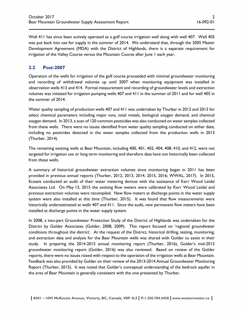
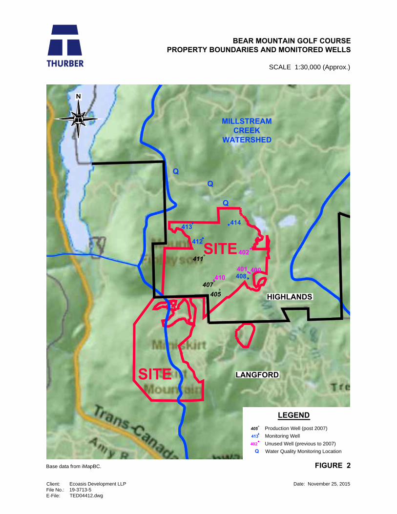
Figure 1 shows a site plan with the location of all wells at Bear Mountain. Figure 2 illustrates the property limits in relation to municipal boundaries and the locations of select onsite and monitored offsite wells. Table A1, which summarizes the location, construction information, and status of wells at Bear Mountain is provided in Appendix A.
2.1 Pre-2007
Groundwater supply potential for the Bear Mountain property was initially investigated in 1996 by Thurber Engineering Ltd. (Thurber) for Western Forest Products with the drilling and test pumping of Well 400 (Thurber, 1996). In 1998, a further five wells (401 to 405) were drilled, and wells 401, 403, 404, and 405 were test pumped to assess yield potential (Thurber, 1998).
In 2002, well 405 was put into active use, being operated continually for approximately five weeks to irrigate the Langford (Valley) golf course during construction (Thurber, 2002). At this time, four new wells (406, 407, 408, and 409) were also drilled. Extraction pumping from wells 407 and 408 commenced immediately for irrigation, prior to test pumping. Wells 406 and 409 were not tested or utilized due to low yield potential. It was later determined, after testing, that well 408 may be connected to nearby Millstream Creek (Mackie and Allen, 2003). Well 410 was drilled and tested in 2003 for utilization while alterations to well 407 were being undertaken.
Prior to construction of the Highlands golf course at Bear Mountain, assessment and sampling of neighbouring residential wells was initiated in 2005 to collect baseline water quality and well construction information. The initial sampling included 25 wells. Following completion of earthworks and blasting in November 2007, the scale of the sampling program was reduced. The approximate location of the three residential wells that are currently sampled on a quarterly basis is shown in Figure 2.
In 2006, an additional two proposed irrigation wells (411 and 412) and two observation wells (413 and 414) were constructed and tested to meet the additional irrigation requirements of the Highlands golf course.
October 2017 2 Bear Mountain Groundwater Supply Assessment Report 16-092-01
| #301 – 1095 McKenzie Avenue, Victoria, BC, Canada, V8P 2L5 | P:1.250.704.4428 | www.westernwater.ca |
Well 411 has since been actively operated as a golf course irrigation well along with well 407. Well 405 was put back into use for supply in the summer of 2014. We understand that, through the 2005 Master Development Agreement (MDA) with the District of Highlands, there is a separate requirement for irrigation of the Valley Course versus the Mountain Course after June 1 each year.
2.2 Post-2007
Operation of the wells for irrigation of the golf course proceeded with minimal groundwater monitoring and recording of withdrawal volumes up until 2007 when monitoring equipment was installed in observation wells 413 and 414. Formal measurement and recording of groundwater levels and extraction volumes was initiated for irrigation pumping wells 407 and 411 in the summer of 2011 and for well 405 in the summer of 2014.
Water quality sampling of production wells 407 and 411 was undertaken by Thurber in 2012 and 2013 for select chemical parameters including major ions, total metals, biological oxygen demand, and chemical oxygen demand. In 2013, a scan of 120 common pesticides was also conducted on water samples collected from these wells. There were no issues identified from water quality sampling conducted on either date, including no pesticides detected in the water samples collected from the production wells in 2013 (Thurber, 2014).
The remaining existing wells at Bear Mountain, including 400, 401, 402, 404, 408, 410, and 412, were not targeted for irrigation use or long term monitoring and therefore data have not historically been collected from these wells.
A summary of historical groundwater extraction volumes since monitoring began in 2011 has been provided in previous annual reports (Thurber, 2012, 2013, 2014, 2015, 2016; WWAL, 2017). In 2015, Ecoasis conducted an audit of their water metering devices with the assistance of Kerr Wood Leidal Associates Ltd. On May 13, 2015 the existing flow meters were calibrated by Kerr Wood Leidal and previous extraction volumes were recompiled. New flow meters at discharge points in the water supply system were also installed at this time (Thurber, 2015). It was found that flow measurements were historically underestimated at wells 407 and 411. Since the audit, new permanent flow meters have been installed at discharge points in the water supply system.
In 2008, a two-part Groundwater Protection Study of the District of Highlands was undertaken for the District by Golder Associates (Golder, 2008, 2009). This report focused on ‘regional groundwater conditions throughout the district’. At the request of the District, historical drilling, testing, monitoring, and extraction data and analysis for the Bear Mountain wells was shared with Golder to assist in their study. In preparing the 2014-2015 annual monitoring report (Thurber, 2016), Golder’s mid-2015 groundwater monitoring report (Golder, 2016) was also reviewed. Based on review of the Golder reports, there were no issues raised with respect to the operation of the irrigation wells at Bear Mountain. Feedback was also provided by Golder on their review of the 2013-2014 Annual Groundwater Monitoring Report (Thurber, 2015). It was noted that Golder’s conceptual understanding of the bedrock aquifer in the area of Bear Mountain is generally consistent with the one presented by Thurber.
October 2017 3 Bear Mountain Groundwater Supply Assessment Report 16-092-01
| #301 – 1095 McKenzie Avenue, Victoria, BC, Canada, V8P 2L5 | P:1.250.704.4428 | www.westernwater.ca |
According to the District of Highlands records dating back to 2004, there have been no reported impacts to the groundwater quality or yield of neighbouring supply wells as a result of operation of the golf course irrigation wells (District of Highlands, personal communication, January 6, 2017).
3. AQUIFER DESCRIPTION AND CONCEPTUAL FLOW MODEL
The aquifer description and conceptual groundwater flow model described in this section is taken from Thurber (2015, 2016).
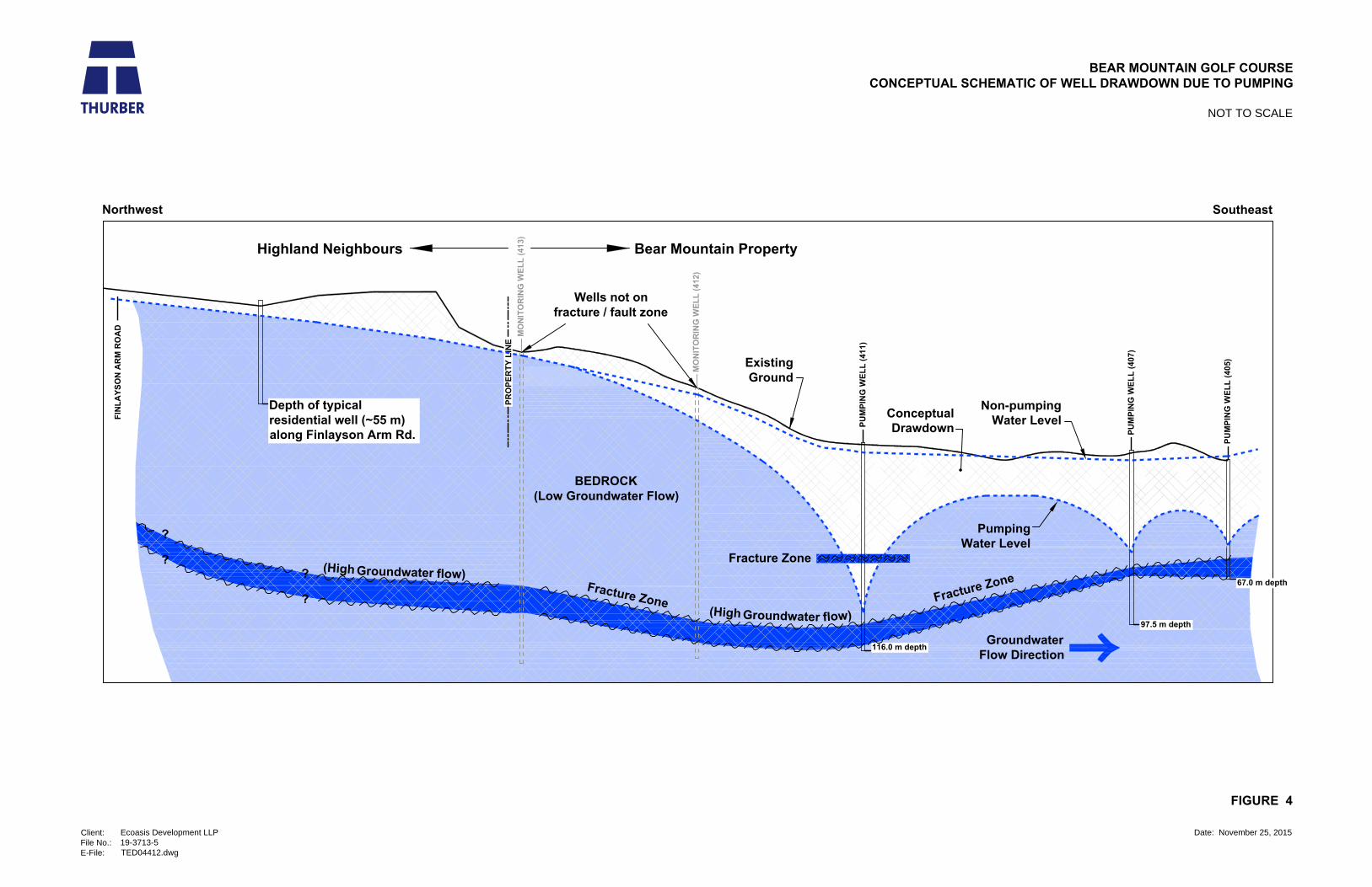
The primary aquifer in the area consists of bedrock in which groundwater is stored and transmitted through fractures. Zones of higher permeability in bedrock aquifers can exist as faults, dykes, joints, or geological contacts that may be hydraulically connected to the bulk rock through a fracture network. Higher yielding wells in bedrock aquifers source groundwater from these geological features. From well testing conducted in 2006/2007 (Thurber, 2007), the hydraulic behaviour of irrigation wells 405, 407, and 411 suggests that they are located near a shared linear feature (shown in Figure 1) that is higher in permeability than the surrounding bedrock. Observation wells 413 and 414, which are not located along this feature, appear to have little or no hydraulic connection to the irrigation wells.
On a regional scale, groundwater generally flows from recharge areas at higher elevations to lower elevation discharge areas. Much of the District of Highlands is therefore considered to be an area of regional groundwater recharge. Groundwater originating from infiltrated surface water in the Highlands migrates toward lower elevations. The surface water drainage patterns for the Millstream and Craigflower Creek watersheds were described by Golder (2008). Groundwater in the south part of the Highlands is anticipated to drain toward the south. Migrating groundwater is expected to eventually discharge to Esquimalt Harbour and Portage Inlet, either directly or via surface water drainage. The Millstream Creek watershed, which is the inferred groundwater catchment for the area upland of Bear Mountain, is shown in Figure 3.
The Bear Mountain supply wells are situated in a localized topographic low between higher elevations to the north (Gowlland Range), west (Mount Finlayson) and south (Skirt Mountain). Based on the conceptual flow model described, the groundwater sourced by the irrigation wells is expected to have come from higher surrounding elevations. Groundwater that is not consumed by users along the way continues downgradient toward the drainage areas at lower elevations.
The sources, sinks and relative amounts of groundwater recharge and discharge to the District of Highlands were estimated by Golder (2008) through calibration of a numerical flow model for the region. Table 4 in their report, which is attached in Appendix B, summarizes the results of water balance predictions for current conditions and various future water use scenarios. An excerpt from the table is provided in Table 3.1 on the following page, which shows relative estimated contributions of various sources to the regional water balance under current conditions.
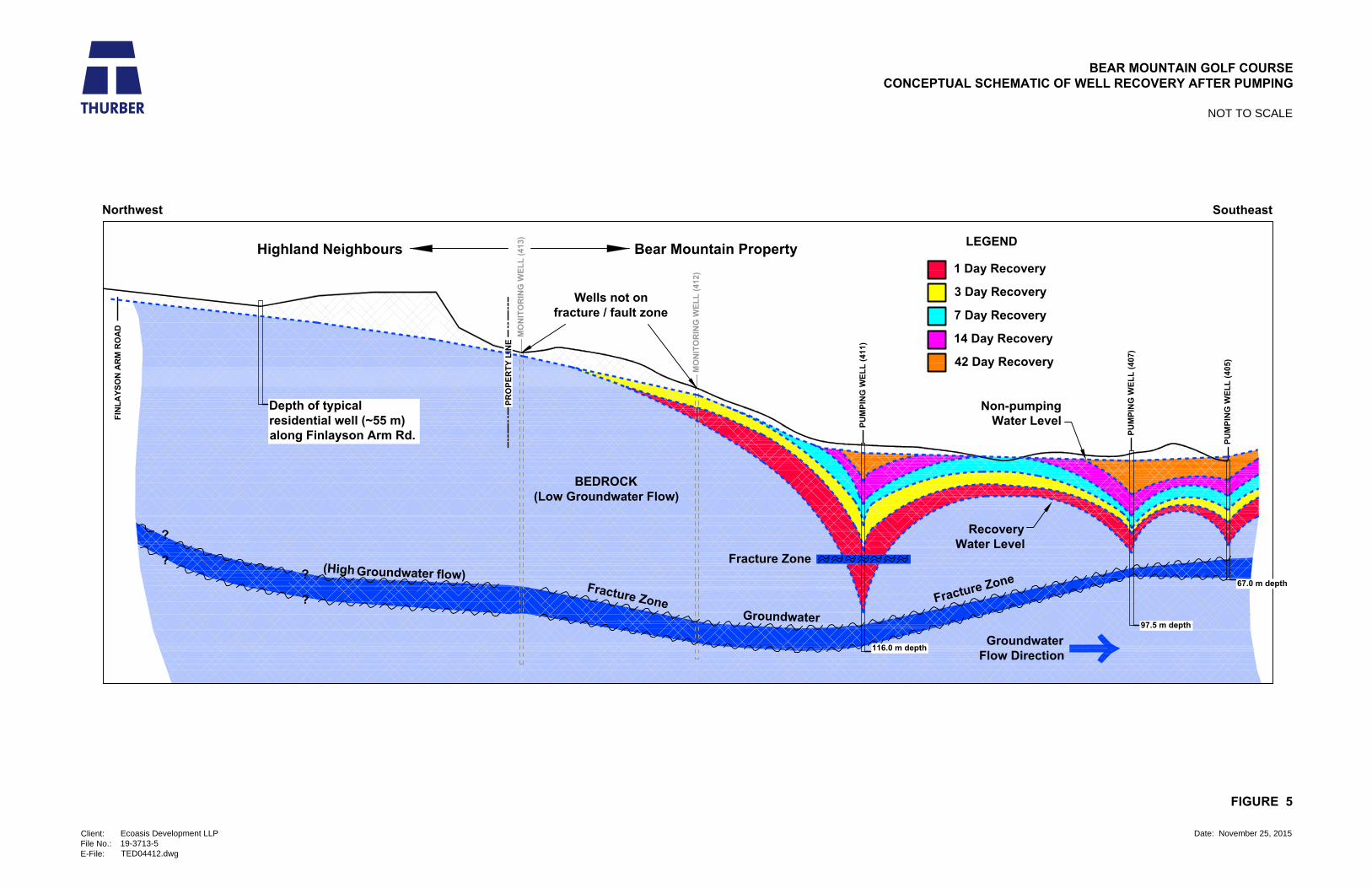
Figures 4 and 5 respectively show conceptualizations of aquifer drawdown (during pumping) and recovery (after pumps shut off) along the fracture zone shared by the Bear Mountain production wells. The magnitude of drawdown and recovery in the wells is based on data collected during 2014 irrigation

October 2017 4 Bear Mountain Groundwater Supply Assessment Report 16-092-01
| #301 – 1095 McKenzie Avenue, Victoria, BC, Canada, V8P 2L5 | P:1.250.704.4428 | www.westernwater.ca |
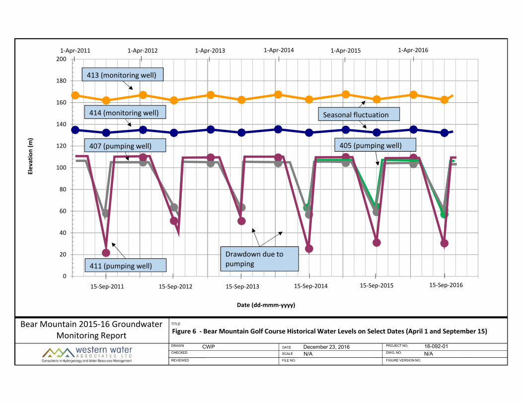
pumping. The figures have been vertically scaled by a factor of three for illustrative purposes. As can be seen in the figures, the wells were operated to near their highest yield potential during 2014 operation with the maximum drawdown in all three pumping wells approaching the productive fracture zone. Since monitoring of the pumping wells was initiated in 2011, complete recovery following pumping has been consistently observed in the supply wells over a duration of between two weeks (in 2012) and six weeks (in 2014). The effect of pumping and recovery in the past is shown in Figure 6, which provides the water levels in the pumping wells and the monitoring wells in the Spring (April 1) and Fall (Sept 15) each year since 2011. The lines in Figure 6 connecting water levels on the select dates are based on actual data but have been converted to straight line segments for illustrative purposes to remove high frequency fluctuations such as pump cycling. Year over year recovery of the wells provides an indication that existing local demands on the aquifer do not exceed its supply capacity. Current operation of the irrigation wells is therefore viewed as sustainable in terms of groundwater quantity over the long-term.
Table 3.1 Predicted Highlands Water Balance for Current Conditions*
Sources of Groundwater Inflow and Outflow Best Calibration
Inflow
Recharge from precipitation 83%
Recharge from anthropogenic sources 5%
Recharge from surface water bodies 7%
Groundwater flow from neighbouring jurisdictions 5%
Total 100%
Outflow
Groundwater withdrawals by major users 3%
Groundwater withdrawals by minor (residential) users 7%
Groundwater discharge to surface water (except Finlayson Arm) 61%
Groundwater discharge to Finlayson Arm 18%
Groundwater discharge to neighbouring jurisdictions 11%
Total 100%
*taken from Golder (2008)
4. WATER LEVEL MONITORING AND GROUNDWATER EXTRACTION
The 2015-2016 Annual Groundwater Monitoring Report in Appendix C provides the results of groundwater extraction volumes and water level monitoring from November 2015 to December 2016.
During the 2016 irrigation season a total volume of approximately 344,500 cubic metres of groundwater was extracted from May 4 to September 27, based on data provided by Ecoasis to Colquitz Engineering.

October 2017 5 Bear Mountain Groundwater Supply Assessment Report 16-092-01
| #301 – 1095 McKenzie Avenue, Victoria, BC, Canada, V8P 2L5 | P:1.250.704.4428 | www.westernwater.ca |
Of this total volume, approximately 204,500 m3 was pumped into Osborne Pond and approximately 140,000 m3 was pumped into the Mountain Pond.
With respect to the water balance, a significant portion of the extracted groundwater at Bear Mountain is expected to return to the aquifer via infiltration of golf course irrigation return flow and from leakage of the main golf course storage reservoir, Osborne Pond. In their 2008 report, Golder estimated through calibration of the numerical model that 8.5% of total precipitation infiltrates into the ground and recharges the aquifer. They also estimated that 70% of the groundwater extracted from residential wells is returned to the ground via septic field infiltration. These estimates (8.5 and 70%, respectively) were previously used to approximate the amount of water that infiltrates back into the aquifer from irrigation of the golf course, and the amount of water that leaks from Osborne Pond (Thurber, 2014).
Due to losses, which are primarily believed to be from leakage from Osborne Pond, Colquitz Engineering estimated the net groundwater extraction volume removed for the Valley course to be 52,000 m3, or approximately 26% of the gross extraction volume. Details of the water balance calculations are included in the water balance study.
5. NEW GROUNDWATER LICENSING REQUIREMENTS
The Province of BC passed the Water Sustainability Act (WSA) in 2014, and a series of initial Regulations were enacted on February 29, 2016 requiring non‐domestic water users to apply for a water licence and pay annual water rental fees. The purpose of the WSA is to ‘ensure a sustainable supply of fresh, clean water that meets the needs of B.C. residents today and in the future’.
In June 2017, Ecoasis submitted an application to the Province for an Existing Use Groundwater Licence. The total annual groundwater diversion amount applied for was 375,000 m3 from the three existing supply wells (405, 407, and 411). We understand that the water use purpose that normally applies to golf courses is ‘Lawn, Fairway and Garden’. This is different than the ‘Irrigation’ purpose which applies to ‘use of water on cultivated land or hay meadows to nourish crops or on pasture to nourish forage’.
Historical groundwater extraction volumes have been summarized in previous monitoring reports. Prior to the 2016 irrigation season, however, Ecoasis installed electromagnetic flow meters (magmeters) on the well supply mains to both the Valley and Mountain irrigation ponds to improve flow measurement accuracy. The extraction volumes summarized in previous reports, prior to the new magmeter installations, therefore are considered rough estimates.
Requirements for measuring and reporting water use under the WSA have not yet been specified by the Province. We anticipate that the new magmeters and the protocol developed by Bear Mountain will allow for accurate measurement and recording of groundwater supply data going forward under the WSA. This will assist Ecosasis in ensuring that groundwater extraction is conducted in accordance with the water licence.

October 2017 6 Bear Mountain Groundwater Supply Assessment Report 16-092-01
| #301 – 1095 McKenzie Avenue, Victoria, BC, Canada, V8P 2L5 | P:1.250.704.4428 | www.westernwater.ca |
6. ONGOING MONITORING AND WELL CLOSURE
We understand that many of the wells that were drilled for groundwater exploration at Bear Mountain are not currently being used. We have been informed by Ecoasis that wells 403 and 409 are now owned by Hannington Creek Estates and that well 404 cannot be located as it was buried during golf course construction.
It was recommended in the 2014-2015 monitoring report, that the dataloggers be removed from wells 413 and 414 and placed in wells 408 and 412 to gather detailed data at other monitoring locations. It has since been found that well 408 has been vandalized by means of debris being dropped down the well. As such, this well is not currently usable for monitoring. On October 26, 2016, the datalogger from well 413 was removed and placed in well 412. On July 7, 2017 the datalogger from well 414 was removed as it was malfunctioning. A new datalogger was installed in well 400 for ongoing monitoring.
As recommended in the 2014-2015 monitoring report, wells 413 and 414 should be maintained as monitoring wells for periodic manual measurements and for future continuous water level readings, if desired. It is recommended that well 408 be cleaned out for future use as a monitoring well or for decommissioning.
It is recommended that the status of all remaining wells, including 401, 402 and 410, be reviewed to determine options for future use (monitoring or supply). Any unused wells at Bear Mountain should be decommissioned in accordance with the 2016 B.C. Ground Water Protection Regulation.
7. OFFSITE GROUNDWATER QUALITY MONITORING
In accordance with the MDA, three private residential wells on adjacent properties north of Bear Mountain have been sampled quarterly since 2005. The samples are analyzed for select potability parameters, including: major ions, total coliform, E. coli, and total metals. There have been over 40 samples of each well to date (>120 samples in total). The results of water quality analyses have been reviewed for potability and provided to the well owners with a digital copy sent to Ecoasis.
We understand that this program was implemented to collect baseline data in anticipation of irrigating the golf course with recycled effluent. There is currently no plan to carry out irrigation of the Bear Mountain golf course in this manner. The offsite quality monitoring is also not considered effective for the purpose of monitoring impacts to the aquifer due to activities at the golf course given that it is upgradient of the groundwater flow direction. We believe that more effective water quality monitoring for potential impacts (e.g. from fertilizer application) would be on-site or downgradient. On-site water quality monitoring is currently being undertaken by WSP Global Inc.

October 2017 7 Bear Mountain Groundwater Supply Assessment Report 16-092-01
| #301 – 1095 McKenzie Avenue, Victoria, BC, Canada, V8P 2L5 | P:1.250.704.4428 | www.westernwater.ca |
8. REFERENCES
Golder Associates Ltd., Mid-Year Results of 2015 Groundwater Level Monitoring Program, District of Highlands, BC, June 8, 2016.
Golder Associates Ltd., Phase 1: Groundwater Protection Study, District of Highlands, October, 2008. Golder Associates Ltd., Phase 2: Groundwater Protection Study, District of Highlands, December, 2009. Mackie, D., and D.M. Allen, Detailed analysis of pumping test data, estimation of long term yield and
potential off-site impacts from pumping, January, 2003. Thurber Engineering Ltd., Bear Mountain 2014-2015 Annual Groundwater Monitoring Report, Ecoasis
Developments LLP, August, 2016. Thurber Engineering Ltd., Bear Mountain 2013-2014 Annual Groundwater Monitoring, Ecoasis
Developments LLP, October, 2015. Thurber Engineering Ltd., 2012-2013 Annual Groundwater Monitoring, Bear Mountain Development,
January, 2014. Thurber Engineering Ltd., 2011-2012 Annual Groundwater Monitoring, Bear Mountain Development,
February, 2013. Thurber Engineering Ltd., Bear Mountain Development, 2010-2011 Annual Groundwater Monitoring
Report, January, 2012. Thurber Engineering Ltd., Bear Mountain Golf & Country Club, Highlands Golf Course, Groundwater
Supply Report, 2006-2007 Program, October, 2007. Thurber Engineering Ltd., Western Forest Products Limited Highlands South Golf Community
Groundwater Supply Program, November, 1998. Thurber Engineering Ltd., WFP – Highlands South Development Water Well Supply Overview Study Test
Well 96-1 (Highlands #400) Assessment, September, 1996. Western Water Associates Ltd., Bear Mountain 2015-2016 Annual Groundwater Monitoring Report,
August, 2017.

| #301 – 1095 McKenzie Avenue, Victoria, BC, Canada, V8P 2L5 | P:1.250.704.4428 | www.westernwater.ca |
Western Water Associates Ltd.
Standard Report Limitations 1. This Document has been prepared for the particular purpose outlined in the work scope that has
been mutually agreed to with the Client. 2. The scope and the period of service provided by Western Water Associates Ltd are subject to
restrictions and limitations outlined in subsequent numbered limitations. 3. A complete assessment of all possible conditions or circumstances that may exist at the Site or
within the Study Area referenced, has not been undertaken. Therefore, if a service is not expressly indicated, it has not been provided and if a matter is not addressed, no determination has been made by Western Water Associates Ltd. in regards to it.
4. Conditions may exist which were undetectable given the limited nature of the enquiry that Western Water Associates Ltd. was retained to undertake with respect to the assignment. Variations in conditions may occur between investigatory locations, and there may be special conditions pertaining to the Site, or Study Area, which have not been revealed by the investigation and which have not therefore been taken into account in the Document. Accordingly, additional studies and actions may be required.
5. In addition, it is recognised that the passage of time affects the information and assessment provided in this Document. Western Water Associates Ltd’s opinions are based upon information that existed at the time of the production of the Document. It is understood that the Services provided allowed Western Water Associates Ltd to form no more than an opinion of the actual conditions of the Site, or Study Area, at the time the site was visited and cannot be used to assess the effect of any subsequent changes in the quality of the Site, or Study Area, nor the surroundings, or any laws or regulations.
6. Any assessments made in this Document are based on the conditions indicated from published sources and the investigation described. No warranty is included, either expressed or implied, that the actual conditions will conform exactly to the assessments contained in this Document.
7. Where data supplied by the Client or other external sources, including previous site investigation data, have been used, it has been assumed that the information is correct unless otherwise stated.
8. No responsibility is accepted by Western Water Associates Ltd for incomplete or inaccurate data supplied by others.
9. The Client acknowledges that Western Water Associates Ltd may have retained sub-consultants affiliated to provide Services. Western Water Associates Ltd will be fully responsible to the Client for the Services and work done by all of its sub-consultants and subcontractors. The Client agrees that it will only assert claims against and seek to recover losses, damages or other liabilities from Western Water Associates Ltd.
10. This Document is provided for sole use by the Client and is confidential to it and its professional advisers. No responsibility whatsoever for the contents of this Document will be accepted to any person other than the Client. Any use which a third party makes of this Document, or any reliance on or decisions to be made based on it, is the responsibility of such third parties. Western Water Associates Ltd. accepts no responsibility for damages, if any, suffered by any third party as a result of decisions made or actions based on this Document.

414
402
404
401
400
408
410406
413
PRODUCTION WELL
OBSERVATION WELL
OTHER EXISTING WELLS
INFERRED SECONDARY LINEAMENTS
INFERRED PRIMARY FAULT ZONE
412
407
405
405
LEGEND
411
CLOSED WELLS SHOWN IN GREY
406
409 403
413
BEAR MOUNTAIN GOLF COURSE
2014-2015 ANNUAL MONITORING REPORT - WELL LOCATION PLAN
SCALE 1:8000
Client:
File No.:
E-File:
Date: November 25, 2015
FIGURE 1
Ecoasis Developments LLP
19-3713-5
TED04392.dwg
5004003002001000
SCALE 1:8000
Digital base plan provided by Focus Corporation.
NOTES:
405
407
411
413
414
402
401
400
408
410
Q
Q
Q
412
BEAR MOUNTAIN GOLF COURSE
PROPERTY BOUNDARIES AND MONITORED WELLS
SCALE 1:30,000 (Approx.)
Client:
File No.:
E-File:
Date: November 25, 2015
FIGURE 2
Ecoasis Development LLP
19-3713-5
TED04412.dwg
Base data from iMapBC.
MILLSTREAM
CREEK
WATERSHED
SITE
HIGHLANDS
LANGFORD
SITE
LEGEND
Production Well (post 2007)405
413 Monitoring Well
402 Unused Well (previous to 2007)
Q Water Quality Monitoring Location

BEAR MOUNTAIN GOLF COURSE
GROUNDWATER SOURCE AREA
SCALE 1:60,000 (Approx.)
Client:
File No.:
E-File:
Date: November 25, 2015
FIGURE 3
Ecoasis Development LLP
19-3713-5
TED04412.dwg
Base data from iMapBC.
MILLSTREAM
CREEK
WATERSHED
CRAIGFLOWER
CREEK WATERSHED
SITE
HIGHLANDS
LANGFORD
GRADIENT
SITE
PU
MP
IN
G W
EL
L (405)
PU
MP
IN
G W
EL
L (407)
PU
MP
IN
G W
EL
L (411)
SoutheastNorthwest
Non-pumping
Water Level
Pumping
Water Level
Conceptual
Drawdown
Groundwater
Flow Direction
Existing
Ground
F
r
a
c
tu
r
e
Z
o
n
e
F
ra
c
tu
re
Z
o
n
e
BEDROCK
(Low Groundwater Flow)
67.0 m depth
97.5 m depth
116.0 m depth
MO
NIT
OR
IN
G W
EL
L (412)
FIN
LA
YS
ON
A
RM
R
OA
D
PR
OP
ER
TY
L
IN
E
3 X VERT SCALE,
MIRRORED AND
EXTENDED
MO
NIT
OR
IN
G W
EL
L (413)
?
?
?
?
Depth of typical
residential well (~55 m)
along Finlayson Arm Rd.
Wells not on
fracture / fault zone
(Hig
h
Groundwater flo
w)
(Hig
h
Groundwaterflow)
Highland Neighbours Bear Mountain Property
Fracture Zone
BEAR MOUNTAIN GOLF COURSE
CONCEPTUAL SCHEMATIC OF WELL DRAWDOWN DUE TO PUMPING
NOT TO SCALE
Client:
File No.:
E-File:
Date: November 25, 2015
FIGURE 4
Ecoasis Development LLP
19-3713-5
TED04412.dwg
SoutheastNorthwest
Recovery
Water Level
MO
NIT
OR
IN
G W
EL
L (412)
FIN
LA
YS
ON
A
RM
R
OA
D
PR
OP
ER
TY
L
IN
E
MO
NIT
OR
IN
G W
EL
L (413)
?
?
?
?
Depth of typical
residential well (~55 m)
along Finlayson Arm Rd.
(Hig
h
Groundwaterflow)
3 X VERT SCALE,
MIRRORED AND
EXTENDED
UP TO 42 day recovery
LEGEND
1 Day Recovery
3 Day Recovery
7 Day Recovery
14 Day Recovery
42 Day Recovery
Wells not on
fracture / fault zone
Highland Neighbours Bear Mountain Property
Non-pumping
Water Level
F
r
a
c
tu
r
e
Z
o
n
e
F
ra
c
tu
re
Z
o
n
e
BEDROCK
(Low Groundwater Flow)
Groundwater
Fracture Zone
Groundwater
Flow Direction
PU
MP
IN
G W
EL
L (405)
PU
MP
IN
G W
EL
L (407)
PU
MP
IN
G W
EL
L (411)
67.0 m depth
97.5 m depth
116.0 m depth
BEAR MOUNTAIN GOLF COURSE
CONCEPTUAL SCHEMATIC OF WELL RECOVERY AFTER PUMPING
NOT TO SCALE
Client:
File No.:
E-File:
Date: November 25, 2015
FIGURE 5
Ecoasis Development LLP
19-3713-5
TED04412.dwg
0
20
40
60
80
100
120
140
160
180
200
Elevation (m
)
Date (dd‐mmm‐yyyy)
Figure 6 ‐ Bear Mountain Golf Course Historical Water Levels on Select Dates (April 1 and September 15)
CWP December 23, 2016 16-092-01
TITLE
DRAWN
CHECKED
REVIEWED
DATE
SCALE
FILE NO.
PROJECT NO.
DWG. NO.
FIGURE VERSION NO.
N/A N/A
Bear Mountain 2015‐16 Groundwater Monitoring Report
Seasonal fluctuation
Drawdown due to pumping
413 (monitoring well)
414 (monitoring well)
407 (pumping well)
411 (pumping well)
405 (pumping well)
1‐Apr‐2011 1‐Apr‐2012 1‐Apr‐2013 1‐Apr‐2014 1‐Apr‐2015 1‐Apr‐2016
15‐Sep‐2011 15‐Sep‐2012 15‐Sep‐2013 15‐Sep‐2014 15‐Sep‐2015 15‐Sep‐2016

APPENDIX A Table A1. Bear Mountain Wells
Bear Mountain Groundwater Supply Assessment Report WWAL Ref: 16-092-01

Table A1. Bear Mountain Wells
Northing Easting(m) (m) (m) (masl) (m) Method Frequency
400 MW inactive 5370022.45 461975.45 0.15 95 107 ‐ ‐ 100 mm PVC liner401 MW inactive 5370034.65 461945.33 0.2 94 83.8 ‐ ‐ 150 mm PVC liner402 MW inactive 5370413.40 461989.09 0.15 105 123.4 ‐ ‐403 ‐ ‐ 5369634.54 462206.89 0.2 91.0 123.4 ‐ ‐ Owned by Hannington Estates404 MW inactive 5370281.76 461666.32 0.15 100 99.1 ‐ ‐405 PW active 5371903.00 461669.00 0.2 105 67.0 automatic3 annually406 ‐ closed 5372055.00 461484.00 ‐ ‐ ‐ ‐ ‐ Formerly closed in accordance with GWPR407 PW active 5372039.00 461580.00 0.25 110 97.5 ‐ ‐408 MW inactive 5369930.47 461946.06 0.2 95 121.9 ‐ ‐ Vandalized with debris in well409 ‐ ‐ 5369635.28 461935.23 0.2 105.0 83.8 ‐ ‐ Owned by Hannington Estates410 MW inactive 5372055.00 461574.00 ‐ ‐411 PW active 5372462.00 461417.00 0.25 114.4 116.0 automatic annually 200 mm PVC liner412 MW active 5372743.00 461398.00 0.25 154.3 152.4 automatic annually 200 mm PVC liner413 MW active 5372983.00 461225.00 0.15 169.3 175.3 ‐ ‐414 MW active 5372961.00 461818.00 0.15 136.4 221.0 automatic annually
NOTES: 1 MW ‐ monitoring well PW ‐ pumping well2 Ground elevation and screen depths from: Thurber Engineering Ltd. (Thurber, 1996, 1998, 2007)3 Refers to use of datalogging transducers taking hourly level and temperature readings with datadownloaded a minimum of 1 time per year
CommentOpen Hole DiameterType1Well ID Status
LocationTotal Depth Water Level Monitoring
Ground Elevation2
| #301 ‐ 1095 McKenzie Ave, Victoria, B.C. V8P 2L5 | P:1.250.704.4428 | Vernon | Prince George | www.westernwater.ca |
APPENDIX B
Table 4 from Golder (2008)
Bear Mountain Groundwater Supply Assessment Report WWAL Ref: 16-092-01

APPENDIX C Bear Mountain 2015-2016 Annual Groundwater Monitoring Report
Bear Mountain Groundwater Supply Assessment Report WWAL Ref: 16-092-01

| #301 ‐ 1095 McKenzie Ave, Victoria, B.C. V8P 2L5 | P:1.250.704.4428 | Vernon | Prince George | www.westernwater.ca |
October 19, 2017 FILE: 16‐092‐01
Ecoasis Developments LLP 2050 Country Club Way Victoria, BC V9B 6R3 Attention: Eric Gerlach, P.Eng. Re: Bear Mountain 2015‐2016 Annual Groundwater Monitoring Report
Dear Mr. Gerlach:
As requested, Western Water Associates Ltd. (WWAL) provides this report summarizing groundwater monitoring at Bear Mountain golf course in 2015‐2016.
This document provides a summary of the groundwater monitoring data collected at Bear Mountain from November 2015 to December 2016. General and background information that support this report can be found in the September 2017 Bear Mountain Groundwater Supply Assessment Report.
1. GROUNDWATER EXTRACTION
1.1 Licensing
The Province of BC passed the Water Sustainability Act (WSA) in 2014, and a series of initial Regulations were enacted on February 29, 2016 requiring non‐domestic water users to apply for a water licence and pay annual water rental fees.
In June 2017, Ecoasis submitted an application to the Province for an Existing Use Groundwater Licence. The total annual groundwater diversion amount applied for was 375,000 m3 from the three existing supply wells (405, 407, and 411).
1.2 Extraction Rates and Volumes
During the 2015‐2016 monitoring period, pumping of wells 405, 407 and 411 for irrigation of both the Mountain and Valley golf courses began on May 4, 2016 and continued until September 27, 2016 when the pumps in all production wells were shut off for the winter. Extraction volumes were measured by digital flow meters, which are recorded and maintained by Ecoasis staff.
Ecoasis reported a gross extraction volume of 344,500 m3 for both golf courses. Extraction rates were measured to be approximately 30 USgpm (1.9 L/s) for well 405, 140 USgpm (8.8 L/s) for well 407, and 170 USgpm (10.7 L/s) for well 411. The digital flow meters measured approximately 204,500 m3 pumped into Osborne Pond (the primary reservoir for the Valley Course) and approximately 140,000 m3 pumped into the Mountain Pond over the duration of pumping in 2016 (May 4 to September 27).

October 19, 2017 Bear Mountain 2015-2016 GW Monitoring 2 16-092-01
| #301 ‐ 1095 McKenzie Ave, Victoria, B.C. V8P 2L5 | P:1.250.704.4428 | Vernon | Prince George | www.westernwater.ca |
From the water balance work conducted for the golf course by Colquitz Engineering Ltd., we understand that the net extraction volume for the Valley Golf Course is estimated to be approximately 26% of the measured gross extraction volume, due to leakage of the Osborne Pond. The net groundwater extraction volume removed for the Valley course is therefore estimated by Colquitz Engineering to be approximately 52,000 m3.
2. WATER LEVEL MONITORING
2.1 Methodology
Water levels were continuously monitored in pumping wells 405, 407 and 411 and two monitoring wells (413 and 414) during the 2015‐2016 monitoring period (November 2015 to October 2016). Production wells and observation wells that are continuously monitored are shown in red and magenta, respectively in Figure 1. Each of the monitored wells have data‐logging transducers that are capable of measuring temperature and pressure at set intervals (set to hourly at this site). During downloading of the dataloggers, manual water level measurements were taken. Periodic water level measurements in the pumping wells were also made by Ecoasis staff.
2.2 Results and Discussion
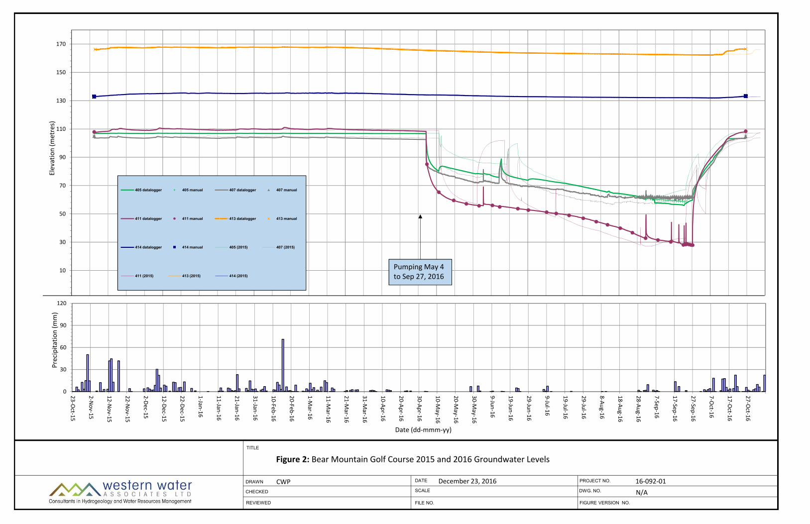
Groundwater elevations for the selected wells during the 2015‐2016 monitoring period are compiled in Figure 2. For comparison, water level data from the 2014‐2015 monitoring period are also plotted on the same figure using a lighter line weight and a one year shift in the date.
From the data at monitoring wells 413 and 414, 2016 groundwater elevations in the bedrock aquifer were similar to those observed in the past. As in previous years (Thurber, 2012, 2013, 2014, 2015, 2016), aquifer levels fluctuated seasonally on the order of 3 to 5 m and appear to peak in the early spring (February to April) and be lowest in the early fall. Water levels in wells 413 and 414 rise relatively quickly in late fall following the first significant precipitation events. In 2016, this occurred around the middle of October (compared to late October in 2015). The groundwater flow gradient in the north part of the golf course is inferred to be towards the southeast based on the relative static water levels in the wells 407, 411, 413, and 414. The static water level in well 405 was higher than that in the other 2 pumping wells suggesting that the local groundwater flow in that area is toward the north.
Water levels in the pumping wells show a similar fluctuation to the observation wells in the winter and early spring when they are not being pumped. During the irrigation season, the water levels in the irrigation wells were drawn down by a maximum of approximately 50 m in well 405, 43 m in well 407 and 80 m in well 411. Water level drawdown in the pumping wells show a relatively rapid decline when extraction is initiated and then a gradual flattening after prolonged pumping. When pumping is stopped, the water levels in the wells recover relatively quickly. Drawdown in all three pumping wells in 2016 was similar to that observed in 2015.
Following shutdown of the pumps for the winter on September 27, 2016, water levels in the pumping wells recovered to 100% of the pre‐pumping groundwater levels after approximately 4 weeks. This can be compared to a full recovery after ~5 weeks in 2015 (Thurber, 2016), ~6 weeks in 2014 (Thurber, 2015), ~10 days in 2013 (Thurber, 2014), and ~2 weeks in 2012 (Thurber, 2013). The slower recovery times in 2014 and 2015 are likely the result of a longer dry season in these years. From this information, we can conclude that the time to full recovery

October 19, 2017 Bear Mountain 2015-2016 GW Monitoring 3 16-092-01
| #301 ‐ 1095 McKenzie Ave, Victoria, B.C. V8P 2L5 | P:1.250.704.4428 | Vernon | Prince George | www.westernwater.ca |
varies from year to year, depending on the timing of the onset of the rainy season, which is typically within one to two months after the end of the irrigation season.
As observed in previous years, extraction pumping of irrigation wells does not appear to impact the water levels in the two observation wells 413 and 414. This is consistent with the conceptual understanding of the aquifer described in previous reports that the observation wells are considered hydraulically separate from the permeable fault/fracture zone that provides the source of water for the irrigation wells. There are no upgradient monitoring wells (i.e. north of wells 407/411) that share the fault/fracture zone with the production wells. The extent of pumping‐induced drawdown along this lineament is therefore not known.
3. CONCLUSIONS AND RECOMMENDATIONS
Groundwater extraction and level monitoring data at Bear Mountain in 2015‐2016 are provided in this report. The results of monitoring were similar to previous years. Seasonal fluctuations in monitoring wells were on the order of 3 to 5 m. Complete recovery of water table drawdown in the aquifer due to pumping occurred after approximately 4 weeks. There were no indications of groundwater quantity issues. Consistent year‐over‐year recovery in the extraction wells suggests that existing local demands on the aquifer do not exceed its supply capacity.
It was recommended in the 2014‐2015 monitoring report, that the dataloggers be removed from wells 413 and 414 and placed in wells 408 and 412 to gather detailed data at other monitoring locations. It has since been found that well 408 has been vandalized by means of debris being dropped down the well. As such, this well is not currently usable for monitoring. On October 26, 2016, the datalogger from well 413 was removed and placed in well 412. On July 7, 2017 the datalogger from well 414 was removed as it was malfunctioning. A new datalogger was installed in well 400 for ongoing monitoring.
It is recommended that the annual groundwater monitoring and reporting program be maintained. The dataloggers should be downloaded at the start and the end of the irrigation season, or approximately in May and November.


October 19, 2017 Bear Mountain 2015-2016 GW Monitoring 5 16-092-01
| #301 ‐ 1095 McKenzie Ave, Victoria, B.C. V8P 2L5 | P:1.250.704.4428 | Vernon | Prince George | www.westernwater.ca |
5. REFERENCES
Thurber Engineering Ltd., Bear Mountain 2014‐2015 Annual Groundwater Monitoring Report, Ecoasis Developments LLP, August, 2016. Thurber Engineering Ltd., Bear Mountain 2013‐2014 Annual Groundwater Monitoring, Ecoasis Developments LLP, October, 2015. Thurber Engineering Ltd., 2012‐2013 Annual Groundwater Monitoring, Bear Mountain Development, January, 2014. Thurber Engineering Ltd., 2011‐2012 Annual Groundwater Monitoring, Bear Mountain Development, February, 2013. Thurber Engineering Ltd., Bear Mountain Development, 2010‐2011 Annual Groundwater Monitoring Report, January, 2012.
| #301 ‐ 1095 McKenzie Ave, Victoria, B.C. V8P 2L5 | P:1.250.704.4428 | Vernon | Prince George | www.westernwater.ca |
Western Water Associates Ltd. Standard Report Limitations
1. This Document has been prepared for the particular purpose outlined in the work scope that has been mutually
agreed to with the Client. 2. The scope and the period of service provided by Western Water Associates Ltd are subject to restrictions and
limitations outlined in subsequent numbered limitations. 3. A complete assessment of all possible conditions or circumstances that may exist at the Site or within the Study Area
referenced, has not been undertaken. Therefore, if a service is not expressly indicated, it has not been provided and if a matter is not addressed, no determination has been made by Western Water Associates Ltd. in regards to it.
4. Conditions may exist which were undetectable given the limited nature of the enquiry that Western Water Associates Ltd. was retained to undertake with respect to the assignment. Variations in conditions may occur between investigatory locations, and there may be special conditions pertaining to the Site, or Study Area, which have not been revealed by the investigation and which have not therefore been taken into account in the Document. Accordingly, additional studies and actions may be required.
5. In addition, it is recognised that the passage of time affects the information and assessment provided in this Document. Western Water Associates Ltd’s opinions are based upon information that existed at the time of the production of the Document. It is understood that the Services provided allowed Western Water Associates Ltd to form no more than an opinion of the actual conditions of the Site, or Study Area, at the time the site was visited and cannot be used to assess the effect of any subsequent changes in the quality of the Site, or Study Area, nor the surroundings, or any laws or regulations.
6. Any assessments made in this Document are based on the conditions indicated from published sources and the investigation described. No warranty is included, either expressed or implied, that the actual conditions will conform exactly to the assessments contained in this Document.
7. Where data supplied by the Client or other external sources, including previous site investigation data, have been used, it has been assumed that the information is correct unless otherwise stated.
8. No responsibility is accepted by Western Water Associates Ltd for incomplete or inaccurate data supplied by others. 9. The Client acknowledges that Western Water Associates Ltd may have retained sub‐consultants affiliated to provide
Services. Western Water Associates Ltd will be fully responsible to the Client for the Services and work done by all of its sub‐consultants and subcontractors. The Client agrees that it will only assert claims against and seek to recover losses, damages or other liabilities from Western Water Associates Ltd.
10. This Document is provided for sole use by the Client and is confidential to it and its professional advisers. No responsibility whatsoever for the contents of this Document will be accepted to any person other than the Client. Any use which a third party makes of this Document, or any reliance on or decisions to be made based on it, is the responsibility of such third parties. Western Water Associates Ltd. accepts no responsibility for damages, if any, suffered by any third party as a result of decisions made or actions based on this Document.

414
402
404
401
400
408
410406
413
PRODUCTION WELL
OBSERVATION WELL
OTHER EXISTING WELLS
INFERRED SECONDARY LINEAMENTS
INFERRED PRIMARY FAULT ZONE
412
407
405
405
LEGEND
411
CLOSED WELLS SHOWN IN GREY
406
409 403
413
BEAR MOUNTAIN GOLF COURSE
2014-2015 ANNUAL MONITORING REPORT - WELL LOCATION PLAN
SCALE 1:8000
Client:
File No.:
E-File:
Date: November 25, 2015
FIGURE 1
Ecoasis Developments LLP
19-3713-5
TED04392.dwg
5004003002001000
SCALE 1:8000
Digital base plan provided by Focus Corporation.
NOTES:
‐10
10
30
50
70
90
110
130
150
170
23-Oct-15
12-Dec-15
31-Jan-16
21-Mar-16
10-May-16
29-Jun-16
18-Aug-16
07-Oct-16
Elevation (m
etres)
Figure 2: Bear Mountain Golf Course 2015 and 2016 Groundwater Levels
405 datalogger 405 manual 407 datalogger 407 manual
411 datalogger 411 manual 413 datalogger 413 manual
414 datalogger 414 manual 405 (2015) 407 (2015)
411 (2015) 413 (2015) 414 (2015)
TITLE
DRAWN
CHECKED DWG. NO.
DATE PROJECT NO.
REVIEWED FIGURE VERSION NO.
SCALE
FILE NO.
CWP December 23, 2016 16‐092‐01N/A
Pumping May 4 to Sep 27, 2016
0
30
60
90
120
23‐Oct‐15
2‐Nov‐15
12‐Nov‐15
22‐Nov‐15
2‐Dec‐15
12‐Dec‐15
22‐Dec‐15
1‐Jan‐16
11‐Jan‐16
21‐Jan‐16
31‐Jan‐16
10‐Feb‐16
20‐Feb‐16
1‐Mar‐16
11‐Mar‐16
21‐Mar‐16
31‐Mar‐16
10‐Apr‐16
20‐Apr‐16
30‐Apr‐16
10‐May‐16
20‐May‐16
30‐May‐16
9‐Jun‐16
19‐Jun‐16
29‐Jun‐16
9‐Jul‐16
19‐Jul‐16
29‐Jul‐16
8‐Aug‐16
18‐Aug‐16
28‐Aug‐16
7‐Sep‐16
17‐Sep‐16
27‐Sep‐16
7‐Oct‐16
17‐Oct‐16
27‐Oct‐16
Precipita
tion (m
m)
Date (dd‐mmm‐yy)
| #301 – 1095 McKenzie Avenue, Victoria, BC, Canada, V8P 2L5 | P:1.250.704.4428 | www.westernwater.ca |
Groundwater Supply Development and Management
Source Water Assessment and Protection
Well Monitoring & Maintenance
Environmental & Water Quality Monitoring
Storm & Wastewater Disposal to Ground
Groundwater Modeling
Aquifer Test Design and Analysis
Geothermal / Geoexchange Systems
Policy and Guideline Development
Applied Research
Rural Subdivision Services
Environmental Assessment & Permitting