bedrock geology of barre area, the central; massachusetts
TRANSCRIPT

BEDROCK GEOLOGY OF BARRE AREA, THE
CENTRAL; MASSACHUSETTS BY ROBERT D. TUCKER
CONTRIBUTION NO. 30
DEPARTMENT OF GEOLOGY 8 GEOGRAPHY
UNIVERSITY OF MASSACHUSETTS
AMHERST, MASSACHUSETTS

BEDROCK GEOLOGY OF THE BARRE AREA, CENTRAL MASSACHUSETTS
by
Robert D. Tucker
Contribution No. 30
Department of Geology
University of Massachusetts
Amherst, Massachusetts
August, 1977


TABLE OF CONTENTS
Page
ABSTRACT. . . . . . . . . . . . • • • • . . . . • . • . . • • • . . . • . . . . . . . . . . . • • . . . • . . . . • . . 1
INTRODUCTION. . . . . . . . . . . • • . . . . . . . • • • . . • . . . . . . . . . • . • . . . . • . . . . . • . . . 4
Location ............................ ,...................... 4
Vegetation and Quaternary Cover........................... • 4
Regional Setting.
Purpose of Study.
6
9
Previous Work. . . . . . . . . . . . . . . . . . . . . . . . . . . . . . . . . . . . . . . . . . . . . . 10
Field Work ................................................. 11
Acknowledgments. 11
STRATIGRAPHY. . . . . . . . • • . . • . . . . . . . • . . . • . . . . . • . . . . • • • • • • . . • . . • . . . . . 12
PARTRIDGE FORMATION. • • • • • • • • • • • • • • • • • • • • • • • • • • • • • • • • • • • • • • • • • 16
Lithology ••.• · •••..•.•••.•••. 17
Ragged Hill anticline ••••••.•••..•.••••••••••••••...•• 17
Unitas Road anticline .••.•••.••.•.•.••••••••••••••..•• 18
Lamberton Brook anticline. • • . • • • . • • • • • • • . • • • • . • • . . • • • • 19
Pleasant Brook anticline •••••.•••••.•••••••••••.••.••• 19
Wickaboag Pond anticline •..•.•••••..•••••••••..•..•... 25
Oakham area. 25
Derivation ................................................. 26
Thickness . . . . . . . . . . . . . . . . . . . . . . . . . . . . . . . . . . . . . . . . . . . . . . . . . . 2 7
FITCH FORMATION. . . • • . . . . . • . . . . . . . . • • . . . . . . . . . . . • . • . . • . • . . • • . . 2 7
Lithology. 27
Contacts. . . . . . . . . . . . . . . . . . . . . . . . . . . . . . . . . . . . . . . . . . . . . . . . . . . 28
Derivation ................................................. 28
Thickness. . . . . . . . . . . . . . . . . . . . . . . . . . . . . . . . . . . . . . . . . . . . . . . . . . 29
iii
TABLE OF CONTENTS (Continued)
Page
PAXTON SC~IST ...... "' I ... " ........................ I............. 29
Lithology ..•••...••.••••.•• . . . . . . . . . . . . . . . -............... . 30
Gray Granulite Member •••.•... . . . . . . . . . . . . . . . . . . . . . . . . . 30
White Sulfidic Schist Member.......................... 31
Gray Graphitic Schist Member .•••...•.•.•. ,............ 36
Contacts.................................................... 37
Derivation................................................. 38
Thickness. . . . . . . . . . . . . . . . .. . . . . . . . . . . . . . . . . . . . . . . . . . . . . . . . . . 39
LITTLETON FORMATION. . . . . . • . . . . • • . . . . . . • . • . • . . • • . • • • • • . • • • . . • • 39
Lithology ...••...•.•..• "' ' • • I • • • il • • • • il "' il • "' I "' I "' • I • ' I il • • • • • • I il 40
Hardwick syncline, .• . . . . . . . . . . . . . . . . . . . . . . . . . . . . . . . . . . 44
Big Garnet syncline. • • • ' I • • • • • il • • • • • I • • "' • I "' il il • • il il • • • ' il 44
Coys Hill syncline .•.• . . . . . . . . . . . . . . . . . . . . . . . . .. . . . . . . . 45
Prouty Road syncline .• "' • • I • • • • • • • 1 • • • • • • • "' • I "' "' • il • • • • il I 46
Gilbert Road syncline • . . . . . . . . . . . . . . . . . . . . . . . . . . . . . . . . 49
Kruse Road syncline. • . . • . • • • . . . • • • • . • • . • • . • . . • • • • . . . • . 50
Lower Contacts. . . . . . . . . . . . . . . . . . . . . . . . . . . . . . . . . . . . . . . . . . . . . 50
Derivation................................................. 52
Thickness.. . . . . . . . . . . . . . . . . . . . . . . . . . . . . . . . . . . . . . . . . . . . . . . . . 52
INTRUSIVE IGNEOUS ROCKS.......... . • • • . . . . . . . • . • . • . . . • • • . • • • • • . • • 53
COYS HILL GRANITE............................................ 53
L:i,thology................................................... 54
Lower Contact and Thickness •.•.•...•..•....•.•...•.•.•...•• 57
iv

TABLE OF CONTENTS (Continued)
HARDWICK QUARTZ DIORITE . . . . . . . . . . . . . . . . . . . . . . . . . . . . . . . . . . . . . . . Page
58
Litholo'5j................................................... 58
Contacts and Thicknesses •. .................................. 60
GNEISS OF PLEASANT BROOK. . . . . • • • • • . • • . . • • • • . • . • • • • • . • • . . . . . . . . 60
Lithology .•..• · • · · • · · • • ..................................... 61
Contacts a.Ild Thickness. . . . . . . . . . . . . . . .. . . . . . . . . . . . . . . . . . . . . . . 61
PEG}1ATITE..................................................... 61
DIABASE. . . . . . . . . . . . . . • . . . • . . . . . • . . . . . • . . . . • . . • . . . . . • . . . . . . . . . . 63
STRUCTURAL GEOLOGY......................... . . • • . . . . . . . . . . . . . . . . . . 63
Introduction................................................ 63
SUMMARY OF STRUCTURAL HISTORY................................. 65
DESCRIPTION OF MINOR STRUCTURAL FEATURES ....•.•..••••.•...•.•• 66
Bedding ...• . . . . . . . . . . . . . . . . . . . . . . . . . . . . . . . . . . . . . . . . . . . . . . . . . 66
Foliations . ........................... . . .......... . 67
v
Cataclastic Zones, .................... . ~-:--=-~-:-~-:-:--. ,_~,-:-~~.-:-~~-:-~-:-:--n, , ____ ,_ ~-~------~---
Minor Folds. . . . . . . . . . . . . . . . . . . . . . . . . . . . . . . . . . . . . . . . . . . . . . . . . 71
Lineations. . . . . . . . . . . . . . . . . . . . . . . . . . . . . . . . . . . . . . . . . . . . . . . . . . 7 2
Boudinage . .......... , . . . . . . . . . . . . . . . . . . . . . . . . . . . . . . . . . . . . . . . 7 3
GENERAL PATTERN OF MINOR STRUCTURAL FEATURES ••••••..••...•.•.. 73
DETAILED INTERPRETATION OF STRUCTURAL FEATURES ..•... 75
Features Formed during Earliest Recumbent Folding, ••••.•.•.. 75
Minor folds. . . . . . . . . . . . . . . . . . . . . . . . . . . . . . . . . . . . . . . . . . . . 7 5
Foliation.............................................. 75
Major folds. . . . . . . . . . . . . . . . . . . . . . . . . . . . . . . . . . . . . . . . . . . . 7 5

TABLE OF CONTENTS (Continued)
Page
Features Formed During Regional Backfolding ••••••••..•••.••• 77
Minor folds and foliation ••••.•••.•.••••...••••••••.••• 78
Cataclasis and mylonization, .•.•••.••••.••..••.••.••••. 78
Lineation ............................................... 79
Major folds •.•••.•••..• , •• . . . . . . . . ~ ................... . 80
Southwest "Main Stage" Folding ••..••..••..••.•.•..•....•.••. 81
Minor folds . .................. , . . . . . . . . . . . . . . . . . . . . . . . . 81
Foliation ...... , ........................................ 82
Lineation . ............... e • • • • • • • • • • • • • • • • • • • • • • • • • • • • • 82
Major folds ••••••.• , .• , .• 84
Late Northwest Trending Folds, ••••.• , .••.•••.••.•..•••••••.• 84
Late Open Folding •..••••.•.••••.•• 86
Post-Metamorphic Brittle Fracture ••••. 88
CORRELATION AND AGE OF STRATIGRAPHIC UNITS. 91
General Statement . . . . . . . . . . . . . . . . . . . . . . . . . . . . . . . . . . . . . . . . . . . 91
Partridge Formation • . . . . . . . . . . . . . . . . . . . . . . . . . . . . . . . . . . . . . . . . 94
Correlation ............................................ 94
Age . . . . . . . . . . . . . . . . . . . . . . . . . . . . . . . . . . . . . . . . . . . . . . . . . . . . 96
Fitch Formation, ............................................ 96
Correlation ............................................ 96
Age. . . . . . . . . . . . . • . . . . . . . . . . . . . . . . . . . . . . . . . . . . . . .. . . . . . . . 9 7
Paxton S chis t . . . . . . . . . . . . . . . . . . . . . . . . . . . . . . . . . . . . . . . . . . . . . . . 9 7
Gray Granulite Meniber .•••••.•.•.•.•.•••••.••..•••...•.. 97
vi

TABLE OF CONTENTS (Continued)
White Sulfidic Schist Member .• ........................ Gray Graphitic Schist Member .• ........................
Littleton Formation •• . . . . . . . . . ~ ........................... . Correlation •.... . . ~ .................................. . Age.·· ................................................
}f:ETAM.ORPHISM • ..•.••••••••.••••••••.••.••.•
METAMORPHIC ZONES IN ALUMINOUS SCHIST.
MINERAL ASSEMBLAGES.
Aluminous Schist •.
Calc-silicate Rocks • . . . . . . . . . . . . . . . . . . . . . . . . . . . . . . . . . . . . . . . Mafic Igneous Rocks. . ................................ .
CONDITIONS OF METAMORPHISM, ol ol ol ol ol e ol ol ol ol ol ol ol ol ol ol ol e ol ol ol ol ol ol ol ol ol ol e ol ol I e ol
GEOLOGIC HISTORY OF THE AREA .• . . . . . . . . . . . . . . . . . . . . . . . . . . . . . . . . . . REFERENCES CITED . ....................... , ........... .
APPENDIX-EQUAL AREA DIAGRAMS OF STRUCTURAL FEATURES ..
Page
99
99
100
100
101
101
101
103
103
108
108
110
117
120
128
vii

TABLES
Page
1 Estimated modes of specimens from the Partridge 20 Formation .............................................. .
2 Estimated modes of specimens from the Partridge Formati,on, Oakham area ......................... ,........ 22
3 Estimateq modes of specimens of the Fitch Formation and Gray Granulite Member of the Paxton Schist ..................................... .
4 Estimated modes of specimens from members
32
of the Paxton Schist ...............•....... , ..... , ... ,. 34
5 Estimated modes of specimens from the Littleton Formation ........•.......... ,................ 42
6 Estimated modes of White Feldspathic Gneiss Member of the Littleton Formation... . . . . . . . . . . . . . . . . . . . 48
7 Estimated modes qf specimens from the Coys Hill Granite ...•....•.•...... ,.,.................. 56
8 Estimated modes of specimens from the Hardwick Quartz Diorite ......•........•..•..........•......... , . 59
9 Estimated modes of the gniess of Pleasant Brook ••.•.•.• 62
10 Correlation chart of Paleozoic units in the Bronson Hill anticlinorium and Merrimack synclinorium, southern New England .....•••...........•. 92
11 Correlation chart of Paleozoic units across the Merrimack synclinorium ..•.........•.........••..•.....• 95
12 List of mineral assemblages in pelitic rocks .......•... 104
13 List of mineral assemblages in calc-silicate rocks ..... 109
14 Electron microprobe analyses of garnets from selected samples....................................... 111
15
16
Electron microprobe analyses of biotites and co~dierite from selected sampels .................•.....
Table of garnet-biotite Fe-Mg fractionation and estimated temperatures and pressures .........•....•..•.
112
116
viii

ILLUSTRATIONS
Figure Page
1 Location map of the Barre area.......................... 5
2 Columnar section of stratigraphy in the Barre area ...... 13
3 Map of phase 1 axial surfaces.............. . . • • . . . . . . • . . 15
4a Photograph of graded beds in the Littleton Formation .... 41
4b Photograph of garnets in Littleton schist ••..•.......••. 41
5 Photograph of the Coys Hill Granite ...•.•.•......••..... 55
6 Location map of graded bedding localities ..•••..•....... 68
7a Equal area lower hemisphere diagram of contoured poles to foliations ........•..•.....•. , . . • • . • . . . . . . . . . . . 70
7b Equal area lower hemisphere diagram of contoured mineral lineations, fold axes and intersection lineations •••••..•••....••....••..•.... 70
8 Equal area lower hemisphere plot of all minor folds and mineral lineations in the Barre area •.....•.•• 72
9 Structural sectors within the Barre area, ...•....• ·, •..•. 74
lOa Equal area lower hemisphere plot of Phase 1 minor folds ................................................... 76
lOb Sketch of Phase 1 minor fold in the Lower Devonian Littleton ForTilation ..................................... 76
11 Photograph of Phase 2A minor fold in the Coys Hill Gran.i te .. ..................................•......... ~ . . 79
12 Equal area lower hemisphere plot of mineral lineations from selected outcrops displaying a "double fabric." ...................................... 80
13a Equal area lower hemisphere plot of Phase 2B minor folds and mineral lineations ..••.•.••..••..•..•.....•... 83
13b Equal area lower hemisphere plot of Phase 2B poles to foliation ............................................ 83
14 Sketch of Phase 2B minor fold asymmetry across central Massachusetts •.............•............. 85
ix
ILLUSTRATIONS (Continued)
Figure Page
15 Equal area lower hemisphere plot of Phase 3 open folds. . . . . . . . . . . . . . . . . . . . . . . . . . . . . . . . . . . . . . . . . . . . . 86
16 Beta diagram used to determine orientation of Phase 4 anticline...................................... 87
17 Equal area lower hemisphere plots of poles to joints and faults across the Barre area ............. 89
18 Regional metamorph:j_c map of central Massachus.etts...... 102
19 Location map of metamorphic assemblages ........•.•.•.•. 105
20 K-feldspar projection of phases in pelitic schist of the Barre area...................................... 107
21 Plotted compositions of mineral assemblages ~n pelitic schist on AFM (Kspar) projection .•......•..• 113
22 Projection of sill-bio-gar three phase triangles from sillimanite to base of A-Fe-Mg-Mn tetrahedron •.•....... 114
23 Plot of garnet core and rim compositions in ternary Fe-Mn-Mg system,............................... 115
Plate
1 Bedrock geologic map of the Barre area ..•.•.•.....•. IN POCKET
2 Geologic cross-sections across the Barre area ....•.. IN POCKET
3 Barre area planar structural features .............•. IN POCKET
4 Barre area linear structural features •...•....•...•. IN POCKET
5 Outcrop map of the Barre area ...•.•.......•...•..... IN POCKET
6 Axial surfaces Barre area ....•.............•.....•.. IN POCKET
X

1
ABSTRACT
The Barre area lies within the Merrimack synclinorium, a major tec
tonic zone of the northern Appalachians, which extends from central and
west-central Maine through New Hampshire into central Massachusetts and
eastern Connecticut. The bedrock in the area consists of complexly
deformed Ordovician, Silurian and Lower Devonian rocks, regionally met
amorphosed to sillimanite-orthoclase grade in the western part of the
area, and to sillimanite-orthoclase-muscovite grade in the eastern part.
The stratified rocks in the western part of the area correlate in part
with the sequence of the Bronson Hill anticlinorium of Billings (1937).
The rocks in the eastern part of the area correlate with the str~tigra
phic sequence recognized in central and northwestern Maine (Osberg et
al., 1968; Ludman and Griffin, 1974).
The stratigraphic sequence of the western part of the area consists
of the Middle Ordovician Partridge Formation, the Middle-Upper Silurian
Fitch Formation, and the Lower Devonian Littleton Formation. The Par
tridge Formation consists of pyrrhotite-bearing sillimanite-orthoclase
biotite-garnet schist and granular schist with small lenses of amphibo
lite. The Fitch Formation occurs as a thin, continuous layer of graphi
tic pyrrhotite-calc-silicate granulite. The Littleton Formation is
sub-divided into the Gray Schist Member, the Feldspathic Gneiss Member
and the Cummingtonite Gneiss Member. The Gray Schist Member, the dom
inant lithology, consists of gray, well bedded, quartz-rich biotite
garnet-sillimanite-orthoclase schist. The Feldspathic Gneiss, a biotite
microcline-quartz-plagioclase gneiss, and the Cummingtonite Gneiss Mem
ber, a cummingtonite-hornblende-plagioclase gneiss, are believed to be

2
metamor~hosed volcanic rocks and generally are found at the top and near
the base of the Ltttleton Formation.
The stratigraphic sequence of the eastern part of the area consists
of the Partridge Formation overlain by the Middle and Upper Silurian
Paxton Schist subdivided into three members, the White Sulfidic Schist,
the Gray Graphitic Schist, and the Gray Granulite Member. This sequence
consists of extremely magnesian sulfidic schist interbedded with impure
quartzite (White Sulfidic Schist Member), minor amounts of gray
weathering, graphitic schist (Gray Graphitic Schist Member), and a major
section of calc-silicate gneiss and biotite-plagioclase-granulite and
interbedded sulfidic schist (Gray Granulite Member), believed to repre
sent a zone of eastward thickening of euxinic shales, organic-rich
silts and feldspathic clastic sediments in Silurian time, These members
are correlated on lithic grounds with fossiliferous rocks in central and
northwestern Maine.
Three major syntectonic Devonian intrusions are present in the Barre
area, the Hardwick Quartz Diorite, correlated with the Spaulding Quartz
Diorite of New Hampshire, the Coys Hill Granite, correlated with the
Kinsrnan Quartz Monzonite of New Hampshire and the garnet-biotite granitic
gneiss of Pleasant Brook._ The Hardwick Quartz Diorite and the Coys Hill
Granite appear as sill-like sheets confined largely to the Lower Devonian
Littleton Formation. The gneiss of Pleasant Brook forms sill-like intru
sions in the Partridge Formation. Two cross-cutting diabase dikes of
probable Jurassic age were also mapped.
Six stages of deformation have been recognized in the area subse
quent to emplacement of the sill-like intrusions. The first phase of

3
folding resulted in large-scale west-directed isoclinal folds, analo
gous to the nappes of the Bronson Hill anticlinorium ten miles to the
west. This was followed by an episode of east-directed recumbent fold
ing which caused the axial surfaces of earlier folds to dip west in the
western part of the area. This folding was accompanied by an episode
of cataclasis and by the development of northwest- and west-trending
lineations in some rocks. This was followed by development of asymme
tric folds with east-side up movement sense in the western part of the
area and ~vest-side up movement sense in the eastern part of the area.
These folds are the most abundant in the area and have been equated in
timing and style to the "main stage" of gneiss dome formation in the
Bronson Hill anticlinorium. West- and northwest-trending open folds in
foliation followed this episode and were followed by broad open north
south trending folds which clearly deform all tectonic elements of
earlier generations. Analysis of joints and faults from the Quabbin
Aqueduct Tunnel, which traverses the area, reveals the same general pat
tern of brittle fractures as in the Mesozoic Montague Basin to the west.
Mineral assemblages in the western part of the Barre area are
typical of the sillimanite-orthoclase zone of regional metamorphism,
those in the eastern part are typical of the sillimanite-orthoclase
muscovite zone. Electron microprobe analyses of coexisting garnets and
biotites across the area suggests prograde equilibration at about 650°C
and pressures of at least 5.1 to 5.8 kbar suggesting tectonic burial to
depths of approximately 20 kilometers.

4
INTRODUCTION
Location
The Barre area, located in the Central Massachusetts Upland Pro
vince (Alden, 1924), lies approximately 12 miles west-southwest of Wachu
sett Mountain, 33 miles south of Mt. Monadnock, New Hampshire and 22
miles east of Amherst (Figure 1). The area covered in this report con
sists of approximately 25 square miles located in the southern two
thirds of the Barre 7 1/2 minute quadrangle. It includes a large por
tion of the township of Barre as well as small portions of Petersham,
Oakham and Hubbardston.
The study area is rather rugged, with north-south trending hills
rising four to five hundred feet above their bases. The quadrangle is
drained by the east and west branches of the Ware River which join at the
Barre Falls Dam to flow southwest out of the area. The Prince, Burnshirt
and Canesto Rivers, and Natty Brook, the major tributaries of the Ware
River have their headwaters to the north and provide limited exposures of
bedrock. The highest elevation in the area is 1271 feet on Hawes Hill in
the northwestern portion of the map area and the lowest elevation is 589
feet on the Ware River in the southwest corner of the quadrangle. The
main roads passing through the area include state highways 122, 62, 32
and 67. In addition, other town-supported, light-duty all-weather roads
and unimproved roads provide easy access to outcrops throughout the
area.
Vegetation and Quaternary Cover
The Barre area is rather heavily vegetated, much of it deciduous

NEW YORK VERMONT
Figure 1. Location map of the Barre area and related geologic mapping .
l. 2 . 3 . 4 . 5. 6.
7. 8 . 9 .
Monadnock (Fowler-Billings , 1949) Peterborough (Greene, 1970) Fitchb urg (P eper, 1976)
Amhers t Sterling (He pburn, 1976) \-lorcest er (G rew, 1973) Warren-East Brookfield (Pomeroy , 1973; 1975) . Palmer-Nonson (Peper, 1966; 1967) Ware (Field, 1975)
•
North Brookfield (Fie l d , unpublished, 1976)
10 . Quabbin Reservoir (Robinson , 1967b and in progress)
11 . Or ange (Robinson , 1963) 12 . Tul ly (Pike , 1968) 13. Templeton (D'Onf r o, unpublished , 1974)
10
2 NEW HAMPSHIRE
Mt . Mo nadnock I)
Mt. 1-lachuset t
CONN . I R. I.
MASSACHUSETTS
20 miles
20 km
~ + 7(0
42 °

6
hardwood growth on old grazing lands. Some abandoned pastures are now
overgrown to juniper and mountain laurel. Several locally supervised,
state-owned reserves are in the s area, most of them marked by fair-
ly recent plantings of pine.
Outcrops of bedrock are scarce in the southern portion of the area,
especially in the vicinity of South Barre and Barre Plains. Fahlquist
35) reports that the original line of the Quabbin Aqueduct had to be
re-routed to the north at South Barre because test borings over
160 feet of subsurface fill and alluvium here. The of
bedrock exposures are found on the east slopes of hills in the western
portion of the area and on the western slopes in the eastern part of
the area. Bedrock on the north slopes of hills is typically covered by
glacial till, and valley floors are covered by deposits of stratified
glacial drift or alluvium. Sand and gravel pits are found throughout
the area.
In addition to surface exposures, the Quabbin Aqueduct Tunnel pas
ses through the southern part of the map area. The geology of the tun-
nel \vas studied Fahlquist 35) during construction and hand
mens were collected. These specimens are stored in the intake works on
Route 122 near the Ware River in the town of Barre, and were
examined
The
formed and
Precambrian
this study.
belt a northeas belt de-
ed s , volcanic and rocks of
Permian age that lies southeast of the Canadian

7
Shield and interior platform of central North America. To the east this
province is bordered by the Atlantic Ocean and by undeformed Mesozoic
and Cenozoic rocks of the Atlantic coastal plain.
The northeastern Appalachians and more specifically the rocks that
underly New England, can be divided into several broad tectonic zones.
East of Grenvillian basement of the Green Mountain anticlinorium, lies
a 5,400 m section of metamorphosed Cambrian through Lower Devonian
clastic and volcanic eugeosynclinal rocks (Hatchet al., 1968). These
rocks constitute the east limb of the Green Mountain anticlinorium and
the Connecticut Valley-Gaspe synclinorium, which extends from Quebec
south through Vermont and Massachusetts to Long Island Sound. In Ver-
mont and western Massachusetts the synclinorium may be thought of in
two subzones: 1) a western predominantly eastward dipping sequence of
Cambrian through Lower Devonian clastics and volcanics representing a
homoclinal sequence dipping off the Precambrian highlands to the west,
2) an eastern subzone characterized by late Acadian domes superimposed
on early and probably recumbent isoclinal folds (Rosenfeld, 1968).
The Bronson Hill anticlinorium consists of approximately twenty en
echelon mantled gneiss domes extending from the Haine-New Hampshire
border south through west-central Hassachusetts and central Connecticut.
In the domes of west-central Massachusetts, pre-Middle Ordovician base-
ment is unconformably overlain by metamorphosed sedimentary and vol-
canic rocks of Middle Ordovician, Silurian and Lower Devonian age
(Robinson, 1963). All of these rocks have been severely deformed and
folded into at least three structural levels of nappes, with east over
west movement sense (Thompson et al., 1968), somewhat analogous to the

8
Pennine Nappes in the Swiss Alps. Large scale isoclinal, recumbent
folds directed from west toward east, deform earlier axial surfaces and
pre-date the upward gravitational rise of the gneiss domes at the height
of the Acadian orogeny and metamorphism (Thompson et al., 1968).
East of the Bronson Hill anticlinorium, the Merrimack synclinorium
extends from central and western Maine through New Hampshire into cen
tral Massachusetts and eastern Connecticut. Thought at first to be a
simple synclinorium (Billings, 1956), it now is believed to consist of
a complex series of overturned isoclinal folds (Dixon and Lundgren,
1968b; Field~ 1975) some of which may represent root zones of the nappes
described in the Bronson Hill anticlinorium to the west (Thompson et
al., 1968). In eastern Connecticut (Dixon and Lundgren, 1968a) and
central Massachusetts (Fahlquist, 1935) the Merrimack synclinorium is
occupied by broad foliation arches and basins which are thought to de
form earlier-formed Acadian structures. In northeastern Connecticut
and south-central Massachusetts (Pease and Peper, 1968; Peper
et al., 1975; Pomeroy, 1973; 1975) the synclinorium is thought
to represent a westward dipping homoclinal sequence cut by major
west-dipping thrust faults which separate lithologically distinct for
mations.
The eugeosynclinal clastic sediments and volcanic debris that com
pose the rocks which underly the Merrimack synclinorium in central Massa
chusetts can be shown, in part, to be identical to the New Hampshire
stratigraphic sequence (Billings, 1956) exposed in the Bronson Hill anti
clinorium to the west (Field, 1975). In the eastern part of the syn
clinorium in Massachusetts, there appears to be a thickening of the

Silurian stratigraphic section as noted elsewhere by workers in Maine
(Osberg et al., 1968; Boone et al., 1970; Boone, 1973), and lithic
correlations to the Maine stratigraphy have been made where apparent
(Field, 1975).
9
East of the Merrimack synclinorium lies a belt of poorly under
stood, probable lower Paleozoic and older metamorphic rocks. The Mil
ford anticlinorium in southeastern }1assachusetts is separated from the
rocks of the Merrimack synclinorium by several west-dipping, thrust
faults of the Clinton-Newbury and Bloody Bluff systems. Gneisses in
the core of the Milford anticlinorium may correlate with Precambrian
gneisses in the core of the Pelham dome (Naylor et al., 1973). Else
where to the east, unmetamorphosed Avalonian age rocks are unconformably
overlain by Cambrian clastics and minor amounts of dirty carbonates com
prising the "shaley" eastern Cambrian facies (Theokritoff, 1968) char
acterized by Cambrian trilobites (Paradoxides) of the Acado-Baltic pro-
vince.
Superimposed on these older formations are numerous isolated basins
of post-Acadian rocks. These include: 1) metamorphosed Pennsylvanian
lacustrine and non-marine sedimentary rocks in southern Rhode Island and
eastern and east-central Massachusetts, 2) Mesozoic arkoses, sandstones
and conglomerates and basaltic lavas of the Connecticut Valley and the
offshore region.
Purpose of Study
The Barre area is located in the heart of the Merrimack synclinorium
and was known to lie geologically in one of the least studied and perhaps

10
most complicated regions of New England. The primary purpose of this
study was to investigate the stratigraphic changes, to determine the
deformational history of the rocks within the area, and to relate these
findings to regional considerations across and within the synclinorium.
There is a considerable difference between the stratigraphic inter
pretation of workers to the south (Pease and Peper, 1968; Peper
et al., 1975; Pomeroy, 1973; 1975) and that of workers to the
southwest (Field, 1975) so one task of this study was to determine
which model is more appropriate. In the Ware area, Field studied the
transition from the stratigraphic sequence of the Bronson Hill anti
clinorium to that of the western Merrimack synclinorium. His stratigra
phy extends into the Barre area and proved to be of tremendous help. In
addition, the Barre area proved to have sufficient outcrop to define
more adequately the eastern stratigraphy, a necessary initial step for
others working in adjacent eastern quadrangles.
Previous Work
The bedrock of the Barre area was mapped in reconnaissance by Emer
son (1917) as part of the geologic map of Massachusetts. Fahlquist
(1935) studied the geology of the Quabbin Aqueduct Tunnel, which passes
through the southern part of the area. Field (1975) has extensively stu
died the rocks in the Ware area including the extreme southwest corner of
the Barre quadrangle. Peter D'Onfro (unpublished data, 1974) has done
reconnaissance work in the Templeton quadrangle to the north and in the
northwest part of the Barre quadrangle.
11
Field Work
Field work for this report was done in the summer of 1975 with fol
low-up visits in Fall 1975 and Spring 1976. Extension of this work was
resumed in the summer of 1976 to include the nor·thern part of the Barre
quadrangle, the southern part of the Templeton quadrangle, and western
portions of the Wachusett Mountain quadrangle. Outcrops were plotted
directly on a 1:24,000. topographic base map with assistance of a Brun
ton compass and a pocket aneroid altimeter. Planar and linear features
were measured with a Brunton compass at recorded stations. Some data
was taken from the published work of Fahlquist (1935), Field (1975) and
the unpublished work of D'Onfro (1974, unpublished field data on file
at the University of Massachusetts).
Acknowledgements
This report is submitted in partial fulfillment of the requirements
for the degree of Master of Science in Geology at the University of Massa
chusetts, Amherst. The author would like to extend his sincere apprecia
tion to Peter Robinson who suggested the project and served as advisor,
and to L.M. Hall, S.A. Morse and M.T. Field for advice and guidance. R.J.
Tracy graciously supplied microprobe data on mineral compositions in sel
ected samples from the Quabbin Aqueduct. The author would also like to
acknowledge the co-operation of the Metropolitan District Commission, Bos
ton for assistance in collecting rock chips from samples taken from the
Quabbin Aqueduct Tunnel during its construction. Summer subsistence, mon
ey for thin sections and manuscript preparation were supplied by National
Science Foundation Grant GA-33857Al and United States Geological Survey
Grants GS-14-08-0001-G-134 and G-400 (to Robinson).

12
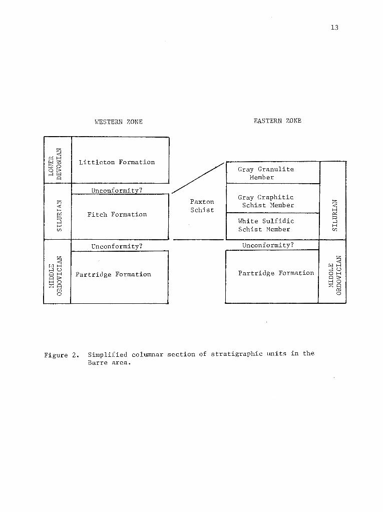
STRATIGRAPHY
The present study has shown that the stratigraphy of the Barre area
can be sub-divided into two distinctive stratigraphic sequences that
appear in two stratigraphic-tectonic zones. The stratigraphy of the
western zone (Figure 2), that section on the map west of the axial sur
face of the Wickaboag Pond anticline (Field, 1975) (Plate 6), consists
of Middle Ordovician rusty-weathering aluminous mica schist, feldspathic
granular schist and minor amphibolite and of Lower Devonian gray
weathering, cyclically bedded,quartzose schist, with minor amounts of
calc-silicate granulite and felsic volcanic gneiss. Small amounts of
graphitic calc-silicate granulite of the Silurian Fitch Formation is
exposed in one anticline beneath Lower Devonian schist. This sequence
of rocks is thought to represent regionally metamorphosed sedimentary
and volcano-clastic rocks, and is correlated with part of the strati
graphy of the Bronson Hill anticlinorium in western New Hampshire (Bil
lings, 1937; 1956), and west-central Massachusetts (Robinson, 1963;
1967a; Thompson, et al., 1968) and with the stratigraphy in the western
and central portions of the Ware area (Field, 1975).
Since the work of Billings (1937), his stratigraphic sequence has
been traced along the axis of the Bronson Hill anticlinorium to Long
Island Sound (Moore, 1949; Billings, 1956; Robinson, 1963; 1967a; Rosen
feld and Eaton, 1956; Lundgren, 1962; Thompson et al., 1968). It has
since been argued that parts of a similar stratigraphic sequence can be
seen on the west limb of the Connecticut Valley-Gaspe synclinorium
(Doll et al., 1961) and to the east in the Merrimack synclinorium (Fow
ler-Billings, 1949; Dixon, 1968; Dixon and Lundgren, 1968a, 1968b).
WESTERN ZONE
~ r::c:H
Littleton Formation r.LJZ ~0 OP. .-:lj:..Ci
A
Unconformity?
z <r: H ~ Fitch Formation :=> .-:l H (/)
Unconformity?
~ WH .-:lU AH Partridge Formation AP. HO ~~ ~ 0
-
/ Paxton Schist
EASTERN ZONE
Gray Granulite l1ember
Gray Graphitic Schist Member
White Sulfidic Schist Hember
Unconformity?
Partridge Formation
Figure 2. Simplified columnar section of stratigraphic units in the Barre area.
13
z ~
I ~ I
:=> I .-:l
H (/)
I'Ll~ .-:lU AH AP. HO
, ~ I

14
Field (1975),studying the transition in the stratigraphy from the Bron
son Hill anticlinorium of central Massachusetts into the Merrimack syn
clinorium, has found that the stratigraphy does not change greatly across
the zone. Moreover, he has concluded that the dominant stratigraphic
units of the Ware area are the Partridge and Littleton Formations, which
are repeated several times by isoclinal folding (Figure 3). This tec
tonic style continues north to the Barre area where many of the same
anticlinal and synclinal belts have been mapped.
The eastern zone of the Barre area, defined as that stratigraphy
east of the axial surface of the Wickaboag Pond anticline, is exposed
in an east facing recumbent syncline whose lower limb has been refolded
across a north-plunging open anticline (Plate 2). The eastern strati
graphy is composed of Middle Ordovician rusty-weathering schist over
lain by extremely magnesian pyrrhotite schist interbedded with impure
quartzite, minor amounts of gray-weathering graphitic schist, and a ma
jor section of calc-silicate gneiss and granulite. This upper sequence
is believed to represent a thickened section of pelite and carbonate
rich clastic sediments deposited in a subsiding basin during middle to
late Silurian time (Wenlock-Ludlow). The basis for this hypothesis
rests on lithic comparisons with the stratigraphy of western and central
Maine (Moench, 1971; Boone, 1973; Osberg and others, 1968; Ludman, 1969;
Ludman et al., 1972; Ludman and Griffin, 1974; Pankiwskyj et al., 1976),
and the physical tracing of some lithically similar rocks from Maine
through southeastern New Hampshire to Massachusetts (Hussey, 1968).
As presently understood, the boundary between these two zones is
the axial surface of a major recumbent anticline in Middle Ordovician

I
I /
I
G)
I I
I I
I
I I
I
I
I I
I
I
I I
I I
I
I @
@I I
I I
15
I
I I I I
J
Petersham Barre
I I
Ware
I
I I
jl
~ 0
I® 0 ® 0 ® ® @ @ @ ©
No. Brookfield
EXPLANATION
Hardwick syncline
Lyon Road anticline
Ragged Hill syncline
Ragged Hill anticline
Big Garnet syncline
West Coys Hill anticline
Coys Hill syncline
Unitas Road anticline
Prouty Road syncline
Lamberton Brook anticline
Gilbert Road syncline
Pleasant Brook anticline
Kruse Road syncline
Figure 3. Map of Phase 1 axial surfaces near the junction of the Ware (Field, 1975), Petersham, North Brookfield, and Barre quadrangles.

16
rocks with the s~ratigraphy of the eastern zone representing the east
ward thickened Silurian section. The facies change from thin to thick
Silurian is presumably in the hinge region of the recumbent anticline
that has been eroded away at this latitude. This boundary has been
extended to the southwest, through the North Brookfield and Ware quad
rangles by Field (Field, 1975; personal comm. 1976) and to the north at
least to the middle of the Templeton quadrangle (personal observation).
To the southwest this contact falls within the Hamilton Reservoir Form
ation of Pomeroy (Pomeroy, 1975) and does not appear on his map as a
boundary of regional significance. This boundary is well known as far
north as the middle of the Templeton quadrangle on the basis of recon
naissance in 1976, and it is hoped it can be extended to Winchendon and
beyond in 1977.
PARTRIDGE FORMATION
The Partridge Formation in the western portion of the Barre area
is exposed in the cores of five isoclinal anticlines that trend north
east across the area. Three belts have been mapped from surface expos
ures and one belt (Ragged Hill anticline) is located on the basis of
field relations to the north and southwest and from sub-surface data.
To the southeast, the Partridge Formation is exposed in the Oakham area
where it forms the core of a late generation anticline. Because the
rocks exposed in each of the anticlines of the Partridge Formation vary
somewhat, the details within each anticlinal area are discussed separ
ately.
17
Lithology
The Partridge Formation consists essentially of rusty-weathering,
sillimanite mica schist with minor amounts of cummingtonite-hornblende
amphibolite and calc-silicate granulite. The mica schist, consisting
of quartz, biotite, garnet, sillimanite, pyrrhotite, plagioclase, ortho
clase, and less commonly muscovite or cordierite, is fine- to medium
grained, slabby and very well foliated. Cummingtonite-hornblende amphi
bolite is found generally in the lower part of the section, and calc
silicate granulite appears dispersed throughout. In spite of the varia
tion in the degree of weathering, the Partridge Formation is always more
sulfidic than members of the Littleton Formation and generally is mor,e
feldspathic. The White Schist Member. of the Paxton Schist can be con
fused with extremely rusty-weathering varieties of the Partridge Forma
tion, however, it generally doesn't have dark-colored biotite, has no
garnet and has abundant quartzite and feldspathic quartzite beds.
Estimated modes of specimens of the Partridge Formation are given in
Tables 1 and 2.
Ragged Hill anticline. The Partridge Formation is not exposed in
the core of this anticline in the map area, but is inferred to lie
between the Coys Hill Granite and the Hardwick Quartz Diorite, from
known exposures to the north and south and from sub-surface data. Field
(1975) in the Ware area, has mapped an anticline of rusty-weathering
schist which extends northeast from the village of Ware into the Peter
sham quadrangle (Field, 1975). North from here, this belt has been
identified in sub-surface (Quabbin Aqueduct specimen #950+00) and
picked up again in a single surface exposure northwest of M~. Pleasant,
18
0.05 miles east and 0.17 miles north of the intersection of Petersham
Road and Gilbert Road in the northwest portion of the Barre quadrangle
Onfro, lished field notes,
personal observation). The
of Massachusetts; Tucker,
Formation in this belt is composed
primarily of rusty-weathering feldspathic and micaceous schist, general
with more sillimanite than in other belts. No garnet was recorded
in the tunnel specimen (950+00 Table
muscovite and some Fe-rich chlorite.
, but there is 7% of secondary
Unitas Road anticline. This belt of rusty-weathering schist lies
immediately east of the Coys Hill Granite in the southern portion of the
map area but is separated from the Hill body by the Littleton Form-
ation west of Quabbin Regional High School (Figure 3) and extends north-
east to the Barre Foundry where it out apparently in a Phase 1
fold hinge (see Structural Geology). The Partridge Formation in this
belt is dominated by feldspathic mica schist, typically well foliated
and exhibiting faint bedding traces of alternating feldsPathic and mica-
rich layers. Typical modes of schist in this anticline yield
, plagioclase and orthoclase as the principal constituents with
lesser sillimanite and biotite
silicate and boudins are
as consisting of equidimensional
minor amounts of biotite, garnet
two characteristics the rock
heterogeneity of rock
calc-silicate granulite, mafic
le 1, TB-307). Thinly bedded calc
and identified in the field
of plagioclase and
Field
in this belt:
75)
they
with
a
minor amounts of gray schist,
and 2 to the

19
south the rock becomes considerably more quartzose and less rusty
weathering than usual (Field, 1975). Neither of these characteristics
is typical of this belt in the Barre area, although the presence of
limited amounts of calc-silicate rock is confirmed.
Lamberton Brook anticline. This anticline is cored by the next
belt of rusty-weathering schist east of the Unitas Road anticline. It
is superbly exposed in Galloway Brook, in the section east of the Audu
bon Reserve known as Cooks Canyon approximately 3/4 mile south of Barre.
Here one can walk across the core of a recumbent anticline with nearly
100 percent of the section exposed. The rocks in the Lamberton Brook
anticline consist of rusty-weathering,sillimanite-biotite-garnet schist,
blue- to gray-colored, medium-grained, graphite and pyrrhotite-rich,
plagioclase-quartz-biotite granulite and medium- to fine-grained
slightly rusty-weathering,sillimanite-garnet-biotite granular schist.
The granular schist in this zone is generally quite rich in sillimanite,
up to 8 percent, as well as biotite and quartz. Substantial amounts of
secondary muscovite (3 percent) and Fe-rich chlorite (5 percent) have
been found in specimen TB-105 (Table 1).
Pleasant Brook anticline. The Wickaboag Pond anticline of Field
(1975) has been sub-divided into a western anticline (the Pleasant Brook
anticline) and an eastern anticline (the Wickaboag Pond anticline) based
on the occurrence of a belt of gray-weathering,quartz-rich biotite-garnet
schist mapped between them (Figure 3). These gray schists form an elon
gate north-northeast trending syncline, the Kruse Road syncline, which
has been traced from the north-central part of the Barre quadrangle

1. of of t' schist and one the Partridge Formation.
t----------------granular t---a---------------------------------schist--------------------------
Hill Unites Road Lamberton Brook Pleasant Brook Hickaboag Pond TB- TB- TB- TB- TB- TB-
950+00 TB-307 TB-542 TB-105 TB-669 91 591 526 858+50 434 63 793+50 782+50
37 36 30 1 38 32 20 32 53 59
32 34 40 33 35 49 L1l 52 41 24 7 38 15 15 9
Orthoclase 8 8 tr 3 X X 4 4 2 33 5 4 14
13 5 18 12 5 9 18 18 7 25 22 18 7 7
1 7 1 6 3 2 6 3 5
Sillimanite 12 5 4 8 3 1 5 12 2 1 6 10
Cordierite 2 1
Pyrrhotite X 1 1 1 1 tr tr 1 X tr 1 X X
1 X X tr 1 tr tr X X
Ilnenite X tr X 1 1 X tr X 1 1 X tr X X X
Rutile tr X X
tr X X X X X tr X X
X X X X
tr tr X X X X tr tr tr X X tr tr
Apatite X X X tr tr tr tr tl: tJ: X X X tr 7* 3* * * * Muscovite X l 1 - 4 2 - - 4 I Chlorite X X tr l
Sericite 3 3 3 10
Hornblende 31
Cummingtonite 27
- Denotes Fe-rich chlorite * Denotes secondary muscovite + Denotes Mg-rich chlorite a Denotes amphibolite body
N 0

21
List of specimens in Table 1.
950+00 Rusty- to red-weathering, muscovite-biotite-garnet-sillimanite schist, very rich in sillimanite. 95,000 feet from east end of Quabbin Aqueduct at Wachusett Reservoir.
TB-307 Well foliated, slightly rusty weathering, muscovite-biotite feldspathic schist. Taken from outcrop behind Barre Foundry on Schoo~ St.
TB-542 Fine- to medium-grained, garnet-biotite-plagioclase granular schist with calc-silicate. 1000 feet north of the junction of James St. and Rt. 122 in the town of Barre.
TB-105 Dark-gray, fine- to medium-grained,graphitic pyrrhotite granulite. At 750 foot mark in Cooks Canyon Gorge. Stream cut of Partridge schist in west-central portion of the map area.
TB-669 Massive, well foliated, biotite-cummingtonite-hornblendeplagioclase amphibolite. 0.28 miles north and 0.1 miles west of White Valley.
TB-91 Fine- to medium-grained, well foliated, slightly rusty-weathering, feldspathic garnet-biotite schist. Strong biotite lineation is evident. 0.48 miles north and 0.22 miles west of Nichols Rd. and Rt. 122 intersection on top of Town Farm Hill Road at 882' elevation.
TB-591 Moderately well foliated, slightly rusty-weathering, garnet biotite-feldspathic schist. 500 feet south of TB-590.
TB-590 Rusty-weathering, fine- to medium-grained, biotite-quartzgarnet feldspathic schist. On crest of Town Farm Hill, in southwest portion of the map area.
TB-526 Medium-biotite section portion
860+50 Somewhat schist.
to coarse-grained, well foliated garnet-cordieritefeldspathic schist. 1500 feet due west of the interof South Barre Road and Summer St .. in the west-central of the quadrangle.
rusty-weathering, quartz-biotite-sillimanite-garnet 86,500 feet from east end of Quabbin Aqueduct.
858+50 Well foliated,rusty weathering, feldspathic biotite-garnetsillimanite schist. 85,850 feet from east end of Quabbin Aqueduct.
TB-434 Rusty weathering, fine- to medium-grained, biotite-sillimanitegarnet schist with crinkled foliation. 1.28 miles north and 0.21 miles west of intersection of Gilbert Rd. and Rt. 62 in central portion of the map area.

Table Estimated from the Partridge Format:i.on
-------------schist---------------- granulite calc-silicate
Oakham area
722+00 713+75 614+75 608+75 692+50
z 22 14 18 23 Quartz 2
Plagioclase 14 30 53 Plagioclase 6
Orthoclase 1411 22 9 Microc1ine 28
Biotite 15 10 11 12 Diopside 22
Garnet 2 1 2 Actinolite 14
Sillimanite 16 5 6 Clinozoisite 12
22 Scaoolite 8
* 1 19 X
X 1 tr X
X tr tr
1
Allanite tr
Calcite
tr tr X tr Zircon
tr tr X t:r
XC 10
2 1
n Denotes microcline as the alkali feldspar present in thin section.
both magnetic pyrrhotite and pyrite.
allanite rimmed by clinozoisite.
secondary muscovite.
Fe-rich secondary chlorite. 1'-' N
23
TB-63 Well foliated, slightly rusty-weathering, biotite-sillimanite schist. 0.4 miles east and 0.8 miles north of intersection of Gilbert Road and Rt. 62 in north-central portion of the map area.
793+50 Evenly foliated, biotite-orthoclase schist, slightly rustyweathering. 79,350 feet from east end of Quabbin Aqueduct.
782+50 Rather dense, fine- to medium-grained sillimanite-biotite schist. 78,250 feet from Wachusett Reservoir.
List of specimens in Table 2.
722+00 Magnetic, well foliated, biotite-sillimanite schist. Located 72,200 feet from east end of Quabbin Aqueduct.
713+75 Pyrrhotite-rich, gray to slightly rusty-weathering, biotitecordierite schist with quartz-feldspar inclusions. 71,375 feet from east end of Quabbin Aqueduct.
614+75 Well foliated, garnet-biotite-sillimanite schist, gray to slightly rusty-weathering. Streaked with quartz-feldspar segregates. 61.475 feet from Wachusett Reservoir.
608+75 Massive, medium-grained, gray-weathering, garnet-biotite granulite. 60,875 feet from east end of Quabbin Aqueduct.
692+50 Light gray, medium-grained, equigranular microcline-diopsideactinolite calc-silicate. 69,250 feet from east end of Quabbin Aqueduct.
south to t~w southeriJ. liillit of the ~ap area. Pomeroy (1973) in the
Warren quadrangle (Figure 1), has mapped similar looking rocks (husn)
which strike into the Wickaboag Pond anticline of Field (1975).
24
The Pleasant Brook anticline, named for the excellent exposures in
Pleasant Brook east and north of Glen Valley Cemetery, contains the
widest belt of the Partridge Formation in the area and the rocks are
generally extremely feldspathic and pyrrhotite-rich. The dominant
lithology in this anticline is rusty-weathering, feldspathic, garnet
biotite-silimanite schist (Table 1, TB-91 through 858+50). Granular
minerals such as quartz, plagioclase and orthoclase usually total 60 to
80 modal percent with garnet, biotite and sillimanite in varying pro
portions making up the remainder of the rock. Although no polished
thin sections were analyzed, the iron-sulfide in these rocks appears to
be magnetic pyrrhotite. Rocks exposed along strike in the northern
portion of the Barre quadrangle are thinly bedded and consist of 2-4
em laminae of feldspar and quartz intercalated with layers rich in bio
tite, sillimanite and garnet.
Other rock types in this zone include slabby granulite composed
largely of quartz, plagioclase (oligoclase), biotite and minor pyrrho
tite. Individual beds vary in thickness but commonly are on the order
of 7-12 em thick. The color of the granulites where fresh is purplish
to medium-gray, and the pyrrhotite appears as small disseminated crys
tals throughout the specimen. Calc-silicate rocks appear as fine- to
medium-grained boudins in schist or as attenuated, one- to three-inch
beds and are characterized by the assemblage diopside-orthoclase
plagioclase-quartz.

25
Wickaboag Pond anticline. As in the Pleasant Brook anticline, the
Partridge Formation in the Wickaboag Pond anticline are generally more
feldspathic and quartz-rich than rocks in the Partridge Formation to
the west. The best exposures in this belt are in Burrow Brook in the
south-western portion of the map area, in the meadows southeast of the
junction of Old Worcester Road and Chapman Road, and on the hills due
east of the Burnshirt River north of Route 62.
The rocks exposed in this anticline have a rather abnormal abund
ance of pegmatite, and many of the exposures of pelitic schist are
under pegmatite ledges. One of the few occurrences of garnet-cordierite
rock has been found in this belt (TB-434) although it is not considered
to be an equilibrium assemblage. Cordierite-garnet occurrences are
reported in several localities to the south in this anticline (Field,
1975) and the lack of identification of more garnet-cordierite assem
blages in these rocks in the Barre area may be due to inadequate
sampling.
Other rock types exposed in the Wickaboag Pond anticline include
rusty-weathering, slabby, granular schist, medium- to fine-grained equi
granular calc-silicate granulite, and coarse-grained, massive amphibo
lite (Table 2, TB-669). The best exposure of the amphibolite is due
west of Chapman Road approximately 2000 feet north of White Valley,
where it occurs as boudins and as attenuated, dark colored tiger-striped
massive beds in pelitic schist and consists mainly of plagioclase (35%),
hornblende (31%), cummingtonite (27%), biotite (5%), and quartz.
Oakham area. The eastern-most exposure of the Partridge Formation
in the Barre area occurs in the south-southeastern section of the area

in the township of Oakham (Plate 1). Here rusty-weathering, pelitic
schist, structurally under the Paxton Schist, is exposed in the core
of a late north-plunging anticline between Quabbin Aqueduct stations
599+00 and 722+75 (Plate 2).
26
The rock types in this zone consist largely of dark-brown to
rusty~weathering,pyrrhotite-sillimanite-biotite-garnet schist (Table 2,
722+00 through 688+75), but other rock types, including pyrite
pyrrhotite sillimanite-cordierite-biotite schist, and scapolite-diop
side-actinolite calc-silicate granulite (Table 2, 692+50) are also
present.
Fahlquist (1935, p. 20 Appendix) reports a wider variety of litho
logies in this belt of schist including "thin layers of feldspathic
schist .•. gneissoid granite occurring as large lens-shaped bodies ... and
the rather unique occurrence of limestone beds from 6 inches to fifteen
feet in thickness". Fahlquist also admits that this belt of rock "is
very similar to that of the Brimfield Schist but is separated from the
Brimfield Formation by the Paxton Schist".
Derivation
The schists that make up the Partridge Formation are interpreted
to be metamorphosed marine shales and silts deposited in a euxinic
environment. The variation in the feldspar/quartz ratio across and
within each anticline is probably due to depositional differences,
although no systematic trends in the amount of granular minerals within
any section can be proved. Associated calc-silicate granulite may rep
resent metamorphosed dolomitic sands or silts. Plagioclase-hornblende
cummingtonite amphibolite are probably metamorphosed mafic volcanic

27
rocks, possibly basaltic flows or ashes. Field (1975) has noted a gen
eral decrease in the iron-sulfide content toward the top of the section
of the Partridge Formation in the Ware area, but no evidence was found
for such a conclusion in the Barre area.
Thickness
Since the base of the Partridge Formation is not exposed, only min
imum thicknesses can be estimated. However, the greatest width of any
of the belts in map pattern is found across the Pleasant Brook anticline
which is approximately 4500 feet across. Assuming simple doubling up
due to an isoclinal fold and an average westerly dip of 20° (Figure 9)
a thickness of at least 770 feet is obtained.
FITCH FORMATION
The Fitch Formation was found in only one locality in the Barre
area, and that is as a discontinuous lens due east of the Big Garnet
syncline in the Prince River at the 820 foot contour. It has, however,
been extended the length of the quadrangle to connect with outcrops of
known Fitch lithology in Phillipston (Robinson, personal comm., Tucker,
personal observation) and with the West Coys Hill anticline of Field
(1975).
Lithology
In the one exposure of the Fitch Formation, the rock is a sulfidic
graphite calc-silicate granulite. It is equigranular and fine- to
medium-grained, composed largely of 0.2 - 0.4 mm crystals of quartz,
labradorite and biotite with lesser diopside, sphene, and clinozoisite

minor actinolite, and scapolite 3,TB-386). The pleochroic
color scheme of the sphene in the Fitch Formation is strong with x
lorless to ' y brown
is interes to note that the
Ware area as well as in the Rus
pink to light red. It
in the Fitch Formation in the
Quartzite Member of the Littleton
28
Formation in the Monadnock area, New
darker red pleochroic color.
1), show an even
of obvious limited extent, the Fitch Formation is found
between two belts of the Littleton Formation. and thus in the correct
s to occupy the core of an anticline.
Contacts
The basal contact of the Fitch Formation with the Partridge Forma-
tion is not exposed, but the upper contact \vith the Littleton
Formation is well at the one It is
with no s of and is inferred to be an unconformity
by this author, based on considerations , 1963 Field,
1975 The contact of the Fitch Formation with the Littleton Formation
is well exposed in ton in the on
Williamsville Road, 1100 feet south Lake Road.
The Fitch Formation is believed to derived from calcareous silts
and calcareous shales
environment. graPhite is
New Hampshire, at the
with the Fitch
in a
northern
association of marbles and
fairly shallow water.
Thickness
The minimum thickness calculated for the Fitch Formation in the
Barre area is nine feet, based on the limited exposure in the Prince
River. However, for purposes of visibility, the Fitch Formation is
shown as approximately 150 feet thick on cross-section line B-B' on
Plate 2.
PAXTON SCHIST
29
The youngest (?) sedimentary unit in the eastern zone is mapped as
the Paxton Schist after Emerson (1898; 1917), who named it after the
town of Paxton 12 miles southeast of Barre. Although unidentified by
him, Emerson's type locality may be the well exposed ledges of biotite
plagioclase-quartz granulite in Turkey Hill Brook southwest of Eames
Pond, in the township of Paxton. This rock type together with ·two
other members here assigned to the Paxton Schist, a gray-weathering,
graphitic schist and a white,pyrrhotite-rich schist, constitute the
major Silurian (?) units of the area, and represent a thickened eugeo
synclinal section in the Merrimack synclinorium.
The Paxton Schist in the Barre area, is exposed only in the eastern
and southeastern portions of the quadrangle. The gray granulite unit is
the easiest of all the units mapped in the area to identify in the field,
as it is typically seen as slabby, commonly flaggy, 2-inch to 5-inch
plates of gray-weathering granulite. The other units of the Paxton
Schist, the Gray Graphitic Schist Member and the White Sulfidic Schist
Member also have their own unique characteristics discussed below.

The Paxton Schist is comuosed of
, gray- to uuru~lsh-weatnering. quartz-labradorite-
Calc-silicate beds of actinolite,
e are common in the gray in the side. calcite and p
Barre area, and are
Paxton Schist east
well outcrops of the
Road near the River, on Hill,
and in the the Ware River at the Barre Falls Dam. Boulders
, such as that found Field f
(1976, comm. in the North Brookfield quadrangle to the south
have been seen on the hillside north of Rt. 62, west of Fairweather
Hill and east of the Burnshirt River, but no outcrop was found.
Crystals of quartz and labradorite in the granulite are typically
, approximately 3/4 mm in diameter and exhibit a grana
blastic texture. Less abundant minerals found in the Paxton granulite
and calc-silicate include microcline, garnet, and
Trace amounts of , zircon, allanite, clinozoisite, s
and calcite also occur in some
Sulfidic schis is
Granulite Member, and consists
le 3).
interbedded in the
and sillimanite with or without muscovite
4). These schists resemb those of the Forma-
tion could be structural infolds of the
conclusion would involve
more intricate than are believed the case, and the
sulfidic t are interbeds
31
within the Gray Granulite Member. Excellent exposures of these sulfi
dic schists occur on the eastern-most crest of Harding Hill in the
east-central portion of the map area, in large exposures due west of
Riverside Cemetery and in the Ware River Spillway at the Barre Falls
Dam.
Tourmaline-bearing pegmatites are extremely common in the Paxton
Schist, and in many areas comprise much of the outcrop. Commonly the
pegmatites, like the calc-silicate beds, are boudinaged, indicating
their less ductile behavior under conditions of high-grade regional
metamorphism.
White Sulfidic Schist Member. The basal member of the Paxton
Schist is a rusty-weathering, pelitic schist and feldspathic quartzite
that occurs in a narrow belt at the western contact of the Paxton Schist
against the Partridge Formation. This belt appears to widen to the
north and has been mapped northward into the Templeton quadrangle where
it apparently terminates on Mine Hill just south of Route 2.
The pelitic schist contains magnesium-rich silicates together with
graphite, and pyrite or pyrrhotite. In weathered outcrop, large pits
up to 7 em across are conspicuous where iron-sulfide has been leached
out. The White Sulfidic Schist typically weathers white to buff with
an intense rusty stain, but when broken fresh is characteristically a
bluish-gray rock. Associated rock types of this member include felds
pathic and micaceous quartzites which typically are very hard and
tough. These rock types seem to make the White Sulfidic Schist less
susceptible to erosion, and where these lithologies are present, the
outcrops tend to form prominent ledges. Some of these quartzites are

Table 3. Estimated modes of specimens of the Fitch Formation and Gray Granulite Hember of the Paxton Schist.
Fitch Gray Granulite Hember, Paxton Schist
TB-. TB- TB- TB- TB- TB- TB- A B 368 209 276A 276B 466 470 523 745+00 74S+oo* * 608+75 743+50 737+50 692+50 597+00
Quartz 44 33 38 44 51 31 20 28 23 29 31 8 23 22
Plagioclase 33 35 29 35 25 38 48 35 28 24 18 8 53 31
Orthoclase 8 5 2 5 9 4 9 17 16 26 28 9 12
Biotite 12 3 15 7 13 13 21 9 10 10 12 11 6
Diopside 4 16 7 5 2 7 10 7 8 22 12
Actinolite X 2 6 4 6 5 6 14 11
Garnet tr 2
Scapolite X 7
Sphene 4 I 2 2 1 X 1 2 1 3 1
Pyrrhotite X
Graphite tr X X X tr 1 1 1 tr tr tr
Apatite X X X X X tr 1 tr tr tr X 1
Zircon tr X X X X tr tr tr X 1 tr tr
Allanite X X tr X tr tr tr X
Clinozoisite 3 1 2 X X 3 1 1 1 6 1 2
Calcite X X tr tr 3 tr 1
Sillimanite 6 3
Muscovite tr tr 5 9 ... tr
Chlorite - - - - + I 2 X X X 5 X tr 1
* Denotes thin section taken across calc-silicate granulite and pelitic interbed. - Denotes Fe-rich chlorite.
+ Denotes ~~-rich chlorite.
w N

33
List of specimens in Table 3.
TB-368 Rusty-weathering, graphitic biotite granulite. Taken from a small stream cut in the Prince River at the 820 foot elevation mark.
TB-209 Medium-grained, slabby, foliated feldspar granulite. 0.15 miles north and 0.36 miles west of intersection of Blake Road and Coldbrook Road in east-central portion of the map area, southeast of Harding Hill.
TB-276 (A, B)
TB-466
TB-470
TB-523
745+00 (A,B)
743+50
737+50
692+50
608+75
597+00
Medium-grained, dark-colored granular biotite gneiss. Located 0.1 miles southeast of junction of Hubbardston, Barre, and Oakham townships in east-central portion of the map area.
Fine- to medium-grained, hard, biotite granulite. Collected from north entrance to Barre Falls Dam in stream cut of the Ware River.
Well foliated, biotite-plagioclase granulite with thin calcsilicate beds evident in hand specimen. 0.13 miles due south of Barre Falls near the Ware River.
Massive, well foliated, gray-weathering, biotite-plagioclase granulite. 0.05 miles south and 0.57 miles west of Barre Falls Dam on the Ware River, east-central portion of the map area.
Purplish to gray-weathering, massive granulite with green calcsilicate bed in contact with pelitic schist bed. 74,000 feet from the east end of Quabbin Aqueduct.
Gray-weathering, well foliated, feldspathic schist in the Paxton Schist. 74,350 feet from the east end of Quabbin Aqueduct.
Gray-weathering, biotite granulite with thin sillimanitepelitic schist bed in it. 73,750 feet from Wachusett Reservoir.
Light gray to green, plagioclase-rich calc-silicate bed in the Paxton Schist. 69,250 feet from the east end of the Quabbin Aqueduct.
Gray-weathering, medium- to coarse-grained plagioclase-garnetbiotite gneiss. 60,875 feet from the east end of the Quabbin Aqueduct.
Gray- to purple-weathering, well foliated, fine- to mediumgrained biotite granulite with 1 inch calc-silicate bed. 59,700 feet from Wachusett Reservoir.

Table 4. Estimated modes of specimens from the \''hite Sulfidic Schist Hember, Gray Graphitic
Schist Member and pelitic interbeds of the Paxton Schist.
White Sulfidic Schist Gray Graphitic Schist pelitic interbeds
TB- TB- TB- TB- TB- TB- TB- TB- TB-55 54A 278A 278B 268 509 137 146 180 772+00 750+00
Quartz 50 42 46 ~2 37 40 30 54 51 55 42
Plagioclase 40 40 7 20 27 22 23 11 21 5 16
Orthoclase 6 6 26 31 2 3 3 4 tr 22 13
l:liotite tr 4 8 5 21 20 35 11 13 11 23
Garnet 1 5 5 3 1 tr 2
Sillimanite tr tr 10 2 2 2 tr 7 2
Cordie rite 1 2 1
Pyrrhotite tr X 1 X X tr
Graphite 1 1 X X 1 1 tr 1 1 X X
Ilmenite X X X tr tr X X
Rutile 1 X X X
Hematite X X
Allanite tr X tr
Tourmaline tr
Zircon X 1 X tr X tr tr
Apatite X 1 X tr X
* * * Huscovite 1 5 1 5 1 2 10 10 2
Chlorite 2 2 2 6 3 Sericite tr 4
* Denotes secondary muscovite
Denotes Fe-rich chlorite (...)
~

TB-55
TB-54A
TB-278 (A,B)
List of specimens from Table 4.
Medium- to coarse-grained,feldspathic quartzite and rustyweathering pelite. 0.4 miles east and 0.8 miles north of intersection of Gilbert Road and Rt. 62 in the north-central portion of the map area.
35
Rusty-weathering, feldspathic granulite and sillimanite schist. Same locality as TB-55.
Rusty-weathering, quartzose granulite and pyrrhotite schist. 0.44 miles north and 0.05 miles east of intersection of Barre Depot Road and Hunt Road in south-central portion of the map area.
TB-268 Gray, fine-grained, biotite-garnet-sillimanite schist. 0.44 miles north and 0.15 miles west of the junction of Hubbardston, Oakham and Barre twonships. Taken from outcrop behind a small spring house.
TB-509 Well-bedded, gray, sillimanite-garnet-biotite schist. Specimen taken from a large stream exposure 0.33 miles downstream from Natty Brook Pond near Hale Brook crossing.
TB-137 Gray-weathering, biotite schist with 1 mm garnets. Taken from large exposure 0.4 miles east and 0.58 miles north of Fruitland Road and Granger Road in the central portion of the map area.
TB-146 Well foliated, gray-weathering, biotite-graphite schis~ with quartzo-feldspathic pods and streaks. 0.47 miles east and 0.9 miles north of Fruitland and Granger Roads in the central portion of the map area at the 790' elevation contour.
TB-180 Gray-weathering, biotite-garnet schist with clots of intergrown biotite and graphite. 0.25 miles due north of intersection of Fruitland and Granger Roads in central portion of the map area.
772+00 Slightly rusty-weathering, sillimanite-biotite-garnet schist. Double sillimanite fabric is evident. 77,200 feet from east end of the Quabbin Aqueduct.
750+00 Gray- to rusty-weathering, muscovite-biotite-sillimanite schist. 75,000 feet from the east end of the Quabbin Aqueduct.
particularly slabby and may have 2- to 3-inch laminations defined by
mica-rich layers and quartzo-feldspathic ribs.
36
The dominant minerals in the schist are quartz, orthoclase, plagi
oclase and lesser amounts of cordierite, sillimanite, muscovite and
light-brown biotite. Minor amounts of graphite, rutile, pyrrhotite,
apatite and zircon, and, in rare cases, pyrite are also present. Elec
tron microprobe analyses of mineral assemblages from specimens in the
Templeton and Ware areas indicate that the silicates are extremely iron
deficient and that nearly all the iron in these rocks is in the sul
fides (Field, 1975; Tracy, Robinson, and Field, 1976; Robinson and
Tracy, 1977).
Gray Graphitic Schist Member. This member is stratigraphically be
neath the Gray Granulite Member and above the White Sulfidic Schist Mem
ber, and extends continuously around the crest of the late foliation arch
where it presumably thickens to the north. It appears to pinch out
southward in the North Brookfield quadrangle or at least was not seen
by Field (pers. comm., 1976) in that area. Excellent exposures of this
rock type occur in the outcrops just west of the powerline west of
Riverside Cemetery (Plate 6), in the hills in the Hubbardston State
Forest north of Fairweather Hill, and in outcrops north of the triple
junction of the townships of Rutland, Barre and Hubbardston.
This schist is a gray- to slightly rusty-weathering pelitic schist,
with subordinate amounts of calc-silicate beds, and typically has
quartzo-feldspathic segregations 5 to 6 inches long strung throughout
the rock. The dominant minerals (Table 4) are quartz, plagioclase,

37
feldspar, biotite, garnet and sillimanite. Accessory minerals include
graphite, rutile and ilmenite. The schist is medium-grained and evenly
foliated and in places slight compositional layering results from a
differential concentration of the various light and dark minerals.
Graphite, where present, may be clotty, and commonly is intergrown
with biotite in thin section.
Contacts
The contact of the White Sulfidic Schist Member of the Paxton
Schist with the Partridge Formation of the Wickaboag Pond anticline is
well exposed on the hills east of the Burnshirt River north of Route
62 and in the outcrops north of the intersection of Fruitland Road and
Granger Road. Since the White Sulfidic Schist Member of the Paxton
Schist and the Partridge Formation are both extremely rusty-weathering
in outcrop, some stringent criteria were set up to distinguish between
these units in the field. The criteria for the White Schist Member as
contrasted with the Partridge Formation are: 1) association with im
pure quartzite beds, 2) absence of garnet, 3) absence of dark-colored
biotite, 4) large pits on weathered surfaces due to weathering of
pyrite cubes, 5) blue-gray color of the rock where fresh, 6) presence
of black porphyroblastic cordierite.
The contact of the Gray Graphitic Schist with the White Sulfidic
Schist has been mapped with close certainty in the same vicinities as
those mentioned above. This contact is extremely easy to map because
the differences in weathering characteristics of the two rock types
are readily apparent.
38
Contacts of the Gray Granulite with the Gray Graphitic Schist are
well exposed in several localities. These include exposures west of
Granger Road in the central portion of the map area, and on the hills
east of Brigham Road in the east-central portion of the map area.
Over most of this contact, the boundary has been drawn based on the
last appearance of the Gray Granulite going toward the bottom of the sec
tion. The interfingering nature of this contact along most of its length
is taken as evidence for a conformable sequence with the Gray Granulite
Member lying above the Gray Graphitic Schist Member.
In the Oakham area, the contact of the Partridge Formation with the
Gray Granulite Member of the Paxton Schist is exposed northeast of the
intersection of Bullard Road and Edson Road in the south-central portion
of the map area. Along this contact one outcrop of a graphitic quartzite
was found that looks similar to some of the feldspathic quartzites of the
White Sulfidic Schist. In addition, Quabbin Aqueduct specimen 713+75,
which is very near this contact, has much the same mineralogy of the
White Sulfidic Schist (Table 2). Thus there is indirect evidence that
the White Sulfidic Schist may be present near the rnner contact of the
Gray Granulite Member with the Partridge Formation. This would imply
that the Gray Graphitic Schist Member is either pinched out tectonically
or stratigraphically in the Oakham area.
Derivation
The White Sulfidic Schist Member probably consists of metamorphosed
sulphur-rich aluminous shales interbedded with feldspathic quartzites.
The Gray Graphitic Schist Member characteristically contains graphite
and probably represents metamorphosed organic-rich silts and shales.

The Gray Granulite Member is probably derived from calcareous silts
and sands, interbedded with carbonate-rich layers and lenses along
with sulphide-rich pelites.
Thickness
39
As interpreted in cross-section (Plate 2), the Paxton Schist is
doubled up in a recumbent syncline with the Partridge Formation exposed
on both limbs. Since the top of the Paxton Schist is not exposed, only
a minimum true thickness can be obtained. This being the case, assum
ing an average westerly dip of 24° (Figure 9) and using the measured
map width of 2900 feet, a minimum thickness of 1180 feet for the Paxton
Schist is obtained. Calculated thicknesses of individual members are:
White Sulfidic Schist = 100 feet; Gray Graphitic Schist = 470 feet,
Gray Granulite Member 610 feet.
LITTLETON FORMATION
The Littleton Formation is exposed in seven isoclinal synclines
that trend north-northeast through the Barre area. One of these syn
clines is composed principally of the Cays Hill Granite (Cays Hill
syncline), and another is dominated by feldspathic gneiss derived from
felsic volcanics (Prouty Road syncline). These two synclines merge
north of the Barre Foundry in the west-central portion of the map area
where the Partridge Formation of the Unitas Road anticline hinges out.
Elsewhere the Littleton Formation is composed primarily of gray-weath
ering, quartzose aluminous schist, the Gray Schist Member (Dl), which
locally exhibits graded beds from one to two inches and locally up to
four inches thick (Figure 4a).
40
Lithology
The dominant rock type of the Littleton Formation in the Barre area
(Table 5) is quartz-rich biotite schist with variable amounts of plagio
clase, orthoclase, garnet and sillimanite. Quartz averages 40 to 45
percent, plagioclase 30 percent, biotite 20 percent, and orthoclase,
garnet and sillimanite are normally less than 10 percent. Trace min
erals in the Littleton Formation include secondary muscovite, Fe-rich
chlorite, allanite, zircon and tourmaline. Opaque minerals commonly
are graphite, and ilmenite. Distinctly subordinate rock types of the
Littleton Formation include quartz-feldspar granulite, calc-silicate
granulite, and distinctly mappable members of feldspathic gneiss and
plagioclase-hornblende-cummingtonite gneiss. The quartz-feldspar
granulite is composed mostly of quartz and plagioclase, with considera
ble biotite and some garnet. The calc-silicate granulites are white
in color with equant 1 mm crystals of garnet and diopside peppered in a
matrix of quartz, plagioclase, clinozoisite, sphene and calcite (Table
5 TB 248). The feldspathic gneiss and the plagioclase-hornblende
cummingtonite gneiss are discussed below for those synclines where they
are most abundant.
Pyrite and pyrrhotite are absent in all the rock types of the
Littleton Formation. Thus the gray-weathering character of the Gray
Schist Member of the Littleton Formation was a tremendous aid in dis
tinguishing it from rocks of the Partridge Formation or the White Sul
fidic Schist Member of the Paxton Schist. The various synclines of the
Littleton Formation with local lithic variations are discussed below.

41
Figure 4. a. Graded beds in the Lower Devonian Littleton Formation, Gilbert Road syncline, Barre area. Tops point toward the top of the photograph as demonstrated by the garnet-sillimanite-rich layers. Graded beds are on the order of two inches thick. b. Garnets rimmed by orthoclase and quartz, from the Littleton Formation. Both photographs were taken from the same outcrop (graded bed locality 10, Figure 6).

Table 5. Estimated modes of specimens from the Gray Schist Member, Littleton Formation.
Hardwick syncline
966+50 965+50 965+50 962+00 960+50
Quartz 34 44 42 42 35
Plagioclase 27 15 21 34 31
Orthoclase 6 10 8 9 2
Biotite 29 21 17 5 27
Garnet 3 6 9 7 3
Sillimanite 1 3 2 1
Ilmenite X 1 tr tr 1
Graphite X X tr
Allanite X
Tourmaline X
Zircon tr tr 1 tr tr
Apatite tr X X 1 tr
* Muscovite X tr X
+ Chlorite X pg Actinolite 1
Sphene 1
Diopside
Calcite X X
Clinozoisite
* Denotes secondary muscovite.
+ Denotes Mg-rich secondary chlorite.
Denotes Fe-rich secondary chlorite.
Big garnet Prouty Road
TB 649
38
20
10
21
2
7
X
1
X
-tr
928+00
39
31
7
17
5
1
tr
tr
X
1B 332B
36
26
4
14
12
5
2
X
tr
X
X
tr
1
Gilbert Road
897+50
60
15
3
19
2
tr
X
X
tr
TB TB 249 248
54 41
12 45
3
19
6 4
5
1 tr
X
tr
tr
X
tr tr
tr
1
8
tr
1
Kruse Road
TB 653
41
27
9
11
3
8
1
X
X
X
X
-X
pg Denotes actinolite which is pleochroic from pale green to colorless.
.1'-N
'T<"'"""''.''1F~cc:•-c"C·C:""''~"'''"~·=--~-~ , .. ,, ..

966+50
965+50 (A,B)
962+00
960+00
TB-649
43
List of specimens in Table 5.
Gray-weathering, sillimanite-biotite-garnet schist, well foliated. 96,650 feet from the east end of the Quabbin Aqueduct.
Extremely well foliated, dark gray-weathering, garnet-biotitesillimanite quartzose schist. Contains two sillimanite lineations at right angles. 96,550 feet from east end of Quabbin Aqueduct.
Well foliated, gray-weathering, garnet-biotite, granulite with a thin calc-silicate bed evident. 96,200 feet from the east end of the Quabbin Aqueduct.
Well foliated and crinkled, garnet-sillimanite-orthoclase schist. Medium-grained garnets rimmed by orthoclase evident in hand specimen. 96,000 feet from the east end of Quabbin Aqueduct.
Well bedded, gray-weathering, feldspathic schist from the Big Garnet syncline. Taken from intermittent stream cut at the 920 foot elevation, 0.22 miles east and 0.39 miles north of the intersection of Washburn Road and Pleasant Street.
928+00 Gray-weathering, sillimanite-orthoclase-biotite schist with 1 em garnets rimmed by leucocratic material. Sillimanite lineation is obvious. 92,800 feet from east end of Quabbin Aqueduct.
TB-332 (B)
897+50
TB-249
TB-248
TB-653
Well foliated, gray-weathering, biotite-sillimanite-garnet schist. Located in Audubon campground, 0.3 miles south from Barre Common next to dining hall.
Light-gray-weathering, well foliated, fine- to medium~grained, garnet-sillimanite-biotite schist. 89,750 feet from the east end of the Quabbin Aqueduct.
Gray-weathering, sillimanite-biotite-garnet schist with graded bedding. From the Gilbert Road syncline, 0.2 miles southeast of South Street directly under the powerline.
White-colored, massive calc-silicate rock in the Littleton Formation. Located in the same outcrop as TB-249.
Extremely well bedded, gray-weathering schist from the Kruse Road syncline (atypical). Collected 0.38 miles north and to the west of Walnut Road near the intersection with Cut-Off Road in the central portion of the map area.
44
Hardwick syncline. Gray-weathering, pelitic schist immediately
next to the Hardwick pluton is very poorly exposed in the Barre area,
with the exception of small stream exposures north of the Old Reser-
voir in the Barre quadrangle just out of the map area. However, Quabbin
Aqueduct Tunnel specimens from this syncline have been co,llected and
estimated modes are given in Table 5. These specimens are gray, medium-
grained, garnet-sillimanite-biotite-quartz-plagioclase schists. Grading
or cyclical bedding are not evident in hand specimen. They are well
foliated, and contain migmatite layers composed of quartz, plagioclase
and orthoclase 1/2 inch to 1 inch across, striking parallel to the prom-
inent foliation. Although the bulk of the Hardwick syncline is not ex-
posed in the Barre area, specimens from the Quabbin Aqueduct Tunnel show
that gray pelitic schist of the Littleton Formation occurs at both the
east and west contacts of the Hardwick Pluton. Reconnaissance mapping
of the eastern contact of the Hardwick Quartz Diorite with the Little-
ton Formation some 5 miles to the north near Queen Lake in the Temple-
ton quadrangle, also proves the existence of the Littleton Formation on
the east side of the Hardwick Pluton (D'Onfro, unpublished notes).
Big garnet syncline. Well bedded, gray-weathering, pelitic schist
is exposed in continuous outcrop for over 2000 feet south of the Old
Reservoir in the Prince River. The Big Garnet syncline is extrapolated
south through an area of no outcrop past Route 122 where it joins
Field's (1975) Big Garnet syncline in the southeast corner of the Peter-
sham quadrangle. Since not all of the Phase 1 axial surfaces mapped in
the Ware area have been recognized in the Barre area, the present inter-
"

45
pretation of connecting these axial surfaces is shown in Figure 3.
Note that in this interpretation, the Partridge Formation in the core
of Lyon Road anticline hinges out to the north in an early fold hinge
with the Littleton Formation in the Hardwick and Ragged Hill synclines
merging.
The Littleton Formation in the Big Garnet syncline is typically
rich in quartz, plagioclase, biotite and sillimanite (Table 5, TB-649). I
Minor Fe-rich chlorite after biotite is also present. Generally, the
rock types in this syncline do not differ much in texture and mineralogy
from the pelitic schist in the Gilbert Road or Prouty Road synclines to
the east. Field (1975) reports the Littleton Formation in the Big Gar
net syncline as an aluminous schist commonly with garnets 1 em and more
in diameter. Although some rather large garnets with leucocratic rims
consisting of orthoclase and quartz (Figure 4b) have been seen in this
syncline, these textures are not considered to be more characteristic
of this syncline than of any others in the area.
Coys Hill syncline. The next syncline to the east in the Barre
area is underlain principally by the Coys Hill Granite, but the east
ern and western contacts of Granite with the underlying Littleton Form
ation are well exposed in several localities including the 760-foot and
810-foot elevations on Prince River, southwest of the intersection of
Dick's Brook and Rt. 122, and near the powerline south of Crogan Road.
The Littleton Formation in this syncline is typically well bedded and
aluminous with large garnets up to 1 inch across and with conspicuous
sillimanite. Odtside of the larger crystal textures and more alumin
ous-rich composition, it is similar to the Littleton Formation seen
46
elsewhere in the western portion of the Barre area.
Prouty Road syncline. The Littleton Formation exposed in this
syncline is dominated by white, well foliated, layered feldspathic
gneiss derived from felsic volcanics, and by gray-weathering, well
bedded quartzose schist typical of the pelitic schist exposed elsewhere
in the Littleton Formation. The feldspathic gneiss is separately
mapped as the White Feldspathic Gneiss Member. A single exposure of
cummingtonite gneiss also occurs in this syncline and is mapped sepa
rately as the Cummingtonite Gneiss Member of the Littleton Formation.
It probably correlates with the Orthopyroxene Gneiss Member (Dlo) of
Field (1975).
The best exposures of the Feldspathic Gneiss Member in the Prouty
Road syncline can be seen south-southeast of the intersection of Root
Road and South Street and at the head of Cooks Canyon in the Audubon
Campground. Pelitic schist of the Littleton Formation is beautifully
exposed in the Audubon Campground, on the hillside east of Barre, south
of Rt. 62 and in a few isolated outcrops northeast-of the Barre Foundry
in the west-central portion of the map area.
The pelitic schist in this syncline has graded beds up to 5 inches
thick, and is composed largely of quartz (37 percent), plagioclase (28
percent), and biotite (18 percent). Less abundant minerals, commonly
conspicuous in hand specimen, include sillimanite, garnet and ortho
clase (Table 5). Trace amounts of Fe-rich chlorite, secondary muscov
ite, allanite, zircon, apatite, graphite and ilmenite are also present.
47
In many instances the mineralogy of the schists of the Littleton
Formation is an aid in determination of graded bedding tops. For
example, the basal sandy beds of these rocks are commonly seen to con
sist of equigranular crystals of quartz, orthoclase and plagioclase
while the more aluminous shaley tops are composed of sillimanite, gar
net and biotite.
The Feldspathic Gneiss Member (Dlf) is a white, well foliated,
feldspar-rich rock, commonly with small pink garnets and a minor per
centage of biotite (Table 6). Plagioclase (45 percent), quartz (39 per
cent), microcline (6 percent) and biotite (7 percent) are the major con
stituents; muscovite, chlorite, apatite, zircon and allanite occur in
trace amounts. The Feldspathic Gneiss is somewhat similar to pegmatites
seen in the Barre area but has been distinguished from them by the smal
ler grain size, the presence of small pink garnets and the strongly
foliated texture. The Feldspathic Gneiss is assumed to be Devonian in
age because of its intimate association with the Littleton Formation.
It appears at or near the base of the Littleton Formation in the
Prouty Road syncline and as discontinuous lenses in the Gilbert Road and
Coys Hill synclines. An associated rock type in the Feldspathic Gneiss
Member is gray-weathering, biotite granulite, too thin to map separately,
exposed in the Cooks Canyon section in the west-central portion of the
map area.
Only one outcrop of the Cummingtonite Gneiss Member of the Little
ton Formation has been identified in the Barre area, and that is beneath
the powerline at the intersection of Root Road and South Street. No
thin sections of this rock are available but field identification of

Table 6. Specimens of the Feldspathic Gneiss Member of the Littleton
Formation.
Quartz
Plagioclase
Orthoclase
Biotite
Garnet
Sillimanite
Secondary Muscovite
Secondary Chlorite
Allanite
Zircon
Apatite
TB-339
41
34 (ol) 19
1
X
19
X
tr
TB-256
39
45 (ol) tr
7
tr
tr
1
X
X
X
X
List of Specimens in Table 8.
TB-339 White, well foliated, feldspathic sillimanite gneiss. Sample from outcrop 0.4 miles west and 0.38 miles south of intersection of Loring Road and South Street.
TB-256 Well foliated, white gneiss with pink garnets. Taken from outcrop at the top of Cooks Canyon north of Galloway Brook.
48
this rock yields the assemblage cummingtonite-hornblende-plagioclase
quartz. This rock occurs at exactly the same stratigraphic position
as the Orthopyroxene Gneiss of Field (1975), near the top of the sec
tion in the Prouty Road syncline.
49
Gilbert Road syncline. Rocks in this syncline of the Littleton
Formation exhibit the best examples of graded bedding in the area (Fig
ure 4a). The dominant rock type is gray-weathering, well bedded, sil
limanite-garnet-biotite schist with beds 2 to 4 inches thick. Three
to four-inch beds and boudins of calc-silicate rock appear in this
syncline and consist of quartz (42 percent), plagioclase (47 percent),
garnet (4 percent), diopside (8 percent), clinozoisite (1 percent) and
lesser amounts of apatite, sphene and ilmenite (Table 5, TB-248).
These rocks are in most occurrences distinctly white in color and are
equigranular with crystals on the order of 2 to 4 rom in diameter.
The Gilbert Road syncline is known to extend south through the
Ware quadrangle (Field, 1975) and from there similar rock types have
been mapped as various members of the Hamilton Reservoir Formation by
Peper et al. (1975). Pomeroy (1973), in the Warren quadrangle, desig
nated similar rock types as unit husg of the Hamilton Reservoir Forma
tion. To the north, mapping by this writer has extended this syncline
into the southern third of the Templeton quadrangle.
The pelitic schist exposed in the Gilbert Road syncline is typical
ly more quartzose than that in the other synclines of Littleton Forma
tion, with up to 60 percent quartz reported in specimen 897+50 (Table
5). Plagioclase and orthoclase commonly average less than 15 modal

percent and 4 percent respectively. Other minerals include biotite,
garnet, and sillimanite,and trace amounts of chlorite, allanite, zir
con, apatite, ilmenite and graphite are also reported.
so
Kruse Road syncline. This is the easternmost syncline of the Lit
tleton Formation in the Barre quadrangle. To the south this syncline
was not mapped in the Ware quadrangle (Field, 1975) possibly due to
scarcity of outcrop. However, in the Warren quadrangle Pomeroy (1973)
has mapped a belt of gray-weathering, sillimanite schist, the East
Hill belt (husn), which is similar to the schist considered to be
Littleton here. North of the Barre area, in the northern part of the
Barre quadrangle, this belt of rock is best exposed on Kruse Road.
Generally speaking, the rock in this syncline is well foliated,
gray-weathering schist, commonly with a streaked appearance due to the
abundance of pegmatite veins. The schist commonly exhibits large,
deep-black biotite crystals along with garnet-sillimanite-plagioclase
and quartz with or without muscovite (Table 5). It is easily distin
guished from the more typical Littleton schist by the poorly developed
bedding, absence of noticeable sandy beds, and the small size of the
garnets (1/4 inch) which might be a function of metamorphic grade.
Lower Contacts
The contacts of the Littleton Formation with underlying strata are
generally poorly exposed throughout much of the western portion of the
map area. However, the eastern and western contacts with the Fitch
Formation are beautifully exposed in the Prince River at 820 foot and
830 foot elevations respectively. Likewise, the eastern and western

51
contacts with the Partridge Formation in the core of the Unitas Road
anticline are approachable to within a few feet along South Street in
the town of Barre and again north of the Barre Foundry on School Street.
The eastern contact of the Littleton Formation in the Prouty Road synr
cline with the Partridge Formation in the core of the Lamberton Brook
anticline is well exposed and easily identified on the hillside north
of Glen Valley Cemetery and again along Galloway Brook in Cooks Canyon.
This contact is also approachable to within a few feet in the southwest
corner of the map area.
The western contact of the Littleton Formation in the Gilbert Road
syncline with the Partridge Formation in the Lamberton Brook anticline
is sharp and clearly displayed at the 750 foot contour on Galloway
Brook in Cooks Canyon and on the hillside to the north of Galloway Brook
near Route 122. Although sharp and clearly non-gradational, these con-
tacts could never be walked out for more than a few hundred feet, due
to lack of outcrop.
The western contact of the Gray Schist Member of the Littleton For-
mation in the Kruse Road syncline was never located to within 10 feet
but was located on the basis of boulders of the Littleton Formation just
north of Cadwell Cemetery in the central portion of the area, south of
the junction of Walnut Hill Road and Route 62, and in the north-central
portion of the map area west of the Burnshirt River. The eastern con-
tact of the Littleton Formation in the Kruse Road syncline with the
Partridge Formation in the Wickaboag Pond anticline is approachable
just north of the triple junction of Walnut Hill Road, Gilweg Road and
Everett Road, and to within a few feet on the hills south of Worcester
52
Road in the central portion of the map area.
In contrast, the contacts of the White Feldspathic Gneiss Member
with the Littleton schist and Partridge Formation are less well exposed,
with the exception of outcrops at Cooks Canyon, near the Barre Foundry
and in the southwest portion of the area.
Derivation
The Littleton Formation probably consists of metamorphosed aluminous
pelite and quartz-rich sands together with minor mafic and falsie volcan
ics. It commonly has cyclical and graded bedding which suggest rapid
sediment influx into a rather deep sedimentary basin (Blatt et al., 1972)
possibly as a result of turbidity currents. The abundance of graphite
suggests deposition under reducing conditions but the lack of abundant
iron-sulfides indicates absence of sulfur-reducing bacteria. Calc-sil
icate beds probably represent metamorphosed carbonate-rich horizons with
in the turbidite sequence.
Thickness
Because the top of the Littleton Formation is not exposed, only a
minimum thickness can be estimated. Assuming a complete doubling up of
the Littleton Formation across each of the synclines in which it has been
mapped, its minimum thickness for each syncline can be calculated from
the map pattern width and the average dip of the syncline axial surface.
Calculated minimum thicknesses for the Littleton Formation in the Prouty
Road and Gilbert Road synclines are 680 feet and 410 feet respectively.
53
INTRUSIVE IGNEOUS ROCKS
Most of the intrusive rocks in the Barre area are probably of
Devonian age and appear to have been intruded as sills early in the defor
mational history. Evidence for the age comes from the fact that the
major igneous bodies in the Barre area, the Coys Hill Granite and the
Hardwick Quartz Diorite, are correlated with the Kinsman Quartz Monzonite
and Spaulding Quartz Diorite respectively in New Hampshire that have been
recently dated by the Rb/Sr whole rock method (J.B. Lyons, personal comm.,
1976), as well as from the fact that these sills appear to be largely
confined to the Lower Devonian Littleton Formation. The other main in
trusive body, the gneiss of Pleasant Brook, is a foliated, biotite
granitic gneiss. Foliated pegmatite, a common rock in all of the strat
ified rocks, is thought to have been intruded during the Acadian (Devonian)
orogeny. One diabase dike has been mapped and is probably Jurassic in age.
COYS HILL GRANITE
The Coys Hill Granite is exposed in the Coys Hill syncline which
extends north-northeast through the western portion of the map area, and
in the northern portion of the area is bordered on both sides by rocks
of the Littleton Formation. The Coys Hill Granite has been traced south
ward from the Barre area through the Ware area (Field, 1975) into the
northwestern corner of the Warren quadrangle (Pomeroy, 1973), and the
eastern portions of the Palmer (Peper, 1976) and Monson quadrangles
(Peper, 1974). To the north of the Barre area, the Coys Hill Granite
has been mapped in reconnaissance through the western portion of the

54
Templeton and Winchendon quadrangles and the eastern part of the
Monadnock quadrangle, New Hampshire, and probably is continuous with the
Cardigan Pluton of Kinsman Quartz Monzonite (Billings, 1956).
Lithology
The Cays Hill Granite is perhaps the most striking unit in the map
area. Phenocrysts of microcline, as long as 4 inches but averaging ap
proximately 2 inches are the major constituent and are set in a matrix
of biotite, quartz, plagioclase and garnet (Figure 5). Much of the Cays
Hill is a true granite with microcline phenocrysts, containing an average
of 33 percent potassium feldspar, 21 percent oligoclase, 40 percent quartz,
6 percent biotite, 1 percent garnet and trace amounts of ilmenite, apatite
and zircon (Table 7). Sillimanite is seen in a few outcrops. Commonly
the microcline phenocrysts exhibit a "chewed up" or cataclastic margin,
and have a rim of re-crystallized plagioclase and quartz. In Barre on
Route 122 and Union Street, there is a spectacular clean exposure of Cays
Hill Granite in which it is possible to study the temporal relations
between crystallization of the microcline phenocrysts and tectonic features.
The significant conclusion reached here is that the plutonic event res
ponsible for the microcline phenocrysts in the Cays Hill Granite took
place before the earliest stage (Phase 1) of folding, and cannot be eq
uated in time with the generation of most pegmatites or the peak of reg
ional metamorphism. Fine-grained aplitic biotite granitic dikes can be
seen to intrude the Cays Hill Granite in the Barre and their temporal
relations were also studied. It was determined that the granitic dikes
were intruded prior to Phase 2A (see Structural Geology Chapter) fold-

55
Figure 5. Photograph of the Coys Hill Granite, Barre area. Note the microcline phenocrysts with their "nipped off" appearance and granulated margins. Taken from an exposure near the intersection of Union Street and Route 122 in the village of Barre.
ing, clearly cross-cuts the foliation in the groundmass of the Coys Hill
Granite, and post-dates the alignment of the microcline phenocrysts.
This is consistent with the observation in the Quabbin area that "leuco-
cratic and restite layers" are involved in Phase 2A folds and appear to
have been largely crystalline and competent by that time (Tracy, 1975;
Robinson, 1967b).
One specimen taken from the Quabbin Aqueduct Tunnel (941+50) rep-
resents a metamorphosed mafic volcanic layer and is characterized by
the assemblage hornblende-cummingtonite-plagioclase-garnet-sphene-
biotite-quartz (Table 7). The hornblende is very coarse, pleochroic
from pale green to colorless, and makes up approximately 10 percent of
the rock. Andesine (34 percent) and quartz (10 percent) are the major
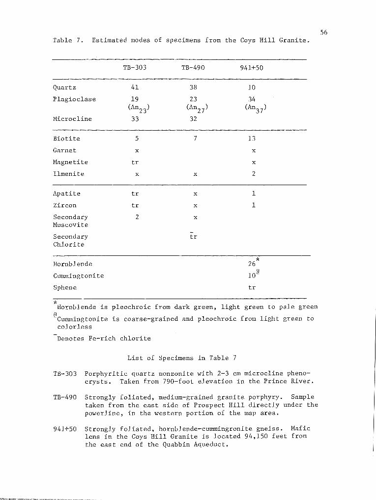
Table 7. Estimated modes of specimens from the Cays Hill Granite.
Quartz
Plagioclase
Microcline
Biotite
Garnet
Magnetite
Ilmenite
Apatite
Zircon
Secondary Huscovite
Secondary Chlorite
Hornblende
Cummingtonite
Sphene
* Hornblende is
@c • ·t umm1.ngton1. e colorless
TB-303
41
19 (An23)
33
-5
X
tr
X
tr
tr
2
TB-490
38
23 (An27)
32
7
X
X
X
X
-tr
941+50
10
34 (An37)
13
X
X
2
1
1
26*
10@
tr
pleochroic from dark green, light green to pale green
is coarse-grained and pleochroic from light green to
Denotes Fe-rich chlorite
List of Specimens in Table 7
TB-303 Porphyritic quartz monzonite with 2-3 em microcline phenocrysts. Taken from 790-foot elevation in the Prince River.
TB-490 Strongly foliated, medium-grained granite porphyry. Sample taken from the east side of Prospect Hill directly under the powerline, in the western portion of the map area.
941+50 Strongly foliated, hornblende-cummingronite gneiss. Hafic lens in the Cays Hill Granite is located 94,150 feet from the east end of the Quabbin Aqueduct.
56

57
constituents of the rock with garnet (4 percent), biotite (13 percent)
and ilmenite (2 percent) and trace amounts of sphene, apatite and zir
con making up the remainder.
Since the Coys Hill Granite is apparently continuous with the Car
digen Pluton of Kinsman Quartz Monzonite of New Hampshire (Billings,
1956), it must be genetically related to it. Thompson and others (1968)
suggest the possibility that the Kinsman Quartz Monzonite was derived
from remelted ignimbrites similar to those mapped in the Lower Devonian
of central Maine (Smith, 1933). Nielson and others (1976) postulate
that the Kinsman Quartz Monzonite was injected synchronous with the
development of large-scale nappes during the early stages of the Acad
ian orogeny. Other authors interpret the origin of the Kinsman either
as concordant plutons emplaced by forceful injection (Billings, 1937;
Hadley, 1942; Chapman, 1939; 1942; Kruger, 1946; Moore, 1949; Heald,
1950; Dean, 1977) or as metasomatic replacement of the Littleton For
mation (Chapman, 1952). The mafic gneiss in the Coys Hill Granite pro
bably represents a metamorphosed basaltic flow or ash deposit.
Lower Contact and Thickness
The contact of the Coys Hill Granite with the Littleton Formation
on the west limb of the Coys Hill syncline is well exposed at four local
ities. Where seen, the contact is well defined, with little evidence
for a contact metamorphic zone with the exception of the larger garnet
size in adjacent pelitic schist. The best examples of this contact are
in the Prince River at the 810-foot and 750-foot elevations, at Crogan
Road underneath the powerline, and at the intersection of Union Street
and Route 122 in the village of Barre.
58
The Coys Hill Granite in the Quabbin Aqueduct Tunnel is an intru
sive sill 1,000 feet wide, having an average westerly dip of 20°. As
suming that it lies in the core of an isoclinal syncline, its minimum
thickness is calculated to be 170 feet.
HARDWICK QUARTZ DIORITE
The western portion of the map area includes the eastern contact
of the main body of the Hardwick Quartz Diorite against the Littleton
Formation (Plate 1). The shape of the Hardwick Quartz Diorite on re
gional maps, is like that of an elongate tongue which extends from
southern New Hampshire (Spaulding Quartz Diorite) south to the Ware
area where it appears to wedge out in an intense cataclastic zone
(Field, 1975). In the Barre area, it is interpreted by this author to
have been intruded as a thin plutonic sheet early in the structural
history. Lyons (personal comm. 1976) gives a Rb/Sr whole rock age on
the Spaulding of 402 ± 5 m,y. Nielson and others (1976) also believe
the Spaulding Quartz Diorite was intruded into the Littleton Forma
tion early in the deformational history.
Lithology
The Hardwick Quartz Diorite in the Barre area grades from quartz
diorite to granodiorite. Typically it is strongly foliated, dark
biotite-rich gneiss, forming massive low-lying outcrops in the western
portion of the map area. Rarely it is porphyritic with andesine (An38 )
phenocrysts up to one centimeter across. Where this texture is present,
the rock retains a mottled appearance defined by subhedral andesine
phenocrysts in a groundmass of biotite, quartz and orthoclase. Biotite
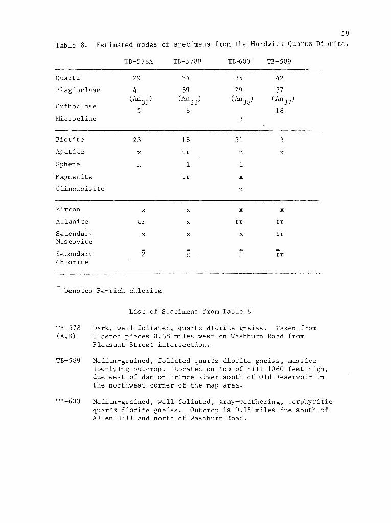
59
Table 8. Estimated modes of specimens from the Hardwick Quartz Diorite.
TB-578A TB-578B TB-600 TB-589
Quartz 29 34 35 42
Plagioclase 41 39 29 37
Orthoclase (An35) (An33) (An38) (An37)
5 8 18 Micro cline 3
Biotite 23 18 31 3
Apatite X tr X X
Sphene X 1 1
Magnetite tr X
Clinozoisite X
-Zircon X X X X
Allanite tr X tr tr
Secondary X X X tr Muscovite
Secondary 2 X 1 tr Chlorite
Denotes Fe-rich chlorite
TB-578 (A, B)
TB-589
TB-600
List of Specimens from Table 8
Dark, well foliated, quartz diorite gneiss. Taken from blasted pieces 0.38 miles west on Washburn Road from Pleasant Street intersection.
Medium-grained, foliated quartz diorite gneiss, massive low-lying outcrop. Located on top of hill 1060 feet high, due west of dam on Prince River south of Old Reservoir in the northwest corner of the map area.
Medium-grained, well foliated, gray-weathering, porphyritic quartz diorite gneiss. Outcrop is 0.15 miles due south of Allen Hill and north of Washburn Road.
60
and less commonly ilmenite or magnetite are the major mafic minerals.
The biotite is typically pleochroic from olive green to pale brown
indicating a high Fe+3 content relative to Ti+4 in the octahedral site
(Deer, et al., 1966). In most specimens the rock contains 1-2 percent
sphene with accessory apatite, zircon and allanite. Clinozoisite oc
curs in trace amounts in TB-600 (Table 8).
Contacts and Thickness
The contact of the Hardwick Quartz Diorite and the Little Formation
tion is exposed only north of the Old Reservoir just out of the map
area. The contact is also located within a few feet, fifty feet west
of the Old Reservoir and is inferred on the basis of Littleton float
southeast of the Barre Town Reservoir. Field (1975) has noted that in
the Quabbin Aqueduct Tunnel, the Hardwick Quartz Diorite is bordered
on both sides by the gray-weathering, pelitic schist of the Littleton
Formation. Since only the eastern contact of the Hardwick body is ex
posed in the Barre quadrangle, no thickness can be determined. Fahl
quist (1935) reports the Hardwick Quartz Diorite to be 16,200 feet
wide and assuming an average westerly dip of 22°, and compensating for
tectonic doubling up, a minimum thickness of 3035 feet is obtained.
GNEISS OF PLEASANT BROOK
This rock type forms two separate belts in map pattern (Plate 1),
restricted to the Wickaboag Pond and Pleasant Brook anticlines. The
best exposure of the rock is under the powerline west of Nichols Road
in the southwest portion of the map area and in scattered outcrop west
61
of Caldwell Cemetery. Other good exposures can be found on the hill
side north of the junction of Fruitland Road and Old Worcester Road,
and in scattered outcrop on the hill west-southwest of the junction of
Gilbert Road and Route 62.
Lithology
The gneiss of Pleasant Brook is a biotite granitic gneiss, with
very minor amounts of garnet (Table 9). It commonly forms large massive
outcrops with characteristically flat dips.
The gneiss averages 40 percent quartz with varying plagioclase
feldspar content, averaging 32 percent. The amount of orthoclase varies
but is typically less than 20 percent. Garnets account for one percent,
of the mode and are typically 1-3 mm across, in many cases rimmed by
biotite or chlorite.
Contacts and Thickness
The contacts of the gneiss of Pleasant Brook with the Partridge
Formation are exposed only in one locality but are approachable in sev
eral others. In the exposure north of Nichols Road the contact is
sharp with little evidence of interfingering. The greatest width of the
gneiss in map pattern (Plate 1) is approximately 1000 feet and assuming
an average dip of 18°, a calculated thickness of 309 feet is obtained.
PEGMATITE
Intrusive pegmatites occur in many rock types throughout the Barre
area. They are particularly common in the meadows of the central por
tion of the map area in the Pleasant Brook and Wickaboag Pond anti-
Table 9. Estimated modes of the gneiss of Pleasant Brook.
TB-79 TB-89 TB-429 TB-84 TB-414
Quartz 53 47 42 40 36
Plagioclase 28 31 25 20 28 (An30) (An26) (Anl8) (An20) (An25)
Orthoclase 12 13 21 26 24
Biotite 4 9 12 13 11
Garnet 1 tr X tr tr
Ilmenite X X X tr tr
Zircon tr tr X X X
Apatite X X X tr tr
Secondary X tr tr X 1 Chlorite
S~condary 2 tr X 1 tr Muscovite
Denotes Fe-rich chlorite
List of Specimens from Table 9.
TB-79 Medium- to corase-grained, well foliated garnet-biotite granitic gneiss. Taken from a large outcrop due west of Nichols Road under powerline.
TB-89 Well foliated, medium-grained biotite-garnet granitic gneiss. Located 0.38 miles west and 0.05 miles north of Nichols Road and Route 122 intersection.
TB-429 Well foliated granitic gneiss. Outcrop is 1 mile north and 0.14 miles east of Gilbert Road and Route 62 in the Burnshirt Hills.
TB-84 Gray-weathering, medium-grained biotite gneiss. Located 0.7 miles due west of White Valley.
62
TB-414 Well foliated, gray-weathering, medium-grained granitic gneiss. Taken from an outcrop 0.1 miles north and 0.18 miles west of the intersection of Gilbert Road and Route 62.

63
clines where they are exposed in large rounded outcrops, commonly with
rusty-weathering schist underneath them. The pegmatites are generally
foliated parallel to the dominant regional foliation, and commonly are
boudinaged. None of the pegmatites were studied in thin section, but
most of them appear to be of granitic composition. Field identification
showed them to be sillimanite-bearing, muscovite-bearing and muscovite
free, although the distribution of these types was not mapped.
DIABASE
One diabase dike was mapped on the surface in the Barre area (Plate
1), another thin dike is shown on the map on the basis of the report on
the geology of the Quabbin Tunnel, an aeromagnetic anomaly (U.S.G.S.,
1971) and distribution of float on the ground. The mapped dike, north
of the intersection of Fruitland Road and Granger Road, is vertical,
has a trend of N56E and cross-cuts contacts of all other units.
The dike consists of 52 percent plagioclase, 46 percent augite and
2 percent magnetite. Crystal size of the plagioclase and augite is
approximately 1/2 mm. The dike typically displays a weakly developed
subophitic texture.
STRUCTURAL GEOLOGY
Introduction
The deformational history of the Barre area as presently understood
involved five phases of folding, probably synchronous with the Acadian
(Devonian) orogeny and metamorphism, and an episode of post-metamorphic
brittle fracture of probable Mesozoic age. Cataclasis can be shown to
have occurred contemporaneously with intermediate stages of Acadian
folding.
The stratigraphic units of Ordovician, Silurian and Devonian
schists and gneisses seen in map pattern are repeated by a series of
recumbent isoclinal folds analogous to the major nappes described in
64
the Bronson Hill anticlinorium. In the western portion of the area,
recumbent anticlines with west-dipping axial surfaces are separated by
synclines of graded-bedded quartzose schist which show a reversal of
top sense across these early folds. The axial surfaces of these early
folds were then deformed by a large-scale recumbent anticline exhibit
ing west over east movement sense and a west-dipping axial surface.
This folding re-oriented the first axial plane schistosity to the west
ward dip it now has in the western portion of the study area and was
accompanied or immediately followed by local cataclasis and the develop
ment of a penetrative east-west trending mineral lineation. A third
deformation produced southwest plunging folds characterized by ·west
dipping axial surfaces and east-side up asymmetry in the western por
tion of the map area and west-side up asymmetry in the eastern portion
of the area. They also produced a penetrative mineral lineation so
that many outcrops show two mineral lineations at nearly right angles.
Formation of west-trending open folds in foliation followed this episode
of deformation. In the eastern part of the area all of these structural
features are deformed around a broad open anticline which plunges very
gently north-northeast and results in east-dipping foliations at the
east edge of the area.
SUMMARY OF STRUCTURAL HISTORY
The sequence of deformations as understood in the Barre area and
as related to the nearby Orange (Robinson, 1967a), Quabbin Reservoir
(Robinson, 1967b), and Ware (Field, 1975) areas is as follows:
65
1. Recumbent, isoclinal folding of large amplitude with an east
over west overfolding. Prior to or early in this folding, thin sheet
like bodies of Devonian plutonic rocks were intruded. This phase was
analogous to Phase 1A in the Orange, Quabbin Reservoir and Ware areas,
and probably took place under medium- to high-grade conditions of meta
morphism (Thompson et al., 1968).
2A. Overfolding toward the east of Phase 1 axial surfaces about
gently plunging axes (Robinson, 1967b) causing the axial surfaces of
the earlier isoclinal folds to dip west in the western part of the
Barre area. Evidence for this deformation is fairly scarce in the Barre
area, but has been described elsewhere. It was probably related to an
early phase of gneiss doming in the Orange and Quabbin Reservoir areas
(Robinson, 1967a, 1967b) and the formation of the Colchester nappe and
the Chester-Hunts Brook syncline in Connecticut (Dixon and Lundgren,
1968b). This folding was accompanied or immediately followed by cata
clasis along narrow shear zones and by the development of penetrative
east-west or northwest trending sillimanite, biotite and quartz linea
tions in some rocks.
2B. Formation of southwest-plunging folds with a distinct, gently
dipping axial plane foliation. Associated with this development of the
dominant southwest-plunging "b" mineral lineations. This folding is

66
equated with Phase 2B in the Ware area (Field, 1975, Robinson, 1967a)
and with the "main stage" of gneiss dome formation (Phase 2B) in the
Bronson Hill anticlinorium (Robinson, 1967a, 1967b).
3. Formation of symmetric west-trending open folds in foliation.
4. Broad open folding about a north-trending axis that is respon
sible for the broad foliation arch that deforms earlier-formed structur
al elements in the eastern part of the area.
5. Post-metamorphic brittle fracture and diabase dike intrusion.
DESCRIPTION OF MINOR STRUCTURAL FEATURES
Bedding
The contacts between distinctive rock types such as pelitic schist,
calc-silicate, amphibolite and gneiss is suggestive of primary bedding.
Fortunately, in pelitic units, graded bedding is evident and was used
to obtain unequivocal evidence for the direction of primary tops. In
schist where bedding is not directly evident, foliation was measured.
In nearly every instance bedding is parallel or subparallel to folia
tion. This foliation is generally taken to be the axial plane foliation
of the first phase of folding unless it can be shown to be related to a
younger phase of folding.
Graded bedding was found at ten localities (Figure 6), all in the
Gilbert Road and Prouty Road synclines of Lower Devonian Littleton For
mation (Field, 1975). Graded bedding at these localities is consistent
with the interpretation that the Littleton Formation rests above the
Middle Ordovician Partirdge Formation and that the belts of Littleton
Formation occupy the cores of isoclinal synclines. This is exactly the

same interpretation obtained by Peper (1976) on the basis of graded
bedding in the Mt. Pisgah syncline, approximately along strike to the
south.
Foliations
67
Foliation is used here to refer to all types of mesoscopically rec
ognizable planar surfaces defined by compositional layering, surfaces of
discontinuity, preferred orientation of planar grain boundaries or a
combination of these (Turner and Weiss, 1963). Schistosity is used to
describe foliations defined by parallel alignment of tabular minerals,
especially micas.
The dominant foliation in the Barre area is believed to be axial
plane foliation of the early phase of recumbent folding. On the average
its attitude is N28E20W (Figure 7a) in the western portion of the map
area and Nl3E21E in the eastern portion of the study area. The one
reasonable example of a Phase 2A fold (see below) shows a weakly dev
eloped axial plane foliation cutting across Phase 1 foliation.
The other conspicuous foliation is that associated with Phase 2B
folds. This foliation is generally not so strongly developed, except
in well indurated and more massive rocks, and typically is less steep
than the first foliation and commonly is seen as a wrinkling of the
first. Attitudes of the second foliation vary considerably in strike
but dip moderately northwest and southwest (Figure 7). Other axial
plane foliations were not immediately evident in the Barre area, for
example no penetrative axial plane cleavage could be identified with
confidence for third or fourth phase folds.
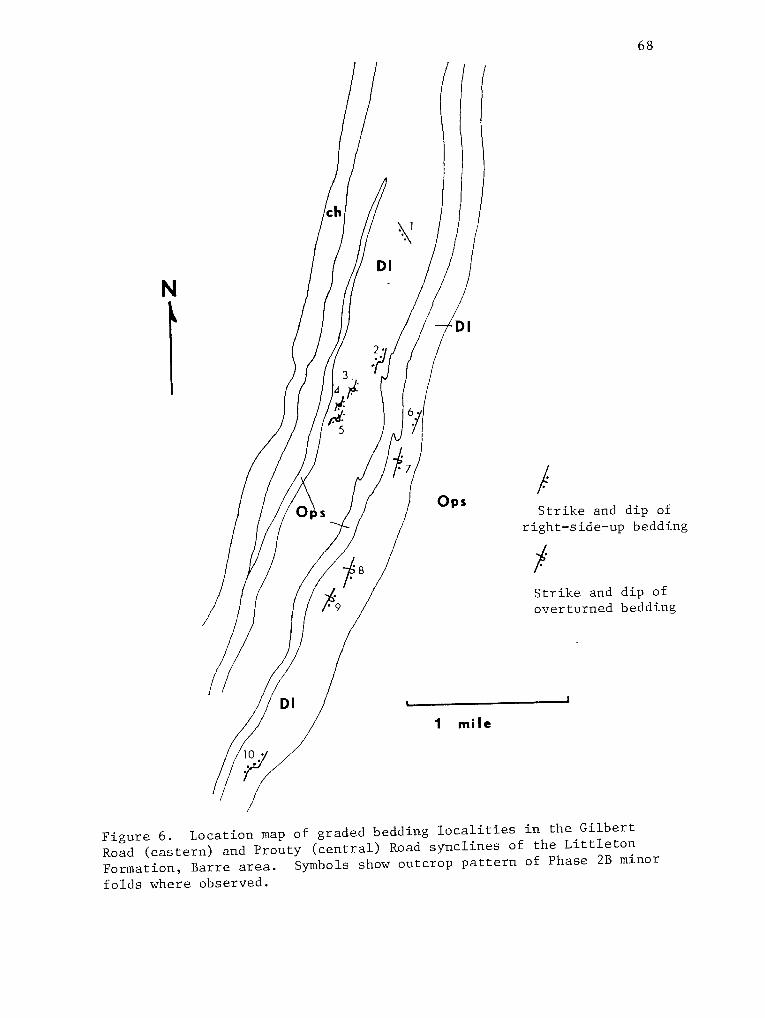
N
68
I Strike and dip of
right-side-up bedding
f Strike and dip of overturned bedding
Figure 6. Location map of graded bedding localities in the Gilbert Road (eastern) and Prouty (central) Road synclines of the Littleton Formation, Barre area. Symbols show outcrop pattern of Phase 2B minor folds where observed.
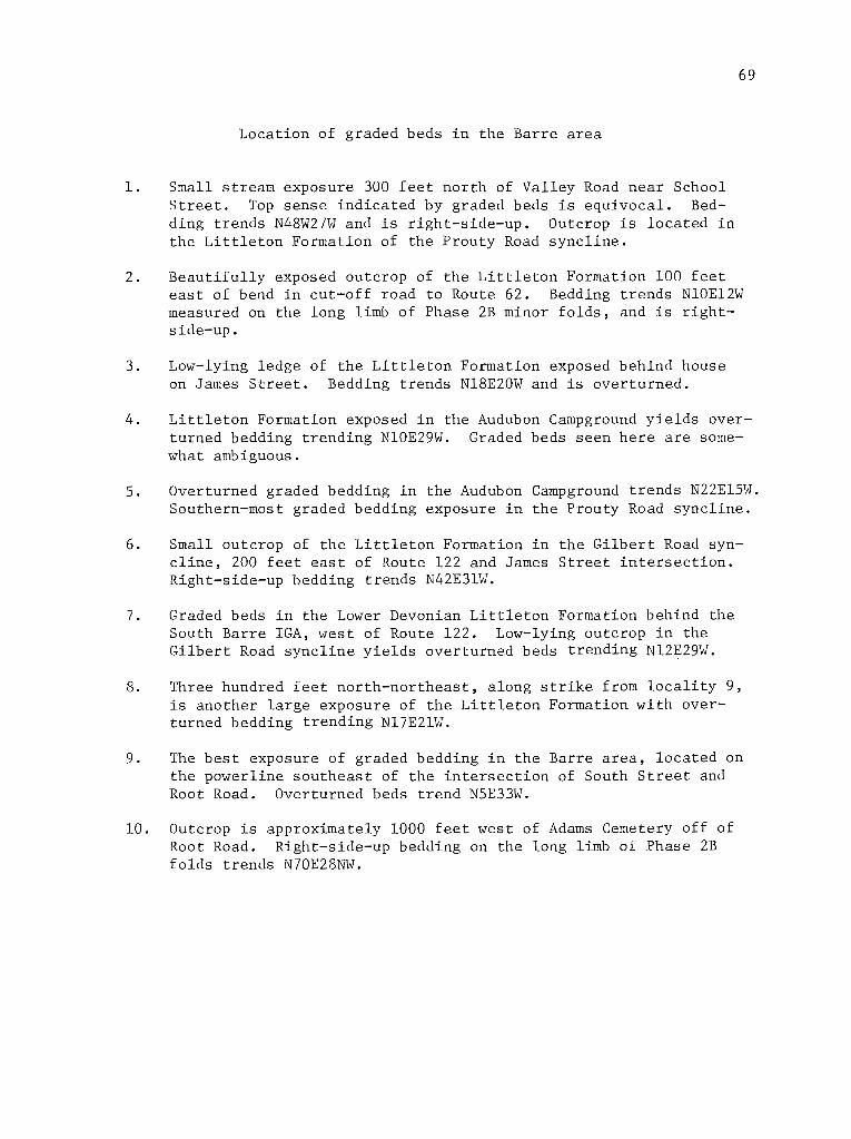
Location of graded beds in the Barre area
1. Small stream exposure 300 feet north of Valley Road near School Street. Top sense indicated by graded beds is equivocal. Bedding trends N48W27W and is right-side-up. Outcrop is located in the Littleton Formation of the Prouty Road syncline.
69
2. Beautifully exposed outcrop of the Littleton Formation 100 feet east of bend in cut-off road to Route 62. Bedding trends NlOE12W measured on the long limb of Phase 2B minor folds, and is rightside-up.
3. Low-lying ledge of the Littleton Formation exposed behind house on James Street. Bedding trends Nl8E20W and is overturned.
4. Littleton Formation exposed in the Audubon Campground yields overturned bedding trending Nl0E29W. Graded beds seen here are somewhat ambiguous.
5. Overturned graded bedding in the Audubon Campground trends N22El5W. Southern-most graded bedding exposure in the Prouty Road syncline.
6. Small outcrop of the Littleton Formation in the Gilbert Road syncline, 200 feet east of Route 122 and James Street intersection. Right-side-up bedding trends N42E31W.
7. Graded beds in the Lower Devonian Littleton Formation behind the South Barre IGA, west of Route 122. Low-lying outcrop in the Gilbert Road syncline yields overturned beds trending Nl2E29W.
8. Three hundred feet north-northeast, along strike from locality 9, is another large exposure of the Littleton Formation with overturned bedding trending Nl7E21W.
9. The best exposure of graded bedding in the Barre area, located on the powerline southeast of the intersection of South Street and Root Road. Overturned beds trend NSE33W.
10. Outcrop is approximately 1000 feet west of Adams Cemetery off of Root Road. Right-side-up bedding on the long limb of Phase 2B folds trends N70E28NW.

70
N
a.
N
b.
+ J) . . .
Figure 7. a. Equal area, lower hemisphere plot of poles to foliation measured in the Barre area. Contouring is on 1%, 3%, ..... 13% per one percent area. b. Equal-area, lower hemisphere plot of lineations measured in the Barre area. Contouring is 1%, 3%, •.... per one percent area.
71
Cataclastic Zones
Cataclastic rocks in the Barre area appear as three- to four-inch
narrow shear zones seen to cro,gs-cut Phase 2A or older foliation. Typi-
cally these rocks are fine- to medium-grained blastomylonites commonly
with alkali feldspar porphyroclasts in a fine-grained matrix of biotite,
plagioclase feldspar and quartz. Actual occurrences of these mylonites
are rare in the Barre area but may best be seen in an outcrop of the
Cays Hill Granite in the township of Barre (Figure 11).
Hinor Folds
The majority of asymmetric minor folds measured in the Barre area
were recognized as belonging to Phase 2B. Hinor folds associated with
this deformation are varied in size and style but generally are several
inches in wavelength and similar in style. Where rotation sense is de-
terminable for these folds, it was generally east-side-up (or clockwise
rotation sense looking southwest down the plunge of the fold). Hinor
folds associated with Phase 1 or Phase 2A are extremely scarce and are '
discussed separately below. Hinor folds associated with Phase 3 struc-
tures were found to be generally west or northwest plunging, upright,
symmetric folds. In some cases these folds deformed cataclastic zones
of Phase 2A or Phase 2B axial plane foliation. In other cases north-
west plunging folds have been assigned to Phase 3 based on their simi-
larity of orientation.
No minor fold axes were identified that could conclusively be
attributed to Phase 4 folding. Apparently this last stage of open
folding was not penetrative enough to develop minor folds. However,
Phase 4 major folds clearly rotated Phase 2A lineations and Phase 2B
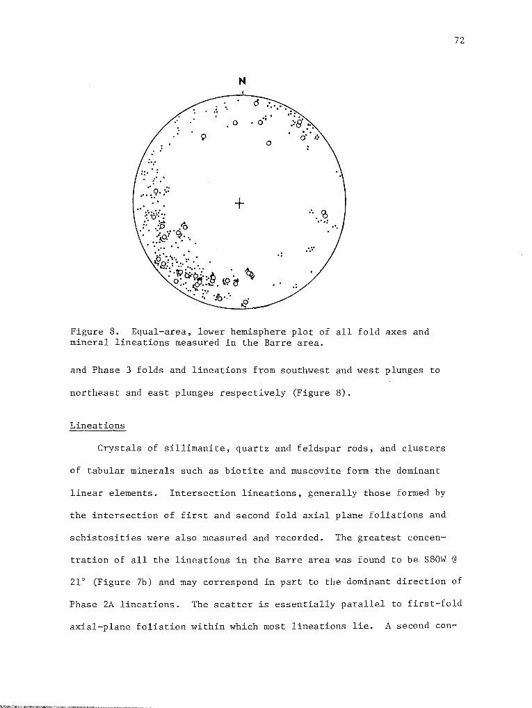
.. ::·~.: .. ... . ...... .:· .. :P .. IQ . .:o? 9/ .. .. ~ ..
.. . . ·· .·. . . . 0 ... , .. · ...
N
0
9
+
.. . o··
0
. 'I:T.fJ:.= ·.~· ·• . • • . \Q' ..... : ~· ty~'·:·fi ·. ~ < , . .,;; . t9 et
... ::: ·.~·.'·
.·. ~ · .. . : . .. ...
Figure 8. Equal-area, lower hemisphere plot of all fold axes and mineral lineations measured in the Barre area.
and Phase 3 folds and lineations from southwest and west plunges to
northeast and east plunges respectively (Figure 8).
Lineations
Crystals of sillimanite, quartz and feldspar rods, and clusters
of tabular minerals such as biotite and muscovite form the dominant
linear elements. Intersection lineations, generally those formed by
the intersection of first and second fold axial plane foliations and
schistosities were also measured and recorded. The greatest concen-
72
tration of all the lineations in the Barre area was found to be S80W @
21° (Figure 7b) and may correspond in part to the dominant direction of
Phase 2A lineations. The scatter is essentially parallel to first-fold
axial-plane foliation within which most lineations lie. A second con-
centration within this plane at S33W @ 20° probably best approximates
the trend of Phase 2B folds and related features. A third cluster at
N30E@ 12°, is probably the result of rotation of Phase 2B lineations
about the major fourth phase anticline.
Boudinage
73
Boudinage was a commonly observed phenomenon in the Barre area,
most commonly involving pegmatite and in rarer instances calc-silicate
beds. For the most part, the neck lines of the boudins trend southwest
and generally parallel the axes of Phase 2B folds.
GENERAL PATTERN OF MINOR STRUCTURAL FEATURES
The study area was divided in 14 sectors shown in Figure 9. In
each sector the poles to foliation and individual measurements of
mineral lineations were plotted directly (see Appendix). In Figure 9
the dominant foliation and lineation orientations for each sector are
shown. The most obvious features of the study area are as follows: 1)
the general uniformity of minor structural elements in the western por
tion of the map area, 2) the gradual change to nearly horizontal and then
to east dips in the central and eastern portions of the map area, 3) the
change in plunge of mineral lineations from west-southwest in the west
ern portion of the area to northeast and east in the eastern part of
the area.

CD ®}!
)
:ulli: 111 II I I
/ ,'/ ,'J f I Ill ,, I I ltJ II 1 I
1 11 II I I /J' 11} I
I 1 I II I I
,, ''' I II Ill I
6 I 1,' ~~1,' /
I I ,I
//1 21 1 1 II 1 II
6~ I f
' I /'
I
I I
I I
12 // I I
I I I
'I I ,' / IJ / ,' /
J I I I I I I I
N 1'/ /'
' I I I I I
I I I I I 1 I I I
1 I / I, I
I 1 I
I I
®I I I
I :
I I I I 'I
I I I I
I I
I I
I! I I I I
I I I I
I I I
I I I I I I I I I I I I
0
II
I
'J ,' II I II I II I
,'1 ,.
0
74
I I I I
' I I I
I I
I I
I I 0 \® I I :I I I I I It ~ I
I I I I
I I I
I I
;) I I t_,r, I
I, I I
" I I I I
I I I I I I
I I/ I I 1
I I I I I I
I I I I I
I I /
I I I
I I
I I
I I I I
I
I I ,' II I
I I I
I I I I I
II I 11 I II I ,, ,'
~~~ / /
I I
I I I I I I I I I I
I
miles
I km
2
, ... -,, / '
/ ' ' '
2
'
I 8 II
', /: I I \ I
·--- r : ' I ' I \ 20!
' I \ I
' ' ' . ' I I I I I
' I I I \\ ''\ t
\. / \.j ' I
' I \ I /10 /20
'J
15
/8 ' ' ...
r 34 ' I
I I I I I I '\
Figure 9. Structural sectors within the Barre area. The Barre area is outlined with the contacts between lithologic units shown dashed. In each sector the average planar attitude (bedding and foliation) and linear orientation (fold axes and lineations) is shown. Sector area is numbered in upper left-hand corner of each domain.

75
DETAILED INTERPRETATION OF STRUCTURAL FEATURES
Features Formed During Earliest Recumbent Folding
Minor folds. Four candidates for early minor folds were recognized
in the field. All of these exhibit an ambiguous rotation sense and
plunge in various directions. Their orientations are shown in Figure
10. The criterion for identifying early folds was that they have iso
clinally folded compositional layering with a strong axial plane schis
tosity that intersects bedding at a high angle in the hinge area of the
fold but is parallel or subparallel to bedding elsewhere. These are
the only folds that do not deform foliation and therefore are inter
preted to be the oldest folds in the study area. The very best can
didate for an early fold has been found in the Littleton Formation
(Figure 10), others are in the Partridge Formation and in the Paxton
Schist. Generally, the angle between the limbs of the minor folds formed
during Phase 1 folding is small, with evidence for passive slip movement
along the axial surface of the fold. Each of the four folds are similar
in style.
Foliation. At the four localities where Phase 1 minor folds were
found their axial planes have an orientation close to that of the region
al foliation. Since this foliation was observed to be near parallel to
bedding everywhere but near the early fold hinge, the regional foliation
is believed to have developed during Phase 1. No mineral lineations
were found that were proven to have developed during Phase 1.
Major folds. Phase 1 major folds are by far the most obvious struc
tural features in the Barre area, forming belts of Ordovician, Silurian

N 76
0
+ 0
0 0
6 inches
Figure 10. a. Equal-area lower hemisphere plot of Phase 1 minor fold axes in the Barre area. Note that no rotation sense was observed for any of the minor folds. b. Sketch of Phase 1 isoclinal minor fold in the Littleton Formation, Gilbert Road syncline. Minor fold is exposed in outcrop 100 feet east of bend in cut-off road to Route 62 in the central portion of the Barre area.
and Devonian rocks that extend north-south across the area. In the
Barre area, five Phase 1 anticlinal belts cored by Ordovician rocks
77
and six Phase 1 synclinal belts underlain by Siluro-Devonian rocks have
been identified. Apparently because of a combination of large ampli
tude and of low angle plunge, only one Phase 1 fold hinge has been map
ped. It has been postulated (Thompson et al., 1968; Field, 1975) that
the highest of the three westward-transported nappes of the Bronson
Hill anticlinorium, the Fall Mountain nappe, may have its roots south
west of Barre in the western part of the Ware area. This being the
case, it is possible to interpret the early isoclinal folds mapped in
the Barre area as representing structurally still higher nappes of the
same stratigraphic sequence that were not transported as far west. Due
to the great distances these anticlines and synclines can be traced, in
excess of twenty miles, the axes of these early folds would appear to
have a shallow plunge and a north-south trend. The fact that adjacent
anticlines and synclines contain considerably different stratified and
plutonic rocks, for example the Cays Hill Granite of the Cays Hill syn
cline is not repeated in any adjacent synclines, strongly suggests
that the early folds had large amplitude with respect to wavelength.
Features Formed During Regional Backfolding
As in the Ware area (Field, 1975), the Barre area showed little
minor structural evidence that either proved or disproved an intermedi
ate folding event between Phase 1 and Phase 2B. Regional considerations
and the map pattern of the Orange area have led others (Robinson, 1967a;
Thompson et al., 1968) to suggest large-scale east-directed backfolding

78
of the axial surfaces of the earlier west-directed nappes giving them
their present west dip. This recumbent backfolding was believed to have
been synchronous with the development of the east-directed Colchester
nappe of southern Connecticut (Dixon and Lundgren, 1968a), and was re
ferred to by Robinson (1967a; 1967b) as Phase 2A.
Minor folds and foliation. Only one occurrence of minor folds has
been found in the Barre area that can reasonably be assigned to Phase
2A. They are folds in Phase 1 foliation in the Coys Hill Granite
(Figure 11) which plunge west-southwest and exhibit east-side-up move
ment sense, the same as Phase 2B folds in the same region. The Phase
1 foliation in the Coys Hill Granite is cut by fine-grained aplitic
dikes, which are in turn deformed by the folds and contain and incip
ient very fine axial plane foliation.
Cataclasis and mylonization. Within the outcrop of Coys Hill Gran
ite (Figure 11) cataclastic zones are recognized that cut across the
axial surfaces of the west-plunging folds assigned to Phase 2A. In one
place an apparent left-lateral offset of approximately four inches can
be seen on a cataclastic zone. The cataclastic rocks themselves appear
to contain later west-plunging (down-dip) mineral lineations and in a
few places later southwest plunging mineral lineations and crenulations
that could be assigned to the later Phase 2B (see below). In the
Quabbin Reservoir area, nine miles to the west, Robinson (1967b) report
ed the occurrence of cataclastic zones that cross-cut the axial sur
faces of folds equated with regional Phase 2A, and that are folded
about folds of Phase 2B and contain Phase 2B mineral lineations. These
79
Figure 11. Photograph of relationship of cataclastic zones to regional Phase 2A folds. Note presence of fine-grained granite that cross-cuts Phase 1 feldspar foliation but was injected prior to Phase 2A folds. Outcrop is located on Route 122 in the village of Barre.
cataclastic zones also showed left-lateral shear sense. In the Ware
area, Field (1975) also recognized cataclastic rocks in which mineral
lineations of Phase 2B were superimposed and which had to have formed
before or during Phase 2B. It is this relationship with cataclastic
zones that supports the view that the fold in Figure 11 should be
assigned to Phase 2A. In an alternative interpretation long supported
by this writer, the fold in Figure 11 was assigned to Phase 2B on the
basis of orientation and asymmetry, thus requiring both the cataclastic
zones and the down-dip mineral lineations to post-date Phase 2B.
Lineation. Lineations that can be assigned to Phase 2A are ex-
tremely difficult to identify with certainty. They are pervasive, fine
lineations composed of oriented silimanite needles, elongated quartz
and feldspar grains, and mica aggregates, and locally are superimposed

80
N
Figure 12. Equal-area, lower hemisphere plot of mineral lineations from outcrops exhibiting a double fabric in the Barre area. Early (Phase 2A) mineral lineations are shown in open circles (o) and plunge moderately west and northwest. Later (Phase 2B) mineral lineations are shown in darkened circles (o) and plunge southwest and northeast. Superscripts indicate the lineations measured from the same outcrop. Locations of outcrops where this texture is evident can be found on Plate 4.
on cataclastic rocks. They are best identified by their west or north-
west trend in outcrops where a definite southwest-trending lineation of
later Phase 2B can also be identified (Figure 12) (Plate 4). However,
even among outcrops where two lineations nearly at right angles can be
identified, there are only a handful where the relative ages can be
determined with reasonable certainty.
Major folds. The map patterns in the Orange area (Robinson, 1967a)
and in eastern Connecticut (Dixon and Lundgren, 1968a; 1968b) have led
several authors to suggest large-scale east-directed recumbent folds.
In the eastern portion of the Barre area (Plate 6), repetition of the
Middle Ordovician Partridge Formation on both sides of the west-dipping
~ ~~
~ ~ '{._'
~ .;;
i .;: c.'j
c, :c;
l
·~ j
ij
81
Silurian (?) Paxton Schist suggests the existence of an early east-
facing recumbent syncline. In addition, Quabbin Aqueduct Tunnel speci-
men 713+75, found near the contact of the Gray Granulite Member of the
Paxton Schist with the Partridge Formation, closely resembles the White
Sulfidic Schist Member of the Paxton Schist in both mineralogy and chem-
istry. If this repetition is indeed due to recumbent folding, the evid-
ence suggests a Phase 2A synclinal axial surface within the Gray Granu-
lite Member of the Paxton Schist on the western limb of the Phase 4
anticline (Plate 6). In this interpretation the Gray Graphitic Schist
Member of the Paxton Schist would pinch out stratigraphically before
being repeated on the east limb of the fold. It is interesting to note
that in this interpretation the structure invoked here is similar to the
east-facing recumbent syncline of the Colchester nappe (Dixon and
Lundgren, 1968a; 1968b) although the two axial surfaces are difficult
to connect on a regional map.
Southwest "Main Stage" Folding
The dominant minor structural features recognized in the Barre area
probably correspond with late stage folds (Phase 2B) in the Ware (Field,
1975) and Quabbin Reservoir (Robinson, 1967b) areas.
Minor folds. The majority of minor folds seen in the area belong
to Phase 2B. They are seen in all rock types, but are especially well
developed in stratified rocks. The minor folds appear to be similar in
style, plunge moderately south-southeast and, in the western part of
the area, exhibit east-side-up asymmetry (clockwise rotation sense
looking down plunge). East of the axial surface of the Kruse Road syn-

82
cline, Phase 2B minor and macroscopic folds continue to plunge southwest
but exhibit west-side-up asymmetry. Discussion of this asymmetry rever
sal appears under Major folds. Figure 13a shows an equal-area net plot
of Phase 2B minor folds. Those that plunge northeast are all from the
eastern part of the area on the east limb of the late (Phase 4) folia
tion arch. Axial plane features attributed to this phase are evident
in the more massive, plutonic rock types, and generally dip less steeply
than the dominant (presumably Phase 1) foliation.
Foliation. The dominant planar structural feature attributed to
Phase 2B deformation is a moderately developed axial plane foliation,
generally striking north-northeast and dipping about 20° northwest.
Where best developed, in more massive, medium-grained foliated gneiss,
it is a late slip cleavage deforming Phase 1 axial surfaces. Figure
13b shows a plot of all measurements of axial plane foliation associated
with Phase 2B folds.
Lineation. Minor folds of Phase 2B have a strong "b" lineation
statistically parallel to their axes. Mineral lineations oriented paral
lel to the axes of Phase 2B folds, including long axes of sillimanite
crystals, quartz and feldspar rods, and elongate aggregates of biotite
or muscovite, are by far the most commonly observed and measured linear
fabric element. Lineations formed by intersection of Phase 1 and Phase
2B axial plane foliations were also observed. Figure 13a shows an equal
area plot of all measured mineral lineations believed to have formed
during Phase 2B.

N
.. . o·· ··.:a;·· ..
0
... · .. · ... + .. ;··~\:'·:
::· ·:0 .~ . ·. •. ·o. . . ;_/'"'\: "' ... I ·~ I .... ·. . . .. .
·.' .. ·~·· ..... . .tlo:: ·~· ... ·.. . ~ ''):,', 1:_, .•• r- • ·~
: • :'>J b;·¢, .. ~·P ~ 0' o: .. ~ .. ~. · .. :· ~~ ·~· ·. ~
N
•• • •• • + ••• •. I • • • • ••
6·' It
•
83
Figure 13. a. Equal-area lpwer hemisphere plot of fold axes and mineral lineations related to Phase 2B folds. b. Lower hemisphere equal-area net plot of poles to axial plane foliation of Phase 2B minor folds in the Barre area. Foliations associated with Pahse 2B minor folds dip less steeply than Phase 1 foliation.
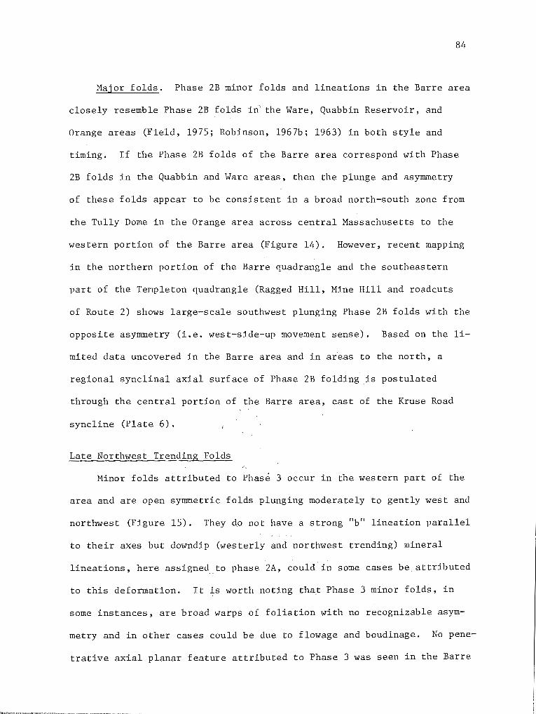
84
Major folds. Phase 2B minor folds and lineations in the Barre area
closely resemble Phase 2B folds in' the Ware, Quabbin Reservoir, and
Orange areas (Field, 1975; Robinson, 1967b; 1963) in both style and
timing. If the Phase 2B folds of the Barre area correspond with Phase
2B folds in the Quabbin and Ware areas, then the plunge and asymmetry
of these folds appear to be consistent in a broad north-south zone from
the Tully Dome in the Orange area across central Massachusetts to the
western portion of the Barre area (Figure 14). However, recent mapping
in the northern portion of the Barre quadrangle and the southeastern
part of the Templeton quadrangle (Ragged Hill, Mine Hill and roadcuts
of Route 2) shows large-scale southwest plunging Phase 2B folds with the
opposite asymmetry (i.e. west-side-up movement sense). Based on the li
mited data uncovered in the Barre area and in areas to the north, a
regional synclinal axial surface of Phase 2B folding is postulated
through the central portion of the Barre area, east of the Kruse Road
syncline (Plate 6).
Late Northwest Trending Folds
Minor folds attributed to Phase 3 occur in the western part of the
area and are open symmetric folds plunging moderately to gently west and
northwest (Figure 15). They d.o not have a strong "b" lineation parallel
to their axes but downdip (westerly and northwest trending) mineral
lineations, here assignedto phase 2A, could in some cases be attributed
to this deformation. It is worth noting that Phase 3 minor folds, in
some instances, are broad warps of foliation with no recognizable asym
metry and in other cases could be due to flowage and boudinage. No pene
trative axial planar feature attributed to Phase 3 was seen in the Barre

~-:> ...... ~ -.;
(i>
Dome
I I
7. x,_'l>,;z-
5'3 s"., ;.-+~
:\-~ ~0
~<,;
//' /
Barre area
~
Figure 14. Diagrammatic sketch of· relationship of Phase 2B fold asymmetry across central Massachusetts. Note that east from the Athol Axial Surface to the central portion of the Barre area, Phase 2B minor folds exhibit east-side up asymmetry. East of Barre, minor folds apparently reverse their asymmetry.
00 Vl

86
N
0
0
0 +
Figure 15. Equal-area, lower hemisphere plot of Phase 3 minor folds in the Barre area. Note that Phase 3 folds are symmetric open folds, which in the eastern part of the area, plunge east due to rotation about a
Phase 4 anticline.
area. This deformation is known to have little effect on the map pat-
tern and is thought to have been only locally developed. A few Phase 3
fold axes plunge east or southeastdue to a later refolding during
Phase 4.
Late Open Folding
The last folding in the Barre area is demonstrated by the rotation
of previously formed lineations and fold axes. During this last phase,
earlier structures were deformed in a broad smootp warping, whereas
folds of the earlier generations appear to deform minor structural elem-
ents to a much greater degree. This open folding appears to be restrict-
ed to the east-central portion of the area and is clearly seen in map
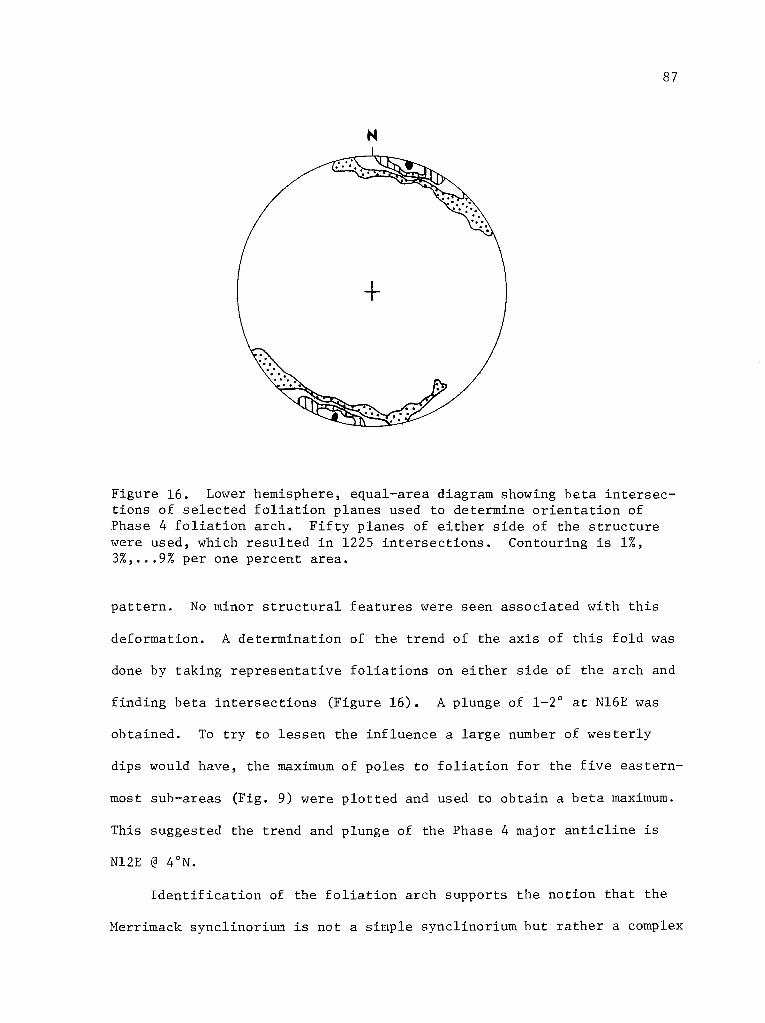
87
N
Figure 16. Lower hemisphere, equal-area diagram showing beta intersections of selected foliation planes used to determine orientation of Phase 4 foliation arch. Fifty planes of either side of the structure were used, which resulted in 1225 intersections. Contouring is 1%, 3%, .•• 9% per one percent area.
pattern. No minor str~ctural features were seen associated with this
deformation. A determination of the trend of the axis of this fold was
done by taking representative foliations on either side of the arch and
finding beta intersections (Figure 16). A plunge of 1-2° at Nl6E was
obtained. To try to lessen the influence a large number of westerly
dips would have, the maximum of poles to foliation for the five eastern-
most sub-areas (Fig. 9) were plotted and used to obtain a beta maximum.
This suggested the trend and plunge of the Phase 4 major anticline is
Nl2E @ 4°N.
Identification of the foliation arch supports the notion that the
Merrimack synclinorium is not a simple synclinorium but rather a complex

88
zone of refolded folds masked by late broad open flexures. Moreover,
it is in direct contradiction to the hypothesis that the synclinorium
is essentially a westward dipping homoclinal sequence. Recent mapping
by this author in the Gardner, Paxton and Wachusett Mountain quadrangles
has uncovered additional late open folds, that also plunge gently north,
which likewise are to be related to Phase 4 folding.
Post-Metamorphic Brittle Fracture
To better determine the brittle fracture history of the Barre area,
683 joints and 20 faults were compiled directly from Fahlquist's report
on the geology of the Quabbin Aqueduct Tunnel (1935) and plotted on
three equal-area nets across the area. Each sector has approximately
an equal number of readings, the maximum number in Sector C (241 joints
and 6 faults) and the minimum number in Sector B (206 joints and 9
faults) (Figure 17). In Sector A, the joints are dominated by a N47W
and vertical set with a weakly developed set striking generally N35E
to N70E and dipping moderately 30° to 80° NW, is also present but clear
ly is less well defined. North-south trending vertical joints are also
present (Figure 17).
Sector B between the tunnel footages 720+00 and 640+00, has a
strong maximum with attitudes centered around N66E80NW. A second
weakly defined set striking NlOE to N20E and moderately west dipping
appears and trends into the N66E and 80NW set. Vertical joints with a
wide variety of strike directions also are recorded but no statistical
cluster is apparent.
Sector C is dominated by joints with attitudes of N62E80NW to
vertical. A second set of joints generally trending NlSE to N20°E and
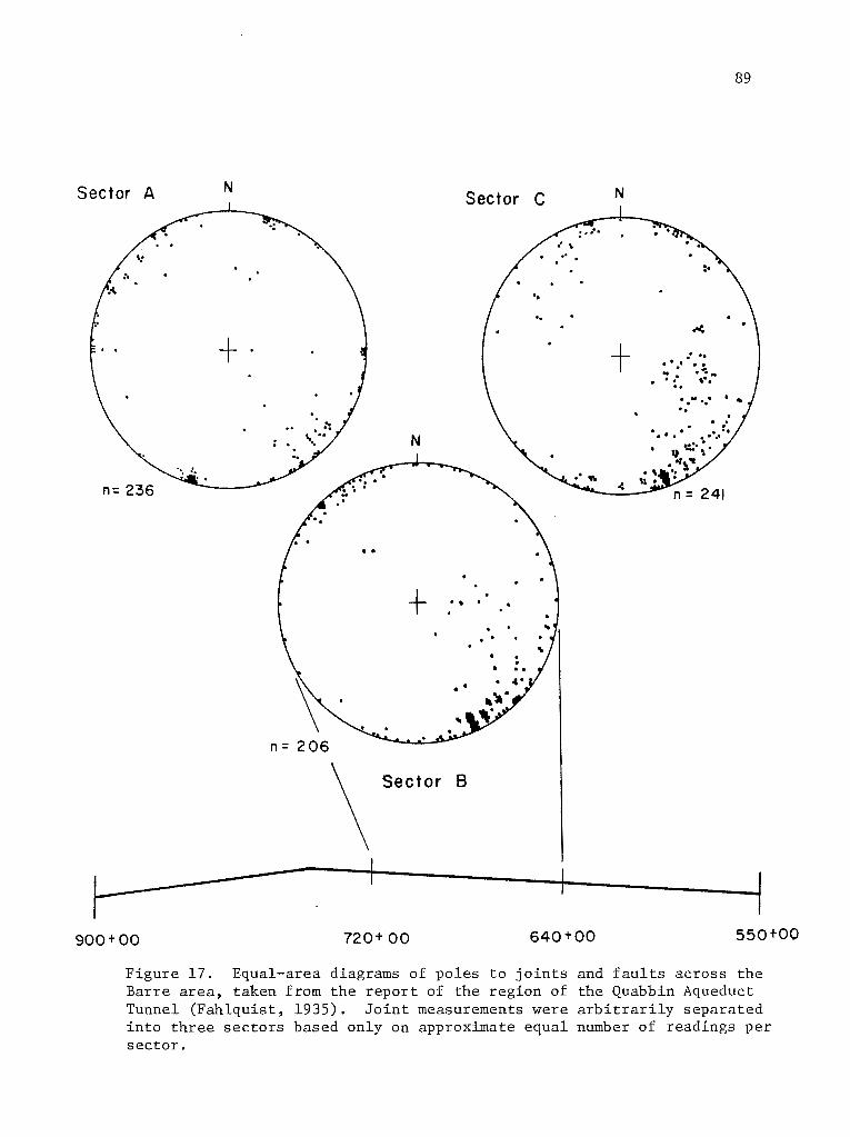
Sector A N Sector C
n= 236
+ ... . .
• •
n= 206
\ Sector B
900+00 720+ 00 640+00
N
+ .'(
.· .. . . . . . . .. .. . . :. . . ' . . ... .. · ..
. . . . .
89
550+00
Figure 17. Equal-area diagrams of poles to joints and faults across the Barre area, taken from the report of the region of the Quabbin Aqueduct Tunnel (Fahlquist, 1935). Joint measurements were arbitrarily separated into three sectors based only on approximate equal number of readings per sector.

90
dipping west at 40 to 50 is more prominent in this sector and a third
weakly developed set which trends N7W and dips 80 to 90NE. is also pre-
sent.
In the analysis of this joint data, it as apparent that several
Mesozoic trends are recorded in the rocks across the Barre area. Gold
stein (1976) working in the Montague Basin reports three major joint
sets with the following orientations; 1) N65E to N75E and vertical, 2)
N70W to N80W and vertical, best developed in the northern portion of the
basin, 3) N30E and moderately west-dipping, more or less restricted to
the Turners Falls area. He also reports, citing evidence from Onasch
(1973), Laird (1974) and Pferd (personal comm., 1976) that sets 1 and
2 (above) exist both within the Mesozoic basin rocks and in the Paleozoic
rocks to the east and west of the Connecticut Valley (Goldstein, 1975;
p. 34). Data from the Barre area suggests all three of these joint sets
are present. Furthermore, in the Barre area a Jurassic dike was mapped
with a N56E trend. Presumably this dike intruded along an extensional
fracture zone active in Mesozoic time. Although no direct evidence is
available in the Barre area for age relations of the other major trends,
the prominence of these sets in the Mesozoic basin to the west suggests
similarity of stress orientations across most of central Massachusetts
in Triassic-Jurassic time.

91
CORRELATION AND AGE OF STRATIGRAPHIC UNITS
General Statement
No fossils have been discovered in the Barre area, hence the dat
ing of the formations is dependent on the continuity of geologic mapping
with several areas to the north and south. Indirect evidence that the
stratigraphy of the western portion of the Barre area is broadly equiva
lent to the stratigraphic sequence in the Bronson Hill anticlinorium is
suggested below. The correlation of the formations thus proposed
(Table 10) is based on the following observations:
1. The Partridge and Littleton Formations have been traced south
from the Orange area down the east limb of the Bronson Hill anticlinor
ium to the western part of the Ware area, Massachusetts. From there
eastward, Field (1975) has mapped alternating isoclinal anticlines and
synclines developed in these units to Wickaboag Pond. These isoclinal
folds can be followed for great distances north, up to 20 miles, and
appear to strike into the Mt. Monadnock area of New Hampshire mapped by
Fowler-Billings (1949) who assigned most rocks to the Littleton
Formation.
2. The lithology of the rock types in the Partridge, Fitch and
Littleton Formations of the Ware area is very similar to that in the
adjacent anticlinorium. The gross lithology of each of these formations
and relative abundance of accessory rock types within each formation
of the Bronson Hill stratigraphy can also be recognized in corresponding
units in the Barre area. Discussion of the specific details of each
formation is given below.

~ H p:: ~ ...:1 H U1
DEVONIAN
Ludlow
Henlock
I I
Llandovery
MIDDLE ORDOVICIAN I
PRE-MIDDLE ORDOVICIAN
Bronson Hill anticlinorium !Hare-Barre area (Robinson, 1963) west (Field, 1975)
Erving Fm.
Littleton Fm. I Littleton Fm.
Fitch Fm. l Fitch Fm.
Clough Quartzite
Partridge Fm. I Partridge Fm.
Ammonoosuc Volcanics
Monson Gneiss
Mt. Monadnock, N.H. (Fowler-Billings, 1949; Nelson, 1974)
Littleton Fm.
Gray calc-silicate (Dublin Pond)
"Rusty Quartzite" (Dlr)
Sulfidic schists (outcrops at H. Rindge, for example)
HillsboroHarner area, N.H. (Nielson, Lyons)
Littleton Fm.
Harner Member
Francestown Member
Rusty-weathering schists
Table 10. Possible correlations of lower and middle Paleozoic stratigraphic units in the Bronson Hill anticlinorium and Merrimack synclinorium of southern New England.
\0 N
93
3. The similarity of stratigraphic sequences in the western por-
tion of the Barre area to that of the Bronson Hill stratigraphic se-
quence suggests correlation of formations. Although most of the key
Silurian rocks of the Bronson Hill anticlinorium, in particular the
Clough Quartzite, are not present in the Barre area, graded-bedding in
the Littleton Formation is consistent with the interpretation that it
occupies the cores of early synclines. However, nowhere in the Barre
area are there conclusive examples of graded-bedding at the contact
between the Partridge and Littleton Formations. Where the Fitch For-
mation is present it is inferred to lie in the core of an early anti-
cline bordered on both sides by the Littleton Formation.
4. The Coys Hill Granite and the Hardwick Quartz Diorite, two of
the most conspicuous igneous rocks in the Barre area, can be correlated
with the Kinsman Quartz Monzonite and the Spaulding Quartz Diorite
(Billings, 1956) in New Hampshire which are intimately associated with
the Littleton Formation of the Bronson Hill anticlinorium stratigraphy.
Correlation of the rocks in the eastern portion in the Barre area
is much more tenuous and is based on lithic similarities to the strati-
graphy of western and central Maine (Moench, 1971; Boone, 1973; Osberg
et al., 1968; Ludman, 1969; Ludman et al., 1972; Ludman and Griffin,
1974; Pankiwskyj et al., 1976) and the physical tracing of some lithi-
cally similar rocks from Maine through southeastern New Hampshire to
Massachusetts (Hussey, 1968) (Table 11). Moreover, the similarity of
the stratigraphic sequence in western and central Maine (Boone, 1973;
Ludman and Griffin, 1974) to .that of the Paxton Schist of the Barre
area is striking. In western Maine, the granular calc-silicate unit of
the Madrid Formation (Paxton Gray Granulite Member) is underlain by

94
sulfidic pelite and quart~ite of the Smalls Falls Formation (Paxton
Sulfidic White Schist Member). In central Maine similar rocks have
been assigned to the Fall Brook and Parkman Hill Formations respective
l~which overlie the Late Llandovery to Early Ludlow Sangerville For
mation (Ludman and Griffin, 1974; Boone, 1973). In addition, further
east in central Maine, the we9tern facies of the Waterville Formation
(Wenlock) (Osberg, 1968) together with the underlying Mayflower Hill
Formation are considered to be lateral equivalents of the Sangerville
Formation (Ludman and Griffin, 1974). This suggests the meta-pelite
and meta-siltstones of the Vassalboro Formation (Osberg, 1968) to be
correlative of the Fall Brook Formation (Ludman and Griffin, 1974).
Possible correlations of these rocks to the south and west is
presented in Table 11.
Partridge Formation
Correlation. The Partridge Formation in the Bronson Hill-anticlin
orium has been traced south from the type locality at Partridge Lake,
New Hampshire (Billings, 1937; 1956) down the axis of the anticlinorium
and into Connecticut (Thompson et al., 1968; Robinson, 1963; 1967a and
1967b; Moore, 1949; Rodgers et al., 1959; Dixon and Lundgren, 1968b).
At Partridge Lake, the Partridge Formation consists of sulfidic black
gray slates interbedded with thin-bedded gray quartzites and soda
rhyolite tuffs at the base (Billings, 1956, p. 20). The slates and
schists of the Partridge Formation weather rusty brown to red, commonly
with crusts of sulfates on fracture planes.
Robinson (1967a and unpublished data) and Thompson and others
(1968) have traced the Partridge Formation on the east limb of the

DEVONIA.';
Ludlow
:'ii Wenlock .... "' ==! ;:<
"'
Llandovery
XIDDLE
ORDOVICIA.'l
PRE~IIDDLE
ORDOVICIA.<;
Yt'arc-Barre area-east
(Field, 1975)
Possible Little-
ton Fm. on su:n-
mit of !,..'achusett
:-~tn.
Partridge FC!.
IPhilips-Rangeleyl Central Maine ittle Bigelo~ (Ludman and
cltn. ~Iaine Griffin, 1974) U\oench, 197], Boone, 1973)
Seboo:oook F:n. Solon Fm.
Hadrid Fro. Fall Brook Fm.
Fm.
South-Central ~~aine (Osberg, et. al., 1968)
not exposed
Vassalboro Fm. I
Perry ~tn. F:::;,. Sangerville Fe. I Waterville Fm.
Rangeley Fm. Mayflower Hill
Fm.
Southwestern Maine
(Hussey, 1968)
SterlingShirley area (Hepburn, 1977)
Towow Fm.
Rindgemere
Gonic Fro.
Units 3 and 4 of
Fm.IPeck (1976) and
lllolden Fm. of
Grew (1973).
Berwick Fm.
Eliot Fn.
Kittery Fm.
Rye Fm.
Unit 2 (Peck)
O:tkdale Fm.
Unit 1
Tower Hill Qtzt.
Tadrnuck Brook Fm.
Nashoba Fm.
Harlboro Fm.
Southt.•estern Connecticut (Dixon and Lundgren, 1968)
Scotland Schist
Franklin Qtzite.
Hebron FIO.
Tatnic Hill
Fm.
Quinebaug Fm.
Table 11. Possible correlations of lower and middle Paleozoic stratigraphic units across the Merrimack synclinorium as applied to New England.
\0 VI
96
North Orange band (Robinson, 1963) south from the Orange area to the
Ware area (Field, 1975), where it overlies the pre-Middle Ordovician
Monson Gneiss. East from here, the Partridge Formation is exposed in
the cores of early isoclinal anticlines that trend north-northeast
across the Ware area and have been mapped into the Barre area. The
sulfidic schist, minor amphibolite and calc-silicate granulite in the
core of these folds resembles the Partridge Formation mapped in the
Orange area, and elsewhere in the Bronson Hill anticlinorium. The east
ern-most anticline in the Ware area, the 1~ickaboag Pond anticline, con
tains an ultramafic body, strongly suggesting that the sulfidic schist
is Middle Ordovician or older (Field, 1975; Chidester, 1968; Cady, 1969).
The Wickaboag Pond anticline has been mapped south of the village of
Brimfield by Pomeroy (1973) and Seiders (1976) who assigned such rocks
to the Upper Schist Member of the Hamilton Reservoir Formation. The
Partridge Formation in the Barre area may also be correlated with the
Tatnic Hill Formation of the Merrimack synclinorium (Dixon and Lundgren,
1968b) based on lithologic grounds and similar position in the regional
stratigraphic sequence.
Age. The Partridge Formation is considered Middle Ordovician in
age (Billings, 1956), most firmly based on Zone 13 graptolites found
in western Maine (Harwood and Berry, 1967).
Fitch Formation
Correlation. The outcrop of the Fitch Formation in the Barre area
is too small to permit definitive correlation. However, the rock in this
exposure is nearly identical to and on strike with extensive exposures

97
of Fitch Formation in the Ragged Hill anticline of the Ware area (Field,
1975). Here the Fitch Formation is a graphite-rich, sulfidic calc
silicate granulite. This belt is generally on strike with the rusty
weathering quartzite of the Littleton Formation in the Mt. Monadnock
area (Fowler-Billings, 1949) to the north and the Francestown Member of
the Littleton Formation in the Peterborough area, New Hampshire
(Greene, 1970). Moreover, all of these rock types are similar to the
sulfidic calc-silicate granulite of the Fitch Formation exposed oppos
ite Gee Mill in the Lovewell Mountain quadrangle, New Hampshire (Dll
of Heald, 1950; Thompson et al., 1968). Elsewhere in New Hampshire,
the Fitch Formation is composed of impure limestones and calcareous
slates and at the type locality near Littleton, New Hampshire consists
of white calcitic marbles interbedded with light-gra~ quartz pebble
conglomerates. The Fitch Formation in the Bronson Hill anticlinorium
is a mixture of gray-weathering, biotite-plagioclase granuL1te and
calc-silicate granulite. Robinson (1963), in the Orange area, has
mapped rusty-weathering, calc-silicate granulite and sulfidic bytownite
schist intercalated with diopside-garnet calc-silicate granulite.
Age. The Fitch Formation near Fitch Hill, Littleton, New Hamp
shire contains corals, crinoids, brachiopods, trilobites and bryozoans
previously thought to be of Middle Silurian (Niagaran) age (Billings
and Cleaves, 1934). Closer examination by Boucot and Thompson (1963)
place the faunal assemblage in the Early-Late Silurian (Early Ludlow).
Paxton Schist
Gray Granulite Member. The Gray Granulite Member of the Paxton
Schist in the Barre area is lithically similar to the Oakdale Quartzite

98
exposed a few miles to the east in the Sterling, Worcester North and
Worcester South quadrangles (Hepburn, personal comm., 1976; Grew, 1973).
Emerson (1917) has mapped these units across much of central Massachu
setts and considered the Oakdale Quartzite to be an eastern,less meta
morphosed facies equivalent of the Paxton Schist. Along strike to the
northeast, the Oakdale Quartzite resembles the Kittery, Eliot and
Berwick Formations of southeast New Hampshire (Billings, 1956; Hussey,
1968). These units can be traced north into central Maine (Hussey,
1968; Osberg et al., 1968) where at lower grade of regional metamorphism
the metapelite and metasiltstone of the Mayflower Hill and Waterville
Formations contain Late Llandovery (Silurian) graptolites. More speci
fically, however, these units trace into west-central and northwestern
Maine where the Madrid and Fall Brook Formations (Boone, 1973; Ludman
and Griffin, 1974) are lithically like the Paxton Gray Granulite Member.
The Fall Brook Formation overlies the Late Wenlock to Early Ludlow
Parkman Hill Formation and the Late Llandovery to Early Ludlow
Sangerville Formation (Ludman and Griffin, 1974) and is older than the
Early Devonian Solon Formation (Ludman and Griffin, 1974). Other
authors (Field, 1975; Grew, 1973) suggest similar correlations for the
Paxton Schist and Oakdale Quartzite in the Ware and Worcester areas
respectively.
To the south of the Barre area, the Paxton Schist can be traced
into the Hebron Formation of southern Connecticut (Dixon and Lundgren,
1968). Members of the U.S. Geological Survey (Pomeroy, 1973; 1975)
have mapped rocks lithically identical to the Paxton Schist south of the
Barre area as members of the Hamilton Reservoir, Bigelow Brook and
99
Southbridge Formations.
White Sulfidic Schist Member. The belt of the White Sulfidic Schist
Member of the Paxton Schist mapped in the Barre area is continuous with
the western-most belt of Sulfidic White Schist mapped by Field in the
Ware area. No other equivalent rock type exists in the immediate area
which can be correlated with the White Sulfidic Schist Member of the
Paxton Schist. It is similar in weathering characteristics to the
Silurian Fitch Formation to the west but i~ much less calcareous. Of
key importance is the lithic similarity of the White Sulfidic Schist
Member to the Smalls Falls and Parkman Hill Formations in western and
west-central Maine (Boone, 1973; Guidotti et al., 1975; Ludman and Grif
fin, 1974; Pankiwskyj et al., 1976). In particular, electron probe stu
dies of both the White Schist Member and the Smalls Falls Formation show
they have extremely magnesian silicates, high sulfide content, and rutile
as the main Ti oxide. The Parkman Hill Formation of west-central Maine
contains fossils of Late Wenlock and Early Ludlow age (Ludman and
Griffin, 1974).
Gray Graphitic Schist Member. At the present time, the Gray Gra
phitic Schist Member is thought to rest above the White Sulfidic Schist
Member and below the Gray Granulite Member of the Paxton Schist. No
unit similar to the Gray Graphitic Schist Member is known to exist in
adjacent areas. The Lower Devonian Littleton Formation is lithically
somewhat similar to th2s unit although generally the schist of the
Littleton Formation is more quartzose and tends to exhibit better bed
ding characteristics. The Gray Graphitic Schist Member has not been
seen south of the Barre area but to the north it has been mapped as far
100
north as the Winchendon quadrangle. To the east, similar looking rocks
are present in the central portion of the Wachusett Mountain quadrangle
and Gardner quadrangle.
Littleton Formation
Correlation. The Littleton Formation in the Barre area is lithical
ly identical to that mapped in the Ware area and to some of the Littleton
Formation of the Orange area (Robinson, 1963, 1967a) ~· Robinson (1967b
and unpublished data) has traced the Littleton Formation east of the
North Orange band of Monson Gneiss south from the Orange area to the
Ware area. East from this belt, the Littleton Formation is exposed in
several isoclinal synclines that have been traced north through the
Barre quadrangle and into the southern part of the Templeton quadrangle.
Elsewhere in the Merrimack synclinorium the Littleton Formation is lithi
cally similar to the Scotland Schist (Dixon and Lundgren, 1968b; Zart
man et al., 1965) exposed in the Merrimack synclinorium in south-central
Connecticut. East of the Barre area, cyclically bedded, gray-weathering,
quartzose schist very similar to the Littleton Formation occurs on
Wachusett Mountain and vicinity, and again on the east side of the Fitch
burg Pluton. In the Sterling quadrangle, the "Bee Hill Formation" of
Hepburn (personal comm.) has been correlated with the Worcester Phyllite
(Grew, 1973) and the Boylston Schist (Emerson, 1917; Grew, 1973) all of
which may be varieties of the Littleton Formation. The Littleton Forma
tion probably correlates with Units 3 and 4 of Peck (Peck, 1976) as well
as the Holden Formation of Grew (1973).
The Feldspar Gneiss Member and the Cummingtonite-Hornblende Gneiss
Member of the Littleton Formation in the Barre area are lithically

101
identical to the Feldspar Gneiss and Orthopyroxene Member of the Little
ton Formation in the Ware area (Field, 1975). Field (1975) has suggest
ed that the Feldspar Gneiss may be an unmobilized mass of felsic vol
canics, similar to those in central Maine (Smith, 1933). The Cummington
ite-Hornblende Gneiss Member is surely equivalent to the Orthopyroxene
Gneiss Member in the Ware area, but regional equivalents are rare.
Bilings (1956) has reported rare mafic volcanics in the Littleton For
mation of New Hampshire, and early Devonian andesites are known near
Presque Isle in northeastern Maine (Boucot ·et al., 1964).
Age. Brachiopods, crinoid columnals and gastropods have been col
lected southwest of Littleton, New Hampshire (Billings, 1956; Billings
and Cleaves, 1934). Lower Devonian fossils have also been collected
in the Littleton Formation northwest of Whitefield, New Hampshire
(Boucot and Arndt, 1960). Boucot (Boucot and Arndt, 1960) believes all
of these fossils are of Onondaga age.
METAMORPHISM
METAMORPHIC ZONES IN ALUMINOUS SCHIST
The western portion of the Barre area lies well within the silli
manite-orthoclase zone of regional metamorphism as studied by Tracy
(1975) and Field (1975) in adjacent areas (Figure 18), and is typified
by the assemblage sillimanite-orthoclase-plagioclase-q~artz-garnet
biotite. To the east of the Kruse Road syncline the rocks appear to
exhibit a trend to lower metamorphic grade, characterized by silli
manite-orthoclase-muscovite-plagioclase-quartz assemblages. Southwest

EXPLANATION
VI Sill-Cord-Gar
v Sill-Ksp
IV Sill-Mus-Ksp
III Sill-Mus
II Sill-Staur
IK Kya-Staur
IA And-Staur
G Garnet
B Biotite
c Chlorite
30 k.m
Figure 18. Regional paleozoic metamorphic isograd map of central Massachusetts, southern Vermont, New Hampshire and northern Connecticut (Robinson, unpublished data, 1977).
..... 0 N

..
103
of the Barre quadrangle, pelitic rocks are typified by the assemblage
quartz-orthoclase-plagioclase-sillimanite-garnet-cordierite (Field,
1975) and thus are of somewhat higher metamorphic grade than the west
ern-most rocks in the Barre area. Garnet and cordierite were found in
the same thin section west of the Kruse Road syncline (TB-526, TB-434)
but are-not in contact and thus are not considered to represent a
coexisting equilibrium assemblage.
First examination of thin sections east of the Barre area, made
from specimens collected during construction of the Quabbin Aqueduct
Tunnel (Fahlquist, 1935), indicates that sillimanite-muscovite assem-
blages are stable at least as far east as the middle of the Sterling
quadrangle (Tucker, personal observation). In addition, pelitic schi~t
inclusions in the Fitchburg Pluton contain alkali feldspar (microcline)
sillimanite-muscovite assemblages where sillimanite may replace andalu
site. Further to the east however, the regional metamorphic grade drops
off very abruptly, resulting in greenschist (biotite-chlorite grade)
facies assemblages immediately east of the Fitchburg Pluton (Figure 18).
MINERAL ASSEMBLAGES
Aluminous Schist
Mineral assemblages in pelitic rocks of the Barre area are listed
in Table 12, and are portrayed in Figures 20 and 21.
In the western portion of the Barre area, pelitic schist is char
acterized by the assemblages quartz-plagioclase-orthoclase-sillimanite
biotite-garnet and quartz-plagioclase-orthoclase-sillimanite-biotite
cordierite (Figure 19). Two thin sections were discovered to contain
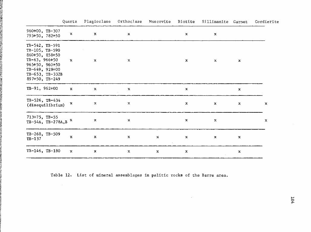
Quartz Plagioclase Orthoclase Muscovite Biotite Sillimanite
960+00, TB-307 793+50, 782+50 X X X X X
-TB-542, TB-591 TB-105, TB-590 860+50, 858+50 TB-63, 966+50 X X X X X
965+50, 960+50 TB-649, 928+00 TB-653, TB-332B 897+50, TB-249
TB-91, 962+00 X X X X
-TB-526, TB-434 (disequilibrium) X X X X X
713+75, TB-55 TB-54A, TB-278A,B x X X X X
TB-268, TB-509 TB-137 X X X X X X
-TB,..,l46, TB-180 X X X X X
Table 12. List of mineral assemblages in pelitic rocks of the Barre area.
Garnet
X
X
X
X
X
Cordierite
X
X
1-' 0 ~

I I
.'
I 1 I I I I I I I
I I I
I
TB-649
.,. I I I I
I I I I 1 I I I I I I I I I I I I
I I 1 I
I I
I
I I I I 1 I I / I
,' / I 1 I I
I I I I I
I I 1
I I 1
I I I I I I ( : I I I I I I I I! I
I
ej,'A. I I.-....,:
TB-307
I I
TB-434 A
I I I I I
I :
TB-54A TB-509 I I I I I I I 1 I I I I I I I I I I I I
-'{J' 0 I,, ,..- ..... , 'J .;'
TB-63 .. TB-55 ',, I I r '..,
I I 1 I I I I I I If
I I I '
I I I ', I I '
I I I \ I I I \
I I I \ I,' I ', II I '
I I I I I I
' I I I If : I It I 1/1
I I II
j I I I I I
I I I I I I
II I I
I I
I:
II 1' \ /I 1 \ If' I \
TB-268
I I I
' I
I I
I I
I I
I
I I
I I
I
: I If t I tl I I II I I /1
I I II I 1 It
I I II I / /1
I I It I I II ' , , ',: ,, I I It
I I II , , ,, , ,' I I
I I I I I
I I I I I I
I I 1 I I 1
I I 1
I J I I I I
r' I I
: r ; I I I I" I
I I I I I I I I I I I I I I
I I I I
I I I I
I I I I 1 I
II I I I 1 /II
,',' I If
TB-137
!{ 0} \r ,,' II I
, I
I , I I I J
,' I /l I I I
,' / I
J/11,' I I I I
I :
II 1 If f If I
I I I 1 / I I 1 TB-526
I If I I I I I
1 II I
, . ,' ,' ,.~
I ~I f I I
/ 1, TB-249 I I I
I I 1 I I 1,1• I I I I
I I II
I/ // I I //
I I
I' I
I
I I
I .
TB-590
•
I ' I I
I I I,' II II
/I I I
I I I I
I I 1 I I II II I I II , .
)( )(
/1 I 1 I I If I II I II I :1 / II I 1 I I II I If I !1 I II ! ,"',
/ ' ,, ', ,/ ',
I I I/ I I It / /t
I /t2< 858+50
fl 793+50 !::.A 1! 746+25
,'0'4 I I I I I
I
X D
I ', ,' X ' , 0 I
713+75 I .•
897+50 I, , , I
I I , ,.
I I , I I
II tl
II I I
I I I I I I
I
782+50
It; TB-278A
i I I I I I 'I
I I ,, I
EXPLANATION
A Sill-Ksp-Bio
e Sill-Ksp-Bio-Gar
694+00
~ Sill-Ksp-Bio-Gar-Cord
0 Sill-Ksp-Bio-Cord
0 Sill-Ksp-Bio-Gar-Musc
X 0
614+75
I I \ \ I
I IQ I \ ,, \
' I '-I
\( ..
/ Denotes thin section from Quabbin Tunnel
105
Figure 19. Location map of critical metamorphic assemblages across the Barre area.
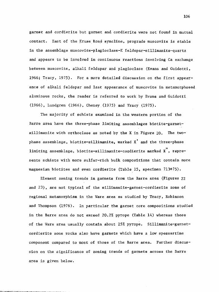
106
garnet and cordierite but garnet and cordierite were not found in mutual
contact. East of the Kruse Road syncline, prograde muscovite is stable
in the assemblage muscovite-plagioclase-K feldspar-sillimanite-quartz
and appears to be involved in continuous reactions involving Ca exchange
between muscovite, alkali feldspar and plagioclase (Evans and Guidotti,
1966; Tracy, 1975). For a more detailed discussion on the first appear-
ance of alkali feldspar and last appearance of muscovite in metamorphosed
aluminous rocks, the reader is referred to work by Evans and Guidotti
(1966), Lundgren (1966), Cheney (1975) and Tracy (1975).
The majority of schists examined in the western portion of the
Barre area have the three-phase limiting assemblages biotite-garnet-
sillimanite with orthoclase as noted by the X in Figure 20. The two-
phase assemblage, biotite-sillimanite, marked x' and the three-phase
" limiting assemblage, biotite-sillimanite-cordierite marked X , repre-
sents schists with more sulfur-rich bulk compositions that contain more
magnesian biotites and even cordierite (Table 15, specimen 713+75).
Element zoning trends in garnets from the Barre area (Figures 22
and 23), are not typical of the sillimanite-garnet-cordierite zone of
regional metamorphism in the Ware area as studied by Tracy, Robinson
and Thompson (1976). In particular the garnet core compositions studied
in the Barre area do not exceed 20.2% pyrope (Table 14) whereas those
of the Ware area usually contain about 25% pyrope. Sillimanite-garnet-
cordierite zone rocks also have garnets which have a low spessartine
component compared to most of those of the Barre area. Further discus-
sion on the significance of zoning trends of garnets across the Barre
area is given below.
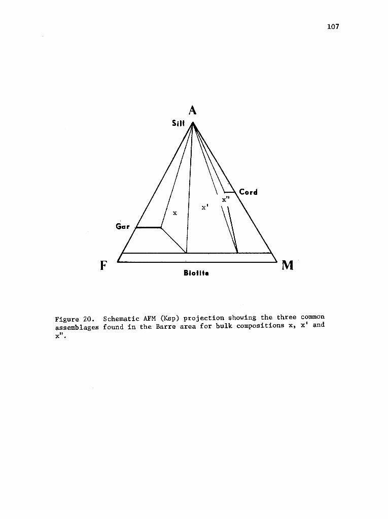
A
F Biotite
M
Figure 20. Schematic AFM (Ksp) projection showing the three common assemblages found in the Barre area for bulk compositions x, x' and x".
107

108
Calc-Silicate Rocks
Calc-silicate beds and boudins are common in the Barre area. They
are most prevalent in the Fitch Formation and the Gray Granulite Member
of the Paxton Schist but occur as minor accessory rock types of the
Partridge and Littleton Formations. A list of mineral assemblages is
present~d in Table 13. In addition to the obvious abundance of quartz-
plagioclase-diopside-sphene assemblages, many calc-silicate rocks also
have actinolite, epidote and scapolite. Calcite, muscovite and quartz
were never found in actual contact.
Mafic Igneous Rocks
Mafic igneous rocks in the Barre area are represented by small
bodies of amphibolite in the Partridge Formation, the Cummingtonite
Gneiss Member of the Littleton Formation and one mafic gneiss lens
in the Coys Hill Granite. The assemblages in these rocks are:
1. quartz-plagioclase-biotite-hornblende-cummingtonite-garnetsphene
2. quartz-plagioclase-biotite-hornblende-cummingtonite
The hornblende in these assemblages is typically pleochroic from
light green to dark green, the cummingtonite is pale yellow to color-
less. No microprobe analyses have been obtained on the minerals in
these rocks, but they appear to be similar to andesine-hornblende-cumm-
ingtonite amphibolites studied elsewhere in central Massachusetts, al-
though the association of cummingtonite with sphene is unusual.

Calcite Sphene Labradorite- Orthoclase- Clino- Diopside Actinolite Garnet Scapolite Bytownite (Microcline} zoisite
737+50 X X
TB-470 X X X X
TB-523 X X X
TB-209 X X X X X
-743+50 X X X X X
608+75 X X X X
TB-276A
745+00 X X X X X X X
597+00
TB-276B
TB-466 X X X X X X
~
745+00 B X X X X X X X
692+50 X X X X X X X X X
Table 13. List of mineral assemblages in calc-silicate rocks in the Barre area.
1-' 0 1.0

110
CONDITIONS OF METAMORPHISM
It appears that the rocks studied within the Barre area lie east of
the sillimanite-orthoclase-garnet-cordierite zone defined by Tracy et al.
(1975) as the highest grade regionally metamorphosed rocks in central
Massachusetts and lie astride the transition from the sillimanite
orthoclase-muscovite to the sillimanite-orthoclase zone. Mafic and
aluminous assemblages place the Barre area in the amphibolite facies of
regional metamorphism (Winkler, 1965).
Electron probe analyses of coexisting minerals from nine aluminous
schists collected from the Quabbin Aqueduct across the Barre area are
shown in Tables 14 and 15 and plotted in Figures 21, 22, and 23. Like
the garnets studied by Hess (1971), Grant and Weiblen (197lh Tracy,
Robinson and Thompson (1976), and Robinson and Tracy (1976) retrograde
zoning from core to rim is evident, indicating lower temperature reac
tions involving garnet. Elemental zoning in the garnets is a function
of the P-T history of the rock, bulk composition, availability of meta
morphic fluids at the time of garnet growth and garnet diffusion rates,
as well as the various prograde and retrograde continuous reactions the
garnet may have been involved in.
Element distribution paths of zoned garnets in these assemblages
(Figures 22 and 23), are consistent with variations found in similar
grade rocks studied in the Quabbin Reservoir and Ware areas (Tracy et
al., 1976). Using the· methods proposed by these authors, the composi
tions of garnet-biotite pairs have been used to estimate temperatures
across the area (Table 16). Applying the compositions of garnet cores,

111
TABLE 14 • MICROPROBE ANALYSES OF GARNETS.
928+00 866+00 858+50 746+25 722+00 694+00
core rim core rim core rim core rim core rim core rim
Si02 37.95 37.50 37.13 37.40· 36.29 36.42 35.65 36.07 36.54 36.61 36.32 37.14
Ti02 0 .05 .o .o 0 0 0 0 0 0 .03 .08
Al203 21.87 21.61 21.79 21.61 21.34 21.45 21.28 21.04 21.38 21.04 20.26 20.47
cr2o3 .03 .04 .03 .05 .04 .04 0 .02 0 0 0 0
FeO 34.86 37.96 34.79 34.94 34.22 34.55 31.97 32.36 32.26 33.06 32.04 31.73
MnO .87 1.38 3.92 .4.46 3.96 5.19 4.83 5.34 4.48 4. 71 4.99 5.59
MgO 5.21 2.22 2.92 2.26 3.12 1.69 3.44 2.40 3.54 2. 71 3. 71 2.74
CaO .74 .99 1.03 1.02 1.04 1.04 1.15 1.36 1.12 1.17 1.09 1.09
Total 101.53 101.75 101.61 101.77 100.01 100.38 98.32 99.32 99.35 99.67 98.44 98.84
Formulas based on 12 oxygens
Si 2.973 2.985 2.954 2.9713 2,937 2.953 2.924 2.958 2.958 2.968 2.979 3.029
Al 2.019 2.025 2.043 2.027 2.036 2.048 2.055 2.034 2.038 2.042 1.961 1.968 Ti o.oo .002 .00 .00 .oo .oo .00 .oo .00 .00 .• 002 .005 Cr .oo .002 .00 .002 .002 .002 .oo .oo .oo .oo .oo .00
Fe 2.283 2.527 2.314 2.324 2.316 2.341 2.192 2.219 2.183 2.242 2.;wo 2.165 Mn .057 .091 .264 .299 .271 .354 .334 .371 .306 .324 .347 .386 Mg .607 .261 .345 .266 .418 .293 .418 .293 .425 .326 .453 • 333 Ca .060 .084 .086 .086 .088 .090 .101 .118 .095 .100 .096 .095
3.007 2.963 3.009 2.975 3.050 2.987 3.045 3.001 3.009 2.992 3.096 2.979
Mol % Alm 75.9 85.3 76.9 78.1 75.9 78.4 72.0 73.9 72.5 74.9 71.1 72.7 Mol % Py 20.2 8.8 11.5 8.9 12.3 6.8 13.8 9.8 14.1 10.9 14.6 11.2 Mol % Gr 1.9 2.8 2.2 . 2.9 2.9 3.0 3.3 3.9 3.2 3.3 3.1 3.2 Mol % Sp 1.9 3.1 8.7 10.1 8.9 11.9 10.9 12.4 10.2 10.8 11.2 13.0

112
TABLE 15, HICROPROBE ANALYSES OF BIOTlTES AND CORDIERITE.
BIOTlTES CORDIERITE
928+00 866+00 858+50 746+25 722+00 694+00 713+75 713+75
5102 35.30 35.38 34.57 34.90 34.52 36.85 38.50 49.04
Ti02 3.97 3.65 3.82 4.02 3.68 3.86 2.17 0.00
A1 203 18.85 19.26 19.53 18.17 19.00 18.49 19.48 33.41
cr2o3 .00 .05 .01 .01 .03 .00 .08 0.00
FeO 20.12 21.36 20.47 19.48 20.13 18.51 8.97 3.10
HnO .10 .12 .09 .23' .11 .14 .13 .34
HgO .00 .02 .02 .00 .oo .00 11.30 11.30
Na 20 .13 .14 .14 .12 .14 .12 .10 .22
K20 9.56 9.48 9.61 10.04 9.03 9.65 9.27 .01
97.07 97.28 96.07 95.64 95.04 96.50 95.40 97.42
Formulas based on 11 oxygens. 18 oxyzena
Si 2.666 2.657 2.628 2.663 2.645 2.7Sl 2.761 4.982 Al 1. 334 1. 343 1.372 1.337 1.355 1.249 1.239 l.Ql8
4.000 4.000 4.000 4.000 4.000 4.000 4.000 6.000
A1 .333 .361 .377 .396 .361 .379 .408 2.985 T1 .222 .205 .218 .230 .211 .217 .116 0.000 Cr .000 .000 .000 .ooo .000 .000 .004 0.000 Fe 1. 262 l. 340 1.301 1.243 1.289 1.156 .538 0.263 Hn .004 .006 .004 .013 .006 .009 .004 0.029 Hg .965 .875 .883 .985 .951 .989 . 1. 786 1. 712
2.786 2.787 2.783 2.867 2.818 2.750 2.856 4.989
Ca .ooo .000 .000 .ooo .000 .000 .000 .002 Na .018 .020 .020 .016 .020 .018 .013 .043 K .914 .908 .930 .977 .881 .919 .848 .000
.932 .928 .950 .993 .901 .937 .861 .045
\-e .567 .605 .596 .558 .575 .539 .231 .133
~g .433 .395 .404 .442 .425 .461 • 769 .867
113
A Sill
Fe+ Biotite
Mn Mg
Figure 21. Plotted compositions of mineral assemblages from the Barre area, on AFM (Ksp) projection. Note that analysed assemblages fall into two bulk compositions garnet-biotite-sillimanite + muscovite and cordieritebiotite-sillimanite. Also note the plotted position of analysed muscovite.

Fe
I Mn
I
Garnet
o-- ==
90
- ---o-928+00 ---
80 70 60 50 Mg '-
7
Figure 22. Projection of sillimanite-biotite-garnet three phase triangles from sillimanite onto the base of A-Fe-Mg-Mn tetrahedron~ Plot is.designed to show the range of spessartine component in garnets in equilibrium with biotite. Solid lines connect garnet rims to biotites, fine dashed lines tie garnet rims to garnet cores.
1-' 1-'
"""
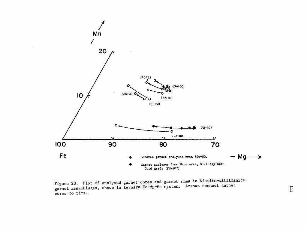
I Mn
I
100
Fe
746+25
d ()' 0
' 0~1ilih 694+0o 866+00 0~ ....__~"0<\
"C> 0 722+00
858+50
0 ·~ ----:::::~~------- FW-407
90
928+00
80 70
() Denotes garnet analyses from 694+00.
e Garnet analyses from Ware area. Sill-Ksp-GarCord grade (FW-407)
- Mg
Figure 23. Plot of analysed garnet cores and garnet rims in biotite-sillimanitegarnet assemblages, shown in ternary Fe-Mg-Mn system. Arrows connect garnet
cores to rims.
1-' 1-' V1
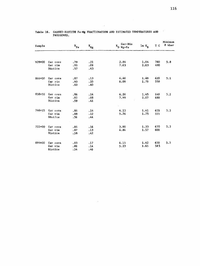
Table 16. GARNET-BIOTITE Fe-Mg FRACTIONATION AND ESTIMATED TEMPERATURES ANP PRESSURES.
116
Minimum Sample ~e ~
IC Gar-Bio -ll Mg-Fe ln~ T C P kbar
928+00 Gar core .79 .21 2.84 1.04 780 5.8 Gar rim .91 .09 7.63 2.03 490 Biotite .57 .43
866+00 Gar core .87 .13 4.46 1.49 620 5.1 Gar rim .90 .10 6.00 1. 79 550 Biotite .60 .40
858+50 Gar core .86 .14 4.26 1.45 640 5.2 Gar rim .92 .08 7.99 2.07 480 Biotite .59 .41
746+25 Gar core .84 .14 4.13 1.41 655 5.3 Gar rim .88 .12 5.76 1. 75 55.; Biotite .56 .44
722+00 Gar core .84 .16 3.80 1.33 670 5.3 Gar rim .87 .13 4.84 1.57 600 Biotite .58 .42
694+00 Gar core .83 .17 4.15 1.42 650 5.5 Gar rim .86 .14 5.23 1.65 585 Biotite .54 .46

117
corrected for grossular content, to the ternary Fe-Mg-Mn diagram of
Tracy and others (1976, Figure 6, p. 720) and assuming an average temp
erature of 650°C, minimum pressures are estimated to have been 5.1 kb
to 5.8 kb. These pressures and temperatures, as expected, lie within
the field of sillimanite stability as determined in various experimen
tal work (Richardson et al., 1969; Newton, 1966; Holdaway, 1971).
GEOLOGIC HISTORY OF THE AREA
The earliest recognizable geologic event in the Barre area is the
deposition of the sulfidic shales and silts of the Partridge Formation
in Middle Ordovician time. Early in the depositional history of the
Partridge Formation, thin basaltic flows or mafic volcanic ashes were
laid down that are now recognized as amphibolite lenses in ·the lower
parts of the formation.
Firm evidence for an orogenic episode in the later part of the
Ordovician is lacking in the Barre area, but numerous authors (see
Pavlides et al., 1968) have noted the effect of such an episode through
out much of New England and the northern Appalachians. It is likely
that part of the Taconic orogeny was going on in surrounding areas and
it probably resulted in limited deposition or erosion in Late Ordovician
time in the Barre area.
In the Silurian, the western portion of the Barre area was a zone
of limited deposition, recorded by thin and discontinuous calcareous
silts and clastics deposited in a reducing environment (Fitch Formation).
To the east, however, lay a deeper marine basin which extended for some

118
distance. The sediments collected in this basin, now mapped as the
Paxton Schist, range in composition from impure quartzites and sulfide
rich shales at the base, through organic-rich shales and silts to cal
careous silts and pelites at the top. An eastern source is implied for
these sediments, possibly the Siluro-Devonian Newburyport Volcanic Com
plex (Shride, 1976).
Following the Silurian, Lower Devonian sediments were laid down as
a thick and widespread sequence of cyclically bedded quartzose shales
and sands (Littleton Formation). The graded-bedded nature of this for
mation and its widespread areal extent imply rhythmic deposition on a
large, deep water shelf or in a basin. Felsic and mafic volcanic lavas,
and tuffs were deposited locally in the section.
At the onset of the Acadian (Devonian) orogeny, the most intense
orogenic episode recognized in the area, large sheet-like plutonic masses,
the Hardwick Quartz Diorite and the Coys Hill Granite, were intruded into
Devonian rocks in the uppermost parts of the stratigraphic section. Sub
ordinate binary and biotite granites were also implaced. These rocks
and the enclosing sediments were then intensely deformed and metamorph
osed reaching their peak of metamorphism at temperatures around 650 C 0
and at pressures of at least 5.5 kbars. The earliest stage of folding
in the study area was marked by east over west recumbent folding under
the influence of compressional forces and/or gravity, probably from an
already heated source area. The axial surfaces of these nappes were sub
sequently backfolded to the east. Occurences of cataclastic textures
cross-cutting these structures indicate that the rocks in the Barre area
were sufficiently dehydrated to undergo solid state inter-grain crushing
119
at high strain rates. Continued east-west compression resulted in
asymmetrical folds with shallow, west-dipping axial surfaces. The last
deformation in the Barre area was an episode of rather weak, broad open
folding.
Permian events, (Allegheny), which affected the K/Ar ages through
much of New England (Zartman et al., 1970) as well as localized retrograde
metamorphism are well known in central Massachusetts, and may have slight
ly affected the rocks in the Barre area. Mesozoic tectonics are seen
at a limited scale, in the form of Jurassic diabase dikes with a N60E
trend, and as extensional joints and faults.
Pleistocene glaciation left its impact on the landscape, resulting
in deposition of till and numerous erratics throughout the area. Melt
water deposits are common in the Barre area typically seen as fluvio
glacial drift in valleys, discontinuous eskers or as kame terrace deposits.

120
REFERENCES CITED
Alden, W.C., 1924, The physical features of central Massachusetts: U.S. Geol. Survey Bull., 760-B, p. 13-105.
Billings, M.P., 1937, Regional metamorphism of the Littleton-Moosilaukee area, New Hampshire: Geol. Soc. Amer. Bull., v. 48, p. 463-566.
___ , .1956, The geology of New Hampshire, part II-bedrock geology: N.H. Plan. and Devel. Comm., 203 pp.
---, and Cleaves, A.B., 1934, Paleontology of the Littleton area, New Hampshire: Am. J. Sci., 5th ser., v. 28, p. 412-438.
Blatt, Harvey, Middleton, Gerard, and Murray, Raymond, 1972, Origin of sedimentary rocks: Prentice-Hall, 634 pp.
Boone, G.M., 1973, Metamorphic stratigraphy, petrology and structural geology of the Little Bigelow Mountain map area, western Maine: Maine Geol. Survey Bull. 24, 136 pp.
____ , Baudette, E.L., and Moench, R.H., 1970, Bedrock geology of the Rangeley Lakes--Dead River basin region, western Maine, New England Intercollegiate Geol. Conf. 62nd Ann. Mtg.· Guidebook, Rangeley, Maine, p. 1-20.
Boucot, A.J. and Arndt, R.T., 1960, Fossils of the Littleton Formation (Lower Devonian) of New Hampshire: U.S. Geol. Survey Prof. Paper 334-B, p. 41-53.
----, Field, M.T., Fletcher, Raymond, Forbes, W.H., Naylor, R.S., and Pavlides, Louis, 1964, Reconnaissance bedrock geology of the Presque Isle quadrangle, Maine: Maine Geol. Survey Quad. Map Ser. no. 2, 123 pp.
-----~·and Thompson, J.B., Jr., 1958, Late lower Silurian fossils from sillimanite zone near Claremont, New Hampshire: Science, v. 128, p. 362-363.
_____ , and Thompson, J.B., Jr., 1963, Metamorphosed Silurian brachiopods from New Hampshire: Geol. Soc. Amer. Bull., v. 74, p. 1313-1334.
Cady, W.M., 1969, Regional tectonic synthesis of northwestern New England and adjacent Quebec: Geol. Soc. Amer. Mem. 120, 180 pp.
Chapman, C.A., 1939, Geology of the Mascoma quadr~gle, New Hampshire: Geol. Soc. Amer. Bull., v. 50, p. 127-180.
121
_____ , 1942, Intrusive domes of the Claremont-Newport area, New Hampshire: Geol. Soc. Amer. Bull., v. 53, p. 889-916.
----~' 1952, Structure and petrology of the Sunapee quadrangle, New Hampshire: Geol. Soc. Amer. Bull. v. 63, p. 381-426.
Cheney, J.T., 1975, Mineralogy and petrology of lower sillimanite through sillimanite+ K feldspar zone pelitic schists, Puzzle Mtn. area, N.W. Maine, Ph.D. thesis, Univ. Wisconsin, Madison, pp. 291.
Chidester, A.H., 1968, Evolution of the ultramafic complexes of northwestern New England, in Zen, E-an, White, W.S., Hadley, J.B., and Thompson, J.B., Jr., eds., Studies of Appalachian geology, northern and maritime: Wiley, p. 343-354.
Dean, C.S., 1977, Northward transport of the Kinsman Quartz Monzonite in southwestern New Hampshire, Geol. Soc. Amer., Abstracts with Programs, v. 9, p. 254.
Deer, W.A., Howie, R.A., and Zussman, Jack, 1966, An introduction to the rock-forming minerals: Longmans, 528 p.
Dixon, H.R., 1968, Bedrock geology of the Danielson quadrangle, Connecticut, U.S. Geol. Survey Quad. Map~ GQ-696.
_____ , and Lundgren, L.W., Jr., 1968a, A structural and stratigraphic cross-section traverse across eastern Connecticut: New England Intercollegiate Geol. Conf., 60th Ann. Mtg. Guidebook, New Haven, Trip F-4, 23 p.
_____ , and Lundgren, L.W., Jr., 1968b, Structure of eastern Connecticut, in Zen, E-an, White, w.s., Hadley, J.B., and Thompson, J.B., Jr., eds., Studies of Appalachian geology, northern and maritime: Wiley, p. 203-218.
Doll, C.G., Cady, W.M., Thompson, J.B., Jr., and Billings, M.P., compilers and editors, 1961, Centennial geologic map of Vermont: Vermont Geol. Survey, Montpelier, Vt.
Emerson, B.K., 1898, Geology of old Hampshire County, Massachusetts: U.S. Geol. Survey Monograph 29, 790 p.
_____ , 1917, Geology of Massachusetts and Rhode Island, U.S. Geol. Survey Bull. 597, 289 p.
Evans, B.W., and Guidotti, C.V., 1966, The sillimanite-potash feldspar isograd in western Maine, U.S.A., Contrib. Mineral. Petrol., v. 12, p. 25-62.
122
Fahlquist, F.E., 1935, Geology of region in which Quabbin Aqueduct and Quabbin Reservoir are located; Appendix to Report of Chief Engineer, Annual Report of the Metropolitan District Water Supply Commission, Commonwealth of Massachusetts, Public Document No. 147.
Field, M.T., 1975, Bedrock geology of the Ware area, central Massachusetts: Contribution No. 22 (Ph.D. thesis), Geology Dept., University of Massachusetts, Amherst, 186 p.
Fowler-~illings, Katherine, 1949, Geology of the Monadnock region of New Hampshire: Geol. Soc. Amer. Bull., v. 60, p. 1249-1280.
Goldstein, A.G., 1976, Brittle fracture history nf .the Montague basin, , north-central Massachusetts: Contribution No. 25 (M.S. thesis),
Geology Dept., University of Massachusetts, Amherst, 108 p.
Grant, J.A., and Weiblen, P.W., 1971, Retrograde zoning in garnet near the second sillimanite isograd, Amer. J. Sci., v. 270, p. 281-297.
Greene, R.C., 1970, The geology of the Peterborough quadrangle, New Hampshire; Bulletin No. 4, N.H. Dept. Res. and Econ. Dev. Bull. No. 4, 88 p.
Grew, E.S., 1973, Stratigraphy of the Pennsylvanian and pre_-Pennsylvanian rocks of the Worcester area, Massachusetts: Amer. J. Sci!, v. 273, p. 113-129.
Guidotti, C.V., Cheney, J.T., and Conatore, P.D., 1975, Coexisting cordierite+biotite+chlorite from the Rumford quadrangle, Maine: Geology, v. 3, p. 147-148.
Hadley, J.B., 1942, Stratigraphy, structure and petrology of the Mt. Cube area, New Hampshire: Geol. Soc. Amer. Bull., v. 53, p. 113-176.
_____ , 1949, Bedrock geology of the Mt. Grade quadrangle, Massachusetts: U.S. Geol. Survey Geol. Quad. Map GQ-3.
Harwood, D.S., and Berry, W.B.N., 1967, Fossiliferous lower Paleozoic rocks in the Cupsuptic quadrangle, west-central Maine: U.S. Geol. Survey Prof. Paper 575-D, p. 16-23.
Hatch, N.L., Schnabel, R.W., and Norton, S.A., 1968, Stratigraphy and correlation of the rocks on the east limb of the Berkshire anticlinorium in wes~ern Massachusetts and north-central Connecticut, in Zen, E-an, White, W.S., Hadley, J.B., and Thompson, J.B. Jr., eds., Studies of Appalachian geology, northern and maritime: Wiley, p. 177-184.

123
Heald, M.T., 1950, Structure and petrology of the Lovewell Mountain quadrangle, New Hampshire: Geol. Soc. Amer. Bull., v. 61, p. 43-89.
Hess, P.C., 1971, Prograde and retrograde quilibria in garnetcordierite gneisses in south-central Massachusetts: Contrib. Mineral. Petrol., v. 30, p. 177-195.
Holdaway, M.J., 1971, Stability of andalusite and the aluminumsilicate phase diagram: Amer. J. Sci., v. 271, p. 97-131.
Hussey, A.M. II, 1968, Stratigraphy and structure of southwestern Maine,in Zen, E-an, White, W.S., Hadley, J.B., and Thompson, J.B., Jr., eds., Studies of Appalachian geology, northern and maritime: Wiley, p. 291-301.
Kruger, F.C., 1946, Structure and metamorphism of the Bellows Falls quadrangle of New Hampshire and Vermont: Geol. Soc. Amer. Bull. v. 57, p. 161-206.
Laird, H.S., 1974, Geology of the Pelham dome near Montague, westcentral Massachusetts: Contribution No. 14 (M.S. thesis), Geology Dept., University of Massachusetts, Amherst, 84 p.
Ludman, Allan, 1969, Structure and stratigraphy of Silurian rocks in the Skowhegan area, south-central Maine: Geol. Soc. Amer., Abstracts with Programs, part 1, p. 37.
_____ , and Griffin, J.R., 1974, Stratigraphy and structure of central Maine: New England Intercollegiate Geol. Con£., 66th Ann. Mtg., Guidebook, Orono, Maine, p. 154-179.
_____ ,Griffin, J.R., and Lindsley-Griffin, N., 1972, Sedimentary facies relationships in the Siluro-Devonian slate belt of central Maine: Geol. Soc. Amer., Abstracts with Programs, v. 4, p. 28.
Lundgren, L.W., Jr., 1962, Deep River area, Connecticut--stratigraphy and structure: Amer. J. Sci., v. 260, p. 1-23.
_____ , 1966, Muscovite reactions and partial melting in southeastern Connecticut: J. Petrology, v. 7, p. 421-453.
Moench, R.H., 1971, Geologic map of the Rangeley-Phillips quadrangles, Franklin and Oxford counties, Maine: U.S. Geol. Surv. Misc. Geol. Inv. Map I-605.
Moore, G.E., 1949, Structure and metamorphism of the Keene-Brattleboro area, New Hampshire-Vermont: Geol. Surv. Soc. Amer. Bull., v. 60, p. 1613-1670.

124
Naylor, R.S., Boone, G.M., Baudette, E.L., Ashenden, D.D., and Robinson, Peter, 1973, Pre-ordovician rocks in the Bronson Hill and Boundary Mountain anticlinoria, New England, U.S.A.: Trans. American Geophysical Union, v. 54, p. 495.
Nelson, C.E., 1975, Structure and petrology of the Thorndike Pond area, southwestern New Hampshire: M.A. thesis, Dartmouth College.
Newton, R.C., 1966, Kyanite-andalusite equilibrium from 700°to 800°C: Science, v. 153, p. 170-172.
Nielson, D.L., 1974, Geology of the Hillsboro quadrangle, New Hampshire: Ph.D. thesis, Dartmouth College, Hanover, New Hampshire.
_____ , Clark, R.G., Lyons, J.B., Englund, E.J., and Borns, D.J., 1976, Gravity models and mode of emplacement of the New Hampshire Plutonic Series, in Lyons, P.C., and Brownlow, A.H., eds., Studies in New England Geology: Geol. Soc. Amer. Mem. 146, p. 301-318.
Onasch, C.M., 1973, Analysis of the minor structural features in the north-central portion of the Pelham dome: Contrib. No. 12 (M.S. thesis), Geology Dept., University of Massachusetts, Amherst, 87 P·
Osberg, P.R., 1968, Stratigraphy, structural geology and metamorphism of the Waterville-Vassalboro area, Maine: Maine Geol. Survey Bull. 20, 64 p.
_____ ,Moench, R.H., and Warner, Jeffrey, 1968, Stratigraphy of the Merrimack synclinorium in west-central Maine in Zen, E-an, White, W.S., Hadley, J.B. and Thompson, J.B., Jr., eds., Studies of Appalachian geology, northern and maritime: Wiley, p. 61-82.
Page, L.R., 1968, Devonian plutonic rocks in New England in Zen, E-an, White, W.S., Hadley, J.B., and Thompson, J.B., Jr., eds., Studies of Appalachian geology, northern and maritime: Wiley, p. 371-383.
Pankiwskyj, K.A., Ludman, Allan, Griffin, J.R., and Berry, W.B.N., 1976, Stratigraphic relationships, southeast limb of the Merrimack synclinorium in Lyons, P.C. and Brownlow, A.H. eds., Studies in New England Geology: Geol. Soc. Amer. Mem. 146, p. 263-280.
Pavlides, Louis, Boucot, A.J., and Skidmore, W.B., 1968, Stratigraphic evidence for the Taconic orogeny in the northern Appalachians in Zen, E-an, White, W.S., Hadley, J.B., and Thompson, J.B., Jr., eds., Studies of ·Appalachian geology, northern and maritime, Wiley, p. 61-82.
_____ , Mencher, Ely, Naylor, R.S., and Boucot, A.J., 1964, Outline of the stratigraphic and tectonic features of northeastern Maine: U.S. Geol. Survey Prof. Paper 501-C, p. C28-C38.

125
Pease, M.H., and Peper, J.D., 1968, The Brimfield (?)and Paxton (?) Formations in northeastern Connecticut: New England Intercollegiate Geol. Conf., 60th Ann. Mtg., Guidebook, New Haven, Connecticut, Section F-5.
Peck, J.H., 1976, Silurian and Devonian stratigraphy in the Clinton quadrangle, central Massachusetts, in Page, L.R., ed., Contributions to the stratigraphy of New England: Geol. Soc. America Mem. 148. p. 241-252.
Peper, J.D., 1974, Preliminary bedrock geologic map of the Monson quadrangle, Massachusetts and Connecticut; U.S. Geol. Survey openfile report 74-103, 15 p.
--~-· 1976, Preliminary bedrock geologic map of the Palmer quadrangle, south-central Massachusetts; U.S. Ge~l. Survey open-file report 76-489, 21 p.
_____ ,Pease, M.H., and Seiders, V.E., 1975, Stratigraphic and structural relationships of the Brimfield Group in northeast-central Connecticut and adjacent Massachusetts: Geol. Surv. Bull. 1389, 31 p.
Pomeroy, J.S., 1973, Preliminary bedrock geologic map of the Warren quadrangle, Worcester, Hampden and Hampshire counties, Massachusetts: U.S. Geol. open-file report, 24 p.
_____ , 1975, Preliminary bedrock geologic map of the East Brookfield quadrangle, Worcester county, Massachusetts: U.S. Geol. Survey open-file report 75-530, 10 p.
Richardson, S.W., Gilbert, M.C., and Bell, P.M., 1969, Experimental determination of kyanite-andalusite and andalusite-sillimanite equilibria, the aluminosilicate triple point: Amer. J. Sci., v. 267, p. 259-272.
Robinson, Peter, 1963, Gneiss domes of the Orange area, Massachusetts and New Hampshire: Ph.D. thesis, Harvard University, 253 p.
_____ , 1967a, Gneiss domes and recumbent folds of the Orange area, west-central Massachusetts: New England Intercollegiate Geol. Conf. 59th Ann. Mtg., Guidebook, Amherst, Massachusetts, p. 17-47.
_____ , 1967b, Geology of the Quabbin Reservoir area, central Massachusetts: New England Intercollegiate Geol. Conf., 59th Ann. Mtg., Guidebook, Amherst, Massachusetts, p. 114-127.
_____ , and R.J. Tracy, 1976, Retrograde garnet zoning paths produced in continuous hydration reactions in high grade pelitic schists, central Massachusetts: Geol. Soc. Amer. Abstracts with Programs, v. 8, p. 1072-1073.

126
_____ , and R.J. Tracy, 1977, Sulfide-silicate-oxide equilibria in sillimanite-K feldspar grade pelitic schists, central Massachusetts (abstract): Trans. Amer. Geoph. Union, v. 58, p. 524.
Rodgers, John, Gates, R.N., and Rosenfeld, J.L., 1959, Explanatory text for preliminary geological map of Connecticut, 1956: Connecticut Geol. Nat. History Survey Bull. No. 84, 64 pp.
Rosenfeld, J.L., 1968, Garnet rotations due to the major Paleozoic deformations in southeast Vermont,in Zen, E-an, White, W.S., Hadley, J.B. and Thompson, J.B., J~, eds., Studies of Appalachian geology, northern and maritime; Wiley, p. 185-202.
_____ ,and Eaton, G.P., 1956, Metamorphic geology of the Middle Haddam area, Connecticut--a progress report (abstracts): Geol. Soc. Amer. Bull., v. 67, 1823 p.
Seiders, V.M., 1976, Bedrock geologic map of the Wales quadrangle, Massachusetts and Connecticut; U.S. Geol. Survey Geologic Map, GQ-1320.
Shride, A.F., 1976, Stratigraphy and structural setting of the Newburg Volcanic Complex, Northeastern Massachusetts: New England Intercollegiate Geol. Conf., 68th Ann. Mtg., Guidebook, Boston, Mass., p. 291-300.
Theokritoff, George, 1968, Cambrian biogeography and biostratigraphy of New England,in Zen, E-an, White, W.S., Hadley, J.B., and Thompson, J.B., Jr., eds., Studies of Appalachian Geology, northern and maritime: Wiley, p. 9-22.
Thompson, J.B., Jr., Robinson, Peter, Clifford, T.N., and Trask, N.J., Jr., 1968, Nappes and gneiss domes in west-central New England, in Zen, E-an, White, W.S., Hadley, J.B., and Thompson, J.B., Jr., eds., Studies of Appalachian Geology, northern and maritime: Wiley, p. 203-218.
Tracy, R.J., 1975, High grade metamorphic reactions and partial melting in pelitic schist, Quabbin Reservoir area, Massachusetts, Contribution No. 20 (Ph.D. thesis), Geology Dept., University of Massachusetts, Amherst, 127 p.
----- , Robinson, Peter, and Thompson, A.B., 1976, Garnet composition and zoning in the determination of temperature and pressure of metamorphism, central Massachusetts: Am. Mineral. v. 61, p. 762-775.
_____ ,Robinson, Peter, and Field, M.T., 1976, Phase relations of natural pure magnesian cordierite and biotite from pyrite-sillimanite-orthoclase schist, central Massachusetts (abstract): Trans. Amer. Geoph. Union, v. 57, p. 338-339.
127
Turner, F.J. and Weiss, L.E., 1963, Structural analysis of metamorphic tectonites: McGraw-Hill, 545 p.
United States Geological Survey, 1971, Aeromagnetic Map of the Barre quadrangle, Worcester County, Massachusetts: Geophysical Investigations Map GP-700.
Warner, Jeffrey, and Pankiwskyj, K.A., 1965, Geology of the Buckfield and Dixfield quadrangles in northwestern Maine: New England Intercollegiate Geol. Conf., 57th Ann. Mtg., Guidebook, Brunswick, Maine, p. 103-118.
Winkler, H.G.F., 1965, Petrogenesis of metamorphic rocks: Springer, New York, 220 p.
Zartman, R.E., Hurley, P.M., Krueger, H.W~, and Giletti, B.J., 1970, A Permian disturbance of K-Ar ages in New England, its occurrence and cause: Geol. Soc. Amer. Bull., v. 81, p. 3359-3374.
_____ , Snyder, G.L., Stern, T.W., Marvin, R.F., and Buckman, R.C., 1965, Implications of new radiometric ages in eastern Connecticut and Massachusetts: U.S. Geol. Survey Prof. Paper 525-D, p. Dl-DlO.

128
APPENDIX
This appendix contains 28 equal-area, lower hemisphere plots from
14 sectors of poles to bedding (a) and foliation (on the left) and fold
axes (e) and mineral lineations (on the right). The location of each of
the sectors is shown in Figure 9.
Poles to bedding (e) and foliation (·)
N
<i • @)
.. . . . . . ... .... • .J...t, • ~.
l!l..:, \•: •. . . .:. ·8
N
~
'<; <il •
<i
Sector 1
+ .. :: :. ·.:·. <i 'f) · .. · . . . . . ,. . .. . . ... 'lt :. • • • • . ..· . . . . . .. .. . . .
Sector 2
Minor fold axes (e)
Mineral lineations (·)
N
N
+ • <t
• • • Glllt • Ci • .CJ

N
N
N 6ZT
. .·.:. - -p..~\ .... ... . . .. ~···I.. ' •• .... ·:e.
' •• • • t€t.:,. •• ·~ ..
N
•: . .
. . .
• •·• ·:'(i:4· f . . ..... ·. . . . . . . . . e ... ._ '&,• •••
N
N
II
N L .:w:pas
N 9 .:ro:pas
... •
+ . .
on N
• • • •
N
.. .. .. -. ·=· ,.,~ •• ,~ • ·: ·""" •"-LJ- ... :.... . . .... . . •
N
. . e ._ .... . •• •.l :.· ••
\?. .. ,.-:.:-
•• .,,. ··+ 6) .... ~4> •••• ,!_.
• • I!" . " . • tt>Q
·.
N

11 .10::pas
•
N
N 6 .:ro:pas
N
•
. .... ..... . 1;J -• ~ ...... :f- . . ... . . -. . : . . . •
. . . . .
. . '
N
.. ,. " .. ~+ .. ..
N
•
•• .ee .. • •• . , .\... . .... . . ~ .... ij.., ,. ... . • ..\ rt.· • • • ·: J£,: (,.:~ •• .... . . .. : . ., ... . .. :· .. .. . :. ... ·. ., ..
N
N £1 .Io:pas
N
N ZH
• • . .. .... . . :" t · ...... ·. .. . . •• •i •. iJo
N
. . . :·~·"=·. ~ •• J~<-J ..• •:. •, ou'f • + . . """ . . . . . .
N
·' ..;:'··+ ... . . .
N
. .

PLATE BEDROCK GEOLOGIC MAP, BARRE
t•sg · 35 MILS
t_.TM GRID AND 1969 M"-GNET !C NORTH DECLINATION A.f CENTER OF SHEET
1000 0 ELE:L:H
1 E3
I
' E3
1000 2000 =r=
5 E3 E3 E--l
0
3()()1)
~
0 -"==
~""' j
7000 rEET -=- c! -----, I !';IL0 M£T [R
----=1
CONTOUR IN TERVAL 10 FEET DATUM IS M EAN SEA LlVEl
AREA, CENTRAL MASSACHUSETTS
r:::;;~ ~~
?:>.!) QUA0°ANGL[ LOCATION
ROAD CLASSIFICATION
Secondary highway. all weather , Light-duty road, all weather, hard surface ~~ 1mproved surface
Un 1mproved road , fair or dry weather
Q Stale Route
Geology mapped by Robert D. Tucker
1975 and 19 76
EXPLANATION
INTRUSIVE IGNEOUS ROCKS
tJ ..-4
~ [ ...... I _ J_d----J
Diabase dike Jd: Fine-grained augite-plagioclase diabase.
...,
§ 1-1 •.-l Q) l'l ) 0 0 >
....:l <ll ~
I
I
L
h
gg
Dl
Dlf)
Sp
Spg
Spw
Sf I
Ops
Hardwick Quartz Diorite h: Strongly foliated, medium-grained, biotite
quartz diorite with minor amounts of biotite granite and biotite granodiorite gneiss.
Coys Hill Granite ch: Well foliated, massive quartz monzonite and
biotite granite gneiss. Typically porphyritic with microcline phenocrysts up to 2 inches across in matrix of quartz, plagioclase, biotite, garnet and rarely sillimanite.
Gneiss of Pleasant Brook gg: Well foliated, light-colored, medium
grained biotite-garnet-quartz-plagioclaseorthoclase gneiss.
STRATIFIED ROCKS
Littleton Formation Dl: Gray Schist Member: Gray-weathering, bio
tite-garnet-sillimanite-orthoclase schist, commonly in beds 2-5 inches thick, locally exhibits graded bedding.
Dlf: Feldspathic Gneiss Member: Quartz-feldspar gneiss with minor amounts of biotite . Small 1/8 inch pink garnets are characteristic.
Dlo: Cummingtonite Gneiss Member: Dark brown, medium-grained cummingtonite-hornblendeplagioclase gneiss.
Paxton Schist Sp: Gray Granulite Member: Medium-grained,
gray- to purple-weathering, biotite-quartzlabradorite granulite and rusty-weathering quartz-andesine-biotite-sillimanite schist. Calc-silicate beds consisting of actinolitediopside-clinozoisite-sphene and labradorite are also present.
Spg: Gray Graphitic Schist Member: Grayweathering, graphite-biotite-sillimanitemuscovite-garnet schist. Conspicuous quartzfeldspar pods and segregations are found throughout the unit.
Spw: White Sulfidic Schist Member: Quartz-orthoclase - Mg-rich cordierite - Mg- rich biotitesillimanite-rutile schist and feldspathic quartzite.
Fitch Formation ~Sulfidic graphitic quartz-labradorite
diopside-sphene granulite .
Partridge Formation Ops: Sulfidic, biotite-garnet-orthoclase
sillimanite ± muscovite schist and slabbyweathering, quartz-plagioclase-biotitegarnet granular schist. Thin biotitediopside-quartz-plagioclase calc-silicate beds are common throughout the section. Opa: Rare lenses of cummingtonite-hornblende-biotite amphibolites are found in the lower po:o.rts of the formation.
------ --------- ..... .. .... . Contact; location accurate where solid, approximate where dashed, inferred where dotted.
A A' Line of cross-section
.. . j Strike and dip of bedding, dot shO'Y'S strati graphic top.
Strike and dip of foliation.
Strike and dip of foliation measured in Quabbin Aqueduct Tunnel (Fahlquist, 1935).
Trend and plunge of lineation.

A 4000'
3000'
2000'
1000'
SEA LEVEL
1000'
2000'
3000'
4000'
B 4000'
3000'
2000'
1000'
1000'
2000'
3000'
4000'
c 4000'
3000'
2000'
1000'
1000'
2000'
3000'
4000'
PLATE 2 GEOLOGIC
h
Howes Hill
h
/ / ' / /
/ / / / I /
I / v' I I
I I / I
~ / , / / /
/
890t00
/ /
/ / / /
/ / / /
/ / / /
/ / / /
/ / / /
/ / / /
/ / / /
/ / ;' ;'
;' ;'
/ / / /
/ / I /
I / c,/
CROSS SECTIONS, BARRE AREA
---
-------
790+ 00 750 t 00
-------
--
----:::>
-------
---)
/
----- ------------ Sp -----=----=-=~::- -=-=---:::...-_-_--------- -------
Ops
--------- -----------
Opa
-- ------~::::=-..::::---- ...... :::- ......... ........ -...... ...... " -..... \ \
/ J / /
---- -~-=-_:-----...:-_-_-.::: ..::----- -----~_:--.:::::-------
Spg
-------- ------------------------- -)
-------
--
-_..-
-------------_;. --- / -- ,...' /
,-'
/ ----,..~- _..../ _,., __ ... -
--
-- - ---? --:::-....- --_ ..... ---- _,.... --- -
-----
Ops
/
Harding Hill Spg
--~~~~------------------------------=::::::- --- ----- -------... ---.._..~---...... _, ,-.....
"' _)) --=-----=--=-------_:"""""--=--=--=--....:----=---
----:::: -:.:-=-..:-_:-~ ~ ---~---....... ---
---Sp
___ Sp
-----spw Spg
Oak Hill
Sp
Ops
730+ 00 700 t 00 670tOO 6~0t 00 SIO t 00 580+00
A'
I km
I km
B'
I km
lkm
c•
I km
SEA LEVEL
lkm

PLATE 3 MAP OF PLANAR STRUCTURAL FEATURES '
BARRE ro:l
.. ~
. ~ 'I
I
I I
I
I I
f I
, , I I I I I I .. ~ :
.. J"f
I I
I
/ ''1 I
I I ~• .f
I ' I
I I
I I I
I .. \ 301
' I I I
' I I
I I I I I I I I I I I I I I I I
I
I I I I I I I I I I I I I I I
I I
I I
I I
I I I
'
I
I I I I I
I I
I I
I
I /
/ /
I /
/ I I I I I I I
"'~ 46 I I I I I I I I I I I I
I I \ I I
I I
I I I I I I I I I I I I I I I I I I I
I I I I I I
I I
I
"'("{
,, y
•• T
10
~ 20
'41 • 28
•2 -""'21 "i I ""'-- .... , r .•
,." ' , __.__ ' ,...... !8 ' ......
I \ '-... I '
I ' ' ........ I .._
I ' I \
I ' / ',
/ ' I ' I ' t Zl
I \ '" I f.,,""
~ ]I
" r f •.
I
IZ; I I
I
I ' I I / f·· I
I , I I I I
I re~ I
I I ,
I f I I
'"J 1'j
I
I I I I I
I i2r, I ' I \
I \ / \
/ ' I I I "r \
I I
f
I ,.~ I 21;1
I
I I I I I I I I I ''I
I
/ \ I \
I \ ( \
I ,, I I
I . ( I
I I I
I I
I
"'"' ''I ••r I I I
I I
I
I I ,' .. ~ :
I I
f•
I I
I
I I
I
I I
I
I I f
I I I I
I I f I
I I I f
I I
I I
I I "~ \ I
""-._20
I
I , I
I
I I I
I zo I~ _/
f .. ~ 26 ~. .I
I I'
I /
I I
voJ\ 1 T 1 I I
I I .. ~or 1
~·:r / I I I' (
I I I
I I
I
, I
I I
I I
'"1 I I I
I I 36 ~ I
I I I I
1 I I I
I I I .J I
,'• '7 I I I I I
I 20 it
1 I
I I "I I
•o ~ 1 I I
ro/1 ,' / Z"1 1
I I / I
I f t I
I I I ••1 I I I I I I I
I
I /
I
.,.I I
I I
I I
2Z~
·•f
•• ,23
......... " 36 ~.
I
121.
"I
63 f.
34
'"i.
......._ 42 281
'"1.1
".1
'"I I I
I \ I
•\_ 29
I I I I
I I I I I I I I ' I I
271 30 I
I I
I I 1?9 ly
(
I •• f I •• I , I •
I I".J I I 7
I I I I
,-" I f (
I I I I
I I "I 27 i I I
1'".1 I I 7 I
\ '.'
I I I I I
' I I I I
I I
.,r 10 ~ J\
"~,'
I I
!61 2] \
J 25
22 /42{
'"1 y., ,.-~ "IJ y
22 J~. ,7
14
Y,,l
32
T
22
~
,, f
I I I I
30 I I I
r2 {I I•~ ~. I 1 , ,. .,
" i I I 34 1
" "~~ ,: I 23 fof ~,('o 1 "/
45 ~ ' " ( ,'
]7 J I
30
Jy. '"l 'Y
··1 .~
••
I I I I
I I I I '\
I I 24 "\ I I
I I 30 .f I I I 2r ~
/ /261
,' /" 1 I 35
•• J I
/ / I • ~ .I I
/ .I / /
I I I I I I I I I
I I I I I I 1 I I ) I
36 ~.
1 I I I
I I
" , '( I I
I I I I
1 I
36 { u { I 17 ~
I ,.11 I I
I I I I
I I I I
I I / I
I / I 1
I I ( I
I / I 1
I / I I
/ I I I
/ I I I
I I I I
I I I I
I I I I
I I
I I
I I
49 1 34 ~
I I
I I I I I .. \
I I I
I I
I I
I I'
44 1
42 I ze J !'•• 1
II I I I .• f
, • .!
' ·• I I I
~I
•• J,
25 1 I
/8
.----.,"' ................ ,. ' ,. ' , ' , '
"' ' / \
" I ,." \
/ ' / \
271 I I I I
I I
I I I I I I
40 ~/
I
I I
I
30
( I \ I \.
/ 24 1 ', // ',
21 ~// "1 23..1 \
I 'j ~' 5 \ j20 ~25 // \
/ \ , \
I '\ •z \ I JO \ .>- \ I • \ I ~B \ \
26 i
20 ·~ I I
I \
~\ ' ~~ \ I I I I
'" J I ', II .,, ~ e I
''1:' 0~ r2 ..1 ~ ' I 7 I
I I I ,,. \
""'
I I
' I
\ I _,_. l
6 I
I r 1
/ I
EXPLANATION
Strike and dip of bedding. Dot indicates strRtjgraphic tops.
42 (
I I
I
I :
Strike and dip of metamorphic foliation based on subsurface measurement in Quabbin Tunnel (Fahlquist,l935),
Strike and dip of dominant metamorphic foliation.
,~ Selected geologic cantacts. ' I
•
f,.
' ' -T""I
AREA
I I
I ~~~
I~ z• I I I I I
I I
~ 6 I I I I I
<" I I I I ~ I I
•• I
.-<If 2• rO I
<o \:
I ... ~ \.7 ;. 1 •o L I \ ' ' r '"t 1 d r··l •• ''J'I·
f,
', 1 r '41
\ ~ I ~}J ',,.. ll /
I \ 26 2r
r '" I I } " ,(.'I L ;'J r •• 44
f .•
,, I

PLATE 4 MAP OF LINEAR
I , I I
\
I I
I , ,
/
I I
I I
I I
I I
I
I I
I
I I I I I I I I I I I
I
I I I I I I I I ( I I I I
I
' I I I I I I I I ,
I I I I I I I I
I I
I I
// I I
I
I I I I I /"/ I
I I
I
I I
I
I I 1 21
I I
I I
I I
I
I I
I
I I; r/J
I I I
I
I 231~ I I /I I.
~• I I IJ~ "I I
I 1/ I 29 I
I I
I / I I I I f I I I I I I I
I I I I
I I I I
21
\ I / \ / I I II I
17- l
I , I I I I I I I I I I I I I I
20
;;---28 4
21-- / I
I I
I
STRUCTURAL FEATURES, BARRE AREA
16
I I I I I I I
/ I
I I I I I
I I
/
I
/ I
\ I I \
I
I I I I I I I I I
I
I I I I I I
I I I I I I I I I I
I I I I
I
I I I I I I I I I
I I I I I I
I I I I I ,
I
I , I I I I I I I I ,
I I
I
I I
I I I
I I
I I
I I I I I I I
I ,..
I I
I I
19
~· I \ j
II
•
JO
10 I J-, .-"' .... , / '
/ ' 1/ ........
I ' • I ', I ' ' I I
I ', I I ' I
I ' I I ', I
I ' I
I '-' I
I \ " I I \ / I I \ I
I ' I I , I
t .... I I ', I
I ' I I \. I
/ ' I ' I
I \ I
I ' L L.
I \ ~-,. •z I \ I
I \ l
I \ 1
I ', I
I 2o ', I
I I 22 I
! " L-· --... V i I I\_ I \
I - \1 \
I 21 I\ '-. 11 \ I ",. !\I I ......,_ 1 l1 3 1 I
i "'-,. Z4 ' .... \ 1/ f '-"',J I '-,, I~
I I I
I I I
I ( ?I<--__,; 211 /
/ I
I I
I \ I \I
" 2'2~
I I
I I
I , I I I I I
I I
I
.--1-- \ /19 12
I I I I ' j
1 I /
/',/ 1/ I. ~· .. -;- / ·; .. h--
1 I n j I I
I I /
/ ,' ~: / I I I I j (
24
21 J
I I ?6
I I
I
I
I I
I I
I
-!--.. I
I I
I
I
I I
I I
I
I /
I I
I
I
I I I I I I
I
/ ~ I I I I
I / 21
/ I I I I I I I
I I I I
/ I I I
I I I I
I I I I I I I I I I I I
I I I I
I I
/
I /
/
/ '.
I I
15
\
··---
14
/ I I I
I..--;/28 /
I I I I
I / I I I I I I I I I I I 1
I I I I
I / I I
( I
I / I 1 I I
I I I /
I I
I / I I
/ I I I
1 I I I
I I I I
I I I I
I I I /
I I
I / I I
I 1 I I
I / I I
I I
I / -26
I
/ I
L-----------------------------~~L------------"
I 6
I I
I I
I I
I I I
\
I I
I I
/ Trend and plunge of mineral lineation. II
I I
I I
I
I I I I I I I I 22:;
I I •
I
I I
I
I
,.~ I
I I I
.. / I
I I
I
II
/./ \ .,Y
I I
.. /:/ j /'
/ 27 / I I I I I
38---
I. ---
I I
I 20 ~
_____.. 14
,..,'--- ........ ,.' ',
; \
/ ' // \
/ \ / '
; ' ," '
I \ I \.
I \
/ ' ,"' ', , \ / \
r \
/1 ~ I \
/ " \ I I I I I \
I
I
/ / \
f \
I \ I I I I
I 13
1/ \
n ' I \ /
I \
2Z ~ \
I I I \ I \ I \
10---
EXPLANATION
15
32 ~
I
Trend and plunge of axis of minor fold, showing movement sense.
I I I I I I I I
~ Trend and plunge of Phase 2A mineral lineation. , I
I
---I
I
Selected geologic contact.
10
15
PLATE 5 OUTCROP MAP,
EXPLANATION
I Area of bedrock outcrop
*
UTM GRID AND 1969 MAGNETIC NORTH DECLI NATIO N AT CENTER OF SHEET
...--------=3 ...--------=3 1000
BARRE AREA
I 0 1
...--------=3 ...--------=3 ~ ---=r= 0 1000 2000 3000 4000 5000 6000 7000 fEET
0 E;:r=:::E=c:::E==i:==:=~=~=::E===========il KILOMETER
CONTOUR I NTERVAL 10 FEET DATU M IS MEAN SEA LEVEL
Secondary highway, all weather, Light·duty road, all weather, hard surface improved surface
Unimproved road, fa ir or dry weather 3~m:~~;;;
~ C>c!)
Q State Route
QUADRANGLE LOCATION

A
B
c
PLATE 6
141
. ' ./fL~L-crJ/~ .. · - 191
MAP OF AXIAL SURFACES, I I
Ops
I
f,L.. } ILL;. : , I i I :
I : I :
42
/ I .j I ! } I ! Ops
f I
. I : ! I
ih I J IT I I
I : J l 1 f I
/Dlf : I : I :
!I ! • I : I I 129
' / /y I I
fb : .~/ f6~
~ ·J 9 I 3 7~ -:til /
:'C) I . /
/ 27i :'~/ /... :( ;-·~/ -::.·~i f; / )L ., 1.:. ..j
.. f 12 Y/ I J 81 ,A •of I Jo1 : I I
/ / I / 55 1 .. .. Ops
I I
I I
I I
I I I v'J_/J I .t;' .. ...... 2.\
r 1 : ...
Z l I 3 0 / (: /~·6~~ ! ! : 4 4 J
I :' .. Zl :: I 1 I ~
•
' ) ,// / Zl f • I f l: 20 --d--.!,z• t
.. : I 13 6 II ; I 5 0_r .... I/ ,' f 61 J I :. I .... .... / 43~ 171: y
[ gg ./ /··( ... / ·~ ;,i / 11
f 17 (
BARRE
I •
I
·-(.) ~ c 0
E 0
.s:: ~
0 0 ! /I { 39 ~1/l 4Z1f ~ \t"
l i : 2 1
1 I I I l 6
< I I \ '$(
1··. 2Y ··· ..... .
... ~ ·JJ5~r-Opo Spw ... ...-!:~ ~ . ······ ...
AREA
·~ •
\ ' 22 .
'Y ..... I.TT/ - 1 1 .. ·\' ...... h J .~, .· 7 f J • ..... : / ./ • ••••• •· u j /~ ~ • :·' ······· ...
\ \
\ \
•
t> \ \
81 / { / .... ..··. . 27130, ~/
--J~::.·:··~···~' ... :.-9 ~~·1 .. · ·~J..~ .. ,J...:'- - -:r--7·::-"· .·:_· - --r/:_ 2!.;., - ... ····· ··. .. •·• 171 /.•'i'/1/ .. J ~~__j:-;:.-----.... -/"'-:7~c:..:._ ___ zd---ft------ ~ :> ..... ' 7"',,- ---- l z,. ____ _
/ ,~' :' / r
//Jd1 .. ~~~:· i \ Spg g.~ / ... ···,
0
\ • z /2
$ Ops ·· ..
/ .... .... I I P/ : ~ ~ / I. ....... \ \ ,' 0 . : 58
/' .l> .. · !1
;\ .. 1 ., V :z: I (.~ : .'/ ; · ./ 43, I I I
\ .... / .;::.• : : I "\/ .·z............ 2$./Z:~, : : ~
/ i I I I 10 ·--:!.; 'I' 0 \. I I
• • 2J"' .1
. I I IB J I r
: _: J I I . __.l J . I
··.
~ 6
) I:S
\ \
I I I
:.; I 1 I I I
t'J • ,,-----J
\ \ \ \
: : 26------29., Z6 '' 1 •
~------------~------~~-------,0~----------~~~----~------~-------------U--~----------------~----------------~----~
Major early isoclinal folds
~anticline "Ysyncline
Phase 2A recumbent f old
syncline
EXPILANATION
Southwes t -trending "mai n stage" folds
~~nticline ~ s yncline
/ Late open folds
8'