beginning of the end - himdhara – environment … of the end a preliminary report on the jispa dam...
TRANSCRIPT
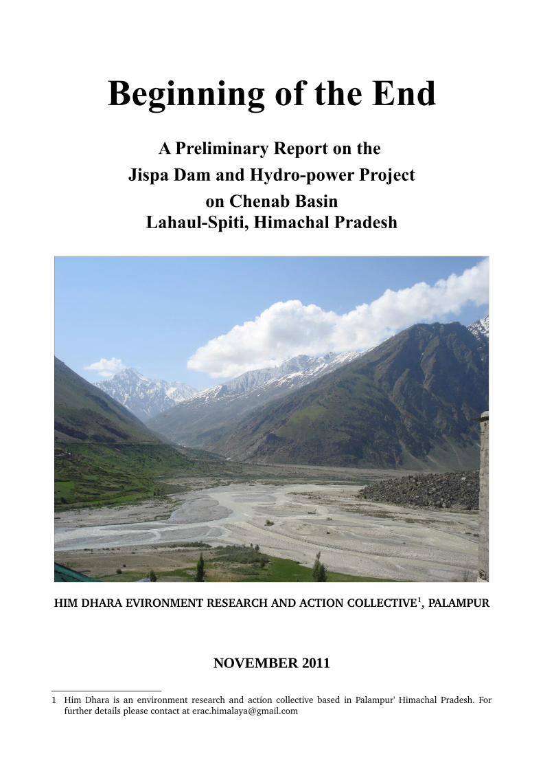
Beginning of the EndA Preliminary Report on the
Jispa Dam and Hydro-power Project
on Chenab BasinLahaul-Spiti, Himachal Pradesh
HIM DHARA EVIRONMENT RESEARCH AND ACTION COLLECTIVE1, PALAMPUR
NOVEMBER 2011
1 Him Dhara is an environment research and action collective based in Palampur' Himachal Pradesh. For further details please contact at [email protected]

Beginning of the End
A Preliminary Report on the Jispa Dam and Hydro-power Project Lahaul-Spiti, Himachal Pradesh
November 2011
Financial Support : INTERNATIONAL RIVER NETWORKS (IRN) and RURAL TECOLOGY AND DEVELOPMENT CENTER (RTDC), PALAMPUR (HIMACHAL PRADESH)
Research and Writing : This report has been written by Prakash Bhandari member of Him Dhara, Environment Research and Action Collective based in Palampur, Himachal Pradesh.
Editorial Support : Manshi Asher and Nidhi Agarwal members of Him Dhara, Environment Research and Action Collective based in Palampur, Himachal Pradesh.
This report, or its parts can be used freely. Please do inform us of the usage and acknowledge the source and inform us of the reproduction at [email protected].

1. Background
Of the five major river basins in Himachal, the Chenab basin is the least exploited basin for Hydro Electricity generation. The Chenab is a glacial river which originates from Bara Lacha pass in Lahaul division of Lahaul Spiti district. The water flow towards south forms Chandra River and the water flow towards north forms the Bhaga River and both rivers confluence at Tandi forms Chenab. In Himachal it's basin is spread over a distance of 130 kms and flows through the Jammu region of Jammu and Kashmir into the plains of the Punjab, Pakistan. In Himachal Chenab basin has total hydro power generation potential of 3032.3 MW. In this stretch 20 HEPs (Annexure-1) have been planned but out of this only 5.35 MW of hydro energy has been exploited as the area is inaccessible and remain snow bound and cut off from the rest of the world for 6 months. Table1: Basinwise Potential in H.P.
Basin Hydro Power PotenialBeas Basin 4604.00 MWRavi Basin 2359.00 MWSatluj Basin 9450.25 MWYamuna Basin 591.52 MWChenab Basin 3032.30 MWMini Micro Projects 750 MWTotal 20787.07 MW(Source: http://www.hpseb.com/hydro_potential.htm)
The part of Chenab basin falling in Jammu and Kashmir state already has 6 major dam projects i.e. Salal, Baglihar (900 MW) Kishenganga (330 MW), Sawalkot (1200 MW), Pakuldul (1000 MW), Bursar (1000 MW), Dal Husti (390 MW) under various stages of planning and construction. In Himachal with the initiation of construction work of Rohtang tunnel the not so accessible Lahual and Spiti valley will now have year round transportation facility which will subsequently be followed by initiation of the spate of HEP in the basin which have been in the pipeline so far. This report takes a look at the probable impacts that will be unleashed as a result of the 300 MW Jispa dam ,the first major hydro electricity project in this river basin in Himachal.
Map-12: Hydro power projects on Chenab
2(Source: IUCN, 2010. Indus Water Treaty and Managing Shared Water Resources for the Benefit of Basin States Policy Issues and Options. IUCN Pakistan, Karachi)
2. Background and Current Status of the Project
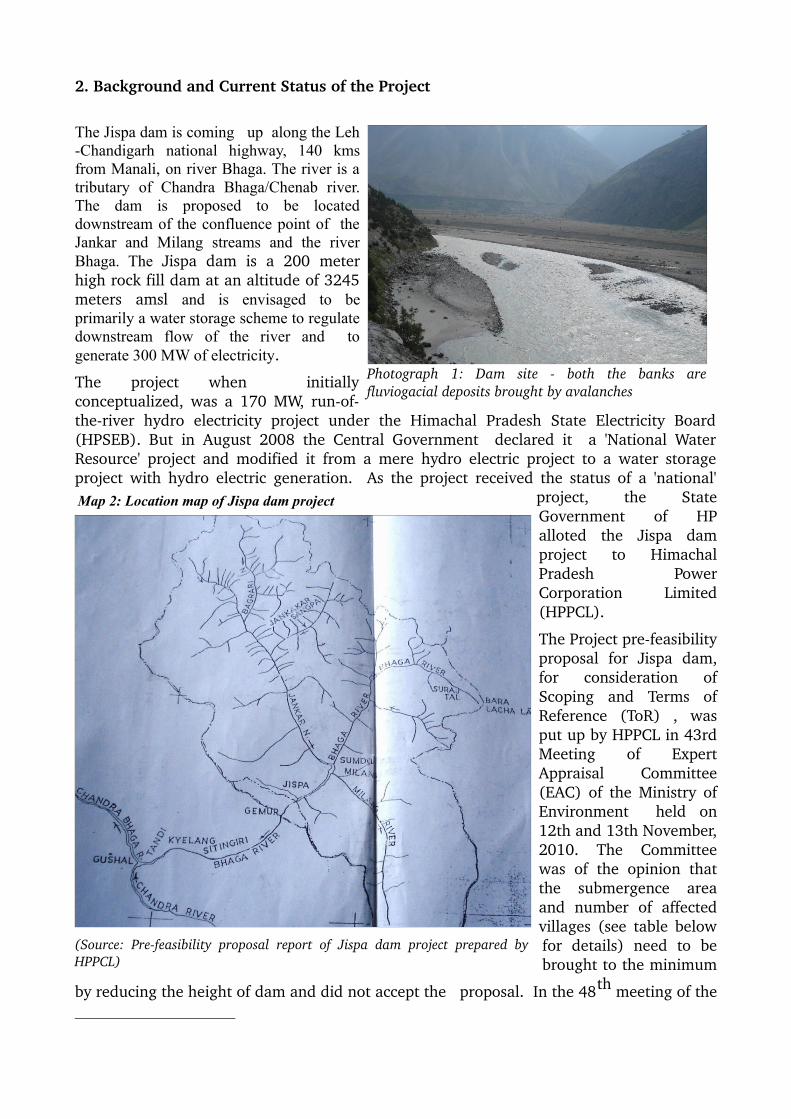
The Jispa dam is coming up along the Leh -Chandigarh national highway, 140 kms from Manali, on river Bhaga. The river is a tributary of Chandra Bhaga/Chenab river. The dam is proposed to be located downstream of the confluence point of the Jankar and Milang streams and the river Bhaga. The Jispa dam is a 200 meter high rock fill dam at an altitude of 3245 meters amsl and is envisaged to be primarily a water storage scheme to regulate downstream flow of the river and to generate 300 MW of electricity.
The project when initially conceptualized, was a 170 MW, runoftheriver hydro electricity project under the Himachal Pradesh State Electricity Board (HPSEB). But in August 2008 the Central Government declared it a 'National Water Resource' project and modified it from a mere hydro electric project to a water storage project with hydro electric generation. As the project received the status of a 'national'
project, the State Government of HP alloted the Jispa dam project to Himachal Pradesh Power Corporation Limited (HPPCL).
The Project prefeasibility proposal for Jispa dam, for consideration of Scoping and Terms of Reference (ToR) , was put up by HPPCL in 43rd Meeting of Expert Appraisal Committee (EAC) of the Ministry of Environment held on 12th and 13th November, 2010. The Committee was of the opinion that the submergence area and number of affected villages (see table below for details) need to be brought to the minimum
by reducing the height of dam and did not accept the proposal. In the 48th meeting of the
Photograph 1: Dam site both the banks are fluviogacial deposits brought by avalanches
Map 2: Location map of Jispa dam project
(Source: Prefeasibility proposal report of Jispa dam project prepared by HPPCL)
EAC, HPPCL again put up the case with some minor changes but without reducing the height of dam as suggested by EAC earlier and despite this EAC approved the ToR with some conditions.
Table2 : Important Features of Jispa Dam Project
S.No. Initial pre feasibility Proposal Changed pre feasibility Proposal
Location Dam near Jispa village and power house at Stingri village
3.2 kms upstream of Jispa village and power house at Stingri village
Height of the Dam 200 meters 200 metersCapacity 300 MW 300 MWHRT 11.75 kms 14.96 kmsStorage capacity 1 MAF 0.7 MAFTotal land required 1635 hectares 1322.95 hectaresForest Area 1500 ha 1253.70 ha Private land 135 ha 69.25 haSubmergence Area 1500 hectares 1220 hectaresSubmerged villages 5 4No. of displaced families131 74(Source: Pre feasibility report and EAC meeting minutes)
Being a national project the Central government will bear 90% cost of the project and the Center agreed to release funds for the preparation of detailed project report, environment impact assessment and environment management plan. The Himachal Pradesh Power Corporation Limited has sought Rs 30 crore for the purpose.
3. Issues of Concern
3.1. Dam of this magnitude not suitable in such a fragile and sensitive zone
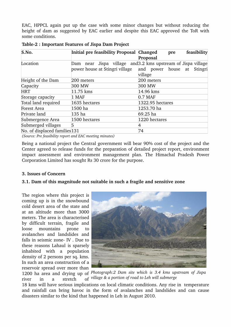
The region where this project is coming up is in the snowbound cold desert area of the state and at an altitude more than 3000 meters. The area is characterised by difficult terrain, fragile and loose mountains prone to avalanches and landslides and falls in seismic zone IV . Due to these reasons Lahaul is sparsely inhabited with a population density of 2 persons per sq. kms. In such an area construction of a reservoir spread over more than 1200 ha area and drying up of river in a stretch of 18 kms will have serious implications on local climatic conditions. Any rise in temperature and rainfall can bring havoc in the form of avalanches and landslides and can cause disasters similar to the kind that happened in Leh in August 2010.
Photograph:2 Dam site which is 3.4 kms upstream of Jispa village & a portion of road to Leh will submerge

3.2. Adverse impact on livelihood and local economy
There are 12 villages (Darcha1 and 2, Sumdu, Limkyum, Rarik, Gandaj, Balijim, Yoche, Chikka, Dogma, Nama, Ranglyo, Makseen) which will be completely/partially submerged by the project, displacing more than 250 families Additionally, 40 shops will be also be submerged by the dam. Around 10 villages (Jispa, Kaimur, Khangsan, Sorang, Kalong, Rangrik, Kwaing, Sitangiri, Kwang etc) will be impacted by drying up of water sources due to construction of 18 kms long head race tunnel.
Lahaul and Spiti district has the highest irrigation intensity for the area under cultivation in the State. This means that the entire area under cultivation is irrigated, without which no agriculture would be possible in such harsh dry cold desert climatic conditions. The village settlements are supported by the community owned and run kuhls (irrigation channels). The area is known for cultivation of high quality Potatoes, Hops, Kuth (Saussurea costus) and Peas and is now moving towards Apple orchards, floriculture (Lilium) and off season vegetable cultivation (cabbage, carrot etc) with a rise
in local temperatures. The fertile agriculture fields along the river face submergence and the sources of irrigation for the fields in higher altitudes will dry up due to the the under ground construction of the project which will hamper agriculture badly.
A typical family in Lahaul possesses 45 cows, 2530 goats and sheep, 56 horses and Yak and Chiru, this livestock is reared for one's own survival and sometimes for cash. Submergence of more than 1200 hectares of forestland/grass plots along the river will make livestock rearing difficult as in winters agriculture fields and grasslands along the river are the only source of fodder. There is no doubt that this project will destroy both the agriculture and livestock economy of the area. It is based on these two occupations that the Lahaul and Spiti district has the highest per capita income in the state.
Photograph 4: Alpine pastures for summer grazing used by migratory communities and local community
Photograph 3: Pea cultivation along river bank and without irrigation agriculture is not possible

3.3. Adverse impact on biodiversity
Being sparsely populated, there is little pressure on forest resources currently because of which there are good forests of Junipers (Devidyar) and Birch (Bhojpatra) in the area which are very slow growing . The government provides fuelwood to locals through depots and has promoted plantations of Poplar and Willow trees which provides timber for house construction, both on forest and private land and helps in protecting the endangered Juniper and Birch forests. According to the local residents, there will be more than 1 lakh trees of Devidyar, Poplar and Willow each in the 1200 ha forest area being diverted for the project. Despite this the project proponents (EAC meeting minutes) have claimed that 90% of the forest land proposed to be diverted for the project is barren land.
The forests which will be diverted for the project are rich in high altitude medicinal and aromatic plants (MAPs) like Salam
Panja (Dactylorhiza hatagirea), Patish (Aconitum heterophyllum) and Kutki (Picrorhiza kurroa) which are critically endangered plants according to the Red data list. These medicinal plants are in high demand and of high economic value (in pharma and cosmetic industries) because of which they are on the verge of extinction in other high altitude areas. In this region because of other, better livelihood options available to local communities, extraction of these plants for commercial purposes is more or less absent. According to Amchi Karma (traditional medical practitioner
and also UpPrdhan, “In traditional medicine 80 plants are used and each plant grows in a specific area. This project will have a negative impact on the availability of these for medicinal use”. Similarly, the area is rich in wild fauna found in alpine regions like Ibex, Snow leopard, Black Bear, Snow Cock, Musk Deer, Nama, Main, etc. and the project will disturb their
Photographs 6: Submergence area rich is in high altitude medicinal plant like Salampanja “Dactylorhiza hatagirea”
Photograph 5: Project will adversely impact Juniper, Willow and Birch forest in the area

habitat as hunting will inevitably start with exodus of labour force from outside.3.4. Adverse impact on demography and social fabric of the area
Lahaul & Spiti is an entirely tribal district and majority of population follows Buddhism. It is the least populous district in Himachal with a population of 31254 according to 2011 census data. It has a unique cultural mix of both old tribal traditions and Buddhism. As per the local people there is no word for 'enemy' in their local dialect, indicating that it is quite a close knit society, unexposed to many external dynamics. In such an area construction of a project of such a huge magnitude by bringing a large labour force from outside will not only change the demographic profile of the area but will have a long
lasting and adverse impact on the social fabric. According to locals “Already very few suitable places exist in Lahaul for human habitation and it will be very difficult to to rehabilitate more than 100 families going to be displaced by these projects”.
The area falls under Schedule V of the Constitution of India and enjoys a special status in terms of prevention of land alienation, ethnic and cultural identity etc. Before planning a project like Jispa dam it is the responsibility of project proponents to take the consent of local community. The Forest Right Act 2006 has been implemented by the state government in this tribal district but not a single individual or community claim has been recognised under this Act. In such a scenario, it is imperative that the government first ensures the implementation this Act and recognise the rights of people under this Act before moving ahead with any developmental projects.
3.5. Violation of Indus Water Treaty (IWT), 1960 and a potential source of conflicts
The usage of Chenab water is governed by Indus Water Treaty, 1960 between India and Pakistan on three western rivers i.e. Chenab, Indus and Jhelum. As per the IWT Pakistan has exclusive usage but India has right to tap the hydropower potential of these rivers without affecting water flows and natural timing of water flows. The treaty also allows India to tap the 1.7 MAF water storage on Chenab basin. To tap this potential, 1.1 MAF water storage facility has been be created in the Bursar project in the adjoining Jammu and Kashmir and the remaining 0.6 MAF has been planned to be stored at Jispa. According to the IUCN report, 'Indus Water Treaty and Managing Shared Water Resources, for the Benefit of Basin States Policy Issues and Options', "If Salal and Baglihar were the only two dams built by India on the Chenab, there would be a limited impact on flows of water to Pakistan. But India has developed an extensive plan for the construction of hydro-power projects like Walkot, Pakuldul, Bursar, Dal Husti, Gyspa (Jispa), etc. The cumulative live storage will be large, giving India an unquestioned capacity to have major impact on the timing of flows into Pakistan, especially during the dry periods.”
Already a conflict situation has arisen due to the construction of Baglihar dam on Chenab
Photograph 7: Women in traditional dress from project affected area
river and India has had to reduce the height of the dam. However, with more projects coming up on Chenab this situation is likely to deteriorate. Clearly, the protocol requires that before construction of Jispa dam the Indian government take consent of Pakistan which is part of the IWT. According to John Bresco3 “India can not decrease the water for her any project and can not change the natural timing of the water flow. Here is the problem though electricity projects don't drink water but India is changing the water flow timing.”
Highlights of Indus Water Treaty
1. The Indus Waters Treaty (IWT) was signed on 19 September 1960 by Prime Minister Jawaharlal Nehru and President Ayub Khan.
2. Allocated the waters of the three eastern rivers, viz. Ravi, Beas and Sutlej, to India for exclusive use and the waters of the three western rivers, viz. Indus, Jhelum and Chenab, to Pakistan
3. India has the right to tap the hydropower potential of the western rivers before they entered Pakistan, without affecting water flows and natural timing of those flows
4. Permits India for creating storages on the Western Rivers of 1.54, 1.98 and 0.933 MAF (million acre feet) for general, power and flood storages, respectively, amounting to total permissible storage of 4.45 km (3.6 MAF)
5. In terms of rivers, 0.4 MAF of storage allowed on the Indus, 1.5 MAF on the Jhelum and 1.7 MAF on the Chenab
4. Local Resistance against the project
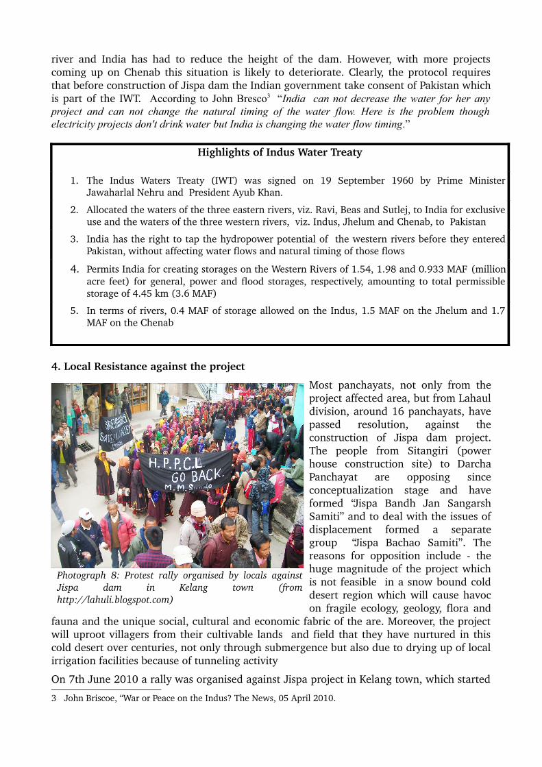
Most panchayats, not only from the project affected area, but from Lahaul division, around 16 panchayats, have passed resolution, against the construction of Jispa dam project. The people from Sitangiri (power house construction site) to Darcha Panchayat are opposing since conceptualization stage and have formed “Jispa Bandh Jan Sangarsh Samiti” and to deal with the issues of displacement formed a separate group “Jispa Bachao Samiti”. The reasons for opposition include the huge magnitude of the project which is not feasible in a snow bound cold desert region which will cause havoc on fragile ecology, geology, flora and
fauna and the unique social, cultural and economic fabric of the are. Moreover, the project will uproot villagers from their cultivable lands and field that they have nurtured in this cold desert over centuries, not only through submergence but also due to drying up of local irrigation facilities because of tunneling activity
On 7th June 2010 a rally was organised against Jispa project in Kelang town, which started
3 John Briscoe, “War or Peace on the Indus? The News, 05 April 2010.
Photograph 8: Protest rally organised by locals against Jispa dam in Kelang town (from http://lahuli.blogspot.com)

with a padyatra from Sitingri village (power house site). On17th October 2010 a meeting of people from project affected villages, but residing outside Lahaul was held in Bhuntar and a memorandum (Annexure2: Copy of memorandum) was submitted to the Governor of HP during the inauguration of Dusshea fair in Kullu town. This was followed by one day fast on 3rd November 2011 and submission of memorandum to the Ministry of Environment and Forests (MoEF) through Deputy Commissioner (DC), Lahaul & Spiti. The EAC took cognizance of this memorandum in its 43rd meeting held on 12th and 13th November 2011 and asked the HPPCL to reduce the height of the dam to lessen the impact of the project. In response, while HPPCL did not reduce the height of the dam, it shifted the project 3.2 kms upstream of Jispa village, thereby removing Jispa village from the submergence area, a village which was most vocal in voicing their opposition to the project. But this step brought a new set of villages under the submergence area of dam.
Against this decision locals from three project affected Panchayts i.e. Kelang, Darcha and Yurnath gathered in at Darcha Panchyat to reevaluate their strategy and to make necessary changes in composition of Sangarsh Samiti according to the revised proposal. In the revised proposal despite reducing the height of the dam as suggested by Environment Advisory Committee, the project proponents have merely changed the location of project whereas the local community is against the project of this size in their ecologically and geologically sensitive area. According to Rigzin Hayerpa, member Zila Parishad “This step (of changing the location) will not lessen the negative impacts of the project but will bring new set of villages under submergence and will increase the number of villages going to be adversely impacted by tunneling.” Due to these reasons the affected people with one voice opposed the project and have appealed to the MoEF to stop any survey work for the dam project.
5. Conclusion
The Chenab basin in Himachal which so far has been free of hydro power projects, today has 20 projects lined up in a stretch of 130 kms attempting to utilize every stretch of river that offers a vertical drop. Apart from Jispa, 120 MW Miyar and 400 MW Seli Hydro projects are also currently in the process of getting cleared. The fate of the Chenab, this means, will be no different from Satluj, Ravi and Beas where a cascade of projects have threatened the free flow of these rivers and their tributaries. While cumulative impact assessment studies are being made mandatory prior to clearances by the Ministry of Environment, the Chief Minister of Himachal has recently written to the Ministry to exempt the Chenab basin from such studies because these were acting as 'obstacles' in the quick implementation of the projects.
In 2008 the HP government was planning to construct the Jispa Dam as a 170 MW project but the Central government modified this project into a water storage scheme to have 1.7 MAF storage in Chenab basin as per IWT, without properly assessing the benefits of this project and the environmental and socioeconomic implications. The project which is going
Photograph 9: Meeting against Jispa dam project at Darcha

to have a huge environmental cost has been planned on the grounds that there was no other suitable place for storage of Chenab water.
The Jispa dam project is still in its initial stages of implementation and there is not much information about the project like EIA, DPR in the domain . Even the prefeasibility report available is for the old dam site . However, whatever little information is available related to the sheer magnitude and location of the project is enough to ring the alarm bells and indicate that this is the beginning of a cycle of destruction that the rest of the state has already witnessed. The residents who are living in this fragile, difficult and hostile environment of the Lahaul valley have opposed the Jispa dam since the day they have heard of it. They have seen the condition of the Satluj and Ravi in their front yards and have vowed to protect the pristine Chenab for everything its worth.
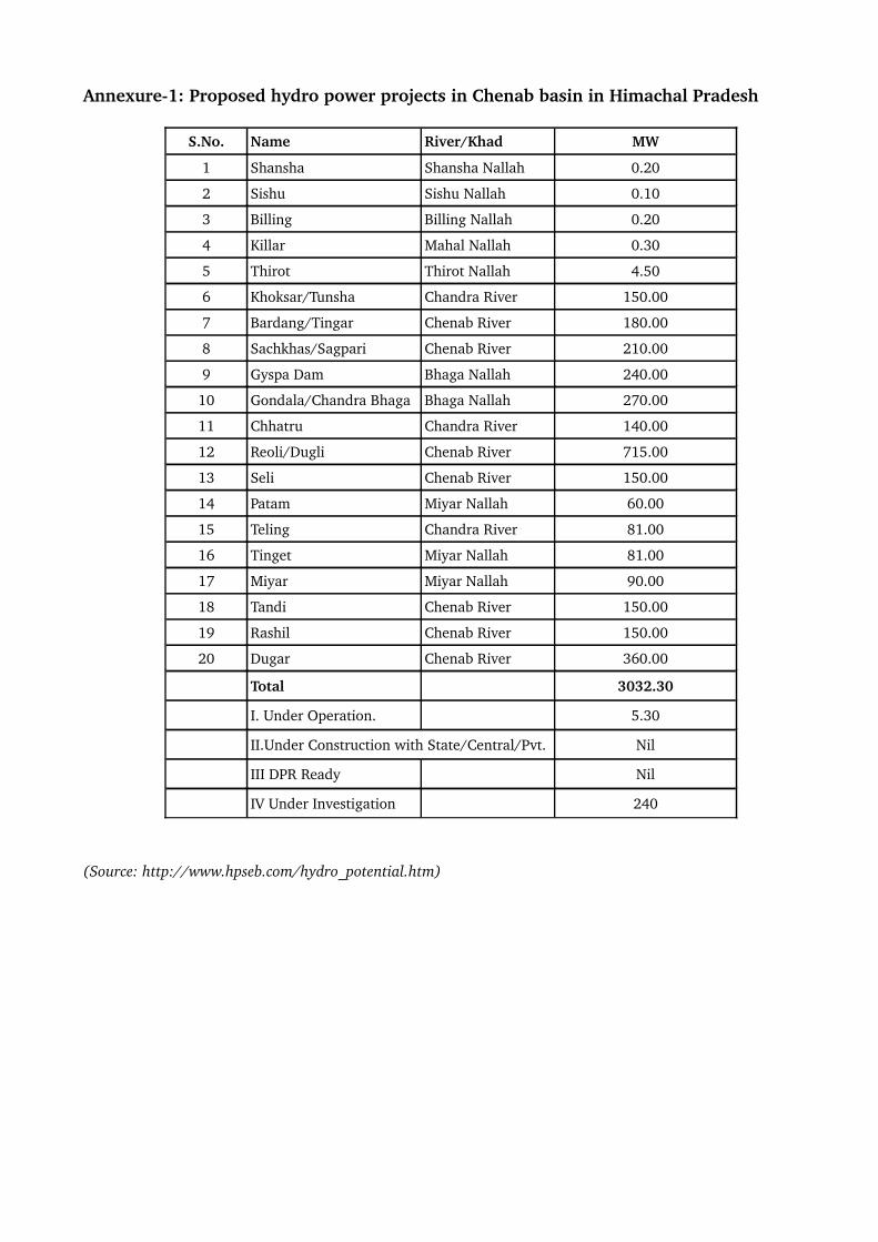
Annexure1: Proposed hydro power projects in Chenab basin in Himachal Pradesh
S.No. Name River/Khad MW
1 Shansha Shansha Nallah 0.20
2 Sishu Sishu Nallah 0.10
3 Billing Billing Nallah 0.20
4 Killar Mahal Nallah 0.30
5 Thirot Thirot Nallah 4.50
6 Khoksar/Tunsha Chandra River 150.00
7 Bardang/Tingar Chenab River 180.00
8 Sachkhas/Sagpari Chenab River 210.00
9 Gyspa Dam Bhaga Nallah 240.00
10 Gondala/Chandra Bhaga Bhaga Nallah 270.00
11 Chhatru Chandra River 140.00
12 Reoli/Dugli Chenab River 715.00
13 Seli Chenab River 150.00
14 Patam Miyar Nallah 60.00
15 Teling Chandra River 81.00
16 Tinget Miyar Nallah 81.00
17 Miyar Miyar Nallah 90.00
18 Tandi Chenab River 150.00
19 Rashil Chenab River 150.00
20 Dugar Chenab River 360.00
Total 3032.30
I. Under Operation. 5.30
II.Under Construction with State/Central/Pvt. Nil
III DPR Ready Nil
IV Under Investigation 240
(Source: http://www.hpseb.com/hydro_potential.htm)

Annexure2: Memorandum submitted to the Governor of Himachal Pradesh
