beitin village profile
TRANSCRIPT
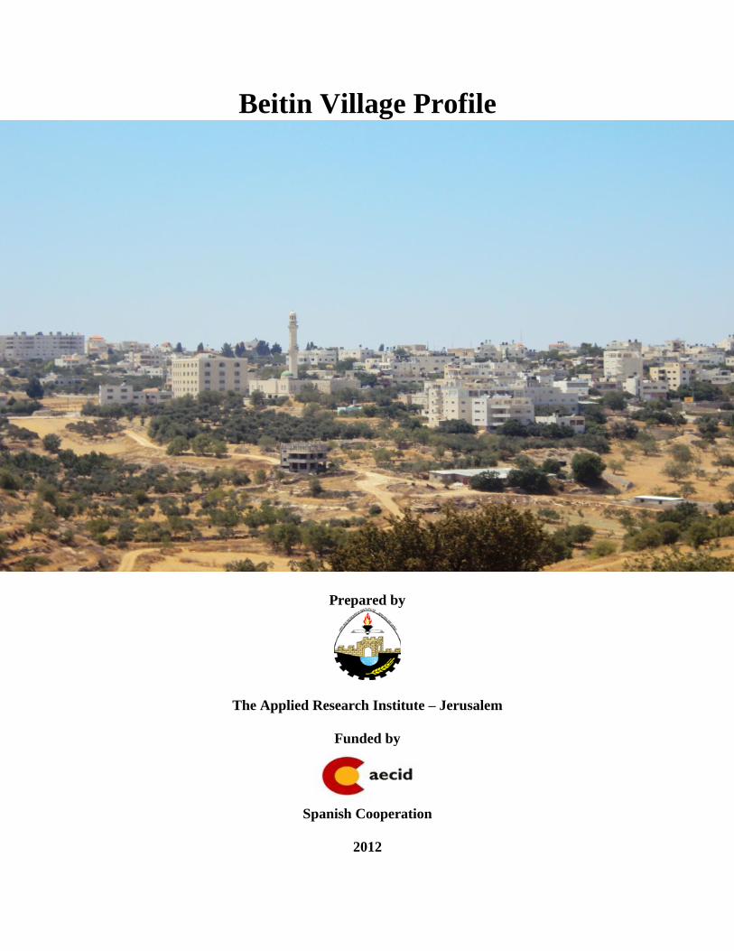
Beitin Village Profile
Prepared by
The Applied Research Institute – Jerusalem
Funded by
Spanish Cooperation
2012

Palestinian Localities Study Ramallah Governorate
1
Acknowledgments
ARIJ hereby expresses its deep gratitude to the Spanish agency for International Cooperation for
Development (AECID) for their funding of this project.
ARIJ is grateful to the Palestinian officials in the ministries, municipalities, joint services councils,
village committees and councils, and the Palestinian Central Bureau of Statistics (PCBS) for their
assistance and cooperation with the project team members during the data collection process.
ARIJ also thanks all the staff who worked throughout the past couple of years towards the
accomplishment of this work.

Palestinian Localities Study Ramallah Governorate
2
Background
This report is part of a series of booklets, which contain compiled information about each city, town, and
village in the Ramallah Governorate. These booklets came as a result of a comprehensive study of all
localities in Ramallah Governorate, which aims at depicting the overall living conditions in the
governorate and presenting developmental plans to assist in developing the livelihood of the population
in the area. It was accomplished through the "Village Profiles and Needs Assessment;" the project
funded by the Spanish Agency for International Cooperation for Development (AECID).
The "Village Profiles and Needs Assessment" was designed to study, investigate, analyze and document
the socio-economic conditions and the needed programs and activities to mitigate the impact of the
current unsecure political, economic and social conditions in Ramallah Governorate.
The project's objectives are to survey, analyze, and document the available natural, human,
socioeconomic and environmental resources, and the existing limitations and needs assessment for the
development of the rural and marginalized areas in Ramallah Governorate. In addition, the project aims
at preparing strategic developmental programs and activities to mitigate the impact of the current
political, social, and economic instability with the focus on the agricultural sector.
All locality profiles in Arabic and English are available online at http://vprofile.arij.org.

Palestinian Localities Study Ramallah Governorate
3
Table of Content
Location and Physical Characteristics __________________________________________________ 4
History ___________________________________________________________________________ 5
Religious and Archaeological Sites _____________________________________________________ 6
Population ________________________________________________________________________ 6
Education _________________________________________________________________________ 7
Health Status ______________________________________________________________________ 8
Economic Activities _________________________________________________________________ 8
Agricultural Sector _________________________________________________________________ 10
Institutions and Services ____________________________________________________________ 13
Infrastructure and Natural Resources _________________________________________________ 13
Environmental Conditions ___________________________________________________________ 15
Impact of the Israeli Occupation ______________________________________________________ 16
Development Plans and Projects ______________________________________________________ 19
Implemented Projects _______________________________________________________________ 19
Proposed Projects __________________________________________________________________ 20
Locality Development Priorities and Needs _____________________________________________ 21
References: _______________________________________________________________________ 22

Palestinian Localities Study Ramallah Governorate
4
Beitin Village Profile
Location and Physical Characteristics
Beitin is a Palestinian village in the Ramallah Governorate located (horizontally) 4.2km east of
Ramallah City. Beitin is bordered by Deir Dibwan to the east, „Ein Yabrud village to the north, Al Bireh
city to the west, and Burqa village to the south (ARIJ GIS, 2012) (See map 1).
Map 1: Beitin location and borders
Source: ARIJ GIS, 2012
Beitin is located at an altitude of 859m above sea level with a mean annual rainfall of 546.7mm. The
average annual temperature is 16 o
C, and the average annual humidity is approximately 60% (ARIJ GIS,
2012).
Since 1995, Beitin has been governed by a village council, which is currently administrated by 9
members appointed by the Palestinian National Authority. Moreover, the village council, which is

Palestinian Localities Study Ramallah Governorate
5
included within the Joint Services Council for Ramallah Governorate, owns a permanent headquarters,
but does not possess a vehicle for the collection of solid waste (Beitin Village Council, 2011).
It is the responsibility of the village council to provide a number of services to the residents of Beitin,
including (Beitin Village Council, 2011):
Infrastructure services such as water management and maintenance, and providing an electricity
network or generators.
Solid waste collection, road construction and restoration, and social development services.
Provision of children‟s kindergartens.
Implementation of projects and studies pertaining to the village development.
History
Beitin village was originally called Bethel, meaning "House of El" or "House of God", however, it was
later renamed Beitin by Bedouins who resided in the village. Also, the village is one of the oldest
inhabited areas in the world, and its residents are originally Canaanites (Beitin Village Council, 2011) (See
photo below for Beitin village).
Photos of Beitin
Palestinian Localities Study Ramallah Governorate
6
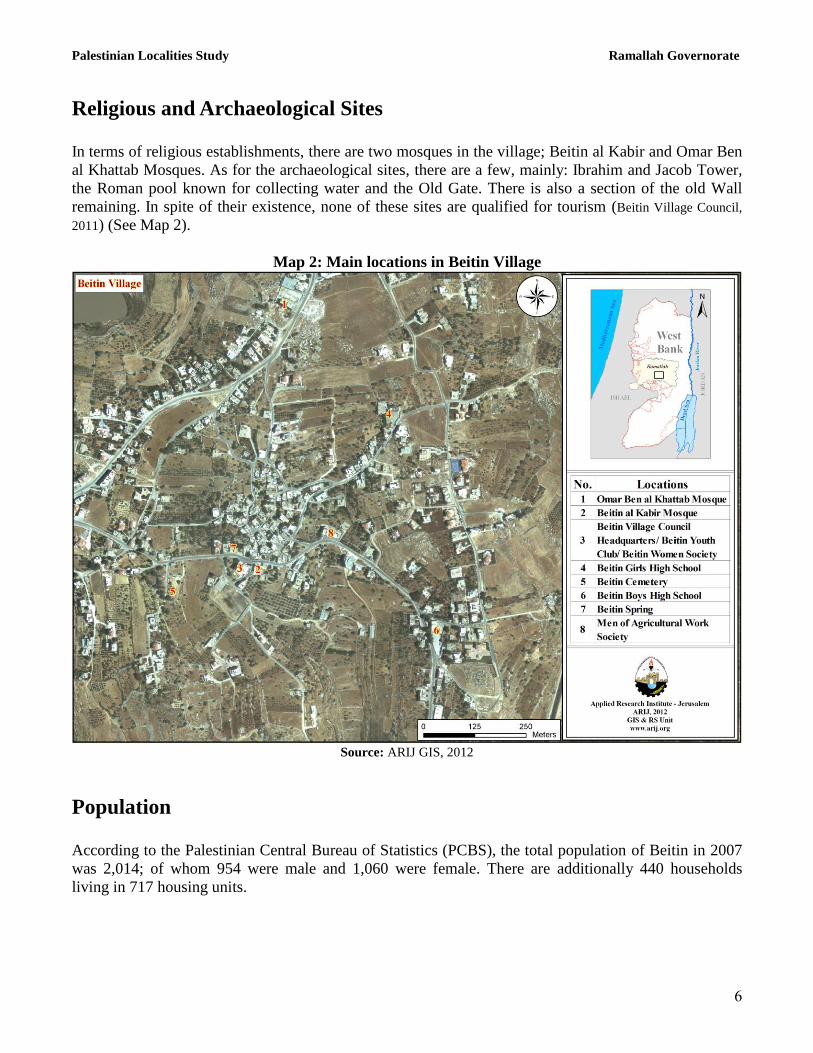
Religious and Archaeological Sites
In terms of religious establishments, there are two mosques in the village; Beitin al Kabir and Omar Ben
al Khattab Mosques. As for the archaeological sites, there are a few, mainly: Ibrahim and Jacob Tower,
the Roman pool known for collecting water and the Old Gate. There is also a section of the old Wall
remaining. In spite of their existence, none of these sites are qualified for tourism (Beitin Village Council,
2011) (See Map 2).
Map 2: Main locations in Beitin Village
Source: ARIJ GIS, 2012
Population
According to the Palestinian Central Bureau of Statistics (PCBS), the total population of Beitin in 2007
was 2,014; of whom 954 were male and 1,060 were female. There are additionally 440 households
living in 717 housing units.

Palestinian Localities Study Ramallah Governorate
7
Age Groups and Gender
The General Census of Population and Housing carried out by PCBS in 2007 showed the distribution of
age groups in Beitin was as follows: 35.3% were less than 15 years old, 57.2% between 15 - 64 years
old, whilst 5.5% fell into the 65 years and older category. Data additionally showed that the sex ratio of
males to females in the village was 90:100, meaning that males and females constitute 47.4% and 52.6%
of the population, respectively.
Families
Beitin residents are composed of several families, mainly: Hamid, Jarab'ah, Zeidan and Khalil (Beitin
Village Council, 2011).
Education
According to the results of the PCBS Population, Housing and Establishment Census-2007, the illiteracy
rate among Beitin population was approximately 6.7%, of whom 73.2% were females. Of the literate
population, 13.8% can only read and write, with no formal education 21.9% had elementary education,
26.7% had preparatory education, 17.6% had secondary education, and 13.2% completed higher
education. Table 1, shows the educational level in the village of Beitin, by sex, and educational
attainment in 2007.
Table 1: Beitin population (10 years and above) by sex and educational attainment
S
E
x
Illiterate
Can
read &
write
Elementary Preparatory Secondary Associate
Diploma Bachelor
Higher
Diploma
Maste
r
PhD Unknown Total
M 27 102 167 189 127 36 38 3 11 2 - 702
F 74 107 164 215 139 59 45 3 2 1 1 810
T 101 209 331 404 266 95 83 6 13 3 1 1,512
Source: PCBS, 2009.
With regards to the basic and secondary education institutions and schools in Beitin in the academic year
2010/2011, there are two public schools in the village run by the Palestinian Ministry of Higher
Education (MoEHE) (Directorate of Education in Ramallah, 2010/2011) (See Table 2).
Table 2: The Schools in : Beitin by name, stage, sex, and supervising authority
School Name Supervising Authority Sex
Beitin Boys Secondary School
Government
Male
Beitin Girls Secondary School Female
Source: Directorate of Education in Ramallah, 2011

Palestinian Localities Study Ramallah Governorate
8
In the village there are currently 495 students, 41 teachers, and 24 classes registered (Directorate of Education
in Ramallah, 2010/2011). It should be noted here that the average number of students per teacher in the
school is nearly 12, whilst the average number of students per class is approximately 21.
Furthermore, there is one kindergarten in Beitin run by a private body and hosts a total of 24 children
(Directorate of Education in Ramallah, 2011).
However, due to the lack of a scientific branch in Beitin schools, the students interested in pursuing such
studies have to head to „Ein Yabrud or Deir Dibwan village schools; each of which are 3km in distance
from the village (Beitin Village Council, 2011).
Nevertheless, the educational sector in Beitin village suffers some obstacles, mainly (Beitin Village Council,
2011):
The lack of scientific tools.
The lack of specialized teachers.
Problems concerning the school‟s building.
The large number of students dropping out of schools.
Health Status
There are a few health centers available in Beitin village; a governmental physician clinic, a
governmental motherhood and childhood center, a governmental medical analysis laboratory and a
private pharmacy. In case of the absence of a required health service and in emergency cases, residents
of Beitin head to Al 'Elmiya Society Center in Deir Dibwan or Ramallah governmental hospital; 3km
and 15km in distance from the locality, respectively (Beitin Village Council, 2011).
Nevertheless, the health sector in the village suffers many obstacles and problems, including (Beitin
Village Council, 2011):
The lack of medical machines and equipments.
The lack of needed medicines and drugs.
The lack of an ambulance.
Economic Activities
The economy in Beitin is dependent on several economic sectors, mainly: the agriculture sector, which
absorbs 30% of the village workforce (Beitin Village Council, 2011) (See Figure 1).
The results of a field survey conducted by ARIJ team in 2011 for the distribution of labor by economic
activity in Beitin are as follows (Beitin Village Council, 2011):

Palestinian Localities Study Ramallah Governorate
9
Agriculture Sector (30%)
Government or Private Employees Sector (20%)
Trade Sector (20%)
Services Sector (20%).
Industry (10%)
Figure 1: Economic Activity in Beitin Village
Source: Beitin Village Council, 2011
In term of economic and industrial productions in Beitin village, there are 6 grocery stores, 2 vegetables
and fruits stores, one bakery, 2 butchers, 10 different professional workshops (carpentry, blacksmith,..
etc.), 4 different services stores and 3 stone quarries. However, the unemployment rate in Beitin has
reached around 60% in 2011, and the economical groups most affected by the Israeli restrictions have
been (Beitin Village Council, 2011):
Workers in the agriculture sector.
Workers in industry.
Workers in the trade sector.
Workers in the services sector.

Palestinian Localities Study Ramallah Governorate
11
Labor Force
According to the PCBS Population, Housing and Establishment Census-2007, 32.7% of Beitin labor
force was economically active, of whom 90.9% were employed, 67.3% were not economically active,
46.2% were students, and 36.3% were housekeepers (See table 3).
Table 3: Beitin population (10 years and above) by sex and employment status-2007
S
E
X
Economically Active Not Economically Active
Un-
known
Total Employed
Currently
Unemployed
Unemployed
(Never
worked)
Total Students House-
keeping
Unable
to work
Not working
& Not
looking
for work
Other Total
M 350 13 23 386 205 2 63 39 7 316 - 702
F 99 3 6 108 265 368 57 9 3 702 - 810
T 449 16 29 494 470 370 120 48 10 1,018 - 1,512
Source: PCBS, 2009.
Agricultural Sector
Beitin lies on an area of 5,653 dunams, of which 2,644 dunams are considered arable land, and 508
dunams are dedicated to residential services (see table 4 and map 3).
Table 4: Land use and land cover in Beitin village in 2010 (area in dunam)
Total
Area
Built
up
Area
Agricultural area
(2,644)
Inland
water
Forests Open
Spaces
Area of
Industrial,
Commercial
&
Transport
Unit
Area of
Settlement,
Military
Bases &
Wall Zone
Permanent
Crops
Green-
houses
Range
-land
Arable
land
5,653 508 871 0 0 1,773 0 0 2,280 116 104
Source: ARIJ – GIS Unit, 2012.

Palestinian Localities Study Ramallah Governorate
11
Map 3: Land use/land cover and Segregation Wall in Beitin Village
Source: ARIJ GIS, 2012
Table 5 shows the different types of rain-fed and irrigated open-cultivated vegetables in Beitin. The
most commonly cultivated crop within this area is squash.
Table 5: Total area of rain-fed and irrigated open cultivated vegetables in Beitin village (dunam)
Fruity vegetables Leafy
vegetable
Green
legumes Bulbs
Other
vegetables Total area
RF Irr. RF Irr. RF Irr. RF Irr. RF Irr. RF Irr.
25 0 0 0 15 0 5 0 5 0 50 0 Rf: Rain-fed, Irr: Irrigated
Source: Palestinian Ministry of Agriculture, 2009
Table 6 shows the different types of fruit trees planted in the area. Beitin is famous for olive; there being
a total of 545 dunams planted with olive crops.
Table 6: Total area of fruit and olive trees in Beitin village (dunam) Olives Citrus Stone-fruits Pome fruits Nuts Other fruits Total area Rf Irr. Rf Irr. Rf Irr. Rf Irr. Rf Irr. Rf Irr. Rf Irr.
545 0 0 0 73 0 3 0 25 0 100 0 746 0 Rf: Rain-fed, Irr: Irrigated
Source: Palestinian Ministry of Agriculture, 2009

Palestinian Localities Study Ramallah Governorate
12
As for the field crops and forage in Beitin, cereals (in particular wheat) are the most cultivated covering
an area of about 65 dunams (See table 7).
Table 7: Total area of field crops in Beitin village (dunam) Cereals Bulbs Dry
legumes Oil
crops
Forage
crops
Stimulating
crops
Other
crops
Total
area
Rf Irr Rf Irr Rf Irr Rf Irr Rf Irr Rf Irr Rf Irr Rf Irr
65 0 8 0 39 0 0 0 25 0 0 0 0 0 137 0 Rf: Rain-fed, Irr: Irrigated
Source: Palestinian Ministry of Agriculture, 2009
The difference between the two sets of results obtained from the Ministry of Agriculture and by ARIJ‟s
GIS Unit in sizes of agricultural areas is explained by the fact that the Ministry of Agriculture and the
Palestinian Central Bureau of Statistics (2010) conducted a survey which used a definition of
agricultural areas based on land ownership. Therefore, the areas included in the survey were those of
actual holdings of agricultural areas instead of seasonal ones. The survey did not consider fragmented
and small seasonal cultivated areas in residential and agricultural areas. ARIJ‟s survey, however,
indicated the existence of a high proportion of small and fragmented holdings (home gardens)
throughout the occupied Palestinian territories, thus accounting for the larger area of agricultural
holdings calculated by ARIJ.
The field survey conducted by ARIJ team in 2011 shows that 23% of the residents in Beitin rear and
keep domestic animals such as sheep, goats and others (Beitin Village Council, 2011) (See Table 8).
Table 8: Livestock in Beitin village
Cows* Sheep Goats Camels Horses Donkeys Mules Broilers Layers Bee Hives
0 500 113 0 0 0 0 12,000 0 19 *Including cows, bull calves, heifer calves and bulls
Source: Palestinian Ministry of Agriculture, 2009
There are also around 8 kilometers of agricultural roads in the village, divided as follows (Beitin Village
Council, 2011):
Table 9: Agricultural Roads in Beitin village and their Lengths
Suitability of Agricultural Roads Length (km)
For vehicles -
For tractors and agricultural machinery only 2
For animals only 2
Unsuitable 4 Source: Beitin Village Council, 2011
The agricultural sector suffers some obstacles and problems, including the following (Beitin Village
Council, 2011):
The lack of space for rearing livestock.
Palestinian Localities Study Ramallah Governorate
13
Institutions and Services
Beitin village has no governmental institutions except for one post division. However, it has a number of
local institutions and associations that provide services to various segments of society: children, youth,
and women. The services are in the areas of culture, sports and others, including (Beitin Village Council,
2011):
Beitin Village Council: Founded in 1995 by the Palestinian National Authority, with the goal of
taking care of all the issues in the village and providing various services to its population.
Beitin Youth Club: Founded in 1970 by the village‟s young people and is currently registered in
the Ministry of Youth & Sports, with an interest in all sports and cultural activities for the youth.
Beitin Women Society: Founded in 2005 by the Women's Affairs' crew and is interested in all
women's issues and affairs.
Beitin Agricultural Committee: Founded in 2007 by the Agricultural Work Committees and is
interested in issues such as planting trees, manufacturing of food and so on.
Infrastructure and Natural Resources
Electricity and Telecommunication Services:
Beitin has been connected to a public electricity network since 1961; served by Jerusalem Electricity
Company, which is the main source of electricity in the village. Approximately 99% of the housing units
in the village are connected to the network. However, the village residents suffer some problems
concerning electricity, mainly: the increasing cost of electricity from the source and the network's need
for renovation (Beitin Village Council, 2011).
Furthermore, Beitin is connected to a telecommunication network and approximately 70% of the
housing units within the village boundaries are connected to phone lines (Beitin Village Council, 2011).
Transportation Services:
There are 10 taxis and 5 public buses which are considered to be the main means of transportation in
Beitin village; however, residents suffer from the existence of earth mounds and military checkpoints on
roads along with their poor condition (Beitin Village Council, 2011). As for the village‟s road; there are a
total of 4km of main roads and a total of 10km of secondary roads (See Table 10) (Beitin Village Council,
2011).

Palestinian Localities Study Ramallah Governorate
14
Table 10: Roads in Beitin village
Status of Internal Roads Road Length (km)
Main Sub
1. Paved & in good condition - -
2. Paved but in poor condition 4 6
3. Unpaved - 4 Source: Beitin Village Council, 2011
Water Resources:
Beitin is provided with water by the Jerusalem Water Authority, through the public water network
established in 1961. Approximately, 99% of the housing units are connected to the water network (Beitin
Village Council, 2011).
The quantity of water supplied to Beitin in 2010 is about 84,070 cubic meters/ year. The estimated rate
of water supply per capita is about 114.4 liters/day (Jerusalem Water Authority, 2011). Here it should be
noted that no Beitin citizen in fact consumes this amount of water due to water losses, which are about
26.5%. The losses happen at the main source, major transport lines, distribution network, and at the
household level, thus the rate of water consumption per capita in Beitin is 84 liters per day (Jerusalem
Water Authority, 2010). This is a low rate compared with the minimum quantity proposed by the World
Health Organization, which is 100 liters per capita per day.
Helping to augment the water supply, there are 30 rainwater harvesting cisterns located in Beitin. These
are considered to be the alternative resource of water for the public network; however, these do not meet
the residents‟ needs of water (Beitin Village Council, 2011).
To regulate water costs, the water authority has adopted an upward rate where the price of water
increases with increasing consumption. Table 11 shows the price of water by category of consumption.
Table 11: Water tariffs of Jerusalem Water Authority adopted since 01.01.2012
Consumption
Category (m³)
Domestic
(NIS/m³)
Industrial
(NIS/m³)
Tourist
(NIS/m³)
Commercial
(NIS/m³)
Public
Institutions
(NIS/m³)
0 – 5 4.5 5.6 5.6 5.6 5.4
5.1 – 10 4.5 5.6 5.6 5.6 4.5
10.1 – 20 5.6 6.8 6.8 6.8 5.6
20.1 – 30 6.8 8.1 8.1 8.1 6.8
30.1+ 9 9.9 10.8 9 9
Source: Jerusalem Water Authority, 2012
Sanitation:
Beitin lacks a public sewerage network, with most of the village residents using cesspits and endocrines
as the main means of waste water disposal (Beitin Village Council, 2011).
Palestinian Localities Study Ramallah Governorate
15
Based on the estimated daily per capita water consumption, the estimated amount of wastewater
generated per day, is approximately 135.4 cubic meters, or 49,433 cubic meters annually. At the
individual level, it is estimated that the per capita wastewater generation is approximately 58.8 liters per
day. The wastewater collected by cesspits is discharged by wastewater tankers directly to open areas or
nearby valleys without regard for the environment. Here it should be noted that there is no wastewater
treatment either at the source or at the disposal sites and this poses a serious threat to the environment
and the public health (ARIJ - WERU, 2012).
Solid Waste Management:
Beitin Village Council is considered the official body responsible for managing solid waste, i.e. Solid
waste collection and disposal, generated from the citizens and establishments in the village, which is
currently represented by solid waste collection and disposal. Due to the fact that the process of solid
waste management is costly, a monthly fee has been charged on the population serviced by domestic
solid waste collection and transportation services which totals about 200 NIS/year. However, the
collected fees are not considered sufficient for a good management of solid waste; only 50% of these
fees are collected from the citizens (Beitin Village Council, 2011).
Most of the population in Beitin benefit from the solid waste services, where waste is collected from
households, institutions, shops, and public squares in plastic bags. The Village Council collects the solid
waste twice a week and transports it with a tractor to a random dump site located 200m from the village.
The common method for solid waste treatment in this dumping site is setting waste on fire (Beitin Village
Council, 2011).
The daily per capita rate of solid waste production in Beitin is 0.7kg. Thus the estimated amount of solid
waste produced per day from the Beitin residents is nearly 1.4 tons, or 514.6 tons per year (ARIJ -
WERU, 2012).
Environmental Conditions
Like other villages and towns in the governorate, Beitin experiences several environmental problems
which must be addressed and solved. These problems can be identified as follows:
Water Crisis
Water is cut off by the Jerusalem Water Authority for long periods of time during summer in
several neighborhoods of the village.
High rate of water losses, because the water network is old and in need of rehabilitation and
renovation.
Lack of a public water reservoir in the village to be used by residents during water shortages.

Palestinian Localities Study Ramallah Governorate
16
Wastewater Management
The absence of a public sewerage network means that in Beitin residents are forced to use
unhygienic cesspits and endocrines for the disposal of wastewater, and/or discharge wastewater
in the streets. This is particularly common in winter, as citizens cannot afford the high cost of
sewage tankers during this period. These methods facilitate environmental damage, health
problems, and the spread of epidemics and diseases in the village. This wastewater also
contaminates the groundwater and water collected in household cisterns (rainwater harvesting
cisterns), as it mixes with the waste water thus becomes unsuitable for drinking, because most
cesspits are built without lining, allowing wastewater to enter into the ground and avoiding the
need to use sewage tankers. Moreover, the untreated wastewater collected from cesspits by
sewage tankers is disposed of in open areas without concern for the damage it causes to the
environment and to residents' health.
Solid Waste Management
The lack of a central sanitary landfill to serve Beitin and the other neighboring communities in
the governorate is due mainly to the obstacles created by the Israeli authorities for local and
national institutions in granting licenses to establish such a landfill, because the appropriate land
is within Area C and under Israeli control. Additionally, the implementation of such projects
depends on funding from donor countries. The lack of a sanitary landfill is a source of pollution
to the groundwater and soil through the leachate produced from the solid waste, and produces
bad odors and distortion of the landscape.
Impact of the Israeli Occupation
Geopolitical status in Beitin Village According to the Oslo II Interim Agreement signedbetween the Palestinian Liberation Organization
(PLO) and Israel, on 28th
September 1995, Beitin was divided into politically classified areas “B” and
“C”. Approximately 1,077 dunums (19.1% of the village‟s total area) were classified as area B, where
the Palestinian National Authority has complete control over civil matters and Israel continues to have
overriding responsibility for security. Area B constitutes most of the inhabited Palestinian areas,
including municipalities, villages and some camps. It can be noted that most of the village‟s population
resides in area B. The rest of the village‟s area, constituting 4,576 dunums (80.9% of the total area), is
classified as area C, where Israel retains full control over security and administration related to the
territory (table 12). In area C, Palestinian building and land management is prohibited unless through
consent or authorization by the Israeli Civil Administration. Most of the lands lying within the area C
are classified as agricultural areas, open spaces and settlement zones.

Palestinian Localities Study Ramallah Governorate
17
Table 12: The Geopolitical Divisions of Beitin Village according to Oslo II Agreement 1995 – Ramallah
Governorate
Classification Area in dunums Percent from Total
village area
Area A 0 0
Area B 1,077 19.1
Area C 4,576 80.9
Nature Reserve 0 0
Total 5,653 100 Source:ARIJ-GIS, 2011
Beitin Village and the Israeli Occupation Practices
Beitin village has been subjected to multiple Israeli land and property confiscations for the benefit of the
various Israeli ends such as the construction of Israeli settlements, military bases, outposts and Israeli
bypass roads on village territories, in addition to the establishment of the multiple Israeli checkpoints.
Following is a breakdown of confiscations that have occurred within Beitin village territories:
Israeli Occupation Forces confiscated 29dunums of lands in Beitin to establish part of Beit El Israeli
military base to the west of the village, the majority of which is located on the lands of Al Bireh city.
This military base includes the central Israeli Civil Administration office in the West Bank in addition to
the presence of a detention center and military area. Israeli Occupation Forces through the establishment
of these military bases on Palestinian territories aim at intensifying their military presence within
Palestine and strengthening security control over Palestinian citizens.
Furthermore, Israeli Occupation Forces confiscated additional lands from Beitin to construct Israeli
bypass road no. 60 leading to Beit El settlement bloc, which had been closed for use by Palestinians for
years, in order to connect Israeli settlements with each other. It is further noted that the real threat of
bypass roads lies in the buffer zone formed by the Israeli Occupation Forces (IOF) along these roads,
extending to approximately 75 m on the roads‟ sides.
Regarding the presence of these military barriers, Israeli Occupation Forces have established several
barriers in Beitin village following the outbreak of the second Intifada during 2000. Of these barriers, 7
representearth mounds established on sub roads entrances to bypass road 60, created in order to prevent
Palestinian usage of this road in addition to the establishment of an observation tower close to road 60.
In addition, the occupation forces have closed the sub road linking Beitin and Burqa villages with two
concrete barriers. Therefore, Palestinians are forced to use alternative roads through Deir Dibwan town,
in order to access Burqa village. Moreover, the occupation authorities have established a tunnel that
passes under bypass road 60 to link Beitin with Deir Dibwan. However, the worst damage caused by the
barrier came from the blocking of Beitin with Ramallah city from the west, near Beit El settlement
military bloc, as Beitin village was considered the closest of Ramallah eastern villages near to the city.
Having separated the areas with this military checkpoint, Palestinians were forced to re- route through
„Ein Yabrud, Dura al Qar‟ villages and Al Jalazun Camp to return to Ramallah city with an additional
Palestinian Localities Study Ramallah Governorate
18
distance of around 13km, thus causing traffic congestion and economic burden. Such Israeli barriers aim
to restrict the movement of Palestinians under the auspices of protecting.
Also, lands of Beitin village have been forcefully seized by Israeli settlers to establish Asaf Hill (Givat
Asaf)Israeli outposts; aiming at controlling more Palestinian lands. It is worth mentioning that during
the last two decades, Israel built 232 outposts in the West Bank. These outposts are considered the
nucleus for the development of new settlements. Outposts are composed of mobile caravans which are
located on stolen lands by the settlers and they are a contiguity of a mother settlement that is near. It is
worth mentioning that the epidemic of Israeli outposts started with a “Sharonian” call for Jewish settlers
to take control over Palestinian hilltops to prevent transferring them to Palestinians in negotiations.
Although the successive Israeli governments haven‟t legalized this phenomenon, they managed to find a
security and logistic cover to justify the act and its existence and continuity. After 2001 the Prime
Minister at that time, Ariel Sharon, unleashed the expansion of outposts which has led to a significant
increase in the number of outposts within Palestinian areas. Also, the Israeli Occupation Forces (IOF)
helped the Israeli settlers to move and settle in those outposts, in addition to protecting and providing
them with the necessary infrastructure to guarantee their continued existence.
It is noted that in 2005, former Israeli Prime Minister 'Ariel Sharon' commissioned Israeli lawyer 'Talia
Sasson' to prepare an official Israeli government report on the number of illegal outposts in the West
Bank. The results of the report indicated that there are 105 illegal outposts built at the initiative of the
settlers themselves, illegally and without any governmental permission, including Asaf Hill (Givat Asaf)
outpost. The report also claims that 15 sites were set up on private Palestinian lands, and an additional
24 locationswere established during the"Sharon" government, whilst 71 locations were set up prior to
Ariel Sharon presiding as prime minister in 2001. In addition, ten other sites have been creation but their
date of establishment is unknown. Arguably, Israel in order to present a critical and transparent
impression in front of the European Quartet. The Israelis wanted to create a good impression in front of
the Quartet to show that Israel is a state of law and not an occupying power. Israel has repeatedly tried to
justify the phenomena of outposts through providing them with a legal cover, by noting that there are
some legal outposts built before 2001. Following this report, since the year 2005, the Israeli government
announced a number of initiatives to evacuate a number of outposts. However, since this time, none of
them have been evacuated.
The Israeli defense minister at the time (2005), Shaul Mofaz, had ordered the evacuation of all illegal
outposts in the West Bank including the outpost of Givat Asaf. In 2006, Amir Peretz, the then Israeli
Defense Minister postponed the evacuation order of Givat Asaf outpost for a further two years (until
2008), following a petition filed by settlers living in the outpost, noting that by the end of the deferral
period, Givat Asaf outpost will be evacuated by force if need arises.
In 2008, the Israeli Defense Minister at the time Ehud Barak postponed the evacuation of the outpost for
an additional year under the pretext of negotiating with the settlers living in the outpost. In 2009, in
response to a petition filed by the Israeli Peace Now movement to the Israeli Supreme Court, the Court
issued an order giving the state 90 days to clarify "the reason why Givat Asaf outpost has not yet been
evacuated." In March 2011, in response to another petition made by theIsraeli Peace Now movement,
the Israeli government issued a decision to evacuate all settlement outposts that were built on private
Palestinian land, by the end of 2011, including Givat Asaf outpost, whose residents vowed to defy the
evacuation order. In November 2011, the Israeli government demanded the Israeli Supreme Court

Palestinian Localities Study Ramallah Governorate
19
extend the date set for the evacuation of Givat Asaf outpost under the pretext of being in the midst of a
negotiation process with the settlers living in it and demanding for the evacuation of the outpost to beby
July 2012. However, till this day, Givat Asaf outpost is still being illegally occupied by settlers and over
time has gradually expanded on Beitin village territories.
Further Israeli attacks on the territory and property of the Palestinian village of Beitin:
On December 19th
2011, Beitin village witnessed a serious violent attack by settlers from Ofar
settlement. The attack involved setting fire to five cars belonging to Palestinian villagers parked at the
entrance of a building on the main road connecting the village with Deir Dibwan neighboring town. It is
noteworthy that the settlers used benzene in the process of torching cars parked in front of a five
flooredbuilding (containing 15 apartments), which resulted in thefullburning of this building‟s eastern
interface. Furthermore, due to the closure of the village main entrance, enacted since 2001, the
Palestinian civil defense car‟s access to the fire site was delayed,thus resulting in increased damage to
both cars and buildings from this attack. It is further noted that Israeli soldiers protected the settlers
fleeing from the site after launching this violent attack.
During March 2012, Israeli occupation authoritiesbegan a process of expanding the Beit El military
checkpoint established on Beitin land, which connects the Israeli Central Civil Administration
headquarters located in Beit El settlement with Al Bireh city. Israeli soldiers are constantly present at the
barrier which is open between 7am-10pm during the day. After 10pm there can be no movement by
Palestinians through this barrier. The expansion works include the addition of new lanes to the military
checkpoint in addition to setting upadditional observation towers in the vicinity of the barrier.
Development Plans and Projects
Implemented Projects
Beitin village council has implemented only one development project in Beitin, during the last five years
(See Table 13).
Table 13: Implemented Development Plans and Projects in Beitin During the Last Five Years
Name of the Project
Type Year Donor
Beitin Services Center Public Services 2009 Local Community
& Ministry of Local Government Source: Beitin Village Council, 2011

Palestinian Localities Study Ramallah Governorate
21
Proposed Projects
Beitin Village Council, in cooperation with the civil society organizations in the village and the village
residents, looks forward to the implementation of several projects in the coming years. The project ideas
were developed during the PRA workshop that was conducted by ARIJ staff in the village. The projects
are as follows, in order of priority, from the perspectives‟ of the participants in the workshop:
1. Constructing a public water reservoir.
2. Rehabilitating springs in the village.
3. Constructing household harvesting cisterns.
4. Renewing the water network (15 km).
5. Establishing a sewerage network (15 km).
6. Establishing a joint landfill.
7. Establishing sheep and poultry farms to help people of the village.
8. Constructing agricultural roads (5 km).
9. Establishing a public park.
10. Constructing new schools.
11. Establishing sport playgrounds inside and outside schools.
12. Constructing internal roads (5 km).
13. Rehabilitating the lighting network.
14. Rehabilitating the Main Street (4 km).
15. Changing the location of stone cutters to places far from the locality.
16. Rehabilitating archaeological sites in the area and exploiting them for tourism.

Palestinian Localities Study Ramallah Governorate
21
Locality Development Priorities and Needs
Beitin suffers from a significant shortage of infrastructure and services. Table 14 shows the development
priorities and needs in the village, according to the village council‟s feedback.
Table 14: Development Priorities and Needs in Beitin
No. Sector Strongly
Needed
Needed Not a
Priority
Notes
Infrastructural Needs
1 Opening and Pavement of Roads * 14km
2 Rehabilitation of Old Water Networks *
3 Extending the Water Network to Cover New Built up
Areas *
4 Construction of New Water Networks * 5km
5 Rehabilitation/ Construction of New Wells or
Springs *
1 spring
6 Construction of Water Reservoirs * 5000 cubic meters
7 Construction of a Sewage Disposal Network * 15km
8 Construction of a New Electricity Network * 15km
9 Providing Containers for Solid Waste Collection *
10 Providing Vehicles for Collecting Solid Waste * 1 vehicle
11 Providing a Sanitary Landfill *
Health Needs
1 Building of New Clinics or Health Care Centres *
2 Rehabilitation of Old Clinics or Health Care Centres *
3 Purchasing of Medical Equipment and Tools *
Educational Needs
1 Building of New Schools *
elementary &
secondary levels
2 Rehabilitation of Old Schools * secondary level
3 Purchasing of New Equipment for Schools *
Agriculture Needs
1 Rehabilitation of Agricultural Lands *
2 Building Rainwater Harvesting Cisterns * 20 cisterns
3 Construction of Barracks for Livestock *
4 Veterinary Services *
5 Seeds and Hay for Animals * 250 tons/ year
6 Construction of New Greenhouses *
7 Rehabilitation of Greenhouses *
8 Field Crops Seeds *
9 Plants and Agricultural Supplies *
4km are main roads, 5km are sub roads and 5km are agricultural roads Source: Beitin Village Council, 2011

Palestinian Localities Study Ramallah Governorate
22
References:
Applied Research Institute - Jerusalem (ARIJ), 2012. Geographic Information Systems and
Remote Sensing Unit; Land Use Analysis (2010) – Half Meter High Accuracy. Bethlehem -
Palestine.
Applied Research Institute - Jerusalem (ARIJ), 2012. Geographic Information Systems and
Remote Sensing unit Database. Bethlehem - Palestine.
Applied Research Institute - Jerusalem (ARIJ). 2012. Water & Environment Research Unit
Database (WERU). Bethlehem – Palestine.
Beitin Village Council, 2011.
Jerusalem Water Authority (for Ramallah & Al Bireh areas) (2011). Detection showing the
amount of water sold from 1/1/2010 till 31/12/2010. Ramallah – Palestine.
Jerusalem Water Authority (2012). Jerusalem Water Authority's Website; Data Retrieved on the
first of March. http://www.jwu.org/newweb/atemplate.php?id=87.
Ministry of Education & Higher Education (MOHE) - Ramallah, 2011. Directorate of Education;
A database of schools (2010/2011). Ramallah – Palestine.
Palestinian Ministry of Agriculture (MOA), 2009. Directorate of Agriculture data (2008/2009).
Ramallah - Palestine.
Palestinian Central Bureau of Statistics. 2009. Ramallah, Palestine: General Census of
Population and Housing Censuses, 2007.