belle tout lighthouse heritage coast - nationaltrail.co.uk · belle tout lighthouse circa 1691,...
TRANSCRIPT

9997 99
HERITAGE COAST
SOUTH DOWNS WALKS
GODALMING
LEWES
BOGNOR REGIS
BRIGHTON & HOVE
MIDHURST PULBOROUGH
PORTSMOUTH
PETERSFIELD
EASTBOURNE
TUNBRIDGEWELLS
WINCHESTER
SOUTHAMPTON
CHICHESTER HERITAGECOAST
GETTING HERE CONTACTBy bus: There are regular services between Seaford and Eastbourne, visit traveline.info/se
By rail: Nearest stations are Seaford and Eastbourne. Visit nationalrail.co.uk
South Downs National Park Authority:01730 814810
@SDNPA
/SDNPA
FIND YOUR WAYFollow the arrows on waymarkers.
SOUTHDOWNS.GOV.UK
Footpath
Bridleway
Restricted byway
Byway
Open access land National Trail Acorn
TAKE THE LEADFor a safe and fun visit with your dog please remember to keep them on a lead around livestock and wildlife. Always bag and bin your dog poo – any public bin will do!
SOUTH DOWNS NATIONAL PARKFrom rolling hills to bustling market towns, the South Downs National Park’s landscapes cover 1,600km² of breathtaking views, hidden gems and quintessentially English scenery. A rich tapestry of wildlife, landscapes, tranquillity and visitor attractions, weave together a story of people and place in harmony.
For your guide to everything there is to see and do in the National Park visit southdowns.gov.uk/discovery-map
YOUR COUNTRYSIDE CODE: RESPECT. PROTECT. ENJOY.Respect other people• Leave gates and property as you fi nd them• Keep to the paths unless on Access Land
Protect the natural environment• Take your litter home• Keep dogs under effective control
Enjoy the outdoors• Plan ahead and be prepared• Follow advice and local signs
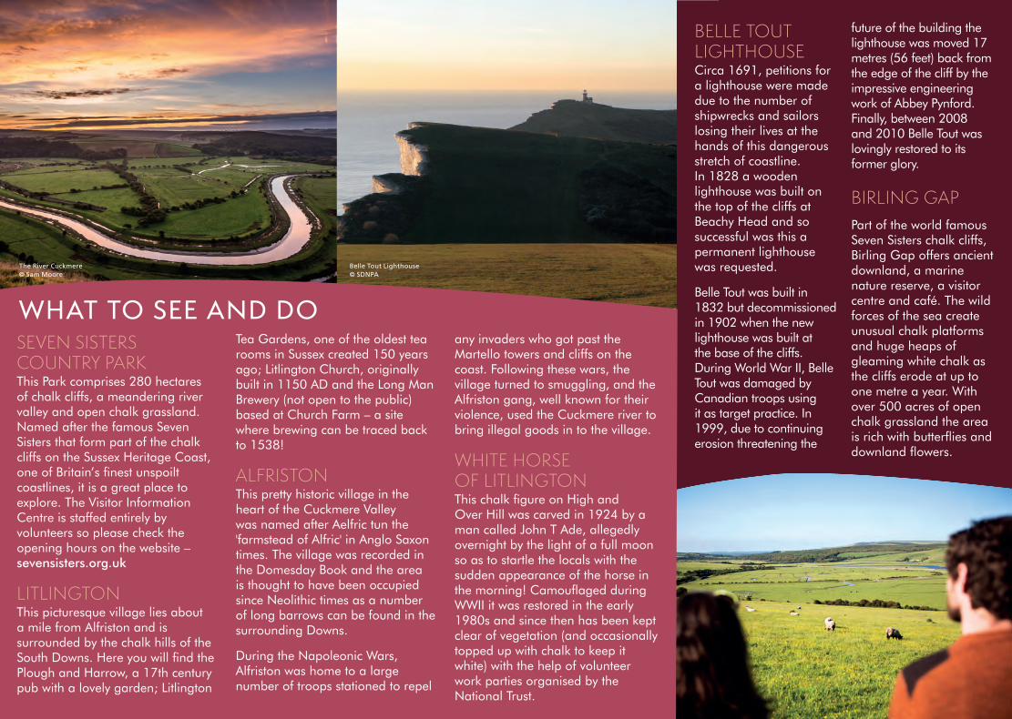
BELLE TOUT LIGHTHOUSECirca 1691, petitions for a lighthouse were made due to the number of shipwrecks and sailors losing their lives at the hands of this dangerous stretch of coastline. In 1828 a wooden lighthouse was built on the top of the cliffs at Beachy Head and so successful was this a permanent lighthouse was requested.
Belle Tout was built in 1832 but decommissioned in 1902 when the new lighthouse was built at the base of the cliffs. During World War II, Belle Tout was damaged by Canadian troops using it as target practice. In 1999, due to continuing erosion threatening the
future of the building the lighthouse was moved 17 metres (56 feet) back from the edge of the cliff by the impressive engineering work of Abbey Pynford. Finally, between 2008 and 2010 Belle Tout was lovingly restored to its former glory.
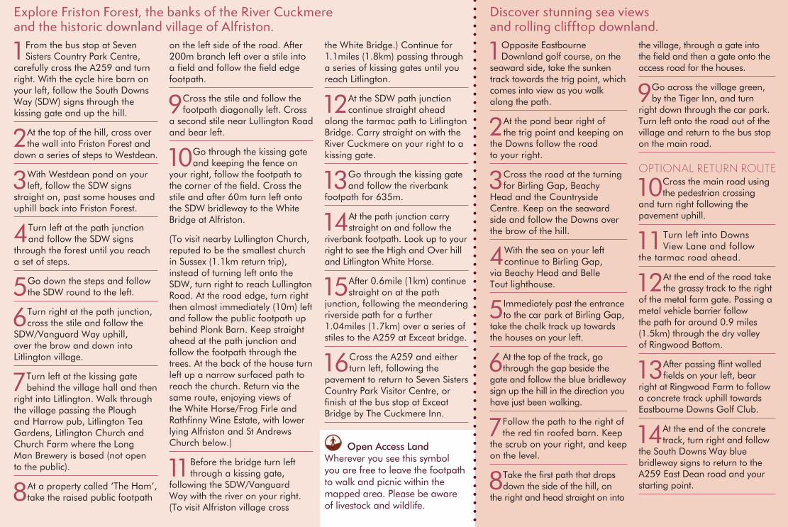
BIRLING GAPPart of the world famous Seven Sisters chalk cliffs, Birling Gap offers ancient downland, a marine nature reserve, a visitor centre and café. The wild forces of the sea create unusual chalk platforms and huge heaps of gleaming white chalk as the cliffs erode at up to one metre a year. With over 500 acres of open chalk grassland the area is rich with butterfl ies and downland fl owers.
SEVEN SISTERS COUNTRY PARK This Park comprises 280 hectares of chalk cliffs, a meandering river valley and open chalk grassland. Named after the famous Seven Sisters that form part of the chalk cliffs on the Sussex Heritage Coast, one of Britain’s fi nest unspoilt coastlines, it is a great place to explore. The Visitor Information Centre is staffed entirely by volunteers so please check the opening hours on the website – sevensisters.org.uk
LITLINGTON This picturesque village lies about a mile from Alfriston and is surrounded by the chalk hills of the South Downs. Here you will fi nd the Plough and Harrow, a 17th century pub with a lovely garden; Litlington
Tea Gardens, one of the oldest tea rooms in Sussex created 150 years ago; Litlington Church, originally built in 1150 AD and the Long Man Brewery (not open to the public) based at Church Farm – a site where brewing can be traced back to 1538!
ALFRISTONThis pretty historic village in the heart of the Cuckmere Valley was named after Aelfric tun the 'farmstead of Alfric' in Anglo Saxon times. The village was recorded in the Domesday Book and the area is thought to have been occupied since Neolithic times as a number of long barrows can be found in the surrounding Downs.
During the Napoleonic Wars, Alfriston was home to a large number of troops stationed to repel
any invaders who got past the Martello towers and cliffs on the coast. Following these wars, the village turned to smuggling, and the Alfriston gang, well known for their violence, used the Cuckmere river to bring illegal goods in to the village.
WHITE HORSE OF LITLINGTONThis chalk fi gure on High and Over Hill was carved in 1924 by a man called John T Ade, allegedly overnight by the light of a full moon so as to startle the locals with the sudden appearance of the horse in the morning! Camoufl aged during WWII it was restored in the early 1980s and since then has been kept clear of vegetation (and occasionally topped up with chalk to keep it white) with the help of volunteer work parties organised by the National Trust.
WHAT TO SEE AND DO
The River Cuckmere © Sam Moore
Belle Tout Lighthouse © SDNPA
TUNBRIDGETUNBRIDGETUNBRIDGETUNBRIDGETUNBRIDGETUNBRIDGETUNBRIDGEWELLSWELLSWELLSWELLSWELLSWELLSWELLSNational Park Area
RailwayStation
SDNPA/The Way Design/March ‘15. © SDNPA Crown copyright
Cover image ©National Trust Images/Megan Taylor. All uncredited photos © SDNPA/Mischa Haller. Printed on FSC certifi ed paper. Details correct at time of going to print. Please be aware that routes are shared with other users (vehicles, pedestrians, dogs, horses etc.) and users of this route do so at their own risk. We do not accept any responsibility for loss, damage or injury, however caused, arising directly or indirectly from use of this leafl et. Contains Ordnance Survey data © Crown copyright and database right 2013.
Please recycle me after use
0368 SDNPA Heritage walks.indd 1 02/06/2015 16:20
99 9799
HERITAGE COAST
SOUTH DOWNS WALKS
GODALMING
LEWES
BOGNOR REGIS
BRIGHTON & HOVE
MIDHURSTPULBOROUGH
PORTSMOUTH
PETERSFIELD
EASTBOURNE
TUNBRIDGEWELLS
WINCHESTER
SOUTHAMPTON
CHICHESTERHERITAGECOAST
GETTING HERECONTACTBy bus: There are regular services between Seaford and Eastbourne, visit traveline.info/se
By rail: Nearest stations are Seaford and Eastbourne. Visit nationalrail.co.uk
South Downs National Park Authority:01730 814810
@SDNPA
/SDNPA
FIND YOUR WAYFollow the arrows on waymarkers.
SOUTHDOWNS.GOV.UK
Footpath
Bridleway
Restricted byway
Byway
Open access land National Trail Acorn
TAKE THE LEADFor a safe and fun visit with your dog please remember to keep them on a lead around livestock and wildlife. Always bag and bin your dog poo – any public bin will do!
SOUTH DOWNS NATIONAL PARKFrom rolling hills to bustling market towns, the South Downs National Park’s landscapes cover 1,600km² of breathtaking views, hidden gems and quintessentially English scenery. A rich tapestry of wildlife, landscapes, tranquillity and visitor attractions, weave together a story of people and place in harmony.
For your guide to everything there is to see and do in the National Park visit southdowns.gov.uk/discovery-map
YOUR COUNTRYSIDE CODE: RESPECT. PROTECT. ENJOY.Respect other people• Leave gates and property as you fi nd them• Keep to the paths unless on Access Land
Protect the natural environment• Take your litter home• Keep dogs under effective control
Enjoy the outdoors• Plan ahead and be prepared• Follow advice and local signs
BELLE TOUT LIGHTHOUSECirca 1691, petitions for a lighthouse were made due to the number of shipwrecks and sailors losing their lives at the hands of this dangerous stretch of coastline. In 1828 a wooden lighthouse was built on the top of the cliffs at Beachy Head and so successful was this a permanent lighthouse was requested.
Belle Tout was built in 1832 but decommissioned in 1902 when the new lighthouse was built at the base of the cliffs. During World War II, Belle Tout was damaged by Canadian troops using it as target practice. In 1999, due to continuing erosion threatening the
future of the building the lighthouse was moved 17 metres (56 feet) back from the edge of the cliff by the impressive engineering work of Abbey Pynford. Finally, between 2008 and 2010 Belle Tout was lovingly restored to its former glory.
BIRLING GAPPart of the world famous Seven Sisters chalk cliffs, Birling Gap offers ancient downland, a marine nature reserve, a visitor centre and café. The wild forces of the sea create unusual chalk platforms and huge heaps of gleaming white chalk as the cliffs erode at up to one metre a year. With over 500 acres of open chalk grassland the area is rich with butterfl ies and downland fl owers.
SEVEN SISTERS COUNTRY PARK This Park comprises 280 hectares of chalk cliffs, a meandering river valley and open chalk grassland. Named after the famous Seven Sisters that form part of the chalk cliffs on the Sussex Heritage Coast, one of Britain’s fi nest unspoilt coastlines, it is a great place to explore. The Visitor Information Centre is staffed entirely by volunteers so please check the opening hours on the website – sevensisters.org.uk
LITLINGTON This picturesque village lies about a mile from Alfriston and is surrounded by the chalk hills of the South Downs. Here you will fi nd the Plough and Harrow, a 17th century pub with a lovely garden; Litlington
Tea Gardens, one of the oldest tea rooms in Sussex created 150 years ago; Litlington Church, originally built in 1150 AD and the Long Man Brewery (not open to the public) based at Church Farm – a site where brewing can be traced back to 1538!
ALFRISTONThis pretty historic village in the heart of the Cuckmere Valley was named after Aelfric tun the 'farmstead of Alfric' in Anglo Saxon times. The village was recorded in the Domesday Book and the area is thought to have been occupied since Neolithic times as a number of long barrows can be found in the surrounding Downs.
During the Napoleonic Wars, Alfriston was home to a large number of troops stationed to repel
any invaders who got past the Martello towers and cliffs on the coast. Following these wars, the village turned to smuggling, and the Alfriston gang, well known for their violence, used the Cuckmere river to bring illegal goods in to the village.
WHITE HORSE OF LITLINGTONThis chalk fi gure on High and Over Hill was carved in 1924 by a man called John T Ade, allegedly overnight by the light of a full moon so as to startle the locals with the sudden appearance of the horse in the morning! Camoufl aged during WWII it was restored in the early 1980s and since then has been kept clear of vegetation (and occasionally topped up with chalk to keep it white) with the help of volunteer work parties organised by the National Trust.
WHAT TO SEE AND DO
The River Cuckmere © Sam Moore
Belle Tout Lighthouse © SDNPA
TUNBRIDGE TUNBRIDGE TUNBRIDGE TUNBRIDGE TUNBRIDGE TUNBRIDGE TUNBRIDGEWELLS WELLS WELLS WELLS WELLS WELLS WELLS National Park Area
RailwayStation
SDNPA/The Way Design/March ‘15. © SDNPA Crown copyright
Cover image ©National Trust Images/Megan Taylor. All uncredited photos © SDNPA/Mischa Haller. Printed on FSC certifi ed paper. Details correct at time of going to print. Please be aware that routes are shared with other users (vehicles, pedestrians, dogs, horses etc.) and users of this route do so at their own risk. We do not accept any responsibility for loss, damage or injury, however caused, arising directly or indirectly from use of this leafl et. Contains Ordnance Survey data © Crown copyright and database right 2013.
Please recycle me after use
0368 SDNPA Heritage walks.indd 102/06/2015 16:20
9999 97
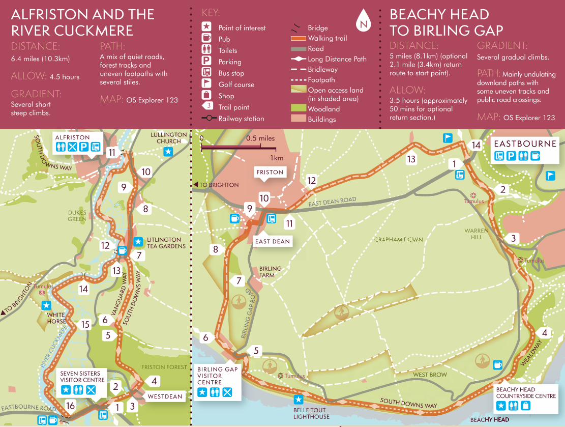
SEVEN SISTERSVISITOR CENTRE
Tumulus
Tumulus
Tumulus
Tumulus
FRISTON
ALFRISTON
WESTDEAN
EAST DEAN
BIRLING FARM
BELLE TOUTLIGHTHOUSE
EASTBOURNE
WHITE HORSE
LITLINGTONTEA GARDENS
LULLINGTONCHURCH
CRAPHAM DOWN
FRISTON FORESTFRISTON FORESTFRISTON FOREST
DUKESDUKESGREENGREEN
WARRENWARRENHILL
WEST BROW
2
14
3
4
5
7
6
87
15
8
10
1
42
16 3
13
14
5
6
9
11
12
109
12
11
13
SOUTH DOWNS WAY
SOU
TH D
OW
NS
WAY
SOU
TH D
O
WNS WAY
VAN
GU
ARD
WAY
WEALD
WAY
BEACHY HEAD
BIRL
ING
GA
P R
OAD
EAST DEAN ROAD
EASTBOURNE ROAD
1
RIVE
R CUCKM
ERE
BEACHY HEADBEACHY HEAD
BEACHY HEAD COUNTRYSIDE CENTRE
FRISTON FOREST
5
BIRLING GAPVISITOR CENTRE
TO BRIGHTO
N
TO BRIGHTON
Explore Friston Forest, the banks of the River Cuckmere and the historic downland village of Alfriston.
KEY: Point of interest
Pub
Toilets
Parking
Bus stop
Golf course
Shop
Trail point
Railway station
Bridge Walking trail Road Long Distance Path Bridleway Footpath Open access land (in shaded area) Woodland Buildings
0 0.5 miles
1km
1 Opposite Eastbourne Downland golf course, on the
seaward side, take the sunken track towards the trig point, which comes into view as you walk along the path.
2 At the pond bear right of the trig point and keeping on
the Downs follow the road to your right.
3 Cross the road at the turning for Birling Gap, Beachy
Head and the Countryside Centre. Keep on the seaward side and follow the Downs over the brow of the hill.
4 With the sea on your left continue to Birling Gap,
via Beachy Head and Belle Tout lighthouse.
5 Immediately past the entrance to the car park at Birling Gap,
take the chalk track up towards the houses on your left.
6 At the top of the track, go through the gap beside the
gate and follow the blue bridleway sign up the hill in the direction you have just been walking.
7 Follow the path to the right of the red tin roofed barn. Keep
the scrub on your right, and keep on the level.
8 Take the fi rst path that drops down the side of the hill, on
the right and head straight on into
the village, through a gate into the fi eld and then a gate onto the access road for the houses.
9 Go across the village green, by the Tiger Inn, and turn
right down through the car park. Turn left onto the road out of the village and return to the bus stop on the main road.
OPTIONAL RETURN ROUTE
10 Cross the main road using the pedestrian crossing
and turn right following the pavement uphill.
11 Turn left into Downs View Lane and follow
the tarmac road ahead.
12 At the end of the road take the grassy track to the right
of the metal farm gate. Passing a metal vehicle barrier follow the path for around 0.9 miles (1.5km) through the dry valley of Ringwood Bottom.
13 After passing fl int walled fi elds on your left, bear
right at Ringwood Farm to follow a concrete track uphill towards Eastbourne Downs Golf Club.
14 At the end of the concrete track, turn right and follow
the South Downs Way blue bridleway signs to return to the A259 East Dean road and your starting point.
Discover stunning sea views and rolling clifftop downland.
DISTANCE:5 miles (8.1km) (optional 2.1 mile (3.4km) return route to start point).
ALLOW: 3.5 hours (approximately 50 mins for optional return section.)
GRADIENT: Several gradual climbs.
PATH: Mainly undulating downland paths with some uneven tracks and public road crossings.
MAP: OS Explorer 123
DISTANCE:6.4 miles (10.3km)
ALLOW: 4.5 hours
GRADIENT:Several short steep climbs.
PATH:A mix of quiet roads, forest tracks and uneven footpaths with several stiles.
MAP: OS Explorer 123
BEACHY HEAD TO BIRLING GAP
ALFRISTON AND THE RIVER CUCKMERE N
1 From the bus stop at Seven Sisters Country Park Centre,
carefully cross the A259 and turn right. With the cycle hire barn on your left, follow the South Downs Way (SDW) signs through the kissing gate and up the hill.
2 At the top of the hill, cross over the wall into Friston Forest and
down a series of steps to Westdean.
3 With Westdean pond on your left, follow the SDW signs
straight on, past some houses and uphill back into Friston Forest.
4 Turn left at the path junction and follow the SDW signs
through the forest until you reach a set of steps.
5Go down the steps and follow the SDW round to the left.
6 Turn right at the path junction, cross the stile and follow the
SDW/Vanguard Way uphill, over the brow and down into Litlington village.
7 Turn left at the kissing gate behind the village hall and then
right into Litlington. Walk through the village passing the Plough and Harrow pub, Litlington Tea Gardens, Litlington Church and Church Farm where the Long Man Brewery is based (not open to the public).
8 At a property called ‘The Ham’, take the raised public footpath
on the left side of the road. After 200m branch left over a stile into a fi eld and follow the fi eld edge footpath.
9 Cross the stile and follow the footpath diagonally left. Cross
a second stile near Lullington Road and bear left.
10 Go through the kissing gate and keeping the fence on
your right, follow the footpath to the corner of the fi eld. Cross the stile and after 60m turn left onto the SDW bridleway to the White Bridge at Alfriston.
(To visit nearby Lullington Church, reputed to be the smallest church in Sussex (1.1km return trip), instead of turning left onto the SDW, turn right to reach Lullington Road. At the road edge, turn right then almost immediately (10m) left and follow the public footpath up behind Plonk Barn. Keep straight ahead at the path junction and follow the footpath through the trees. At the back of the house turn left up a narrow surfaced path to reach the church. Return via the same route, enjoying views of the White Horse/Frog Firle and Rathfi nny Wine Estate, with lower lying Alfriston and St Andrews Church below.)
11 Before the bridge turn left through a kissing gate,
following the SDW/Vanguard Way with the river on your right. (To visit Alfriston village cross
the White Bridge.) Continue for 1.1miles (1.8km) passing through a series of kissing gates until you reach Litlington.
12 At the SDW path junction continue straight ahead
along the tarmac path to Litlington Bridge. Carry straight on with the River Cuckmere on your right to a kissing gate.
13 Go through the kissing gate and follow the riverbank
footpath for 635m.
14 At the path junction carry straight on and follow the
riverbank footpath. Look up to your right to see the High and Over hill and Litlington White Horse.
15 After 0.6mile (1km) continue straight on at the path
junction, following the meandering riverside path for a further 1.04miles (1.7km) over a series of stiles to the A259 at Exceat bridge.
16 Cross the A259 and either turn left, following the
pavement to return to Seven Sisters Country Park Visitor Centre, or fi nish at the bus stop at Exceat Bridge by The Cuckmere Inn.
Open Access LandWherever you see this symbol you are free to leave the footpath to walk and picnic within the mapped area. Please be aware of livestock and wildlife.
0368 SDNPA Heritage walks.indd 2 02/06/2015 16:20
9999 97
SEVEN SISTERSVISITOR CENTRE
Tumulus
Tumulus
Tumulus
Tumulus
FRISTON
ALFRISTON
WESTDEAN
EAST DEAN
BIRLING FARM
BELLE TOUTLIGHTHOUSE
EASTBOURNE
WHITE HORSE
LITLINGTONTEA GARDENS
LULLINGTONCHURCH
CRAPHAM DOWN
FRISTON FORESTFRISTON FORESTFRISTON FOREST
DUKESDUKESGREENGREEN
WARRENWARRENHILL
WEST BROW
2
14
3
4
5
7
6
87
15
8
10
1
42
16 3
13
14
5
6
9
11
12
109
12
11
13
SOUTH DOWNS WAY
SOU
TH D
OW
NS
WAY
SOU
TH D
O
WNS WAY
VAN
GU
ARD
WAY
WEALD
WAY
BEACHY HEAD
BIRL
ING
GA
P R
OAD
EAST DEAN ROAD
EASTBOURNE ROAD
1
RIVE
R CUCKM
ERE
BEACHY HEADBEACHY HEAD
BEACHY HEAD COUNTRYSIDE CENTRE
FRISTON FOREST
5
BIRLING GAPVISITOR CENTRE
TO BRIGHTO
N
TO BRIGHTON
Explore Friston Forest, the banks of the River Cuckmere and the historic downland village of Alfriston.
KEY: Point of interest
Pub
Toilets
Parking
Bus stop
Golf course
Shop
Trail point
Railway station
Bridge Walking trail Road Long Distance Path Bridleway Footpath Open access land (in shaded area) Woodland Buildings
0 0.5 miles
1km
1 Opposite Eastbourne Downland golf course, on the
seaward side, take the sunken track towards the trig point, which comes into view as you walk along the path.
2 At the pond bear right of the trig point and keeping on
the Downs follow the road to your right.
3 Cross the road at the turning for Birling Gap, Beachy
Head and the Countryside Centre. Keep on the seaward side and follow the Downs over the brow of the hill.
4 With the sea on your left continue to Birling Gap,
via Beachy Head and Belle Tout lighthouse.
5 Immediately past the entrance to the car park at Birling Gap,
take the chalk track up towards the houses on your left.
6 At the top of the track, go through the gap beside the
gate and follow the blue bridleway sign up the hill in the direction you have just been walking.
7 Follow the path to the right of the red tin roofed barn. Keep
the scrub on your right, and keep on the level.
8 Take the fi rst path that drops down the side of the hill, on
the right and head straight on into
the village, through a gate into the fi eld and then a gate onto the access road for the houses.
9 Go across the village green, by the Tiger Inn, and turn
right down through the car park. Turn left onto the road out of the village and return to the bus stop on the main road.
OPTIONAL RETURN ROUTE
10 Cross the main road using the pedestrian crossing
and turn right following the pavement uphill.
11 Turn left into Downs View Lane and follow
the tarmac road ahead.
12 At the end of the road take the grassy track to the right
of the metal farm gate. Passing a metal vehicle barrier follow the path for around 0.9 miles (1.5km) through the dry valley of Ringwood Bottom.
13 After passing fl int walled fi elds on your left, bear
right at Ringwood Farm to follow a concrete track uphill towards Eastbourne Downs Golf Club.
14 At the end of the concrete track, turn right and follow
the South Downs Way blue bridleway signs to return to the A259 East Dean road and your starting point.
Discover stunning sea views and rolling clifftop downland.
DISTANCE:5 miles (8.1km) (optional 2.1 mile (3.4km) return route to start point).
ALLOW: 3.5 hours (approximately 50 mins for optional return section.)
GRADIENT: Several gradual climbs.
PATH: Mainly undulating downland paths with some uneven tracks and public road crossings.
MAP: OS Explorer 123
DISTANCE:6.4 miles (10.3km)
ALLOW: 4.5 hours
GRADIENT:Several short steep climbs.
PATH:A mix of quiet roads, forest tracks and uneven footpaths with several stiles.
MAP: OS Explorer 123
BEACHY HEAD TO BIRLING GAP
ALFRISTON AND THE RIVER CUCKMERE N
1 From the bus stop at Seven Sisters Country Park Centre,
carefully cross the A259 and turn right. With the cycle hire barn on your left, follow the South Downs Way (SDW) signs through the kissing gate and up the hill.
2 At the top of the hill, cross over the wall into Friston Forest and
down a series of steps to Westdean.
3 With Westdean pond on your left, follow the SDW signs
straight on, past some houses and uphill back into Friston Forest.
4 Turn left at the path junction and follow the SDW signs
through the forest until you reach a set of steps.
5Go down the steps and follow the SDW round to the left.
6 Turn right at the path junction, cross the stile and follow the
SDW/Vanguard Way uphill, over the brow and down into Litlington village.
7 Turn left at the kissing gate behind the village hall and then
right into Litlington. Walk through the village passing the Plough and Harrow pub, Litlington Tea Gardens, Litlington Church and Church Farm where the Long Man Brewery is based (not open to the public).
8 At a property called ‘The Ham’, take the raised public footpath
on the left side of the road. After 200m branch left over a stile into a fi eld and follow the fi eld edge footpath.
9 Cross the stile and follow the footpath diagonally left. Cross
a second stile near Lullington Road and bear left.
10 Go through the kissing gate and keeping the fence on
your right, follow the footpath to the corner of the fi eld. Cross the stile and after 60m turn left onto the SDW bridleway to the White Bridge at Alfriston.
(To visit nearby Lullington Church, reputed to be the smallest church in Sussex (1.1km return trip), instead of turning left onto the SDW, turn right to reach Lullington Road. At the road edge, turn right then almost immediately (10m) left and follow the public footpath up behind Plonk Barn. Keep straight ahead at the path junction and follow the footpath through the trees. At the back of the house turn left up a narrow surfaced path to reach the church. Return via the same route, enjoying views of the White Horse/Frog Firle and Rathfi nny Wine Estate, with lower lying Alfriston and St Andrews Church below.)
11 Before the bridge turn left through a kissing gate,
following the SDW/Vanguard Way with the river on your right. (To visit Alfriston village cross
the White Bridge.) Continue for 1.1miles (1.8km) passing through a series of kissing gates until you reach Litlington.
12 At the SDW path junction continue straight ahead
along the tarmac path to Litlington Bridge. Carry straight on with the River Cuckmere on your right to a kissing gate.
13 Go through the kissing gate and follow the riverbank
footpath for 635m.
14 At the path junction carry straight on and follow the
riverbank footpath. Look up to your right to see the High and Over hill and Litlington White Horse.
15 After 0.6mile (1km) continue straight on at the path
junction, following the meandering riverside path for a further 1.04miles (1.7km) over a series of stiles to the A259 at Exceat bridge.
16 Cross the A259 and either turn left, following the
pavement to return to Seven Sisters Country Park Visitor Centre, or fi nish at the bus stop at Exceat Bridge by The Cuckmere Inn.
Open Access LandWherever you see this symbol you are free to leave the footpath to walk and picnic within the mapped area. Please be aware of livestock and wildlife.
0368 SDNPA Heritage walks.indd 2 02/06/2015 16:20