belmont park redevelopment project final scope for ... · draft environmental impact statement a....
TRANSCRIPT
1 August 29, 2018
Belmont Park Redevelopment Project
Final Scope for Preparation of a
Draft Environmental Impact Statement
A. INTRODUCTION
This document is the final scope of work (“Final Scope”) for a Draft Environmental Impact
Statement (DEIS) to inform the environmental review process for the proposed redevelopment of
two underutilized parcels (the “Project Sites”) located within Belmont Park in the unincorporated
hamlet of Elmont, Town of Hempstead, Nassau County, NY. This Final Scope has been prepared
to describe the Proposed Project (as defined below), present the proposed framework and
methodologies for the DEIS analysis, and discuss the procedures to be followed in the preparation
of the DEIS. The DEIS will be prepared pursuant to the State Environmental Quality Review Act
(SEQRA) and its implementing regulations at 6 NYCRR Part 617. Empire State Development
(ESD) is serving as the lead agency under SEQRA.
A Draft Scope for the project was issued on February 27, 2018. Oral and written comments were
received during the scoping meetings held by ESD on March 22, 2018 at Elmont Memorial Library
at 700 Hempstead Turnpike, Elmont, NY 11003. Written comments were accepted from the
issuance of the Draft Scope through the public comment period, which ended April 12, 2018. The
majority of the comments relevant to the Draft Scope focused on: (1) potential health and safety
concerns related to the proposed siting of a new electrical substation to serve the Proposed Project;
(2) traffic generated by the proposed uses and associated pedestrian safety; (3) the adequacy of
parking for the proposed uses; (4) infrastructure and community services capacity concerns; (5)
buffers between the Project Sites, North Lot, and adjacent communities (6) visual and safety
concerns related to the proposed height of the hotel; and (7) concerns about whether the hotel
could include a casino. A number of comments were made in general support or opposition to the
project, but did not relate to the proposed approach or methodology for the impact assessments.
Other comments suggested editorial changes. In addition to the comments described above,
several comments requested analyses that are beyond the scope of this project’s SEQRA review
(see Appendix A, “Response to Comments”).
Since the Draft Scope was issued, New York Arena Partners, LLC (“NYAP” or “the Applicant”)
selected Site Plan Option 2, which was one of two site plan options under consideration at the time
of the issuance of the Draft Scope and when the scoping meetings were held. The primary
difference between the two options was the allocation of the proposed retail uses across Sites A
and B. Site Plan Option 2 as described in this Final Scope will serve as the Proposed Project for
purposes of the environmental review in the DEIS. Site Plan Option 1 will be evaluated as an
alternative.
In addition to the selection of the preferred site plan, project design development since the release
of the Draft Scope has resulted in the following programmatic adjustments:
Changes in open space. In consultation with ESD and based on concerns expressed by
members of the public, NYAP has proposed modifications to the proposed open space. In

Belmont Park Redevelopment Project
2
particular, the proposed publicly accessible open space on Site B would no longer include
active recreational amenities, but would include landscaped, passive recreational areas. Also,
the proposed acreage of open space on Site B was reduced to approximately 3.75 acres (from
approximately 6.5 acres); this loss would be offset by NYAP’s commitment to make
improvements to an existing community park in the local area.
Changes in parking. The proposed number of parking spaces to be provided on Sites A and B
increased from 2,200 to 3,440 under Site Plan Option 2, and some spaces that had been surface
parking are now proposed to be underground or structured parking. Also, based on an
engineering study by the Applicant, the calculation of anticipated number of existing parking
spaces that could be utilized on the existing “North Lot” and “South Lot” (shown on Figure
1) increased from approximately 3,275 surface parking spaces to approximately 4,010 surface
parking spaces. The total parking to accommodate the Proposed Project is now anticipated to
be up to 7,450 parking spaces.
A change in the location of the proposed electrical substation. PSEG Long Island, in consultation
with ESD and based on concerns expressed by the surrounding community, has relocated the
proposed electrical substation from the originally proposed location immediately adjacent to the
Floral Park Bellerose School athletic field to a location in the vicinity of the Cross Island Parkway
ramps, just north of the Racetrack, directly adjacent to the North Lot to the west (see Figure 1).
Change in proposed hotel height. The height of the proposed hotel was reduced from
approximately 265 feet to a maximum height of 150 feet.
This Final Scope reflects changes made in response to relevant public comments on the Draft
Scope, as well as additional details on the locations of the proposed uses, open space, and parking.
Deletions are not shown in this document. However, additions to text not found in the Draft Scope
have been incorporated into the Final Scope and are indicated by double-underlining.
As shown in Figure 1, the area proposed for redevelopment is located on two Project Sites south
of the existing Belmont Park Racetrack and Grandstand, and includes approximately 15 acres on
“Site A,” north of Hempstead Turnpike, and approximately 28 acres on “Site B,” south of
Hempstead Turnpike. The Project Sites are owned by the State of New York (the State) acting by
and through the Franchise Oversight Board (FOB), and are leased through a ground lease (the
“Ground Lease”) to The New York Racing Association, Inc. (NYRA).1
NYAP proposes to construct a sports, hospitality, and entertainment destination at Belmont Park.
The Proposed Project would redevelop the Project Sites with: an arena for the New York Islanders
National Hockey League (NHL) franchise and for other sports, music, and entertainment events;
dining, retail, and entertainment uses; a hotel; commercial office space; community center space;
publicly accessible open space; parking; and one or more pedestrian connections providing access
between Sites A and B. In addition to the parking proposed for the Project Sites, it is expected that
visitors to the Proposed Project would also utilize existing parking at Belmont Park in the North
Lot and South Lot through a shared parking agreement with the FOB and NYRA.2 Construction
of the Proposed Project would be expected to occur in a single phase over a period of
1 The tax parcels that comprise the Project Sites include: 32-B-82A (portion of) north of Hempstead
Turnpike, and 32-372-81, 32-374-1, 32-391-36, 32-392-226, 32-393-1, 32-394-1, 32-395-1, 32-396-1, and
32-397-50 south of Hempstead Turnpike.
2 It is anticipated that the North Lot would only be utilized to accommodate parking demand for events at
the arena and Racetrack.
!H
North Lot
SouthLot
Site A
Site B
Belmont ParkRace Track
Nas
sau
Que
ens
Nassau
Queens
UV24
UV24
Cross Island P
kwy
Hempstead Ave
Hempstead Tpke
Pla
infie
ld A
ve
Belmont Park
BELMONT PARK REDEVELOPMENT PROJECT
Project LocationFigure 1
0 1,000 FEET
Project Sites
North and South Parking Lots
Proposed Belmont Electrical Substation
Long Island Rail Road (LIRR)
!H Belmont Park LIRR Station
Nassau County/Queens County Boundary
8/27
/2018
Manhattan
Brooklyn
Queens
Bronx
NassauNY
Project Location
!\

Final Scope
3
approximately 28 months, starting in 2019, with completion of the full build-out of all project
components in 2021.
The Proposed Project requires a number of actions (collectively, the “Proposed Actions”),
including: adoption and authorization of a General Project Plan (GPP) in accordance with the New
York State Urban Development Corporation Act by ESD, which will include an override of the
Town of Hempstead Building Zone Ordinance and provisions in the Town Code, where
applicable. In addition, the Proposed Actions include conveyance of the Project Sites to ESD from
the FOB, lease approval from the FOB, and the necessary approvals to facilitate the construction
of an electrical substation immediately adjacent to the North Lot to the west, and associated
underground distribution feeders and underground transmission lines to serve the Proposed Project
(to be constructed by the Long Island Lighting Company d/b/a Long Island Power Authority
[LIPA] and operated by the Public Service Enterprise Group Long Island [PSEG Long Island]).
These Proposed Actions are discretionary actions subject to environmental review under SEQRA,
Article 8 of the Environmental Conservation Law, and its implementing regulations at 6 NYCRR
Part 617. Because the Proposed Actions may have significant adverse environmental impacts,
ESD has determined that a DEIS will be prepared. To ensure comprehensive environmental review
in accordance with SEQRA, the potential environmental impacts associated with implementation
of the Proposed Actions will be evaluated in the DEIS.
This Final Scope has been prepared to describe the Proposed Project, present the proposed
framework for the DEIS analysis, and discuss the scope of topics to be examined and
methodologies to be followed in the preparation of the DEIS.
B. BACKGROUND
The Project Sites are located within Belmont Park, a State-owned property that is leased by the
FOB to NYRA. Belmont Park is one of the major thoroughbred horseracing facilities in the
country and has been in active use since 1905. It hosts the annual Belmont Stakes, the final race
of the Triple Crown, as part of its Spring Meet that runs from the end of April through mid-July.
The Fall Meet runs from early September through October. In addition, Belmont Park is used year-
round for training facilities, including stables and residential accommodations for racing-related
workers. The Grandstand, one of the largest in thoroughbred racing, was redeveloped between
1964 and 1968, and has a seating capacity of 33,000 with a total capacity for 100,000 attendees.
The premier racing event is the Belmont Stakes, which typically attracts between 60,000 to
100,000 attendees. Several stakes races in the Spring and Fall Meets also attract a larger than
average daily attendance. Outside of these specific events, Belmont Park has an average daily
attendance of approximately 3,000 visitors during the Spring and Fall Meets.
Construction and operation of the Proposed Project would be coordinated with NYRA and the
FOB to protect the operational requirements of the Belmont Stakes and other horse racing events
held during the Spring and Fall Meets. For example, as required by the Developer Request for
Proposals (RFP), any parking provided on the Project Sites would be made available for use by
Belmont Park in connection with the running of the Belmont Stakes and the Breeder’s Cup.
Moreover, there would be no arena events held on Belmont Stakes day.
DEVELOPER REQUEST FOR PROPOSALS (RFP) PROCESS
The underutilization of certain parcels within Belmont Park has led the State to formulate
strategies to enhance economic development opportunities. The RFP solicitation for
redevelopment of the Project Sites was issued on July 31, 2017 with the intention of strengthening
Belmont Park Redevelopment Project
4
Belmont Park as a premier destination for entertainment, sports, recreation, retail, and hospitality
on Long Island. In addition to the overall goal of development that would complement the horse
racing and wagering at Belmont Park, several other development objectives were also outlined in
the RFP (see “Purpose and Need,” below).
Proposals were encouraged to consider entertainment, sports, recreation, hospitality, and retail
uses. Residential development, gaming (e.g., VLT, table games, pari-mutuel, simulcast wagering,
and casinos), and horseracing were specifically excluded from further consideration. Three
submissions were presented to ESD by September 28, 2017, including a proposal submitted by
NYAP. On December 21, 2017, NYAP was conditionally designated by ESD as developer of the
Project Sites, subject to completion of the requisite environmental review, among other conditions.
Following the RFP process and NYAP’s conditional designation, NYAP, in consultation with
ESD and members of the community, modified the placement of proposed uses on the Project
Sites. This modified plan constitutes the “Proposed Project” as described in this Final Scope and
that will be analyzed in the DEIS. NYAP’s contemplated site plan included in its original
submission to ESD (Site Plan Option 1 from the Draft Scope) will be considered as an alternative
to the Proposed Project in the DEIS.
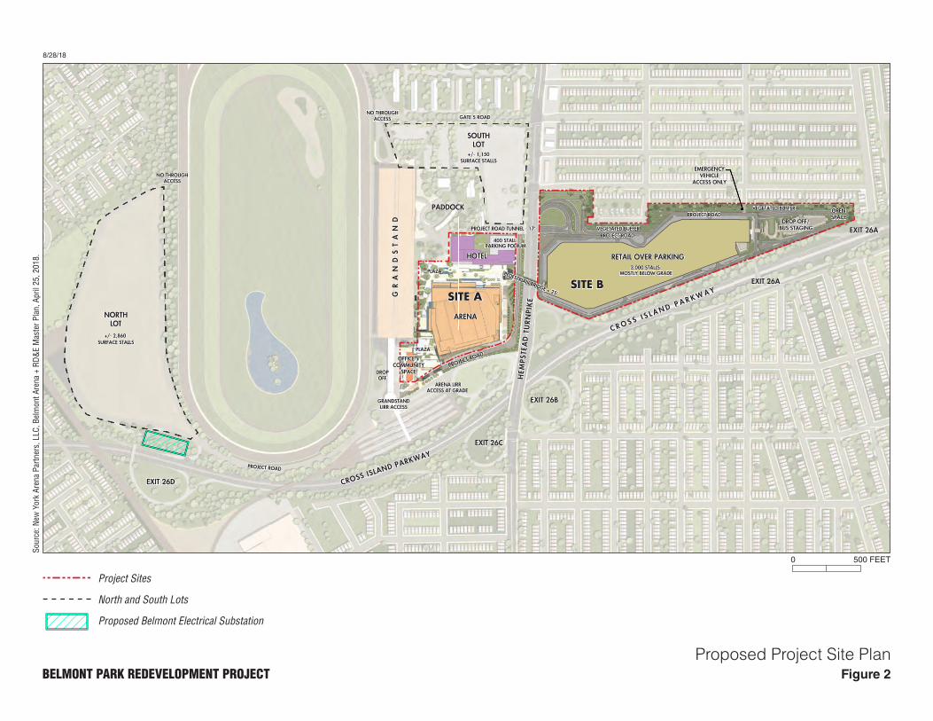
C. PROJECT DESCRIPTION AND PURPOSE AND NEED
PROJECT SITES
The Project Sites total approximately 43 acres, consisting of approximately 15 acres on “Site A,”
north of Hempstead Turnpike, and approximately 28 acres on “Site B,” south of Hempstead
Turnpike (see Figure 1). Site A is currently used for surface parking and includes a portion of a
privately operated picnic area (the “Backyard”) adjacent to the Belmont Park paddock. Site A is
bordered on the south by Hempstead Turnpike, a four- to six-lane local road that is a major
commercial corridor. Site A is also adjacent to the Cross Island Parkway, a six-lane limited access
highway that extends north from the intersection of the Southern State and Belt Parkways near
Valley Stream to its intersection with the Whitestone Expressway near College Point, Queens. West of Site A, the Cross Island Parkway runs along the Nassau-Queens border. Immediately
West of Site A is the Belmont Park station of the Long Island Rail Road (“LIRR”), located on a
spur of the Hempstead Branch. Belmont Park station is a seasonal-use LIRR facility; the station
is open and train service is operated only during the Belmont Park racing seasons. The ticket office
is open at Belmont Park station on Belmont Stakes day only.
Site B, located south of Hempstead Turnpike, is an approximately 28-acre parcel currently used
for vehicle storage and as surface parking for Belmont Park visitors on large-volume event days
(e.g., the Belmont Stakes).
The Project Sites are owned by the State acting by and through the FOB, and are leased through a
Ground Lease to NYRA. In accordance with the Ground Lease, the State has the ability to sever
from the Ground Lease a portion of Site A and the entirety of Site B.3
OTHER DIRECTLY AFFECTED AREAS
In addition to the two Project Sites, it is expected that NYAP would utilize the existing North and South
Lots at Belmont Park for additional parking through a shared parking agreement with the FOB and
3 With the Proposed Actions NYRA would surrender approximately 7 acres on Site A.

Final Scope
5
NYRA. The North Lot is an unpaved parcel located north of the Racetrack that, based on an
engineering study conducted by the Applicant, can accommodate approximately 2,860 spaces, and is
currently utilized for Belmont Park parking only on Belmont Stakes day, as well as for vehicle storage.
The North Lot is also bordered by the LIRR tracks to the north, the Floral Park Bellerose School athletic
field to the east, and the Cross Island Parkway to the west. The South Lot is located to the east of the
proposed arena, south of the Racetrack, and based on an engineering study can accommodate
approximately 1,150 spaces. The exact number of parking spaces that would be available on the North
and South Lots would be subject to the conditions of the shared parking agreement.
Directly adjacent and to the west of the North Lot is the location of the proposed electrical
substation (see Figure 1). This additional substation is required to service the Proposed Project
because Belmont Park currently does not have the infrastructure necessary to accommodate the
Proposed Project’s energy demand. The electrical substation would be located in the vicinity of
the Cross Island Parkway ramps, just north of the Racetrack. In addition to the substation, the
Proposed Actions would facilitate the construction of associated underground distribution feeders
and underground transmission lines, all of which would be operated by PSEG Long Island. PSEG
Long Island must obtain easements from the FOB for an approximately 42,450-square-foot (sf)
area for construction of the substation and associated feeders. The underground distribution feeder
cables would extend south, around the Belmont Park Racetrack, and to the proposed uses on Site
A. Underground transmission lines would extend west from the proposed substation along
Belmont Park Road for approximately 1.5 miles, and tie into existing overhead power lines on
Plainfield Avenue. An overhead bypass would also be installed on Plainfield Avenue.
PROJECT DESCRIPTION
The Proposed Project would replace the underutilized paved parking lots that exist on Sites A and
B with an arena for the New York Islanders NHL franchise and for other sports, music and
entertainment events; dining, retail, and entertainment uses; a hotel; commercial office space;
community center space; publicly accessible open space; parking; and one or more pedestrian
connections providing access between Sites A and B. The proposed program is specified in Table
1, and additional description of the program components are provided below. Figure 2 presents
the Proposed Project site plan, which illustrates the location of the various program components.
ARENA
The proposed multi-purpose arena would be a new state-of-the-art facility located in the western
central portion of Site A. The arena would contain up to 18,000 seats for hockey; it has been
designed to the demand specifications of a NHL facility and would be the home of the New York
Islanders. In addition to serving as a professional hockey venue, the building would host major
concerts, college sports, conferences, and family events.
In addition to the approximately 44 to 60 New York Islanders home games,4 NYAP envisions
approximately 145 non-NHL arena event days annually, including: approximately 50 marquee
concert/entertainment event days that would fully utilize the arena’s space (approximately 19,000
seats); approximately 65 large to medium event days (utilizing between 6,000 and 11,500 seats), such
as Disney on Ice, Cirque Du Soleil, E-Sports, or High School sports; and approximately 30 small or
4 Based on a current NHL schedule, there would be approximately 3 pre-season home games, 41 regular
season home games, and up to 16 post-season home games.
8/28/18
Figure 2BELMONT PARK REDEVELOPMENT PROJECTProposed Project Site Plan
ARENA
SITE ASITE B
RETAIL OVER PARKING
C R O S S I S L A N D P A R K W A Y
EXIT 26B
EXIT 26C
EXIT 26A
EXIT 26A
EXIT 26D
SOUTHLOT
NORTHLOT
PADDOCK
3,000 STALLS MOSTLY BELOW GRADE
GATE 5 ROAD
PROJECT ROAD
CROSS ISLAND PARKWAY
+/- 1,150SURFACE STALLS
+/- 2,860 SURFACE STALLS
NO THROUGHACCESS
PEDESTRIAN BRIDGE + 25’
HOTEL
OPENSPACE
DROP OFF/BUS STAGING
VEGETATED BUFFER
VEGETATED BUFFERPROJECT ROAD TUNNEL - 17’
EMERGENCYVEHICLE
ACCESS ONLY
PROJECT ROAD
PROJECT ROAD
ARENA LIRRACCESS AT GRADE
GRANDSTANDLIRR ACCESS
DROPOFF
PLAZA
PLAZA
OFFICE +COMMUNITY
SPACE
GR
AN
DS
TA
ND
PROJECT ROAD
400 STALLPARKING PODIUM
NO THROUGHACCESS
HEM
PSTE
AD
TU
RNPI
KE
Sour
ce: N
ew Y
ork
Aren
a Pa
rtner
s, L
LC, B
elm
ont A
rena
+ R
D&E
Mas
ter P
lan,
Apr
il 25
, 201
8.
500 FEET0
Project Sites
North and South Lots
Proposed Belmont Electrical Substation
Belmont Park Redevelopment Project
6
non-ticketed event days (3,500 seats or less), such as conferences, expos, graduations, or community
events.
Table 1
Proposed Program Proposed Use Proposed Amount
Arena 690,000 gross square feet
(gsf) (Up to 19,000 seats1)
Retail, Dining, and Entertainment Up to 435,000 gsf2
Hotel 230,000 gsf
(Up to 250 keys)
Office 30,000 gsf
Community Space 10,000 gsf
Open Space 250,470 sf
(approximately 5.75 acres)3
Parking (3,440 spaces)4
Notes: 1 Up to 18,000 seats for NHL hockey; up to 19,000 seats for other select events. 2 Site A would include a minimum of 85,000 gsf and up to 135,000 gsf of “experiential”
retail and food and beverage uses; and Site B would include a minimum of 300,000 gsf and a maximum of 350,000 gsf of luxury outlet stores within a “retail village.” The total amount of retail would add up to the overall maximum of 435,000 gsf of retail across the entire development.
3 A would include approximately 2.0 acres of publicly accessible open space and Site B
would include approximately 3.75 acres of publicly accessible space. 4 Site A would include approximately 400 spaces in the hotel podium and an additional 40
spaces for player parking within the arena’s marshalling area; Site B would include approximately 3,000 spaces of below-grade parking. In addition to parking provided on Sites A and B, it is anticipated that NYAP, through a shared parking agreement with the FOB and NYRA, would utilize existing parking on the North and South Lots (up to approximately 4,010 surface parking spaces).
Source: NYAP, August 2018.
RETAIL, DINING, AND ENTERTAINMENT
As detailed below, on Sites A and B, two separate and distinct retail, dining, and entertainment
experiences are proposed. The site plan includes up to 435,000 gsf of retail.
Site A
Up to approximately 135,000 gsf of “experiential” retail and food and beverage uses would be
located on Site A, consisting primarily of dining uses. Unlike the retail proposed on Site B (see
below), the experiential retail proposed on Site A would be expected to draw customers largely
from the proposed arena’s attendees, the proposed hotel’s guests, and Belmont Park patrons, as
well as the community at large. A program of pop-up installations and special events would
complement the dining experience.
Site B
Up to approximately 350,000 gsf of destination retail uses with an average storefront size of 2,000
sf is proposed within a “retail village” on Site B. This retail area is intended to create a village-
type atmosphere that would incorporate pedestrian pathways and squares, lined with small and
unique buildings featuring boutiques, restaurants, and special events to complement the shopping
experience. NYAP does not propose to include any large-format “big box” retail uses. As
Final Scope
7
envisioned by NYAP, the proposed retail village would be composed of pedestrian boulevards
and squares, lined with a collection of storefronts occupied by individual fashion and lifestyle
brands and food and beverage concepts. The complex is anticipated to host a collection of
international, regional and local brands, as well as a collection of emerging, entrepreneurial and
innovative brands identified within the New York Metropolitan Area. The retail village is intended
to be a complementary, stand-alone use, meaning that it would not be reliant on the arena’s
attendees but would be expected to draw customers from Long Island and the Greater New York
City metropolitan area, as well as from the national and international tourism industry.
HOTEL
The proposed hotel would be located along Hempstead Turnpike on Site A, between the proposed
arena and the South Lot. The hotel would rise to a maximum height of approximately 150 feet,
providing views of the Grandstand, proposed arena, and proposed retail village on Site B. With
up to 250 hotel rooms and conference facilities, the hotel is intended to serve the existing Belmont
Park Racetrack and surrounding community, as well as new demand generated by the Proposed
Project.
OFFICE
The proposed office space totaling approximately 30,000 gsf would be located on Site A and is
expected to be used primarily by employees associated with the New York Islanders staff and
Proposed Project operations. The remainder would be available as co-working office space.
COMMUNITY SPACE
The proposed 10,000-gsf community facility would be co-located on Site A with the proposed
office use to promote synergies between these two uses. It would be maintained and operated by
NYAP or its partners. It is anticipated that the community facility would offer an array of
programming options with particular focus on health and wellness, as well as educational and
career development services.
In keeping with NYAP’s goal to use the arena and other elements of the Proposed Project as a
platform for innovation in live entertainment and guest experience, NYAP intends to create and
operate facilities in this space that would provide educational and job training opportunities for
community members interested in careers in audio and light technology, sports, music, retail and
event management, tourism development and hospitality. Upon its conditional designation in
December 2017, NYAP commenced discussions with leading New York-based enterprises to
provide content and programming for the facilities to be incorporated into this component of the
development, and NYAP is seeking community input in finalizing the program.
OPEN SPACE
The proposed open spaces would provide hard- and soft-scaped plazas on Site A and naturally
landscaped areas on Site B. Approximately 3.75 acres of publicly accessible landscaped open
spaces are proposed to be located on Site B. Walking trails would link open space northward along
the vegetated buffered landscape area separating Site B from the adjacent residential areas. An
additional approximately 2.0 acres of landscaped plazas would be located on Site A. The multiple
plaza areas would include sitting areas, gathering spaces for on-site events, and programming. The
plazas are intended to be accessible to Belmont Park patrons at all times. In addition, NYAP would
provide improvements and/or renovation to an existing community park located off-site based on
coordination with local officials and community stakeholders.
Belmont Park Redevelopment Project
8
As there are no residences that are directly adjacent to Site A, vegetated buffer areas on Site A
would be somewhat narrower, but would separate the proposed development from Hempstead
Turnpike and the Cross Island Parkway interchange.
PARKING AND CIRCULATION
Parking is proposed to accommodate the Proposed Project’s patrons and employees. There would
be approximately 440 parking spaces on Site A, and approximately 3,000 spaces on Site B.
Site A
There would be limited surface and structured parking on Site A, including 400 spaces in new
structured parking in the hotel’s podium and 40 spaces in new parking within the arena’s
marshalling area, available to New York Islanders team members and staff.
Site B
NYAP proposes to construct approximately 3,000 parking spaces on two levels of new structured
parking beneath the proposed retail village on Site B. Site B also would include surface-level drop-
off and staging areas for taxi/ride-share services and buses.
North and South Lots
In addition, it is anticipated that NYAP, through a shared parking agreement with FOB and
NYRA, would utilize existing surface parking on the North and South Lots (up to approximately
4,010 surface parking spaces. NYAP would provide shuttle transportation from the North Lot to
Site A when the North Lot is utilized for parking. The North and South Lots would be resurfaced
and restriped to maximize the number of spaces that can be achieved, and new lighting would be
installed in both lots. Pedestrian access between Sites A and B would be provided through one or
more of the following: a new pedestrian bridge above Hempstead Turnpike; an improved
pedestrian/vehicular tunnel under Hempstead Turnpike that currently connects Site B to Belmont
Park Racetrack (the “Project Road” tunnel); and/or an improved pedestrian-only tunnel under
Hempstead Turnpike that currently connects Site B to Belmont Park Racetrack.
PURPOSE AND NEED
ESD identified the following development objectives for the redevelopment of the Project Sites:
Enhance Belmont Park to become one of Long Island’s premier destinations for entertainment,
sports, hospitality, and retail, with uses that are complementary to the existing Belmont Park
Racetrack;
Maximize economic benefit to the State while minimizing significant adverse environmental
impacts;
Provide a source of quality jobs for area and New York State residents;
Benefit the neighborhoods and communities adjacent to and surrounding Belmont Park;
Maximize incorporation of green building and sustainable design practices; and
Feature meaningful participation of Minority- and Women-Owned Business Enterprises
(MWBE), and Service-Disabled Veteran-Owned Businesses (SDVOB).
The Proposed Project responds to the development objectives in several ways. First, it creates a
gateway to Long Island by creating a striking new presence for Elmont; attentive and sensitive
architectural design, signage, public art, and landscape elements would transform the current
vacant and underutilized space on the Project Sites to the benefit of the community. Second, it

Final Scope
9
aims to create a premier destination by providing a year-round retail village, office space,
community space, hotel, and arena, all of which would complement Belmont Park. In addition,
the Proposed Project would greatly diversify the economic base at Belmont Park, enhancing
economic benefit in comparison with the current underutilized character of the Project Sites.
Economic risk would be minimized by commitment to lease terms as negotiated between NYAP
and ESD and the combination of proposed world-class sports, entertainment, retail, and hospitality
uses.
NYAP’s Proposed Project aims to prioritize environmental sustainability, promote public safety,
and build an asset of lasting importance and value to the greater community. According to NYAP,
the implementation of the plan is anticipated to create over 3,100 permanent jobs and 12,300
temporary construction jobs, including direct and indirect jobs.5 This significant investment in the
metropolitan New York region would spur economic development and produce reliable and
permanent revenue streams for the benefit of the public. Moreover, NYAP is committed to paying
a living wage, hiring locally, and encouraging MWBE and SDVOB participation, with
apprenticeship programs and diversity initiatives and commitments anticipated during both
construction and operations.
In addition, the proposed sports and entertainment arena would serve as the new and permanent
home for the New York Islanders. The new arena is expected to attract a wide audience of new
and existing fans, due to its modern and innovative design, and being centrally located at the
border of New York City and Long Island. The proposed arena would be an adaptable NHL-ready
venue that would serve as the new and permanent home for the New York Islanders.
Overall, the Proposed Project would benefit the local community by providing new retail,
hospitality, and entertainment and substantial employment opportunities that can be locally
accessed by adjacent communities. In addition, the Proposed Project incorporates passive public
open space on Sites A and B, and would include the renovation and improvement of an off-site
park facility within the Elmont community. Finally, the Proposed Project would target LEED v4
certification, which indicates NYAP’s commitment to a sustainably designed and built project.
The Proposed Project would implement a variety of low-impact development methods, including
the use of green stormwater infrastructure, pre- and post-consumer recycled materials, and high
efficiency LED lighting and other infrastructure to reduce total energy demand. Additional detail
on community benefits will be provided in the DEIS.
COMMUNITY ENGAGEMENT AND OUTREACH
The commitment to community engagement that ESD and NYAP has established for the Proposed
Project ensures fair representation from all of the surrounding communities through intimate
community-based meetings, large public meetings, regular dialogue with local elected officials,
and creation of the Community Advisory Committee. This outreach will continue throughout the
planning and construction of the Proposed Project. Moreover, NYAP will work with NYRA and
the greater racing community to enhance the experience for Belmont Park patrons.
5 As noted in Task 7, the DEIS will include independent estimates of the economic benefits associated with
the Proposed Project.
Belmont Park Redevelopment Project
10
D. REQUIRED ACTIONS AND ENVIRONMENTAL REVIEW
ESD DISCRETIONARY ACTIONS
The Proposed Project is expected to require the following ESD discretionary actions (the “Proposed
Actions”):
ESD adoption and authorization of a GPP in accordance with the New York State Urban
Development Corporation Act, which will include an override of the Town of Hempstead
Building Zone Ordinance (BZO) and provisions in the Town Code, where applicable, to
facilitate the Proposed Project. Specific BZO and Town Code regulations anticipated to be
subject to the override may include but are not limited to:
Permitted principal and accessory uses;
Minimum lot area and width;
Maximum building area and height;
Minimum front, side, and rear yard depths;
Maximum building coverage and heights;
Minimum parking stalls, stall size, aisle width, and parking setbacks;
Signage; and
Acquisition of the Project Sites, including NYRA’s surrendered property, and long-term lease
to NYAP.
OTHER INVOLVED OR INTERESTED AGENCIES
In addition to ESD, the following involved or interested public agencies or authorities have been
identified as being required to implement the Proposed Project, as follows:
FOB: assemblage and conveyance of the Project Sites to ESD (including 7 acres that NYRA
would surrender); lease and shared parking agreement approval; and approval of easements
for substation and cables;
NYS Office of General Services: review of transaction on behalf of the FOB as agent; building
permits for construction;
NYS Department of Transportation: highway work permits for curb cut access and pedestrian
bridge;
NYS Department of Environmental Conservation: State Pollutant Discharge Elimination
System Permit/approval of Storm Water Pollution Prevention Plan (SWPPP);
NYS Office of Parks, Recreation and Historic Preservation: historic resources determination;
NYS Office of Fire Prevention and Control: fire code review and permitting;
Long Island Lighting Company d/b/a Long Island Power Authority (LIPA): proposed
substation, underground distribution feeders and transmission lines, and electric connection;
Metropolitan Transportation Authority Long Island Rail Road (LIRR): improved train service;
Nassau County Department of Public Works: sewer permit/stormwater management
requirements;
Nassau County Department of Health: water supply and bulk storage approval, if applicable;
and
Final Scope
11
Town of Hempstead Supervisor: offsite open space improvement; consultation regarding use
of override.
ENVIRONMENTAL SETTING
SEQRA requires that a DEIS include a concise description of the environmental setting of the
areas to be affected, sufficient to understand the impacts of a proposed action and alternatives.
The DEIS will include a discussion of existing conditions as well as conditions expected in the
future with the Proposed Project. As noted above, construction of the Proposed Project is expected
to occur in a single phase over a period of approximately 28 months. Therefore, analysis of the
Proposed Project’s potential impacts will be performed for one analysis year (2021). In accordance
with SEQRA, the DEIS will consider the Proposed Project’s potential significant adverse impacts
on the environmental setting, taking into account planned and in-construction development as well
as major infrastructure projects in the area that are anticipated to be completed by 2021.
In accordance with SEQRA, the DEIS will also analyze the cumulative impacts of the Proposed
Project and other relevant projects that will affect conditions in any of the relevant study areas in
2021. Governmental entities with jurisdiction in an approximately ½-mile radius surrounding the
Project Sites—including Nassau County, the Town of Hempstead, Village of Floral Park, Village
of Bellerose, and the City of New York—as well as NYRA will be contacted for information
regarding planned future development and capital projects.
ENVIRONMENTAL REVIEW PROCESS
The Proposed Project is subject to environmental review under SEQRA. ESD is the SEQRA lead agency for the Proposed Project. All state, county, and local government agencies in New York must comply with SEQRA. The environmental review process allows decision-makers to systematically consider potential significant adverse environmental impacts of the Proposed Project, to evaluate reasonable alternatives, and to identify measures to mitigate significant adverse environmental impacts to the extent practicable, considering social, economic, and other important factors. The SEQRA process facilitates public involvement in the process by providing the opportunity for public comment on the DEIS and Draft Scope.
The lead agency’s first charge is to determine whether the Proposed Project may have a significant
adverse impact on the environment. ESD prepared an Environmental Assessment Form (EAF) and
determined that the Proposed Project may result in one or more significant adverse environmental
impacts. On February 27, 2018, ESD issued a Combined Notice that included its intent to act as
lead agency, a Positive Declaration—thereby requiring the preparation of a DEIS—and a public
scoping meeting notice, along with the Draft Scope for the DEIS.
Public scoping meetings were held under the direction of ESD on March 22, 2018 at the Elmont
Memorial Library at 700 Hempstead Turnpike, Elmont, NY 11003. Two scoping sessions were
held, both on March 22, 2018: one from 3:30 PM to 5:30 PM; and a second session from 6:30 PM
to 9:30 PM. In addition to public comments received orally and in writing at the March 22, 2018
scoping sessions, written comments on the Draft Scope were accepted through 5:00 PM on
Thursday, April 12, 2018, at which point the public comment period for the Draft Scope closed.
All comments received prior to the close of the comment period were considered by the lead
agency and this Final Scope inclusive of any changes as appropriate was prepared and distributed
on August 29, 2018.
A DEIS will be prepared for review by the lead agency. Upon its determination that the DEIS document is complete and sufficiently analyzes the environmental effects of the Proposed Project pursuant to this Final Scope, the lead agency will issue a Notice of Completion. Publication of the

Belmont Park Redevelopment Project
12
DEIS and issuance of the Notice of Completion commence the public review period. During this time, the public may review and comment on the DEIS, either in writing or at a public hearing convened for the purpose of receiving such comments. A public hearing will be held to accept comments on the DEIS, and a written comment period will be provided. After the close of the public comment period on the DEIS, a Final EIS (FEIS) will be prepared. All substantive comments received on the DEIS, at the hearing or during the comment period, become part of the SEQRA record and are summarized and responded to in a new chapter of the FEIS, “Response to Comments.”
The lead agency and each involved agency must adopt a set of written findings based on the FEIS
prior to taking any discretionary actions subject to SEQRA. The approval process for the GPP is
set forth in the New York State Urban Development Corporation Act, Chapter 174 of the Laws of
1968 (the “UDC Act”). The procedure under the UDC Act is generally as follows: ESD initially
adopts a GPP and makes it available for public review and comment, including a public hearing.
This is typically coordinated with the SEQRA process so that one public hearing is held that serves
for both the GPP and the DEIS. After the hearing, the ESD Board may affirm, reject, or modify
the GPP. ESD must make its SEQRA Findings before it can take its final action regarding the
GPP.
E. SCOPE OF WORK
The DEIS will contain:
A description of the Proposed Actions and the Proposed Project, its purpose and need, and its
environmental setting;
An evaluation of the potential significant adverse environmental impacts of the Proposed
Project, including short- and long-term and cumulative impacts, when considered with other
planned developments in the area;
An identification of any significant adverse environmental impacts that cannot be avoided if
the Proposed Project is implemented;
A discussion of any irreversible and irretrievable commitments of resources to develop the
project;
Any growth-inducing aspects of the Proposed Project;
Impacts of the Proposed Project on solid waste management;
Impacts of the Proposed Project on special groundwater protection areas;
A description of mitigation measures proposed to eliminate or minimize significant adverse
environmental impacts; and
A discussion of feasible alternatives to the Proposed Actions and the Proposed Project.
All of the specific areas of analysis to be included in the DEIS, as well as their respective tasks,
are described below.
TASK 1. PROJECT DESCRIPTION
The first chapter of the DEIS will introduce the reader to the Proposed Project and present its
purpose, public need, and benefits, including social and economic considerations. This chapter
will provide a detailed description of the project including project location and boundaries,
existing uses on the Project Sites and other directly affected areas (including the new substation
and the North and South Lots), and the proposed uses, including parking facilities. The chapter

Final Scope
13
will also describe objectives relating to the redevelopment of the Project Sites within Belmont
Park. The project description will also provide additional detail on the planning history of Belmont
Park, including the Developer RFP process. In addition, the chapter will describe the SEQRA
process and the environmental setting to be analyzed in the DEIS, the required actions and
approvals necessary for project implementation, and the roles of the lead agency and other
involved public agencies. Moreover, in response to public comments received on the Draft Scope,
this chapter will describe measures contemplated by ESD and the Applicant to manage the safety
and security of the proposed redevelopment, including the management of site access to/from the
surrounding communities.
TASK 2. LAND USE, ZONING, AND COMMUNITY CHARACTER
The Proposed Actions include the adoption and authorization of a GPP, which will include an
override of the Town of Hempstead Building Zone Ordinance and provisions in the Town Code,
where applicable. Additionally, the Proposed Actions would result in new and different land uses
to the Project Sites and other directly affected areas. Therefore, the DEIS will include an
assessment of the Proposed Actions’ consistency with land use, zoning, and community character,
as detailed below.
LAND USE
The DEIS will describe the physical characteristics of the Project Sites and other directly affected
areas, in terms of boundaries, acreage, landscaping and other vegetated areas, buildings, roadways,
parking lots and other pavement areas, infrastructure, use areas and open space. Maps/aerial
photographs, tables, and descriptive text, as appropriate, will be used in this chapter of the DEIS
to provide: (a) an overview of the communities in the surrounding area, within both the Town of
Hempstead in Nassau County and the Borough of Queens in New York City, including Bellerose
Terrace and Bellerose to the north, Floral Park to the northeast, South Floral Park to the east,
Elmont to the south and southeast, Cambria Heights to the southwest, and Queens Village to the
west-northwest; and (b) details regarding the land uses within a ½-mile radius of the Project Sites
and other directly affected areas.
In order to describe any current or ongoing changes to land use patterns in the area surrounding
the Project Sites, information regarding other major pending development proposals and planned
capital projects within ½-mile study area radius will be obtained from local municipalities and
other involved agencies. This information will be summarized in terms of location, existing and
proposed uses/conditions, size, and status/schedule.
Project-related changes to the physical characteristics of the Project Sites and other directly
affected areas will be described and compared to future conditions without the Proposed Project
in terms of land coverage (e.g., landscaping and other vegetated areas, buildings, roadways, and
parking lots and other pavement areas), as well as infrastructure, use areas, and open space.
Existing uses on the Project Sites and other directly affected areas that would be displaced by the
Proposed Project will be identified, and provisions to accommodate such uses elsewhere (as
necessary) will be discussed. This analysis will address the degree to which the proposed uses are
compatible with (i.e., “complementary to”) the existing uses at Belmont Park and uses within the
surrounding ½-mile study area, and also will examine more specific aspects of land use
compatibility (e.g., in terms of density, bulk, height, setbacks, and similar parameters). Similarly,
the DEIS will assess the internal compatibility of the various uses within the Project Sites and the
other directly affected areas under the Proposed Actions.

Belmont Park Redevelopment Project
14
ZONING
The current zoning requirements of the Project Sites (i.e., Town of Hempstead Residence B
district, and Hempstead Turnpike-Elmont overlay district) will be described in terms of use and
dimensional requirements. Existing zoning in the ½-mile study area will be described and depicted
on a map. Compatibility of current land uses with existing zoning in the study area will also be
examined and reported.
Relevant land use plans that encompass or address the Project Sites will be reviewed and analyzed.
This includes the community-based Elmont Community Vision Plan (Town of Hempstead and
Nassau County, June 2008), the most recent adopted version of the Nassau County Comprehensive
Plan (Nassau County Planning Commission, December 1998), and the 2003 and 2008 Nassau
County Master Plan Updates, as applicable.
The DEIS will evaluate the consistency of the Proposed Action with applicable land use plans,
including the 2008 Elmont Community Vision Plan, the Nassau County Comprehensive Plan, as
well as the 2003 and 2008 Nassau County Master Plan Updates.
ESD is expected to use its statutory powers to override municipal zoning jurisdiction, and
therefore, the Proposed Actions do not contemplate the need for local zoning approvals. As part
of the GPP development, a set of Design Guidelines will be prepared to provide bulk and form
parameters in lieu of zoning and other local regulations. The overrides necessary for the Proposed
Project will be described in terms of the aspects of the Proposed Project that do not conform to
local zoning and certain other regulatory provisions. While it is anticipated that the Proposed
Actions will include a zoning override, the DEIS will assess the general compatibility of the
Proposed Project with zoning in the area.
COMMUNITY CHARACTER
Community character is a broad-based parameter that encompasses a range of variables which, in
addition to land use and zoning, include socioeconomic conditions, open space, historic and
cultural resources, visual resources, transportation, and noise. The DEIS will describe community
character in the area surrounding the Project Sites.
This chapter will evaluate whether the Proposed Project conforms to the character of the
surrounding ½-mile study area. In general, a community character impact may result if there is a
potential for a combination of potential significant impacts to land use/zoning, socioeconomic
conditions, open space, historic/cultural resources, visual resources, transportation, and noise to
adversely impact the character of a local community. As the Proposed Actions may have the
potential to result in significant adverse impacts to more than one of these variables, a community
character analysis will be conducted. This analysis will identify the defining features of the ½-
mile study area, assess how these major characteristics relate to the area’s overall character, and
analyze whether the Proposed Actions could significantly alter the defining features of the
community.
If any potential significant adverse impacts are identified, appropriate mitigation measures to
avoid or reduce these impacts will be proposed. These measures may relate to various land
use/zoning parameters such as building uses, height, bulk, setbacks, and buffers.
TASK 3. COMMUNITY FACILITIES AND UTILITIES
The Proposed Project would not result in the direct displacement of any existing community
facilities or utilities. However, it would place additional demands on community facilities and

Final Scope
15
services, as well as on utilities; therefore, the potential indirect effects of these incremental
demands will be analyzed. The Proposed Actions include the development of community facility
space on the Project Sites, which will be described in the DEIS.
The existing community facilities and services and utilities serving the Project Sites will be
described, including: Nassau County Police Department, 5th Precinct; Nassau County Police
Medic Association (for emergency medical services); Elmont Fire Department (for fire protection
and ambulance service); Floral Park Police and Fire Departments, private solid waste collection
and disposal services; Water Authority of Western Nassau County for potable water supply;
Nassau County Department of Public Works for sewage collection, treatment, and disposal; PSEG
Long Island for electricity; National Grid for natural gas; and Elmont Memorial Library.
Community facilities within the ½-mile study area surrounding the Project Sites including schools,
hospitals, and local day care providers will also be identified. The DEIS also will identify those
service providers that would not be adversely affected by the Proposed Actions (e.g., the Proposed
Project does not include a residential component that would introduce additional children into the
Elmont Union Free School District or the Sewanhaka Central High School District). This
discussion will be based upon existing information sources, and will include a direct inquiry in
correspondence to the entities that will be required to serve the Project Sites to obtain information
about their respective facilities, equipment, capabilities, constraints, and any planned
improvements. LIPA has already identified a need to construct a new electrical substation and
associated feeders and transmission lines to service the project. All requests to and responses
received from the service providers and utilities will be documented in the DEIS.
Existing water use for the Project Sites will be estimated based on site-specific data or standard
factors applied to domestic consumption for any active buildings and other operational facilities,
as well as any landscaped areas that are receiving irrigation. The water purveyor serving the
Project Sites (i.e., Water Authority of Western Nassau County) will be consulted regarding the
ability to service the Project Sites under existing conditions (e.g., pumping capacity, distribution,
water pressure, and occurrence of significant contamination in supply wells and the need for
treatment), and any recent or planned upgrades or improvements to increase the availability of
water to the Project Sites will be reported. The existing water distribution system, and the presence
of any active wells or water storage facilities on the Project Sites, or on the remainder of Belmont
Park, also will be discussed. The analysis of existing conditions will address average demand
conditions, as well as peak demand periods (e.g., during special events at Belmont Park).
Existing sanitary waste flow on the Project Sites will be quantified based on the existing water use
estimate. The DEIS will also identify the wastewater treatment plant serving the site (i.e., Bay
Park), and the sewer mains serving the site based on existing surveys and other available
information. The Nassau County Department of Public Works will be consulted regarding the
ability to service the Project Sites under existing conditions (including capacity of
collection/conveyance piping and/or wastewater treatment plant, compliance with discharge
standards and other permit conditions), as well as any recent or planned upgrades or improvements
to increase the capacity and/or reliability of the wastewater collection and disposal system
available for the Project Sites; this will include post-Superstorm Sandy repairs/enhancements to
the sewage treatment plant providing for greater storm resiliency.
Consultations with the involved service providers/utilities will be undertaken to assess their ability
to serve the Proposed Project. Specific responses from service providers will be supplemented by
published information and will be used to assess service capabilities and anticipated impacts to
the degree practicable, including quantifying the demand that would be created for each provider
Belmont Park Redevelopment Project
16
by the Proposed Project. This chapter will also assess impacts of the Proposed Project on solid
waste management and its consistency with the state or locally adopted solid waste management
plan.
Potable water demand will be calculated for the Proposed Project based on Nassau County
Department of Health sewage flow standards and/or other relevant factors. Irrigation demand will
be computed based on the projected area of landscaping and standard factors for seasonal irrigation
use. These quantities of projected future water demand will be compared to existing conditions
for the Project Sites in order to calculate the projected net increase in water demand under the
Proposed Actions.
The Water Authority of Western Nassau County will be consulted to identify potential water
infrastructure issues that may affect supply, water pressure and/or distribution capacity, as well as
any new or expanded infrastructure that may be required to serve the water demand associated
with the Proposed Project. The need for fire protection infrastructure (e.g., hydrants, piping) on
the redeveloped Project Sites will also be discussed.
Sewage flow will be based on the domestic water use calculation, and will be compared to the
existing condition to calculate the projected net increase in wastewater discharge under the
Proposed Actions. The Nassau County Department of Public Works will be consulted to identify
the ability of the existing infrastructure to accommodate projected sewage flow from the Project
Sites under the Proposed Actions. This inquiry to the County will include a request for information
on the adequacy of the capacity of the Bay Park Wastewater Treatment Plant and the existing
sewer mains at the project site to serve the redeveloped Project Sites, as well as information
regarding the potential for the Proposed Project to cause or exacerbate contraventions of the
Treatment Plant’s discharge standards.
Based on public comment on the Draft Scope, an assessment will be included in the DEIS that
considers electromagnetic fields (EMFs) from the proposed electrical substation. This assessment
will include a general description of magnetic fields, a discussion of applicable standards and
criteria, estimates of the strength of EMFs adjacent to typical transmission lines of this magnitude
and substations, and a discussion of effects of EMFs based on current literature.
If necessary, mitigation measures to avoid or reduce potential significant adverse impacts will be
identified.
TASK 4. OPEN SPACE/RECREATIONAL RESOURCES
The Proposed Project would introduce approximately 5.75 acres of new publicly accessible open
spaces on Sites A and B. While the Proposed Project would not directly displace any existing
designated open space or parkland, it would displace a portion of a privately operated picnic area
within Belmont Park (on the easterly portion of Site A, adjacent to the Belmont Park paddock)
that includes a lawn with trees, paths, and picnic benches. As detailed below, the open space and
recreational resources chapter of the DEIS will assess these direct effects, and consider the
potential indirect effects of incremental demands on area open space resources generated by the
Proposed Project’s workers and visitors.
The assessment will include an inventory of the existing public open spaces and recreational
resources that serve the communities within an approximately ½-mile radius area surrounding the
Project Sites. These resources, as well as private open space resources on Site A, will be described
through text and representative photographs. Text will describe the nature and condition of the
facilities and the uses that currently are accommodated, as well as utilization, based primarily on

Final Scope
17
a field inspection. The user populations, utilization, and capital planning of the open spaces and
recreational resources in this area will be based primarily on information provided by the Town
of Hempstead, Borough of Queens, NYRA, or other managing entities.
The potential effects that the Proposed Project will have on the study area’s existing open
space/recreational resources will be described, in terms of facilities, uses, and activities on the
Project Sites. This assessment will describe the types of open space and recreational amenities
contemplated as part of the project-generated publicly accessible open space proposed for Sites A
and B, and the potential benefits to the community. The assessment also will consider the project-
induced displacement of private recreational resources from the easterly portion of Site A, and the
expected incremental demand placed on existing and project-generated open spaces from the
Proposed Project’s workers and visitors. In addition, the DEIS will identify an off-site park or
other area open space that would receive project-funded improvements.
If necessary, mitigation measures to avoid or reduce potential significant adverse impacts will be
identified.
TASK 5. HISTORIC AND CULTURAL RESOURCES
Cultural resources include both archaeological and architectural resources. Architectural resources
include National Historic Landmarks (NHLs); properties listed on the State and National Registers
of Historic Places (S/NR) or formally determined eligible for S/NR listing (S/NR-eligible), or
properties contained within a S/NR listed or eligible historic district; properties recommended by
the New York State Board for listing on the S/NR; and potential architectural resources (i.e.,
properties not identified by one of the programs listed above, but that appear to meet their
eligibility requirements). Archaeological resources include material culture and other physical
remnants of past human activities on a site. They can include archaeological resources associated
with Native American populations that used or occupied a site; these resources are also referred
to as “precontact,” since they were deposited before Native Americans’ contact with European
settlers. Archaeological resources can also include remains from activities that occurred during
the historic period, which began with the European colonization of the region in the 17th century.
As is required of any State agency undertaking a discretionary action, the Proposed Actions will
be subject to review by the New York State Office of Parks, Recreation and Historic Preservation
(OPRHP) pursuant to the New York State Historic Preservation Act (SHPA) of 1980, as set forth
in Section 14.09 of the New York State Parks, Recreation and Historic Preservation Law (Section
14.09). Therefore, an analysis will be undertaken to examine the potential impacts of the Proposed
Actions on historic and cultural resources in consultation with OPRHP, pursuant to Section 14.09.
On January 30, 2018, information regarding the Proposed Project was provided to OPRHP via
OPRHP’s Cultural Resources Information System (CRIS). On May 25, 2018, OPRHP provided a
letter determining that Belmont Park does not meet the criteria for inclusion in the New York State
or National Registers of Historic Places.
ARCHITECTURAL RESOURCES
The potential for the Proposed Actions to have impacts on architectural resources will be
considered for the Project Sites and other directly affected areas as well as the Project Impact Area
(the study area). The study area is the geographic area where the Proposed Actions may have the
potential to directly or indirectly impact architectural resources, and will be delineated to consider
areas from which the Proposed Project and substation may be visible and could potentially impact
the historic characteristics or setting of an architectural resource. Any known architectural
resources in the study area will be mapped and described. A field survey of the Project Sites and

Belmont Park Redevelopment Project
18
other affected areas and study area will be conducted by an architectural historian, to determine
whether there are any potential architectural resources that could be affected by the Proposed
Actions. In addition, based on the initial submission of the Proposed Project to OPRHP (discussed
above), OPRHP will either make a preliminary determination regarding the potential for the
Proposed Actions to have impacts on architectural resources or request additional information in
order to make such a determination.
Based on planned development projects and other considerations of the future baseline condition
as detailed in Task 2 above, this chapter will discuss any potential impacts on architectural
resources that are expected in the future without the Proposed Project. This chapter will also assess
the Proposed Actions’ potential impacts on architectural resources, including visual and contextual
impacts, as well as any direct physical impacts.
If applicable, mitigation measures to avoid and/or mitigate any adverse impacts on architectural
resources would be identified in consultation with OPRHP and would be set forth in a Letter of
Resolution (LOR) pursuant to Section 14.09.
ARCHAEOLOGICAL RESOURCES
Because the Proposed Actions would involve new in-ground disturbance, its potential to adversely
affect archaeological resources has been considered. The study area for archaeological resources
includes all areas on the Project Sites and other directly affected areas (including the new
substation and associated transmission line route) that could be disturbed by in-ground
construction as a result of the Proposed Actions. In response to the submission of information
regarding the Proposed Project to OPRHP, OPRHP determined that no historic or archaeological
properties would be impacted by the Proposed Actions (letter dated August 10, 2018)._Therefore,
no further archaeological study is required.
TASK 6. VISUAL RESOURCES
The Proposed Project would redevelop portions of Belmont Park into an arena for the New York
Islanders Hockey Club; a hotel; office space; community space; surface and structured parking;
open space; and retail, dining, and entertainment uses in a “retail village.” The proposed
redevelopment would replace underutilized parking lots and displace a small private open space
area within Belmont Park. Therefore, a visual and aesthetic resources analysis will be conducted
to assess the potential for the Proposed Project to result in adverse impacts to visual and aesthetic
resources. This assessment will be performed in accordance with the New York State Department
of Environmental Conservation (NYSDEC) Visual Impact Assessment Methodology. The study
area for the visual and aesthetic resources analysis will be delineated to include areas from which
the Proposed Project would be visible and where there could be the potential for impacts to visual
and aesthetic resources. Existing visual and aesthetic resources within the study area will be
identified and described. Visual and aesthetic resources may include landscape elements such as
water bodies, designated historic structures and other cultural resources, parks, unique topographic
or geologic features, and critical environmental areas, where applicable. Photographs will be used
to document the visual character of the Project Sites and study area and any visual and aesthetic
resources.
Based on planned development projects and other considerations of the future baseline condition
as detailed in Task 2, above, this chapter will discuss any changes to visual and aesthetic resources
that are expected in the future without the Proposed Project. The Proposed Project’s potential
impacts to visual and aesthetic resources will be assessed with the analysis considering such
factors as substantial changes to views, the number and type of viewers that would be affected,
Final Scope
19
the duration of views, lighting, and whether or not the feature has been designated as a special
resource or viewshed. As appropriate, the potential impacts of the Proposed Project will be
illustrated with renderings and photo-simulations that will reflect the height and dimensions of the
Proposed Project.
If necessary, mitigation measures to avoid or reduce potential significant adverse impacts will be
identified and described.
TASK 7. SOCIOECONOMIC CONDITIONS
The Proposed Project would generate substantial new economic activities within the local area,
including new full- and part-time employment during both construction and operations. As
detailed below, this chapter of the DEIS will estimate the direct and indirect economic benefits of
the Proposed Project, and will assess whether the Proposed Project could result in any significant
adverse environmental impacts resulting from changes in socioeconomic conditions within a local
area and within broader trade areas.
The chapter will describe the existing demographic and economic conditions, including
population, housing, and employment, in an approximately ½-mile study area radius of the Project
Sites, as well as for Elmont, the Town of Hempstead, and Nassau County using 2010 U.S. Census
data, data from the latest U.S. Census American Community Survey, U.S. Census Zip Code
Business Patterns, New York State Department of Labor data, and other sources. This includes
snapshot economic profiles for all industry sectors potentially affected by the Proposed Project
(e.g., construction; retail trade; arts, entertainment and recreation; accommodation; and food
services). The existing inventory of retail, hotel, entertainment venues, and other commercial uses
in Elmont, the Town of Hempstead, and broader Proposed Project trade areas will be described.
Retail assessment will include capture rate estimates for major retail categories and discussion of
local consumer patterns and retail trends. The hotel assessment will include market trends with
performance metrics (e.g., total available rooms, average daily rates [ADR], revenue per available
room [RevPar], average occupancy rate).
Using publicly available information and existing research, potential socioeconomic conditions in
the future without the Proposed Project will be summarized. This future will assume previously
approved and in-construction projects in Elmont, the Town of Hempstead, Queens Borough, and
Nassau County as identified through online research and outreach to the applicable municipalities.
This effort would be done in conjunction with the land use analysis (Task 2, detailed above). An
evaluation will be conducted to determine whether any planned projects or in-construction projects
would alter existing trends regarding economic activity in the ½-mile study area, Elmont, the
Town of Hempstead, Queens, and Nassau County.
The socioeconomic impact assessment will include analyses of potential competitive effects (retail
sales for local businesses) and/or displacement effects (changes in the vacancy rate) as well as
potential synergies with local retail concentrations and larger entertainment venues. This
assessment also will consider the potential for induced growth, specifically within the retail,
entertainment, and hospitality sector.
The socioeconomic impacts on the surrounding area during the construction period will be
presented, including: estimates of the number of jobs to be generated directly and indirectly as a
result of construction, and income to the local economy from sales of construction material and
construction labor. Using NYAP estimates and standard assumptions regarding employment
density in various economic sectors, the approximate number of permanent jobs that will be
generated by the Proposed Project will be reported, including information with regard to employee

Belmont Park Redevelopment Project
20
type, estimated salary level, and full-time or part-time status, as well as the estimated indirect and
induced jobs and wages generated by the Proposed Project at the County/Borough level.
TASK 8. HAZARDOUS MATERIALS
The hazardous materials chapter will summarize NYRA’s October 2017 Belmont Park Phase I
Environmental Site Assessment; results from the Phase I and Phase II investigation of the Project
Sites commissioned by NYAP; as well as field reconnaissance and/or database review for other
directly affected areas where in-ground disturbance could occur. This section will include
recommendations for subsurface testing and/or other activities required prior to or during
construction and/or operation of the Proposed Project to avoid the potential for significant adverse
impacts, including a discussion of any necessary remedial or related measures to precede or be
incorporated into the development plans. This chapter will also include a general discussion of the
health and safety measures to be implemented during project construction to protect workers and
the surrounding community. The appropriate remediation measures specific to the proposed end
use of the Project Sites will be provided in the DEIS.
TASK 9. WATER RESOURCES
Regional and local hydrogeological conditions and water quality will be described, based on
published data from Nassau County Department of Health, U.S. Geological Survey, The Long
Island Comprehensive Waste Management Plan (the “208 Study”, Long Island Regional Planning
Board, 1978), and the Long Island Comprehensive Special Groundwater Protection Area Plan
(Long Island Regional Planning Board, 1992). Depth to groundwater and groundwater flow
direction will be described based on publicly available groundwater monitoring data, and site-
specific data, if available.
Preliminary review of available mapping (NYSDEC and National Wetland Inventory maps) and
aerial photographs indicates that the Project Sites do not appear to contain or lie adjacent to surface
water resources. This conclusion will be verified in the DEIS by further investigation, including a
site inspection.
Existing stormwater drainage conditions and infrastructure on the Project Sites will be described
and evaluated, based on information in available plans and surveys, and through a site inspection.
A consistency analysis will be performed for the Proposed Project with respect to the
recommendations and standards for development within the relevant hydrogeologic zone (i.e.,
Zone #1, Deep Flow), as set forth in the 208 Study and the Long Island Comprehensive Special
Groundwater Protection Area Plan. The requirements of the Nassau County Public Health
Ordinance will be reviewed, and the consistency of the Proposed Project therewith will be
evaluated.
This chapter of the DEIS will include projections of stormwater volumes to be generated on the
Project Sites, description of the proposed stormwater collection and management systems,
delineation of stormwater drainage sub-watershed areas (as appropriate), discussion of anticipated
changes in drainage patterns, and analysis of whether and how the proposed stormwater
management plan will comply with applicable regulatory requirements, and other relevant
guidelines and standards for on-site storage volume.
This chapter of the DEIS will also describe measures that would be included in the Proposed
Project to mitigate impacts to water resources that are expected to arise from the Proposed Project
(e.g., erosion and sediment control plan, Storm Water Pollution Prevention Plan, and green
infrastructure).

Final Scope
21
TASK 10. NATURAL RESOURCES
This chapter of the DEIS will assess the potential for the Proposed Actions to affect natural
resources (Task 9 presents the approach for assessing the Proposed Actions’ potential effects on
groundwater and other water resources and floodplains). The Project Sites are located on
approximately 43 acres within Belmont Park. The eastern portion of Site A comprises a lawn area
with mature trees, paths, a man-made water feature and other public amenities. The eastern
boundary of Site B contains a narrow band of shade trees with additional shade trees at the
southern end of the site. The remainder of the Project Sites consists of large areas of pavement
used for parking for Belmont Park events and for vehicle storage.
Existing natural resources (e.g., geology, soils, and topography, ecological communities, wildlife,
and threatened, endangered, and special concern species) within or in the vicinity of the Project
Sites will be characterized. The Proposed Actions’ potential impacts to natural resources will be
assessed, including potential improvements in wildlife habitat from landscaping and any
implementation of green infrastructure (e.g., bioswales) that would be implemented as a result of
the Proposed Actions. Potential temporary impacts to wildlife during construction due to loss of
wildlife habitat through tree removal, increased human activity and noise, and potential permanent
impacts due to operation will be discussed. A discussion of any related permits that may be
required will be provided.
Specifically, the analysis will include the following tasks:
On the basis of a site reconnaissance and existing information on terrestrial resources in the
vicinity of the Project Sites, including potential threatened, endangered, and special concern
species from resource agencies such as the U.S. Fish and Wildlife Service (USFWS) and
NYSDEC, characterize the existing natural resources within the vicinity of the Project Sites
and other directly affected areas.
Assess potential effects to natural resources in the future without the Proposed Project,
accounting for any changes that may alter natural resources in the vicinity of the Project Sites
and other directly affected areas.
Assess potential temporary impacts to terrestrial natural resources (i.e., geology, soils, and
topography, vegetation and wildlife, and threatened or endangered species) due to tree
removal and other vegetation disturbance, increased human activity, and noise.
Assess potential permanent impacts to natural resources as a result of the Proposed Actions,
including any potential beneficial impacts resulting from improved landscaping and plants
incorporated within green infrastructure, and any adverse impacts associated with any
incremental increase in human activity and potential impacts to migratory and resident birds
due to collision with proposed buildings. The need for any additional state or federal
approvals, if applicable, will be identified.
Methodology for characterizing wildlife and plant species on the Project Sites, including those
that are High Priority and identified for Conservation Need will comprise desktop review of
existing information including aerial photography; the NYSDEC breeding bird survey and
Herp Atlas; NYSDEC Natural Heritage database; USFWS Information for Planning and
Consultation (IPaC) system; and site reconnaissance.
The potential impacts to migratory and resident birds will be evaluated based on amount of
glass coverage, proximity of vegetation, and surrounding habitat characteristics. Collision risk
is simply a function of the amount of glass and the amount of birds in the area.

Belmont Park Redevelopment Project
22
If necessary, mitigation measures to avoid or reduce potential significant adverse impacts will be
identified. As collision risk is a function of the amount of glass and the amount of birds in the
area, mitigation measures could include low reflectivity glass, reducing the amount of glass
coverage, and fritting or other patterning on the glass on the first few floors, as well as
minimization of indoor and outdoor lighting, especially during spring and fall migration.
TASK 11. TRANSPORTATION
The purpose of the transportation analyses is to determine the effects of the Proposed Project on
vehicular traffic on the local street network and the Cross Island Parkway; the adequacy of parking
to be provided; utilization of public transportation services (commuter rail and bus services);
pedestrian circulation within the Project Sites; and vehicular and pedestrian safety at the
intersections being analyzed. Should any significant adverse impacts be identified, improvements
will be identified and evaluated to mitigate those impacts to the extent practicable.
As detailed in Task 1, “Project Description,” the Proposed Project is comprised of an arena which
would serve as the future home of the New York Islanders professional hockey team and also host
other events; a retail village; hotel; open space; and a modest amount of office and community
space. Each of these proposed components has its own travel demand characteristics, and the first
step in the transportation analyses is to determine the amount of inbound and outbound trips that
would be expected to be generated by each component by hour of the day on a typical weekday
and a typical weekend day, and to then determine the peak hours that need to be analyzed. This is
referred to as the “Travel Demand Analysis.” It is anticipated that the transportation analyses will
focus on hockey use in the arena as a worst-case condition because of its frequency and the
concentration of trips in the peak hours.
Subsequent to that first step, roadway capacity and levels of service (LOS), public transportation
services and their utilization, parking demand versus the capacity provided, pedestrian conditions,
and vehicular and pedestrian safety will be assessed with the project-generated travel demand to
identify the potential for significant adverse impacts. The specific tasks and analyses are outlined
below.
TRAVEL DEMAND ANALYSIS
Trip generation rates (i.e., the volume of trips generated over the course of the day and on an
hourly basis) will be established for each of the Proposed Project’s components based on
appropriate industry sources such as the Institute of Transportation Engineers (ITE) Trip
Generation Manual, prior approved EISs, and information obtained from NYAP related to the
geographical distribution of the Islanders’ fan base from former and current venues (Nassau
Coliseum and Barclays Center, respectively), modified where necessary to account for local travel
characteristics (e.g., auto use vs. transit use). This will enable the computation of person and
vehicle trips for a series of potential peak traffic analysis hours, including the weekday AM peak
hour, the weekday PM peak hour, and the Saturday midday peak hour; these are the conventional
peak analysis hours in Nassau County. Additionally, the DEIS will establish trip generation for
the arena including the arrivals and departures of attendees at sold-out arena events on a weekday
evening and a weekend evening. Together with a side-by-side comparison of background traffic
volumes on the adjacent roadway network, five peak traffic analysis hours will be identified for
detailed evaluation in the DEIS. The travel demand analysis will make use of data, where
available, from prior years to understand pre-game arrival and post-game departure patterns for
Islander games at the Nassau Coliseum.
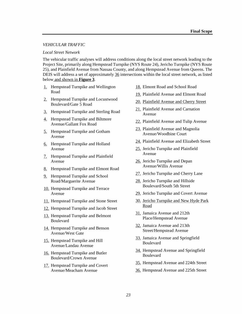
Final Scope
23
VEHICULAR TRAFFIC
Local Street Network
The vehicular traffic analyses will address conditions along the local street network leading to the
Project Site, primarily along Hempstead Turnpike (NYS Route 24), Jericho Turnpike (NYS Route
25), and Plainfield Avenue from Nassau County, and along Hempstead Avenue from Queens. The
DEIS will address a set of approximately 36 intersections within the local street network, as listed
below and shown in Figure 3.
1. Hempstead Turnpike and Wellington
Road
2. Hempstead Turnpike and Locustwood
Boulevard/Gate 5 Road
3. Hempstead Turnpike and Sterling Road
4. Hempstead Turnpike and Biltmore
Avenue/Gallant Fox Road
5. Hempstead Turnpike and Gotham
Avenue
6. Hempstead Turnpike and Holland
Avenue
7. Hempstead Turnpike and Plainfield
Avenue
8. Hempstead Turnpike and Elmont Road
9. Hempstead Turnpike and School
Road/Marguerite Avenue
10. Hempstead Turnpike and Terrace
Avenue
11. Hempstead Turnpike and Stone Street
12. Hempstead Turnpike and Jacob Street
13. Hempstead Turnpike and Belmont
Boulevard
14. Hempstead Turnpike and Benson
Avenue/West Gate
15. Hempstead Turnpike and Hill
Avenue/Landau Avenue
16. Hempstead Turnpike and Butler
Boulevard/Crown Avenue
17. Hempstead Turnpike and Covert
Avenue/Meacham Avenue
18. Elmont Road and School Road
19. Plainfield Avenue and Elmont Road
20. Plainfield Avenue and Cherry Street
21. Plainfield Avenue and Carnation
Avenue
22. Plainfield Avenue and Tulip Avenue
23. Plainfield Avenue and Magnolia
Avenue/Woodbine Court
24. Plainfield Avenue and Elizabeth Street
25. Jericho Turnpike and Plainfield
Avenue
26. Jericho Turnpike and Depan
Avenue/Willis Avenue
27. Jericho Turnpike and Cherry Lane
28. Jericho Turnpike and Hillside
Boulevard/South 5th Street
29. Jericho Turnpike and Covert Avenue
30. Jericho Turnpike and New Hyde Park
Road
31. Jamaica Avenue and 212th
Place/Hempstead Avenue
32. Jamaica Avenue and 213th
Street/Hempstead Avenue
33. Jamaica Avenue and Springfield
Boulevard
34. Hempstead Avenue and Springfield
Boulevard
35. Hempstead Avenue and 224th Street
36. Hempstead Avenue and 225th Street

!! ! ! ! ! !! ! ! !! ! ! ! !!!
!
!
!
!!
!
! !!
! !
!
!!
!
!!!
!
North Lot! South Lot
!
Site A
!
Site B
!
Proposed BelmontElectrical Substation
Queens
Bellerose
Floral Park
New Hyde Park
Stewart Manor
UV25
UV25B
Union Tpke
Bell Blvd
Lakeville Rd
Edge
mer
eR
d
Cross Island P
kwy
Tann
ers
Pon
d R
d
Cov
ert A
ve
Hempstead Tpke
New
Hyde
ParkRd
212th St
Hollis
Court Blvd
Grand
Centra
l Pkw
yBraddock Ave
Denton
Ave
S
Hillside
Ave
Plai
nfiel
dA
ve
Elm
ont R
d
Cou
rthou
se R
d
Jamaica Ave
Fran
klin
Ave
Tulip Ave
Jerich
o Tpke263rd St
90th Ave
Har
riso
n Av
e
E Williston Ave
212th St
Empo
ria A
ve
Bryant Ave
Lowell Ave
Wal
dorf
Ave
Brooklyn Ave
Got
ham
Ave
Jack
son
St
Jaco
b St
211th St
Ston
e St
Har
riso
n S
t
Elzey Ave
S 1
0th
St
Mad
ison
Ave
Cre
st A
ve
Claridge Ave
N 11th St
Lee
Rd
Fiel
dmer
e St
222nd St
Linc
oln
St
Sew
anee
Ave
Hill
Ave
N 12th St
S 12th St
Belm
ont B
lvd
N 10th St
Millers Ln
Ingraham Ln
Hathaway Ave
N 6th St
S 2nd St
Wic
kham
Rd
Lehr
erA
ve
S 16th St
Ash St
Savo
y Av
e
Fran
klin
St
Evan
s Av
e
Ren
ken
Blv
d
Steele St
Lexi
ngto
n Av
e
Floral Pkwy
Cro
wn
Ave
225t
h S
t
But
ler
Blv
d
Land
au A
ve
Carnation Ave
111th Rd
War
wic
k Rd
Hun
new
ell A
ve
217th St
Hay
es S
t
260th St
Rem
senLn241st St
Ster
ling
Rd
Gra
nd S
t
Luci
lle A
ve
Lym
an S
t
Oak
ley
Ave
221s
t St
Theodora St
Whittier Ave
Benris Ave
Her
man
Blv
d
99th Ave
Hillside Blvd
Fairmount Blvd
Locu
stw
ood
Blvd
112th Ave
212th Pl
93rd Ave
98th Ave
Pac
ific
St
Murdock Ave
216th St
88th Ave
215th St
Central Blvd
86th Ave
91st
Ave
215th Pl
Herkom
er St
Comm
onwealth
Blvd
214th Pl
249thSt
252ndSt
Ran
dolp
h Av
e
Oak St
242nd St
109th Ave
104th Ave
250th St
Huron Rd
Aspen St
N 2nd St251st St
Cypress St
110thAve
246th St
247th St
Superior Rd
253rdSt
248th St
85th Ave
209th St
87th Ave
Mol
ine
St
94th Ave
Hinsdale Ave
Clinch Ave
86th Rd
Stewart St
Aven
ue A
Tennessee St
Suss
ex R
d
210th St
Win
ches
ter B
lvd
Hudson Rd
89th
Rd
82nd Ave
223r
d St
Chelsea St
Cal
la A
ve
111th Ave
Birc
h St
220th StVanderveer St
89th Ave
87th Dr
Willis Ave
239t
h St
217t
hLn
Cherry Ln
North Ave
Holland Ave
Colfax St
243rd St
213th St
Fenworth Blvd
Vanderbilt Ave
Sycamore Ave
Rang
e St
217th Pl
Crocus Ave
203rd St
235t
h C
t
233rd St Aven
ue C
Floral Blvd
232nd St
234th St
110th Rd
224th St
208th St
Magnolia Ave
229th St
Cherry St
214th St
Bens
on A
ve
256th St
Cro
ss Is
land
Pkw
y
Carn
egie
Ave
Raff
Ave
Atherton Ave
Salisbury Ave
100th Dr
Bar
rym
ore
Blv
d
Charles Linbergh Blvd
Cisney Ave
Langdon St
Hathaway Dr
92nd Ave
Get
tysb
urg
St
Elizabeth St
257th St
S 8
th S
t
Vassar St
Gr eenridgeAve
Cla
flin
Blv
d
Arg
yle
Rd
Garden C
ity Rd
Russell St
Stratford Ave
Webster St
91st Rd
221st Pl Charles St 6th Ave
Jeffe
rson
St
Bardwell Ave
N 5th St
Joan
Ct
Virgini a
Dr
218th St
Ontario Rd
Rosalind Ave
Adams St
Pre
mie
r B
lvd
S 1
1th
St
Hill
St
Roo
seve
lt S
t
Bro
mle
igh
Rd
105th Ave
Hawthorne
Rd
Surprise St
83rd Ave
Edmore AveDavenport Ave
106th Ave
Linden Ave
Depaul St
2nd Ave
Farn
um B
lvdAv
erill
Blv
d
259th St
Hancock St
85th Rd
100th Ave
Mayfair Ave
Arthur Ave
3rd St
S 9
th S
t
W Elder Ave
Peck Ave
Pine Ave
Ger
aniu
m A
ve
Cat
heri
ne A
ve
Dor
is A
ve
Garfield St
Cle
men
t Ave
Litc
hfiel
d Av
e
Aven
ueD
Saw
yerAve
Estelle Ave
Hoeffn
erAv
e
Barwick St
262nd St
227t
h St
Colonial Ave
Bella
irePl
S 1
3th
St
Plaza Ave
S C
over
t Ave
Atlantic Ave
Murray Hill St
Clarence St
Emerson Ave
Bertha St
Herald Ave
Sch
enck
Blv
d
Sun Ave
Seward Ave
Mosefan St
Maple Dr
Atlantic St
264th St
Herb
ert A
ve
101st Ave
95th Ave
Madison St
94th Dr
211thPl
Hem
lock
St
1st Ave
Hof
fman
St
Larch Ave
Orc
hid
St
Harvard St
Marshall Ave
Benmore Ave
Bedford Ave
Fe
nimoreAve
Terrace Ave
Foster St
Yale St
Rog
ers
Pl
Lloyd St
Zinnia Ave
Florence St
Rose Ave
87th Rd
Miller Ave
Manor Rd
Stewart PlCathedral Rd
Barnes StFrederick Ave
Carukin St
Cro
ssSt
93rd Rd
Spruce Ave
97th Ave
Esse
x Rd
E Po
plar
St
5th Ave
N Tyson Ave
94th Rd
Marshall St
Beec
h St
Homestead Ave
88th Rd
N 3rd St
Hillside A
ve
Fuller Ave
210th Pl
Beverly Ave
107th Ave
Witth
off Ave
Clay St
Park Ave
92nd Rd
Kingston Ave
Fern
woo
d Te
r
261st St
Bellm
ore
St
219th St
Pansy Ave
Childs Ave
218th Pl
Chestnut Ave
103rd Ave
Primrose Ave
258th St
Mck
inle
y Av
e
Car
lton
Ter
Walnut Ave
Fairbury Ave
235th St
Jam
es S
t
Linc
oln
Rd
102nd Ave
201st St205th St
207th St
204th St
205th Pl
Cambridge Ave
Cedar Pl
Marguerite Ave
Wils
on S
t
Spooner St
Iris
Ave
254th St
108th Ave
Rosegold St
Leso
ir A
ve
Mon
roe
St
Haw
thorne Ave
226th St
S 1st St
Verb
ena
Ave
Washington Ave
Esther St
Elto
n R
d
202nd St
Dov
er P
kwy
Admont Ave
Viol
et A
ve
Stewart Ave
McKee St
112th Rd
Louis Ave
113th Dr
113th Ave
Memphis Ave
Whitney Ave
237t
h St
Locu
st S
t
Irving Ave
N 1st St
88th Dr
Lutz St
238t
h St
8th Ave
240t
h St
Biltm
ore
Ave
Willow St
4th St
231st St
220thPl
10th Ave
War
d St
N 7th St
Roquette Ave
Stewart Rd
11th Ave
Hea
thco
te R
d
Laur
el S
t
Sabr
e St
Doh
erty
Ave
Seville St
Fern
St
7th Ave
Whitehall Ter
Trav
is A
ve
Fran
cis
Ct
Mus
ket S
t
Rans
om S
t Lewis Ave
Pont
iac
St
Princeton St
Dartmouth St
Belmont ParkRace Track
Nassau
Queens
12
1112
3536
34 5 6 7 8 9
1013 14 15
1617
18
19
20
21
22
23
24
2526
2728
29
30
31 32
33
34
BELMONT PARK REDEVELOPMENT PROJECT
Traffic IntersectionsFigure 3
0 4,000 FEETProject Sites
North and South Parking Lots
Proposed Belmont Electrical Substation
Nassau County/Queens County Boundary
! Traffic Intersections
8/27
/2018
!(
1

Belmont Park Redevelopment Project
24
In response to public comment on the Draft Scope, the intersections of Plainfield Avenue and
Cherry Street and Jericho Turnpike and New Hyde Park Road have been added to this Final Scope
and will be analyzed in the DEIS.
This study area will include the primary approach/departure roadway, Hempstead Turnpike from
the Cross Island Parkway along the entire frontage of the Belmont Park site up to Covert
Avenue/Meacham Street, about a mile east of Belmont Park’s eastern edge at Plainfield Avenue.
It will also include select intersections along Plainfield Avenue between Hempstead Turnpike and
Jericho Turnpike,6 and along Jericho Turnpike from Plainfield Avenue eastward to New Hyde
Park Road. Intersection analyses in Queens will primarily focus on Hempstead Avenue between
the Cross Island Parkway and Jamaica Avenue. Site access locations (existing and proposed) along
Hempstead Turnpike will be identified and evaluated to accommodate all anticipated vehicles.
Traffic counts will be conducted at each of the intersections identified above during each of the
five traffic analysis periods identified as critical in the Travel Demand Analysis task above, thus
covering the time periods of peak traffic flows to and from the proposed arena, retail village, and
hotel. All traffic counts will be taken on days when NYRA racing is underway at Belmont Park,
thus representing the typical peak background traffic in the area. Traffic counts will consist of
both detailed intersection counts, movement-by-movement (left turns, through movements, right
turns), by vehicle type (auto, truck, bus), and via 24-hour Automatic Traffic Recorder (ATR)
machine counts for a full week and two weekends that will allow intersection counts to be adjusted
to reflect conditions on a typical day in the area.
Existing intersection capacities, levels of service, and volume-to-capacity (v/c) ratios will be
determined for each traffic movement, for each approach to the intersection, and for the overall
intersection, using Synchro software, confirmed by field observations of trained staff.
Future conditions without the Proposed Project (the “No Action” condition) will evaluate the same
intersections and peak traffic analysis hours, incorporating an annual background growth rate
reflecting local areas (Nassau County and Queens), potential changes to racing operations at
Belmont Park, and significant proposed developments nearby, if any, by the Proposed Project’s
2021 Build year. Should traffic improvements be programmed by local municipalities by the
Proposed Project’s 2021 Build year, they will be incorporated in the No Action analysis.
Future conditions with the Proposed Project (the “With Action” condition) will overlay vehicle
trips generated by the Proposed Project on the No Action traffic volume networks, and produce
With Action traffic volume networks that will then be evaluated. Each of the generated vehicle
traffic “layers” will be distributed to the street network along the most logical routes. The
distribution of trips to an Islanders game at the proposed arena will be developed based on the
geographic distribution of season and individual game ticket purchases from the most recent
season when the Islanders formerly played at the Nassau Coliseum, adjusted to reflect a slight
shift towards a New York City market (due to the location of Belmont Park near the Nassau-
Queens border). The assignment of other project-generated trips, including shoppers at the retail
village, patrons of the hotel, and other trips will be performed based on available market studies,
population distribution within a 30-minute radius of the site, or other information which may aid
in the development of identifying logical routes for arrivals and departures.
6 The entrance to Belmont Park on Plainfield Avenue (Gate 8) is not proposed to be used for site access to
the Proposed Project.
Final Scope
25
The analyses will develop v/c ratios and levels of service for each of the approximately 36 study
area intersections. Significant adverse traffic impacts attributable to the Proposed Project will be
identified and traffic improvements available to mitigate those impacts will also be identified and
evaluated within the DEIS, in consultation with the jurisdictions responsible for implementing
such measures. Such measures could include roadway or intersection re-striping to increase
capacity; intersection widening where needed and feasible; new traffic signals if needed at
currently unsignalized intersections; modifying signal phasing and timing at currently signalized
intersections; and imposing turn prohibitions, parking prohibitions, or other measures to increase
intersection capacity.
In response to the public comments on the Draft Scope, the Final Scope has been expanded to
include an assessment of the potential for traffic diversions (i.e., project-related traffic through
local streets), and potential mitigation measures that could be implemented to address this issue
should traffic diversions occur. The DEIS will also discuss the impacts of the Proposed Project on
emergency response times. A description of the entrances to the Proposed Project will also be
included and the chapter will explain how these would be used to accommodate traffic for the
various project components.
Highway Network
It is anticipated that the Cross Island Parkway (CIP) will be the major route used by project-
generated traffic traveling to and from the Project Sites. The DEIS will focus on its interchange
with Hempstead Turnpike/Hempstead Avenue and the multiple on/off ramps providing access to
Belmont Park’s parking lots. Detailed traffic volume counts will be conducted during each of the
potential traffic analysis periods cited above along with travel speed-and-delay studies and visual
observations of existing conditions by trained staff.
Existing traffic conditions on the CIP, from Linden Boulevard through Jamaica Avenue, and
including all ramp junctions, merge/diverge and weave conditions, and mainline segments will be
analyzed using the VISSIM software. In response to public comments on the Draft Scope, the
analysis of key merges at the interchanges of the CIP with the Grand Central Parkway, Long Island
Expressway, and Southern State Parkway have been added to this Final Scope and will be analyzed
in the DEIS:
Merge segment on the southbound Cross Island Parkway at the on-ramp from the westbound
Long Island Expressway;
Weaving segment following the off-ramps from the northbound and southbound Cross Island
Parkway to the eastbound Long Island Expressway and service road;
Merge segment on the eastbound Long Island Expressway at the on-ramp from the northbound
and southbound Cross Island Parkway;
Merge segment on the southbound Cross Island Parkway at the on-ramp from the westbound
Grand Central Parkway;
Merge segment on the eastbound Grand Central Parkway at the on-ramp from the northbound
Cross Island Parkway; and
Merge segment on the northbound Cross Island Parkway at the on-ramp from the westbound
Southern State Parkway.
All new traffic counts, speed and delay data, and other data needed for model calibration will be
obtained for the same traffic analysis periods identified previously and collected on days when
NYRA racing is underway at Belmont Park and the ramps that currently directly serve Belmont
Belmont Park Redevelopment Project
26
Park on racing days are open. Traffic volumes, densities, and highway speeds will be identified
for each element of the highway network.
Future conditions without the Proposed Project will use an annual background traffic growth rate
provided by the New York State Department of Transportation (NYSDOT) and additional
significant development traffic for the local street network analysis task described above. For the
With Action condition, project-generated traffic will be assigned to the highway network.
Potential significant adverse highway impacts on the CIP will be identified. Should highway
mitigation be needed, a set of appropriate measures that can be considered, depending upon the
number and magnitude of such impacts, will be determined through consultation with New York
City Department of Transportation (NYCDOT).
PARKING
The parking analyses will focus on the evaluation of off-street parking that would be included on
the Project Sites, including parking on the North and South Lots, which is anticipated to be made
available for arena events through a shared parking agreement to be negotiated with the FOB and
NYRA. Parking lot occupancies will be surveyed during a typical weekday and Saturday during
racing season; these surveys will include parking spaces available both north and south of the
Racetrack. Once existing and No Action analyses are completed, hourly parking accumulation
profiles will be prepared for each land use. These estimates will indicate the peak parking demand
for each land use by time of day. Cumulatively, the combined estimates will arrive at a total hourly
demand for the Proposed Project. These estimates will be prepared for a typical weekday and
weekend day to determine whether or not the amount of parking to be provided on-site under the
With Action condition would be sufficient to accommodate all parking demands. Should any
parking shortfalls be identified, they will be identified in the DEIS and means of ameliorating
them will be described. In addition, the Transportation chapter of the DEIS will identify the net
change in parking capacity on the Project Sites as a result of the Proposed Project, and will describe
the proposed parking management plan for arena events. The proposed operation of parking
facilities will be described and the potential for queuing at parking entrances will be assessed.
The Transportation chapter of the DEIS will also identify whether there is potential for project-
generated parking demand to occur on local streets, and mitigation measures that could be
implemented to minimize or prevent project-generated parking on surrounding streets.
PUBLIC TRANSPORTATION
This section will include a description of LIRR service to Belmont Park and the bus routes
operated by the Metropolitan Transportation Authority (MTA) Bus Company, MTA New York
City Transit, and Nassau Inter-County Express (NICE) that also provide access to the Project Sites.
Impacts due to additional project-generated transit travel, if any, will be determined in consultation
with the corresponding transit agencies. The LIRR is committed to developing a plan to expand
LIRR service to Belmont Park station for events year-round; the extent and utilization of this
service expansion will be confirmed with MTA/LIRR and described in the DEIS. The Proposed
Project will preserve access to the bus loop area adjacent to the LIRR Belmont Park station.
Since public transportation has been serving Belmont Park on the day of the Belmont Stakes, the
busiest racing day of the year, and attendance on that day is substantially higher than for a
sports/entertainment event at the proposed arena, it is unlikely that detailed analyses of platform,
stairway, or elevated walkway conditions will be needed.

Final Scope
27
VEHICULAR AND PEDESTRIAN SAFETY
A crash analysis study will be conducted for the approximately two-mile length of Hempstead
Turnpike between the Cross Island Parkway ramps and Covert Avenue/Meacham Street and for
the key intersections identified previously along Jericho Turnpike and Plainfield Avenue. The data
to be requested and reviewed as part of the crash study shall consist of NYSDMV MV-104 crash
reports and represent the most recent three-year period of available information. Collision and
condition diagrams will be developed and reviewed to identify high crash types and/or patterns by
location and a comparison by location will be made with regard to calculated accident rates for
study segments and intersections versus statewide average rates for similar facilities. For
intersections located within Queens, NYCDOT crash data will be compiled for the latest three
years for which data are available and summarized to determine whether any should be identified
as high crash locations per New York City criteria. An assessment will be made of the Proposed
Project’s effect on vehicular and/or pedestrian safety on high crash locations, should any be
identified, and potential improvement measures would be identified.
An evaluation of the Proposed Project’s potential impacts on the walking routes to schools that
involve crossings of Plainfield Avenue will also be included in the DEIS.
PEDESTRIAN CIRCULATION
The DEIS will evaluate on-site pedestrian circulation between the proposed parking facilities
(including the North and South Lots), the public transportation services, and the major components
of the Proposed Project. This will be a qualitative assessment and will include description of the
one or more proposed pedestrian connections that would link the developments on the south side
of Hempstead Turnpike (Site B) with the developments on the north side (Site A).
TASK 12. AIR QUALITY
As detailed below, the Air Quality chapter of the DEIS will assess the Proposed Project’s potential
effects on air quality from both mobile (i.e., vehicular) and stationary sources of emissions. The
assessment of potential effects on air quality from the Proposed Project’s construction activities is
described under Task 15, “Construction,” below.
MOBILE SOURCE ANALYSES
Initially, a screening analysis will be performed to determine whether the projected emissions of
carbon monoxide (CO) and particulate matter (PM) from the vehicle trips generated by the
Proposed Project could result in any air quality impacts. Intersections will be chosen for further
evaluation based on the procedures outlined in the NYSDOT guidance document, The
Environmental Manual (TEM), 2010, or latest available NYSDOT guidance.
If any intersections do not pass the volume threshold screening criteria, an analysis of CO
concentrations, the principal emission of concern from vehicular sources, will be performed
according to the procedures of the User’s Guide to CAL3QHC, Version 2.0, A Modeling
Methodology for Predicting Pollutant Concentrations Near Roadway Intersections (U.S.
Environmental Protection Agency [EPA] Publication EPA-454/R-92-006, November, 1992) and
Guidelines for Modeling Carbon Monoxide from Roadway Intersections (USEPA Publication
EPA-454/R-92-005, November, 1992). Vehicle emissions will be estimated with the reported
emission factors in the NYSDOT TEM for Nassau County, which are based on the MOVES2014a
model. CO concentrations will be modeled for up to three peak hour traffic volumes and 8-hour
concentrations will be estimated using the applicable persistence factor in the TEM. Modeling will
be performed for the future conditions, both without and with the project-generated traffic. A

Belmont Park Redevelopment Project
28
determination will be made comparing the results with National Ambient Air Quality Standards,
and the State Implementation Plan (SIP) for CO. In the event that a significant adverse air quality
impact is predicted, traffic mitigation measures will be examined.
STATIONARY SOURCE ANALYSES
The stationary source air quality impact analysis will determine the effects of emissions from the
Proposed Project’s fossil-fuel fired heating and hot water systems to significantly impact air
quality at existing land uses, or on the Proposed Project itself (i.e., project-on-project impacts).
A screening analysis will be prepared using EPA’s AERSCREEN screening dispersion model to
determine whether the Proposed Project could potentially cause any significant adverse impacts
with respect to the nitrogen dioxide (NO2) ambient air quality standard and fine particulate matter
(PM2.5) de minimis criteria, and, if fuel oil is proposed to be used, the 1-hour sulfur dioxide (SO2)
ambient air quality standard. Project-on-project and project-on-existing/No Build impacts will be
determined.
If the AERSCREEN analysis identifies potential significant adverse air quality impacts, a refined
stationary source analysis will be prepared using the EPA AERMOD model to determine the
potential impacts from the Proposed Project’s heating and hot water systems. For this analysis,
five years of surface meteorological data from the JFK Airport National Weather Station (2012-
2016) and concurrent upper air data will be applied. Concentrations of nitrogen dioxide (NO2),
particulate matter (PM10 and PM2.5), and, if assuming fuel oil, sulfur dioxide (SO2) will be
determined at off-site and on-site (project) receptor locations. Predicted values will be compared
with NAAQS and other relevant standards. In the event that violations of standards are predicted,
the analysis will include assessment and reporting of potential design measures to reduce pollutant
levels to within standards.
TASK 13. NOISE
The noise impact analysis for the Proposed Project will focus on three primary areas of concern
regarding noise: the effect the Proposed Project would have on noise levels in neighborhoods
adjacent to the Project Sites; the effect the Proposed Project would have on existing operations at
Belmont Park; and the level of noise exposure expected for the proposed new uses that may be
noise sensitive. The assessment of potential environmental effects associated with noise generated
by the Proposed Project’s construction activities is described under Task 15, “Construction,”
below.
The Proposed Project has the potential to result in increased noise levels at locations in the adjacent
neighborhoods due to the expected increase in the number of vehicle trips to the Project Sites,
crowd noise from events associated with the proposed arena, and the proposed new substation.
Noise due to each of these sources will be examined and, where necessary, general noise
abatement/control measures to reduce potential impacts will be recommended. In addition, the
noise study will examine the noise exposure at the Project Sites and compare it to noise levels
generally considered acceptable for the proposed uses.
Specifically, the analysis will include the following tasks:
Select appropriate noise descriptors. The A-weighted Leq levels will be the primary noise
descriptors used for the impact analysis as is directed by NYSDEC noise impact evaluation
guidance.
Final Scope
29
Select noise receptor locations. Receptor locations will include locations in immediate
proximity to the Project Sites and/or along roadways leading to and from the Project Sites. It
is expected that eight (8) noise receptor locations will be used to represent the nearby noise
receptors and the noise exposure at the Project Sites.
Determine existing noise levels at the receptor locations. Existing noise levels shall be
measured at each of the proposed receptor locations over a 20-minute time period during each
of the typical weekday AM, midday, and PM peak periods, as well as two (2) time periods
related to events and the proposed arena. Additionally, at the receptor nearest the location of
the new substation, existing noise levels will be measured during a weekend overnight period
to determine minimum weekly noise levels for comparison with projected noise levels
resulting from substation operation. Measurements shall be made using Type I
instrumentation and measured quantities shall include A-weighted and ⅓-octave band Leq, L1,
L10, L90, Lmin, and Lmax noise levels. Where necessary, measurements will be supplemented by
mathematical model results to determine an appropriate base of existing noise levels.
Establish noise levels associated with arena operations. Noise level measurements will be
conducted at a comparable arena facility for a pre-event and post-event time period to
determine the amount of noise generated by crowds entering and exiting the facility as well
as vendors and other event-associated activity in the area surrounding the facility. Noise levels
measured at this facility would be used to determine the potential for increases due to crowds
attending events at the Proposed Project’s arena.
Establish noise levels associated with the new substation. Based on a source list of all the
major noise producing components at the substation, sound emission data for each component,
and the expected site layout plan for the substation, the expected level of noise emission from
the proposed substation will be determined. A 3-dimensional CadnaA noise model will be
utilized to calculate noise levels resulting from substation operation for the selected Receptor
locations as well as produce noise contour maps that show expected noise levels over the
entire area.
Determine future noise levels without and with the Proposed Project. At each of the receptor
locations identified above, noise levels will be determined for the 2021 analysis year both with
and without the Proposed Project. The noise level projects will be based on existing noise
levels, acoustical fundamentals, the CadnaA model projections of substation noise, and
mathematical models that account for changes in traffic volume and vehicle mix due to the
Proposed Project.
Compare noise levels with standards, guidelines, and other impact evaluation criteria.
Compare existing noise levels and future noise levels, both with and without the Proposed
Project, with various noise standards, guidelines, and other appropriate noise criteria.
If the results of the impact analysis identify a potential for significant adverse impacts, potential
practicable mitigation measures to avoid or reduce those significant adverse impacts will be
identified.
TASK 14. CLIMATE CHANGE
Climate change analyses generally evaluate two potential issues: (1) the potential effect of a
project or action on global climate change, using the project or action’s contribution to climate
change-inducing greenhouse gas (GHG) emissions as a proxy; and (2) the potential for projected
climatic changes to impact a project or action’s operations and the potential to exacerbate potential
local environmental variables that are affected by climatic conditions due to the introduction of
Belmont Park Redevelopment Project
30
design elements or infrastructure. Since the Proposed Project would be located outside of the
potential future flood zones as projected by New York State for 2100, and since the Proposed
Project would not introduce any major drainage infrastructure with the potential to affect local
flooding conditions during severe precipitation events, the focus of the Climate Change analysis
will be on potential GHG emissions.
In accordance with NYSDEC policy,7 GHG emissions generated by the Proposed Project will be
quantified, and an assessment of consistency with the State’s established GHG reduction goals
and related policies will be prepared. The analysis will follow the general guidance provided in
the NYSDEC policy while employing more recent, updated methods and data where available and
appropriate. Emissions will be estimated for the 2021 analysis year and reported as carbon dioxide
equivalent (CO2e) metric tons per year. GHG emissions other than carbon dioxide (CO2) will be
included if they would account for a substantial portion of overall emissions, adjusted to account
for the global warming potential. The analysis will quantify direct and indirect GHG emissions
from building energy use and on-road. Emissions associated with construction will be assessed
qualitatively, including direct and indirect emissions related to on-road and non-road engines as
well as indirect emissions related to materials used for construction. Relevant mitigation measures
to reduce operational and construction energy consumption and GHG emissions that could be
incorporated into the Proposed Project will be discussed, and the potential for those measures to
reduce GHG emissions from the Proposed Project will be assessed to the extent practicable.
TASK 15. CONSTRUCTION
Construction impacts, though temporary, can have a disruptive and noticeable effect on the
adjacent community. This chapter will provide a discussion of the projected construction schedule,
activities likely to occur during construction of the Proposed Project and new substation, the types
of equipment that are likely to be used, construction logistics (e.g., site access points and potential
staging area locations), construction workers and truck delivery estimates, and safety measures
that will be implemented to protect the public during construction. Based on this information, an
assessment of relevant technical areas where construction activities may pose specific
environmental problems will be provided. Measures to avoid, minimize and/or mitigate potential
significant adverse construction-related effects will also be identified where appropriate.
Technical areas to be assessed include the following:
TRANSPORTATION SYSTEMS
The construction transportation analysis assesses the potential for construction activities to result
in significant adverse effects to traffic, transit (i.e., LIRR and bus), pedestrian elements (i.e.,
sidewalks, corners, and crosswalks), and parking conditions. The first step of the transportation
assessment will be to develop the volume of traffic during peak hours that would be generated
during the peak quarter (i.e., three-month period) of construction activity. This would include both
construction worker trips made by auto and the volume of delivery trucks to and from the
construction sites.
Once construction period trips are quantified, they will be assigned to the roadway network, and
an assessment of their effects on the roadway network will be prepared. It is assumed that
construction traffic will be substantially lower than project-generated traffic and that intersection
7 NYSDEC. DEC Policy: Assessing Energy Use and Greenhouse Gas Emissions in Environmental Impact
Statements. July 15, 2009.

Final Scope
31
and highway level of service analyses will not be needed. The Construction Traffic section will
also describe whether any curb parking lane closures or sidewalk closures are expected and
estimate the number of construction workers likely to drive to the construction sites, the number
of parking spaces needed, and the availability of on-site parking to accommodate the construction
parking demand. The assessment also will consider the potential effects on traffic from
construction associated with the installation of the new substation’s transmission lines in roadbeds.
AIR QUALITY
Construction of the Proposed Project would require the use of both non-road construction
equipment and on-road vehicles. Non-road construction equipment includes equipment operating
on-site such as excavators and loaders, while on-road vehicles include construction delivery trucks
and construction worker vehicles arriving to and departing from the Project Sites and other directly
affected areas. Emissions generated from these sources, as well as dust-generating activities such
as truck loading operations, have the potential to affect air quality. The construction air quality
section will assess the potential for significant adverse impacts from these sources of air emissions
generated during construction by reviewing the projected construction activity and equipment in
the context of intensity, duration, and location of emissions relative to nearby sensitive locations
(i.e., Belmont Park, residences, etc.). The construction air quality section will further describe any
project-specific control measures (i.e., diesel equipment reduction; clean fuel; best available
tailpipe reduction technologies; utilization of equipment that meets specified emission standards;
and fugitive dust control measures, etc.) required to further reduce the effects of construction and
to ensure that significant impacts on air quality do not occur.
NOISE AND VIBRATION
Potential impacts on community noise levels could result from construction equipment operation
as well as construction vehicles and delivery vehicles traveling to and from the Project Sites and
other directly affected areas. The construction noise section will contain an assessment of the
magnitude and duration of noise from the Proposed Project’s construction activity based on the
conceptual construction schedule for Proposed Project and noise emission level estimates for
individual construction stages taken from detailed noise modeling analyses that have previously
undergone environmental review and approval process. The analysis will compare the
construction noise levels estimated for construction activities resulting from the Proposed Actions
to existing noise levels at nearby receptors as determined by noise level measurements conducted
for the operational noise analysis. The analysis will also review the projected activity and
equipment in the context of intensity, duration, and location of emissions relative to nearby
sensitive locations, and identify any project-specific control measures required to further reduce
construction noise. Appropriate recommendations will be made to comply with State and local
rules.
The potential for construction-related noise to affect horses within the paddock and stables will
also be considered based on the results of the construction noise analysis. Construction on the
Project Sites could also potentially produce vibration at adjacent structures. The construction
vibration section will contain an assessment of the potential for the Proposed Project’s
construction activity to produce vibration at nearby structures, with particular attention to historic
or potentially fragile structures. The analysis will predict construction vibration levels based on
vibration emission levels for individual pieces of construction equipment and expected distances
between equipment and surrounding structures. The analysis will also compare projected vibration
levels to acceptable thresholds and identify any project-specific control measures required to
Belmont Park Redevelopment Project
32
reduce construction vibration. Appropriate recommendations will be made to comply with State
and local rules.
HAZARDOUS MATERIALS
In coordination with the hazardous materials assessment (Task 8), determine whether construction
activities resulting from the Proposed Actions have the potential to expose construction workers
and the surrounding community to contaminants.
NATURAL RESOURCES
The effects of construction activities on natural resources will be assessed. A detailed technical
approach to assess the effects of construction activities on natural resources is included above in
Task 10, “Natural Resources.”
OTHER TECHNICAL AREAS
As appropriate, discuss other areas of environmental assessment for potential construction-related
impacts.
TASK 16. ALTERNATIVES
The purpose of an alternatives analysis in an EIS is to examine reasonable and practicable
development options that would avoid or reduce project-related significant adverse impacts and
achieve the stated goals and objectives of the Proposed Project.
The alternatives analysis will be qualitative, except in those technical areas where significant
adverse impacts for the Proposed Actions have been identified.
The following alternatives will be evaluated in the DEIS:
No Action Alternative: SEQRA requires an analysis of a No Action Alternative (i.e., a future
condition without the Proposed Project), which will assume that the existing uses on the
Project Sites would continue;
No Unmitigated Impact Alternative: If the analyses in the DEIS demonstrate that the Proposed
Project would result in significant adverse impacts, an alternative will be considered that could
avoid or reduce the impacts;
No Arena Alternative: This alternative would contemplate the Proposed Project but without
the proposed arena;
Alternate Site Plan Alternative: This alternative would contemplate the Proposed Project
under the site plan that has not been selected as the preferred option (i.e., Site A would include:
the proposed arena; the hotel; all of the retail and office space; approximately 1.2 acres of
publicly accessible open space; and approximately 1,339 parking spaces. Site B would
include: the community center space; approximately 6.1 acres of publicly accessible open
space; and approximately 2,360 spaces of at-grade parking. Sites A and B would be connected
by two pedestrian bridges.); and
South Lot Structured Parking Alternative: This alternative would contemplate the Proposed
Project as described under Site Plan Option 2 (the preferred alternative) but with
approximately 1,500 spaces of structured parking shifted from Site B to a new structured
parking garage on the South Lot.
Final Scope
33
TASK 17. MITIGATION
This chapter will summarize any potential impacts identified in previous chapters of the EIS, and
will describe measures that could be advanced to avoid or minimize to the extent practicable those
identified impacts.
TASK 18. EIS SUMMARY CHAPTERS
EXECUTIVE SUMMARY
The executive summary will summarize relevant material from the body of the EIS to describe the
Proposed Project, the Proposed Actions’ potential environmental impacts, measures to mitigate
those impacts, and alternatives to the Proposed Project.
UNAVOIDABLE IMPACTS
Those significant adverse impacts, if any, which could not be avoided or mitigated, will be
described in this chapter.
IRREVERSIBLE AND IRRETRIEVABLE RESOURCES
This chapter focuses on those resources, such as energy and construction materials, that would be
irretrievably committed should the Proposed Project be built.
GROWTH-INDUCING ASPECTS
This chapter will focus on whether the Proposed Project would have the potential to induce new
development within the surrounding area, and the potential environmental effects associated with
any induced development.
CUMULATIVE EFFECTS
Cumulative impacts occur when multiple actions affect the same resource(s). These impacts can
occur when the incremental or increased impacts of an action, or actions, are added to other past,
present and reasonably foreseeable future actions. Cumulative impacts must be assessed when
actions are proposed, or can be foreseen as likely, to take place simultaneously or sequentially in
a way that the combined impacts may be significant. For example, when there are two or more
related actions; when two or more unrelated impacts may have related significant impacts; or when
the actions are in close enough proximity to affect the same resources.
This chapter will summarize the Proposed Actions’ anticipated cumulative effects, or effects
which result from the incremental impact of the Proposed Actions when added to other past,
present, and reasonably foreseeable future actions. This chapter will rely on other chapters of the
DEIS for a description of relevant future projects, and will assess the Proposed Actions’ potential
effects in combination with anticipated conditions in the future without the Proposed Actions.