best practices for implementing a successful gis project€¦ · design operations &...
TRANSCRIPT

Business GeoInfo Summit 2007Business GeoInfo Summit 2007 11
ESRI Business GeoInfo SummitESRI Business GeoInfo Summit
Best Practices for Implementing a Best Practices for Implementing a Successful GIS ProjectSuccessful GIS Project
Gerry Clancy, Manager Gerry Clancy, Manager Federal Civilian and Commercial Services, ESRIFederal Civilian and Commercial Services, ESRI

Business GeoInfo Summit 2007Business GeoInfo Summit 2007 22
AgendaAgenda
•• Review of Session GoalsReview of Session Goals
•• Overview of the Implementation ProcessOverview of the Implementation Process
•• StepStep--byby--Step Discussion of the Implementation Process Step Discussion of the Implementation Process and Recommended Best Practicesand Recommended Best Practices

Business GeoInfo Summit 2007Business GeoInfo Summit 2007 33
Goals for This SessionGoals for This Session
1.1. Provide a road map for planning a GIS projectProvide a road map for planning a GIS project
2.2. Describe best practices for implementing a successful Describe best practices for implementing a successful projectproject
3.3. Help you plan for risks and avoid common mistakesHelp you plan for risks and avoid common mistakes
4.4. Provide information on available project planning Provide information on available project planning resourcesresources

Business GeoInfo Summit 2007Business GeoInfo Summit 2007 44
Scope of This SessionScope of This Session
IncludesIncludes
•• Project Management Project Management perspectiveperspective
•• Best Practices for project Best Practices for project lifecycle planninglifecycle planning
•• Lessons Learned from past Lessons Learned from past Enterprise GIS implementationsEnterprise GIS implementations
Does Not IncludeDoes Not Include
•• Specific Geodatabase planning Specific Geodatabase planning adviceadvice
•• Specific systems architecture Specific systems architecture sizing guidelinessizing guidelines
•• Specific product adviceSpecific product advice
•• Programming adviceProgramming advice

Business GeoInfo Summit 2007Business GeoInfo Summit 2007 55
What is Enterprise GIS?What is Enterprise GIS?
“Enterprise” has several meanings:• Organizational
– Multiple Departments, Multiple Business Processes and Many Systems Involved in GIS Applications
• Deployment and Licensing– Software Licensing and Purchasing Agreements– Large Scale Deployments of Software
• Enterprise IT Architecture– A Technology Strategy and Architectural
Decisions that are Organizing Principles for Design
– Broad-based Applications, Data, and Systems Design For Business-critical Systems

Business GeoInfo Summit 2007Business GeoInfo Summit 2007 66
What is Enterprise GIS?What is Enterprise GIS?
ApplicationApplication
ServicesServices
ApplicationsApplications
ServicesServices
Operations Operations Business UnitBusiness Unit
Financial Financial Business UnitBusiness Unit
DataWarehouse
ServicesServices
ServicesServices
ApplicationsApplications ApplicationsApplications
OtherOtherBusiness UnitsBusiness Units
ServicesServices
ApplicationsApplications
ServicesServices
Enterprise Service Bus
An enterprise GIS is an An enterprise GIS is an integrated, multiintegrated, multi--departmentaldepartmental system of components used to collect, organize, analyze, system of components used to collect, organize, analyze, visualize, and disseminate geographic information.visualize, and disseminate geographic information.
The goal of an enterprise The goal of an enterprise GIS is to implement GIS is to implement interoperable interoperable technologiestechnologies, standards, , standards, and methods so that GIS and methods so that GIS data and services can data and services can support core business support core business needs more efficiently needs more efficiently and more effectively.and more effectively.
Requires a Higher Level of Planning, Integration, Testing and Support

Business GeoInfo Summit 2007Business GeoInfo Summit 2007 77
Ongoing Ongoing PlanningPlanning
DesignDesign
Operations & Operations & MaintenanceMaintenance
DevelopmentDevelopment
DeploymentDeployment
ArcGISArcGIS
AnalysisAnalysis Cartographer
Adjudicator
Parcel Management - Acquisition
Proponent
ProposalAuthorityLegaldescriptionPublic InterestBenefit(PM 2-1)
Acquisition: Conveyance in an interestin land to the US from a non Federalparty
Noting to MAPS/DATA(PM 0-12)
Review andProcess Proposal
(PM 0-2)
Assumption: this flowdescribes serializedapplications
SurveyorQ
CSupervisor
Survey(if there is no surveycontrol in proposal)
(MM)
QC(G)
Proposal may be initiatedby private individuals orfederal agency
Land DescriptionVerification
(usually for forestservice acquisitions
and disposals )
In the case of areconveyance there will bean automatic re-openingnotation; in someacquisitions there may bea re-opening notation
Create MapOutput
(G)
Flow of tasksStarting point PM Use Case Other Use Case
Strategy & Strategy & PlanningPlanning

Business GeoInfo Summit 2007Business GeoInfo Summit 2007 88
Project Lifecycle Phases & ActivitiesProject Lifecycle Phases & Activities
Strategy & Strategy & PlanningPlanning
Analysis & Analysis & DesignDesign
DevelopmentDevelopment DeploymentDeployment Operations & Operations & MaintenanceMaintenance
••Visioning & Visioning & Strategic PlanningStrategic Planning
••Business Case Business Case DevelopmentDevelopment
••Implementation Implementation PlanningPlanning
••Organizational Organizational PlanningPlanning
••Risk ManagementRisk Management
••Business Process Business Process AnalysisAnalysis
••Requirements Requirements AnalysisAnalysis
••Use Case Use Case AnalysisAnalysis
••Database DesignDatabase Design
••System System Architecture Architecture DesignDesign
••Application Application DesignDesign
••Database Database DevelopmentDevelopment
••Application Application DevelopmentDevelopment
••Systems Systems IntegrationIntegration
••Quality Quality Assurance Assurance TestingTesting
••Configuration Configuration ManagementManagement
••Deployment Deployment PlanningPlanning
••System System InstallationInstallation
••Acceptance Acceptance TestingTesting
••Performance Performance Validation, Validation, Testing & TuningTesting & Tuning
••User TrainingUser Training
••User SupportUser Support
••Performance Performance MonitoringMonitoring
••Systems Systems MaintenanceMaintenance
••Software Software MaintenanceMaintenance

Business GeoInfo Summit 2007Business GeoInfo Summit 2007 99
ESRI Project CenterESRI Project Center
––http://support.esri.com/projectcenterhttp://support.esri.com/projectcenter

Business GeoInfo Summit 2007Business GeoInfo Summit 2007 1010
Project Lifecycle Phases & ActivitiesProject Lifecycle Phases & Activities
Strategy & Strategy & PlanningPlanning
Analysis & Analysis & DesignDesign
DevelopmentDevelopment DeploymentDeployment Operations & Operations & MaintenanceMaintenance
••Visioning & Visioning & Strategic PlanningStrategic Planning
••Business Case Business Case DevelopmentDevelopment
••Implementation Implementation PlanningPlanning
••Organizational Organizational PlanningPlanning
••Risk ManagementRisk Management
••Business Process Business Process AnalysisAnalysis
••Requirements Requirements AnalysisAnalysis
••Use Case Use Case AnalysisAnalysis
••Database DesignDatabase Design
••System System Architecture Architecture DesignDesign
••Application Application DesignDesign
••Database Database DevelopmentDevelopment
••Application Application DevelopmentDevelopment
••Systems Systems IntegrationIntegration
••Quality Quality Assurance Assurance TestingTesting
••Configuration Configuration ManagementManagement
••Deployment Deployment PlanningPlanning
••System System InstallationInstallation
••Acceptance Acceptance TestingTesting
••Performance Performance Validation, Validation, Testing & TuningTesting & Tuning
••User TrainingUser Training
••User SupportUser Support
••Performance Performance MonitoringMonitoring
••Systems Systems MaintenanceMaintenance
••Software Software MaintenanceMaintenance

Business GeoInfo Summit 2007Business GeoInfo Summit 2007 1111
Strategy and Planning Activities:Strategy and Planning Activities: Process OverviewProcess Overview

Business GeoInfo Summit 2007Business GeoInfo Summit 2007 1212
Strategy and Planning Activities:Strategy and Planning Activities: Developing the VisionDeveloping the Vision
•• What Is the Business Problem Being Solved?What Is the Business Problem Being Solved?
•• What Is the Proposed Solution?What Is the Proposed Solution?
•• Who Are the Target Users?Who Are the Target Users?
•• How Does This Solution Integrate With Other Existing or How Does This Solution Integrate With Other Existing or Planned Systems?Planned Systems?
•• How Will This Solution Benefit the Organization?How Will This Solution Benefit the Organization?
•• What Are the Criteria for Success?What Are the Criteria for Success?
Template for Creating a Project Vision StatementAvailable on the Project Center

Business GeoInfo Summit 2007Business GeoInfo Summit 2007 1313
Strategy and Planning Activities:Strategy and Planning Activities: Developing the Business CaseDeveloping the Business Case
•• What Are the What Are the Benefits Benefits of the Project? How Does It of the Project? How Does It Support the Mission of the Organization?Support the Mission of the Organization?
•• What Are the Estimated What Are the Estimated CostsCosts??
•• What Is the Expected Return On Investment (What Is the Expected Return On Investment (ROIROI) ?) ?
•• How Does the Project Relate to Other Efforts Within the How Does the Project Relate to Other Efforts Within the Enterprise?Enterprise?
•• ESRI Press:ESRI Press:––Measuring UpMeasuring Up -- Outlines a Number of Case Studies and General Outlines a Number of Case Studies and General Methodology for Doing Cost Benefit Analysis Methodology for Doing Cost Benefit Analysis ––Thinking About GISThinking About GIS –– Roger TomlinsonRoger Tomlinson–– New ROI book coming from ESRINew ROI book coming from ESRI

Business GeoInfo Summit 2007Business GeoInfo Summit 2007 1414
Strategy and Planning Activities: Strategy and Planning Activities: Activity PlanningActivity Planning
•• Define the Initial Work Breakdown Structure (WBS)Define the Initial Work Breakdown Structure (WBS)–– By Project PhaseBy Project Phase–– By ComponentBy Component
•• Define the ActivitiesDefine the Activities•• Assign ResourcesAssign Resources•• Define Dependencies Between ActivitiesDefine Dependencies Between Activities•• Assign DurationsAssign Durations

Business GeoInfo Summit 2007Business GeoInfo Summit 2007 1515
Strategy and Planning Activities:Strategy and Planning Activities: Identifying & Monitoring Project RisksIdentifying & Monitoring Project Risks
•• InternalInternal–– StaffStaff–– BudgetBudget–– ScheduleSchedule–– User ExpectationsUser Expectations
•• ExternalExternal–– Hardware FailureHardware Failure–– ““33rdrd PartyParty”” Software Release SchedulesSoftware Release Schedules–– ““33rdrd PartyParty”” ContractorsContractors–– Integration IssuesIntegration Issues–– Natural DisasterNatural Disaster
Risk Monitoring Should Be Done Throughout the Project LifecycleRisk Monitoring Should Be Done Throughout the Project Lifecycle
Business GeoInfo Summit 2007Business GeoInfo Summit 2007 1616
Strategy and Planning Activities:Strategy and Planning Activities: Managing ChangeManaging Change
•• Managing Change Is Essential to Managing Scope, Managing Change Is Essential to Managing Scope, Schedule and BudgetSchedule and Budget
•• Clearly Identify Procedures for Identifying, Documenting, Clearly Identify Procedures for Identifying, Documenting, and Approving Change Requestsand Approving Change Requests
•• Assess Schedule and Budget Impact of Proposed Assess Schedule and Budget Impact of Proposed ChangesChanges
•• Set Up a Project Change Management Board, if Set Up a Project Change Management Board, if NecessaryNecessary
•• Many Changes Have Contractual Implications and Must Many Changes Have Contractual Implications and Must Be Handled AccordinglyBe Handled Accordingly
……..This May Be Your Most Important Job As a Project Manager!..This May Be Your Most Important Job As a Project Manager!
Best PracticesBest Practices

Business GeoInfo Summit 2007Business GeoInfo Summit 2007 1717
Strategy and Planning Activities:Strategy and Planning Activities: Summary of Best PracticesSummary of Best Practices
•• Identify Project Stakeholders and Understand their Identify Project Stakeholders and Understand their Criteria for SuccessCriteria for Success
•• A Well Defined A Well Defined VisionVision Will Help Avoid Scope Creep at All Will Help Avoid Scope Creep at All Stages of the ImplementationStages of the Implementation
•• Quality PlanningQuality Planning Needs to Start at the Needs to Start at the BeginningBeginning of the of the Project LifecycleProject Lifecycle
•• The Project MangerThe Project Manger’’s Primary Job is to s Primary Job is to Effectively Effectively Manage ChangeManage Change
•• Good CommunicatorsGood Communicators ensure that the Message is ensure that the Message is Successfully Successfully Transmitted AND ReceivedTransmitted AND Received
Best PracticesBest Practices

Business GeoInfo Summit 2007Business GeoInfo Summit 2007 1818
Analysis & Design PhaseAnalysis & Design Phase
Strategy & Strategy & PlanningPlanning
Analysis & Analysis & DesignDesign
DevelopmentDevelopment DeploymentDeployment Operations & Operations & MaintenanceMaintenance
••Visioning & Visioning & Strategic PlanningStrategic Planning
••Business Case Business Case DevelopmentDevelopment
••Implementation Implementation PlanningPlanning
••Organizational Organizational PlanningPlanning
••Risk ManagementRisk Management
••Business Process Business Process AnalysisAnalysis
••Requirements Requirements AnalysisAnalysis
••Use Case Use Case AnalysisAnalysis
••Database DesignDatabase Design
••System System Architecture Architecture DesignDesign
••Application Application DesignDesign
••Database Database DevelopmentDevelopment
••Application Application DevelopmentDevelopment
••Systems / Systems / Enterprise Enterprise IntegrationIntegration
••Quality Quality Assurance Assurance TestingTesting
••Configuration Configuration ManagementManagement
••Deployment Deployment PlanningPlanning
••System System InstallationInstallation
••Acceptance Acceptance TestingTesting
••Performance Performance Validation, Testing Validation, Testing & Tuning& Tuning
••User TrainingUser Training
••User SupportUser Support
••Performance Performance MonitoringMonitoring
••Systems Systems MaintenanceMaintenance
••Software Software MaintenanceMaintenance

Business GeoInfo Summit 2007Business GeoInfo Summit 2007 1919
Business Process, Requirements, & Use Case Analyses:Business Process, Requirements, & Use Case Analyses: Overview of ActivitiesOverview of Activities

Business GeoInfo Summit 2007Business GeoInfo Summit 2007 2020
Business Process, Requirements, & Use Case Analyses:Business Process, Requirements, & Use Case Analyses: Key Outputs/ProductsKey Outputs/Products
•• Processes and ServicesProcesses and Services–– AsAs--Is business processes documentedIs business processes documented–– New services definedNew services defined
•• Requirements Requirements –– Includes Functional and NonIncludes Functional and Non--FunctionalFunctional
•• Use Cases Use Cases –– ActorsActors–– WorkflowsWorkflows–– ToTo--Be Business Processes documented in detailBe Business Processes documented in detail
•• External Systems and Services With Which External Systems and Services With Which GIS Integrates/Interfaces Have Been IdentifiedGIS Integrates/Interfaces Have Been Identified–– ERP, EDMS, CRM, CAMA, etc.ERP, EDMS, CRM, CAMA, etc.
•• Glossary EstablishedGlossary Established

Business GeoInfo Summit 2007Business GeoInfo Summit 2007 2121
Business Process AnalysisBusiness Process Analysis
•• Document the AsDocument the As--Is business processes, if applicableIs business processes, if applicable–– User interviewsUser interviews–– Application walkthroughsApplication walkthroughs–– Review user documentation from existing systemsReview user documentation from existing systems
•• Identify pain points in the current workflowsIdentify pain points in the current workflows•• Identify opportunities for process improvementIdentify opportunities for process improvement
Customer fills outrequest for a
survey
CadastralSurveyor
evaluates therequest
Surveyor pulls outthe official recordsand determinesthe scope of job---------------SM1.01GC1.01
yes
Written responsewith rejection to
customer and howto solve without
survey
Is surveyrequired?
no
Prioritizing thework andscheduling tasks----------------GC3.01
yes
Reviewer createsjob folder andassigns jobs----------texteditorWord Processor----------.ASR.REC----------SM1.01(SM3.02) no NILSGC1.01GC3.01
Surveyor goes tothe field---------SM2.01SM3.02GC3.01
Surveyor finds thenecessarymonuments---------SM4.02MM1.11
Surveyor collectsevidence throughmeasurementsand by observingconditions------SM4.01MM3.02
Surveyordocuments the
evidence
Surveyor decides ifthere is sufficient
information to solvethe problem
Surveyor calculates thecoordinates and layoutmeasurements--------CSTUF.exeCMOVE.exeCURVE.exeCONVERT.exe(ADJUST.exe)(ADJUSTSTUFF.exe)or CAPD---------SM3.01SM4.02MM1.01-MM1.04MM1.06-MM1.07MM1.11-1.13
YES
Surveyor sets themonument(s) and
documents
Is the lastmonument
set?
NO
Surveyor writesthe field notes--------------Word Processorwith macros.---------------
yes
Surveyor submitsfield notes to theoffice----------------GC3.01
A survey plat iscreated from fieldnotes information-----------CAPD (AutoLISP)-----------#37 in GeneralRequirements (DFF)
Notes and Platsare submitted forreview----------------GC3.01
Reviewer reviewsand edits the plat
and notes
Surveyor approvesany modifications------------------GC3.01
Cadastral SurveyChief reviews theplats and notes
Are fieldcorrectionsnecessary?
yes
no
Are fieldcorrectionsnecessary?
Chief CadastralSurveyor approvesthe plats andnotes--------------GC3.01
NO
Surveyor doesfield preparationand starts aproject---------INREC.exe--------.LSA.SD.REC--------SM1.02SM2.01SM3.01(SM3.02) no NILSSM4.02MM3.05-MM3.06GC1.01
Changing conditions onthe ground might requestfor a Survey but only ifPublic Land is involved.
Copies of plats,assignment instructions,special instructions,horizontal controlstations, topographicmaps
Surveyor performs LSA------------LS386.exe------------.LSA.ADJ.PGC.GEO.COR-----------MM2.07MM2.08.1-MM2.08.2MM2.08.4
Surveyor doesblunder detection------CHECKER.exeCOMPAR.exeLOOPER.exeSECTSHOW.exeWHATIS.exeSORTLSA.exeCSTUF.exeRAW.exeBLUNDER.exeor CAPD------.CHK.DIF.WHA.RAW.BLU----------MM2.02-MM2.03MM2.08.4-2.08.7MM3.03-MM3.06
Calculate andexamine snoopvalues in .ADJ file
Surveyor exportsto data collectorformats-------------CMM2SMI.exeCMM2TDS.exeCMMCG.exe-------------SM3.03
Import collectedmeasurements toCMM---------CGCMM.exeTDS.exeTRIMBLEOFFICESOKKIAHP48----------ASCII.OBS.CG.TDS-----------SM3.01(SM3.02) no NILSMM3.03
Merge with otherCMM data---------COMBIN.exe----------.LSA.SD.COR----------MM2.01
Digital dataformats
Surveyor createssketch-----------DXF.exe orWinGMM-----------.DXF-----------G3.4G3.5
Prepare data forLSA singleadjustment orrobusting---------LOOPER.exeGENER.exePROJEC.exe---------.DEF.GEN.LSA.SD.COR---------MM2.01MM2.06
Plats getphotographed
Plats and notesget scanned
Plats and Notesare submitted forofficial filing atLand Records-------------------GC3.01
Plats gets indexnumber
Notes gets booknumber
Official notice ofsigned Survey Plat
is send to theFederal Register
Official notice ofsigned Survey Platis send to interest
organizations
Official notice ofsigned Survey Plat
is send torequester
Archive CMM filesinto project folder
Generate GMMfiles from CMMfiles------------CMM2GMM.exe------------.CHN.RAW------------MM3.07
In storage at theEastern State BLM
Office
Is researchrequired?
no
Is fieldworkrequired?
no
Images of official recordsHorizontal control - Geodetic control points/referencestationsGPS coordinates - Clearing houseGCDBLocal Parcel coveragesGeoreferenced topographic maps
Official Plats and NotesGroup file (initially a job folder) - Field tablets - internal use - Deck Pads - Copies of other types of platsAnalysis of Survey workTopographic maps
data fromother field
crews---------
CMM files
data collector data
GCDB Physicalrecords Field tablets - internal use
Deck PadsCopies of other types of plats
CadastralElectronicField Book-----------WinCMM
Field tabletsDeck pads
Field surveyindex
Field Survey indexis updated
Plats and notesare published on
the State Office ftpsite
Reading file
CMMdata
Group file (initially a jobfolder) - Field tablets - internal use - Copies of other types ofplats - Analysis of Survey work
Official Plats and NotesGroup file (initially a job folder) - Field tablets - internal use - Deck Pads - Copies of other types of platsAnalysis of Survey workTopographic maps
Photocopy fullscale of plat
Physicalrecords
Physicalrecords
Surveyor sets up aGCDB - project inGMM--------------PROJEC.exe---------------.DEF
Surveyor importsany digital datainto GMM---------------INRAW .exeWinGMM (APD)-------------------.CON.RAW.SID---------------MM3.01-3.02
Input and editingpoint, line andsource data-------------------INRAW.exetexteditor-------------------.CON.RAW.SID-----------------MM2.04-MM2.05MM3.03-3.06
PCCS to GMMconversion--------NODUP.exe--------.RA2, .DEF, .CON,.LSA, .SD, .RAW,.SID, .PGC, .COR,.ADD, .LXN, .DUP
LSA of township-------------------LSGMM.exe-------------------Updates coords. in.LSA file.ADJ (report file)Creates coordinatefiles:.PGC.COR.GEO-----------------MM2.07MM2.08.1-MM2.08.2MM2.08.4
Prepare data forLSA of townshipSingle/robusting-------------------INRAW.exeoptional: GEN.exePROJEC.exe-------------------.LSA.SD.GEN (report file)-----------------MM2.08.4-05MM2.08.1MM2.04-06
User performsblunder detectionand data analysis---------------------RAW.exeCOMPAR.exeCK.exeGEN.exeSNOOPER.exe-----------------RAW.LSA.CHK.GEN.REP.JNK.SID------------------MM2.02-2.03MM2.08.7MM2.08.2-2.08.3MM3.03-3.06
no
User performsSectionsubdivision andpolygon creation----------------APROP.exe----------------see next page---------------MM1.01-MM1.07MM1.11-MM1.12
User performsG-linking-----------------GETLLD.exeRPOLY.exeLLD.exeWinGMM GUIAutoCAD----------------.LOT.RPO.IID.AN-----------------MM4.01-4.03
User gets .LLD file-------------------BRIO query
User definesproject name andproject parameters------------PROJEC.exe-------------.DEF--------------MM2.08.6
User defines a list oftownships to beadjusted in regionaladjustment and anydata to adjust to------------Text editor orWinGMM GUI-------------.HOW--------------MM2.01
Adjust data -Robusting - SIngleadjustment------------LSGMM.exe------------.LSA.ADJ.PGC.GEO.COR---------------MM2.07-2.08.2MM2.08.4-2.08.6
Reliabilitiescalculated------------FORMREL.exe------------.REL.PGC------------MM2.08.1
Separated adjustedregional data intoconstituent datasetsd------------FORMCOR.exe------------.LSA.PGC.ADJ.GEO.COR
Calculate andexamine snoopvalues------------REGSNOOP.exetexteditor------------MM2.08.3
Examines report files------------.ADJ.REL (optional)------------MM2.08.2-08.3
Are blundersremoved from
data?
Looking for large snoop numbersin control points, bearings anddistances to define problemareas.
noyes
Update constructed coordinate values in thetownship data set------------APROP..exe------------- subdivides sections with normal rules- subdivides sections with non-normal rules (IRR)- Adds lines (ADD)- COGO computations (ADD)- Makes lines invisible (NOT)- Performs intersections "autoI" - creates points "950xxx points" - assigns points IDs to new points - break parent lines into child lines- Outputs line data (LXN)- Outputs coordinate data (PGC, GEO , COR)- Outputs polygon data (INT)- Outputs report file (SUB)-------------MM1.01-1.07MM1.11-1.12
User performsG-linking-----------------WinGMM GUIAutoCAD-----------------MM4.01-4.03
no
Update linksbetween areapoints and labelattributes----------------VERIID.exe----------------.IID.AN.GLD.VER------------MM4.01-4.03
Is the linkingOkay?
GCDBCoordinate Data
and Polygon Labels---------------------------Windows NT or AIX
(W. States: 25,000 twpsAlaska: 18,000 twps)-----------------------------
<= 8 chars
yes
Is thesubdivision
Okay?
Edit subdivision------------------APROP.exeWinGMM-------------------MM1.11-1.12MM1.01-1.07
yes
no
Is data good?
Give job name, set units/projection, projectionparameters and objectbehavior
Batch ftp
firewallfirewall
OfficialPlats and
Notes
PCCS data converted into astandard file format
------------
Used control points (.CON)RAW line data (.RAW)Units/Projection (.DEF)
List of sources (.SID) - optional
Lines/points/pen (.LX)Label attributes (.AN)
PCCS data-----------
Availlable control points (AVL)Used control points (C-file)
RAW line data (R-file)Units/Projection (Q-file)
Geographic coordinates (PGC)Plane coordinates (X-files)Lines/points/pen (LX-files)Label attributes (LQ-file)
Data conversion-----------------DCSS (UNIX)
Horizontal control -Geodetic controlpoints/reference
stations
Amended ProtractionDiagram Coordinates
----------APD coordinates get
flagged as legallydefined
(coordinate valuestatus)
Dataconvertedfrom CMM
GCDBtownship
folder
Group file (initially a jobfolder) - Field tablets - internal use - Copies of other types ofplats - Analysis of Survey work
Topographic maps
Digitizing foundcorner symbols
State office publicftp site---------------GMM flat filesGCDB covera.Scanned images
State office publicftp site---------------GMM flat filesGCDB covera.Scanned images
LR2000Legacy System
.LLDCase Recordation
STATUS(dbsystem)
yes
Create CON fileby:text editor orSQL query orINRAW.exe, below----------------------------.CON
Field SurveyingIndex
--------------------Informix (Denver)Oracle(Arizona)
Create SID file by:text editor orSQL query orINRAW.exe, below----------------.SID
GCDB outGCDB inIf .DEF exists there is noState Plane zone value,yet
GCDB Township folder------------------------------
Township sketch w/SIDSlisted and displayed
QC checklist/ QA checklistAcceptance/Rejection formsPrinting of data and analysisCopies of records used withcomputations skteched into
marginsSketches and plots
User convertsMAT data tospatial format tocheck edge match------------QCMAT.exeWinGMM GUIoptional: DXF.exeoptional:ACAD.exeFORMLSA.exe------------QC.LSAQC.COROptional: QC.DXF-------------N/A ingeodatabase
Is automaticanalysis ofestimatesneeded?
no
yes
Merge townshipsinto one dataset------------FORMLSA.exe------------.LSA.SD.MAT-------------MM2.01
Cartographer
Adjudicator
P a rc e l M a n a g e m e n t - A c q u is it io n
Proponent
P r o p o s a lA u th o r it yL e g a ld e s c r ip t io nP u b lic In te re s tB e n e f it(P M 2 -1 )
A c q u is it io n : C o n v e y a n c e in a n in te re s tin la n d to th e U S f ro m a n o n F e d e ra lp a r ty
N o t in g to M A P S /D A T A(P M 0 -1 2 )
R e v ie w a n dP r o c e s s P r o p o s a l
(P M 0 -2 )
A s s u m p t io n : th is f lo wd e s c r ib e s s e r ia l iz e da p p lic a t io n s
SurveyorQ
CS
upervisor
S u r v e y( if th e re is n o s u rv e yc o n t ro l in p ro p o s a l)
(M M )
Q C(G )
P ro p o s a l m a y b e in i t ia te db y p r iv a te in d iv id u a ls o rfe d e ra l a g e n c y
L a n d D e s c r ip tio nV e r if ic a t io n
(u s u a lly fo r fo re s ts e rv ic e a c q u is i t io n s
a n d d is p o s a ls )
In th e c a s e o f are c o n v e y a n c e th e re w i ll b ea n a u to m a t ic re -o p e n in gn o ta t io n ; in s o m ea c q u is i t io n s th e re m a y b ea re -o p e n in g n o ta t io n
C r e a te M a pO u tp u t
(G )
F lo w o f ta s k sS ta r t in g p o in t P M U s e C a s e O th e r U s e C a s e
Flow DiagramsFlow Diagrams
Swimlane DiagramsSwimlane Diagrams
InterviewsInterviews

Business GeoInfo Summit 2007Business GeoInfo Summit 2007 2222
Requirements AnalysisRequirements Analysis
•• Requirements Should Requirements Should ––Describe WHAT not HOWDescribe WHAT not HOW––Only Contain One RequirementOnly Contain One Requirement––Be Unambiguous, Measurable, And Achievable Be Unambiguous, Measurable, And Achievable ––Be Be ““TestableTestable””––Map Back to the SOWMap Back to the SOW
•• Requirements Form the Basis ForRequirements Form the Basis For––Software Design and Application Development Software Design and Application Development
ActivitiesActivities––Testing and Acceptance ActivitiesTesting and Acceptance Activities

Business GeoInfo Summit 2007Business GeoInfo Summit 2007 2323
Requirements Analysis:Requirements Analysis: NonNon--Functional RequirementsFunctional Requirements
–– User Interface RequirementsUser Interface Requirements–– Performance RequirementsPerformance Requirements–– Integration/Interoperability RequirementsIntegration/Interoperability Requirements–– Operational Requirements e.g. 24 x 7 uptimeOperational Requirements e.g. 24 x 7 uptime–– Security RequirementsSecurity Requirements–– Audit Requirements e.g. Sarbanes OxleyAudit Requirements e.g. Sarbanes Oxley–– Accessibility/Section 508 Compliance RequirementsAccessibility/Section 508 Compliance Requirements–– Maintenance and System Administration Requirements Maintenance and System Administration Requirements –– Documentation RequirementsDocumentation Requirements

Business GeoInfo Summit 2007Business GeoInfo Summit 2007 2424
Requirements Analysis: Requirements Analysis: Lessons LearnedLessons Learned
Define and Maintain a Define and Maintain a Common VocabularyCommon Vocabulary
Define Requirements in Define Requirements in Terms of the Business Terms of the Business Need, NOT the Technical Need, NOT the Technical SolutionSolution
Find out best way to Find out best way to communicate within all communicate within all team members team members
Do Not Assume AnythingDo Not Assume Anything; ; Express All Requirements Express All Requirements In Explicit TermsIn Explicit Terms
Manage User ExpectationsManage User Expectations; ; Communicate the Communicate the Constraints of the ProjectConstraints of the Project
Lessons LearnedLessons Learned

Business GeoInfo Summit 2007Business GeoInfo Summit 2007 2525
Use Case Analysis:Use Case Analysis: OverviewOverview
•• Following From The Functional Following From The Functional RequirementsRequirements……
•• Use Cases Seek To:Use Cases Seek To:–– Clearly Document the ToClearly Document the To--Be Business Be Business
ProcessesProcesses•• I.E. Workflows And Associated I.E. Workflows And Associated
Business RulesBusiness Rules–– Clearly Document the User Interaction Clearly Document the User Interaction
With the (New) SystemWith the (New) System•• Involves Technique Of Involves Technique Of ““ScenariosScenarios””
–– Clearly Identify the Clearly Identify the ““ActorsActors”” Using the Using the SystemSystem
•• Can Be Mapped Directly To Can Be Mapped Directly To ““GroupsGroups”” Or Or ““RolesRoles”” In an LDAP Or Active In an LDAP Or Active DirectoryDirectory
–– As Mentioned, Functional Requirements As Mentioned, Functional Requirements Should Be Mapped Onto Use Cases For Should Be Mapped Onto Use Cases For TraceabilityTraceability

Business GeoInfo Summit 2007Business GeoInfo Summit 2007 2626
Use Case Analysis: Use Case Analysis: DocumentationDocumentation
•• Use Case Overview/InteractionUse Case Overview/Interaction–– Show System Overview and InteractionShow System Overview and Interaction–– Updated On An Ongoing Basis During DesignUpdated On An Ongoing Basis During Design
•• Use Case ScenariosUse Case Scenarios–– Language Appropriate For a User GuideLanguage Appropriate For a User Guide–– User And System Interaction To Complete Specific Tasks User And System Interaction To Complete Specific Tasks –– Include Primary and Alternate ScenariosInclude Primary and Alternate Scenarios–– CrossCross--reference Functional Requirements reference Functional Requirements –– Updated on an Ongoing Basis During DesignUpdated on an Ongoing Basis During Design

Business GeoInfo Summit 2007Business GeoInfo Summit 2007 2727
Business Process, Requirements, & Use Case Analyses: Business Process, Requirements, & Use Case Analyses: Enterprise ConsiderationsEnterprise Considerations
•• Enterprise GIS Are Always TransactionalEnterprise GIS Are Always Transactional–– Use Cases Are a Good Time to Start Thinking About What Use Cases Are a Good Time to Start Thinking About What
Functions/Apps Involve GIS Data EditsFunctions/Apps Involve GIS Data Edits•• Should Come Out of the Workflow Processes in the Use CasesShould Come Out of the Workflow Processes in the Use Cases•• Need To Clearly Identify Data Need To Clearly Identify Data ““OwnershipOwnership””
•• Consider the Role Of Versioning and Versioning StrategyConsider the Role Of Versioning and Versioning Strategy–– ““ClassicClassic”” GIS Workflow Model Where GIS Workflow Model Where ““JobsJobs”” Are Tied To VersionsAre Tied To Versions–– Certain Constructs Require Versioning (E.G. Multiple Editors, Certain Constructs Require Versioning (E.G. Multiple Editors,
Replication, Etc.)Replication, Etc.)
•• Enterprise GIS Is Typically an Integration Point (Or Enterprise GIS Is Typically an Integration Point (Or ““GlueGlue””) Between Multiple Systems) Between Multiple Systems–– What Systems (And Information) Must the GIS Interact With?What Systems (And Information) Must the GIS Interact With?
•• Again, the Use Cases and Workflows Help Us Identify thisAgain, the Use Cases and Workflows Help Us Identify this

Business GeoInfo Summit 2007Business GeoInfo Summit 2007 2828
Business Process, Requirements, & Use Case Business Process, Requirements, & Use Case Analyses: Best PracticesAnalyses: Best Practices
•• End Users May Need to Be Trained in GIS Capabilities at End Users May Need to Be Trained in GIS Capabilities at the Beginning of the Analysis Phasethe Beginning of the Analysis Phase
•• Requirements Should Describe Requirements Should Describe What What the System Needs the System Needs to Do, to Do, Not HowNot How to Do Itto Do It
•• Use Cases/To Be Business Processes Should Be Use Cases/To Be Business Processes Should Be Developed Based on Available COTS Technology, Where Developed Based on Available COTS Technology, Where PossiblePossible
•• User Expectations Need To Be Carefully Managed During User Expectations Need To Be Carefully Managed During the Analysis Phasethe Analysis Phase
Best PracticesBest Practices

Business GeoInfo Summit 2007Business GeoInfo Summit 2007 2929
Database Considerations:Database Considerations: Process OverviewProcess Overview
Data RequirementsGathering and
Analysis
Conceptual Database
Design and Review
Logical Database
Design and Review
Physical Database Creation
Data Migration / Conversion Procedures
Development
Data Migration / Conversion
Pilot and Review
Database Design and Procedures Refinement
Full DataMigration / Conversion
Quality Control Deployment
Database Design and Preparation
Migration and Implementation

Business GeoInfo Summit 2007Business GeoInfo Summit 2007 3030
Database Considerations:Database Considerations: Information ProductsInformation Products
AnalysesAnalyses
ToolsTools
Web ServicesWeb Services
MapsMaps
Data Requirements MatrixData Requirements Matrix
Application Roads Hydro Parcels Elevation
Basemap X X X X
Evacuation Route Planning X X X
Wildfire Management X X X X
Emergency Vehicle Routing X

Business GeoInfo Summit 2007Business GeoInfo Summit 2007 3131
Database Considerations:Database Considerations: Database DesignDatabase Design
•• Database Design Is a Part of the Overall Database Design Is a Part of the Overall Data Data Management StrategyManagement Strategy–– Requires Analysis of Requirements for Data Access, Data Requires Analysis of Requirements for Data Access, Data
Distribution, Security, and ReplicationDistribution, Security, and Replication
–– Data Management Strategy is Addressed Through the System Data Management Strategy is Addressed Through the System Architecture Design ProcessArchitecture Design Process
–– Enterprise GIS Project Should Include a System Architecture Enterprise GIS Project Should Include a System Architecture Design Workshop and Development of a System Architecture Design Workshop and Development of a System Architecture Design Strategic PlanDesign Strategic Plan
–– Multiple Databases May Be AppropriateMultiple Databases May Be Appropriate•• Distributed Organization With Regional Business UnitsDistributed Organization With Regional Business Units
•• Security FactorsSecurity Factors
•• Controlled RedundancyControlled Redundancy
•• Other ReasonsOther Reasons

Business GeoInfo Summit 2007Business GeoInfo Summit 2007 3232
Database Considerations:Database Considerations: Database Design ProcessDatabase Design Process
GDB ReporterGDB Reporterhttp://arcscripts.esri.com/details.asp?dbhttp://arcscripts.esri.com/details.asp?db id=13508id=13508
GDB DiagrammerGDB Diagrammerhttp://arcscripts.esri.com/details.asp?dbhttp://arcscripts.esri.com/details.asp?db d=12616d=12616

Business GeoInfo Summit 2007Business GeoInfo Summit 2007 3333
Database Considerations:Database Considerations: Database DesignDatabase Design
•• Consider Use of ESRI Data Model TemplatesConsider Use of ESRI Data Model Templateshttp://support.esri.com/index.cfm?fa=downloads.dataModels.gatewahttp://support.esri.com/index.cfm?fa=downloads.dataModels.gatewayy
•• Crosswalk With FGDC Guidelines and Other Published Crosswalk With FGDC Guidelines and Other Published Models If AppropriateModels If Appropriate
•• Avoid Analysis Paralysis Avoid Analysis Paralysis –– Model May Not Be Perfect But Model May Not Be Perfect But Should Not Prevent ProgressShould Not Prevent Progress
•• Case Tools (UML) Are Helpful, but Not EssentialCase Tools (UML) Are Helpful, but Not Essential•• Only Model Data and Metadata that Can Realistically Be Only Model Data and Metadata that Can Realistically Be
MaintainedMaintained–– Tendency to be Inclusive Often Results in More Attributes Being Tendency to be Inclusive Often Results in More Attributes Being
Modeled than Can Be Maintained EffectivelyModeled than Can Be Maintained Effectively
•• Avoid OverAvoid Over--Complication Complication –– Simpler Is Usually BetterSimpler Is Usually Better
Best PracticesBest Practices
Lessons LearnedLessons Learned

Business GeoInfo Summit 2007Business GeoInfo Summit 2007 3434
Database Considerations:Database Considerations: Data Migration and ConversionData Migration and Conversion
•• Pilot Project is Always Valuable, Usually EssentialPilot Project is Always Valuable, Usually Essential•• Expect to Make Refinements to Database Design and Expect to Make Refinements to Database Design and
Migration Process Based On PilotMigration Process Based On Pilot•• Document Procedures for Repeatability and RecordDocument Procedures for Repeatability and Record•• Select Appropriate Migration Tools, Possibly More Than Select Appropriate Migration Tools, Possibly More Than
OneOne
•• Careful Planning of Cutover to New System is CrucialCareful Planning of Cutover to New System is Crucial•• Ensure That the Data Maintenance Environment is Ready Ensure That the Data Maintenance Environment is Ready
Prior to Completion of Data Migration or ConversionPrior to Completion of Data Migration or Conversion•• Users Must Be Trained in the Use of the New Database Users Must Be Trained in the Use of the New Database
and the Maintenance Tools Prior to Going Liveand the Maintenance Tools Prior to Going Live
Best PracticesBest Practices
Lessons LearnedLessons Learned

Business GeoInfo Summit 2007Business GeoInfo Summit 2007 3535
Database Considerations:Database Considerations: Quality AssuranceQuality Assurance
•• Quality Assurance Plan Should Be Developed in Advance Quality Assurance Plan Should Be Developed in Advance of the Migration or Conversion and Should Address:of the Migration or Conversion and Should Address:–– Quality Assurance WorkflowQuality Assurance Workflow–– Types of Validation to be Applied to Each Type of Data:Types of Validation to be Applied to Each Type of Data:–– Specific Checks to Be PerformedSpecific Checks to Be Performed–– Allowable Error Tolerances, if AnyAllowable Error Tolerances, if Any–– Quality Assurance RecordsQuality Assurance Records
•• Data Migration Is Not Always As Straightforward As It Data Migration Is Not Always As Straightforward As It Might SeemMight Seem–– DonDon’’t Assume Migration Process is Foolproof t Assume Migration Process is Foolproof –– Some Level of QA Some Level of QA
is Essentialis Essential
Best PracticesBest Practices
Lessons LearnedLessons Learned

Business GeoInfo Summit 2007Business GeoInfo Summit 2007 3636
What is System Architecture Design? What is System Architecture Design?
System Architecture Design System Architecture Design Evaluates the Following Inputs:Evaluates the Following Inputs:–– User RequirementsUser Requirements–– Data RequirementsData Requirements–– Application Resource Application Resource
RequirementsRequirements–– Available Hardware TechnologyAvailable Hardware Technology
To Provide Hardware To Provide Hardware Specifications For:Specifications For:–– Client SystemsClient Systems–– Servers, and Servers, and –– Network ResourcesNetwork Resources
User NeedsUser Needs
Hardware Hardware SpecificationsSpecifications
ApplicationApplicationResources Resources
Data Data NeedsNeeds
AvailableAvailableHardwareHardware

Business GeoInfo Summit 2007Business GeoInfo Summit 2007 3737
System Architecture Design Activities:System Architecture Design Activities: Process OverviewProcess Overview

Business GeoInfo Summit 2007Business GeoInfo Summit 2007 3838
GIS Can Be Implemented in Many Ways:GIS Can Be Implemented in Many Ways: GIS Architecture AlternativesGIS Architecture Alternatives
WorkgroupWorkgroup
DepartmentDepartment
OrganizationOrganization
Business to BusinessBusiness to Business
StandaloneStandalonePoint to PointPoint to Point CentralizedCentralized Services Oriented ArchitectureServices Oriented Architecture CommunityCommunity

Business GeoInfo Summit 2007Business GeoInfo Summit 2007 3939
System Architecture:System Architecture: Recommended Environments Recommended Environments
Development Development EnvironmentEnvironment
Test Test EnvironmentEnvironment
Production Production EnvironmentEnvironment
Staging Staging EnvironmentEnvironment
Depending on the Size of the Project, You May Need Multiple EnviDepending on the Size of the Project, You May Need Multiple Environmentsronments
Development ActivitiesDevelopment Activities Deployment & Operational Deployment & Operational ActivitiesActivities
Testing AnalystsTesting Analysts
Release ManagersRelease Managers
DevelopersDevelopers
End UsersEnd Users
System System AdministratorsAdministrators
User RepsUser Reps

Business GeoInfo Summit 2007Business GeoInfo Summit 2007 4040
System Architecture Design: System Architecture Design: Summary of Best PracticesSummary of Best Practices
•• Start With Well Defined User RequirementsStart With Well Defined User Requirements•• Choose System Architecture Deployable In 6 MonthsChoose System Architecture Deployable In 6 Months•• Use a Phased ApproachUse a Phased Approach•• Leverage Existing Infrastructure If It Meets RequirementsLeverage Existing Infrastructure If It Meets Requirements•• Purchase Hardware When You Need It (To Support 3+ Purchase Hardware When You Need It (To Support 3+
Years)Years)•• Utilize Existing IT Established PracticesUtilize Existing IT Established Practices•• Use Industry Standards Use Industry Standards –– OGC, Security, DatabaseOGC, Security, Database•• Plan for Business Continuance (Protect Your Investment)Plan for Business Continuance (Protect Your Investment)•• Plan for Technology ChangesPlan for Technology Changes•• Establish Clear Roles and Responsibilities For Establish Clear Roles and Responsibilities For Operations Support StaffOperations Support Staff
Best PracticesBest Practices

Business GeoInfo Summit 2007Business GeoInfo Summit 2007 4141
•• What is? What is? –– some Enterprise some Enterprise ‘‘buzzwordbuzzword’’ definitionsdefinitions––a Service?a Service?––a Web Servicea Web Service––Service Oriented Architecture (SOA)?Service Oriented Architecture (SOA)?––an Enterprise Application Framework?an Enterprise Application Framework?––Enterprise Service Bus (ESB)Enterprise Service Bus (ESB)
Application Design:Application Design: Enterprise Design ConsiderationsEnterprise Design Considerations

Business GeoInfo Summit 2007Business GeoInfo Summit 2007 4242
Application Design:Application Design: Enterprise Application Framework OverviewEnterprise Application Framework Overview
UsersUsers
GIS Data GIS Data ServicesServices
BusinessBusinessDataData
Mobile Mobile ApplicationsApplications
Desktop Desktop ApplicationsApplications
Directory Services:Directory Services:LDAP, Active DirectoryLDAP, Active DirectoryApplication Application ServerServer
(Business Logic)(Business Logic)
More Services
More Services
LoggingLogging
Data A
ccessD
ata Access
GIS Services
GIS Services
AF Security
AF Security Database ServersDatabase Servers
Web ServerWeb Server(User Interface)(User Interface)

Business GeoInfo Summit 2007Business GeoInfo Summit 2007 4343
•• Which Services System Architecture Is Best Suited For Which Services System Architecture Is Best Suited For Your Enterprise?Your Enterprise?–– Consider A Mix:Consider A Mix:
•• Client/Server For Client/Server For ‘‘DepartmentDepartment’’ GIS/Tabular Editing Applications (Best GIS/Tabular Editing Applications (Best Support For Transactions)Support For Transactions)
•• NN--tier For Intra/Internet Web Sitestier For Intra/Internet Web Sites•• SOA For SOA For ‘‘InterInter--departmentaldepartmental’’ Service / Data AccessService / Data Access•• SOA For SOA For ‘‘LegacyLegacy’’ EncapsulationEncapsulation
–– For ScalabilityFor Scalability•• NN--Tier: Database Access Scales Best When Using Tier: Database Access Scales Best When Using ‘‘ImpersonationImpersonation’’
–– For Fast TransactionsFor Fast Transactions•• Client / ServerClient / Server
Application Design:Application Design: Enterprise Architecture Design ConsiderationsEnterprise Architecture Design Considerations

Business GeoInfo Summit 2007Business GeoInfo Summit 2007 4444
•• GIS GIS –– Security In The EnterpriseSecurity In The Enterprise–– ArcSDE Security ArcSDE Security -- use use ‘‘Direct ConnectDirect Connect’’–– Configure ArcSDE Using Configure ArcSDE Using ‘‘RoleRole--basedbased’’ SecuritySecurity
•• Note: Use Case Note: Use Case ‘‘ActorsActors’’ Are Mapped To Security RolesAre Mapped To Security Roles–– Web Applications:Web Applications:
•• Consider Consider ‘‘ImpersonationImpersonation’’ For Scalability (Aka For Scalability (Aka ‘‘PooledPooled’’ And And ‘‘NonNon-- pooledpooled’’ ArcGIS Server Objects)ArcGIS Server Objects)
•• ArcSDE Database ArchitectureArcSDE Database Architecture–– Split Departmental Spatial Data Into Different Databases Or Split Departmental Spatial Data Into Different Databases Or
Database InstancesDatabase Instances•• Geodatabase Features Are Best Maintained On A Department LevelGeodatabase Features Are Best Maintained On A Department Level
–– Split Vector And Raster Data Into Separate DatabasesSplit Vector And Raster Data Into Separate Databases•• Vector Data Is Transactional, Raster Data Is NotVector Data Is Transactional, Raster Data Is Not•• Backup, Maintenance, And Performance Tuning Easier In Backup, Maintenance, And Performance Tuning Easier In Separate DBSeparate DB’’ss
Application Design:Application Design: Enterprise Architecture Design Considerations (contEnterprise Architecture Design Considerations (cont’’d)d)
Best PracticesBest Practices

Security Planning:Security Planning: Security MechanismsSecurity Mechanisms
Security LayersSecurity Layers Security MechanismsSecurity Mechanisms
ApplicationApplication ControlsControls
LDAP IntegrationLDAP IntegrationSSO IntegrationSSO Integration
HTML Content FiltersHTML Content FiltersValidation ChecksValidation Checks
Secure Stored ProceduresSecure Stored Procedures
Host/DeviceHost/Device ControlsControls
Native AuthenticationNative AuthenticationLDAP/Central User RepositoryLDAP/Central User Repository
Hardening GuidesHardening GuidesHIDSHIDS
Network ControlsNetwork ControlsFirewallsFirewalls
NIDSNIDSSSLSSL
IPSecIPSec
DataData ControlsControls
AuthenticationAuthenticationRole Based AccessRole Based AccessRowRow--Level AccessLevel Access
Data File EncryptionData File Encryption

Business GeoInfo Summit 2007Business GeoInfo Summit 2007 4646
Security Planning:Security Planning: Best PracticesBest Practices
Leverage Your Existing IT Security ArchitectureLeverage Your Existing IT Security Architecture
Design A Flexible, Scalable Security Solution that allows Design A Flexible, Scalable Security Solution that allows for Frequent Updatesfor Frequent Updates
If You Derive Your Security From Your Business Requirements Your Risk Level Will Be Appropriate
Best PracticesBest Practices
ESRI Whitepaper: ESRI Whitepaper: ArcGIS Enterprise Security: Delivering Secure SolutionsArcGIS Enterprise Security: Delivering Secure Solutions
http://www.esri.com/library/whitepapers/pdfs/arcgishttp://www.esri.com/library/whitepapers/pdfs/arcgis-- security.pdfsecurity.pdf
Business GeoInfo Summit 2007Business GeoInfo Summit 2007 4747
Application Design:Application Design: Lessons LearnedLessons Learned
SOA Versus NSOA Versus N--tier:tier:–– SOA can have performance impacts that need to be evaluatedSOA can have performance impacts that need to be evaluated
Reduce Reduce ‘‘Moving RequirementsMoving Requirements’’–– Avoid A Process Which Lets You Change Anything On the Basis Avoid A Process Which Lets You Change Anything On the Basis
that "Change Is Free" that "Change Is Free"
Promote Communication Between Design Team And Promote Communication Between Design Team And CustomerCustomer–– Involve Design Team Early (Even During Requirements Phase)Involve Design Team Early (Even During Requirements Phase)
Lessons LearnedLessons Learned

Business GeoInfo Summit 2007Business GeoInfo Summit 2007 4848
•• Use Or Build An Enterprise Application Framework Use Or Build An Enterprise Application Framework •• System Architecture:System Architecture:
–– Use SOA For Legacy System Encapsulation and InterUse SOA For Legacy System Encapsulation and Inter--departmental departmental ServicesServices
–– Use NUse N--tier Or Client/Server for Transactional Processing and Authoringtier Or Client/Server for Transactional Processing and Authoring•• Web ServicesWeb Services
–– Start Out With Secure Web Services Start Out With Secure Web Services –– WSWS--securitysecurity–– Encapsulate Legacy Systems And External SystemsEncapsulate Legacy Systems And External Systems
•• GIS / ArcSDE SecurityGIS / ArcSDE Security–– Use Use ‘‘Direct ConnectDirect Connect’’–– Use Use ‘‘RoleRole--basedbased’’ Security ConfigurationSecurity Configuration
•• Use A Structured MethodologyUse A Structured Methodology•• Avoid Analysis ParalysisAvoid Analysis Paralysis
–– Endless Debate About Whether to Use Endless Debate About Whether to Use IncludesIncludes or or ExtendsExtends In Your UMLIn Your UML•• Hold Regular Design Reviews With the UsersHold Regular Design Reviews With the Users•• Design Must Trace Back To RequirementsDesign Must Trace Back To Requirements
Application Design:Application Design: Best PracticesBest Practices
Best PracticesBest Practices

Business GeoInfo Summit 2007Business GeoInfo Summit 2007 4949
Enterprise Application Development ActivitiesEnterprise Application Development Activities
Strategy & Strategy & PlanningPlanning
Analysis & Analysis & DesignDesign
DevelopmentDevelopment DeploymentDeployment Operations & Operations & MaintenanceMaintenance
••Visioning & Visioning & Strategic PlanningStrategic Planning
••Business Case Business Case DevelopmentDevelopment
••Implementation Implementation PlanningPlanning
••Organizational Organizational PlanningPlanning
••Risk ManagementRisk Management
••Business Process Business Process AnalysisAnalysis
••Requirements Requirements AnalysisAnalysis
••Use Case Use Case AnalysisAnalysis
••Database DesignDatabase Design
••System System Architecture Architecture DesignDesign
••Application Application DesignDesign
••Database Database DevelopmentDevelopment
••Application Application DevelopmentDevelopment
••Systems / Systems / Enterprise Enterprise IntegrationIntegration
••Quality Quality Assurance Assurance TestingTesting
••Configuration Configuration ManagementManagement
••Deployment Deployment PlanningPlanning
••System System InstallationInstallation
••Acceptance Acceptance TestingTesting
••Performance Performance Validation, Testing Validation, Testing & Tuning& Tuning
••User TrainingUser Training
••User SupportUser Support
••Performance Performance MonitoringMonitoring
••Systems Systems MaintenanceMaintenance
••Software Software MaintenanceMaintenance

Business GeoInfo Summit 2007Business GeoInfo Summit 2007 5050
Enterprise Application Development: Enterprise Application Development: Overview of ActivitiesOverview of Activities
Establish Teams
Configure Development Environment
Configure Test Databases and
Servers
Development Activities
Establish Bug Tracking
Release
Test
Produce Documentation.
Load Test Data
Establish Enterprise Application Framework
Code, Build, Install
Establish Automated Build and
Install
Establish Source Code Control
Implement Guidelines
and Standards
Business GeoInfo Summit 2007Business GeoInfo Summit 2007 5151
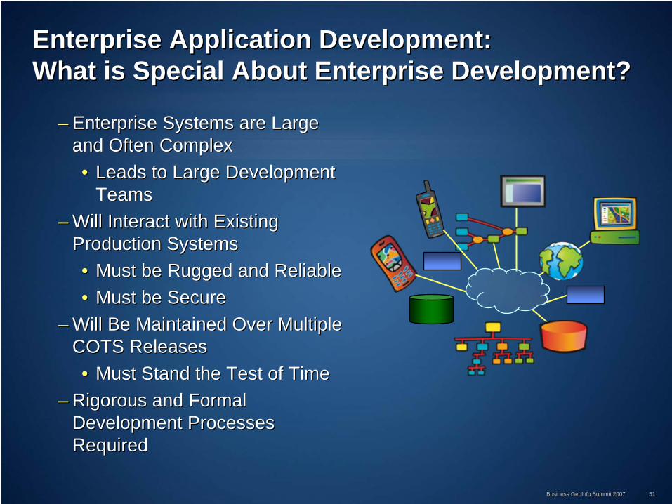
Enterprise Application Development:Enterprise Application Development: What is Special About Enterprise Development?What is Special About Enterprise Development?
–– Enterprise Systems are Large Enterprise Systems are Large and Often Complexand Often Complex•• Leads to Large Development Leads to Large Development
TeamsTeams–– Will Interact with Existing Will Interact with Existing
Production SystemsProduction Systems•• Must be Rugged and ReliableMust be Rugged and Reliable•• Must be SecureMust be Secure
–– Will Be Maintained Over Multiple Will Be Maintained Over Multiple COTS ReleasesCOTS Releases•• Must Stand the Test of TimeMust Stand the Test of Time
–– Rigorous and Formal Rigorous and Formal Development Processes Development Processes RequiredRequired

Business GeoInfo Summit 2007Business GeoInfo Summit 2007 5252
Enterprise Application Development:Enterprise Application Development: Establishing the Development Process Establishing the Development Process –– Essentials (Essentials (Before CodingBefore Coding))
Focus Is On Core Processes First:Focus Is On Core Processes First:•• Establish Fully Automated Builds and Establish Fully Automated Builds and InstallInstall•• Establish Source Code Control Establish Source Code Control •• Establish Bug Tracking System Establish Bug Tracking System
•• Consult Joel on SW Consult Joel on SW http://www.joelonsoftware.com/articles/fog0000000043.htmlhttp://www.joelonsoftware.com/articles/fog0000000043.html
•• (The Joel Test, 12 Steps to Better Code)(The Joel Test, 12 Steps to Better Code)
Build
Install
Code`
Test

Business GeoInfo Summit 2007Business GeoInfo Summit 2007 5353
•• Configure the Development Environment:Configure the Development Environment:–– I.D.E. and 3I.D.E. and 3rdrd Party Components Party Components
•• Special Controls, Reporting and Charting Tools, etc Special Controls, Reporting and Charting Tools, etc •• Can Be Organizational Issue (i.e. a Standard Toolset already in Can Be Organizational Issue (i.e. a Standard Toolset already in place)place)
–– Target O.S., COTS SoftwareTarget O.S., COTS Software•• Developing on Beta or Release?Developing on Beta or Release?
–– Web Server, Servlet Engine, RDBMS, RDBMS Client installsWeb Server, Servlet Engine, RDBMS, RDBMS Client installs
•• Recommendation: Recommendation: –– Establish a Project Website and/or WIKIEstablish a Project Website and/or WIKI–– Document Development SetDocument Development Set--up Instructionsup Instructions–– Document Tricky Configuration ProceduresDocument Tricky Configuration Procedures–– Document/Explain Special Coding Tips/TechniquesDocument/Explain Special Coding Tips/Techniques–– ……....
Enterprise ApplicationEnterprise Application Development:Development: Establishing the Development Process Establishing the Development Process –– Essentials (Before Coding)Essentials (Before Coding)
Best PracticesBest Practices

Business GeoInfo Summit 2007Business GeoInfo Summit 2007 5454
Enterprise Application Development:Enterprise Application Development: Summary and Best PracticesSummary and Best Practices
––Develop a Team Structure that Can Support and Develop a Team Structure that Can Support and Sustain the Coding EffortSustain the Coding Effort•• Avoid Overloading Your DevelopersAvoid Overloading Your Developers
–– Invest in Automation Of ProcessesInvest in Automation Of Processes•• Build, Install, Database Loading, Etc.Build, Install, Database Loading, Etc.
––Establish a Project Website And/Or Wiki For Establish a Project Website And/Or Wiki For Documentation Of:Documentation Of:
–– Configuration Info, Development SetConfiguration Info, Development Set--up, Tips, Etc. up, Tips, Etc.
––Minimize Interruptions to Your Development TeamMinimize Interruptions to Your Development Team––Use An Enterprise Application Framework for Use An Enterprise Application Framework for
ImplementationImplementation
Best PracticesBest Practices

Business GeoInfo Summit 2007Business GeoInfo Summit 2007 5555
Deployment ActivitiesDeployment Activities
Strategy & Strategy & PlanningPlanning
Analysis & Analysis & DesignDesign
DevelopmentDevelopment DeploymentDeployment Operations & Operations & MaintenanceMaintenance
••Visioning & Visioning & Strategic PlanningStrategic Planning
••Business Case Business Case DevelopmentDevelopment
••Implementation Implementation PlanningPlanning
••Organizational Organizational PlanningPlanning
••Risk ManagementRisk Management
••Business Process Business Process AnalysisAnalysis
••Requirements Requirements AnalysisAnalysis
••Use Case Use Case AnalysisAnalysis
••Database DesignDatabase Design
••System System Architecture Architecture DesignDesign
••Application Application DesignDesign
••Database Database DevelopmentDevelopment
••Application Application DevelopmentDevelopment
••Systems / Systems / Enterprise Enterprise IntegrationIntegration
••Quality Quality Assurance Assurance TestingTesting
••Configuration Configuration ManagementManagement
••Deployment Deployment PlanningPlanning
••System System InstallationInstallation
••Acceptance Acceptance TestingTesting
••Performance Performance Validation, Testing Validation, Testing & Tuning& Tuning
••User TrainingUser Training
••User SupportUser Support
••Performance Performance MonitoringMonitoring
••Systems Systems MaintenanceMaintenance
••Software Software MaintenanceMaintenance

Business GeoInfo Summit 2007Business GeoInfo Summit 2007 5656
Deployment Activities:Deployment Activities: OverviewOverview
Test Data & Applications in Test
Environment
Deploy Training
Fix Defects
Develop Training Plan & Materials
Develop Detailed Deployment Plan
Deployment Activities
Go Live
Develop Technical Support Plan &
Materials
Develop Detailed Test Plans
Develop SW Configuration Mgmnt Plan
Procure Hardware Install SW and Data in Test Environment
Install & Test Released SW & Data
in Staging Env.
Install Released SW & Data to
Production Env.
Deploy User Support
Conduct Site Acceptance Testing

Business GeoInfo Summit 2007Business GeoInfo Summit 2007 5757
Deployment Activities:Deployment Activities: Configuration ManagementConfiguration Management
•• A Set of Procedures to Control Changes to the Project A Set of Procedures to Control Changes to the Project During All Phases of the Software LifecycleDuring All Phases of the Software Lifecycle
•• Typical Activities Include :Typical Activities Include :–– Identification of Deliverables Subject to Configuration ManagemeIdentification of Deliverables Subject to Configuration Managementnt–– Creation of A Source Code Repository and Documentation LibraryCreation of A Source Code Repository and Documentation Library–– Identification of Change Request ProceduresIdentification of Change Request Procedures–– Definition of Problem Report ProceduresDefinition of Problem Report Procedures–– Identification of Variances Between Development and Deployment Identification of Variances Between Development and Deployment
EnvironmentsEnvironments–– Write It Down > Software Configuration Management PlanWrite It Down > Software Configuration Management Plan
Change Control is Especially Important if Working with Multiple Change Control is Especially Important if Working with Multiple Development Teams Development Teams –– Must Have a Single Must Have a Single ““GatekeeperGatekeeper”” to Approve to Approve CM Changes During Deployment CM Changes During Deployment
Business GeoInfo Summit 2007Business GeoInfo Summit 2007 5858
Deployment Activities:Deployment Activities: Configuration ManagementConfiguration Management
•• Software Upgrade Requests Should Be DocumentedSoftware Upgrade Requests Should Be Documented•• Installation Packages Should Be Developed Early In the Installation Packages Should Be Developed Early In the
Project LifecycleProject Lifecycle•• Data Model Must Be the Same In Each EnvironmentData Model Must Be the Same In Each Environment
–– Restrict Data Model Access and Track Changes For Each ReleaseRestrict Data Model Access and Track Changes For Each Release•• Consolidate Data Model Updates To Designated Team Member(s)Consolidate Data Model Updates To Designated Team Member(s)•• Review Data Model Plans/Changes To Ensure Consistency, Review Data Model Plans/Changes To Ensure Consistency,
Performance And IntegrationPerformance And Integration•• Track Requested Data Model Updates To Verify Changes Were Track Requested Data Model Updates To Verify Changes Were
Implemented Correctly Implemented Correctly •• Update Data Management Plan Documentation For Each Update Data Management Plan Documentation For Each Software ReleaseSoftware Release
Lessons LearnedLessons Learned
Best PracticesBest Practices

Business GeoInfo Summit 2007Business GeoInfo Summit 2007 5959
Deployment Activities:Deployment Activities: Quality AssuranceQuality Assurance
•• 2002 Study2002 Study11 by the National Institute of Standards & by the National Institute of Standards & Technology found:Technology found:
Source: IBM Systems Sciences Institute
Software bugs, or Software bugs, or errors, are so errors, are so prevalent and so prevalent and so detrimental that they detrimental that they cost the U.S. economy cost the U.S. economy an estimated an estimated $59.5 $59.5 billion annuallybillion annually
Although all errors cannot be removed, Although all errors cannot be removed, more than a third of these more than a third of these costs, could be eliminated by an improved testing infrastructurecosts, could be eliminated by an improved testing infrastructure that that enables earlier and more effective identification and removal ofenables earlier and more effective identification and removal of software defects. software defects.
1 1 NIST Planning Report O2NIST Planning Report O2--3, The Economic Impacts of Inadequate Infrastructure for Softwar3, The Economic Impacts of Inadequate Infrastructure for Software Testinge Testing

Business GeoInfo Summit 2007Business GeoInfo Summit 2007 6060
Deployment Activities: Deployment Activities: Deploy and Test Incremental ReleasesDeploy and Test Incremental Releases
•• Start deployment and testing early on, reStart deployment and testing early on, re--test after fixes test after fixes or changes, plan for adequate testing and bug fixesor changes, plan for adequate testing and bug fixes
•• Early testing ideally includes unit testing by developers Early testing ideally includes unit testing by developers and builtand built--in testing and diagnostic capabilitiesin testing and diagnostic capabilities
TimeTasksTasks
Tasks
TasksTasks
Time Time TimeAlpha
Beta
Pre-Release
Final
Deploy & Test: Deploy & Test: Functions 1 Functions 1 --33
Deploy & Test: Deploy & Test: Functions 1 Functions 1 --66
••Early deployment planning Early deployment planning and implementation and implementation
••Early code integrationEarly code integration
••Staged and smart regression Staged and smart regression testingtesting
••Functional prioritizationFunctional prioritization
••Mitigates impact of schedule Mitigates impact of schedule creepcreep
BenefitsBenefits
Best PracticesBest Practices
Business GeoInfo Summit 2007Business GeoInfo Summit 2007 6161
Deployment Activities: Deployment Activities: Summary of Best PracticesSummary of Best Practices
•• Recognize that Deployment is Harder than It LooksRecognize that Deployment is Harder than It Looks•• Use a Source Control SystemUse a Source Control System•• Implement a Quality Assurance Review ProgramImplement a Quality Assurance Review Program•• Regularly Deploy and Test Incremental ReleasesRegularly Deploy and Test Incremental Releases•• Create and Test Installation PackagesCreate and Test Installation Packages•• Well Tested Software is Easier to DeployWell Tested Software is Easier to Deploy•• Start Planning EarlyStart Planning Early•• Develop a Deployment ChecklistDevelop a Deployment Checklist•• Know Your End User Audience and Target Training and Know Your End User Audience and Target Training and
Supporting Documentation To Meet Their NeedsSupporting Documentation To Meet Their Needs
Best PracticesBest Practices

Business GeoInfo Summit 2007Business GeoInfo Summit 2007 6262
Operations & MaintenanceOperations & Maintenance
Strategy & Strategy & PlanningPlanning
Analysis & Analysis & DesignDesign
DevelopmentDevelopment DeploymentDeployment Operations & Operations & MaintenanceMaintenance
••Visioning & Visioning & Strategic PlanningStrategic Planning
••Business Case Business Case DevelopmentDevelopment
••Implementation Implementation PlanningPlanning
••Organizational Organizational PlanningPlanning
••Risk ManagementRisk Management
••Business Process Business Process AnalysisAnalysis
••Requirements Requirements AnalysisAnalysis
••Use Case Use Case AnalysisAnalysis
••Database DesignDatabase Design
••System System Architecture Architecture DesignDesign
••Application Application DesignDesign
••Database Database DevelopmentDevelopment
••Application Application DevelopmentDevelopment
••Systems / Systems / Enterprise Enterprise IntegrationIntegration
••Quality Quality Assurance Assurance TestingTesting
••Configuration Configuration ManagementManagement
••Deployment Deployment Planning Planning
••System System InstallationInstallation
••Acceptance Acceptance TestingTesting
••Performance Performance Validation, Testing Validation, Testing & Tuning& Tuning
••User TrainingUser Training
••User SupportUser Support
••Performance Performance MonitoringMonitoring
••Systems Systems MaintenanceMaintenance
••Software Software MaintenanceMaintenance
The Project Lifecycle Does Not End With Deployment!The Project Lifecycle Does Not End With Deployment!

Business GeoInfo Summit 2007Business GeoInfo Summit 2007 6363
Operations & Maintenance Activities:Operations & Maintenance Activities: User Support ConsiderationsUser Support Considerations
•• How Many People Are You Supporting?How Many People Are You Supporting?•• What Are Their Geographic Parameters?What Are Their Geographic Parameters?
-- Domestic or International?Domestic or International?-- What Time Zones Are They In?What Time Zones Are They In?
•• Will You Provide 24/7 Support?Will You Provide 24/7 Support?•• How Do You Select Your Support Staff?How Do You Select Your Support Staff?
-- From Internal Personnel?From Internal Personnel?-- Use Outsourced Professionals?Use Outsourced Professionals?-- A Combination of The Two?A Combination of The Two?
•• What Applications Do You Support?What Applications Do You Support?-- Commercial Off The Shelf?Commercial Off The Shelf?-- Custom Applications?Custom Applications?-- ThirdThird--party Configurations?party Configurations?
•• What Support Infrastructure Already Exists in Your Organization?What Support Infrastructure Already Exists in Your Organization?

Business GeoInfo Summit 2007Business GeoInfo Summit 2007 6464
Operations & Maintenance Activities:Operations & Maintenance Activities: User SupportUser Support
•• Tiered Support Model Tiered Support Model ––Tier 1: Help DeskTier 1: Help Desk
•• Solves Issues InternallySolves Issues Internally•• Directs Issues To Tier 2 Or Tier 3Directs Issues To Tier 2 Or Tier 3
––Tier 2: Domain/Technical KnowledgeTier 2: Domain/Technical Knowledge•• Internal ExpertiseInternal Expertise•• External ExpertiseExternal Expertise•• Directs Issues To Tier 3Directs Issues To Tier 3
––Tier 3: Vendor SupportTier 3: Vendor Support•• Standard Level SupportStandard Level Support•• Extended Level SupportExtended Level Support

Business GeoInfo Summit 2007Business GeoInfo Summit 2007 6565
Operations & Maintenance Activities:Operations & Maintenance Activities: Performance Monitoring & TuningPerformance Monitoring & Tuning
•• Establish a Performance BaselineEstablish a Performance Baseline
•• Define and Measure Performance Metrics Based on Define and Measure Performance Metrics Based on Business Processes Not Button ClicksBusiness Processes Not Button Clicks
•• Plan For System Tuning After Each InstallationPlan For System Tuning After Each Installation
•• Develop Administrative Procedures to Automate System Develop Administrative Procedures to Automate System Tuning Tuning
Best PracticesBest Practices

Business GeoInfo Summit 2007Business GeoInfo Summit 2007 6666
Operations & Maintenance:Operations & Maintenance: System AdministrationSystem Administration
•• Regular Geodatabase Maintenance is Regular Geodatabase Maintenance is RequiredRequired–– Monitor StatisticsMonitor Statistics–– Manage Your VersionsManage Your Versions
•• Reconcile and Post Edits as Frequently as PossibleReconcile and Post Edits as Frequently as Possible•• Delete Unnecessary When PossibleDelete Unnecessary When Possible•• Compress the Database on a Regular ScheduleCompress the Database on a Regular Schedule
–– Use SQL Scripts to Perform Nightly Tuning of an Use SQL Scripts to Perform Nightly Tuning of an ArcSDE DatabaseArcSDE Database•• Rebuilds All Indexes Owned By Any User That Owns Rebuilds All Indexes Owned By Any User That Owns
SDE Data SDE Data
•• Treat Your GIS As You Would Any Other IT Treat Your GIS As You Would Any Other IT System In Terms Of Disaster Recovery and System In Terms Of Disaster Recovery and Business Continuity PlanningBusiness Continuity Planning
ArcSDE tuning ArcSDE tuning scripts available on scripts available on support.esri.comsupport.esri.com
GDB Management GDB Management toolset available on toolset available on
support.esri.comsupport.esri.com

Business GeoInfo Summit 2007Business GeoInfo Summit 2007 6767
Operations & Maintenance:Operations & Maintenance: Software MaintenanceSoftware Maintenance
•• Enhancement RequestsEnhancement Requests–– Need to Be Prioritized and Approved Need to Be Prioritized and Approved
By the Change Management BoardBy the Change Management Board–– Regression Test After New Regression Test After New
Capabilities Are AddedCapabilities Are Added–– Plan For Beta Releases and HandsPlan For Beta Releases and Hands--
on User Review on User Review –– Before Going LiveBefore Going Live–– Allow Time to Implement Required Allow Time to Implement Required
Changes After Beta ReviewsChanges After Beta Reviews–– Train the Users to Use New Train the Users to Use New
CapabilitiesCapabilities–– Provide Refresher Training in Key Provide Refresher Training in Key
Problem AreasProblem Areas–– Allow Enough Time Between Allow Enough Time Between
ReleasesReleases~6 Months For Major Releases~6 Months For Major Releases
•• COTS SW UpgradesCOTS SW Upgrades–– Evaluate New Releases to Evaluate New Releases to
Determine If There Is a Business Determine If There Is a Business Need to UpgradeNeed to Upgrade
–– Consider the Impact of Upgrading Consider the Impact of Upgrading Your Geodatabase Before UpgradingYour Geodatabase Before Upgrading
–– Evaluate Compatibility Of Upgrades Evaluate Compatibility Of Upgrades To 3To 3rdrd Party SW Before Party SW Before Implementing i.e. Do Not Upgrade Implementing i.e. Do Not Upgrade Your RDBMS Without Evaluating the Your RDBMS Without Evaluating the Impact On ArcSDEImpact On ArcSDE
–– Regression Test New Releases Regression Test New Releases Within Your Test/Development Within Your Test/Development Environment FirstEnvironment First
Best PracticesBest Practices

Business GeoInfo Summit 2007Business GeoInfo Summit 2007 6868
SummarySummary

Business GeoInfo Summit 2007Business GeoInfo Summit 2007 6969
Summary of Best Practices for Planning and Summary of Best Practices for Planning and Managing a GISManaging a GIS
•• Communication, communication, communicationCommunication, communication, communication
•• Start With a Clearly Defined Vision and Success CriteriaStart With a Clearly Defined Vision and Success Criteria
•• Identify and Monitor RisksIdentify and Monitor Risks
•• Use a Phased Approach Use a Phased Approach
•• Involve the Users and Key Stakeholders Early and OftenInvolve the Users and Key Stakeholders Early and Often
•• Manage Change Manage Change
•• Pilot your Geodatabase MigrationPilot your Geodatabase MigrationBest PracticesBest Practices

Business GeoInfo Summit 2007Business GeoInfo Summit 2007 7070
Summary of Best Practices for Planning and Summary of Best Practices for Planning and Managing a GISManaging a GIS
•• Use a Structured Development MethodologyUse a Structured Development Methodology
•• DonDon’’t get too focused on technology and cool stuff t get too focused on technology and cool stuff –– make it business make it business relevantrelevant
•• Assign a Dedicated Configuration Management Team to Manage the Assign a Dedicated Configuration Management Team to Manage the Development, Test, and Staging EnvironmentsDevelopment, Test, and Staging Environments
•• Hire or Train a Skilled Geodatabase AdministratorHire or Train a Skilled Geodatabase Administrator
•• Plan for PostPlan for Post--Deployment User Support Deployment User Support
•• Communication, communication, communicationCommunication, communication, communication
Best PracticesBest Practices

Business GeoInfo Summit 2007Business GeoInfo Summit 2007 7171
Additional ResourcesAdditional Resources
•• ESRI Project Center WebsiteESRI Project Center Website–– http://support.esri.com/projectcenterhttp://support.esri.com/projectcenter
•• ESRI Enterprise Advantage ProgramESRI Enterprise Advantage Program–– http://www.esri.com/eeap/index.htmlhttp://www.esri.com/eeap/index.html
•• ESRI Systems Integration Web SiteESRI Systems Integration Web Site–– http://www.esri.com/systemsint/index.htmlhttp://www.esri.com/systemsint/index.html
•• ESRI Developer NetworkESRI Developer Network–– http://edn.esri.comhttp://edn.esri.com
•• ESRI Professional ServicesESRI Professional Services–– http://www.esri.com/consulting/index.htmlhttp://www.esri.com/consulting/index.html
•• Project Management InstituteProject Management Institute–– http://www.pmi.orghttp://www.pmi.org

Business GeoInfo Summit 2007Business GeoInfo Summit 2007 7272
Additional ResourcesAdditional Resources
•• Doug Rosenberg (primary author)Doug Rosenberg (primary author)–– Use Case Driven Object Modeling with UMLUse Case Driven Object Modeling with UML–– Agile Development with Iconix ProcessAgile Development with Iconix Process
•• Grady BoochGrady Booch–– Managing an Object Oriented projectManaging an Object Oriented project

Business GeoInfo Summit 2007Business GeoInfo Summit 2007 7373
Questions?Questions?
Please Fill Out Your Evaluation FormsPlease Fill Out Your Evaluation Forms
Thank You!Thank You!