bgs classification of lithodemic units: proposals for ... · bgs classification of lithodemic...
TRANSCRIPT

BGS classification of lithodemic units: Proposals for classifying units of intrusive rock
RESEARCH REPORT RR/08/05
E
W2
W4
A3 A1P2
P1
P5P4
P3
CU
MW4
GG
W3
W4M
M
Z
GS2
S1
S3
G
W6W1
CU
MS
CU
STRATHAIRD
Z
ED
CU
W3
Loch Scavaig
SZ
D1
MDZ
Zone
2
Zone 3
F1BDX
C1
C2
C2
C2
C3
C1
F2
F3D2
LochAinort


Bookmarks
The main elements of the table of contents are bookmarked enabling direct links to be followed to the principal section headings and sub-headings, figures, plates and tables irrespective of which part of the document the user is viewing.
HOw TO NAviGATE THiS dOCumENT
in addition, the report contains links:
from the principal section and subsection headings back to the contents page,
from each reference to a figure, plate or table directly to the corresponding figure, plate or table,
from each figure, plate or table caption to the first place that figure, plate or table is mentioned in the text and
from each page number back to the contents page.
RETuRN TO CONTENTS PAGE


The National Grid and other Ordnance Survey data are used with the permission of the Controller of Her majesty’s Stationery Office. Licence No: 100017897/ 2008.
Front cover
Geological map of the Skye Central Complex showing the lithode-mic units (adapted from British Regional Geology—the Palaeogene volcanic districts of Scotland. Fourth edition. 2005).
Key words
Lithodemic unit, lithodemic classification, intrusive units, mixed units, uK, onshore
Bibliographical reference
Gillespie, M R, stephenson, D, and MillwaRD, D. 2008. BGS classification of lithodemic units: Proposals for classifying units of intrusive rock. British Geological Survey Research Report, RR/08/05. 31pp.
Copyright in materials derived from the British Geological Survey’s work is owned by the Natural Environment Research Council (NERC) and/or the authority that commissioned the work. You may not copy or adapt this publication without first obtaining permission. Contact the BGS intellectual Property Rights Section, British Geological Survey, Keyworth, e-mail [email protected]. You may quote extracts of a reasonable length without prior permission, provided a full acknowledgement is given of the source of the extract.
Your use of any information provided by the British Geologi-cal Survey (BGS) is at your own risk. Neither BGS nor the Natural Environment Research Council gives any warranty, condition or representation as to the quality, accuracy or completeness of the information or its suitability for any use or purpose. All implied conditions relating to the quality or suitability of the information, and all liabilities arising from the sup-ply of the information (including any liability arising in negligence) are excluded to the fullest extent permitted by law.
maps and diagrams in this report use topography based on Ordnance Survey mapping.
iSBN 978 0 85272 624 2
© NERC 2008. All rights reserved
BRiTiSH GEOLOGiCAL SuRvEY
RESEARCH REPORT RR/08/05
BGS classification of lithodemic units: Proposals for classifying units of intrusive rock
m R Gillespie, d Stephenson and d millward
Keyworth, Nottingham British Geological Survey 2008

BRiTiSH GEOLOGiCAL SuRvEY
The full range of our publications is available from BGS shops at Nottingham, Edinburgh, London and Cardiff (welsh publications only), see contact details below or shop online at www.geology-shop.com
The London information Office also maintains a reference collection of BGS publications, including maps, for consultation.
we publish an annual catalogue of our maps and other publications; this catalogue is available online or from any of the BGS shops.
The British Geological Survey carries out the geological survey of Great Britain and Northern ireland (the latter as an agency service for the government of Northern ireland), and of the surrounding continental shelf, as well as basic research projects. it also undertakes programmes of technical aid in geology in developing countries.
The British Geological Survey is a component body of the Natural Environment Research Council.
British Geological Survey offices
BGS Central Enquiries DeskTel 0115 936 3143 Fax 0115 936 3276email [email protected]
Kingsley Dunham Centre, Keyworth, Nottingham NG12 5GGTel 0115 936 3241 Fax 0115 936 3488email [email protected]
Murchison House, West Mains Road, Edinburgh EH9 3LATel 0131 667 1000 Fax 0131 668 2683email [email protected]
Natural History Museum, Cromwell Road, London SW7 5BDTel 0207 589 4090 Fax 0207 584 8270Tel 0207 942 5344/45 email [email protected]
Columbus House, Greenmeadow Springs, Tongwynlais, Cardiff CF15 7NETel 029 2052 1962 Fax 029 2052 1963
Maclean Building, Crowmarsh Gifford, Wallingford OX10 8BBTel 01491 838800 Fax 01491 692345
Geological Survey of Northern Ireland, Colby House, Stranmillis Court, Belfast BT9 5BFTel 028 9038 8462 Fax 028 9038 8461www.bgs.ac.uk/gsni/
Parent BodyNatural Environment Research Council, Polaris House,North Star Avenue, Swindon SN2 1EUTel 01793 411500 Fax 01793 411501www.nerc.ac.uk
website www.bgs.ac.uk
Shop online at www.geologyshop.com
iii British Geological Survey Research Report RR/08/05
1 Introduction 1
2 The BGS lithodemic classification 2 2.1 The glossary 2 2.2 The hierarchy 2 2.3 Lithodemic units in formal ranks 4 2.4 Commonly used terms excluded from the formal classification 6 2.5 Naming lithodemic units 7 2.6 Other classifications 8 2.7 Non-igneous intrusive units 8
3 Major intrusive lithodemic units in the UK 9 3.1 Precambrian igneous supersuites 9 3.2 Caledonian igneous Supersuite 9 3.3 variscan igneous Supersuite 9 3.4 Carboniferous and Permian igneous Supersuite 10 3.5 Atlantean igneous Supersuite 10
4 Formal definitions and Lexicon entries 11
5 Approval procedures and management 12
Appendix 13Examples1 A possible lithodemic classification at Ranks 1, 2 and 3
of the Caledonian igneous Supersuite 132 Lake district and adjacent areas 14
3 Carrock Fell Centre 154 Glen Etive area 165 Glen Coe area 176 Late Carboniferous tholeiitic sills and dykes of northern England and the midland valley 187 Skye Central Complex 198 Rum Central Complex 20
Glossary 21
References 25
FIGURE
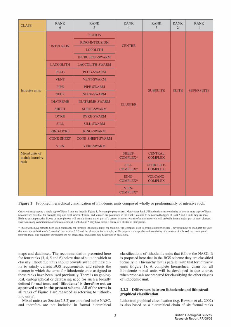
1 Proposed hierarchical classification of lithodemic units composed predominantly of intrusive rock 3
ACKNOWLEDGEMENTS
This report has benefited considerably from critical reviews provided by Henry Emeleus, Brian Bell, and British Geological Survey staff (John Carney, maarten Krabbendam, david Lowe, John mendum and Richard Scrivener), and from feedback provided by members of the Geological Society Stratigraphy Commission.
Contents

ivBritish Geological Survey Research Report RR/08/05
This report sets out a framework and terminology for classi-fying and naming lithodemic units composed entirely or predominantly of intrusive rock. it has been written with the geology of the uK in mind, but the principles and defini-tions recommended here should be applicable globally. The report anticipates a second phase of work, in which a BGS lithodemic classification for onshore intrusions in the uK will be constructed using the recommendations set out here. it is expected that this classification will in future be extended to include other classes of lithodemic unit (highly deformed, highly metamorphosed and ‘mixed’), and lithodemic units in offshore parts of the uK.
A hierarchical framework of six formal ranks is pro-posed. Recommendations are made for classifying lithodemic units within the hierarchy and for constructing formal names for lithodemic units. A comprehensive glos-sary contains definitions for ‘approved’ lithodemic terms and for other terms associated with lithodemic classi-fication.
Some amendments to the existing form for making entries to the BGS Lexicon of Named Rock Units are suggested in order to make it compatible with some of the special charac-teristics of lithodemic units. it is proposed that a Lithodemic Framework Committee be established to approve new names for lithodemic units and to oversee management and devel-opment of the classification. Examples showing how the proposed classification and nomenclature will work are set out in an Appendix, generally in the form of simplified geo-logical maps accompanied by a ‘classification’ of the illustrated lithodemic units in a hierarchical chain.
in anticipation of a second phase of work that will produce a full lithodemic classification, it is proposed that intrusive lithodemic units associated with each of the four major Phanerozoic tectonothermal events to have affected the uK (‘Caledonian’, ‘variscan’, ‘Carboniferous and Permian’, and ‘Atlantean’) be grouped at the highest formal rank proposed here to create four ‘supersuites’; a brief summary is provided of the salient aspects of each of these four events.
Summary
1 British Geological Survey Research Report RR/08/05
Lithodemic units are the mappable geological units in ter-rains in which rocks generally lack primary stratification. unlike lithostratigraphical units, lithodemic units do not obey the Law of Superposition (North American Commission on Stratigraphic Nomenclature (NACSN), 1983; Rawson et al., 2002). They consist predominantly of intrusive, highly deformed, and/or highly metamorphosed rock, and can include lithostratigraphical units. Formalised lithostrati-graphical classifications, such as those set out in British Geological Survey (BGS) Stratigraphical Framework reports, are now accepted widely and used on all modern BGS maps, in publications, in databases and associated dig-ital products. units of extrusive igneous rock have been integrated into a formal lithostratigraphical hierarchy (e.g. Rushton and Howells, 1998; millward, 2004). This report sets out a framework and terminology for classifying litho-demic units composed entirely or predominantly of intrusive rock. The great majority of these have an igneous origin but some, including salt ‘domes’ and some sediment-filled frac-tures, do not. Although the report is concerned primarily with igneous intrusive units, those of non-igneous origin can be treated in the same way (see Section 2.7). it is anticipated that the scheme discussed here will be extended in future to include the other main classes of lithodemic units (highly deformed, highly metamorphosed, and ‘mixed’ units not dominated by intrusive rocks). Lithodemic units are not recognised in the International Stratigraphic Guide (Salvador, 1994), which considers intru-sive igneous bodies and non-stratified metamorphic rocks to be special cases within lithostratigraphy. As pointed out by Rawson et al. (2002), this approach provides little help to geologists mapping in igneous and metamorphic terrains. The need in the British Geological Survey for a formal lith-odemic classification of intrusive igneous rocks of the uK has been demonstrated during the recent development of major projects such as the Lexicon of Named Rock Units and the Digital Geological Map of Great Britain (digmapGB). Recent reviews of the Caledonian igneous rocks and the Carboniferous and Permian igneous rocks of Great Britain (Stephenson et al., 1999, 2003), undertaken as part of the Geological Conservation Review, and preparation of the fourth edition of British Regional Geology: the Palaeogene volcanic districts of Scotland (Emeleus and Bell, 2005), pro-vided opportunities to begin developing a practical, formal, lithodemic scheme. A formalised scheme for the Early Palaeozoic igneous rocks of northern England, arising from almost 20 years of recent BGS work in the Lake district, has been published (millward, 2002, table 1). The recent work outlined above has emphasised the need to revise and expand current BGS guidelines for the termi-nology of lithodemic units, which were set out by Allen (1995). This report does that, and sets out the foundations
for a hierarchical classification of intrusive igneous lithode-mic units of the uK. The production of a full classification is planned in two phases:
• thisreport,theoutcomeofPhase1,setsoutrecommendations for a hierarchical structure and terminology for the classification
• theintrusivelithodemicunitsoftheUKwillbeclassified and named according to these recommendations in Phase 2.
The main purpose of the classification is to promote wide-spread use of a consistent lithodemic nomenclature and hierarchy within the uK, and thereby assist in communicat-ing uK igneous history. The general principles of the classification, and the associated terminology, should apply to intrusive rocks anywhere in the world and hence should be followed, where appropriate, by BGS teams working overseas. The scheme will over time be presented to a wider national and international audience, for example through BGS publications and collaborations, and the BGS website, and it, or a derivative from it, may eventually attain general and widespread usage. The approach and terminology recommended here are based to an extent on established schemes, particularly the North American Stratigraphic Code (NASC), devised by the North American Commission on Stratigraphic Nomenclature (NACSN, 1983). we have also considered how various terms have been used by geologists in parts of the world where intrusive igneous rocks contribute extensively to the geology (e.g. w S Pitcher and coworkers in Peru; A J R white and others in Australia). However, the requirements of the BGS, and the geology and geological history of the uK, have dictated that the scheme recommended here is dis-tinctly different from other published schemes. it is intended that all exposed and known concealed bodies of intrusive igneous rock in onshore areas of the uK be included in the classification (Phase 2). Lithodemic units that crop out in (or are concealed beneath) offshore parts of the uK will not be included initially, but may be classified at a later date using an extension of the approach and terminol-ogy recommended here. Similarly, lithodemic units not composed predominantly of intrusive rock will not be clas-sified initially. The scheme should be sufficiently flexible to allow these to be added readily at a later date. Every effort has been made to provide recommendations for best practice, though as with all attempts to classify nat-ural systems there is no ideal solution. The robustness of the recommendations set out here will be tested thoroughly only when the full classification is prepared during Phase 2; it may be necessary at that stage to alter some aspects of the scheme.
1 introduction
2British Geological Survey Research Report RR/08/05
The recommendations set out here deal specifically with lithodemic units composed of intrusive rocks only and those that are mixed (i.e. contain two or more classes of rock unit) but composed predominantly of intrusive rock. The recom-mendations are built around two important components: a glossary of approved terms and their definitions, and a hier-archical framework for classifying lithodemic units.
2.1 THE GLOSSARy
All successful classifications are underpinned by clearly defined terms used in a consistent way. Selecting and defin-ing ‘approved’ terms for, or relevant to, lithodemic units formed an important part of the process of creating the present scheme. The approved terms, their definitions, and some indications of how we recommend or expect them to be used in BGS, are given in the glossary. Expanded defini-tions of several key terms are given in the following text, but readers should refer to the glossary to find formal definitions for approved terms. The glossary also draws attention to some terms that should not be used in a lithodemic context.
2.2 THE HIERARCHy
The classification framework recommended here is set out in Figure 1. it has a hierarchical structure and six formal ranks, numbered 1 to 6; Rank 1 is taken to be the highest. The figure incorporates the two classes of lithodemic unit that form the subject of this report — intrusive units and mixed units of mainly intrusive rock. Lithodemic units clas-sified in Ranks 1 and 2 are common to both classes, whereas those classified in Ranks 3–6 are unique to each class. Classification is based on the principle that a unit classified in any rank other than 6 may be used to group two or more units of lower rank. Single intrusions are classified at Rank 6. units classified at Ranks 5, 4 and 3 group intrusions that have a spatial asso-ciation and/or an association with a particular phase of magmatism. units classified at Ranks 2 and 1 (and ‘sub-suite’ at Rank 3) group ‘natural associations’ of intrusions. most classified units will be part of simple ‘parent–child’ chains spanning up to six ranks. However, as in lithostratig-raphy, classified units do not need to have a ‘parent’ either at the next rank up in the chain, or indeed at any higher rank. it is, for example, perfectly acceptable to classify a unit at Rank 6 or 5 with no parent or child at any other rank. This could be because the unit has no ‘relatives’, or because its lithodemic relationship with other units is unknown or uncertain. it is also acceptable for a parent–child relation-ship to skip one or more ranks. For example, a unit classified at Rank 5 may have a parent classified at Rank 2. However, the only type of intrusive unit classified at Rank 3 — sub-suite — must have a parent classified at Rank 2, for reasons outlined in Section 2.3.1.5. individual types of lithodemic unit may span several orders of magnitude of size; for example, some dykes per-
sist for no more than a few metres, whereas the largest ones can straddle much of a continent. unlike lithostratig-raphy, where a depositional origin for all units means that thickness is a useful means of recording and comparing size, the only meaningful measure of the size of lithodemic units is their volume. However, volume is generally impos-sible to determine accurately from the outcrop; a dyke 10 m thick at outcrop may in its full extent contain many cubic kilometres of rock and be as voluminous as a pluton. For these reasons, scale cannot be incorporated practically into a lithodemic classification. Therefore, as in lithos-tratigraphy, the size of a lithodemic unit is irrelevant in determining its position in the classification hierarchy. A dyke is classified at Rank 6 regardless of whether its out-crop is 10 m long or 100 km long, and a pluton is classified at Rank 5 regardless of whether its outcrop covers 1 km2 or 1000 km2. For similar reasons, the number of lithodemic units is not critical in determining the type or rank of lithodemic unit used to group them. A number of dykes may be grouped within a dyke-swarm regardless of whether there are 2 or 2000. Similarly, two or any larger number of units classified at Ranks 6 and 5 may be grouped at Rank 4 in a cluster or centre. The Appendix contains several examples of lithodemic hierarchies for intrusive rocks in different parts of the uK. Appendix, Example 1 shows one possible classification of the Caledonian igneous Supersuite (highest ranks). Names used in Appendix, Example 1 appear in the other examples, but it is emphasised that they are illustrative and currently have no formal status; they are all liable to be revised during Phase 2.
2.2.1 Lithodemic terminology in the North American Stratigraphic Code
The recommendation made here for six formal ranks in a hierarchical classification of lithodemic units is a signifi-cant departure from the scheme set out in the North American Stratigraphic Code (NACSN, 1983). in the NASC, only three types of intrusive lithodemic unit are recognised: supersuite (Rank 1), suite (Rank 2) and litho-deme (Rank 3). The terms supersuite and suite are adopted here and placed in the two highest ranks of this classifica-tion. in traditional usage these terms commonly imply a genetic (familial) relationship between intrusions, and their use in a lithodemic context is therefore not ideal. However, it is justified in being consistent with the NASC, and because there are no established terms that are more suitable for grouping intrusive lithodemic units. The NASC defines lithodeme as ‘… the fundamental unit in lithodemic classification. A lithodeme is a body of intrusive, pervasively deformed, or highly metamor-phosed rock, generally non-tabular and lacking primary depositional structures, and characterized by lithic homo-geneity. It is mappable at the Earth’s surface and traceable in the subsurface. For cartographic and hierar-chical purposes, it is comparable to a formation.’ A single type of lithodemic unit in a rank below that of suite is clearly inadequate to meet fully the needs of digital
2 The BGS lithodemic classification
CLASSRANK
6RANK
5RANK
4RANK
3RANK
2RANK
1
intrusive units
iNTRuSiON
PLuTON
CENTRE
CLuSTER
SuBSuiTE SuiTE SuPERSuiTE
RiNG-iNTRuSiON
LOPOLiTH
iNTRuSiON-SwARm
LACCOLiTH LACCOLiTH-SwARm
PLuG PLuG-SwARm
vENT vENT-SwARm
PiPE PiPE-SwARm
NECK NECK-SwARm
diATREmE diATREmE-SwARm
SHEET SHEET-SwARm
dYKE dYKE-SwARm
SiLL SiLL-SwARm
RiNG-dYKE RiNG-SwARm
CONE-SHEET CONE-SHEET-SwARm
vEiN vEiN-SwARm
mixed units of mainly intrusive rock
SHEET-COmPLEX*
CENTRAL COmPLEX
SiLL-COmPLEX*
OPHiOLiTE-COmPLEX
RiNG-COmPLEX*
vOLCANO-COmPLEX
vEiN-COmPLEX*
Figure 1 Proposed hierarchical classification of lithodemic units composed wholly or predominantly of intrusive rock.
Only swarms grouping a single type of Rank 6 unit are listed in Figure 1, for example plug-swarm. many other Rank 5 lithodemic terms consisting of two or more types of Rank 6 feature are possible, for example plug-and-vent-swarm. ‘Centre’ and ‘cluster’ are positioned in the Rank 4 column to be near to the types of Rank 5 and 6 units they are most likely to encompass; that is, one or more plutons will usually form a major part of a centre, whereas swarms of minor intrusions will probably form a major part of most clusters. However, many combinations of units classified at Ranks 6 and 5 may have either a centre or a cluster as their parent.
* These terms have hitherto been used commonly for intrusive lithodemic units; for example, ‘sill-complex’ used to group a number of sills. They must now be used only for units that meet the definition of a ‘complex’ (see section 2.3.2 and the glossary); for example, a sill-complex is a mappable unit consisting of a number of sills and the country-rock between them. The examples shown here are not exhaustive, and others may be defined in due course.
3 British Geological Survey Research Report RR/08/05
maps and databases. The recommendation presented here for four ranks (3, 4, 5 and 6) below that of suite in which to classify lithodemic units should provide sufficient flexibil-ity to satisfy current BGS requirements, and reflects the manner in which the terms for lithodemic units assigned to these ranks have been used previously. There is no geolog-ical, cartographical or databasing need for such a broadly defined formal term, and ‘lithodeme’ is therefore not an approved term in the present scheme. All of the terms in all ranks of Figure 1 are regarded as referring to ‘lithode-mic units’. mixed units (see Section 2.3.2) are unranked in the NASC, and therefore are not included in formal hierarchical
classifications of lithodemic units that follow the NASC. it is proposed here that in the BGS scheme they are classified formally in a hierarchy that is parallel with that for intrusive units (Figure 1). A complete hierarchical chain for all lithodemic mixed units will be developed in due course, when proposals are prepared for classifying the other classes of lithodemic unit.
2.2.2 Differences between lithodemic and lithostrati-graphical classification
Lithostratigraphical classification (e.g. Rawson et al., 2002) is also based on a hierarchical chain of six formal ranks

4British Geological Survey Research Report RR/08/05
(though one of these, containing the unit ‘subgroup’, is used rarely), and in this respect lithostratigraphical classification and the proposed lithodemic classification are similar. However, the strongly contrasting ways in which intrusive lithodemic units and lithostratigraphical units are formed (i.e. emplacement versus deposition) mean that there are a number of fundamental differences. The most obvious of these are:
• Theshapeoflithodemicunitsishighlyvariableandisthe principal criterion used to classify single units of intrusive rock. The lithodemic classification hierarchy therefore contains a large number of types of unit in Rank 6. By contrast, Rank 6 of the lithostratigraphical hierarchy contains only two types of unit — bed and flow.
• Intrusivelithodemicunitsmaybeassociatedspatiallyin a large number of ways, ranging from simple groups of two or more units of the same type to highly complicated groups involving numerous units of different type, rank and relative disposition. Twenty-two ‘types’ of lithodemic unit shown in Ranks 5 and 4 in Figure 1 reflect this diversity; those shown in Rank 5 represent only a subset of those that can be formed at Rank 5 by combining two or more types of Rank 6 unit, e.g. plug-and-vent-swarm. By contrast, related lithostratigraphical units are invariably associated spatially in a relatively simple manner, as part of a depositional succession, hence the lithostratigraphical hierarchy contains only one type of unit classified at each of Ranks 5 (member) and 4 (formation).
Thus, although the lithostratigraphical chain bed – member – formation – subgroup – group – supergroup has a similar hierarchical structure to a lithodemic chain such as intrusion – pluton – centre – subsuite – suite – supersuite, lithostrati-graphical and lithodemic units classified at the same rank (e.g. member and pluton, both in Rank 5) should not be thought of as ‘equivalent’. A further important contrast lies in the philosophy under-pinning lithostratigraphical and lithodemic classification. The ‘basic unit’ of lithostratigraphy is the formation, classi-fied at Rank 4 (whittaker et al., 1991). Higher and lower ranking units in a stratigraphical sequence are classified once the formations are defined. The classification proce-dure proposed here for lithodemic units is less formal, with no ‘basic unit’.
2.3 LITHODEMIC UNITS IN FORMAL RANKS
2.3.1 Intrusive units
2.3.1.1 intRusive lithoDeMic units of Rank 6
Thirteen types of lithodemic unit are classified at Rank 6 (Figure 1). Each denotes an intrusion that was emplaced effectively in a single phase. Twelve are distinguished pri-marily on the basis of intrusion shape and, in some cases, setting. The term ‘intrusion’ carries no connotation of shape or setting, and may be used (with a capital ‘i’) in the formal name of a lithodemic unit classified at Rank 6, the shape of which is not known or is not described adequately by one of the other Rank 6 terms (e.g. iron Crag microgranite intrusion; see Appendix, Examples 2, 3, 4, 6, 7 and 8). The term ‘intrusion(s)’ may also be used generi-cally (with a lower case ‘i’) to refer to any intrusive lithodemic unit(s).
2.3.1.2 intRusive lithoDeMic units of Rank 5
Lithodemic units of Rank 5 generally group two or more intrusions of Rank 6 that are spatially associated and/or associated with a particular phase of magmatism (Appendix, Examples 2 and 6). Groups of Rank 6 intrusions are in many cases classified at Rank 5 using the term ‘swarm’. Thus, a group of dykes is a dyke-swarm, and a group of cone-sheets is a cone-sheet-swarm. Longer names may be constructed to denote groups of more than one type of intrusion, for example dyke-and-sill-swarm (such names are not shown in Figure 1, but many combinations are possible). The term intrusion-swarm may also be used to denote groups of two or more types of intru-sion, or of intrusions of unknown shape. The propensity of natural systems to defy rigorous classifi-cation means that a degree of pragmatism will commonly be required in using Rank 5 terms (and, indeed, terms for litho-demic units in all ranks). For example, a group of spatially associated intrusions of which 95 per cent are dykes and 5 per cent are sills could still be termed ‘dyke-swarm’, as that describes the essential character of the lithodemic unit. Plutons, lopoliths and ring-intrusions may consist of single intrusions or multiple intrusions. Hence, all plutons, lopoliths and ring-intrusions are classified at Rank 5, even though some may be essentially single intrusions (Appendix, Examples 2, 4, 7 and 8). Plutons and lopoliths are, by definition, quite large features (kilometre scale and larger, see glossary), and typically larger than many units classified at Rank 6.
2.3.1.3 intRusive lithoDeMic units of Rank 4
Two or more intrusions classified at Ranks 6 and/or 5 that are spatially associated may be grouped within two types of intrusive lithodemic unit classified at Rank 4 — centre and cluster. Centres encompass spatially tight groups of intru-sive units focused around a central point, and clusters encompass less tight (more scattered) groups (Appendix, Examples 2, 3, 4 and 7). Classification at Rank 4 allows a diverse assemblage of units classified at Ranks 5 and 6 to be included in centres and clusters. A centre could, for exam-ple, comprise two intersecting plutons, several ring-dykes, an associated dyke-swarm, and a number of pipes. A cluster could consist of two dyke-swarms, a sill-swarm and numer-ous pipes, scattered over a wide area.
2.3.1.4 intRusive lithoDeMic units of Rank 3
Only one type of intrusive lithodemic unit — subsuite — is classified at Rank 3. it is useful in some instances to identify within a suite (Rank 2, see Section 2.3.1.5) a smaller group (or groups) of lithodemic units that display shared charac-teristics. Subsuites can be identified only after the ‘parent’ suite has been defined. A subsuite may be formed by group-ing two or more lithodemic units that share some similarities in a meaningful combination of observed features, and that are already assigned to a single suite. Not all suites contain subsuites, and there is no need to group all the lithodemic units in a suite into subsuites. A suite could, for example, consist of a subsuite of three plu-tons and several other intrusive lithodemic units not assigned to a subsuite. No subsuites have been defined formally in the uK to date. However, it is anticipated that some will be defined in the course of the forthcoming (Phase 2) formal classification of uK lithodemic units; Appendix, Example 1 illustrates how subsuites might be assigned in the Caledonian igneous Supersuite.

5 British Geological Survey Research Report RR/08/05
2.3.1.5 intRusive lithoDeMic units of Rank 2
Only one type of lithodemic unit — suite — is classified at Rank 2. in the context of intrusive rocks, the term ‘suite’ has been used traditionally to denote a group of intrusions considered to have some direct genetic (familial) relationship; formal definitions of ‘suite’ typically include terms like ‘cognate’ (e.g. Challinor, 1978) and ‘comagmatic’ (e.g. Neuendorf et al., 2005). with such definitions, the term can be applied strictly only to rocks that are differentiates of a common parent magma, or are derived from a common and broadly homogeneous source. Such relationships are often difficult to prove, and will generally not apply to intrusions scattered across large areas. defined in this way, the term ‘suite’ is not useful in a lithodemic context. The term has also been used widely to group intrusions displaying a set of characteristics that imply some degree of genetic association, though they need not be comagmatic. intrusions in such ‘suites’ typically display a set of common observed and/or measured characteristics, which may include some or all of the following: outcrop character, mode of emplacement, textural character, modal composi-tion, geochemical character, isotope character, and age. A genetic association is inferred from the shared characteris-tics; for example, magmatism that yielded a group of spatially associated intrusions of broadly similar age and geochemical character is likely to have been triggered by one tectonothermal event, thus the intrusions may be assumed to have a genetic association without being neces-sarily comagmatic. defined in this way, the term ‘suite’ is much better suited to use in a lithodemic context. A suite is defined here as a group of two or more lithodemic units of lower rank (i.e. Ranks 3 to 6), and of the same class (intrusive igneous, highly metamorphosed, highly deformed, or mixed), that display a degree of natural relationship through similarities in a meaningful combination of observed features, such as shape, spatial distribution, composition and/or age (Appendix, Examples 2, 4, 5, 6, 7 and 8). mixed litho-demic units that are composed mainly of intrusive igneous rock (i.e. those included in Figure 1) may be included in a suite that also groups intrusive units. in this definition the term ‘natural’ replaces the term ‘genetic’ as it is used in the paragraph above. Terms such as ‘comagmatic’ and ‘cognate’ should not appear in formal names for lithodemic units. Suite is comparable in rank to group in lithostratigraphy. Suites may be used on maps where the scale is too small to show the detail of component lithodemic units. There is no requirement for every lithodemic unit classified at Ranks 3 to 6 to belong to a suite, in the same way that every forma-tion need not belong to a group.
2.3.1.6 intRusive lithoDeMic units of Rank 1
Only one type of lithodemic unit — supersuite — is classi-fied at Rank 1. Supersuite is the lithodemic unit of highest rank, and is comparable in rank to supergroup in lithostrati-graphical classification. A supersuite is formed by grouping two or more suites and may include other lithodemic units of lower rank that are not part of these suites. in most cases, all the units must be of the same class (intrusive igneous, highly metamorphosed, highly deformed or mixed) and have a degree of natural relationship to one another (Appendix, Examples 2, 4, 5, 6, 7 and 8). However, mixed lithodemic units that are composed mainly of intrusive igne-ous rock (i.e. those included in Figure 1) may be included in a supersuite that also groups intrusive units.
it is proposed that in a uK lithodemic classification of intrusive igneous units, supersuites group lithodemic units associated with major tectonothermal events. Thus, for example, a variscan igneous Supersuite would encompass all the intrusive lithodemic units (and mixed units composed mainly of intrusive rocks) formed in association with the variscan Orogeny. A summary of uK igneous supersuites is provided in Section 3.
2.3.2 Mixed units of mainly intrusive rock
A comprehensive classification of mixed lithodemic units is beyond the scope of this report, however mixed units that consist mainly of intrusive rock are dealt with here. in the uK, the term ‘complex’ has been used widely in the past to refer to, and to name, complicated associations of rock units that may or may not be ‘mixed’ in a lithodemic sense; for example, some associations that have in the past been labelled a ‘complex’ actually consist entirely of intru-sive units. it is proposed that, henceforth, the term ‘complex’ be reserved exclusively to refer to, and to name, mixed lith-odemic units. The NASC defines ‘complex’ as ‘an assemblage or mixture of rocks of two or more genetic classes, i.e. igneous, sedimentary or metamorphic, with or without highly complicated structure’. That definition is extended here to include any mixture of lithodemic and lithostratigraphical units (e.g. intrusive with extrusive, sedi-mentary or metasedimentary units). The term complex is unranked in the NASC. However, in a future comprehensive BGS classification of mixed litho-demic units the term complex is likely to be used for a mixed lithodemic unit in its own right, probably classified at Rank 2 (e.g. the Anytown Complex). To name mixed units of mainly intrusive rock (Figure 1), a term to indicate the essential character of the intrusive unit(s) should be concatenated with the word complex using a hyphen, to produce names like sill-complex and volcano-complex. identification of such ‘mixed’ units is useful in two situations:
• whereacomplicatedassemblageormixtureofrocksoftwo or more classes exists, and mapping of individual lithic components within it is impractical or undesirable at the mapping scale (e.g. a vein-complex of numerous vein intrusions in metasedimentary country rock)
• whereitisusefultouniteinasinglelithodemicunitaclose association of rock units of two or more classes (e.g. intrusive and extrusive rocks forming a volcano-complex)
The term complex should not be used to unite assemblages consisting of diverse types of a single class of rock, as has happened in the past; for example, a name like ‘Garabal Hill–Glen Fyne igneous-complex’ cannot exist within a formal lithodemic scheme. mixed units of mainly intrusive rock are classified only at Ranks 4 and 3 (Figure 1).
2.3.2.1 MixeD lithoDeMic units of Rank 4
Four types of mixed unit are classified at Rank 4 (Figure 1). The name of each one combines the name of an intrusive unit classified at Rank 6 with the term complex: sheet-complex, sill-complex, ring-complex and vein-complex. These terms have hitherto been used commonly for intrusive lithodemic units; for example, the term ‘sill-complex’ has been used
6British Geological Survey Research Report RR/08/05
widely to group a number of sills. The terms must now be used only for units that meet the definition of a ‘complex’; thus, a sill-complex is a mixed unit composed of a number of sills (a sill-swarm) and the country-rock that lies within the boundary of the defined unit. The Basal Andesite Sill-complex of the Glencoe Caldera volcano-complex (Appendix, Example 5) is a good example; it includes sills and sedimentary coun-try rock shown on current maps as a single unit. The terms listed here (Figure 1) for mixed units of mainly intrusive rock are not exhaustive; others may be defined in due course. They are placed at Rank 4 so that they may con-tain lithodemic ± lithostratigraphical units classified at Rank 5; for example, a vein-complex may consist of a vein-swarm ‘mixed’ with other lithodemic and/or lithostratigraphical units of Rank 5 and/or 6. more recommendations for classi-fying and naming mixed lithodemic units will be presented with forthcoming proposals for dealing with the non-intru-sive classes of lithodemic units.
2.3.2.2 MixeD lithoDeMic units of Rank 3
Three types of mixed unit are classified at Rank 3 (Figure 1). They may contain lithodemic and lithostratigraphical units classified at Rank 4 and lower ranks (Appendix, Examples 5, 7 and 8), and they may form part of lithodemic units classified at Ranks 2 and 1. Because they are classified at Rank 3, they may not contain, or be part of, subsuites (which are also classified at Rank 3); situations where this would be desirable are likely to be rare, and a solution will need to be found on a case-by-case basis. Strictly speaking, an ophiolite-complex is a structural unit composed in part of intrusive rock (see glossary defini-tion). it is included in the present scheme because some ophiolite-complexes consist largely of intrusive rock, and could be considered to be intrusive lithodemic units.
2.3.2.3 otheR consiDeRations
in certain circumstances the inclusion of litho-stratigraphical or lithodemic units of higher rank within mixed lithodemic units classified at a lower rank is una-voidable, and has to be accepted. Thus, for example, a screen of Lewisian Gneiss Complex rocks (which will in due course probably be classified as a mixed lithodemic unit at Rank 1) may be part of a central complex (Rank 3), as on Skye and Rum (Appendix, Example 8). For Lexicon and database purposes a lithostratigraphical unit forming part of a mixed unit cannot have two parents, that is one lithostratigraphical parent and one mixed lithode-mic parent. it is recommended therefore that the formal parent should always be the ‘natural’ (lithostratigraphical) parent and not the ‘adopted’ (lithodemic) parent. Thus, the Glencoe volcanic Formation is a major component of the Glencoe Caldera volcano-complex (Appendix, Example 5), but its formal parent for database purposes is the Lorn–Glencoe –Ben Nevis Group (a formal name for this unit has not yet been identified by the devonian Framework Committee).
2.4 COMMONLy USED TERMS EXCLUDED FROM THE FORMAL CLASSIFICATION
2.4.1 Terms used to divide single intrusions
The following terms should be used informally. They do not refer to formal lithodemic units and therefore are not included in Figure 1.
2.4.1.1 facies
The term facies is used widely in geology to refer to the characteristic features that distinguish a rock unit, includ-ing rock type, mineralogy, texture and structure. The term can also be used informally to refer to, or to name, parts of an intrusion that have distinctive features, but which are not bound by intrusive margins; for example ‘… the porphyritic monzogranite facies of the Starav Granite Pluton… ’ (Appendix, Example 4). Note that the informal nature of such names is reflected in the use of lower case letters.
2.4.1.2 Zone
The term zone is used to refer to, or to name, facies displaying a geometrical regularity, such as parallel or concentric layers; for example ‘the inner concentric zone of granite’, or ‘… the diorite zone of the Loch doon diorite−granite Pluton’. The term has been used widely for well-defined pseudostratigraphical units of mineralogical variation in layered intrusions, for example the ‘middle Zone’ of the insch Pluton; this zone is analogous to the ‘middle Zone’ of the Skaergaard intrusion, on which many subsequent zonal divisions of tholeiitic intrusions have been based.
2.4.2 Terms used to group associations of igneous lithodemic and lithostratigraphical units
it is commonly useful to indicate the wider geographical and/or petrogenetic associations of formal suites and super-suites of intrusive rocks, and to include their comagmatic and/or contemporaneous extrusive equivalents. The follow-ing terms should be used informally. They do not refer to lithodemic units and therefore are not included in Figure 1.
2.4.2.1 pRovince
The term province is used in published accounts usually to unite igneous rocks linked to a specific tectonothermal event, or series of related events, such as the Caledonian Orogeny or the opening of the North Atlantic Ocean. The rocks so grouped commonly occur over a wide geograph-ical area that may extend beyond the onshore areas of the uK. igneous provinces typically include intrusive and extru-sive rocks. This feature makes the province concept very useful as a means of indicating the broad-scale association between extrusive rocks, covered by lithostratigraphical nomenclature, and their contemporaneous intrusions, cov-ered by lithodemic nomenclature. For example, the Skye Lava Group, the mull Lava Group, the Hebrides Central Complex Suite and the North Britain Palaeogene dyke Suite are all part of the (Palaeogene) Hebridean igneous Province (known formerly as the British Tertiary igneous [or volcanic] Province). mixed lithodemic units can per-form a similar function on a smaller scale.
2.4.2.2 supeRpRovince
The concept of ‘large igneous provinces’ has been developed recently in petrogenetic studies and their associated literature (e.g. mahoney and Coffin, 1997). Some large igneous prov-inces could warrant the title of superprovince, that is where they consist of a set of related provinces. Thus, in Emeleus and Bell (2005), it is suggested that the Hebridean igneous Province should be regarded as part of a North Atlantic igneous Superprovince (offshore geologists have been refer-

7 British Geological Survey Research Report RR/08/05
ring to a North Atlantic igneous Province for some time). This superprovince can be regarded as consisting of the Hebridean igneous Province, an East Greenland province, a west Greenland province, an iceland province, a Faroes province and possibly some others, although the formal definition and naming of such provinces (and superprovinces) is outwith the remit of the BGS. Similarly, the Caledonian igneous Province of the uK could be regarded as part of a North Atlantic Caledonian igneous Superprovince.
2.4.3 Batholith
Large masses of adjacent, contiguous and intersecting intru-sions are referred to as batholiths in some parts of the Earth’s crust, notably in Cordilleran mountain belts. These crop out over areas significantly greater than those of typical com-posite plutons and centres; for example, the well-documented mesozoic and Cenozoic coastal batholiths of Peru have an along-strike length of over 1600 km, comprising perhaps as many as 1000 plutons. They can, and commonly do, include plutons that span a wide time range. There are no exposed examples of batholiths in the uK, though several concealed examples are inferred from geo-physical data to link plutons exposed at the surface. Perhaps the best known of the uK examples is the Cornubian Batholith in south-west England, which underlies the dartmoor, Bodmin moor, St Austell, Carnmenellis and Land’s End granite plutons. The northern Pennines is under-pinned by an inferred batholith, approximately 1800 km2 in area and comprising at least five, entirely concealed, gra-nitic plutons. Only one of these, the weardale Granite Pluton, has been proved, and emplacement during the Acadian event has been inferred. The Lake district Batholith underpins an area of at least 1500 km2 (millward, 2002). it incorporates an Ordovician component, represented by the exposed Ennerdale and Eskdale granite plutons and by the Broad Oak Granodiorite Pluton, and an Early devonian component represented by the Skiddaw and Shap granite plutons. The plutons of these two components belong to two suites (see Appendix, Example 2). with no exposed examples in the uK, there is no need for batholith to be a type of formal lithodemic unit in the present scheme. Furthermore, the fact that they can include units formed during different events and/or assigned to different suites (as in the Lake district Batholith) makes it very difficult to incorporate them meaningfully into a lithodemic classification. used informally, the term remains useful in the uK as a means of referring to inferred (concealed), continuous or near-continuous masses of more-or-less contiguous plutons (see the glossary for a full definition).
2.4.4 Subswarms
Examples exist in published accounts where authors have allocated sets of dykes to subswarms. However, the way in which this term has been used is not consistent. where subs-warms are components of a parent swarm, and are distinguished by location, composition or some other geological feature (e.g. compositional divisions of the ‘Scourie dyke Swarm’), this is a useful concept that is consistent with the hierarchical principles of this proposed lithodemic classification scheme. unfortunately, the most commonly quoted subswarms in the British isles are probably those defined by Speight et al. (1982) among the Palaeogene dykes of Scotland, where the subswarms are not components of the defined larger swarms, but are merely smaller, more-localised groups of dykes. This
usage cannot fit into a hierarchical scheme and should be rationalised, however it is entrenched firmly in all post-1982 literature, including Emeleus and Bell (2005). No position is allocated for subswarm in Figure 1. use of the term in a lith-odemic context must be informal and still consistent with the formal hierarchy (i.e. a subswarm, even though informal, should group features that are part of a formal swarm).
2.4.5 Series
The term ‘series’ has been used in the past to group igneous lithodemic units. However, the term is now accepted formally as a chronostratigraphical division (e.g. whittaker et al., 1991), and therefore must not be used in a lithodemic context. Examples of past use (now unacceptable) include Rum Layered Series (see Appendix, Example 8), and mosedale Series (part of the Carrock Fell Centre; see Appendix, Examples 2 and 3).
2.5 NAMING LITHODEMIC UNITS
2.5.1 Naming intrusive lithodemic units in Ranks 6 and 5
Formal names for lithodemic units classified in Ranks 6 and 5 should consist of a geographical, a lithological and a ‘shape’ component, in that order, for example Eskdale Granite Pluton. The geographical component should refer to a settlement or feature within, or adjacent to, the outcrop of the lithodemic unit. An appropriate lithological name should be selected that is consistent with the BGS Rock Classification Scheme (volume 1, igneous rocks; Gillespie and Styles, 1999). En rules may be used for intrusions with two major lithological components, or to indicate the principal end-members in a pluton hosting a range of lithological components, for example Comrie diorite−granite Pluton. A suitable ‘shape’ term (e.g. plug, dyke, pluton) that sits in an appropriate rank in the hierarchy should be selected from Figure 1 and using the glossary definitions. The Appendix provides many examples of lithodemic units named accord-ing to this convention.
2.5.2 Naming intrusive lithodemic units in Ranks 4, 3 and 2
where possible and practical, the names of intrusive litho-demic units classified at Ranks 4, 3 and 2 should be composed of a geographical name followed by the term for the lithode-mic unit, for example Carrock Fell Centre, Shetland Suite. However, in areas where there are multiple suites and/or suitable geographical names are at a premium, other fea-tures such as typical composition, age and/or typical intrusion shape may be added to help distinguish one unit from another, for example North Britain Palaeogene Sill Suite, North Britain Palaeogene dyke Suite, North Britain Late Carboniferous Tholeiitic Suite.
2.5.3 Naming intrusive lithodemic units in Rank 1
where possible and practical, supersuites are assigned a tri-partite name consisting of a term referring to the tectonothermal event with which the magmatism is associ-ated, followed by ‘igneous Supersuite’, for example Caledonian igneous Supersuite, variscan igneous Supersuite. where there is no suitable term to describe the tectonother-mal event, other information may be included in the name, for example Carboniferous–Permian igneous Supersuite.

8British Geological Survey Research Report RR/08/05
The terms suite and supersuite, and the essence of their def-initions, have been adopted here from the NASC, where they were first used in a formal lithodemic context. The present widespread use of these terms in both lithodemic and non-lithodemic contexts reflects the absence of suitable alternative terms for grouping large-scale associations of intrusive units. Henceforth, use of these terms in formal names shall imply a lithodemic context unless stated otherwise. where the context is not lithodemic this should be made clear; for example ‘these plutons form a geochemical suite’.
2.5.4 Naming mixed lithodemic units
where possible and practical, the names of mixed units should be composed of a geographical name followed by a term indicating the appropriate type of ‘complex’, for example Skye Central Complex, Ballantrae Ophiolite-complex. where the term ‘suite’ is used to group two or more mixed lithodemic units of lower rank, it should be preceded by both a geographical term and a term identifying the type of unit, for example iapetan Ophiolite-complex Suite (Appendix, Example 1).
2.5.5 Abbreviating formal names for lithodemic units
Some formal names for lithodemic units generated using the above recommendations will inevitably be long and rather clumsy. As in lithostratigraphical nomenclature, once the formal name for a lithodemic unit (e.g. Eskdale Granite Pluton) has been introduced in a report or publica-tion it may thereafter be abbreviated if desired (in this case to, for example, Eskdale Granite, Eskdale Pluton, or
Eskdale intrusion). in the interests of reducing possible sources of confusion in formal names and abbreviated names, geographical names should not be used more than once in formal names for lithodemic and lithostratigraphi-cal units so far as is possible or practical: for example the term ‘Eskdale’ should not appear more than once in the Lexicon of Named Rock units.
2.6 OTHER CLASSIFICATIONS
The terms subsuite, suite and supersuite have been used elsewhere in contexts different to that proposed here. For example, in south-east Australia, white et al. (2001) defined a set of granitic suites and supersuites based prin-cipally on the geochemical composition of plutons. Their aim was to understand the petrogenesis of the rocks and to characterise the source of the magmas. Some suites defined in this manner contain intrusions of widely disparate ages. Such usage should not be confused with a lithodemic classification.
2.7 NON-IGNEOUS INTRUSIvE UNITS
Some intrusive units do not have an igneous origin. Salt domes and some sediment-filled (‘Neptunian’) fractures are two examples. Such features can be classified and named in the same way as igneous intrusive units. Following the pro-posals set out above would create names such as Groucho Salt intrusion, Chico Salt Pluton, Harpo Salt-intrusion Cluster, and Zeppo Salt-intrusion Suite.
9 British Geological Survey Research Report RR/08/05
most intrusions in the uK were emplaced during the Phanerozoic Eon, in association with four major tectono-thermal events:
• theCaledonianOrogeny(associatedwithclosureoftheiapetus Ocean) from the late Cambrian to Late devonian
• crustalstretchingduringtheCarboniferousandPermian periods
• theVariscanOrogeny(associatedwithclosureoftheTethys Ocean), from the mid devonian to early Permian
• crustalstretching(priorto,andassociatedwith,opening of the North Atlantic Ocean) from the end of the Cretaceous to the present day.
These associations provide an obvious basis for primary classification of uK intrusive lithodemic units, and we pro-pose that in the BGS classification all intrusive rocks associated with each of the main Phanerozoic tectonother-mal events are grouped at supersuite level (Rank 1). in this section, names for the more obvious supersuites are pro-posed, and some of the salient aspects of each are summarised, in order to ‘set the scene’ for the forthcoming (Phase 2) clas-sification. with increasing geological age it becomes in general more difficult to recognise and classify meaningful groups of intrusive rocks. Consequently, no firm proposals for primary classification of Precambrian lithodemic units are made at this stage. A brief outline of Precambrian mag-matism is provided below, with some indications of how primary classification might be addressed.
3.1 PRECAMBRIAN IGNEOUS SUPERSUITES
There are currently no obvious established names that can be utilised for the broad classification of Precambrian intru-sive igneous rocks. The vast time range, and the number and extent of tectonic events and discrete terranes involved, will inevitably result in the generation of many supersuites if we are to avoid having units that span unrealistically long peri-ods of time and/or multiple tectonomagmatic events. All of the rocks involved have been metamorphosed to a greater or lesser degree and hence the terminology has to be compati-ble with any future lithodemic scheme for the highly metamorphosed rocks of the uK. we suggest that Archaean, Palaeoproterozoic and mesoproterozoic igneous rocks are incorporated into a future classification of highly metamor-phosed lithodemic units, in accordance with the principles and examples laid down in this report. By contrast, Neoproterozoic intrusions can be related to a reasonably well-established lithostratigraphy and chron- ology, and most can be allocated to specific tectonomagmatic events. in Scotland, two as yet unnamed intrusive events have been recognised (Strachan et al., 2002), at about 870 ma (e.g. the west Highland Granite Gneiss and various mafic minor intrusions in the Northern Highlands), and at about 600 ma in association with crustal extension that pres-aged the opening of the iapetus Ocean. The latter led to
emplacement of the Tayvallich and other volcanic rocks, numerous mafic minor intrusions in the Grampian Highlands, and A-type and/or S-type granite plutons such as those at Ben vuirich, Keith, Portsoy and Carn Chuinneag. The 870 ma and 600 ma events have to be represented by two supersuites. Precambrian intrusions in England and wales are all Neoproterozoic and broadly coeval, having been emplaced at around 600 ma (Thorpe, 1979; Harris, 1992). However, they were emplaced in several terranes and therefore cannot be combined realistically into a single supersuite. intrusions emplaced between 680 and 560 ma as part of the Avalonian arc system (or ‘Superterrane’) may be regarded as part of an Avalonian igneous Supersuite. The Coedana granite intru-sion of Anglesey is emplaced in a separate terrane, and may be regarded as part of a monian igneous Supersuite. Precambrian intrusions in the Channel islands are regarded increasingly as part of a separate terrane, and may best be considered part of a Cadomian igneous Supersuite.
3.2 CALEDONIAN IGNEOUS SUPERSUITE
This supersuite comprises all intrusive igneous rocks associ-ated with the Caledonian Orogeny. Stephenson et al. (1999) defined the Caledonian Orogeny to include all of the conver-gent tectonic and magmatic events arising from the closure of the iapetus Ocean, marginal to which many of the rocks of later Proterozoic and early Palaeozoic age had been deposited. it therefore includes the accretion or obduction of oceanic crust and island arc material onto the flanking con-tinental margins; subduction beneath the margins; and ultimately continent–continent collision, uplift and exten-sional collapse. it encompasses many identifiably separate ‘events’, several of which have commonly used specific names, most notably the Early to mid Ordovician peak of deformation and metamorphism in the Scottish Highlands, termed the Grampian Event by many authors, and the mid- to late-Silurian deformation referred to widely as the Scandian Event. (Note: many authors refer to these events as separate ‘orogenies’.) The brief (post-Scandian, Early to mid devonian) Acadian event, affecting northern England and wales, is coeval with some Caledonian plutons in south-ern Scotland. By this definition, most Caledonian igneous rocks in the uK range in age from around 500 ma (earliest Ordovician) to around 390 ma (latest Early devonian), with related activity continuing to around 360 ma (end Late devonian) in Orkney and Shetland.
3.3 vARISCAN IGNEOUS SUPERSUITE
This supersuite comprises all intrusive igneous rocks in south-west England that are associated directly with the variscan Orogeny. They include the Lizard Ophiolite-complex, minor intrusions associated with basaltic volcanism of devonian, early Carboniferous and early Permian age, and the late Carboniferous to early Permian ‘Cornubian Batholith’. Floyd et al. (1993) have reviewed these intru-
3 major intrusive lithodemic units in the uK

10British Geological Survey Research Report RR/08/05
sions. Not included are minor intrusions associated with various basaltic volcanic rocks that crop out between Bristol and weston-super-mare which, although now lying to the south of the final position of the variscan Front, were emplaced to the north of the front in early Carboniferous times (Stephenson et al., 2003).
3.4 CARBONIFEROUS AND PERMIAN IGNEOUS SUPERSUITE
This supersuite comprises all intrusive igneous rocks that were emplaced in the uK and the adjacent continental shelf to the north of the variscan Front during Carboniferous and Permian times. Although broadly coeval with the variscan Orogeny, the magmatism cannot be classed as ‘variscan’, since it is not orogenic in origin or nature. The magmas were emplaced in a cratonic region that, although affected by far-field tectonic effects of the orogeny, experienced typical intraplate magmatism due to crustal extension and eventual intracontinental rifting. Rocks of this supersuite are scattered widely from the Bristol Channel to the Orkney islands. They include intrusions associated with the voluminous volcanic sequences in and around the midland valley of Scotland and the Solway Firth, intrusions in derbyshire and the west midlands of England, the large tholeiitic sill-swarms of north-east England and the eastern midland valley, and dyke-swarms that extend across parts of the Scottish Highlands. Stephenson et al. (2003) have reviewed them.
3.5 ATLANTEAN IGNEOUS SUPERSUITE
we propose the term ‘Atlantean igneous Supersuite’ to include all intrusive igneous rocks resulting from magma-tism that was a precursor to, and accompanied, the opening of the North Atlantic Ocean. we are not aware that ‘Atlantean’ has been used hitherto formally in such a con-text, but its use follows the convention used to name the Caledonian and variscan igneous supersuites. Onshore in the uK the magmatism occurred almost entirely during the Paleocene Epoch, from about 62 ma to about 55 ma. However, offshore there are lavas of latest Cretaceous age, and volcanism continues to the present day at the mid-Atlantic Ridge. Almost all of the intrusions in the uK and the north-west continental shelf can be regarded as compo-nents of the Hebridean igneous Province (referred to in many earlier publications as the British Tertiary Igneous Province or British Tertiary Volcanic Province), which is part of the North Atlantic igneous Superprovince. Onshore, they occur mainly in the inner Hebrides, the isle of Arran and Northern ireland, but dyke-swarms extend over a wide area — from the Outer Hebrides, through central and south-ern Scotland and into northern England. There are also scattered occurrences of Palaeogene igneous rocks in wales, in central England and forming Lundy island in the Bristol Channel. Emeleus and Gyopari (1992), Bell and williamson (2002) and Emeleus and Bell (2005) have reviewed these events.
11 British Geological Survey Research Report RR/08/05
The proposed BGS lithodemic classification of uK intrusive rocks will be accompanied by a requirement to define each lithodemic unit formally, using the Lexicon of Named Rock units. Formal definitions for lithodemic units will differ in some significant ways from those for lithostratigraphical units, and this will necessitate changes to the present table structure in the Lexicon database. Full definitions for litho-demic units of intrusive rock will require the following recommended information. Reference to the current Lexicon entry form (version 7.0) is made, and items in bold are fields that differ from those used to define lithostratigraphical units.
Section 1 named lithodemic unit
Full name of lithodemic unit
Rank of lithodemic unit
Full name of parent unit
Rank of parent unit
Geological age (or age range, if appropriate) [for lithos-tratigraphical units the heading is Chronostratigraphy]. This should be the currently preferred age of emplacement, expressed in terms of geochronological divisions (e.g. late Silurian to Early devonian). if this is based largely or wholly upon a radiometric age or ages, this should be stated clearly, with the published timescale to which it is related.
Note: the different radiometric systems used to ‘date’ intrusive rocks can reflect different stages in their cooling history. None of the systems dates emplacement directly; however, some reflect the period of transition from magma to solid rock (‘crystallisation age’), and may approximate to an ‘emplacement’ age. Others reflect changes in crystal structure during rock cooling; these may not be reliable proxies of the age of emplacement or crystallisation.
Status of entry
Range of full entry definition
Extent of current use of the name in the uK
Computer code
Section 2.1 GeoloGical deScription of the named lithodemic unit
Lithology and lithological description (free text description using appropriate terminology from the BGS Rock Classification Scheme, volume 1 igneous rocks: Gillespie and Styles, 1999)major, subsidiary and trace rock typesDescription of the form of the named unit (free text)Lithodemic or lithostratigraphical unit(s) cut by named unit (free text description)Units that cut or overlie the named unit (free text description)Relationship of the named unit to sequence of deforma-tion events (free text description). Example for Shap Granite Pluton: synchronous with formation of regional, Acadian, cleavage; Boulter and Soper, 1973.Other geological evidence for age of emplacement of the unit (free text description). Example pebbles of the rock unit contained in the such-and-such conglomerate.Preferred radiometric age of ‘emplacement’ (see note above under ‘Geological Age’ relating to radiometric ages), with 2 error, method (for example Rb-Sr, whole rock; K-Ar, hornblende) and where age publishedOther published radiometric ages, with associated fields as above, and where appropriate their geological signifi-cance, e.g. whether they constrain the age of crystallisation, cooling, alteration or upliftPrevious name (s)Alternative name(s)where definition published
Section 2.2 GeoGraphical deScription Geographical limitsClassification of type locality(ies)description and location of type locality(ies)Reference(s) to published description of the aboveNational Grid Reference(s) of the type locality(ies)
Section 2.3 full biblioGraphic referenceS
Section 3 map codeS
4 Formal definitions and Lexicon entries
12British Geological Survey Research Report RR/08/05
The proposed BGS lithodemic classification of uK intrusive rocks will require a mechanism for approving additions to, and modifications of, the scheme. The scheme as a whole will also require a degree of management, monitoring and steering that will ensure it is maintained and developed appropriately. This will be particularly important when the classification is
extended to encompass other (non-intrusive) classes of litho-demic units, and those in offshore parts of the uK. we propose therefore that a BGS Lithodemic Framework Committee be established, with the same responsibilities, authority and sup-port given to the existing BGS Stratigraphical Framework committees.
5 Approval procedures and management

Several examples of classification hierarchies for uK intru-sive lithodemic units are set out below to provide an illustration of how the recommendations for classification and nomenclature proposed here can be applied in practice. The examples are intended to be indicative; other than in Example 1, many of the names for lithodemic units are those currently in use, and a proportion of these will change when the lithodemic units are classified formally.
Example 1 A possible lithodemic classification at Ranks 1, 2 and 3 of the Caledonian igneous Supersuite
Example 2 The Lake district and adjacent areas
Example 3 The Carrock Fell Centre
Example 4 The Glen Etive area
Example 5 The Glen Coe area
Example 6 Late Carboniferous tholeiitic sills and dykes of northern England and the midland valley of Scotland
Example 7 The Skye Central Complex
Example 8 The Rum Central Complex
Appendix
* the alkaline intrusions, except Glen dessarry** a possible alternative name for Cairngorm Subsuite
Note: The names shown above for lithodemic units have been created to illustrate this example, and they are also used where appropriate in the following examples. They currently have no formal status.
Example 1 A possible lithodemic classification at Ranks 1, 2 and 3 of the Caledonian igneous Supersuite.
Time/event Rank 3 Rank 2 Rank 1
Ordovician
Shetland Ophiolite-complex
Caledonian igneous Supersuite
Highland Border Ophiolite-complex iapetan Ophiolite-complex Suite
Ballantrae Ophiolite-complex
devonian–Carboniferouswest Shetland Granite Subsuite
Shetland Granite SuiteEast Shetland Granite Subsuite
North-east Grampian Basics Subsuite
Grampian North-east Grampian Granite Subsuite Highlands Older Suite
North-west Grampian Granite Subsuite
Scandian
Assynt Subsuite*
Highlands Younger Suite
Argyll and Northern Highlands Subsuite
deeside Subsuite**
South Grampian Subsuite
Glencoe Caldera volcano-complex
Scottish Lowlands Suite
AcadianGalloway Subsuite
Hadrian’s wall SuiteNorthern England Subsuite
Ordovician
Cumbrian mountains Subsuite Lake district Suite
Central England Suite
wales Suite(s)
North Britain Siluro-devonian dyke Suite
13 British Geological Survey Research Report RR/08/05

Example 2 Proposed lithodemic classification of intrusive igneous rocks in the Lake district and adjacent areas. modified from millward (2002) with some additional, previously unused names. See millward (2002, table 1) for details of lithology, size, age and information sources.
Rank 6 Rank 5 Rank 4 Rank 3 Rank 2 Rank 1
many unnamed dykes
Northern England Subsuite
Hadrian’s wall Suite
Caledonian Igneous Supersuite
Rake Beck microgranite dyke duddon valley microgranite dyke-swarm
Other unnamed dykes
weardale Granite Pluton
Shap Granite Pluton
Shap Felsic Clustermany unnamed dykes Shap microgranite dyke-swarm
Skiddaw Granite Pluton
many unnamed lamprophyre dykes
North Britain Siluro-devonian dyke Suite
many unnamed sills undefined sill-swarms Borrowdale Sill Cluster
Lake district Suite
Several unnamed plugs and sheets Embleton microdiorite Swarm
derwent mafic minor intrusion Cluster
dash Hornblendite Plug Bassenthwaite microdiorite Swarm
Other unnamed intrusions
unnamed plugs, necks, pipes and dykes
Pike de Bield Andesite Swarm
many unnamed dykes wasdale Basalt Swarm
wallow Crag Gabbro Plug Haweswater Gabbro–microdiorite Swarm
Naddle Beck dolerite Plug
Birkhouse Hill microdiorite Plug
Other unnamed plugs and dykes
Harestones Rhyolite intrusion
Carrock Fell Centre
Red Covercloth microgranite intrusion
iron Crag microgranite intrusion
Rae Crags Granite intrusion Carrock Gabbro–granite Plutonmiton Hill microgabbro intrusion
Buck Kirk Quartz-gabbro intrusion
mosedale Gabbro Plutonwhite Crags Gabbro intrusion
Black Crag Gabbro intrusion
Eskdale Granite Pluton
Cumbrian mountains Felsic Subsuite
Broad Oak Granodiorite Pluton
Ennerdale Granite Pluton
many unnamed dykes wast water Felsic dyke-swarm
Threlkeld microgranite intrusion
wensleydale Granite Pluton
14British Geological Survey Research Report RR/08/05
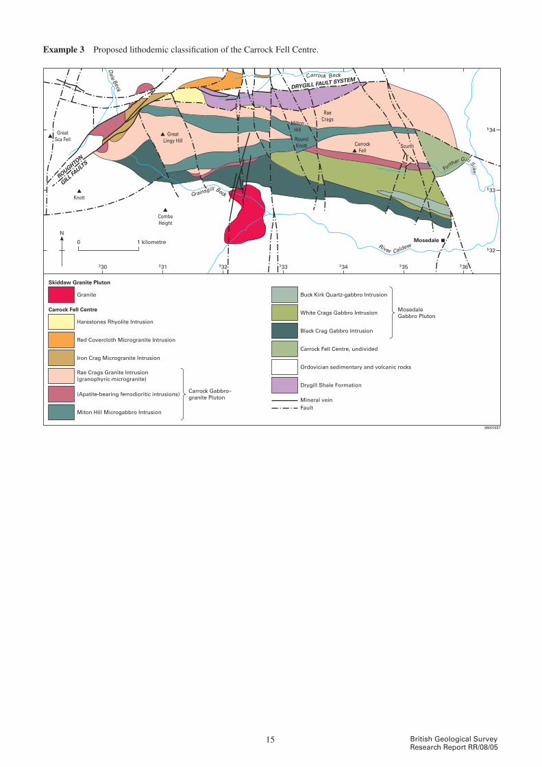
Fault
Granite
CombeHeight
RaeCrags
MiltonHill
RoundKnott Scurth
Knott
GreatSca Fell
GreatLingy Hill
CarrockFell
Carrock Gabbro–granite Pluton
Buck Kirk Quartz-gabbro Intrusion
Harestones Rhyolite Intrusion
White Crags Gabbro Intrusion
Red Covercloth Microgranite Intrusion
Black Crag Gabbro Intrusion
Iron Crag Microgranite Intrusion
Carrock Fell Centre, undivided
Rae Crags Granite Intrusion(granophyric microgranite)
Drygill Shale Formation
Miton Hill Microgabbro Intrusion
(Apatite-bearing ferrodioritic intrusions)
Skiddaw Granite Pluton
Mosedale
Carrock Fell Centre MosedaleGabbro Pluton
Ordovician sedimentary and volcanic rocks
Mineral vein
330
0 1 kilometre532
533
534
331 332 333 334 335 336
ROUGHTON
GILL FAULT
S
DRYGILL FAULT SYSTEM
River Caldew
N
98001657
Carrock Beck
Further Gill Sike
Dale Beck
Grainsgill Beck
Example 3 Proposed lithodemic classification of the Carrock Fell Centre.
15 British Geological Survey Research Report RR/08/05

Fault
Etive Diorite−granite Centre
Taynuilt
Central monzogranite facies
Outer porphyritic monzogranite facies
Cruachan Monzodiorite−granite Pluton
Monzogranite facies
Loch
Etiv
e
Monzodiorite facies
Glen Coe
Glen
Strae
Glen Etive
Quarry Diorite Intrusionand satellite bodies
960
200 210 220
0 5 kilometres
950
940
Glencoe Gabbro−micrograniteFault Intrusion-swarm
Ben Starav
Meall Odhar
Ben Cruachan
Dalradian metamorphic rocks
Etive Dyke-swarm, mostly andesite and microdiorite with minor felsite
Glencoe and Lorne volcanic formations
Meall Odhar Granite Intrusion
Starav Granite Pluton
Clach Leathad Granite Pluton
Rannoch Moor Granodiorite Pluton
LOCH AW
E FA
ULT
PASS
OF
BRAN
DER
FA
ULT
930
N
98001656
Example 4 A lithodemic classification of intrusive igneous rocks in the Glen Etive area.
Informal units Rank 6 Rank 5 Rank 4 Rank 3 Rank 2 Rank 1
monzogranite faciesStarav Granite Pluton
Etive diorite–granite Centre
Argyll and N
orthern Highlands Subsuite
Highlands Y
ounger Suite
Caledonian Igneous Supersuite
Porphyritic monzogranite facies
meall Odhar Granite intrusion
monzodiorite facies Cruachan monzodiorite–granite Pluton
monzogranite facies
Quarry diorite intrusion
unnamed dykes Etive Andesite– microdiorite dyke-swarm
Glencoe Gabbro–microgranite Fault intrusion–swarm
Clach Leathad Granite Pluton
Rannoch moor Granodiorite Pluton
16British Geological Survey Research Report RR/08/05

Example 5 A hierarchical classification of lithodemic and lithostratigraphical units in the Glen Coe area.
Rank 6 Rank 5 Rank 4 Rank 3 Rank 2 Rank 1
upper dalness ignimbrite
dalness ignimbrite member
Glencoe volcanic Formation
Glencoe C
aldera volcano-com
plex
Highlands Y
ounger Suite
Caledonian Igneous Supersuite
Coire nan Easan Tuffs
Lower dalness ignimbrite
Coir Eilde Tuffs
unnamed andesite lavas Bidean nam Bian Andesite member
unnamed beds of sandstone, conglomerate and siltstone
Glas Choire Sandstone member
upper Streaky Andesites (extrusive components)
Church door Buttress Breccias
Three Sisters ignimbrite member
upper Queen’s Cairn Breccias
upper Three Sisters ignimbrite
Lower Queen’s Cairn Breccias
dalness Breccias
Queen’s Cairn Conglomerates
white Corries Breccias
Lower Three Sisters ignimbrite
Lower Streaky Andesites (extrusive components)
upper Etive Rhyolite
Etive Rhyolite member
Crowberry Ridge Tuffs
middle Etive Rhyolite
Raven’s Gully Tuffs
Lower Etive Rhyolite
Kingshouse Tuffs
Kingshouse Breccias
unnamed sills of andesite with a conglomerate and sandstone host
unnamed clastic sedimentary unit Basal Andesite Sill-complexunnamed Sill-swarm
unnamed multiple intrusions of gabbro, diorite, tonalite, monzonite and granite
Glencoe Gabbro–microgranite Fault intrusion-swarm
unnamed sheets of andesite with mingled rhyolite upper Streaky Andesites (intrusive components)
unnamed sheets of andesite with mingled rhyoliteLower Streaky Andesites (intrusive components)unnamed intrusions of rhyolite and aplitic
microgranite
unnamed sheets and sills of andesite
unnamed dykes of volcaniclastic breccia and tuffisite
17 British Geological Survey Research Report RR/08/05
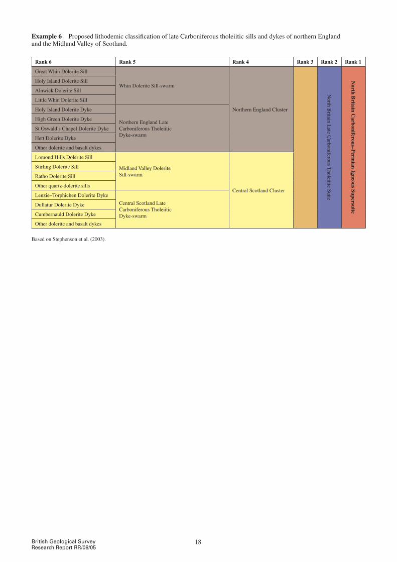
Example 6 Proposed lithodemic classification of late Carboniferous tholeiitic sills and dykes of northern England and the midland valley of Scotland.
Rank 6 Rank 5 Rank 4 Rank 3 Rank 2 Rank 1
Great whin dolerite Sill
whin dolerite Sill-swarm
Northern England Cluster
North B
ritain Late C
arboniferous Tholeiitic Suite
North B
ritain Carboniferous–P
ermian Igneous Supersuite
Holy island dolerite Sill
Alnwick dolerite Sill
Little whin dolerite Sill
Holy island dolerite dyke
Northern England Late Carboniferous Tholeiitic dyke-swarm
High Green dolerite dyke
St Oswald’s Chapel dolerite dyke
Hett dolerite dyke
Other dolerite and basalt dykes
Lomond Hills dolerite Sill
midland valley dolerite Sill-swarm
Central Scotland Cluster
Stirling dolerite Sill
Ratho dolerite Sill
Other quartz-dolerite sills
Lenzie–Torphichen dolerite dyke
Central Scotland Late Carboniferous Tholeiitic dyke-swarm
dullatur dolerite dyke
Cumbernauld dolerite dyke
Other dolerite and basalt dykes
Based on Stephenson et al. (2003).
18British Geological Survey Research Report RR/08/05

Informal units Rank 6 Rank 5 Rank 4 Rank 3 Rank 2 Rank 1
Raasay Granite Sill
Skye Central C
omplex
Hebrides C
entral Com
plex Suite
Atlantean Igneous Supersuite
Scalpay Granite intrusion
An Sithean Granite intrusion
unnamed composite sheets of basaltic andesite and rhyolite
unnamed sheets of granite and microgranite
unnamed intrusions of gabbro and dolerite
unnamed volcaniclastic breccias
Beinn na Caillich Granite Pluton
Eastern Red Hills Centre
Creag Strollamus Granite Pluton
Beinn an dubhaich Granite Pluton
Beinn na Cro Granite Pluton
Glas Bheinn mor Granite Pluton
Broadford Gabbro intrusion
Beinn na Cro Gabbro intrusion
Small individual intrusions Kilchrist Hybrid intrusions
Kilchrist Breccias
Eas mor Granite Ring-dyke
western Red Hills Centre
meall Buidhe Granite Ring-dyke
maol na Gainmhich Granite Ring-dyke
Loch Ainort Granite Pluton
Beinn dearg mhor Granite Pluton
marsco Granite intrusion
Southern Porphyritic Granite intrusion
Glen Sligachan Granite intrusion
Northern Porphyritic Felsite Pluton
Glamaig Granite Pluton
marsco Hybrids Ring-dyke
marsco Summit Gabbro intrusion
Blaven Granite intrusionSrath na Creitheach Centre
Ruadh Stac Granite intrusion
meall dearg Granite intrusion
volcaniclastic-breccia, lapilli-tuff and tuffaceous-sandstone
Srath na Creitheach volcaniclastic Rocks
intrusion breccia
Cuillin Centre
meallan dearg Breccia Pipe
Coire uaigneich Granite intrusion
Gars-bheinn Peridotite Sill
F1, F2 & F3 inner Gabbro intrusion
inner Bytownite Troctolite intrusion
d1 & d2 druim nam Ramh Bytownite Gabbro Ring-intrusion
C1, C2 & C3 Outer Bytownite Gabbro intrusion
P1, P2, P3, P4, P5 & P6 Layered Peridotite intrusions
B1, B2 & B3 Outer Bytownite Troctolite intrusion
A1, A2 & A3 Outer Gabbro intrusions
Trachyte and rhyolite lavas and volcaniclastic rocks
Fionn Choire Formation
Example 7 A hierarchical classification of lithodemic and lithostratigraphical units of the Skye Central Complex.
19 British Geological Survey Research Report RR/08/05

Informal units & other units
Rank 6 Rank 5 Rank 4 Rank 3 Rank 2 Rank 1
Ruinisval zone
Central mafic intrusion
Formerly grouped as the ‘(Rum) Layered Series’, then as the ‘(Rum) Layered Suite’ (e.g. on 50k Sheet 60). The former term is no longer approved because ‘series’ is now a chronostratigraphical division, and the latter term is no longer approved because of the inappropriate rank of the term ‘suite’.
Rum
Central C
omplex
Hebrides C
entral Com
plex Suite
Atlantean Igneous Supersuite
Long Loch zone
dornabac zone
Harris Bay zone
western Layered mafic intrusionTransitional zone
Ard mheall zone
Layered units 1–15 Eastern Layered mafic intrusion
western Granite Pluton
individual intrusions and extrusive units, some named Southern mountains
‘mixed unit’Papadil microgranite intrusion
individual intrusions and extrusive units, some named
Northern marginal ‘mixed unit’
Coire dubh Breccia
Am mam Breccias
Long Loch microgranite intrusion
individual plugs mafic and ultramafic plug-swarm
individual sheets mafic sheet-swarm
Eigg Lava Formation
Broadford Beds
Lewisian Gneiss Complex
Notes: 1. The names of informal units and of units classified at Ranks 6, 5 and 4 in this example are based on those currently in use (Emeleus and Bell, 2005), however some of these have been modified to reflect the system for naming units set out in this scheme. Others will be modified, where appropriate, in Phase 2.2. The Southern mountains and Northern marginal ‘mixed units’ are shown at Rank 4 without an approved lithodemic unit name. Appropriate formal names for these units will be defined in due course (during Phase 2), and they may be classified formally at Rank 5.3. Representatives of the Eigg Lava Formation, the Broadford Beds (Formation) and the Lewisian Gneiss Complex are all included within the Rum Central Complex, making it a ‘complex’ in the full sense of the formal definition.4. The inclusion of lithodemic or lithostratigraphical units of higher rank (e.g. Lewisian Gneiss Complex, which is likely to be classified at Rank 1) within a central complex (Rank 3) is unavoidable in many mixed units (complexes) and is acceptable. Their parent has to be the one allocated in their main scheme and not the central complex.
Example 8 A hierarchical classification of lithodemic and lithostratigraphical units associated with the Rum Central Complex.
20British Geological Survey Research Report RR/08/05
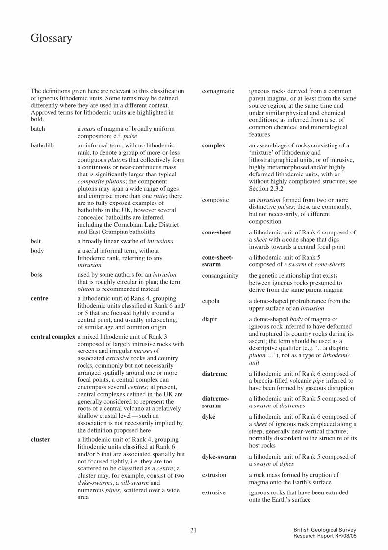
21 British Geological Survey Research Report RR/08/05
The definitions given here are relevant to this classification of igneous lithodemic units. Some terms may be defined differently where they are used in a different context. Approved terms for lithodemic units are highlighted in bold.
batch a mass of magma of broadly uniform composition; c.f. pulse
batholith an informal term, with no lithodemic rank, to denote a group of more-or-less contiguous plutons that collectively form a continuous or near-continuous mass that is significantly larger than typical composite plutons; the component plutons may span a wide range of ages and comprise more than one suite; there are no fully exposed examples of batholiths in the uK, however several concealed batholiths are inferred, including the Cornubian, Lake district and East Grampian batholiths
belt a broadly linear swathe of intrusions
body a useful informal term, without lithodemic rank, referring to any intrusion
boss used by some authors for an intrusion that is roughly circular in plan; the term pluton is recommended instead
centre a lithodemic unit of Rank 4, grouping lithodemic units classified at Rank 6 and/or 5 that are focused tightly around a central point, and usually intersecting, of similar age and common origin
central complex a mixed lithodemic unit of Rank 3 composed of largely intrusive rocks with screens and irregular masses of associated extrusive rocks and country rocks, commonly but not necessarily arranged spatially around one or more focal points; a central complex can encompass several centres; at present, central complexes defined in the uK are generally considered to represent the roots of a central volcano at a relatively shallow crustal level — such an association is not necessarily implied by the definition proposed here
cluster a lithodemic unit of Rank 4, grouping lithodemic units classified at Rank 6 and/or 5 that are associated spatially but not focused tightly, i.e. they are too scattered to be classified as a centre; a cluster may, for example, consist of two dyke-swarms, a sill-swarm and numerous pipes, scattered over a wide area
comagmatic igneous rocks derived from a common parent magma, or at least from the same source region, at the same time and under similar physical and chemical conditions, as inferred from a set of common chemical and mineralogical features
complex an assemblage of rocks consisting of a ‘mixture’ of lithodemic and lithostratigraphical units, or of intrusive, highly metamorphosed and/or highly deformed lithodemic units, with or without highly complicated structure; see Section 2.3.2
composite an intrusion formed from two or more distinctive pulses; these are commonly, but not necessarily, of different composition
cone-sheet a lithodemic unit of Rank 6 composed of a sheet with a cone shape that dips inwards towards a central focal point
cone-sheet- a lithodemic unit of Rank 5swarm composed of a swarm of cone-sheets
consanguinity the genetic relationship that exists between igneous rocks presumed to derive from the same parent magma
cupola a dome-shaped protruberance from the upper surface of an intrusion
diapir a dome-shaped body of magma or igneous rock inferred to have deformed and ruptured its country rocks during its ascent; the term should be used as a descriptive qualifier (e.g. ‘…a diapiric pluton …’), not as a type of lithodemic unit
diatreme a lithodemic unit of Rank 6 composed of a breccia-filled volcanic pipe inferred to have been formed by gaseous disruption
diatreme- a lithodemic unit of Rank 5 composed of swarm a swarm of diatremes
dyke a lithodemic unit of Rank 6 composed of a sheet of igneous rock emplaced along a steep, generally near-vertical fracture; normally discordant to the structure of its host rocks
dyke-swarm a lithodemic unit of Rank 5 composed of a swarm of dykes
extrusion a rock mass formed by eruption of magma onto the Earth’s surface
extrusive igneous rocks that have been extruded onto the Earth’s surface
Glossary

22British Geological Survey Research Report RR/08/05
facies the characteristic features that distinguish a rock unit, including rock type, mineralogy, texture and structure; the term can also be used in informal names for part of an intrusion that lacks intrusive margins but has distinctive features; see Section 2.4.1.1
gabbroid used traditionally as an adjective to refer to rocks of gabbroic composition, but also used more recently as a noun to denote a body of gabbroic rock; it is recommended that the term ‘gabbroic rock’ is used instead of gabbroid as an adjective, and ‘gabbroic intrusion’ or ‘gabbroic pluton’ is used instead of gabbroid as a noun
granitoid used traditionally as an adjective to refer to rocks of granitic composition, but also used more recently as a noun to denote a body of granitic rock; it is recommended that the term ‘granitic rock’ is used instead of granitoid as an adjective, and ‘granitic intrusion’ or ‘granitic pluton’ is used instead of granitoid as a noun
intrusion a unit of geological material produced by an intrusive process and bounded by observed or inferred intrusive margins; usually used to refer to any unit of rock or magma formed by emplacement of magma and/or pyroclastic material into the subsurface, however units of non-igneous material can also result from an intrusive process, e.g. salt ‘domes’; the term may be used formally (with a capital ‘i’) for a lithodemic unit of Rank 6, or informally (with a small ‘i’) to refer to any intrusive lithodemic unit(s); see Sections 2.3.1.1 and 2.7
intrusion- a lithodemic unit of Rank 5 composed of swarm a swarm of intrusions
laccolith a lithodemic unit of Rank 6 composed of an intrusion that is roughly circular in plan, concordant with the structure of the country rock, and generally has a planar floor and a domed roof
laccolith-swarm a lithodemic unit of Rank 5 composed of a swarm of laccoliths
lithodeme defined in the NASC as ‘a body of intrusive, pervasively deformed, or highly metamorphosed rock, generally non-tabular and lacking primary depositional structures, and characterised by lithic homogeneity’; the NASC regards ‘lithodeme’ as the fundamental unit in lithodemic classification, broadly equivalent to the lithostratigraphical term ‘formation’; the term lithodeme has not been adopted here for reasons outlined in Section 2.2.1; the term lithodemic unit is preferred for all units encompassed by the NASC definition of lithodeme, and for groups of such units at higher lithodemic ranks
lithodemic unit a mappable unit, or group of units, distinguished and delimited on the basis of rock characteristics, that does not obey the Law of Superposition, i.e. is composed predominantly of intrusive, highly deformed, and/or highly metamorphosed rock, or a mixture composed of one or more of these with or without lithostratigraphical units; lithodemic units are the practical units of geological work in terranes in which rocks generally lack primary stratification
lopolith a lithodemic unit of Rank 5 composed of a body of kilometre-scale or larger that is concordant, broadly saucer-shaped and typically layered; a ‘simple’ lopolith consists of essentially one intrusion, whereas a ‘composite’ lopolith consists of two or more; the intrusions in composite lopoliths are inferred to be related genetically, and to be associated spatially because the magma batches used a common pathway through the crust
mass an informal term, without lithodemic rank, used to refer to a body of intrusive rock or magma
minor intrusion any intrusion of small surface areal extent, for example most dykes, sills and small irregular masses
neck a lithodemic unit of Rank 6 composed of the feeder ‘pipe’ of a volcano, which has been infilled with collapsed material from the surface vent and commonly intruded by magma, after eruption has ceased, to form a plug; exposed due to subsequent erosion
neck-swarm a lithodemic unit of Rank 5 composed of a swarm of necks
ophiolite- a mixed lithodemic unit of Rank 3complex composed of ophiolite (a section or
sections of the oceanic crust, with or without the subjacent upper mantle) that has been uplifted or emplaced to be exposed within continental crustal rocks, during which process the ophiolite becomes tectonically ‘mixed’ (usually interleaved) with crustal rocks; strictly speaking, an ophiolite-complex is a structural unit composed in part of intrusive rock; it is included in the present scheme because some ophiolite-complexes consist largely of intrusive rock, and could be considered to be intrusive lithodemic units
phase a temporally distinct event or events; may be used informally to distinguish events (e.g. ‘an early phase of magmatism’), or to denote units that are part of a recognised sequence of events; the term should not be used in formal names for lithodemic units, and hence should not be capitalised, e.g. Ben Rinnes Granite Pluton phase 1

23 British Geological Survey Research Report RR/08/05
pipe a lithodemic unit of Rank 6 composed of a discordant, cylindrical intrusion, normally steeply orientated
pipe-swarm a lithodemic unit of Rank 5 composed of a swarm of pipes
plug a lithodemic unit of Rank 6 composed of the solidified remains of a cylindrical intrusion of magma, inferred to be intrusive into or associated with a volcanic neck
plug-swarm a lithodemic unit of Rank 5 composed of a swarm of plugs
pluton a lithodemic unit of Rank 5 composed of a body of intrusive rock, generally with a simple, regular margin, the whole being kilometre-scale or larger and with a cylindrical, lenticular or tabular shape; a ‘simple’ pluton consists of essentially one intrusion, whereas a ‘composite’ pluton consists of two or more; the intrusions in composite igneous plutons are inferred to be related genetically, and to be associated spatially because the magma batches used a common pathway through the crust; see Section 2.3.1.2
province a region encompassing all igneous units (lithodemic and lithostratigraphical) related to a major tectonothermal event; c.f. superprovince; see Section 2.4.2.1 for further information
pulse an injection of magma of broadly uniform composition; c.f. batch
ring-complex a mixed lithodemic unit of Rank 4 composed of one or more ring-intrusions, ring-dykes, cone-sheets, ring-swarms and cone-sheet-swarms, with their country-rocks; see also Section 2.3.2.1
ring-dyke a lithodemic unit of Rank 6 composed of a sheet that is arcuate or annular in plan, and usually vertical or inclined steeply outwards
ring-intrusion a lithodemic unit of Rank 5 composed of an intrusion observed or inferred to have been emplaced within, or bounded by, a ring-fracture
ring-swarm a lithodemic unit of Rank 5 composed of a swarm of ring-dykes with or without cone-sheets
series a chronostratigraphical division; must not be used in a lithodemic context; see Section 2.4.4
sheet a lithodemic unit of Rank 6 composed of an intrusion with broadly parallel margins and one dimension much shorter than the other two; most sheets have a broadly tabular shape, but they may be curved, sinuous or irregular
sheet-complex a mixed lithodemic unit of Rank 4 composed of a sheet-swarm and its country-rocks
sheet-swarm a lithodemic unit of Rank 5 composed of a swarm of sheets
sill a lithodemic unit of Rank 6 composed of a sheet of igneous rock emplaced along a near-horizontal fracture; usually broadly concordant in stratified rocks
sill-complex a mixed lithodemic unit of Rank 4 composed of a sill-swarm and its country-rocks
sill-swarm a lithodemic unit of Rank 5 composed of a swarm of sills
stock an intrusion that is smaller than but otherwise similar to a pluton; the term is virtually unused in the uK and there are no formally named examples; in some countries the term ‘stock’ is defined differently and used to name lithodemic units
subsuite a lithodemic unit of Rank 3 grouping two or more lithodemic units from a single suite that share some similarities in a meaningful combination of observed features; the lithodemic unit next lower in rank to suite; see Section 2.3.1.4
subswarm an informal unit grouping two or more intrusions that are part of a formally classified swarm but are distinguished by location, composition or some other geological feature(s); it is emphasised that subswarms must be informal, and cannot form part of a formal lithodemic classification; as such, the term should be used sparingly; see Section 2.4.4
suite a lithodemic unit of Rank 2 grouping two or more lithodemic units of lower rank (i.e. Ranks 3 to 6), and of the same class (intrusive igneous, highly metamorphosed, highly deformed or mixed), that display a degree of natural relationship through similarities in a meaningful combination of observed features such as shape, spatial distribution, composition, and age; mixed lithodemic units composed mainly of intrusive igneous rock may be included in a suite otherwise grouping intrusive units; the lithodemic unit next lower in rank to supersuite; see Section 2.3.1.5
superprovince a group of two or more provinces that are related to a major tectonothermal event; see section 2.4.2.2
supersuite a lithodemic unit of Rank 1 grouping two or more suites that have a degree of natural relationship to one another; supersuites may also contain lithodemic units that are not assigned to suites; the highest ranking formal lithodemic unit; see Section 2.3.1.6

24British Geological Survey Research Report RR/08/05
swarm a group of Rank 6 intrusions that are associated spatially and inferred to be related genetically; swarm is not a formal type of lithodemic unit (and therefore does not appear on its own in Figure 1), however many of the terms used for lithodemic units classified at Rank 5 have been created by linking the term swarm to Rank 6 terms, for example dyke-swarm, sill-swarm; see Section 2.3.1.2
vein a lithodemic unit of Rank 6 composed of a sheet-like body that is generally narrower and more irregular than features classified as sills, dykes or sheets; the term is also used for features that are not lithodemic units, e.g. the mineral filling in, or replacement around, a fracture
vein-complex a mixed lithodemic unit of Rank 4 composed of a vein-swarm and its country-rocks, the whole being typically intermediate in character between a xenolith-rich pluton and veined country-rock; see Section 2.3.2.1
vein-swarm a lithodemic unit of Rank 5 composed of a swarm of veins, typically with an irregular disposition
vent strictly, an opening at the Earth’s surface through which volcanic material is extruded; on uK maps a vent usually represents the chaotic near-surface deposits formed by collapse of the original crater; c.f. neck; a lithodemic unit of Rank 6
vent-swarm a lithodemic unit of Rank 5 composed of a swarm of vents
volcano- a mixed lithodemic unit of Rank 3 complex composed of extrusions, related
intrusions and volcaniclastic products, at a site of persistent volcanic activity; see Section 2.3.2.2
zone used to refer to, or to name, facies displaying a geometrical regularity, such as parallel or concentric layers; see Section 2.4.1.2

25 British Geological Survey Research Report RR/08/05
British Geological Survey holds most of the references listed below, and copies may be obtained via the library service subject to copyright legislation (contact [email protected] for details). The library catalogue is available at: http://geolib.bgs.ac.uk
allen, P m. 1995. A paper of the British Geological Survey Stratigraphy Committee. usage of stratigraphical nomenclature in BGS. British Geological Survey Technical Report, wA/95/27R.
Bell, B R, and williaMson, i t. 2002. Tertiary igneous activity. 371–408 in Geology of Scotland. Fourth edition. tRewin, n h (editor). (London: The Geological Society.)
challinoR, J. 1978. A dictionary of geology. (Cardiff: university of wales Press.)
eMeleus, c h, and Bell, B R. 2005. British regional geology: the Palaeogene volcanic districts of Scotland. Fourth edition. (Keyworth, Nottingham: British Geological Survey.)
eMeleus, c h, and GyopaRi, M c. 1992. British Tertiary volcanic province. Joint Nature Conservation Committee. Geological Conservation Review Series, No. 4. (London: Chapman and Hall.)
floyD, p a, exley, c s, and styles, M t. 1993. Igneous rocks of south-west England. Joint Nature Conservation Committee. Geological Conservation Review Series, No. 5. (London: Chapman and Hall.)
Gillespie, M R, and styles, M t. 1999. BGS Rock Classification Scheme, volume 1, Classification of igneous rocks. British Geological Survey Research Report (Second edition), RR99–06.
haRRis, a l. 1992. Precambrian. 13–34 in Geology of England and Wales. Duff, P m d, and sMith, A J (editors). (London: The Geological Society.)
Mahoney, J J, and coffin, M f (editors). 1997. Large igneous provinces: continental, oceanic, and planetary flood volcanism. American Geophysical Union, Geophysical Monograph, No. 100.
MillwaRD, d. 2002. Early Palaeozoic magmatism in the English Lake district. Proceedings of the Yorkshire Geological Society, vol. 54, 65–93.
MillwaRD, d. 2004. A stratigraphical framework for the Lower Palaeozoic igneous rocks of the Lake district and adjacent areas. British Geological Survey Research Report, RR/01/07.
neuenDoRf, k k e, Mehl JR., J p, and Jackson, J a. 2005. Glossary of geology. Fifth edition. (Alexandria, virginia: American Geological institute.)
noRth aMeRican coMMission on stRatiGRaphic noMenclatuRe. 1983. North American Stratigraphic Code. The American Association of Petroleum Geologists Bulletin, vol. 67 (5), 841–875.
Rawson, p f, allen, p M, BRenchley, p J, and 14 otheRs, 2002. Stratigraphical procedure. Professional Handbook. (London: The Geological Society.)
Rushton, A w A, and howells, m F. 1998. Stratigraphical framework for the Ordovician of Snowdonia and Lleyn Peninsula. British Geological Survey Research Report, RR/98/01.
salvaDoR, a, 1994. International Stratigraphic Guide. A guide to stratigraphic classification, terminology, and procedure. Second edition. (The international union of Geological Sciences and the Geological Society of America).
speiGht, J M, skelhoRn, R R, sloan, t, and knaap, R J. 1982. The dyke swarms of Scotland. 449–460 in Igneous rocks of the British Isles. SutheRlanD, d S (editor). (London: wiley interscience.)
stephenson, D, Bevins, R e, MillwaRD, D, hiGhton, a J, paRsons, i, stone, p, and waDswoRth, w J. 1999. Caledonian igneous rocks of Great Britain. Geological Conservation Review Series, No. 17. (Peterborough: Joint Nature Conservation Committee.)
stephenson, D, louGhlin, s c, MillwaRD D, wateRs c n, and williaMson, i. 2003. Carboniferous and Permian igneous rocks of Great Britain, north of the Variscan Front. Geological Conservation Review Series, No. 27. (Peterborough: Joint Nature Conservation Committee.)
stRachan, R a, sMith, M, haRRis, a l, and fettes, D J. 2002. The Northern Highland and Grampian terranes. 81–148 in The geology of Scotland. Fourth edition. tRewin, n h (editor). (London: The Geological Society.)
thoRpe, R s. 1979. Late Precambrian igneous activity in southern Britain. 579–584 in The Caledonides of the British isles — reviewed. haRRis, a l, hollanD, c h, and leake, B e (editors). Geological Society of London Special Publication, No. 8,
white a J R, allen, c M, BeaMs, s D, caRR, p f, chaMpion, D c, chappell, B w, wyBoRn, D, and wyBoRn, l a i. 2001. Granite suites and supersuites of eastern Australia. Australian Journal of Earth Sciences, vol. 48, 515–530.
whittakeR, a, cope, J c w, cowie, J w, GiBBons, w, hailwooD, e a, house, M R, Jenkins, D G, Rawson, p f, Rushton, a w a, sMith, D G, thoMas, a t, and wiMBleDon, w a. 1991. A guide to stratigraphical procedure. Journal of the Geological Society of London, vol. 148, 813–824.
References