bicester london road level crossing alternatives rev1
TRANSCRIPT
Bicester London Road Level
Crossing Alternatives
Stage 1 - Engineering Feasibility
Assessment Oxfordshire County Council
August 2013

Bicester London Road Level Crossing Alternatives Stage 1 - Engineering Feasibility Assessment
Atkins Version 1.0 | 15 July 2013
Notice
This document and its contents have been prepared and are intended solely for Oxfordshire County
Council’s information and use in relation to assessing alternative routes to the existing Bicester London Road
level crossing
Atkins Ltd assumes no responsibility to any other party in respect of or arising out of or in connection with
this document and/or its contents.
This document has 26 pages including the cover.
Document history
Job number: Document ref:
Revision Purpose description Originated Checked Reviewed Authorised Date
Rev 1.0 For Review RP AL PRM AL 19/08/13
Client signoff
Client Oxfordshire County Council
Project Bicester London Road Level Crossing Alternatives
Document title Stage 1 – Engineering Feasibility Assessment
Job no. 5121910
Copy no.
Document
reference
5121910/DOC/001

Bicester London Road Level Crossing Alternatives Stage 1 - Engineering Feasibility Assessment
Atkins Version 1.0 | 15 July 2013
Table of contents
Chapter Pages
Introduction 4
Executive summary 5
1. Introduction 6
1.1. Objective 6
1.2. Development in Bicester 6
1.3. Train Service 6
2. The Site, Issues and Constraints 7
2.1. London Road 7
2.2. Chiltern Railway 7
2.3. Potential Stakeholders 8
3. Proposed Alternative Options 10
3.1. Option A 11
3.2. Option B 14
3.3. Option C 16
3.4. Option D 18
3.5. Option E 20
Appendices 22
Appendix A. Option Layouts
Appendix B. Works Cost Estimate
Appendix C. Indicative Construction Programme
Introduction
This document is a review of alternative routes to London Road, Bicester.
Preliminary Designs for all schemes have been prepared along with Works Costs Estimates, Programme of Works and Risks associated with each project.
Bicester London Road Level Crossing Alternatives Stage 1 - Engineering Feasibility Assessment
Atkins Version 1.0 | 15 July 2013 5
Executive summary
The scope of this scheme is to investigate alternative routes to the level crossing on London Road in
Bicester Town. The Bicester area is expected to grow and the number of trains crossing the level crossing is
expected to increase leading to excessive delays on London Road. Five options to bypass the crossing have
been considered. A layout drawing, cost estimate and outline construction programme have been produced
for each solution to the proposed options.
The options considered are:
Option A – All purpose overbridge
Option B – Pedestrian Footbridge
Option C – Underpass
Option D – Link road from London Road to A41
Option E – Link road from Launton Road to A4421
Bicester London Road Level Crossing Alternatives Stage 1 - Engineering Feasibility Assessment
Atkins Version 1.0 | 15 July 2013 6
1. Introduction
1.1. Objective Atkins has been commissioned by Oxfordshire County Council (OCC) to consider a range of possible
alternative options to bypass the London Road Level crossing in Bicester Town. This is in anticipation of an
increase in rail traffic expected to lead to excessive delays on London Road and future developments
leading to a forecasted doubling of the population by the year 2033.
This report will consider transportation routes for 5 alternative options. Each option has at least 1 proposed
alignment with drawings displaying the horizontal layout and the works required to achieve the proposed
option. This report will describe each proposed option and comment on the pros & cons, safety aspect and
cost estimation.
Other studies have been undertaken to consider the development along the Chiltern railway and associated
infrastructure. This report (with the agreement of OCC) intended to take an independent view of possible
alternative solutions without the influence of the previous reviews.
1.2. Development in Bicester Bicester Town is located in the Cherwell District, 12 miles from Oxford. Significant development is planned in
Bicester including a large site south of Bicester at Graven Hill which will generate a large travel demand
between south east Bicester and the town centre.
1.3. Train Service The railway crossing London Road is part of the Chiltern Railway network and runs through the south east
part of Bicester. The line services the Bicester Town station which is located south of the level crossing at
London road. The station consists of a single platform catering for passenger trains from Oxford to Bicester.
Currently, passenger trains do not travel east of the station and only one scheduled freight train per weekday
traverses the level crossing.
Bicester London Road Level Crossing Alternatives Stage 1 - Engineering Feasibility Assessment
Atkins Version 1.0 | 15 July 2013 7
2. The Site, Issues and Constraints
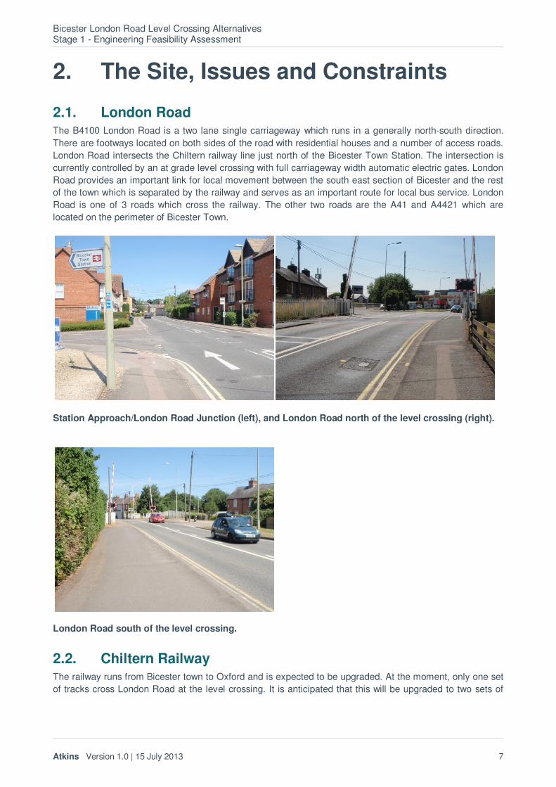
2.1. London Road The B4100 London Road is a two lane single carriageway which runs in a generally north-south direction.
There are footways located on both sides of the road with residential houses and a number of access roads.
London Road intersects the Chiltern railway line just north of the Bicester Town Station. The intersection is
currently controlled by an at grade level crossing with full carriageway width automatic electric gates. London
Road provides an important link for local movement between the south east section of Bicester and the rest
of the town which is separated by the railway and serves as an important route for local bus service. London
Road is one of 3 roads which cross the railway. The other two roads are the A41 and A4421 which are
located on the perimeter of Bicester Town.
Station Approach/London Road Junction (left), and London Road north of the level crossing (right).
London Road south of the level crossing.
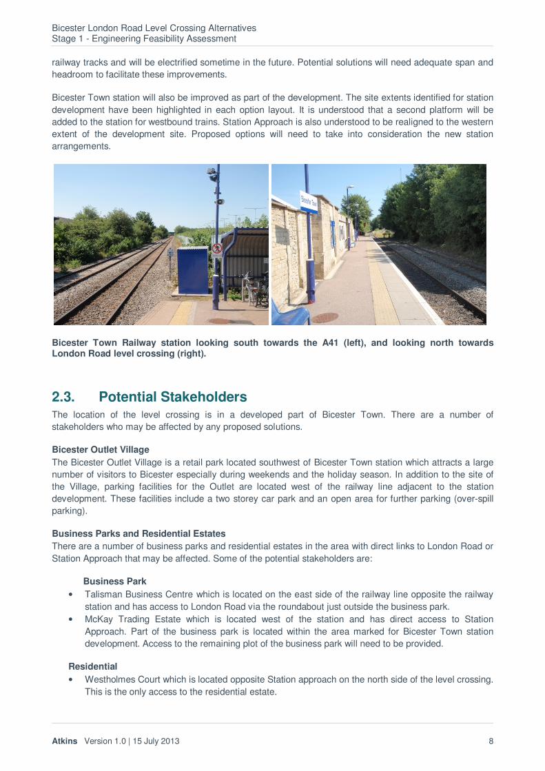
2.2. Chiltern Railway The railway runs from Bicester town to Oxford and is expected to be upgraded. At the moment, only one set
of tracks cross London Road at the level crossing. It is anticipated that this will be upgraded to two sets of
Bicester London Road Level Crossing Alternatives Stage 1 - Engineering Feasibility Assessment
Atkins Version 1.0 | 15 July 2013 8
railway tracks and will be electrified sometime in the future. Potential solutions will need adequate span and
headroom to facilitate these improvements.
Bicester Town station will also be improved as part of the development. The site extents identified for station
development have been highlighted in each option layout. It is understood that a second platform will be
added to the station for westbound trains. Station Approach is also understood to be realigned to the western
extent of the development site. Proposed options will need to take into consideration the new station
arrangements.
Bicester Town Railway station looking south towards the A41 (left), and looking north towards London Road level crossing (right).
2.3. Potential Stakeholders The location of the level crossing is in a developed part of Bicester Town. There are a number of
stakeholders who may be affected by any proposed solutions.
Bicester Outlet Village
The Bicester Outlet Village is a retail park located southwest of Bicester Town station which attracts a large
number of visitors to Bicester especially during weekends and the holiday season. In addition to the site of
the Village, parking facilities for the Outlet are located west of the railway line adjacent to the station
development. These facilities include a two storey car park and an open area for further parking (over-spill
parking).
Business Parks and Residential Estates
There are a number of business parks and residential estates in the area with direct links to London Road or
Station Approach that may be affected. Some of the potential stakeholders are:
Business Park
• Talisman Business Centre which is located on the east side of the railway line opposite the railway
station and has access to London Road via the roundabout just outside the business park.
• McKay Trading Estate which is located west of the station and has direct access to Station
Approach. Part of the business park is located within the area marked for Bicester Town station
development. Access to the remaining plot of the business park will need to be provided.
Residential
• Westholmes Court which is located opposite Station approach on the north side of the level crossing.
This is the only access to the residential estate.

Bicester London Road Level Crossing Alternatives Stage 1 - Engineering Feasibility Assessment
Atkins Version 1.0 | 15 July 2013 9
• Coach House Mews which is located adjacent the petrol station on the south side of the level
crossing. This is the only access to the residential estate.
• A Grade II listed building is located just west of the level crossing.
• There are a number of residences with direct access to London Road
Bicester London Road Level Crossing Alternatives Stage 1 - Engineering Feasibility Assessment
Atkins Version 1.0 | 15 July 2013 10
3. Proposed Alternative Options
Oxfordshire County Council has proposed 5 alternative route corridors to bypass the existing level crossing
at London Road. The options are considered in this section.
Design Parameters
All proposed options have been designed in accordance with the Highways Agency Design Manual for
Roads and Bridges (DMRB). The Network Rail – Track Design Handbook has been used to determine the
minimum headroom for a structure over the railway, 5.45m (for Trans-European Transport Networks). The
Railway Group Standard – Rail Traffic Loading Requirements for the Design of Railway Structures has also
been used. This standard dictates that the supports of structures should be offset 4.5m from the railway to
avoid the requirements for impact loading design.
NOTE: The minimum headroom over the railway line is 5.45m as advised in the Network Rail Design
Handbook. In the event that the railway is electrified before the closure of the level crossing, then the track
clearance may need to be increased to 7m as the 25kv overhead cables will need to cross the road at a
height appropriate for HGV’s. This may increase the cost of the options.
Cost Estimation
Works costs have been estimated from Spon’s – Civil Engineering and Highway Works Price Book 2013
based on the expected elements in each solution. C2 Statutory Undertaker returns have not been obtained
for this study and a contingency cost has been estimated for each solution to allow for utility diversion. The
estimate for design fees is a prorata cost of construction (please note this is not a quotation).
A preliminary estimate of the cost associated with land acquisition and compensation has been included but
a full assessment of land value and negotiation with affected land owners will be necessary as this value is
subject to significant variation. For the purpose of this report, a review has been done on the existing
exchange price offers (via internet searches) for fields, industrial buildings and commercial buildings in the
Bicester area. These figures have been used to estimate a rate for undeveloped land, industrial building and
commercial building purchases.
It must be noted that the estimates in this report may differ greatly from actual costs.
Indicative Construction Programme
An indicative construction programme has been estimated based on typical levels of productivity. The
duration of activities can vary greatly depending on factors such as, ground conditions, working space, and
permitted working hour limitations (particularly relating to track possession).
Bicester London Road Level Crossing Alternatives Stage 1 - Engineering Feasibility Assessment
Atkins Version 1.0 | 15 July 2013 11
3.1. Option A Option A routes consider crossing the railway line by providing an all-modes overbridge sited off-line to the
existing London Road alignment. For the purpose of this report all options will consist of a route with
standard 7.3m wide carriageway with a 2m wide footway on both verges. The minimum headroom over the
railway line is 5.45m as advised in the Network Rail Design Handbook which is the minimum clearance to
comply with a designated TENs route.
The speed limit of the route is assumed to be 30mph and due to the urban area, the design speed will also
be taken as 30mph. The alignment for the options has been designed against the requirements set out in the
Highways Agency – Design Manual for Roads and Bridges.
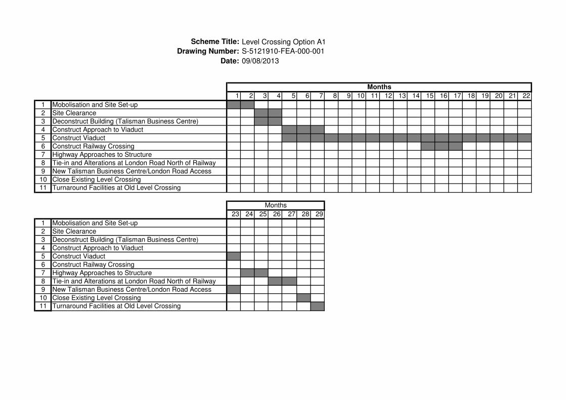
3.1.1. Option A1
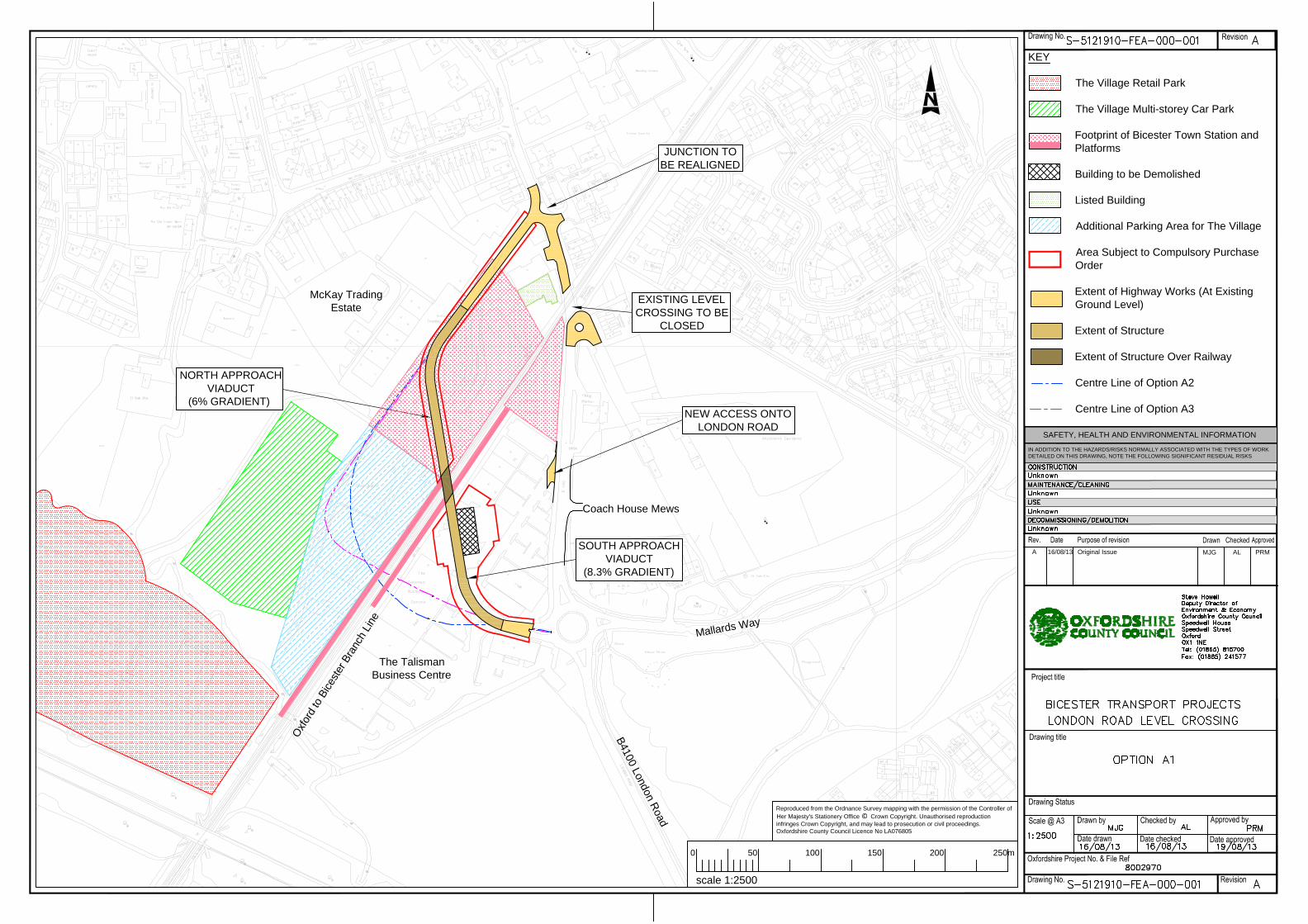
The alignment for option A1 follows the outline proposed in the client brief (refer to drawing number S-
5121910-FEA-000-001). The bridge is positioned approximately 180m southwest of the existing crossing and
ties-in the original alignment at the London Road/Station Road junction to the north, and at the roundabout
opposite Talisman Business Centre to the south. This proposed alignment will require the demolition of an
existing building in the Talisman Business Centre. Entry into the business centre will not be available from
the existing roundabout. An alternate entry point will be constructed for the business centre on the north side
of the site to provide direct access to London Road.
The alignment runs through the Talisman Business centre and the area of the proposed railway station. Land
will need to be acquired from both parties and compensation paid to affected businesses. It has been
assumed that the approaches to the railway crossing will be constructed as a viaduct to minimise the
footprint on the Talisman Business Centre and the Network Rail station area as it will permit the release of
areas under the structure for the use of the landowners (such as parking and through access), but will
increase construction cost.
The proposed horizontal alignment in Option A1 is compliant with standards. The vertical gradients on the
north approach and south approach are 6% and 8.3% respectively. The desired maximum grade for a single
carriageway is 6% with gradients steeper than 8% requiring a departure from standard.
It is proposed that when option A1 is implemented, the existing level crossing will be closed. Local alterations
to the existing highway infrastructure are required to provide turnaround facilities.
Road Safety Audit Comments
The combination of 8.3% gradient, 50m horizontal radius, and proximity to the roundabout on the southern
approach to the bridge is a safety issue. Heavy vehicles may lose control when breaking and turning while
approaching the roundabout. This arrangement is not advisable.
It is not advisable to use this overbridge as a pedestrian route. The 8% gradient is difficult to negotiate for
wheelchair users. The route is also a long detour from the original desire line.
Works and Design Cost Estimate
The Works Cost Estimate for Option A1 is in the order of £36,250,000. The breakdown is summarised below:
• Works Cost - £18,600,000
• Statutory Undertakers - £50,000
• Design Fees - £1,900,000
• Site Supervision Fees - £1,400,000
• Land Acquisition - £3,100,000
• Optimism Bias at 45% - £11,200,000

Bicester London Road Level Crossing Alternatives Stage 1 - Engineering Feasibility Assessment
Atkins Version 1.0 | 15 July 2013 12
Indicative Construction Programme
An indicative construction programme for this option is included in appendix C. The overall construction
programme is 29 months. The construction period for the viaduct could be shortened if work is progressed at
multiple locations, however this may increase the cost of construction. Limited access due to possession
restrictions over the railway line would increase the duration of works. Two site compounds may also be
required due to restricted access over the railway line.
Summary Commentary on Option A1
The main pros for this option include:
• This solution provides a direct alternative to bypass the level crossing in close proximity to the
existing desire line
• Use of the existing Talisman Business Centre roundabout
• Mainly offline construction simplifies traffic management and reduces user delays
The main cons for this option include:
• The gradient of the road is more than 8% on the southern side which will be a departure from
standards, this combined with the relaxation on the horizontal curve at the immediate approach to
the Talisman roundabout is a significant safety concern
• Restricting the use of the train station land and conflicts with new proposed station layout
• Demolition of existing business park building required
• Disruption of businesses in Talisman Business centre and compensation/relocation payment for
affected businesses
• Vehicle movement within the business park would be disrupted
3.1.2. Option A2 and A3
Variations to the layout in Option A1 were considered (see Options A2 and A3 as shown on drawing number
S-5121910-FEA-000-001). These options all produced substandard gradients on the southern approach to
the Talisman roundabout (steeper than 8%) and impact severely on the additional parking area for the
Village Retail Park. Options A2 and A3 were not considered further for cost estimation or delivery
programme.
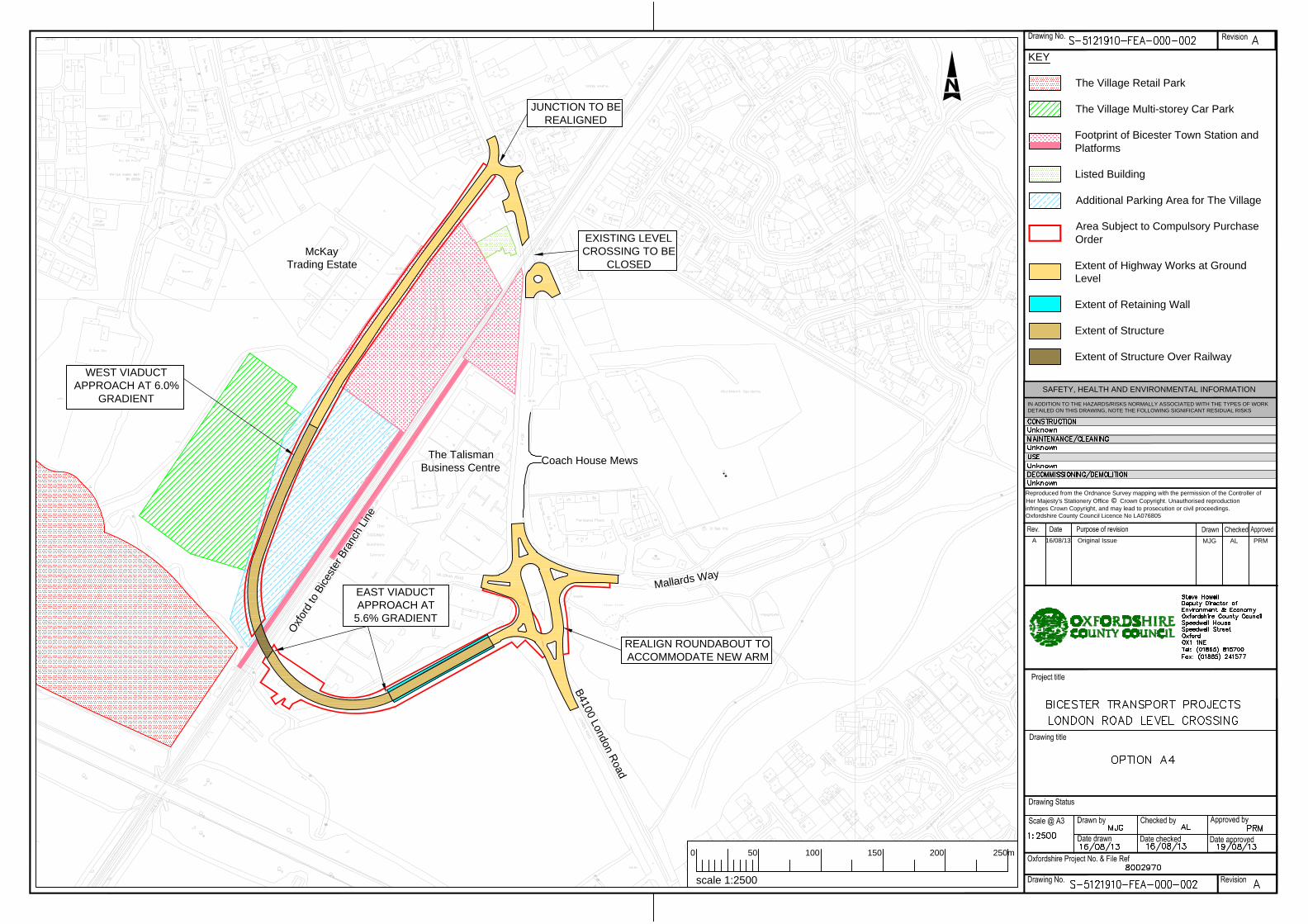
3.1.3. Option A4
Option A4 requires realignment of the Talismans Business Centre roundabout to accommodate a new arm to
the west (refer to drawing number S-5121910-FEA-000-002). This alignment ties-in at the Talisman
roundabout to the south of the railway and follows the edge of the business centre site crossing the railway
via an overbridge approximately 370m southwest of the existing level crossing. The alignment runs along the
western extent of the shopping village (over-spill) car park and ties into the proposed alignment of Station
Approach.
The alignment is intended to reduce the impact on commercial and retail parking areas as it runs along the
south perimeter of the business centre, west perimeter of the Outlet Village car park, and proposed railway
station site. Land is to be acquired from all affected parties and compensation may be required for the Outlet
Village car park area. The north approach is proposed to be a viaduct to minimise the footprint on the Village
car park. The south approach is proposed to be a viaduct over the extent of the business centre, with
retaining walls constructed on the tie-in to the roundabout to minimise land acquisition. Where headroom
permits, land under the viaduct can be reverted back to parking.

Bicester London Road Level Crossing Alternatives Stage 1 - Engineering Feasibility Assessment
Atkins Version 1.0 | 15 July 2013 13
The proposed horizontal alignment is compliant with standards. Some local widening may be required on
either side of the railway crossing to accommodate turning movement of long vehicles. The vertical gradients
on the north and south approaches are approximately 6% (desired maximum grade for a single
carriageway).
It is proposed that when option A4 is implemented, the existing level crossing will be closed. Local alterations
are required to provide turnaround facilities.
Road Safety Audit Comments
It is not advisable to use this overbridge for pedestrian use. The route is a long detour for pedestrians with no
opportunity to leave the route.
Works and Design Cost Estimate
The Works Cost Estimate for Option A4 is in the order of £38,550,000. The breakdown is summarised below:
• Works Cost - £20,100,000
• Statutory Undertakers - £50,000
• Design Fees - £2,000,000
• Site Supervision Fees - £1,500,000
• Land Acquisition - £2,900,000
• Optimism Bias at 45% - £12,000,000
Indicative Construction Programme
An indicative construction programme for this option is in appendix C. The overall construction programme is
31 months. The construction period for the viaduct could be shortened if work is progressed at multiple
locations, however this may increase the cost of construction. Limited access over the railway line would
increase the duration of works. Two site compounds may also be required due to limited access over the
railway line.
Commentary on Option A4
The main pros for this option include:
• This solution provides a direct alternative to bypass the level crossing in close proximity to the
existing desire line
• Existing buildings would not need to be demolished
• Less disruption to Bicester train station the Option A1 as the proposed road travels along the
northern boundary.
The main cons for this option include:
• Long structure and high works cost
• Disruption to Village car park and compensation payment would be required
• Roundabout realignment would cause traffic disruption
• Elongated roundabout may cause safety concerns due to increase circulating speeds
Bicester London Road Level Crossing Alternatives Stage 1 - Engineering Feasibility Assessment
Atkins Version 1.0 | 15 July 2013 14
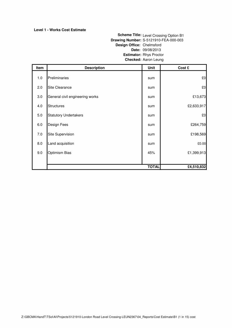
3.2. Option B Option B considers footbridges in place of the closed level crossing; each bridge complies with the DMRB
BD29/04 Design Criteria for Footbridges. The recommended gradient for the ramp is 1:20, however a
gradient of 1:15 may be used with the agreement of the overseeing organisation and with the provision of
rest areas.
It is assumed that the footbridge options will be implemented at the same time as one of the highway
solutions. Cost estimates and the construction programme assume the site compounds will be in place to
construct the highway solutions.
3.2.1. Option B1
The alignment for option B1 follows the outline proposed in the client brief (refer to drawing number S-
5121910-FEA-000-003). The bridge will provide for passengers using the railway, and pedestrians using
London Road. Passengers using the railway will use the stairs or a stair lift (not included in this estimate).
The London Road pedestrians will be able to use either stairs or a 1:20 (or 1:15) ramp.
There will be no direct access from London Road to the railway platform, as users would be separated by a
fence on the bridge deck. The total width of the footbridge is 5m. The length of ramp for a 1:20 gradient is
138m. The length of ramp for a 1:15 gradient is 101m.
Road Safety Audit Comments
There were no comments resulting from the Road Safety Audit for this proposal.
Works and Design Cost Estimate
This cost estimate is based on a 1:15 gradient ramp. The Works Cost Estimate for Option B1 is in the order
of £4,500,000. The breakdown is summarised below:
• Works Cost - £2,600,000
• Design Fees - £300,000
• Site Supervision Fees - £200,000
• Optimism Bias at 45% - £1,400,000
Indicative Construction Programme
An indicative construction programme for this option is in appendix C. The overall construction programme is
8 months.
Commentary on Option B1
The main pros for this option include:
• Stairs and ramps available for users using London Road
• No impact protection needed to the bridge supports as they are 4.5m from the railway tracks
• No existing buildings would need to be demolished if the ramps are 1:15
The main cons for this option include:
• The high cost due to the length of the ramps
• Increase of journey time to users due to the long ramps
• Requires repositioning of the west station platform
Bicester London Road Level Crossing Alternatives Stage 1 - Engineering Feasibility Assessment
Atkins Version 1.0 | 15 July 2013 15
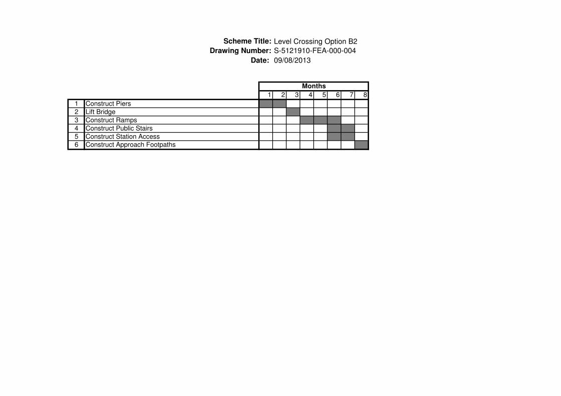
3.2.2. Option B2
This option will not facilitate passenger movement within the station as the bridge will be too far away from
the train station (refer to drawing number S-5121910-FEA-000-004). As there is a grade 2 listed building in
the area the bridge will require footpaths from London road to the foot of the stairs/ramps. The total width of
the footbridge is 2m. The length of the ramp for a 1:20 gradient is 128m. The length of ramp for a 1:15
gradient is 94m.
Road Safety Audit Comments
There were no comments resulting from the Road Safety Audit for this proposal.
Works and Design Cost Estimate
This cost estimate is based on a 1:15 gradient ramp. The Works Cost Estimate for Option B2 is in the order
of £3,600,000. The breakdown is summarised below:
• Works Cost - £2,100,000
• Design Fees - £200,000
• Site Supervision Fees - £200,000
• Optimism Bias at 45% - £1,100,000
Indicative Construction Programme
An indicative construction programme for this option is in appendix C. The overall construction programme is
8 months.
Commentary on Option B2
The main pros for this option include:
• Footbridge does not deviate significantly from the original desire line for London Road
• No impact protection needed to the bridge supports as they are 4.5m from the railway tracks
The main cons for this option include:
• The bridge does not readily accommodate passengers trying to cross the railway line as the bridge
will be too far away
• High cost due to the length of ramps
• Increase of journey time to users due to the long ramps
Bicester London Road Level Crossing Alternatives Stage 1 - Engineering Feasibility Assessment
Atkins Version 1.0 | 15 July 2013 16
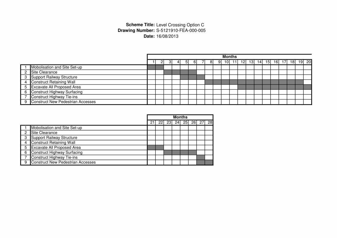
3.3. Option C Option C considers an underpass beneath the railway on the current horizontal alignment (refer to drawing
number S-5121910-FEA-000-005) of London Road. The required headroom at the underpass is 5.8m in
accordance with the DMRB TD 27/05. The width of the underpass will be 7.3m and will be a single
carriageway. The underpass will only accommodate vehicles as pedestrians movement will be provided by
footbridges (see option B). The underpass will only extend the width of the railway line. The carriageway
approaching the underpass will be lowered with the cutting supported by retaining walls either side.
The drawing indicates the extent of carriageway to be lowered. This alignment has been designed against
the maximum permitted 6% gradient recommended in the DMRB. The horizontal alignment will follow the
existing London Road alignment; however the construction will be in the very close proximity of the Grade 2
listed building near the railway lines and it may be difficult to construct a retaining wall near this area without
damaging the integrity of the building.
The cutting extends a distance along Station Approach and Priory Road to provide a compliant gradient for
the carriageway. This will however leave a level difference of 4m on the side road to the residential estate on
Westholmes Court. Vehicle access to existing houses, buildings and shops will be removed along London
Road along the extent of the cutting due to the level difference. There is no alternative access provision
without significant clearance of other properties. Due to the lack of access, it is expected that properties and
estates will need to be purchased.
There is limited space currently available between the edge of the carriageway and many of the building
frontages on London Road; this will be further reduced with the retaining structure. The land/properties along
London Road acquired through purchasing will be available for conversion to pedestrian access. Land
acquired along the east side of London Road will also allow the carriageway to be realigned and provide
further clearance to the listed building. Any resale value of land has not been included.
It will be necessary to close London Road during the construction period. Traffic diversions will be needed
during construction works.
Road Safety Audit Comments
The Station Approach/London Road junction in this proposal is expected to be a give-way junction. Vehicles
are required stop and start on a 6% incline. This is a safety concern.
Works and Design Cost Estimate
The Works Cost Estimate for Option C is in the order of £49,900,000. The breakdown is summarised below:
• Works Cost - £11,500,000
• Statutory Undertakers - £200,000
• Design Fees - £1,200,000
• Site Supervision Fees - £900,000
• Land Acquisition - £17,500,000
• Optimism Bias at 45% - £18,600,000
Indicative Construction Programme
An indicative construction programme for this option is included in appendix C. The overall construction
programme is 28 months.

Bicester London Road Level Crossing Alternatives Stage 1 - Engineering Feasibility Assessment
Atkins Version 1.0 | 15 July 2013 17
Commentary on Option C
The main pros for this option include:
• Provision along existing London Road.
The main cons for this option include:
• High construction cost
• Large number of affected stakeholders leading to many parties to negotiate with
• On-line works requiring significant diversion during construction.

Bicester London Road Level Crossing Alternatives Stage 1 - Engineering Feasibility Assessment
Atkins Version 1.0 | 15 July 2013 18
3.4. Option D Option D routes consider providing a link from London Road to the A41 which in turn will provide access to
Bicester on the south side of the railway. The road link will be a single carriageway 7.3m wide with no
pedestrian provision.
The speed of the route is assumed to be 30mph. The alignment for the options has been designed in
accordance with the requirements set out in the Highway Agency – Design Manual for Roads and Bridges.
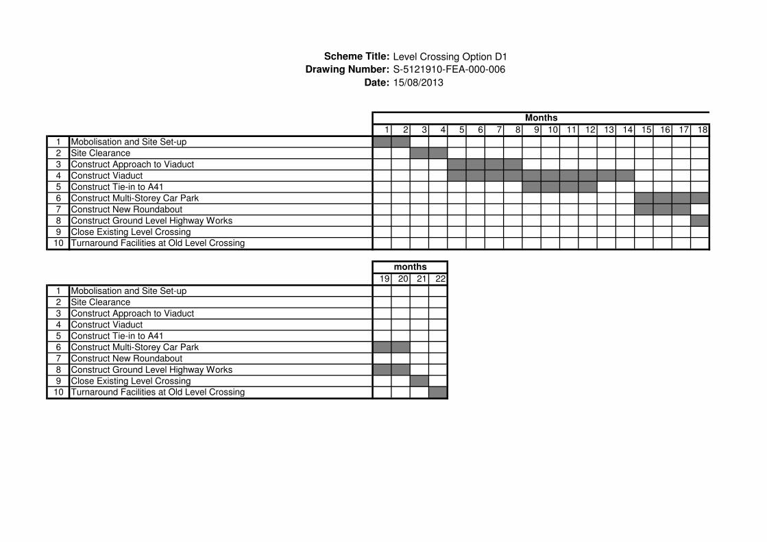
3.4.1. Option D1
This alignment links the A41 to London Road with a route on the west side of the railway (refer to drawing S-
5121910-FEA-000-006). The junction with the A41 is proposed to be a signalised junction. The road
alignment will run parallel to the railway line and travel along the eastern boundary of the parking area for the
village. A roundabout will be provided to link this proposed road to realigned Station Approach and access to
the existing multi-storey car park, and a new multi-storey car park.
The proposed highway will travel through the east side of the Village Retail Park on a viaduct to allow the car
parking/delivery area to remain operational. The alignment will tie in the new roundabout using a 6% gradient
from the viaduct. The approach to the viaduct will be supported by retaining walls. This proposal
compensates for the loss of parking area and disruption to the outlet village by including a new multi-storey
car park at the site of the existing over-spill car park.
Road Safety Audit Comments
A signalised junction on the A41 may increase the likelihood of nose to tail collisions.
Works and Design Cost Estimate
The Works Cost Estimate for Option D1 is in the order of £37,500,000. The breakdown is summarised below:
• Works Cost - £14,300,000
• Statutory Undertakers - £100,000
• Design Fees - £1,400,000
• Site Supervision Fees - £1,100,000
• Land Acquisition - £9,000,000
• Optimism Bias at 45% - £11,600,000
Indicative Construction Programme
An indicative construction programme for this option is in appendix C. The overall construction programme is
22 months.
Commentary on Option D1
The main pros for this option include:
• Little disruption to existing buildings as it travels along the boundaries
• Very little disruption to existing roads
• No new crossing of the railway
The main cons for this option include:
• Disruption to the shopping village
• The A41 would need to be widened to accommodate proposed junction
• Traffic signals on the A41 junction would need to be installed which would affect traffic flow
• Does not provide a direct bypass for the original London Road crossing
Bicester London Road Level Crossing Alternatives Stage 1 - Engineering Feasibility Assessment
Atkins Version 1.0 | 15 July 2013 19
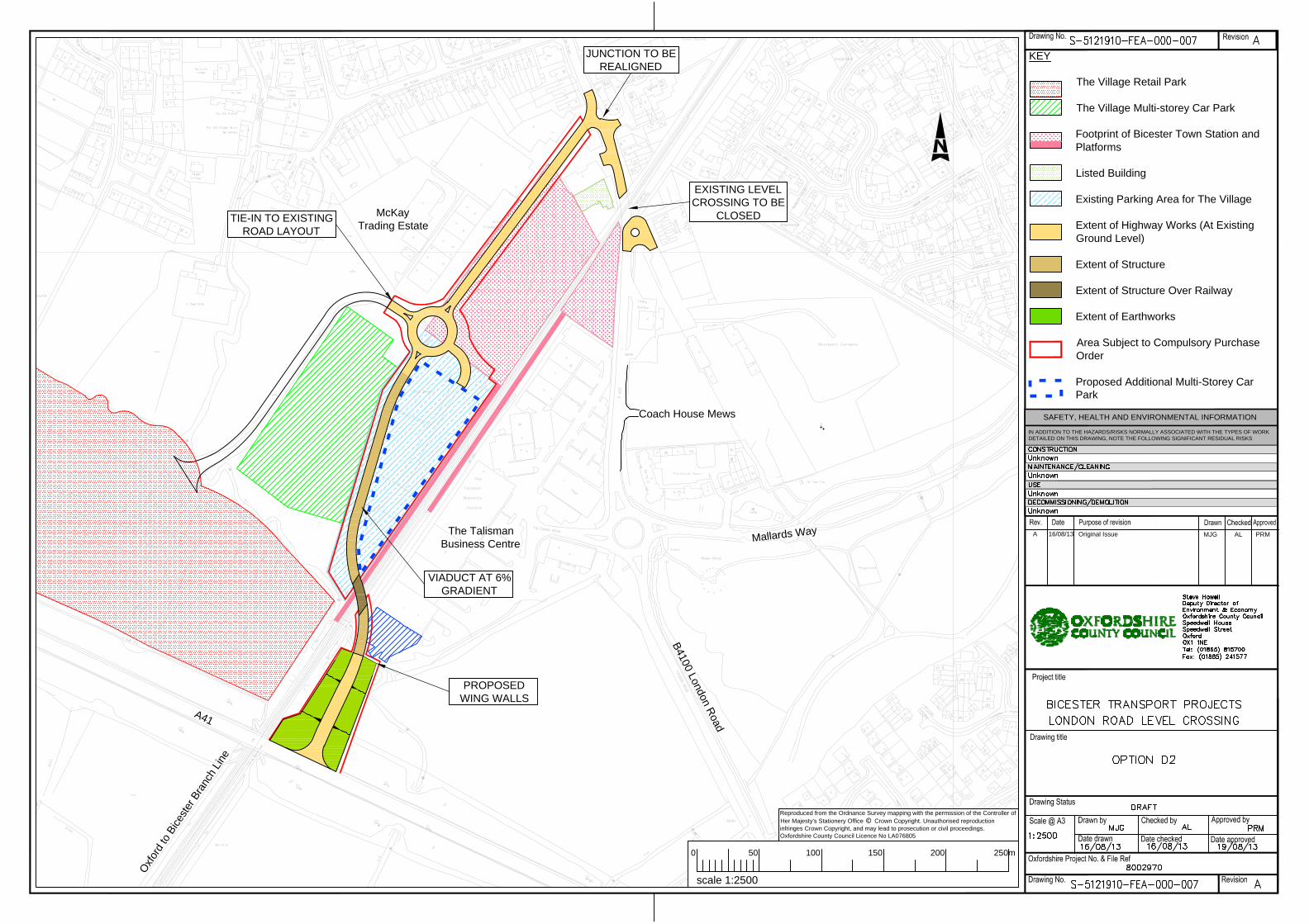
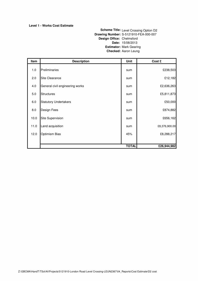
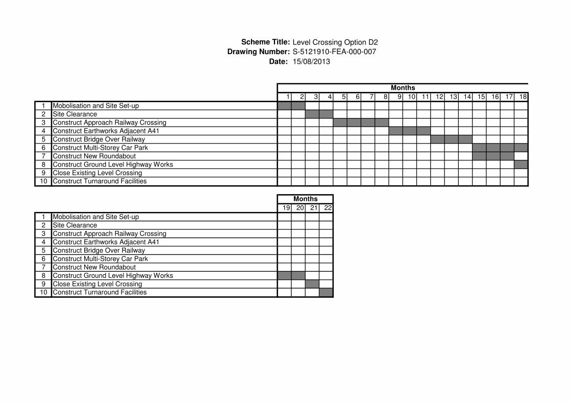
3.4.2. Option D2
This option is similar to D1 however the A41 junction will be on the eastern side of the railway line as there is
more available space which will mean less disruption to the shopping village (refer to drawing S-5121910-
FEA-000-007). There will be earthworks and retaining walls supporting the proposed highway south-west of
the roundabout which will raise the road from ground level to bridge level at a gradient of 6%.
This option will avoid constructing a large the viaduct through the existing Village Retail Park, but it will take
up a small amount of space of a car park in the corner of the Talisman Business Centre.
The junction with the A41 is proposed to be signalized.
The proposed highway will extend over a parking area in the Talisman Business Centre, the small area will
not be useable as earthworks and a retaining wall will be constructed. There will be a bridge that will extend
over the railway before it reaches more earthworks and retaining walls which will travel through the existing
parking area for the village.
Due to the disruption that the road will cause for the existing parking area for the village, an additional multi-
storey car park has been proposed which can also be seen on the drawing. Access to the multi storey will be
via the new roundabout.
Road Safety Audit Comments
A signalised junction on the A41 may increase the likelihood of nose to tail collisions.
Works and Design Cost Estimate
The Works Cost Estimate for Option D2 is in the order of £27,000,000. The breakdown is summarised below:
• Works Cost - £8,700,000
• Statutory Undertakers - £50,000
• Design Fees - £900,000
• Site Supervision Fees - £700,000
• Land Acquisition - £8,400,000
• Optimism Bias at 45% - £8,300,000
Indicative Construction Programme
An indicative construction programme for this option is in appendix C. The overall construction programme is
22 months.
Commentary on Option D2
The main pros for this option include:
• Little disruption to existing buildings as it travels along the boundaries
• Earthworks will be used to shorten the length of the viaduct
• Limited impact on the operation of the Shopping Village
The main cons for this option include:
• Bridge approaches will be constructed in car parking areas
• The A41 would need to be widened to accommodate proposed junction
• Traffic signals on the A41 junction would need to be installed which would affect traffic flow
• Does not provide a direct bypass for the original London Road crossing
Bicester London Road Level Crossing Alternatives Stage 1 - Engineering Feasibility Assessment
Atkins Version 1.0 | 15 July 2013 20
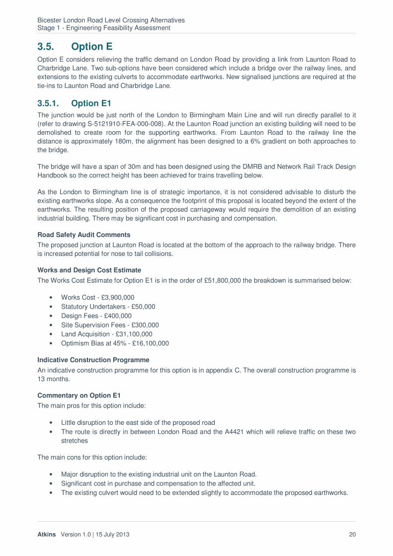
3.5. Option E Option E considers relieving the traffic demand on London Road by providing a link from Launton Road to
Charbridge Lane. Two sub-options have been considered which include a bridge over the railway lines, and
extensions to the existing culverts to accommodate earthworks. New signalised junctions are required at the
tie-ins to Launton Road and Charbridge Lane.
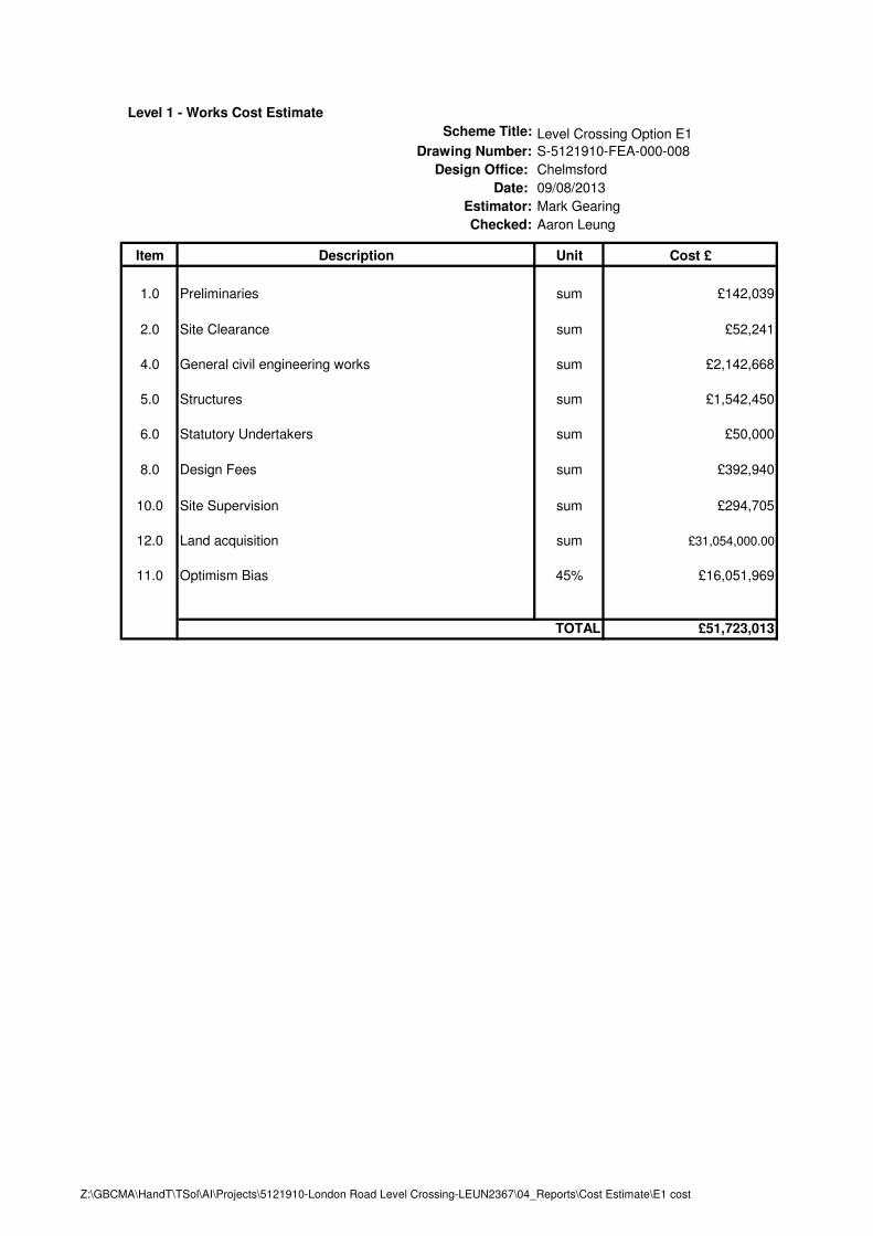
3.5.1. Option E1
The junction would be just north of the London to Birmingham Main Line and will run directly parallel to it
(refer to drawing S-5121910-FEA-000-008). At the Launton Road junction an existing building will need to be
demolished to create room for the supporting earthworks. From Launton Road to the railway line the
distance is approximately 180m, the alignment has been designed to a 6% gradient on both approaches to
the bridge.
The bridge will have a span of 30m and has been designed using the DMRB and Network Rail Track Design
Handbook so the correct height has been achieved for trains travelling below.
As the London to Birmingham line is of strategic importance, it is not considered advisable to disturb the
existing earthworks slope. As a consequence the footprint of this proposal is located beyond the extent of the
earthworks. The resulting position of the proposed carriageway would require the demolition of an existing
industrial building. There may be significant cost in purchasing and compensation.
Road Safety Audit Comments
The proposed junction at Launton Road is located at the bottom of the approach to the railway bridge. There
is increased potential for nose to tail collisions.
Works and Design Cost Estimate
The Works Cost Estimate for Option E1 is in the order of £51,800,000 the breakdown is summarised below:
• Works Cost - £3,900,000
• Statutory Undertakers - £50,000
• Design Fees - £400,000
• Site Supervision Fees - £300,000
• Land Acquisition - £31,100,000
• Optimism Bias at 45% - £16,100,000
Indicative Construction Programme
An indicative construction programme for this option is in appendix C. The overall construction programme is
13 months.
Commentary on Option E1
The main pros for this option include:
• Little disruption to the east side of the proposed road
• The route is directly in between London Road and the A4421 which will relieve traffic on these two
stretches
The main cons for this option include:
• Major disruption to the existing industrial unit on the Launton Road.
• Significant cost in purchase and compensation to the affected unit.
• The existing culvert would need to be extended slightly to accommodate the proposed earthworks.
Bicester London Road Level Crossing Alternatives Stage 1 - Engineering Feasibility Assessment
Atkins Version 1.0 | 15 July 2013 21
3.5.2. Option E2
Refer to drawing number S-5121910-FEA-000-009. This option will be further north than option E1, but still
between Launton Road and Charbridge Lane. The route will overlay the existing Jarvis Lane and will follow
that route to tie into Charbridge Way. There will be a 25m span bridge crossing the railway line
Currently the access to the Bibby Distribution Unit is at the end of Charbridge Lane, it is proposed that this
entrance is moved further east along Charbridge Way.
The highway works will end just east of the Bibby Distribution unit, and traffic modelling would be required to
determine whether traffic signals is needed on the junction of Charbridge Way and Charbidge Lane.
Road Safety Audit Comments
There were no comments resulting from the Road Safety Audit for this proposal.
Works and Design Cost Estimate
The Works Cost Estimate for Option E2 is in the order of £6,300,000. The breakdown is summarised below:
• Works Cost - £3,000,000
• Statutory Undertakers - £50,000
• Design Fees - £300,000
• Site Supervision Fees - £200,000
• Land Acquisition - £800,000
• Optimism Bias at 45% - £2,000,000
Indicative Construction Programme
An indicative construction programme for this option is in appendix C. The overall construction programme is
11 months.
Commentary on Option E2
The main pros for this option include:
• Good use of existing roads (Jarvis’ Lane and Charbridge Way)
• Does not need to demolish any structure
• Low cost compared to other options
The main cons for this option include:
• Access to Bibby’s Distribution would need to be altered slightly
• It may have little effect to traffic problems as it is remote from the main generators.

Appendices

Bicester London Road Level Crossing Alternatives Stage 1 - Engineering Feasibility Assessment
Atkins Version 1.0 | 15 July 2013 23
Appendix A. Option Layouts
M
a
lla
rd
s
W
a
y
B
4
1
0
0
L
o
n
d
o
n
R
o
a
d
The Talisman
Business Centre
McKay Trading
Estate
Coach House Mews
O
x
f
o
r
d
t
o
B
i
c
e
s
t
e
r
B
r
a
n
c
h
L
i
n
e
SOUTH APPROACH
VIADUCT
(8.3% GRADIENT)
NORTH APPROACH
VIADUCT
(6% GRADIENT)
JUNCTION TO
BE REALIGNED
EXISTING LEVEL
CROSSING TO BE
CLOSED
NEW ACCESS ONTO
LONDON ROAD
KEY
The Village Retail Park
The Village Multi-storey Car Park
Footprint of Bicester Town Station and
Platforms
Building to be Demolished
Listed Building
Additional Parking Area for The Village
Area Subject to Compulsory Purchase
Order
Extent of Highway Works (At Existing
Ground Level)
Extent of Structure
Extent of Structure Over Railway
Centre Line of Option A2
Centre Line of Option A3
IN ADDITION TO THE HAZARDS/RISKS NORMALLY ASSOCIATED WITH THE TYPES OF WORK
DETAILED ON THIS DRAWING, NOTE THE FOLLOWING SIGNIFICANT RESIDUAL RISKS
SAFETY, HEALTH AND ENVIRONMENTAL INFORMATION
scale 1:2500
0 50 250m100 150 200
Reproduced from the Ordnance Survey mapping with the permission of the Controller of
Her Majesty's Stationery Office © Crown Copyright. Unauthorised reproduction
infringes Crown Copyright, and may lead to prosecution or civil proceedings.
Oxfordshire County Council Licence No LA076805
A 16/08/13 Original IssueMJG AL PRM
M
a
lla
rd
s W
a
y
B
4
1
0
0
L
o
n
d
o
n
R
o
a
d
The Talisman
Business Centre
McKay
Trading Estate
Coach House Mews
O
x
f
o
r
d
t
o
B
i
c
e
s
t
e
r
B
r
a
n
c
h
L
i
n
e
WEST VIADUCT
APPROACH AT 6.0%
GRADIENT
JUNCTION TO BE
REALIGNED
EXISTING LEVEL
CROSSING TO BE
CLOSED
REALIGN ROUNDABOUT TO
ACCOMMODATE NEW ARM
EAST VIADUCT
APPROACH AT
5.6% GRADIENT
Reproduced from the Ordnance Survey mapping with the permission of the Controller of
Her Majesty's Stationery Office © Crown Copyright. Unauthorised reproduction
infringes Crown Copyright, and may lead to prosecution or civil proceedings.
Oxfordshire County Council Licence No LA076805
scale 1:2500
0 50 250m100 150 200
KEY
The Village Retail Park
The Village Multi-storey Car Park
Footprint of Bicester Town Station and
Platforms
Listed Building
Additional Parking Area for The Village
Area Subject to Compulsory Purchase
Order
Extent of Highway Works at Ground
Level
Extent of Retaining Wall
Extent of Structure
Extent of Structure Over Railway
IN ADDITION TO THE HAZARDS/RISKS NORMALLY ASSOCIATED WITH THE TYPES OF WORK
DETAILED ON THIS DRAWING, NOTE THE FOLLOWING SIGNIFICANT RESIDUAL RISKS
SAFETY, HEALTH AND ENVIRONMENTAL INFORMATION
A 16/08/13 Original IssueMJG AL PRM

B4100 London R
oad
The Talisman Business Centre
McKay Trading Estate
Coach House Mews
O
x
f
o
r
d
t
o
B
i
c
e
s
t
e
r
B
r
a
n
c
h
L
i
n
e
S
t
a
t
i
o
n
A
p
p
r
o
a
c
h
STATION MOVEMENT
AND PUBLIC MOVEMENT
TO BE SEPARATED
EXTENSION OF PLATFORM FOR
STATION MOVEMENT ONLY
APPROXIMATE FOOTWAY
POSITION OF BICESTER TOWN
STATION IMPROVEMENTS
Reproduced from the Ordnance Survey mapping with the permission of the Controller of
Her Majesty's Stationery Office © Crown Copyright. Unauthorised reproduction
infringes Crown Copyright, and may lead to prosecution or civil proceedings.
Oxfordshire County Council Licence No LA076805
KEY
Listed Building
Footprint of Bicester Town Station and
Platforms
The Village Multi-storey Car Park
Additional Parking Area for The Village
Existing Footway
Extent of Footway Diversion
Extent of Footbridge Over Railway
Extent of Approach Ramps
Extent of Steps and Landings
0
IN ADDITION TO THE HAZARDS/RISKS NORMALLY ASSOCIATED WITH THE TYPES OF WORK
DETAILED ON THIS DRAWING, NOTE THE FOLLOWING SIGNIFICANT RESIDUAL RISKS
SAFETY, HEALTH AND ENVIRONMENTAL INFORMATION
A 16/08/13 Original IssueMJG AL PRM

Coach House Mews
McKay Trading Estate
O
x
f
o
r
d
t
o
B
i
c
e
s
t
e
r
B
r
a
n
c
h
L
i
n
e
S
t
a
t
i
o
n
A
p
p
r
o
a
c
h
APPROXIMATE FOOTWAY
POSITION OF BICESTER TOWN
STATION IMPROVEMENTS
B4100 London R
oad
Reproduced from the Ordnance Survey mapping with the permission of the Controller of
Her Majesty's Stationery Office © Crown Copyright. Unauthorised reproduction
infringes Crown Copyright, and may lead to prosecution or civil proceedings.
Oxfordshire County Council Licence No LA076805
0
KEY
Listed Building
Footprint of Bicester Town Station and
Platforms
The Village Multi-storey Car Park
Additional Parking Area for The Village
Existing Footway
Extent of Footway Diversion
Extent of Footbridge Over Railway
Extent of Approach Ramps
Extent of Steps and Landings
IN ADDITION TO THE HAZARDS/RISKS NORMALLY ASSOCIATED WITH THE TYPES OF WORK
DETAILED ON THIS DRAWING, NOTE THE FOLLOWING SIGNIFICANT RESIDUAL RISKS
SAFETY, HEALTH AND ENVIRONMENTAL INFORMATION
A 16/08/13 Original IssueMJG AL PRM

M
a
lla
rd
s
W
a
y
B
4
1
0
0
L
o
n
d
o
n
R
o
a
d
The Talisman
Business Centre
McKay Trading
Estate
Coach House Mews
O
x
f
o
r
d
t
o
B
i
c
e
s
t
e
r
B
r
a
n
c
h
L
i
n
e
S
t
a
t
i
o
n
A
p
p
r
o
a
c
h
PROPOSED GIVE
WAY JUNCTION
PROPOSED APPROACH
TO UNDERBRIDGE (6%
GRADIENT)
PROPOSED APPROACH
TO UNDERBRIDGE (6%
GRADIENT)
Reproduced from the Ordnance Survey mapping with the permission of the Controller of
Her Majesty's Stationery Office © Crown Copyright. Unauthorised reproduction
infringes Crown Copyright, and may lead to prosecution or civil proceedings.
Oxfordshire County Council Licence No LA076805
scale 1:2500
0 50 250m100 150 200
KEY
The Village Retail Park
The Village Multi-storey Car Park
Footprint of Bicester Town Station and
Platforms
Listed Building
Additional Parking Area for The Village
Extent of Highway to be Lowered
Extent of Structure Under Railway
Extent of Retaining Wall
Areas Subject to Compulsory Purchase
Order.
IN ADDITION TO THE HAZARDS/RISKS NORMALLY ASSOCIATED WITH THE TYPES OF WORK
DETAILED ON THIS DRAWING, NOTE THE FOLLOWING SIGNIFICANT RESIDUAL RISKS
SAFETY, HEALTH AND ENVIRONMENTAL INFORMATION
A 16/08/13 Original IssueMJG AL PRM

M
allards W
ay
B
4
1
0
0
L
o
n
d
o
n
R
o
a
d
The Talisman
Business Centre
McKay
Trading Estate
Coach House Mews
A
4
1
O
x
f
o
r
d
t
o
B
i
c
e
s
t
e
r
B
r
a
n
c
h
L
i
n
e
JUNCTION TO BE
REALIGNED
TIE-IN TO EXISTING
ROAD LAYOUT
EXISTING LEVEL
CROSSING TO BE
CLOSED
VIADUCT TO MAINTAIN
HEADROOM AND ACCESS TO
BICESTER OUTLET VILLAGE
AND SERVICE AREA
APPROACH TO VIADUCT AT
6% GRADIENT. SIDES TO BE
RETAINING WALLS TO
REDUCE FOOTPRINT
scale 1:2500
0 50 250m100 150 200
KEY
The Village Retail Park
The Village Multi-storey Car Park
Footprint of Bicester Town Station and
Platforms
Listed Building
Existing Parking Area for The Village
Extent of Highway Works (at Existing
Ground Level)
Extent of Structure
Extent of Earthworks
Area Subject to Compulsory Purchase
Order
Proposed Additional Multi-Storey Car
Park
Extent of Retaining Wall
Reproduced from the Ordnance Survey mapping with the permission of the Controller of
Her Majesty's Stationery Office © Crown Copyright. Unauthorised reproduction
infringes Crown Copyright, and may lead to prosecution or civil proceedings.
Oxfordshire County Council Licence No LA076805
IN ADDITION TO THE HAZARDS/RISKS NORMALLY ASSOCIATED WITH THE TYPES OF WORK
DETAILED ON THIS DRAWING, NOTE THE FOLLOWING SIGNIFICANT RESIDUAL RISKS
SAFETY, HEALTH AND ENVIRONMENTAL INFORMATION
A 16/08/13 Original IssueMJG AL PRM
M
allards W
ay
B
4
1
0
0
L
o
n
d
o
n
R
o
a
d
The Talisman
Business Centre
McKay
Trading Estate
Coach House Mews
A
4
1
O
x
f
o
r
d
t
o
B
i
c
e
s
t
e
r
B
r
a
n
c
h
L
i
n
e
JUNCTION TO BE
REALIGNED
TIE-IN TO EXISTING
ROAD LAYOUT
EXISTING LEVEL
CROSSING TO BE
CLOSED
VIADUCT AT 6%
GRADIENT
PROPOSED
WING WALLS
scale 1:2500
0 50 250m100 150 200
Reproduced from the Ordnance Survey mapping with the permission of the Controller of
Her Majesty's Stationery Office © Crown Copyright. Unauthorised reproduction
infringes Crown Copyright, and may lead to prosecution or civil proceedings.
Oxfordshire County Council Licence No LA076805
KEY
The Village Retail Park
The Village Multi-storey Car Park
Footprint of Bicester Town Station and
Platforms
Listed Building
Existing Parking Area for The Village
Extent of Highway Works (At Existing
Ground Level)
Extent of Structure
Extent of Structure Over Railway
Extent of Earthworks
Area Subject to Compulsory Purchase
Order
Proposed Additional Multi-Storey Car
Park
IN ADDITION TO THE HAZARDS/RISKS NORMALLY ASSOCIATED WITH THE TYPES OF WORK
DETAILED ON THIS DRAWING, NOTE THE FOLLOWING SIGNIFICANT RESIDUAL RISKS
SAFETY, HEALTH AND ENVIRONMENTAL INFORMATION
A 16/08/13 Original IssueMJG AL PRM

C
U
T
L
I
N
E
C
U
T
L
I
N
E
L
a
u
n
t
o
n
R
o
a
d
G
r
a
n
v
i
l
l
e
W
a
y
M
u
r
d
o
c
k
R
o
a
d
L
o
n
d
o
n
t
o
B
i
r
m
i
n
g
h
a
m
M
a
i
n
L
i
n
e
PROPOSED SIGNAL
JUNCTION
WEST APPROACH
6% GRADIENT
PROPOSED 1:2 SLOPE
EAST APPROACH
6% GRADIENT
PROPOSED 1:2 SLOPE
EXISTING RAILWAY
EARTHWORK TO REMAIN
UNDISTURBED
C
U
T
L
I
N
E
C
U
T
L
I
N
E
Charbridge Lane
L
o
n
d
o
n
t
o
B
i
r
m
i
n
g
h
a
m
M
a
i
n
L
i
n
e
PROPOSED SIGNAL
JUNCTION
Reproduced from the Ordnance Survey mapping with the permission of the Controller of
Her Majesty's Stationery Office © Crown Copyright. Unauthorised reproduction
infringes Crown Copyright, and may lead to prosecution or civil proceedings.
Oxfordshire County Council Licence No LA076805
KEY
Area Subject to Compulsory Purchase
Order
Building to be Demolished
Extent of Highway Works
Extent of Bridge Over Railway
Extent of Earthworks
Extent of Retaining Wall
scale 1:2500
0 50 250m100 150 200
IN ADDITION TO THE HAZARDS/RISKS NORMALLY ASSOCIATED WITH THE TYPES OF WORK
DETAILED ON THIS DRAWING, NOTE THE FOLLOWING SIGNIFICANT RESIDUAL RISKS
SAFETY, HEALTH AND ENVIRONMENTAL INFORMATION
A 16/08/13 Original IssueMJG AL PRM

L
a
u
n
t
o
n
R
o
a
d
Charbridge Lane
L
o
n
d
o
n
t
o
B
i
r
m
i
n
g
h
a
m
M
a
i
n
L
i
n
e
J
a
r
v
i
s
'
L
a
n
e
C
h
a
r
b
r
i
d
g
e
W
a
y
WEST APPROACH
6% GRADIENT
PROPOSED 1:2 SLOPE
EAST APPROACH
6% GRADIENT
PROPOSED 1:2 SLOPE
PROPOSED SIGNAL
JUNCTION
EXISTING JUNCTION
TO BE SIGNALISED
Bibby Distribution
Reproduced from the Ordnance Survey mapping with the permission of the Controller of
Her Majesty's Stationery Office © Crown Copyright. Unauthorised reproduction
infringes Crown Copyright, and may lead to prosecution or civil proceedings.
Oxfordshire County Council Licence No LA076805
KEY
Extent of Highway Works
Extent of Bridge Over Railway
Extent of Earthworks
Area Subject to Compulsory Purchase
Order
scale 1:2500
0 50 250m100 150 200
IN ADDITION TO THE HAZARDS/RISKS NORMALLY ASSOCIATED WITH THE TYPES OF WORK
DETAILED ON THIS DRAWING, NOTE THE FOLLOWING SIGNIFICANT RESIDUAL RISKS
SAFETY, HEALTH AND ENVIRONMENTAL INFORMATION
A 16/08/13 Original IssueMJG AL PRM
Bicester London Road Level Crossing Alternatives Stage 1 - Engineering Feasibility Assessment
Atkins Version 1.0 | 15 July 2013 24
Appendix B. Works Cost Estimate

Level 1 - Works Cost Estimate
Drawing Number:
Estimator:
Item Description Unit Cost £
1.0 Preliminaries sum £312,315
2.0 Site Clearance sum £129,096
3.0 General civil engineering costs sum £449,514
4.0 Structures sum £17,716,728
5.0 Statutory Undertakers sum £50,000
6.0 Design Fees sum £1,865,765
7.0 Site Supervision sum £1,399,324
8.0 Land acquisition sum £3,064,830.00
9.0 Optimism Bias 45% £11,244,407
£36,231,979
Design Office:
TOTAL
Date:
Checked: Aaron Leung
Level Crossing Option A1
S-5121910-FEA-000-001
Chelmsford
09/08/2013
Rhys Proctor
Scheme Title:
Z:\GBCMA\HandT\TSol\AI\Projects\5121910-London Road Level Crossing-LEUN2367\04_Reports\Cost Estimate\A1 cost

Level 1 - Works Cost Estimate
Level Crossing Option A4
Drawing Number:
Estimator:
Item Description Unit Cost £
1.0 Preliminaries sum £334,233
2.0 Site Clearance sum £12,182
3.0 General civil engineering works sum £1,503,380
4.0 Structures sum £18,259,670
5.0 Statutory Undertakers sum £50,000
6.0 Design Fees sum £2,015,947
7.0 Site Supervision sum £1,511,960
8.0 Land acquisition sum £2,923,200.00
9.0 Optimism Bias 45% £11,974,757
£38,585,329
09/08/2013
Rhys Proctor
Scheme Title:
Design Office:
TOTAL
Date:
Checked: Aaron Leung
S-5121910-FEA-000-002
Chelmsford
Z:\GBCMA\HandT\TSol\AI\Projects\5121910-London Road Level Crossing-LEUN2367\04_Reports\Cost Estimate\A4 cost
Level 1 - Works Cost Estimate
Drawing Number:
Estimator:
Item Description Unit Cost £
1.0 Preliminaries sum £0
2.0 Site Clearance sum £0
3.0 General civil engineering works sum £13,673
4.0 Structures sum £2,633,917
5.0 Statutory Undertakers sum £0
6.0 Design Fees sum £264,759
7.0 Site Supervision sum £198,569
8.0 Land acquisition sum £0.00
9.0 Optimism Bias 45% £1,399,913
£4,510,832TOTAL
Date:
Checked: Aaron Leung
Level Crossing Option B1
S-5121910-FEA-000-003
Chelmsford
09/08/2013
Rhys Proctor
Scheme Title:
Design Office:
Z:\GBCMA\HandT\TSol\AI\Projects\5121910-London Road Level Crossing-LEUN2367\04_Reports\Cost Estimate\B1 (1 in 15) cost

Level 1 - Works Cost Estimate
Drawing Number:
Estimator:
Item Description Unit Cost £
1.0 Preliminaries sum £0
2.0 Site Clearance sum £0
3.0 General civil engineering works sum £3,965
4.0 Structures sum £2,098,410
5.0 Statutory Undertakers sum £0
6.0 Design Fees sum £210,238
7.0 Site Supervision sum £157,678
8.0 Land acquisition sum £0.00
9.0 Optimism Bias 45% £1,111,631
£3,581,922
Chelmsford
09/08/2013
Rhys Proctor
Scheme Title:
Design Office:
TOTAL
Date:
Checked: Aaron Leung
Level Crossing Option B2
S-5121910-FEA-000-004
Z:\GBCMA\HandT\TSol\AI\Projects\5121910-London Road Level Crossing-LEUN2367\04_Reports\Cost Estimate\B2 (1 in 15) cost

Level 1 - Works Cost Estimate
Drawing Number:
Estimator:
Item Description Unit Cost £
1.0 Preliminaries sum £374,304
2.0 Site Clearance sum £12,182
3.0 General civil engineering works sum £1,547,837
4.0 Retaining Structure/Underpass sum £9,599,416
5.0 Statutory Undertakers sum £200,000
7.0 Design Fees sum £1,173,374
9.0 Site Supervision sum £880,030
10.0 Land acquisition sum £17,516,000.00
11.0 Optimism Bias 45% £14,086,415
£45,389,558
Scheme Title:
Design Office:
TOTAL
Date:
Checked: Aaron Leung
C
S-5121910-FEA-000-005
Chelmsford
09/08/2013
Rhys Proctor
Z:\GBCMA\HandT\TSol\AI\Projects\5121910-London Road Level Crossing-LEUN2367\04_Reports\Cost Estimate\C cost
Level 1 - Works Cost Estimate
Drawing Number:
Estimator:
Item Description Unit Cost £
1.0 Preliminaries sum £238,503
2.0 Site Clearance sum £12,182
3.0 General civil engineering works sum £1,378,106
4.0 Structures sum £12,679,189
5.0 Statutory Undertakers sum £100,000
6.0 Design Fees sum £1,440,798
7.0 Site Supervision sum £1,080,598
8.0 Land acquisition sum £8,957,400.00
9.0 Optimism Bias 45% £11,649,049
£37,535,825
Scheme Title:
Design Office:
TOTAL
Date:
Checked: Aaron Leung
Level Crossing Option D1
S-5121910-FEA-000-006
Chelmsford
15/08/2013
Mark Gearing
Z:\GBCMA\HandT\TSol\AI\Projects\5121910-London Road Level Crossing-LEUN2367\04_Reports\Cost Estimate\D1 cost
Level 1 - Works Cost Estimate
Drawing Number:
Estimator:
Item Description Unit Cost £
1.0 Preliminaries sum £238,503
2.0 Site Clearance sum £12,182
4.0 General civil engineering works sum £2,636,263
5.0 Structures sum £5,811,873
6.0 Statutory Undertakers sum £50,000
8.0 Design Fees sum £874,882
10.0 Site Supervision sum £656,162
11.0 Land acquisition sum £8,376,900.00
12.0 Optimism Bias 45% £8,288,217
£26,944,982
Mark Gearing
Scheme Title:
Design Office:
TOTAL
Date:
Checked: Aaron Leung
Level Crossing Option D2
S-5121910-FEA-000-007
Chelmsford
15/08/2013
Z:\GBCMA\HandT\TSol\AI\Projects\5121910-London Road Level Crossing-LEUN2367\04_Reports\Cost Estimate\D2 cost
Level 1 - Works Cost Estimate
Drawing Number:
Estimator:
Item Description Unit Cost £
1.0 Preliminaries sum £142,039
2.0 Site Clearance sum £52,241
4.0 General civil engineering works sum £2,142,668
5.0 Structures sum £1,542,450
6.0 Statutory Undertakers sum £50,000
8.0 Design Fees sum £392,940
10.0 Site Supervision sum £294,705
12.0 Land acquisition sum £31,054,000.00
11.0 Optimism Bias 45% £16,051,969
£51,723,013
S-5121910-FEA-000-008
Chelmsford
09/08/2013
Mark Gearing
Scheme Title:
Design Office:
TOTAL
Date:
Checked: Aaron Leung
Level Crossing Option E1
Z:\GBCMA\HandT\TSol\AI\Projects\5121910-London Road Level Crossing-LEUN2367\04_Reports\Cost Estimate\E1 cost

Level 1 - Works Cost Estimate
Drawing Number:
Estimator:
Item Description Unit Cost £
1.0 Preliminaries sum £122,054
2.0 Site Clearance sum £6,091
4.0 General civil engineering woks sum £1,812,433
5.0 Structures sum £1,034,176
6.0 Statutory Undertakers sum £50,000
8.0 Design Fees sum £302,475
10.0 Site Supervision sum £226,857
11.0 Land acquisition sum £825,000.00
12.0 Optimism Bias 45% £1,970,589
£6,349,675
S-5121910-FEA-000-009
Chelmsford
09/08/2013
Rhys Proctor
Scheme Title:
Design Office:
TOTAL
Date:
Checked: Aaron Leung
Level Crossing Option E2
Z:\GBCMA\HandT\TSol\AI\Projects\5121910-London Road Level Crossing-LEUN2367\04_Reports\Cost Estimate\E2 cost
Bicester London Road Level Crossing Alternatives Stage 1 - Engineering Feasibility Assessment
Atkins Version 1.0 | 15 July 2013 25
Appendix C. Indicative Construction Programme
Level Crossing Option A1
Drawing Number:
1 2 3 4 5 6 7 8 9 10 11 12 13 14 15 16 17 18 19 20 21 22
1 Mobolisation and Site Set-up
2 Site Clearance
3 Deconstruct Building (Talisman Business Centre)
4 Construct Approach to Viaduct
5 Construct Viaduct
6 Construct Railway Crossing
7 Highway Approaches to Structure
8 Tie-in and Alterations at London Road North of Railway
9 New Talisman Business Centre/London Road Access
10 Close Existing Level Crossing
11 Turnaround Facilities at Old Level Crossing
23 24 25 26 27 28 29
1 Mobolisation and Site Set-up
2 Site Clearance
3 Deconstruct Building (Talisman Business Centre)
4 Construct Approach to Viaduct
5 Construct Viaduct
6 Construct Railway Crossing
7 Highway Approaches to Structure
8 Tie-in and Alterations at London Road North of Railway
9 New Talisman Business Centre/London Road Access
10 Close Existing Level Crossing
11 Turnaround Facilities at Old Level Crossing
Months
Scheme Title:
Date: 09/08/2013
S-5121910-FEA-000-001
Months

Level Crossing Option A4
Drawing Number:
1 2 3 4 5 6 7 8 9 10 11 12 13 14 15 16 17 18 19 20
1 Mobolisation and Site Set-up
2 Site Clearance
3 Construct Approach to Viaduct
4 Construct Viaduct
5 Construct Railway Crossing
6 Highway Approaches to Structure
7 Construct New Roundabout Alignment
8 Construct Tie-in at London Road North of Railway Line
9 Close Existing Level Crossing
10 Turnaround Facilities at Old Level Crossing
21 22 23 24 25 26 27 28 29 30 31
1 Mobolisation and Site Set-up
2 Site Clearance
3 Construct Approach to Viaduct
4 Construct Viaduct
5 Construct Railway Crossing
6 Highway Approaches to Structure
7 Construct New Roundabout Alignment
8 Construct Tie-in at London Road North of Railway Line
9 Close Existing Level Crossing
10 Turnaround Facilities at Old Level Crossing
Months
Months
Scheme Title:
Date: 09/08/2013
S-5121910-FEA-000-002

Level Crossing Option B1
Drawing Number:
1 2 3 4 5 6 7 8
1 Construct Piers
2 Lift Bridge
3 Construct Ramps
4 Construct Public Stairs
5 Construct Station Access
6 Construct Approach Footpaths
Months
Scheme Title:
Date:
S-5121910-FEA-000-003
09/08/2013
Level Crossing Option B2
Drawing Number:
1 2 3 4 5 6 7 8
1 Construct Piers
2 Lift Bridge
3 Construct Ramps
4 Construct Public Stairs
5 Construct Station Access
6 Construct Approach Footpaths
Months
Scheme Title:
Date: 09/08/2013
S-5121910-FEA-000-004
Level Crossing Option C
Drawing Number:
1 2 3 4 5 6 7 8 9 10 11 12 13 14 15 16 17 18 19 20
1 Mobolisation and Site Set-up
2 Site Clearance
3 Support Railway Structure
4 Construct Retaining Wall
5 Excavate All Proposed Area
6 Construct Highway Surfacing
7 Construct Highway Tie-ins
9 Construct New Pedestrian Accesses
21 22 23 24 25 26 27 28
1 Mobolisation and Site Set-up
2 Site Clearance
3 Support Railway Structure
4 Construct Retaining Wall
5 Excavate All Proposed Area
6 Construct Highway Surfacing
7 Construct Highway Tie-ins
9 Construct New Pedestrian Accesses
Months
Scheme Title:
S-5121910-FEA-000-005
Date: 16/08/2013
Months
Level Crossing Option D1
Drawing Number:
1 2 3 4 5 6 7 8 9 10 11 12 13 14 15 16 17 18
1 Mobolisation and Site Set-up
2 Site Clearance
3 Construct Approach to Viaduct
4 Construct Viaduct
5 Construct Tie-in to A41
6 Construct Multi-Storey Car Park
7 Construct New Roundabout
8 Construct Ground Level Highway Works
9 Close Existing Level Crossing
10 Turnaround Facilities at Old Level Crossing
19 20 21 22
1 Mobolisation and Site Set-up
2 Site Clearance
3 Construct Approach to Viaduct
4 Construct Viaduct
5 Construct Tie-in to A41
6 Construct Multi-Storey Car Park
7 Construct New Roundabout
8 Construct Ground Level Highway Works
9 Close Existing Level Crossing
10 Turnaround Facilities at Old Level Crossing
months
Months
Scheme Title:
Date:
S-5121910-FEA-000-006
15/08/2013
Level Crossing Option D2
Drawing Number:
1 2 3 4 5 6 7 8 9 10 11 12 13 14 15 16 17 18
1 Mobolisation and Site Set-up
2 Site Clearance
3 Construct Approach Railway Crossing
4 Construct Earthworks Adjacent A41
5 Construct Bridge Over Railway
6 Construct Multi-Storey Car Park
7 Construct New Roundabout
8 Construct Ground Level Highway Works
9 Close Existing Level Crossing
10 Construct Turnaround Facilities
19 20 21 22
1 Mobolisation and Site Set-up
2 Site Clearance
3 Construct Approach Railway Crossing
4 Construct Earthworks Adjacent A41
5 Construct Bridge Over Railway
6 Construct Multi-Storey Car Park
7 Construct New Roundabout
8 Construct Ground Level Highway Works
9 Close Existing Level Crossing
10 Construct Turnaround Facilities
Months
Months
Scheme Title:
Date: 15/08/2013
S-5121910-FEA-000-007
Level Crossing Option E1
Drawing Number:
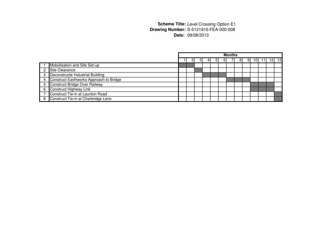
1 2 3 4 5 6 7 8 9 10 11 12 13
1 Mobolisation and Site Set-up
2 Site Clearance
3 Deconstructe Industrial Building
4 Construct Earthworks Approach to Bridge
5 Construct Bridge Over Railway
6 Construct Highway Link
7 Construct Tie-in at Launton Road
8 Construct Tie-in at Charbridge Lane
Months
Scheme Title:
Date:
S-5121910-FEA-000-008
09/08/2013

Drawing Number:
1 2 3 4 5 6 7 8 9 10 11
1 Mobolisation and Site Set-up
2 Site Clearance
4 Construct Earthworks Approach to Bridge
5 Construct Bridge Over Railway
6 Construct Highway Link
7 Construct Access to Industrial Units on Charbridge Way
9 Construct Tie-in at Launton Road
10 Construct Tie-in at Charbridge Lane
Months
Scheme Title:
Date:
Level Crossing Option E2
S-5121910-FEA-000-009
09/08/2013

© Atkins Ltd except where stated otherwise. The Atkins logo, ‘Carbon Critical Design’ and the strapline ‘Plan Design Enable’ are trademarks of Atkins Ltd.
Contact name
Atkins company name
Office address
Telephone
Direct telephone
Fax