biddeford mill district
TRANSCRIPT

Biddeford Mill DistrictMaster Plan
October 2009


ACKNOWLEDGEMENTS
BiDDEfOrD MiLL DiSTriCT
ACKNOWLEDGEMENTS
The Biddeford Mill District Master Plan is the
result of a collaborative effort with the dedicated
members of the Steering Committee, property
owners and the wider community over the course
of the past year and a half. This Master Plan
would not be possible without the generous
contribution of time and insight by these
participants.
U.S. Economic Development Agency (funding source and support)
City of Biddeford Mayor and City CouncilJohn Bubier, City ManagerJennie Franceschi, Planning EngineerTom Milligan, City EngineerGreg Tansley, City Planner and Project ManagerSally Bates, Project Coordinator
Downtown Development CommissionEconomic Improvement CommissionHistoric Preservation Commission
Robert Dodge, Biddeford Economic Development Direc-tor who passed away February 4, 2009
Master Plan Steering Committee Brian Pelletier, Downtown Development Commission Member Ward 3, Aurelie Wallach, Historic Preservation Commission Member Ward 1 Andrew Michaud, Economic Improvement Commission Member Ward 7 Rachael Weyand, Executive Director, Heart of Biddeford Councilor David Flood, Ward 7 Councilor J. Fred Staples, Ward 2 Roland Lawler, Downtown Development Commission Member Ward 5Peter Morelli, Development Director, City of Saco
Participating Property OwnersTrent Bell, Vacant Parcel Greg Bennett, Lincoln MillAlbert Davis, WestPoint (Facilities Manager) Diane Doyle, Saco & Lowell Machine ShopDavid Flood, Courier BuildingStephen Goodrich, Riverdam Millyard Davic McClees, TopspinJoe Moreshead, Precision ScrewMark Roazen, CarQuestDoug Sanford, North Dam MillGeorge Sharkey, MulligansNathan Szanton, The Mill at Saco Falls John Tarbox, Bugbee Brown
The Consultant Team
Crosby | Schlessinger | Smallridge, LLC
Carole Schlessinger, Principal/Project ManagerSkip Smallridge, Principal/Urban DesignerCarolyn Campbell, Landscape DesignerChris Riale, Urban Planner/Designer Aimee Weeks, Graphic Designer
Community Initiatives
Jill Michaels, Economic/Funding Consultant
Resource Systems Group: Transportation
Robert Chamberlain, Transportation AnalysisAmanda Clancy, Transportation Analysis
Economic & Policy Resources, Inc.
Jeff Carr, Market Assessment
Encore Redevelopment
Chad Farrell, Environmental Analysis
Engineering Resources, Inc
David Boehm, Engineering Analysis

BiDDEfOrD MiLL DiSTriCT
1 Introduction .................................................. 1
2 History of the Mill District ............................. 3 Recommendations for Incorporating History into
the Mill District Redevelopment ................................ 93 Existing Conditions ..................................... 11
4 Environmental Issues ................................. 17
5 Market Analysis ......................................... 19
6 Review of Other Successfully Redeveloped Mill Districts ........................ 23 Lessons Learned ..................................................... 25
7 The Plan .................................................... 27 Principles ................................................................. 27 The Framework ....................................................... 28 Land Use ................................................................. 42 Parking .................................................................... 43
8 Multi-Modal Transportation ........................ 47 2005 Existing Conditions ......................................... 47 2025TrafficVolumes...............................................49 Intersection Analysis & Mitigation ............................ 50 Transportation Demand Management ................... 54 Role of Transit ......................................................... 57 Car Sharing ............................................................. 58
9 Phasing & Implementation ......................... 59 Phasing ................................................................... 59 Implementation Issues ............................................ 61 Funding ................................................................... 62 Recommendations for Early Actions ....................... 66
TABLE OF CONTENTS

�Biddeford Mill District Master Plan
CHAPTER � | INTRODUCTION
The Biddeford Mill District is on the brink of some-thing great – its reincarnation as a lively mixed-use commercial, light industrial and residential district. The area’s incredible assets include water views and the potential for pedestrian access along and across the Saco River, beautiful historic structures, a fas-cinating history and its location just steps from the heart of downtown Biddeford.
For much of Biddeford’s history the mills repre-sented the heart of the community, with a thriving and attractive downtown growing up to serve the mill owners and workers. As with other mill towns in New England, the mills closed over time, eventu-ally eroding the success of the downtown. Over the past few years, revitalization efforts have resulted in a downtown and Mill District beginning to bustle with activity – the beautifully restored City Theater; new stores such as the Art Mart on Main Street; and in the Mill District, 54 new residential units at North Dam, several food production and retail outlets, offices, artist studios, fitness and martial arts studios, many smaller “creative economy” uses, and industrial uses including a number of specialized woodworkers. These successes have increased inter-est in the underutilized Mill District and the City, and mill owners have shown impressive successes in tough economic times.
1introduction
Aerial view of the Biddeford Mill District (District boundary shown in red).

� Biddeford Mill District Master Plan
The current interest in redeveloping a significant portion of the district, along with the progress being made on the relocation of the Main Energy Recovery Facility (MERC), provides the unique opportunity to, in fact, create a district – a recogniz-able place with a collection of interwoven uses and public open spaces linked to (and linking) downtown and the riverfront. There is also the opportunity to coordinate infrastructure investments to develop a more efficient and sustainable district. All of these components, along with public realm improvements including streetscape, parks and the pedestrian environment, must work together to create a “sense of place” so that the mill district becomes “The Bid-deford Mill District.”
GoALSFrom the outset, this project has been guided by two key goals:
1. Strategically guide new private and public investment in the site with recommendations for:
• Land and building use - a mix of uses which, in concert with the physical improvements, create a new place – a destination that complements rather than competes with downtown businesses
• A riverfront walkway and improved pe-destrian access
• Access improvements (auto and transit)
• Parking facilities
• Funding sources
2. Ensure than any future redevelopment is complementary, as well as sensitive, to
• The river environment
• Existing public, cultural, and historic amenities that help to create the City’s special character
• The public’s desire for visual and physical access to the Saco River
StudY ProcESSPublic input has been an important component of this project and the public process has had four major elements.
• Steering Committee: The Consultant Team met five times over the course of the project with the Steering Committee.
• Stakeholders: The Team met individually with most of the property owners. The property owners also were invited to participate in the Steering Committee meetings.
• Public Meetings: Three public meetings were held: one to introduce the project and elicit ideas and concerns, a second one to present
early draft concepts for the Master Plan and elicit comments, and a third one to present a draft of the final Master Plan to elicit com-ments prior to finalizing the Master Plan. These meetings were publicly advertised in local papers, flyers were sent out via email and posters were displayed around town.
• Website: A project website was used to post meeting announcements and presentations. Contact information was provided to encour-age community members to send in questions or comments.
Attendees got a closer look at presentation boards at the November 13, 2009 Public Meeting held at the City Theater.
�Biddeford Mill District Master Plan
CHAPTER 2 | HISTORY OF THE MILL DISTRICT
This brief narrative history of the Mill District explores four themes which should be incorporated into interpretive features in the Mill District.
• The Place: Wood, Granite, Blue Clay, Water
• The Mills: Architecture, Canals, The District
• The Products: Biddeford Goes to the World
• The People: The World Comes to Biddeford
The Place: Wood, Granite, Blue Clay, The River
The area’s abundant natural resources were instrumental in the development of Biddeford and the Mill District.
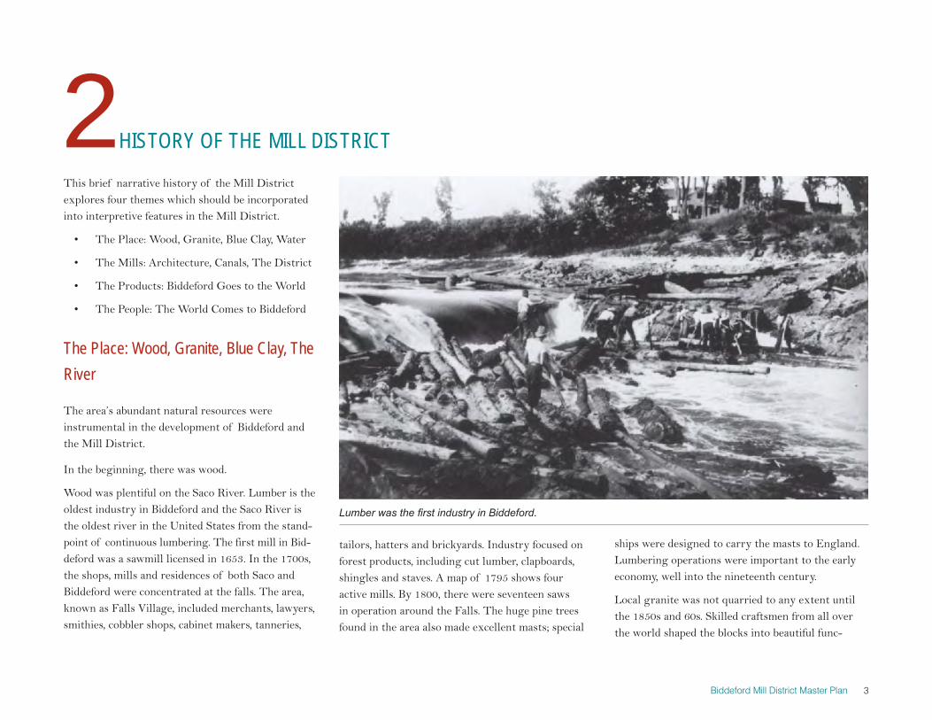
In the beginning, there was wood.
Wood was plentiful on the Saco River. Lumber is the oldest industry in Biddeford and the Saco River is the oldest river in the United States from the stand-point of continuous lumbering. The first mill in Bid-deford was a sawmill licensed in 1653. In the 1700s, the shops, mills and residences of both Saco and Biddeford were concentrated at the falls. The area, known as Falls Village, included merchants, lawyers, smithies, cobbler shops, cabinet makers, tanneries,
2HISTORY OF THE MILL DISTRICT
tailors, hatters and brickyards. Industry focused on forest products, including cut lumber, clapboards, shingles and staves. A map of 1795 shows four active mills. By 1800, there were seventeen saws in operation around the Falls. The huge pine trees found in the area also made excellent masts; special
ships were designed to carry the masts to England. Lumbering operations were important to the early economy, well into the nineteenth century.
Local granite was not quarried to any extent until the 1850s and 60s. Skilled craftsmen from all over the world shaped the blocks into beautiful func-
Lumber was the first industry in Biddeford.

� Biddeford Mill District Master Plan
tional forms like the granite steps at the River’s edge shown at left. Biddeford granite was used for rebuilding the breakwaters at the mouth of the Saco River in 1866, to build the forts in Portland Har-bor during the Civil War, and to build the Lincoln monument in Springfield, Illinois in 1870. Quarries were at their peak in 1886 when a railroad was built through the woods to make the hauling of stone easier. From “Quarry Dock,” shipments were sent to Boston for wharves and seawalls, and to New York for the construction of the Brooklyn Bridge. The granite was important for the construction of the mills – not just for the stairs, lintels and sills – but for the seawalls and foundation walls, which needed the strength to withstand high water and floods.
The blue clay was plentiful as well. 12 million bricks were used in the construction of the Laconia Mills. Saco Water & Power Company used more than 10 million bricks in its buildings between 1845 and 1849. The earliest French Canadian immigrants were skilled brick makers.
And finally, of course, the river and the falls pro-vided the power to run the mills.
The MillsThe Mill District is unique in New England’s his-tory in that the mill buildings are so compact and so close to both Main Street and the River.
The architecture of the mills is extraordinarily rich in detail. The cupolas on the mill towers were
Granite quarries were plentiful in Biddeford and skilled craftsmen from all over the world shaped the blocks (top and middle left). Granite seawalls and foundations protected the mills from Saco River floods, as shown in this 1895 view (bottom left).
The 1870 photograph (top) taken from the top of City Hall, illustrates the tight proximity of downtown, the mills and the river. A cupola with its bell can be seen in this view of Main Street (bottom).

�Biddeford Mill District Master Plan
CHAPTER 2 | HISTORY OF THE MILL DISTRICT
distinctive and some of them became the logos for those particular companies. In the 1890s Biddeford became known as the City of Bells. The mill bells of the Laconia and Pepperell rang at intervals seven or eight times each day, school bells rang in the morn-ing and at noon, Angelus church bells rang at sunset, and a curfew bell rang at night.
In 1821 Boston merchant Josiah Calef secured a charter for a new company called the Saco Iron Works Company in order to manufacture iron, steel and cotton goods. In 1826 the name was changed to the Saco Manufacturing Company and a seven-story wooden cotton mill was constructed. This marked the start of the textile industry that would become the economic foundation for Biddeford and Saco.
The Laconia Manufacturing Co., Pepperell Manufacturing Company and Saco Water Power Machine Shop were all intact in this 1872 Map (left). The 1884 Map (right) illustrates the compactness of the mill district and its proximity to Main Street and the River (right).
the mill slowed down and coming back to the mills when they were needed again. The Waltham manu-facturers were the first in the country to set up a cotton mill in which all phases of production “From the opening of the cotton bale to the finished cloth” were done under one roof.”
Boston publisher and lawyer Charles Bradbury and several investors formed the York Manufacturing Company in 1831 and completed construction of a new cotton mill on Saco Island the following year. The company’s success laid the foundation for fur-ther investment in the development of cotton textile and textile machinery manufacturing at the Saco Falls, and within ten years York became the progeni-tor of the three manufacturing companies on the Biddeford side of the Falls.
The Biddeford and Saco mills were set up under the “Waltham System” which employed New England farm girls who worked for the mill independent of their families, living in company provided boarding houses, returning to the farm when production at
Young women from nearby farms were employed in the mills (top), and lived in boarding houses such as these built for the Laconia Mill (bottom).

� Biddeford Mill District Master Plan
The York Manufacturing Company directors created the Saco Water Power Company (SWPC) in 1837 to oversee real estate and waterpower matters of the company, as well as operations of the machine shop, which produced the machinery needed to outfit their cotton mills. Land for the new machine shop was set off on the Biddeford side of the River and the build-ing was completed in 1842. By 1848, the complex in-cluded an extended Machine Shop, Counting House, storehouse, blacksmith shop, foundry and bobbin shop (in what is, today, the Riverdam complex).
The Laconia Company, founded by the Saco Water Power Company with new investors, erected its first mill in 1845. The agreement between the Water Power Company and the Laconia Company called not only for providing the mill machinery and main mill but also for construction of a counting house, picker house, cotton house, packing house and three blocks of tenements. A contract for a second La-conia mill building followed, resulting in five years of steady activity for the Water Power Company. Laconia Mill #2 was completed in 1846 and a third mill was added the following year. The Laconia’s line of cotton goods included shirtings, sheetings, drills, jeans and flannels. Laconia’s three early mills remain today (within the Riverdam and North Dam complexes).
In 1847, the SWPC embarked on development of a second manufacturing company to be known as the Pepperell Manufacturing Company. By 1850
the complex included two mills and a picker house on the east side of the mill yard, a cotton and cloth house on the north side, and a counting house on the south side. In 1854 construction began on a third mill at Pepperell along with two picker houses. By then the company had also erected a long row of three-story brick boarding houses (no longer extant) along the north side of Pearl Street.
In addition to developing the new manufacturing companies, by 1850 the SWPC had created a system of canals to provide the water necessary to power the mills. Water from the Saco River was diverted above the upper dam to a main canal that passed through the SWPC yard to a holding basin from which secondary canals carried the water to the Pep-perell mills and Laconia’s lower mills. A smaller ca-nal branched off the river just above the lower dam and ran beneath Laconia Mill #1 (as shown on the historic map on page 5). Stone culverts carried the water from the canals into the lower level of the mill buildings. The canal system remained in use into the twentieth century. The open canals have long since been infilled, but remnants of the stone culverts can be seen at the lower level of some buildings.
By 1850 the SWPC successfully developed its real estate holdings and its machine shop had completed the job of outfitting the Laconia and Pepperell mills. The Pepperell and Laconia mill sites had been sold outright to the respective companies. Advancements in technology made SWPC’s machine shop obsolete
Spindles, bobbins and harnesses manufactured in Biddeford were employed in mills throughout New England and abroad (top). The canals and sub-grade viaducts, as shown here beneath the Lincoln Mill, were engineering/ construction feats and should become an impressive exhibit for visitors to the District (bottom).

�Biddeford Mill District Master Plan
CHAPTER 2 | HISTORY OF THE MILL DISTRICT
by 1850. They developed a specialization in the cot-ton machinery field, becoming a leading producer of roving and spinning frames. The firm acquired an excellent reputation, with some observers noting that “the Biddeford machines were not excelled by any builders of cotton machinery in America.”
In 1866 directors of the Pepperell Manufacturing Company and Laconia Company, most of whom were also controlling the SWPC, arranged to pur-chase all the Water Company assets, including their real estate holdings, water privileges, and machine shop operations. The following year all of the machine shop operations were transferred to a new company, the Saco Water Power Machine Shop. The Saco Water Power Machine Shop embarked on a period of expansion following the Civil War, and between 1868 an 1869 the size of the machine shop nearly doubled. Manufacturing capacity was dra-matically increased at the Biddeford location during the period 1897 to 1912 (in what is now the River-dam complex). In 1912 the Saco-Lowell Shops was formed to consolidate the machine-making opera-tions of the Lowell Machine Shop and Saco & Pettee Company. Several buildings were demolished in the mid-1980s for construction of the Main Energy Recovery Company trash-to-energy recovery facility.
It was not until the last three decades of the nineteenth century, continuing until the twentieth century, that the Pepperell Manufacturing Com-pany substantially expanded their operations. They
purchased much of the SWPC property in 1866 and by 1870 had added several buildings. In 1874 they embarked on a nine year expansion project. In 1899 they absorbed the Laconia Company. To compete with less costly production at mills in southern states, they modified their production, continuing to produce their successful sheetings and adding blan-kets to their production line. Pepperell became one of the most well-known and respected manufactur-ers of cotton goods in the world.
The Pepperell Manufacturing Company merged with the WestPoint Manufacturing Company in 1965. They operated as West Point-Pepperell until 1988 when they acquired J.P. Stevens & Company and became West Point Stevens., Inc. which contin-ued to occupy most of the former Pepperell and La-conia buildings until closing in the Summer of 2009.
Products: Biddeford Goes to the WorldBy 1847 Laconia goods were being shipped and sold as far as the islands of the South Pacific. The Pep-perell Mills China Trade began in 1852, when Pep-perell drills were carried by fast clipper ships around the Horn to China and the Far East. After the Civil War, shipments grew steadily. They went by steamer across the Atlantic, past the Straits of Gibraltar, through the Suez Canal to the Red Sea and Indian Ocean. Then in 1886 the Canadian Pacific Railway was opened, and after that the shipments traveled
by rail to Vancouver and then across the Pacific to China and India. In 1895 a solid trainload left Bid-deford – 29 freight cars loaded with the 2oo pound bales of Pepperell drills. The old Pepperell ship-ping books show 1,000 and 2,000 bale orders going out constantly to Shanghai and Tien-Tsin, China; Bombay, Calcutta and Madras, India; Singapore and Penang, Malaysia; Rangoon, Burma and Colombo, Ceylon.
The Mill District was substantially intact by the late 19th Century. In the 16 year period between 1899 and 1915, 34% of the cloth manufacturing in the Pepperell Mills was “drills,” which was especially popular in China. The mill’s “chop,” or logo, was a stylized dragon which was easily recognized in China. A U.S. Department of Commerce report from
The Mount Washington, shown here in Canton Harbor, was the largest clipper ship built in Biddeford (1867).

� Biddeford Mill District Master Plan
1916 notes that “The Dragon Chop (or trade mark) of the Pepperell Manufacturing Company com-mands the highest price because of its good quality and the fact that it has been in the market for many years and is a well-known chop.”
The Saco Water Power Machine Shop provided cot-ton textile machinery for the Laconia and Pepperell
Mills, and for export around the world. Spindles, bobbins and harnesses manufactured in Biddeford were employed in mills throughout New England and abroad. Saco-Lowell continued producing textile machinery into the mid 1950s.
The Biddeford Mills were very active during both the Civil War and World War I. During the Civil War, the Union blockade shut off the Southern cotton from Europe, so foreign buyers paid pre-miums for stored-up pre-war cotton. Laconia sold off stored-up cotton at high prices and closed for a year. The Pepperell Mills produced canvas for tent cloth and for wagon covers, sheeting for the Sani-tary Commission (the Civil War counterpart of the Red Cross), jeans for soldiers’ shirts, and drills for a number of Army and Navy uses. They were kept in constant operation during the whole four years of the war, in spite of serious shortages of labor and materials. The Pepperell payroll kept Biddeford from suffering the severe financial hardships felt by other northeast mill towns.
In Works War I, Pepperell Mill furnished millions of yards of cloth for Army khaki and Navy white.
People: The World Comes to BiddefordAs mentioned earlier, the Biddeford mills employed the Waltham System, and the earliest mill work-ers included young women from nearby farms. But, over time, many nationalities, religions and
cultures arrived in Biddeford. Poles, Armenians, Italians, Albanians, Turks, Greek, British and French Canadians were prominent in the mills. There were many denominations, and the Albanians and Turks are thought to have established the first mosque in America on the second floor of the old Pepperell counting house. Pierre Painchaud’s Marching Band, “La Fanfare Painchaud,” was a presence at numer-ous Biddeford events over many decades. 24 men of Pinchaud’s band volunteered during the Spanish American War in 1898 and became the official band of the First Maine Regiment.
Laconia had 1500 employees in 1849, and SWPC had 600. Combined, this was more than twice the number of people living in the village less than two years before. By 1880, the population had grown to 12,640; although the Census reported that ap-proximately half the residents had been born in the
The Dragon Chop of the Pepperell Manufacturing Company.
“La Fanfare Pinchaud”

�Biddeford Mill District Master Plan
CHAPTER 2 | HISTORY OF THE MILL DISTRICT
United States, other countries of origin included Ire-land, Scotland, Germany, Denmark, Holland, Italy, Canada, England, the Maritime Provinces, Portugal, Saxony, Malta and France.
In 1910, the census was 17,079, making Biddeford the fourth largest city in Maine.
Recommendations for Incorporating History into The Mill District RedevelopmentParticularly with the closing of WestPoint, the last operating mill, it is important that this rich histori-cal narrative - the story of the Falls of the Saco River and the mills that it spawned – be incorporated into the redevelopment of the Mill District. Recom-mendations include:
1. Development of a Visitor Center (see page 40) with exhibits and a self-guided walking tour through the District and downtown could build on the existing “The Museum in the Streets.”
2. Interpretive elements should be incorporated into the Riverwalk, pedestrian paths and sig-nage program (see page 40). The Riverwalk is designed to highlight existing materials, buildings and artifacts, particularly the beauti-ful granite seawalls.
3. Highlighting historic elements of the district, such as restoring and lighting the cupola at the Lincoln Mill and providing public access to the visible canal remnants in the Lincoln Mill, would help to bring attention to, and make palpable, the important history of the Mill District.
4. Creation of a Mill District Museum in one of the historic mill buildings could be a later project. For example, Minneapolis, located at the Falls of the Mississippi River, cel-ebrates its flour mill history in a seven story museum built into the ruins of one of the old mills. From the top floor of the museum, there is a panoramic view of the river that powered the largest complex of flour mills in the world. The Woonsocket Museum of Work and Culture on the Blackstone River (a National Heritage Corridor) in Rhode Island is another example of how the district might be celebrated – it focuses on French Canadian immigrants.
Rather than developing a museum in a single location, another option would be to have a series of interpretive exhibits in locations throughout the District. For example, one stop could be the canals in the lower basement of the Lincoln Mill. Locating interpretive exhibits throughout the District would have significantly lower capital costs than devel-
The top figure illustrates potentially dramatic night lighting of the falls, which would be visible from many of the buildings. The Lincoln Mill cupola (bottom) should be restored and replaced on the top of the buildings.

10 Biddeford Mill District Master Plan
oping a single comprehensive museum, and would also greatly reduce ongoing operating costs and the need for staffing.
5. Maintaining the historic integrity of the district and the structures by maintaining the key portions of all of the mill buildings to
preserve the character and dense compact feel of the District. Later additions, not integral to the building, can be removed to improve site circulation, safety, gateways and views. Details such as windows, towers, cupolas and materials should be maintained. Where over-head bridges do not obstruct important views (such as views to the River or cupolas), they should be maintained as an intrinsic part of the district character.
The Biddeford/Saco Mills Historic District has been included on National Register of Historic Places. The District encompasses 38 acres of land flanking the Saco River. There are a total of 42 contribut-ing resources and one non-contributing resource within the district limits. With the exception of six contributing resources in Saco, all of the resources are within the Biddeford Mill District. The National Register designation will assist property owners in using Historic Tax Credits for building improve-ments. Use of these tax credits will require develop-ers to follow strict preservation guidelines.
The City of Biddeford and the property owner have expressed an interest in expanding the district to include the Saco & Lowell Machine Shops.
Sources include interviews; The Draft National Reg-ister Nomination form prepared by Tremont Preser-vation Services, 2008; Images of America - Biddeford, Charles L. Butler, Jr. 2003; and A History and Stories of Biddeford, Dane York, 1994.
The Mill City Museum in Minneapolis (top) and the night-time view of the Mississippi River from the museum (bottom).
This mixed-use redevelopment of an historic industrial building successfully incorporates manufacturing artifacts into a courtyard area used for outdoor restaurant seating.

11Biddeford Mill District Master Plan
CHAPTER 3 | EXISTING CONDITIONS
URBAN DESIGNThe Biddeford Mill District is a uniquely dense and compact assemblage of buildings compared to other New England mill districts. The red brick and granite industrial architecture is quite beautiful, and in many places creates a series of intimate spaces. A series of circuitous paths and narrow courtyards lead to the river. Views are narrow and often termi-nated by buildings, making views of the Falls from the riverfront even more dramatic and unexpected.
Currently, many of the existing approaches to the Mill District are uninviting and give little insight into the beauty of the district. From the north on Elm Street, the main entries are via Gooch Street with the vacant Saco & Lowell factory and park-ing lots, and at the intersection of Elm, Lincoln and Pearl Streets, which is a somewhat amorphous, unattractive intersection. The former WestPoint loading docks dominate the entry from Alfred Street. A stairway on Main Street adjacent to the Courier Building provides a more attractive pedestrian entry, although parking lots dominate the view.
3EXISTING CONDITIONS
The figure-ground drawing (top left) illustrates the compact geometry of the Mill District. Circuitous paths are often terminated by buildings and connecting bridges (top right). The beautiful brick and granite buildings create many intimate spaces (bottom left). Views of the falls are unexpected and dramatic (bottom right).

12 Biddeford Mill District Master Plan
LAND USEThe Mill district is approximately 40 acres in size, with 35 buildings encompassing over two million square fleet of floor area. The district is currently a mix of retail, office, industrial, storage, art studio, residential and vacant space. There are a number of businesses operating in the mill buildings, includ-ing commercial uses in buildings which appear to be vacant or almost vacant from the outside, and over
50 residential units. Commercial uses include, among others, bakeries, florists, specialty woodworkers, cord manufacturers and specialty aquarium producers. The approximate breakdown is shown in Table 3.1.
Ground floor uses immediately adjacent to the district include a wide variety of retail, office, ser-vice and residential use. The businesses form a few clusters with most of the financial activities at the west end, office use clustered just west of City Hall
and vacancies clustered around the intersection of Alfred and Main Street. Restaurant and service uses tend to be at the eastern end of Downtown with retail extending the entire length of Main Street through downtown. The location of these adjacent land uses helped to guide the analysis of important connections and potential entry points into the Mill District.
BUILDINGSThe buildings in the district were constructed be-tween 1830 and 1940, although most of the con-struction was prior to 1900. They represent a mix of mid-19th Century Greek Revival, Late Victorian Italianate and some modern buildings. The buildings are primarily three to five story red brick structures, with granite foundations and lintels, ranging from one to seven floors. Most have flat roofs.
Biddeford’s tightly clustered mill buildings create a much more compact and cohesive district than those in Lowell and Lawrence, MA and Manchester, NH (clockwise, beginning top left).
Total Units or SF
% of Total Building Area
Retail SF 31,000 2%
Office SF 73,000 4%
Industrial SF 426,000 24%
Storage SF 514,000 28%
Art Studios SF 15,000 1%
Residential Units 54 3%
Vacant SF 494,000 27%
Table 3.1: Existing Land Use

13Biddeford Mill District Master Plan
CHAPTER 3 | EXISTING CONDITIONS
been substantially served by the key utilities and a great deal of infrastructure is in place. As with most redevelopment projects, some upgrades, relocations, and additional infrastructure will nevertheless be anticipated as each segment of the site is rehabili-tated or redeveloped. Potential upgrades are typical of those required in redevelopment projects.
Water capacity is reported to be available and the site is well served by distribution lines. Treatment capacity is available.
Sanitary sewer is also available throughout the site and treatment capacity exists. A key on-site pump station may need some upgrading as the usage de-mand is fully defined.
Power is reported to be available to meet the build-out of the site. The Mill complex includes a steam generation plant as part of the WestPoint Mill buildings. This plant is located along the River northeast of the North Dam parking lot. This plant has served a number of buildings within the com-plex over the years. Given the proximity of many of the buildings, and the network of underground tunnels, canals, and utility facilities throughout the site, this plant has the potential to serve a key role in developing an energy loop throughout the entire complex.
An existing stormwater system is in place. It func-tions to drain the site with no significant existing issues. The site is substantially covered by buildings
and paving. Almost no plans being conceived for developing the site can have a significant negative impact on the amount of impermeable area. Little means of treatment of the stormwater exists. There are opportunities to improve this condition as the site is developed. More permeable conditions can be created. Treatment can be provided along the paths of discharge, both above and below the ground sur-face. The underground canals could serve as space for storage and treatment. There is also little means of attenuating any of the stormwater flow, although this is not likely an issue to this downstream site on the Saco River.
If demanded by redevelopment uses, more current utilities such as cable and broadband service will need to be distributed throughout the site.
OWNERSHIP & EXISTING PLANSLand within the district is owned by a number of different entities, mostly private. Many of the own-ers have developed re-use plans for their property, some of which are already underway, and some of which are longer-term. The Consultant Team met with property owners to gain a better understanding of their plans and goals, and, to the extent possible, the Master Plan recommendations accommodate the plans of individual property owners.
Property in the Mill District is owned by 17 differ-ent private entities, as shown on the figure on the
As the buildings vary in age and architectural style, they also vary significantly in structural materials, construction and condition. Materials include stone, cast iron, brick, lumber, planking, timber, concrete and steel. Virtually all these materials can last many years, although all are subject to deterioration. Where structures have been protected against the elements they are generally in sound and serviceable condition, and conversely, structures exposed to the elements, and particularly to water, have deteriorated to varying degrees, and in some cases, to serious conditions.
The buildings were generally built to withstand the heavy floor loads of machinery and bulk storage, and therefore can be expected to support a multitude of mixed uses. As is typical in rehabilitation and re-use of buildings of this type and age, each building will require a complete structural evaluation as reuse takes place. As major renovation is undertaken, and new uses are incorporated, current rehabilitation will be subject to current building code standards. An important factor will be evaluation for seismic loads, as standards have increased, and this area of the Maine coast is subject to moderate seismic forces.
UTILITIESAvailability, access, capacity and service from public utilities are not likely to be constraints on the re-development of the site. In most cases, the site has

14 Biddeford Mill District Master Plan
Property ownership.

15Biddeford Mill District Master Plan
CHAPTER 3 | EXISTING CONDITIONS
facing page. The City of Biddeford owns Street and a portion of Pearl Street.
• WestPoint Stevens: WestPoint Stevens owns approximately 8.9 acres, with 674,055 square feet of building area. Until June of 2009, the property was being used for the manufacture and storage of blankets. The plant ceased operations at the end of June and the future of the facility is uncertain at this time.
• North Dam: This 4.4 acre property has ap-proximately 230,000 square feet of building area, with commercial, residential and light industrial uses. Ongoing rehabilitation efforts for commercial and residential uses have been successful and are continuing. 54 newly devel-oped residential units in the complex are fully occupied.
• Riverdam: 3.75 acres; 329,000 square feet of building area. The buildings are currently being used for a variety of office, industrial, storage and arts studio uses; rehabilita-tion plans call for a mix of commercial and residential uses. This complex was recently sold. Plans are progressing for the reuse of the southernmost building for 66 units of workforce housing. The City received a HUD HOPE VI grant of $1,000,000 to support the development of this workforce housing project.
• Lincoln Mill: 3.5 acres; 224,000 square feet of building area. The building is currently being used for a variety of light industrial and office uses; rehabilitation plans call for a mix of commercial and residential uses.
• Bugbee Brown: 0.4 acres; 44,000 square feet of building area. This building is fully oc-cupied with industrial uses; the owner has no plans to change the building use.
• Saco & Lowell Machine Shop: 3.5 acres; 145,000 square feet of building area. The building is currently vacant, and was recently sold. Current reuse plans include residential and/or office space.
• Precision Screw: 1.5 acres; 53,000 square feet of building area. The buildings are fully occu-pied with an ongoing industrial business; the owner is considering very long-term redevel-opment for residential use.
• CarQuest: 0.34 acres; 25,000 square feet of building area. The building houses ongo-ing retail and light industrial use on the first floor with vacant second floor office area. The owner has expressed an interest in potential long-term changes.
• Topspin: 0.45 acres; 23,376 square feet of building area. Ongoing use as a warehouse; the owner has expressed an interest in poten-tial re-use as the master plan is implemented.
• A & M: 0.21 acres; 12,300 square feet of building area. The building is currently va-cant. A reuse plan for residential condomini-ums was approved several years ago, but there has been no progress on the project.
• Vacation Properties: 0.3 acres; 21,168 square feet of building area. The building is current-ly vacant. A reuse plan for residential condo-miniums was approved several years ago, but there has been no progress on the project.
• Courier Building: 0.29 acres; 10,000 square feet of building area. There are no plans to change the ongoing office use.
• Mulligans: 0.29 acres; 15,000 square feet of building area. There are no plans to change the ongoing restaurant use.
• J&B: 0.08 acres; no building. thre are no stated reuse plans for this currently vacant parcel.
• Maine Energy Recovery Company (MERC): 8.45 acres; 141,680 square feet of building area. The owner has no stated reuse plans for this ongoing Resource Recovery facility, although there is interest on the part of the City to relocate the facility. A Task Force has been established by Mayor Joanne Twomey and Governor John Baldacci to establish a fair market value for the plant and possible compensation for the owner, Casella Waste Systems. The goal is to shut down the incin-

16 Biddeford Mill District Master Plan
erator, freeing up this key waterfront site for other uses.
• Florida Power and Light: 0.42 acres along the River and hydro power rights on the River; no buildings. The owner has indicated a willing-ness to accommodate easements for a river-walk along the property.
ZONINGThe Mill District falls within three zoning districts:
• Main Street Revitalization District 3
• Main Street Revitalization District 1
• General Development Shoreland Overlay District
Most of the area is within the Main Street Revital-ization High Density/Mixed Use Zoning District (MSRD3), which is intended to facilitate the de-velopment of a vibrant mixed use residential and commercial district contributing to the revitalization of Downtown. Residential, office, commercial and industrial uses are all allowed and there is no maxi-mum building height.
The Courier Building and the small area west of Lincoln Street are in the Main Street Revitalization Commercial Core District (MSRD1) which includes the traditional Main Street corridor. Residential and commercial uses are allowed, but manufacturing and storage are not allowed; the maximum building height is 60 feet.
The 250 foot swath along the river edge is within the General Development Shoreland Overlay district which includes “areas devoted to commercial/indus-trial or intensive recreation activities or a mix of such activities.” Residential, commercial and indus-trial uses are allowed with Planning Board approval.
Zoning within the Mill District (project area boundary is shown in blue; hatched area is the General Development Shoreland Overlay District).
The current zoning designations will accommodate the uses and densities recommended in this Master Plan.

17Biddeford Mill District Master Plan
CHAPTER 4 | ENVIRONMENTAL ISSUES
Existing Environmental Conditions
Saco RiverNo publicly available information was available pertaining to the environmental conditions of the Saco River in the vicinity of the subject property. However, it can be assumed that the environmental condition of the Saco River in the vicinity of the Biddeford Mill District is similar to that of other rivers found in the northeast where former indus-trial operations have taken place. In other words, it is very likely that former discharges from industrial operations in the vicinity of the River have impacted water and sediment quality. However, as is the case with other similar rivers, the river ecosystem is likely restoring itself in the absence of continued discharges and the implementation of best manage-ment practices for the River both at and above the Biddeford location. It should be noted that water quality issues in the Saco River are not anticipated to have an impact on redevelopment scenarios within the Biddeford Mill District, as significant redevelop-ment efforts are already underway on both sides of the River in this location.
4EnviRonmEntal iSSuES
Hazardous materials and other Potential Subsur-face liabilitiesIt is anticipated that the Mill District will have many of the environmental concerns typical of former mill sites and buildings, including:
• Asbestos containing building materials (pipe/boiler insulation, roofing, fire-proof doors and walls, floor tiles, window glazing, etc.)
• Lead based paint (in buildings and in soils adjacent to buildings)
• Leaking underground storage tanks
• Spills from above-ground storage tanks
• Spills from improperly handled petroleum and hazardous material drums and containers
• Buried drums
• Polychlorinated biphenyls (PCBs) in trans-formers and elevator oils
• Possible mercury usage
Former hazardous waste practices often involved disposal to the River and/or municipal sewer sys-tem. These practices, although harmful in the past to nearby water bodies, have often been found to reduce the degree of on-site subsurface impacts in comparison with similar inland industrial properties.
Actual known environmental concerns at the Bid-deford mills (as of 08/01/08), based on available reports for review, included:
• Asbestos-containing building materials
• Lead based paint in buildings and soils
• Petroleum underground storage tanks
• Diesel range organics in soils (heating oil)
• Possible PCBs (transformers, elevator sumps)
• Confirmed presence of contaminated sedi-ments in “dry channels” below buildings and possible previous disposal of hazardous mate-rials in basement trenches
• Possible buried drums
• Spill reports associated with storage tanks and drums (petroleum and hazardous sub-stances)
• Possible impact from upgradient MERC facility
Site Cleanup, Including BrownfieldsDue to the former industrial usage of the Biddeford Mill Complex, numerous recognized environmental conditions are suspected and have been documented. These environmental conditions will require cleanup

18 Biddeford Mill District Master Plan
and/or management as part of any redevelopment program such that protection of human health and the environment are assured. In order to accomplish this goal, while at the same time managing cleanup costs in a reasonable and fiscally prudent manner, a combination of cleanup and risk management prac-tices should be employed.
Using this technique, “source” areas and “hot spots” are typically removed and/or treated to address the most impacted areas of a site, while engineering and/or institutional controls are employed in less significantly impacted areas to control costs while ensuring protection of human health and the envi-ronment. Examples of engineering controls include capping or paving of residually contaminated soils to minimize the potential for exposure and the utili-zation of vapor-proof membranes under buildings that are sited above contaminated soils and ground-water to prevent vapor intrusion into the building. Examples of institutional controls include deed restrictions and notices to land records prohibiting certain land uses (residential, agricultural, etc.) and operations (drinking water wells, child care facilities, etc.) at the site.
Potential funding sources and cost offset mecha-nisms for site assessment and cleanup are detailed below:
Site assessment and Remediation Funding
Site Assessment
• EPA Brownfield Site Assessment Grants – through Southern Maine Regional Planning Commission (SMRPC)
• Maine DEP Municipal Brownfield Site As-sessment Program – municipalities and non-profits only
Remediation
• EPA competitive remediation grants – mu-nicipalities and non-profits only (SMRPC can assist in securing these funds)
• EPA revolving loan fund
• Maine DEP Municipal Brownfields Remedial Program – municipalities and non-profits only ($50K cap per site)
implementation CostsUntil detailed redevelopment plans are generated for the site or individual parcels, it is very difficult to generate cost estimates pertaining to environmental cleanup, as variables including the exact location of redevelopment within the mill complex (and thus the exact nature of contamination) and the type of redevelopment (residential, industrial, etc.) play a large role in developing a strategy for environmental
remediation. However, in general and based on oth-er mill redevelopments occurring throughout New England, it can be expected that between $500,000 and $1,000,000 may be required to address cleanup activities for each separate mill within the Biddeford Mill District. Obviously these estimates could be higher (such as in the case of the Maine Energy Re-covery Facility) or lower (such as in the case of one of the smaller mills within the complex).
If necessary, potential public/private relationships should be explored for the purposes of redevelop-ment of the Biddeford Mill District. These relation-ships might be helpful for offsetting cleanup costs by securing various grants and loans available to the public sector that are not possible for private devel-opers. Such creative project structures also address the underlying liability issues associated with the redevelopment of environmentally challenged land.
ConclusionIn summary, subsurface environmental impacts have been found at various sites within the Biddeford Mill District, and while all parcels within the District will require assessment and remediation planning prior to redevelopment, a wide variety of uses appear pos-sible given the data available for review. These uses include open space, residential, institutional, office, commercial and industrial.

19Biddeford Mill District Master Plan
CHAPTER 5 | MARKET ANALYSIS
This summary highlights the central findings of the Biddeford market study – the complete study is available under separate cover. The market study includes a review of key economic and demographic trends, an assessment of recent developments in owner housing and rental housing markets, a review of recent retail sales, and the identification and assessment of key regional industries -- including tourism.
DEMOGRAPHICSBiddeford has a much different age distribution than the rest of Maine. The state’s population distribution by age has two spikes; one in the aged 35-50 years category and one in the 5-19 years age category. These spikes roughly correspond to the so-called “Baby Boom” generation and the children of those “Baby Boomers.” In 2000, Biddeford had a much higher share of its population in the 20-35 years age category, likely due to the relatively more affordable housing price situation in comparison to the rest of the York County.
HOUSINGBiddeford has a much lower rate of home ownership than York County or Maine. To a great extent, this
5MARkEt ANAlySIS
is a legacy of the housing stock available in the City. Table 5.1 shows the renting and owning percent-ages. What housing affordability problems there are in the City appear to be due to relatively lower median household incomes in the City as opposed to high median home prices. This suggests there is an opportunity for the construction of housing units at price points and rent levels that are “affordable” to lower and medium levels of household income.
Owner Renter
Biddeford 48.59% 51.41%
York county 72.65% 27.35%
Maine 71.58% 28.42%
Table 5.1: Percentage of Owners vs Renters
level of retail spending appears tied to the pres-ence of national retail stores within the City that is attracting regional residents for acquisition of household staples rather than visitor-based retail activity. With a vibrant tourism industry all around the City, visitor-based retailing is an opportunity for the downtown area, provided an attractive destina-tion can be built that will bring visitors into the City’s downtown.
kEy INDUStRIESIndustries primarily engaged in serving final de-mand from outside the region are key to the econom-ic health and performance of regional economies as “base industries.” Base (or basic) industries serve to import dollars into a region and thereby expand the size of the regional economic pie. These key industries also tend to have higher paying job op-portunities and stronger linkages to local businesses due to well-developed supplier or customer relation-ships. In that way, healthy key industries contribute to a strong region by improving the quality of life through higher incomes and the well being of the region’s citizens, and through the provision of pub-lic resources to provide good schools, a high quality environment and high quality public services.
REtAIl SAlES ACtIVItyRelative to the U.S., the state has a significantly higher level of income-adjusted sales per household. At the state level, this typically is indicative of tour-ist activity — including expenditures and income generated from out-of-state visitors. Biddeford also has a high level of sales, which recently has grown to eclipse both the state and national averages. Al-though this is ordinarily a sign of significant levels of visitor spending, the City’s higher than average

20 Biddeford Mill District Master Plan
A region’s key industries are those basic industries present in the region with significant employment levels and concentration. They typically exhibit high multiplier effects. Key industry sectors or clusters may be located in the region by historical factors, proximity to production requirements such as natural resources or to markets by transportation corridors, or other competitive advantages that favor the industry’s development in the region relative to elsewhere.
By understanding the competitive circumstances of the County’s key industries or clusters of employers in those key industries, strategies can be developed to help the Biddeford Mill District Master Plan to direct economic and community development re-sources and efforts of the City and other stakehold-ers in the region to achieve the highest valued return to the City and regional overall quality of life. The data indicate that the key industries for York County and/or the City include: 1. Wood Product Manu-facturing, 2. Fabricated Metal Manufacturing, 3. Food Manufacturing, 4. Textile Product Mills (this analysis was prepared prior to the announcement of the closing of WestPoint Home in the Mill District) and 5. Plastics and Rubber Products Manufacturing. Although the data pertaining to these industries are published only for York County (instead of the City), it should be noted that industries that are competi-tive and successful in York County are also highly likely to be successful in City since Biddeford has
many of the same competitive characteristics as the county overall.
The study shows that while manufacturing has been losing employment share in the United States for many years now, it is important to recognize the opportunities for certain types of manufacturers. Clearly, the U.S., the county and the City’s manufac-turers cannot compete in the global market manu-facturing commodity items that compete primarily on price. They can, however, effectively compete in the manufacture of specialized and/or high-value added niches. Regional fabricated metal manufactur-ing and plastics and rubber manufacturing indus-tries produce products that serve niche markets and compete in the global market based on their quality and specialization as opposed to competing mostly on price. Future business development in the City can learn from what makes current regional busi-nesses successfully compete and apply that under-standing across a wide range of sub-industries that utilize those same competitive characteristics or features. The City could focus its efforts on that ap-proach as it seeks to redevelop the Mill District. To accomplish this, further research and dialogue with existing City export-industry employers is needed to determine what elements — particularly those which can be affected by the local/regional forces -- can be influenced to support and grow these key industries. Examples of targeted key industry sectors for this effort include: (1) Wood Product Manufacturing,
(2) Fabricated Metal Product Manufacturing, (3) Food Manufacturing, (4) Textile Product Mills, and (5) Plastics and Rubber Products Manufacturing. Examples of strategies that could be further refined and implemented to help nurture and cultivate these key export-based industries include: (1) policies to support competitive electricity prices, (2) steps to support the cost-effective transporting of goods, and (3) other initiatives to strengthen local supplier and customer chains and relationships.
tOURISMA sixth key regional export-based industry that does not appear to be proportionally represented in the City is the tourism industry (which includes lodg-ing, restaurants and bars, and other establishments that serve the visitor market). Biddeford does not show up anywhere in the top 20 tourist destinations in Maine. The state economy has a demonstrated comparative advantage in tourism, with 16.7% of employment in the tourism sector. This concentra-tion is significantly higher than the states of New Hampshire (9.5%), Vermont (9.4%) and Florida (12.5%). In addition to higher employment, 20.8% of state output could be attributed to the tourism sector in calendar year 2006. Tourism also generates significant tax revenues for the state. About 1/5 of all sales tax revenues are directly or indirectly pro-duced by visitor spending. In 2006, this tax revenue totaled an estimated $429 million.

21Biddeford Mill District Master Plan
CHAPTER 5 | MARKET ANALYSIS
lAND USEGiven Biddeford’s position as a significant regional employment center and the economic forces at play in the York County region, this study indicates that the mix of use types at the Biddeford Mill Complex should lean toward residential and industrial use. It is important to keep in mind that, while anticipat-ing market demand for different use types is helpful, flexibility in the proportions will result in the best use of the site. The best approach may be making space available to tenants at market clearing prices which will go a long way towards full utilization over time.
In addition, attracting some retail and commercial users to the site will enhance the desirability of the residential units as workers will value the conve-nience of walking to work and shopping sites. The most difficult part of this effort is to find what mix of residential, retail and commercial uses will work over time — as the specific mix of uses will change over time. As mentioned above, flexibility will be key so that the site can adjust to changes in mar-ket conditions and demand. With this in mind, the study indicates that reasonable proportions among these classes of uses would at least initially be 45% residential, 30% light industry, 10% retail, and 15% commercial. As these proportions are not set in stone, the order of these uses appears to be more important than the exact initial proportions indi-cated above.
Although it is impossible to predict the interaction of all factors that will influence the viability of the Biddeford Mill Distsrict 20 years into the future, two decades of actual experience will provide enough market-feedback to help determine the evolution of market clearing prices for the District’s use alterna-tives. The largest obstacle will likely be the sheer size of the complex within the context of Bidd-eford’s modest size and the underlying slow-growth, and in some cases declining population trends within the state overall.
Calendar year 2006 (the latest year for which visitor counts are available), saw approximately 10.1 million overnight trips and 31.7 million day trips to Maine. Maine’s Southern Coast accounts for nearly 40% of all trips to Maine. In 2006, this translated to 16.7 million trips to the Southern Coast. A total of 77% of travelers to Maine use their own automobile as their primary mode of transportation. With its location right off of Interstate 95, Biddeford is positioned to capture both destination demand, that is, individuals traveling to Biddeford, as well as dol-lars from travelers passing through to other Maine destinations.
In addition to not being a destination for visitors, the City also appears to lack an appropriate venue for displaying/selling the work of the City’s artisans which currently populate the mill area.
The point is that there are significant levels of tourism activity happening all around the City, and the City is not capturing its fair share of an already very competitive key industry where the state has a significant comparative advantage. Tourism appears to be an area for further evaluation as a development opportunity for the Downtown and Mill District as long as an attractive destination can be developed to attract out-of-the region visitors — including both visitors from the northeastern U.S. and, potentially, international visitors. Many of the components of this Master Plan will help to create that “attrac-tive destination.”

22 Biddeford Mill District Master Plan
The proximity to Downtown will allow the redevelopment of the Mill District to complement and support Downtown revitalization efforts.

23Biddeford Mill District Master Plan
CHAPTER 6 | REVIEW OF OTHER SUCCESSFULLY REDEVELOPED MILL DISTRICTS
A number of mill complexes throughout the North-east have been successfully redeveloped, providing valuable lessons for this project. A few successful projects are summarized below.
Clipper Mill, Baltimore MDThe Clipper Mill in Baltimore, Maryland includes five buildings on 17.5 acres. After a successful rehabilitation, the Clipper Mill complex is a mixed-use community containing residential units, office space and art and craft studio space. The developers creatively used the remains of several structures no longer standing as design elements, creating inter-esting courtyards and other amenities for residents and patrons. Events at the complex highlight the diverse artisans.
Clock Tower Place, Maynard MAClock Tower Place in Maynard, Massachusetts, with its beautiful mill pond and historic structures, has had several reincarnations. Beginning in 1957, the original 1847 woolen mill became the center for Digital Equipment Corporation’s computer manu-facturing until the company eventually went out of business in 1998. The complex was then rehabili-tated and converted to office use, using a Tax Incre-
6review of oTher suCCessfully reDeveloPeD Mill DisTriCTs
ment Financing (TIF) agreement to help finance improvements. One million square feet of space was leased to 85 companies in two years. This complex
is immediately adjacent to downtown Maynard, and the successful complex brings hundreds of workers to downtown restaurants and shops.
Clipper Mill (top) and Clock Tower Place (bottom) have incorporated natural and historic features into the site design to provide amenities for tenants and visitors.

24 Biddeford Mill District Master Plan
The Promenade District, Providence riOn a larger scale, the 175 acre Promenade District in Providence RI includes several mill complexes along the Woonasquatucket River. The Rising Sun
Mill has been redeveloped with 313,000 square feet of office and retail space, and residential lofts. Nearby is The Foundry with over 500,000 square feet of office space. The Promenade building con-tains 230 residential lofts. The property’s industrial
past is memorialized in the restoration and display of some of Brown and Sharpe’s machinery in com-mon areas and in enlarged historic photographs that decorate the walls. Other projects within the district include National and Providence Worcester Mills and American Locomotive Works. The American Locomotive Works is being converted into a vibrant, mixed-use community. The development plan for the 22-acre mixed-use project calls for a total of up to 2 million square feet of commercial and residential uses over three phases:
• 300,000 square feet of Retail / Restaurant space
• 323,000 square feet of Class-A office space
• 385 residential units — a mixture of mixed-use, for-sale condominiums, townhouses and mixed income rental apartment residences
• More than 2,925 parking spaces
Phase I, completed in 2007, rehabilitated five historic buildings to create 200,000 square feet of retail and office space. The next phase calls for the rehabilita-tion of two more historic buildings to create 124 rental apartments with a rooftop garden and 55,000 square feet of commercial space.
lowell MALike Providence, Lowell MA has a series of mill complexes spread out over a large area. Lowell is
Views of a courtyard and internal roads in the Promenade District (top); the Promenade residential building (bottom left) and an aerial view of the American Locomotive Works with downtown Providence in the background (bottom right).

25Biddeford Mill District Master Plan
CHAPTER 6 | REVIEW OF OTHER SUCCESSFULLY REDEVELOPED MILL DISTRICTS
Private investments have included the development of over 350 market-rate housing units, with another 250 housing units in development, leveraging over $70 million in private investments into the neighbor-hood to date.
The redevelopment of the Hamilton Canal District in the JAM Plan will result in the creation of a new mixed-use transit-orientated neighborhood, recon-necting Downtown Lowell and the JAM area with the City’s transportation infrastructure. The devel-opment is projected to develop housing, create over 400 jobs, and provide over $2 million in increased tax revenue upon completion.
lessons learned As part of this Master Plan, a review of other suc-cessful mill redevelopment projects was conducted in order to understand the essential ingredients of successful plans. From this review, it was clear that each mill district is different with respect to exist-ing infrastructure, market conditions, and building conditions. Revitalization strategies and efforts were specifically tailored to each district and there is little doubt that this will be true for the Biddeford Mill District. However, these revitalization efforts also have some common features or threads that can be instructive for the Biddeford revitalization/redevel-opment effort. Looking at the above New England examples, it seems apparent that there are several
most famous for developing an urban National His-torical Park in its mill district in 1978, but it is im-portant to note that in addition to the National Park, a number of mills have been redeveloped for com-mercial and residential use, including the Boott Cot-ton Mill (195 residential units and 150,000 square feet of office space), Massachusetts Mill (282-unit mixed income residential units) and Wannalancit Mills (commercial space including 42,500 square feet used for the University of Lowell offices). The City has built an extensive riverwalk connecting many of these mills and adjacent canals, and incorporat-ing historic artifacts and public art. Boarding House Park, built along the Eastern Canal, has become a major gathering space in the city for events such as the annual folk festival which brings in thousands of visitors.
The Jackson/Appleton/Middlesex (JAM) Plan proposes to develop/redevelop 75,000 square feet of retail space, 100,000 square feet of office space and 100,000 square feet of industrial space. In addition, Canal Place III will house 80 market rate residential units. The first seven years of the JAM Plan have included the City’s initiatives to develop a 900 space parking structure with ground floor retail space and convert Middlesex Street to two-way operation.
A concert at Boarding House Park, the redeveloped Massachusetts Mill, and a view of the walkway along the canal with Massachusetts Mill in the background, are all part of the Mill District in Lowell, MA.

26 Biddeford Mill District Master Plan
threads that are common to each successful mill redevelopment project:
• Nearly every successful mill redevelopment utilized the concept of mixed uses/spaces to gain benefits such as increased pedestrian ac-tivity and the creation of 24-hour activity in the redeveloped area. The building uses vary widely, and include residential, office, retail, restaurants, artist/craft studios, industrial, educational, and cultural space.
• Many recommendations for mill district revi-talizations overlap with “normal” downtown area development plans. The central idea of most downtown plans is the creation of “vibrancy”, with more businesses open later and a population that works and lives in close proximity to the subject area. Usually this entails businesses locating on the first floor of buildings and residential uses in the floors above. This creates a true a living/working atmosphere and helps to avoid one of the downsides to commercial-only zoning — an essentially deserted downtown after business hours. For example, the zoning provisions for mixed use buildings were used in the Lowell redevelopment plan as a tool to help create this vibrancy.
• Most plans stress that mill redevelopment is a long term strategy and often does not produce instant results, although early invest-
ments area needed to create momentum and an interest in the district.
• There is an emphasis on creating an “at-tractive sense of destination.” The goal of destination building is to create a mixed area of retail, office, and restaurant space that attracts both the local resident and visitor demand to that area. In short, the goal is to put the many pairs of feet on the ground that are needed to draw a critical mass of consistent patronage to support district busi-nesses across the entire 24 hour period. Such a critical mass of patronage traffic is crucial to having a diverse mix of small service and retail oriented businesses succeed.
• All of the successful districts took great care to create amenities around natural features such as riverfronts, as well as man-made features such as canals, architectural elements, and the historic and cultural assets of the sites.
• These projects incorporated a wide range of public and private funding opportunities, including TIF districts, historic tax credits, affordable housing funding programs, and brownfields funds.

27Biddeford Mill District Master Plan
CHAPTER 7| THE PLAN
Through community meetings and discussions with the Steering Committee, the following vision was developed for the Mill District:
Anewmixed-useresidential,commercial,artisanandlightindustrialdistrictthatcelebratestheuniquecharacter,beautyandhistoryof themillsandtheriver,andattractsresidentsandvisitorstotheactiveandvibrantMillDistrictandtoDown-townBiddeford.
PRINCIPLESBuilding on this vision, the following series of six principles provided the framework for the analysis and specific recommendations of this Master Plan:
• Connections: Create strong visual, pedestrian and vehicular connections throughout the Mill District and between the Mill District, the Saco River and downtown Biddeford.
• Land Use and Placemaking: Provide a mix of residential, commercial and industrial uses and activities to create a “sense of place,” with active street life, safety, convenience and amenity.
• Open Space: Develop a public open space sys-tem with a riverwalk, public parks and plazas,
7THE PLAN
The plan is designed to highlight the beautiful existing buildings.

28 Biddeford Mill District Master Plan
and landscaped pedestrian and bicycle paths connected both internally and between the Mill District and adjacent districts.
• Character: Ensure that redevelopment is complementary and sensitive to existing pub-lic, cultural and historic amenities that help to create the City’s special character.
• Economic Development: Encourage a mix of uses that builds and strengthens the City’s economy, and improves downtown vitality.
• Flexibility: Develop a framework that guides and supports desired redevelopment and infrastructure improvements, but that is flex-ible to allow redevelopment to be phased to accommodate changes in market conditions and funding opportunities.
This Master Plan assumes that the key sections of all of the existing mill buildings will remain, with the exception of the one-story Precision Screw buildings. The closeness of the buildings to each other, their almost precarious juxtaposition against the river, and their similarities in style, with varia-tions in details, create an intimacy and sense of time and place that should be left intact. Later additions, not integral to the building, can be removed to improve site circulation, safety, gateways and views. Details such as windows, towers, cupolas and materi-als should be maintained.
THE FRAMEWORKThe Master Plan is developed around a framework, or armature, of open space, pedestrian circulation, urban design and infrastructure improvements. The key components to this framework are listed below:
• An open space system, including a Riverwalk, a series of parks and plazas, gateway elements and pedestrian bridges across the Saco River
• A network of pedestrian paths connecting:
o All parts of the Mill District to the Riv-erwalk
o All of the individual developments/clus-ters within the Mill District, including the areas north and south of the railroad tracks
o Downtown Biddeford to the Mill District and the Riverwalk
o Downtown Biddeford and the Mill Dis-trict to Saco Island development and the railroad station
• A Visitor Center/Showroom
• A signage and wayfinding program
• Parking facilities
Open SpaceThe Master Plan’s open space network includes a variety of open spaces which, woven together with pedestrian paths, create an engaging environment that will attract visitors, residents and businesses to the Mill District and provide amenity for residents of the district. The components include:
• The Riverwalk
• Plazas and Parks
• Street Edges
• Gateways
• Pedestrian Bridges
The Riverwalk
The Riverwalk is the key component or “star attrac-tion” of the open space system, bringing people to the River, and to the dramatic falls which currently are largely hidden from view. The Riverwalk will extend from Mechanics Park on the east to Elm Street (Route 1) on the west. At the eastern end it will connect to the existing Eastern Trail which follows Main Street to the north and Hill Street to the south. The western end could eventually link to Rotary Park as well as to the planned trail in the Eastern Railroad Corridor (see page 35).
The design for the Riverwalk accommodates a va-riety of edge conditions, including locations where there is existing space at an appropriate grade to

29Biddeford Mill District Master Plan
CHAPTER 7| THE PLAN
Illustrative Site Plan:existing buildings are shown in terra cotta, new buildings are shown in brown, the Riverwalk is shown in red and a potential Saco Island Riverwalk is shown as a dotted line.

30 Biddeford Mill District Master Plan
accommodate the walkway on a boardwalk, locations where the area between the seawall and the land can be backfilled to accommodate the walkway, loca-tions where buildings come right to the edge of the seawall and the walkway will have to be cantilevered from the building or the seawall, and locations where the walkway can run through an existing building at the river edge.
While some aspects of the walkway will change to accommodate varying conditions, it is recommended that key elements, such as the railing, be consistent along the entire length. The Riverwalk should be lit with a consistent style of fixture, although, depend-ing on conditions, fixtures could be freestanding or attached to buildings.
There are significant grade changes along the river edge and between the river edge and adjacent parcels that will need to be accommodated in the design. Although to the greatest extent possible, the Riverwalk should meet ADA guidelines for accessi-bility, this may not be possible in some cases and the primary path will need to be diverted away from the River to provide a continuously accessible route.
The Riverwalk is divided into the following ty-pologies designed to accommodate the changing riverfront conditions while highlighting the special features of each area.
• Path on grade utilizing stabilized crushed granite with metal edging
• Boardwalk built on top of the existing con-crete seawall
• Boardwalk built on foundations
• Aluminum grated path
• Path on existing stonewall
• Path through building
NumbersinthetextbelowrefertothenumbersonthePlanonpage31andtheillustrativesectionsonpages31through34.
The Riverwalk is shown as eight feet in width, al-though it widens out in a few prominent locations. It is anticipated that biking will not be allowed on the Riverwalk.
The Riverwalk begins at Mechanics Park, crossing Main Street at the existing crosswalk and continu-ing up the River Dam driveway (1). The pathway then follows the riverfront on grade, skirts the exist-ing riverfront steam plant (alternatively, it could run through the building), and then drops back down to the riverfront using a series of switchbacks (2). At this point it could connect to a pedestrian bridge utilizing the existing utility bridge (see p. 37).
The path then goes through the riverfront portion of the North Dam building (3). The large existing windows in the ground floor of the building should be opened (some have been partially boarded) to allow expansive views out to the River. Windows on the inside of the building could provide views into
View of the newly opened High Line Park in New York City as it approaches and passes through an old industrial building. The path through North Dam should have a similar character.

31Biddeford Mill District Master Plan
CHAPTER 7| THE PLAN
1
76B
5
8
24 3
9
14
1012 13
11
The section above illustrates the Riverwalk passing through the North Dam building (3). Pedestrians are looking through the windows at the River. The Riverwalk includes many different elements and conditions. Numbers on the plan at right refer to the text beginning on page 30 and the sections beginning above and continuing through page 34.
6A

32 Biddeford Mill District Master Plan
active building spaces such as a restaurant or gallery. Pedestrians would exit the building at the existing door at the north end, where a new plaza is shown (4) enclosed by the beautiful existing granite walls. A restaurant in the building could use a portion of this plaza for outdoor seating with a magnificent view of the falls. It may be possible to create another exit from the building into this plaza, further east, by replacing one of the windows with a door. The window sills are almost at grade with the plaza. Existing granite steps separate the northern end of this plaza from the adjacent section (5). These two sections together form Laconia Plaza.
Currently, a driveway meanders around several WestPoint and North Dam buildings and continues towards the River, but access close to the river is
restricted by a chain link fence. The paving at the end of the driveway is supported on a tall, large, one-story, open structure. This structure is built of steel and concrete and is in a state of substantial disrepair. Areas above are restricted from traffic and parking; the restricted area should be expanded. While there appear to be both used and unused utilities passing through this cavernous space, it is proposed that this structure be removed and the area filled. The filled area (5) is shown as a sloping lawn facing out to the River and the falls (see Laconia Plaza on page 34).
The path continues on as a boardwalk following the alignment of the Riverdam building (6A & B) to Falls Plaza (7). Because the seawall changes from a concrete seawall to the original granite seawall, the boardwalk also transitions. It rests on the concrete
The beautiful existing granite steps between areas 4 and 5.
Sections show (clockwise from top) grassy slope and boardwalk at Laconia Plaza (5), boardwalk on top of concrete seawall (6A) and boardwalk on foundations adjacent to granite wall (6B).
Rendering of plaza adjacent to North Dam (4); the Riverwalk is inside the building at left).

33Biddeford Mill District Master Plan
CHAPTER 7| THE PLAN
seawall (6A), but is pile supported next to the gran-ite seawall (6B) to allow views of the beautiful gran-ite blocks. There is a significant grade change along this stretch of the wall; the boardwalk includes steps to accommodate this change. The boardwalk then bridges over a short narrow section of water leading into a canal under Riverdam Mill.
At Falls Plaza (7), the Riverwalk becomes part of the plaza, which is shown as stabilized crushed stone. This plaza is located at a dramatic point, fac-ing directly into the falls. The plaza could provide outdoor seating space for a restaurant in the adjacent Riverdam building as well as seating for visitors who want to stop and admire the view.
North of the Plaza, along the face of the Riverdam building (8), the building location on the edge of the River and the proximity of the upper falls make a very dramatic setting. The Riverwalk in this location is shown as a metal grating, cantilevered out from the seawall and building face, with stairs leading to a small overlook at the northern end. Pedestrians will be out over the river, looking through the grating. The Riverwalk is supported by a combination of the stone wall, the ground behind the wall, and the building itself. The stone wall and the building will require investigation and appraisal for adequacy to support the walkway. There is evidence that there has been movement and settlement of this building along this location.
Rendering of the boardwalk over the concrete seawall (6A), looking towards Laconia Plaza (5) and the Riverwalk passing through North Dam (3).
From top to bottom: Rendering of the boardwalk adjacent to the granite wall (6B), with Falls Plaza (7) and the metal grating cantilevered from the building (8) in the background; a photo of a metal grating similar to the one proposed (8); and a section illustrating the metal grating cantilevered from the building and stone wall (8).

34 Biddeford Mill District Master Plan
Conditions then immediately become tamer, and the path continues on grade around Canal Park (9 and 10) to the railroad bridge. Pedestrians in this area have several options. One path (11) heads north through the Park, crosses under the railroad embankment through the existing underpass and then continues on the north side of the tracks to the river’s edge. A ramp from this path (12) could take pedestrians to the level of a new pedestrian bridge across the River (13), discussed more fully on page 37. It may also be possible to pass under the railroad bridge at the water’s edge, with the path continuing around the river edge north of the bridge (14). The elevation of the walk would be determined and lim-ited by the high water mark and clearance under the bridge structure. The walk, if feasible in this loca-tion, would require support from the west abutment of the bridge, and/or from the four main girders of the railroad bridge.
The path continues on grade, above the natural riverbank, north of the railroad bridge (14) to Route 1. Behind Precision Screw, shoreline protection may be necessary to secure a stable and appropriate width for the Riverwalk.
Plazas and Parks
Laconia Plaza encompasses two areas. To the south-east is a plaza adjacent to the North Dam building, partially enclosed by the existing granite walls and beautifully carved steps (4). The plaza provides an excellent view of the falls, and is adjacent to the por-
tion of the Riverwalk running through the North Dam building. The northwest section of the park is a sloped lawn - a soft, quiet gathering space where visitors can enjoy views of the River (5).
Falls Plaza (7), adjacent to Riverdam, is located at the lower falls. In addition to the view, the noise and spray from the falls create an exciting setting. The small plaza could accommodate seating for pedes-trians on the Riverwalk, as well as some outdoor seating space for a restaurant in Riverdam.
Canal Park (9-14) provides the major open space for residents of the Mill District, as well as a gather-ing space for City-wide events such as concerts. The park could include a playground to serve new residents and visitors, as well as an open lawn for picnics and lounging. The relatively flat site provides beautiful views down the riverbank lined with mill
Section illustrating Canal Park (10) with a path on grade utilizing stabilized crushed granite.
View of opening under the railroad embankment (11)
View of a boardwalk with an attractive railing and stone wall, similar to that being recommended for the Riverwalk.

35Biddeford Mill District Master Plan
CHAPTER 7| THE PLAN
At the eastern end, the Riverwalk can connect to the existing on-road Eastern Trail at Main and Hill Streets, and should be extended to the west to connect to the Eastern Railroad Corridor when that trail is implemented.

36 Biddeford Mill District Master Plan
buildings and a view of the upper portion of the falls.
Pepperell Plaza forms the roof of the proposed central parking garage (see page 44). Although pri-marily a surface parking lot, there are two east/west pedestrian paths connecting the parking to adjacent buildings and paths to the Riverwalk, as well as a tree-lined sidewalk leading pedestrians to York Street and the proposed Visitor Center in the former WestPoint Company Store (see page 41). A small bosk of trees on the northeast corner of the plaza provides space for an information kiosk or interpre-tive and directional signage.
WestPoint Park at the northeast corner of Laconia and Main Streets creates an attractive entry into the Mill District at the former WestPoint loading docks, and provides Main Street green space for Downtown Biddeford.
Gateways
There are several key gateways into the Mill District for both drivers and pedestrians coming from the north and south. It will be important that these gateways provide an inviting and attractive entry into the District. In addition to gateway signage (see Wayfinding and Signage on P. 42), landscape and/or streetscape elements are proposed at each of these gateways:
• The intersection of Route 1 (Elm Street) and Gooch Street: Landscaping on the south side
Diagram of Riverwalk (red), key pedestrian routes (blue) and gateways (green).
of Gooch Street and a new building on the north side define this gateway. The landscap-ing highlights the pedestrian connection to the railroad truss path (see page 39).
• The intersection of Lincoln and Pearl Streets: New buildings on both sides of Pearl Street create a more defined entry. Alternatively, or
in the short-term, landscaping could be used to define the entry.
• The north side of Main Street at Lincoln Street, continuing east onto York Street: Landscaping along York Street provides an attractive entry into the proposed Visitor Center (see p.41) and a new building to the

37Biddeford Mill District Master Plan
CHAPTER 7| THE PLAN
east. The existing staircase on the east side of the Courier Building leads down to a small plaza.
• The Alfred/Main/Laconia Streets intersec-tion: WestPoint Park creates a new gateway in this location.
• Water Street/Main Street: The new North Dam/Water Street intersection will help to define this important gateway.
• Banners on West Point Building 36 along Main Street would make that portion of Main Street more inviting both to pedes-trians, cyclists and driers continuing along Main Street, and to those coming in on Alfred Street. A potential new entry is shown through the green door at the foot of Emery Street.
Street Edges
The beautiful mill buildings create strong edges along most of the perimeter of the district. New buildings help to fill in the gaps. In locations where existing buildings are set further back, or where there is open space or surface parking, street trees and landscaping are shown.
New Pedestrian BridgesThere is a strong desire to create improved pedes-trian connections from the Mill District to Saco Island, both to provide pedestrian access to the train
Photo rendering of banners on the Main Street facade of West Point (top) and the green door which could provide a new Main Street entrance into the Mill District (bottom).
station and, as discussed earlier, to provide a synergy that will increase the attractiveness of both places as a destination. Two existing bridges, the railroad bridge (owned by Pan Am Railways) and a steamline bridge, are well-located and could be used as the basis for new pedestrian bridges.
The existing railroad bridge, at the northern end of the Mill District, would take pedestrians on a direct path to the Saco Amtrak station. There are four options for developing a pedestrian bridge in this location (illustrated on the following page):
• One option is to ramp up to the level of the tracks and use the railroad bridge itself to provide a river crossing. Only one track is in place and in use; the remaining 16 foot width of the railroad bridge is unused. By providing a secure divider along the tracks and an ap-propriate fence along the edge of the bridge, a walk could be easily constructed between the two. Interest in expanding rail service could result in the need for two tracks which would preclude this option, although it could be a short-term solution.
• Another option, with less relationship to the traveled tracks, would be to support a new bridge from the unused main girders which no longer support train traffic directly above. The elevation of the pedestrian crossing could be adjusted to simplify connections to the Riverwalk.

38 Biddeford Mill District Master Plan
Sections illustrating (counterclockwise from top left) a pedestrian walkway adjacent to the existing tracks, a pedestrian bridge cantilevered from the girders, a bridge supported on the piers and abutments, and a new full span bridge independent of the railroad bridge. View of the railroad bridge from the MERC property south of the tracks (bottom).
View of the railroad tracks on the existing bridge with the new Saco Amtrak station in the background (top).
• A third option would be to support a new pedestrian bridge from the railroad bridge’s piers and abutments. Again, the elevation of the pedestrian crossing could be adjusted to simplify connections to the Riverwalk.
• A fourth option would be to support a new full span bridge from the two shorelines.
Discussions should begin as early as possible with Pan Am Railways regarding the use of the railroad bridge. Negotiations with railroads can take many years and beginning the negotiations early could re-sult in having an agreement in place when this later portion of the Riverwalk is constructed.
Near the southern end of the Mill District, adjacent to the WestPoint steam plant, is a utility bridge. It

39Biddeford Mill District Master Plan
CHAPTER 7| THE PLAN
appears that this bridge is in decent condition and could potentially be rehabilitated as a pedestrian crossing. If rehabilitated, and reinforced as may be necessary, this bridge would provide another connec-tion to Saco Island.
Pedestrian PathsWith the exception of the Riverwalk and paths shown though park areas, it is recommended that most of the pedestrian paths be delineated with stamped or imprinted bituminous, rather than with new curbing and sidewalks. The “on-street paths” will help to maintain the historical industrial charac-ter of the district, in addition to being less expansive to implement. New sidewalks are shown in a few locations adjacent to new buildings and defining plaza edges.
Behind the Saco & Lowell Machine Shop the railroad tracks are supported for some distance by a series of inverted trusses that at one time spanned a canal. The trusses create an interesting industrial artifact. At present, access to the trusses is blocked by a ramp that provides access to an upper floor of the Saco & Lowell Machine Shop. The ramp is in disrepair and would not be needed for residential or office reuse of the building. The center triangular opening in the truss is 20 feet wide at the base and comes to a point at a height of approximately 12 feet. The illustrative plan shows a pedestrian path through the trusses, connecting Smith Street under the railroad tracks to
Stamped bituminous pedestrian paths (top) and industrial light fixtures (bottom) help to maintain the historic industrial character at MassMOCA at the former Sprague Manufacturing complex in North Adams, MA. Similar details are recommended for the Biddeford Mill District.
The existing utility bridge with Saco Island on the left (top.) A view of the inverted truss under the railroad tracks, with the Saco & Lowell Machine Shop ramp on the left (bottom).

40 Biddeford Mill District Master Plan
the Saco & Lowell Machine Shop. On the north side of the tracks, the path continues west to Elm Street. On the south side of the tracks, the path continues east to the Riverwalk, Canal Park and the pedestrian bridge across the River. Utilizing the trusses would provide an opportunity for an interpretive feature explaining the location of the canals.
Visitor Center/ShowroomExpansion of tourism in Biddeford will be an important economic benefit of the redevelopment of the Mill District. The District’s remarkable his-tory, as well as the great variety of arts and other goods produced in the district, should be showcased in a Visitor Center/showroom that would provide another attraction for the Mill District and help to orient visitors. The Visitor Center could house inter-pretive displays and artifacts, as well as examples or photographs of work by local artisans. This type of a showroom could provide an outlet for the many ar-tisans working in the Mill District, and throughout Biddeford, who currently show most of their work in other locations. Ideally, the Visitor Center should be visible to drivers and pedestrians Downtown, to draw them into the District. A large scale map of the District, highlighting all of the attractions and paths, would help to orient visitors and could be reproduced as a self-guided “walking tour.”
One potential site for the Visitor Center is the for-mer WestPoint Company Store, which is located just
off Main Street and close to the proposed Central Parking Area/Pepperell Plaza. A few parking spaces in the proposed Pepperell Plaza behind the building could be designated for short-term parking to allow visitors to run in, pick up a map and get oriented. The showroom could either be located in the same building, or separately in a nearby building. The plaza shown behind the building would provide a spot for visitors to eat lunch and peruse their maps before going onto the Riverwalk.
Another potential location for the Visitor Center is within the Lincoln Mill. From the basement of Lincoln Mill, it is possible to see the remains of one of the canal pipes running through the district, an amazing sight and one which makes it easier for visitors to understand the scale of the underground canal system which powered the mills.
The Visitor Center could potentially be run by a Business Association (see Page 61) or the Historical Society.
Wayfinding and SignageA wayfinding and signage program can help to provide a consistent identity to the district as well as to guide visitors to and around the District. Because of the densely spaced buildings in the Mill District, and the resulting circuitous circulation patterns, such a system will be particularly important - many of the buildings within the District are not on actual streets, so street addresses are not helpful in giving directions.
Sign using Biddeford icons to orient visitors (top); industrial signage program at Channel Center in Boston (bottom).

41Biddeford Mill District Master Plan
CHAPTER 7| THE PLAN
1. The program should include other Downtown destinations in addition to the Mill District.
2. The program should be coordinated with Saco and include Saco destinations. Tourism in both cities will benefit from this combined program, providing tourists with a wider variety of attractions.
3. The program should include a variety of signage types:
• Directional signs announcing the Mill District and pointing the way at major intersections, including an outer ring at locations such as the Route 111 exit from I-95, and a second inner ring of similar signs at locations such as the intersec-tions of Elm Street with Main Street and Alfred Street with Main Street.
• Gateway signs indicating entry points into the district.
• District maps showing the entire area, both Downtown and within the Mill Dis-trict., with buildings/destinations labeled, and a “You Are Here” symbol.
• Directional signs to specific buildings, uses and attractions. These signs should be located Downtown and within the Mill District.
Symbols could be developed for the different mill complexes and for downtown. For example, the dragon from the original dragon chop used to mark bales from the Pepperell Mill could be used to indi-cate WestPoint Buildings, the Lincoln Mill cupola could be used to indicate that mill and the City Hall cupola could be used to indicate Downtown. Similar symbols could be found for the other mill complexes and a stylized graphic of the falls could be used for the Riverwalk.
The style of the signs could take a variety of forms, but one that acknowledges the industrial character of the district would be distinctive and appropriate. Metal signs and building numbers currently in use at RiverDam and North Dam employ that industrial character.
It is recommended that as an early action item, the City coordinate with Saco to develop a signage and wayfinding program. The program can then be implemented as part of the implementation of other public improvements. The City will also need to develop zoning language to support the signage program.
Existing Signage Regulations
City of Biddeford
Off-site signs announcing specific buildings and uses are not currently allowed by the Biddeford Zoning Code. It is recommended that the Zoning Code be amended to include a new “Biddeford Mill District
Much of the existing Biddeford Mill District signage has an industrial character appropriate for the District.
Development of the final wayfinding and signage program will require a more detailed study, and initiating that study is one of the recommendations of this plan. The following key recommendations should be included in the final program:

42 Biddeford Mill District Master Plan
Overlay Zone.” This zone could then be treated similar to the existing Institutional (IN) zone which allows specific signs “consistent with the design standards set forth in the approved institutional master plan.” The IN Zone allows the following signs, consistent with the signage program envi-sioned for the Mill District:
• Gateway signs: One sign identifying the insti-tution located at each principal entrance to the campus from the major road network.
• Building and facility signs: Each building or facility may be identified by a sign at the prin-cipal entrance and at each additional major entrance to the building or facility.
• Directional signs: Signs providing directions to buildings or facilities may be placed at ap-propriate locations within the campus.
• Public safety and regulatory signs: Signs set-ting forth public safety regulations, parking regulations, or other public informational signs.
• Informational kiosks: Facilities for the posting of temporary notices or campus informa-tion such as kiosks and bulletin boards may be placed at appropriate locations within the campus.
The exact list and description of allowable signs should be finalized following the development of a detailed signage program.
State of Maine
State regulations (Title 23 Highways, Part 1: State Highway Law, Chapter 21: Maine Traveler Informa-tion Services) which limit signage on interstate, pri-mary and secondary highways, will restrict signage on Alfred Street (Route 111), Elm Street (Route 1) and Pool/Water Streets (Route 9).
The regulations state that “Lawful businesses and points of interest and cultural, historic, recreational, educational and religious facilities are eligible for “official business directional signs to indicate to the traveling public the route and distance to public accommodations, facilities, commercial services for the traveling public and points of scenic, histori-cal, cultural, recreational, educational and religious interest.” However, the size, shape, color, lighting, manner of display and lettering of official business directional signs are regulated. Official business directional signs are allowed only in those vicinities where the traveler must change direction from one public way to another to reach the business, facility or point of interest.
The statute does allow “approach signs.” “Any busi-ness or facility whose principal building, or a point of interest, which is located on a private way more than 1,000 feet from the nearest public way, or is not visible to traffic from the nearest public way, may erect no more than 2 approach signs with a total surface area not to exceed 100 square feet per sign. These signs are to be located outside the public
right-of-way limits within 300 feet of the junction of the public and private ways.” Signage along the state-controlled roads would have to comply with these regulations.
LAND USEAs described in Chapter 3, it is recommended that the final build-out of the Mill District encompass a mix of uses including residential, retail, restaurant, light industrial, and artisan. The approximate rec-ommended land use breakdown includes:
• Residential: 45% (850 units)
• Commercial (Retail & Office): 25% (590,000 square feet)
• Light Industrial (including artisan space): 30% (614,000 square feet)
The square footages shown above are the result of a rough build-out analysis prepared to determine po-tential traffic impacts and parking requirements and to gain a sense of the amount of space that would be available in the District. This build-out includes both existing buildings and potential new buildings on the MERC site, as well as on the vacant parcels and a portion of the Precision Screw property north of Gooch Street. It is anticipated, however, that the build-out will occur over 20 to 25 years and the demand for different uses will change over that time period. The key is to plan for a mix of uses and to

43Biddeford Mill District Master Plan
CHAPTER 7| THE PLAN
develop an infrastructure system with the flexibility to accommodate and support that mix.
Some space (for example WestPoint Building 36, with approximately seven foot floor to ceiling heights and small windows) will most likely continue as storage space because of the difficulty in making it suitable for habitable purposes. Significant interior reconfiguration of these buildings involving the removal of floors to create double-height spaces may be possible, although because of the large amount of available, more easily usable building space, it is unlikely that this would happen for a number of years. It has been suggested that WestPoint Building 36 could be used as a parking structure. The dimen-sions of the building and existing column placement would make interior circulation difficult. A more detailed study of the building would be required to determine the feasibility of this reuse.
New buildings are shown on the MERC property, on the vacant Saco & Lowell Machine Shop prop-erty north of the railroad tracks, and on the site of the single-story additions to the Precision Screw building. A few smaller buildings are also shown on scattered small sites such as on York Street by the former WestPoint Company Store.
On the MERC property south of the railroad tracks, new buildings line Lincoln Street, creating new gateways on Lincoln Street at Pearl and Elm Streets. These could be either residential or office buildings with ground floor retail, depending on the market.
Continuing east on Pearl Street, the illustrative plan shows a garage across from Bugbee Brown (see Parking below) and a cluster of residential build-ings across from Riverdam, leading to Canal Park. The residential buildings are shown as three-story row-houses with parking tucked underneath. Trees screen the residential buildings from the railroad tracks.
These new buildings could house a variety of differ-ent uses. The key principles are that they create an edge to Pearl Street leading to Canal Park, continue the Lincoln Street building line created by the Lincoln Mill and create a strong street edge on the street on the east side of Lincoln Mill, connecting to a potential Visitor Center at the former WestPoint Company Store on York Street.
North of the railroad tracks, Gooch Street is shown shifted slightly to the south to create better water-side parcels. Three-level row houses line the north side of Gooch Street, ending with the rehabilitated Precision Screw building which could be used for either housing or artist space. The building is shown with a patio facing east to Canal Park.
PARKINGBased on the full buildout of the Mill District described above, potential parking requirements are estimated at approximately 2,500 to 3,000 spaces. Parking ratios used for this calculation are:
• 1 space/residential unit
• 1.5 spaces per 1,000 square feet of light in-dustrial space
• 3 spaces per 1,000 square feet of office and retail space
These ratios are relatively low and take into account the mixed use nature of the district which reduces parking demand. Parking demand should continue to go down over time as individuals become more conscious of reducing automobile use. The mixed-use nature of the Mill District and the proximity to Downtown will allow people to live, work and shop without driving.
There are approximately 676 existing surface spaces within the Mill District, 361 south of the railroad tracks and 315 north of the railroad tracks. In the short to mid-term, these spaces will be available to help meet the parking demand. In the long-term, many of these surface lots may be redeveloped for other uses (as shown in the illustrative plan on page 29), resulting in the loss of the parking spaces as well as demand for more parking spaces in other locations.
In many instances, individual property owners will not be able to accommodate potential long-term parking needs on-site. Parking facilities should be developed for shared-use among different property owners, maximizing the efficiency of parking solu-tions and minimizing the need for each property

44 Biddeford Mill District Master Plan
owner to satisfy parking requirements with on-site surface lots or garages.
Because of the dense building configuration, there are limited options for developing new parking facili-ties. Several locations for structured parking, both within and outside of the District, have been identi-fied. Although locating spaces within the district certainly provides for convenient parking, locating a structured parking facility or facilities outside of the district would help to encourage visitors to walk between downtown and the Mill District, supporting businesses in both locations.
Within the district, locations identified for potential structured parking include the existing surface lot at WestPoint. This lot could be combined with the lot at Lincoln Mill. Because of the grade change between the two lots, it would be possible to create a structure with two to three levels of below-grade parking, with a combination of a pedestrian plaza/surface parking at the grade of the existing Lincoln Mill parking lot. With two below-grade levels, this parking facility could accommodate approximately 865 spaces. In the spring of 2009, the City commis-sioned a geotechnical study of the site to determine the feasibility of this garage. The conclusion of the study was that the site is suitable for the proposed construction.
Potential parking garage locations have been identified both within the Mill District and in Downtown Biddeford.

45Biddeford Mill District Master Plan
CHAPTER 7| THE PLAN
Section illustrating existing conditions (top) and a proposed below-grade parking structure, with at-grade parking and a plaza on the existing Lincoln Mill/WestPoint surface lots (bottom).

46 Biddeford Mill District Master Plan
A second parking structure is shown on a portion of the existing MERC parcel. A five floor garage in this location would hold approximately 830 cars and could serve the new buildings on Lincoln Street as well as the Saco & Lowell Machine Shop Building.
Approximately 33 on-street parking spaces to serve the new residential buildings on Gooch Street are shown between Gooch Street and the railroad tracks. An additional approximately 40 spaces are shown between the railroad tracks and the new housing along Pearl Street.
Locations identified for Downtown parking garages, serving both Downtown and the Mill District, include:
• The existing city-owned surface lot at Washington and Federal Streets, behind the courthouse, which could be redeveloped for structured parking. A five-story garage on this lot could accommodate approximately 650 spaces.
• Existing city-owned surface lot on Alfred Street between Bacon and Pool Streets, adja-cent to the Police Station. A five-story garage on this lot could accommodate approximately 310 spaces.
• Existing surface lot at St. Andre’s housing on Sullivan Street. A five-story garage on this lot could accommodate approximately 620 spaces.
Significant vacant land on Saco Island may also be available for parking, and with the introduction of pedestrian bridges across the river, would be within a 1/4 to 1/2 mile walking distance of the Biddeford Mill District.
Exact parking requirements will depend on the final land use mix, the successful implementation of shared-use parking, the popularity of bicycle and transit options, and the effectiveness of Transporta-tion Demand Management (see Chapter 8). Parking facilities should be implemented incrementally as redevelopment progresses and parking requirements become more specific, with vacant land used for sur-face parking in the interim.

47Biddeford Mill District Master Plan
CHAPTER 8 | MULTI-MODAL TRANSPORTATION
2005 EXISTING CONDITIONS
Study AreaFor purposes of this transportation analysis, the study area consists of the entire Biddeford Mill District and the adjacent roadways. All roadways are two lanes, and most have on-street parking in both directions. Shoulders, if any, are narrow, and the roadway is frequently bounded by historic buildings within the Mill District.
Within the study area, there are six study intersec-tions:
• Elm St./Main St.
• Main St./Lincoln St.
• Main St./York St.
• Main St./Laconia St./Alfred St.
• Main St./Hill St./Water St.
• Main St./South Entrance
The Main Street/Elm Street intersection is the only fully operational signalized intersection; Main Street/Hill Street/Water Street has a signal in-stalled but is presently “in flash,” and all others are two-way stop controlled.
8MULTI-MODAL TRANSPORTATION
These intersections and their existing lane configu-rations are shown above.
Traffic VolumesThis study used the traffic volumes and recommen-dations from the Downtown Biddeford Parking and Traffic Study (DBPTS) as a starting point for analy-sis1,2. The present study differs from the DBPTS in
Existing traffic volumes and lane configurations.
that it assumes a greater amount of growth within the Mill District which, in turn, translates into more traffic in the future.
Level-of-service (LOS) is a qualitative measure describing the operating conditions as perceived by motorists driving in a traffic stream. Conditions are rated from A to F, with A being the best. In an urban area, LOS D or better is considered acceptable.

48 Biddeford Mill District Master Plan
Level of Service Results and QueuingTable 8.1 presents the LOS and queuing results during the 2005 weekday PM peak hour for all study intersections.
The Main Street/Hill Street/Water Street traffic signal currently operates “in flash,” which means that the traffic signal equipment is fully installed, but flashes in yellow for the Main Street approaches and flashes in red for the side street approaches. Therefore the intersection currently operates more like a stop-controlled intersection. The intersection currently operates at LOS F, with extensive queues in all directions. Although the other two signalized intersections operate at LOS B, there is excessive southbound queuing at the Main Street/South En-trance intersection.
At the unsignalized intersections, two approaches are currently failing with excessive queues:
• Traveling southbound on Lincoln Street at Main Street
• Traveling northbound on Alfred Street at Main Street
TransitThere are several existing transit services operating in the greater Biddeford area. The downtown area is serviced by the Shuttle Bus Tri-Town Service (“The Local”), which provides service between Biddeford, Saco, and Old Orchard Beach. This bus alternates
between the Alfred Street and Elm Street loops, and travels 15 weekday round-trips; 10 Saturday round-trips and 5 Sunday round-trips.
The Shuttle Bus also provides Intercity Service, which connects Biddeford to Portland via Old Or-chard Beach, Scarborough, and the South Portland Maine Mall. This route provides six weekday round-trips; five on Saturday and three on Sunday.
The ZOOM Turnpike Express is a commuter ser-vice from Biddeford and Saco Park and Ride lots into downtown Portland. This bus completes six weekday round-trips and no weekend service.
Lastly, there is the Nor’easter Express, which pro-vides service from September to May. This route connects the University of New England with Saco and Downtown Biddeford with the following service trips: 10 round-trips Monday through Thursday, 19 round-trips on Friday, 13 on Saturday and seven on Sunday.
These four routes are shown in the map above.
On the Tri-Town line, Downtown Biddeford is the second-most popular stop – second only to the Old Orchard Beach stop, which is the final stop on the
Biddeford Park & Ride
Shops at Bedford Crossing
Southern MaineMedical Center
5 PointsShopping Center
Elm St & Main St
Main St & Alfred St
Washington & JeffersonCommuter Lot
Saco Amtrak Station
Route 1 SouthCorridor
Boulder Way Shopping
Alfred Street
Precourt Street
Route1/
Elm
Stre
et
Pool Street
Main Street
To Saco, Old Orchard Beach, and Portland
Tri-Town Local - Alfred Street
Tri-Town Local - Elm Street
IntercityNor’easterZOOM
95
Existing bus routes.

49Biddeford Mill District Master Plan
CHAPTER 8 | MULTI-MODAL TRANSPORTATION
route.3 Further, ridership has shown steady growth in both the short and long term history:
• 21% increase in annual ridership from FY 2007 to FY 2008
• 55% increase in annual ridership over the last 10 years
Just over the bridge from Downtown Biddeford is the Amtrak Train Station on Saco Island. This sta-tion is serviced by the Downeaster, which travels from Portland to Boston with five daily round trips into and out of Saco.
Other transit options in the area include taxi cabs and the York County Community Action Corpora-tion (YCCAC) – a scheduled bus service for York County residents. This service, which is provided for shopping and medical reasons, is available to residents who call 24 hours in advance to schedule service.
Pedestrian FacilitiesThe City of Biddeford has a well connected sidewalk network which extends and connects to all down-town areas. Marked crosswalks exist on at least one leg of almost all downtown intersections.
The Downtown Biddeford Parking and Traffic Study recommended the rehabilitation of existing sidewalks and ramps to meet the Americans with Disabilities Act (ADA) standards. This study has inventoried and assessed sidewalk conditions within
the study area, and found four segments to be in below average condition:
• Lincoln Street: Lincoln Mill to Main Street
• Lincoln Street: In front of Bugbee Brown
• Main Street: Laconia to West Point Mill-South
• York Street: Main Street to Laconia Street
ParkingAn inventory was collected for on-street parking on the following streets: Lincoln, York, Laconia, Pearl, and Main. The total inventory on these streets is 194 spaces. A one-day snapshot of parking occu-pancy was recorded on 16 June 2008 for the sections of Main, Pearl, and Lincoln in the study area. The number of available spaces on these streets totals 156. At peak occupancy (12 PM – 1 PM), on-street parking was 47% full.
2025 TRAFFIC VOLUMESThe Downtown Biddeford Parking and Traffic Study (DBPTS) applied a zero percent annual adjustment to traffic volumes. This assumption was based on historic study area volumes, which have ranged from relatively unchanged to declining over the past ten years. This study adopts those same assump-tions; thus the 2025 background traffic volumes are unchanged from the 2005 volumes. Overall traffic
volumes for this study are different, however, due to the build-out assumptions for the Mill District.
Trip Generation and DistributionITE’s (Institute of Traffic Engineers) Trip Genera-tion was used to determine the number of vehicle trips currently entering and exiting the Project Area. The following land use codes were used in determining existing trip generation:
• 110: General Light Industrial
• 710: General Office Building
• 820: Shopping Center
Studies of mixed-use developments have shown that the combination of land uses typically produces fewer vehicle trips than independent land uses on independent parcels. For instance, when residential and office land uses are combined within one devel-opment it is anticipated that a resident might walk from their residence to their office, thus eliminating one vehicle trip. For this project area, a 23% mixed-use reduction was applied to the total trip genera-tion.
Based on existing occupancy data, the previously mentioned trip generation rates, and the mixed-use reduction factor, the Biddeford Mill District cur-rently generates roughly 745 vehicle trips in the PM peak hour.

50 Biddeford Mill District Master Plan
The same land use codes were used to project future trip generation, with the addition of land use code 230: Residential Condominium/Townhouse. Using projected land use types and information detailed in Chapter 7, the future scenario is anticipated to generate 1762 vehicle trips in the PM peak hour. This results in a net difference of 1017 additional
Existing and projected vehicle trip generation and distribution.
vehicle trips in the PM peak hour throughout the study area.
To distribute these trips throughout the network, various assumptions were made based on parking availability and land use by area. These assumptions are shown on the figure above.
Build traffic volumes are the sum of the No Build volumes and the additional site-generated traffic for 2025.
Intersection Analysis & MitigationThe Downtown Biddeford Parking and Traffic Study recommended the following traffic mitigation measures in 2025:
• Relocate access to/from North Dam Mill to better align with Water Street, so that it becomes part of the intersection;
• Retime all the traffic signals throughout the Downtown, maintaining the coordination of the Elm Street signals at Spruce Street and Main Street;
• Construct a roundabout at the intersection of Main Street, Hill Street, Water Street, and the North Dam Mill;
• Implement all-way stop at the intersection of Main Street, Alfred Street and Laconia Street (This is critical if the roundabout is con-structed as described above);
• Construct left-turn lanes at the intersection of Main Street and Alfred Street if the inter-section does not become an all-way stop;
• Consider the implementation of an all-way stop at Jefferson Street and Adams Street;
Area 1
Area 1
Area 1Area 1
Area 2
Area 3
Area 4
* Refers to the % of trips from each Area entering/exiting at that intersection.

51Biddeford Mill District Master Plan
CHAPTER 8 | MULTI-MODAL TRANSPORTATION
• Extension of the left-turn lanes at the inter-section of Main Street and Elm Street;
This 2009 study based its initial analysis on the above recommendations. However, it is important to note that this 2009 study anticipates a substantially larger amount of development than the DBPTS, thus the projected traffic volumes are also greater. Generally, the analysis shows that upon implemen-tation of these recommendations, significant delay and substantial queues would remain throughout the Downtown area. As a result, additional measures are needed. This analysis is described in the following sections. The LOS and queuing results are shown in Table 8.1
Table 8.1: LOS, Delay (seconds) and Queues (feet).
* 2005 Existing Conditions updated to reflect current “in flash” signal operation.
2005 Existing Condi-tions
2025 Full Build with DBPTS Mitigation
2025 Full Build with Recommended Mitigation
Intersection/Movement LOS Delay Avg. Queue
LOS Delay Avg. Queue
LOS Delay Avg. Queue
Elm Street/Main St.Overall B 20 C 25
EB Left – Main St. C 28 69 D 41 74
EB Thru/Right – Main St. B 16 121 B 17 219
WB Left – Main St. B 18 52 B 19 59
WB Thru/Right –Main St. C 21 131 C 23 177
NB Left – Elm St. B 10 11 B 13 13
NB Thru/Right – Elm St. B 18 180 C 21 220
SB Left - Elm St. B 12 37 B 15 26
SB Thru/Right – Elm St. C 21 233 C 30 203
Main/Hill/Water Sts.
Overall* F >100 F >100
EB Thru/Rt/Rt – Main St.* A 3 16 F >100 517
WB Left, Left, Thru – Main St.* F >100 619 F >100 677
NB Left/Thru/Right – Hill St.* F >100 >1000 E 78 427
NB Left/Thru/Rt – Water St.* F >100 >1000 F >100 432
Main St./Hill St.**Overall C 26
EB Thru/Right - Main St. B 12 533
WB Left/Thru/Right - Main St. C 33 203
NB Left/Thru/Right - Water St. D 37 93
Main St./Water St./North Dam**Overall C 21
EB Thru/Right - Main St. C 25 186
WB Left/Thru/Right - Main St. B 11 349
NB Left/Thru/Right - Water St. D 39 129
SB Left/Thru/Right - North Dam D 39 32
* *Indicates new intersections created with recommended mitigation.

52 Biddeford Mill District Master Plan
2005 Existing Condi-tions
2025 Full Build with DBPTS Mitigation
2025 Full Build with Recommended Mitigation
Intersection/Movement LOS Delay Avg. Queue
LOS Delay Avg. Queue
LOS Delay Avg. Queue
Main St./South Entrance (Saco)Overall B 12 B 15 B 12
EB Left/Thru/Right – South Entrance
D 52 112 D 53 111 D 55 189
NB Left/Thru – Main St. B 10 222 B 14 240 A 8 89
SB Thru/Right – Main St. A 9 >1000 B 11 >1000 B 10 646
Main/Adams/Lincoln Sts.Overall C 24
EB – Main St. A 1 10 D 27 199 B 18 286
WB – Main St. A 1 16 F 94 134 B 15 148
NB – Adams St. C 21 35 B 14 40 B 19 46
SB – Lincoln St. F >100 115 F 67 230 D 40 326
Main St./York St.EB – Main St. A <1 1 A <1 21
WB – Main St. A <1 0 A <1 1
SB – York St. B 13 2 C 19 42
Main /Alfred/Laconia Sts.Overall C 30
EB – Main St. A <1 49 F 220 382 C 30 386
WB – Main St. A 8 238 E 49 146 C 23 267
NB – Alfred St. F >100 525 E 44 186 D 41 114
SB – Laconia St. D 30 1 C 18 252 D 40 106
Table 8.1: LOS, Delay (seconds) and Queues (feet). (continued)
Main / Hill / Water Streets Intersection
The Main St./Hill St./Water St. intersection experi-ences the most substantial delay and queuing in the study area, and the effects of these delays reverber-ate throughout the downtown area.
The DBPTS recommends a one-lane roundabout with five approaches, including the re-alignment of the North Dam Mill driveway directly into the roundabout. One of the most significant con-sequences of this recommendation was that the historic North Dam Mill building would have to be removed.
Based on the traffic volumes developed for this study, it was evident that the one-lane roundabout would be insufficient. A two-lane or hybrid roundabout would process the traffic volume efficiently, however it also came with several significant implications, including the potential demolition of the historic WestPoint Mill Building 20, restricted access at adjacent driveways, and the potential widening of the bridge to Saco. Neither roundabout presented a satisfactory solution.
At present, a traffic signal exists at this intersection; however it is programmed to be in flashing yellow mode and therefore is not fully utilized. Full signal-ization was considered, however this did not show significant relief to delay and queues due to the intersection configuration and directional vehicular demand.

53Biddeford Mill District Master Plan
CHAPTER 8 | MULTI-MODAL TRANSPORTATION
Other Recommendations
With the recommended addition of four signalized intersections, it is critical that these signals form a coordinated network. The network should consist of the following signalized intersections:
• Main Street/Elm Street
• Main Street/Adams Street/Lincoln Street
• Main Street/Alfred Street/Laconia Street
• Main Street/Hill Street
• Main Street/Water Street/Northdam Mill
• Main Street/South Entrance
Although not included in the DBPTS project study area, several other observations were made with re-gard to intersections within the Mill District. These include:
• Lincoln Street/Pearl Street – two-way stop control appears to sufficiently process 2025 Build traffic volumes.
• Elm Street/Gooch Street –two-way stop control does not appear to sufficiently process 2025 Build traffic; further analysis should be taken to determine the level of mitigation needed at this intersection.
The City should coordinate with Saco on mutually beneficial transportation improvements such as con-tinuing to explore opportunities for a one-way loop through Downtown Biddeford and Saco.
Conceptual plans of one-lane roundabout recommended in DNPTS report (top), two-lane roundabout (middle) and two new intersections recommended in this Master Plan (bottom).
The scenario that provided the greatest relief with minimized adjacent impact was the creation of two separate intersections, thereby re-aligning the ap-proaches as follows:
• Main Street/Hill Street
• Main Street/Water Street/North Dam Park-ing Lot
The re-alignment of the existing Main Street/Hill Street/Water Street intersection into two fully signalized intersections provides for greatly reduced delay and queuing at this intersection and, therefore, throughout the study area. The realignment shown at left is conceptual, and may shift slightly to mini-mize impacts to utilities and Mechanics Park.
Main Street/South Entrance Intersection
The Main Street/South Entrance intersection oper-ates under acceptable LOS in the present, future, and mitigated scenarios. Although no additional mitiga-tion is suggested at this intersection, southbound queues, which become a substantial problem in the 2025 Build scenario, are greatly reduced due to the reconfiguration of the Main Street/Hill Street/Wa-ter Street intersection.

54 Biddeford Mill District Master Plan
Mitigation Prioritization
Recommendations can be implemented over short-term (1-7 years) and long-term (8-20 year) time horizons. These ranges are estimates given current traffic conditions; traffic congestion should be moni-tored annually as the Mill District redevelops4.
Under current conditions, traffic operations at the Main St./Hill St./Water St. intersection often fail during peak periods. To some extent, people have become accustomed to this level of congestion. It is not anticipated that congestion will ease in the future; it is more probable that conditions will worsen over time. Anticipating a gradual worsening of conditions and increasing frustration among local travelers, it would be prudent to initiate a design study for this intersection such that the City would be able to proceed with financing, permitting and construction at the point where conditions are deter-mined to be intolerable.
Project prioritization should be pursued as follows:
• Short-Term:
o Commission design of improvements of Main St/Hill St/Water St
o Convert Main Street/Alfred Street to all-way stop
o Convert Main Street/Adams Street to all-way stop
• Long-Term:
o Re-Align and signalize Main Street/Hill Street/Water Street/North Dam Mill
o Convert Main Street/Alfred Street to signal; add turn lanes
o Convert Main Street/Adams Street to signal
o Coordinate all signals from Elm Street to South Entrance
The reconstruction of the Main/Hill/Water Street intersections is shown as a long-term project, fol-lowing the design effort (listed as a short-term recommendation). However, if there was a local consensus to advance the reconstruction of this key intersection, it could proceed quickly after design, permitting, and financing is secured. In other words, reconstruction could occur in the short-term time frame if a public consensus to pursue this was estab-lished.
Other recommendations from the DBPTS should be implemented as needed (i.e. extended turn lanes, larger signal heads, etc.). Signal re-timing and coor-dination along Main Street should occur with each new signal installation.
Cost Estimates
Cost estimates for all recommended mitigation measures – including the conversion of Alfred and Adams Streets first to all-way stops and later to traf-
fic signals – are shown in Table 8.2. If all measures are implemented, the estimated cost will be $2.73 million.
Location Mitigation Measure
2010 Estimat-ed Cost
Main & Elm Extend Turn Lanes
$100,000
Main & Adams Convert to All-Way Stop
$50,000
Install Signal $300,000
Main & Alfred Convert to All-Way Stop
$100,000
Install Signal $300,000
Install Turn Lanes
$150,000
Main, Hill & Water
Re-Align Inter-section
$500,000
Install Signals (2) $600,000
Subtotal $2,100,000
Contingency, Engineering & Design @30%
$630,000
Total $2,730,000
Table 8.2: Roadway Improvement Cost Estimates
Transportation Demand ManagementTransportation Demand Management (TDM) is a term used to encompass a variety of methods, pro-grams, technologies, and incentives used to manage

55Biddeford Mill District Master Plan
CHAPTER 8 | MULTI-MODAL TRANSPORTATION
travel demand. Some TDM principles have become commonplace (transit, carpooling, etc.), while others are less widely utilized (ridematching, incentive sys-tems, etc.). Approaches to TDM vary widely among private employers, institutions, and public entities, but they are unified by one goal: to improve the ef-ficiency of their transportation system.
In Downtown Biddeford, the implementation of a TDM program has the potential to provide tremen-dous benefit. “Benefit” can be classified in a variety of ways – including reduced congestion on the road-way, increased business activity, improved safety and health benefits. Particularly, the Mill District has the unique opportunity of being at a critical juncture in its history; it is largely under-developed and has the potential for substantial growth. Therefore, this is an important time to implement TDM strategies.
Implemented TDM measures have been shown to significantly impact the number of vehicle trips on the roadway. While providing financial incentives/disincentives or enhancing travel alternatives alone has a sizeable impact on reducing traffic, the combi-nation of the two has been shown to reduce vehicle trips by nearly 25%.
Types of Transportation Demand Management
There are generally three basic types of TDM:
• Public Sector - this variety is typically run by government departments, such as Transit Agencies, Planning or Economic Develop-
ment Departments and Environmental Units. Some are run by public employees, while oth-ers outsource to consultants through the bid process.
• Public Sector with Transportation Manage-ment Initiative (TMI) – this type of TDM is publicly funded, and usually a joint effort between local business and community repre-sentatives.
• Transportation Management Association (TMA) – a TMA is typically a group of private sector and public sector leaders, and therefore is funded from a variety of sources. Public grants for specific projects can also be contributed.
The type of program needed varies between mu-nicipalities, and typically is a result of the source of interest in creating a TDM program (public or private) and funding.
How to Establish Transportation Demand Management Programs
There are four key steps in establishing a TDM program. They are:
• Determine TDM Type (Public, Private, Com-bination)
• Determine Key Players
• Determine Goals and Schedule
o Create action teams (to support various initiatives)
o Meet on a regular basis (weekly or monthly, for instance)
o Set a theme or goal for each meeting
o Have regular visioning sessions (to keep vision and goals fresh, as previous goals are accomplished)
• Identify Funding Sources
o Congestion Management and Air Quality (CMAQ) funds can be available for pro-gram start-up
o Revenue from developer agreements
o Special taxes to fund TDM activities
Roles & Methods
Once the basic structure of the TDM program has been established, there are limitless roles that the group can take on. Depending on interest and the size of the body, the program can tackle one or many initiatives. Local employers and developers are typically the most frequently involved groups, but other parties such as national organizations (ZipCar, Amtrak, etc.) and neighboring communities may also have a vested interest. A partial list of potential roles is provided on the following page.5

56 Biddeford Mill District Master Plan
1. Support to employers:
• Worksite assessment of existing and potential TDM services
• Assess travel patterns, trip lengths, and employee origin mapping
• Recommend appropriate shared-ride modes and worksite initiatives
• Provide information and awareness events to promote travel alternatives
• Promotional materials for worksite dis-tribution, including posters, table tents, flyers, e-mail
• Ridematching for carpooling and van-pooling
• Technical assistance in TDM program implementation and ongoing operation
2. Support to and requirements of developers:
• Apply TDM requirements for large single use or any multi-use developments
• Require traffic impact analysis to include the number of Single Occupant Vehicle (SOV) trips and estimated reduction with TDM measures
• Provide a list of acceptable TDM ap-proaches that could be used to meet TDM requirements
• Require the preparation of a TDM plan, which will be a commitment to TDM measures
• Create a process for requesting a waiver from the regulations
• Create a means of regulation enforce-ment, including implementation monitor-ing
Permit Conditions
Perhaps the most effective way to implement TDM strategies is to make them a requirement of develop-ment permitting. Conditions should be applied based on the type and location of development, although other factors can also play a role. A partial list of potential permit conditions is provided below.
• Carpooling/Vanpooling/Rideshare require-ments:
o A commuter matching service and/or an area wide rideshare program
o Vans for vanpooling
o Subsidized carpooling or vanpooling
- Payment for fuel, insurance or park-ing
- Use of company vehicles
• Transit requirements:
o Cooperation with transit providers to provide additional service (direct or shuttled) to the work site
o Subsidized bus fares
o Emergency taxi services
• Facility construction requirements:
o Separate non-SOV loading/unloading facilities
o Bicycle racks, lockers and showers
o An information center that provides information on alternate modes and other travel reduction measures
o Day care facilities (to reduce commute trips)
• Adjusted work schedules, including:
o Compressed work weeks and employee-selected starting and stopping hours
o Establishment of a work-at-home pro-gram, for full- or part-time employees (Telecommuting)
• Establish incentive programs:
o Charge a fee for parking and/or a “re-bate” for employees who do not use the parking facility

57Biddeford Mill District Master Plan
CHAPTER 8 | MULTI-MODAL TRANSPORTATION
o Incentives to encourage employees to live closer to work
o Preferential parking (close or covered)
o “Guaranteed Ride Home” program
• Infrastructure investment, including:
o Contributions to park and ride lots, bus shelters, sidewalks, bicycle lanes and parking, shared use paths
o Dedicated capital development funds for capacity
ROLE OF TRANSITThe Shuttle Bus currently has four transit routes that connect the Downtown Biddeford area to other destinations. Within the realm of TDM, the most ef-fective role that transit can play in reducing vehicles in the downtown area is to provide a free bus service. This can be made possible through the support of the established TDM program.
The Downtown area is well established to create an effective bus loop that links the Mill District in Downtown Biddeford with Water Street in Saco and the Amtrak train station. Additionally, with the mitigation proposed in the previous sections, the Main Street corridor will be well positioned to implement signal priority – a means for extending the green signal phase during transit arrival – at all
Proposed bus route.

58 Biddeford Mill District Master Plan
Footnotes1The DBPTS evaluated conditions in 2005 and 2025 so these years are used in this study as well.2The Main Street/York Road intersection was not a part of the DBPTS; volumes for this intersection are estimated.3Based on daily boardings and alightings.4 Monitoring studies typically include peak period turning movement counts at 2-3 key intersections, trip generation counts/estimates, LOS or delay study analysis, and general traffic observations. These data and the associated analysis and observations can be recorded in a technical memo to establish an historic record of change.5VTrans, Traffic Impact Study Guidelines, page 34, rev. October 2008.6$75/hour*6 days per week*52 weeks per year*12 hours per day = $280,800 per year.
new traffic signals. Additionally, some Mill District streets could be identified for transit only to increase the efficiency of the route. This option could be preliminarily explored simply by installing jersey barriers at roadway entrance points, which could be either removed if deemed ineffective or upgraded at a later point.
For optimal use and efficiency, the bus should oper-ate four times per hour (every 15 minutes), and should offer transfer opportunities to other bus routes. A proposed transit route and potential trans-fer locations have also been identified in the figure on Page 57. It is understood that Water Street in Saco currently runs in the opposite direction; an easterly direction would be preferable for transit purposes to allow passengers to exit the bus on the Mill District side of the street, but that direction could be reversed.
This bus route could be funded in one of three ways: through an endowment, impact fees (or a combina-tion of the two), or by annual fees assessed to major employers, the TMA, or other beneficiary groups. A shuttle system operating Monday through Saturday from 7 AM to 7 PM is estimated to cost $300,000 to operate annually. Based on this annual cost, roughly $10,000,000 would be needed in an endowment to support this route, assuming a 3% annual growth in principal.6
CARSHARINGThe University of New England participates in ZipCar, an organization that matches members with shared vehicles at a cost-effective rate. There are currently two ZipCars available on the UNE campus. As the redevelopment in the Mill District and sur-rounding area occurs, inviting ZipCar to place ve-hicles at key Downtown Biddeford and Mill District locations could be another strategy to further relieve development-related congestion in the study area.

59Biddeford Mill District Master Plan
CHAPTER 9 | PHASING & IMPLEMENTATION
PHASINGAs discussed earlier, full implementation of this Master Plan could take 20 to 25 years. Because most of the land is privately-owned, the time frame for many of the redevelopment projects will be depen-dent on property owners and their individual timeta-bles. However, a number of the public improvement projects, while dependent upon private property owners’ cooperation with regard to easements and access, can move forward independent of the larger mill redevelopment projects.
Table 9.1 summarizes these public improvement projects, described throughout the report, and indi-cates the time frame in which each could be imple-mented, the party(ies) responsible for implementa-tion, the estimated cost when available, and specific implementation issues. Short-term is defined as 1– 5 years, Mid-term as 6-10 years and Longer-term as 11-25 years.
The mill redevelopment/reuse projects are divided into four categories as shown on the figure at right. Area 1 includes those mill buildings that could move forward at any point because the property owners have specific plans or because redevelopment is not dependent on other events; this district also includes buildings such as Mulligan’s and Bugbee Brown
9PHASING & ImPlemeNtAtIoN
Redevelopment areas (Numbers correspond to description in text beginning at left).
1
2
1
1
1
1
3
2
4

60 Biddeford Mill District Master Plan
Project Time-Frame Participating Parties Cost IssuesOpen SpaceRiverwalk Short-term & Mid-
termCity, Property Owners Sections 1-2 $355,000
Sections 4-7 $396,000
Section 8 $444,000
Sections 9-10 $211,000
Section 14 $517,000
Property ownership
Property ownership
Property ownership
Property ownership, closing of MERC
Property ownership, closing of MERC
Pedestrian Paths Short-term & mid-term
City, Property Owners Property ownership, in some cases will happen as redevelop-ment occurs
Laconia Plaza Short-term City, Property Owners Property ownership
Falls Plaza Short-term City, Property Owners Property ownership
Canal Park Mid-term City, Property Owners Property ownership, closing of MERC
Pedestrian Bridge by Railroad Mid-term City, Railroad On unused rail bed adja-cent to tracks $325,000
Utilizing existing piers and/or girders- $1.1 mil
New free-standing bridge $1.5 mil
Property ownership, closing of MERC, coordination with RR
Pedestrian Bridge at Steamline Short-term City, Property Owners $500,000 Property ownership, coordination with Saco
Traffic Improvements Short to mid-term City, Property Owners $2,730,000 Property ownership, phasing to coordinate with development
Signage & Wayfinding Short-term City, Property Owners Coordination with property owners, Saco; zoning & state regs.
Gateways Short to mid-term City, Property Owners Property ownership
Banners on WestPoint Bldg. 36 Short-term City, Property Owners Property ownership
Pepperell Plaza/Garage Short-term City, Property Owners $34.6 million Property ownership
MERC Garage Mid-term City, MERC $18.3 million Property ownership; availability of site
RR Underpass thru trusses Mid-term City, Property Owners Property ownership, need to remove ramp at Saco & Lowell, coordination with RR
Visitor Center Short-term City, Business Association? Determining location, management, ownership
Acquisition of WestPoint Short-term City Plans by current owner uncertain at this time
Acquisition of MERC Mid-term City Results of Task Force
Table 9.1: Implementation Actions

61Biddeford Mill District Master Plan
CHAPTER 9 | PHASING & IMPLEMENTATION
owners have expressed interest in the Riverwalk and several have participated in funding applications. Because of the desire to have a continuous River-walk open to the public, it is likely that the City will want to have an easement over the property for the length of the Riverwalk. The easement agreement with property owners should spell out responsibili-ties concerning maintenance, public access and li-ability. It is likely that the City would be responsible for liability for public use. An arrangement such as this would help to eliminate mill owners’ concerns regarding public access.
The parks and plazas, as well as gateways, are also on privately owned land. In some instances, particu-larly in the case of plazas that could accommodate seating for outdoor restaurants, it is likely that the property owner would participate in development of the plaza. In other cases, for example at Canal Park which would be a city-wide resource, the City could acquire the property or an easement on the property and develop the park. It will be important to develop a clear understanding of which spaces are open to the public. It is the intent of this Master Plan that all of the open spaces and plazas adjacent to the Riverwalk be open to the public.
Many of the gateways are small and could be devel-oped as part of the general site improvements when the adjacent properties are redeveloped. The City may want development of some of the gateways to precede redevelopment of adjacent buildings, in
which case it may be necessary for the City to take on the responsibility of constructing and maintain-ing those gateways.
The parking facilities are also located on private property. Because these facilities will so directly benefit property owners, who will need structured parking either on or off-site to meet their parking requirements, it will be in the property owners’ interests to participate with the City in the develop-ment of parking facilities. The City will have access to public funds that would not otherwise be available to a private developer, and can ensure that parking structures are developed in a coordinated manner, serving multiple users, rather than having individual mill owners developing individual parking facilities.
mill District Business Association/Business Im-provement DistrictAs discussed above, many improvements cross prop-erty boundaries and it will be desirable for adjacent property owners to work cooperatively to implement specific improvements. For example, the proposed central garage is shown on property owned by both Lincoln Mill and West Point. Development of a garage in this location would certainly benefit both owners, and using a portion of both proper-ties would enable the garage to be larger and to take advantage of the significant grade change. The signage and wayfinding program will require the co-operation of most if not all of the property owners.
where the buildings are fully occupied and the own-ers do not intend to make any significant changes. Area 2 encompasses the WestPoint parcels. These buildings could be redeveloped at any time, but the future ownership of the parcels is uncertain, given the recent closing. Area 3 encompasses the MERC property. Redevelopment of that property is contin-gent on the recommendations of the Task Force de-veloping a plan for closing the facility. Area 4, north of the railroad tracks, includes the Precision Screw Property as well as vacant property. The owners of Precision Screw have indicated that they would like to redevelop long-term, but intend to continue oper-ating in their existing facility for a number of years. The vacant property belongs to MERC and the Saco & Lowell Machine Shop and could be redeveloped at any time; the property is likely to be developed in the longer-term because of the great amount of exist-ing building space south of the railroad tracks.
ImPlemeNtAtIoN ISSUeS
ownership and Development of Public FacilitiesBecause most of the land is privately owned, implementation of many of the recommended im-provements will require the cooperation of private owners. For example, the Riverwalk is on property owned by WestPoint, North Dam, Riverdam, MERC, the Saco & Lowell Machine Shop, Precision Screw and Florida Power & Light. Many of the property

62 Biddeford Mill District Master Plan
In addition, programming events such as Open Studios or concerts in the parks will help to draw visitors and potential residential and commercial tenants into the district. A Business Association or Business Improvement District could be the organiz-ing entity for such events, as well as for operating a showroom highlighting products and art produced in the Mill District (see p. 40).
A Business Improvement District would allow ad-ditional City property taxes to be collected from property owners within the District, which could then be specifically targeted to projects within the Mill District.
Cooperation with SacoMany of the projects outlined in this report would benefit from (or in some cases, rely on) a cooperative effort with the City of Saco. These projects include:
• Signage and wayfinding program
• Pedestrian bridges across the Saco River
• Potential remote parking on Saco Island
• Vehicular circulation improvements
In addition, the shared history and riverfront make it likely that many potential visitors would want to visit both cities. The City of Saco was represented on the Steering Committee for this Master Plan by the Saco Economic Development Director. It will be in the interest of both cities to continue to work cooperatively on the implementation of this Master Plan.
Public SafetyPublic safety requirements should be assessed as the Master Plan is implemented, and activity within the Mill District increases. It may be desirable to locate emergency call boxes throughout the District, or to locate a police substation within the District, as parts of the District are somewhat isolated. Access requirements for emergency vehicles will need to be addressed as individual buildings are redeveloped.
FUNDINGThe City of Biddeford and the mill owners have been very entrepreneurial in pursuing funding from state and federal sources for affordable housing, transportation, brownfields assessment/remedia-tion and other infrastructure, and riverfront projects including:
• HUD HOPE VI grant of $1,000,000 to be used for a 66–unit workforce housing project at Riverdam.
• State of Maine Riverfront Community Devel-opment Bond: $500,000 for the Riverwalk.
• $12-13 million Tax Increment Financing for infrastructure improvements: has already funded some minor intersection improve-ments, will likely be used to fund the River-walk, parking and transportation improve-ments.
The majority of these sources will continue to be available in the future, primarily by going through competitive grant processes. This discussion focuses on sources not yet tapped for Mill District projects.
Funding for Infrastructure and Public Programs
Have the Saco River Designated a State Scenic Byway.
The National Scenic Byways Program is part of the U.S. Department of Transportation, Federal High-way Administration. The program was established to help recognize, preserve and enhance selected roads throughout the United States. Since 1992, the National Scenic Byways Program has funded 2,672 projects for state and nationally designated byway routes in 50 states, Puerto Rico and the District of Columbia.
The National Scenic Byways Discretionary Grants program provides funding for byway-related projects each year, as part of the Federal Highway Adminis-trations Discretionary Grants Program. Projects to support and enhance National Scenic Byways, All-American Roads and State-designated byways are eligible (www.byways.org).
Maine has a number of Scenic Byways, primarily on the western side of the state, including the Schoodic National Scenic Byway, the Acadia Byway and the Rangeley Lakes Scenic Byway, as well as the Ken-nebec-Chaudiere International Heritage Corridor connecting Maine with the province of Quebec.

63Biddeford Mill District Master Plan
CHAPTER 9 | PHASING & IMPLEMENTATION
In 2006, Maine Scenic Byways received a total of $509,000 for grants to 10 scenic byways; in 2008 the state received $618,500 for seven scenic byways in-cluding $270,000 for Rangeley Lakes Scenic Byway for a “Height of Land Overlook and Parking Area Construction.”
In Vermont and New Hampshire the Connecticut River has been designated a National Bi-State Scenic Byway for two years and a Bi-State Scenic Byway for about 10 years (http://www.vermont-byways.us/index.html). There are a number of historic mill towns along the byway and a number of them have received over $500,000 each for visitors’ centers, infrastructure improvements, signage and interpre-tive materials.
In NH the Saco River is currently being nominated for designation as a “Wild and Scenic River” on the state’s “Rivers Management and Protection Act” which uses an attributes designation assess-ment similar to the National Scenic Byway system (http://des.nh.gov/organization/divisions/water/wmb/rivers/categories/overview.htm).
The Wild and Scenic Rivers Act, (Pub.L. 90-543 as amended: 16 U.S.C. 1271-1287) established a method for providing Federal protection for certain free-flowing rivers, preserving them and their immediate environments for the use and enjoyment of present and future generations.
Communities for Maine’s Future
The June 2010 bond proposal includes a $25 million economic development package with: (1) the De-partment of Economic and Community Develop-ment overseeing the provision of $8 million for the Brunswick Naval Air Station redevelopment, $3.5 million for the “Communities for Maine’s Future” program (see below), and $3 million for research and development investments; (2) the Finance Authority of Maine overseeing the provision of $5 million for the Small Enterprise Growth Fund, $3 million for an economic recovery loan program, and $1 million to provide grants for food processing and lumbering industries in the state; and (3) the Maine Historic Preservation Commission overseeing a $1.5 million revolving loan program for the purpose of acquiring historic properties
The Communities for Maine’s Future program would be capitalized with $3.5 million as part of the economic development bond. The Act establishes the program within the Department of Economic and Community Development and creates the 7-member “review panel” that would determine how the grant funds would be distributed. The membership of the review panel includes the Commissioner of DECD, the Director of the Maine Historic Preservation Commission, the Director of the State Planning Office, and four members of the public, each with experience in economic and community develop-ment, historic preservation, downtown revitalization
or tourism promotion and development. The Act also prescribes the program’s review process, the 11-point scoring system by which to evaluate any grant applications, and the 6 additional criteria that must be considered in the grant award process.
Small Grant Programs
Recreational Trail Grants (www.maine.gov/doc/parks/programs/community/trailsfund.html)
Recreational Trail grants, funded with federal SAF-ETEA-LU, provide municipalities with funds for, among other things, development and rehabilitation of trailside and trailhead facilities and trail link-ages for recreational trails as well as construction of new recreational trails. Goals for the program include but are not limited to: providing linkages with existing or planned networks; serving a wide spectrum of users; providing relatively high use levels and “close-to-home” trails; enhancing tourism and economic development; and providing aesthetic or cultural benefits to users. RTP grants can provide up to $100,000 for certain motorized bridge work; most grants are limited to up to $35,000 of allow-able costs.
Land and Water Conservation Fund (www.maine.gov/doc/parks/programs/community/lwgrants.html)
The Land and Water Conservation Fund Act of 1964 (LWCF) was established to assist federal, state, and local governments in the acquisition and/or

64 Biddeford Mill District Master Plan
development of public outdoor recreation facilities. Administered at the federal level by the National Park Service and at the state level by the Maine Department of Conservation, Bureau of Parks and Lands, LWCF grants can provide up to $50,000.00 of the allowable costs for eligible acquisition and/or development projects.
Funding and Financing Available for Private Developers/DevelopmentsA number of the private mill developers have been very successful in accessing state and federal tax credit programs and funding sources. But there are other sources available as well.
Coastal Enterprises, Inc.
As described on its web site (www.ceimaine.org): “CEI is a private, nonprofit Community Develop-ment Corporation (CDC) and Community Develop-ment Financial Institution (CDFI). CEI was founded in 1977 to develop job-creating natural resources and small business ventures in primarily rural re-gions of Maine. A pioneer in the CDC/CDFI field, CEI is one of the nation’s premiere rural CDC/CD-FIs. CEI serves all of Maine, its primary market, and areas of northern New England and upstate New York.
CEI has subsidiaries that enable it to expand its programs and services: CEI Ventures, Inc. and CEI Community Ventures, Inc. are investing $35 mil-
lion in venture capital in promising job-generating ventures; and CEI Capital Management, LLC man-ages CEI’s $481 million allocation under the New Markets Tax Credit program.
Funding Available Under CEI
SBA 504 Program is a flexible business finance program. SBA 504 loans are for businesses to build or improve their fixed assets - mainly real estate and equipment. The terms of the loan are 20 years for real estate and 10 years for equipment. CEI is licensed as a Certified Borrower by the SBA to ad-minister the 504 Program in Maine, and is the larg-est CDC based in Maine. The SBA 504 program is an ideal way of financing properties and equipment with a lower down payment than many banks offer. Businesses are also able to lock in their financing at a fixed rate of 10 or 20 years.
Eligibility for SBA 504 Loans
• Almost all for-profit owner-operated Maine small businesses are eligible. The 504 Pro-gram can lend a business up to 40% or up to $1,500,000 (and go up to $2,000,000 in certain conditions) of the total financing. For manu-facturing, loans can go up to $4,000,000.
• The tangible net worth of the business can-not exceed $7 million and the previous two years’ net profit after taxes cannot exceed $2.5 million.
• Minimum project size: $125,000
Eligible Uses of SBA 504 Loans
• Land acquisition and improvement
• Building construction and addition
• Purchase and/or remodeling of existing buildings
• Purchase and installation of machinery and equipment (must have a useful life of 10 years or more
Funding available under CEI Capital Management LLC
The mission of the New Markets Tax Credit Program (NMTC) of the U.S. Treasury Depart-ment’s CDFI Fund is to expand the availability of credit, investment capital, and financial services in distressed urban and rural communities. It gives individual and corporate taxpayers the opportunity to receive a credit against income taxes by investing in qualified investment entities.
Investors can earn attractive rates of return while meeting a community need, qualified businesses gain access to development funds at reasonable rates, and community development entities fulfill their mis-sion by helping stimulate economic growth and job creation in specifically targeted lower-income com-munities.
The NMTC initiative is designed to mobilize up to $15 billion in development capital based on a direct federal income tax credit of 39 percent spread over

65Biddeford Mill District Master Plan
CHAPTER 9 | PHASING & IMPLEMENTATION
seven years. The program is very flexible and al-lows the tax credits to be structured into a deal in a variety of ways to best meet the needs of the inves-tors (banks and private equity), borrowers (project), and the sponsor (CEI). The tax credits, for instance, can be used to enhance an investor’s Internal Rate of Return, provide a borrower with access to debt at a reduced interest rate (typically 1.00-3.00% below market), and/or repay equity investors with tax credits as opposed to actual cash. The financial success of a project depends on balancing all of the interests so that all needs are met. The types of business investments eligible under the NMTC program are very broad, allowing virtually any real estate project or operating business. Projects can be undertaken by either for profit or nonprofit entities.
Financing Authority of Maine (FAME)
Loan Insurance Program
The Loan Insurance Program insures a portion of a loan to a business made by a participating financial institution, thus assisting businesses in gaining ac-cess to financing and, in many cases, reducing inter-est rates (and or fees) on the loan. The loan term is consistent with the useful life of the assets being financed or provided as collateral. Interest rates are set by the lending institution.
Secondary Market Taxable (SMART) Bonds
Any commercially viable borrower proposing to finance the acquisition or expansion of commercial
or industrial assets can apply for long-term bond financing on loans for the construction or acquisi-tion of real estate and the purchase of machinery and equipment, up to 90% of the project debt not exceeding $4,250,000.
Secondary Market Tax-Exempt (SMART-E)
Any commercially viable borrower that proposes to finance the acquisition or expansion of manufactur-ing assets may apply for tax-exempt interest rate bond financing up to 90% of the project debt not exceeding $4,250,000.
Potential Funding as a Result of American Re-covery and Reinvestment Act (ARRA) Programs (the “Stimulus” package)
The bulk of the ARRA funding through HUD and SBA is focused on remediation for homeowners and small businesses who are in serious trouble as a result of the bank/credit crisis. Funds allocated to other agencies show more promise for funding as-sistance to the Biddeford Mill District.
Economic Development Administration
EDA has received a significant increase in funding primarily to re-capitalize existing programs. This boosts Biddeford’s chances in securing the funding it is pursuing for structured parking and may also loosen up EDA’s historic suspicion of funding park-ing not connected to a specific job creation project.
Environmental Protection Administration
Like EDA, EPA has significantly increased funding primarily to re-capitalize existing programs. This increased funding should make accessing significant funds for remediation of properties and removal of underground storage tanks in the District easier. Southern Maine Regional Planning Commission can be helpful in this area.
Department of Energy through Maine PUC
Perhaps the most useful funds from ARRA for this project come from the US Department of Energy through the Maine Public Utilities Commission under the “plan for business and organizations.” This program is just beginning to gear up. Components of the plan for businesses and organizations include:
• Provide grants for energy efficiency engineer-ing studies in businesses ($1,000,000).
• Expand commercial energy audit services and offer 50% grants up to up to $15,000 incentive payments to businesses that install energy saving measures ($3,000,000).
• Increase the business loan fund (operated in cooperation with FAME) to $3,000,000 and reduce the interest rate to 1% ($4,000,000).
• Implement up to four regional demonstration projects in different parts of the state to illus-trate the value of energy efficient technolo-gies ($2,000,000).

66 Biddeford Mill District Master Plan
• Fund a program to help builders and business owners achieve up-front efficiencies in com-mercial new construction design ($1,500,000).
• Assist municipalities through collaboration with MDOT in the adoption of improved traffic management practices including traffic light sequencing and installation of LED traf-fic signals ($1,500,000).
Safe, Accountable, Flexible, Efficient Transpor-tation Equity Act (SAFETEA-LU)
SAFETEA-LU provides funding for highways, high-way safety, and public transportation. SAFETEA-LU represents the largest surface transportation investment in the nation’s history. As Biddeford has already learned, SAFETEA-LU funds can be used for improving safety, reducing traffic congestion, improving efficiency in freight movement, increas-ing intermodal connectivity, and protecting the environment – as well as laying the groundwork for addressing future challenges.
The large amount of ARRA funds that are available for transportation projects will, over the long run, make more funding available through the regular SAFETEA-LU allocations in future years. As a result, this program should be a significant source of funding for transportation related projects within the Mill District, especially after 2010. (Discussions with various state and regional staff confirm this assessment).
ReCommeNDAtIoNS FoR eARlY ACtIoNSAs discussed earlier, implementation of the recom-mendations in this Master Plan will take place over many years and could be phased in many different ways. There are, however, several recommendations that could be implemented in the very near term. These early actions would help to raise interest in the Mill District and demonstrate the City’s com-mitment to implementing this Master Plan. These projects include:
• Implementation Committee: Establishing an Implementation Committee to work with the City on moving forward with specific recom-mendations will help to maintain momentum and public support for the project.
• The Riverwalk: A designer has been selected for the first phase of the Riverwalk and fund-ing is in place.
• Banners: Installation of decorative banners on WestPoint Building 36 along Main Street: This project will require coordination with the building owner, but would be a low-cost way to provide very visible evidence of activ-ity in the Mill District and to enliven this stretch of Main Street.
• Signage and wayfinding: Developing a signage and wayfinding plan and design at
this early stage will help to ensure that a consistent signage and wayfinding system is incorporated into individual mill redevelop-ment projects as they move forward. The first steps will include hiring a signage consultant and adopting the required zoning changes.
• Traffic improvements: Moving forward on the short-term recommendations such as com-missioning the study/design of the improve-ments to the Main Street/Hill Street/Water Street intersection will enable the City to quickly move forward with improvements when congestion worsens as the result of increased activity within the Mill District and Downtown.
The City also should continue to be aggressive in pursuing funding sources for implementation. The successes seen to date indicate that the Mill Dis-trict Revitalization is a project that will be reviewed favorably by funding entities.

