big data and transportation solutions in northern virginia · big data and transportation solutions...
TRANSCRIPT

Big data and transportation
solutions in Northern Virginia
Chris McCahill, Senior AssociateState Smart Transportation Initiative
Keith Jasper, Program CoordinatorNorthern Virginia Transportation Authority

State Smart Transportation Initiative
A network of reform-oriented state DOTs, founded in
2010 and housed at the University of Wisconsin.
5/25/16 Big data and transportation solutions in NOVA 1
• Executive-level
Community of
Practice
• Technical
assistance
• Resource for the
transportation
community
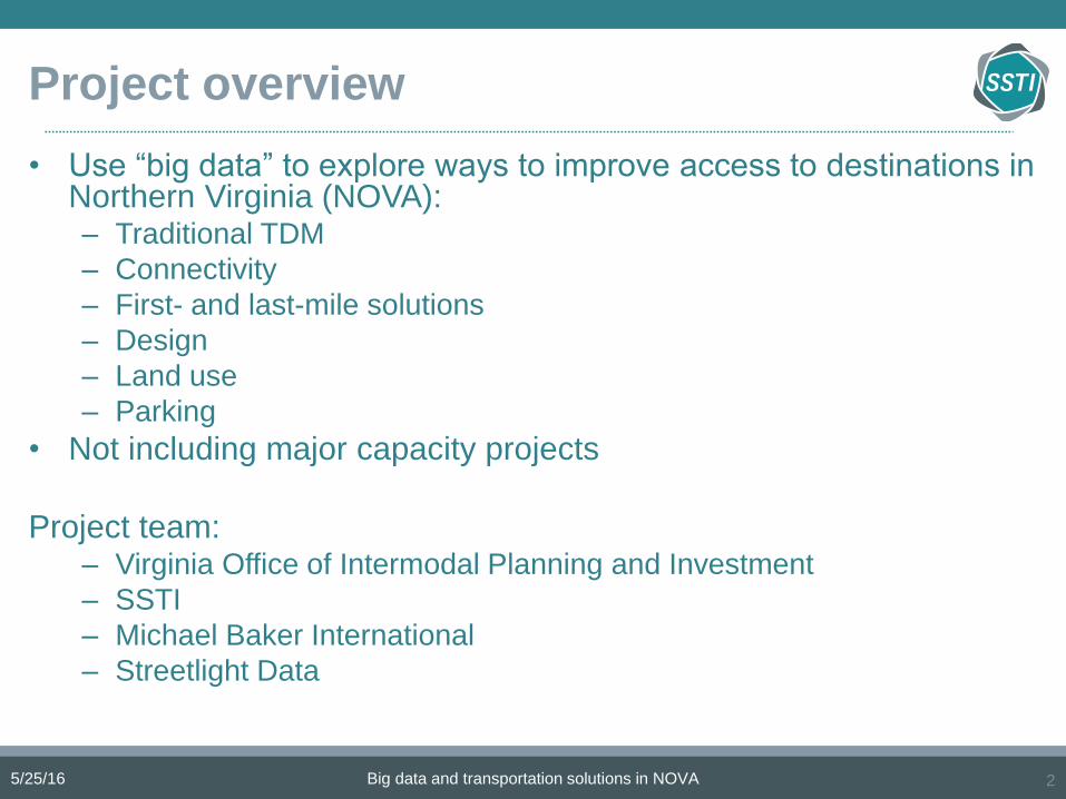
Project overview
• Use “big data” to explore ways to improve access to destinations in Northern Virginia (NOVA):– Traditional TDM
– Connectivity
– First- and last-mile solutions
– Design
– Land use
– Parking
• Not including major capacity projects
Project team:– Virginia Office of Intermodal Planning and Investment
– SSTI
– Michael Baker International
– Streetlight Data
5/25/16 Big data and transportation solutions in NOVA 2

Major initiativesMajor initiatives
in NOVA
Educational programs/events
Expanded transit service
Carpool/ridesharing services
Increased coordination among modes/agencies
Information kiosks/apps
Special event services
Improve transit stations/shelters
Improve access to transit stations
Employer-based economic incentives
Improved road and path connectivity/directness
Bicycle and pedestrian improvements
Park and ride facilities
Transit priority/express lanes
Intelligent Transportation Services
Smart Growth policies
Subsidized transit passes or decrease fares
Bike share programs
Flexible work schedules
On-site transportation coordinators
Bicycle accommodations
Car share programs
Employer-assisted housing/live near work
Guaranteed ride home
HOV/HOT lanes
TMA membership
Toll-managed lanes
Transit-oriented development
Congestion pricing
Demand-responsive transit
Designated carpool/car share spaces
Distance based charges/PAYD insurance
Parking management/pricing
5/25/16 Big data and transportation solutions in NOVA 35/25/2016 3
Somewhat typical

Data
• Anonymous GPS data
from mobile phones and
navigational devices
• Smaller sample but
higher precision than
cellular data
• Added information
compared to traffic
counts and travel
demand modelsStreetlight Data
5/25/16 Big data and transportation solutions in NOVA 4
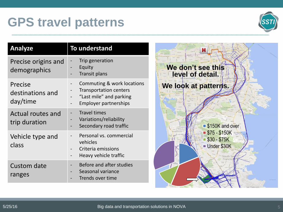
GPS travel patterns
5/25/16 Big data and transportation solutions in NOVA 5
Analyze To understand
Precise origins and demographics
- Trip generation- Equity- Transit plans
Precise destinations and day/time
- Commuting & work locations- Transportation centers- “Last mile” and parking- Employer partnerships
Actual routes and trip duration
- Travel times- Variations/reliability- Secondary road traffic
Vehicle type and class
- Personal vs. commercial vehicles
- Criteria emissions- Heavy vehicle traffic
Custom dateranges
- Before and after studies- Seasonal variance- Trends over time
$150K and over
$75 - $150K
$30 - $75K
Under $30K
We don’t see this level of detail.
We look at patterns.

Our approach
1. Scan GPS data for short trips, circuitous trips and common origin-destination pairs.
2. Identify case studies showing unique issues and opportunities.
3. Evaluate potential costs and benefits of recommended actions (using GPS data).
We engaged with local stakeholders throughout the process.
The project evolved to meet the needs of stakeholders (providing access to data).
5/25/16 Big data and transportation solutions in NOVA 6

5/25/16 Big data and transportation solutions in NOVA 7
Scan – Common OD pairsOrig.
TAZ
Dest.
TAZ
Flow
(000) Circ.
Dist.
(mi)
Dur.
(min)
VMT
(000)
VHT
(000)
591 604 4.66 1.50 5.2 11 24.2 0.85
604 591 2.96 1.36 4.7 10 14.0 0.49
576 565 2.84 1.48 2.9 9 8.2 0.43
824 828 2.74 1.29 1.8 22 5.0 1.00
695 618 2.64 1.21 2.1 11 5.4 0.48
834 828 2.56 1.41 3.1 18 7.8 0.77
591 601 2.50 1.79 3.3 12 8.2 0.50
565 576 2.42 1.50 2.9 8 7.0 0.32
576 591 2.17 1.56 3.7 13 8.1 0.47
591 576 2.05 1.58 3.8 13 7.7 0.44
576 585 2.00 1.66 1.8 11 3.7 0.37
618 695 1.92 1.22 2.1 10 4.0 0.32
735 725 1.88 1.48 2.0 18 3.7 0.56
588 591 1.86 1.37 3.4 13 6.4 0.40
219 238 1.84 1.60 1.1 8 2.1 0.25
478 467 1.83 1.39 3.3 9 6.1 0.27
295 282 1.79 1.26 1.1 8 1.9 0.24
220 218 1.76 1.35 0.9 7 1.5 0.21
834 819 1.72 1.26 2.9 19 4.9 0.54
725 737 1.71 1.29 1.7 9 3.0 0.26
542 540 1.62 1.42 1.2 8 1.9 0.22
220 242 1.61 1.18 1.6 7 2.5 0.19
282 295 1.60 1.42 1.2 8 1.9 0.21
282 297 1.54 1.42 0.8 8 1.3 0.20
618 725 1.52 1.52 10.3 28 15.6 0.71

5/25/16 Big data and transportation solutions in NOVA 8
Scan – Short, circuitous trips
Orig.
TAZ
Dest.
TAZ
<5 miles <2 miles <1 mile
Flow Circ. Flow Circ. Flow Circ.
32 32 2,351 2.48 1,957 1.86 1,069 1.42
559 559 716 2.40 570 1.57 254 1.32
843 843 711 2.20 476 1.84 265 1.31
238 238 682 2.40 609 1.86 514 1.48
52 52 546 2.58 395 1.49 320 1.23
457 457 491 3.00 487 2.98 65 1.87
449 449 477 3.54 288 2.02 95 1.69
76 76 474 2.27 436 2.05 280 1.51
130 121 434 2.55 376 2.33 0 -
107 115 392 2.21 315 1.45 248 1.26
115 107 373 2.80 278 1.79 149 1.39
707 732 358 2.26 113 1.73 8 1.03
308 323 333 2.48 275 1.90 80 1.56
121 130 290 3.11 228 2.87 0 -
70 76 276 2.34 248 2.15 145 1.51
323 308 266 2.22 229 1.84 79 1.43
584 584 266 2.41 224 1.77 127 1.40
326 326 238 2.28 215 1.65 183 1.44
474 474 232 2.40 208 1.84 57 1.31
722 630 221 2.36 69 1.71 34 1.55
186 186 221 2.39 202 1.68 182 1.57
376 394 219 2.38 136 1.91 8 1.11
290 290 216 4.54 130 1.59 85 1.35
350 331 209 2.33 111 1.93 4 1.07
757 757 208 2.30 179 1.97 80 1.29

5/25/16 Big data and transportation solutions in NOVA 9
Scan – Selected linksPercent of flow
Link ID
Flow
(000)
Top O-D
pair
Top five
pairs <5 mi <2 mi <1 mi Link description and direction
1036 67.5 10.7 19.0 2.9 0.7 0.2 Neabsco Mills Rd (US-1 to Opitz Blvd) SB
1018 60.3 1.4 4.4 3.4 1.1 0.3 VA-28 (I-66 to Westfields Blvd) SB
1012 55.7 2.0 4.4 0.0 0.0 0.0 I-66 (US-29 to VA-120) WB
1106 51.3 1.4 4.4 3.3 1.4 0.4 US-50 (VA-286 to I-66) EB
1006 47.8 10.6 25.1 0.5 0.1 0.0 VA-123 (George Wash. Pkwy to Chain Bridge) NB
2217 47.6 1.5 5.1 5.5 1.5 0.4 US-50 (Stringfellow Rd to VA-286) EB
1049 45.0 1.6 6.0 10.2 4.4 2.0 US-50 (VA-28 to Lees Corner Rd) EB
1217 43.2 1.4 4.1 3.8 1.4 0.3 US-50 (Stringfellow Rd to VA-286) WB
2224 41.0 0.9 4.1 0.4 0.1 0.0 I-66 (I-495 to VA-7) WB
1019 40.7 2.0 7.2 10.2 3.6 1.1 US-50 (VA-609 to VA-28) WB
1224 40.6 1.9 5.6 0.4 0.1 0.1 I-66 (I-495 to VA-7) EB
1010 40.4 2.0 6.5 2.0 0.5 0.3 VA-7 (VA-2400 to Lexington Dr) EB
1201 38.9 4.9 9.2 0.6 0.5 0.4 VA-267 (I-66 to Magarity Rd) SB
2148 38.0 2.2 8.9 6.6 1.0 0.2 VA-7 (Battlefield Pkwy SE to Crosstrail Blvd) WB
1086 37.9 0.7 2.7 0.4 0.2 0.1 VA-286 (VA-123 to Popes Head Rd) NB
2010 37.9 1.8 6.8 2.5 0.4 0.0 VA-7 (VA-2400 to Lexington Dr) WB
1016 37.9 3.4 9.0 5.8 2.5 1.0 George Wash. Pkwy (VA-124 to US-29) SB
1222 37.5 2.9 7.1 15.3 11.1 4.4 VA-7 (VA-123 to I-495) EB
1013 37.5 1.3 5.1 12.0 3.8 1.0 VA-123 (VA-267 to VA-738/VA-309) NB
1148 36.7 2.0 7.9 7.9 0.6 0.1 VA-7 (Battlefield Pkwy SE to Crosstrail Blvd) EB
1102 36.5 1.5 6.4 16.6 11.4 4.4 VA-7 (VA-267 to VA-123) WB
1032 35.3 1.0 4.1 9.1 5.6 1.7 US-1 (VA-7 to East Monroe Ave) SB
2222 35.3 1.2 4.8 14.6 10.1 3.5 VA-7 (VA-123 to I-495) WB
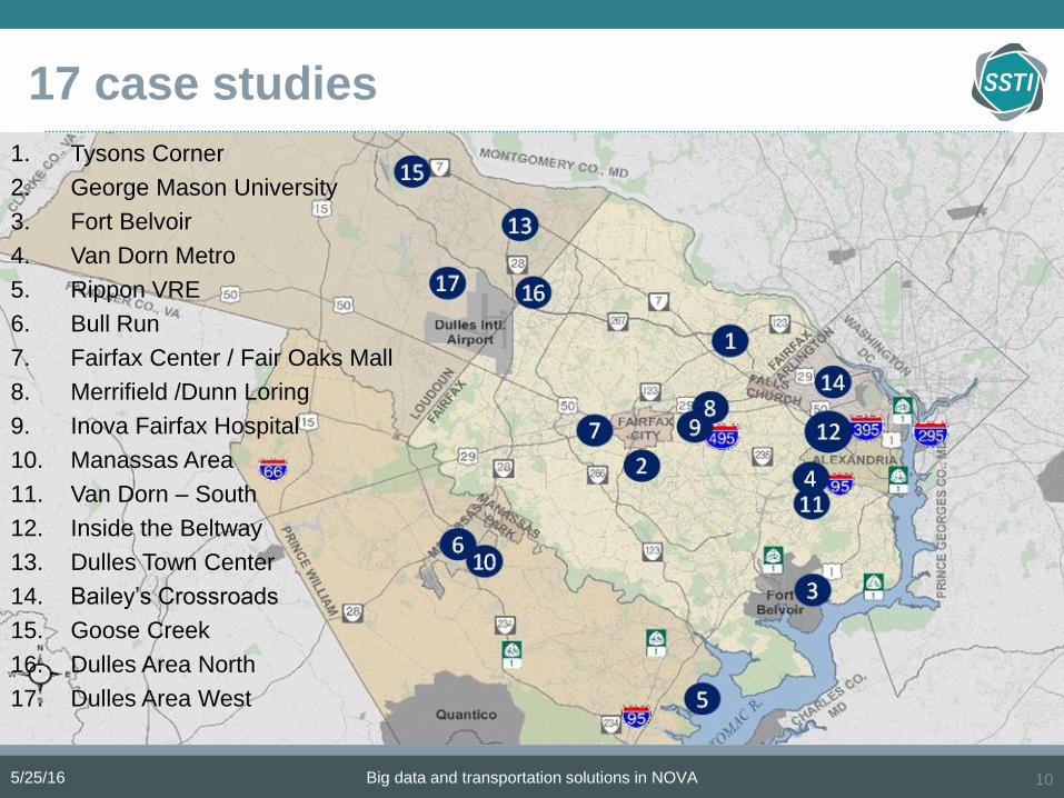
17 case studies
5/25/16 Big data and transportation solutions in NOVA 10
1. Tysons Corner
2. George Mason University
3. Fort Belvoir
4. Van Dorn Metro
5. Rippon VRE
6. Bull Run
7. Fairfax Center / Fair Oaks Mall
8. Merrifield /Dunn Loring
9. Inova Fairfax Hospital
10. Manassas Area
11. Van Dorn – South
12. Inside the Beltway
13. Dulles Town Center
14. Bailey’s Crossroads
15. Goose Creek
16. Dulles Area North
17. Dulles Area West

Example case study: Tysons Corner
5/25/16 Big data and transportation solutions in NOVA 11
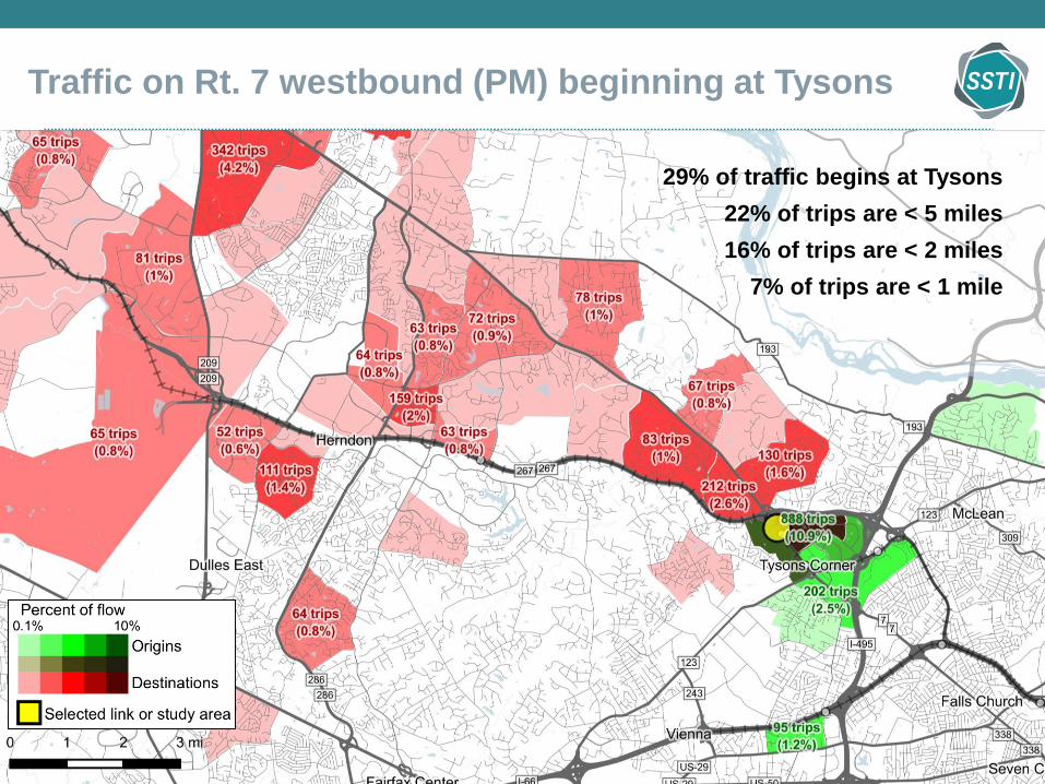
Traffic on Rt. 7 westbound (PM) beginning at Tysons
5/25/16 Big data and transportation solutions in NOVA 12
29% of traffic begins at Tysons
22% of trips are < 5 miles
16% of trips are < 2 miles
7% of trips are < 1 mile

Tysons Corner
Opportunities
• Bicycle and pedestrian improvements
• Parking management
• Street and parcel connections
• Other local transportation options
5/25/16 Big data and transportation solutions in NOVA 13
Dulles Toll Road
M
M M
M
Tysons Corner
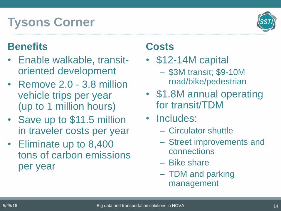
Benefits
• Enable walkable, transit-oriented development
• Remove 2.0 - 3.8 million vehicle trips per year (up to 1 million hours)
• Save up to $11.5 million in traveler costs per year
• Eliminate up to 8,400 tons of carbon emissions per year
Costs
• $12-14M capital – $3M transit; $9-10M
road/bike/pedestrian
• $1.8M annual operating for transit/TDM
• Includes:– Circulator shuttle
– Street improvements and connections
– Bike share
– TDM and parking management
5/25/16 Big data and transportation solutions in NOVA 14

George Mason University
5/25/16 Big data and transportation solutions in NOVA 15
33% of trips

George Mason University
Opportunities
• Off campus connections by foot, biking and transit
• Parking management
• Walkable development in surrounding area
Remove 250K to 460K vehicle trips per year
5/25/16 Big data and transportation solutions in NOVA 16

5/25/16 Big data and transportation solutions in NOVA 17
Van Dorn Street Metro

5/25/16 Big data and transportation solutions in NOVA 18
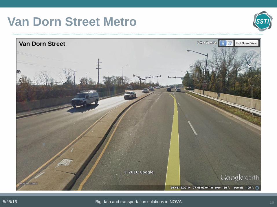
Van Dorn Street Metro
5/25/16 Big data and transportation solutions in NOVA 19
Van Dorn Street
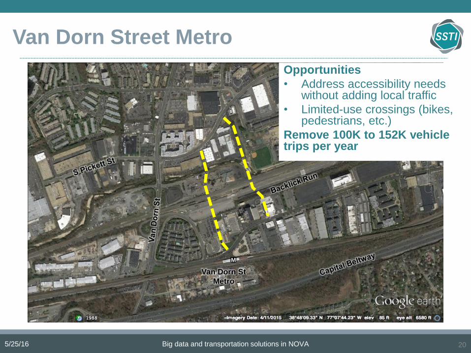
Van Dorn Street Metro
Van Dorn St
Metro
M
Opportunities
• Address accessibility needs without adding local traffic
• Limited-use crossings (bikes, pedestrians, etc.)
Remove 100K to 152K vehicle trips per year
5/25/16 Big data and transportation solutions in NOVA 20

5/25/16 Big data and transportation solutions in NOVA 21
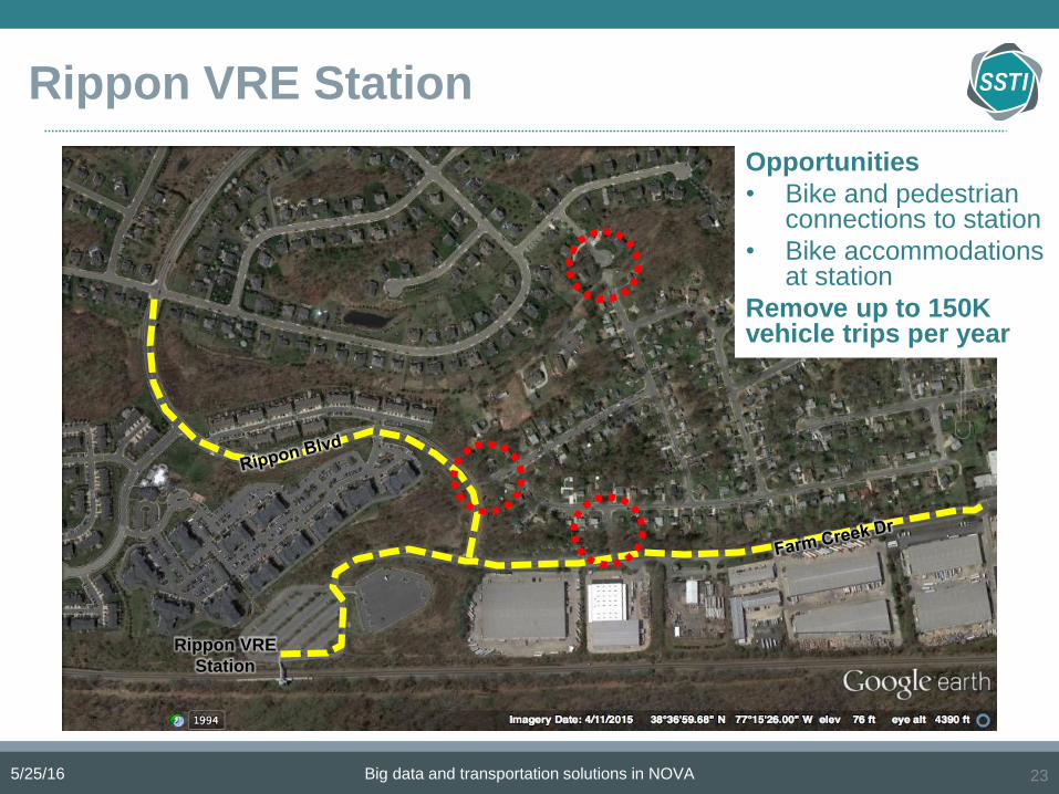
Rippon VRE Station
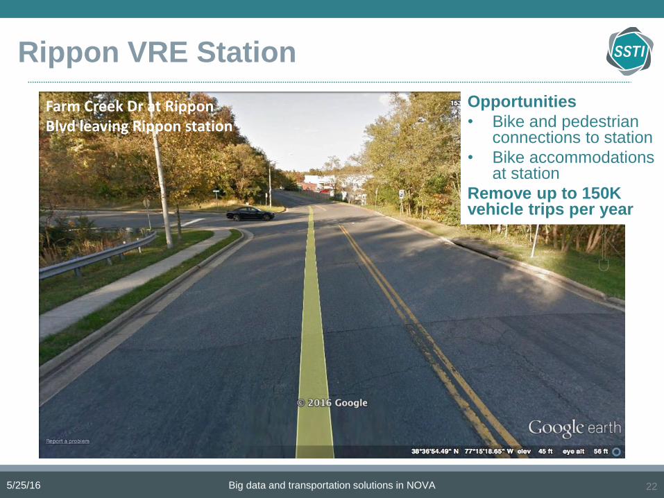
Rippon VRE Station
5/25/16 Big data and transportation solutions in NOVA 22
Farm Creek Dr at RipponBlvd leaving Rippon station
Opportunities
• Bike and pedestrian connections to station
• Bike accommodations at station
Remove up to 150K vehicle trips per year
Rippon VRE Station
Rippon VRE
Station
5/25/16 Big data and transportation solutions in NOVA 23
Opportunities
• Bike and pedestrian connections to station
• Bike accommodations at station
Remove up to 150K vehicle trips per year

Key findings
• Data visualization and trip quantification are
immensely useful.
• Important to consider multimodal connections
to sites and multimodal options at sites.
• Still more work needed in modal recognition,
trip-chaining, automation, and visualization.
Full report available at ssti.us
5/25/16 Big data and transportation solutions in NOVA 24
Big Data and Transportation Solutionsin Northern Virginia: An NVTA Perspective
Keith Jasper
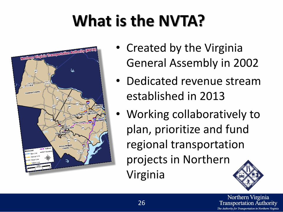
What is the NVTA?
• Created by the Virginia General Assembly in 2002
• Dedicated revenue stream established in 2013
• Working collaboratively to plan, prioritize and fund regional transportation projects in NorthernVirginia
26

The Authority: Working Regionally
27
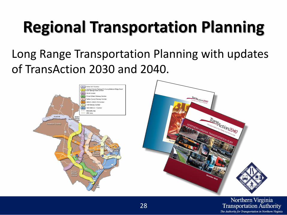
Regional Transportation Planning
Long Range Transportation Planning with updates of TransAction 2030 and 2040.
28

TransAction Update
29

Regional Funding Programmed to
Date
70 Projects Approved
Totaling$535 million
30
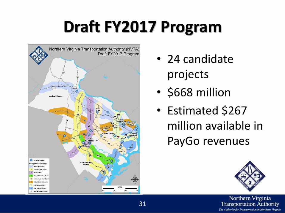
Draft FY2017 Program
31
• 24 candidate projects
• $668 million
• Estimated $267 million available in PayGo revenues

Big Data – FY2017 Program
32
Big Data – TransAction update
Possible applications:
• Origin-destinations
• Travel behavior in activity centers
• Model validation?
33
Big Data – Long Term ‘Benefit’
• Understanding the regional transportation impact of NVTA-funded projects relative to the jurisdictions from which the revenue can be attributed.
34
Additional Information
• For more information, please visit: www.TheNoVaAuthority.org
• TransAction: www.NVTATransAction.org
35

36
THANK YOU!
A recording of this webinar will be on the SSTI web site tomorrow.
To find out about future SSTI webinars, subscribe to our newsletter and follow us on
Twitter.
www.ssti.us
@SmartTransp
5/25/16 Big data and transportation solutions in NOVA