big hickory island preserve 14500 estero boulevard … hickory island preserve 14500 estero...
TRANSCRIPT

Big Hickory Island Preserve
14500 Estero Boulevard Bonita Beach
Land Stewardship Plan 2013
Prepared by Land Stewardship Lee County Department of Parks & Recreation Approved by Lee County Board of County commissioners 3/5/2013

Acknowledgements This document was prepared with the assistance of Roger Clark, Jim Green, Lee County Land Stewardship, Lee County Conservation 2020 and Lee County Parks and Recreation staff. Special thanks to those who proof read the drafts and submitted comments, making this a better document. Many thanks for your time and help.
Terry Cain

Table of Contents
VISION STATEMENT I. EXECUTIVE SUMMARY………………………………………………………….....1 II. INTRODUCTION …………………………………………………………………….3 III. LOCATION AND SITE DESCRIPTION ………………………………………….5 IV. NATURAL RESOURCES DESCRIPTION……………………………………....8 A. Physical Resources……………………………………………………………..8 i. Climate………………………………………………………………….....……8 ii. Geographic Features……………………………………………...……...…...8 iii.Topographic Features……………………………………………..………......8 iv. Soils…………………………………………………………....…..…….…....10 v. Hydrologic Components and Watershed …………………………….........12 B. Biological Resources………………………………………………...…………....14 i. Ecosystems Function…………………………………………………...……….14 ii. Natural Plant Communities……………………………………………………...14 iii. Fauna……………………………………………………………………...……...17 iv. Designated Species……………………………………………………………..17 v. Biological Diversity………………………………………………………...….....17 C. Cultural Resources………………………………………………………………..18 i. Archaeological Features…………………………………………………….…..18 ii. Land Use History………………………………………………………...….…..18
iii. Public Interest ……………………………………………………………......…25 V. FACTORS INFLUENCING MANAGEMENT…………………………………...25 A. Natural Trends and Disturbances……………………………………………25 . B. Internal Influences………………………………………………………….….26 C. External Influences……………………………………………………………27 D. Legal Obligations and Constraints……………………………………….….29 i. Permitting………………………………………………………………....….29 ii. Other Legal Constraints………………………………………………….....29

iii. Relationship to Other Plans………………………………………………...29
E. Management Constraints………………………………………………….....30 F. Public Access and Resource-Based Recreation………………………......30 G. Acquisition…………………………………………………………………......33 VI. MANAGEMENT ACTION PLAN……………………………………………….33 A. Management Unit Description………………………………………….…....33 B. Goals and Strategies………………………………………………………….35 VII. PROJECTED TIMETABLE FOR IMPLEMENTATION……………………..36 VIII. FINACIAL CONSIDERATIONS……………………………………………....38 IX. LITERATURE CITED……………………………………………………….......39 X. APPENDICES……………………………………………………………………41

List of Exhibits
Figure 1: Location Map ........................................................................................ 6
Figure 2: 2010 Aerial............................................................................................ 7
Figure 3: Topograpic Map .................................................................................... 9
Figure 4: Soils Map ............................................................................................ 11
Figure 5: Watersheds Map ................................................................................. 13
Figure 6: Plant Communities Map ...................................................................... 16
Figure 7: 1944 Aerial.......................................................................................... 20
Figure 8: 1953 Aerial.......................................................................................... 21
Figure 9: 1968 Aerial.......................................................................................... 22
Figure 10: 1986 Aerial......................................................................................... 23
Figure 11: 1998 Aerial......................................................................................... 24
Figure 12: Internal & External Influences Map .................................................... 28
Figure 13: Site Plan Map ................................................................................... 32
Figure 14: Management Units & Strap Numbers Map…………………………...34

Appendices
Appendix A: Lease Agreement between Lee County and the State of Florida, Department of Environmental Protection, Division of Recreation and Parks Appendix B: Plant sightings at Big Hickory Island Preserve Appendix C: Wildlife Sightings at Big Hickory Island Preserve Appendix D: Lee County Storm Surge Map Appendix E: Projected Cost & Funding Sources Table Appendix F: Great Calusa Blueway Map Appendix G: Minutes of the Big Hickory Island Preserve Public Meeting

Vision Statement
It is the vision of the Lee County Board of County Commissioners, Lee County Department of Parks & Recreation
and Land Stewardship staff to preserve and maintain the natural resources found at Big Hickory
Island Preserve so they provide a viable wildlife habitat for avian, sea and land based creatures. The Preserve will provide natural resource-based experiences for visitors and residents
through wildlife viewing, canoeing/kayaking, fishing, swimming and beach experiences. Maintaining the variety of
ecosystems with exotic pest plant control, preservation, education and scheduled coastal clean ups will ensure a healthy ecosystem
for all to enjoy.

1
I. EXECUTIVE SUMMARY Big Hickory Island Preserve (BHIP) is located in southwestern Lee County, within the limits of the City of Bonita Springs in Section 24, Township 47 South and Range 24 East. This group of five islands is south of Fort Myers Beach / Lovers Key and north of Bonita Beach. The largest island is bisected east and west by County Road 865/ Estero Boulevard. The estimated 147 acre eastern portion of the preserve was acquired by application to the Trustees of the Internal Improvement Fund of the State of Florida in May 1963 by Lee County for dedication of the land to be used for public purpose including public parks and recreation. After a five year lease option purchase agreement with the Hickory Corporation an estimated 145 acre western parcel of the preserve was purchased in 1978 for $287,275.00 by Lee County. At this time the most northern ever changing parcel of the preserve, the point, is under management of Lovers Key State Park. This is due to a lease agreement created in 1996 between Lee County and the State of Florida for county owned recreational lands known as Carl Johnson Park that included the northern point of Big Hickory Island. This lease was amended in 2001 to create a clear legal description of the property and to remove an area from the lease known as Dog Beach from the state land lease to allow the county to establish a dog beach. At the writing of this land stewardship plan it is under consideration to amend the lease, yet again, and remove the northern point of Big Hickory Island from the lease and bring it under the management of Lee County and include the point in the Big Hickory Island Preserve. (See Figure 1)(See appendix A) Big Hickory Island Preserve is part of the barrier island chain off the coast of Lee County. The northern boundary of the preserve is New Pass and a parcel of property owned by Pelican Landing Community Association, Inc. that is used as the community beach (see appendix B); its eastern boundary is Estero Bay; its southern boundary is predominately mangrove swamp property owned by Barron Collier Investments LTD, CDC Investments Inc. and its western boundary is the Gulf of Mexico and Big Hickory Pass. Natural elevations range from 0 to 4.83 feet above sea level with the highest point being a dune along the beach front. From either side of the high beach the islands slope down into mangrove swamps to the east or the Gulf of Mexico to the west at sea level. There is one soil type in the preserve, Wulfert muck, along with a narrow strip of beach. Wulfert muck is a nearly level, very poorly drained soil on broad tidal swamps. Slopes are smooth and range from 0 to 1 percent. Areas are subject to tidal flooding as the water table fluctuates with the tides. The surface layer is muck that is dark reddish brown to a depth of 12 inches and dark brown to a depth of 36 inches. Beneath the muck is gray fine sand with light gray streaks and about 10 percent shell fragments. The beach area consists of narrow strips

2
of nearly level mixed shell and sand fragments along the Gulf of Mexico. These areas are subject to movement by wind and tide. The beach is used intensively for recreation during the entire year. BHIP is within the Greater Charlotte Harbor Watershed that extends approximately 130 miles from the northern headwaters of the Peace River in Polk County to southern Estero Bay in Lee County. The water shed is divided into basins and sub basins with Big Hickory Island being designated as a sub basin. County Road 865/Estero Boulevard and an adjacent berm, created to protect the road, are the only manmade features that impede tidal flow across the island and create run off from the road. Big Hickory Island Preserve is made up of beaches, mangrove swamps and emerging mangrove islands surrounded by oyster beds. All are important habitats for shore and wading birds, mammals, reptiles and amphibians. The preserve consists of five natural plant communities described by the Florida Natural Areas Inventory. An estimated 92 percent of the preserve is Mangrove Swamp with coastal land types making up the rest. The preserve and beaches were only accessible by boat prior to construction of County Road 865 in the mid 1960’s so use was limited. Road construction not only altered inlet dynamics south of Big Carlos Pass but also closed several tidal channels between Black Island and Little Hickory Island. Island dynamics changed with the closures of these channels as seen in the 1944, 1953 and 1968 aerials. The road brought new and more uses to the area creating beach areas at the base of New Pass bridge and access to the shallow bay side of the island. The Gulf front beaches are still only accessible by boat. Restoration and protection of the natural resources for wildlife and native plant communities include exotic pest plant and animal removal, scheduled marine debris removal, creating a primitive camp area for shallow draft boaters on Bow Tie Island (figure 13) to protect ground nesting birds, sea turtles and fauna on the beach front, educating and encouraging appropriate behavior for preserve use. The goal of this land stewardship plan is to identify preserve resources, create strategies to protect the natural resources and implement the plan in accordance with Lee County Parks and Recreation’s Land Stewardship Operations Manual. A balance for the needs of the public while also creating protection for the natural resources is a major component of this stewardship plan. Natural disasters, winds, tides and long shore drift are elements to be considered in the plan and will have a direct impact on how the plan is implemented. The Management Action Plan outlines restoration and stewardship goals with strategies and a time table for completion. This plan will be revised in ten years (2022).

3
II. INTRODUCTION Big Hickory Island Preserve is a series of islands off the south west Lee County Florida coast. Big Hickory Island is located south of Lovers Key and north of Bonita Beach with GPS coordinates of 26 degrees 22 minutes and 09 seconds north and 81 degrees 51 minutes and 29 seconds west.(See figure 2) Lee County entered into a lease option purchase agreement with the Hickory Corporation in 1973 to purchase Big Hickory Island, paying a fee every year until 1978, with the total payment equaling $287,275.00. This estimated 145 acre acquisition included parcels of land that totaled over one thousand feet of beach front property on the Gulf of Mexico with mangrove swamps along Estero Bay Aquatic Preserve. Barrier islands are shown by 1944 aerial photography to the west of Big Hickory Island. In the 1953 aerial the islands have migrated ashore to the back bay islands and created a beach, typical of barrier islands. As seen in the 1968 aerial the bridge and causeway are in place and there is no evidence of the past barrier island chain. (Figures 7, 8 & 9) Construction of the County Road (CR) 865 causeway in the mid 1960’s linking Fort Myers Beach (Estero Island) and Bonita Beach (Little Hickory Island), significantly altered inlet dynamics south of Big Carlos Pass. The causeway closed several tidal channels between Black Island and Little Hickory Island. (Antonini, 2002) The entire island is divided by County Road 865 (Estero Boulevard/Bonita Beach Road) creating accessibility to the eastern side of the island and creating a bay side park with water access at the foot of New Pass Bridge. Big Hickory Island’s gulf side beach has been accessible only by boat since 1988 when Big Hickory Pass reopened after being closed for nine years. (Figure 10) Before that time residents of the northern end of Little Hickory Island (Bonita Beach) could walk to Big Hickory Island. In 1991 Lee County proposed a project for Big Hickory Island to include a boardwalk from a parking area to the beach, over looks, landscaping, beach crossovers and a rest room if funds were approved at a later date. This project was controversial as there were those both in favor and against the project. Pro: “We will never have enough beach accesses.” Con: “The area is pristine and should remain so.” In a 1993 Board of County Commissioners workshop it was expressed by Mr. Judah that if Westinghouse (the owner of an estimated 35 acre site on Big Hickory Island) is going to move forward with their gazebo and bath facility, there is an opportunity to have the County Staff work with Westinghouse to minimize impacts. No formal Board vote was taken. Staff did contact Westinghouse and

4
the minutes from the 1993 work shop did not indicate that staff had been directed to initiate design and permitting activities. The Lee County owned parcels of Big Hickory Island remain in a natural state. The final decision to not repeat facilities similar to the Westinghouse construction was based on environmental impacts and cost. $49,500.00 of funding was provided in 2004 through the Florida Department of Environmental Protection, after review by the Southwest Florida Invasive Species Working Group, to clear invasive exotic pest plants from the preserve and right of way of County Road 865. Heavy equipment that cuts down and mulches invasive exotic plants was used for this project In 2005 Lee County received a $15,000.00 grant from the U.S. Fish & Wildlife Service, Partners for Fish and Wildlife Program for restoration on Big Hickory Island Preserve. This grant included treatment of invasive exotic pest plants and planting of 44 native trees and 130 native shrubs. These plants were installed on the artificial berm to the west of CR 865 to provide habitat diversity for wildlife. $1,900.00 was funded in 2010 by mitigation funds received through DEP to remove Australian pines from Bow Tie Island, the island on the east side of the preserve. Invasive exotic pest plant and animal control is provided as follow-up to those projects by Lee County Parks & Recreation Land Stewardship Staff. The preserve is made up of five plant communities that are typical of west coast Florida barrier islands. The biggest man made disturbance to this island was the creation of CR 865/Estero Blvd. that included a berm created on the west side of the road to protect the road. BHIP is mostly mangrove swamp with areas of beach shore line on the Gulf of Mexico and Estero Bay that are important habitat for a variety of wildlife. Many state and federal endangered species use the preserve for foraging, resting and nesting including snowy plovers (Charadrius alexandrines), least terns (Sterna antillarum ) red knots (Calidris canutus) and loggerhead sea turtles (Caretta caretta). BHIP is unique because the natural areas of this island chain were not disturbed until the building of CR 865 in the mid 1960’s. This construction not only disturbed habitat and hydrology but also brought the influence of human behavior to the site. The wildlife and ecosystem will benefit from exotic plant removal and education for the public on wildlife species protection and habitat importance.

5
Ill. LOCATION AND SITE DESCRIPTION Big Hickory Island Preserve is located in southwestern Lee County within Section 24, Township 47 South and Range 24 East – south of Fort Myers Beach and Lover’s Key and north of Bonita Beach and consists of an estimated 280 acres. The preserve is divided into two strap (section, township, area, and parcel) numbers: STRAP # 24-47-24-B2-00003.0000 is west of County Road 865/Estero Boulevard and STRAP # 13-47-24-B3-0004.0000 is located to the east of County Road 865/Estero Boulevard. (Figure 1) Big Hickory Island Preserve is a group of islands bordered by the Gulf of Mexico to the west and Estero Bay to the east. The preserve is connected by bridges to other barrier islands in this west coast Florida chain. New Pass Bridge to the north connects the preserve to Lovers Key/Black Island and Big Hickory Pass Bridge connects the preserve to Little Hickory Island/Bonita Beach to the south. (Figure 2) The closest neighbors to the south reside in condominiums across Big Hickory Pass on Little Hickory Island/Bonita Beach. The Pelican Landing Hickory Island Beach Park, neighbor to the north, is an estimated 35 acre area of the island purchased as an amenity. This area is used by Pelican Landing residents and Hyatt Hotel guests, brought in by boat. According to Pelican Landing Conservation Officers, between private boats that anchor on the beach and Pelican Landing / Hyatt guests, the count of people on the beach can be from 50 to 200 people on weekends. Figure 1 shows the location of BHIP and Figure 2 outlines the boundaries of BHIP on a 2011 aerial. Big Hickory Island Preserve has two aspects: one area being accessible by automobile with a major road way and the Gulf beach area which is accessible only by boat.

6

7

8
IV. Natural Resources Description A. Physical Resources i. Climate General information on the climate of southwest Florida is located in the Land Stewardship Operations Manual’s (LSOM) Land Stewardship Plan Development and Supplemental Information section. ii. Geology Specific information on the geologic features such as physiographic regions, formations and maps can be found in the LSOM’s Land Stewardship Plan Development and Supplemental Information section. iii. Topographic features The elevation of BHIP ranges from zero to over four feet in elevation. (Figure 3) A majority of the site falls between zero and two-feet in elevation as the beach area rises out of the Gulf of Mexico. When the intertidal zone is exposed at mean low water level, a feeding area is created for resident avian life. Within the preserve there is a decrease in elevation as the beach area slopes back down on the east side into the mangrove area. The highest elevations on the island are the road way and that is not within the preserve boundaries. All elevations are based on the National Geodetic Vertical Datum (NGVD). Figure 3 topographic map also includes light detecting and ranging (LiDAR) data that is an optical remote sensing technology measuring properties of scattered light to fine range and/or other information of a distant target.

9

10
iv. Soils BHIP contains one soil type as seen in figure 4, Wulfert muck. There are also narrow strips of nearly level mixed sand and shell fragments making up the beach. These areas are subject to movement by wind and tide and are bare of vegetation. Soils play an important role in dictating the location and types of recreation that the preserve can provide. This soil has severe limitations for sanitary facilities and recreational uses and moderate limitations for most building site development. The high water table and sandy surface texture are major limitations. (USDA/SCS 1984) Refer to the LSOM’s Land Stewardship Plan Development and Supplemental Information section for additional information on soil types and limitation.

11

12
v. Hydrologic Components and Watershed
Big Hickory Island Preserve is located within the Greater Charlotte Harbor Watershed. The Greater Charlotte Harbor Watershed extends over an area of 4,400 square miles and is divided into basins and sub basins.
BHIP is within the Estero Bay Basin watershed and is noted as being in the Big Hickory Island Sub Basin of the South Florida Water Management District’s (SFWMD) Lower West Coast Region.(Figure 5) Over three quarters of the Preserve consists of mangrove swamp that is influenced by tidal flow. The tides bring relatively clean water to the mangroves, and in turn flush out accumulations of hydrogen sulfide and salts. The mangrove swamp also filters nutrients such as phosphorus and nitrogen from terrestrial runoff, which help to buffer the estuary from water pollution.
In 1974 the United States Fish and Wildlife Service (USFWS) directed its Office of Biological Services to conduct an inventory of the nation’s wetlands. Wetlands were identified on aerial photography by vegetation, visible water features and geography, and subsequently classified in general accordance with the Classification of Wetlands and Deep Water Habitats of the United States. (Cowardin et al. 1979). More information about the different classifications can be found there, or in the LSOM’s Land Stewardship Plan Development and Supplemental Information section. The unnatural features will be discussed more fully in the Internal Influences section of this plan.

13

14
B. Biological Resources
i. Ecosystem Function Lee County’s preserves contain a diversity of plant communities that provide habitat for numerous plant and animal species. The majority of these preserves are not islands of habitat, but are pieces of a larger conservation effort striving to create or maintain a healthy and viable ecosystem. Refer to the LSOM’s Land Stewardship Plan Development section for additional information. ii. Natural Plant Communities The five native plant communities of Big Hickory Island Preserve are beach dune (G3/S2), coastal berm (G3/S2), coastal grassland (G3/S2), coastal strand (G3/S2) and mangrove swamp (G5/S4). (Figure 6) These plant communities are defined according to Florida Natural Areas Inventory’s (FNAI) Guide to the Natural Communities of Florida, www.fnai.org > natural communities (Florida State University, 2010) and ranks natural areas as significant on a Global (G) or State (S) basis and numerically from 1 to 5. A rank of 1 designates an area as critically imperiled (G1-S1) and a rank of 5, (G5 –S5) as demonstrably secure, although it may be quite rare in part of its range. The five native plant communities of Big Hickory Island Preserve are ranked above. Definitions of Global (G) element ranks: G3 = either very rare and local throughout its range or found locally (even abundantly at some of its locations) in a restricted range or because of other factors making it vulnerable to extinction throughout its range, 21 to 100 occurrences; G5 = demonstrably secure globally, though it may be quite rare in parts of its range, especially at the periphery; Definition of State (S) element ranks: S2 = Imperiled in state because of rarity (6-20 occurrences or little remaining area) or because of some factor(s) making it very vulnerable to extinction throughout its range; S4 = apparently secure in state, although it may be rare in some parts of its state range
Acreages and percent of cover for each community are listed below. Descriptions of the plant communities and characteristics animals found within each community, as well as management suggestions can be found in the LSOM. A complete list of plant species identified during site inspections to BHIP can be found in Appendix B.

15
Beach Dune – 2.1 acres and 2.2% of the preserve A small area of beach has created a dune system that helps to protect the small creek that flows through the preserve. Beach dune is characterized as a wind-deposited, fore dune and wave-deposited upper beach that are sparsely to densely vegetated with pioneer species, especially sea oats (Uniola paniculata). Other pioneer species include beach cordgrass (Spartina patens), sand spur (Cenchrus spinifex), railroad vine (Ipomoea pes-caprae), beach morning glory (Ipomea stolonifera) and dune sunflower (Helianthus debilis). Beach dunes are very dynamic communities. The wind continually moves sand inland from the beach until trapped by vegetation. This area is subject to drastic topographic alterations during winter storms and hurricanes. Intact beach dunes are essential for protection of inland biological communities and human infrastructure. Coastal Berm – 2.5 acres and 2.5 % of the preserve Along the north eastern gulf beach area of the preserve is a ridge that has been created from storm deposits of sand, shell, and marine debris. Plants associated with this formation include thickets of large shrubs and small trees, hammocks or sparse shrubby vegetation with spiny xerophytic plants. Many animals typical of Beach Dune inhabit the Coastal Berm. Coastal Grassland – 1.8 acres and 2.0% of the preserve Directly behind the open beach area is variety of herbaceous vegetation including salt tolerant grasses creating a small coastal grassland. Coastal grassland is a low flat area behind fore dunes that are found on broader barrier islands, capes, spits, and is best developed along the Gulf Coast; it may be flooded by salt water and covered with sand and debris during major storms. Coastal Strand – 1.1 acres and 1.3% of the preserve Coastal strand is characterized as stabilized, wind-deposited coastal dunes that are vegetated with a dense thicket of salt–tolerant shrubs. Shrubs subject to this harsh environment are frequently dwarfed and pruned as a result of salt spray-laden winds that kill twigs on the seaward side of the vegetation. This area makes up the southernmost beach part of the preserve and is a stabilized area with older vegetation including sea grapes and buttonwoods. This area is heavily used by visitors and has evidence of open fire pits. Mangrove Swamp – 131.3 acres and 92% of the preserve
The largest area of the preserve is covered in mangroves including the recent emerging oyster bar islands in the most southern part of the preserve. Red mangrove, black mangrove, white mangrove and buttonwood typically occur in the mangrove swamp.

16

17
iii. Fauna Big Hickory Island Preserve is mostly mangrove forest. This community is significant because it functions as nursery grounds for most of the state’s important commercial and recreational fish and shellfish. The continuous shedding of mangrove leaves and other plant components produce as much as 80% of the total organic material available in the estuarine aquatic food web. Appendix C has the complete list of wildlife documented in the preserve as recorded through staff field work and site inspection. Additional general information about fauna can be found in the LSOM’s Land Stewardship Plan Development and Supplemental Information section. iv. Designated Species Three loggerhead sea turtle (Caretta caretta) nests were reported on Big Hickory Island in 2011, seven in 2010 and one in 2009. Turtle Time Inc. has documented 156 nests on Big Hickory Island since 1991. (Eve Haverfield, Turtle Time Inc. 9/24/2011) Stewardship of the native biological communities will benefit all species in the preserve including protection of designated species in Florida’s Endangered Species, Threatened Species and Species of Special of Special Concern document maintained by the Florida Fish and Wildlife Conservation Commission as well as those species listed by the federal government in the Endangered Species Act. Management practices conducted in the preserve include the control of exotic pest plant and animal communities, removing marine debris and litter, wildlife monitoring and restoring native plant communities. Camping is not allowed on the beach front and has been redirected to Bow Tie Island to protect beach ground nesting birds, sea turtles and to stop the cutting of vegetation for beach side fires. Litter control and permitted fires will be more contained in the smaller physical space of Bow Tie Island. Enforcement of unacceptable behavior in the preserve such as fires in undesignated areas, using vegetation for tents or tying off boats, and not allowing pets will also protect the many species in the preserve. Additional natural history on these species and stewardship measures to protect them can be found in the LSOM’s Land Stewardship Plan Development and Supplemental Information section. v. Biological Diversity General information on biological diversity and measures used to help promote biological diversity can be found in the LSOM’s Land Stewardship Plan Development and Supplemental Information section.

18
Many species of birds, reptiles, invertebrates, fish and mammals inhabit, forage, nest, or rest in Big Hickory Island Preserve. The mangroves provide nesting and roosting area for birds. Many species of fish either breed or spend some part of their juvenile life in the protection of the mangroves. The integrity and diversity of Big Hickory Island Preserve and its associated waters must be protected when and where possible. Management staff will perform the following actions in this regard:
Control of invasive exotic plants and animals with annual follow-up maintenance will provide suitable habitat for native wetland and terrestrial species.
Removal of any debris and prevention of future littering on site will improve and protect water quality.
Removal of hazardous debris such monofilament line and other potential entrapment debris will also contribute to the quality of surrounding waters and protect wildlife species that utilize this area.
On-going sea turtle, bird and plant species surveys conducted by volunteers from Turtle Time Inc., Lee County Bird Patrol and staff will confirm and protect the diversity that is present.
Provide educational opportunities for visitors through both interpretive signs and programs.
C. Cultural Resources i. Archaeological Features Although the Preserve is not likely to contain archaeological material due to its wet nature it is considered Sensitivity Level 2 on the Lee County Archaeological Sensitivity Map. (http://leegis.leegov.com/gismaps.htm) Calusa pottery sherds are occasionally found on the Gulf beach. General information on archeological features in Lee County can be found in the LSOM. ii. Land use History As seen in the 1944 aerial (Figure 7) there is a sandy island off the west side of what will become the present day preserve. The entire preserve is a group of sand and mangrove islands with visible channel passes behind the island. Development of New Pass appears to have resulted from hurricanes during the 1944-1947 periods. New Pass in 1944 shows a small ebb-tidal delta, but this has changed in recent years, as a substantial lobe has developed off the Gulf side. (Antonini 2002). By 1953 (Figure 8) the northern end of the island is almost gone and the channel into Estero Bay is now a direct pass. Mid sections of the island not affected by erosion migrate ashore to the established recurved spit and creates a sandy beach on a mangrove spit. (Dr. Frank Stapor, 2011) Note how large and deep Big Hickory Pass appears.

19
The 1968 aerial depicts (Figure 9) the changes on Big Hickory Island from boat only access to anyone who can drive a car with the completion of New Pass and Big Hickory Pass bridges and CR 865. By 1986 (Figure 10) large amounts of sand have started to accrete onto the beach and into Big Hickory Pass closing it off and making the beach accessible by foot from Little Hickory Island. The large amounts of sand in the system create a long wide beach. The 1998 aerial (Figure 11) shows a beach that has narrowed, the lobe on the northern end has grown and Big Hickory Pass is open and active again. The large amount of sand seen in the system in the earlier aerials appears to be accreting on the northern lobe making it wider and more stable. Stabilizing plant life can be seen in this aerial. Today the lobe is eroding on all sides, north, east and west and is scheduled to be the recipient of beach compatible sand originating from the 2012 dredging project to take place in Hogue and Broadway Channels.

20

21

22

23

24

25
iii. Public Interest Big Hickory Island Preserve was purchased for the preservation of environmentally sensitive land and future public use. In 1991 Lee County proposed a project for Big Hickory Island to include a boardwalk from a parking area to the beach, over looks, landscaping, beach crossovers and a rest room if funds were approved at a later date. Environmental sensitivity and the Westinghouse project were taken into consideration and this project was not funded. On the East side of New Pass Bridge, know as Raccoon Beach, there is a trail to Estero Bay that is used by fishermen. On the west side of New Pass Bridge there is a sandy beach popular with sun bathers, swimmers and kayakers. Kayaks, private and commercial power boats bring people to the white sandy beaches on the Gulf of Mexico side of Big Hickory Island. Some tie up their crafts to the mangroves but most anchor off the shoreline. This use is a concern for the health of the vegetation and beach. Public use is high at Big Hickory Island so litter is also a concern. Big Hickory Island will be a point of interest for coastal cleanup projects for different organizations including Florida Gulf Coast University, Edison College, Boy and Girl Scout Troops, Florida Paddlers Association and Keep Lee County Beautiful.
V. Factors Influencing Management
A. Natural Trends and Disturbances Natural trends influencing stewardship include hurricanes, drought, tropical storms, tidal flooding and patterns of wet and dry seasons, bird migration and nesting seasons. Coastal grassland communities depend on occasional saltwater flooding to keep from transforming into a coastal strand community. High winds and long durations of standing salt water from tidal flooding or storm surge effects even salt tolerant plant species by weakening or eventually contributing to their mortality. Bird nesting and migration will be considered when work is conducted in the preserve to minimize disturbance to the foraging birds resting, feeding and raising young. Significant storms can cause damage to the vegetation in the preserve with mortality and dieback. If restoration needs to take place after a significant storm plant community and site elevation will be taken into consideration. It is not unusual to have a storm tide wash over a barrier island and no precautions need to be taken. General information on natural trends and disturbances influencing native communities and stewardship at BHIP can be found in the LSOM’s Land Stewardship Plan Development and Supplemental Information section.

26
B. Internal Influences
There are varieties of human influences as mentioned in previous sections of the plan that impact Big Hickory Preserve. Visitors have become accustomed to a lack of enforcement of county regulations relating to littering, camping, nudity, and bringing pets to the preserve due to remote locations in the preserve. Organized trash removal is a goal conducted by volunteers to help address the heavy public use. This problem will continue to decrease over time as trash is regularly picked up and education efforts are implemented. Camping will be redirected to Bow Tie Island and pets will continue to be prohibited. According to Lee County Parks & Recreation Ordinance nudity is prohibited within all jurisdictional boundaries of the Lee County Parks & Recreation properties.
Nudity is defined in Florida Statutes section 847.001 as: Definitions: As used in this chapter, the term: “Nudity” means the showing of the human male or female genitals, pubic area, or buttocks with less than a fully opaque covering; or the showing of the female breast with less than a fully opaque covering of any portion thereof below the top of the nipple; or the depiction of covered male genitals in a discernibly turgid state. A mother’s breastfeeding of her baby does not under any circumstance constitute “nudity,” irrespective of whether or not the nipple is covered during or incidental to feeding. Fishing is allowed at the preserve which leads to a problem with monofilament line litter. Monofilament line can cause injury and death to birds and other wildlife when tangled or ingested. Coordinating with the Monofilament Recovery and Recycling Program (http://fishinglinerecycling.org/) to organize volunteer clean-up days and set up recycling bins will help with this problem. The berm associated with CR 865 had invasive exotics plants and will need continued monitoring and treatment as will the beach areas. When applying any chemicals for invasive exotic plant control Land Stewardship Staff will follow the procedures described in the Land Stewardship Operations Manual. (Figure 12) Because parts of the preserve are in secluded areas, enforcing regulations that apply to all county parks and preserves is difficult. It will take time for those visiting the preserve to learn that these and other practices will no longer be tolerated. Visits by Lee County Park Rangers, Lee County Parks and Recreation staff, Land Stewardship staff as well as volunteer groups will improved the behavior by visitors in the preserve.

27
C. External Influences The biggest external influence is that County Road 865 / Estero Boulevard runs through the middle of the preserve. Because this is a heavily used road all the effects of traffic are felt in the preserve including noise, litter, and automobile emissions.

28

29
D. Legal Obligations and Constraint
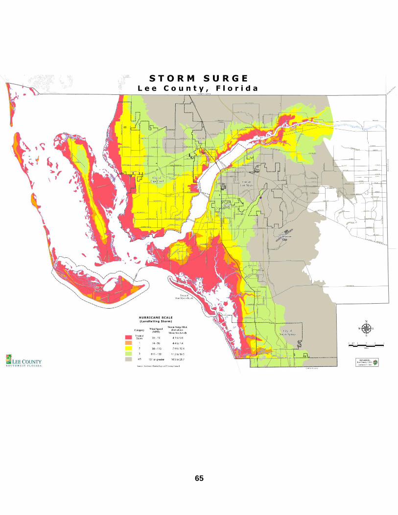
i. Permitting and Mitigation Issues
Because the preserve is comprised mainly of wetland plant communities, should any construction be considered, required permits would need to be obtained from various agencies, including the U. S. Army Corps of Engineers, Florida Department of Environmental Protection, City of Bonita Springs and the South Florida Water Management District. Since the entire area of the Preserve is located within the Lee County Strom Surge /Coastal High Hazard Area any construction considered will need to take this into consideration. (Appendix E) Lee County’s Local Mitigation Strategy supports natural resource protection activities that preserve or maintain natural areas through restoration and nourishment, as well as efforts to purchase environmentally sensitive areas in high hazard flood zones through Conservation 20/20 funds. The stewardship of this preserve implements this strategy. ii. Other Legal Constraints BHIP is located within the City of Bonita Springs and their city ordinances, codes, permits, and/or plans may pertain to this property in addition to the usual restrictions staff is used to implementing. Therefore, contacting city staff will be necessary in the future if any restoration activities may be planned. The entire preserve of Big Hickory Island is zoned Environmentally Critical with the future land use plan designation of Conservation Lands. This protection will have to be taken into consideration for any future amenities. iii. Relationship to Other Plans The Lee Plan, 2011 Codification, is used as a vision for the future. In the first chapter of the Lee Plan, entitled Lee County – A vision for 2020, the three broad purposes of the plan are listed: “First of all, certain day-to-day public and private activities within each jurisdiction must be consistent with the goals, objectives, and policies in the adopted plan. Second, the plan is a source of authority for the local government’s land development regulations and for a wide range of official discretionary actions, including, but not limited to, the capital improvement program. Finally, the plan represents the community’s vision of what it will or should look like by the end of the planning horizon.” The entire Lee Plan is found on the Internet at: http://www.leecounty.com/dcd1/Leeplan/Leeplan.pdf. The two chapters of the Lee Plan

30
that affect the management of Big Hickory Island Preserve are Chapter V, Parks, Recreation and Open Space and Chapter VII, Conservation and Coastal Management. Chapter V states that Land Stewardship Staff ensure that any public use facilities constructed at Big Hickory Island Preserve complies with Goal 85: Park Planning and Design. Staff will also work to provide, whenever staffing and funding permit, appropriate environmental programs to the public in order to meet Goal 86: Environmental and Historic Programs. Under Chapter VII, Goal 107: Resource Protection within Objective 107.1: Environmentally Critical Areas, Lee County Land Stewardship Staff has the responsibility to conserve and enhance the natural functions of environmentally critical lands such as the habitats found at Big Hickory Island Preserve. Objective 107.2: Plant Communities, states Lee County will protect, maintain and routinely update an inventory of native plant communities. Objective 107.3: Wildlife, states that Lee County has a responsibility to maintain and enhance the fish and wildlife diversity for the benefit of a balanced ecological system. Within Objective 106.1: Coastal High Hazard Area Expenditures, Policy 106.1.1 describes the need to seek approval from the county commission for the use of public funds in a Coastal High Hazard Area, in which Big Hickory Island Preserve is located, for the development of public use facilities.
E. Management Constraints
The main constraints to management of the preserve are funding and staffing. Obtaining funds through grants and other sources will need to continue. Coordination with other agencies and adjacent landowners will also be an important part of managing the preserve. Little Hickory Beach Park and Bonita Beach Park are located within three miles of the preserve and staff will coordinate activities that would affect these parks and BHIP when necessary. Environmental education relating to the dynamics of barrier islands will be beneficial for both parks and the preserve.
F. Public Access and Resource Based Recreation
The public has used Big Hickory Island for boating, fishing, camping and swimming for many years. There is presently no parking fee at Big Hickory Island Preserve due to the lack of facilities and limited parking along the road right of way.

31
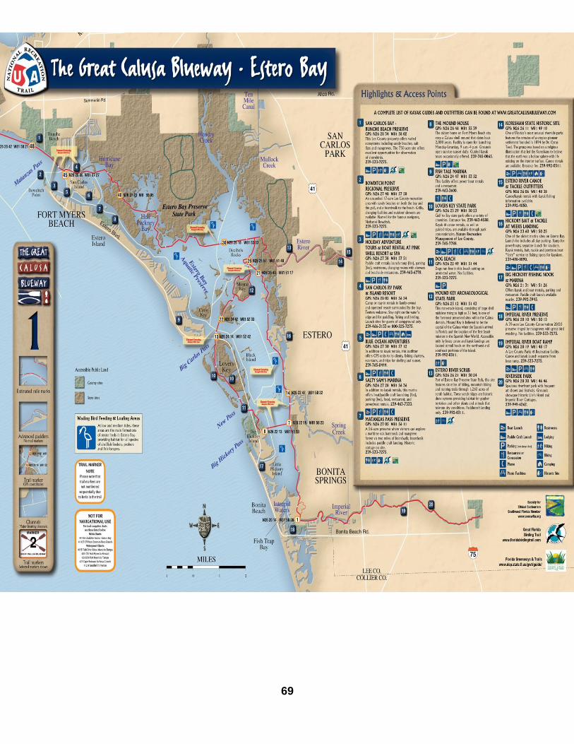
Public use of this preserve will always need to be monitored and controlled to ensure that it does not interfere with the health of the ecosystem or the wildlife that live in this habitat. Staff will make sure that the public is complying with Lee County Parks & Recreation’s Ordinance: 0626(http://www.leecounty.com/gov/bocc/ordinances/Ordinances/06-26.pdf) as well as educating visitors about the preserve and what makes it such a unique and important area. Environmental education programs will be important for educating visitors and residents, instilling respect for the resources while enjoying the preserve. This preserve is Trail Marker number 8 (GPS coordinates N26 22 13 W81 51 13) on the Estero Bay portion of The Great Calusa Blueway which is Lee County’s paddling trail that provides an ecological tour of the bays, rivers, backwaters and shorelines of southwest Florida. Information on this kayak/canoe trail can be found at www.thegreatcalusablueway.com. A map of the Estero Bay portion of this trail is located in Appendix G. Within one half mile north of the preserve is Dog Beach, here dogs can run off leash in the waters of New Pass with their owners. One and one half miles north of the preserve is Lovers Key State Park with many amenities including kayak rentals, rest rooms and showers, walking trails, shelling, bike trails, picnicking, boat launch, playground and guided tours. Two and a half miles north of the preserve is Fort Myers Beach with many beach accesses, restaurants and lodging, Matanzas Pass Preserve, Crescent Beach Family Park, Lynn Hall Beach Park and Bowditch Point Regional Park. One quarter mile south of the preserve is a primitive canoe/kayak launch just off CR 865 right of way into Squaw Creek. A paddle west on this creek will bring you to the sandy beach of Big Hickory Island Preserve. This area is a Lee County department of Transportation Right of Way with stewardship provided cooperatively by Lee County Parks & Recreation. Two miles to the south is Bonita Beach with many public beach accesses, Little Hickory Island Beach Park, Bonita Beach Park, lodging and restaurants. Within three miles there are many preserves and beaches that provide recreational opportunities for the public and cooperative adventures for different government entities. Many things are taken into consideration when planning resource – based activities in preserves including but not limited to: access, plant and animal communities, soil constraints, hydrologic components and archaeological/cultural resources. Restoration and land stewardship activities can impact resource-based activities in designated areas of a preserve. The most utilized areas of this preserve are the beach and waterways. Resource based recreation activities are appropriate for this preserve.

32
As shown in the Master Site Plan for the preserve (Figure 13) limited existing improvements such as an area to off load kayaks and canoes, a primitive trail and regulation signs exist today. A primitive camp site on Bow Tie Island has been created to redirect camping from the gulf side beach and still have an island camping experience. The challenge of providing a positive experience for visitors, while protecting the fragile ecosystem of the preserve, will always be a focus for Lee County staff.

33

34
G. Future Acquisition Adjacent lands to the Preserve are privately owned and are not under consideration for acquisition. Two properties south of the preserve were Conservation nominations #294 and #462, both have been withdrawn by the owners. Conservation 2020 has not been approached by any other willing sellers at this time. If any of these properties were to be considered in the future it would be an addition of waterways and mangrove shoreline to the preserve. VI. Management Action Plan A. Management Units Descriptions The Big Hickory Island Preserve has been divided into two management units to better organize and achieve management goals. Figure 14 delineates the two management units, which were created based on community type, management needs, restoration required and location of CR 865. Management Unit #1 has the strap number of 244 724 B 20000 30000 and is 142.73 acres located in the western portion of the preserve. This area consists of mangrove swamp and beach community which extends north to New Pass and west to the Gulf of Mexico, east to Estero Blvd. / CR 865 and south to the boundary lines of predominately mangrove swamp property owned by Barron Collier Investments LTD and Squaw Creek and Big Hickory Pass. This area includes the Gulf side beach used by visitors and residents and is heavily impacted by beach and camping activities. Management unit #2 has the strap number of 134 724 B 30000 40000 and is 137.29 acres east Estero Blvd. / CR 865 with the north and eastern boundary of Estero Bay and the southern boundary of mangrove swamp owned by CDC Investments Inc. These areas consist mostly of mangroves and now include the primitive camping site on Bow Tie Island. Maintenance for Big Hickory Island Preserve is divided into operations and land stewardship; both are located in the Department of Parks and Recreation. Operations are responsible for stewardship of all the preserves and consist of a manager, supervisor, coordinators, and field technicians. A land steward’s job consists of conservation and restoration of biological communities which includes: exotic pest plant and animal removal and monitoring, debris removal, forming contacts with other groups and agencies to share the latest data on similar land management activities, establishing volunteer programs for the sites, protecting water resources, establishing opportunities for multiple uses and compatibility, providing public access and response to public use. Partnerships with Florida Gulf Coast University, Edison State College, the Department of Environmental Protection, Keep Lee County Beautiful, Florida Paddlers Association

35
and other volunteer groups have created opportunities for thousands of people to explore the mangrove forest and beaches of a gulf coast barrier island, learning the importance of native vegetation and conservation.

36
B. Goals and Strategies Big Hickory Island Preserve is part of a countywide quarterly site inspection program for all preserves. A copy of the site inspection form is available in the Land Stewardship Operations Manual. The inspection allows staff to monitor any impacts and/or changes to each preserve and includes listing all animal sightings and new plants found. If during these inspections at the preserve staff finds FNAI listed species, staff will report those findings to FNAI using the appropriate form located in the Land Stewardship Operations Manual. The Florida Exotic Pest Plant Council’s List of Invasive Species (www.fleppc.org) will be consulted in determining the invasive exotic plants to be controlled in both management units. Invasive exotic plant control will be conducted with the least amount of impact to the preserve possible and with appropriate herbicides (as per the Land Stewardship Operations Manual). The primary management objectives for BHIP are removal and continued treatment of invasive exotic pest plants, continued removal of marine debris and litter with natural area and environmental education. Natural Resource Management Exotic plant control and maintenance Monitor and protect listed species Litter control Public use Educational interpretive panels Develop primitive camping area on Bow Tie Island Volunteers Advertise marine clean up days Target the preserve for special interest groups The following table is a description of how each of these goals will be carried out. Success criteria used to measure accomplishments of each goal and a projected timetable outlining which units each activity will take palce in and when is included.

37
VII. Projected Time Table
Management Activity
July 2012
Oct 2012
Jan 2013
April 2013
July 2013
Oct 2013
Jan 2014
April 2014
July 2014
Natural Resources Exotic plant & animal control
X X X X X X X X X
Monitor and protect listed species
X X X X X X X
Litter control X X X X X X X
Public use Educational panels X Primitive camping X
Volunteers Marine clean up X X X X X X X Work days X X X X
The implementation of this time table is based on obtaining necessary funding for projects. Goals may be delayed or added due to changes in staff, weather conditions or a change in priorities on properties managed by Lee County. This table is created to run for a ten year time period, until 2022, when this stewardship plan will be updated. VIII. Financial Consideration Funding sources will be researched and applications will be made for appropriate grants or other sources of funding such as Florida Fish & Wildlife Conservation Commission Bureau of Invasive Plant Management for exotic plant control projects. Project cost and funding sources are listed in Appendix F.

38
IX. Literature Cited Adams, P. & L.Stockwell, A Method for Wetland Functional Assessment: Critical Review and Evaluation Concepts (Scodari 1990). (Report No. FHWA-IP-82-23, Federal Highway Administration, U.S. Department of Transportation, March 1983). Antonini, Gustavo A. & Fann, David A. & Roat, Paul, (2002). A Historical Geography of Southwest Florida Waterways, Volume Two, Placida Harbor to Marco Island, West coast Inland Navigation District, Venice, Florida. Brown, Adelaide & Barrett, (1965) A Short History of Fort Myers Beach, Estero and San Carlos Islands Florida, Estero Island Publishers, Fort Myers Beach, Florida. Library of Congress Catalog Card Number 65-29236. Charlotte Harbor National Estuary Program, (2000). Committing To Our Future, A Comprehensive Conservation and Management Plan for the Greater Charlotte Harbor Watershed. Fort Myers, Florida Florida Natural Areas Inventory and Florida Department of Natural Resources. (1990).Guide to the Natural Communities of Florida. Florida State University, Tallahassee. Haverfield, Eve M., (2011) Turtle Time Inc. Interview via e-mail Henderson, W.G.Jr.1984. Soil Survey of Lee County, Florida.U.S. Department of Agriculture/Soil Conservation Service. Island –News Paper articles; Big Hickory –Acquisition 11/89 to 02/93 Kaufman, Kenn, (2000).Birds of North America. Houghton Mifflin Company, New York. Lee County Parks & Recreation Historic files: Big Hickory 04/20/73 (part of CJP); Big Hickory Lee County Parks and Recreation Land Stewardship Operations Manual, (2003). Unpublished manuscript, Fort Myers Florida. Myers, Ronald & Ewel, John, (1990).Ecosystems of Florida University of Central Florida Press, Orlando. Scodari, Paul F., (1990).Wetlands Protection: The Role of Economics Environmental Law Institute, Washington D.C.

39
South Florida Ecosystem Restoration Taskforce (1996) South Florida Ecosystem Restoration: Scientific Information Needs Subregion 10. Retrieved 4-16-2003 from http://everglades.fiu.edu/taskforce/scineeds/sub10.pdf. Stapor, Frank Ph.D. in geology. Publications include papers on modern beach-ridge plains, Holocene sea-level history, and the facies and sequence stratigraphy of southeastern US Carboniferous units. Information gained from a personal visit to Matanzas Pass Preserve. Wunderlin, Richard P. and Hansen, Bruce F. (2003). Guide to the Vascular Plants of Florida. Second Edition, University Press Florida, Gainesville, Florida. Wentzel, Mark, (1995) Professional Land Surveyor Florida Certification No.5247 Johnson Engineering, Inc. for the Grant of Conservation Easement by Pelican Landing Community Association.

40
X. APPENDICES Appendix A: Lease Agreement between Lee County and the State of Florida, Department of Environmental Protection, Division of Recreation and Parks Appendix B: Plant sightings at Big Hickory Island Preserve Appendix C: Wildlife Sightings at Big Hickory Island Preserve Appendix D: Lee County Storm Surge Map Appendix E: Projected Cost & Funding Sources Table Appendix F: Great Calusa Blueway Map Appendix G: Minutes of the Big Hickory Island Preserve Public Meeting Appendix A:

41
Lease Agreement between Lee County and the State of Florida, Department of Environmental Protection, Division of Recreation and Parks

42

43

44

45

46

47

48

49

50

51

52

53

54

55
Appendix B: Plant sightings at Big Hickory Island Preserve

56
Appendix B: Plant Sightings at Big Hickory Island Preserve Scientific names for this list were obtained from Wunderlin & Hanson 2003
Family Scientific Name Common Name FDACS FNAI IRC EPPC
Pteridophytes
Pteridaceae (break fern)
53 Acrostichum aureum Golden leather fern T G3/S3 R
Monocotyledons
Amaryllidaceae
75 Hymenocallis latifolia Mangrove spiderlily
Arecaceae (palm)
84 Cocos nucifera Coconut palm
86 Sabal palmetto Cabbage palm
Commelinaceae (spiderwort)
93 Commelina diffusa Common dayflower
Cyperaceae (sedge)
111 Cyperus ligularis Swamp flat sedge
112 Cyperus rotundus Nutgrass
117 Fimbristylis cymosa Hurricanegrass
Dioscoreaceae (yam)
131 Dioscorea bulbifera Air potato I
Poaceae (grass)
187 Cenchrus spinifex Coastal sandbur
216 Paspalum vaginatum Seashore paspalum
225 Spartina patens Saltmeadow cordgrass
227 Sporobolus virginicus Seashore dropseed
229 Uniola paniculata L. Seaoats
Smilacaceae (smilax)
236 Smilax auriculata Earleaf greenbrier
Dicotyledons
Amaranthaceae (amaranth)
257 Atriplex cristata Crested saltbush
259 Salicornia bigelovii Glasswort R
259 Suaeda linearis Sea blite
Anacardiaceae (cashew)
261 Schinus terebinthifolius Brazilian pepper I
261 Toxicodendron radicans Poison ivy
Apocynaceae (dogbane)
275 Asclepias tuberosa Butterflyweed R
276 Cynanchum angustifolium Gulfcoast swallowwort
Asteraceae (aster)
296 Ambrosia artemisiifolia Common ragweed
298 Baccaharis angustifolia Saltwater falsewillow R
298 Baccaharis halimifolia Groundsel tree
299 Bidens alba Beggerticks
300 Borrichia frutescens Bushy sea oxeye
320 Helianthus debilis Dune sunflower
323 Iva imbricata Seacoast marshelder
330 Pluchea rosea Rosy camphorweed
337 Solidago sempervirens Seaside goldenrod R

57
Family Scientific Name Common Name FDACS FNAI IRC EPPC
Avicenniaceae (black mangrove)
344 Avicennia germinans Black mangrove
Bataceae (saltwort)
345 Batis maritima Saltwort
Brassicaceae (mustard)
356 Capparis cynophallophora Jamaican caper
Burseraceae (gumbo-limbo)
362 Bursera simaruba Gumbo limbo
Cactaceae (cactus)
365 Opuntia humifusa Prickly pear cactus
Casuarinaceae (sheoak)
379 Casuarina equisetifolia Australian pine I
Combretaceae (combretum)
390 Conocarpus erectus Buttonwood
390 Laguncularia racemosa White mangrove
Convolvulaceae (morning-glory)
395 Ipomoea alba Moonflower
396 Ipomoea pes-caprae Railroad vine
396 Ipomoea sagittata Saltmarsh morning glory
Euphorbiaceae (spurge)
425 Poinsettia cyathophora Paintedleaf
417 Chamaesyce thymifolia Gulf sandmat
Fabaceae (pea)
432 Abrus precatorius Rosary pea I
438 Caesalpinia bonduc Grey nicker bean
441 Chamaecrista nictitans var. nictitans
Sensitive pea CI
443 Crotalaria pumila Low rattlebox
443 Dalbergia ecastophyllum Coinvine
459 planted Piscidia piscipula Jamaica dogwood
464 Sophora tomentosa Yellow necklacepod R
Goodeniaceae (goodenia)
479 Scaevola plumieri Beachberry; Inkberry T
479 Scaevola taccada Beach naupaka I
Lamiaceae (mint)
488 planted Callicarpa americana Beautyberry
Meliaceae (mahogany)
523 Swietenia mahagoni West Indian mahogany
T
Moraceae (mulberry)
526 Ficus aurea Strangler fig
Myricaceae (bayberry)
528 planted Myrica cerifera Wax myrtle
Oleaceae (olive)
536 Forestiera segregata Florida swamprivet
Passifloraceae (passionflower)
553 Passiflora suberosa Corkystem passionflower
Phytolaccaceae (pokeweed)
554 Phytolacca americana American pokeweed

58
Family Scientific Name Common Name FDACS FNAI IRC EPPC
Plumbaginaceae (leadwort)
558 Limonium carolinianum Carolina sealavender
Polygonaceae (buckwheat)
563 Coccoloba uvifera Seagrape
Rhizophoraceae (mangrove)
578 Rhizophora mangle Red mangrove
Rubiaceae (madder)
591 Randia aculeata White indigoberry
Sapindaceae (soapberry)
599 Cupaniopsis anacardioides Carrotwood I
Solanaceae (nightshade)
608 Lycium carolinianum Christmasberry
609 Physalis walteri Walter’s groundcherry
Surianaceae (baycedar)
614 Suriana maritima Bay cedar R
Verbenaceae (vervain)
622 Lantana camara Lantana I
Exotic (non-native) taxa are highlighted. Exotic taxa are those that have become part of the Florida flora following the occupation by Europeans in the early sixteenth century (1513). (Wunderlin & Hansen) Numbers refer to the page the plant is located in Wunderlin & Hansen. Key FDACS (Florida Department of Agriculture and Consumer Services) E = Endangered T = Threatened CE = Commercially Exploited FNAI (Florida Natural Areas Inventory) G = Global Status T = Global Subspecies that is rare or imperiled S = Florida Status 1 = Critically imperiled because of extreme rarity (5 or fewer occurrences or less than 1000 individuals) or because of extreme vulnerability to extinction due to some natural or man-made factor. 2 = Imperiled because of rarity (6 to 20 occurrences or less than 3000 individuals) or because of vulnerability to extinction due to some natural or man-made factor. 3 = Either very rare and local throughout its range (21-100) occurrences or less than 10,000 individuals) or found locally in a restricted range or vulnerable to extinction from other factors. 4 = Apparently secure 5 = Demonstrably secure IRC (Institute for Regional Conservation) CI = Critically Imperiled I = Imperiled R = Rare Florida EPPC Status (Exotic Pest Plant Council) I = species that are invading and disrupting native plant communities II = species that have shown a potential to disrupt native plant communities

59
Appendix C: Wildlife Sightings at Big Hickory Island Preserve

60
Appendix C: Wildlife Sightings at Big Hickory Island Preserve
Scientific Name Common Name Designated Status
FWC USFWS FNAI
CRUSTACEANS
Family: Grapsidae (marsh, shore and talon crabs)
Aratus pisoni Mangrove tree crab
Family: Ocypodoidea (ghost and fiddler crabs)
Subfamily: Ocypodinae (fiddler crabs)
Uca stylifera Fiddler crab
HORSESHOE CRABS
Family:Limulidae (horseshoe crabs)
Limulus polyphemus Horseshoe crab
ARACHNIDS
Family: Araneidae (orb weaver)
Gasteracantha elipsoides Crab like spiny orb weaver
INSECTS
Family: Cyrtacanthacridinae (spurthroated grasshoppers)
Schistocerca americana American grasshopper
Family: Romaleidae (lubber grasshopper)
Romalea microptera
Family: Pieridae (whites and sulphers)
Subfamily: Pierinae (whites, marbles and orange tips)
Ascia monuste Great southern white
Subfamily: Coliadinae (sulphurs)
Phoebis philea Orange –barred sulphur
Family: Nymphalidae (brushfoots)
Subfamily: Heliconiinae (longwings)
Argaulis vanilla Gulf fritillary
Subfamily: Nymphalinae (brushfoots)
Junonia evarete Mangrove buckeye
Anartia jatrophae White peacock
Family:Hesperiidae (skippers)
Subfamily: Pyrginae (open winged skippers)
Phocides pigmalion Mangrove skipper
AMPHIBIANS
Family: Hylidae (treefrogs and their allies)
Osteopilus septentrionalis Cuban treefrog*
REPTILES
Family: Emydidae (box and water turtles)
Malaclemys macrospilota Ornate diamondback terrapin
Family: Cheloniidae (sea turtles)
Caretta caretta Loggerhead T T G3/S3
Family: Dermochelyidae (leatherback turtles)
Dermochelys coriacea Leatherback E E G2/S2
Family: Polychridae (anoles)
Anolis carolinensis Green anole
Anolis sagrei Brown anole*
Family:Scincidae
Eumeces fasciatus Five lined skink
Family: Colubridae (colubrids)
Coluber constrictor priapus Southern black racer
Nerodia clarkii compressicausa Mangrove salt marsh snake

61
Scientific Name Common Name Designated Status
FWC USFWS FNAI
BIRDS
Family: Anatidae (swans, geese and ducks)
Subfamily: Anatinae (dabbling ducks)
Anas fulvigula Mottled duck
Anas discors Blue- winged teal
Subfamily Merginae (mergansers)
Mergus serrator Red-breasted merganser
Family: Gaviidae (loons)
Gavia immer Common loon
Family: Sulidae ( gannets and boobies)
Morus bassanus Northern gannet
Family: Pelecanidae (pelicans)
Pelecanus erythrorhynchos American white pelican
Pelecanus occidentalis Brown pelican SSC G4/S3
Family: Phalacrocoracidae (cormorants)
Phalacrocorax auritus Double-crested Cormorant
Family: Anhingidae (anhingas)
Anhinga anhinga Anhinga
Family: Fregatidae (frigatebirds)
Fregata magnificens Magnificent frigatebird
Family: Ardeidae (herons, egrets, bitterns)
Ardea herodius Great blue heron
Ardea alba Great egret G5/S4
Egretta thula Snowy egret SSC G5/S3
Egretta caerulea Little blue heron SSC G5/S4
Egretta tricolor Tricolored heron SSC G5/S4
Egretta rufescens Reddish egret SSC G4/S2
Bubulcus ibis Cattle egret
Butorides virescens Green heron
Nycticorax nyticorax Black-crowned night heron G5/S3
Nyctanassa violacea Yellow-crowned night heron G5/S3
Family: Threskiornithidae (ibises and spoonbills)
Eudocimus albus White ibis SSC G5/S4
Ajaia ajaja Roseate spoonbill SSC G5/S2
Family: Cathartidae (new world vultures)
Coragyps atratus Black vulture
Cathartes aura Turkey vulture
Family: Pandionidae (osprey)
Pandion haliaetus Osprey
Family: Accipitridae (hawks, kites, accipiters, harriers, eagles)
Subfamily: Elaninae and Milvinae (kites)
Elanoides forficatus Swallow-tailed kite G5/S2
Subfamily: Buteoninae (buzzard, hawks and eagles)
Hailaeetus leucocephalus Bald Eagle T G5/S3
Buteo lineaus Red shouldered hawk
Subfamily: Falconinae (falcons)
Falco sparverius American kestrel
Family: Charadriidae (plovers)
Charadrius alexandrinus Snowy plover T G4/S1
Charadrius melodus Piping plover T T G3/S2
Charadrius semipalmatus Semipalmated plover

62
Scientific Name Common Name Designated Status
FWC USFWS FNAI
Family: Charadriidae (plovers)
Charadrius wilsonia Wilson’s plover
Pluvialis squatarola Black-bellied plover
Family: Haematopodidae (oystercatchers)
Haematopus palliatus American oystercatcher SCC G5/S2
Family: Scolopacidae (sandpipers and phalaropes)
Actitis macularia Spotted sandpiper
Arenaria interpres Ruddy turnstone
Calidris alba Sanderling
Calidris canutus Red knot
Calidris mauri Western sandpiper
Calidris minutilla Least sandpiper
Catoptrophorus semipalmatus Willet
Limnodromus griseus Short-billed dowitcher
Limosa fedoa Marbled godwit
Numenius phaeopus Whimbrel
Tringa solitaria Solitary sandpiper
Family: Laridae (gulls)
Larus atricilla Laughing gull
Larus delawarensis Ring-billed gull
Subfamily: Sterninae (terns)
Sterna maxima Royal tern G5/S3
Sterna sandvicensis Sandwich tern G5/S2
Stern hirundo Common tern
Sterna antillarum Least tern T G4/S3
Family: Rynchopinae (skimmers)
Rynchops niger Black skimmer SSC G5/S3
Family: Columbidae (pigeons and doves)
Zenaida macroura Mourning dove
Columbina passerina Common ground dove
Family: Cuculidae (cuckoos and their allies)
Coccyzus minor Mangrove cuckoo G5/S3
Family: Strigidae (true owls)
Bubo virginianus Great horned owl
Family: Caprimulgidae (goatsuckers)
Chordeiles minor Common nighthawk
Family: Alcedinidae (kingfishers)
Ceryle alcyon Belted kingfisher
Family: Picidae (woodpeckers)
Melanerpes carolinus Red-bellied woodpecker
Dryocopus pileatus Pileated woodpecker
Family: Corvidae (cros, jays, ect.)
Cyanocitta cristata Blue jay
Corvus brachyrhyncos American crow
Corvus ossifragus Fish crow
Family: Hirundinidae (swallows)
Progne subis Purple martin
Hirundo rustica Barn swallow
Family: Sylvidae (gnatcatchers)
Polioptila caerulea Blue-grey gnatcatcher

63
Scientific Name Common Name Designated Status
FWC USFWS FNAI
Family: Mimidae (mockingbirds and thrashers)
Mimus polyglottos Northern mockingbird
Family: Parulidae (wood-warblers)
Dendroica discolor Prairie warbler
Dendroica palmarum Palm warbler
Family: Cardinalidae (cardinals, some grosbeaks, new world buntings, ect.)
Cardinalis cardinalis Northern cardinal
Family: Icteridae (blackbirds, orioles, ect.)
Quiscalus quiscula Common grackle
MAMMALS
Family: Dildelphidae (opossums)
Didelphis virginiana Virginia Opossum
Family: Leporidae (rabbits and hares)
Sylvilagus palustris Marsh rabbit
Family: Felidae (cats)
Lynx rufus Bobcat
Family: Procyonidae (raccoons)
Procyon lotor Raccoon
Key FWC: Florida Fish & Wildlife Conservation Commission USFWS: United States Fish and Wildlife Service FNAI: Florida Natural Areas Inventory SSC: Species of Special Concern T: Threatened E: Endangered FNAI (Florida Natural Areas Inventory) G = Global Status T = Global Subspecies that is rare or imperiled S = Florida Status 1 = Critically imperiled because of extreme rarity (5 or fewer occurrences or less than 1000 individuals) or because of extreme vulnerability to extinction due to some natural or man-made factor. 2 = Imperiled because of rarity (6 to 20 occurrences or less than 3000 individuals) or because of vulnerability to extinction due to some natural or man-made factor. 3 = Either very rare and local throughout its range (21-100) occurrences or less than 10,000 individuals) or found locally in a restricted range or vulnerable to extinction from other factors. 4 = Apparently secure 5 = Demonstrably secure
* = Not native

64
Appendix D Lee County Storm Surge-Coastal High Hazard
65

66
Appendix E Projected Cost and Funding Sources Table

67
Projected Cost and Funding Sources Table Structures and Improvements Item Possible Funding source Estimated cost
Trail improvement Boundary markers New foot trails Information signs
Tourist Development Council (TDC) and or Program Grants(FRDAP)
$ 1,000.00 $ 1,000.00 $ 1,000.00 $ 5,000.00
$ 8,000.00 Education Programs Item Possible Funding Estimated Cost
Education: Program Material including trail guides
Lee County Parks and Recreation
$ 5,000.00
$ 5,000.00 Site Management & Maintenance Item Possible Funding Estimated Cost
Exotic Plant Control Lee County Parks & Recreation
$ 1,000.00 per year
Trail Maintenance
Lee County Parks and Recreation
$ 1,000.00 per year
$ 2,000.00

68
Appendix F The Great Calusa Blueway Map
69

70
Appendix G Minutes of the Big Hickory Island Preserve Public Meeting August 7, 2012

71
Minutes of Big Hickory Island Preserve Public Meeting August 7, 2012
Notes taken by Annisa Karim
In attendance: five residents of Lee County, one City of Bonita Springs official, four Lee County Parks & Recreation staff, one Florida Gulf Coast University college intern.
Public meeting started on time at 6:00pm in the Bonita Springs Library meeting room.
Terry Cain, Land Stewardship Coordinator for Lee County Parks & Recreation introduced herself and presented a short power point program on the Land Stewardship Plan.
Questions and statements from the audience:
Lee County Resident for ten years: swimming beach is a misnomer. The beach is actually a boating beach. There is confusion in the LSP about the Bonita Springs Ordinance-vessel exclusion swim area only - correction to plan - this should be added. Area is marked as 400 foot swim area is attached-but there is no exhibit A in packet. Where is the 400 foot linear area marked as swim only? 400 feet actually belongs in front of Pelican Island Beach Park-not on Big Hickory Island boundary. (See exhibit A of Bonita Springs Ordinance.)
Same resident: Nobody wants signs on the beach.
Sign say no nudity-under what authority? Florida State Law is worthless-nudity must be accompanied by lewd and lascivious behavior. A Supreme Court Ruling-Florida State Law 800.03 Lee County Ordinance refers to it. Why put unenforceable laws on the sign.
Do not put the sign up! Mother Nature does not want your sign.
Also please no trash cans!
Sign says no fires, no camping-how would people know that fires and camping are allowed on Bow Tie Island…clarify signs.
No smart people actually camp on the island-if you camp overnight on the beach side and the weather turns you could be in trouble. We shouldn’t worry about people cutting live trees-doesn’t happen that often.
Remove swimming beach icon and designation from Master Site Plan.
Slow speed buoys are good.
What’s going on with the dredging of New Pass?
A plea for volunteers and explain the Lee County Parks & Recreation Volunteer Program.