biodiversity information for decision-makers… · biodiversity information for decision-makers: a...
TRANSCRIPT

Proceedings of the 2013 International Conference on Ecology and Transportation (ICOET 2013)
BIODIVERSITY INFORMATION FOR DECISION-MAKERS:
A CONSERVATION PARTNERSHIP IN NEW YORK
John J. Schmid, GISP (518-402-8930, [email protected]), GIS Specialist,
New York Natural Heritage Program, 625 Broadway, Albany, NY 12233-4757
Schmid 2
Abstract: The New York Natural Heritage Program (NYNHP) tracks over 12,500 locations of
rare and endangered species and significant natural communities in New York in a complex
tabular and spatial database format. The New York State Department of Transportation
(NYSDOT) is responsible for approximately 15,000 miles of highways in the state, of which
about 8,300 miles intersect with NYNHP rare species and natural community locations.
NYNHP has for years provided NYSDOT with Geographic Information Systems (GIS) digital
spatial data of its precise locations. However, knowing these locations is of limited benefit if the
data users don’t know exactly what kind of habitat is used by that species or how DOT activities
could impact it. It had become apparent to both partners that many NYSDOT staff, including
those making decisions that could potentially result in on-the-ground impacts to biodiversity, had
little awareness of the NYNHP dataset, nor how to interpret and apply the data to their daily
operations. To address this gap in understanding, NYSDOT funded a 5-year project entitled
Biodiversity Information for Decision-Makers (BIDM).
The overall objective of this project was to provide NYSDOT with powerful new conservation
tools that would assist their staff in both project site-level planning and planning in a broader
context. These new tools should help staff make better decisions about how to design and modify
activities that might affect rare species and natural communities.
This objective was achieved through three primary procedures: 1) Improved mapping of selected
Heritage locations; 2) Modeling the landscape surrounding known Heritage locations (Important
Areas); and 3) Creating online fact sheets of NYNHP’s listed species and communities
(Conservation Guides).
Over 400 Natural Heritage locations were screen-digitized to increase the precision of their
spatial representation, and these locations were an essential input for the next procedure,
Important Area modeling.
Important Areas (IAs) are the areas around known observed locations that have conservation
importance, and are modeled by enlarging or buffering the observation locations based on natural
history requirements of a species, species guild, or natural community. For example, while a
turtle might have only been observed in a specific wetland, the IA would also include upland
habitat that the turtle needs for breeding and for dispersing between wetlands. Forty-seven (47)
IA models (automated in Python script tools in ArcGIS) have been developed in New York State
through this project. GIS datasets of Natural Heritage locations and of IAs, along with
documentation and training in applying them, have been provided to NYSDOT staff having
direct responsibility for potential ecological impacts on the ground.
NYNHP has also posted on its public website online “Conservation Guides” for over 200 rare
species and natural communities. These guides provide concise, easily accessible information
about habitat, why the species and ecosystems are rare, threats to their viability, management
considerations, and other information that NYSDOT planners and managers can use to make
informed decisions regarding land use, natural resources, and transportation infrastructure. The
guides offer insight that translates a catalogue of NYNHP locations into a conservation tool
understandable to anyone.
Schmid 3
POWERFUL NEW CONSERVATION & PLANNING TOOLS
The New York Natural Heritage Program (NYNHP) tracks over 12,500 locations of 1,078 rare
and endangered species and significant natural communities in New York in a complex tabular
and spatial database format. Most partners that use New York Natural Heritage Program
(NYNHP) data for planning and conservation do not have technical science training. As such,
sharing raw NY Natural Heritage data with them is not necessarily providing the information
they really need for effective action. NY Natural Heritage has therefore partnered with the New
York State Department of Transportation (DOT) to develop interpreted information that DOT
planners and project managers can use to further conservation of New York’s most imperiled
animals, plants, and ecosystems.
This interpreted information (a) shows the areas important to each rare species and significant
ecosystem (not just where they were found); and (b) explains how they are threatened and what
management considerations will help ensure their survival. The information has been developed
in two formats – Geographic Information Systems (GIS) digital spatial data and online
conservation guides. These resources will provide important technical information early in
decision-making processes. This information will enable users to:
understand the implications of rare species and significant ecosystems at different sites
make better decisions about how to design and modify activities that may affect them
put the rare species and significant ecosystems into a broader context for planning
These resources have just recently been rolled out to the DOT, but we expect that ultimately they
will result in more complete DOT project plans, faster project reviews, and more informed land-
use decisions that will help ensure the conservation of these imperiled resources.
The DOT has provided NYNHP with funding to create GIS data and online conservation guides
for the 235 rare species and 48 ecosystem types that occur within New York City and Long
Island, with the goal of eventually rolling these products out statewide. There were three main
components of this project:
1) Digital re-map of coarsely mapped NYNHP species and natural community
(ecosystems) locations on Long Island and in New York City.
2) Develop GIS spatial data that interprets the NYNHP locations to not just the location
where an NYNHP animal, plant, or natural community was found, but to also include
the area important to the viability of the species or natural community at a given
NYNHP location, These areas are referred to as Important Areas (IAs).
3) Develop publicly accessible online fact sheets of NYNHP’s listed species and
communities. These fact sheets are referred to as Conservation Guides or simply
Guides.
Schmid 4
Digital Re-Maps
During its first 13 years of operation, NYNHP mapped locations of rare species and of
significant natural communities on paper USGS 1:24,000 7.5’ x 7.5’ topographic maps. Each
individual location of a given species or community type is called an element occurrence, or
occurrence. If the occurrence occupied a very small area, smaller than 100 meters across (such as
occurrences consisting of only a few plants), it was represented with a dot on the map, and a
mylar grid was used to calculate the latitude and longitude (lat/long) of the dot; this lat/long was
then entered into the Natural Heritage database. If the occurrence occupied a larger area (as with
almost all natural communities), the boundaries of that area were drawn on the paper topo map,
and the mylar grid was used to calculate not only the lat/long of a centrum point, but also the
latitudes of the northernmost and southernmost extents and the longitudes of the easternmost and
westernmost extents, which again were entered into the database.
The actual locations of many occurrences are not known, because of a lack of detail in the
original source documentation. If the actual location of such an occurrence was presumed to be
within 1.5 mi (about one minute of latitude or longitude) of a likely point, that point was mapped
on the paper topo map, and the occurrence was assigned an M in the database for ‘Minutes
precision’. If the actual location could only be narrowed down to within 5 miles of a point, that
point was mapped and the occurrence was assigned a G for ‘General precision’. The lat/long of
these points were calculated and entered into the database.
In the late 1990’s, NYNHP started digitally mapping occurrences using GIS, and had to convert
all the existing occurrences mapped on paper. It was impractical to hand digitize all the
occurrences already mapped on paper, so in 1999 some procedures were developed which
allowed for the quick conversion of occurrences into GIS, but which in many cases generalized
the location of the occurrence.
For occurrences mapped with just a point, the lat/long from the database was used to digitize a
point which was then buffered up to 100 meters. For occurrences mapped with hand-drawn
boundaries on the map, the latitudes and longitudes of the extents of the boundary were pulled
from the database and used to create a rectangle called the ‘least rectangle’, so named because it
was the smallest rectangle that could still contain the full extent of the mapped occurrence.
For occurrences assigned M, the lat/long in the database was used to define a point, which was
then buffered by 1.5 miles to form a large M-precision circle. For occurrences assigned G, the
lat/long in the database was used to define a point, which was then buffered by 5 miles to form a
very large G-precision circle.
The end result of the conversion to GIS of occurrences mapped on paper was a set of
occurrences that were accurately mapped (originally mapped to just a very small area), and a set
of occurrences whose representation in GIS was generalized with least rectangles or large circles.
At the start of this project, 36 rare animal occurrences, 250 rare plant occurrences, and 116
significant community occurrences on Long Island were represented in NYNHP’s spatial
database (Biotics) as least rectangles. An additional four recent animal occurrences and 17 recent
plant occurrences on Long Island were represented with large M- or G-precision circles.

Schmid 5
With GIS, we have the ability to accurately digitize the actual boundaries of occurrences known
to cover a large area. For occurrences whose precise locations are not known, we have the ability
to digitize for each occurrence a custom area, somewhere within which that occurrence is
presumed to have actually occurred. However, performing this digitizing on the occurrences
converted from paper maps was opportunistic, depending on funding.
One goal of this project was to digitize more accurate spatial representations of these least
rectangles and large circle occurrences on Long Island, using existing information and recent
aerial photography. Re-maps included a careful review of all associated database records and
manual files in order to determine the best available information on the location.
NYNHP has been providing EO data to DOT for years. Now hundreds of them are mapped more
precisely, and were available as input for the Important Area mapping. Both the raw EO and
interpreted IA data will serve DOT as valuable project planning resources.
Interpreted NYNHP Data: Important Areas
Important Areas (IAs) are lands and waters that support the continued presence and quality of
known populations of rare animals and rare plants, or of documented examples of rare or high-
quality ecological communities. Important Areas include the specific locations where the
animals, plants, and/or ecological communities have been observed, but go beyond these to also
include:
additional habitat for the rare animal and plant populations, including areas which may be
used by rare animals for breeding, nesting, feeding, roosting, or over-wintering.
areas that support the natural ecological processes critical to maintaining the habitats of
these rare animal and plant populations, or critical to maintaining these significant
communities.
Important Areas are digitally delineated using Geographic Information System (GIS) geo-
processing tools and models (ESRI ArcGIS and Python scrimping language), based on
methodologies developed by NYNHP biologists. For rare animals, the models are based on
knowledge of the animal’s habitat and life history. For example, the Important Area for a
Southern Leopard Frog (Lithobates sphenocephalus) would extend beyond the wetland where it
was found (the EO) to include the various breeding wetlands during nocturnal rains.
Important Areas also include land around these animal habitats, and around rare plant
populations and significant ecological communities that sustain ecological processes and that
provide a buffer against disturbance. For example, for the wetland habitats identified for the
Southern Leopard Frog above, the Important Area would also include an area around the
wetlands that would contribute to maintaining favorable water quality and flow in the wetlands.
The size of these surrounding areas can vary depending on the steepness and aspect of slopes, the
type of soils, and the surrounding land cover.
Important Areas do not include all potential habitat for the species within its range; rather, they
are the areas important to known populations and locations. Important Areas are based on best
Schmid 6
available information, but do not represent a comprehensive inventory of resources or habitats.
Lands outside the Important Areas on these maps may also support rare animals and plants and
significant ecosystems, or provide ecological benefits.
With funding from New York State Department of Transportation (DOT), NYNHP has
completed a set of 47 Important Area models around more than 2,444 individual locations of
about 73 animal species (1093 occurrences), about 125 plant species (1090 occurrences), and
about 37 ecological community types (261 occurrences), in New York City and Long Island.
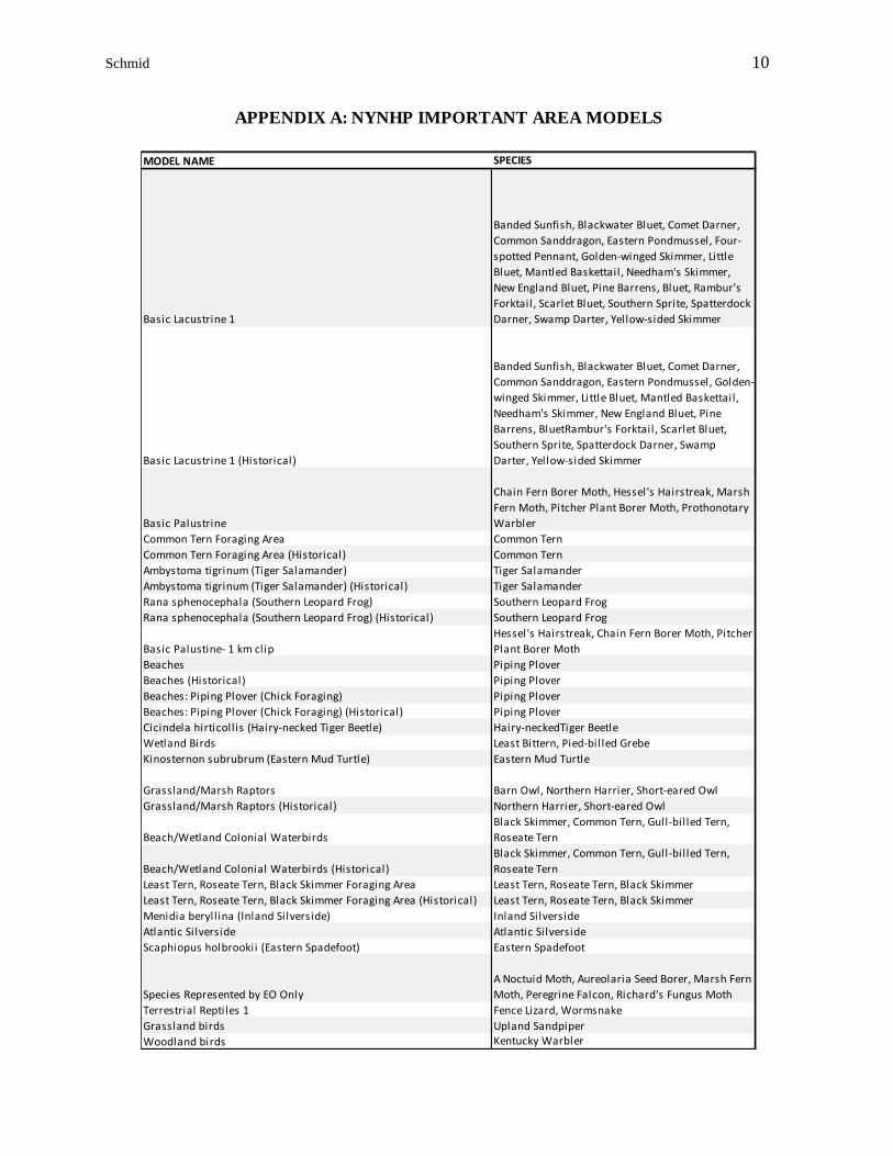
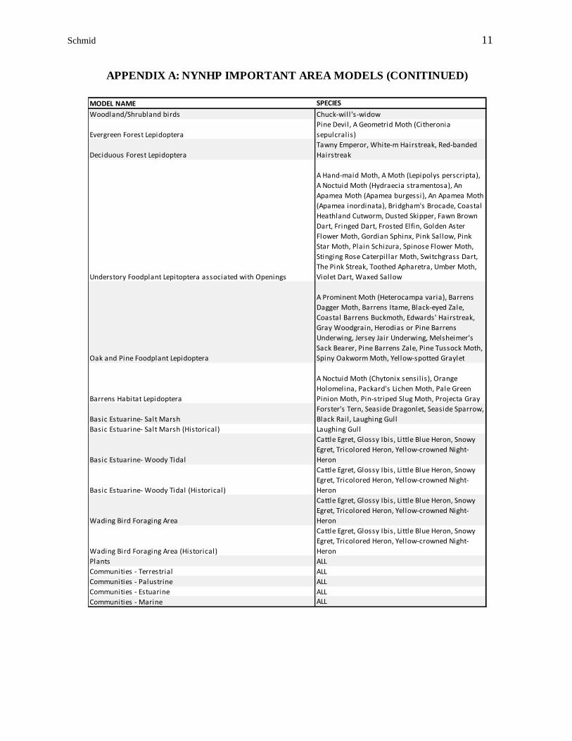
Please see Appendix A for a table of the Important Area models developed for this project. The
Important Area data layers will be used by DOT staff to incorporate more biodiversity
information in planning and project management. Important Area data layers will also be
provided to New York State Department of Environmental Conservation (DEC) staff and other
state agencies, and to conservation partners for use in biodiversity protection and conservation.
Conservation Guides
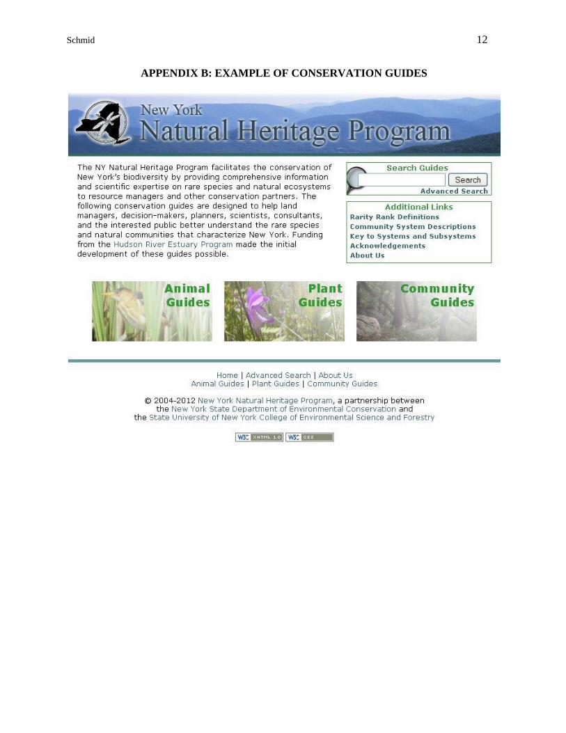
Conservation Guides (Guides) (www.guides.nynhp.org) are online fact sheets for the species and
natural communities whose locations NYNHP tracks in its database, Biotics. The Guides that
existed before this project were completed under an earlier project funded by the New York State
Department of Environmental Conservation (NYSDEC) Hudson River Estuary Program
(HREP), to assist land use planning and decisions. Development of these Guides has been an
ongoing task for the Program. As a result of funding provided by DOT through this project,
Guides for 73 animals, 125 plants, and 37 natural communities have been created. These Guides
explain basic ecological information, including identifying characters, life history information,
and distribution. The Guides also contain information on conservation issues, including trends,
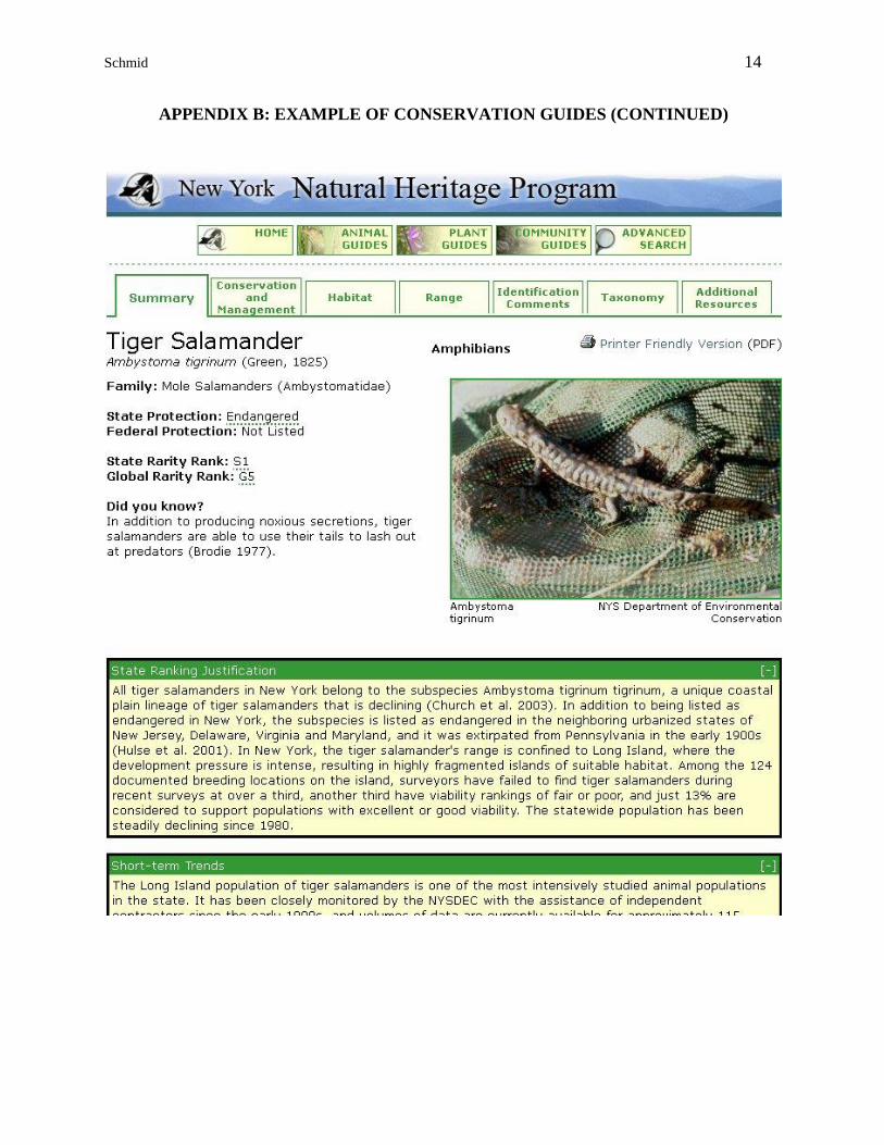
threats, management implications, and research needs. Please see Appendix B for an example of
the Guides.
In creating new and revising existing guides there was a focus on consistency, both in how the
information is presented and in the level of detail the Guides contain. Where possible,
redundancy was reduced by addressing conservation issues for groups of ecologically similar
species and by linking threats and management considerations for individual species back to the
community (or habitat) within which they reside. Specifically, the Guides include the following:
specific and detailed information on management practices/techniques for use by
decision-makers and conservation practitioners;
information addressing both biodiversity considerations, development
considerations, and impact abatement;
more links to and references for successful species-specific management
techniques and scientific research;
more links to other resources, including other conservation programs, permits,
agency contacts, and conservation issues such as invasive species;
research needs for better management and protection; and
improved look and functionality.
Schmid 7
While the scope of the previous Guides had been limited to those species and communities found
in the lower Hudson River Basin, the study area for this project focused on Long Island and New
York City. The first step of this project was for NYNHP to develop a prioritized list of
Conservation Guides that needed to be revised or created. Once the list was established,
available data was synthesized, scientific literature was reviewed, and NYSDEC staff and other
experts were consulted to create draft revised/new Conservation Guides. These draft guides
were reviewed by NYSDEC staff. Once approved, New York Natural Heritage Program posted
them on the Guides website (www.guides.nynhp.org).
For developing the Guides, NYNHP used the following methodology:
1. Develop management considerations by synthesizing existing information in the NY Natural
Heritage database, review of scientific literature, and consultation with experts. Management
considerations combine information on ecological processes, habitat requirements, and points
of vulnerability with discussions of threats, such as hydrologic changes or intensive logging.
They provide general information that can be integrated into site-specific decisions.
2. Prepare descriptions with explanations of processes that are geared for municipal and agency
planners, and conservation professionals that do not have biological training. Prepare similar
descriptions for groups of species that share a common habitat and are so technical in nature
that there is less demand for specifics on each species, such as selected pine barrens moths.
3. Obtain clear photographs showing species, and natural community type and natural community
class.
5. Develop map templates that pull locational data directly from the NY Natural Heritage
database to display locations within the Hudson River Valley and New York for each rare
species and natural community type.
6. Develop conservation guide templates that pull information fields directly from the NY Natural
Heritage database, thereby allowing rapid and automatic updates as new information becomes
available.
7. Generate conservation guides for the 198 animal and plant species, and 37 natural community
types currently known within the Long Island and New York City study area. These
conservation guides may include, at a minimum: species/natural community name, state rarity
rank, global rarity rank, description (including, for natural communities, characteristic plant
and animal species), factors that determine quality, distribution map of known exemplary
occurrences, best time to see (for rare species), excellent example (only for communities with
occurrences on lands open for public visitation), and list of source information.
8. Prepare hard copy versions of conservation guides and distribute these copies to partners
interested in reproducing them and distributing them further. Also, post the conservation
guides on the NY Natural Heritage web site in formats that can be downloaded. Ensure that
links to the web-based conservation guides are in partner web sites, particularly NYS DEC’s
NY Nature Explorer.
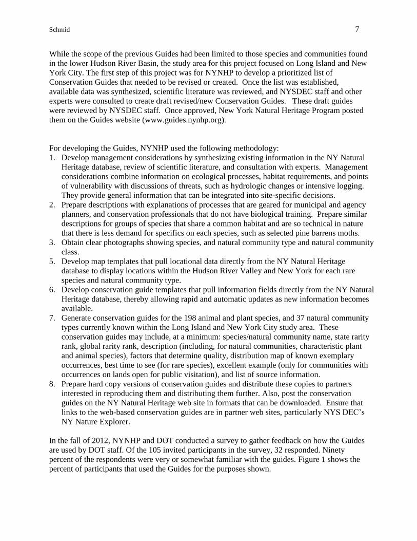
In the fall of 2012, NYNHP and DOT conducted a survey to gather feedback on how the Guides
are used by DOT staff. Of the 105 invited participants in the survey, 32 responded. Ninety
percent of the respondents were very or somewhat familiar with the guides. Figure 1 shows the
percent of participants that used the Guides for the purposes shown.
Schmid 8
FIGURE 1
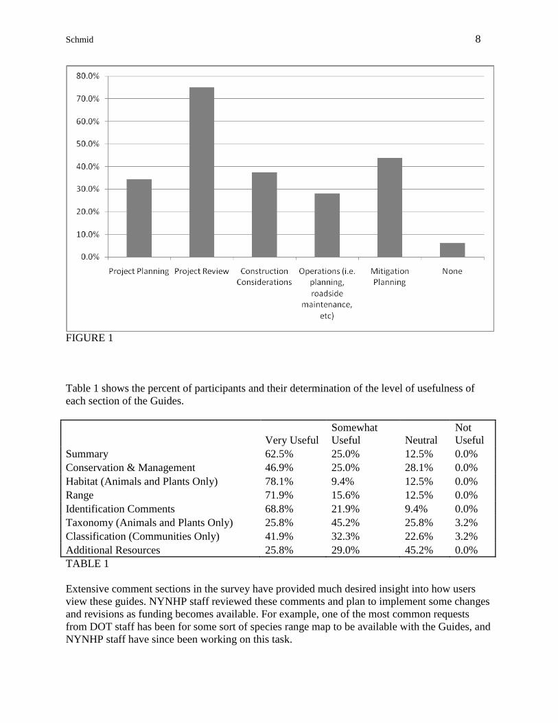
Table 1 shows the percent of participants and their determination of the level of usefulness of
each section of the Guides.
Very Useful
Somewhat
Useful Neutral
Not
Useful
Summary 62.5% 25.0% 12.5% 0.0%
Conservation & Management 46.9% 25.0% 28.1% 0.0%
Habitat (Animals and Plants Only) 78.1% 9.4% 12.5% 0.0%
Range 71.9% 15.6% 12.5% 0.0%
Identification Comments 68.8% 21.9% 9.4% 0.0%
Taxonomy (Animals and Plants Only) 25.8% 45.2% 25.8% 3.2%
Classification (Communities Only) 41.9% 32.3% 22.6% 3.2%
Additional Resources 25.8% 29.0% 45.2% 0.0%
TABLE 1
Extensive comment sections in the survey have provided much desired insight into how users
view these guides. NYNHP staff reviewed these comments and plan to implement some changes
and revisions as funding becomes available. For example, one of the most common requests
from DOT staff has been for some sort of species range map to be available with the Guides, and
NYNHP staff have since been working on this task.
Schmid 9
NYNHP and DOT have also been discussing augmentation of the management sections of the
Guides. It is hoped that the gap between DOT staff knowledge and activities, and NYNHP
biological expertise can be bridged by using the Guides to address specific DOT functions as
they relate to NYNHP species and natural communities. A frequent example brought up during
these discussions is DOT maintenance activities such as mowing roadsides. How does DOT
currently schedule mowing roadsides? Once NYNHP knows more about this activity, could there
perhaps be a better time to mow – both time of year and time of day? It is believed by both
partners that a more specific and detailed management section for the Guides will greatly aid
efforts to protect species of greatest conservation need and the habitats that support them. In
addition, completely new guides are needed for the most vulnerable species that only occur
outside the Hudson River Basin, Long Island, and New York City.
ACKNOWLEDGEMENTS
On behalf of the New York Natural Heritage Program, I extend my thanks to the New York State
Department of Transportation for funding this project and specifically within that organization,
Deb Nelson and Brandon Greco, both of whom are extremely enthusiastic about addressing
biodiversity as it relates to their agency’s activities. I’d like to thank Nick Conrad, NYNHP
Information Manager, for helping me put this document together and incorporating sections he
had already written. Virtually all of NYNHP’s staff members have contributed in some way to
this project, and for that I am grateful to them. Thanks to the ICOET Program Committee for
accepting this presentation abstract and allowing me to present this project so that others can
learn about this very worthwhile project.
BIOGRAPHICAL SKETCH
After receiving a Bachelor’s degree in engineering and serving a brief stint as a Field Engineer in
the semiconductor industry, John Schmid despised wearing a clean-suit and therefore went back
to school to earn a Master of Science degree in Environmental Science at the University of New
Haven. From there he held municipal and regional planning positions in Connecticut and
Massachusetts, with an emphasis in environmental planning and geographic information systems
(GIS). John has been a GIS Specialist for the New York Natural Heritage Program since 2000.
This position has allowed him to utilize a diverse skill-set across the full gamut of GIS
technology-tasks, from simple mapping to scripting and modeling.
John lives near extended family in the beautiful landscape of the Hudson Valley in upstate New
York, with his wife and two daughters. John enjoys archery, hunting, mechanical tinkering, home
improvement, and especially spending time with his girls - camping, fishing, and dressing up like
a princess (but not usually all at the same time).
Schmid 10
MODEL NAME SPECIES
Basic Lacustrine 1
Banded Sunfish, Blackwater Bluet, Comet Darner,
Common Sanddragon, Eastern Pondmussel, Four-
spotted Pennant, Golden-winged Skimmer, Little
Bluet, Mantled Baskettail, Needham's Skimmer,
New England Bluet, Pine Barrens, Bluet, Rambur's
Forktail, Scarlet Bluet, Southern Sprite, Spatterdock
Darner, Swamp Darter, Yellow-sided Skimmer
Basic Lacustrine 1 (Historical)
Banded Sunfish, Blackwater Bluet, Comet Darner,
Common Sanddragon, Eastern Pondmussel, Golden-
winged Skimmer, Little Bluet, Mantled Baskettail,
Needham's Skimmer, New England Bluet, Pine
Barrens, BluetRambur's Forktail, Scarlet Bluet,
Southern Sprite, Spatterdock Darner, Swamp
Darter, Yellow-sided Skimmer
Basic Palustrine
Chain Fern Borer Moth, Hessel's Hairstreak, Marsh
Fern Moth, Pitcher Plant Borer Moth, Prothonotary
Warbler
Common Tern Foraging Area Common Tern
Common Tern Foraging Area (Historical) Common Tern
Ambystoma tigrinum (Tiger Salamander) Tiger Salamander
Ambystoma tigrinum (Tiger Salamander) (Historical) Tiger Salamander
Rana sphenocephala (Southern Leopard Frog) Southern Leopard Frog
Rana sphenocephala (Southern Leopard Frog) (Historical) Southern Leopard Frog
Basic Palustine- 1 km clip
Hessel's Hairstreak, Chain Fern Borer Moth, Pitcher
Plant Borer Moth
Beaches Piping Plover
Beaches (Historical) Piping Plover
Beaches: Piping Plover (Chick Foraging) Piping Plover
Beaches: Piping Plover (Chick Foraging) (Historical) Piping Plover
Cicindela hirticoll is (Hairy-necked Tiger Beetle) Hairy-neckedTiger Beetle
Wetland Birds Least Bittern, Pied-billed Grebe
Kinosternon subrubrum (Eastern Mud Turtle) Eastern Mud Turtle
Grassland/Marsh Raptors Barn Owl, Northern Harrier, Short-eared Owl
Grassland/Marsh Raptors (Historical) Northern Harrier, Short-eared Owl
Beach/Wetland Colonial Waterbirds
Black Skimmer, Common Tern, Gull-bil led Tern,
Roseate Tern
Beach/Wetland Colonial Waterbirds (Historical)
Black Skimmer, Common Tern, Gull-bil led Tern,
Roseate Tern
Least Tern, Roseate Tern, Black Skimmer Foraging Area Least Tern, Roseate Tern, Black Skimmer
Least Tern, Roseate Tern, Black Skimmer Foraging Area (Historical) Least Tern, Roseate Tern, Black Skimmer
Menidia beryll ina (Inland Silverside) Inland Silverside
Atlantic Silverside Atlantic Silverside
Scaphiopus holbrookii (Eastern Spadefoot) Eastern Spadefoot
Species Represented by EO Only
A Noctuid Moth, Aureolaria Seed Borer, Marsh Fern
Moth, Peregrine Falcon, Richard's Fungus Moth
Terrestrial Reptiles 1 Fence Lizard, Wormsnake
Grassland birds Upland Sandpiper
Woodland birds Kentucky Warbler
APPENDIX A: NYNHP IMPORTANT AREA MODELS
Schmid 11
MODEL NAME SPECIES
Woodland/Shrubland birds Chuck-will 's-widow
Evergreen Forest Lepidoptera
Pine Devil, A Geometrid Moth (Citheronia
sepulcralis)
Deciduous Forest Lepidoptera
Tawny Emperor, White-m Hairstreak, Red-banded
Hairstreak
Understory Foodplant Lepitoptera associated with Openings
A Hand-maid Moth, A Moth (Lepipolys perscripta),
A Noctuid Moth (Hydraecia stramentosa), An
Apamea Moth (Apamea burgessi), An Apamea Moth
(Apamea inordinata), Bridgham's Brocade, Coastal
Heathland Cutworm, Dusted Skipper, Fawn Brown
Dart, Fringed Dart, Frosted Elfin, Golden Aster
Flower Moth, Gordian Sphinx, Pink Sallow, Pink
Star Moth, Plain Schizura, Spinose Flower Moth,
Stinging Rose Caterpillar Moth, Switchgrass Dart,
The Pink Streak, Toothed Apharetra, Umber Moth,
Violet Dart, Waxed Sallow
Oak and Pine Foodplant Lepidoptera
A Prominent Moth (Heterocampa varia), Barrens
Dagger Moth, Barrens Itame, Black-eyed Zale,
Coastal Barrens Buckmoth, Edwards' Hairstreak,
Gray Woodgrain, Herodias or Pine Barrens
Underwing, Jersey Jair Underwing, Melsheimer's
Sack Bearer, Pine Barrens Zale, Pine Tussock Moth,
Spiny Oakworm Moth, Yellow-spotted Graylet
Barrens Habitat Lepidoptera
A Noctuid Moth (Chytonix sensil is), Orange
Holomelina, Packard's Lichen Moth, Pale Green
Pinion Moth, Pin-striped Slug Moth, Projecta Gray
Basic Estuarine- Salt Marsh
Forster's Tern, Seaside Dragonlet, Seaside Sparrow,
Black Rail, Laughing Gull
Basic Estuarine- Salt Marsh (Historical) Laughing Gull
Basic Estuarine- Woody Tidal
Cattle Egret, Glossy Ibis, Little Blue Heron, Snowy
Egret, Tricolored Heron, Yellow-crowned Night-
Heron
Basic Estuarine- Woody Tidal (Historical)
Cattle Egret, Glossy Ibis, Little Blue Heron, Snowy
Egret, Tricolored Heron, Yellow-crowned Night-
Heron
Wading Bird Foraging Area
Cattle Egret, Glossy Ibis, Little Blue Heron, Snowy
Egret, Tricolored Heron, Yellow-crowned Night-
Heron
Wading Bird Foraging Area (Historical)
Cattle Egret, Glossy Ibis, Little Blue Heron, Snowy
Egret, Tricolored Heron, Yellow-crowned Night-
Heron
Plants ALL
Communities - Terrestrial ALL
Communities - Palustrine ALL
Communities - Estuarine ALL
Communities - Marine ALL
APPENDIX A: NYNHP IMPORTANT AREA MODELS (CONITINUED)
Schmid 12
APPENDIX B: EXAMPLE OF CONSERVATION GUIDES
Schmid 13
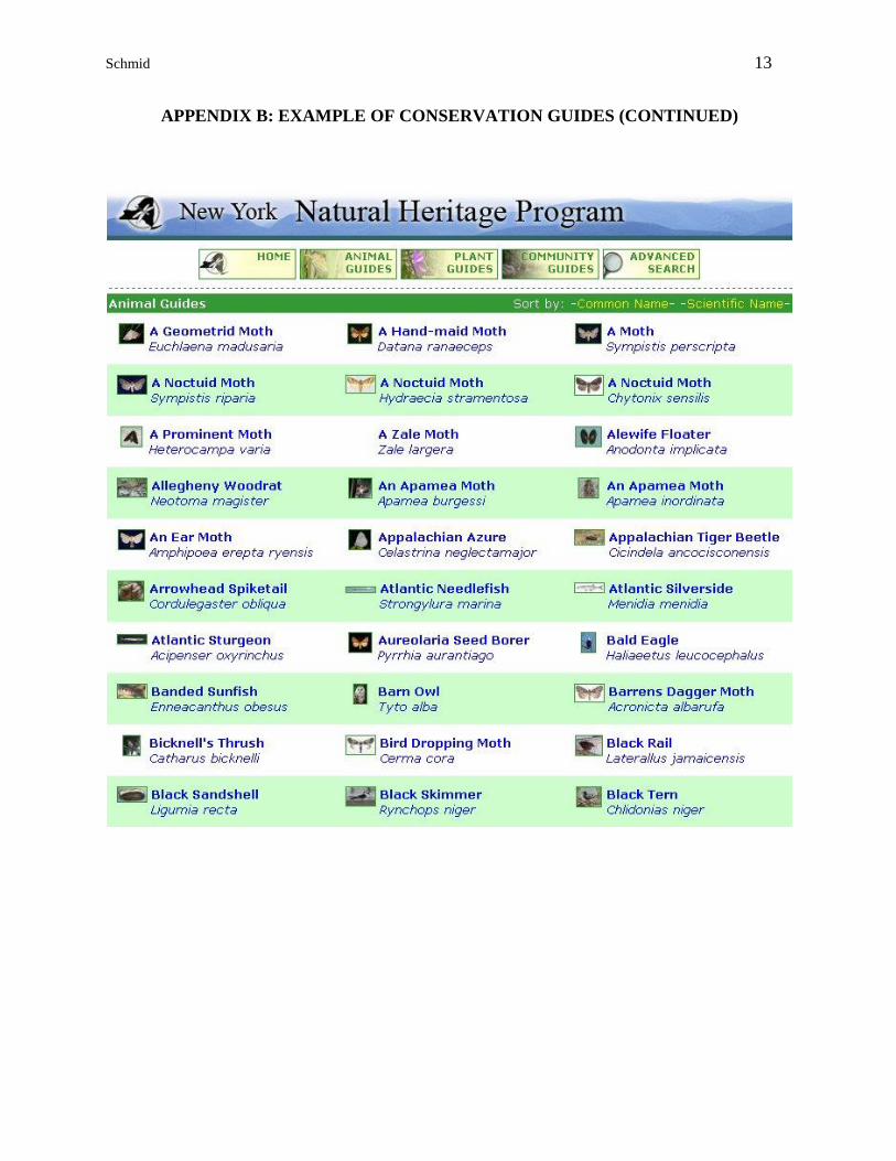
APPENDIX B: EXAMPLE OF CONSERVATION GUIDES (CONTINUED)
Schmid 14
APPENDIX B: EXAMPLE OF CONSERVATION GUIDES (CONTINUED)