block 30 - eiss and asip communications - …€¦ · g lobal hawk is a high-altitude,...
TRANSCRIPT
www.northropgrumman.com© 2012 Northrop Grumman Systems CorporationPrinted in USACreative Business SolutionsAFMC-2011-0201/88ABW-2011-5420, 17 October 2011, NASA Approval and NAVAIR Concurrence, 20 October 2011 500 • 7/12 • 1020-AS-5940
For more information, please contact:Northrop Grumman Aerospace Systems Unmanned Systems Jim Stratford (321) 726-7536 • [email protected] Loochkartt (858) 618-4245 • [email protected] Comer (858) 618-7788 • [email protected]
Payload and Communication • Active Electronically
Scanned Array (AESA) Radar called MP-RTIP
• Mission Plan: Aircraft and MP-RTIP collect and distribute radar data
• Fixed Targets: Synthetic Aperture Radar (SAR) “Spot and Swath” Imagery
• Moving Objects: Ground Moving Target Indicator (GMTI) of vehicles and others
• Distribution: Wideband Ku SATCOM and line-of- sight connectivity
• Data stored: Ground servers store data for worldwide network access
• GMTI service: Provides sensor GMTI detection to command nodes to form target tracks
Use of Radar Data by Intelligence• USAF and Army Distributed Common Ground Station
(DCGS) analysts receive and exploit MP-RTIP Radar Imagery (SAR Spot and Swath)
• DCGS and Battle Management Nodes view GMTI tracks to monitor enemy
• DCGS uses data from sensors to find, identify and locate both stationary and moving targets
Battle Management Command and Control (BMC2) Future• Directs Global Hawk MCE crew to alter collection in real-
time to support battle plans• DCGS nominates targets for battle management nodes to
consider for attack• BMC2 directs weapons to attack both stationary and
moving targets from SAR and GMTI data• Weapon systems use Global Hawk radar cues to find and
attack target
Maritime Surveillance
Tactical CommonData Link
Mission Control Element (C2 and Sensor)
Launch andRecovery Element
Air VehicleLength ................................................................... 47.6 ft (14.5 m)Height .......................................................................15.4 ft (4.7 m)Gross Takeoff Weight......................32,250 lbs (14,628 kg)Payload ...................................................... 3,000 lbs (1,360 kg)Ferry Range .......................................12,300 nm (22,780 km)Maximum Altitude ................................> 60,000 ft (18.3 km)Loiter Velocity ................... 310 knots True Air Speed (TAS)On-Station Endurance at 1,200 nm .......................24 hoursMaximum Endurance .................................................. 36 hours
CommunicationsKu SATCOM Datalink ...........................1.5, 8.67, 20, 30, 40, 47.9 MbpsCDL LOS ........................................................137, 274 MbpsUHF SATCOM/LOS ..................Command and ControlATC VoiceSecure Voice
USAF Global HawkBlock 20/30/40 Specifications
Block 20 - Communications Relay Payload
Block 30 - EISS and ASIP
Block 40 - MP-RTIP
Block 40 Employment Concept for Intelligence and Battle Management
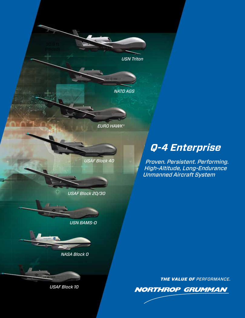
Q-4 Enterprise Proven. Persistent. Performing. High-Altitude, Long-EnduranceUnmanned Aircraft System
USN Triton
NATO AGS
EUrO HAwk®
USAF Block 40
USAF Block 20/30
USN BAMS-D
NASA Block 0
USAF Block 10
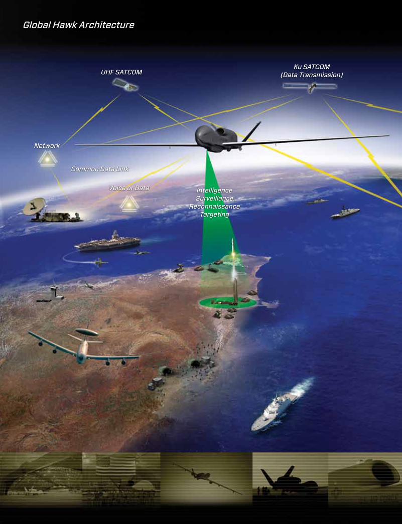
ku SATCOM(Data Transmission)UHF SATCOM
Network
Voice or Data
Common Data Link
IntelligenceSurveillance
reconnaissance Targeting
Global Hawk Architecture
CSAr Spot
SAr Airfield
130.9 ft (39.9 m)
47.6 ft (14.5 m)
15.4 ft (4.7 m)
13.9 ft30.9 ft
(folded)
www.northropgrumman.com© 2012 Northrop Grumman Systems CorporationPrinted in USACreative Business SolutionsAFMC-2011-0201/88ABW-2011-5420, 17 October 2011, NASA Approval and NAVAIR Concurrence, 20 October 2011 500 • 7/12 • 1020-AS-5940
For more information, please contact:Northrop Grumman Aerospace Systems Unmanned Systems Jim Stratford (321) 726-7536 • [email protected] Loochkartt (858) 618-4245 • [email protected] Comer (858) 618-7788 • [email protected]
Payload and Communication • Active Electronically
Scanned Array (AESA) Radar called MP-RTIP
• Mission Plan: Aircraft and MP-RTIP collect and distribute radar data
• Fixed Targets: Synthetic Aperture Radar (SAR) “Spot and Swath” Imagery
• Moving Objects: Ground Moving Target Indicator (GMTI) of vehicles and others
• Distribution: Wideband Ku SATCOM and line-of- sight connectivity
• Data stored: Ground servers store data for worldwide network access
• GMTI service: Provides sensor GMTI detection to command nodes to form target tracks
Use of Radar Data by Intelligence• USAF and Army Distributed Common Ground Station
(DCGS) analysts receive and exploit MP-RTIP Radar Imagery (SAR Spot and Swath)
• DCGS and Battle Management Nodes view GMTI tracks to monitor enemy
• DCGS uses data from sensors to find, identify and locate both stationary and moving targets
Battle Management Command and Control (BMC2) Future• Directs Global Hawk MCE crew to alter collection in real-
time to support battle plans• DCGS nominates targets for battle management nodes to
consider for attack• BMC2 directs weapons to attack both stationary and
moving targets from SAR and GMTI data• Weapon systems use Global Hawk radar cues to find and
attack target
Maritime Surveillance
Tactical CommonData Link
Mission Control Element (C2 and Sensor)
Launch andRecovery Element
Air VehicleLength ................................................................... 47.6 ft (14.5 m)Height .......................................................................15.4 ft (4.7 m)Gross Takeoff Weight......................32,250 lbs (14,628 kg)Payload ...................................................... 3,000 lbs (1,360 kg)Ferry Range .......................................12,300 nm (22,780 km)Maximum Altitude ................................> 60,000 ft (18.3 km)Loiter Velocity ................... 310 knots True Air Speed (TAS)On-Station Endurance at 1,200 nm .......................24 hoursMaximum Endurance .................................................. 36 hours
CommunicationsKu SATCOM Datalink ...........................1.5, 8.67, 20, 30, 40, 47.9 MbpsCDL LOS ........................................................137, 274 MbpsUHF SATCOM/LOS ..................Command and ControlATC VoiceSecure Voice
USAF Global HawkBlock 20/30/40 Specifications
Block 20 - Communications Relay Payload
Block 30 - EISS and ASIP
Block 40 - MP-RTIP
Block 40 Employment Concept for Intelligence and Battle Management
Q-4 Enterprise Proven. Persistent. Performing. High-Altitude, Long-EnduranceUnmanned Aircraft System
USN Triton
NATO AGS
EUrO HAwk®
USAF Block 40
USAF Block 20/30
USN BAMS-D
NASA Block 0
USAF Block 10
ku SATCOM(Data Transmission)UHF SATCOM
Network
Voice or Data
Common Data Link
IntelligenceSurveillance
reconnaissance Targeting
Global Hawk Architecture
CSAr Spot
SAr Airfield
130.9 ft (39.9 m)
47.6 ft (14.5 m)
15.4 ft (4.7 m)
13.9 ft30.9 ft
(folded)
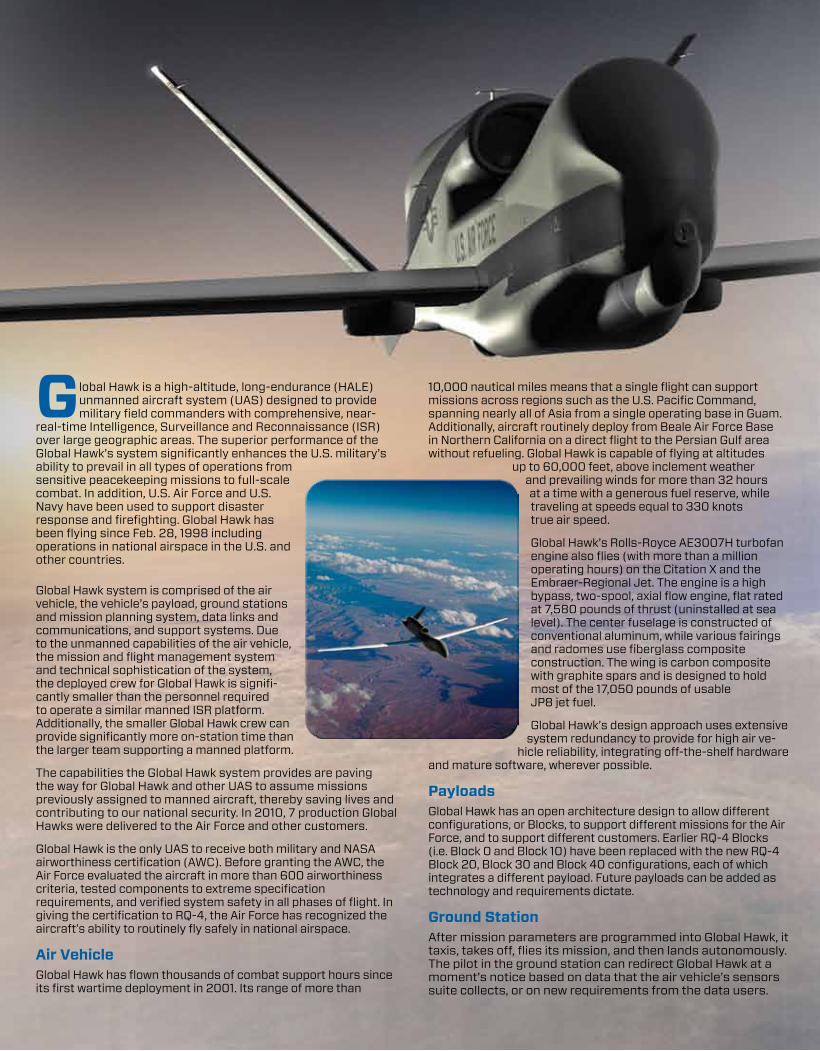
Global Hawk is a high-altitude, long-endurance (HALE) unmanned aircraft system (UAS) designed to provide military field commanders with comprehensive, near-
real-time Intelligence, Surveillance and Reconnaissance (ISR) over large geographic areas. The superior performance of the Global Hawk’s system significantly enhances the U.S. military’s ability to prevail in all types of operations from sensitive peacekeeping missions to full-scale combat. In addition, U.S. Air Force and U.S. Navy have been used to support disaster response and firefighting. Global Hawk has been flying since Feb. 28, 1998 including operations in national airspace in the U.S. and other countries.
Global Hawk system is comprised of the air vehicle, the vehicle’s payload, ground stations and mission planning system, data links and communications, and support systems. Due to the unmanned capabilities of the air vehicle, the mission and flight management system and technical sophistication of the system, the deployed crew for Global Hawk is signifi-cantly smaller than the personnel required to operate a similar manned ISR platform. Additionally, the smaller Global Hawk crew can provide significantly more on-station time than the larger team supporting a manned platform.
The capabilities the Global Hawk system provides are paving the way for Global Hawk and other UAS to assume missions previously assigned to manned aircraft, thereby saving lives and contributing to our national security. In 2010, 7 production Global Hawks were delivered to the Air Force and other customers.
Global Hawk is the only UAS to receive both military and NASA airworthiness certification (AWC). Before granting the AWC, the Air Force evaluated the aircraft in more than 600 airworthiness criteria, tested components to extreme specification requirements, and verified system safety in all phases of flight. In giving the certification to RQ-4, the Air Force has recognized the aircraft’s ability to routinely fly safely in national airspace.
Air VehicleGlobal Hawk has flown thousands of combat support hours since its first wartime deployment in 2001. Its range of more than
10,000 nautical miles means that a single flight can support missions across regions such as the U.S. Pacific Command, spanning nearly all of Asia from a single operating base in Guam. Additionally, aircraft routinely deploy from Beale Air Force Base in Northern California on a direct flight to the Persian Gulf area without refueling. Global Hawk is capable of flying at altitudes
up to 60,000 feet, above inclement weather and prevailing winds for more than 32 hours at a time with a generous fuel reserve, while traveling at speeds equal to 330 knots true air speed.
Global Hawk’s Rolls-Royce AE3007H turbofan engine also flies (with more than a million operating hours) on the Citation X and the Embraer-Regional Jet. The engine is a high bypass, two-spool, axial flow engine, flat rated at 7,580 pounds of thrust (uninstalled at sea level). The center fuselage is constructed of conventional aluminum, while various fairings and radomes use fiberglass composite construction. The wing is carbon composite with graphite spars and is designed to hold most of the 17,050 pounds of usable JP8 jet fuel.
Global Hawk’s design approach uses extensive system redundancy to provide for high air ve-
hicle reliability, integrating off-the-shelf hardware and mature software, wherever possible.
PayloadsGlobal Hawk has an open architecture design to allow different configurations, or Blocks, to support different missions for the Air Force, and to support different customers. Earlier RQ-4 Blocks (i.e. Block 0 and Block 10) have been replaced with the new RQ-4 Block 20, Block 30 and Block 40 configurations, each of which integrates a different payload. Future payloads can be added as technology and requirements dictate.
Ground StationAfter mission parameters are programmed into Global Hawk, it taxis, takes off, flies its mission, and then lands autonomously. The pilot in the ground station can redirect Global Hawk at a moment’s notice based on data that the air vehicle’s sensors suite collects, or on new requirements from the data users.
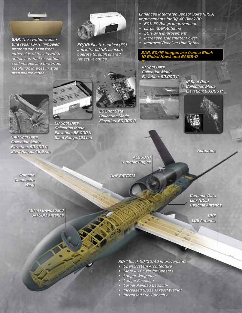
SAR: The synthetic aper-ture radar (SAr) gimbaled antenna can scan from either side of the aircraft to obtain one-foot resolution spot images and three-foot resolution images in wide area search mode.
SAr Spot Data Collection ModeElevation: 60,400 ftSlant range: 46.6 nm
The pilot in the Launch and Recovery Element (LRE) of the ground segment system controls the operation of the aircraft during its automatic taxi, takeoff and landing, and is assisted by the Differential Global Positioning System (DGPS).
The Mission Control Element (MCE) of the Global Hawk ground segment provides management of the aircraft and its sensors. It has the ability to command and control the aircraft, data links, and payload in order to disseminate near-real-time information to tactical commanders anywhere in the world. The aircrew in the MCE shelter conducts the command and control, mission planning, imagery quality control, and communications functions of the system. For operational use, Global Hawk is flown from the MCE at its main operating base in Beale Air Force Base, Calif. In 2011, Grand Forks Air Force Base in North Dakota has become a second main operating base.
Communications and Data LinksGlobal Hawk’s communication system is used for line-of-sight and satellite connectivity for command and control, and near-real-time data dissemination. Multiple satellite and line-of-sight data links provide numerous communication paths to Global Hawk’s MCE and LRE. Broadband communications via commer-cial satellites is the primary data link for transmitting reconnais-sance data. In addition, broadband line-of-sight communication is available through the Common Data Link (CDL). Mission control and system status messages are transmitted through the broadband links and through additional narrowband radios for command and control. In addition, the pilot is provided voice communication to air traffic control through the aircraft. All of this allows the aircrew in the MCE to monitor and operate their assigned air vehicle/payload no mat-ter how far away it is in the world.
Support SystemsGlobal Hawk systems are supported logistically similar to manned aircraft. Supplies and maintenance use the same processes and management systems as manned aircraft, except that all manuals are electronic with virtual illustrations. The crew chief uses a rugged laptop called the Vehicle Test Computer (VTC) to connect to the aircraft and monitor the systems and status of components. A second laptop contains all of the maintenance manuals for troubleshooting and ordering parts.
History and Current Deployment of Global HawkThe first Global Hawk, Advanced Concept Technology Demon-strator (ACTD), was deployed overseas to the Persian Gulf two months after Sept. 11, 2001. The ACTD assets then transitioned to the Block 10 Global Hawks, which were deployed through mid-2011 and replaced by Block 30 Global Hawks. The seven Block 10 Global Hawks were divested - three to the U.S. Navy, two to NASA and two to USAF museums. Block 20 Global Hawks are equipped with a new communications relay package and are deployed in the Overseas Contingency Operations (OCO).The Block 30 Global Hawks are also deployed across the globe; to include support of Operation Odyssey Dawn in Libya.
The Global Hawk has supported humanitarian relief efforts including the southern and northern California wildfires in 2007 and 2008, Hurricane Ike in 2008, Haiti Earthquake in 2010, and the 2011 Japan earthquake and tsunami.
Redesigns of Next Generation RQ-4 VariantsLessons learned during RQ-4 Block 10 deployments have led to the next-generation, enhanced capability RQ-4 Blocks 20, 30, and 40. They carry 3,000 pounds of communications and sensor payloads, allowing for true multi-intelligence collection capability. The next-generation sensor suite, the Enhanced Integrated Sensor Suite (EISS), provides an intelligence collection capability in Block 30 at 50 percent longer range than the ISS in RQ-4 Block 10.
To accommodate the increased payload capacity, Northrop Grumman redesigned and strengthened Global Hawk’s fuse-lage. The fuselage of Blocks 20, 30 and 40 are four feet longer than the Block 10, and the new landing gear makes these blocks slightly taller than the Block 10 with more space available under the aircraft for payloads. The wingspan has also increased by approximately 15 feet to 130.9 feet, allowing it to carry more fuel and fly longer missions than its predecessor. Blocks 20, 30, and 40 also feature a gross takeoff weight 5,800 pounds heavier than that of the Block 10.
RQ-4 Blocks 20/30In mid-2011, Block 30 replaced Block 10 aircraft in supporting operations in Iraq and Afghanistan, thereby perhaps creating a Block 10 secondary market for other government agencies.
The Block 20 aircraft system was chosen to be modified with a special communications relay package to support coalition forces in Afghanistan. This communications relay system enables warfighters to rapidly share data and information between multiple users across multiple dissimilar systems present within the battlefield.
The Block 30 Global Hawk carries sophisticated imaging and electronic signals sensors on missions that can exceed 32 hours. Configured to carry an EISS and an Airborne Signals Intelligence Payload (ASIP), the Block 30 is extremely important for situational awareness and intelligence-gathering across huge areas
of land.
Reconnaissance imagery is obtained through the use of the Global Hawk’s EISS. Block 30 EISS includes an all-weather synthetic aperture radar/moving target indicator (SAR/MTI), a high-resolution electro-optical (EO) digital camera, and a third-generation infrared (IR) sensor. These all operate through a common signal processor, which is equivalent to an airborne super computer. The integrated design of the sensor package gives commanders on the ground the ability to select radar, IR and visible modes as desired, and even use the SAR or MTI simultaneously with EO or IR sensors. This means that Block 30 can simultaneously collect signals intelligence, and visible/IR and radar information, and transfer it to the warfighter in near-real-time.
The EISS allows Global Hawk to survey vast geographic regions with pinpoint accuracy. The system combines these advanced technology sensors with a range that extends more than
halfway around the world and an ability to remain on station for long periods of time. The high-resolution image quality makes it possible to distinguish various types of vehicles, aircraft, people and missiles, and look through adverse weather, day or night. These features enable the Global Hawk system to provide the warfighter with essential intelligence needed to achieve information dominance throughout battlespace and to respond to immediate surveillance needs in combat.
RQ-4 Block 40The Block 40 aircraft has the unique capability to monitor large areas in all weather with the Multi-Platform Radar Technology Insertion Program (MP-RTIP) sensor, which is an advanced air-to-surface radar for wide area surveillance of fixed and moving targets. MP-RTIP provides game-changing situational awareness and targeting information for warfighters.
The first Block 40 aircraft flew on Nov. 16, 2009 and completed initial flight tests in June 2010. The MP-RTIP sensor completed testing on the manned Proteus aircraft in October 2010 and flew on the first Block 40 aircraft in 2011. The Block 40 Global Hawks are based at Grand Forks Air Force Base, N.D.
BAMS-DRQ-4 Block 10 Global Hawks are currently being used for the U.S. Navy’s Broad Area Maritime Surveillance-Demonstrator (BAMS-D) program. Stationed at Naval Air Station Patuxent River, Md., the air system is being used to help define the concept of operations for maritime surveillance. The BAMS-D has participated in naval exercises including Trident Warrior ‘05, RIMPAC ‘06 and ‘08. The Navy’s BAMS-D system reported for duty to USCENTCOM in January 2009 and provides over 50 percent of all maritime ISR to Commander Fifth Fleet.
MQ-4C Triton Based on the RQ-4 Block 30 Global Hawk, the U.S. Navy’s MQ-4C Triton BAMS UAS will provide maritime ISR data collection and dissemination capability to the Maritime Patrol and Reconnaissance Force (MPRF). When it becomes operational in 2015, BAMS will provide ISR persistence over large maritime distances for long periods of time for up to five simultaneous orbits worldwide. Its missions include, but are not limited to, maritime surveillance, collection of enemy order of battle information, battle damage assessment, port surveillance, communication relay, and support of other maritime missions. It is equipped with a 360-degree Multi-Function Active Sensor (MFAS) Active Electronically Scanned Array (AESA), along with an electronic support measures payload and the Raytheon MTS-B EO/IR reconnaissance system. BAMS expands maritime battlespace awareness and permits wide distribution of naval strike power. In development now, the first MQ-4C flight is scheduled for late 2012.
NASA Global Hawk In April 2010, NASA Global Hawk completed the first UAS flights in the name of scientific research. These flights over the Pacific and Arctic Oceans were part of the Global Hawk Pacific (GloPac) mission, a joint project between NASA and the National Oceanic and Atmospheric Administration (NOAA), with Northrop Grumman support. In August 2010, NASA Global Hawk examined hurricanes, their formation process, and the possibility of improving hurricane forecasts.
The aircraft is proving to be the premier platform for use in HALE Earth science missions. In 2011 NASA will establish a portable ground control station at NASA Wallops Flight Facility in support of upcoming Earth science deployments.
EURO HAWK®Based on the Block 20, EURO HAWK® marks the first international configuration of the RQ-4 Global Hawk. EURO HAWK® is Northrop Grumman’s first trans-Atlantic cooperation with Germany and EADS Deutschland GmbH, which operates through Cassidian. It includes a signals intelligence (SIGINT) system developed by Cassidian, providing the capability to detect electronic and communications emitters from a long distance. The ground station, which consists of an MCE and LRE, will be provided by Northrop
Grumman. The EURO HAWK® successfully completed its maiden flight on June 29, 2010 from Northrop Grumman’s Palmdale, Calif., manufacturing facility, and its ferry flight to Manching, Germany, on July 21, 2011.
NATO AGSNATO Alliance Ground Surveillance (AGS) will provide unprecedented real-time airborne ground surveillance and situational awareness information throughout the full range of NATO operations for the NATO and the nations. A systems-of-systems, the Sigonella, Italy-based AGS core consists of airborne, air vehicle mission command and control and ground elements, performing all-weather, persistent wide-area surface surveillance and providing a NATO-owned and operated joint intelligence, surveillance and reconnaissance (JISR) capability. The NATO AGS air vehicle is an enhanced version of the Block 40 Global Hawk with modifications to include radar maritime modes, BAMS-based communications suite, enhanced mission and data management and IP-based tactical wideband data distribution to the Northrop Grumman-provided mission command and control center and the European/Canadian-sourced fixed, mobile and transportable ground entities for data exploitation.
The PresentThe Q-4 Enterprise system is the culmination of a successful team effort on the part of the U.S. government and industry. Today, the Enterprise program has multiple customers, including the U.S. Air Force and Navy. Global Hawks are flown in several locations across the globe: Beale Air Force Base, home of the 9th Reconnaissance Wing and the RQ-4’s main operating base, in Northern California; Edwards Air Force Base in Southern California; Naval Air Station Patuxent River in Maryland; in a forward operating location in support of U.S. Central Command in the Persian Gulf; Naval Air Station Sigonella in Italy; Andersen Air Force Base in Guam; and in 2011, Grand Forks Air Force Base in North Dakota. International interest in HALE surveillance is growing. Countries along the Pacific Rim and Europe are exploring the benefits of acquiring the system. Q-4 Enterprise represents the future of aviation — military and civilian, domestic and foreign.
EO/IR: Electro-optical (EO) and infrared (Ir) sensors operate through shared reflective optics.
Enhanced Integrated Sensor Suite (EISS) Improvements for rQ-4B Block 30• 50% EO range Improvement• Larger SAr Antenna• 50% SAr Improvement• Increased Transmitter Power• Improved receiver Unit Optics
EO Spot DataCollection ModeElevation: 56,000 ftSlant range: 13.1 nm
EO Spot DataCollection ModeElevation: 60,000 ft
Ir Spot DataCollection ModeElevation: 60,000 ft
Ir Spot DataCollection ModeElevation: 60,000 ft
rQ-4 Block 20/30/40 Improvements• Open System Architecture• More AC Power for Sensors• Longer wingspan• Longer Fuselage• Larger Payload Capacity• Increased Gross Takeoff weight• Increased Fuel Capacity
AE3007HTurbofan Engine
UHF SATCOMGraphiteComposite
wing
1.21 m ku-widebandSATCOM Antenna
Actuators
Common DataLink (CDL)radome Antenna
UHFLOS Antenna
MCE C2 and Sensor
CommunicationsInside MCE
LrEC2 Communications
Inside LrE
SAR, EO/IR images are from a Block 10 Global Hawk and BAMS-D
Global Hawk is a high-altitude, long-endurance (HALE) unmanned aircraft system (UAS) designed to provide military field commanders with comprehensive, near-
real-time Intelligence, Surveillance and Reconnaissance (ISR) over large geographic areas. The superior performance of the Global Hawk’s system significantly enhances the U.S. military’s ability to prevail in all types of operations from sensitive peacekeeping missions to full-scale combat. In addition, U.S. Air Force and U.S. Navy have been used to support disaster response and firefighting. Global Hawk has been flying since Feb. 28, 1998 including operations in national airspace in the U.S. and other countries.
Global Hawk system is comprised of the air vehicle, the vehicle’s payload, ground stations and mission planning system, data links and communications, and support systems. Due to the unmanned capabilities of the air vehicle, the mission and flight management system and technical sophistication of the system, the deployed crew for Global Hawk is signifi-cantly smaller than the personnel required to operate a similar manned ISR platform. Additionally, the smaller Global Hawk crew can provide significantly more on-station time than the larger team supporting a manned platform.
The capabilities the Global Hawk system provides are paving the way for Global Hawk and other UAS to assume missions previously assigned to manned aircraft, thereby saving lives and contributing to our national security. In 2010, 7 production Global Hawks were delivered to the Air Force and other customers.
Global Hawk is the only UAS to receive both military and NASA airworthiness certification (AWC). Before granting the AWC, the Air Force evaluated the aircraft in more than 600 airworthiness criteria, tested components to extreme specification requirements, and verified system safety in all phases of flight. In giving the certification to RQ-4, the Air Force has recognized the aircraft’s ability to routinely fly safely in national airspace.
Air VehicleGlobal Hawk has flown thousands of combat support hours since its first wartime deployment in 2001. Its range of more than
10,000 nautical miles means that a single flight can support missions across regions such as the U.S. Pacific Command, spanning nearly all of Asia from a single operating base in Guam. Additionally, aircraft routinely deploy from Beale Air Force Base in Northern California on a direct flight to the Persian Gulf area without refueling. Global Hawk is capable of flying at altitudes
up to 60,000 feet, above inclement weather and prevailing winds for more than 32 hours at a time with a generous fuel reserve, while traveling at speeds equal to 330 knots true air speed.
Global Hawk’s Rolls-Royce AE3007H turbofan engine also flies (with more than a million operating hours) on the Citation X and the Embraer-Regional Jet. The engine is a high bypass, two-spool, axial flow engine, flat rated at 7,580 pounds of thrust (uninstalled at sea level). The center fuselage is constructed of conventional aluminum, while various fairings and radomes use fiberglass composite construction. The wing is carbon composite with graphite spars and is designed to hold most of the 17,050 pounds of usable JP8 jet fuel.
Global Hawk’s design approach uses extensive system redundancy to provide for high air ve-
hicle reliability, integrating off-the-shelf hardware and mature software, wherever possible.
PayloadsGlobal Hawk has an open architecture design to allow different configurations, or Blocks, to support different missions for the Air Force, and to support different customers. Earlier RQ-4 Blocks (i.e. Block 0 and Block 10) have been replaced with the new RQ-4 Block 20, Block 30 and Block 40 configurations, each of which integrates a different payload. Future payloads can be added as technology and requirements dictate.
Ground StationAfter mission parameters are programmed into Global Hawk, it taxis, takes off, flies its mission, and then lands autonomously. The pilot in the ground station can redirect Global Hawk at a moment’s notice based on data that the air vehicle’s sensors suite collects, or on new requirements from the data users.
SAR: The synthetic aper-ture radar (SAr) gimbaled antenna can scan from either side of the aircraft to obtain one-foot resolution spot images and three-foot resolution images in wide area search mode.
SAr Spot Data Collection ModeElevation: 60,400 ftSlant range: 46.6 nm
The pilot in the Launch and Recovery Element (LRE) of the ground segment system controls the operation of the aircraft during its automatic taxi, takeoff and landing, and is assisted by the Differential Global Positioning System (DGPS).
The Mission Control Element (MCE) of the Global Hawk ground segment provides management of the aircraft and its sensors. It has the ability to command and control the aircraft, data links, and payload in order to disseminate near-real-time information to tactical commanders anywhere in the world. The aircrew in the MCE shelter conducts the command and control, mission planning, imagery quality control, and communications functions of the system. For operational use, Global Hawk is flown from the MCE at its main operating base in Beale Air Force Base, Calif. In 2011, Grand Forks Air Force Base in North Dakota has become a second main operating base.
Communications and Data LinksGlobal Hawk’s communication system is used for line-of-sight and satellite connectivity for command and control, and near-real-time data dissemination. Multiple satellite and line-of-sight data links provide numerous communication paths to Global Hawk’s MCE and LRE. Broadband communications via commer-cial satellites is the primary data link for transmitting reconnais-sance data. In addition, broadband line-of-sight communication is available through the Common Data Link (CDL). Mission control and system status messages are transmitted through the broadband links and through additional narrowband radios for command and control. In addition, the pilot is provided voice communication to air traffic control through the aircraft. All of this allows the aircrew in the MCE to monitor and operate their assigned air vehicle/payload no mat-ter how far away it is in the world.
Support SystemsGlobal Hawk systems are supported logistically similar to manned aircraft. Supplies and maintenance use the same processes and management systems as manned aircraft, except that all manuals are electronic with virtual illustrations. The crew chief uses a rugged laptop called the Vehicle Test Computer (VTC) to connect to the aircraft and monitor the systems and status of components. A second laptop contains all of the maintenance manuals for troubleshooting and ordering parts.
History and Current Deployment of Global HawkThe first Global Hawk, Advanced Concept Technology Demon-strator (ACTD), was deployed overseas to the Persian Gulf two months after Sept. 11, 2001. The ACTD assets then transitioned to the Block 10 Global Hawks, which were deployed through mid-2011 and replaced by Block 30 Global Hawks. The seven Block 10 Global Hawks were divested - three to the U.S. Navy, two to NASA and two to USAF museums. Block 20 Global Hawks are equipped with a new communications relay package and are deployed in the Overseas Contingency Operations (OCO).The Block 30 Global Hawks are also deployed across the globe; to include support of Operation Odyssey Dawn in Libya.
The Global Hawk has supported humanitarian relief efforts including the southern and northern California wildfires in 2007 and 2008, Hurricane Ike in 2008, Haiti Earthquake in 2010, and the 2011 Japan earthquake and tsunami.
Redesigns of Next Generation RQ-4 VariantsLessons learned during RQ-4 Block 10 deployments have led to the next-generation, enhanced capability RQ-4 Blocks 20, 30, and 40. They carry 3,000 pounds of communications and sensor payloads, allowing for true multi-intelligence collection capability. The next-generation sensor suite, the Enhanced Integrated Sensor Suite (EISS), provides an intelligence collection capability in Block 30 at 50 percent longer range than the ISS in RQ-4 Block 10.
To accommodate the increased payload capacity, Northrop Grumman redesigned and strengthened Global Hawk’s fuse-lage. The fuselage of Blocks 20, 30 and 40 are four feet longer than the Block 10, and the new landing gear makes these blocks slightly taller than the Block 10 with more space available under the aircraft for payloads. The wingspan has also increased by approximately 15 feet to 130.9 feet, allowing it to carry more fuel and fly longer missions than its predecessor. Blocks 20, 30, and 40 also feature a gross takeoff weight 5,800 pounds heavier than that of the Block 10.
RQ-4 Blocks 20/30In mid-2011, Block 30 replaced Block 10 aircraft in supporting operations in Iraq and Afghanistan, thereby perhaps creating a Block 10 secondary market for other government agencies.
The Block 20 aircraft system was chosen to be modified with a special communications relay package to support coalition forces in Afghanistan. This communications relay system enables warfighters to rapidly share data and information between multiple users across multiple dissimilar systems present within the battlefield.
The Block 30 Global Hawk carries sophisticated imaging and electronic signals sensors on missions that can exceed 32 hours. Configured to carry an EISS and an Airborne Signals Intelligence Payload (ASIP), the Block 30 is extremely important for situational awareness and intelligence-gathering across huge areas
of land.
Reconnaissance imagery is obtained through the use of the Global Hawk’s EISS. Block 30 EISS includes an all-weather synthetic aperture radar/moving target indicator (SAR/MTI), a high-resolution electro-optical (EO) digital camera, and a third-generation infrared (IR) sensor. These all operate through a common signal processor, which is equivalent to an airborne super computer. The integrated design of the sensor package gives commanders on the ground the ability to select radar, IR and visible modes as desired, and even use the SAR or MTI simultaneously with EO or IR sensors. This means that Block 30 can simultaneously collect signals intelligence, and visible/IR and radar information, and transfer it to the warfighter in near-real-time.
The EISS allows Global Hawk to survey vast geographic regions with pinpoint accuracy. The system combines these advanced technology sensors with a range that extends more than
halfway around the world and an ability to remain on station for long periods of time. The high-resolution image quality makes it possible to distinguish various types of vehicles, aircraft, people and missiles, and look through adverse weather, day or night. These features enable the Global Hawk system to provide the warfighter with essential intelligence needed to achieve information dominance throughout battlespace and to respond to immediate surveillance needs in combat.
RQ-4 Block 40The Block 40 aircraft has the unique capability to monitor large areas in all weather with the Multi-Platform Radar Technology Insertion Program (MP-RTIP) sensor, which is an advanced air-to-surface radar for wide area surveillance of fixed and moving targets. MP-RTIP provides game-changing situational awareness and targeting information for warfighters.
The first Block 40 aircraft flew on Nov. 16, 2009 and completed initial flight tests in June 2010. The MP-RTIP sensor completed testing on the manned Proteus aircraft in October 2010 and flew on the first Block 40 aircraft in 2011. The Block 40 Global Hawks are based at Grand Forks Air Force Base, N.D.
BAMS-DRQ-4 Block 10 Global Hawks are currently being used for the U.S. Navy’s Broad Area Maritime Surveillance-Demonstrator (BAMS-D) program. Stationed at Naval Air Station Patuxent River, Md., the air system is being used to help define the concept of operations for maritime surveillance. The BAMS-D has participated in naval exercises including Trident Warrior ‘05, RIMPAC ‘06 and ‘08. The Navy’s BAMS-D system reported for duty to USCENTCOM in January 2009 and provides over 50 percent of all maritime ISR to Commander Fifth Fleet.
MQ-4C Triton Based on the RQ-4 Block 30 Global Hawk, the U.S. Navy’s MQ-4C Triton BAMS UAS will provide maritime ISR data collection and dissemination capability to the Maritime Patrol and Reconnaissance Force (MPRF). When it becomes operational in 2015, BAMS will provide ISR persistence over large maritime distances for long periods of time for up to five simultaneous orbits worldwide. Its missions include, but are not limited to, maritime surveillance, collection of enemy order of battle information, battle damage assessment, port surveillance, communication relay, and support of other maritime missions. It is equipped with a 360-degree Multi-Function Active Sensor (MFAS) Active Electronically Scanned Array (AESA), along with an electronic support measures payload and the Raytheon MTS-B EO/IR reconnaissance system. BAMS expands maritime battlespace awareness and permits wide distribution of naval strike power. In development now, the first MQ-4C flight is scheduled for late 2012.
NASA Global Hawk In April 2010, NASA Global Hawk completed the first UAS flights in the name of scientific research. These flights over the Pacific and Arctic Oceans were part of the Global Hawk Pacific (GloPac) mission, a joint project between NASA and the National Oceanic and Atmospheric Administration (NOAA), with Northrop Grumman support. In August 2010, NASA Global Hawk examined hurricanes, their formation process, and the possibility of improving hurricane forecasts.
The aircraft is proving to be the premier platform for use in HALE Earth science missions. In 2011 NASA will establish a portable ground control station at NASA Wallops Flight Facility in support of upcoming Earth science deployments.
EURO HAWK®Based on the Block 20, EURO HAWK® marks the first international configuration of the RQ-4 Global Hawk. EURO HAWK® is Northrop Grumman’s first trans-Atlantic cooperation with Germany and EADS Deutschland GmbH, which operates through Cassidian. It includes a signals intelligence (SIGINT) system developed by Cassidian, providing the capability to detect electronic and communications emitters from a long distance. The ground station, which consists of an MCE and LRE, will be provided by Northrop
Grumman. The EURO HAWK® successfully completed its maiden flight on June 29, 2010 from Northrop Grumman’s Palmdale, Calif., manufacturing facility, and its ferry flight to Manching, Germany, on July 21, 2011.
NATO AGSNATO Alliance Ground Surveillance (AGS) will provide unprecedented real-time airborne ground surveillance and situational awareness information throughout the full range of NATO operations for the NATO and the nations. A systems-of-systems, the Sigonella, Italy-based AGS core consists of airborne, air vehicle mission command and control and ground elements, performing all-weather, persistent wide-area surface surveillance and providing a NATO-owned and operated joint intelligence, surveillance and reconnaissance (JISR) capability. The NATO AGS air vehicle is an enhanced version of the Block 40 Global Hawk with modifications to include radar maritime modes, BAMS-based communications suite, enhanced mission and data management and IP-based tactical wideband data distribution to the Northrop Grumman-provided mission command and control center and the European/Canadian-sourced fixed, mobile and transportable ground entities for data exploitation.
The PresentThe Q-4 Enterprise system is the culmination of a successful team effort on the part of the U.S. government and industry. Today, the Enterprise program has multiple customers, including the U.S. Air Force and Navy. Global Hawks are flown in several locations across the globe: Beale Air Force Base, home of the 9th Reconnaissance Wing and the RQ-4’s main operating base, in Northern California; Edwards Air Force Base in Southern California; Naval Air Station Patuxent River in Maryland; in a forward operating location in support of U.S. Central Command in the Persian Gulf; Naval Air Station Sigonella in Italy; Andersen Air Force Base in Guam; and in 2011, Grand Forks Air Force Base in North Dakota. International interest in HALE surveillance is growing. Countries along the Pacific Rim and Europe are exploring the benefits of acquiring the system. Q-4 Enterprise represents the future of aviation — military and civilian, domestic and foreign.
EO/IR: Electro-optical (EO) and infrared (Ir) sensors operate through shared reflective optics.
Enhanced Integrated Sensor Suite (EISS) Improvements for rQ-4B Block 30• 50% EO range Improvement• Larger SAr Antenna• 50% SAr Improvement• Increased Transmitter Power• Improved receiver Unit Optics
EO Spot DataCollection ModeElevation: 56,000 ftSlant range: 13.1 nm
EO Spot DataCollection ModeElevation: 60,000 ft
Ir Spot DataCollection ModeElevation: 60,000 ft
Ir Spot DataCollection ModeElevation: 60,000 ft
rQ-4 Block 20/30/40 Improvements• Open System Architecture• More AC Power for Sensors• Longer wingspan• Longer Fuselage• Larger Payload Capacity• Increased Gross Takeoff weight• Increased Fuel Capacity
AE3007HTurbofan Engine
UHF SATCOMGraphiteComposite
wing
1.21 m ku-widebandSATCOM Antenna
Actuators
Common DataLink (CDL)radome Antenna
UHFLOS Antenna
MCE C2 and Sensor
CommunicationsInside MCE
LrEC2 Communications
Inside LrE
SAR, EO/IR images are from a Block 10 Global Hawk and BAMS-D
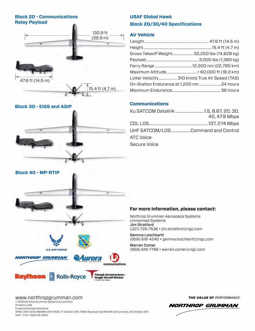
www.northropgrumman.com© 2012 Northrop Grumman Systems CorporationPrinted in USACreative Business SolutionsAFMC-2011-0201/88ABW-2011-5420, 17 October 2011, NASA Approval and NAVAIR Concurrence, 20 October 2011 500 • 7/12 • 1020-AS-5940
For more information, please contact:Northrop Grumman Aerospace Systems Unmanned Systems Jim Stratford (321) 726-7536 • [email protected] Loochkartt (858) 618-4245 • [email protected] Comer (858) 618-7788 • [email protected]
Payload and Communication • Active Electronically
Scanned Array (AESA) Radar called MP-RTIP
• Mission Plan: Aircraft and MP-RTIP collect and distribute radar data
• Fixed Targets: Synthetic Aperture Radar (SAR) “Spot and Swath” Imagery
• Moving Objects: Ground Moving Target Indicator (GMTI) of vehicles and others
• Distribution: Wideband Ku SATCOM and line-of- sight connectivity
• Data stored: Ground servers store data for worldwide network access
• GMTI service: Provides sensor GMTI detection to command nodes to form target tracks
Use of Radar Data by Intelligence• USAF and Army Distributed Common Ground Station
(DCGS) analysts receive and exploit MP-RTIP Radar Imagery (SAR Spot and Swath)
• DCGS and Battle Management Nodes view GMTI tracks to monitor enemy
• DCGS uses data from sensors to find, identify and locate both stationary and moving targets
Battle Management Command and Control (BMC2) Future• Directs Global Hawk MCE crew to alter collection in real-
time to support battle plans• DCGS nominates targets for battle management nodes to
consider for attack• BMC2 directs weapons to attack both stationary and
moving targets from SAR and GMTI data• Weapon systems use Global Hawk radar cues to find and
attack target
Maritime Surveillance
Tactical CommonData Link
Mission Control Element (C2 and Sensor)
Launch andRecovery Element
Air VehicleLength ................................................................... 47.6 ft (14.5 m)Height .......................................................................15.4 ft (4.7 m)Gross Takeoff Weight......................32,250 lbs (14,628 kg)Payload ...................................................... 3,000 lbs (1,360 kg)Ferry Range .......................................12,300 nm (22,780 km)Maximum Altitude ................................> 60,000 ft (18.3 km)Loiter Velocity ................... 310 knots True Air Speed (TAS)On-Station Endurance at 1,200 nm .......................24 hoursMaximum Endurance .................................................. 36 hours
CommunicationsKu SATCOM Datalink ...........................1.5, 8.67, 20, 30, 40, 47.9 MbpsCDL LOS ........................................................137, 274 MbpsUHF SATCOM/LOS ..................Command and ControlATC VoiceSecure Voice
USAF Global HawkBlock 20/30/40 Specifications
Block 20 - Communications Relay Payload
Block 30 - EISS and ASIP
Block 40 - MP-RTIP
Block 40 Employment Concept for Intelligence and Battle Management
Q-4 Enterprise Proven. Persistent. Performing. High-Altitude, Long-EnduranceUnmanned Aircraft System
USN Triton
NATO AGS
EUrO HAwk®
USAF Block 40
USAF Block 20/30
USN BAMS-D
NASA Block 0
USAF Block 10
ku SATCOM(Data Transmission)UHF SATCOM
Network
Voice or Data
Common Data Link
IntelligenceSurveillance
reconnaissance Targeting
Global Hawk Architecture
CSAr Spot
SAr Airfield
130.9 ft (39.9 m)
47.6 ft (14.5 m)
15.4 ft (4.7 m)
13.9 ft30.9 ft
(folded)