bloomfield colliery - bloomfield group > home · 1.2 south-east area - overburden dumping and...
TRANSCRIPT

Bloomfield Colliery Section 75W Modification
September 2010
Bloomfield Colliery
Project Approval No. 07_0087
Extension of the Project Approval Area for out-of-pit overburden emplacement
and rehabilitation, alternative haul road and powerline relocation.
Application for a Modification to the Minister’s Consent
Pursuant to Section 75W of the Environmental
Planning and Assessment Act 1979
APPENDICES
September 2010

Bloomfield Colliery Section 75W Modification
September 2010
Appendix A - Director-General’s Requirements – Section 75W
Modification


Bloomfield Colliery Section 75W Modification
September 2010
Appendix B – Biodiversity Assessment
Bloomfield Colliery East Maitland
Part 3A variation ecology report
HUNTER ECO May 2010
HUNTER ECO May 2010
ii
Bloomfield Colliery Part 3A variation ecology report
HUNTER ECO
Colin Driscoll Environmental Biologist NPWS Scientific Licence S10565 Exp 31 January 2011
HUNTER ECO . ABN 25 112 984 240
PO Box 1047, Toronto, NSW 2283 Phone/Fax +61 2 4959 8016 Mobile 0438 773 029 Email [email protected]
This report was prepared for the sole use of the proponents, their agents
and any regulatory agencies involved in the approval process. It should
not be otherwise referenced or reproduced without permission of the
author.
HUNTER ECO May 2010
iii
CONTENTS
1 DESCRIPTION OF THE PROPOSED MODIFICATIONS – BLOOMFIELD COLLIERY 1
1.1 Construction of an Overhead Powerline and Easement 1
1.2 South-East Area - Overburden Dumping and Rehabilitation 2
1.3 Northern and South-Eastern Areas – Out-of-Pit Reshaping and Rehabilitation 2
1.4 Development of Wattle Tree Drive as an Alternative Haul Route 4
2 METHODS 4
2.1 Threatened species, ecological communities and key threatening processes 4
2.2 Flora 5
2.3 Vegetative Community Type Determination 5
2.4 Fauna 5 2.4.1 Arboreal Mammals 7 2.4.2 Terrestrial Mammals 7 2.4.3 Bats 7 2.4.4 Birds 7 2.4.5 Reptiles 8 2.4.6 Habitat Hollows 8
3 THREATENED FLORA 9
4 THREATENED FAUNA 10
5 RESULTS 12
5.1 Habitat description 12
5.2 Vegetation community and flora 12
5.3 Fauna 14 5.3.1 SEPP 44 14 5.3.2 Habitat trees 14
6 IMPACT ASSESSMENT 16
6.1 Flora 16
6.2 Fauna 16

HUNTER ECO May 2010
iv
6.3 Endangered Ecological Community 21
6.4 Commonwealth considerations 24
7 CONCLUSION & RECOMMENDATIONS 24 Appendix 1 - Flora species recorded on the subject site 26 Appendix 2 - Fauna species in the immediate vicinity if the proposed powerline easement 30 Appendix 3 – Habitat images 32
FIGURES
FIGURE 1: THE APPLICATION AND DISTURBANCE AREAS 3
FIGURE 2: FLORA AND FAUNA SURVEY LOCATIONS 6
FIGURE 3: THE LOCATION AND SPECIES OF HABITAT TREES RECORDED IN THE AREAS TO BE CLEARED 15
FIGURE 4 VEGETATION MAP FOR THE POWERLINE EASEMENT AND INFRASTRUCTURE AREAS TO BE CLEARED 23
TABLES
TABLE 1: THREATENED FLORA SPECIES RECORDED WITHIN A 5-KILOMETRE RADIUS OF THE SUBJECT SITE 9
TABLE 2: THE LIKELIHOOD OF THREATENED FLORA SPECIES OCCURRING IN THE POWERLINE EASEMENT 9
TABLE 3: THREATENED FAUNA SPECIES RECORDED WITHIN A 5-KILOMETRE RADIUS OF THE SUBJECT SITE 10
TABLE 4: THE LIKELIHOOD OF THREATENED FAUNA SPECIES OCCURRING IN THE POWERLINE EASEMENT 11
TABLE 5: THREATENED FAUNA SPECIES RECORDED ON THE SUBJECT SITE 14
TABLE 6: SEPP 44, SCHEDULE 2 - KOALA FEED TREE SPECIES 14
HUNTER ECO May 2010
Bloomfield Part 3A variation ecology 1
Bloomfield Colliery Part 3A variation ecology report
1 Description of the Proposed Modifications – Bloomfield Colliery
During preparation of the Environmental Assessment that accompanied the original Part 3A application (Business Environment, 2008), the PA Area only included those areas of the larger existing Bloomfield Colliery site that were specifically required for active mining and other activities associated with the winning of coal. Rehabilitated areas that were within the existing mine lease and adjacent to the open cut pits were not included. Section 6 of the Mining Amendment Act 2008 states that “A person must not carry out a mining purpose specified for the purposes of this section except in accordance with an authorisation that is in force in respect of the land where the purpose is carried out.” As the Mining Lease (being the “authorisation” required by Section 6 quoted above) to be granted to Bloomfield for the approved operation is only for that area included in the Approval under Part 3A of the EP&A Act, Bloomfield are seeking to extend the PA Area so that it may be included in the Mining Lease, and therefore satisfy the Mining Amendment Act 2008. Bloomfield therefore seeks to extend the boundary of the Project Application Area to include all areas of previous rehabilitation associated with its S Cut and Creek Cut operations, including those areas requiring improvement works as described following. Only those activities as described following and associated with the mining operation will be undertaken within this extended area.
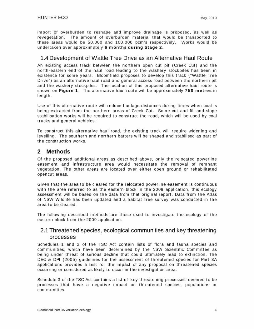
1.1 Construction of an Overhead Powerline and Easement An existing overhead powerline and easement is located to the north-west of the Bloomfield PA Area. This line, as shown on Figure 1, extends from a previous open cut mine area in the north of the Bloomfield Colliery site into the current Creek Cut area. The powerline currently provides power for the water cart filling station, water pumps and rope shovel. To enable the approved mining areas of Creek Cut and S Cut to proceed, the southern section of this powerline and associated infrastructure, within the current PA Area, needs to be relocated. It is proposed to relocate a 330 metre section of the powerline as shown on Figure 1. This would require construction of a 40 metre wide easement, removing approximately one hectare of native vegetation outside the existing project area plus approximately 10 hectares of native vegetation within the existing approved project area, including approximately 7ha Lower Hunter Spotted Gum-Ironbark Forest Endangered Ecological Community (LHSGIF EEC). The area within the approved project area is required for infrastructure associated with the power supply to the face shovel and mine water management. It includes: transformers, earth leakage grids, cables and powerlines. This area is outside current mining areas.

HUNTER ECO May 2010
Bloomfield Part 3A variation ecology 2
Construction would consist of marking of the easement, vegetation clearing within the easement and the existing project area, installation of posts and lines, connection to the existing line and relocation of transformers, earth grids etc. The existing line and posts would then be removed.
1.2 South-East Area - Overburden Dumping and Rehabilitation An out-of-pit area to the east of the approved haul road (“Save-a-Mile Highway”) has previously been rehabilitated but not to current standards. This area is approximately 14 hectares in size and shown on Figure 1. To maximise operational efficiencies and improve final land shaping and vegetation cover in this area, Bloomfield proposes to place approximately 1.2 million bank cubic metres (bcm’s) of overburden on this area prior to reshaping and revegetation to current rehabilitation standards. Works would occur over approximately twelve months during the early stages of the approved “Stage 2” of mining. This out-of-pit emplacement and rehabilitation does not alter the approved mine plan or tonnages as this site would replace the previous emplacement location approximately 850 metres south-west at similar RL’s. Equipment proposed for these works will be that used for the currently approved operation as described by Section 2.6.2 of the EA (Business Environment, 2008), with no additional equipment to be introduced for these works. Rear dump haul trucks will transport overburden material to the area with dozers pushing and shaping material prior to topsoil application and seeding.
1.3 Northern and South-Eastern Areas – Out-of-Pit Reshaping and Rehabilitation
Two out-of-pit areas of approximately 10 hectares and 7 hectares respectively, as shown on Figure 1, are former mining areas consisting of overburden material with some minor shaping and grass seeding. There is minimal native vegetation and any native vegetation that does exist has grown from adjacent tree seeding. To improve the rehabilitation of these areas and revegetate to current standards, minor

HUNTER ECO May 2010
Bloomfield Part 3A variation ecology 3
Figure 1: The application and disturbance areas
HUNTER ECO May 2010
Bloomfield Part 3A variation ecology 4
import of overburden to reshape and improve drainage is proposed, as well as revegetation. The amount of overburden material that would be transported to these areas would be 50,000 and 100,000 bcm’s respectively. Works would be undertaken over approximately 6 months during Stage 2.
1.4 Development of Wattle Tree Drive as an Alternative Haul Route An existing access track between the northern open cut pit (Creek Cut) and the north-eastern end of the haul road leading to the washery stockpiles has been in existence for some years. Bloomfield proposes to develop this track (“Wattle Tree Drive”) as an alternative haul road and general access road between the northern pit and the washery stockpiles. The location of this proposed alternative haul route is shown on Figure 1. The alternative haul route will be approximately 750 metres in length. Use of this alternative route will reduce haulage distances during times when coal is being extracted from the northern areas of Creek Cut. Some cut and fill and slope stabilisation works will be required to construct the road, which will be used by coal trucks and general vehicles. To construct this alternative haul road, the existing track will require widening and levelling. The southern and northern batters will be shaped and stabilised as part of the construction works.
2 Methods Of the proposed additional areas as described above, only the relocated powerline easement and infrastructure area would necessitate the removal of remnant vegetation. The other areas are located over either open ground or rehabilitated opencut areas. Given that the area to be cleared for the relocated powerline easement is continuous with the area referred to as the eastern block in the 2009 application, this ecology assessment will be based on the data from that original report. Data from the Atlas of NSW Wildlife has been updated and a habitat tree survey was conducted in the area to be cleared. The following described methods are those used to investigate the ecology of the eastern block from the 2009 application.
2.1 Threatened species, ecological communities and key threatening processes
Schedules 1 and 2 of the TSC Act contain lists of flora and fauna species and communities, which have been determined by the NSW Scientific Committee as being under threat of serious decline that could ultimately lead to extinction. The DEC & DPI (2005) guidelines for the assessment of threatened species for Part 3A applications provides a test for the impact of any proposal on threatened species occurring or considered as likely to occur in the investigation area. Schedule 3 of the TSC Act contains a list of ‘key threatening processes’ deemed to be processes that have a negative impact on threatened species, populations or communities.

HUNTER ECO May 2010
Bloomfield Part 3A variation ecology 5
An assessment of the threatened species and endangered communities that could possibly occur on the subject site was made using Atlas of NSW Wildlife records from within a 5km radius of the subject site. Next, based on information available concerning the habitat requirements of these species (drawn from http://www.threatenedspecies.environment.nsw.gov.au/tsprofile/), an assessment was made as to the likelihood of any of the reported threatened species occurring on the subject site or using the habitat of the subject site as an essential part of a foraging range. A field survey was then conducted using the list of threatened species as a guide to species potentially likely to occur on the subject site. The survey was however, not limited to the species reported on the database extract. Searches were carried out for any species listed on Schedules 1 and 2 of the TSC Act that were considered likely to occur in the type of vegetative habitat present on the subject site. The likelihood of any ‘key threatening processes’ (KTP) occurring on the subject site was also assessed.
2.2 Flora Systematic transect searches were conducted across the whole area. This method improves the likelihood of finding any rare or threatened species. A floristic list was compiled for each different vegetation community from the transect searches as well as from a standard .04ha floristic plot placed in a representative part of each community in each vegetation block (using the Braun-Blanquet 1-6 scale for cover-abundance). Figure 2 shows the location of plots and transects used for the 2009 application. Floristic nomenclature was based on Harden (1992, 1993, 2000, 2002) with subsequent revisions as published on PlantNet (http://plantnet.rbgsyd.nsw.gov.au). Targeted searches were conducted for those threatened plant species that were identified during the preliminary assessment as likely to occur on the subject site. Plants listed under the ROTAP scheme (Briggs and Leigh 1996) were also considered in this assessment along with species and vegetation deemed to be of local conservation significance.
2.3 Vegetative Community Type Determination The remnant vegetation for the whole of the Bloomfield, Ashtonfield and Donaldson areas has been mapped previously (Driscoll & Bell 2006) however while this mapping was ground-truthed, the area of the powerline easement and infrastructure area was inspected to confirm the communities present.
2.4 Fauna The fauna assessment involved ground and arboreal trapping, targeted searches, spotlighting and the broadcasting of the calls of threatened owls. Figure 2 shows the location of the various components of the fauna survey that was conducted for the 2009 application in relation to the powerline easement.

HUNTER ECO May 2010
Bloomfield Part 3A variation ecology 6
Figure 2: Flora and fauna survey locations

HUNTER ECO May 2010
Bloomfield Part 3A variation ecology 7
2.4.1 Arboreal Mammals Trapping transects were designed to assess the presence of arboreal and terrestrial mammals utilising the subject site. For arboreal mammals, Elliot B traps and hair tubes were placed in trees at heights of 3m or above, along two transects and baited with a mixture of rolled oats, honey, peanut butter and treacle. The trunks of trees with the traps were sprayed with a honey and water mixture. These traps were check daily for arboreal species and wafers from the hair tubes were collected after the four-night period and checked for the presence of hair samples. Hair identification methods followed those of Brunner et al. (2002). Spotlighting was undertaken from dusk for a 3-hour period on one night to identify the presence of any arboreal mammals. Trees were inspected (during daylight hours) for the presence of habitat hollows and if present these were watched at dusk to see if any nocturnal birds or mammals emerged.
2.4.2 Terrestrial Mammals In order to identify any terrestrial mammals, Elliot A traps, Elliot B traps and Cage traps were placed along transects at regular intervals. All traps were baited with a mix of rolled oats, honey, peanut butter and treacle. The traps were set in position for four consecutive nights and checked each morning. Spotlighting from dusk for a 3-hour period on one night was also undertaken to identify the presence of any terrestrial mammals. Careful daytime searches were also conducted for the presence of fauna activity such as diggings, droppings or scratch marks.
2.4.3 Bats An Anabat II bat-call recorder (Titley Electronics, Ballina) was used to record the calls of any Microchiropteran bats feeding in the area. The unit was set up at dusk and recording occurred for 2 hours continuous on one night at two locations. Spotlighting searches of blossoming trees were undertaken to identify any Megachiropteran bat species.
2.4.4 Birds The method employed to survey diurnal birds was an area search of vegetation on the subject site. Four plots, each approximately 1ha in size, were surveyed for 30 minutes. Birds were identified either visually, with the aid of binoculars, or by call interpretation. Surveys were conducted in the morning when bird activity is maximised (Bibby et al. 2000). Opportunistic sightings were also recorded and listed separately to actual survey results. Other data recorded included the field site number, coordinates of the location using a handheld GPS unit, location description, start and finish times, as well as the temperature, relative humidity and wind speed using a Kestrel 4000 portable weather unit. After dark, the calls of threatened owl species were broadcast over a megaphone in an attempt to encourage a response. The subject site was also searched to locate any regurgitated owl pellets. If any pellets were found, their size, shape and content would be used in an attempt to determine the species of owl from which the pellet originated as well as the prey species the owl had been feeding on. Analysis methods followed those of Brunner et al. (2002) and Triggs (1996).

HUNTER ECO May 2010
Bloomfield Part 3A variation ecology 8
2.4.5 Reptiles Type IV funnel traps were set in along both sides of two 20m runs of drift fence. Trapping lines were left for four consecutive days and nights and traps were checked daily. During survey periods on the subject site suitable reptile habitat was inspected to detect the presence of any reptile species by way of occupancy, scats or other detectable traces. Suitable habitat included roadsides, rock outcrops and crevices, any fallen hollow logs and limbs, burrows and suitable rubbish items such as sheets of tin.
2.4.6 Habitat Hollows Hollows are an important resource utilised by a variety of forest fauna. Vertebrate and invertebrate species use hollows as diurnal or nocturnal shelter sites, for rearing young, feeding, thermoregulation and to facilitate ranging behaviour and dispersal (Gibbons & Lindenmayer 2002). Approximately 400 Australian species potentially use hollows either on a permanent or opportunistic basis. Many threatened species are obligate users, requiring the presence of hollows to survive in the landscape (Gibbons & Lindenmayer 2002). The areas to be cleared were inspected and any trees having potential habitat hollows were marked with a band of survey paint and their location recorded using a hand-held GPS.

HUNTER ECO May 2010
Bloomfield Part 3A variation ecology 9
3 Threatened flora According to the Atlas of NSW Wildlife (data extracted 2 February 2010) a total of 6 threatened flora species have been recorded within a 5-kilometre radius of the subject site (Table 1). Table 1: Threatened flora species recorded within a 5-kilometre radius of the subject site
Family Scientific Name Common Name Status Asteraceae Rutidosis heterogama Heath Wrinklewort V Elaeocarpaceae Tetratheca juncea Black-eyed Susan V Fabaceae (Mimosoideae) Acacia bynoeana Bynoe's Wattle E1
Myrtaceae Callistemon linearifolius Netted Bottle Brush V
Myrtaceae Eucalyptus parramattensis subsp. decadens Drooping Redgum V
Proteaceae Grevillea parviflora subsp. parviflora Small-flower Grevillea V E = Endangered; V = Vulnerable (NSW TSC Act 1995)
Using known habitat requirements, the species from Table 1 were assessed for their likelihood of occurrence in the powerline easement vegetation (Table 2). Table 2: The likelihood of threatened flora species occurring in the powerline easement
Scientific Name Likelihood of occurring Impact assessed
Rutidosis heterogama Possible Yes
Tetratheca juncea
Unsuitable habitat In the locality, occurs in Smooth-barked Apple Woodland.
No
Acacia bynoeana Unsuitable habitat In the locality occurs in Kurri Sands Swamp Woodland,
No
Callistemon linearifolius Unsuitable habitat Normally occurs in moister habitat,
No
Eucalyptus parramattensis subsp. decadens Unsuitable habitat In the locality occurs in Kurri Sands Swamp Woodland,
No
Grevillea parviflora subsp. parviflora Unsuitable habitat Occurs locally in Smooth-barked Apple Woodland.
No
HUNTER ECO May 2010
Bloomfield Part 3A variation ecology 10
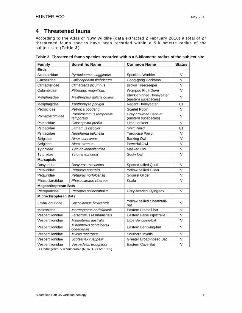
4 Threatened fauna According to the Atlas of NSW Wildlife (data extracted 2 February 2010) a total of 27 threatened fauna species have been recorded within a 5-kilometre radius of the subject site (Table 3). Table 3: Threatened fauna species recorded within a 5-kilometre radius of the subject site
Family Scientific Name Common Name Status Birds Acanthizidae Pyrrholaemus saggitatus Speckled Warbler V Cacatuidae Callocephalon fimbriatum Gang-gang Cockatoo V Climacteridae Climacteris picumnus Brown Treecreeper V Columbidae Ptilinopus magnificus Wompoo Fruit-Dove V
Meliphagidae Melithreptus gularis gularis Black-chinned Honeyeater (eastern subspecies) V
Meliphagidae Xanthomyza phrygia Regent Honeyeater E1 Petroicidae Petroica boodang Scarlet Robin V
Pomatostomidae Pomatostomus temporalis temporalis
Grey-crowned Babbler (eastern subspecies) V
Psittacidae Glossopsitta pusilla Little Lorikeet V Psittacidae Lathamus discolor Swift Parrot E1 Psittacidae Neophema pulchella Turquoise Parrot V Strigidae Ninox connivens Barking Owl V Strigidae Ninox strenua Powerful Owl V Tytonidae Tyto novaehollandiae Masked Owl V Tytonidae Tyto tenebricosa Sooty Owl V Marsupials Dasyuridae Dasyurus maculatus Spotted-tailed Quoll V Petauridae Petaurus australis Yellow-bellied Glider V Petauridae Petaurus norfolcensis Squirrel Glider V Phascolarctidae Phascolarctos cinereus Koala V Megachiropteran Bats Pteropodidae Pteropus poliocephalus Grey-headed Flying-fox V Microchiropteran Bats
Emballonuridae Saccolaimus flaviventris Yellow-bellied Sheathtail-bat V
Molossidae Mormopterus norfolkensis Eastern Freetail-bat V Vespertilionidae Falsistrellus tasmaniensis Eastern False Pipistrelle V Vespertilionidae Miniopterus australis Little Bentwing-bat V
Vespertilionidae Miniopterus schreibersii oceanensis Eastern Bentwing-bat V
Vespertilionidae Myotis macropus Southern Myotis V Vespertilionidae Scoteanax rueppellii Greater Broad-nosed Bat V Vespertilionidae Vespadelus troughtoni Eastern Cave Bat V
E = Endangered; V = Vulnerable (NSW TSC Act 1995)
HUNTER ECO May 2010
Bloomfield Part 3A variation ecology 11
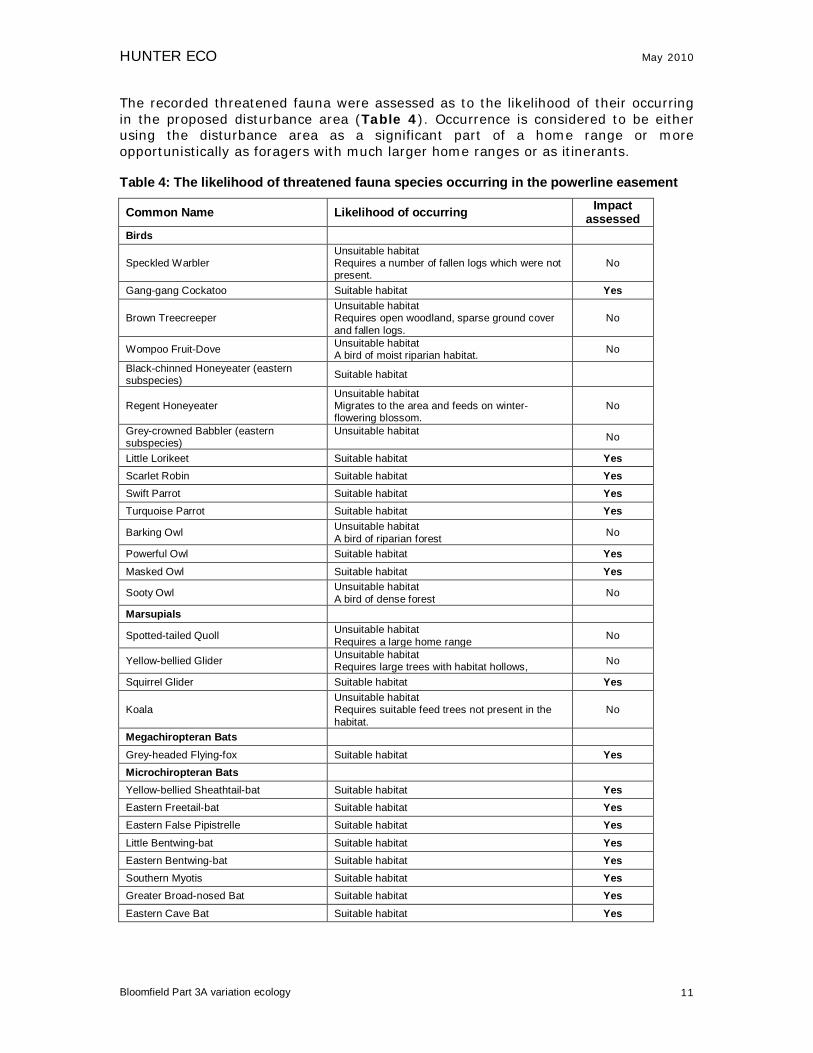
The recorded threatened fauna were assessed as to the likelihood of their occurring in the proposed disturbance area (Table 4). Occurrence is considered to be either using the disturbance area as a significant part of a home range or more opportunistically as foragers with much larger home ranges or as itinerants. Table 4: The likelihood of threatened fauna species occurring in the powerline easement
Common Name Likelihood of occurring Impact assessed
Birds
Speckled Warbler Unsuitable habitat Requires a number of fallen logs which were not present.
No
Gang-gang Cockatoo Suitable habitat Yes
Brown Treecreeper Unsuitable habitat Requires open woodland, sparse ground cover and fallen logs.
No
Wompoo Fruit-Dove Unsuitable habitat A bird of moist riparian habitat. No
Black-chinned Honeyeater (eastern subspecies) Suitable habitat
Regent Honeyeater Unsuitable habitat Migrates to the area and feeds on winter-flowering blossom.
No
Grey-crowned Babbler (eastern subspecies)
Unsuitable habitat No
Little Lorikeet Suitable habitat Yes Scarlet Robin Suitable habitat Yes Swift Parrot Suitable habitat Yes Turquoise Parrot Suitable habitat Yes
Barking Owl Unsuitable habitat A bird of riparian forest No
Powerful Owl Suitable habitat Yes Masked Owl Suitable habitat Yes
Sooty Owl Unsuitable habitat A bird of dense forest No
Marsupials
Spotted-tailed Quoll Unsuitable habitat Requires a large home range No
Yellow-bellied Glider Unsuitable habitat Requires large trees with habitat hollows, No
Squirrel Glider Suitable habitat Yes
Koala Unsuitable habitat Requires suitable feed trees not present in the habitat.
No
Megachiropteran Bats
Grey-headed Flying-fox Suitable habitat Yes Microchiropteran Bats
Yellow-bellied Sheathtail-bat Suitable habitat Yes Eastern Freetail-bat Suitable habitat Yes Eastern False Pipistrelle Suitable habitat Yes Little Bentwing-bat Suitable habitat Yes Eastern Bentwing-bat Suitable habitat Yes Southern Myotis Suitable habitat Yes Greater Broad-nosed Bat Suitable habitat Yes Eastern Cave Bat Suitable habitat Yes

HUNTER ECO May 2010
Bloomfield Part 3A variation ecology 12
5 Results
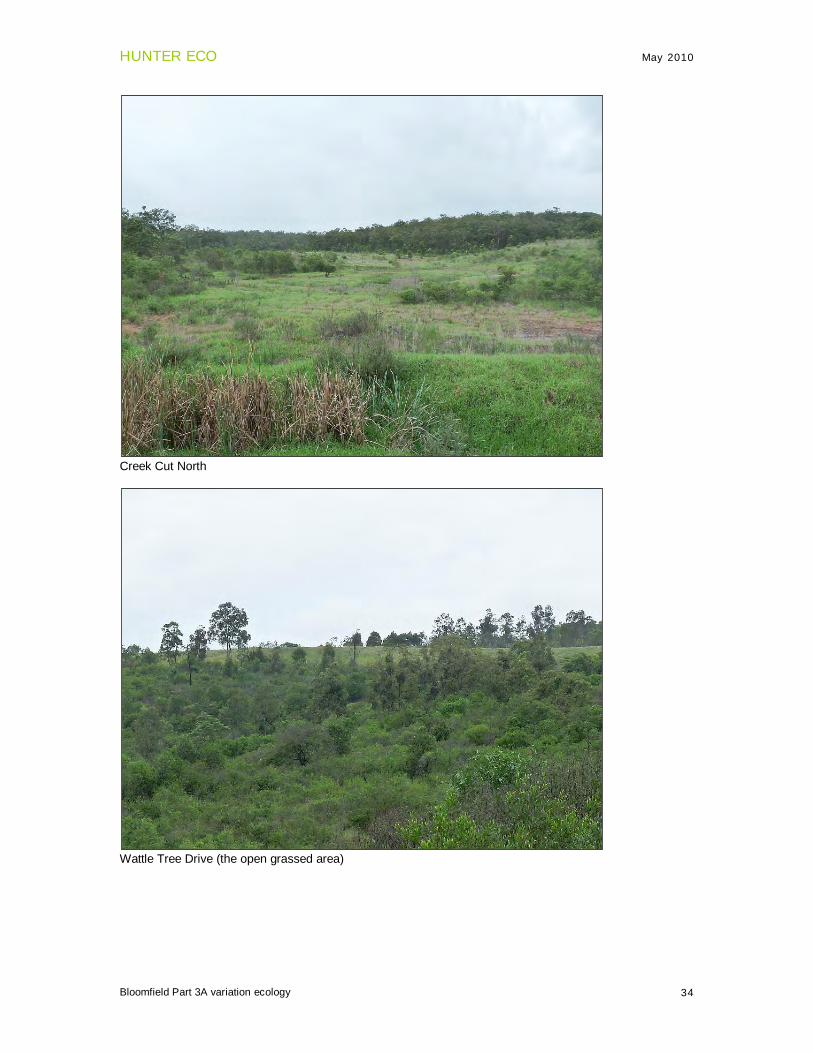
5.1 Habitat description A broad description of the habitat of each of the proposed areas: Overhead powerline easement & infrastructure area: fully forested with Spotted Gum (Corymbia maculata) and Red Ironbark (Eucalyptus fibrosa) being the main canopy species. Save-a-Mile: Landscaped overburden back-fill with a mix of planted Spotted Gum, wattles and exotic grasses as well as areas of spontaneous regrowth of exotic grasses and wattles. K-cut: Landscaped overburden back-fill with spontaneous regrowth of exotic grasses and wattles. Wattle Tree Drive: Landscaped overburden back-fill with sown exotic grasses, predominantly Rhodes Grass. Creek-cut North: Landscaped overburden back-fill with spontaneous regrowth of exotic grasses and wattles. The only area having potential habitat for threatened species was that of the powerline easement. The habitat in the other four areas was in poor condition and unsuitable for any of the threatened species recorded in the area. The ecological impact assessment that follows is applied to the vegetation in and around the proposed powerline easement.
5.2 Vegetation community and flora Lower Hunter Spotted Gum – Ironbark Forest The overstorey was dominated by Corymbia maculata (Spotted Gum), Eucalyptus fibrosa (Red Ironbark) and Eucalyptus umbra (Bastard Mahogany); other overstorey species were Eucalyptus punctata (Grey Gum), Syncarpia glomulifera (Turpentine), Angophora costata (Smooth-barked Apple) and Allocasuarina torulosa (Forest Oak). The shrub layer was dominated by Bursaria spinosa and Daviesia ulicifolia and the ground layer was dominated by Joycea pallida, Themeda australis and Entolasia stricta. This combination of species is consistent with that of the listed EEC (TSC Act) Lower Hunter Spotted Gum – Ironbark Forest. 54 species of flora were recorded across the area (Appendix 1). There were no threatened flora species present.
HUNTER ECO May 2010
Bloomfield Part 3A variation ecology 13
Coastal Plains Smooth-barked Apple Woodland The overstorey was dominated by Angophora costata (Smooth-barked Apple), Corymbia gummifera (Red Bloodwood), Eucalyptus umbra (White Mahogany). There was also Eucalyptus punctata (Grey Gum), Corymbia maculata (Spotted Gum) and Eucalyptus siderophloia (Grey Ironbark). The shrub layer contained Ceratopetalum gummiferum, Pultenaea villosa, Gompholobium latifolium Glochidion ferdinandi and Xylomelum pyriforme. The ground cover was dominated by Entolasia stricta, Themeda australis and Imperata cylindrica. 68 species of flora were recorded in this community (Appendix 1). There were no threatened flora species present.
HUNTER ECO May 2010
Bloomfield Part 3A variation ecology 14
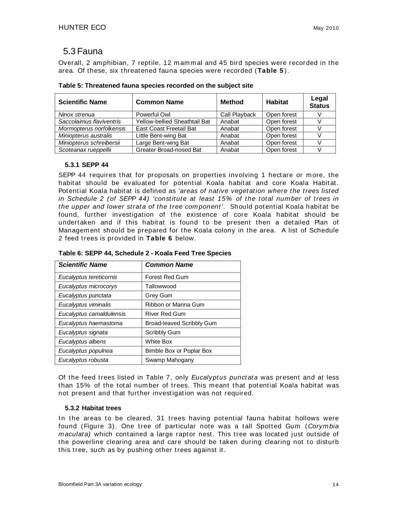
5.3 Fauna Overall, 2 amphibian, 7 reptile, 12 mammal and 45 bird species were recorded in the area. Of these, six threatened fauna species were recorded (Table 5). Table 5: Threatened fauna species recorded on the subject site
Scientific Name Common Name Method Habitat Legal Status
Ninox strenua Powerful Owl Call Playback Open forest V Saccolaimus flaviventris Yellow-bellied Sheathtail Bat Anabat Open forest V Mormopterus norfolkensis East Coast Freetail Bat Anabat Open forest V Miniopterus australis Little Bent-wing Bat Anabat Open forest V Miniopterus schreibersii Large Bent-wing Bat Anabat Open forest V Scoteanax rueppellii Greater Broad-nosed Bat Anabat Open forest V
5.3.1 SEPP 44 SEPP 44 requires that for proposals on properties involving 1 hectare or more, the habitat should be evaluated for potential Koala habitat and core Koala Habitat. Potential Koala habitat is defined as 'areas of native vegetation where the trees listed in Schedule 2 (of SEPP 44) 'constitute at least 15% of the total number of trees in the upper and lower strata of the tree component'. Should potential Koala habitat be found, further investigation of the existence of core Koala habitat should be undertaken and if this habitat is found to be present then a detailed Plan of Management should be prepared for the Koala colony in the area. A list of Schedule 2 feed trees is provided in Table 6 below. Table 6: SEPP 44, Schedule 2 - Koala Feed Tree Species
Scientific Name Common Name
Eucalyptus tereticornis Forest Red Gum Eucalyptus microcorys Tallowwood Eucalyptus punctata Grey Gum Eucalyptus viminalis Ribbon or Manna Gum Eucalyptus camaldulensis River Red Gum Eucalyptus haemastoma Broad-leaved Scribbly Gum Eucalyptus signata Scribbly Gum Eucalyptus albens White Box Eucalyptus populnea Bimble Box or Poplar Box Eucalyptus robusta Swamp Mahogany Of the feed trees listed in Table 7, only Eucalyptus punctata was present and at less than 15% of the total number of trees. This meant that potential Koala habitat was not present and that further investigation was not required.
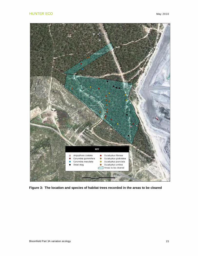
5.3.2 Habitat trees In the areas to be cleared, 31 trees having potential fauna habitat hollows were found (Figure 3). One tree of particular note was a tall Spotted Gum (Corymbia maculata) which contained a large raptor nest. This tree was located just outside of the powerline clearing area and care should be taken during clearing not to disturb this tree, such as by pushing other trees against it.
HUNTER ECO May 2010
Bloomfield Part 3A variation ecology 15
Figure 3: The location and species of habitat trees recorded in the areas to be cleared
HUNTER ECO May 2010
Bloomfield Part 3A variation ecology 17
The clearing would be at the edge of the open cut working areas and would not result in a loss of connectivity between habitat patches.
f) How is the proposal likely to affect critical habitat? No critical habitat for this species occurs at this location. Little Lorikeet
a) How is the proposal likely to affect the lifecycle of a threatened species and/or population?
Three trees having potential breeding hollows would be lost but this would not have an impact on the life cycle of the species..
b) How is the proposal likely to affect the habitat of a threatened species, population or ecological community?
The loss of canopy trees would reduce the amount of available foraging habitat for the species. However the loss of about 1 hectare would be insignificant in the overall context of available habitat in the locality.
c) Does the proposal affect any threatened species or populations that are at the limit of its known distribution?
The Little Lorikeet is not at the known limit of its distribution at this location. d) How is the proposal likely to affect current disturbance regimes?
There would be very little change to current disturbance regimes as the habitat is located at the edge of the existing work areas.
e) How is the proposal likely to affect habitat connectivity? The clearing would be at the edge of the open cut working a areas and would not result in a loss of connectivity between habitat patches.
f) How is the proposal likely to affect critical habitat? No critical habitat for this species occurs at this location.
Swift Parrot
a) How is the proposal likely to affect the lifecycle of a threatened species and/or population?
The habitat at the forest/cleared interface is marginal for these birds with little grassland foraging available and none of these birds were recorded during the investigation. The small amount of clearing required would not have any impact on the life cycle of these birds were they present at the subject site.
b) How is the proposal likely to affect the habitat of a threatened species, population or ecological community?
The proposal would not affect the potential habitat for this bird. c) Does the proposal affect any threatened species or populations that are at the limit of
its known distribution? The Swift Parrot is not at the known limit of its distribution at this location.
d) How is the proposal likely to affect current disturbance regimes? There would be very little change to current disturbance regimes as the habitat is located at the edge of the existing work areas.
e) How is the proposal likely to affect habitat connectivity? The clearing would be at the edge of the open cut working a areas and would not result in a loss of connectivity between habitat patches.
f) How is the proposal likely to affect critical habitat? No critical habitat for this species occurs at this location.
Gang-gang Cockatoo
a) How is the proposal likely to affect the lifecycle of a threatened species and/or population?
The small amount of clearing required would have no impact on the life-cycle of the Gang-gang Cockatoo. The loss of three trees having potential breeding hollows would not have a detrimental impact on the life-cycle of the species.

HUNTER ECO May 2010
Bloomfield Part 3A variation ecology 18
b) How is the proposal likely to affect the habitat of a threatened species, population or ecological community?
The proposal would not affect the potential habitat for this bird. c) Does the proposal affect any threatened species or populations that are at the limit of
its known distribution? The Gang-gang Cockatoo is not at the known limit of its distribution at this location.
d) How is the proposal likely to affect current disturbance regimes? There would be very little change to current disturbance regimes as the habitat is located at the edge of the existing work areas.
e) How is the proposal likely to affect habitat connectivity? The clearing would be at the edge of the open cut working a areas and would not result in a loss of connectivity between habitat patches.
f) How is the proposal likely to affect critical habitat? No critical habitat for this species occurs at this location.
Powerful Owl a) How is the proposal likely to affect the lifecycle of a threatened species and/or
population? The Powerful Owl home range is around 1000 ha. The small amount of vegetation that is proposed to be cleared does not contain essential habitat features for this bird i.e. there were no trees with suitable breeding hollows and no vegetation suitable for daytime roosting.
b) How is the proposal likely to affect the habitat of a threatened species, population or ecological community?
The proposal would not affect the potential habitat for this bird. c) Does the proposal affect any threatened species or populations that are at the limit of
its known distribution? The Powerful Owl is not at the known limit of its distribution at this location.
d) How is the proposal likely to affect current disturbance regimes? There would be very little change to current disturbance regimes as the habitat is located at the edge of the existing work areas.
e) How is the proposal likely to affect habitat connectivity? The clearing would be at the edge of the open cut working a areas and would not result in a loss of connectivity between habitat patches.
f) How is the proposal likely to affect critical habitat? No critical habitat for this species occurs at this location.
Masked Owl a) How is the proposal likely to affect the lifecycle of a threatened species and/or
population? The Masked Owl home range is around 750 ha. Three trees having possible breeding hollows would be lost however no Masked Owls were recorded in the area.
b) How is the proposal likely to affect the habitat of a threatened species, population or ecological community?
The proposal would not affect the potential habitat for this bird. c) Does the proposal affect any threatened species or populations that are at the limit of
its known distribution? The Powerful Owl is not at the known limit of its distribution at this location.
d) How is the proposal likely to affect current disturbance regimes? There would be very little change to current disturbance regimes as the habitat is located at the edge of the existing work areas.
e) How is the proposal likely to affect habitat connectivity? The clearing would be at the edge of the open cut working a areas and would not result in a loss of connectivity between habitat patches.

HUNTER ECO May 2010
Bloomfield Part 3A variation ecology 19
. f) How is the proposal likely to affect critical habitat?
No critical habitat for this species occurs at this location.
Black-chinned Honeyeater (eastern subspecies) a) How is the proposal likely to affect the lifecycle of a threatened species and/or population? The species can be found foraging and breeding in habitat similar to that present. The loss of 1 hectare would not place any local population at risk. b) How is the proposal likely to affect the habitat of a threatened species, population or
ecological community? The proposal would not affect the potential habitat for this bird. c) Does the proposal affect any threatened species or populations that are at the limit of its
known distribution? The species is not at the known limit of its distribution at this location.
d) How is the proposal likely to affect current disturbance regimes? There would be very little change to current disturbance regimes as the habitat is located at the edge of the existing work areas. e) How is the proposal likely to affect habitat connectivity? The clearing would be at the edge of the open cut working a areas and would not result in a loss of connectivity between habitat patches. f) How is the proposal likely to affect critical habitat? No critical habitat for this species occurs at this location.
Scarlet Robin a) How is the proposal likely to affect the lifecycle of a threatened species and/or population? The species can be found foraging and breeding in habitat similar to that present. The loss of 1 hectare would not place any local population at risk. b) How is the proposal likely to affect the habitat of a threatened species, population or
ecological community? The proposal would not affect the potential habitat for this bird. c) Does the proposal affect any threatened species or populations that are at the limit of its
known distribution? The species is not at the known limit of its distribution at this location.
d) How is the proposal likely to affect current disturbance regimes? There would be very little change to current disturbance regimes as the habitat is located at the edge of the existing work areas. e) How is the proposal likely to affect habitat connectivity? The clearing would be at the edge of the open cut working a areas and would not result in a loss of connectivity between habitat patches. f) How is the proposal likely to affect critical habitat? No critical habitat for this species occurs at this location.
Squirrel Glider a) How is the proposal likely to affect the lifecycle of a threatened species and/or
population? No Squirrel Gliders were recorded during the field work although they are known to be in the area having been recorded elsewhere on Bloomfield as well as on Donaldson to the east. The proposed clearing would not place any local population of Squirrel Gliders under threat. Three trees having potential denning hollows would be lost, however no Squirrel Gliders were recorded in the area.
b) How is the proposal likely to affect the habitat of a threatened species, population or ecological community?
The proposal would not affect the potential habitat for this glider.

HUNTER ECO May 2010
Bloomfield Part 3A variation ecology 20
c) Does the proposal affect any threatened species or populations that are at the limit of its known distribution?
The Squirrel Glider is not at the known limit of its distribution at this location. d) How is the proposal likely to affect current disturbance regimes?
There would be very little change to current disturbance regimes as the habitat is located at the edge of the existing work areas.
e) How is the proposal likely to affect habitat connectivity? The clearing would be at the edge of the open cut working a areas and would not result in a loss of connectivity between habitat patches.
f) How is the proposal likely to affect critical habitat? No critical habitat for this species occurs at this location.
Grey-headed Flying Fox a) How is the proposal likely to affect the lifecycle of a threatened species and/or
population? There were no breeding colonies of this flying fox present and the small amount of vegetation proposed to be cleared would not impact on the overall available foraging resources of the species.
b) How is the proposal likely to affect the habitat of a threatened species, population or ecological community?
The proposal would not affect the potential habitat for this flying fox. c) Does the proposal affect any threatened species or populations that are at the limit of
its known distribution? The Grey-headed Flying Fox is not at the known limit of its distribution at this location.
d) How is the proposal likely to affect current disturbance regimes? There would be very little change to current disturbance regimes as the habitat is located at the edge of the existing work areas.
e) How is the proposal likely to affect habitat connectivity? The clearing would be at the edge of the open cut working a areas and would not result in a loss of connectivity between habitat patches.
f) How is the proposal likely to affect critical habitat? No critical habitat for this species occurs at this location.
Cave Roosting Microchiropteran Bats
Little Bent-wing Bat Eastern Bent-wing Bat Eastern Cave Bat
a) How is the proposal likely to affect the lifecycle of a threatened species and/or population? The proposed action would not remove foraging habitat from the home ranges of these species. No breeding habitat was present in the area.
b) How is the proposal likely to affect the habitat of a threatened species, population or ecological community?
The proposal would not affect the potential habitat for these bats. c) Does the proposal affect any threatened species or populations that are at the limit of its
known distribution? Neither species of bat are at the known limit of their distributions at this location.
d) How is the proposal likely to affect current disturbance regimes? Very little change to current disturbance regimes as the habitat is on the edge of a cleared mining area.
e) How is the proposal likely to affect habitat connectivity?
HUNTER ECO May 2010
Bloomfield Part 3A variation ecology 16
6 Impact assessment This section examines the possible impact of the proposed powerline easement construction on threatened species and endangered communities. An impact assessment is conducted according to the Draft Guidelines for Threatened Species Assessment (DECC & DPI 2005). A review of the threatened species profiles shows that there were threatened species that could be found on the subject site under different conditions to those prevailing at the time of this investigation or could be found in similar habitat in the immediate region. An impact assessment was applied to these species, threatened flora and fauna species and any endangered ecological communities that were recorded during the field surveys.
6.1 Flora Rutidosis heterogama
a) How is the proposal likely to affect the lifecycle of a threatened species and/or population?
No Rutidosis heterogama was found in or near the area to be cleared. b) How is the proposal likely to affect the habitat of a threatened species, population or
ecological community? The clearing of approximately 8 hectare would have no impact on the availability of suitable habitat for the species.
c) Does the proposal affect any threatened species or populations that are at the limit of its known distribution?
Rutidosis heterogama would not be at the limit of its known distribution at this location. d) How is the proposal likely to affect current disturbance regimes?
There would be no additional risks to the surrounding habitat as a result of the establishment of the powerline easement.
e) How is the proposal likely to affect habitat connectivity? The clearing would be at the edge of the open cut working a areas and would not result in a loss of connectivity between habitat patches.
f) How is the proposal likely to affect critical habitat? No critical habitat was present.
6.2 Fauna Turquoise Parrot
a) How is the proposal likely to affect the lifecycle of a threatened species and/or population?
The habitat at the forest/cleared interface is marginal for these birds with little grassland foraging available and none of these birds were recorded during the investigation. The small amount of clearing required would not have any impact on the life cycle of these birds were they present at the subject site. It may in fact create a small amount of suitable habitat for the species.
b) How is the proposal likely to affect the habitat of a threatened species, population or ecological community?
The new powerline easement could make more suitable habitat available for these birds by creating additional forest/grassland interface.
c) Does the proposal affect any threatened species or populations that are at the limit of its known distribution?
The Turquoise Parrot is not at the known limit of its distribution at this location. d) How is the proposal likely to affect current disturbance regimes?
There would be very little change to current disturbance regimes as the habitat is located at the edge of the existing work areas.
e) How is the proposal likely to affect habitat connectivity?

HUNTER ECO May 2010
Bloomfield Part 3A variation ecology 21
The clearing would be at the edge of the open cut working a areas and would not result in a loss of connectivity between habitat patches.
f) How is the proposal likely to affect critical habitat? No critical habitat for this species occurs at this location.
Tree Roosting Microchiropteran Bats Eastern Freetail-bat Yellow-bellied Sheathtail Bat Greater Broad-nosed Bat Eastern False Pipistrelle Southern Myotis
a) How is the proposal likely to affect the lifecycle of a threatened species and/or population? The small area of clearing involved in the proposed development would not impact on the life cycle of these species and would not restrict their foraging.
b) How is the proposal likely to affect the habitat of a threatened species, population or ecological community?
The proposal would not affect the potential habitat for these bats. c) Does the proposal affect any threatened species or populations that are at the limit of its
known distribution? None of the species of bat are at the known limit of their distributions at this location.
d) How is the proposal likely to affect current disturbance regimes? Very little change to current disturbance regimes as the habitat is on the edge of a cleared mining area.
e) How is the proposal likely to affect habitat connectivity? The clearing would be at the edge of the open cut working a areas and would not result in a loss of connectivity between habitat patches.
f) How is the proposal likely to affect critical habitat? No critical habitat for this species occurs at this location.
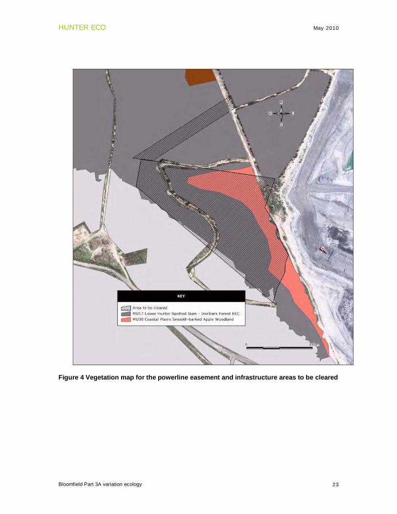
6.3 Endangered Ecological Community Lower Hunter Spotted Gum – Ironbark Forest Figure 4 shows the mapped vegetation for the clearing required for the powerline easement and infrastructure areas. A total of about 8 hectares of the EEC would be cleared.
a) How is the proposal likely to affect the lifecycle of a threatened species and/or population? Not applicable.
b) How is the proposal likely to affect the habitat of a threatened species, population or ecological community?
The proposed mining will result in the loss of about 8 hectares of this community. However there is about 145 ha of this community in the immediate vicinity of the proposed disturbance area and the loss of 8 hectares would not have a significant impact on the remaining community. This of course has been demonstrated by the fact that historical clearing around remnants of this EEC has not impacted negatively on those remnants.
c) Does the proposal affect any threatened species or populations that are at the limit of its known distribution?
Not applicable. d) How is the proposal likely to affect current disturbance regimes? Very little change to current disturbance regimes as the habitat is on the edge of a cleared mining area.
e) How is the proposal likely to affect critical habitat?
HUNTER ECO May 2010
Bloomfield Part 3A variation ecology 23
Figure 4 Vegetation map for the powerline easement and infrastructure areas to be cleared
HUNTER ECO May 2010
Bloomfield Part 3A variation ecology 24
6.5 Commonwealth considerations Matters of national significance protected under the EPBC Act 1999 are as follows:
• World Heritage properties
• National heritage places
• Wetlands of international importance (Ramsar wetlands)
• Threatened species and ecological communities
• Migratory species
• Commonwealth marine areas
• Nuclear actions (including uranium mining)
None of these matters would be involved in the proposed extension to activities. In particular there were: no wetlands; no migratory species; and, none of the Commonwealth listed threatened species or ecological communities were present.
7 Conclusion & recommendations The treatment of the habitat trees in the powerline easement is the only recommendation. In the week prior to clearing, these trees should be inspected at dusk to determine whether any of the hollows are occupied. If there is a colony of microbats or a threatened owl using the hollows then clearing should be timed to minimise any impact. When clearing is finally carried out these trees should be left standing for at least 5 nights so that any occupants can relocate. When these trees are finally brought down an experienced fauna ecologist should be present to attend to any fauna that are still occupying the hollows.
HUNTER ECO May 2010
Bloomfield Part 3A variation ecology 25
8 References Bibby, C.J., Burgess, N.D. and Hill, D.A. (2000). Bird Census Techniques. Academic Press Limited, London. Briggs, J.D. and Leigh J.H. (1996). Rare or threatened Australian plants. CSIRO Publishing, Australia. Brunner, H., Triggs, B. & Ecobyte Pty Ltd. (2002). Hair ID. An interactive tool for identifying Australia mammalian hair. CSIRO Publishing, Collingwood, Victoria. Driscoll, C. & Bell, S.A.J. (2006) The natural vegetation of Bloomfield, Ashtonfield and Donaldson properties: preliminary report. A report prepared for Bloomfield and Donaldson Coal. DECC & DoP (2005) Draft Guidelines for Threatened Species Assessment under Part 3A of the Environmental Planning and Assessment Act 1979. Gibbons, P. and Lindenmayer, D. (2002) Tree Hollows and Wildlife Conservation in Australia. CSIRO Publishing, Canberra. Harden, G.J. (ed) (1992). Flora of New South Wales Volume 3. NSW University Press: Sydney. Harden, G.J. (ed) (1993). Flora of New South Wales Volume 4. NSW University Press: Sydney. Harden, G.J. (ed) (2000). Flora of New South Wales Volume 1. NSW University Press: Sydney. Harden, G.J . (ed) (2002). Flora of New South Wales Volume 2. NSW University Press: Sydney.
Business Environment (2008) Bloomfield Colliery Completion of Mining and Rehabilitation – Part 3A Environmental Assessment Project Application 07_0087.
Triggs, B. (1996). Tracks, Scats and Other Traces: A Field Guide to Australian Mammals, Oxford University Press.
HUNTER ECO May 2010
Bloomfield Part 3A variation ecology 26
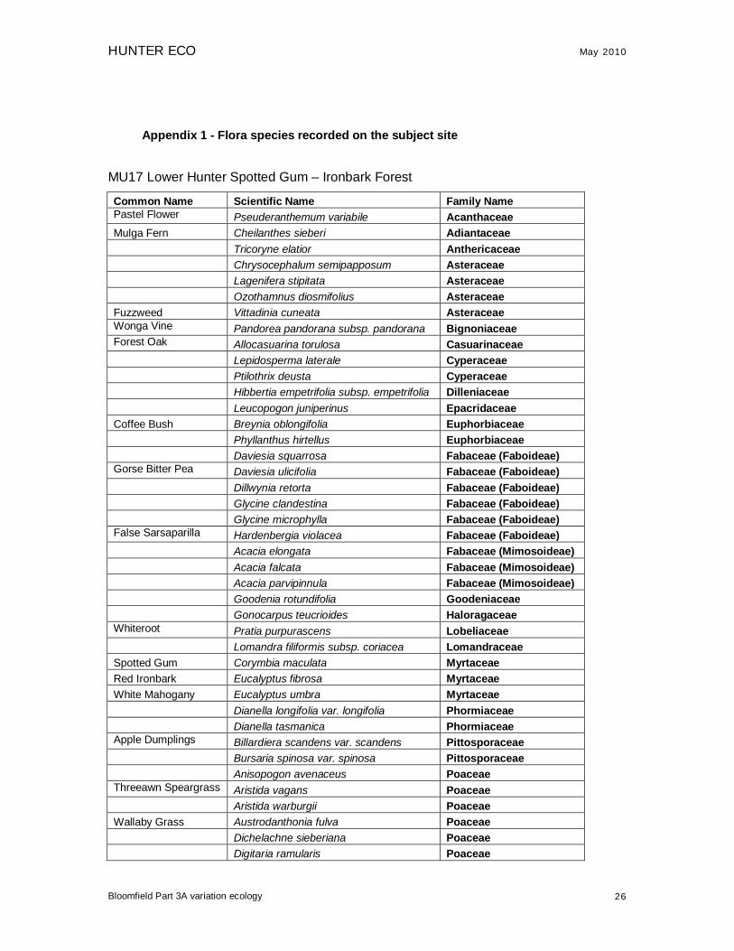
Appendix 1 - Flora species recorded on the subject site
MU17 Lower Hunter Spotted Gum – Ironbark Forest
Common Name Scientific Name Family Name Pastel Flower Pseuderanthemum variabile Acanthaceae Mulga Fern Cheilanthes sieberi Adiantaceae Tricoryne elatior Anthericaceae Chrysocephalum semipapposum Asteraceae Lagenifera stipitata Asteraceae Ozothamnus diosmifolius Asteraceae Fuzzweed Vittadinia cuneata Asteraceae Wonga Vine Pandorea pandorana subsp. pandorana Bignoniaceae Forest Oak Allocasuarina torulosa Casuarinaceae Lepidosperma laterale Cyperaceae Ptilothrix deusta Cyperaceae Hibbertia empetrifolia subsp. empetrifolia Dilleniaceae Leucopogon juniperinus Epacridaceae Coffee Bush Breynia oblongifolia Euphorbiaceae Phyllanthus hirtellus Euphorbiaceae Daviesia squarrosa Fabaceae (Faboideae) Gorse Bitter Pea Daviesia ulicifolia Fabaceae (Faboideae) Dillwynia retorta Fabaceae (Faboideae) Glycine clandestina Fabaceae (Faboideae) Glycine microphylla Fabaceae (Faboideae) False Sarsaparilla Hardenbergia violacea Fabaceae (Faboideae) Acacia elongata Fabaceae (Mimosoideae) Acacia falcata Fabaceae (Mimosoideae) Acacia parvipinnula Fabaceae (Mimosoideae) Goodenia rotundifolia Goodeniaceae Gonocarpus teucrioides Haloragaceae Whiteroot Pratia purpurascens Lobeliaceae Lomandra filiformis subsp. coriacea Lomandraceae Spotted Gum Corymbia maculata Myrtaceae Red Ironbark Eucalyptus fibrosa Myrtaceae White Mahogany Eucalyptus umbra Myrtaceae Dianella longifolia var. longifolia Phormiaceae Dianella tasmanica Phormiaceae Apple Dumplings Billardiera scandens var. scandens Pittosporaceae Bursaria spinosa var. spinosa Pittosporaceae Anisopogon avenaceus Poaceae Threeawn Speargrass Aristida vagans Poaceae Aristida warburgii Poaceae Wallaby Grass Austrodanthonia fulva Poaceae Dichelachne sieberiana Poaceae Digitaria ramularis Poaceae
HUNTER ECO May 2010
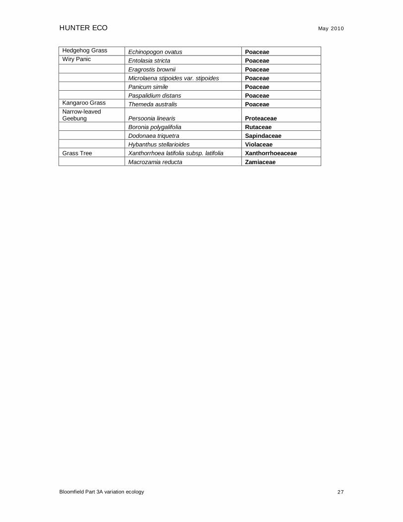
Bloomfield Part 3A variation ecology 27
Hedgehog Grass Echinopogon ovatus Poaceae Wiry Panic Entolasia stricta Poaceae Eragrostis brownii Poaceae Microlaena stipoides var. stipoides Poaceae Panicum simile Poaceae Paspalidium distans Poaceae Kangaroo Grass Themeda australis Poaceae Narrow-leaved Geebung Persoonia linearis Proteaceae Boronia polygalifolia Rutaceae Dodonaea triquetra Sapindaceae Hybanthus stellarioides Violaceae Grass Tree Xanthorrhoea latifolia subsp. latifolia Xanthorrhoeaceae Macrozamia reducta Zamiaceae
HUNTER ECO May 2010
Bloomfield Part 3A variation ecology 28
MU30 Coastal Plains Smooth-barked Apple Woodland Common Name Scientific Name Family Name Pastel Flower Pseuderanthemum variabile Acanthaceae Maiden Hair Fern Adiantum aethiopicum Adiantaceae Mulga Fern Cheilanthes sieberi Adiantaceae Tricoryne elatior Anthericaceae Astrotricha obovata Araliaceae Elderberry Ash Polyscias sambucifolia Araliaceae Wonga Vine Pandorea pandorana subsp. pandorana Bignoniaceae Forest Oak Allocasuarina torulosa Casuarinaceae Orange Bark Maytenus silvestris Celastraceae Ceratopetalum gummiferum Cunoniaceae Swordgrass Gahnia clarkei Cyperaceae Lepidosperma concavum Cyperaceae Lepidosperma laterale Cyperaceae Hypolepis muelleri Dennstaedtiaceae Bracken Fern Pteridium esculentum Dennstaedtiaceae Hibbertia empetrifolia subsp. empetrifolia Dilleniaceae Cheese Tree Glochidion ferdinandi Euphorbiaceae Phyllanthus hirtellus Euphorbiaceae Gorse Bitter Pea Daviesia ulicifolia Fabaceae (Faboideae) Dillwynia retorta Fabaceae (Faboideae) Glycine clandestina Fabaceae (Faboideae) Gompholobium latifolium Fabaceae (Faboideae) Hovea linearis Fabaceae (Faboideae) Pultenaea villosa Fabaceae (Faboideae) Acacia elongata Fabaceae (Mimosoideae) Acacia linifolia Fabaceae (Mimosoideae) Gonocarpus teucrioides Haloragaceae Lacy Wedge Fern Lindsaea microphylla Lindsaeaceae Whiteroot Pratia purpurascens Lobeliaceae Whiteroot Pratia purpurascens Lobeliaceae Lomandra filiformis subsp. coriacea Lomandraceae Lomandra multiflora subsp. multiflora Lomandraceae Fishbone Lomandra obliqua Lomandraceae Muttonwood Rapanea variabilis Myrsinaceae Smooth-barked Apple Angophora costata Myrtaceae Red Bloodwood Corymbia gummifera Myrtaceae Spotted Gum Corymbia maculata Myrtaceae Red Ironbark Eucalyptus fibrosa Myrtaceae Eucalyptus globoidea Myrtaceae Eucalyptus punctata Myrtaceae Eucalyptus siderophloia Myrtaceae White Mahogany Eucalyptus umbra Myrtaceae
Leptospermum polygalifolium subsp. polygalifolium Myrtaceae
Leptospermum trinervium Myrtaceae Native Olive Notelaea longifolia Oleaceae

HUNTER ECO May 2010
Bloomfield Part 3A variation ecology 29
Dianella caerulea var. caerulea Phormiaceae Dianella longifolia var. longifolia Phormiaceae Dianella tasmanica Phormiaceae Apple Dumplings Billardiera scandens var. scandens Pittosporaceae Hairy Pittosporum Pittosporum revolutum Pittosporaceae Anisopogon avenaceus Poaceae Threeawn Speargrass Aristida vagans Poaceae Wallaby Grass Austrodanthonia fulva Poaceae Cymbopogon refractus Poaceae Hedgehog Grass Echinopogon caespitosus var.
caespitosus Poaceae Wiry Panic Entolasia stricta Poaceae Bladey Grass Imperata cylindrica var. major Poaceae Joycea pallida Poaceae Microlaena stipoides var. stipoides Poaceae Kangaroo Grass
Themeda australis Poaceae Banksia spinulosa var. collina Proteaceae Lomatia silaifolia Proteaceae Narrow-leaved Geebung Persoonia linearis Proteaceae Woody Pear Xylomelum pyriforme Proteaceae Ripogonum album Ripogonaceae Pomax umbellata Rubiaceae Pimelea linifolia subsp. linifolia Thymelaeaceae Macrozamia reducta Zamiaceae
HUNTER ECO May 2010
Bloomfield Part 3A variation ecology 30
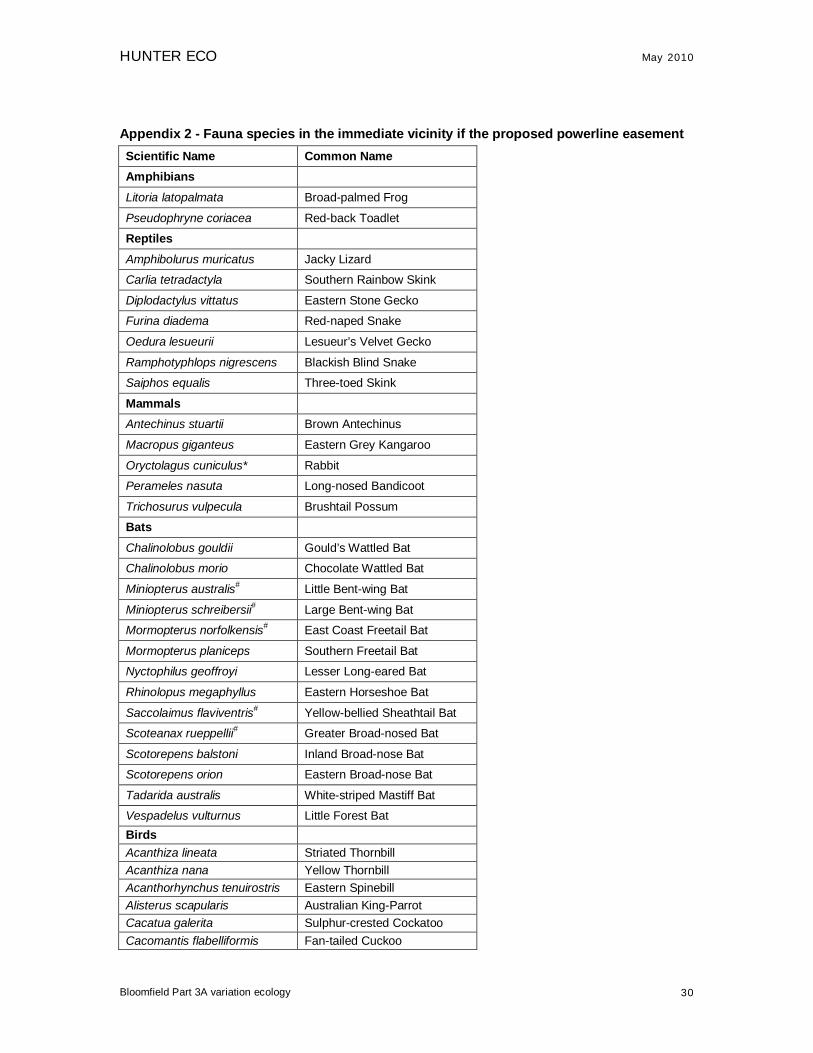
Appendix 2 - Fauna species in the immediate vicinity if the proposed powerline easement Scientific Name Common Name Amphibians
Litoria latopalmata Broad-palmed Frog
Pseudophryne coriacea Red-back Toadlet
Reptiles
Amphibolurus muricatus Jacky Lizard
Carlia tetradactyla Southern Rainbow Skink
Diplodactylus vittatus Eastern Stone Gecko
Furina diadema Red-naped Snake
Oedura lesueurii Lesueur’s Velvet Gecko
Ramphotyphlops nigrescens Blackish Blind Snake
Saiphos equalis Three-toed Skink
Mammals
Antechinus stuartii Brown Antechinus
Macropus giganteus Eastern Grey Kangaroo
Oryctolagus cuniculus* Rabbit
Perameles nasuta Long-nosed Bandicoot
Trichosurus vulpecula Brushtail Possum
Bats
Chalinolobus gouldii Gould’s Wattled Bat
Chalinolobus morio Chocolate Wattled Bat
Miniopterus australis# Little Bent-wing Bat
Miniopterus schreibersii# Large Bent-wing Bat
Mormopterus norfolkensis# East Coast Freetail Bat
Mormopterus planiceps Southern Freetail Bat
Nyctophilus geoffroyi Lesser Long-eared Bat
Rhinolopus megaphyllus Eastern Horseshoe Bat
Saccolaimus flaviventris# Yellow-bellied Sheathtail Bat
Scoteanax rueppellii# Greater Broad-nosed Bat
Scotorepens balstoni Inland Broad-nose Bat
Scotorepens orion Eastern Broad-nose Bat
Tadarida australis White-striped Mastiff Bat
Vespadelus vulturnus Little Forest Bat Birds Acanthiza lineata Striated Thornbill Acanthiza nana Yellow Thornbill Acanthorhynchus tenuirostris Eastern Spinebill Alisterus scapularis Australian King-Parrot Cacatua galerita Sulphur-crested Cockatoo Cacomantis flabelliformis Fan-tailed Cuckoo

HUNTER ECO May 2010
Bloomfield Part 3A variation ecology 31
Calyptorhynchus funereus Yellow-tailed Black-Cockatoo Chrysococcyx basalis Horsfield's Bronze-Cuckoo Chrysococcyx lucidus Shining Bronze-Cuckoo Colluricincla harmonica Grey Shrike-thrush Coracina novaehollandiae Black-faced Cuckoo-shrike Coracina tenuirostris Cicadabird Cormobates leucophaeus White-throated Treecreeper Corvus coronoides Australian Raven Coturnix ypsilophora Brown Quail Cracticus nigrogularis Pied Butcherbird Dacelo novaeguineae Laughing Kookaburra Eopsaltria australis Eastern Yellow Robin Geopelia humeralis Bar-shouldered Dove Gerygone olivacea White-throated Gerygone Gymnorhina tibicen Australian Magpie Hirundo neoxena Welcome Swallow Lichenostomus chrysops Yellow-faced Honeyeater Lichenostomus melanops Yellow-tufted Honeyeater Malurus cyaneus Superb Fairy-wren Malurus lamberti Variegated Fairy-wren Myiagra rubecula Leaden Flycatcher Neochmia temporalis Red-browed Finch Ninox strenua# Powerful Owl Nycticorax caledonicus Nankeen Night Heron Ocyphaps lophotes Crested Pigeon Oriolus sagittatus Olive-backed Oriole Pachycephala rufiventris Rufous Whistler Pardalotus punctatus Spotted Pardalote Pardalotus striatus Striated Pardalote Philemon corniculatus Noisy Friarbird Platycercus elegans Crimson Rosella Platycercus eximius Eastern Rosella Podargus strigoides Tawny Frogmouth Rhipidura fuliginosa Grey Fantail Scythrops novaehollandiae Channel-billed Cuckoo Sericornis frontalis White-browed Scrubwren Strepera graculina Pied Currawong Taeniopygia bichenovii Double-barred Finch Todiramphus sanctus Sacred Kingfisher Zosterops lateralis Silvereye
*Introduced, #Vulnerable (TSC Act)
HUNTER ECO May 2010
Bloomfield Part 3A variation ecology 32
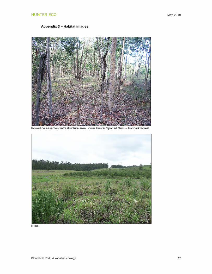
Appendix 3 – Habitat images
Powerline easement/infrastructure area Lower Hunter Spotted Gum – Ironbark Forest
K-cut
HUNTER ECO May 2010
Bloomfield Part 3A variation ecology 22
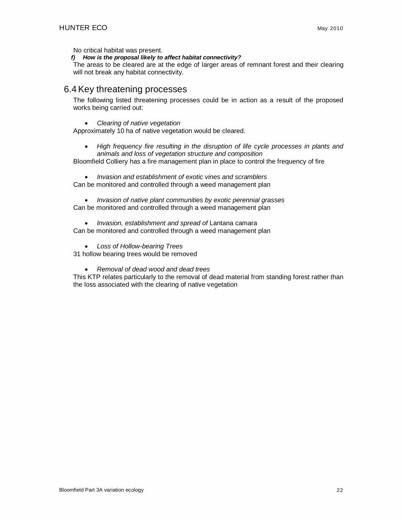
No critical habitat was present. f) How is the proposal likely to affect habitat connectivity? The areas to be cleared are at the edge of larger areas of remnant forest and their clearing will not break any habitat connectivity.
6.4 Key threatening processes The following listed threatening processes could be in action as a result of the proposed works being carried out:
• Clearing of native vegetation Approximately 10 ha of native vegetation would be cleared.
• High frequency fire resulting in the disruption of life cycle processes in plants and animals and loss of vegetation structure and composition
Bloomfield Colliery has a fire management plan in place to control the frequency of fire
• Invasion and establishment of exotic vines and scramblers Can be monitored and controlled through a weed management plan
• Invasion of native plant communities by exotic perennial grasses Can be monitored and controlled through a weed management plan
• Invasion, establishment and spread of Lantana camara Can be monitored and controlled through a weed management plan
• Loss of Hollow-bearing Trees 31 hollow bearing trees would be removed
• Removal of dead wood and dead trees This KTP relates particularly to the removal of dead material from standing forest rather than the loss associated with the clearing of native vegetation

HUNTER ECO May 2010
Bloomfield Part 3A variation ecology 33
Save-a-mile
Save-a-mile
HUNTER ECO May 2010
Bloomfield Part 3A variation ecology 34
Creek Cut North
Wattle Tree Drive (the open grassed area)

Bloomfield Colliery Section 75W Modification
September 2010
Appendix C – Air Quality Assessment

PAEHolmes
SYDNEY
Suite 2B, 14 Glen St Eastwood NSW 2122
Ph: + 61 2 9874 8644
Fax: + 61 2 9874 8904
[email protected] www.paeholmes.com
BRISBANE
GOLD COAST
TOOWOOMBA
A PEL COMPANY
Queensland Environment Pty Ltd Trading as PAEHolmes ABN: 86 127 101 642
31 May 2010
Steve Dunn Bloomfield Colliery Via email: [email protected]
Dear Steve
Re: Bloomfield Modification Analysis for Air Quality
We have completed the modelling for the proposed additional overburden emplacement area and modification of the two rehabilitation areas for Stage 2. The additional emplacement area will facilitate the storage of 1,200,000 bcm of overburden at the “Save a mile south” emplacement area as shown in Figure 1. The modification of the rehabilitation areas, also shown in Figure 1, will involve the reshaping of the final landform to improve drainage along with the addition of 50,000 bcm and 100,000 bcm of overburden to the northern and southern rehabilitation areas, respectively.
Also proposed are the relocation of the southern end of the powerline that provides electricity to the site along with a 40 m wide easement. The construction of these works is anticipated to take less than 6 weeks and is to be built during Stage 2. In addition, it is proposed to develop a northern haul road known as “Wattle Tree Drive”
along the alignment of an existing access road. The location of Wattle Tree Drive is shown in Figure 1. The implementation of the new haul route would result in a decreased haul distance for the ROM coal transported from Creek Cut to the washery for processing. While dust would be generated from the earthworks associated with the proposed relocation of the powerline and construction of Wattle Creek Drive, there are a number of safe guards that can be put in place during these type of operations to ensure there is no detrimental impact on the local air quality. Therefore the impacts have not been specifically modelled.
The modelling of emissions from Bloomfield is based on the emissions estimation tables, as agreed on 11 January 2010. Copies of the emissions tables are provided in Table 1 for reference.
For the cumulative assessment, emissions from the Donaldson Open-Cut and Abel Underground coal mines, located to the east of Bloomfield, have been included in the assessment. Bloomfield, Donaldson and Abel make use of a common Coal Handling and Processing Plant (CHPP) and also operate stockpiles in the same area and share the same rail loop. These activities were approved as part of the Abel Underground Mine Project (Holmes Air Sciences, 2006). Emissions from these common facilities have only been included in the cumulative assessment.

Bloomfield_Letter_Report_rev.docx Page 1
31 May 2009
It was assumed that annual average concentrations due to emissions from distant mines and other sources, including the shared CHPP are:
PM10 – 9.6 μg/m3
TSP – 24.5 μg/m3
Dust deposition – 0.5 g/m2/month
These data are consistent with values used in recent assessments (Holmes Air Sciences, 2008).
Meteorological data
A meteorological station has been operated since 1999 as part of the Donaldson Project environmental monitoring program. Figure 2 shows the windroses for this site. The weather station is located on the Donaldson mine site, to the east of Bloomfield mine, but is unavoidably affected by trees. Therefore, the weather station’s exposure does not comply with Australian
Standard 2923-1987, which specifies the requirements for the exposure of weather stations used to collect wind speed and wind direction data for modelling. For this reason, the modelling work has been undertaken using data from the nearby DECCW meteorological station at Beresfield located 8 km to the east. Figure 3 presents the windroses compiled for the 2004 and 2005 dataset at Beresfield. Meteorological information was available from the 1st of August 2004 to 31st July 2005 with 92% data retrieval.
The two sites show a similar distribution of winds, but the Donaldson site shows a much higher frequency of light winds. This is not unexpected given the shielding effect of the vegetation on the mine site.
Results
The results of the modelling are presented as contour plots in Figure 4 to Figure 7 for Bloomfield Colliery alone and Figure 8 to Figure 10 for the cumulative impact assessment. A summary of these results for each residence has been provided in Table 2.
The figures indicate the potential area of impact for 24-hour average PM10, annual average PM10, TSP and dust deposition, as a result of the proposed modifications to Bloomfield Colliery shown in Figure 1.
The modelling results indicate that there are no predicted exceedances of the DECCW criterion due to the modifications of Bloomfield Colliery at any of the residences.
Concluding comments
The assumptions included in the dispersion modelling which would influence the predicted impacts include:
Quantity of overburden and coal removed.
Length and location of haul roads.
Level of dust control on haul roads (assumed to be 75% through the application of water).
Size of exposed areas that would be impacted by wind erosion i.e. any increase in rehabilitated areas would be beneficial and tend to reduce the impacts.
Meteorological data used – the data used are considered to be reliable, representative data.
Assumptions related to activities at nearby mines e.g. any operations at Donaldson and Abel mines would increase the cumulative impacts.

Bloomfield_Letter_Report_rev.docx Page 2
31 May 2009
Assumptions related to “background” concentrations. Whilst the approach generally taken is to review ambient air quality monitoring data and professional judgement, a more representative “background”, could be determined by modelling detailed mining activities for 2008 and comparing the predicted impacts with contemporaneous monitoring data. There are still limitations to this approach as it will not be possible to accurately model the activities at the nearby mines.
Please feel free to contact me on 02 9874 8644 if you would like any clarification or if I can assist in any way.
Yours sincerely
Justine Beaney PAEHolmes
References
Holmes Air Sciences (2006). Air Quality Assessment Abel Underground Coalmine. Suite 2B, 14 Glen Street, Eastwood NSW 2122: Holmes Air Sciences.
Holmes Air Sciences (2008). Air Quality Assessment Bloomfield Mine. Suite 2B, 14 Glen Street, Eastwood NSW 2122: Holmes Air Sciences.

Page
3
Blo
om
field
_Le
tter
_Rep
ort_
rev.d
ocx
31 M
ay
2010
Tab
le 1
: S
tag
e 2
– B
loom
field
Mo
dif
icati
on
s E
mis
sio
ns D
ata
AC
TIV
ITY
TSP
In
tens
ityun
itsE
mis
sion
un
itsV
aria
ble
1un
itsV
aria
ble
2un
itsV
aria
ble
3un
itsO
B -
Stri
ppin
g to
psoi
l - C
reek
cut
280
20h/
y14
.0kg
/hO
B -
Stri
ppin
g to
psoi
l - S
cut
266
19h/
y14
.0kg
/hO
B -
Stri
ppin
g to
psoi
l - S
ave
a m
ile s
outh
14
1h/
y14
.0kg
/hO
B -
Dril
ling
- Cre
ek c
ut10
,386
17
,604
hole
s/y
0.59
kg/h
ole
OB
- D
rillin
g - S
cut
9,58
8
16,2
50ho
les/
y0.
59kg
/hol
eO
B -
Bla
stin
g - C
reek
cut
7,87
2
115
blas
ts/y
68kg
/bla
st45
90A
rea
of b
last
in s
quar
e m
etre
sO
B -
Bla
stin
g - S
cut
7,26
6
106
blas
ts/y
68kg
/bla
st45
90A
rea
of b
last
in s
quar
e m
etre
sO
B -
Sh/
Ex/
FELs
load
ing
- Cre
ek c
ut44
,157
10
,140
,000
t/y0.
0043
5kg
/t1.
3937
aver
age
of (w
ind
spee
d/2.
2)1̂.
3 in
m/s
1m
oist
ure
cont
ent i
n %
OB
- S
h/E
x/FE
Ls lo
adin
g - S
cut
40,7
60
9,36
0,00
0t/y
0.00
435
kg/t
1.39
37av
erag
e of
(win
d sp
eed/
2.2)
1̂.3
in m
/s1
moi
stur
e co
nten
t in
%O
B -
Hau
ling
to e
mpl
acem
ent -
from
Cre
ek c
ut67
,532
8,
520,
000
t/y0.
0079
3kg
/t19
0t/t
ruck
load
1.50
6km
/retu
rn tr
ip1.
0kg
/VK
TO
B -
Hau
ling
to e
mpl
acem
ent -
from
S c
ut95
,495
8,
100,
000
t/y0.
0117
9kg
/t19
0t/t
ruck
load
2.24
km/re
turn
trip
1.0
kg/V
KT
OB
- H
aulin
g to
sav
e a
mile
sou
th e
mpl
acem
ent -
from
Cre
ek
27,9
66
1,44
0,00
0t/y
0.01
942
kg/t
190
t/tru
ck lo
ad3.
69km
/retu
rn tr
ip1.
0kg
/VK
TO
B -
Hau
ling
to s
ave
a m
ile s
outh
em
plac
emen
t - fr
om S
cut
32,9
38
1,44
0,00
0t/y
0.02
287
kg/t
190
t/tru
ck lo
ad4.
35km
/retu
rn tr
ip1.
0kg
/VK
TO
B -
Em
plac
ing
at d
umps
- C
reek
cut
37,1
02
8,52
0,00
0t/y
0.00
435
kg/t
1.39
37av
erag
e of
(win
d sp
eed/
2.2)
1̂.3
in m
/s1
moi
stur
e co
nten
t in
%O
B -
Em
plac
ing
at d
umps
- S
cut
35,2
73
8,10
0,00
0t/y
0.00
435
kg/t
1.39
37av
erag
e of
(win
d sp
eed/
2.2)
1̂.3
in m
/s1
moi
stur
e co
nten
t in
%O
B -
Em
plac
ing
at s
ave
a m
ile s
outh
dum
ps -
Cre
ek c
ut6,
271
1,
440,
000
t/y0.
0043
5kg
/t1.
3937
aver
age
of (w
ind
spee
d/2.
2)1̂.
3 in
m/s
1m
oist
ure
cont
ent i
n %
OB
- E
mpl
acin
g at
sav
e a
mile
sou
th d
umps
- S
cut
6,27
1
1,44
0,00
0t/y
0.00
435
kg/t
1.39
37av
erag
e of
(win
d sp
eed/
2.2)
1̂.3
in m
/s1
moi
stur
e co
nten
t in
%O
B -
Doz
ers
on O
/B -
Cre
ek c
ut61
,316
1,
488
h/y
41.2
kg/h
10si
lt co
nten
t in
%1
moi
stur
e co
nten
t in
%O
B -
Doz
ers
on O
/B -
S c
ut66
,797
1,
621
h/y
41.2
kg/h
10si
lt co
nten
t in
%1
moi
stur
e co
nten
t in
%O
B -
Doz
ers
on O
/B -
Sav
e a
mile
sou
th4,
203
10
2h/
y41
.2kg
/h10
silt
cont
ent i
n %
1m
oist
ure
cont
ent i
n %
OB
- D
ozer
s on
Reh
abili
tatio
n - C
reek
cut
30,9
02
750
h/y
41.2
kg/h
10si
lt co
nten
t in
%1
moi
stur
e co
nten
t in
%O
B -
Doz
ers
on R
ehab
ilita
tion
- S c
ut28
,375
68
9h/
y41
.2kg
/h10
silt
cont
ent i
n %
1m
oist
ure
cont
ent i
n %
OB
- D
ozer
s on
Reh
abili
tatio
n - S
ave
a m
ile s
outh
4,66
4
113
h/y
41.2
kg/h
10si
lt co
nten
t in
%1
moi
stur
e co
nten
t in
%C
L - D
ozer
s rip
ping
- C
reek
cut
36,1
06
1,02
4h/
y35
.3kg
/h5
silt
cont
ent i
n %
4m
oist
ure
cont
ent i
n %
CL
- Doz
ers
rippi
ng -
S c
ut33
,329
94
5h/
y35
.3kg
/h5
silt
cont
ent i
n %
4m
oist
ure
cont
ent i
n %
CL
- Loa
ding
RO
M to
truc
ks -C
reek
cut
56,8
34
676,
000
t/y0.
0840
7kg
/t5
moi
stur
e co
nten
t of c
oal i
n %
CL
- Loa
ding
RO
M to
truc
ks -
Sou
th P
it52
,462
62
4,00
0t/y
0.08
407
kg/t
5m
oist
ure
cont
ent o
f coa
l in
%C
L - H
aulin
g R
OM
coa
l to
dum
p ho
pper
- C
reek
cut
- w
attle
78
,213
67
6,00
0t/y
0.11
570
kg/t
40t/l
oad
4.62
8km
/retu
rn tr
ip1.
0kg
/VK
TC
L - H
aulin
g R
OM
coa
l to
dum
p ho
pper
- S
cut
115,
970
624,
000
t/y0.
1858
5kg
/t40
t/loa
d7.
434
km/re
turn
trip
1.0
kg/V
KT
RE
- H
aulin
g O
B to
nor
ther
n re
hab
10,9
56
120,
000
t/y0.
0913
0kg
/t40
t/loa
d3.
652
km/re
turn
trip
1.0
kg/V
KT
RE
- H
aulin
g O
B to
sou
ther
n re
hab
29,9
64
240,
000
t/y0.
1248
5kg
/t40
t/loa
d4.
994
km/re
turn
trip
1.0
kg/V
KT
RE
- un
load
ing
OB
at n
orth
ern
reha
b52
3
12
0,00
0t/y
0.00
435
kg/t
1.39
37av
erag
e of
(win
d sp
eed/
2.2)
1̂.3
in m
/s1
moi
stur
e co
nten
t in
%R
E -
unlo
adin
g O
B a
t sou
ther
n re
hab
1,04
5
240,
000
t/y0.
0043
5kg
/t1.
3937
aver
age
of (w
ind
spee
d/2.
2)1̂.
3 in
m/s
1m
oist
ure
cont
ent i
n %
RE
- D
ozer
s at
nor
ther
n re
hab
777
19h/
y41
.2kg
/h10
silt
cont
ent i
n %
1m
oist
ure
cont
ent i
n %
RE
- D
ozer
s at
sou
ther
n re
hab
389
9h/
y41
.2kg
/h10
silt
cont
ent i
n %
1m
oist
ure
cont
ent i
n %
WE
- O
B s
poil
area
- C
reek
cut
16,9
83
5ha
3538
.1kg
/ha/
y84
Ave
rage
num
ber o
f rai
nday
s10
silt
cont
ent i
n %
9.6
% o
f win
ds a
bove
5.4
m/s
WE
- O
B s
poil
area
- S
cut
161,
586
46ha
3538
.1kg
/ha/
y84
Ave
rage
num
ber o
f rai
nday
s10
silt
cont
ent i
n %
9.6
% o
f win
ds a
bove
5.4
m/s
WE
- O
pen
pit -
Cre
ek c
ut38
,212
11
ha35
38.1
kg/h
a/y
84A
vera
ge n
umbe
r of r
aind
ays
10si
lt co
nten
t in
%9.
6%
of w
inds
abo
ve 5
.4 m
/sW
E -
Ope
n pi
t - S
cut
95,1
76
27ha
3538
.1kg
/ha/
y84
Ave
rage
num
ber o
f rai
nday
s10
silt
cont
ent i
n %
9.6
% o
f win
ds a
bove
5.4
m/s
WE
- R
OM
sto
ckpi
les
-
0ha
1769
.1kg
/ha/
y84
Ave
rage
num
ber o
f rai
nday
s5
silt
cont
ent i
n %
9.6
% o
f win
ds a
bove
5.4
m/s
WE
- P
rodu
ct s
tock
pile
s-
0
ha17
69.1
kg/h
a/y
84A
vera
ge n
umbe
r of r
aind
ays
5si
lt co
nten
t in
%9.
6%
of w
inds
abo
ve 5
.4 m
/sW
E -
OB
Sav
e a
mile
sou
th24
,961
14
ha17
69.1
kg/h
a/y
84A
vera
ge n
umbe
r of r
aind
ays
5si
lt co
nten
t in
%9.
6%
of w
inds
abo
ve 5
.4 m
/sW
E -
Nor
ther
n re
hab
area
18,0
17
10ha
1769
.1kg
/ha/
y84
Ave
rage
num
ber o
f rai
nday
s5
silt
cont
ent i
n %
9.6
% o
f win
ds a
bove
5.4
m/s
WE
- S
outh
ern
reha
b ar
ea12
,784
7
ha17
69.1
kg/h
a/y
84A
vera
ge n
umbe
r of r
aind
ays
5si
lt co
nten
t in
%9.
6%
of w
inds
abo
ve 5
.4 m
/sG
radi
ng ro
ads
13,5
16
21,9
60km
0.61
547
kg/V
KT
8sp
eed
of g
rade
rs in
km
/hD
onal
dson
and
Abe
l wi
6181
3D
onal
dson
and
Abe
l ws
1140
0D
onal
dson
and
Abe
l we
1123
1D
onal
dson
and
Abe
l - D
umpi
ng R
OM
1314
0D
onal
dson
and
Abe
l - H
aulin
g to
CH
PP
1480
00D
onal
dson
and
Abe
l -H
andl
ing
coal
at C
HP
P11
7000
Don
alds
on a
nd A
bel -
load
ing
coal
to s
tock
pile
2250
Don
alds
on a
nd A
bel -
Loa
ding
coa
l to
train
s/tru
cks
2250
Tota
l1,
423,
499

Bloomfield_Letter_Report_rev.docx
31 May 2009 Page 4
Table 2: Predicted PM10 concentrations at discrete receptors (μg/m3)
Project alone Project and other sources
PM10
(g/m3)
TSP
(g/m3)
Dust
Deposition
(g/m2/month)
PM10
(g/m3)
TSP
(g/m3)
Dust
Deposition
(g/m2/month)
Averaging Period 24-hour Annual Annual Annual Annual Annual Annual
Map Grid Australia
Coordinates (Zone 56) ID Impact Assessment Criteria
X (m) Y (m) 50 30 90 2 30 90 4
366938 6366795 E 21 3 4 0.4 13 29 0.9
367471 6367197 F 23 4 5 0.6 21 46 1.1
362820 6368716 G 11 2 2 0.1 11 27 0.6
364843 6371713 H 29 5 5 0.2 15 30 0.7
369556 6372623 I 10 1 1 0.0 11 26 0.5
370119 6366617 K 8 1 2 0.2 13 28 0.8
367414 6372389 L 17 2 2 0.0 12 28 0.6
366319 6367539 M 32 6 7 0.9 16 33 1.4
365080 6367704 N 33 4 5 0.4 14 30 0.9

Bloomfield_Letter_Report_rev.docx
31 May 2009 Page 5
Figure 1: Site layout for Bloomfield Colliery Stage 2
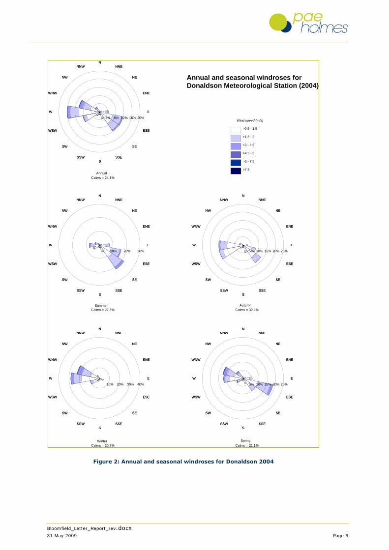
Bloomfield_Letter_Report_rev.docx
31 May 2009 Page 6
Figure 2: Annual and seasonal windroses for Donaldson 2004
NNNNENNE
NENE
ENEENE
EE
ESEESE
SESE
SSESSESS
SSWSSW
SWSW
WSWWSW
WW
WNWWNW
NWNW
NNWNNW
5% 10% 15% 20% 25%
NNNNENNE
NENE
ENEENE
EE
ESEESE
SESE
SSESSESS
SSWSSW
SWSW
WSWWSW
WW
WNWWNW
NWNW
NNWNNW
10% 20% 30% 40%
NNNNENNE
NENE
ENEENE
EE
ESEESE
SESE
SSESSESS
SSWSSW
SWSW
WSWWSW
WW
WNWWNW
NWNW
NNWNNW
5% 10% 15% 20% 25%
NNNNENNE
NENE
ENEENE
EE
ESEESE
SESE
SSESSESS
SSWSSW
SWSW
WSWWSW
WW
WNWWNW
NWNW
NNWNNW
10% 20% 30%
NNNNENNE
NENE
ENEENE
EE
ESEESE
SESE
SSESSESS
SSWSSW
SWSW
WSWWSW
WW
WNWWNW
NWNW
NNWNNW
4% 8% 12% 16% 20%Wind speed (m/s)
>0.5 - 1.5
>1.5 - 3
>3 - 4.5
>4.5 - 6
>6 - 7.5
>7.5
Annual and seasonal windroses forDonaldson Meteorological Station (2004)
SpringWinter
AutumnSummer
AnnualCalms = 24.1%
Calms = 22.3% Calms = 32.2%
Calms = 20.7% Calms = 21.1%

Bloomfield_Letter_Report_rev.docx
31 May 2009 Page 7
Figure 3: Annual and seasonal windroses for Bloomfield August 2004 to July 2005
NNNNENNE
NENE
ENEENE
EE
ESEESE
SESE
SSESSESS
SSWSSW
SWSW
WSWWSW
WW
WNWWNW
NWNW
NNWNNW
4% 8% 12% 16% 20%
NNNNENNE
NENE
ENEENE
EE
ESEESE
SESE
SSESSESS
SSWSSW
SWSW
WSWWSW
WW
WNWWNW
NWNW
NNWNNW
10% 20% 30%
NNNNENNE
NENE
ENEENE
EE
ESEESE
SESE
SSESSESS
SSWSSW
SWSW
WSWWSW
WW
WNWWNW
NWNW
NNWNNW
4% 8% 12% 16%
NNNNENNE
NENE
ENEENE
EE
ESEESE
SESE
SSESSESS
SSWSSW
SWSW
WSWWSW
WW
WNWWNW
NWNW
NNWNNW
4% 8% 12% 16% 20%
NNNNENNE
NENE
ENEENE
EE
ESEESE
SESE
SSESSESS
SSWSSW
SWSW
WSWWSW
WW
WNWWNW
NWNW
NNWNNW
4% 8% 12% 16% 20%Wind speed (m/s)
>0.5 - 1.5
>1.5 - 3
>3 - 4.5
>4.5 - 6
>6 - 7.5
>7.5
Annual and seasonal windroses for Beresfield DECCW monitoring station
1st August 2004 - 31st July 2005
SpringWinter
AutumnSummer
AnnualCalms = 4.4%
Calms = 3.8% Calms = 4.7%
Calms = 5.3% Calms = 3.5%
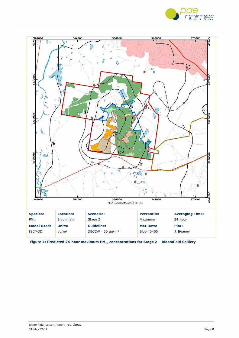
Bloomfield_Letter_Report_rev.docx
31 May 2009 Page 8
Species:
PM10
Location:
Bloomfield
Scenario:
Stage 2
Percentile:
Maximum
Averaging Time:
24-hour
Model Used:
ISCMOD
Units:
µg/m³
Guideline:
DECCW =50 µg/m³
Met Data:
Bloom0405
Plot:
J. Beaney
Figure 4: Predicted 24-hour maximum PM10 concentrations for Stage 2 – Bloomfield Colliery

Bloomfield_Letter_Report_rev.docx
31 May 2009 Page 9
Species:
PM10
Location:
Bloomfield
Scenario:
Stage 2
Percentile:
Average
Averaging Time:
Annual
Model Used:
ISCMOD
Units:
µg/m³
Guideline:
DECCW =30 µg/m³
Met Data:
Bloom0405
Plot:
J. Beaney
Figure 5: Predicted annual average PM10 concentrations for Stage 2 – Bloomfield Colliery

Bloomfield_Letter_Report_rev.docx
31 May 2009 Page 10
Species:
TSP
Location:
Bloomfield
Scenario:
Stage 2
Percentile:
Average
Averaging Time:
Annual
Model Used:
ISCMOD
Units:
µg/m³
Guideline:
DECCW =90 µg/m³
Met Data:
Bloom0405
Plot:
J. Beaney
Figure 6: Predicted annual average TSP concentrations for Stage 2 – Bloomfield Colliery
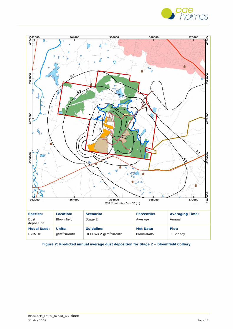
Bloomfield_Letter_Report_rev.docx
31 May 2009 Page 11
Species:
Dust deposition
Location:
Bloomfield
Scenario:
Stage 2
Percentile:
Average
Averaging Time:
Annual
Model Used:
ISCMOD
Units:
g/m2/month
Guideline:
DECCW=2 g/m2/month
Met Data:
Bloom0405
Plot:
J. Beaney
Figure 7: Predicted annual average dust deposition for Stage 2 – Bloomfield Colliery

Bloomfield_Letter_Report_rev.docx
31 May 2009 Page 12
Species:
PM10
Location:
Bloomfield
Scenario:
Stage 2
Percentile:
Average
Averaging Time:
Annual
Model Used:
ISCMOD
Units:
µg/m³
Guideline:
DECCW =30 µg/m³
Met Data:
Bloom0405
Plot:
J. Beaney
Figure 8: Predicted annual average PM10 concentration for Stage 2 – Bloomfield Colliery and
other sources
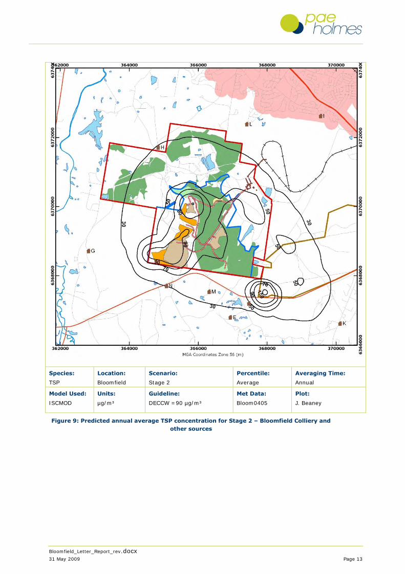
Bloomfield_Letter_Report_rev.docx
31 May 2009 Page 13
Species:
TSP
Location:
Bloomfield
Scenario:
Stage 2
Percentile:
Average
Averaging Time:
Annual
Model Used:
ISCMOD
Units:
µg/m³
Guideline:
DECCW =90 µg/m³
Met Data:
Bloom0405
Plot:
J. Beaney
Figure 9: Predicted annual average TSP concentration for Stage 2 – Bloomfield Colliery and
other sources
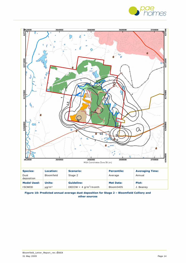
Bloomfield_Letter_Report_rev.docx
31 May 2009 Page 14
Species:
Dust deposition
Location:
Bloomfield
Scenario:
Stage 2
Percentile:
Average
Averaging Time:
Annual
Model Used:
ISCMOD
Units:
µg/m³
Guideline:
DECCW = 4 g/m2/month
Met Data:
Bloom0405
Plot:
J. Beaney
Figure 10: Predicted annual average dust deposition for Stage 2 – Bloomfield Colliery and
other sources

Bloomfield Colliery Section 75W Modification
September 2010
Appendix D – Aboriginal Heritage Impact Assessment

BLOOMFIELD COLLIERY, HUNTER VALLEY, NEW SOUTH WALES:
COMPLETION OF MINING AND REHABILITATION PROJECT -
ABORIGINAL HERITAGE IMPACT ASSESSMENT -
ADDENDUM REPORT TO ASSESS POWERLINE RELOCATION
Prepared by Peter Kuskie, South East Archaeology Pty Ltd On behalf of Bloomfield Collieries Pty Ltd 9 October 2009 Introduction: Bloomfield Collieries Pty Ltd has obtained a Part 3A Major Project Approval (3 September 2009) under the Environmental Planning and Assessment Act 1979 (EP&A Act) for the completion of open-cut coal mining and rehabilitation of areas within Mining Lease CCL761. The project area is located several kilometres south of East Maitland in the lower Hunter Valley of NSW. It measures a total of 290 hectares and includes all of the existing Mining Operations Plan approved area, as well as a workshop area, an access road to the workshop and a haul road from the active mining area to the washery coal stockpile pad. South East Archaeology (Kuskie 2008) undertook an Aboriginal heritage impact assessment for the Part 3A project application. The investigation proceeded by recourse to the archaeological and environmental background of the locality, followed by a field survey undertaken with representatives of the local Aboriginal community, in accordance with the relevant Department of Environment, Climate Change and Water (DECCW) policies and Department of Planning (DoP) requirements. The investigation focused on the "unmodified" portion of the study area of approximately 108 hectares (land yet to be mined area immediately west of the S-Cut and southwest of the Creek Cut) in which there remains some potential for heritage evidence. The remaining 182 hectares of the project area comprises land that has been extensively impacted by earthmoving works and building, such that there is negligible potential for any Aboriginal heritage evidence to survive. The "unmodified" portion of the study area was subdivided and inspected within 26 environmentally discrete survey areas. Even within this "unmodified" area, levels of ground disturbance are typically high, due to the removal of the forest vegetation in early 2004 by earthmoving equipment under existing approvals (Kuskie 2008). Six Aboriginal heritage sites, comprising 19 loci of identified evidence, were recorded within the 108 hectare unmodified portion of the study area. These site loci are all stone artefact occurrences and contain a total of 53 artefacts.

The identified artefact evidence occurs in a very low density distribution. Further artefacts are expected to occur across the unmodified study area in a distribution and density consistent with the survey results. However, notwithstanding that shallow deposits may be present in some forested areas or along the drainages where the A unit soil may have been retained, the potential for sub-surface deposits of artefacts that may be in situ and/or of research value is low to very low. Other types of heritage evidence (for example, scarred trees and grinding grooves) are not anticipated to occur within the unmodified study area (ie. very low or negligible potential) and other Aboriginal cultural values or associations have not been identified (Kuskie 2008). Proposed Powerline Variation to Approved Project: Bloomfield Collieries is seeking a variation under Section 75W of the EP&A Act to the Part 3A Major Project Approval to permit relocation of an existing powerline outside of the project approved area. The powerline supplies power for the Abel Water Management System, water cart filling station and P&H5700 rope shovel. Re-routing of the powerline would require the removal of approximately one hectare of native vegetation to the north of the current approval area. Purpose and Scope of Additional Aboriginal Heritage Assessment: South East Archaeology has been commissioned by Bloomfield Collieries to assess the potential impacts of the proposed powerline variation on Aboriginal heritage. Consistent with the investigation undertaken to date for the approved project (Kuskie 2008), the principal aims of the additional assessment were to identify and record any Aboriginal heritage evidence or cultural values within the study area, assess the potential impacts of the proposal on this evidence, assess the significance of this evidence, and formulate recommendations for the conservation and management of this evidence, in consultation with the local Aboriginal community. For the purpose of the additional Aboriginal heritage assessment, the study area is taken to be the zone of approximately five hectares marked on Figure 1, although project impacts will be confined to an area of approximately one hectare. Methodology of Additional Aboriginal Heritage Assessment: As an addendum to the investigation undertaken to date for the approved project (Kuskie 2008), the additional assessment has involved:
Review of previous searches of the DECCW Aboriginal Heritage Information Management System (AHIMS) and other relevant indigenous heritage registers and planning instruments, along with other relevant information;
Archaeological survey of the powerline study area with the Mindaribba Local Aboriginal
Land Council (LALC), following the same methodology and consultation procedures established for the main project (Kuskie 2008). This was undertaken on 8 October 2009 by Peter Kuskie of South East Archaeology and Ricky-Jo Griffiths of the Mindaribba LALC; and
Preparation of this addendum report to present the results of the investigation, assessment
of the significance of any Aboriginal evidence identified, and recommendations for the management of such evidence, in consultation with the Mindaribba LALC.

Results and Discussion of Additional Aboriginal Heritage Assessment: The additional powerline study area was subdivided into seven survey areas, on the basis of landform element and class of slope, each of which was inspected for Aboriginal heritage evidence. The locations of the individual survey areas are marked on Figure 1. A summary of the survey coverage is presented in Table 1. The total survey coverage (ground physically inspected for heritage evidence) equated to approximately 8,040 m2, or 16% of the study area. As this coverage only refers to an area of several metres width directly inspected by each member of the survey team, the actual coverage for obtrusive site types, such as rock shelters, scarred trees and grinding grooves, was significantly greater than this. The total effective survey coverage (visible ground surface physically inspected with potential to host heritage evidence) equated to around 882 m2, or 1.8% of the study area. No Aboriginal heritage evidence was identified within the study area, and no Aboriginal heritage sites have previously been recorded in this location. The heritage potential of the landform units within the study area is low, generally due to the moderate gradients and in the case of the ridge crest, the high level of existing impacts. A very low density distribution of artefacts may occur across the study area, however the potential for sub-surface deposits of artefacts that may be in situ and/or of research value is very low. Other types of heritage evidence (such as grinding grooves or scarred trees) are not anticipated to occur within the study area and other Aboriginal cultural values or associations have not been identified during the course of the assessment. The proposed powerline will result in impacts to a small proportion of the study area. In the absence of appropriate management and mitigation measures, it is concluded that the impacts of the proposal on Aboriginal heritage will be very low. Recommendations: In consideration of the limited nature of the proposed impacts, the results of the survey and community consultation, it is considered that the potential for significant impacts to occur to the Aboriginal heritage resource from the current proposal is very low. Therefore, there are no Aboriginal heritage constraints to the proposed works proceeding. Under the terms of the National Parks and Wildlife Act 1974 it is an offence to knowingly destroy, damage or deface an Aboriginal object without obtaining the prior written permission of the Director-General of DECCW or in lieu, Part 3A approval. Therefore, should any previously unrecorded Aboriginal sites or objects be detected during the course of development which are not covered by a Section 90 Aboriginal Heritage Impact Permit, work in the immediate vicinity of those objects would need to promptly cease and the finds be reported to DECCW and advice sought as to the appropriate course of action. Alternatively, if the Part 3A approval is extended to the study area, any Aboriginal objects identified can be managed in accordance with the Aboriginal Heritage Management Plan approved for the project. This is anticipated to involve salvage by surface collection of any items that may be identified, in consultation with the registered Aboriginal stakeholders.

References: Kuskie, P. J. 2008 Bloomfield Colliery, Hunter Valley, New South Wales: Completion of
Mining and Rehabilitation Project - Aboriginal Heritage Impact Assessment. Unpublished report to Bloomfield Collieries Pty Ltd.
Table 1: Archaeological survey coverage of powerline study area.
Surv
ey A
rea
Lan
dfor
m E
lem
ent
Slop
e
Dis
tanc
e to
Wat
er (m
etre
s)
Veg
etat
ion
Lan
d Su
rfac
e
Tot
al S
ampl
e A
rea
(m2 )
Surf
ace
Vis
ibili
ty (%
)
Det
ectio
n L
imiti
ng F
acto
rs
Arc
haeo
logi
cal V
isib
ility
%
Gro
und
Dis
turb
ance
Eff
ectiv
e Su
rvey
Cov
erag
e (m
2 )
# of
Art
efac
ts
Art
efac
t Den
sity
/m2 o
f Eff
ectiv
e Su
rvey
Cov
erag
e
Com
men
ts
B27 simple slope
moderate <50 2 4, 5
1000 50 1 50 low-mod
500 0 - power easement, vehicle track, erosion, vegetation cleared in easement; sandy loam, gravel; low potential
B28 drainage depression
moderate <50 2 4 560 0.2 1, 2 0.2 low 3 0 - dense leaf litter, some grass; low potential; minor sandstone cobbles; young Ironbarks and several older Eucalypts
B29 simple slope
moderate <50 2 4 200 0.2 1, 2 0.2 low 1 0 - dense leaf litter; low potential
B30 simple slope
moderate >50 2 4, 5
3820 0.1-70
1, 2 0.1-60
low-mod
315 0 - power easement, vehicle track, erosion, dozer pushes, vegetation cleared in easement; contour drain on southern border, now heavily overgrown, all B unit soil; dense grass, leaf litter in forest; mainly young Ironbark and Spotted Gum; low potential
B31 drainage depression
moderate <50 2 4 400 0.5 1, 2 0.5 low 2 0 - dense grass, leaf litter; low potential
B32 simple slope
moderate <50 2 4 320 0.1 1, 2 0.1 low 1 0 - dense grass, leaf litter; low potential
B33 ridge crest gentle >50 1, 2
4, 5
1740 0.5-60
1, 2 0.5-10
low-high
60 0 - well formed old vehicle track; graded, heavily cut in; spoil mounds adjacent to track; some sandstone bedrock exposed; high disturbance along road and adjacent areas, has lowered heritage potential of crest from moderate-high to low
Vegetation: 1 = cleared/grass/crop; 2 = regrowth/native forest. Land Surface: 1 = sheet erosion; 2 = gully erosion; 3 = stream bank erosion; 4 = vegetated; 5 = modified (eg. vehicle track). Detection Limiting Factors: 1 = vegetation; 2 = leaf litter/gravel; 3 = sediment deposition; 4 = other.

Figure 1: Aboriginal heritage investigation area for proposed powerline, archaeological survey areas (brown shapes) (base map courtesy Bloomfield Collieries Pty Ltd).
B27
B28 B29
B30
B31 B32
B33

Bloomfield Colliery Section 75W Modification
September 2010
Appendix E – Noise Impact Assessment

REPORT 30-1573-R2
Revision 1
Bloomfield Colliery Modifications
Noise Impact Assessment
PREPARED FOR
Bloomfield Collieries Pty Ltd Four Mile Creek Road Ashtonfield NSW 2323
21 JULY 2010
HEGGIES PTY LTD ABN 29 001 584 612
Bloomfield Colliery Modifications
Noise Impact Assessment
PREPARED BY:
Heggies Pty Ltd Level 1, 14 Watt Street Newcastle NSW 2300 Australia (PO Box 1768 Newcastle NSW 2300 Australia) Telephone 61 2 4908 4500 Facsimile 61 2 4908 4501 Email [email protected] Web www.heggies.com
DISCLAIMER
Reports produced by Heggies Pty Ltd are prepared for a particular Client’s objective and are based on a specific scope, conditions and limitations, as agreed between Heggies and the Client. Information and/or report(s) prepared by Heggies may not be suitable for uses other than the original intended objective. No parties other than the Client should use any information and/or report(s) without first conferring with Heggies.
The information and/or report(s) prepared by Heggies should not be reproduced, presented or reviewed except in full. Before passing on to a third party any information and/or report(s) prepared by Heggies, the Client is to fully inform the third party of the objective and scope and any limitations and conditions, including any other relevant information which applies to the material prepared by Heggies. It is the responsibility of any third party to confirm whether information and/or report(s) prepared for others by Heggies are suitable for their specific objectives.
Heggies Pty Ltd is a Member Firm of the Association of Australian Acoustical Consultants.
Heggies Pty Ltd operates under a Quality System which has been certified by SAI Global Pty Limited to comply with all the requirements of ISO 9001:2008 "Quality management systems - Requirements" (Licence No 3236).
This document has been prepared in accordance with the requirements of that System.
DOCUMENT CONTROL
Reference Status Date Prepared Checked Authorised
30-1573-R2 Revision 1 21 July 2010 Nathan Archer John Cotterill John Cotterill
30-1573-R2 Revision 0 28 April 2010 Nathan Archer John Cotterill John Cotterill
Bloomfield Colliery Modifications Noise Impact Assessment Bloomfield Collieries Pty Ltd
Heggies Pty Ltd Report Number 30-1573-R2 Revision 1 (30-1573R2R1.doc) 21 July 2010 Page 2 of 27

TABLE OF CONTENTS
1 INTRODUCTION 5
2 PROPOSAL DETAILS 6 2.1 Operational Activities 6 2.2 Construction Activities 6
3 NOISE MANAGEMENT 9
4 IMPACT ASSESSMENT PROCEDURES 10 4.1 General Objectives 10 4.2 Assessing Intrusiveness 10 4.3 Assessing Amenity 10 4.4 Assessing Sleep Disturbance 12 4.5 Construction Noise 12
5 PROJECT SPECIFIC NOISE CRITERIA 14 5.1 Existing Project Approval and Consent Conditions 14 5.2 Bloomfield Project Environmental Assessment 15
5.2.1 Project Specific Noise Levels 15 5.2.2 Sleep Disturbance Noise Goals 16
5.3 Bloomfield Modification Project Specific Noise Levels 17 5.4 Construction Noise Criteria 17
6 ASSESSMENT OF NOISE IMPACTS 18 6.1 Operational Noise Modelling 18
6.1.1 Operational Noise Modelling Parameters 18 6.1.2 Acoustically Significant Plant and Equipment 19 6.1.3 Noise Controls, Mitigation and Management 19 6.1.4 Operational Noise Modelling Results 21 6.1.5 Discussion 24
6.2 Sleep Disturbance Analysis 25 6.3 Construction Noise Modelling 26
6.3.1 Construction Scenarios 26 6.3.2 Construction Noise Modelling Results 26
7 CONCLUSION 27
Bloomfield Colliery Modifications Noise Impact Assessment Bloomfield Collieries Pty Ltd
Heggies Pty Ltd Report Number 30-1573-R2 Revision 1 (30-1573R2R1.doc) 21 July 2010 Page 3 of 27
TABLE OF CONTENTS
Table 1 Amenity Criteria - Recommended LAeq Noise Levels from Industrial Noise Sources 11 Table 2 Modification to Acceptable Noise Level (ANL)* to Account for Existing Levels of Industrial
Noise 12 Table 3 Construction Noise Management 13 Table 4 Operational noise impact assessment criteria 14 Table 5 Bloomfield Project Specific Noise Levels 16 Table 6 Sleep Disturbance Noise Goals 17 Table 7 Construction Noise Goals 17 Table 8 Meteorological Parameters for Noise Predictions 18 Table 9 Predicted Bloomfield Modification Project Noise Levels – Area B Daytime 21 Table 10 Predicted Bloomfield Modification Project Noise Levels – Area B Evening and Morning
Shoulder 22 Table 11 Predicted Bloomfield Modification Project Noise Levels – Area C 23 Table 12 Predicted Bloomfield Modification Project Noise Levels – Area E 23 Table 13 Predicted Maximum Morning Shoulder Noise Levels – Area B 25
Figure 1 Open Cut Consent Modification Areas 8 Figure 2 Proposed Haul Road Bund Location 20
Appendix A Equipment Sound Power Levels
Bloomfield Colliery Modifications Noise Impact Assessment Bloomfield Collieries Pty Ltd
Heggies Pty Ltd Report Number 30-1573-R2 Revision 1 (30-1573R2R1.doc) 21 July 2010 Page 4 of 27
1 INTRODUCTION
Heggies Pty Ltd (Heggies) has been engaged by Bloomfield Collieries Pty Ltd (Bloomfield) to undertake an assessment of noise impacts associated with the proposed modification (Bloomfield Modifications) to the approved development (Project Approval 07_0087) to allow minor changes to the configuration of out of pit dumping and the realignment of a power easement. This report has been prepared for inclusion within the Environmental Assessment report to support an application to modify the Approval under section 75W of the Environmental Planning and Assessment Act.
Broadly, the objective of the assessment was to identify the potential impacts of noise from the proposed modification. The proposed modification includes:
Small extensions to the areas currently approved for overburden dumping.
Use of an existing road as an alternative haul route to reduce energy consumption.
Recontouring and revegetation of areas that were rehabilitated over 20 years ago and do not meet current NSW Government standards.
Comment will also be made with regard construction activities associated with the relocation of an existing overhead powerline and easement which is required to enable the approved continuation of mining of Creek Cut and S Cut.
Advice with regard to effective mitigation strategies will be provided where necessary.
The noise assessment has been prepared with reference to Australian Standard AS 1055:1997 Description and Measurement of Environmental Noise Parts 1, 2 and 3 and in accordance with the Department of Environment, Climate Change and Water’s (DECCW’s) NSW Industrial Noise Policy (INP) and the Interim Construction Noise Guideline. Where issues relating to noise are not addressed in the INP, such as sleep disturbance, reference has been made to the NSW Environmental Noise Control Manual (ENCM).
The modification to the out of pit dumping area, alternative haul route and change to the powerline easement was not anticipated during the Environmental Assessment (EA) process that commenced in 2007. The need to modify the out of pit areas for the emplacement of overburden provides an opportunity to make improvements to three small areas that were rehabilitated over 20 years ago. The area will be designed to ensure that the current standards are met in relation to slope and final landform.
Bloomfield Colliery Modifications Noise Impact Assessment Bloomfield Collieries Pty Ltd
Heggies Pty Ltd Report Number 30-1573-R2 Revision 1 (30-1573R2R1.doc) 21 July 2010 Page 5 of 27
2 PROPOSAL DETAILS
The proposed modifications to the approved Bloomfield Colliery operations are detailed below and are illustrated in Figure 1.
2.1 Operational Activities
South-East Area – Overburden Dumping and Rehabilitation (Modification Area B)
An out-of-pit area to the east of the approved haul road (Area B as shown in Figure 1) was rehabilitated approximately 20 years ago. Due to the historic nature of the rehabilitation, it does not reflect current standards particularly in relation to slope and final landform requirements. To maximise operational efficiencies and improve final land shaping and vegetation cover in this area, Bloomfield proposes to place approximately 1.2 million bank cubic metres (bcm’s) of overburden in this area prior to reshaping and revegetation. Area B will be included in the end of mine design and shaped in accordance with current rehabilitation standards.
Equipment proposed for these works will be that used for the currently approved operation as described by Section 2.6.2 of the EA (The Bloomfield Group, 2009), with no additional equipment to be introduced for these works. Rear dump haul trucks will transport overburden material to the area with dozers pushing and shaping material prior to topsoil application and seeding.
Northern and South-Eastern Areas – Out-of-Pit Reshaping and Rehabilitation (Modification Areas C and E).
Two out-of-pit areas (Areas C and E as shown in Figure 1) are former mining areas consisting of overburden material with some minor shaping and grass seeding. The areas have been stabilised with grass cover and there are a few native shrubs and trees that have regenerated naturally. To improve these areas and rehabilitate to current standards, minor import of overburden to reshape and improve drainage is proposed, as well as revegetation. Equipment to be used will be as for modification Area B.
Work in Area C would occur over approximately three (3) months during the approved “Stage 2” of mining.
Due to the minor nature of the works in Area E, it is expected the overburden emplacement and shaping would only take 70 hours. However, this work would be scheduled over a three (3) month period to enable normal rates of dumping and the continuation of mining.
2.2 Construction Activities
Construction of an Overhead Powerline and Easement (Modification Area D)
An existing overhead powerline and easement is located to the north-west of the approved Bloomfield mine area. The powerline extends from a previous open cut mine area in the north of the Bloomfield Colliery site into the current Creek Cut area. The powerline currently provides power for the water cart filling station, water pumps and the rope shovel.
To enable the approved expansion of Creek Cut and S Cut to proceed, the southern section of this powerline, within the current approved Bloomfield Mine area, needs to be relocated.
It is proposed to relocate a section of the powerline within Area D as shown in Figure 1. This would require construction of a 40 metre wide easement, removing approximately one hectare of native vegetation.
Bloomfield Colliery Modifications Noise Impact Assessment Bloomfield Collieries Pty Ltd
Heggies Pty Ltd Report Number 30-1573-R2 Revision 1 (30-1573R2R1.doc) 21 July 2010 Page 6 of 27

Construction would consist of marking the easement, vegetation clearing within the easement, installation of posts and lines, and connection to the existing line. The existing line and posts would then be removed.
It is anticipated that this work will be undertaken within six months of the modification being approved and construction works would be less than six weeks in duration.
Development of Wattle Tree Drive as an Alternative Haul Route
An existing access road between the northern open cut pit (Creek Cut) and the north-eastern end of the haul road leading to the washery stockpiles has been used for some years by light vehicles. Bloomfield proposes to upgrade this access (“Wattle Tree Drive”) so that it can be used as an alternative haul road and general access road between the northern pit operations and the washery stockpiles. The location of this proposed alternative haul route is entirely within previously rehabilitated spoil emplacement areas and is shown as Area A on Figure 1.
Use of this alternative route will reduce haulage distances during times when coal is being extracted from Creek Cut and the northern areas of S Cut. Some cut and fill and slope stabilisation works will be required to construct the road, which will be used by coal trucks and general vehicles.
So that the road can be used as an alternative haul route, the existing track will be widened and improvements made to the horizontal alignment and road surface. The southern and northern batters will be shaped and stabilised as part of the construction works.
Bloomfield Colliery Modifications Noise Impact Assessment Bloomfield Collieries Pty Ltd
Heggies Pty Ltd Report Number 30-1573-R2 Revision 1 (30-1573R2R1.doc) 21 July 2010 Page 7 of 27
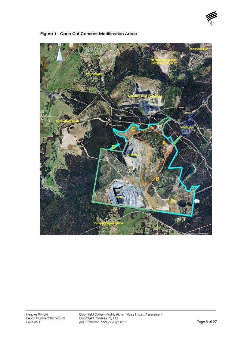
Figure 1 Open Cut Consent Modification Areas
Bloomfield Colliery Modifications Noise Impact Assessment Bloomfield Collieries Pty Ltd
Heggies Pty Ltd Report Number 30-1573-R2 Revision 1 (30-1573R2R1.doc) 21 July 2010 Page 8 of 27

3 NOISE MANAGEMENT
Selecting appropriate noise management strategies for the proposed Bloomfield Modifications involves the following steps:
Determining the noise reduction required to achieve the project-specific noise levels.
Identifying the specific characteristics of the industry and the site that would indicate a preference for specified measures.
Examining the mitigation strategies chosen by similar industries on similar sites with similar requirements for noise reduction; and considering that strategy’s appropriateness for the subject development.
Considering the range of noise-control measures available.
Considering community preferences for particular strategies. This is especially important when the community has particular sensitivities to noise.
The preference ranking (from most preferred to least preferred) for noise mitigation strategies is as follows:
Land-use controls - a long-term strategy preferable to other measures when such strategic decisions are possible in planning land use, as it separates noise-producing industries from sensitive areas and avoids more expensive short-term measures.
Control at the source - Best Management Practice (BMP) and Best Available Technology Economically Achievable (BATEA). These strategies serve to reduce the noise output of the source so that the surrounding environment is protected against noise.
Control in transmission - the next best strategy to controlling noise at the source. It serves to reduce the noise level at the receiver but not necessarily the environment surrounding the source.
Receiver controls - the least-preferred option, as it protects only the internal environment of the receiver and not the external noise environment.
The proponent will take into account the cost-effectiveness of strategies in determining how much noise reduction is affordable. A proponent’s choice of a particular strategy is likely to have unique features due to the economics of the industry and site specific technical considerations.
The above steps and the range of measures described in this chapter can be used as a guide in assessing the strength of the proponent’s mitigation proposals. Where a proposed mitigation strategy will not achieve the desired noise reduction and leaves a remaining noise impact, the problem needs to be solved by negotiation between the land owner and regulatory authority.
Bloomfield Colliery Modifications Noise Impact Assessment Bloomfield Collieries Pty Ltd
Heggies Pty Ltd Report Number 30-1573-R2 Revision 1 (30-1573R2R1.doc) 21 July 2010 Page 9 of 27
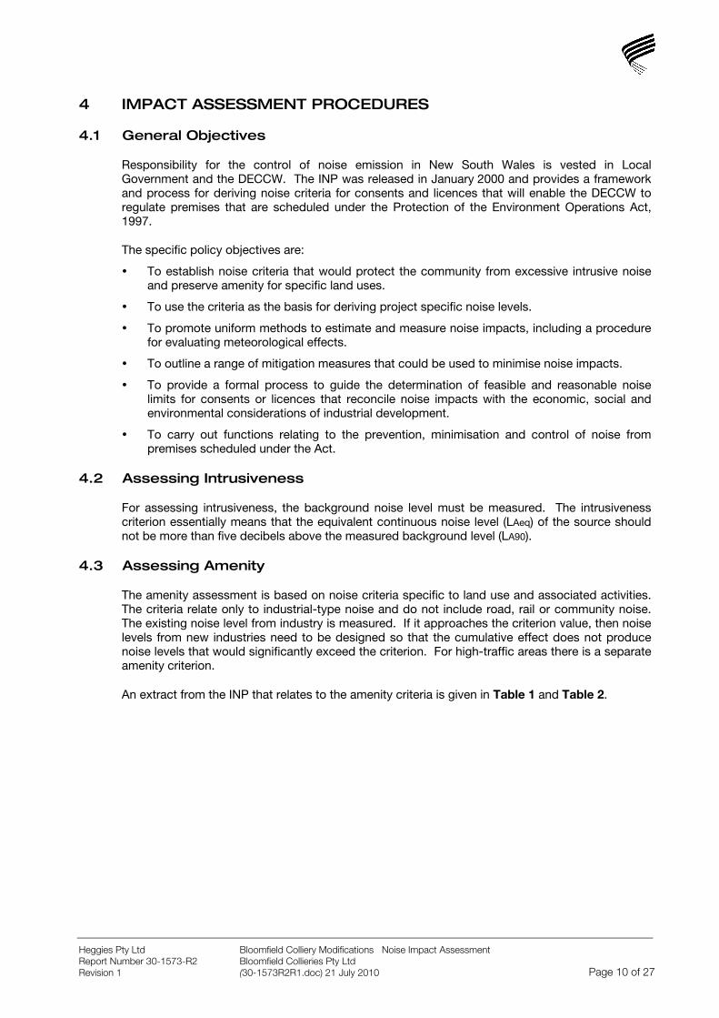
4 IMPACT ASSESSMENT PROCEDURES
4.1 General Objectives
Responsibility for the control of noise emission in New South Wales is vested in Local Government and the DECCW. The INP was released in January 2000 and provides a framework and process for deriving noise criteria for consents and licences that will enable the DECCW to regulate premises that are scheduled under the Protection of the Environment Operations Act, 1997.
The specific policy objectives are:
To establish noise criteria that would protect the community from excessive intrusive noise and preserve amenity for specific land uses.
To use the criteria as the basis for deriving project specific noise levels.
To promote uniform methods to estimate and measure noise impacts, including a procedure for evaluating meteorological effects.
To outline a range of mitigation measures that could be used to minimise noise impacts.
To provide a formal process to guide the determination of feasible and reasonable noise limits for consents or licences that reconcile noise impacts with the economic, social and environmental considerations of industrial development.
To carry out functions relating to the prevention, minimisation and control of noise from premises scheduled under the Act.
4.2 Assessing Intrusiveness
For assessing intrusiveness, the background noise level must be measured. The intrusiveness criterion essentially means that the equivalent continuous noise level (LAeq) of the source should not be more than five decibels above the measured background level (LA90).
4.3 Assessing Amenity
The amenity assessment is based on noise criteria specific to land use and associated activities. The criteria relate only to industrial-type noise and do not include road, rail or community noise. The existing noise level from industry is measured. If it approaches the criterion value, then noise levels from new industries need to be designed so that the cumulative effect does not produce noise levels that would significantly exceed the criterion. For high-traffic areas there is a separate amenity criterion.
An extract from the INP that relates to the amenity criteria is given in Table 1 and Table 2.
Bloomfield Colliery Modifications Noise Impact Assessment Bloomfield Collieries Pty Ltd
Heggies Pty Ltd Report Number 30-1573-R2 Revision 1 (30-1573R2R1.doc) 21 July 2010 Page 10 of 27
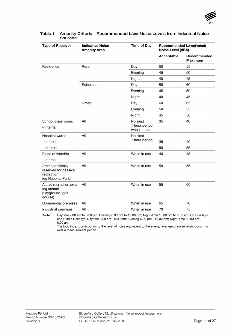
Table 1 Amenity Criteria - Recommended LAeq Noise Levels from Industrial Noise Sources
Recommended LAeq(Period) Noise Level (dBA)
Type of Receiver Indicative Noise Amenity Area
Time of Day
Acceptable Recommended Maximum
Day 50 55
Evening 45 50
Rural
Night 40 45
Day 55 60
Evening 45 50
Suburban
Night 40 45
Day 60 65
Evening 50 55
Residence
Urban
Night 45 50
School classrooms
- internal
All Noisiest 1 hour period when in use
35 40
Hospital wards
- internal
- external
All Noisiest 1 hour period
35
50
40
55
Place of worship
- internal
All When in use 40 45
Area specifically reserved for passive recreation (eg National Park)
All When in use 50 55
Active recreation area (eg school playground, golf course)
All When in use 55 60
Commercial premises All When in use 65 70
Industrial premises All When in use 70 75
Note: Daytime 7.00 am to 6.00 pm; Evening 6.00 pm to 10.00 pm; Night-time 10.00 pm to 7.00 am, On Sundays and Public Holidays, Daytime 8.00 am - 6.00 pm; Evening 6.00 pm - 10.00 pm; Night-time 10.00 pm - 8.00 am. The LAeq index corresponds to the level of noise equivalent to the energy average of noise levels occurring over a measurement period.
Bloomfield Colliery Modifications Noise Impact Assessment Bloomfield Collieries Pty Ltd
Heggies Pty Ltd Report Number 30-1573-R2 Revision 1 (30-1573R2R1.doc) 21 July 2010 Page 11 of 27
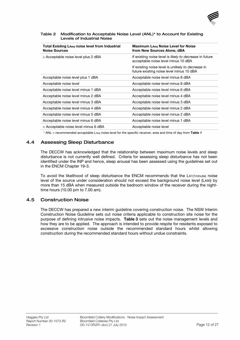
Table 2 Modification to Acceptable Noise Level (ANL)* to Account for Existing Levels of Industrial Noise
Total Existing LAeq noise level from Industrial Noise Sources
Maximum LAeq Noise Level for Noise from New Sources Alone, dBA
≥ Acceptable noise level plus 2 dBA If existing noise level is likely to decrease in future acceptable noise level minus 10 dBA
If existing noise level is unlikely to decrease in future existing noise level minus 10 dBA
Acceptable noise level plus 1 dBA Acceptable noise level minus 8 dBA
Acceptable noise level Acceptable noise level minus 8 dBA
Acceptable noise level minus 1 dBA Acceptable noise level minus 6 dBA
Acceptable noise level minus 2 dBA Acceptable noise level minus 4 dBA
Acceptable noise level minus 3 dBA Acceptable noise level minus 3 dBA
Acceptable noise level minus 4 dBA Acceptable noise level minus 2 dBA
Acceptable noise level minus 5 dBA Acceptable noise level minus 2 dBA
Acceptable noise level minus 6 dBA Acceptable noise level minus 1 dBA
< Acceptable noise level minus 6 dBA Acceptable noise level
* ANL = recommended acceptable LAeq noise level for the specific receiver, area and time of day from Table 1
4.4 Assessing Sleep Disturbance
The DECCW has acknowledged that the relationship between maximum noise levels and sleep disturbance is not currently well defined. Criteria for assessing sleep disturbance has not been identified under the INP and hence, sleep arousal has been assessed using the guidelines set out in the ENCM Chapter 19-3.
To avoid the likelihood of sleep disturbance the ENCM recommends that the LA1(1minute) noise level of the source under consideration should not exceed the background noise level (LA90) by more than 15 dBA when measured outside the bedroom window of the receiver during the night-time hours (10.00 pm to 7.00 am).
4.5 Construction Noise
The DECCW has prepared a new interim guideline covering construction noise. The NSW Interim Construction Noise Guideline sets out noise criteria applicable to construction site noise for the purpose of defining intrusive noise impacts. Table 3 sets out the noise management levels and how they are to be applied. The approach is intended to provide respite for residents exposed to excessive construction noise outside the recommended standard hours whilst allowing construction during the recommended standard hours without undue constraints.
Bloomfield Colliery Modifications Noise Impact Assessment Bloomfield Collieries Pty Ltd
Heggies Pty Ltd Report Number 30-1573-R2 Revision 1 (30-1573R2R1.doc) 21 July 2010 Page 12 of 27
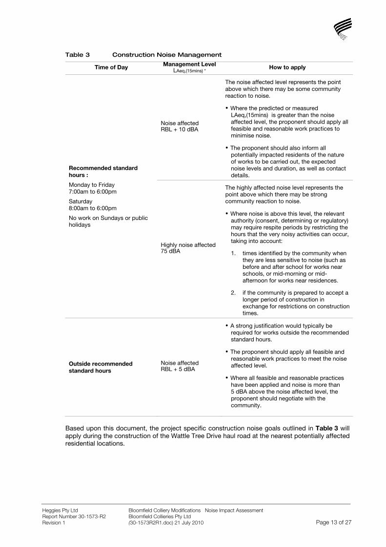
Table 3 Construction Noise Management
Time of Day Management Level LAeq,(15mins) * How to apply
Noise affected RBL + 10 dBA
The noise affected level represents the point above which there may be some community reaction to noise.
Where the predicted or measured LAeq,(15mins) is greater than the noise affected level, the proponent should apply all feasible and reasonable work practices to minimise noise.
The proponent should also inform all potentially impacted residents of the nature of works to be carried out, the expected noise levels and duration, as well as contact details.
Recommended standard hours :
Monday to Friday 7:00am to 6:00pm
Saturday 8:00am to 6:00pm
No work on Sundays or public holidays
Highly noise affected 75 dBA
The highly affected noise level represents the point above which there may be strong community reaction to noise.
Where noise is above this level, the relevant authority (consent, determining or regulatory) may require respite periods by restricting the hours that the very noisy activities can occur, taking into account:
1. times identified by the community when they are less sensitive to noise (such as before and after school for works near schools, or mid-morning or mid-afternoon for works near residences.
2. if the community is prepared to accept a longer period of construction in exchange for restrictions on construction times.
Outside recommended standard hours
Noise affected RBL + 5 dBA
A strong justification would typically be required for works outside the recommended standard hours.
The proponent should apply all feasible and reasonable work practices to meet the noise affected level.
Where all feasible and reasonable practices have been applied and noise is more than 5 dBA above the noise affected level, the proponent should negotiate with the community.
Based upon this document, the project specific construction noise goals outlined in Table 3 will apply during the construction of the Wattle Tree Drive haul road at the nearest potentially affected residential locations.
Bloomfield Colliery Modifications Noise Impact Assessment Bloomfield Collieries Pty Ltd
Heggies Pty Ltd Report Number 30-1573-R2 Revision 1 (30-1573R2R1.doc) 21 July 2010 Page 13 of 27

5 PROJECT SPECIFIC NOISE CRITERIA
5.1 Existing Project Approval and Consent Conditions
Project Approval was granted on 3 September 2009 for the Bloomfield Project (Application No: 07_0087). The relevant Consent Conditions relating to noise are reproduced below.
Schedule 3 NOISE
Noise Impact Assessment Criteria
1. The Proponent shall ensure that the noise generated by the project does not exceed the noise impact assessment criteria in Table 4:
Table 4 Operational noise impact assessment criteria
Morning Shoulder
Day Evening Night
LAeq(15min) LAeq(15min) LAeq(15min) LAeq(15min) LA1(1min)
Location and Locality
40 35 35 35 45 E Browns Road, Black Hill
42 35 35 35 45 F Black Hill Road, Black Hill
43 39 42 37 45 G Buchanan Road, Buchanan
35 35 35 35 45 H Mt Vincent Road, Louth Park
35 35 35 35 45 L Kilshanny Avenue, Ashtonfield
48 39 39 37 46 M John Renshaw Drive, Buttai
43 42 42 35 46 N Lings Road, Buttai
Notes • To interpret the locations in Table 1, see Appendix 2. • The limits in Table 1 are to apply under meteorological conditions of up to 3 m/s at 10 m above ground level, excluding F and G
class inversions as described in the NSW Industrial Noise Policy.
However, if the Proponent has a written negotiated noise agreement with the landowner of any land, and a copy of this agreement has been forwarded to the Department and DECC, then the Proponent may exceed the noise limits in Table 1 on that land in accordance with the negotiated noise agreement.
Cumulative Noise Criteria
2. The Proponent shall take all reasonable and feasible measures to ensure that the noise generated by the project combined with the noise generated by other mines does not exceed the following amenity criteria at any residence on, or on more than 25 percent of, any privately owned land:
• LAeq(11 hour) 50 dB(A) – Day;
• LAeq(4 hour) 45 dB(A) – Evening; and
• LAeq(9 hour) 40 dB(A) – Night.
Bloomfield Colliery Modifications Noise Impact Assessment Bloomfield Collieries Pty Ltd
Heggies Pty Ltd Report Number 30-1573-R2 Revision 1 (30-1573R2R1.doc) 21 July 2010 Page 14 of 27

Continuous Improvement
3. The Proponent shall:
(a) implement all reasonable and feasible noise mitigation measures;
(b) investigate ways to reduce the noise generated by the project; and
(c) report on these investigations and the implementation and effectiveness of these measures in the AEMR, to the satisfaction of the Director-General.
Monitoring
4. The Proponent shall prepare and implement a Noise Monitoring Program for the project to the satisfaction of the Director-General.
The Program must:
(a) be prepared in consultation with DECC and be submitted to the Director-General for approval within 6 months of the date of this approval; and
(b) include:
a combination of unattended and attended monitoring measures; and
a noise monitoring protocol for evaluating compliance with the noise impact assessment criteria in this approval.
5.2 Bloomfield Project Environmental Assessment
5.2.1 Project Specific Noise Levels
It should be noted that the consent criteria determined in the Project Approval (07_0087) for the approved operation differed from the Project Specific Noise Levels (PSNLs) established with reference to the INP. The noise assessment is provided in the Environmental Assessment (refer Part 3A Environmental Assessment Project Application 07_0087 Bloomfield Colliery Completion of Mining and Rehabilitation and Heggies Report 30-1573-R1R1 Noise and Blasting Assessment - Bloomfield Project).
The intrusive and amenity noise assessment criteria based on the INP for the assessment localities are presented in Table 5.
Bloomfield Colliery Modifications Noise Impact Assessment Bloomfield Collieries Pty Ltd
Heggies Pty Ltd Report Number 30-1573-R2 Revision 1 (30-1573R2R1.doc) 21 July 2010 Page 15 of 27

Table 5 Bloomfield Project Specific Noise Levels
Location Locality (Noise Amenity Area)
Period Intrusiveness Criteria LAeq(15minute)
Amenity Criteria LAeq(Period)
Day 41 dBA 55 dBA E
Evening 40 dBA 45 dBA
Night 36 dBA 39 dBA F
Black Hill (Suburban)
Shoulder 44 dBA 47 dBA
Day 43 dBA 55 dBA G
Evening 41 dBA 45 dBA
Night 36 dBA 40 dBA H
Buchanan & Louth Park (Suburban)
Shoulder 45 dBA 48 dBA
Day 46 dBA 55 dBA
Evening 46 dBA 45 dBA
Night 43 dBA 40 dBA
L Ashtonfield (Suburban)
Shoulder 51 dBA 48 dBA
Day 45 dBA 55 dBA M
Evening 43 dBA 45 dBA
Night 36 dBA 40 dBA N
Buttai (Suburban)
Shoulder 53 dBA 48 dBA
For Monday to Saturday, Daytime 7.00 am - 6.00pm; Evening 6.00pm - 10.00pm; Night-time 10.00pm - 7.00am. Morning Shoulder 6.00 am to 7.00 am On Sundays and Public Holidays, Daytime 8.00am - 6.00pm; Evening 6.00pm - 10.0 pm; Night-time 10.0 pm - 8.00am. Morning Shoulder 6.00 am to 8.00 am 1. The RBL’s calculated for the Black Hill area were adopted as representative of the background levels at the occupied residential receivers on the Catholic Diocese Land (K1, K2 and K3).
The INP states that these criteria have been selected to protect at least 90% of the population, living in the vicinity of industrial noise sources, from the adverse effects of noise for at least 90% of the time. Provided the criteria in the INP are achieved, it is unlikely that most people would consider the resultant noise levels excessive.
5.2.2 Sleep Disturbance Noise Goals
The relevant sleep disturbance noise goals identified for each residential area are provided in Table 6. To minimise the potential for sleep disturbance in the morning shoulder period between 6.00 am and 7.00 am night-time RBL’s have been used to set criteria instead of those recorded during the morning shoulder period.
Bloomfield Colliery Modifications Noise Impact Assessment Bloomfield Collieries Pty Ltd
Heggies Pty Ltd Report Number 30-1573-R2 Revision 1 (30-1573R2R1.doc) 21 July 2010 Page 16 of 27
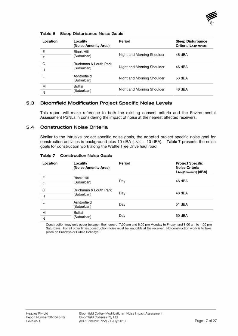
Table 6 Sleep Disturbance Noise Goals
Location Locality (Noise Amenity Area)
Period Sleep Disturbance Criteria LA1(1minute)
E
F
Black Hill (Suburban) Night and Morning Shoulder 46 dBA
G
H
Buchanan & Louth Park (Suburban) Night and Morning Shoulder 46 dBA
L Ashtonfield (Suburban)
Night and Morning Shoulder 53 dBA
M
N
Buttai (Suburban) Night and Morning Shoulder 46 dBA
5.3 Bloomfield Modification Project Specific Noise Levels
This report will make reference to both the existing consent criteria and the Environmental Assessment PSNLs in considering the impact of noise at the nearest affected receivers.
5.4 Construction Noise Criteria
Similar to the intrusive project specific noise goals, the adopted project specific noise goal for construction activities is background plus 10 dBA (LA90 + 10 dBA). Table 7 presents the noise goals for construction work along the Wattle Tree Drive haul road.
Table 7 Construction Noise Goals
Location Locality (Noise Amenity Area)
Period Project Specific Noise Criteria LAeq(15minute) (dBA)
E
F
Black Hill (Suburban) Day 46 dBA
G
H
Buchanan & Louth Park (Suburban) Day 48 dBA
L Ashtonfield (Suburban)
Day 51 dBA
M
N
Buttai (Suburban) Day 50 dBA
Construction may only occur between the hours of 7.00 am and 6.00 pm Monday to Friday, and 8.00 am to 1.00 pm Saturdays. For all other times construction noise must be inaudible at the receiver. No construction work is to take place on Sundays or Public Holidays.
Bloomfield Colliery Modifications Noise Impact Assessment Bloomfield Collieries Pty Ltd
Heggies Pty Ltd Report Number 30-1573-R2 Revision 1 (30-1573R2R1.doc) 21 July 2010 Page 17 of 27

6 ASSESSMENT OF NOISE IMPACTS
6.1 Operational Noise Modelling
6.1.1 Operational Noise Modelling Parameters
A computer model was used to predict noise emissions from operation of the proposed Bloomfield Modifications. The Environmental Noise Model (ENM) used has been produced in conjunction with the DECCW. The modelling process has utilised the Bloomfield noise model prepared by Heggies for the EA for the existing approved operation. The model has been updated to incorporate the latest topographic information available for the site and each of the proposed modifications to be assessed.
The Bloomfield noise model uses a three-dimensional digital terrain map giving all relevant topographic information was used in the modelling process. The model used this map, together with noise source data, ground cover, shielding by barriers and/or adjacent buildings and atmospheric information to predict noise levels at the nearest potentially affected receivers.
Topographic contours and operational descriptions were supplied by Bloomfield for the purpose of modelling noise from the proposed modifications.
Prediction of noise sources were carried out, under calm and prevailing atmospheric conditions (prevailing winds), for three operational scenarios namely;
Area B dumping & rehabilitation.
Area C dumping & rehabilitation.
Area E dumping & rehabilitation.
Prevailing atmospheric conditions established during the previous EA have been utilised for the purpose of this assessment. Atmospheric parameters under which noise predictions were made are given in Table 8.
Table 8 Meteorological Parameters for Noise Predictions
Temperature Humidity Wind Speed Wind Direction (degrees from north)
Temperature Gradient
Calm (All periods)
20oC 65% N/A N/A N/A
North-west wind (morning shoulder)
10oC 90% 3m/s 315 N/A
South-east wind (evening and morning shoulder
10oC 90% 3m/s 135 N/A
Other assumptions made relating to the modifications in the modelling process include:
All acoustically significant plant and equipment operates simultaneously.
Mobile noise sources, such as haul trucks, were modelled at typical locations and assumed to operate in repetitive cycles.
All operations and noise controls described in the assessment of the approved operation will remain; operational modifications are limited to the location of the dump site and associated haul routes.
Dumping and rehabilitation will not occur during the night-time period in Area B.
Bloomfield Colliery Modifications Noise Impact Assessment Bloomfield Collieries Pty Ltd
Heggies Pty Ltd Report Number 30-1573-R2 Revision 1 (30-1573R2R1.doc) 21 July 2010 Page 18 of 27
Dumping and rehabilitation will not occur during the evening, night-time or morning shoulder periods in Areas C and E.
6.1.2 Acoustically Significant Plant and Equipment
Sound power levels of all plant and equipment operating on the site has been based on those modelled in the EA for the approved Bloomfield mine area. Since the publication of the EA, Heggies have performed on site sound power level measurements of some items of plant, where this has occurred the modelled sound power levels have been updated to include the measured data.
Plant operating within the modification areas will include CAT 793 dump trucks and a CAT D11 dozer unless stated in Section 6.1.3.
Sound power levels of relevant items of plant and equipment are contained within Appendix A.
6.1.3 Noise Controls, Mitigation and Management
The following noise controls are recommended for the proposed modified development. Noise mitigation and management procedures that have been incorporated into the noise model with the aim of achieving project specific noise criteria include the following:
Area B
Daytime:
The height of the overburden emplacement area will be limited to an RL of 100m.
Daytime operations will be in the southern part of the dump to raise the dump and provide screening for the evening and morning shoulder operations.
Evening and morning shoulder
The drill and clearing dozer will be working in a shielded location. Dumping will only occur in the northern part of the dump. The dozer will only operate in a shielded location in the northern part of the dump. An earthen bund will be constructed in the approved dumping area to the south of the
existing haul road to a minimum height of 80m RL (refer Figure 2). There will be no coaling from S-Cut during the morning shoulder period.
Night-time
There will be no dumping and rehabilitation in Area B during the night-time period.
Area C
Dumping and rehabilitation will occur in Area C during the daytime period only.
Area E
Dumping and rehabilitation in Area E will occur during the daytime period only.
Dumping will be restricted to a maximum of 70 hours of work.
A front end loader would replace the dozer at the Area E dump once the emplacement reaches an RL of 52m.
Bloomfield Colliery Modifications Noise Impact Assessment Bloomfield Collieries Pty Ltd
Heggies Pty Ltd Report Number 30-1573-R2 Revision 1 (30-1573R2R1.doc) 21 July 2010 Page 19 of 27
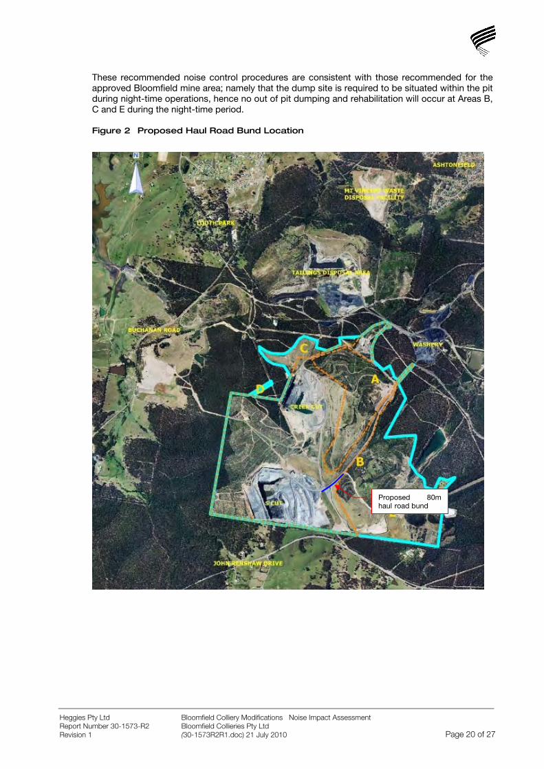
These recommended noise control procedures are consistent with those recommended for the approved Bloomfield mine area; namely that the dump site is required to be situated within the pit during night-time operations, hence no out of pit dumping and rehabilitation will occur at Areas B, C and E during the night-time period.
Figure 2 Proposed Haul Road Bund Location
Proposed 80m haul road bund
Bloomfield Colliery Modifications Noise Impact Assessment Bloomfield Collieries Pty Ltd
Heggies Pty Ltd Report Number 30-1573-R2 Revision 1 (30-1573R2R1.doc) 21 July 2010 Page 20 of 27
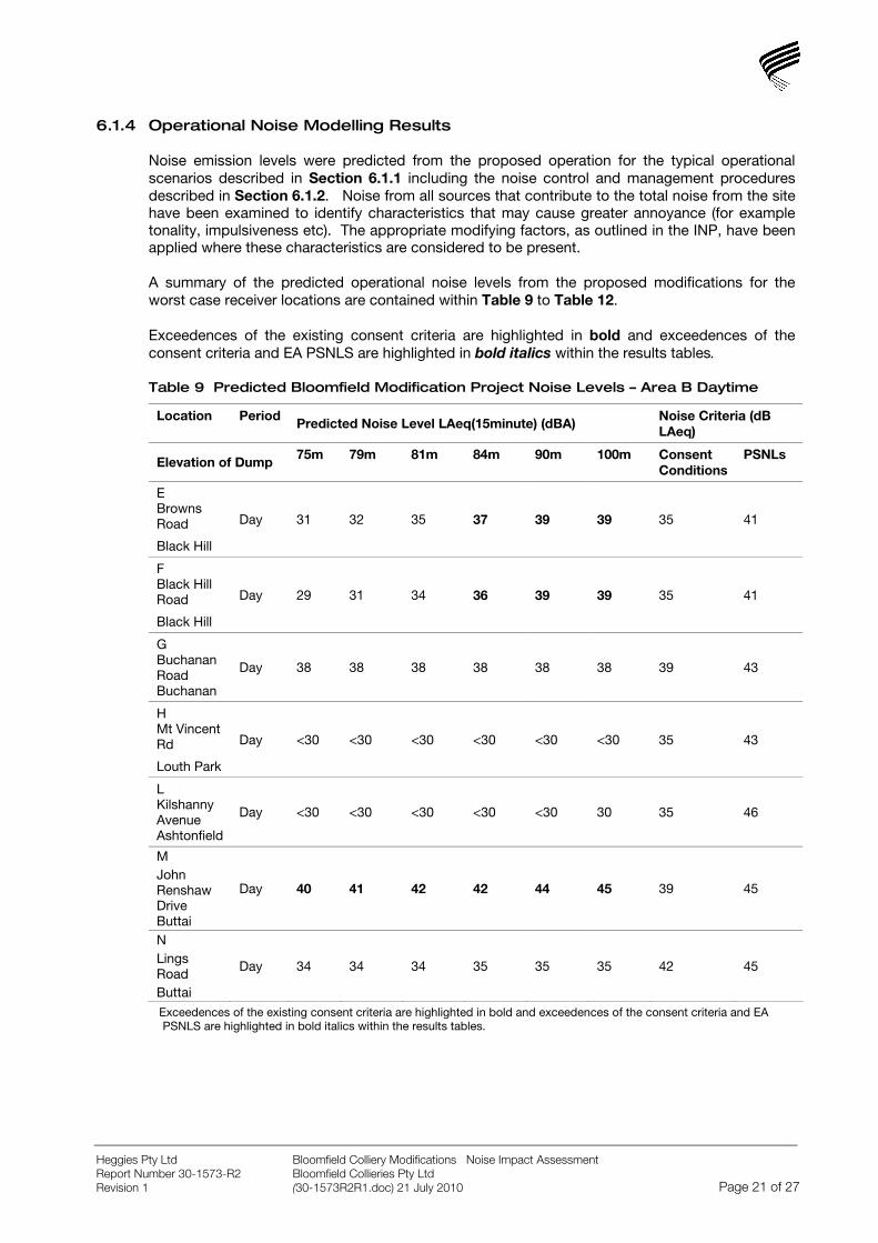
6.1.4 Operational Noise Modelling Results
Noise emission levels were predicted from the proposed operation for the typical operational scenarios described in Section 6.1.1 including the noise control and management procedures described in Section 6.1.2. Noise from all sources that contribute to the total noise from the site have been examined to identify characteristics that may cause greater annoyance (for example tonality, impulsiveness etc). The appropriate modifying factors, as outlined in the INP, have been applied where these characteristics are considered to be present.
A summary of the predicted operational noise levels from the proposed modifications for the worst case receiver locations are contained within Table 9 to Table 12.
Exceedences of the existing consent criteria are highlighted in bold and exceedences of the consent criteria and EA PSNLS are highlighted in bold italics within the results tables.
Table 9 Predicted Bloomfield Modification Project Noise Levels – Area B Daytime
Location Period Predicted Noise Level LAeq(15minute) (dBA) Noise Criteria (dB LAeq)
Elevation of Dump 75m 79m 81m 84m 90m 100m Consent Conditions
PSNLs
E Browns Road
Black Hill
Day 31 32 35 37 39 39 35 41
F Black Hill Road
Black Hill
Day 29 31 34 36 39 39 35 41
G Buchanan Road Buchanan
Day 38 38 38 38 38 38 39 43
H Mt Vincent Rd
Louth Park
Day <30 <30 <30 <30 <30 <30 35 43
L Kilshanny Avenue Ashtonfield
Day <30 <30 <30 <30 <30 30 35 46
M John Renshaw Drive Buttai
Day 40 41 42 42 44 45 39 45
N Lings Road Buttai
Day 34 34 34 35 35 35 42 45
Exceedences of the existing consent criteria are highlighted in bold and exceedences of the consent criteria and EA PSNLS are highlighted in bold italics within the results tables.
Bloomfield Colliery Modifications Noise Impact Assessment Bloomfield Collieries Pty Ltd
Heggies Pty Ltd Report Number 30-1573-R2 Revision 1 (30-1573R2R1.doc) 21 July 2010 Page 21 of 27
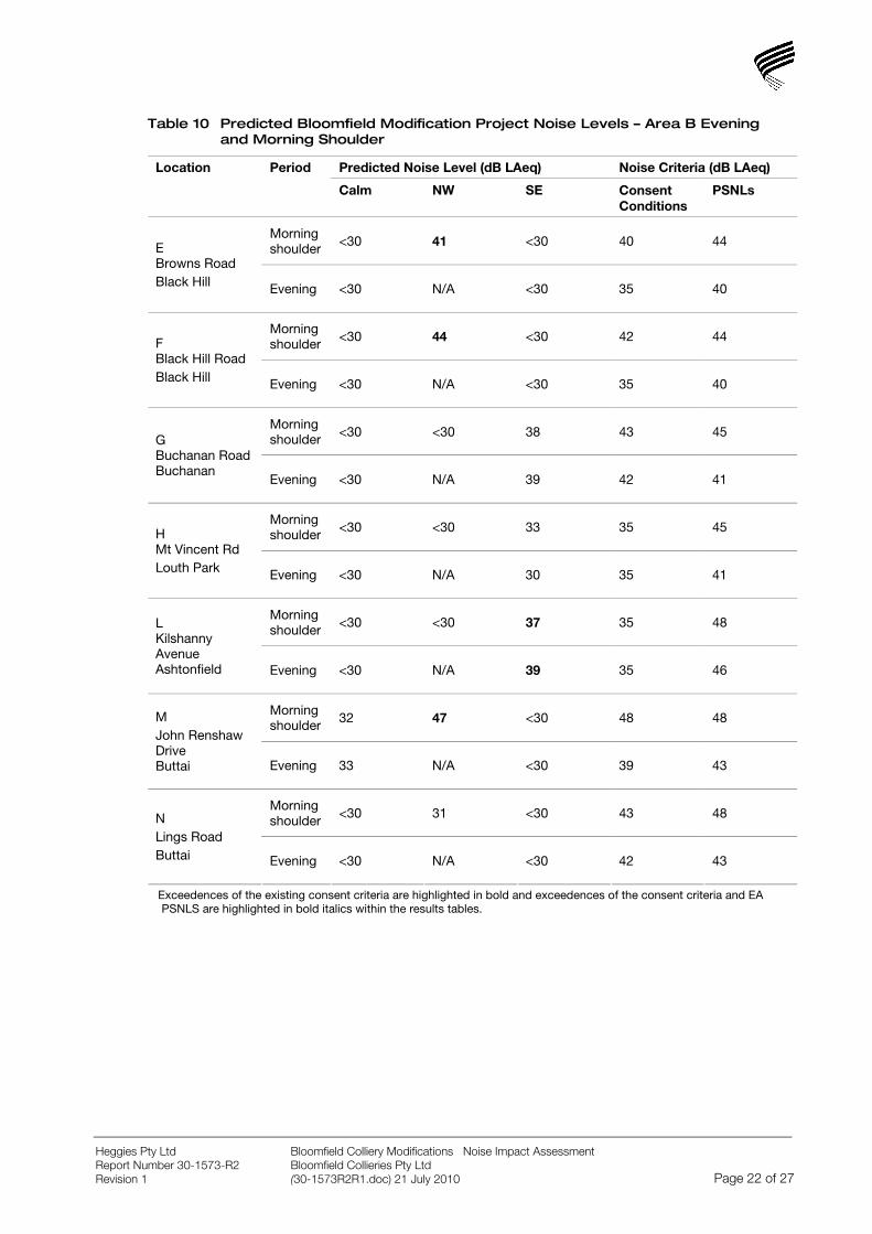
Table 10 Predicted Bloomfield Modification Project Noise Levels – Area B Evening and Morning Shoulder
Predicted Noise Level (dB LAeq) Noise Criteria (dB LAeq) Location Period
Calm NW SE Consent Conditions
PSNLs
Morning shoulder <30 41 <30 40 44 E
Browns Road Black Hill Evening <30 N/A <30 35 40
Morning shoulder <30 44 <30 42 44 F
Black Hill Road Black Hill Evening <30 N/A <30 35 40
Morning shoulder <30 <30 38 43 45
G Buchanan Road Buchanan
Evening <30 N/A 39 42 41
Morning shoulder <30 <30 33 35 45 H
Mt Vincent Rd Louth Park Evening <30 N/A 30 35 41
Morning shoulder <30 <30 37 35 48 L
Kilshanny Avenue Ashtonfield Evening <30 N/A 39 35 46
Morning shoulder 32 47 <30 48 48 M
John Renshaw Drive Buttai Evening 33 N/A <30 39 43
Morning shoulder <30 31 <30 43 48 N
Lings Road Buttai Evening <30 N/A <30 42 43
Exceedences of the existing consent criteria are highlighted in bold and exceedences of the consent criteria and EA PSNLS are highlighted in bold italics within the results tables.
Bloomfield Colliery Modifications Noise Impact Assessment Bloomfield Collieries Pty Ltd
Heggies Pty Ltd Report Number 30-1573-R2 Revision 1 (30-1573R2R1.doc) 21 July 2010 Page 22 of 27

Table 11 Predicted Bloomfield Modification Project Noise Levels – Area C
Noise Criteria (dB LAeq) Location Period Predicted Noise Level LAeq(15minute) (dBA)
Consent Conditions
PSNLs
E Browns Road, Black Hill
Day 30 35 41
F Black Hill Road, Black Hill Day <30 35 41
G Buchanan Road, Buchanan Day 39 39 43
H Mt Vincent Rd, Louth Park
Day <30 35 43
L Kilshanny Avenue Ashtonfield
Day 30 35 46
M John Renshaw Drive, Buttai
Day 38 39 45
N Lings Road, Buttai
Day 30 42 45
Exceedences of the existing consent criteria are highlighted in bold and exceedences of the consent criteria and EA PSNLS are highlighted in bold italics within the results tables.
Table 12 Predicted Bloomfield Modification Project Noise Levels – Area E
Location Period Predicted Noise Level LAeq(15minute) (dBA) Noise Criteria (dB LAeq)
Elevation of Dump
52m
(with dozer on dump)
56m
(with front end loader on dump)
60m
(with front end loader on dump)
Consent Conditions
PSNLs
E Browns Road Black Hill
Day 41 41 41 35 41
F Black Hill Road Black Hill
Day 37 36 37 35 41
G Buchanan Road Buchanan
Day 38 38 38 39 43
H Mt Vincent Rd Louth Park
Day <30 <30 <30 35 43
L Kilshanny Avenue Ashtonfield
Day <30 <30 <30 35 46
M John Renshaw Drive Buttai
Day 46 45 45 39 45
N Lings Road Buttai
Day 35 35 35 42 45
Exceedences of the existing consent criteria are highlighted in bold and exceedences of the consent criteria and EA PSNLS are highlighted in bold italics within the results tables.
Bloomfield Colliery Modifications Noise Impact Assessment Bloomfield Collieries Pty Ltd
Heggies Pty Ltd Report Number 30-1573-R2 Revision 1 (30-1573R2R1.doc) 21 July 2010 Page 23 of 27

6.1.5 Discussion
Area B - Daytime
Noise levels including dumping operations in Area B are predicted to meet the existing consent conditions at locations G, H, L and N during the daytime period. Noise levels are also predicted to meet the existing conditions of consent at locations E and F when the elevation of the dump is 81m or lower.
Operational noise levels from the Area B modification are predicted to exceed the existing consent criteria at location M during daytime operations and at locations E and F when the height of the dump exceeds 81m. However, noise levels at these locations are predicted to meet the project specific noise levels established with reference to the INP for the EA for the approved project and are therefore unlikely to cause disturbance.
Area B – Evening and Morning Shoulder
Noise levels including dumping operations in Area B are predicted to meet the existing consent criteria at locations G, H and N during the evening and morning shoulder periods under calm and prevailing weather conditions with the proposed mitigation and management strategies in place and at all locations under calm weather conditions.
Operational noise levels from the Area B modification are predicted to exceed the existing consent conditions at locations E, F and M during the morning shoulder period under the influence of a prevailing NW wind and at location L during the evening and morning shoulder periods under the influence of a prevailing SE wind. Notwithstanding this, noise levels at these locations are predicted to meet the project specific noise levels established with reference to the INP for the EA for the approved project and are therefore unlikely to cause disturbance.
Area C
Operational noise levels from the proposed Area C modification are predicted to meet the existing conditions of consent at all receiver locations during the daytime period under calm weather conditions.
Area E
Operational noise levels from the proposed Area E modification are predicted to meet the existing consent conditions at locations G, H, L and N during the daytime period. Noise levels at locations E, F and M are all predicted to exceed the existing consent criteria by up to 6 dBA.
Notwithstanding this, noise levels are predicted to meet the project specific noise levels established with reference to the INP for the EA for the approved project at all locations with the exception of Location M where a 1 dBA exceedence is predicted with a dozer working on the dump. This 1 dBA exceedence is unlikely to cause disturbance during the daytime period.
It should be noted that the works required in Area E are minor in nature and will be limited to a total of 70 hours in daytime periods.
Additionally, since the operational scenario modelled is likely to represent an acoustically worst-case scenario, actual operational noise levels from the proposed modifications are likely to be less than those predicted.
Bloomfield Colliery Modifications Noise Impact Assessment Bloomfield Collieries Pty Ltd
Heggies Pty Ltd Report Number 30-1573-R2 Revision 1 (30-1573R2R1.doc) 21 July 2010 Page 24 of 27
6.2 Sleep Disturbance Analysis
In assessing sleep disturbance, typical LAmax noise levels of plant and equipment to be used at the subject site during the night was used as input to the ENM acoustic model and predictions were made at the nearest residential areas under adverse weather conditions during the morning shoulder.
A summary of the predicted maximum noise levels at the most affected locations are contained within Table 13.
Table 13 Predicted Maximum Morning Shoulder Noise Levels – Area B
Predicted Noise Level LAmax (dBA)
Sleep Disturbance Criteria (LA1(1min))
Location Period
NW Wind
SE Wind
Consent Conditions
PSNLs
E Browns Road Black Hill
46 <30 45 46
F Black Hill Road Black Hill
48 <30 45 46
G Buchanan Road Buchanan
<30 38 45 46
H Mt Vincent Rd Louth Park
<30 31 45 46
L Kilshanny Avenue Ashtonfield
<30 40 45 53
M John Renshaw Drive Buttai
48 34 46 46
N Lings Road Buttai
Morning Shoulder
39 <30 46 46
The predicted LAmax noise levels from the proposed Area B Modification will meet the sleep disturbance consent criteria at all locations for all operational scenarios considered with the exception of Locations E, F and M where exceedances of up to 3 dBA are predicted during the morning shoulder period under the influence of a NW wind.
As discussed in Section 5.2.2, in order to minimise the potential for sleep disturbance, noise goals are based on the night-time RBLs rather than those measured during the morning shoulder. However, it should be noted that during the morning shoulder period, noise levels are typically significantly higher than during the night-time due to the increase in road traffic along John Renshaw drive (measured noise levels during the morning shoulder period at locations E, F and M were between 8 and 17 dBA higher than those monitored during the night-time period (refer Heggies report 30-1573-R1R1 Noise and Blasting Assessment – Bloomfield Project)).
Furthermore, the use of the LAmax noise level provides a worst-case prediction since the LA1(1minute) noise level of a noise event is likely to be less than the LAmax. As such, the predicted 3 dBA exceedance is unlikely to cause sleep disturbance during the morning shoulder period.
Bloomfield Colliery Modifications Noise Impact Assessment Bloomfield Collieries Pty Ltd
Heggies Pty Ltd Report Number 30-1573-R2 Revision 1 (30-1573R2R1.doc) 21 July 2010 Page 25 of 27
Since it has been recommended that dumping and rehabilitation in the proposed modification areas does not occur in Areas C and E at night-time or during the morning shoulder period, sleep disturbance analysis has not been undertaken for these locations.
6.3 Construction Noise Modelling
6.3.1 Construction Scenarios
Development of Wattle Tree Drive as Alternative Haul Route (Modification Area A)
The construction of the alternative haul road will involve the widening and levelling of the existing track at Wattle Tree Drive. As part of the construction works the southern and northern batters will be shaped and stabilised.
It has been assumed that the following equipment will be utilised for the construction works:
CAT D11 Dozer.
CAT 16G Grader.
CAT 365 Backhoe.
Noise modelling has considered the worst case construction scenario with all the plant operating at the south-western end of the haul road where the plant will be at its most elevated and exposed level.
Construction of Overhead Powerline and Easement (Modification Area D)
Construction of the overhead powerline and easement would involve the marking of the easement, vegetation clearing and the relocation of the powerline. It is anticipated that construction works would be less than 6 weeks in duration.
It has been assumed that the most acoustically significant equipment operating during the construction period will be a dozer clearing vegetation and marking the easement. This has been modelled at the most elevated level within modification area D to provide a worst case assessment.
6.3.2 Construction Noise Modelling Results
The maximum predicted noise levels due to the development of Wattle Tree Drive as an alternative haul route are less than 30 dBA at all locations and as such are well below the construction noise criteria. Furthermore, once the haul route is in place it is likely that operational noise impacts will be reduced due to the greater separation distances between the haul road and the nearest affected residences to the south.
The maximum predicted noise levels due to the clearing and marking of the easement within modification area D are also predicted to be less than 30 dBA and are significantly below the relevant construction noise criteria.
Bloomfield Colliery Modifications Noise Impact Assessment Bloomfield Collieries Pty Ltd
Heggies Pty Ltd Report Number 30-1573-R2 Revision 1 (30-1573R2R1.doc) 21 July 2010 Page 26 of 27
Bloomfield Colliery Modifications Noise Impact Assessment Bloomfield Collieries Pty Ltd
Heggies Pty Ltd Report Number 30-1573-R2 Revision 1 (30-1573R2R1.doc) 21 July 2010 Page 27 of 27
7 CONCLUSION
Heggies has conducted a noise impact assessment for the proposed modifications to operations at the Bloomfield Colliery located near Beresfield, NSW. The objective of the study was to assess the potential impact of noise from dumping and rehabilitation within the proposed modification areas B, C and E.
Operational noise levels were predicted under calm and prevailing meteorological conditions at the nearest affected residences to the site. With proposed noise controls, mitigation and management in place, operational noise levels are predicted to meet the existing consent criteria during the daytime at locations G, H, L and N during dumping and rehabilitation in Areas B and E and at all locations during dumping and rehabilitation in Area C.
Noise levels are predicted to exceed the existing daytime consent criteria at locations E, F and M during dumping and rehabilitation in Areas B and E. Notwithstanding this, noise levels are predicted to be below the project specific noise levels established with reference to the INP and reported in the EA for the approved development and are therefore unlikely to cause disturbance at the surrounding residential receivers.
Noise levels including dumping operations in Area B are predicted to meet the existing consent criteria at locations G, H and N during the evening and morning shoulder periods under calm and prevailing weather conditions.
Operational noise levels from the Area B modification are predicted to exceed the existing consent conditions at locations E, F and M during the morning shoulder period under the influence of a prevailing NW wind and at location L during the evening and morning shoulder periods under the influence of a prevailing SE wind. Notwithstanding this, noise levels at these locations are predicted to meet the project specific noise levels established with reference to the INP for the EA for the approved project and are therefore unlikely to cause disturbance.
The proposed activity in Areas B and E are necessary to ensure that the rehabilitation measures and final landform meets current standards as prescribed by the NSW Government. The long history of mining on the site and changing rehabilitation standards has prompted the need to make improvements. Whilst there may be some short term exceedence of noise criteria outlined in the Project Approval, the proposed modifications comply with the requirements of the Industrial Noise Policy.
The predicted LAmax noise levels from the proposed Area B Modification are predicted to meet the existing sleep disturbance criteria with the exception of Locations E, F and M under adverse weather conditions. Notwithstanding this, predicted maximum noise levels are considered worst case and are unlikely to cause sleep disturbance during the morning shoulder period where existing noise levels are significantly higher due to the influence of road traffic on John Renshaw Drive.
Predicted construction noise levels from the development of Wattle Tree Drive as an alternative haul route and the construction of the overhead powerline and easement are predicted to be significantly below the relevant construction noise criteria.