board of directors & technical committee thursday, march 29, 2012 data management (contract)...
TRANSCRIPT

Board of Directors & Technical Committee
Thursday, March 29, 2012 Data Management (Contract)
Field Data Collection &Database Development Solution
Presented By:Dr. Del Despain, Developer of VGS through the University of Arizona
Mr. Josh Briggs, Technical Lead for Science Applications International Corporation (SAIC)
Mr. Fon Allan Duke, Program Manager for Mojave Desert Ecosystem Program (MDEP)

Agenda
• Brief historical overview• Who are the three teams involved and their
roles• What is the Vegetation/GIS Data System (VGS)• VGS for NPS • Status• Q & A

Brief historical overview
• A solutions was needed utilize technology to improve reporting methods.
• The Mojave I&M was introduced to the MDEP.
• This collaboration allowed Mojave I&M to find a team to provide a data collection solution that would fit the many needs of the Mojave I&M which brought VGS and SAIC.

The Teams• The DoD and Dept. of Army
charged the program to support the entire Mojave Ecosystem.
• MDEP achieves true collaboration through shared resources, data and projects.
• It is seen as a regional data repository and IT service provider for various agencies in the Mojave Ecosystem.
• MDEP’s data efforts focus on supporting environmental land management issues facing the agencies that the program supports.
The Mojave Desert Ecosystem Program (MDEP)

The Teams
• MDEP operates various government provided servers in Barstow CA, at the NPS Mojave Preserve building in Bartow.
• The program works with ESRI GIS software, Microsoft products such as SharePoint and MS SQL Database along with a whole host of other software.
• Mobile solutions have been and are a large focus for MDEP from researching solutions, supporting many commercial of solutions, and even developing solutions.
• MDEP has works with many agencies in their mobile data efforts such as:– Army Corp of Engineers– U.S. Fish and Wildlife– U.S.M.C.
The Mojave Desert Ecosystem Program (MDEP) cont.

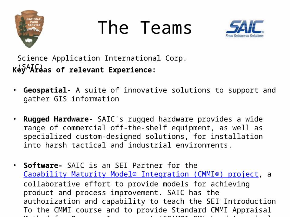
The TeamsScience Application International Corp. (SAIC)
SAIC is a FORTUNE 500® scientific, engineering, and technology applications company that uses its deep domain knowledge to solve problems of vital importance to the nation and the world in national security, energy & environment, health and cybersecurity.
Our Successes– 40 years of continuous growth
• Approximately $11 billion in annual revenues for fiscal year 2011• FORTUNE 500 company – No. 219
– Superb staff of qualified professionals• Approximately 41,000 personnel worldwide• Approximately 10,000 employees with advanced degrees• Over 20,000 employees with security clearances
– Leading provider of contracted R&D services
The TeamsScience Application International Corp. (SAIC)
Key Areas of relevant Experience:
• Geospatial- A suite of innovative solutions to support and gather GIS information
• Rugged Hardware- SAIC's rugged hardware provides a wide range of commercial off-the-shelf equipment, as well as specialized custom-designed solutions, for installation into harsh tactical and industrial environments.
• Software- SAIC is an SEI Partner for the Capability Maturity Model® Integration (CMMI®) project, a collaborative effort to provide models for achieving product and process improvement. SAIC has the authorization and capability to teach the SEI Introduction To the CMMI course and to provide Standard CMMI Appraisal Method for Process Improvement (SCAMPI SM) Lead Appraisal Services. SAIC has several organizations that have achieved SEI CMMI Maturity Level 5 and other organizations with various CMMI maturity level achievements.

The TeamsScience Application International Corp. (SAIC)

The TeamsDr. Del Despain, Univ. of Arizona subcontracted by SAIC
• Vegetation/GIS Data Systems (VGS) was developed at the University of Arizona through federal grants provided by the U.S. Forest Service.
• The Arizona BLM provided additional grant funding to incorporate their protocols for state wide application and use.
• VGS has been requested for use by various private sector groups in support of their regulatory compliance needs with various federal agencies in the select areas in the South West United States.

What is the Vegetation/GIS Data System (VGS)
VGS Objectives
1. Develop and implement electronic field tools.
• Data forms at least as quick and easy to use as paper forms

2. Provide database for managing data (not simply data capture
• Data from multiple sampling protocols
• Photographs, diagrams and documents
• Accessible to GIS implementations
• Suitable for field, office or on-line applications
What is the Vegetation/GIS Data System (VGS)
VGS Objectives

What is the Vegetation/GIS Data System (VGS)
Data Recording Devices

What is the Vegetation/GIS Data System (VGS)

What is the Vegetation/GIS Data System (VGS)

What is the Vegetation/GIS Data System (VGS)

What is the Vegetation/GIS Data System (VGS)
VGS Distribution

What is the Vegetation/GIS Data System (VGS) is not!

VGS for NPS Preview of various NPS improvements:
• PICTURE TO BE ADDED BY JOSH/DEL

StatusPreview of various NPS improvements:

Q & A
and
Thank you