board of geological survey - washingtonfile.dnr.wa.gov/publications/ger_ar1911-13_brd_of_geol.pdf6...
TRANSCRIPT

The Biennial Report
OF THE
BOARD OF GEOLOGICAL SURVEY
OF THE
STATE OF WASHINGTON
FOR THE TERM
1911-13
• OLYMPIA, WA.CIR.:
F. M. LAMllOUN .... PlO'llLIC PRtNTlilR
191ll

LETTER OF TRANSMITTAL.
To the Legislature of the State of Washitngt011,:
The boa.rd of geological survey transmits herewith its bien
nial report £or the term 1911-13, .as required by statute.
Respectfully submitted,
Olympia, December 15, 19m.
M. E. HAY, President;
J. G. L EWIS, Secretary;
T. F. KANE,
E. A. BRYAN.

TABLE OF CONTENTS.
GENERAL PURPOSES OF SURVEYS: Page
Topographical Surveys . . . . . . . . . . . • . . . . . . . . . . . . . . . . . . . . . . . . . . 5
Hydrographical Surveys . . . . . . . . . . . . . . . . . . . . . . . . . . . . . . . . . . . . . 6
Geological Surveys . . . . . . . . . . . . . . . . . . . . . . . . . . . . . . . . . . . . . . . . . . 7
PRINCIPAL FEATURES OF STATE LAWS PROVIDING FOR SURVEYS........ 8
REPORT FOR 1911·13: Organization . . . . . . . . . . . . . . . . . . . . . . . . . . . . . . . . . . . . . . . . . . . . . . . . 10
Topographical Surveys . . . . . . . . . . . . . . . . . . . . . . . . . . . . . . . . . . . . . . 10
Hydrographical Surveys . . . . . . . . . . . . . . . . . . . . . . . . . . . . . . . . . . . . . 11 Gaging Stations . . . . . . . . . . . . . . . . . . . . . . . . . . . . . . . . . . . . . . . . . . 12 River Profiles . . . . . . . . . . . . . . . . . . . . . . . . . . . . . . . . . . . . . . . . . . . . 12
Geological Surveys . . . . . . . . . . . . . . . . . . . . . . . . . . . . . . . . . . . . . . . . . . 13 Mineral Resources . . . . . . . . . . . . . . . . . . . . . . . . . . . . . . . . . . . . . . . 13 Surveys of Coal Fields. . . . . . . . . . . . . . . . . . . . . . . . . . . . . . . . . . . . 15 Investigation of Materials for Portland CelJ).ent............. 15 Reports on Metal Mining Districts. . . . . . . . . . . . . . . . . . . . . . . . . 16 Soil Surveys . . . . . . . . . . . . . . . . . . . . . . . . . . . . . . . . . . . . . . . . . . . . . 16 Geology of Western Counties.............................. 17 Report on the Glaciation of the Puget Sound Region........ 18
FINANCIAL STATEMENT • • • . . • • • • • • • • . • • • . . . • . • • • • • • • • • • • • • . . • • . • • 19
RECOJlrMENDATlON . • . • . • • . • . • . • • • • • • • • • • • • • • • • . • • . . . • • • • • • • • • • . • . 20
Appropriations Requested . . . . . . . . . . . . . . . . . . . . . . . . . . . . . . . . . . . 20 Topographical Surveys . . . . . . . . . . . . . . . . . . . . . . . . . . . . . . . . . . . . . . 20 Hydrographical Surveys . . . . . . . . . . . . . . . . . . . . . . . . . . . . . . . . . . . . . 20
Geological Surveys . . . . . . . . . . . . . . . . . . . . . . . . . . . . . . . . . . . . . . . . . . 20 Printing . . . . . . . . . . . . . . . . . . . . . . . . . . . . . . . . . . . . . . . . . . . . . . . . . 21 Surveys of Coal Fields.... ............ .................... 21 Soil Surveys . . . . . . . . . . . . . . . . . . . . . . . . . . . . . . . . . . . . . . . . . . . . . 21 Surveys of Metal Mining Districts. . . . . . . . . . . . . . . . . . . . . . . . . 22 General Reconnaissance Surveys. . . . . . . . . . . . . . . . . . . . . . . . . . . 22
PUBLTCATIONS ....••......••. •••••• .•....•..•.••.•••....••• , , .'.23-24


BI ENNIAL REPORT OF THE BO.AR D OF GEO LOGIC.AL SURVEY
GENERAL PURPOSES OF SURVEYS.
TPPOGRAPHICAL SURVEYS.
The Topographical Map.-A topographical map is designed to represent the form and slope of the surf ace of the land and the elevation of all points above sea level. T he positions of streams, lakes and ponds, public and p rivate roads, towns and railroads, are shown in their correct l'elative positions. The map indicates boundaries of counties and the position of section lines wherever there have been land surveys. In the making of the necessary surveys for such maps permanent marks, consisting of iron posts, copper bolts or tablets, are set at frequent intervals to mark the exact elevation above sea level to serve as datum points for further spirit level work, for engineering investigation, and for such public works as canals, water supply, railway and other public or private surveys.
The topl'ographical map is made with such ac~uracy and in such detail that it is useful to almost every citizen. In a new state that is ~viting immigration, the map is valuable in order to show the location of desirable farm lands and the general character of the country. From it the positions of streams and lakes may be seen and the possibilities of these for purposes of water power or irrigation may be largely determined. T he topogl'aphical map facilitates the construction of raiJ.roads and wagon roads, since upon it available routes and grades may be laid out without the preliminary surveys ordinarily necessary for improvements of this kind. In our public schools such a map is indispensable in that it places before the children truthful map s of our commonwealth, instead of those that are glaringly inaccurate.

6 Board of Geological Survey
In the making of topographica l maps the areas selected for survey are defined by lines of latitude and longitude and are called quadrangles. Each quad1·angle, and the topographic map which represents its features, is designated by the name of the most prominent place or topographic feature included within it. The scale generally used in map construction is about two miles to the inch, and on this scale the area embraced in a quadrangle is about eight hundred square miles. In Washington the topographic map when completed will comprise, in round numbers, ninety sheets, complete and fractional, of which about thirty-two have already been surveyed.
HYDROGRAPHIC.AL SURYIDYS.
A hydrographical survey is an examination of the water resources of the state or parts thereof, in order to determine the possible supplies of water suitable for domestic purposes, power plants, or for use in irrigation. The water supply of the state is of more importance to the life and pursuits of the people than any other natural resource, as the health and economic development of every community are directly dependent upon the character and volume of the available supply.
Hydrographical surveys have to do with both the surface and underground waters of the state. The rivers are used for domestic and industrial supplies, power purposes, navigation and irrigation. In order that there may be no useless expenditures in the development of these resources, studies are made to determine the amount of water that is available throughout the various seasons of the year and throughout a series of years. Along the principal streams of the state gaging stations are maintained in order to secure records of flow which indicate the fluctuations that might be expected in the quantity of the water. Profiles or level lines along the rivers are run in order to determine the possibilities of storage, and to secure data for the determination of available water power.
Investigation of underground water supplies is equally as important as in the case of surf ace waters. This work includes a determination of the areas that are underlaid by water-bear-

The Biennial Report 7
ing strata, of the depths at which these strata occur, and of
the amount and quality of water that may be obtained. A knowledge of the existence of water-bearing strata is very necessary, not alone for the purpose of irrigation, but in some parts of Washington settlement is well-nigh impossible because not even enough water for domestic ;purposes has as yet been obtained ·
GEOLOGICAL SURVEYS.
Geological surveys have been organized in nearly all the states of the Union, and in some of the older states they have been continuously active for over filty years. In most states they are regular departments of the state government, and receive definite financial support in the way given to every othe1· bureau or department. They are usually in charge of a board of three or five men, who direct the work of the survey, and who are responsible for its management.
The general purpose of a geological survey is to disclose and make known the mineral resources of a state. Under such heading would naturally come the metalliferous deposits, coal fields, iron ores, building stones, soils, clay beds, road materials, water power, and kindred subjects. The field work of a survey consists in mapping accurately the locations of all such valuable products as those just mentioned, and determining the areal extent and quantity of each. The office work consists of careful tests and analyses of all samples collected in the field, and the preparation of 1·eports which describe fully the mineral resources under investigation. The reports and maps when published are valuable alike to the citizens of the state and to outside capitalists and investors. Surveys examine and test those minerals, ores and rocks that are but little known and determine whether or not they are of economic value. They also suggest ways of preventing wastes in mining operations, and assist in all ways to conserve the natural resources. Surveys are potent factors in making available valuable information regarding the mineral resources of the state, which knowledge may be utilized by the poorest citizen as well as the wealthiest corporation.

8 Board of Geological Surcey
PRINCIPAL FEATURES OF STATE LAWS PROVIDING FOR SURVEYS.
The la,v establishing a state geological survey was passed by the legislature at the session of 1901. As set forth in the various sections of the law, the principal objects of the measure are as follows: An examination of the economic products of the state, such as gold, silver, copper, lead, and iron ores, as well as building stones, clays, coal, and all mineral substances of value; an examination of the soils, road-building material, water supplies, artesian wells, water power, etc.; an examination of the physical features of the state with 1·eference to their practical bearing upon the occupations of the people; the preparation of special geographic and economic maps to illustrate the resources of the state; and the publication from time to time of the results of the work of the survey in reports and bulletins, and the dissemination of these among the people.
At the session of 1903 the legislature amended the above law, by providing for co-operative work between the federal and the state bureaus engaged in geological survey work. The amendment authorized the state board of geological survey to make provisions for topographic, geologic, and hydrographie surveys of the state, in co-operation with the United States geological survey, in such manner as would be of the greatest benefit to the agricultural, industrial and geological requirements of the state. The amendment carried a proviso that the director of the United States Geological Survey should agree to expend on the part of the United States upon such surveys a sum equal to that expended by the state.
At the session of the legislature for 1909 the work of the state geological survey was provided for by a law having these provisions :
SECTION 1. In order to complete the topographical map of the State of Washington, and for the purpose of making more extensive stream measurements, and otherwlse investigating and determining the water supply of the state, there is hereby appropriated the sum of thirty thousand dollars ($30,000), for cooperation with those branches of the United States Geological Survey engaged in this work. This appropriation, however, shall be contingent upon, and not become available
The Bic111nial Report 9
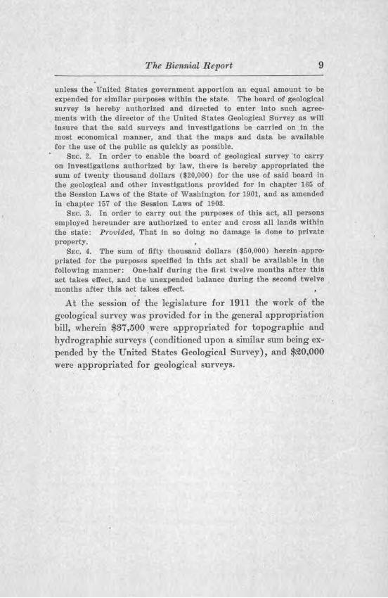
unless the United States government apportion an equal amount to be expended for similar purposes within the state. The board of geological survey is hereby authorized and directed to enter into such agreements with the director of the United States Geological Survey as will insure that the said surveys and investigations be carried on in the most economical manner, and that the maps and data be available for the use of the public as quickly as possible.
SEO. 2. In order to enable the board of geological survey to carry on investigations authorized by law, there Is hereby appropriated the sum of twenty thousand dollars ($20,000) for the use of said board in the geological and other investigations provided for in chapter 165 of the Session Laws of the State of Washington for 1901, and as amended in chapter 157 of the Session Laws of 1903.
SEO. 3. In order to carry out the purposes of this act, all persons employed hereunder are authorized to enter and cross all lands within the state: Proviaea, That In so doing no damage is done to private property.
SEC. 4. The sum of fifty thousand dollars ($50,000) herein appropriated for the purposes specified in this act shall be available in the following manner: One-half during the first twelve months after this act takes effect, and the unexpended balance during the second twelve . months after this act takes effect.
At the session of the legislature: for 1911 the work of the geological survey was provided for in the general appropriation bill, wherein $87,500 .were approp1riated for topographic and hydrographic sm·veys ( conditioned upon a similar sum being expended by the United States Geological Survey), and $9l0,000 were appropriated for geological surveys.

10 Board of Geological Survey
REPORT FOR 1911-18.
ORGANIZATION.
At the call ~f the governor, the State Board of Geological · Survey met at Olympia on March ~9, 1911, with all the members pi-esent as follows: Governor Hay, State Treasurer Lewis, President Kane of the State University and President Bryan of the State College. Governor Hay was authorized to sign the necessary agreements with the director of the United States Geological Sw·vey, arranging for cooperative work in topography and hydrography, as provided by law. The work for the biennium was outlined, and the State Geologist directed to carry on the different investigations and sul'Veys that are described below.
TOPOGRAPHICAL SURVEYS.
The accompanying progress map indicates the locations of the quad1·angles surveyed, during this biennium, as well as durStates Geological Survey, during this biennium, as well as during 1909-11. In selecting quadrangles for survey it has been the policy of the board to choose those areas where the demaud for the maps is very gxeat and where they are most likely to be used to advantage.
In central Washington, immediately east of the Columbia River, and lying between the Great Northerp and Chicago, l\filwaukee & Puget Sound Railways, an area of 1,025 square miles has been surveyed within the past four yea.rs and the maps engraved. In this area there are five quadrangles, viz.: Quincy, Winchester, Moses Lake, Beverly and Red Rock. Each quadrangle was mapped on a scale of one mile to an inch, with contour intervals or level lines every twenty-five feet. During the present biennium sm·veys have been continued on neighboring quadrangles to the northwest of the Quincy quadrangle, and the Palisades quadrangle has been one-third completed, the Malaga quadrangle ent.u·ely finished, and the 'lv enatchee quad-1·angle about two-thirds surveyed. These quadrangles are

The Biennial Report 11
loca.ted in a.rid Washington, where irrigation must be followed to insure the greatest agricultural development. Topographic surveys were made as the first necessary step to secure the reclamation of this dry belt by irrigation.
The survey of the Cedar Lake quadrangle (immediately east of the T acoma quadrangle) was begun in 1910 but was not completed until the summer of 1911 . It is now being engraved on a scale of two miles to an inch, with contour intenals or level lines every one hundred feet. The board chose this quadrangle for survey in order to assist in the development of the great water resources of the area which will be invaluable for municipal and power purposes to the growing cities of Puget Sound.
Topographic surveys were carried on during the summers of 1911 and 191!2 in the region about Grays H arbor. This will be styled the Grays Harbor special map and it will be engraved after a little more field work has been done. D uring the summer of 191!2 topographic mapping was under way in the Chehalis quadrangle, which may be completed in one mo1·e yea.1·. This quadrangle is being mapped p1·epat·atory to a survey of the extensive coal fields which occm· within the area.
Copies of all engraved topographic maps may be purchased of the United States Geological Survey, W asbington, D. C., at ten cents each.
HYDROGRAPHICAL SURVEYS.
The water resources of the state have been investigated jointly by the federal and state surveys, each party assuming one-half of the expense. T]1e chief object has been to obtain accurate information regarding the amount of water that could be depended upon for irrigation and for power purposes. AU of the water that can be secm·ed by storage that is tributary to arid Washington will soon be needed for irrigation. The rapid industrial development of Western Washington demands the continued utilization of the available water power. The detailed investigations have been along two lines, viz., establishment of gaging stations, and running of sui-veys for the dete1·mination of river profiles.

1~ Board of Geological Survey
Gaging Stations.-As shown on the progress map, gaging stations are in operation upon ~ large number of streams of the state. At each station the daily discharge of the stream is obtained and the amount of water available for any purpose made known. The gage readings are particularly valuable at the times of minimum flow, ,vhich occur on some Washington streams in mid-winter and upon others in mid-summer.
River Profiles.-During the past four years an investigation has been carried on of the water power of the Cascades, beginning at the southern end of the range in Washington, along the Columbia river. Along the principal streams level lines have been run and profiles made from the mouths to a point near the headwaters where the volume of water has become too small to be considered for power purposes. Topographical maps have been made, using 5-foot contour lines, of the country immediately adjoining each bank of the stJ·eam. In this way not only has the exact drop of the stream per mile and fraction thereof been determined but also the storage opportunties have been fully shown. The discharge data of the streams, obtained at the gaging stations during previous years, when used with the measured fall of the streams, give the total horsepower which is afforded. .
The first 1·eport was called ''Water Powers of the Cascade Range, Part I, Southern Washington," and was issued in 1910. It described the water powers along the Klickitat, White Salmon, Little White Salmon, Lewis and Toutle rivers, with some of their principal tributaries.
The second repoit is known as "Water Powers of the Cascade Range, Part II," and describes. the following streams and their tributaries: Cowlitz, Cispus, Nisqually, Puyallup, White, Green and Cedar rivers. This report has been printed ~nd is now about r eady for distribution.
The third report is styled "Water Powers of the Cascade Range, Part III, and involves Yakima River with its several important tributaries. The data for this report has been accumulating for a number of years, in great detail, and all
The Biewnial Report 1S
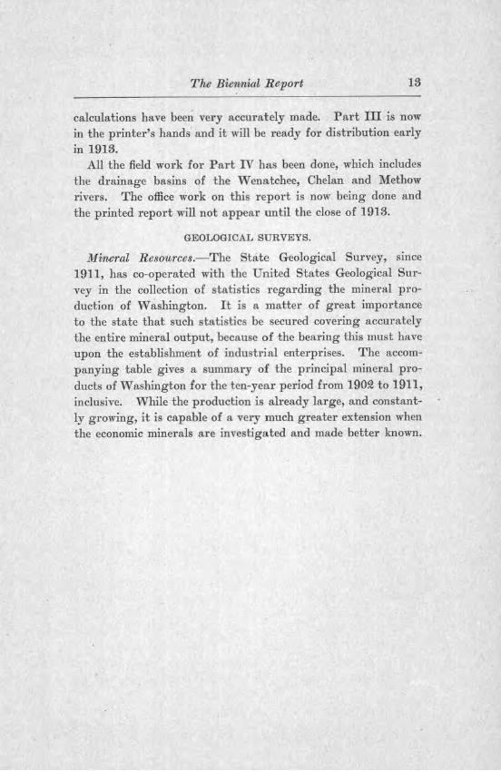
calculations have been very accurately made. Part III is now in the printer's hands and it will be ready for distribution euly in 1913.
All the field work for Part IV has been done, which includes the drainage basins of the Wenatchee, Chelan and Methow rivers. The office work on this report is now being done and the printed report will not appear until the close of 1913.
GEOLOGICAL SURVEYS.
Mineral Resources.-The State Geological Survey, since 1911, has co-operated with the United States Geological Survey in the collection of statistics regarding the mineral production of w ashington. It is a matter of great importance to the state that such statistics be secured covering accurately the entire mineral output, because of the bearing this must have upon the establishment of industrial enterprises. The accompanying table gives a summary of the principal mineral products of W ashlngton for the ten-year pe1·iod from 190Q to 1911, inclusive. While the production is already large, and constantly growing, it is capable of a very much greater extension when the economic minerals are investigated and made better known.
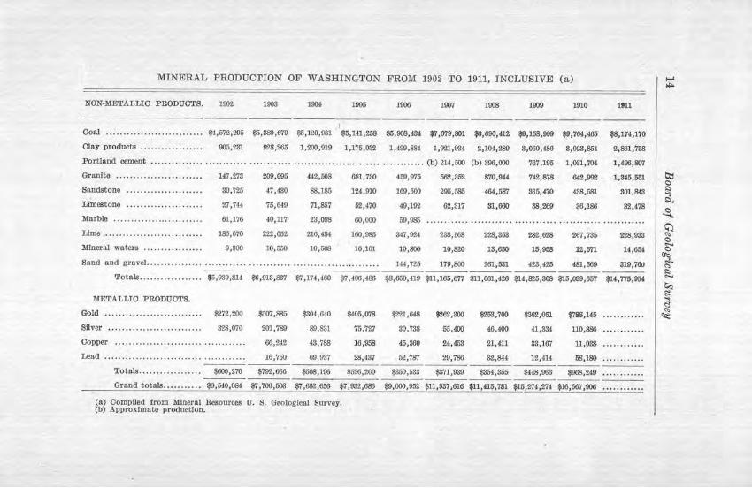
MINERAL PRODUCTION OF WASHINGTON FROM 1902 TO 1911, INCLUSIVE (a) 1~ NON-METALLIO PRODUOTS. 100'2 1903 191)1, 1905 1006 1907 1908 1909 1910 1911
---I
Ooal .......... ... ............... $4,572,295 $5,380,679 $5,120,931 $5,141,268 $5,008,434, $7,679,801 $6,690,ill $9,158,999 $9,764,465 $8,174,170
Olay products .................. 905,231 ~28.265 1,200,919 1,175,032 1,499,884 1,921,934 2,104,289 3,060,(86 3,023,854 2,861,758
Portland cement ................................................................. . .......... (b) 214,600 (b) 396,000 767,195 1,031,704 1,496,807
Granite ....................... .. 147,278 209,095 442,508 681,730 459,975 562,352 870,94.4 742,878 842,99'2 1,846,561 b::I C)
Sandstone ...................... 30,725 47,430 88,186 124,910 169,500 295,585 464,Wl 385,470 438,581 301,843 ~ I;:!..
Limestone ...................... 27,744 75,649 71,867 52,470 49,192 62,317 31,660 88,?.69 36,186 82,478 C)
Marble ............ . ....... ... .. . -61,176 40,117 23,098 60,000 59,985 ............................................................ ~ Lime ..... ... .................... 186,070 222,052 216,454 160,085 347,!l'M 238,668 228,353 282,628 267,735 228,933 ~ C) .,...
Mineral waters ................. 9,800 10,550 10,508 10,101 10,$)() 10,820 18,650 15,968 12,671 H,654 C)
Sand and gravel ................................................................. 14',725 179,$)() 261,531 423,425 481,569 319,76\l °3. ~
Totals •••.....•......... $5,939,814 $6,913,837 $7,174,460 $7,400,486 $8,650,419 $ll,165,677 $11,061,426 $14,825,308 $15,699,657 $14,775,054 ~
~ ?r1ETALLI0 PRODUCTS. ~
~ Gold .............. ....... ....... $272,200 $507,885 $301,640 $105,078 $221,648 $'262,800 $253,700 $362,051 $788,146 . . ... . ...... ~
Silver ........... . ............... 828,070 201,789 89,831 76,727 30,738 55,400 46,400 41,334 110,886 ............
Oopper ................. ..................... 60,24.Z 43,788 16,958 45,300 24,,453 21,411 83,167 11,038 ............
Lead .................................. ..... . 16,750 69,937 28,487 52,787 29,786 32,844 12,414 58,180 ............
Totals .................. $600,270 $'19'2,666 $508,100 $526,200 $350,533 $371,939 $354,365 $448,966 $968,2Ml ....... . ....
Grand totals........... $6,540,084 $7,706,503 $7,682,656 $7,932,680 $9,000,952 $11,637,616 $11,415,781 $15,274,274 $16,667,906 .... . .... .. .
(a? Compiled from Mloeral Resources U. S . Geological Survey. (b Approximate production.

The Biennial Report 15
Surveys of Coal, Fielcls.-In the past four years coal surveys have been made in King, Pierce and Kittitas counties. The work has been carried on with great thoroughness and the plan has been to make the surveys in such detail that they would not need to be repeated fo1· many years. In King and Pierce counties the field work was greatly retarded because of the deep soil covering as well as heavy forest growth under which the coal seams a.re concealed. By going ove! the ground with great care and using all possible sources of information, the detailed structure of the coal formation has been accurately made out.
It has been the plan to publish ample descriptive matter describing the results of the field examinations. Maps are made which sho,v accurntely ( 1) the boundaries of the devel?ped fields, (~) the limits of the probable workable fields, (S) the locations of the fields where coal outcrops occuT but where the coal is not believed to be commercially v!1-luable, and ( 4) those localities underlaid by formations other than coal measures and where coal is an impossibility.
The report on King county has been published as Bulletin No. 3 of the State Geological Survey reports. The field work has been practically completed in Pierce and Kittitas counties and a portion of the office work done in the preparation of the reports for the printer. In both of these counties advance copies of the geological maps have been made, showing the areal distribution of the coal beds.
In cooperation with the United States Geological Survey the state survey collected about two hundred and twenty-five samples of coal, from all the commercial seams of the state, and these were analyzed and their heating values determined. The results have been published in Bulletin 474 of the United States Geological Survey, and in Bulletin No. S of the state survey reports.
Investigation of Materials for Portland Cement.-Because of the rapidly growing demand for Portland cement in Washington, it was deemed wise to have a repo1·t prepared, giving the quantity and quality of the materials known to be available for its manufacture. Proper materials for the manufacture
16 Board of Geological Surv~y
of a high grade of Portland cement are comparatively rare in this state and it is desirable that a thorough search be made for them. All parts of the state have been examined where the necessary limestone and clay deposits were regarded as likley to be found. It was thought wise to examine and report upon all the limestone deposits, rega1·dless of the small size of some of them, because of the necessity for the use of such material in the manufacture of quick lime, in fertilizers, as a flux, for use in paper making, etc., apart from its utilization in the making of cement. This report, which will contain over ~50 pages of descriptive matter, besides the numerous maps and illustrations, is now in manuscript form and ready for the printer.
Reports on Metal Mining Districts.-In the past four years reports have been made upon the metal mining districts in and about Republic, Myers Creek, Oroville, Blewitt and Index. It has heretofore been the policy to select comparatively small areas and work put with much detail the extent, quality and other characteristics of the ore bodies. Four reports upon the metal mining districts have been published, containing geologic and topographic maps, as well as ample descriptions of the or'e deposits, the amount of development work, and the methods of mining and ore reduction.
Soil Surveys.-Extensive soil surveys have been made under a cooperative arrangement with the Bureau of Soils,. United States Department of Agriculture.. Under this plan the latter bureau agreed to assume the major portion of the ei-pense of the field work, and all the expense of printing the reports. In these surveys the various kinds of soil are studied with care, and t]1ey are classified into types based upon origin, texture, depth, agricultural value and topography. Maps are prepared in colors, showing the character of the soils which occur in every locality embraced by the surveys. All the factors that have a bearing upon the utility of the soils, such as topography, drainage, climate, etc., are investigated and the conclusions set forth in detail in the reports.

The Biennial Report 17
The soil sm·veys have been carried on mostly in Western Washington and 11.ave had to do with the logged-off lands. As a result of the surveys a land classification map is prepa1·ed in colors, showing the extent of the logged-off lands, the areas still covered by virgin forests, the tracts which have been developed agricultm·ally, and the swamp or marsh lands. The lands surveyed are further classified into different groups, and these are shown on the land classification map by means of symbols. Some of the principal groups a1·e as follows: Lands adapted to general farming and justifying immediate agricultural development; lands which al'e capable of being developed agriculturally and are adapted to intensive farming, fruit growing and pasturage; lands which can be utilized for orchards and pasturage, but not well adapted to farming; non-agricultural lands, suitable for reforestation only; and areas of forests, unclassified.
Two soil reports have been printed, v-iz. : "Reconnaissance Soil Survey of the Eastern Part of the Puget Sound Basin," and "Reconnaissance Soil Survey of the Western and Southern Parts of the Puget· Sound Basin." A third report entitled "Reconnaissance Soil Survey of Southwestern Washington," has been printed and is now about ready for distl'ibution.
A fourth soil survey report is now about ready for dishibution and is entitled "Reconnaissance Soil Survey of the Quincy Area." It embodies about 1,100 square miles in Grant and Adams counties, immediately east of the Columbia River, in the• most arid part of the state. The soil survey was made as one of the _necessary steps looking toward the 1·eclamation of this desert area by irrigation.
Geofogy of Western CQWltties.-So much inquiry has been made concerning the bedrock geology of that part of the state between the westem foothills of the Cascades and the Pacific Ocean that a reconnaissance survey has been made of this region. The chief question has been in regard to the probable occurrences of gas and oil, mainly in the counties immediately adjacent to the ocean. The prevailing formations have been found to be

18 Board of Geological Survey
sedimentary strata, mainly sandstones and shales, with occasional indications of oil and less frequently of gas. Enough field work has been done to secure the data for a geological map, giving the boundaries of the different formations, and sufficient cross-sections to show the folded condition of the strata. A large amount of information has been obtained regarding the most likely ground for oil and gas prospecting, which will undoubtedly mean a great saving of money in future drilling operations. This report is now about ready for the printer.
Report 011, the Glaciation of the Puget Sound Region.-This report, which was secured at a merely nominal cost to the Geological Survey, is a very accurate account of the geological history of the country around Puget Sound, especially with regard to the story of glaciation. The glacial formations, in their influence on the kind and character of the soil, the clay, sand, gravel and other things of economic value, are fully described. The report, containing several maps and other illustrations, is now ready to be printed.

The Biennial Report 19
FINANCIAL STA.TEMENT.
Topographical and Hydrographical Surveys.
U. S. Geological Survey : Allotment for cooperation 1911-1913. ... ...... . . . . . . . . . $37,500 00 Expenditures to December 1, 1912. . . . . . . . . . . . . . . . . . . . . 29,756 28
Balance on December 1, 1912 .. . . ... . ........ . . . . $7,743 72 State Geological Survey :
Appropriation for 1911-1913...... . ........ ... . . . . . . . . . . $37,500 00 Expenditures to December 1, 1912. . . . . . . . . . . . . . . . . . . . . 31,548 17
Balance on December 1, 1912.. . . . . . . . . . . . . . . . . . . . . $5,961 83
Geological Surveys. State Geological Survey:
Appropriation for 1911-1913 .......... . ........ . .... . .. . Expenditures to December l, 1912:
Printing of Reports . . . . . . . . . . . . . . . . . . . . $4,272 92 Coal Surveys:
Pierce County . .. ........... ..... . . . . Kittitas County . . .......... ... ... . . . King County . ... .................. . .
Investigation of cement materials . . .... . Soil Surveys .... .. ............. .. ..... . Investigations for oil ........... . .... . . Surveys of metal mining districts . .... . . Report on geology of Puget Sound region . Clerical work . ... .... . ..... . ..•... .. . .. Instruments and filing cabinets .. .. .. ... . Office supplies, express charges and in-
cidentals . . . ... .................. ... . Traveling and field expenses of State
Geologist .. . .................... . . . . Per diem paid State Geologist . . ... ... . . Expenses of Board of Geol. Survey ... .. .
5,228 13 1,239 40
696 56 2,126 89 1,523 40 1,607 93
181 10 225 00 686 77 564 71
664 16
806 38 280 00 11 98
$20,000 00
Total.. . . . . . . . . . . . . . . . . . . . . . .. $19,965 88 $19,966 33
Balance on December 1, 1912 .. . ... .... . ... .. .. .. . $34 67
U. S. Department of Agriculture, Bureau of Soils:
Expenditures for field-work 1n cooperation, Soil Sur veys $4,660 26
flO Board of Geowgical Survey
RECOMMENDATIONS.
APPROPRIATIONS REQUESTED.
For topographical and hydrographical surveys (conditioned upon a similar sum being expended in the state by the United States Geological Slll·vey) ......................... $35,000
For Geological Surveys . . . . . . . . . . . . . . . . . . . . . . . . . . . . . . . . . . . . . . 20,000
TOPOGRAPHICAL SURVEYS.
The following areas or quadrangles, which are now partly surveyed, may be completed in one more field season, viz.: Grays Harbol', Chehalis, Wenatchee and Palisades. In addition there is an urgent and imperative demand for topographic maps in the arid districts of the state whe1·e the land may be reclaimed only by iITigation. Topographical surveys should be continued at once in Franklin, Adams, Grant, Benton, Yakima and Kittitas .counties.
In the past four years level · lines or profiles have been run along all the streams of the eastern Cascades, and along all the streams of the western Cascades south of Snoqualmie Pass. This has been done as a necessary part of the .problem of determining with accuracy the total hydro-electric power of the 1·ivers of the Cascade Mountains. It is very desirable that this work should be continued, and it can be carried to completion in two more field seasons.
HYDROGRAPIDCAL SURVEYS.
As indicated on the Progress Map accompanying this report, gaging stations are maintained on a large number of the rivers where information is very necessary as to the total amount of water available for municipal supplies, irrigation and power. The gaging records are of the greatest value only when they are kept continuously for a series of years. It is recommended that the usual appropriation for this work be made so that cooperation with the Federal government may be continued.
GEOLOGICAL SURVEYS.
The sum of twenty thousand dollars, the same amount as appropriated by the legislatures of 1909 and 1911, is requested

T he Biennial Report ~1
for geological surveys, in order that certain. lines of work now under way may be completed and some new work may be begun.
Prim,tvng. Six bulletins or reports are now ready for printing. The field-work necessary for some of these reports has extended over three or four years and many thousands of dollars have been expended in securing the valuable and important information now ready for publication. These bulletins should be printed and distributed as soon .as possible after the necessary appropriation has been made. T he bulletins of the geological survey are sold to the public and the r eceipts therefrom are paid into the general fund.
Surveys of Coal Fields. In addition to those a.heady made, coal surveys are urgently 1·equested in Whatcom and Lewis counties. In the former an area of semi-anthracite coal has recently been discovered, the boundaries of which are unknown, and the economic valu~ of the field should be investigated and publication be made concerning it. In Lewis County also the boundaries of the coal fields have never been accurately ascertained and the quantity and quality of the coal satisfactorily determined.
Soil Surveys. Soil surveys have been Tequested by different organizations in Stevens, Franklin, Grant, Chelan and other counties. In this work cooperation is afforded with the United States Bureau of Soils, the Federal bureau usually assuming about three-fourths of the expense of the field work, besides all the cost of printing.
Surveys of Metal Mining Districts. In addition to the detailed surveys already made of the best known districts, there are many i-equests for reconnoissance surveys of the scattered mining sections, whereby the varieties of bed-rock, the important minerals, and the character of the ore deposits may be determined and described. I t is also hop ed that in this connection samples from low grade ore bodies may be secured and tests made to ascertain the best treatment to employ jn separating out the metals.

Board of Geolvgical Survey
General Reconnaissance Surveys. Large areas of Washington are unknown from a geological standpoint, and as rapidly as possible surveys should be made to determine in a general way the character of the rock formations of such districts and their mineral resources. There has long been a demand for a geological map which would represent by a scheme of colors the general rock formations of the state. Such maps have been made in nearly all the states, and the facts are being 1·apidly secured for the construction of such a map for the State of Washington.

The Biennial Report
PUBLICATIONS OF THE
WASHINGTON GEOLOGICAL SURVEY.
Volume 1.-Annual Report for 1901. Part l, Creation ot the State Geological Survey, and An Outline of the Geology of Washington, by Henry Landes; part 2, The Metalllferous Resources of Washington, Except Iron, by Henry Landes, William S. Thyng, D. A. Lyon and Milnor
·Roberts; part 3, The Non-Metalliferous Resources of Washington, Ex· cept Coal, by Henry Landes; part 4, The Iron Ores of Washington, by S. Shedd, and the Coal Deposits of Washington, by Henry Landes; part 5, The Water Resources of Washington, by H. G. Byers, C. A. Ruddy and R. E. Heine; part 6, Bibliography of the Literature Referring to the Geology of Washington, by Ralph Arnold. Out of print.
Volume 2.-Annual Report for 1902. Part l, The Building and Ornamental Stones of Washington, by S. Shedd; part 2, The Coal Deposits of Washington, by Henry Landes and C. A. Ruddy. Postage 20 cents. Address, State Librarian, Olympia, Washington.
Bulletin 1.-Geology and Ore Deposits of Republic Mining District, by Joseph B. Umpleby. Bound in cloth; price, 35 cents. Address, State Librarian, Olympia, Washington.
Bulletin 2.-Tbe Road Materials of Washington, by Henry Landes. Bound in cloth; price, 60 cents. Address, State Librarian, Olympia, Washington.
Bulletin 3.-The Coal Fields of King County, by Geo. W. Evans. Bound in cloth; price, 76 cents. Address, State Librarian, Olympia, Washington.
Bulletin 4.-The Cement Materials or Washington, by S. Shedd and A. A. Hammer. In preparation.
Bulletin 5.-Geology and Ore Deposits of the Myers Creek and Oroville-Nighthawk Districts, by Joseph B. Umpleby. Bound in cloth; price, 60 cents. Address, State Librarian, Olympia, Washington.
Bulletin 6.-Geology and Ore Deposits of the Blewett Mining District, by Charles E. Weaver. Bound in cloth; price, 60 cents. Address, State Librarian, Olympia, Washington.
Bulletin 7.-Geology and Ore Deposits of the Index Mining District, by CharlesE. Weaver. Bound in cloth; price, 50 cents. Address, State Librarian, Olympia, Washington.
Bulletin 8.-Glaciation of tile Puget Sound Region, by J. Harlen Bretz. In preparation.
Bulletin 9,-The Coal Fields of Kittitas County, by E. J. Saunders. In preparation.

Board of Geological Survey
Bulletin 10.- The Coal Fields of Pierce County. In preparation.
Bulletin 11.-The Mineral Resources of Washington, with statistics for 1912, by Henry Landes. In preparation.
Bulleti n 12.-Bibliography of Washington Geology and Geography, by Gretchen O'Donnell. In preparation.
Bul let in 13.-A Preliminary Report on the Tertiary Formations of Western Washington, by Charles E. Weaver. In preparation.
B ulletin 14.-The Quincy Valley Irrigation Project, by Henry Landes, A. W. Mangum, H. K. Benson, E. J. Saunders, and Joseph Jacobs. Bound in paper, price 20 cents. · Address, State Librarian, Olympia, Washington.
Bulleti n 15.-A Preliminary Report on the Tertiary Paleontology of Western Washington, by Chas. E. Weaver. Bound in paper, price 20 cents. Address, State Librarian, Olympia, Washington.
PUBLICATIONS OF THE U. S. GEOLOGICAL SURVEY, IN CO· OPERATION WITH THE WASHINGTON
GEOLOGICAL SURVEY.
(For copies of these publications address the Director, U. S. Geological Survey, Washington, D. C.)
Topographic Maps of the Following Quadrangles: Mount Vernon, Quincy, Winchester, Moses Lake, Beverly and Red Rock. Price, 10 cents each.
Water Supply Paper No. 253: Water Powers of the Cascade Range, Part I., Southern Washington.
Water Supply Paper No.-: Water Powers of the Cascade Range, Part II. In preparation.
Water Supply Paper No.- : Water Powers of the Cascade Range, Part m. In prepartion.
Water Supply Paper No. 272: Results of Stream Gaging in Wash· lngton for 1909.
PUBLICATIONS OF THE U.S. DEPARTMENT OF AGRICULTURE, BUREAU OF SOILS, IN CO-OPERATION WITH THE
WASHING'.rON GEOLOGICAL SURVEY.
(For copies of these publications address one of the members of congress from Washington.)
Reconnoissance Soll Survey of the Eastern Part of the Puget Sound Basin.
Reconnolssance Soil Survey of the Western and Southern Parts of the Puget Sound Basin.
Reconnoissance Soll Survey of Southwestern Washington. Reconnoissance Soil Survey of the Quincy Area.

[j Quadrangles surveyed by U.S.Geolo~icaJ 5ur;ey~;evlOUS to 130~.
~ Quadrangles surveyed under co-operation during 1605-15 .
x Locations or rock. d e posits tested for use in road buildin~.
--·-1 I i i I . I i
iJ I
PROGRESS MAP
WASHINGTON GEOLOGICAL SURVEY 1909 - 1~ 13
o Ga.u6in<5 station.s for .stream me~surement.s . o O , D
i Completed Surveys of Coa.1 F ields. Metal Mining Di tricts. Q 5oil 5urveys.
State quarrie.s located for roa d building. --- Areo.s covered byWa.ier Power .Reports.
• Loca.tions of mo:teria.]s teste d for mo..K.ing cement.

)
115/ 1170
/ /
"-27
---1076
/221
8 ,2 I • \---~
T, 15 N .
,,,N>---r- - - 85/)
~ ~ l 413•,.5'L....::__.L.....1-,~l.l....1"'-'-w::..~dB;;-:-;i..;-= -=",,..,,1,,.,,..J~~--=----~.!-.1.-,,i+--........ _.::.1.-__ .:1._~~--L--....e:::::__ __ .:_ _ _ :___ .:__-:!;:,------::-:::-:-::---.L...Jc,._1-..._~-----'-"""--'-----';,,..._~':':- 46"45' 120-00' R.23 E , 50 ' R.24 E. 11'1"45'
R. B. Marsha 11. Chi et Geographer. T.G.Gerdine,Gecographer in charge. Topography ~YAO.Burkland and C.F. Ebedy. Control ~r R.B.Robertso,1 and C.H.Semper.
Surve,y.,d on ffl09-1!110 .
SURVEYC.O IN COOPERATI ON W I TM Tf-! E STATE. OF" WASHINGTON.
Se o.le -,
6~&00
Coutoicr iut,n ·vul 25 .fe.,,-r . .\PPRO XI MATE M£Afl
OF:(~L l ltATf();., 1910.
F.d1t,on of' .June 1912.
.I3E'VE1t!.,Y, WASH .

The United St.11
lll!., lal ... t"'J
Ccr1 in i.•r· n pi 1t ol tLe
Cw.lli
Ri:.LIEF
t>F 111.E TOPOGRAPITTU ~iAP 01
- - 0
CONVENTIONAL SIGNS
..
woous (IVhffi 1/wum print -S, gr,
ATES
ti ~ 'l, ·y,
,, /J C.
£1 J
.. ,. ...
:t.l