bonnie glen (fka gear subdivision)
TRANSCRIPT
Planning Commission
Variance & Preliminary Plan
Bonnie Glen Estates Subdivision Sharon Township
Meeting: August 3, 2016
App. No.: 070-2016-PP
Applicant: N.B. 33/ Spicer McDowall
Engineer: Lewis Land Professionals
Inc. /Jason Brenner
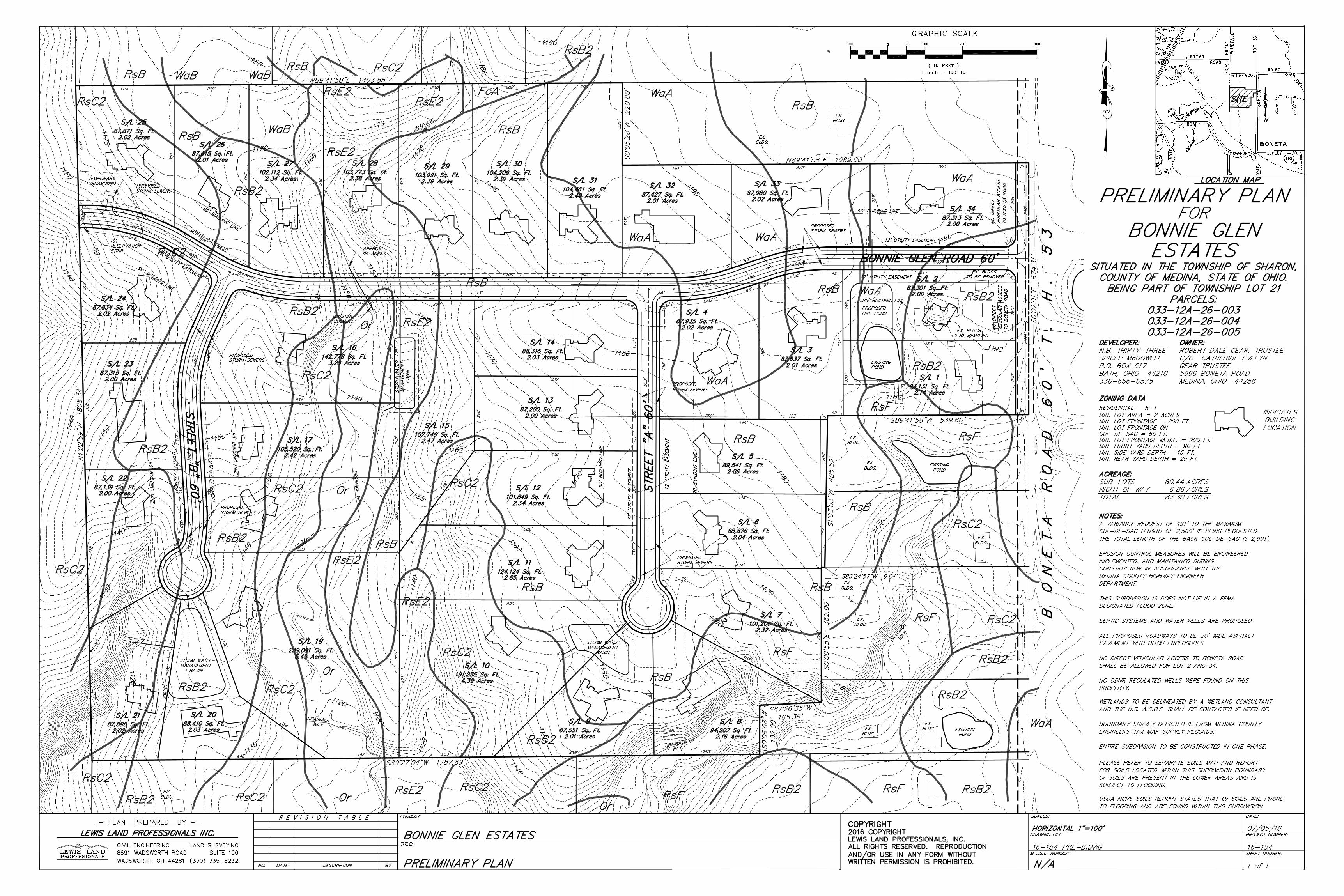
Site Area: 53.84 acres
Parcel Nos.: 033-12A-26-003, 004 and 005
Sublots: 34
Zoning: R-1 Residential
Utilities: Septic systems and water wells
School Dist.: Highland Local
Reviewer: Susan Hirsch
ADJACENT ZONING/LAND USE
Direction Zoning Land Use
North R-1 Residential Single family homes (Ridgewood & Bonita Roads)
East R-1 Residential Single family homes (Bonita Road)
South R-1 Residential Single family homes, vacant, wooded
West R-2 Residential (Montville Twp.) Park (Blue Heron Park)
Proposal: The applicant proposes the following:
34 sublots.
Create Bonnie Glen Road that runs east-
west across the site from Boneta Road
ending in a temporary T-turnaround at the
western boundary of the site, and two
permanent cul-de-sac-streets, each having
sixty feet of right-of-way (ROW) and a 20-
foot pavement width.
Septic systems and water wells.
Three storm water management basins are
to be located on Sublots 9 and 10 in the
south central portion of the site, Sublot 20
in the southwest portion of the site and and
Sublots 15, 16 and 17 in the central portion
of the site. There is also a fire pond
proposed for Sublots 1 and 2.
EXECUTIVE SUMMARY
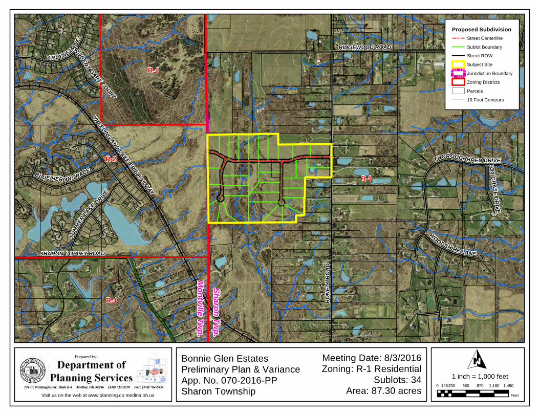
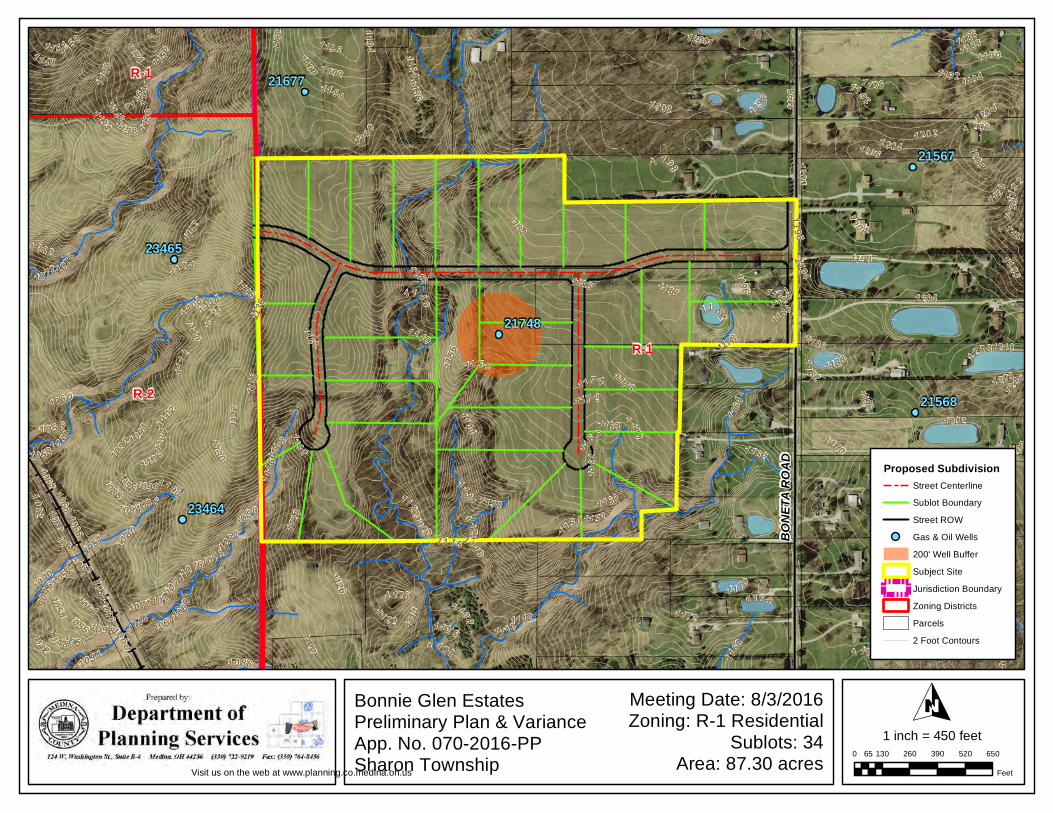
The site is located on the west side of Boneta Road south of the intersection of Boneta and
Ridgewood Roads (see location map). The proposal includes 34 single family sublots on three
public streets; one ends stubs to the western edge of the site, and two cul-de-sac streets. The
subdivision requires a Variance to permit a road to be in excess of the maximum cul-de-sac
length of 2,500 feet. All 34 sublots will be served by on-site septic systems and water wells.
Recommendation: Variance APPROVAL and Preliminary Plan APPROVAL WITH
MODIFICATIONS
Bonnie Glen Estates, Variance and Preliminary Plan
Medina Co. Planning Commission Page 2 of 6 August 3, 2016
Site Conditions: The site is moderately rolling with steeper slopes on the western two thirds of
the site; particularly the southwest and southeastern corners of the site (see GIS map). A stream
flows from north to south on the western part of the site. A few smaller tributaries also drain to
the southern part of the site. There is an existing pond located on Sublots 1 and 2.
Much of the site has been used for agriculture and there are wooded areas on the western half of
the site.
Access: Access to the site is provided by Bonnie Glen Road from Boneta Road. Access to
Sublots 2 and 34 is limited to Bonnie Glen Road only. Both Streets A and B are proposed to
terminate in permanent cul-de-sacs.
Street stubs to the east, and south are not practical for the following reasons:
Stubs to the east are not practical as the land is currently fully developed with single-
family homes with frontage on Boneta Road.
Stubs to the south are not possible as the parcels are either developed as lots with
frontage on Boneta Road or are land-locked parcels.
A street stub to the north may be beneficial for making a connection to Ridgewood Road. The
three parcels that could provide access to Ridgewood Road vary in size between 9.4051 and
17.3404 acres. Each of these three parcels contains single-family homes. It may prove difficult
to provide access to the subject site utilizing only one of these properties.
A stub street to the west is proposed. As shown, Bonnie Glen Road ends in a “temporary T-
turnaround with a 10 foot reservation strip at the western property line. Although Bonnie Glen
Road stubs to the west, the street does not add additional access to the subdivision since the
property to the west is a Township public park. There is no opportunity for Bonnie Glen Road to
become a through street. Therefore this stub will not negate the requirement for a variance.
Bonnie Glen Road requires a Variance from Section 604(B)(9) of the Medina County
Subdivision Regulations (Regulations) to permit it to be 2,991 feet in length; 491 feet longer than
the maximum permitted cul-de-sac length of 2,500 feet.
History: A Concept Plan for this property was discussed at a meeting on June 15, 2016. At that
meeting the need for a variance for the length of a cul-de-sac street was discussed.
Zoning: The subject property is zoned R-1 Residential. The Sharon Township Zoning
Resolution indicates single family dwellings are permitted in the R-1 District (Section 601). The
minimum lot size is two acres with a minimum 200 foot lot width or 60 feet of frontage on cul-
de-sacs with 200 foot lot-width measured at the building line (Section 601-2(A & B).
Comprehensive Plan: The 1996 update of the Sharon Township Development Policy Plan
(Plan) does not include a Future Land Use map nor does it recommend future land uses in
specified locations. The Plan does, however, indicate that the bulk of the land in the township is
zoned R-1 Residential, with a two acre minimum lot size; it further recommends that this land
use is appropriate. Goal I of the Plan calls for the preservation of the “rural, small-town
Bonnie Glen Estates, Variance and Preliminary Plan
Medina Co. Planning Commission Page 3 of 6 August 3, 2016
atmosphere of Sharon Township.” This subdivision proposal is consistent with this broad goal
and is also consistent with the following objective and policies enumerated in the Plan:
1. Objective IB: Maintain the township’s low-density residential environment….
2. Policy IB.1: … [N]ew development shall be compatible with the predominantly rural,
small-town residential nature of the community.
3. Policy IB.2: New residential development shall be planned at densities appropriate for
the township…
Staff Comments: This staff report presents staff comments and recommendations for both the
Variance Request and the Preliminary Plan. The Planning Commission must vote on each item
separately. Preliminary Plan comments are presented assuming that the Variance is approved.
VARIANCE REQUEST
1. The applicant has requested a variance to Section 604(B)(9) of the Medina County
Subdivision Regulations. This Section reads in part:
“A cul-de-sac turnaround shall be provided at the end of all permanent
turnarounds in accordance with the standards of the Engineering Code.
For greater convenience to traffic, more effective police and fire
protection, and efficiency of maintenance, permanent cul-de-sac streets
shall not serve in access of 40 dwelling units, nor have a length in excess
of 2,500 feet. The length of the cul-de-sac street shall be measured along
the centerline of the proposed cul-de-sac street from the centerline of the
nearest existing or proposed intersecting through street to the center of the
cul-de-sac turnaround.”
The length of Bonnie Glen Road in combination with Street “B” is 2,991 feet, 491 feet
more than what is permitted.
2. The following is the justification for the variance submitted by the applicant:
Topographical restrictions for surrounding property;
200 foot frontage makes for long streets with small number of lots;
Other stubs will not go to developable property; stubs would go to
environmentally sensitive land with steep slopes.
3. Section 203(A)(2) of the Regulations stipulates the criteria for granting variances to the
Regulations. The criteria are as follows (Staff comments regarding compliance with the
criteria are shown in italics):
a. In order to approve a variance, the Planning Commission must find that an
unnecessary hardship may result from the strict application of the Subdivision
Regulations due to exceptional topographic or other physical conditions. The
applicant sites the topographical restraints of surrounding properties as a factor
in preventing additional stub streets to surrounding properties. The addition of a
stub street to the north or south would alter the point from which the cul-de-sac
length is measured and could eliminate the need for a variance.
Bonnie Glen Estates, Variance and Preliminary Plan
Medina Co. Planning Commission Page 4 of 6 August 3, 2016
Additionally, the surrounding development and parcel configuration are physical
conditions that further limit the ability to provide stub streets to adjacent
properties:
Stubs to the east are not practical as the land is currently fully developed
with single-family homes with frontage on Boneta Road.
Stubs to the south are not possible as the parcels are either developed as
lots with frontage on Boneta Road or are land-locked parcels.
Stub to the north may prove difficult as there are three parcels each
ranging in size between 9.4051 and 17.3404 acres. Each of these three
parcels contains single-family homes.
A stub to the west is shown; however, it is the site of a Montville
Township’s Blue Heron Park with restrictions for future development.
Topography and natural physical conditions are also a factor in making any
internal connection very difficult. If streets “A” and “B” could be connected to
form a loop, this would also alter the point from which the cul-de-sac length is
measured. However, making this connection would require crossing steep terrain
and several streams. This area is also heavily wooded.
b. The Planning Commission may vary the regulations so as to relieve an established
hardship, provided such relief may be granted without detriment to the public
interest and without impairing the intent and purpose of these regulations or the
desirable development of the neighborhood and the community. The Planning
Commission may consider self-created nature of the hardship as a factor. The R-1
Residential District requires a two acre lot and 200 feet of frontage. Given this
frontage requirement, the 2,500 foot maximum cul-de-sac length requirement
limits the number of sublots to fewer than what would be permitted given the
acreage of the site and the regulation that permits up to 40 units on a cul-de-sac.
The additional 491 feet would not prove a detriment to the public interest, the
neighborhood or the community. It is necessitated by the 200 foot frontage
requirement.
4. Section 203 A. 3. of the Regulations states that the Planning Commission action must not
conflict with certain policies, as follows:
a. In no instance shall a variance be granted for the sole purpose of increasing
economic benefit to the applicant. Although strict adherence to the subdivision
regulation limiting cul-de-sac length to 2,500 feet will undoubtedly reduce the
number of sublots, it will also significantly reduce the developer’s ability to
efficiently and effectively use the property and avoid environmentally sensitive
areas.
b. In no instance shall a variance be granted which has the effect of nullifying the
intent and purposes of the Subdivision Regulations or a valid township zoning
resolution if such exists. Granting of the variance will not have the effect of
nullifying the intent and purposes of the Subdivision Regulations or the Sharon
Township Zoning Resolution
Bonnie Glen Estates, Variance and Preliminary Plan
Medina Co. Planning Commission Page 5 of 6 August 3, 2016
Recommendation: Staff recommends that the Medina County Planning Commission grant the
variance to Section 604(B)(9) of the Medina County Subdivision Regulations.
PRELIMINARY PLAN
Agency Comments: Italicized text indicates quotations from submitting agency comments.
Columbia Gas, Russ Johnson, 7/13/2016. APPROVED.
Highway Engineer, Andy Conrad, 7/13/2016.
1. Temporary turn-around is to be a cul-de-sac.
2. Provide a reasonable width for drive access on S/L 20.
3. Verify S/Ls 8, 16-20 and 28 will be able to support septic systems.
4. Provide typical shoulder/ditch section along Boneta Road frontage.
5. Drainage assessments will be required.
6. Show existing well and provide plugging report.
Ohio Department of Transportation (ODOT), Jared Feller, 7/12/2016. Since the subdivision
does not have direct access to a state highway, ODOT does not have any objections.
Highland School District, Catherine Aukerman, 7/13/2016. This subdivision is entirely within
the Highland School District.
Soil and Water Conservation District, Jeff Van, 6/6/2016
1. The… topography is… [i]n some cases, very steep.
2. The low lying area consists of Orville silt loam. This soil is… prone to… flooding.
3. The broader flat areas are Wadsworth silt loams (WaA and WaB). These soils have slow
permeability and seasonal wetness.
4. Other flatter areas are Rittman silt loam (RsB and RsB2). These also have slow
permeability and seasonal wetness.
5. The remaining sloping and steeper ground are Rittman silt loam (RsC2, RsE2, and RsF).
These will be more conducive to erosion during construction and individual house
building. [T]he proposed lots and house builds are largely located away from these sites.
6. Post house construction lot drainage will need to be accounted for to prevent
mismanaged surface flows across some adjoining properties.
Health Department, Christine Fienga, 7/15/2016. The services of a certified soil scientist must
evaluate the soil conditions for each lot and provide a report to this office on the findings of the
evaluation in accordance with State Rules Chapter 3701-29.
Tax Maps, Beth Mika, 7/27/2016. CONDITIONAL APPROVAL
1. No parcel numbers on final plat.
2. Please contact the Tax Map Office with the preferred new road names, so we can verify
availability and reserve the names for this subdivision.
3. It is recommended that the applicant submit the final subdivision plat to Tax Maps for
review, before obtaining signatures.
Bonnie Glen Estates, Variance and Preliminary Plan
Medina Co. Planning Commission Page 6 of 6 August 3, 2016
4. Subject to Medina County Engineer Land Conveyance Standards found at
http://www.highwayengineer.co.medina.oh.us/surveying/landconveystds.pdf.
Sanitary Engineer, Jeremy Sinko, 7/12/2016. We do not currently have any water or sanitary
sewer utilities at this location.
Staff Comments:
1. The following required data/information was not provided on or with the Revised
Preliminary Plan (Subdivision Regulation section references are included):
a. Permanent parcel numbers of the property to be subdivided and names of the
property owners contiguous to and directly across the street from the proposed
subdivision. § 404(C)(2)a.3. Indicate names of property owners contiguous to
and across the street from the subject site on the Preliminary Plan. 2. The proposed subdivision is consistent with Sharon Township zoning.
3. The proposed subdivision is consistent with the Sharon Township Comprehensive Plan.
4. The developer shall contact in writing the applicable U.S. Army Corp of Engineers
District Office regarding the proposed subdivision, and shall submit such correspondence
to the Medina County Planning Commission as a condition of Preliminary Plan approval.
5. There are three proposed storm water management basins that are located on two or more
sublots each (Sublots 8 and 9, Sublots 15, 16 and 17, and Sublots 21 and 22). If the
storm water management basins will not be maintained by the homeowner association,
staff suggests that there be an agreement between the co-owners of the basins addressing
use, maintenance responsibility, liability etc.
6. The Plan indicates this subdivision will be developed as one phase.
7. There is a note on the Preliminary Plan that states that there will be no direct vehicular
assess to Boneta Road from Sublots 2 and 34. Language similar to this note should be
placed within the deeds for these sublots as well.
8. Draft HOA documents have been submitted to the Department of Planning Services for
review by the Prosecutor’s Office and the Township. Final corrected documents must be
submitted with the Final Plat.
Recommendation: Staff recommends that the Medina County Planning Commission
APPROVE WITH MODIFICATIONS the Preliminary Plan for Bonnie Glen Estates
Subdivision. The modifications are as follows:
1. The temporary T-turnaround at the western end of Bonnie Glen Road must be a full cul-
de-sac.
2. The developer shall contact in writing the applicable U.S. Army Corp of Engineers
District Office regarding the proposed subdivision, and shall submit such correspondence
to the Medina County Planning Commission as a condition of Preliminary Plan approval.
3. Address the comments from the Highway Engineer and Tax Maps Department.
4. A note on the plan restricting access to Boneta Road from Sublots 2 and 34 should also
be placed in the deeds for these units.
5. Maintenance of the storm water basins must be addressed in the HOA documents and/or
by private agreement.
R:\arcview\wp_planning\major_subdivisions\2016\Bonnie_Glen_Prelim_Plan\working_docs\Bonnie_Glen_preliminary_plan_08032016_
R-1
R-2
R-1
R-1
BONE
TA R
OAD
RIDGEWOOD ROAD
WHEELING AND LAKE ERIE RAILWAY
SHARON COPLEY ROAD
ARLYNE LANE
THOROUGHBRED DRIVE
BLUE HERO N TRACE
SUMM
ERLA
KE DRIVE
WOODSHIRE LANE
FOX CHASE DRIVE
ROBER T GARY COURT
Bonnie Glen EstatesPreliminary Plan & VarianceApp. No. 070-2016-PPSharon Township
Meeting Date: 8/3/2016Zoning: R-1 Residential
Sublots: 34Area: 87.30 acres
O0 290 580 870 1,160 1,450145
Feet
1 inch = 1,000 feet
Visit us on the web at www.planning.co.medina.oh.us
Proposed SubdivisionStreet Centerline
Sublot Boundary
Street ROW
Subject Site
Jurisdiction Boundary
Zoning Districts
Parcels
10 Foot Contours
Sharon Twp.Montville Twp.
R-1
R-2
R-1
1178
117611741 172
11701168
1 16
6
116 4
1162
1184
1180
11 82
1 186
1160
11881 1 90
1132
11581156
1154
1130
115 2
1150
11 9211
28
1148
11 46
11441142
1140
1 138
1136
1134
11941196
11261124
1122
1120
1118
1116
1114
1112
1110
1108
1106110
41102
11001098
10 96
10 94
1092
1090
10881 0861 08 4
1082
10
80
1198
10 781076
1074
10 72
1070
1200
1068 10661064
1062
120 2
1060
10 581056
1054
1052
1204
10 50
1206
10 48
1046
1044
1042
1208
1040
1210
1034
1062
1 198
1196
1144
118 4
1118
1196
10 64
11 22
1186
1206
1192
10 5810 54
113 8
114 2
10641184
1072
1170
1054
1112
1150
1164
1062
1 188
1 1 52
1188
1194
1178
106 0
1190
1182
1168
12081188
1 1881186
1066
1206
1 160
1078
11 2 0 1 116
1192
1202
1124
1190
1196
1086
1108
12 00
1082
119 8
1198
1146
1126
1200
1 202
1194
1160
1134
11 82
10 56
1070
1 2 04
1198
1106
1 192
1126
1114
11 96
1122
1142
1060
1152
1198
120 4
1172
1208
1 1041186
116 2
114 8
11 70
1204
1190
1194
1196
1136
1140
11 10
1064
1 188
1 1 46
1196
11 80
BONE
TA R
OAD
23464
23465
21748
21677
21568
21567
Bonnie Glen EstatesPreliminary Plan & VarianceApp. No. 070-2016-PPSharon Township
Meeting Date: 8/3/2016Zoning: R-1 Residential
Sublots: 34Area: 87.30 acres
O0 130 260 390 520 65065
Feet
1 inch = 450 feet
Visit us on the web at www.planning.co.medina.oh.us
Proposed SubdivisionStreet Centerline
Sublot Boundary
Street ROW
Gas & Oil Wells
200' Well Buffer
Subject Site
Jurisdiction Boundary
Zoning Districts
Parcels
2 Foot Contours