book problem
TRANSCRIPT

BOOK PROBLEM

Chiapas Earthquake, MexicoSept 7, 2017, M = 8

OFFICE HOURS
Mike RhodesTuesday and Thursday 3:00 – 5:00 pm
Sumaya Hamdi, TAWednesday 9:30 – 11:30 amTuesday and Thursday 1:00 – 2:00 pm

CONTINENTAL DRIFT
SEA-FLOOR SPREADING
PLATE TECTONICS

The Theory of Continental DriftAlfred Wegener (1912) proposed:- A large super-continent PANGEA split into smaller
fragments about 200-300 million years ago. These then drifted apart to form the present arrangement of continents.
He had no satisfactory mechanism to offer , but appealed to a less-dense continent “floating” and “drifting” over a more dense oceanic crust (like icebergs in the ocean).
Most geologists were highly skeptical and the idea was NOTwidely accepted.

This is what Wegener thought Pangea looked like 200-300 million years ago.
We will now review the evidence that led Wegener to proposehis theory of Continental Drift.
Can you spot the present continents?

Fit of Continents
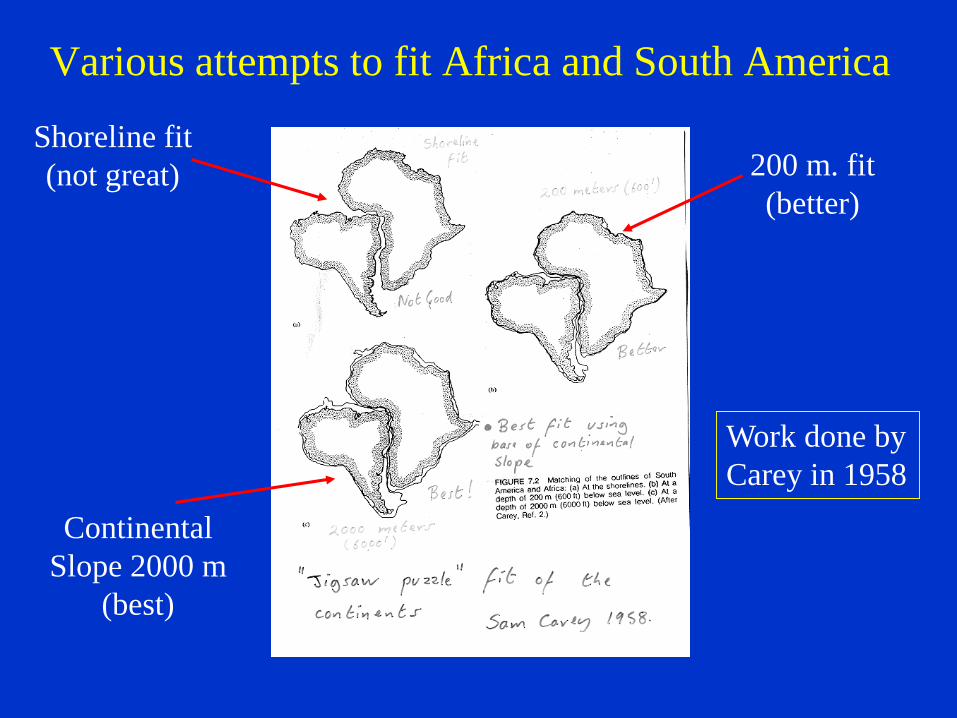
Various attempts to fit Africa and South America
Shoreline fit(not great) 200 m. fit
(better)
ContinentalSlope 2000 m
(best)
Work done byCarey in 1958

When we fit the continents of Africa and South America “back together again”, we find that:-
Similar rock types extend from one continent to the other The rocks are also the same age.
CONCLUSION - perhaps the two continents were once part of asingle larger continent?

Similar rock types extend across continents
Rocks in the Appalachians of North America and the Caledonides of Britain and Norway are very similarand are also similar in age.
When we fit Europe and NorthAmerica together, we find that The Appalachians and Caledonidescould form a single mountain chain.
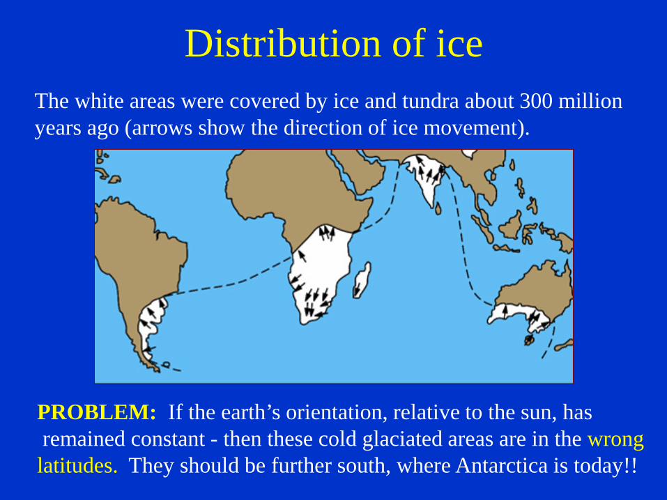
Distribution of iceThe white areas were covered by ice and tundra about 300 millionyears ago (arrows show the direction of ice movement).
PROBLEM: If the earth’s orientation, relative to the sun, hasremained constant - then these cold glaciated areas are in the wrong
latitudes. They should be further south, where Antarctica is today!!

Wegener took the areas that had been covered by ice sheetsand fitted them together around the south pole.
HIS CONCLUSION - the continents were once part of asingle larger continent that then split apart, drifting totheir present positions over the last 300 million years.
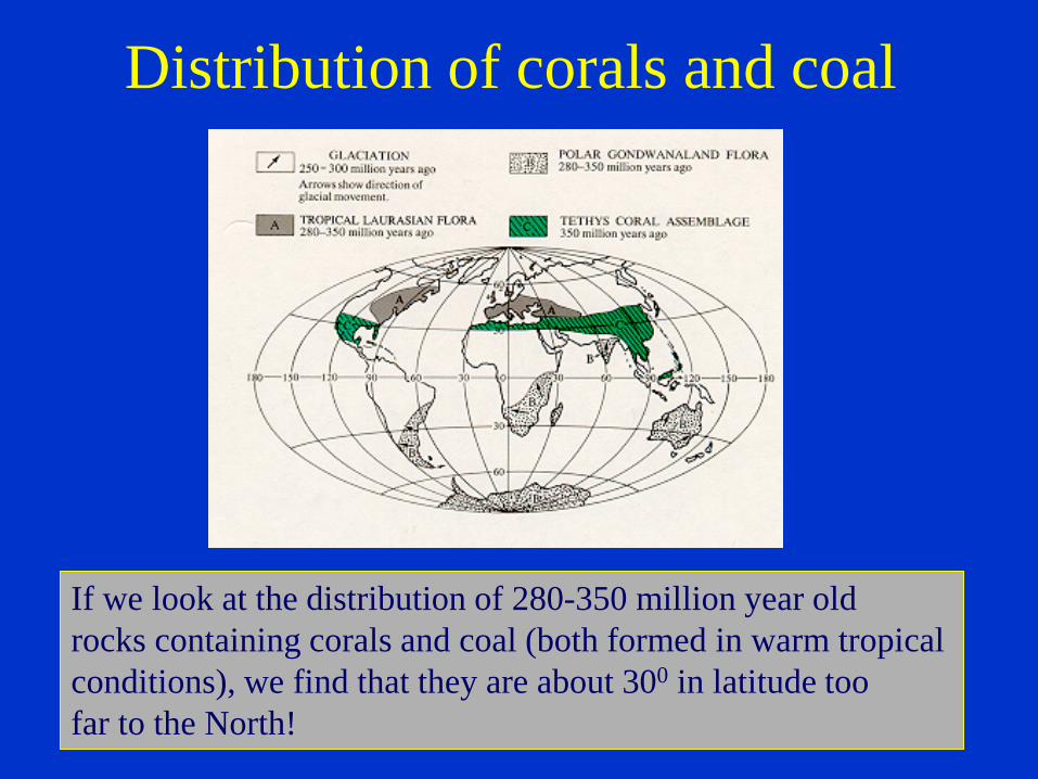
Distribution of corals and coal
If we look at the distribution of 280-350 million year old rocks containing corals and coal (both formed in warm tropical conditions), we find that they are about 300 in latitude toofar to the North!
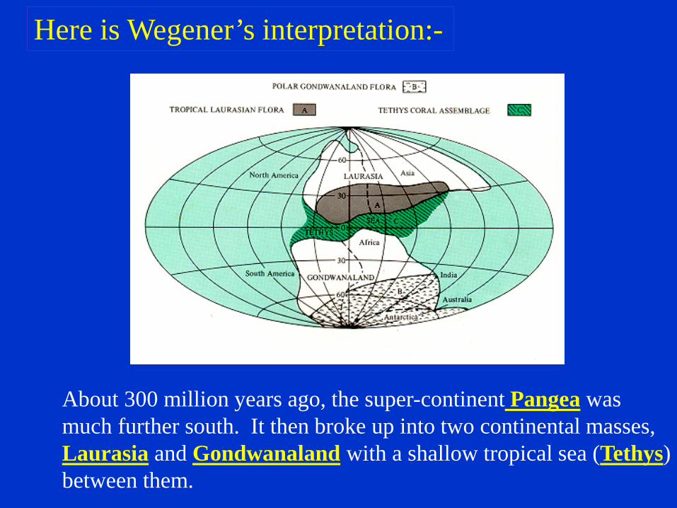
Here is Wegener’s interpretation:-
About 300 million years ago, the super-continent Pangea wasmuch further south. It then broke up into two continental masses,Laurasia and Gondwanaland with a shallow tropical sea (Tethys)between them.

Distribution of Mesosausarus
Mesosaurus was a small reptile that lived about 250 millionyears ago. Fossils of Mesosaurus are found on both sides of the Atlantic in South America and Africa (green shaded areas).

Distribution of other Reptiles and Plants
Similar fossils (reptiles and plants) are found on the different continents.How could they have crossed the oceans?CONCLUSION - they didn’t, the continents were part of the samelandmass about 200-300 million years ago.

This is how Wegener thought the continents moved over the last 200 million years:-
225 135
65
Today

Arguments Favoring Continental Drift Fit of continents Apparent discrepancy in inferred latitudes of
ancient rocks Rocks of same age and similar characteristics on
different continents Distribution of similar plants and animals on
different continents (how did they cross the oceans?)
WEGENERS CONCLUSIONS:The continents have drifted over the past 300 million
years to their present positions!(not a very popular idea at the time!!!)

Let’s review the scientific method
I. Gather data (measurements or observations)II. Think of a hypothesis to explain the dataIII. Gather more data to test the hypothesis (try to
prove it wrong!)IV. If the hypothesis survives testing, refine the
hypothesis to account for the new dataV. If the hypothesis continues to survives testing,
eventually it becomes a theory.
Note - data should be capable of being repeated by others

PALEOMAGNETISMThe next line of evidence came about 40 years later (1950’s) from the study of the earth’s magnetic properties

The direction and inclination in which a dip-needle points reflectsthe earth’s magnetic field:-
NorthMagnetic Pole
Equator InclinationsEquator ~ 0 degreesHawaii ~ 20 degreesIceland ~ 60 degrees
The higher the latitude, the steeperthe inclination

Similarly, magnetic iron-bearing minerals crystallizing from molten lava align themselves with the earth’s magnetic field - thus preserving a record of where the rocks formed relative to the earth’s magnetic poles
Lava
Earth’s magneticfield

If we collect rocks from different latitudes, their magnetic direction and inclination will reflect the earth’s magnetic field where they were formed.

PALEOMAGNETISM
The direction and inclination of magnetism of an iron-bearing mineral such as magnetite can tell us where that mineral (or rock) formed with respect to the magnetic pole.
Example - if basaltic lava that is 200 million years old has a flat magnetic inclination, then it cooledand crystallized near the equator about 200 millionyears ago.
(The study of magnetic properties of old rocks)

Imagine the surprise in the 1950’s when it wasdiscovered that ancient rocks had magnetic directions and inclinations that did not correspondwith the present magnetic pole position.
CONCLUSIONS Either the earth’s axis of rotation has shiftedsignificantly over the last 300 million years (not
considered likely) Or, the rocks on the continents are no longer
located where they were formed.In other words, the paleomagnetic evidence appears tosupport the arguments for continental drift.
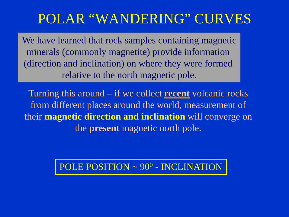
POLAR “WANDERING” CURVESWe have learned that rock samples containing magneticminerals (commonly magnetite) provide information
(direction and inclination) on where they were formed relative to the north magnetic pole.
Turning this around – if we collect recent volcanic rocksfrom different places around the world, measurement of
their magnetic direction and inclination will converge onthe present magnetic north pole.
POLE POSITION ~ 900 - INCLINATION

Does this happen with ancient rocks?If we measure their magnetic inclination and direction, we
might expect that rocks of the same age on different continentswould give identical polar positions, which should correspond
with the present polar position.
Rocks of different ages give different polar positions Rocks of the same age but on different continents give
different polar positions The older the rock the further the calculated polar
position is from the present position

Permian ~ 245-286 million years
EXAMPLE
Not here as expected!

Examples of so-called “Polar Wandering Curves”
Plotting the apparent polar positionsfor rocks of different ages from North
America and Eurasia produces two curves,the so-called “polar wandering curves”.Note that as the curves get younger they
converge.
Fitting the continents back togetherresults in a single curve. Nonetheless,
the positions still do not correspond with the current magnetic position. To account for this, the continents
would have had to move northwardsas well.

Explanation of “Polar Wandering Curves”
300 million years ago Today
Sideways view of earthwith continent astride
the equator
Continent moves northwardsresulting in an “apparent”
magnetic pole that is displacedfrom the true pole

Another example - View looking down onto the magnetic pole
Two locations on largecontinent astride the
equator
Continent splits apart andmoves to the north
Apparent magneticPole for continent B
Apparentmagneticpole for
continent A
In other words it is not the poles that “wander” as the name unfortunately suggests, but the continents!
300 million years ago Today

CONCLUSION
• Paleomagnetic studies appear to providesupport for Wegener’s ideas of continentaldrift.
• The continents appear to have been joinedover 200 million years ago.
• Paleomagnetic evidence also suggests thecontinents have moved northwards.