boreal cordillera ecozone t - government of yukon€¦ · boreal cordillera ecozone ... the...
TRANSCRIPT

Ecoregions of the Yukon Territory, Part 2
This ecozone is located in the midsection of the western cordilleran system of Canada. It covers sections of northern British Columbia and the southern Yukon.
Ecologically, it is an extension of the boreal forest zone that stretches across the continent from the Atlantic coast in Labrador. The boreal zone is modified within the cordillera by strong gradients of elevation, temperature and precipitation over short distances.
Hydrology: This ecozone encompasses portions of three major drainage systems: the Yukon, Liard and Alsek (Fig. 7). Most of the ecozone experiences a rapid increase in streamflow discharge in May due to snowmelt, with high flow continuing for a few weeks maintained by summer rainfall. Streams in
the southwest can have peak flows in July or August due to snowfield and glacier melt. Lying south of the continuous permafrost zone, there is more ground water flow than in the Taiga Cordillera Ecozone and ground water discharge generally continues throughout winter.
Climate: The cold climate ranges from sub-humid to semi-arid. It is marked by long, cold winters and short, warm summers as modified by elevation and aspect. Mean annual temperature ranges from 1 to 5.5°C. The coldest average annual temperatures occur in the Yukon portion of the ecozone. The mean summer temperatures range from 9.5 to 11.5°C. Mean winter temperatures range from –13 to –23°C. The Pacific maritime influence moderates temperatures over most of the ecozone. Mean annual
BOREAL CORDILLERA ECOZONE
The mountainous portion of this ecozone includes valleys filled with glacial till and glaciofluvial sediments. These support a diversity of wildlife habitats such as this wetland beside the Watson River in the Yukon Southern Lakes Ecoregion. Beaver (shown above) are common throughout the ecozone.
C. K
enne
dy,
Yuk
on
Gov
ernm
ent
157
Ecoregions of the Yukon Territory, Part 2
precipitation is lowest in valleys within the rain shadow of the coastal ranges, at less than 300 mm, and increases in the interior ranges farther east, where up to 1000 mm of precipitation is received at higher elevations. Precipitation in the intermontane plateau areas is 300 to 500 mm annually.
Vegetation: In the central Yukon portion of this ecozone, there are grasslands on south-facing slopes with boreal forest vegetation on the north-facing slopes, a feature unique within the boreal forests of Canada. The vegetative cover varies from closed to open canopies over most plateaus and valleys. Tree species include white and black spruce, subalpine fir, lodgepole pine, trembling aspen, balsam poplar, and paper birch. In the northwest, the stands are generally open, and lodgepole pine and subalpine fir are usually absent. At higher elevations, extensive areas of rolling alpine tundra are characterized by sedge-dominated meadows, and lichen-colonized rock fields are common.
Landforms and soils: This ecozone is characterized by mountain ranges, which contain numerous high peaks and extensive plateaus, separated by wide valleys and lowlands. These have been modified as a result of glaciation, erosion, solifluction, and tephra deposition. Glacial drift, colluvium, and bedrock outcrops constitute the main surface materials. A
small portion of this ecozone in the northwest was unglaciated. Permafrost and associated landscape features tend to be widespread in the more northerly areas and at higher elevations; soils are Cryosolic in these regions. In the warmer, lower elevations in the southern half, Brunisols and Luvisols are common.
Wildlife: Characteristic mammals of the Boreal Cordillera ecozone include woodland caribou, moose, Dall sheep, mountain goats, black and grizzly bears, marten, lynx, American pika, hoary marmots and Arctic ground squirrels. Representative bird species include Willow, Rock and White-tailed Ptarmigan, and Spruce Grouse, along with a variety of migratory songbirds and waterfowl.
Human activities: The zone is rich in mineral resources. In addition, the large river systems that drain this ecozone have fostered forestry, tourism and some localized agriculture. The total population of the ecozone is approximately 30,800 within the Yukon portion of the ecozone. The major communities are Whitehorse, Dawson, Faro, Haines Junction, and Mayo. Between 1951 and 1996, the Greater Whitehorse population increased from less than one-third to over two-thirds of the total Yukon population. In 1998, the population of Whitehorse stood at 23,310, the territorial population at 31,768 (Yukon Bureau of Statistics, 1999).
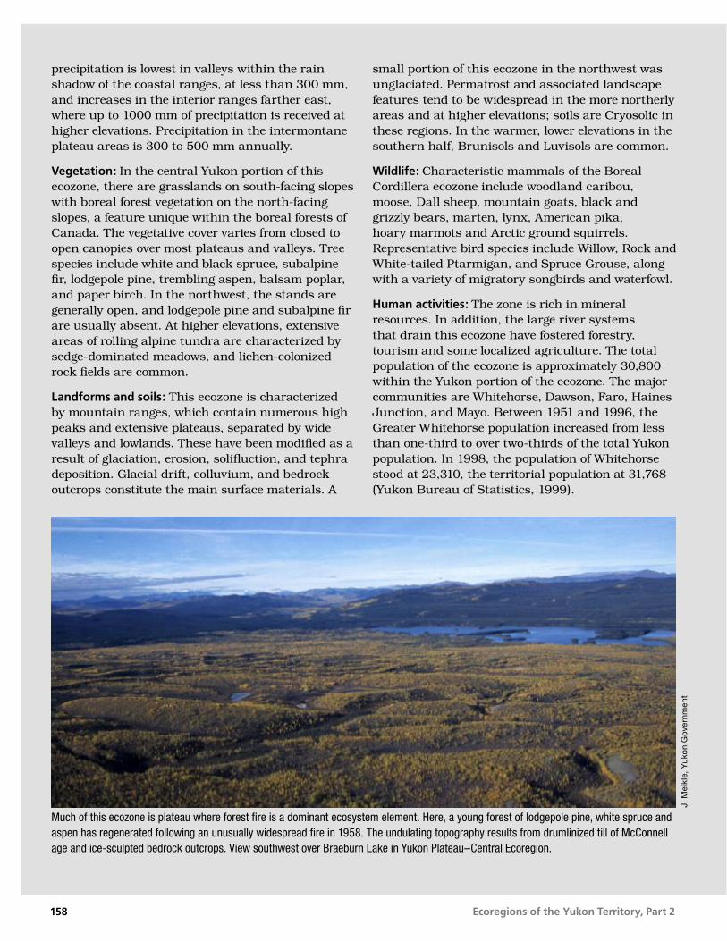
Much of this ecozone is plateau where forest fire is a dominant ecosystem element. Here, a young forest of lodgepole pine, white spruce and aspen has regenerated following an unusually widespread fire in 1958. The undulating topography results from drumlinized till of McConnell age and ice-sculpted bedrock outcrops. View southwest over Braeburn Lake in Yukon Plateau–Central Ecoregion.
J. M
eikl
e, Y
uko
n G
over
nmen
t
158

Ecoregions of the Yukon Territory, Part 2
Klondike PlateauBoreal Cordillera Ecozone
ECOREGION 172
DISTINGUISHING CHARACTERISTICS: As part of easternmost Beringia, this ecoregion
has been exposed to long periods of weathering, resulting in extensive upland
boulder fields, V-shaped valleys and deep soil weathering. Extreme annual
temperature variation occurs in valley bottoms, from –60°C in winter to 35°C in
summer. Portions of the Fortymile, South Klondike and Sixtymile rivers have
been dredged for gold. Two major bird migration corridors exist in this
ecoregion: the Shakwak Trench in the south and the Tintina Trench in
the north. The ecoregion marks the northern limit of lodgepole pine
in North America.
Figure 172-1. The braided floodplain of the White River (entering from the right side of the photo) is shown at its confluence with the Yukon River. The ecoregion is an area of dissected plateau as shown in the undulating upland surface in this photo. South- and west-facing slopes support grasslands while north-facing slopes are forested and are underlain by near-surface permafrost. The fluvial terraces are composed of sands and gravels and support well-drained Brunisolic soils.
J. M
eikl
e, Y
uko
n G
over
nmen
t
TOTAL AREA OF ECOREGION IN CANADA38,471 km2
TOTAL AREA OF ECOREGION IN THE YUKON38,471 km2
ECOREGION AREA AS A PROPORTION OF THE YUKON8%
APPROXIMATE LAND COVERboreal coniferous forest, 60%mixed forest, 15%alpine tundra, 20%lakes and wetlands, 5%
ELEVATIONAL RANGE290–2,000 m asl mean elevation 850 m asl
CORRELATION TO OTHER ECOLOGICAL REGIONS: Equivalent to combined Klondike River and Wesley Lake ecoregions and western portion of Dawson Range Ecoregion (Oswald and Senyk, 1977) • Portion of Cordillera Boreal Region (CEC, 1997) • Portion of Interior Yukon/Alaska Alpine Tundra (Ricketts et al., 1999) • Contiguous with the Yukon–Tanana Uplands Ecoregion (Nowacki et al., 2001)
6000
5500
5000
4500
4000
3500
3000
2500
2000
1500
1000
500
0
6000
5500
5000
4500
4000
3500
3000
2500
2000
1500
1000
500
0
Metres above sea level
159

Ecoregions of the Yukon Territory, Part 2
PHYSIOGRAPHYThe Klondike Plateau Ecoregion conforms fairly well to the Klondike Plateau physiographic subdivision of the Yukon Plateau (Bostock, 1948; Matthews, 1986), although north of the Willow Hills it does not extend as far eastward. It also includes the Wellesley Depression in the southwest and part of the Tintina Trench where the Klondike and Yukon rivers flow through it. The ecoregion extends into east-central Alaska.
The ecoregion is uniform in character with smooth topped ridges dissected by deep, narrow, V-shaped valleys. These valleys, characteristic of an area that has not been glaciated in the recent past, distinguish the Klondike Plateau from adjacent ecoregions.
The Dawson Range, which trends northwest–southeast between the Yukon River to the north and the Nisling River to the south, is the most distinct feature of the plateau. Apex Mountain, at 2,026 m asl, is the highest in the Dawson Range and in the ecoregion. Most ridges are 1,200 to 1,700 m asl. Local relief ranges from 450 to 700 m. The lowest point in the ecoregion is less than 300 m asl, where the Yukon River flows into Alaska, downstream from Dawson City.
Major rivers have cut deeply into the plateau surface. The Nisling River drains the southern part of the Dawson Range as it flows westward along the
southern boundary of the ecoregion before joining the Donjek and White rivers. The White River (Fig. 172-1) flows north to the Yukon River, which is included in the ecoregion from just downstream of the mouth of the Pelly, past the mouth of the Stewart, Klondike, Chandindu, and Fortymile, to the Alaska border at 64°40'N. The only significant lakes in the Klondike Plateau Ecoregion are in the southeast corner in the glaciated Wellesley Depression. The largest of these is Wellesley Lake.
BEDROCK GEOLOGYRocks of this region (regionally mapped by Green, 1972; Bostock, 1973; Tempelman-Kluit, 1974; Ryan and Gordey, 2002) constitute a large part of the Yukon–Tanana Terrane, a composite of crust blocks including former volcanic island arc and continental shelf depositional environments (Mortensen, 1992). The metasedimentary rocks are intruded and overlapped by granitic and volcanic rocks, and overlain by fault-bounded slices of serpentinized ultramafic rock of Slide Mountain Terrane. This area was exposed and deeply weathered for at least 15 million years. Consequently, the sparse outcrops are tors (solitary pillars and knolls; Fig. 172-2) atop broad ridges mantled with felsenmeer (fields of large angular, frost-heaved rock fragments).
In the northwest part of the ecoregion to the west of Dawson, medium grey and brown quartz muscovite
Klondike Plateau • ECOREGION 172
Figure 172-2. High elevation ridges of the Klondike Plateau Ecoregion show characteristic spines and towers (tors) which are bedrock remnants left after long periods of weathering. The valleys are deep and narrow because this area escaped scouring by Pleistocene glaciers.
J. M
eikl
e, Y
uko
n G
over
nmen
t
160

Ecoregions of the Yukon Territory, Part 2
schist predominates, accompanied by prominent bands of quartzite and marble that are up to 100 m thick and several kilometres long (Green, 1972). In the Sixtymile River area, 60-million-year-old porphyritic andesite flows and coal horizons (Glasmacher and Freidrich, 1984) overlie these older rocks. The Klondike placer mining district and the area to the northwest are underlain by chlorite and muscovite schist, commonly known as Klondike Schist (resulting from a Permian felsic volcanic event), and a schist containing thumb-sized feldspar phenocrysts — the 260 Ma Sulphur Creek granitic batholith (Mortensen, 1988). The Fiftymile batholith (Tempelman-Kluit, 1974) of quartz–feldspar–biotite gneiss and hornblende granodiorite underlies a 50 km2 area in the White River area. Rock outcrops are non-existent in the Wellesley Lake–Snag area, but the area is mostly underlain by silica tuff and volcanic breccia of the 60 Ma Donjek Formation (Muller, 1967).
Portions of the Fortymile, South Klondike and Sixtymile drainages have been sluiced and dredged for gold for more than a century. Most of the placer gold is derived from quartz veins (Knight et al., 1994) that have been eroded and the gold concentrated by pre-Ice Age rivers (>3 Ma). The principal formation containing placer gold is the White Channel gravel (Fig. 172-3), although a few bedrock gold veins have been located in the district (Mortensen et al., 1992). Serpentine and chrysotile asbestos are found in the Slide Mountain Terrane and were mined at Clinton Creek and near Cassiar Dome. Placer gold is seasonally mined in the Moosehorn Range near the southwest corner of the ecoregion. The Coffee Creek granite contains large amounts of copper and gold at low concentrations, and the Casino deposit, at the head of Canadian Creek, has been intensely trenched and drilled. Sparse gold and copper mineralization at Mount Nansen, near the southeast tip of the ecoregion, was mined by open-pit, heap-leach methods between 1996 and 1998.
SURFICIAL GEOLOGY AND GLACIAL HISTORYThis ecoregion is largely unglaciated, except for local glaciers that emanated from the headwaters of the Sixtymile River Valley, local peaks in the eastern Dawson Range and the Kluane Ranges into the Wellesley Basin. Surface deposits over much of the ecoregion are composed of colluvium, with alluvium and glacial outwash terraces found along major
river systems. Many of the tributary valleys in the Klondike Plateau proper are blanketed with thick colluvial deposits consisting of silts several metres thick covered by several metres of peat and mucky silt. Uplands are covered with colluvium rubble derived from underlying fractured bedrock. A veneer of wind-blown silt covers most of the ecoregion.
Periglacial features, such as cryoplanation terraces, patterned ground and solifluction lobes, can be found at higher elevations. Active slope processes include soil creep and debris flows.
The Dawson Range was affected by diversion of the pre-glacial Yukon River during the first glaciation of the west-central Yukon Territory about 3 Ma ago (Duk-Rodkin, 1997; Duk-Rodkin and Barendregt, 1997; Froese et al., 2001). It is postulated that the preglacial Yukon River headwaters were located in the Ogilvie Mountains, with a southerly drainage likely entering the Pacific Ocean south of the St. Elias Mountains. The Fifteenmile River, now a tributary to the Yukon River, formed part of this ancestral river system. High fluvial terraces containing Ogilvie Mountain rock types are found above the Fifteenmile River at the confluence of the Yukon River, and extend south to near the mouth of Stewart River (Duk-Rodkin et al., 2001). The earliest glaciation blocked drainage to the south and east, surrounded the Klondike Plateau to near Dawson and flowed along the Tintina Trench to coalesce with glaciers exiting the Ogilvie Mountains. A large but likely short-lived glacial lake, informally called Glacial Lake Yukon, was formed with an outlet cut
ECOREGION 172 • Klondike Plateau
Figure 172-3. Stratified gravel of the White Channel formation in the lower Klondike River valley. This gravel deposit is more than 5 million years old and precedes the Ice Age. At the top of the section is the brown glacial drift called Klondike Gravel, about 3 million years old.
A. D
uk-R
od
kin,
Geo
log
ical
Sur
vey
of C
anad
a
161

Ecoregions of the Yukon Territory, Part 2
west of the mouth of Fifteenmile River at 720 m asl. This resulted in diversion of drainage towards the northwest, and incision of the Klondike Plateau south of the trench. It also greatly expanded the basin of preglacial Kwikhpak River that occupied the trench and flowed northwest into Alaska. Farther south, in the eastern Dawson Range south of the Stewart River, drainage was diverted across a local divide enabling meltwater to drain across to Indian River (Fig. 172-4). The Klondike River became a tributary to the newly established Yukon River. Glaciers flowing north in the Alaska Range extended across Tanana Valley cutting off the headwater of the Tanana River, now the Nisling River, and diverting it to the Yukon River across the Yukon–Tanana upland, forming what is now the Dawson Range.
During the Reid Glaciation, a glacier in the Fifteenmile River valley blocked the Yukon River forming a temporary glacial lake, informally called Glacial Lake Dawson. Catastrophic flood deposits on Reid outwash deposits, found near the Fortymile River, could record drainage of the former glacial lake. McConnell Glaciation was restricted to mountain valleys beyond this ecoregion. However, small patches of McConnell outwash surfaces are found in the lower Klondike River Valley.
CLIMATEThe climate of the ecoregion is strongly continental with warm summers and very cold winters. Precipitation amounts are from 300 to 500 mm annually. There is a gradual increase in precipitation from the southeast to the northwest. The lightest precipitation is from February through April with monthly means of 10 to 20 mm. The wettest period is from June through August with monthly means of 50 to 90 mm. The heaviest precipitation is in the uplands of the northwestern section of the ecoregion west of Dawson and along the Alaska boundary. Most summer precipitation originates from convective rainshowers and thunderstorms.
Mean annual temperatures are near –5°C. These temperatures show a strong seasonal variation with mean January temperatures of –23 to –32°C and in July from 10 to 15°C. The coldest January and warmest July temperatures are recorded in the lowest topographic settings in the ecoregion — the Yukon, lower Klondike, and lower Stewart valleys. Extreme temperatures in the lower valleys range from –60 to 35°C. Note that Snag, which lies in this ecoregion, has had the coldest recorded temperature in North America at –62.8°C. Frost can occur at any time of the year, although it is relatively infrequent in July. Because of the warm summer temperatures, agriculture is practiced in many valley bottoms throughout the ecoregion.
Figure 172-4. Placer mining has been the economic mainstay of the ecoregion for over 100 years. Valley-bottom gravels here have been reworked by the Indian River from a complex set of terraces that reflect the changed drainage gradient in this part of the ecoregion. The forest cover is a mix of black and white spruce.G
. Low
ey, Y
uko
n G
over
nmen
t
Klondike Plateau • ECOREGION 172
162

Ecoregions of the Yukon Territory, Part 2
Winds are generally light, but can occasionally become moderate in association with an individual weather system or thunderstorms.
Representative climatic data are available from Snag, Beaver Creek, Fort Selkirk and Dawson.
HYDROLOGYWith a total area of >38,000 km2, the ecoregion is relatively large leading to some hydrologic diversity. The major streams are the Yukon River corridor between the Pelly River confluence and the Alaska boundary, the White River below the Alaska Highway, the lower Donjek, and the lower reaches of the Stewart River. Wellesley Lake is the only major lake (Fig. 172-5), while wetlands cover significant portions of the general Wellesley Basin and Scottie Creek drainage. Streamflow within this portion of the ecoregion is characterized by a rapid increase in streamflow discharge in May due to snowmelt, rising to a peak in June, after which summer rainfall maintains high flow for a few weeks. Though not representative of the ecoregion as a whole, the White and Donjek rivers experience peak flows slightly later in the summer due to glacier melt in the upper reaches of these streams. Summer rains produce secondary peaks and sometimes the annual maximum, especially from mountainous regions.
There are three representative continuous active or historical hydrometric stations: Fortymile and
Indian rivers, and Snag Creek. The three seasonal stations are Clinton, Thistle and Scroggie creeks. Mean annual runoff is moderately low with values ranging from 85 to 295 mm and an ecoregion mean of 175 mm, while mean seasonal and summer flows are relatively low with values of 7.4 X 10⁻³ and 7.1 X 10⁻³ m3/s/km2, respectively. The mean annual flood and mean maximum summer flow are moderately low and moderate, with values of 52 X 10–3 and 43 X 10–3 m3/s/km2, respectively. Minimum streamflow generally occurs during March, with the relative magnitude generally lower than the western portion due to lower winter temperatures limiting groundwater contributions. The mean annual minimum and mean summer minimum flows are relatively high and relatively low with values of 1.8 X 10⁻³ and 1.8 X 10⁻³ m3/s/km2 (identical values are correct), respectively. Some small streams may experience zero winter flows.
PERMAFROSTPermafrost is discontinuous, but widespread, in the Klondike Plateau Ecoregion. It is absent from well-drained, dry slopes of any aspect (EBA, 1989a), but valley-bottom deposits and upland soils usually contain ice-rich horizons. As in other parts of the central Yukon, soil moisture content and organic-layer thickness are critical variables controlling the occurrence of permafrost (EBA, 1988; Williams and Burn, 1996). Much of the ecoregion was
Figure 172-5. Wellesley Lake lies in a glaciated basin in the southwestern part of the ecoregion.
J. M
eikl
e, Y
uko
n G
over
nmen
t
ECOREGION 172 • Klondike Plateau
163

Ecoregions of the Yukon Territory, Part 2
not glaciated during the Quaternary period and substantial loess deposits accumulated in many valleys during the McConnell advance (Fraser and Burn, 1997). These host some of the largest ground ice masses in subarctic Canada (French and Pollard, 1986). Organic matter-rich accumulations above the loess also contain ice (Fig. 172-6).
The thickness of permafrost near Dawson varies up to 60 m (McConnell, 1905), with near-surface annual mean ground temperatures of between –3 and –1°C (EBA, 1983). The active layer in alluvial sediments is up to 1.5 m thick, and up to 2 m in dry sand (EBA, 1983, 1989b), but in ice-rich peat may be only 30 or 40 cm, and only a little deeper in alpine tundra above treeline. To the south, near Beaver Creek, permafrost remains widespread, but is thaw-stable in gravelly terrain (Horel, 1988a). The active layer above perennially frozen gravel is usually about 1.2 m thick, but thicknesses up to 2 m have been recorded during geotechnical drilling (Geotechnical Services, 1992). The till in southern parts of the ecoregion is ice-rich (Horel, 1988a). In
geotechnical drill holes along the Alaska Highway east of Beaver Creek, 62% indicated permafrost, with the base of permafrost at between 11.5 and 15 m depth (Geotechnical Services, 1993).
Valley-bottom deposits comprise five general units: (1) alluvial sediments, which are unfrozen close to present river courses (EBA, 1977); (2) colluvial materials, both organic and mineral sediments, which usually contain aggrading ice (Fraser and Burn, 1997); (3) gravel, which acts as a conduit for groundwater and is often unfrozen; (4) loess, mostly perennially frozen, containing ice wedges 1 m or more in cross-section and up to 5 m tall (Fraser and Burn, 1997); and (5) organic horizons, containing ice masses in horizontal beds and ice wedges distinct from, and smaller than, similar features in the loess (Naldrett, 1982). The narrow widths of many large ice wedges in the loess suggest they formed syngenetically with deposition. In lower portions of the loess, tabular bodies of ground ice occur, which may have been preserved by burial or grown later (French and Pollard,
4
6
8
10
12
14
16
18
20
Dawson tephra:2 0–20 cm thick, grey to cream.
Organic unit: 1–13.5 m thick, colluvial and in place; dark brown to black.
Colluvium: pebble to cobble diamicton; yellow to brown
Loess,1 light brown
Colluviated silt + organics, 3 to 12 m thick; abundant grass and twigs, light to dark brown.
Cryoturbated bed: up to 75 cm thick; contains tree material, >40 ka.
Grassy loess,1 0–10 m thick; beige-brown with rhizomes and grass beds.
Creek gravel: gold-bearing pebble cobble gravel; grey to yellow.
Graphitic schist
Ice: wedges and lenses
Mammal bonesGrass beds and rhizomes
Tree twigs, branches
HO
LOC
EN
ELA
TE
PLE
IST
OC
EN
E
Silt, 1 m thick; light beige with rhizomes.
Met
res
abov
e ce
ntre
of v
alle
y
Last Chance Member:
Dago Hill Member:
Erosional
Erosional
Erosional
Erosional
Thaw
Thaw
TE
RT
IAR
Y T
O
QU
AT
ER
NA
RY
Kin
g S
olom
on F
orm
atio
n
Quartz Creek Member:
1 Fraser and Burn, 19972 Westgate et al., 2000
Figure 172-6. An idealized cross-section of “muck” (King Solomon Formation) overlying older gravels in the valleys of the Klondike Plateau Ecoregion.
Klondike Plateau • ECOREGION 172
164
Ecoregions of the Yukon Territory, Part 2
1986). The ice wedges in the deposits formed in three periods: Holocene wedges are found in the surficial organic material; ice from the end of Late Wisconsinan (McConnell) glaciation is in the near-surface loess; and, in a few locations, wedges formed before McConnell glaciation at the base of the loess deposits (Kotler and Burn, 1998). These demonstrate that permafrost has been present in the area for at least 35,000 years. Overall, the valley-bottom sediments in the Klondike area are nearly 70% ice by volume. Extensive ice forms in creek bottoms each winter, growing as groundwater issues from the gravel units. Numerous open-system pingos at the base of slopes were mapped in the ecoregion by Hughes (1969a).
The accordant ridge tops of the plateau support a range of periglacial features. Some, such as sorted circles, are a product of seasonal freezing and thawing, while others, such as cryoplanation terraces, tors, stone nets and stripes, suggest periods of periglacial activity stretching over millennia (French et al., 1983).
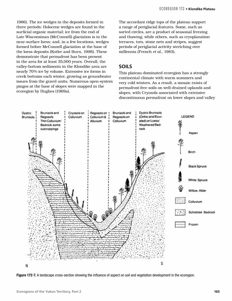
SOILSThis plateau-dominated ecoregion has a strongly continental climate with warm summers and very cold winters. As a result, a mosaic exists of permafrost-free soils on well-drained uplands and slopes, with Cryosols associated with extensive discontinuous permafrost on lower slopes and valley
Figure 172-7. A landscape cross-section showing the influence of aspect on soil and vegetation development in the ecoregion.
N S
ECOREGION 172 • Klondike Plateau
165

Ecoregions of the Yukon Territory, Part 2
bottoms (Fig. 172-7). Eutric Brunisols developed on loamy colluvial materials dominate well-drained ridge crests, south-facing slopes and glaciofluvial terraces. Most soils have formed under boreal forest and woodlands. Alpine environments are limited to the highest elevations of the Dawson Range and the Klondike Plateau proper.
As the ecoregion is largely unglaciated, the dominant parent materials are stony residual materials along ridge tops and summits, coarse colluvium on upper slopes, and silty colluvium and loess, rich in organic matter, often referred to as “muck” by placer miners, on lower slopes (Fraser and Burn, 1997). Muck deposits are usually capped with peat (Fig. 172-6) and are always underlain by permafrost, so Mesic Organic Cryosols are most common in undisturbed valley-bottom settings. Even on upland positions, active cryoturbation may occur and be expressed as sorted patterned ground and Orthic Turbic Cryosol development (site 32 in Tarnocai et al., 1993).
Along the major rivers of the ecoregion, the lower White, Stewart and Yukon, warm summer climates and coarse alluvial or glaciofluvial materials on terraces limit organic matter accumulation and Orthic Eutric Brunisols are most common (Fig. 172-1). Most of these soils are very gravelly, but are often overlain by loess to produce soils with stone-free silt loam textures that support productive stands of boreal forest (Rostad et al., 1977). Alluvial soils in the Klondike Valley consist mainly of 30 to 150 cm of silty sand capping coarse sands and gravels. Fluvial fans support wetlands composed of both fen and peat plateaus. A complex of Cryosols, Regosols and Eutric or Dystric Brunisols composed of highly contrasting soil textures has been mapped in the valley (Walmsley et al., 1987).
Upland soils are dominated by micaceous residual soils that reflect the mineralogy of the underlying bedrock. Most of these well-drained soils are permafrost-free, neutral in reaction and non-calcareous. These soils may thaw to a depth of 2 m in the summer season, particularly following forest fires; those covered by thick mats of moss and forest floor materials may only thaw to 50 cm depth each year. These Turbic Cryosols may form earth hummocks and are widespread on lower slopes and depressions. Wetlands are not extensive in the north part of the ecoregion, but in the south occupy major valley floors and the Wellesley Basin (Fig. 172-5). Wetland soils tend to be composed of
frozen sphagnum peat, but are without permafrost under fen vegetation growing in areas of surface water through-flow. The permafrost portions of wetland support soils are most often classified as Fibric or Mesic Organic Cryosols.
VEGETATIONMuch of the Klondike Plateau Ecoregion straddles the treeline with vegetation ranging from boreal forest in the valleys and on lower slopes, to alpine tundra on ridge crests. Treeline is close to 1,000 m asl in the northern part of the ecoregion and around 1,200 m asl in the south. Below treeline, the vegetation pattern reflects the discontinuous distribution of permafrost. Stunted black spruce woodlands on cold, north-facing sites contrast with mixed forests on warm south-facing slopes.
Black and white spruce forests dominate the ecoregion in both pure and mixed stands with balsam poplar, paper birch and trembling aspen. Lodgepole pine and larch are largely absent from the area.
Black spruce–sphagnum communities exist in poorly drained depressions and at the toe of slopes on fine-textured Cryosols or with a thick organic mat as Organic Cryosols. On gently sloping, fine-textured sediments, black spruce–sedge tussock communities with an understory of ericaceous shrubs predominate. These communities are also associated with permafrost and Turbic Cryosols. Open-canopied black spruce–lichen communities are common on better drained, coarse-textured upland sites. Shrub birch, willow, Labrador tea, alpine blueberry and ericaceous ground shrubs dominate the shrub layer, overlying extensive foliose lichens and feathermoss (Kennedy and Staniforth, 1995). Paper birch and trembling aspen occur with black spruce where disturbance such as fire has happened within about 100 years (Foote, 1993). This ecoregion includes the area with the highest frequency of lightning strikes in the Yukon. Forest stands are a mosaic of fire disturbance, with seral stands more common than mature stands over much of the ecoregion.
Mixed forests are common on warmer sites and gentle to steep south-facing slopes of unfrozen, coarse surface materials. Paper birch, trembling aspen, balsam poplar, white spruce, willow and water birch preside over an understory of ground
Klondike Plateau • ECOREGION 172
166

Ecoregions of the Yukon Territory, Part 2
shrubs, diverse forbs and feathermoss (Kennedy and Smith, 1999). These are mid-successional communities that will gradually become conifer stands in time. As this ecoregion has frequent fires, young, mixed forests are more common.
Mixed black and white spruce forests are common through parts of the ecoregion, such as the Klondike Valley. The driest sites support spruce forests underlain by Cladina lichen; intermediate moisture regime stands are characterized by an understory of feathermoss; moist sites are associated with an understory dominated by horsetail (Kennedy and Staniforth, 1995; Kojima, 1996).
Along major rivers, white spruce–feathermoss communities are found on stable terraces. Balsam poplar is often mixed with white spruce on younger fluvial sites. Willow, alder and balsam poplar with a rich forb and herb understory occupy smaller drainages and large river riparian sites subject to frequent flooding (Kennedy and Smith, 1999).
WILDLIFE
MammalsHistorically, this was one of the more biologically productive Boreal Cordillera ecoregions of the Yukon. The Fortymile barren-ground caribou herd in the mid-nineteenth century is estimated to have been as large as 500,000 and ranged between Fairbanks, Alaska, and Whitehorse, Yukon (U.S. Bureau of Land Management et al., 1995). This population declined through the 1930s to a low of about 6500. In 2001, the herd was estimated at about 40,200 individuals. Many factors have contributed to this decline, including wildfires, food limitations, and overharvesting. An international management plan is attempting to rebuild the herd and restore biological productivity to the ecosystem. Part of the Nelchina barren-ground caribou herd from Alaska, estimated at 33,000, began wintering in the Beaver Creek area in the 1990s. The Klaza and Aishihik woodland caribou herds, with >600 and 1,500 animals, respectively, range into this ecoregion from the east (Farnell and MacDonald, 1987; Farnell et al., 1991). Also, the Chisana and Mentasta herds, 500 and 700 caribou, respectively, enter from Alaska. Dall sheep are found in the southern Dawson Range.
The wildfire regime supplies plentiful early successional moose and snowshoe hare browse.
Moose are also abundant in the gold fields south of Dawson City due either to overharvesting of bears that come into conflict with humans (Larsen and Ward, 1991a) or to riparian willow habitat enhancement as a byproduct of placer gold mining. Snowshoe hares are abundant within their 10-year cycles. Snowshoe hare refugia, areas densely vegetated with browse and cover, are present in the Klondike River Valley. Hare refugia are critical for snowshoe hare specialists, such as lynx, during cyclic hare lows.
Marten are abundant, even occupying recent patchy burns and riparian areas often associated with lynx. Wolverines are also abundant, reflecting the diversity of prey and carrion left by large carnivores. Wolves are less abundant here than elsewhere in the southern Yukon. This is the northern extent of coyote, mule deer and woodchuck in the Yukon (Youngman, 1975). Black bear reach their highest Yukon densities here (MacHutcheon and Smith, 1990). Standing water and the associated semi-aquatic mammals are sparse in this ecoregion, except in the southwest, where muskrats are abundant in the Scottie Creek wetlands (Slough and Jessup, 1984). The house mouse, originating in mid-eastern Asia and now a world traveler, has taken up residence around habitations in Dawson City. A newly described species from the lower Yukon basin in Alaska, the tiny shrew, may occur in the Yukon in this ecoregion (Alaska Geographic Society, 1996; D. Nagorsen, pers. comm., 2000). A complete list of mammal species known or expected to occur in this ecoregion is given in Table 4.
BirdsSpruce-dominated forests are used by raptors such as Northern Goshawk, Red-tailed Hawk, Great Horned Owl, and Northern Hawk Owl (Mossop, 1978; Frisch, 1987). Bald eagles and some ospreys nest near forested wetlands while Peregrine Falcon nests along steep riverbanks such as those of the Yukon River (Mossop, 1978; Department of Renewable Resources, 1994). Year-round residents of these coniferous forests include Spruce Grouse, Three-toed Woodpecker, Gray Jay, Common Raven, Black-capped Chickadee, Boreal Chickadee, and Pine Grosbeak while Northern Goshawk and Common Redpoll winter here in milder years (Frisch, 1987). Coniferous forests provide breeding habitat for Northern Flicker, Western Wood-Pewee, Ruby-crowned Kinglet, Varied Thrush, Yellow-rumped Warbler, Dark-eyed Junco, and White-
ECOREGION 172 • Klondike Plateau
167

Ecoregions of the Yukon Territory, Part 2
winged Crossbill (Grinnell, 1909; Frisch, 1978). Townsend’s Warbler, a species with a limited distribution in the Yukon, also breeds in these forests (Frisch, 1978). Ruffed Grouse, Yellow-bellied Sapsucker, and Orange-crowned Warbler occur in deciduous forests along river courses (Frisch, 1975; Canadian Wildlife Service, unpubl.), while Blue Grouse, which reaches its northwestern limit here, inhabits mixed forests on slopes (Frisch, 1987). Sharp-tailed Grouse, uncommon in the Yukon, inhabits brushy forest openings near alpine areas, floodplains, and old burns (Department of Public Works and U.S. Department of Transportation, 1977; Brown, 1979; Frisch, 1987). These forest openings also support Northern Shrike and Townsend’s Solitaire, with Common Nighthawk and Savannah Sparrow occurring at lower elevations. Western Wood-Pewee, Alder Flycatcher, Say’s Phoebe, Mountain Bluebird, Hermit Thrush, American Robin, and Dark-eyed Junco inhabit the shrubby borders (Betts, 1940; Frisch, 1975; Frisch, 1987; Canadian Wildlife Service, unpubl.). American Kestrels hunt in these openings throughout spring and summer (Canadian Wildlife Service, unpubl.).
Extensive alpine areas provide breeding habitat for Rock Ptarmigan, Horned Lark, American Pipit, and possibly Long-tailed Jaeger (Fig. 172-8). Subalpine shrub areas are inhabited by nesting Willow Ptarmigan, American Tree Sparrow, White-crowned Sparrow, and Common Redpoll (Canadian Wildlife Service, unpubl.).
This ecoregion has two major migration corridors: the Shakwak Trench in the south and the Tintina Trench in the north. The Shakwak Trench funnels spring and fall migrations of swans, geese, ducks, and shorebirds (Department of Renewable Resources, 1994). It also offers important breeding and moulting areas for many species including Trumpeter Swan, American Widgeon, Mallard, Northern Shoveler, Northern Pintail, Green-winged Teal, Ring-necked Duck, Bufflehead, Northern Harrier, Lesser Yellowlegs, and Solitary and Spotted Sandpipers (Grinnell, 1909; Canadian Wildlife Service, 1979a, unpubl.; Hawkings, 1994; Department of Renewable Resources, 1994). The Tintina Trench is a major migration corridor for swans, geese, and Sandhill Crane traveling to and from their Alaskan breeding grounds (Soper, 1954; McKelvey, 1977). Other key wetlands are the Sanpete Wetlands, Scottie Creek Flats, Swede
Johnson Wetlands, and Enger Lakes. These wetlands are important breeding and staging areas for grebes, Mallard, Northern Shoveler, Green-winged Teal, Canvasback, Bufflehead, scaup, scoters, and goldeneyes (Canadian Wildlife Service, 1979b; Hawkings, 1994). Rivers and lakes support Common Merganser, Mew and Herring Gulls, and Belted Kingfisher, with Yellow Warbler, Northern Waterthrush, Wilson’s Warbler, and Lincoln Sparrow breeding in shrubby riparian habitat, while American Dippers inhabit swift flowing streams (Canadian Wildlife Service, unpubl.).
Figure 172-8. Tors are used by birds of prey as perches and nest sites. Bird feces and pellets supply ample nutrients that produce luxuriant grass-dominated plant communities at the base of such prominent rocks.
J. M
eikl
e, Y
uko
n G
over
nmen
t
Klondike Plateau • ECOREGION 172
168

Ecoregions of the Yukon Territory, Part 2
St. Elias MountainsBoreal Cordillera Ecozone
ECOREGION 173
DISTINGUISHING CHARACTERISTICS: This landscape has been, and continues to be, the
most geologically dynamic in the Yukon. Less than 15 million years ago it consisted
of low rolling hills partly flooded by lava; now there are steep-sided mountains
and valleys choked by glaciers and fast-flowing torrents. A 1,200-year-old
tephra blanket supports a forest atop the Klutlan Glacier and contributes
to the silt load in the White River. The ecoregion is distinguished by
relatively high precipitation, almost all of which falls as snow at higher
elevations. Yukon’s highest densities of Dall sheep and mountain
goat are found here.
Figure 173-1. The St. Elias Mountains, viewed westward toward Mount Bona–Churchill, were uplifted over the last 14 million years and are the youngest mountains in Canada. Orographic precipitation results in large snow accumulations at higher elevations in the ecoregion and the development of numerous large valley glaciers. The Klutlan Glacier, shown above, has two medial moraines.
J. M
eikl
e, Y
uko
n G
over
nmen
t
TOTAL AREA OF ECOREGION IN CANADA24,220 km2
TOTAL AREA OF ECOREGION IN THE YUKON19,245 km2
APPROXIMATE LAND COVERglacial ice and snow, 50%rocklands, 25%alpine tundra, 15%boreal coniferous forest, 10%
ELEVATIONAL RANGE580–5,220 m asl mean elevation 1,920 m asl
CORRELATION TO OTHER ECOLOGICAL REGIONS: Equivalent to St. Elias Mountains Ecoregion (Oswald and Senyk, 1977) • Portion of Cordillera Boreal Region (CEC, 1997) • Portion of Alaska/St. Elias Alpine Tundra Ecoregion (Ricketts et al., 1999) • Contiguous with the Kluane Range Ecoregion (Nowacki et al., 2001)
6000
5500
5000
4500
4000
3500
3000
2500
2000
1500
1000
500
0
6000
5500
5000
4500
4000
3500
3000
2500
2000
1500
1000
500
0
Metres above sea level
ECOREGION AREA AS A PROPORTION OF THE YUKON4%
169

Ecoregions of the Yukon Territory, Part 2
PHYSIOGRAPHYThe St. Elias Mountains Ecoregion consists of the Icefield Ranges — high, rugged, glaciated peaks surrounded by glaciers; the Duke Depression, with the broad smooth slopes of a network of river valleys; and the northern part of the Kluane Ranges, a narrow front ridge to the St. Elias Mountains. The Kluane Ranges form a wall rising from the Shakwak Valley, marking a major geological boundary, a fault line scarp, and the eastern boundary of the ecoregion (Mathews, 1986).
Mean elevation ranges from near 3,000 m asl in the southwest portion of the ecoregion to <1,000 m asl along the southeastern, eastern and northern boundaries. However, there are many mountain peaks of 4,000 to 5,000 m asl throughout the western and central portions of this ecoregion. Numerous peaks over 3,600 m elevation include Mount Lucania (5,226 m), Mount Steele (5,073 m), Mount Wood (4,841 m), Mount Hubbard (4,576 m), Mount Kennedy (4,238 m), Mount Badham (3,733 m), Mount Queen Mary (3,886 m) and Pinnacle Peak (3,713 m).
This ecoregion has a relatively less extensive ice surface than the Mount Logan Ecoregion. Intermontane glaciers form the core, grading into valley glaciers that radiate to the west, north and east. The Walsh, Chitina and Anderson glaciers flow west to Alaska. From the north, the largest glaciers flowing north and east are the Klutlan, Steele, Donjek, Kluane, Kaskawulsh, Dusty, Lowell and Fisher glaciers. These glaciers are drained by broad, braided rivers: the White, Generc, Donjek, Duke, Slims, Kaskawulsh, Dusty and Alsek.
BEDROCK GEOLOGYThe rocks of this ecoregion are part of the Insular morphogeologic belt (Gabrielse and Yorath [editors], 1991) and are separated from the rest of the Yukon by the Denali Fault system that underlies the Shakwak Valley. The region consists of deformed sedimentary and volcanic rocks of two terranes, Wrangellia and Alexander. About 20% of the exposed rock is granitic intrusions. The Late Miocene Wrangell lavas were flood basalts that formerly covered large areas; now they are exposed northwest of Donjek River and north of Mush Lake. The area is well mapped (Read and Monger, 1976; Campbell and Dodds, 1982a,b,c), with both
traditional descriptive reports (Kindle, 1953; Muller, 1967) and modern tectonic syntheses (Gabrielse and Yorath [editors], 1991).
Alexander Terrane, which lies between the Duke River and Hubbard faults, consists of moderately metamorphosed Cambrian through Triassic clastic and lesser carbonate, as well as mafic volcanic rocks. Wrangellia, northeast of Duke River and southwest of the Denali Fault, contains weakly metamorphosed volcanic and sedimentary rocks of Late Paleozoic and Triassic age, notably the Skolai and Nikolai mafic volcanic rocks. These terranes are overlapped by Jurassic–Cretaceous Dezadeash Group (Eisbacher, 1976), although they may have been juxtaposed as early as late Paleozoic time, as suggested by the intrusion of 270 to 290 Ma granitic plutons in both terranes (Gardner et al., 1988). Additional granitic suites, 130 to 160 Ma in Alexander Terrane and 106 to 117 Ma in Wrangellia, form northwest-trending belts (Dodds and Campbell, 1988). The latter include ultramafic intrusions 15 km west of Haines Junction and in the Burwash Uplands. The Wrangell lavas are extensive subaerial basalt and andesite flows that erupted 11 to 13 million years ago (Souther and Stanciu, 1975; Skulski et al., 1992). They are part of a magmatic episode indicated by widespread occurrences of felsic dykes, as well as granitic and ultramafic intrusions as young as 9 Ma, such as the Mount Steele pluton (Dodds and Campbell, 1988).
The evolution of the St. Elias landscape is geologically young and stems from oblique subduction of the Pacific oceanic plate with the continental margin of North America (Plafker, 1969). Regional compression resulted in a thickened crust, whose surface is rising, as well as transcurrent faults with more than 300 km of dextral displacement (although most seismic activity is currently localized southwest of the area; Horner, 1983). The rocks are shattered along numerous fault strands in the Kluane Ranges. Mid-Tertiary trunk streams eroded the fault zones and localized coarse clastic material in small depositional basins. Remnants of these basins, called the Amphitheatre Formation (Eisbacher and Hopkins, 1977), are poorly consolidated and a common source of landslides and slips in the Cement Creek, Sheep Creek and Bates Lake areas. The dacite White River Ash, which is up to 50 m thick on level ground near the Klutlan Glacier and more than 2.5 cm thick across the central Yukon, erupted about
St. Elias Mountains • ECOREGION 173
170

Ecoregions of the Yukon Territory, Part 2
AD 803 (Clague et al., 1995) from Mount Churchill (Fig. 173-1), 10 km west of the Alaska–Yukon border (Richter et al., 1995). The eruptions apparently had profound effects on the lives and migration of the ancestral Athapaskan Indians of the region (Moodie et al., 1992).
Upper Triassic rocks of the Insular Belt are richly mineralized and most deposits mentioned below occur within the Nikolai Group. Volcanogenic massive sulphide and skarn deposits occur in these rocks in northwestern British Columbia, while numerous silver–lead and copper–silver veins are found along the northeast side of the ecoregion. More than 5,000 tonnes of copper and silver ore were extracted from the Johobo mine, 7 km west of Kathleen Lake. The Kluane Ranges contain a 130 km long belt of nickel–copper platinum group element (PGE) showings spatially related to ultramafic rocks, including the former Wellgreen mine and Canalask deposit (Hulbert, 1997). This mineralization is unique in the world for its high proportion of platinum group elements and Upper Triassic age. Copper sulphide and native copper showings are common in the vesicular basalt in the upper White River and Quill Creek drainages. Tertiary granite plutons in adjacent Alaska contain significant molybdenum porphyry deposits and a showing of similar type occurs at the head of
Burwash Creek. Lignite seams are present in the Amphitheatre Formation. Placer gold has been mined from Sheep and Bullion creeks in the Slims River drainage; Squirrel, Ptarmigan and Granite creeks in the Duke River drainage; and tributaries of Quill, Wade, Tatamagouche and Burwash creeks.
SURFICIAL GEOLOGY AND GEOMORPHOLOGYAlpine glaciers have probably existed within the St. Elias Mountains Ecoregion since the Late Tertiary. Most surface geology units at the present surface result from the last major glacial expansion, the Kluane Glaciations (29 to 12.5 ka) and from more recent alpine glacial events 2,800 years ago, between 1,250 and 1,050 years ago and during the last 450 years (Rampton, 1971). Rampton (1981b) described the area as “a complex of steep slopes and cliffs, which have been modified by mass wastage, stream erosion and glacial scouring, and which have a veneer of unconsolidated materials. High relief, steep slopes and moderately competent rock have led to the formation of talus fans and aprons and the occurrence of landslides.” Large glaciers, like the Donjek, Lowell, Kaskawulsh, Kluane and Fisher, occupy valleys in the western part of this ecoregion and can be as thick as 450 m (Fig. 173-2).
ECOREGION 173 • St. Elias Mountains
Figure 173-2. The Lowell Glacier, shown above, has a complex history of advance and retreat. The lateral moraines seen on valley walls (arrows) clearly show the extent of recent recession. Such recent retreat is widespread among alpine glaciers in the western Cordillera of Canada over the last 20 years.
M. H
oef
s
171

Ecoregions of the Yukon Territory, Part 2
Numerous smaller glaciers, hanging glaciers, cirque glaciers or small mountain ice caps, are present at high elevation and can be as thick as 90 m. Several debris-covered glaciers and rock glaciers have been mapped at high elevation, particularly in the eastern part of the ecoregion.
Glaciers, bedrock exposures on steep valley walls, cirque headwalls, and colluvium dominate the higher elevations of this ecoregion. The mid- to low elevations are commonly covered by colluvium, moraines and glaciofluvial terraces. Glaciofluvial plains, the toes of alluvial or colluvial fans and fluvial sediments from modern streams cover valley floors (Rampton, 1980a,b,c,d,e).
Colluvium deposits, rock falls, landslides, soil creep and solifluction lobes are common on mountainsides. Steeper slopes usually have talus and fans, with the gentler slopes often covered by blankets of colluvium with solifluction or soil creep features, and occasionally non-sorted polygons or stripes. Moraine originates from the large valley glaciers or as part of a complex network of small moraines associated with cirque glaciers. Moraines often partially mixed with colluvium and glaciofluvial material. Glaciofluvial deposits occur either as kames — terraces on valley sides — or as outwash plains on valley floors. These gravelly surfaces are usually well drained and stable unless they are overlain by thick loess and peat, which fosters the formation of ice-rich permafrost at shallow depth (Rampton, 1981b).
Fluvial deposits in floodplains and alluvial fans are mostly graveled except for the Slims River floodplain, which is composed of fine-grained sediments. Fluvial deposits can be as thick as 45 m, and probably average 15 m. Some terraces overlain by loess or thick peat may contain ice-rich permafrost at shallow depth. Several floodplains of braided rivers are still actively eroding and modifying their beds and are subjected to seasonal flooding and highly variable discharge rate. The larger rivers, like the Donjek, Slims, Kaskawulsh, Alsek and Dusty rivers, have sections of braided and shifting channels, mostly unvegetated and unstable.
Geological processes active in the St. Elias Mountains Ecoregion that present the most immediate hazard to human activity are related to the extreme topography of the Kluane Ranges. Slope failures resulting in rock slides and slumps are commonly associated with the Amphitheatre
Formation and the Saint Clare Group, particularly when these formations outcrop near the Duke River Fault. Several large slumps were mapped in the Sheep Creek area and to the south of Kluane Lake (Yukon GEOPROCESS file, 2002).
GLACIAL HISTORYThis ecoregion comprises the northern slopes of the glacier-covered St. Elias Mountains and the northwestern part of the Kluane Range. The distribution of modern glaciers indicates a network of valley glaciers that becomes a discontinuous ice cover towards the main divides (Fig. 173-1). The Kluane Range now presents local cirque glaciers. During pre-Reid, Reid and McConnell glaciations, these valley glaciers formed piedmont glaciers that extended north near the confluence of the Nisling and Donjek rivers in the Klondike Plateau Ecoregion (Rampton, 1969; Duk-Rodkin et al., 2001). They merged with glaciers emanating from the Kluane Ranges. During the earliest pre-Reid Glaciation (ca. 3 Ma), the piedmont ice front blocked the drainage of White and Nisling rivers to the west and diverted it across the Yukon–Tanana upland, where it entered the Yukon River drainage system.
CLIMATEThis ecoregion’s climate is complex. The topographical divide of the St. Elias–Coast mountains, closely aligned with the divide between the coastal moist climate and the interior drier climate, extends from its southwestern border near Mount Logan, southeastward to bisect this ecoregion along its southern border west of the Tatshenshini and Alsek rivers. Precipitation is heavy in the southeast, particularly along southwestern and southern slopes, amounting up to 1,000 mm, most of which occurs in the fall and early winter. Precipitation decreases rapidly to the north and east with annual amounts of only 300 to 400 mm along the eastern and northern boundary of this ecoregion. The precipitation falls as snow except at elevations below 1,500 to 2,500 m asl during the summer and early autumn. The result is massive icefields with the glaciers spilling out the lower valleys.
Temperatures are affected both by season and elevation (Table 173-1). Generally, there is a decrease in temperature, during the summer months of
St. Elias Mountains • ECOREGION 173
172

Ecoregions of the Yukon Territory, Part 2
5 to 8°C for every 1,000 m increase in elevation. During the winter, this can be dramatically reversed at elevations below 1,500 m due to intrusions of cold arctic air and strong radiation cooling. Temperatures of the valley floors of the eastern and northern portion of this ecoregion can fall between –30 and –60°C. However, with temperatures at 1,500 to 2,000 m asl of only –10 to –20°C, it may be almost isothermal between 2,000 to 3,000 m asl and then decrease above 3,000 m asl at a rate of 5°C per 1,000 m.
Winds are frequently moderate to strong due to proximity of active storms in the Gulf of Alaska. During the fall and winter, and occasionally in the spring, extreme winds can occur that may cause structural damage. These severe winds are most frequently funnelled through well-defined valleys.
No long-term climate stations exist within this ecosystem. Burwash Landing, Haines Junction and Dezadeash can be used as indicators for lower elevations in the extreme northern and eastern sections. Haines Apps#2 weather site could be used as an indicator for lower sections in the coastal southeast portion of this ecoregion. Extensive meteorological data were taken at a divide, 60°46'N, 139°40'W, elevation 2,652 m, but only for June through August in 1961, 1963, 1964, 1965, 1968 and 1969.
HYDROLOGYThe ecoregion drains the northern and eastern slopes of the St. Elias Mountains. Primarily a high altitude source region, the few major streams are relatively short because of the significant coverage by icefields and valley glaciers that dominate the
ecoregion. The largest stream is the White River which flows east out of Alaska before turning and flowing out of the ecoregion. Other major streams are the Generc, a tributary of the White, and the Donjek and Duke rivers. The Slims and Alsek rivers form portions of the eastern boundary. The ecoregion has few waterbodies and no major lakes. Wetlands are largely absent. Annual streamflow is characterized by a rapid increase in discharge in May due to snowmelt at lower elevations, then rising to a peak in July or August due to high elevation snowfield and glacier melt. Because the majority of the stream channels are steep and relatively short, streamflow response tends to be rapid and flashy. Maximum annual flows on larger streams are generated by high-elevation snow and glacier melting, while on smaller streams approximately 40% of the annual maximum flows are due to intense summer rain storm events. The small steep streams draining the northeastern-facing slopes of the front ranges of the St. Elias Mountains are susceptible to mud flows and debris torrents triggered by these summer rainstorms.
There are three representative continuous active or historical hydrometric stations: White and Duke rivers and Burwash Creek. The mean annual runoff is high at a rate of 493 mm, while mean seasonal and mean summer flows are high with values of 31 X 10–3 and 32.2 X 10⁻³ m3/s/km2, respectively. The mean annual flood and mean maximum summer flow are relatively and extremely high with values of 94 X 10–3 and 138 X 10–3 m3/s/km2, respectively. Minimum streamflow generally occurs during March, with the relative magnitude higher than most other ecoregions due to the moderating influence of the Gulf of Alaska on winter temperatures and subsequent groundwater contributions. The mean annual minimum and mean summer minimum flows are relatively high, with values of 1.6 X 10⁻³ and 6.1 X 10⁻³ m3/s/km2, respectively.
PERMAFROSTThe St. Elias Mountains Ecoregion straddles the widespread and sporadic discontinuous permafrost zones. Permafrost is generally found above about 1,600 m asl in the mountains, but the active layer depth is not controlled as much by elevation as by surficial materials (Harris, 1987). Within the mountains, permafrost occurs at high elevation, and the upland surfaces exhibit frost action features,
Coastal slopes over southeastern portion
1,500 m 2,500 m 5,000 m
Annual –5°C –10°C –25°C
December –12°C –18°C –30°C
June 6°C –1°C –22°C
Interior slopes over extreme eastern and northern portions
1,500 m 2,500 m 5,000 m
Annual –3°C –8°C –22°C
December –20°C –20°C –30°C
June 10°C –1°C –21°C
Table 173-1. Probable mean temperatures by elevation, season and location for St. Elias Mountains Ecoregion.
ECOREGION 173 • St. Elias Mountains
173

Ecoregions of the Yukon Territory, Part 2
particularly solifluction lobes and patterned ground. Rock glaciers, with interstitial ice, dominate many slopes (Johnson, 1988). Debris-covered glaciers, relict from Neoglacial ice advances, are found in cirques and valley bottoms (Rampton, 1981a). Near the snout of Klutlan Glacier, much glacier ice has been covered by the recent (AD 803; Clague et al., 1995) White River tephra (Fig. 173-3).
In valleys, ice-rich permafrost is associated with organic soils, colluvial deposits, lacustrine sediments, and some moraine (Rampton, 1981b). Networks of ice wedges are apparent in some colluvial settings, and have been observed in trench walls (Rampton, 1981b; Rampton et al., 1983). Considerable accumulations of aggradational ice
have formed during the Holocene in organic deposits and mineral sediments at sites of active deposition (Rampton et al., 1983). Ground ice in the region is also associated with the emergence of groundwater into near-surface materials (Rampton et al., 1983). Discharge of groundwater draining from the Kluane Front Range creates frequent icing along the Alaska Highway (van Everdingen, 1982).
SOILSSoil development in the ecoregion is controlled by elevation and by a marked climatic gradient moving from relatively mild and humid in the south to relatively cold and dry conditions at its northern limit.
Figure 173-3. The terminus of the Klutlan Glacier is covered by about 1 m of volcanic tephra (ash and pumice) from the White River volcanic eruption in AD 803. This tephra blanket supports white spruce with a willow understory — a unique situation of a forest growing on a glacier!
J. M
eikl
e, Y
uko
n G
over
nmen
t
St. Elias Mountains • ECOREGION 173
174

Ecoregions of the Yukon Territory, Part 2
Orthic Regosols are the dominant soil formed primarily on active colluvial surfaces and moraine in alpine environments that lie above 1,500 m asl. In the northern portion of the ecoregion, Regosolic Static Cryosols are most common. Within the subalpine zone, at elevations between 1,100 and 1,500 m asl, a wider range of materials and soils are found. Dystric and Eutric Brunisols commonly occur on moraine and glaciofluvial landforms within the major valley systems of the Kluane Ranges. Near the active snouts of valley glaciers such as the Kaskawulsh, Donjek, Steele, Kluane and Lowell, Regosols can be found on a variety of neo-glacial moraines and outwash (Gray, 1984).
Below 1,100 m asl, boreal forest occurs on Dystric and Eutric Brunisols, and Gleysols in areas of poor drainage. Wetlands within this zone are underlain for the most part with permafrost, so Mesic and Fibric Organic Cryosols are found here.
A few unique soils occur within this ecoregion. A well-expressed Brunisolic paleosol formed during the early Holocene can be seen in the Slims River Valley and near the Donjek Glacier in the Donjek Valley. The soil is thought to have formed during the period of climatic amelioration following the end of the Pleistocene glaciations. During the Neoglacial period, about 3,000 to 2,500 years ago, the glaciers re-advanced and loess deposition began again, burying the former Slims soil profile over many years. The thickest deposits of the White River eruption lie in the northern portions of the ecoregion. Pumice and ash up to 2 m thick occur on and adjacent to the Klutan Glacier (Fig. 173-3). Within the ecoregion, the thickness of the ash thins rapidly to less than 75 cm moving directly northward and eastward from this point (Lerbekmo and Campbell, 1969). In many locations, this tephra has been invaded by permafrost. There has been little soil development (weathering) in this volcanic parent material.
VEGETATIONThe vegetation of the St. Elias Mountains is mainly alpine and subalpine (Fig. 173-4). Treeline is close to 1,080 m asl. Below treeline, which is restricted to the eastern border of the ecoregion and river valleys, white spruce forms the climax plant community. Black spruce, larch, and pine are absent from the forest canopy except for a few isolated individuals. Broad zones of tall and medium shrubs dominate
the subalpine between 1,040 and 1,400 m elevation. Subalpine meadows are common. Above 1,400 m asl, the cover is mostly alpine tundra with lichens, prostrate willows and ericaceous shrubs.
The most common mature forest community is white spruce and willow, with a moss and ground shrub groundcover. On drier sites in the southern part of the ecoregion, white spruce is often associated with soapberry, grass and ground shrubs. On cool, moist, north and east slopes, white spruce is found with a shrub birch and crowberry understory. On poorly drained sites, white spruce is associated with willow, or with shrub birch and Carex forming a rich fen community. On younger sites (less than about 130 years old) disturbed by fire in the southern and central parts of the region, aspen may compose part or all of the canopy. The willow Salix scouleriana also typically colonizes burned areas.
J. M
eikl
e, Y
uko
n G
over
nmen
t
Figure 173-4. This groundsel species (Senecio kjellmannii) is amphi-Beringian (i.e. endemic to British Columbia, the Yukon, Alaska and Siberia). In the Yukon, it is known to occur in three areas: the Richardson Mountains, the Tombstone area, and the St. Elias Mountains Ecoregion in the Wolverine Plateau area north of Kluane National Park Reserve.
ECOREGION 173 • St. Elias Mountains
175

Ecoregions of the Yukon Territory, Part 2
Salix glauca and shrub birch dominate the subalpine zone. In the south, alder is found along some of the creeks. Interspersed in the shrublands are frequent subalpine meadows. These are usually well drained, but persistent snowpacks provide moisture throughout much of the summer. In the south, these meadows are lush, containing numerous coastal species, and are typical of meadows further south. The easten side of the ecoregion contains dry meadows dominated by Oxytropis and Calamagrostis.
The alpine areas of the St. Elias Mountains Ecoregion consist of extensive glaciers of ice and very sparsely vegetated steep rock and rubble. Any relatively sheltered sites are host to a great diversity of plant life. Flowering plants have been collected at over 2,200 m asl, where such sites allow individual plants to survive (Murray and Douglas, 1980).
On alpine slopes below 1,600 m asl, low shrubs, shrub birch, willow, and ericaceous shrubs such as heather, Labrador tea and alpine blueberry are the dominant groundcover. A short growing season and cold soils limit snowbed sites. These communities are dominated by Salix polaris, or, in the south by Phippsia algida, Ranunculus pygmaeus or Saxifraga spp. and Cassiope stelleriana (Environment Canada, 1987). Seepage zones downslope from persistent snowbeds are rich, wet sites usually dominated by sedges and colourful herbs. Above 1,600 m asl, the pattern of vegetation distribution is related to the time of snowmelt, the available soil moisture and aspect (Douglas, 1974a). The most common alpine communities are those dominated by Salix polaris and Salix reticulata on moister sites, white mountain heather in sheltered sites, Festuca altaica on drier slopes, and Dryas octopetala and Kobresia myosuroides on exposed ridge crests. Lichen is prominent in all of these communities (Environment Canada, 1987).
WILDLIFE
MammalsThe St. Elias Mountains Ecoregion supports a great diversity of wildlife species. The Chisana and Mentasta woodland caribou herds, estimated at 500 and 700, respectively, and the Nelchina barren-ground herd, at about 35,000, enter the ecoregion from Alaska, usually in winter. Dall sheep populations reach high densities
(Fig. 173-5). Mountain goats inhabit Goatherd and other mountains of the southern part of the ecoregion, reaching their highest numbers in the Yukon (Barichello and Carey, 1988). Small, isolated goat populations are found further north. These ungulates, along with moose, support numerous wolves and wolverine (Banci, 1987). Coyotes are abundant along the arid rain shadow in the north of the ecoregion, possibly displacing the red fox during 20th century colonization. Marten are notably rare due to naturally fragmented habitat and mountains as barriers to movement (Slough, 1989). This region is noted for its high density of grizzly bears, which feed on the numerous prey species and diverse plant communities at all elevations (Fig. 176-6).
Dall sheep, mountain goats, arctic ground squirrels, collared pikas and singing voles have colonized nunataks, or unglaciated islands in the glaciers. Predators, such as wolverine and grizzly bears, make occasional forays to the nunataks. Migrating little brown myotis may perish crossing the St. Elias Mountains in unfavourable weather. Mammal species known or expected to occur in this ecoregion are listed in Table 4.
BirdsPacific and Common Loons, Greater Scaup, Bufflehead, Lesser Yellowlegs, Spotted Sandpiper, Red-necked Phalarope, Mew and Bonaparte’s Gulls, Arctic Tern, and Rusty Blackbird can be found in and around the few lakes and ponds that exist in the ecoregion (Kluane National Park, 1951; Hoefs, 1972).
White spruce forests on lower slopes and valleys (Fig. 173-5) provide habitat for year-round residents such as Three-toed and Black-backed Woodpeckers, Gray Jay, Boreal Chickadee, and Red-breasted Nuthatch (Hoefs, 1972; Stelfox, 1972). Other breeding species include Northern Flicker, Swainson’s and Hermit Thrushes, Yellow-rumped Warbler and Chipping Sparrow (Kluane National Park, 1951).
Species that breed at treeline include Northern Shrike, Townsend’s Solitaire, Wilson’s Warbler, White-crowned Sparrow, and Dark-eyed Junco (Kluane National Park, 1951). Higher elevation mountain ridges and exposed talus slopes support year-round populations of Rock and White-tailed Ptarmigan (Theberge et al., 1986). Summer brings migrant Horned Lark, Northern Wheatear, American
St. Elias Mountains • ECOREGION 173
176

Ecoregions of the Yukon Territory, Part 2
Figure 173-6. Not of all the ecoregion is characterized by rugged mountain ranges and glaciers. The northern portion of the ecoregion is dominated by the high elevation Wolverine Plateau supporting shrub tundra vegetation that provides habitat for a range of wildlife species.
J. M
eikl
e, Y
uko
n G
over
nmen
t
Figure 173-5. A bachelor herd of Dall sheep (Ovis dalli) in springtime on the Front Ranges of the St. Elias Mountains along the eastern edge of the ecoregion. White spruce and grassland communities are common on southerly and western aspects at low elevation.
M. H
oef
s
ECOREGION 173 • St. Elias Mountains
177

Ecoregions of the Yukon Territory, Part 2
Pipit, and Gray-crowned Rosy Finch to these ridges to breed (Theberge et al., 1986; CWS, Birds of the Yukon Database), while snow-covered cirques on north-facing slopes attract breeding Snow Bunting (Hoefs, 1972). Species nesting in alpine tundra and shrub areas (Fig. 173-6) include Northern Harrier, Willow Ptarmigan, American Tree, Brewer’s, Savannah, White-crowned and Golden-crowned Sparrows, and Common Redpoll (Drury, 1953; Theberge, 1974; CWS, Birds of the Yukon Database). The numerous south-facing cliffs and canyon walls provide nesting habitat for a large population of Golden Eagle and smaller numbers of Gyrfalcon (Hoefs, 1972). Peregrine Falcon may also use this habitat (Hoefs, 1972).
Numerous migrants have been found dead at very high elevations on the St. Elias Icefields. These include Horned and Red-necked Grebes, Mallard, Green-winged Teal, Solitary and Least Sandpipers, Red-necked Phalarope, Rufous Hummingbird, Tree Swallow, Ruby-crowned Kinglet, Bohemian Waxwing, Blackpoll Warbler, and White-crowned Sparrow (D. Hik, unpubl. data). While some of these, such as Red-necked Grebe and Red-necked Phalarope, may have been on their regular migration to the Pacific Coast, others such as Solitary Sandpiper and Blackpoll Warbler were likely blown off course.
St. Elias Mountains • ECOREGION 173
178

Ecoregions of the Yukon Territory, Part 2
Ruby RangesBoreal Cordillera Ecozone
ECOREGION 174
DISTINGUISHING CHARACTERISTICS: Margins of three Pleistocene glaciations emanating
from the St. Elias Mountains are visible in the Ruby Ranges. This ecoregion is one of
Yukon’s driest, as it lies in the rain shadow of the St. Elias Mountains. Kluane Lake,
the largest lake in the Yukon, lies in the Shakwak Trench along the southwest
edge of this ecoregion. Dall sheep, wolves and grizzly bears are relatively
abundant. Swans, geese and ducks use the wetlands in the Shakwak
Trench for nesting while other migratory birds use the wetlands for
staging enroute to and from breeding grounds in Alaska.
Figure 174-1. An open canopy, mid-elevation white spruce forest with dwarf birch and willow understory occupies the upper Nisling River valley near the northern boundary of the ecoregion. Scant precipitation in the ecoregion fosters grassland communities on south and westerly aspects. Lakes tend to be alkaline and encourage marl (biogenic calcium carbonate) formation. This marl deposit preferentially absorbs higher wavelengths of the visible light spectrum, so that shallow water appears to have an aquamarine tint.
M. B
erkm
an
TOTAL AREA OF ECOREGION IN CANADA22,737 km2
TOTAL AREA OF ECOREGION IN THE YUKON22,737 km2
ECOREGION AREA AS A PROPORTION OF THE YUKON5%
APPROXIMATE LAND COVERalpine tundra, 50%boreal/subalpine coniferous forest, 35%rocklands, 10%lakes and wetlands, 5%
ELEVATIONAL RANGE575–2,745 m asl mean elevation 1,200 m asl
CORRELATION TO OTHER ECOLOGICAL REGIONS: Equivalent to Ruby Range Ecoregion (Oswald and Senyk, 1977) • Portion of Cordillera Boreal Region (CEC, 1997) • Portion of Interior Yukon/Alaska Alpine Tundra Ecoregion (Ricketts et al., 1999)
6000
5500
5000
4500
4000
3500
3000
2500
2000
1500
1000
500
0
6000
5500
5000
4500
4000
3500
3000
2500
2000
1500
1000
500
0
Metres above sea level
179

Ecoregions of the Yukon Territory, Part 2
PHYSIOGRAPHYThe Ruby Ranges Ecoregion occupies the Kluane Plateau physiographic unit, a subdivision of the Yukon Plateau, the Shakwak Trench, and the Kluane Ranges south of Kluane Lake (Mathews, 1986). The Kluane Plateau is a wide, undulating, dissected upland consisting of the Nisling and Ruby ranges and the slightly lower area around Aishihik Lake and the Nisling River valley (Fig. 174-1). The Kluane Plateau is higher than the Lewes Plateau to the east, and higher than the Klondike Plateau to the north.
The Shakwak Trench is a major longitudinal valley marking the Denali Fault, which runs from Haines, Alaska, to the south end of Kluane Lake and on to eastern Alaska. It separates the tectonically active rugged mountains to the west from the lower mountains and broad valleys east of the fault. The Kluane Ranges form a wall rising from the Shakwak Trench to the east marking the fault line scarp (Fig. 174-2). They are uniformly steep-sided mountains with talus slopes. Glaciers occur north of Dezadeash Lake.
Mount Cairnes and Mount Vulcan are over 2,700 m asl; numerous others are over 2,200 m asl. Maximum elevations decrease toward the north and west. Only a couple of peaks in the Ruby Range top 2,200 m asl, and the Nisling Range is less than 2,000 m asl. Most of the Aishihik area is less
than 1,400 m asl, but the Sifton Range and Mount Creedon reach 2,100 m asl. The lowest elevation is in the south, where the Alsek River Valley is less than 600 m asl.
BEDROCK GEOLOGYThree geological terranes separated by two northwest-trending faults lie within this ecoregion. Highly metamorphosed sedimentary and granitic rocks comprise most of the area, regionally mapped by Kindle (1953), Wheeler (1963), Muller (1967) and Tempelman-Kluit (1974).
In the southwest of the ecoregion, the lowlands and some mountains are mantled by 6 to 17 Ma iron mafic lavas and breccias (Wrangell volcanics). Paleozoic greywacke, argillite and limestone are interleaved by closely spaced faults in the Mount Cairnes area. The seismically active Duke River Fault (Clague, 1979; Horner, 1983) separates these rocks of the Alexander Terrane (e.g. Monger and Berg, 1984) from the Gravina–Nutzotin Belt (Berg et al., 1972). The latter includes the Auriol Range, where biotite schist, granitic gneiss, with lesser quartzite and marble comprise the Mesozoic Dezadeash Formation (Eisbacher, 1976). The geological reason for the abrupt mountain front, where the Shakwak Valley (Fig. 174-2) truncates these rocks, remains unclear. The colluvium and glacial deposits in the valley hide a major
Ruby Ranges • ECOREGION 174C
.F. R
oo
ts, G
eolo
gic
al S
urve
y o
f Can
ada
Figure 174-2. Kluane Lake occupies the broad Shakwak Trench, an ancient fault separating the sedimentary Front Ranges of the St. Elias Mountains Ecoregion (left) from the metamorphic rocks of the Ruby Ranges Ecoregion (in the background). This northward view from Outpost Mountain shows the Alaska Highway near the research station of the Arctic Institute of North America on the southern shore of the Kluane lake.
180

Ecoregions of the Yukon Territory, Part 2
transcurrent fault — the Denali, although this segment of the fault is currently inactive.
Northeast of the Shakwak Valley lies the Yukon Crystalline Belt (Tempelman-Kluit, 1976), a southwestern extension of the Yukon–Tanana Terrane, which is a broad zone of metamorphosed rocks in central Alaska and western Yukon (Mortensen, 1992). Foliated granodiorite and biotite quartz diorite constitute the Aishihik and Ruby Range batholiths, which trend north and northwest, parallel to the long axis of the ecoregion. The latter batholith is notable for local pods of 10 cm long pink feldspar crystals, easily visible near the portal of the hydroelectric installation at Canyon Lake. Northeast of Kluane Lake, and structurally below the Ruby Range batholith, are sericite–biotite schist, muscovite-–chlorite schist, gneiss and amphibolite (Kluane Assemblage; Erdmer, 1991). Between the Ruby Range and Aishihik Lake, and extending southeast to Mount Bratnober and northwest to the White River, is biotite schist, granitic gneiss with lesser quartzite and marble of the Aishihik Assemblage (Johnston and Timmerman, 1994). Isolated occurrences of granite, fine-grained siliceous intrusive alaskite and volcanic rock perforate the metamorphic terrane. Granite around Taye and Moraine lakes in the southeast is part of the Coast Plutonic Complex (60 Ma). North of the Ruby Range, the metamorphic rocks are overlain by 50-million-year-old tuff and breccia, the Donjek volcanics (Muller, 1967; Tempelman-Kluit, 1974), which are mainly visible where incised by streams.
An important mineral occurrence near Killermun Lake, 48 km northeast of Haines Junction, consists of native gold and gold-bearing arsenopyrite in quartz veins (Burke and Abbott, 1995). Numerous skarns, where carbonate is metamorphosed by intruding granite, with molybdenite, copper-bearing chalcopyrite, and magnetite have been examined (Morin, 1981) in the Hopkins Lake–Giltana Lake area. The construction of the Aishihik hydroelectric facility, one of the Yukon’s largest rock-moving projects, was undertaken near the mouth of Canyon Lake from 1975 to 1978.
SURFICIAL GEOLOGYInformation on the Quaternary geology of this area is provided by a 1990 report and a set of four maps at the 1:100,000 scale by Hughes (1989a,b,c,d). Most of this ecoregion was included in the terrain hazards
mapping by Thurber Consultants Ltd. (1989). The steep bedrock exposures at high elevation are often mantled with colluvial fans and steep talus slopes covered by coarse, angular, bedrock rubble.
At mid-elevation, most slopes are covered by moraine ridges and blankets, ice contact deposits, and meltwater channels. Moraine deposits are common and consist mainly of gravelly diamicton with a silty to sandy matrix with a low clay content, and clast contents of 20 to 40%. Solifluction lobes, frost-shattered rocks, and sorted polygons are common on moraine and colluvium-covered slopes. Glaciofluvial gravelly sands are well drained and provide stable surfaces, as they are usually free of ice-rich permafrost. They often form large surfaces with gentle to rolling topography, such as the outwash plain north of Aishihik Lake.
Lake Sekulmun–Aishihik, a large glacial lake in the area, formed during the retreat of McConnell ice. The highest elevation of shoreline related to this lake is believed to be 1,130 m asl, which is 196 m above present lake level. Well-sorted silt and clay deposits of this lake are up to 40 m thick. They are found at the north shore of present-day Aishihik Lake and in the West Aishihik River. Thick organic deposits often cover floodplain deposits and are very likely underlain by permafrost. Ice content is expected to be low to nil in well-drained, coarse, fluvial and glaciofluvial deposits. There is no permafrost under large waterbodies, such as lakes and rivers.
GLACIAL HISTORYThe eastern part of this ecoregion was affected by the Cordilleran Ice Sheet and the southern part by piedmont glaciers from the St. Elias Mountains. The highest parts of the Ruby Range supported ice caps and cirque glaciers (Hughes, 1990). A complex network of ice tongues invaded the valleys. Smaller ice bodies from cirque and ice cap glaciers occupying the higher elevations occasionally merged with the valley glaciers. Approximately 90% of the ecoregion was glaciated during pre-Reid glaciation. Approximately 60% of the area was covered by the Reid, and close to 50% was covered by the McConnell, glaciations (Duk-Rodkin, 1999). Numerous drainage diversions took place and many glacial lakes were formed during both the advance and retreat of ice during the glaciations that have affected the area. Glacial Lake Nisling was formed during the Reid Glaciation (Geurts and Dewez,
ECOREGION 174 • Ruby Ranges
181

Ecoregions of the Yukon Territory, Part 2
1993) in the upper Nisling Valley to a maximum elevation of 1,219 m asl. This lake drained north into the Klaza River. Glacial Lake Sekulmun–Aishihik was the most important glacial lake formed in the area during the Late Wisconsinan (Hughes, 1990).
Most recently, Glacial Lake Alsek formed as a result of several incidences of glacial blockage of the Alsek River. The valley where present-day Haines Junction is located has been inundated several times in the last few hundred years.
CLIMATEThis ecoregion is one of the driest within the Yukon because it lies in the rain shadow of the St. Elias Mountains. Precipitation amounts are only 250 to 300 mm annually. Monthly means are only 10 to 20 mm from January to May and are greatest in June and July with means of 30 to 70 mm. This heavier summer precipitation is primarily created by convection with fairly extensive thunderstorm activity, particularly over western portions of this region. The precipitation is mainly snow from October through April.
Mean annual temperatures are from –3 to –7°C with the lower temperatures in the western portion. Mean January temperatures range from –30 to –35°C in the lower elevations of the Shakwak Valley to –25°C over the higher terrain. Mean July temperatures range from 12°C in the lower valleys to 7°C over the higher terrain. Extreme temperatures, from –62 to 32°C, occur in the lower valley floors. Frost can be expected anytime of the year.
Winds tend to be moderate, but are often strong. Gale force winds have caused structural damage. These gale winds are usually southerly and associated with active storms in the Gulf of Alaska. Strong northwesterly winds can occur, generally in the winter, associated with outbreaks of Arctic air.
Representative weather stations are Burwash, Aishihik and Haines Junction. Burwash and the now closed Aishihik station have extensive data on wind.
HYDROLOGYThe ecoregion drains the Ruby and Nisling ranges immediately east of the Shakwak Trench. As a minor exception, a small pocket to the west of the Shakwak Trench (Haines Highway) that includes
the Kluane Ranges is situated within the Western Hydrologic Region (Fig. 8). Hydrologic response from this pocket differs from the rest of the ecoregion because of higher relief, steeper slopes and glaciers. The most representative streams are the Dezadeash River and its tributaries and the Aishihik and Kathleen rivers. The Donjek and Kluane rivers are other large streams within the ecoregion, though not representative of the hydrologic response because their headwaters are outside the ecoregion. The southern boundary is formed by the Alsek and Kaskawulsh rivers, while the northern boundary is formed by the Nisling River. The largest stream is the White River, which flows east out of Alaska before turning and flowing out of the ecoregion. The ecoregion contains Kluane Lake (Fig. 174-2), the largest lake entirely within the Yukon. Other major lakes include Sekulmun and Aishihik lakes to the east of Kluane Lake, and Dezadeash, Kathleen, Mush and Bates lakes to the south. Wetlands are generally associated with these lakes.
There are six representative active and historical continuous and seasonal hydrometric stations: Dezadeash, Aishihik (two) and Sekulmun rivers, and Giltana and Christmas creeks. Annual streamflow is characterized by a rapid increase in snowmelt discharge to a peak in May or June. On smaller streams, approximately 40% of the annual maximum flows are due to intense summer rainstorm events. Streamflow response is unique due to a rain shadow effect provided by the St. Elias Mountains. Not only does the ecoregion have extremely low peak flows, and low runoff and summer flows in general, but it also has low winter flows as well. This is unusual considering the proximity of the ecoregion to the Gulf of Alaska and its moderating influence on winter temperatures and subsequent groundwater contributions. Mean annual runoff is low with values ranging from 97 to 161 mm, with an ecosystem average of 120 mm. Mean seasonal and summer flows are low with values of 6.7 X 10⁻³ and 5.9 X 10⁻³ m3/s/km2, respectively. The mean annual flood is the lowest of all Yukon ecoregions and the mean maximum summer flow is also relatively low with values of 23 X 10–3 and 21 X 10–3 m3/s/km2, respectively. Minimum streamflow generally occurs during March with values considerably lower than would be expected due to the proximity of the ecoregion to the Gulf of Alaska. The minimum annual and summer flows are moderately low and low with values of 0.75 X 10⁻³ and 1.6 X 10⁻³ m3/s/km2, respectively.
Ruby Ranges • ECOREGION 174
182

Ecoregions of the Yukon Territory, Part 2
PERMAFROSTPermafrost is widespread within most of the Ruby Ranges Ecoregion, although it becomes sporadic in southern parts, as around Haines Junction (Boreal Engineering Services, 1985). The maximum thickness recorded at Haines Junction is 12 m, with mean near-surface ground temperature of –0.4°C (Burgess et al., 1982). However, Brown (1967) recorded a thickness of 27 m at Aishihik airfield, and Burn (1995) found a maximum thickness of more than 22 m near Aishihik village, beneath a variable active layer. At sites in the forest, near the village, the active layer was recorded consistently at about 70 cm, but on south-facing, grass-covered slopes, the active layer depth ranged up to 2.2 m. Slumping of banks at the north end of Aishihik Lake is due to thawing of ice-rich ground. Considerable aggradational ice has grown in alluvial fan sediments throughout the ecoregion (Hughes, 1990; Burn, 1995).
In the Shakwak Trench, permafrost is widespread northwest of Kluane Lake, where 60 to 80% of boreholes drilled during geotechnical investigations along the Alaska Highway have encountered permafrost (Rampton et al., 1983; Geotechnical Services, 1993). Near Burwash Landing, permafrost up to 18 m thick has been encountered beneath an active layer of 1.3 to 1.5 m (Ellwood and Nixon, 1983; Nairne, 1989). Southeast of Kluane Lake, only 20% of boreholes drilled along the Alaska Highway pipeline alignment encountered permafrost (Rampton et al., 1983). At Haines Junction, permafrost has been recorded to depths of 7.3 m in two holes drilled for Water Tower construction (EBA, 1974), but most ground nearby is only frozen seasonally (Klohn Leonoff, 1987). The active layer in the dry valley floor is 1 to 2 m thick.
Hughes (1990) indicates that glaciolacustrine and alluvial deposits throughout the ecoregion are ice-rich, and ground ice is also frequently found in peat and other organic accumulations (Wang and Geurts, 1991). A small closed-system pingo northeast of Aishihik airfield is remarkable in its location in the southern Yukon Territory. Relict ice-wedge polygons have been described from select locations along the Nisling River and MacGregor Creek (Hughes, 1990).
Permafrost appears to be variably distributed beneath hillsides, with frozen ground more common on north-facing slopes, particularly in southern portions of the ecoregion (Peddle and Franklin,
1993). Most of the ground in the alpine zone is probably underlain by permafrost, the active layer is from 50 cm to more than 150 cm thick, and there is abundant patterned ground (Price, 1971). North of and above the glacial limits tors and cryoplanation terraces indicate an extended period of frost weathering (Hughes, 1990).
SOILSSoil development in this ecoregion reflects the somewhat moderated continental climate and the rain shadow of the St. Elias Mountains, which produce the cool, dry conditions typical of the southwestern Yukon. The ecoregion is characterized by either rolling plateau or subdued mountainous topography overlain by a variety of parent materials including moraine, colluvium and glaciofluvial materials. Higher elevations are unglaciated and have been subjected to intense periglacial weathering (Hughes, 1990). Soils tend to be colder and moister in the northern portions of the ecoregion.
In the major valleys around Haines Junction, Eutric Brunisols are the most common soils on all parent materials (Day, 1962; Rostad et al., 1977). These soils tend to be alkaline in reaction, calcareous and, in some locations on glaciolacustrine material, saline. In the area of the Nisling Range, lower annual air temperatures lead to the presence of discontinuous permafrost, so that Turbic Cryosols are also common. Soils have formed within residual materials above the glacial limit through much of the ecoregion. Sorted nets and stripes are common and associated soils are classified as Orthic Turbic Cryosols. Throughout the northern portion of the ecoregion, and particularly in the area between the White River and the Donjek River, an extensive blanket of the White River tephra up to 50 cm thick is present. The ash overlies the former soil surface and is not strongly weathered. In some locations, cryoturbation and tree throw have mixed the ash with underlying mineral and organic soil leading to some unique soil morphologies, including the only Cryosols dominated by tephra in Canada (Smith et al., 1999). Cryosols become much more common in the Shakwak Trench north of Kluane Lake. Ellwood and Nixon (1983) described soils with common massive ground ice between 1 and 2 m depth. Estimates on the rate of peat accumulation in the northern wetlands of the Trench are about 50 cm in the last 1,200 years (Zoltai et al., 1988).
ECOREGION 174 • Ruby Ranges
183

Ecoregions of the Yukon Territory, Part 2
Another unique soil forming process in this ecoregion is the active deposition of loess in the vicinity of the Slims, Donjek and White rivers. Loess deposition along the southern end of Kluane Lake has been shown to enhance vegetative productivity in the area (Laxton et al., 1996), particularly native grasses on glaciofluvial terraces and south-facing slopes. Regosols or Gleysols are associated with the large outwash plains developed along these glacier rivers; these may even be saline in some locations, such as the Slims River Delta (Harris, 1990).
VEGETATIONThe vegetation of the Ruby Ranges is mainly boreal forest. White spruce dominates the landscape below treeline, which is near 1,200 m asl. Broad zones of tall and medium shrubs dominate the subalpine between 1,040 and 1,400 m asl. Subalpine meadows are common. Above 1,400 m asl, alpine tundra with lichens and ground shrubs predominates.
In the montane zone of the ecoregion, white spruce is the dominant tree species on well-drained sites (Fig. 174-1). Black spruce, larch, and pine are absent from the forest canopy except for a few isolated individuals. Pine is restricted to the southeastern fringe of the ecoregion. Trembling aspen occurs mixed with white spruce in younger stands on warmer sites (Fig. 174-3). Balsam poplar occurs along streams and on some moister slopes in the south of the ecoregion, where the precipitation is higher. Black spruce dominates poorly drained areas north of Kluane Lake, usually associated with Turbic Cryosolic soils associated with near-surface permafrost. Paper birch is also found in the northern part of the ecoregion, established in early successional stands on cooler sites.
The most common mature forest community in the ecoregion is white spruce and willow with a moss and ground shrub groundcover. On drier sites in the southern part of the ecoregion, white spruce is often associated with soapberry, grass and ground shrubs. On cool, moist, north and east slopes, white spruce with a shrub birch and crowberry understory is found. On poorly drained sites, white spruce is associated with willow, or with shrub birch and Carex forming a rich fen community. Aspen and Salix scouleriana typically colonize burned sites.
Salix glauca and shrub birch dominate the subalpine. In the alpine, prostrate willows,
ericaceous shrubs such as mountain blueberry, crowberry and lingonberry, lichen and herbs predominate.
The Ruby Ranges Ecoregion includes some interesting vegetation features. The saline delta of the Slims River is the only silty floodplain in the Yukon emerging from the St. Elias Mountains. Where Glacial Lake Alsek retreated less than 200 years ago, a primary forest succession occurs. The Haines Junction area has also experienced periodic forest infestation by spruce beetles in the 1940s and 1990s (Environment Canada, 1987).
WILDLIFE
MammalsThe Ruby Ranges support a vast diversity and abundance of wildlife. The Nelchina barren-ground caribou herd, and Chisana and Mentasta woodland caribou herds enter from Alaska, primarily in winter. This is the core area of the Aishihik herd, numbering 1,500 caribou. Possible natural factors and heavy human harvest of caribou made intensive management for the Aishihik herd necessary (Carey et al., 1994), through reduction of harvests and
Figure 174-3. White spruce forest gives way upslope to aspen (bright yellow), with shrub birch (dark green) and willow higher upslope. The extensive alpine and subalpine ecosystems support the Burwash and Aishihik caribou herds. Here in the snow shadow of the St. Elias Mountains, winter range is more plentiful than it is for woodland caribou herds farther east in the Yukon. View is northward from Gladstone Creek in early September.
J. M
eikl
e, Y
uko
n G
over
nmen
t
Ruby Ranges • ECOREGION 174
184

Ecoregions of the Yukon Territory, Part 2
wolf populations between 1993 and 1997. Moose populations had also been depleted (Larsen and Ward, 1991b).
The Kluane caribou herd is one of the smallest in the Yukon at about 200 animals. The Chisana and Mentasta woodland caribou herds are estimated at 500 and 700, respectively and about 3,500 caribou comprise the Nelchina barren-ground herd. Woodland caribou in the more arid regions such as the Mentasta, Kluane and Aishihik herds are not restricted to winter ranges by snowfall (R. Farnell, pers. comm.). These wider ranging herds are more vulnerable to wolf predation than herds with concentrated winter ranges.
Dall sheep reach their greatest numbers here and in the St. Elias Mountains and Yukon Southern Lakes ecoregions (Barichello et al., 1989a). Populations of mountain goats are found in the Alsek Mountain Range. Coyote, wolf and wolverine (Banci, 1987) densities are among the highest in the Yukon. Grizzly bears are also abundant, particularly south of the Dezadeash River, where they reach some of the highest densities found in the Yukon. Red fox numbers have likely decreased since coyotes invaded the area in the 20th century.
Marten, historically rare, were transplanted to the Dezadeash basin in the 1980s, where small
populations have been established (Slough, 1989). Wood bison, introduced to the upper Nisling River basin of the Yukon Plateau–Central and Yukon Southern Lakes ecoregions in 1986, are now established in the Aishihik Lake and Nisling areas (Fig. 174-4) and number about 400.
Elk, introduced in the 1950s and 1990s to enhance biodiversity and hunting opportunities, have established two small but stable herds (M. Hoefs, pers. comm.). One herd of at least 50 elk resides in the Hutshi Lake area and a herd near the Takhini River has about 60 members. Elk are not endemic to the area.
Several muskrat marshes are worthy of note, including Pickhandle Lakes, Kloo Lake–Jarvis River, Hutshi Lakes and Taye Lake wetlands (Slough and Jessup, 1984). The little brown myotis is abundant in the upper Dezadeash Basin. The bushy-tailed wood rat is an uncommon resident. Arctic ground squirrels and least chipmunks thrive in the many meadows of this arid region. The deer mouse, the most widespread mammal in North America, is found only in the southern half of the Yukon, and is most abundant in the Ruby Range and Yukon Southern Lakes ecoregions. Mammal species known or expected to occur in this ecoregion are listed in Table 4.
Figure 174-4. Wood bison were introduced to the upper Nisling watershed in 1979. Part of the species recovery strategy included creating isolated populations to reduce vulnerability to species-wide diseases. Oral history and fossil remains reveal bison were present in central Yukon until the late 18th century.
M. B
erkm
an
ECOREGION 174 • Ruby Ranges
185

Ecoregions of the Yukon Territory, Part 2
BirdsSwans, geese, and ducks migrating to and from their Alaskan breeding grounds use wetlands in the Shakwak Trench, a significant migration corridor running along the southwest edge of this ecoregion. Open water in early spring at the outlets of Dezadeash Lake and Kluane Lake create important spring staging sites for Tundra and Trumpeter Swans, Greater White-fronted Goose, and dabbling and diving ducks, while the lakes are used as staging areas in fall (Dennington, 1985; Nixon, 1989). Other important staging areas include Kloo, Sulphur, Aishihik, Hutshi and Taye lakes.
Common waterbirds include breeding Pacific Loon, Horned and Red-necked Grebes, Trumpeter Swan, Canada Goose, American Widgeon, Mallard, Northern Shoveler, Northern Pintail, scaup, scoters, goldeneyes, and several shorebirds (Soper, 1954; Dennington, 1985; Hawkings, 1994).
Larger streams and rivers support breeding Red-breasted and Common Mergansers along with Belted Kingfisher and American Dipper (Department of Public Works and U.S. Department of Transportation, 1977). Mew Gull and Arctic Tern breed on virtually all of the larger lakes, while Herring Gull occurs more sporadically on lakes and rivers (Godfrey, 1951).
Tree, Violet-green, Bank, and Cliff Swallows commonly breed adjacent to most lakes and rivers, while species such as Yellow and Wilson’s Warblers, Common Yellowthroat, Fox and Lincoln’s Sparrows, and Red-winged Blackbird are common in marshy areas (Hoefs, 1972; Johnston and Eftoda, 1990). Floodplains of large rivers, lakeshores, and marshes provide breeding habitat for shorebirds such as Lesser Yellowlegs, Solitary Sandpiper, Spotted Sandpiper, Least Sandpiper, and Common Snipe (Godfrey, 1951). Killdeer may breed on lakeside gravel beds and river deltas (Hoefs, 1972).
Mature white spruce forests provide breeding habitat for some species found only in the southern Yukon, such as Red-breasted Nuthatch and Golden-crowned Kinglet (Godfrey, 1951; Hoefs, 1972; Eckert et al., 1998; CWS, Birds of the Yukon Database). Common breeding songbirds include Swainson’s Thrush, Yellow-rumped Warbler, Wilson’s Warbler, Dark-eyed Junco (Department of Public Works and U.S. Department of Transportation, 1977), Ruby-crowned
Kinglet, Varied Thrush, and Pine Siskin (Theberge et al., 1986). Common raptors include Sharp-shinned Hawk and Red-tailed Hawk (Theberge et al., 1986).
Year-round residents include Northern Goshawk, Spruce Grouse, Great Horned Owl, Boreal Owl, Three-toed and Black-backed Woodpeckers, Gray Jay, Common Raven, and Black-capped and Boreal Chickadees (Theberge et al., 1986). Open white and black spruce forests with extensive patches of willow and alder support Northern Hawk Owl, Northern Flicker, Olive-sided Flycatcher, Western Wood-Pewee, Hermit Thrush, American Robin, MacGillvray’s Warbler, and American Tree Sparrow, as well as the uncommon Great Gray Owl (Theberge et al., 1986). Breeding Downy Woodpecker, Least Flycatcher, Blackpoll Warbler, American Redstart, and Chipping Sparrow inhabit open mixed forests (Drury, 1953). Grassy openings in forests regularly found on dry, south-facing slopes provide breeding habitat for American Kestrel, Say’s Phoebe, and Mountain Bluebird (Drury, 1953).
Sharp-tailed Grouse inhabit early successional trembling aspen and balsam poplar, while Upland Sandpipers breed in meadows and subalpine bogs (Stelfox, 1972; Department of Public Works and U.S. Department of Transportation, 1977).
Open subalpine forests support breeding Townsend’s Solitaire, White-crowned Sparrow (Godfrey, 1951), and Dusky Flycatcher, which is at the northwestern edge of its range here. Breeding species that inhabit the extensive areas of alder and willow shrub at treeline include Northern Shrike, Alder Flycatcher, American Robin, Golden-crowned Sparrow, Common Redpoll (Godfrey, 1951; Vakil, 1981), and the “Timberline” race of Brewer’s Sparrow (CWS, Birds of the Yukon Database).
At higher elevations, rock ridges and slopes provide nesting habitat for Golden Eagle, Gyrfalcon, Horned Lark, Gray-crowned Rosy Finch, and occasionally Peregrine Falcon (Theberge et al., 1986). Other alpine species include White-tailed Ptarmigan, Snow Bunting (Theberge et al., 1986), Northern Harrier, Willow and Rock Ptarmigan, American Tree Sparrow, and Savannah Sparrow (Vakil, 1981). Alpine tundra provides breeding habitat for American Golden-Plover, some Long-tailed Jaeger, and American Pipit (Price, 1969), as well as Red-necked Phalarope (Hoefs, 1972).
Ruby Ranges • ECOREGION 174
186

Ecoregions of the Yukon Territory, Part 2
Figure 175-1. Broad valleys in Yukon Plateau–Central Ecoregion were conduits for outwash during Cordilleran glaciations. Numerous lakes occupy potholes and hollows, with esker ridges forming long narrow points and shallows (lighter shades of blue represent shallows underlain by marl). A mixed forest of lodgepole pine with white spruce and aspen is kept at early successional stages by periodic forest fires. Islands may escape fire and be cloaked in old-growth spruce, their shores providing nesting sites for loons. Pictured are the Twin Lakes and Klondike Highway south of Carmacks.
Yukon Plateau–CentralBoreal Cordillera Ecozone
ECOREGION 175
DISTINGUISHING CHARACTERISTICS: The western portions of the ecoregion are very
dry with annual precipitation amounts of only 250 to 275 mm. The south-facing
slopes that support extensive grassland communities are a notable feature of
this ecoregion. The wetlands associated with the Tintina Trench flyway, such
as Reid Lakes and the Needle Rock complex, provide important migratory
and nesting habitat for waterfowl. Deeply weathered soils associated
with early Pleistocene glacial deposits are unique within Canada. Very
frequent forest fires maintain vast areas of relatively young aspen and
lodgepole pine forests (Fig. 175-1).
TOTAL AREA OF ECOREGION IN CANADA26,803 km2
TOTAL AREA OF ECOREGION IN THE YUKON26,803 km2
ECOREGION AREA AS A PROPORTION OF THE YUKON6%
APPROXIMATE LAND COVERboreal/subalpine coniferous forest, 65%alpine tundra, 30%lakes and wetlands, 5%
ELEVATIONAL RANGE490–1,860 m asl mean elevation 860 m asl
CORRELATION TO OTHER ECOLOGICAL REGIONS: Equivalent to Pelly River Ecoregion and the northern portion of Lake Laberge Ecoregion (Oswald and Senyk, 1977) • Portion of Cordillera Boreal Region (CEC, 1997) • Northern portion of Yukon Interior Dry Forests (Ricketts et al., 1999)
6000
5500
5000
4500
4000
3500
3000
2500
2000
1500
1000
500
0
6000
5500
5000
4500
4000
3500
3000
2500
2000
1500
1000
500
0
Metres above sea level
J. M
eikl
e, Y
uko
n G
over
nmen
t
187

Ecoregions of the Yukon Territory, Part 2
PHYSIOGRAPHYThe Yukon Plateau–Central Ecoregion incorporates part of the Yukon Plateau physiographic unit, an area of glaciated, rounded and rolling hills, plateaus and broad valleys and surrounded by higher mountain ranges. The Lewes Plateau and the northern portion of the Teslin Plateau (Mathews, 1986) are the major physiographic subdivisions of the ecoregion (Fig. 4).
Numerous lakes and smaller streams fill the network of broad valleys that characterize this ecoregion. Valleys trend northwest–southeast along faults and folds of the bedrock. The Yukon River bisects the ecoregion from south to north, from Lake Laberge and the mouth of the Teslin River to the confluence of the Pelly and Yukon rivers. The Tintina Trench forms the northern boundary of the ecoregion; the Pleistocene glacial limit forms the western and northwestern boundaries.
The base elevations of the Yukon and Stewart river valleys are less than 500 m asl. The Tatchun Hills and several peaks within the eastern portion of the Dawson Range are between 1,750 and 1,850 m asl and comprise the highest elevations in the ecoregion. Other high peaks include Mount Freegold in the Dawson Range, and Rough Top and Flat Top northwest of Pelly Crossing.
BEDROCK GEOLOGYThe Yukon Plateau–Central Ecoregion lies mostly within the Yukon–Tanana terrane with a triangular area of Stikinia extending north from Lake Laberge. The southeast corner of the ecoregion includes the Teslin structural zone, which is composed of steeply dipping, highly deformed rocks. The regional geology mapping (Bostock, 1964; Campbell, 1967; Tempelman-Kluit, 1974, 1984) differs in quality and a contemporary interpretation of rock assemblages is depicted by Gordey and Makepeace (compilers, 2000).
At least three-quarters of the ecoregion consists of igneous bedrock. Granitic batholiths, the biggest being Tatchun, Tatlmain, Glenlyon and Ice Chest, underlie one-fifth of the area. In the southwestern third of the ecoregion are volcanic breccia and augite porphyry of the Triassic Povoas Formation and Early Jurassic granitic rocks of the Big Creek, Granite Mountain and Minto batholiths aged between 192 and 188 Ma. These are covered by brown basalt of
the Cretaceous Carmacks Group and intruded by the mid-Cretaceous Dawson Range batholith from 110 Ma. A remnant of the much younger Selkirk volcanics lies north and south of the mouth of the Pelly River. These lava flows are between 5,000 and 10,000 years old (Jackson and Stevens, 1992).
Northwest-trending valleys, occupied by the Nordenskiold and Big Salmon rivers, the Frenchman Lakes, and the Yukon River downstream of Minto, coincide with inactive fault zones that separate terranes and truncate rock formations. The Whitehorse Trough, which from Late Triassic to Early Cretaceous time accumulated mafic volcanic flows, alluvial fans and lagoon sediments, is folded and faulted, tapering northward from 40 km wide at Lake Laberge to its truncation by faults at Minto. Within the Trough, gritty feldspathic sandstone with minor granite–pebble conglomerate, the Tanglefoot Formation of the Jurassic Laberge Group, is the predominant rock unit. However, a reddish chert–pebble conglomerate (Fig. 175-2) and dark silty shale are typical cliff- and valley-forming rock types, respectively. Red-brown weathering volcanic flows known as Nordenskiold Dacite and white-weathering, thick-bedded limestone are prominent rock types.
Northeast of the Whitehorse Trough is a 15 km wide zone of steeply dipping mylonitic, the Teslin Suture of Tempelman-Kluit (1979). This is the western boundary of the Yukon–Tanana Terrane, an assemblage of muscovite-quartz schist with lesser amounts of quartzite, marble, amphibolite and augen gneiss. These rocks are irregularly exposed through thick glacial drift in subdued topography, except for the resistant basalt, limestone, chert and slate in the Semenof Hills.
The Dawson Range, on the western side of the ecoregion, contains over 150 mineral occurrences, primarily copper–gold with molybdenum porphyries with epithermal gold veins. Among those with calculated reserves are Minto, Cash, Mount Freegold–Antoniak, Laforma, and Williams Creek, the last with a large oxidized cap amenable to heap-leach and electrode precipitation of copper. The Carmacks basalts commonly contain traces of copper. Coal at Tantalus Butte near Carmacks has been mined and larger deposits of bituminous coal occur to the southwest, in particular at Division Mountain where the combined seams are up to 21 m thick (Carne and Gish, 1996).
Yukon Plateau–Central • ECOREGION 175
188

Ecoregions of the Yukon Territory, Part 2
SURFICIAL GEOLOGY AND GEOMORPHOLOGYThis ecoregion is outlined to the west by the limit of Cordilleran Pleistocene glaciation (Hughes et al., 1969, Duk-Rodkin, 1999). Evidence for glaciation includes disrupted drainage patterns, stream capture, streamlined hills, outwash terraces and underfit streams. The digitate western margin of the ecoregion corresponds to tongues of valley glaciers that extended along major valleys and tributary streams. Glacial drift of various ages dominates lower slopes and valley bottoms throughout. Colluvium blankets steep slopes and uplands. The higher elevations were nunataks (ridges and domes above the limit of ice) near the limit of Reid glaciation (Fig. 175-3).
GLACIAL HISTORYThis ecoregion comprises the central Yukon Plateau south of the Tintina Trench, including the eastern slopes of the Dawson Range. The present day Yukon
River crosses this ecoregion from southeast to northwest. In pre-glacial times, this ecoregion was drained by the middle course of the paleo-Yukon River. The trunk stream of this ancient drainage system flowed from north to south exiting in the Gulf of Alaska (Tempelman-Kluit, 1980; Duk-Rodkin, 1997; Jackson, in press). This drainage was diverted northwestward by the first Cordilleran glaciation that occurred around 3 million years ago and covered this ecoregion almost completely (Duk-Rodkin and Barendregt, 1997). During the Reid Glaciation, the ice reached its maximum in the western part of this ecoregion, with well-defined glacial limits marked by subdued moraines and meltwater channels. The McConnell glacial maximum is traceable along the eastern part of this ecoregion (Bostock, 1966; Jackson, 1997a,b), where it reached its maximum extent approximately 24,000 years ago (Jackson and Harington, 1991). Very sharp-edged glacial features occur along this former ice frontal position, as well as around nunataks further east. The central Yukon Plateau
ECOREGION 175 • Yukon Plateau–Central
Figure 175-2. South- and west-facing slopes are very dry, with grasses and sage colonizing the alkaline soil (Melanic Brunisols). Bluffs of reddish conglomerate are of the Cretaceous Tantalus Formation.
J. M
eikl
e, Y
uko
n G
over
nmen
t
189

Ecoregions of the Yukon Territory, Part 2
has an extensive record of at least four Pleistocene glaciations (Bostock, 1966; Jackson et al., 1996).
The Diversion Creek paleosol (Smith et al., 1986) developed during the non-glacial interval between Reid and McConnell glaciations, whereas the Wounded Moose paleosol (Smith et al., 1986) developed between the younger of the pre-Reid glaciations. Reid deposits (more than 200 ka) are commonly buried beneath dune sand and loess deposited by katabatic winds off the Cordilleran Ice Sheet during the McConnell Glaciation. Pre-Reid deposits in this ecoregion are 0.75 to 1.5 Ma or older, typically buried beneath colluvium. In the Fort Selkirk area, extensive volcanic eruptions occurred during the last pre-Reid glaciation (Jackson et al., 1996). Volcano Mountain, north of Fort Selkirk, erupted as recently as 5,000 to 10,000 years ago (Jackson and Stevens, 1992).
CLIMATEThe orientation of the landscape is primarily south–southeast to north–northwest and lies just northeast of the main rain shadow of the St. Elias–Coast mountains. Precipitation is relatively light,
ranging from 250 to 300 mm, two-thirds of which falls during the summer. Snow cover generally exists from mid-October to mid-April in the valley floors and a month longer over the higher terrain.
Mean annual temperatures are near –4°C. Mean January temperatures vary from –30°C in the lowest valleys to a more moderate –20°C over the higher terrain due to inversions. Mean July temperatures range from near 15°C in the valleys to 10°C over the heights. The most extreme daily temperatures occur in the lowest valley floors and can range from extreme minimums of –60 to –65°C, to extreme maximums near 35°C. The period with mean daily temperatures above 0°C is from late April to mid-October, although frost can occur at any time of the year. Winds are generally light, but can also be moderate to strong in association with individual storm situations.
Climatic information is available for Carmacks and Fort Selkirk with limited data from Braeburn. The annual climate graph for Carmacks is shown in Figure 175-4, a schematic cross-section that depicts the major landscape elements that make up the ecoregion.
Figure 175-3 White Mountain, near the centre of the Yukon Plateau Ecoregion, was a nunatak during the Pre-Reid glaciations. Lower elevations are underlain by a thick blanket of glacial outwash and loess deposited when this area was ice-free during the Reid and McConnell glaciations. The foreground hills are covered in willow thickets and a reddish sphagnum bog occupies a broad level area in mid-distance.
J. M
eikl
e, Y
uko
n G
over
nmen
t
Yukon Plateau–Central • ECOREGION 175
190
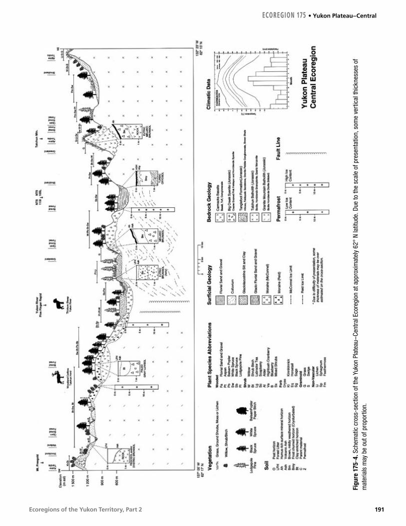
Ecoregions of the Yukon Territory, Part 2
Figu
re 1
75-4
. Sch
emat
ic c
ross
-sec
tion
of th
e Yu
kon
Plat
eau–
Cent
ral E
core
gion
at a
ppro
xim
atel
y 62
° N
latit
ude.
Due
to th
e sc
ale
of p
rese
ntat
ion,
som
e ve
rtic
al th
ickn
esse
s of
m
ater
ials
may
be
out o
f pro
port
ion.
ECOREGION 175 • Yukon Plateau–Central
191

Ecoregions of the Yukon Territory, Part 2
J. M
eikl
e, Y
uko
n G
over
nmen
t
Figure 175-5. The valley of the Pelly River occupies the Tintina Trench through much of its course in the Yukon Plateau–Central Ecoregion. Note the wide floodplain and meander scars in the foreground. Dark patches of spruce represent older stands that have escaped recent fire.
HYDROLOGYThe Yukon Plateau–Central ecoregion is situated exclusively within the Interior Hydrologic region (Fig. 8). With a total area of approximately 27,000 km2, drainage of the largely undulating plateau complex with little significant relief is primarily from the south and east. Several large river valleys traverse the ecoregion including the Yukon, Stewart, Pelly (Fig. 175-5) and Teslin rivers. The most representative intermediate stream is the Nordenskiold River. Tatlmain Lake is the largest lake in the ecoregion. There are numerous smaller lakes, which include Tatchun, Frenchman, Diamain, and von Wilczek. Wetlands are an important component of the landscape, including Needlerock wetlands, the largest wetland complex on the Yukon Plateau, and the Nordenskiold wetland (Fig. 28) complex, both of which have been recently designated as Habitat Protected areas.
There are two active representative hydrometric stations: Nordenskiold River and Big Creek. Annual streamflow is characterized by a rapid increase in snowmelt discharge to a peak in May or June. On smaller streams, approximately 40% of the annual maximum flows are due to intense summer rainstorm events. The nearby Big Salmon River and Nisling River hydrometric data were used to augment available data for streamflow characterization purposes. The mean annual runoff based on the available hydrometric record is low, with values ranging from 76 to 139 mm with an extremely low ecosystem average value of 107 mm. Mean seasonal and summer flows are likewise low, with values of
6.1 X 10⁻³ and 5.7 X 10⁻³ m3/s/km2, respectively. The mean annual flood and mean maximum summer flow are also low, with values of 36 X 10–3 and 17 X 10–3 m3/s/km2, respectively. Minimum streamflow generally occurs during February or March, with relatively low values due to low winter temperatures. The minimum annual and summer flows are also low, with values of 0.25 X 10⁻³ and 1.2 X 10⁻³ m3/s/km2, respectively.
PERMAFROSTThe Yukon Plateau–Central Ecoregion spans both widespread and sporadic discontinuous permafrost zones. A large portion of the ecoregion lies west of the limits of McConnell glaciation, so the surficial deposits are coarse and dry, and largely free of ground ice. However, fine-grained and moist sediments in valleys are prone to perennial freezing and occurrence of ground ice. Permafrost was recorded in two of three instrument holes at Rink Rapids, north of Carmacks, with a maximum thickness greater than 18.3 m, and temperatures at 9 m ranging between –0.9 and 3.2°C (Burgess et al., 1982). The plateau surfaces in the ecoregion are too low to support alpine permafrost and most ice-rich ground is in valleys. In northern portions, permafrost is found in various terrain types, even in relatively dry till under deciduous forest near Pelly Crossing (Klohn Leonoff, 1988). Hughes (1969a) mapped many open-system pingos in the northern valleys, where surficial deposits permit downslope groundwater movement yet valley bottoms may be very cold in winter.
Yukon Plateau–Central • ECOREGION 175
192

Ecoregions of the Yukon Territory, Part 2
The importance of soil moisture and organic accumulation on the specific location of permafrost develops southward. No permafrost has been reported during excavations in relatively coarse materials near Carmacks (e.g. EBA, 1990c) and there is little along the Robert Campbell Highway in the ecoregion (Hoggan, 1992a). However, in the Nordenskiold Valley to the south, moist glaciolacustrine sediments are ice-rich. Occasionally, ground ice forms in slopes that are prone to slumping when the ice is disturbed, as along the Klondike Highway at Tatchun Creek and near Fox Lake (Brown, 1967; Paine, 1984).
SOILSThe ecoregion generally consists of undulating plateau landscapes with a few isolated mountain summits. The climate is strongly continental and semi-arid with warm summers, developing large soil moisture deficits early in the growing season. Soils have been mapped in detail only in the major valley bottoms near Carmacks and Pelly Crossing (Rostad et al., 1977). The south-facing slopes that support extensive grassland communities are a notable feature of this ecoregion. These are common on low elevation sidehills in the Yukon River and Nordenskiold River Valleys around Carmacks. While such grasslands exist throughout the southern Yukon, they are best expressed here. A second notable feature is the layer of tephra up to 35 cm thick that blankets most of the soils of the ecoregion (Fig. 25). While the maximum thickness of the ash is less than that found in the Ruby Ranges Ecoregion to the west, the ash is most ubiquitous throughout.
Mildly weathered, alkaline soils form on a variety of calcareous glacial parent materials. Open meadows on south-facing slopes have soils with dark A horizons typical of grasslands. Soils are classified as Melanic Brunisols (Figs. 175-2, 175-4). Surrounding aspen stands have thick moder humus forms with alkaline forest soils classified as Eutric Brunisols. Northern and eastern aspects support mixed forests underlain by Eutric Brunisols with mor humus forms. Wetlands are associated with thermokarst of large ice masses in the silty alluvial deposits of major floodplains where Organic Cryosols and Gleysolic Turbic Cryosols form. Higher elevation uplands and north-facing slopes may also lie on permafrost. These are most commonly Orthic
Turbic Cryosols, occasionally with patterned ground features in alpine areas.
Some soils in this ecoregion formed with unique features. In association with various ages of Pleistocene glacial drift, a series of paleosols exhibit deep soil development and strong reddish colours that relate to long periods of weathering under interglacial climatic conditions in the central Yukon (Smith et al., 1986; Tarnocai, 1987a). These paleosols are also formed in glacial deposits in the adjacent Klondike Plateau and Yukon Plateau–North ecoregions. There are no other soils like them in Canada (Fig. 175-6).
Figure 175-6. Relict soils are found in the Yukon Plateau–Central Ecoregion on glaciofluvial terraces that have been relatively undisturbed since early pre-Reid glaciations. One of these soils associated with the oldest drift surfaces is the Wounded Moose Paleosol. The involutions of sand (sand wedges) outlined on the photo are thought to have formed during the last glacial interval when this soil was exposed to polar desert-like conditions that existed in unglaciated regions near to the ice front.
S. S
mith
, Ag
ricu
lture
and
Ag
ri-F
oo
d C
anad
a
ECOREGION 175 • Yukon Plateau–Central
193

Ecoregions of the Yukon Territory, Part 2
VEGETATIONThe montane boreal forest dominates the Yukon Plateau–Central Ecoregion below 1,200 m asl. Above 1,200 m asl is the subalpine zone. Treeline near 1,370 m asl separates the subalpine from the alpine (Oswald and Senyk, 1977).
The boreal zone contains many plant communities because of the diverse habitats provided by mixed glacial landforms and fire (Oswald et al., 1983). Fires are frequent and large due to the high incidence of thunderstorms concentrated along the north part of the Tintina Trench and the generally dry summer conditions. Most forest stands are less than 100 years old (Fig. 175-1, 175-5). The dominant community on undisturbed moraine soils, which blanket lower slopes of the ecoregion, is white spruce and feathermoss with few shrubs or herbs. On recent alluvial floodplains, the white spruce–feathermoss forest typically contains rose, horsetail, willow and alder. A mixture of kinnikinnick, grass and lichen replaces the feathermoss understory vegetation on coarse outwash deposits, which are extensive on the valley floor. Succession is also important on fluvial deposits. The first species to colonize recent floodplains is horsetail, which is followed by willow and then balsam poplar.
Due to the frequency of fire, lodgepole pine and trembling aspen are prevalent at low elevations. Pine is more common on better-drained, warmer, coarse soils; aspen grows on sites with finer soil and on steep south-facing slopes. On drier sites, the understory is predominantly lichen, kinnikinnick and grass. The moister sites commonly contain more shrubs, such as alder, willow, lingonberry and soapberry, as well as moss. White spruce slowly invades these post-fire communities. Paper birch is a successional species usually found colonizing moister sites in the ecoregion.
On undisturbed, colder, north-facing lower slopes and alluvial floodplain sites, white spruce–feathermoss forests are slowly invaded by black spruce and permafrost as the dominance of brown mosses increases on the forest floor. Grasslands are an important feature of this ecoregion. They occur on steep south- and west-facing slopes throughout the ecoregion and sometimes extend from the valley floor to the alpine. Sagewort, rose, juniper and kinnikinnick are typical species of these grasslands. Willows and aspens invade moister sites, such as the bases of slopes.
Wetlands are significant in the ecoregion. Shallow open water with Carex aquatilis and aquatic plants and shore marshes dominated by graminoid species are common along the shores of lakes and ponds. Willows with shrub birch, Labrador tea and shrubby cinquefoil, with a moss and sedge groundcover, commonly occur in bogs through the ecoregion.
Subalpine trees include subalpine fir, white spruce and sometimes stunted lodgepole pine. Shrub birch and willow dominate the subalpine, commonly with mountain blueberry and crowberry; on moister sites, they are underlain by moss and Labrador tea, and on drier sites by lichen (Oswald et al., 1983; Oswald and Brown, 1986).
Figure 175-4 illustrates the vegetation, soil and terrain relations in the ecoregion.
G. M
owat
, Yuk
on
Gov
ernm
ent
Figure 175-7. The combination of relatively dry summers and a high incidence of lightning strikes results in both frequent and extensive forest fires. One result is consistently good habitat for snowshoe hare and its main predator, lynx.
Yukon Plateau–Central • ECOREGION 175
194

Ecoregions of the Yukon Territory, Part 2
WILDLIFE
MammalsThe Yukon Plateau–Central supports moderate densities of moose and woodland caribou in the Aishihik, Tatchun, and Klaza herds (Markel and Larsen, 1988; Farnell et al., 1991). The Aishihik herd was intensively managed in the 1990s, primarily through wolf reduction (Carey et al., 1994), and has increased to 1,500. In 2000, the Tatchun and Klaza herds were estimated at 500 and less than 600, respectively.
Grizzly bears and predators such as wolverine and marten are not as abundant as in surrounding ecoregions. River otter densities are probably highest along salmon-bearing streams in the Yukon River drainage. The area supports healthy populations of snowshoe hare and lynx (Fig. 175-7). The juxtaposition of suitable wetlands and fire-induced aspen and willow stands supports large numbers of beaver colonies locally (Slough and Jessup, 1984). The introduced herd of wood bison, now about 400 individuals, and Hutshi Lake elk, of at least 50 individuals, range from the Ruby Ranges Ecoregion into the upper Nordenskiold River drainage. Recently, range-expanding mule deer, more abundant following a succession of mild winters in the 1980s and 1990s, wander in small herds of 12 to 15 individuals. The occasional cougar is sighted near mule deer range; such sightings are unusual and not necessarily indicative of a self-sustaining population. Mammal species known or expected to occur in this ecoregion are listed in Table 4.
BirdsThe northeast border of the Yukon Plateau–Central Ecoregion includes part of the Tintina Trench, which is the Yukon’s major migration corridor for thousands of Sandhill Cranes that nest in Alaska. Important and productive wetlands include the Needlerock complex, the Willow Creek complex, the Nordenskiold River system, and Von Wilczek Lakes (Fig. 175-8). Loons, Horned and Red-necked Grebes, American Widgeon, Mallard, Green-winged Teal, scaup, scoters, Long-tailed Duck, Bufflehead, goldeneyes, and American Coot breed and moult in these wetlands (Dennington, 1985; Hawkings, 1994). Ruddy Duck breeds on some of these wetlands (Fig. 175-8) along with songbirds such as Red-winged and Rusty Blackbirds (Hawkings, 1994).
The Yukon River itself, running north through this ecoregion, contains limited nesting areas on bays and backwaters for Canada Goose while the north section of the river provides open flats and sandbars used as resting areas by Sandhill Crane during spring and fall migration through the Tintina Trench (Soper, 1954). Peregrine Falcon nest along steep banks of the Yukon, Stewart, and Pelly rivers (Stelfox, 1972; Mossop, 1978). Other raptors include Bald Eagle and Golden Eagle (Mossop, 1978). Rivers are also inhabited by breeding Common Merganser and Belted Kingfisher with Bank Swallow colonies in the riverbanks (Rand, 1946). Scattered marshes, lakes, and rivers support breeding shorebirds and gulls including Semipalmated Plover, Lesser Yellowlegs, Spotted Sandpiper, Red-necked
Figure 175-8. The Von Wilczek Lakes wetland south of Pelly Crossing consists of extensive emergent graminoids and open water, protected by a thick fringe of dense alder–willow thicket. One of the most biologically productive wetlands in Yukon Plateau–Central Ecoregion, this wetland is the northern extent of the range for the Ruddy Duck.
J. M
eikl
e, Y
uko
n G
over
nmen
t
ECOREGION 175 • Yukon Plateau–Central
195

Ecoregions of the Yukon Territory, Part 2
Phalarope, Bonaparte’s Gull, and Mew Gull (Stelfox, 1972).
Sharp-tailed Grouse inhabit young deciduous forests throughout the region (Stelfox, 1972). Songbirds breeding in wetland shrubs include Alder Flycatcher, Orange-crowned Warbler, Yellow Warbler, Northern Waterthrush, Common Yellowthroat, and Savannah and Lincoln’s Sparrows (Soper, 1954; Stelfox, 1972).
Year-round residents include Great Horned Owl, Three-toed Woodpecker, Gray Jay, Black-billed Magpie, Common Raven, and Boreal Chickadee (Godfrey, 1986). Coniferous forests provide breeding habitat for Sharp-shinned and Red-tailed
Hawks, Olive-sided Flycatcher, Ruby-crowned Kinglet, Yellow-rumped Warbler, and White-winged Crossbill (Stelfox, 1972). Deciduous forests support breeding Ruffed Grouse, Northern Flicker and Least Flycatcher. Species such as American Kestrel, Common Nighthawk, Say’s Phoebe, American Robin, White-crowned Sparrow, and Dark-eyed Junco inhabit open treed habitats (CWS, Birds of the Yukon Database).
There are few records of bird species for alpine areas, but breeders include Gyrfalcon, Horned Lark, and American Pipit. Subalpine areas provide habitat for resident Willow Ptarmigan, Townsend’s Solitaire, Wilson’s Warbler, and American Tree Sparrow.
Yukon Plateau–Central • ECOREGION 175
196

Ecoregions of the Yukon Territory, Part 2
J. M
eikl
e, Y
uko
n G
over
nmen
t
Yukon Plateau–NorthBoreal Cordillera Ecozone
ECOREGION 176
DISTINGUISHING CHARACTERISTICS: This is the largest ecoregion entirely within the Yukon.
It includes a 450 km length of the Tintina Trench, an ancient fault trace within
which deposits of at least seven Pleistocene glaciations are recognized. Several
large river valleys traverse the ecoregion, including the Pelly, Ross, Macmillan,
Stewart, Hess, McQuesten and Klondike. The Fannin sheep of the McArthur,
Russell and Anvil ranges may be a relict of isolation during the last
glaciation. The glaciated valleys host numerous important wetlands,
including the Sheldon Lake complex and Horseshoe Slough.
Figure 176-1. The Stewart Plateau in the northern portion of the ecoregion consists of rolling uplands with steep slopes leading into U-shaped valleys about 1,000 m below the upland surface. Above Ethel Lake (shown above), the highest deposits of Reid glaciation form low eroded embankments on the upper slopes (arrow). The white spruce forest on the crest of the plateau was burned about 15 years before this photograph was taken and among the dead timbers are scattered spruce, alder thickets and waist-high drawf birch.
TOTAL AREA OF ECOREGION IN CANADA57,091 km2
TOTAL AREA OF ECOREGION IN THE YUKON57,091 km2
ECOREGION AREA AS A PROPORTION OF THE YUKON12%
APPROXIMATE LAND COVERboreal/subalpine coniferous forest, 75%alpine tundra, 20%lakes and wetlands, 5%
ELEVATIONAL RANGE320–2,160 m asl mean elevation 995 m asl
CORRELATION TO OTHER ECOLOGICAL REGIONS: Equivalent to Mayo Lake–Ross River Ecoregion (Oswald and Senyk, 1977) • Portion of Cordillera Boreal Region (CEC, 1997) • Southwest portion of Interior Alaska/Yukon Alpine Tundra (Ricketts et al., 1999)
6000
5500
5000
4500
4000
3500
3000
2500
2000
1500
1000
500
0
6000
5500
5000
4500
4000
3500
3000
2500
2000
1500
1000
500
0
Metres above sea level
197
Ecoregions of the Yukon Territory, Part 2
PHYSIOGRAPHYThe Yukon Plateau–North Ecoregion encompasses, from the north, the Stewart Plateau, the Macmillan Highland and the Ross Lowland (Mathews, 1986) (Fig. 4) or the Stewart, Macmillan and Pelly plateaus (Bostock, 1948). It is located northeast of the Tintina Trench.
The Stewart Plateau is a series of tablelands separated by a network of broad, deeply cut valleys (Fig. 176-1). The Macmillan Highland consists of small mountain ranges: the Anvil (north of Faro), South Fork, Wilkinson and Russell ranges, also separated by broad valleys. The Ross Lowland, as its name implies, is slightly lower in elevation with rolling, rounded hills separated by broad valleys.
Several summits in the ecoregion are over 2100 m asl. Grey Hunter Peak in the McArthur Range is the highest at 2,200 m asl. Most of the area is between 900 and 1,500 m asl. Local relief is typically 300 to 900 m.
BEDROCK GEOLOGYThis ecoregion includes parts of two geological provinces consisting of metamorphosed sedimentary rock; less than one-tenth of the area is granitic. The northern half of the ecoregion is underlain by variably deformed sedimentary rocks deposited on the outer continental shelf of ancestral North America, called the Selwyn Basin, between 530 and 200 Ma. The regional distribution of rock units in the northern half of the ecoregion is shown on geological maps (Bostock, 1964; Campbell, 1967; Green, 1972; Roots et al., 1995; Roots, 1997). In contrast, rocks in the southeast part of the ecoregion include siliceous sedimentary and volcanic rocks of the Yukon–Tanana terrane and metabasaltic flows of the Slide Mountain terrane. The origin of these rocks is obscure because they were deformed before and during transport onto the telescoped Selwyn Basin strata. Their distribution is shown on regional geological maps (Tempelman-Kluit, 1984; Gordey and Irwin, 1987). A contemporary interpretation of the regional assemblages is shown in Gordey and Makepeace (compilers, 2001). The regional distribution of metals, trace elements and fluorine are represented by stream sediment and water geochemical surveys.
Rocks of the Selwyn Basin underlie a broad expanse of the east-central Yukon. The oldest strata are a great thickness of brown sandstone and grit and minor white limestone, overlain by maroon shale, all of which constitute the Late Proterozoic to Middle Cambrian Hyland Group (570 to 520 Ma; Gordey and Anderson, 1993). Within the ecoregion, the Hyland Group is exposed in a 35 km wide swath extending from Partridge Creek to Mount Selous. The quartz-rich rocks in the Mayo area were extensively recrystallized during deformation and metamorphism about 100 million years ago and now contain considerable white mica and green clay minerals, commonly chlorite. South of this belt, ridges are more subdued and covered with vegetation, although bare patches and stream cuts reveal a nondescript succession of dark-coloured, thinly bedded siltstone and shale of the Cambrian Gull Lake Formation and the Ordovician to Middle Devonian Road River Group. Within this succession, which is repeated by folds and thrust faults, are more resistant outcrops that reveal scattered pods or horizons of white limestone, including the Cambrian Rabbitkettle Formation, mafic volcanic flows and breccias with abundant calcite of the Ordovician Menzie Creek Formation (Goodfellow et al., 1995) and grey to multicoloured chert. The formation locally produces crumbling walls with angular, treacherous talus beneath.
In the northern Anvil Range, and near McEvoy Lake, extensive areas of the Devonian Earn Group are characterized by jet-black or gunsteel-blue weathering siliceous siltstone and conglomerate containing abundant chert pebbles. Underlying Earn strata releases high background levels of barium, zinc, lead and cadmium to streams, vegetation and local ungulates (M. Gamberg, pers. comm., 1993). Along the north boundary of the Yukon Plateau–North Ecoregion, scarp-like hills lie on blocky rubble of the Carboniferous Keno Hill quartzite, a distinctive substrate commonly indicated by luxuriant lichen and moss cover.
North of the Macmillan River are numerous sub-circular granitic intrusions of the Tombstone suite, uniformly 92 Ma. These form the core of the Syenite, Lansing and Armstrong ranges, as well as Mount Selous, because they are surrounded by baked sedimentary rocks that are resistant to erosion. The Anvil and McArthur ranges are also underlain
Yukon Plateau–North • ECOREGION 176
198

Ecoregions of the Yukon Territory, Part 2
by granitic batholiths. Between the Rogue and South Macmillan rivers are two large, semi-circular areas underlain by dark brown weathering, locally columnar-jointed, biotite–quartz–hornblende–feldspar crystal tuff. This rock is poorly exposed and resembles a porous granite, but represents the pyroclastic fill of enormous calderas formed 80 million years ago (South Fork volcanics; Wood and Armstrong, 1982).
The southeast part of the ecoregion, the Campbell Range, contains quartz–feldspar–mica schist and black argillite similar to Earn Group, but with higher metamorphic grade, while higher ground is dominated by several varieties of granite (e.g. Murphy, 1998), as well as chlorite–actinolite phyllite and chloritic metavolcanic rocks. The latter dark-green rocks are considered to be part of Slide Mountain Terrane, which formed at the edge of a continent in Permian time and was thrust over the continental rocks (Tempelman-Kluit, 1979) about 100 million years ago.
This ecoregion also includes a 450 km length of the Tintina Trench, an ancient fault trace covered by Pleistocene glacial deposits. River and stream cutbanks expose Tertiary sandstone with coal seams along its length (Hughes and Long, 1980), as well as rhyolite and olivine basalt between Faro and Ross River (Jackson et al., 1986; Pride, 1988).
This ecoregion contains considerable potential for metallic mineral deposits. Open-pit mines have extracted zinc and lead in Cambrian sediments of the Anvil Range at Faro and adjacent ore bodies (Pigage, 1990), gold from veins at Grew Creek in Tintina Trench (Duke, 1990), and gold from altered granitic dykes and black shale at Brewery Creek by heap-leach pad extraction (e.g. Diment, 1996). Another large volume of gold veins amenable to stripping and heap-leach extraction is at Dublin Gulch (Smit et al., 1996). Other explorations have been directed toward stratiform zinc–lead in Earn Group black shale prospects at Dromedary Mountain and Rogue River and to strata-bound lead–copper–zinc–gold–silver in felsic volcanics near Wolverine and Fire lakes (e.g. Schultze, 1996; Foreman, 1998). Tungsten, tin, molybdenum, copper and gold showings are known in and around many granitic intrusions (e.g. Poulsen, 1996) although none are yet recognized as large deposits.
SURFICIAL GEOLOGY AND GEOMORPHOLOGYSurficial geology maps by Hughes (1982a,b; 1983a,b), Jackson (1986), Jackson and Morison (1984), Ward and Jackson (1993a,b,c) and Bond (1998, 1999, 2001) cover the area. The Selwyn Lobe of the Cordilleran Ice Sheet (McConnell Glaciation), which flowed in a west–northwest direction, covered this ecoregion, with the exception of unglaciated summits or nunataks. In some areas, a complex of ice caps and cirque glaciers was active at high elevations.
Deglaciation in this ecoregion consisted mainly of melting large stagnant ice blocks, a complex system of glaciofluvial deposition, and glacial lake resultant formation and drainage disruptions.
At high elevations, thin blankets of weathered and mass-wasted bedrock partially cover the bedrock. At middle to low elevations, valley walls are dominantly covered by till with numerous drumlins or streamlined landforms indicative of north and westward flowing ice of the Selwyn Lobe. The general composition of the till matrix in this area has a wide range of sand (20 to 70%), silt (20 to 80%), and a usually lower clay content (5 to 30%). Permafrost is common, and ice content is estimated as low to moderate in colluvial and moraine deposits. Ice-wedge polygons, solifluction lobes, blockfields and rock glaciers are common in most of the ecoregion.
Glaciofluvial sand and gravel often blanket the valley floors. The Pelly River Valley, for example, is often terraced and covered by glaciofluvial sand and gravel, and in its western part, by glaciolacustrine deposits. The glaciofluvial sand and gravel have variable thickness and composition and are usually from stable surfaces. The glaciolacustrine sediments can be up to 18 m thick. Such deposits are found in several locations in the ecoregion, for example, in No-Gold Creek, Upper Kalzas River and the Keno–Ladue River valleys, as well as in the Stewart River valley. Ice-rich permafrost is very common in these deposits and can sometimes be indicated by the presence of well-developed thermokarst lakes.
Valley floors contain discontinuous permafrost in the silty sediments overlain by organic deposits. Alluvial areas can be flooded seasonally within the lower reaches of major rivers such as the Pelly and Stewart. In some years, low-level terraces up to 3 m
ECOREGION 176 • Yukon Plateau–North
199

Ecoregions of the Yukon Territory, Part 2
above the stream channel are flooded as a result of the snow melt or ice jams during breakup.
Landslides have occurred in a variety of lithologies in the area (Jackson, 1994). Large rock avalanches and rock falls still take place, as indicated by the large number and volume of talus cones and aprons throughout the mountainous portions of the ecoregion. Snow avalanches are common and can contain large volumes of boulders and debris. Solifluction lobes and slope creep are very common. The Surprise Rapids landslide, located south of the Macmillan River, is one of the largest debris flows recognized in the Yukon (Ward et al., 1992). The failure may have been initiated by permafrost degradation due to a forest fire in the late 1800s.
Two hot springs have been found in the southern part of the Ddhaw Ghro Habitat Protection Area.
GLACIAL HISTORYThis ecoregion was intensely glaciated by the Cordilleran Ice Sheet, local glaciers that emanated from the South Ogilvie Mountains, and local cirque glaciers from the highest peaks in the ecoregion at different glacial periods (Hughes et al., 1969; Jackson et al., 1991; Jackson, 1994; Duk-Rodkin, 1996). As in other parts of the northern Cordillera, the same pattern of glaciation occurred where more recent glaciations were less extensive than their precursors were. Most of the glacial features of this ecoregion were left by the last glaciation, the McConnell (Bostock, 1966). However, glacial features and erratics of older Reid and pre-Reid glaciations are found above (Fig. 176-1), and beyond the western limit of McConnell Glaciation. Deposits of older Cordilleran ice sheets that existed during the Reid Glaciation and at least six pre-Reid glaciations can be found in sections in the Tintina Trench (Bostock, 1966; Duk-Rodkin, 1996; Jackson et al., 1996; Duk-Rodkin and Barendregt, 1997). The oldest pre-Reid Glaciation occurred about 3 million years ago (Duk-Rodkin and Barendregt, 1997) and was responsible for the diversion of the south flowing paleo-Yukon River towards the northwest into Alaska (Duk-Rodkin, 1997). The most important diversion within this ecoregion involved the Klondike River, formerly a northern tributary to the paleo-Yukon River, which drained south into the Stewart River area. Stratigraphic records of the earliest glaciation can be also found south of the Trench. Cirque glaciers on Stewart Plateau were developed during pre-Reid,
Reid and McConnell glaciations. Minor drainage diversions in the Stewart Plateau occurred during these glaciations (Figure 176-2) (Bond, 1997; Bond and Duk-Rodkin, in press). Alpine glaciers were present in the McArthur Group mountains during the Little Ice Age.
The floors of major valleys and low relief uplands, such as the Tintina Trench, were extensively fluted or eroded into whalebacks or rock drumlins by the glacial flow. Expansion of glaciers in divide areas could have been underway by 29,000 years ago, but these did not merge to form the ice sheet until after 24,000 years ago (Matthews et al., 1990; Jackson and Harington, 1991). The firn line fell to approximately 1,500 m asl at the climax of McConnell Glaciation. Flow within the ice sheet was more analogous to a complex of merged valley glaciers than to that of extant ice sheets; topographic relief was typically equal to, or exceeded, ice thickness and strongly influenced ice flow. Surface gradients on the ice sheet were fractions of a degree. The ice sheet terminated along the western margin of this ecoregion. Retreat from the terminal moraine was initially gradual, as indicated by recessional moraines within a few tens of kilometres of the terminal moraine. Small magnitude readvances occurred locally. The ice sheet eventually disappeared through regional stagnation and wasting. This stagnation resulted in extensive areas of kame and kettle topography and glacial lake deposits in many valleys. Regional deglaciation ended prior to about 10,000 years ago.
CLIMATEThis ecoregion consists of relatively rolling highlands with an east–west orientation. Mean annual temperatures in this ecoregion are near –5°C, but there is a strong seasonal variability accentuated by difference of elevation. Mean January temperatures range from below –30°C in the lower valleys (Fig. 176-3) to above –20°C over the higher terrain. This gradient is dramatically reversed by July as mean temperatures in the lower valley floors of 15°C drop to near 8°C over the higher terrain. Extreme temperatures in the lower valley floors have ranged from –62 to 36°C. Over higher terrain the extremes are more moderate. Frost can occur at any time of the year but is less likely from mid-June to late July.
Precipitation is relatively moderate showing an increase over eastern sections as a result of
Yukon Plateau–North • ECOREGION 176
200

Ecoregions of the Yukon Territory, Part 2
Figure 176-2. Horseshoe Slough (arrow), about 40 km east of Mayo, is the most important waterfowl and migratory bird habitat in Yukon Plateau–North Ecoregion. Before the last glaciation the Stewart River flowed southwest up the valley of Nogold Creek (foreground) to Ethel Lake and drained southward from there. A moraine now dams Ethel Lake and glacial till chokes the Nogold valley, so that the river now crosses the bedrock divide at Fraser Falls and follows a northwesterly course.
J. M
eikl
e, Y
uko
n G
over
nmen
t
Figure 176-3. The deep valleys of central Yukon undergo temperature extremes. Cold air inversions may confine the temperature to 30°C for weeks in winter, while clear days with little wind in summer may result in temperatures of +30°C. Hungry Mountain (pictured above), which overlooks the Stewart River valley west of Mayo, has terraces above treeline, which represent the upper limit of Reid and Pre-Reid glaciation; the terminal moraine (farthest west) of McConnell glaciation lies near its base.
C.F
. Ro
ots
, Geo
log
ical
Sur
vey
of C
anad
a
ECOREGION 176 • Yukon Plateau–North
201

Ecoregions of the Yukon Territory, Part 2
upslope conditions over the higher terrain of the east. Annual amounts range from near 300 mm in a minor rain shadow along the Tintina Trench, especially near Ross River, to near 600 mm over the higher terrain of the eastern sections. Amounts are fairly low from December through May, being only 20 to 30 mm per month. The wettest period is during July and August, with monthly amounts of 40 to 80 mm from rainshowers and thunderstorms. Winds are generally light, and only moderate to strong in association with thunderstorms or unusually active weather systems.
Mayo and Ross River are representative climate stations in the lower valley floors. Elsa and Sheldon Lake (Twin Creeks) are good indicators for the valley floors in the higher terrain.
HYDROLOGYThe Yukon Plateau–North Ecoregion is situated exclusively within the Interior Hydrologic Region (Fig. 8). Drainage of this plateau complex is primarily from the footslope regions of the Selwyn Mountains to the east. This ecoregion has somewhat greater relief than the Yukon Plateau–Central Ecoregion to the west, with subsequently greater runoff and peak flow events. Several large river valleys traverse the ecoregion including the Pelly, Ross, Macmillan, Stewart, Hess, McQuesten and Klondike. Though the headwaters and upper reaches of these streams are outside the ecoregion, the relative proportions are small enough that these streams are representative. Mayo Lake is the largest lake in the ecoregion. There are numerous intermediate-sized lakes including Finlayson, McEvoy, Earn, Stokes and Ethel, as well as many smaller lakes. Large wetland areas are primarily associated with the lower portions of the large river valleys, including the large wetland complex of the Ross River Lowland (Fig. 176-4). There are other significant wetlands within the Macmillan, Pelly and Stewart River valleys.
There are 12 representative streams with active or historical continuous or seasonal hydrometric stations: Pelly (two), Ross, Macmillan, Stewart (three), McQuesten, Klondike, and Little South Klondike rivers, and 180 Mile and Clear creeks. Annual streamflow is characterized by a rapid increase in snowmelt discharge to a peak in June with secondary rainfall-generated peaks throughout
the summer. On smaller streams, approximately 40% of the annual maximum flows are due to intense summer rainstorm events. The mean annual runoff is moderately high with values ranging from 236 to 385 mm, with an ecosystem average of 309 mm. Mean seasonal and summer flows are likewise moderately high and moderate with values of 18.8 X 10⁻³ and 13.7 X 10⁻³ m3/s/km2, respectively. The mean annual flood and mean maximum summer flood are moderately low and moderate, with values of 70 X 10–3 and 40 X 10–3 m3/s/km2, respectively. Minimum streamflow generally occurs during February or March with relatively low values due to low winter temperatures. The mean annual minimum and mean minimum summer flows are moderate and moderately high, with values of 1.0 X 10⁻³ and 7.4 X 10⁻³ m3/s/km2, respectively. Smaller streams will occasionally experience zero flow during cold winters.
Figure 176-4. Valleys underlain by hummocky glacial debris typically contain meandering streams (Tay River lowland in foreground) and numerous lakes, ponds and wetlands. Anvil Range in the background is a Cretaceous granitic intrusion surrounded by sediments of the Selwyn Basin. This range harbours the largest population of Fannin Sheep in the Yukon.
J. M
eikl
e, Y
uko
n G
over
nmen
t
Yukon Plateau–North • ECOREGION 176
202

Ecoregions of the Yukon Territory, Part 2
PERMAFROSTPermafrost is discontinuous in the Yukon Plateau–North, where its precise location is controlled by microclimatic factors, especially ground surface moisture content and organic-layer thickness (Williams and Burn, 1996). In northern parts of the ecoregion, valley-bottom permafrost thicknesses of up to 40 m have been reported near Mayo, and high on Keno Hill the thickness is at least 135 m (Wernecke, 1932). Ground temperatures near Mayo suggest that the base of permafrost at several sites in the area is elevated by convective heat carried by groundwater, and hence ground temperature gradients are steep (0.08°C/m; Burn, 1991). These temperature profiles also indicate ground warming associated with warmer winters in the 1970s and 1980s, although in the 1990s the ground cooled when snow depths decreased (Burn, 1992, 1998a). Near-surface ground temperatures in permafrost at Mayo are between –1.3° and –1.8°C (Smith et al., 1998).
In southerly portions of the ecoregion near Ross River and Faro, permafrost is thinner and less extensive. Depths to the base of permafrost of up to 24 m, but more commonly 15 to 18 m, are reported from Ross River, and are approximately 10 m near Faro (EBA, 1981; Stanley, 1986). A mean ground temperature of –0.4°C has been measured at Ross River (Hoggan, 1989). Much of the Robert Campbell Highway alignment throughout the ecoregion is
over permafrost-free terrain (e.g. Community and Transportation Services, 1989).
Glaciated portions of the plateau are covered by a blanket of till, which is ice-rich below the active layer, so ground subsidence often occurs upon active-layer deepening following forest fires. Glacial lakes filled many valleys towards the end of the McConnell Glaciation; when these lakes drained, large amounts of segregated ice grew as permafrost aggraded into the lake sediments (Burn et al., 1986; Stanley, 1989; EBA, 1991). Thermokarst lakes are found in these deposits throughout eastern portions of the ecoregion (Fig. 176-5; Hughes, 1983a,b; Burn and Smith, 1990). Occasionally thaw slumps are initiated in such sediments by riverbank or lakeshore erosion (Burn and Friele, 1989). Where the glaciolacustrine sediments have been replaced by alluvial material, the ground is rarely ice-rich, but recent ice wedges may be exposed in riverbanks from time to time (Burn, 1990).
West of the glacial limits, coarse glacial outwash and recent floodplain materials dominate valley-bottom deposits. The coarse deposits are generally ice-free, as in the most southerly length of the Dempster Highway (EBA, 1990a), but isolated ground ice has been found at a depth of 40 m (Burn, 1991). Numerous open-system pingos at the base of slopes in the unglaciated portion of the ecoregion were mapped by Hughes (1969a). Colluvial deposits are often ice-rich, especially if associated with
C. B
urn,
Car
leto
n U
nive
rsit
y
Figure 176-5. Actively expanding thaw lakes are generated as a result of melting ground ice in the underlying silty clay sediments. Black spruce trees topple into the lake as it expands.
ECOREGION 176 • Yukon Plateau–North
203
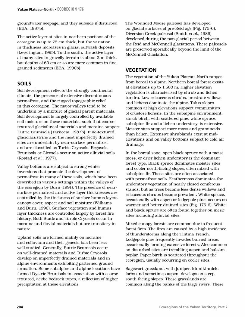
Ecoregions of the Yukon Territory, Part 2
groundwater seepage, and they subside if disturbed (EBA, 1987b).
The active layer at sites in northern portions of the ecoregion is up to 75 cm thick, but the variation in thickness increases in glacial outwash deposits (Leverington, 1995). To the south, the active layer at many sites in gravelly terrain is about 2 m thick, but depths of 60 cm or so are more common in fine-grained sediments (EBA, 1990b).
SOILSSoil development reflects the strongly continental climate, the presence of extensive discontinuous permafrost, and the rugged topographic relief in this ecoregion. The major valleys tend to be underlain by a mixture of glacial parent materials. Soil development is largely controlled by available soil moisture on these materials, such that coarse-textured glaciofluvial materials and moraine support Eutric Brunisols (Tarnocai, 1987b). Fine-textured glaciolacustrine and the most imperfectly drained sites are underlain by near-surface permafrost and are classified as Turbic Cryosols. Regosols, Brunisols or Gleysols occur on active alluvial soils (Rostad et al., 1977).
Valley bottoms are subject to strong winter inversions that promote the development of permafrost in many of these soils, which have been described in various settings within the valleys of the ecoregion by Burn (1991). The presence of near-surface permafrost and active layer thicknesses are controlled by the thickness of surface humus layers, canopy cover, aspect and soil moisture (Williams and Burn, 1996). Surface vegetation and humus layer thickness are controlled largely by forest fire history. Both Static and Turbic Cryosols occur in moraine and fluvial materials but are transitory in nature.
Upland soils are formed mainly on moraine and colluvium and their genesis has been less well studied. Generally, Eutric Brunisols occur on well-drained materials and Turbic Cryosols develop on imperfectly drained materials and in alpine environments exhibiting patterned ground formation. Some subalpine and alpine locations have formed Dystric Brunisols in association with coarse-textured, acidic bedrock types, a reflection of higher precipitation at these elevations.
The Wounded Moose paleosol has developed on glacial surfaces of pre-Reid age (Fig. 175-6). Diversion Creek paleosol (Smith et al., 1986) developed during the non-glacial period between the Reid and McConnell glaciations. These paleosols are preserved sporadically beyond the limit of the McConnell Glaciation.
VEGETATIONThe vegetation of the Yukon Plateau–North ranges from boreal to alpine. Northern boreal forest exists at elevations up to 1,500 m. Higher elevation vegetation is characterized by shrub and lichen tundra. Low ericaceous shrubs, prostrate willows and lichens dominate the alpine. Talus slopes common at high elevations support communities of crustose lichens. In the subalpine environment, shrub birch, with scattered pine, white spruce, subalpine fir and a lichen understory, is extensive. Moister sites support more moss and graminoids than lichen. Extensive shrublands exist at mid-elevations and on valley bottoms subject to cold air drainage.
In the boreal zone, open black spruce with a moist moss, or drier lichen understory is the dominant forest type. Black spruce dominates moister sites and cooler north-facing slopes, often mixed with subalpine fir. These sites are often associated with permafrost soils. Feathermoss dominates the understory vegetation of nearly closed coniferous stands, but as trees become less dense willows and ericaceous shrubs become prevalent. White spruce, occasionally with aspen or lodgepole pine, occurs on warmer and better-drained sites (Fig. 176-6). White and black spruce are often found together on mesic sites including alluvial sites.
Mixed canopy forests are common due to frequent forest fires. The fires are caused by a high incidence of thunderstorms along the Tintina Trench. Lodgepole pine frequently invades burned areas, occasionally forming extensive forests. Also common on disturbed sites are trembling aspen and balsam poplar. Paper birch is scattered throughout the ecoregion, usually occurring on cooler sites.
Sagewort grassland, with juniper, kinnikinnick, forbs and sometimes aspen, develops on steep, south-facing slopes. These grasslands are common along the banks of the large rivers. These
Yukon Plateau–North • ECOREGION 176
204

Ecoregions of the Yukon Territory, Part 2
grasslands are often contiguous with unglaciated high elevation areas, which would have supported similar vegetation during the last glacial period. The elements of the grassland plant communities are considered to be relicts of the glacial period.
Willows, sedges and aquatic plants dominate wetlands on the margins of small lakes, marshes, and shallow open water (Fig. 176-4). Black spruce bogs containing sedge tussocks and sphagnum moss and underlain by permafrost, occur in lowland areas throughout the ecoregion.
WILDLIFE
MammalsThe vast Yukon Plateau–North Ecoregion supports populations of most of the Yukon’s typical boreal forest mammals. Moose, woodland caribou in the Mayo, Ethel Lake, Moose Lake, Tay River, and Finlayson herds, Stone sheep, grizzly bear, black bear, wolverine and marten are all abundant. The size of the Mayo caribou herd is unknown. The Ethel Lake herd numbers about 300, the Moose Lake herd 200, the Tay River herd 4,000, and the Finlayson herd 4,100. Moose and caribou densities were high in the Finlayson Lake area in the 1990s following intensive management, including wolf reduction, from 1983 to 1989 (Larsen and Ward, 1995). The stability of these managed populations is uncertain (Hayes, 1995). The prime wintering area of the Finlayson caribou herd is between Ross River and Finlayson Lake (Farnell and MacDonald, 1987).
The Fannin sheep of the Ddhaw Ghro Habitat Protection Area are relict from the last continental glaciation (Fig. 176-7). The greatest proportion of brown-coloured black bears in the Yukon (45%) occurs between the Stewart and Pelly rivers (Yukon Department of Renewable Resources, 1988). Lynx and red fox are abundant in the Tintina Trench. Mule deer and coyotes, recent colonizers of the Yukon, also live in the Tintina Trench. Mule deer herds are about 12 to 15 individuals. Beavers are abundant in wetland complexes found in the southern Tintina Trench and Ross River Basin. One of the larger microtine rodents, the chestnut-cheeked vole, is confined to colonies in the forests north of the Stewart River. Mammal species known or expected to occur in this ecoregion are listed in Table 4.
BirdsThe southwest border of this ecoregion follows the Tintina Trench, an important migration corridor for large numbers of Sandhill Crane and waterfowl breeding in Alaska. Wetlands are used for breeding and staging by Pacific, Red-throated and Common Loons; Trumpeter Swan; Canada Goose; American Widgeon; Green-winged Teal; scaup; and scoters (Dennington et al., 1983; Dennington, 1985; McKelvey and Hawkings, 1990). Osprey and Bald Eagle also breed around lakes (Dennington et al., 1983).
R. G
ott
hard
t, Y
uko
n G
over
nmen
t
Figure 176-6. An old log deadfall trap for wolverine lies in a clearing on the south side of the McArthur Range, near Woodburn Creek. The forest consists of white spruce with an understory of tall willow and moss–lichen groundcover.
ECOREGION 176 • Yukon Plateau–North
205

Ecoregions of the Yukon Territory, Part 2
Breeding songbirds such as Alder Flycatcher, Orange-crowned Warbler, Yellow Warbler, Northern Waterthrush, Common Yellowthroat, and Fox Sparrow use alder and willow thickets adjacent to marshy lakes (Rand, 1946). Bonaparte’s and Mew Gulls breed at some of these lakes, while Herring Gull more often occurs along rivers (Rand, 1946). The diverse breeding bird community associated with wetlands includes American Kestrel, Lesser Yellowlegs, Solitary Sandpiper, Common Snipe, and Red-winged and Rusty Blackbirds (Osgood, 1909; Johnston and McEwen, 1983).
Many forest bird species reach their northern limit here including Ruffed, Blue, and Sharp-tailed Grouse; Common Nighthawk; Yellow-bellied Sapsucker; Hairy Woodpecker; Western Wood-Pewee; Hermit Thrush; and Townsend’s Warbler (Frisch, 1987). Common year-round residents of
these forests include Spruce Grouse, Great Horned Owl, Three-toed Woodpecker, Black-capped and Boreal Chickadees, Gray Jay, and Common Raven (Osgood, 1909; Rand, 1946). Red-tailed Hawk, Northern Flicker, Olive-sided Flycatcher, Ruby-crowned Kinglet, Swainson’s Thrush, Varied Thrush, Yellow-rumped Warbler, Blackpoll Warbler, and Dark-eyed Junco breed in these forests (Osgood, 1909; Johnston and McEwen, 1983).
Low densities of Gyrfalcon breed in alpine areas accompanied by Rock and White-tailed Ptarmigan, Wandering Tattler, and Gray-crowned Rosy Finch (Osgood, 1909; Beckel [editor], 1975). American Pipits breed on alpine plateaus (Osgood, 1909). At slightly lower elevations, Willow Ptarmigan, Wilson’s Warbler, American Tree Sparrow, and Golden-crowned Sparrow nest in subalpine birch and willow shrubs (Osgood, 1909).
Figure 176-7. The McArthur Mountains within the Ddhaw Ghro Habitat Protection Area have unglaciated ridges between 1,500 and 1,800 m in elevation. The mountains are home to Fannin sheep. The north side of the range is the winter range of the Ethel Lake caribou herd.
C. K
enne
dy,
Yuk
on
Gov
ernm
ent
Yukon Plateau–North • ECOREGION 176
206

Ecoregions of the Yukon Territory, Part 2
Yukon Southern LakesBoreal Cordillera Ecozone
ECOREGION 177
DISTINGUISHING CHARACTERISTICS: Broad valleys and large lakes characterize this
ecoregion. Set within the rain shadow of the St. Elias Mountains, this ecoregion’s
climate is dry and cool. The Yukon Southern Lakes Ecoregion lies in the sporadic
discontinuous permafrost zone, where permafrost underlies less than one-
quarter of the landscape. Soils tend to be alkaline and wetlands (mainly
fens) are typically dominated by marl formation. The ecoregion supports
the highest mammalian diversity in the Yukon, with at least 50 of the
60 species known to occur in the Yukon at present.
Figure 177-1. The north end of Kusawa Lake is a broad U-shaped glacial valley. The surrounding upland is a dissected portion of the Teslin Plateau with a surface elevation 1,000 m higher than the valley floor.
J. M
eikl
e, Y
uko
n G
over
nmen
t
TOTAL AREA OF ECOREGION IN CANADA35,650 km2
TOTAL AREA OF ECOREGION IN THE YUKON29,892 km2
ECOREGION AREA AS A PROPORTION OF THE YUKON6%
APPROXIMATE LAND COVERboreal/subalpine coniferous forest, 65%alpine tundra, 25%rockland, 5%lakes and wetlands, 5%
ELEVATIONAL RANGE610–2,380 m asl mean elevation 1,055 m asl
CORRELATION TO OTHER ECOLOGICAL REGIONS: Equivalent to Lake Labarge Ecoregion (Oswald and Senyk, 1977) • Portion of Cordillera Boreal Region (CEC, 1997) • Southern portion of Interior Yukon Dry Forests (Ricketts et al., 1999)
6000
5500
5000
4500
4000
3500
3000
2500
2000
1500
1000
500
0
6000
5500
5000
4500
4000
3500
3000
2500
2000
1500
1000
500
0
Metres above sea level
207

Ecoregions of the Yukon Territory, Part 2
PHYSIOGRAPHYThe Yukon Southern Lakes Ecoregion, a large area of rounded summits and broad valleys, is part of the Yukon Plateau physiographic unit as defined by Bostock (1948) and Hughes (1987b). Most of this ecoregion is located in the Yukon, but a portion extends south into British Columbia to include the south end of Teslin Lake. The Teslin and Nisutlin plateaus, separated by the Teslin Fault, are the other physiographic subdivisions within this ecoregion (Bostock, 1948; Mathews, 1986). Some mountain groupings are the Sifton, Englishmans and Miners ranges. The topography consists of dissected plateaus, rolling hills and broad valleys occupied by lakes and rivers (Fig. 177-1).
Much of the terrain lies between 1,000 and 1,500 m asl. The highest peak is Mount Arkell at 2377 m asl. Other peaks over 2,000 m asl are Joe Mountain, Mount Lorne, Mount Byng, Pilot Mountain, and peaks in the Sifton and Englishman ranges. The major rivers and Lake Laberge all lie below 760 m asl.
The numerous large lakes and rivers give the ecoregion its name. Most of the lakes, such as Kusawa (Fig. 177-1), Teslin, Marsh and Laberge, and the larger rivers, the Yukon and Teslin, trend northwest–southeast or north–south. This pattern reflects the northwest-trending faults and folds of the bedrock.
BEDROCK GEOLOGYCoarse-grained, crystalline metamorphic and granitic rocks predominate in the eastern and western thirds of this ecoregion, while mafic volcanic rocks, limestone reefs and clastic sediments characterize the central third. The regional rock units are shown by Kindle (1953), Tempelman-Kluit (1974), Wheeler (1961) and Gordey and Stevens (1994a). Certain areas have been mapped in greater detail (Hart, 1997 and references therein) and a contemporary map interpretation of the terranes is given by Gordey and Makepeace (compilers, 2000).
Within the ecoregion are parts of four terranes — Yukon–Tanana, Stikinia, Cache Creek and Dorsey — each with different rock types and origins. The exposed rocks in each are summarized below, beginning in the west.
The area generally west of the Takhini River bridge on the Alaska Highway, belongs to the western part of Yukon–Tanana Terrane, intruded by various granitic components of the Coast Plutonic Complex. The former consists of strongly metamorphosed quartzofeldspathic schist (Erdmer, 1991) flanked by quartz–biotite schist, granitic gneiss, marble and amphibolite (Johnston and Timmerman, 1994). In the Coast Plutonic Complex, the Early Jurassic Little River and the Paleocene Annie Ned batholiths consist of resistant granite, with cliffs and large talus blocks resulting from planar vertical fractures or joints (Hart, 1997).
Northern Stikinia contains sedimentary and volcanic rocks. Augite basalt flows and tuffs of the Povoas Formation of the Lewes River Group predominate on the western part of the terrane. Upper Triassic to Middle Jurassic limestone, argillite, tuffaceous sandstone and conglomerate comprise the Whitehorse Trough (Hart, 1997), which is the largest element of northern Stikinia. Upper Triassic limestone forms sparsely vegetated, light-coloured cliffs, domes and pinnacles east of Lake Laberge (Fig. 177-2), with some notable fossil reef communities (Reid and Tempelman-Kluit, 1987). Areas of thick andesite and basalt flows in the north-central part of the ecoregion include the post-accretion (after Stikinia accreted to ancient North America) mid-Cretaceous Mount Byng, the Late Cretaceous Open Creek, and Carmacks Group (Hart, 1997). The Carmacks Group is notable for its alkaline shoshonitic chemistry (e.g. Johnston et al., 1996; Smuk et al., 1997). Numerous mid-Cretaceous granitic plutons that intrude Stikinia are named after nearby features, including Flat Creek, Haeckel Hill, Cap Mountain and Cap Creek, M’Clintock Lakes, Byng Creek and Mount M’Clintock (Fig. 41 in Hart, 1997). Vesicular basaltic lava erupted near Alligator Lake about 3 million years ago, leaving spatter cones and scoria-covered uplands southwest of Whitehorse. The columnar-jointed basalt lava flows between Cowley Creek, McCrae and the Whitehorse Rapids flowed from vents south of the Mount Sima ski area in several episodes between 15 and 8.5 Ma (Hart and Villeneuve, 1999).
The Cache Creek terrane, east of Carcross and between Marsh and Teslin lakes, contains altered basalt greenstone (Nakina Formation), crinoid- and fusilinid-bearing limestone (Horsefeed Formation)
Yukon Southern Lakes • ECOREGION 177
208

Ecoregions of the Yukon Territory, Part 2
and ribbon chert-rich Kedahda Formation (Monger, 1975; Hart and Pelletier, 1989a,b). Pods of serpentinized peridotite up to several kilometres long (Gordey and Stevens, 1994b) weather black and, where not covered by glacial deposits, support only stunted vegetation.
Northeast of Teslin Lake are strips of Quesnel, Yukon–Tanana and Cassiar terranes (Gordey and Stevens, 1994a). Rock types include siliceous argillite, siltstone and sandstone with abundant fresh augite crystals. Quartz–mica phyllite is flanked to the northeast by sandstone, grit, chert and chert pebble conglomerate. Small hornblende–biotite quartz monzonite plutons throughout the Thirtymile Range, and biotite granite with up to 40% pink feldspar phenocrysts in the Englishman’s Range and west of Quiet Lake, constitute about one-fifth of the eastern third of the ecoregion.
The central part of the ecoregion has significant mineral potential and a long mining history. Copper in limestone skarns has been mined in 13 places (Watson, 1984) immediately west of Whitehorse.
Coal seams have been investigated 24 km south of the city (Bremner, 1988; Hunt and Hart, 1994). Gold in quartz veins has been explored throughout the area south of Whitehorse (Hart and Radloff, 1990). Gold also occurs in altered rocks around Cache Creek ultramafic pods (e.g. Hart, 1996). East of Teslin River is the Red Mountain molybdenum porphyry, about 20 silver–lead–zinc veins, and both copper–iron and tin–tungsten skarn deposits, all related to Cretaceous plutons. Baked mudstone (Laberge Group) in a unique occurrence west of Fish Lake has traditionally been used for cutting and scraping tools (Gotthardt and Hare, 1994).
SURFICIAL GEOLOGY AND GEOMORPHOLOGYThe main sources of surficial geology information for the Yukon Southern Lakes Ecoregion are several surficial geology and soil maps (Rostad et al., 1977; Morison and McKenna, 1981; Klassen and Morison, 1987; Morison and Klassen, 1991; Mougeot and Smith, 1992 and 1994) and maps of terrain hazards
ECOREGION 177 • Yukon Southern Lakes
Figure 177-2. Carbonate cliffs (remnants of large reefs of middle Triassic age) and dense forest flank the east side of Lake Laberge. The rocky headlands and long north–south reach of the lake make small boat travel hazardous during summer stormy weather.
C.D
. Eck
ert,
Yuk
on
Gov
ernm
ent
209

Ecoregions of the Yukon Territory, Part 2
and geological information for all maps sheets (Yukon GEOPROCESS file, 2002).
The surface deposits of the Yukon Southern Lake Ecoregion are associated with the most recent Cordilleran glaciation, the McConnell, believed to have covered the south and central Yukon between 26,500 and 10,000 years ago. Most of the ecoregion was covered by ice that flowed towards the northwest from the Cassiar Mountains. Streamlined moraine deposits, primarily drumlins, are abundant west and north of Lake Laberge, all indicating a northwesterly ice flow direction. After the maximum extent of McConnell ice, deglaciation produced disrupted drainage systems and large glacial lakes as a result of a complex assemblage of ice lobes, which were restricted to valley bottoms and controlled by local topography.
Quaternary deposits are distributed in a general pattern. Representative sequences of Quaternary deposits are found in many major valleys such as the Yukon River Valley. High elevation slopes and summits are covered with a discontinuous colluvium or moraine veneer over bedrock. Where exposed, the bedrock is weathered or frost-shattered.
Glacial till, often gullied, covers most mid-elevation slopes mixed with colluvial fans or aprons. The general composition of the till matrix in adjoining map sheets (Jackson, 1994) indicates a wide range of sand content (20 to 70%), of silt (20 to 80%), and usually a lower clay content (5 to 30%). Isolated lenses of ice-rich permafrost may be present on north-facing slopes and at high elevations where thick organic deposits are present over the Quaternary sediments.
Glaciofluvial sand and gravel terraces flank the valley sides while pitted or hummocky deposits of sand and gravel line the bottom of some valleys. These deposits usually are free of permafrost and have stable surfaces, but may contain undesirable, or weak, lithologies for potential use as aggregate. In addition to the glaciofluvial gravel, the largest river floors contain alluvial deposits.
During deglaciation, large volumes of meltwater were dammed in some valleys and formed large glacial lakes. Beachlines, lake bottom sediments and many modern lakes can now be found in these valleys. In the Takhini River and Tagish River valleys, Glacial Lake Champagne deposited up to 75 m of silt and
Figure 177-3. The Takhini River Valley is filled with glaciolacustrine sediments that were deposited beneath glacial Lake Champagne between 9,000 and 10,000 years ago. Western portions of the Takhini Valley receive only 200 mm of precipitation annually. Light precipitation has resulted in very slow regeneration of mixed forest cover that has replaced the white spruce and lodgepole pine that was burned in 1958.
J. M
eikl
e, Y
uko
n G
over
nmen
t
Yukon Southern Lakes • ECOREGION 177
210

Ecoregions of the Yukon Territory, Part 2
clay (Fig. 177-3). Glaciolacustrine silt and clay deposits border Teslin Lake, Little Atlin and Atlin lakes, as well as the Nisutlin River valley and the Red River valley north of Fish Lake, and can be as thick as 15 m. They commonly contain massive ice bodies and are prone to retrogressive thaw slides and thermokarst degradation when disturbed either by river erosion, forest fires, or other changes in surface conditions.
GLACIAL HISTORYThe Yukon Southern Lakes area is dominated by till, glaciofluvial gravels and glaciolacustrine clay and silt deposited during the McConnell Glaciation (Bostock, 1966; Hughes, 1969a). Ice flowed into the area from the Cassiar Mountains to the southeast and the eastern Coast Mountains to the southwest (Jackson and Mackay, 1991; Jackson et al., 1991; Ryder and Maynard, 1991). Trunk glaciers followed the major valleys and flowed northwestward across this region to terminate in the central Yukon. The streamlined topography of this region was shaped by this flow. Glacial ice covered the lowland some time after 26,000 years ago and was probably gone well before 9,000 years ago (Jackson et al., 1991). Blockage of meltwater drainage, possibly supplemented by isostatic depression, created extensive lakes in the ecoregion during deglaciation, so that Lowlands are often underlain by glaciolacustrine sediments (Fig. 177-3). During the postglacial period, streams incised into the thick drift of this region leaving steep-sided canyons and flights of terraces.
CLIMATEThe orientation of the topography is primarily northwest-trending over its eastern section, but has an east–west orientation over its western portion. This arid ecoregion lies in the heart of the rain shadow of the St. Elias–Coast Mountains. Precipitation ranges from 200 to 325 mm. One-third to one-half of this falls during the summer, primarily as showers. A secondary maximum occurs in the fall and early winter associated with active storm centres in the Gulf of Alaska. Snow cover is generally in place from late October to mid-April in the valley floors, and a month longer over the higher terrain.
Mean annual temperatures are near –1 to –2°C over the southeastern portion of this ecoregion, and –3 to –4°C in the northwest. Mean January temperatures range from –21°C in the southeast to –25°C in the northwest. Mean temperatures are five degrees warmer over higher terrain due to the inversion. Short periods with temperatures above zero can be expected during the winter. July mean temperatures range from 12 to 14°C and some five degrees cooler over higher terrain. Extreme temperatures have ranged from –55 to 34°C. Temperature extremes are not as great as in the Yukon interior valleys, due to the higher elevations of valley floors in this ecoregion. In the immediate vicinity of the larger lakes, spring can be delayed up to two weeks due to the persistence of the ice cover. Conversely, the onset of cold winter temperatures can be delayed from two weeks to a month due to the extensive low cloud associated with the lakes as they freeze over in November and December.
In valleys with southeast to northwest orientation, winds are common because of the proximity of storm centres in the Gulf of Alaska. Strong winds typically range from 30 to 50 km/hr and occasionally reach destructive force with gusts over 100 km/hr, primarily from a southerly direction (Fig. 177-4).
HYDROLOGYThe Yukon Southern Lakes Ecoregion is situated within the Interior Hydrologic Region, although it forms a boundary with the Western Hydrologic Region (Fig. 8). With a total area of approximately 30,000 km2, the ecoregion primarily drains northward from the upland plateau complex consisting of the Teslin and Nisutlin plateaus. The western portion of the ecoregion consists of the footslopes of the Coast Mountains, and as such has greater relief and subsequently higher runoff and peak flows than the central and eastern portion of the ecoregion. Major streams include the Teslin River, which makes up part of the eastern boundary, the upper Yukon River, and the Takhini River. Several smaller, more representative intermediate-sized tributaries of the Yukon include the Nisutlin, Wolf and M’Clintock rivers. The Dezadeash and Aishihik rivers at the western corner flow westward into the Alsek River. Wetlands and large lakes cover approximately 5% of the ecoregion. The ecoregion contains several large lakes including Teslin, Wolf, Marsh and Laberge (Fig. 177-2). The most significant
ECOREGION 177 • Yukon Southern Lakes
211

Ecoregions of the Yukon Territory, Part 2
wetland complex is the Nisutlin River and Delta (Fig. 177-5). Other wetlands include the M’Clintock and Yukon River downstream of Marsh Lake.
There are seven representative hydrometric stations: Teslin (two), Nisutlin, Lubbock, M’Clintock and Ibex rivers, and Sidney Creek. Annual streamflow is characterized by a rapid increase in snowmelt discharge, to a peak in June, with secondary rainfall peaks later in the summer. On smaller streams, approximately 40% of the annual maximum flows are due to intense summer rainstorm events. The mean annual runoff is moderate, though variable, with a range of values of 73 to 366 mm and an ecosystem mean value of 245 mm. Mean seasonal and summer flows are moderate, with values of 14
X 10–3 and 11 X 10–3 m3/s/km2, respectively. The mean annual flood and mean maximum summer flow are moderately low with values of 44 X 10–3 and 29 X 10–3 m3/s/km2, respectively, respectively. Minimum streamflow generally occurs during April, with the relative magnitude reasonably high due to the moderating influence of the Gulf of Alaska on winter temperatures and subsequent groundwater contributions. The minimum annual and summer flows are high and moderate with values of 1.6 X 10⁻³ and 3.9 X 10⁻³ m3/s/km2, respectively. Only very small streams may experience zero winter flows during cold winters.
PERMAFROSTThe Yukon Southern Lakes Ecoregion lies in the sporadic discontinuous permafrost zone, where permafrost underlies less than one-quarter of the landscape. East of Whitehorse, less than 8% of the Alaska Highway is built on permafrost (Brown, 1967) and less than 5% of holes drilled in association with the Alaska Highway gas pipeline encountered permafrost (Rampton et al., 1983). Between Whitehorse and Haines Junction, however, the gas pipeline drilling encountered permafrost in 20% of holes. The active layer in mineral soil is commonly over 1.5 m thick, and so permafrost may not be identified at sites of shallow inspection. In wet, organic terrain, the active layer may be less than 1 m. In the Takhini River Valley, there is up to 15 m of permafrost (Fig. 21), and the mean near-surface temperature is –0.8°C. However, when permafrost is encountered in Whitehorse or Teslin, it is only 2 or 3 m thick (Burgess et al., 1982; EBA, 1995). Permafrost is infrequent because, in the rain shadow of the Coast Mountains, the ecoregion is dry, and thus the soils are warm in summer. Permafrost has rarely been recorded in numerous excavations in coarse materials near Carcross, Teslin, or Tagish (e.g. Department of Highways and Public Works, 1981a; EBA, 1987c, 1988b, 1993), but in moist, silty soils, overlain by a peaty organic layer, ground ice is more frequent (Department of Highways and Public Works, 1981b).
Terrain features associated with permafrost degradation are more common than those associated with aggradation. As in many other ecoregions, glaciolacustrine sediments often contain substantial ground ice. Thermokarst lakes occur where the ice is melting, as in the Takhini Valley. Widespread subsidence in these terrains
Figure 177-4. Sand dunes near Carcross are composed of sediments reworked from nearby glaciofluviual deposits by strong winds through the coastal mountains to the southwest. The lupine (Lupinus kuscheii) and sedge (Carex sabulosa) in the foregound stabilize these dunes. These species are known in only a handful of other Yukon locations.
M. H
oef
s
Yukon Southern Lakes • ECOREGION 177
212
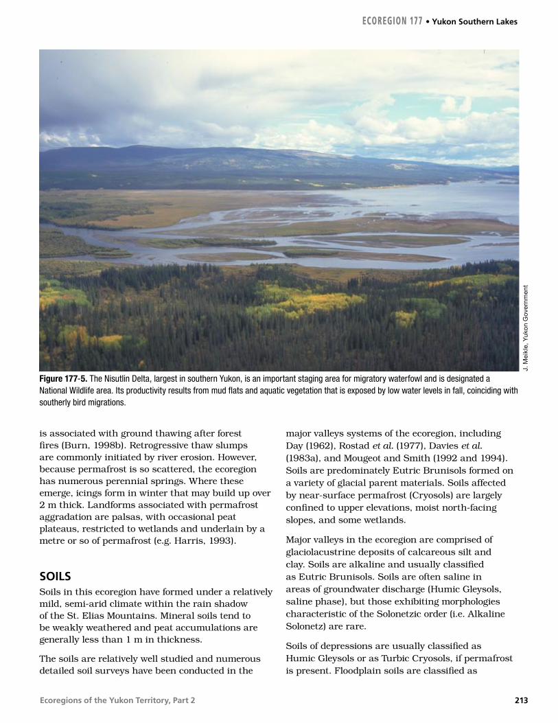
Ecoregions of the Yukon Territory, Part 2
is associated with ground thawing after forest fires (Burn, 1998b). Retrogressive thaw slumps are commonly initiated by river erosion. However, because permafrost is so scattered, the ecoregion has numerous perennial springs. Where these emerge, icings form in winter that may build up over 2 m thick. Landforms associated with permafrost aggradation are palsas, with occasional peat plateaus, restricted to wetlands and underlain by a metre or so of permafrost (e.g. Harris, 1993).
SOILSSoils in this ecoregion have formed under a relatively mild, semi-arid climate within the rain shadow of the St. Elias Mountains. Mineral soils tend to be weakly weathered and peat accumulations are generally less than 1 m in thickness.
The soils are relatively well studied and numerous detailed soil surveys have been conducted in the
major valleys systems of the ecoregion, including Day (1962), Rostad et al. (1977), Davies et al. (1983a), and Mougeot and Smith (1992 and 1994). Soils are predominately Eutric Brunisols formed on a variety of glacial parent materials. Soils affected by near-surface permafrost (Cryosols) are largely confined to upper elevations, moist north-facing slopes, and some wetlands.
Major valleys in the ecoregion are comprised of glaciolacustrine deposits of calcareous silt and clay. Soils are alkaline and usually classified as Eutric Brunisols. Soils are often saline in areas of groundwater discharge (Humic Gleysols, saline phase), but those exhibiting morphologies characteristic of the Solonetzic order (i.e. Alkaline Solonetz) are rare.
Soils of depressions are usually classified as Humic Gleysols or as Turbic Cryosols, if permafrost is present. Floodplain soils are classified as
Figure 177-5. The Nisutlin Delta, largest in southern Yukon, is an important staging area for migratory waterfowl and is designated a National Wildlife area. Its productivity results from mud flats and aquatic vegetation that is exposed by low water levels in fall, coinciding with southerly bird migrations.
J. M
eikl
e, Y
uko
n G
over
nmen
t
ECOREGION 177 • Yukon Southern Lakes
213
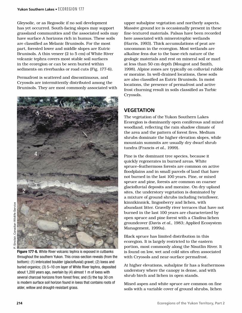
Ecoregions of the Yukon Territory, Part 2
Gleysolic, or as Regosolic if no soil development has yet occurred. South-facing slopes may support grassland communities and the associated soils may have surface A horizons rich in humus. These soils are classified as Melanic Brunisols. For the most part, forested lower and middle slopes are Eutric Brunisols. A thin veneer (2 to 5 cm) of White River volcanic tephra covers most stable soil surfaces in the ecoregion or can be seen buried within sediments on riverbanks or road cuts (Fig. 177-6).
Permafrost is scattered and discontinuous, and Cryosols are intermittently distributed among the Brunisols. They are most commonly associated with
upper subalpine vegetation and northerly aspects. Massive ground ice is occasionally present in these fine-textured materials. Palsas have been recorded here associated with minerotrophic wetlands (Harris, 1993). Thick accumulations of peat are uncommon in the ecoregion. Most wetlands are alkaline fens due to the base-rich nature of the geologic materials and rest on mineral soil or marl at less than 50 cm depth (Mougeot and Smith, 1998). Alpine zones are typically on colluvial rubble or moraine. In well-drained locations, these soils are also classified as Eutric Brunisols. In moist locations, the presence of permafrost and active frost churning result in soils classified as Turbic Cryosols.
VEGETATIONThe vegetation of the Yukon Southern Lakes Ecoregion is dominantly open coniferous and mixed woodland, reflecting the rain shadow climate of the area and the pattern of forest fires. Medium shrubs dominate the higher elevation slopes, while mountain summits are usually dry dwarf shrub tundra (Francis et al., 1999).
Pine is the dominant tree species, because it quickly regenerates in burned areas. White spruce–feathermoss forests are common on active floodplains and in small parcels of land that have not burned in the last 100 years. Pine, or mixed spruce and pine, forests are common on coarser glaciofluvial deposits and moraine. On dry upland sites, the understory vegetation is dominated by a mixture of ground shrubs including twinflower, kinnikinnick, lingonberry and lichen, with abundant litter. Gravelly river terraces that have not burned in the last 100 years are characterized by open spruce and pine forest with a Cladina lichen groundcover (Davis et al., 1983; Applied Ecosystem Management, 1999a).
Black spruce has limited distribution in this ecoregion. It is largely restricted to the eastern portion, most commonly along the Nisutlin River. It is found on low, wet and cold sites often associated with Cryosols and near-surface permafrost.
At higher elevations, subalpine fir has a feathermoss understory where the canopy is dense, and with shrub birch and lichen in open stands.
Mixed aspen and white spruce are common on fine soils with a variable cover of ground shrubs, lichen
Figure 177-6. White River volcanic tephra is exposed in cutbanks throughout the southern Yukon. This cross-section reveals (from the bottom): (1) imbricated boulder (glaciofluvial) gravel; (2) loess and buried organics; (3) 5–10 cm layer of White River tephra, deposited about 1,200 years ago, overlain by (4) almost 1 m of loess with several charcoal horizons from forest fires; and (5) the top 30 cm is modern surface soil horizon found in loess that contains roots of alder, willow and drought-resistant grass.
P. S
incl
air,
Can
adia
n W
ildlif
e S
ervi
ce
1
32
4
5
Yukon Southern Lakes • ECOREGION 177
214

Ecoregions of the Yukon Territory, Part 2
and litter. Willow and soapberry are common. Aspen is also found on steep south-facing slopes, often with small pockets of spruce occupying the moister sites. Balsam poplar is found on roadsides and along creeks and rivers; it is an early invader and usually replaced in the successional sequence by white spruce. Paper birch is scattered on cooler, moister sites, but is neither common nor known to form pure stands.
Open areas at low elevations include grasslands on steep south-facing slopes and alkaline lacustrine depressions, such as those found in the Takhini Valley. Shrub birch is common in moist depressions subject to cold air drainage. Willows dominate fen and marsh wetlands and are common in areas subject to flooding (Oswald and Brown, 1986).
Around treeline, shrub birch, underlain by lichen and moss, takes over the drier sites. On moister and north-facing sites, willow and shrub birch with moss groundcover are more dominant. The alpine dwarf shrub tundra found at higher elevations includes willow, lingonberry, bearberry, bilberry, and mat or cushion plants such as dryas, lichen and graminoids. The vegetation cover is sparse on the most exposed sites.
WILDLIFE
MammalsThe topographically diverse Yukon Southern Lakes Ecoregion supports the highest mammalian diversity in the Yukon with at least 50 of the 60 or more Yukon species. Dall sheep (Barichello et al., 1989a), grizzly bear (Larsen and Markel, 1989), wolves (Hayes et al., 1991), coyotes, red fox, and wolverine (Banci, 1987) are abundant. Wolf and wolverine densities are among the highest in the Yukon. Coyotes invaded the territory in the early 20th century, probably benefiting from widespread wolf control across North America and the ability to outcompete red fox. Coyotes are most abundant in the southern Yukon and range north to the Klondike Plateau and Yukon Plateau–Central. Stone sheep are found east of Lake Laberge.
A long history of overharvesting of moose and caribou populations throughout much of this ecoregion required management programs that restricted human harvest beginning in the 1990s (Larsen et al., 1986, 1989). The Carcross–Squanga,
Ibex and Atlin woodland caribou herds are small and fragmented, estimated at 300, 400, and 800 caribou, respectively. The Carcross–Squanga and Ibex herds are not restricted to smaller winter ranges by snowfall, and therefore expose themselves to more wolf packs. The more remote Wolf Lake caribou herd to the east is considered healthy (Farnell and MacDonald, 1989), with 1400 animals estimated in 1998.
A small population of mountain goats was re-established on White Mountain in 1983–1984 following their extirpation in the 1960s (Barichello et al., 1989b). An elk herd, introduced in the 1950s, with additions for genetic outcrossing in the 1990s, has survived in the Takhini River Valley and numbers about 60. Mule deer are common in this ecoregion and are often seen in small herds of 12 to 15 (Fig. 177-7).
The Teslin burn of 1958 supports some of the highest densities of moose, wolves, snowshoe hare and lynx in the Yukon. The lynx density in 1990–1991 of 45/100 km2 was the highest ever reported in North America (Slough and Mowat, 1996). Beavers are also abundant where burns and wetlands meet, as in the Teslin burn (Slough and Jessup, 1984). Muskrats are still common but once thrived in the Lewes River marsh before flow control, which has altered seasonal water level fluctuations.
The cougar, with the greatest range of any mammal in the Western Hemisphere, makes infrequent movements through this area from northern British Columbia. Marten are uncommon west of the Teslin River; however, a transplant program and natural colonization in the 1980s have increased marten abundance in local climax coniferous habitats, primarily at higher elevations (Slough, 1989).
The northern flying squirrel, bushy-tailed wood rat and woodchuck are uncommonly seen residents. Arctic ground squirrels and least chipmunks flourish in the forest openings and grassy slopes common in the ecoregion. The only know location of the western jumping mouse in the Yukon is on the South Canol Road. The meadow jumping mouse is common throughout the southern Yukon (Youngman, 1975). There is abundant aquatic habitat for water shrew in the ecoregion. The house mouse, originating in mid-eastern Asia and now a world traveler, has taken up residence around the habitations of Whitehorse.
ECOREGION 177 • Yukon Southern Lakes
215

Ecoregions of the Yukon Territory, Part 2
The little brown myotis bat is abundant near lakes where it gleans insects on the wing. It probably winters in coastal Alaska. Bats have received little attention in the Yukon, and other species may yet be found, especially in the south and near the coast. Bat species found near the Yukon include the long-legged myotis, Keen’s long-eared myotis, the silver-haired bat and the big brown bat (van Zyll de Jong, 1985; Nagorsen and Brigham, 1993; Parker et al., 1997; Slough, 1998). Mammal species known or expected to occur in this ecoregion are listed in Table 4.
BirdsThe inlets and outlets of the large lakes provide some of the most important waterfowl staging areas in the Yukon (Department of Renewable Resources, 1994). Perhaps the most significant waterfowl staging area in early spring is the Marsh Lake outlet from M’Clintock Bay and the adjacent Lewes River marsh (Johnston and McEwen, 1983; Hawkings, 1994; Eckert, 1997c). Early open water and exposed mud
flats and sandbars make M’Clintock Bay a spring staging site of national importance (Yukon Waterfowl Technical Committee, 1991) hosting up to 2,000 swans a day (Mossop, 1976; Hawkings, 1994).
Along with M’Clintock Bay and Lewes Marsh, Tagish Narrows between Tagish Lake and Marsh Lake are important to a variety of other waterbirds such as Red-throated, Pacific and Common Loons; Horned and Red-necked Grebes; and virtually all southern Yukon geese and ducks (Mossop, 1976; Canadian Wildlife Service, 1979b; Johnston and McEwen, 1983; Hawkings, 1986; Yukon Waterfowl Technical Committee, 1991; Eckert, 1997c). These areas are equally important to numerous shorebirds such as American Golden-Plover; Semipalmated Plover; Lesser Yellowlegs; Semipalmated, Least, and Pectoral Sandpipers; Common Snipe (Eckert, 1997c; Eckert, 1997d); and migrant songbirds such as American Robin, American Pipit, Lapland Longspur and Rusty Blackbird (Eckert, 1997c). Other important staging areas are upper Lake Laberge and the Teslin Lake outlet (Yukon Waterfowl Technical Committee, 1991).
Figure 177-7. Mule deer (Odocoileus hemionus) spend much of the year in small herds of up to 15 animals. The deer (including occasional white-tailed deer) are increasing in numbers in the Yukon Southern Lakes Ecoregion.
M. H
oef
s
Yukon Southern Lakes • ECOREGION 177
216

Ecoregions of the Yukon Territory, Part 2
The Nisutlin River Delta (Fig. 177-5) is a fall staging area of national importance for swans, geese, dabbling ducks, and diving ducks (Mossop and Coleman, 1984; Yukon Waterfowl Technical Committee, 1991; Hawkings, 1994). While spring water levels are high at the Nisutlin Delta, they decrease in the late summer and fall to expose extensive mud flats and dense beds of aquatic vegetation (Dennington, 1985). The exposed mud flats also provide important feeding areas for many migrant shorebirds including Semipalmated Plover; Lesser Yellowlegs; Semipalmated, Least, Baird’s, and Pectoral Sandpipers; Long-billed Dowitcher; and migrant songbirds such as American Pipit and Lapland Longspur (Eckert, 1997a, 1998a). One of North America’s rarest migrant shorebirds, the Sharp-tailed Sandpiper, is apparently a regular fall migrant here (Eckert, 1997a, 1998a). The large numbers of waterfowl and shorebirds in turn attract numerous predators such as Bald Eagle, Merlin, Peregrine Falcon, and Gyrfalcon (Mossop and Coleman, 1984; Eckert, 1997a, 1998a). Southbound Trumpeter Swans arrive on the delta in mid-September and by late September are greatly outnumbered by large flocks of migrating Tundra Swans, a few of which linger until freeze-up (Mossop and Coleman, 1984; Eckert, 1997a, 1998a).
The lower Nisutlin River is a rare example of a river supporting large numbers of breeding waterfowl (Hawkings, 1994). The river’s abundant cut-off channels, oxbows, and sloughs harbour breeding and moulting Canada Goose, American Widgeon, Mallard, Green-winged Teal, Ring-necked Ducks, scaup, and goldeneye (Dennington, 1985; Hawkings, 1994). Since 1992, these wetlands have hosted the highest density of breeding Trumpeter Swan in the Yukon (Hawkings, 1994). During fall migration from early September to late October, large lakes and other sites that concentrate gulls witness movements of Thayer’s Gull with lesser numbers of Glaucous Gull (Eckert, 1998a; Canadian Wildlife Service, unpubl.).
Larger lakes and rivers support breeding Pacific and Common Loons, Surf Scoter, Mew and Herring Gulls, Arctic Tern, and Belted Kingfisher (Rand, 1946; Godfrey, 1951; Stelfox, 1972; Canadian Wildlife Service, 1979a; Nixon et al., 1992). Numerous wetlands such as Swan Lake (Grunberg, 1994), Rat Lake, Cowley Lake, McIntyre Creek, Mary Lake and Chinook Creek are important to many waterfowl as well as Pied-billed Grebe, Sora, and
American Coot (CWS, Birds of the Yukon Database). McIntyre Creek wetlands are especially important to very large numbers of migrating swallows especially Tree, Violet-green, Northern Rough-winged, Bank, and Cliff Swallows (Eckert, 1997c; Canadian Wildlife Service, unpubl.).
Marshy areas associated with lakes, streams and ponds have breeding Northern Harrier, Lesser Yellowlegs, Solitary and Least Sandpipers, Common Snipe, Wilson’s and Red-necked Phalaropes, Bonaparte’s Gull, Rusty and Red-winged Blackbirds, Northern Waterthrush, Common Yellowthroat, and Savannah and Lincoln’s Sparrows (Grunberg, 1994; Eckert, 1999b; Canadian Wildlife Service, unpubl.). Rocky and sandy lakeshores provide breeding habitat for Semipalmated Plover, Killdeer, Spotted Sandpiper, and Arctic Tern (Johnston and McEwen, 1983; Canadian Wildlife Service, unpubl.), while Harlequin Ducks and American Dippers breed on swift mountain streams (Soper, 1954). Osprey and Bald Eagle nest near lakes and rivers containing spawning fish (Yukon Wildlife Branch, 1977).
Deciduous and mixed forests in riparian areas support breeding Yellow-bellied Sapsucker, Hammond’s Flycatcher, Yellow Warbler, Chipping Sparrow, and Fox Sparrow, with Least Flycatcher occurring locally in trembling aspen forests (e.g. Grunberg, 1994). Ruffed Grouse are year-round residents of trembling aspen forests, while Blue Grouse inhabit subalpine forests (Rand, 1946). Rufous Hummingbirds reach their northern limit in the Southern Lakes Ecoregion although breeding there is unconfirmed (Canadian Wildlife Service, unpubl.).
Open mixed woodland and coniferous forests support raptors such as Northern Goshawk, Red-tailed Hawk, Great Horned Owl, Northern Hawk Owl, Great Gray Owl, and Boreal Owl (Rand, 1946; Godfrey, 1951). Year-round residents include Three-toed, Black-backed, Downy, and Hairy Woodpeckers; Spruce Grouse; Gray Jay; Black-billed Magpie; Common Raven; Black-capped and Boreal Chickadees; Bohemian Waxwing; Pine Grosbeak; and White-winged Crossbill; also, Red Crossbill regularly occur at a few locations (Eckert et al., 1995). Common and Hoary Redpolls occur regularly in winter (Eckert et al., 1995). Common forest species include Olive-sided Flycatcher, Western Wood-Pewee, Ruby-crowned Kinglet, Swainson’s Thrush, American Robin, Varied Thrush, Warbling Vireo, Yellow-rumped Warbler, Blackpoll Warbler,
ECOREGION 177 • Yukon Southern Lakes
217

Ecoregions of the Yukon Territory, Part 2
Dark-eyed Junco, Purple Finch, and in mature spruce forests, Golden Crowned Kinglet (Department of Renewable Resources, 1994; Grunberg, 1994; Eckert et al., 1995; Canadian Wildlife Service, unpubl.). Open country species include Common Nighthawk, Say’s Phoebe, Mountain Bluebird, and Brown-headed Cowbird (Eckert et al., 1995), with Fox and White-crowned Sparrows in shrubby areas (Canadian Wildlife Service, unpubl.)
Alpine areas support Golden Eagle and Gyrfalcon (Foothills Pipe Lines Ltd., 1978; Department of Renewable Resources, 1994). A few Rock and
White-tailed Ptarmigan inhabit these exposed rocky areas, while Willow Ptarmigan are common in subalpine willow and alder shrub (Department of Renewable Resources, 1994). Shrubby subalpine areas also provide breeding habitat for Dusky Flycatcher; Northern Shrike; Townsend’s Solitaire; Wilson’s Warbler; American Tree, Brewer’s, and Golden-crowned Sparrows; and Common Redpoll (Department of Renewable Resources, 1994; Canadian Wildlife Service, unpubl.).
Yukon Southern Lakes • ECOREGION 177
218

Ecoregions of the Yukon Territory, Part 2
Figure 178-1. The Dorsey Range of the Pelly Mountains is composed of metamorphic and granitic rock. Steep-sided mountains with long slopes of blocky talus, typically covered with lichen, characterize the landscape. Higher slopes are frequented by woodland caribou, Stone sheep and mountain goat. This view is southeastward toward Dorsey Lake.
C.F
. Ro
ots
, Geo
log
ical
Sur
vey
of C
anad
a
Pelly Mountains
DISTINGUISHING CHARACTERISTICS: The ecoregion includes two major mountain ranges,
separated by the Dease Plateau; the more rugged Pelly Mountains in the north
and the Cassiar Mountains in the south. The ecoregion encompasses a major
hydrologic divide, with the Teslin and Pelly rivers of the Yukon River watershed
and Liard River tributaries of the Mackenzie River watershed. The relatively
high relief of this ecoregion results in high runoff and peak flows in
summer. The ecoregion provides habitat to Stone sheep, mountain
goats and the Pelly and Wolf Lake caribou herds.
TOTAL AREA OF ECOREGION IN CANADA35,580 km2
TOTAL AREA OF ECOREGION IN THE YUKON34,258 km2
ECOREGION AREA AS A PROPORTION OF THE YUKON7%
APPROXIMATE LAND COVERboreal/subalpine coniferous forest, 50%alpine tundra, 35%alpine rockland, 10%lakes and wetlands, 5%
ELEVATIONAL RANGE600–2,400 m aslmean elevation 1,350 m asl
6000
5500
5000
4500
4000
3500
3000
2500
2000
1500
1000
500
0
6000
5500
5000
4500
4000
3500
3000
2500
2000
1500
1000
500
0
Metres above sea level
CORRELATION TO OTHER ECOLOGICAL REGIONS: Equivalent to Pelly Mountains Ecoregion (Oswald and Senyk, 1977) • Portion of Cordillera Boreal Region (CEC, 1997) • Northern portion of Northern Cordilleran Forests (Ricketts et al., 1999)
Boreal Cordillera Ecozone
ECOREGION 178
219

Ecoregions of the Yukon Territory, Part 2
PHYSIOGRAPHYThe Pelly Mountains Ecoregion is comprised mainly of the Pelly Mountains, the northernmost extent of the Cassiar Mountains, the Dease Plateau, and the Simpson Ranges (Mathews, 1986). The Simpson Ranges are a southern extension of the Selwyn Mountains (Mathews, 1986). Bostock (1948) and Hughes (1987b) have included the Pelly Mountains and the Simpson Ranges as part of the Yukon Plateau and the Dease Plateau with the Cassiar Mountains. Maps of the National Topographic System place the Simpson Ranges and the smaller adjacent Campbell Range as part of the Pelly Mountains. The Saint Cyr, Big Salmon and Glenlyon ranges comprise the Pelly Mountains. A small portion of this ecoregion extends south into British Columbia.
This ecoregion is a rolling plateau topped by numerous mountain peaks and dissected in places by small rivers (Fig. 178-1). The relief is generally greater than 1,500 m asl, with a maximum elevation of 2,404 m asl in the Saint Cyr Range. Relief is greater in the Pelly Mountains than in the Cassiar Mountains to the south (Hughes, 1987b).
BEDROCK GEOLOGYThe Pelly Mountains Ecoregion is entirely within the Omineca Morphological Belt (Fig. 4), an area of uplifted sedimentary, metamorphic and granitic rocks. The northwest-trending axis of the ecoregion is the Cassiar Platform (Fig. 5), composed of continentally derived Paleozoic clastic and carbonate rocks; to the southwest are Dorsey and Yukon–Tanana (also called Kootenay) terranes. Part of the ecoregion is northeast of the Tintina Trench and provides excellent exposure of Yukon–Tanana terrane.
The types of bedrock and their distribution are shown by Poole et al. (1960). Gordey and Stevens (1994b). Tempelman-Kluit (1974 and 1984). Gordey and Irwin (1978) and Campbell (1967).
The metamorphic rocks of the area display multiple generations of folding with mica development and pronounced cleavage, both of which allow preferential erosion parallel to the regional structural grain. In contrast, granitic bodies, which are about 100 million years old and underlie about one-fifth of the ecoregion, post-date regional deformation. They form steep slopes and cliffs and
underlie high standing areas with fields of grey-weathering boulders. The largest is the 350 km long Cassiar Batholith, of which its 90 km length in the Yukon is enclosed within the Pelly Mountains Ecoregion.
The oldest and most extensive rock unit in the Cassiar Platform is metamorphosed sandstone and shale (the Ingenika Group of Late Proterozoic age) overlain by marble (Murphy, 1988). Northeast of this expanse is an arcuate belt containing grey and black slate and phyllite with lesser amygdaloid basalt, known as Kechika Group of Upper Cambrian to Lower Ordovician age, in turn overlain to the northeast by younger black shale, chert and conglomerate. These latter rocks are similar in age and lithology to the Road River and Earn groups of the North American miogeocline, suggesting that the Cassiar Platform may be a displaced sliver of the ancient continent. However, the Platform is separated from the miogeocline by the Saint Cyr Range, between the Saint Cyr and Tintina faults, a series of Paleozoic metasedimentary rocks (platy limestone, phyllitic calcareous siltstone, green slate and blue–grey phyllite) whose origin is unknown.
The southeast prong of the ecoregion has been referred to as Kootenay terrane (Gordey and Stevens, 1994a) and Teslin Suture Zone. However, the metasedimentary and metavolcanic rocks there are comparable to the Yukon–Tanana terrane south of Finlayson Lake (Murphy, 1998; Murphy et al., 2001). In both places, three broad units are recognized: at the base, quartz muscovite chlorite schist, quartzite and graphitic phyllite are intruded by Early Mississippian hornblende-bearing metamorphosed granite and orthogneiss; this is overlain by mafic schist and amphibolite, which is in turn overlain by ridge-forming quartz metasandstone and conglomerate.
South of Wolf Lake lies a portion of Dorsey terrane, which includes the deformed granite Ram stock, of Permian age, surrounded by Paleozoic metavolcanic rock, schist, quartzite and ribbon chert. Near the Swift River are numerous limestone bands 500 to 600 m thick that contain corals of Pennsylvanian age. Cretaceous biotite granite of the Seagull batholith is surrounded by an aureole of rusty- and grey-weathering hornfels more than 1 km wide (Abbott, 1981a).
This ecoregion is rich in minerals. The Ketza River mine, 40 km south of the community of Ross
Pelly Mountains • ECOREGION 178
220

Ecoregions of the Yukon Territory, Part 2
River, is one of several gold-rich massive sulphide deposits in Early Cambrian limestone (Stroshein, 1996). Gold-rich magnetite occurrences and their higher-grade oxidized tops also interest prospectors. Around the Seagull Batholith are tin and iron-zinc vein systems, while the nearby Logjam Intrusion contain tungsten and molybdenum in fractures, and both metals are naturally found in nearby stream sediments.
The area south of Finlayson Lake has seen considerable exploration since the discovery of a zinc–copper massive sulphide deposit, now called Kudz Ze Kayah (Schultze, 1996). Other significant deposits were found near Wolverine and Fyre lakes. The host felsic metavolcanic layers are widely distributed in the Yukon–Tanana terrane. Similar mineralization occurs southwest of Tintina Trench near McNeil Lake. Placer gold was mined early in this century in Sayyea and Cabin creeks, which drain the eastern part of the ecoregion toward the Liard River.
SURFICIAL GEOLOGYThe uplands of the Pelly Mountains Ecoregion were major sources for glacier ice that fed the extensive anastomosing valley glaciers that composed the Cordilleran Ice Sheet during the McConnell, Reid and Pre-Reid glaciations (Jackson et al., 1991; Jackson, 2000). Consequently, alpine-type glacial erosional features such as arête ridges and horn peaks dominate the highest mountains (Fig. 178-1) while high elevation plateaus feature glacial scouring (Fig. 178-2). The last (McConnell-age) ice sheet disappeared by stagnation and downward wasting so that glacial lakes and ice-marginal and englacial streams existed in major valleys during deglaciation. These filled valley bottoms with bedded lacustrine silt and sand, as well as gravel-rich kame and kettle topography (Jackson, 1994; Ward and Jackson, 2000). Valley sides are locally marked by flights of gravel terraces deposited by meltwater streams flowing along former glacier margins during down-wasting. Uplands along the western and northwestern margins of
ECOREGION 178 • Pelly Mountains
Figure 178-2. Glacially scoured metamorphic bedrock at Icy Lakes is colonized by caribou lichen and dwarf birch (red foliage in late August), with pockets of subalpine fir trees in hollows where soil development and soil moisture allow.
J. M
eikl
e, Y
uko
n G
over
nmen
t
221

Ecoregions of the Yukon Territory, Part 2
this ecoregion, such as the Glenlyon Range, stood above Cordilleran ice as nunataks during the Reid and McConnell glaciations. Till deposited by Cordilleran ice sheets during these glaciations are well preserved around these nunataks (Ward and Jackson, 1992).
GLACIAL HISTORYDeposits left by Cordilleran ice sheets during the last two glaciations are found within the Pelly Mountains Ecoregion. Erratics and till from the Reid Glaciation are restricted to nunataks along the west and northwest margins of this ecoregion (Ward and Jackson, 2000). Ice flow patterns during this glaciation are assumed to have been similar to the subsequent McConnell Glaciation although the Reid-age Cordillaeran ice sheet formed rapidly from the expansion of cirque and valley glaciers after about 26 ka (Jackson and Harington, 1991). The ice cap covering all but the peaks of the Pelly Mountains and Cassiar Mountains fed the Selwyn, Cassiar and Liard lobes of the Cordillaran ice sheet (Jackson and Mackay, 1991; Jackson et al., 1991). Deglaciation occurred from the top down: uplands were the first to emerge while valleys remained under stagnant valley glaciers (Jackson, 1994). Deglaciation was completed before 10 ka. During the postglacial period, streams incised into glacial sediments deposited alluvial fans and cut alluvial terraces. Intense mechanical weathering and mass wasting created colluvial mantles on mountain slopes. Rock glaciers advanced from cirques and from below precipitous slopes during the Little Ice Age (about 1550 to 1850). These remain active in many areas (Jackson, 1994).
CLIMATEThis ecoregion is a relatively effective orographic barrier consisting of the Pelly Mountains and the northern extension of the Cassiar Mountains. It has a southeast–northwest orientation with elevations of 600 to 2,400 m asl. This is the first major barrier to the flow of weather systems east of the St. Elias and Coast mountains, so precipitation is relatively heavy. The higher elevations also result in cooler summers and less severe winters.
Mean annual temperatures are near –3°C, but there are moderate variations due to elevation and season. Mean temperatures are near –20°C in January
and near 10°C in July. During January, the higher terrain has temperatures generally 5°C milder; conversely, the higher terrain is about 5°C colder in July but cold air drainage in valley bottoms is common (Fig. 178-3). Extreme temperatures can range from –53 to 32°C in the valley floors, but are less extreme over higher terrain. Frost can occur at any time of the year, but is less frequent in July. Spells of thawing temperatures can occur during winter, particularly in the southern valleys.
Precipitation is moderate, with mean annual amounts of 500 to 650 mm. The driest months are April through June, with monthly amounts of 20 to 40 mm. This increases in July and August, with rainfall of 40 to 60 mm, primarily as showers. The heaviest amounts, between September and January, are associated with weather systems from the Gulf of Alaska. This tends to be snow, with monthly water equivalent amounts of 60 to 80 mm. Winds are generally light but can be moderate, particularly in the fall and winter, in association with passing Pacific systems.
The climate stations representative of at least the valley floors are Quiet Lake and Swift River.
HYDROLOGYThe Pelly Mountains Ecoregion is situated within the Interior Hydrologic Region. The ecoregion drains the Pelly and Cassiar mountains. Drainage from the Pelly Mountains is to the Yukon system through the Pelly River in the east and the Teslin River in the west. Drainage from the Cassiar Mountains is to the Liard River in the east and the Yukon system through the Teslin River in the west and south. This ecoregion is a source area and as such has relatively high relief with subsequent high runoff giving the peak flows. Because the ecoregion is a mountainous source area, there are few large streams within its boundaries. The upper reaches of the Liard flow to the southeast from the Cassiar Mountains, while the upper reaches of the intermediate-sized Big Salmon River flow to the west from the Pelly Mountains. Other significant smaller streams include the Meister, Hoole, Smart, Rose, Lapie and North Big Salmon rivers. The ecoregion has relatively few waterbodies, with Little Salmon and Drury lakes as the only major ones. The coverage by wetlands is also relatively small.
Pelly Mountains • ECOREGION 178
222

Ecoregions of the Yukon Territory, Part 2
There are four representative active and historical continuous hydrometric stations: Rancheria, Big Salmon, and South Big Salmon rivers; and Sidney Creek. Annual streamflow is characterized by a rapid increase in discharge in May, due to snowmelt at lower elevations, rising to a peak in June. Because of the mountainous topography, there are a number of streams likely to produce a streamflow response that tends to be rapid and flashy. Because this area is also susceptible to intense summer rainstorms, maximum annual flows are frequently produced by these storm events. Some steep, smaller streams are susceptible to mud flows triggered by these summer rainstorms. Mean annual runoff is moderate with a range in values of 244 to 366 mm, and an ecosystem mean value of 309 mm. Mean seasonal and summer flows are moderate with values of 19 X 10–3 and 15 X 10–3 m3/s/km2, respectively. The mean annual flood and mean summer flood are moderately low values of 70 X 10–3 and 35 X 10–3 m3/s/km2, respectively. The minimum
annual and summer flows are high and moderate, with values of 1.7 X 10⁻³ and 6.1 X 10⁻³ m3/s/km2, respectively. Minimum streamflow generally occurs during April, with the relative magnitude higher than more eastern or northern ecoregions because of higher winter temperatures and subsequently greater groundwater contributions. Only very small streams may experience zero winter flows during cold winters.
PERMAFROSTPermafrost occurs regularly in the alpine zone, but at lower elevations it is more variably distributed. Permafrost was not encountered in seven exploration wells drilled on Red Mountain below 1,500 m asl, but at 1,605 m asl the permafrost thickness was 115 m (Burgess et al., 1982). In northern parts of the ecoregion, most valley floors are underlain by frozen ground, such as near
Figure 178-3. Higher elevation valleys within the Pelly Mountains Ecoregion are often subject to cold air drainage such that forest growth is suppressed on the valley floor (1000 m elevation) but vigorous on the sidehills. In this photo taken along the South Canol Road, shrub vegetation covers the glacial deposits of the valley floor, in contrast to open stands of subalpine fir and white spruce above. Alpine tundra and perennial snowpatches are seen in the distance at elevations above 1500 m.
C.D
. Eck
ert
ECOREGION 178 • Pelly Mountains
223

Ecoregions of the Yukon Territory, Part 2
Ross River and Finlayson Lake, where the base of permafrost is over 20 m below the ground surface (Burgess et al., 1982; Stanley, 1986). In these parts, only some south-facing slopes and river courses are permafrost-free (Jackson, 1994).
In the southern portion of the ecoregion, dry coarse-grained deposits tend to be permafrost-free, while throughout the region fine-grained mineral soil and sites covered by organic soil support near surface ground ice. Floodplains of the larger rivers are moist, thus supporting organic accumulation over permafrost (Jackson, 1993a). The floodplain is rarely ice-rich because the sandy alluvial material is not conducive to ice segregation. The sediments are ice-bonded with local injection or wedge ice.
Ice-rich glaciolacustrine and glaciofluvial sediments, in which thermokarst lakes often develop, are found in valleys. As in other areas, the extent of ground ice in such sediments renders them susceptible to thaw slumping when exposed by river erosion. At higher elevations, there are rock- and debris-covered glaciers in north-facing cirques (Jackson, 1993b); many slopes that support a veneer of soil and organic material have solifluction lobes (Jackson, 1994). Patterned ground, comprised of sorted stone nets and fine-grained circles, develops where upland terrain is flat. Palsas and peat plateaus are common in valley floors in the southern portions of the region.
SOILSThe soils of this ecoregion have formed under the influence of relatively high precipitation, strong elevation gradients and warm summers. Mean annual precipitation is higher than that in adjacent plateau ecoregions. Soils have formed on a wide range of parent materials of varied lithology.
Precipitation tends to increase with elevation, so soils of the alpine and subalpine environments are relatively strongly leached and acidic. There are no published soil surveys in this ecoregion, but surveys in adjacent ecoregions (Rostad et al., 1977; Davies et al., 1983a) are useful in defining the range of soil types that exist. Strongly leached Eluviated Dystric Brunisols are found where crystalline intrusive rocks (Cassiar batholith) are predominant in northern ranges of the ecoregion. In areas of sedimentary and metamorphic rocks, and at lower elevations, Orthic Eutric Brunisols develop on sandy
loam moraine or on coarse colluvium (Fig. 178-3). Soils formed under subalpine fir forests at or near treeline tend to have thick accumulations of forest floor organic layers; if they are more than 40 cm thick, they are classified as Typic Folisols.
Much of the ecoregion is above treeline. The soils of the alpine zone are acidic and often show evidence of permafrost through cryoturbation as Turbic Cryosols and patterned ground formation. Permafrost is common on north-facing slopes and under bog complexes, particularly at higher elevations. Turbic Cryosols are the common soil formed on north-facing slopes. Occasionally, Organic Cryosols are found in peat plateau wetlands on the Nisutlin Plateau.
VEGETATIONMuch of the Pelly Mountains Ecoregion lies above treeline, which is between 1,350 and 1,500 m asl. Shrub and dwarf shrub tundra dominate the vegetation at higher elevations. Coniferous, and sometimes mixed, forests mantle the slopes below 1,350 m asl.
There appear to be differences in the vegetation as one travels from south to north across the ecoregion. Porsild (1951) noted a floristic break between the vegetation of the granitic intrusions that form the core of this ecoregion and the often calcareous Paleozoic rocks to the east. Also, in the northern part of the ecoregion, black spruce is common on cool wet sites and paper birch is a significant component of the canopy. These two species are much less frequent in the south.
White spruce is the dominant tree species in the ecoregion. White spruce–feathermoss forests occupy more mature sites on most soils, while white spruce–lichen is the most common forest type on well and rapidly drained soils (Fig. 178-4). Throughout most of the ecoregion, white spruce is found with pine and aspen following fire. The groundcover on these sites usually contains a significant Peltigera lichen, ground shrub and grass component. Further north, white spruce is found on warmer sites, often mixed with subalpine fir or black spruce. Where the canopy is denser, the groundcover is feathermoss and a shrub layer of Labrador tea is common. Where the trees are less dense, a shrub birch, ground shrub — kinnikinnick, lingonberry and twinflower — and lichen understory is common.
Pelly Mountains • ECOREGION 178
224
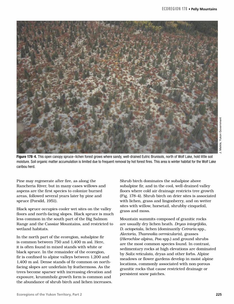
Ecoregions of the Yukon Territory, Part 2
Pine may regenerate after fire, as along the Rancheria River, but in many cases willows and aspens are the first species to colonize burned areas, followed several years later by pine and spruce (Porsild, 1951).
Black spruce occupies cooler wet sites on the valley floors and north-facing slopes. Black spruce is much less common in the south part of the Big Salmon Range and the Cassiar Mountains, and restricted to wetland habitats.
In the north part of the ecoregion, subalpine fir is common between 750 and 1,400 m asl. Here, it is often found in mixed stands with white or black spruce. In the remainder of the ecoregion, fir is confined to alpine valleys between 1,200 and 1,400 m asl. Dense stands of fir common on north-facing slopes are underlain by feathermoss. As the trees become sparser with increasing elevation and exposure, krummholz growth form is common and the abundance of shrub birch and lichen increases.
Shrub birch dominates the subalpine above subalpine fir, and in the cool, well-drained valley floors where cold air drainage restricts tree growth (Fig. 178-4). Shrub birch on drier sites is associated with lichen, grass and lingonberry, and on wetter sites with willow, horsetail, shrubby cinquefoil, grass and moss.
Mountain summits composed of granitic rocks are usually dry lichen heath. Dryas integrifolia, D. octopetala, lichen (dominantly Cetraria spp., Alectoria, Thamnolia vermicularis), grasses (Hierochloe alpina, Poa spp.) and ground shrubs are the most common species found. In contrast, sedimentary rocks at high elevations are dominated by Salix reticulata, dryas and other forbs. Alpine meadows or flower gardens develop in moist alpine locations, commonly associated with non-porous granitic rocks that cause restricted drainage or persistent snow patches.
J. M
eikl
e, Y
uko
n G
over
nmen
t
Figure 178-4. This open canopy spruce–lichen forest grows where sandy, well-drained Eutric Brunisols, north of Wolf Lake, hold little soil moisture. Soil organic matter accumulation is limited due to frequent removal by hot forest fires. This area is winter habitat for the Wolf Lake caribou herd.
ECOREGION 178 • Pelly Mountains
225

Ecoregions of the Yukon Territory, Part 2
WILDLIFE
MammalsThe Pelly Mountains are home to Stone sheep and several herds of woodland caribou including the Pelly, Wolf Lake and Little Rancheria herds (Farnell and MacDonald, 1987, 1990). The Pelly herds have not been surveyed but are believed to number about 1,000 (2001). The Wolf Lake herd numbered 1,400 in 1998, and the Little Rancheria herd 1,000. The Wolf Lake herd is thought to be the most naturally regulated herd in the territory (R. Farnell, pers. comm., 2002). The Finlayson herd, 4,100 strong in 1999, ranges into the eastern Pelly Mountains (Farnell and MacDonald, 1989). Moose and caribou densities were elevated in the 1990s following intensive management, including wolf population control, on the Finlayson caribou range. Mammal species known or expected to occur in this ecoregion are listed in Table 4.
BirdsThe northeast side of this ecoregion follows the Tintina Trench, one of the major flyways for migratory birds through the Yukon. Sandhill Cranes move over the Pelly Mountains and along the Tintina Trench during migration (Theberge et al. [editors], 1979). Canada Goose and Common Merganser breed in small numbers along rivers. Wetlands provide breeding habitat for Red-throated and Common Loons, Horned and Red-necked Grebes, small numbers of Trumpeter Swan, American Widgeon, Mallard, Northern Shoveler, Green-winged Teal, Ring-necked Duck, Bufflehead, and goldeneyes (Johnston and McEwen, 1983; McEwen and Johnston, 1983; Nixon et al., 1992). Small influxes of dabbling ducks such as Northern Pintail, diving ducks such as scoters and Long-tailed Duck, and other migrants such as Pacific Loon, Horned Grebe, swans, and Greater White-fronted and Canada Geese (Johnston and McEwen, 1983; McEwen and Johnston, 1983) are seen on the wetlands during spring and fall migrations.
Rivers and wetlands also support Harlequin Duck; Osprey; Bald Eagle; Peregrine Falcon; Semipalmated Plover; Lesser Yellowlegs; Solitary Sandpiper; Spotted Sandpiper; Common Snipe; Red-necked Phalarope; Bonaparte’s, Mew, and Herring Gulls; Arctic Tern; Belted Kingfisher and American Dipper (Johnston and McEwen, 1983; McEwen and Johnston, 1983; Department of
Renewable Resources, 1994). Songbirds breeding in riparian shrubs and adjacent forests include Alder Flycatcher, Yellow Warbler, Northern Waterthrush, Common Yellowthroat, Wilson’s Warbler, Savannah Sparrow, Lincoln’s Sparrow, Red-winged Blackbird, and Rusty Blackbird (Johnston and McEwen, 1983; McEwen and Johnston, 1983). Tree, Violet-green, Bank, Cliff, and Barn Swallows breed and forage near lakes, ponds, marsh, rivers and forest edges (Johnston and McEwen, 1983; McEwen and Johnston, 1983).
Winter inhabitants of spruce and mixed forests include Spruce Grouse, Great Horned Owl, Gray Jay, Common Raven, Boreal Chickadee, Red-breasted Nuthatch, Pine Grosbeak, White-winged Crossbill, and Common and Hoary Redpolls (Rand, 1946; Johnston and McEwen, 1983). In summer, raptors such as Sharp-shinned and Red-tailed Hawks are common inhabitants of these forests (Johnston and McEwen, 1983). Olive-sided Flycatcher, Western Wood-Pewee, Ruby-crowned Kinglet, Gray-cheeked Thrush, Hermit Thrush, Varied Thrush, Yellow-rumped and Blackpoll Warblers, and Dark-eyed Junco are some of the migrants that come to these forests to breed (Rand, 1946; Johnston and McEwen, 1983). Deciduous and mixed forests on floodplains and south-facing slopes are used by breeding Yellow-bellied Sapsucker, Hairy Woodpecker, Least Flycatcher, and Warbling Vireo (Johnston and McEwen, 1983). Songbirds found in all forests include Swainson’s Thrush, American Robin, Yellow-rumped Warbler, and Dark-eyed Junco (Rand, 1946). Forest edges and other open areas provide suitable habitat for breeding and foraging Common Nighthawk, Northern Flicker, Say’s Phoebe, Orange-crowned Warbler, Chipping Sparrow, and Fox Sparrow (McEwen and Johnston, 1983).
Subalpine shrubs and trees provide breeding habitat for Willow Ptarmigan, Dusky Flycatcher, Townsend’s Solitaire, and American Tree, White-crowned, and Golden-crowned Sparrows (CWS, Birds of the Yukon Database).
Mountain ridges and cliffs in the extensive alpine areas support Golden Eagle, White-tailed Ptarmigan and Gray-crowned Rosy Finch (Department of Renewable Resources, 1994). Rock Ptarmigan, Horned Lark, and American Pipit breed in drier, lichen covered tundra (Canadian Wildlife Service, unpubl.).
Pelly Mountains • ECOREGION 178
226
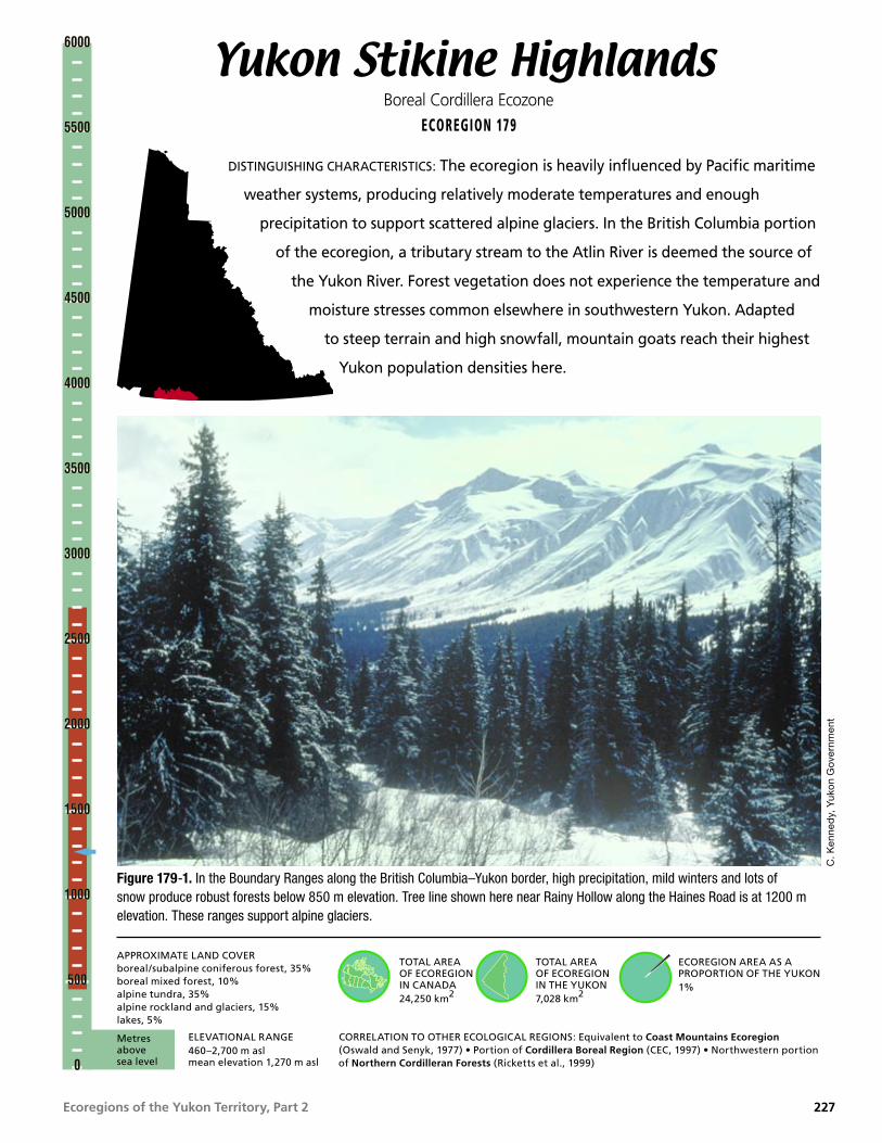
Ecoregions of the Yukon Territory, Part 2
Yukon Stikine HighlandsBoreal Cordillera Ecozone
ECOREGION 179
DISTINGUISHING CHARACTERISTICS: The ecoregion is heavily influenced by Pacific maritime
weather systems, producing relatively moderate temperatures and enough
precipitation to support scattered alpine glaciers. In the British Columbia portion
of the ecoregion, a tributary stream to the Atlin River is deemed the source of
the Yukon River. Forest vegetation does not experience the temperature and
moisture stresses common elsewhere in southwestern Yukon. Adapted
to steep terrain and high snowfall, mountain goats reach their highest
Yukon population densities here.
Figure 179-1. In the Boundary Ranges along the British Columbia–Yukon border, high precipitation, mild winters and lots of snow produce robust forests below 850 m elevation. Tree line shown here near Rainy Hollow along the Haines Road is at 1200 m elevation. These ranges support alpine glaciers.
C. K
enne
dy,
Yuk
on
Gov
ernm
ent
TOTAL AREA OF ECOREGION IN CANADA24,250 km2
TOTAL AREA OF ECOREGION IN THE YUKON7,028 km2
ECOREGION AREA AS A PROPORTION OF THE YUKON1%
APPROXIMATE LAND COVERboreal/subalpine coniferous forest, 35%boreal mixed forest, 10%alpine tundra, 35%alpine rockland and glaciers, 15%lakes, 5%
ELEVATIONAL RANGE460–2,700 m asl mean elevation 1,270 m asl
CORRELATION TO OTHER ECOLOGICAL REGIONS: Equivalent to Coast Mountains Ecoregion (Oswald and Senyk, 1977) • Portion of Cordillera Boreal Region (CEC, 1997) • Northwestern portion of Northern Cordilleran Forests (Ricketts et al., 1999)
6000
5500
5000
4500
4000
3500
3000
2500
2000
1500
1000
500
0
6000
5500
5000
4500
4000
3500
3000
2500
2000
1500
1000
500
0
Metres above sea level
227

Ecoregions of the Yukon Territory, Part 2
PHYSIOGRAPHYThe Yukon Stikine Highlands Ecoregion is part of a larger ecoregion that extends south into British Columbia. In the Yukon, it consists of the Boundary Ranges (Coast Mountains) and the Alsek Ranges (St. Elias Mountains) (Mathews, 1986; Bostock, 1948; Hughes, 1987b). The boundary of the ecoregion conforms approximately to the northern boundary of the Coast Mountains. This boundary varies from map to map due to the broad transition area from mountains to plateau.
These rugged mountain ranges support glaciers at higher elevations and are dissected by deep valleys. The relief is usually 900 to 1200 m between the broad summit areas and the valley floors lying between 760 and 900 m asl. The Tatshenshini River valley (Fig. 179-1), the lowest elevation in the southern Yukon, lies less than 450 m asl where it crosses into northern British Columbia. The highest point in the ecoregion, 2,700 m asl, is in the Alsek Ranges between the Alsek River and the upper reaches of the Tatshenshini River. The highest mountain in the Boundary Ranges, 2,522 m asl, is east of Kusawa Lake. Numerous other peaks are greater than 2,100 m asl.
Most of the Boundary Ranges drain via the Takhini, Watson and Wheaton rivers of the Yukon River system. Kusawa and Bennett lakes are the largest in the ecoregion. Other lakes include Rose and Primrose lakes. In the Alsek area, which drains via the Tatshenshini and Alsek rivers to the Pacific, Mush and Bates lakes are the only large waterbodies in this portion of the ecoregion.
BEDROCK GEOLOGYUnlike the elongated British Columbia portion of this ecoregion, which generally coincides with the metasandstone of Nisling subterrane of Yukon–Tanana Terrane, the Yukon portion extends westward across four northwest-trending terranes. The rock types, age range, and origin contrast greatly between the terranes; only the adjacent Yukon Southern Lakes Ecoregion displays as great a diversity of rocks and structures.
The regional distribution of rock types are shown on 1:250,000 scale maps by Wheeler (1961), Kindle (1953) and Campbell and Dodds (1982b). More detailed maps exist for certain areas (referenced
below) and a compilation by Gordey and Makepeace (compilers, 2001) shows updated interpretations. The Cordilleran context of the terranes is discussed in Gabrielse and Yorath (editors, 1991) and in the “Geologic Framework” introductory section of this report.
Granitic intrusions are exposed over about 60% of the ecoregion, chiefly in the Coast Plutonic Complex. In the east lies Stikinia and pendants of Nisling subterrane of Yukon–Tanana, while the Gravina–Nutzotin belt, a sliver of Wrangell terrane (Wrangellia), and eastern Alexander terrane form the western quarter. The rocks are summarized below in similar order.
Stikinia, between Carcross and the Primrose River, contains three sub-circular volcanic cauldron complexes that underlie highlands on Montana Mountain (Hart and Radloff, 1990), around the West Arm of Bennett Lake (Lambert, 1974), and Mount Skukum (Pride, 1985). Each contains cliff bands and pinnacles of dark, fine-grained andesite and dacite flows and breccia. Steep faults separate the volcanics from older sandstone, conglomerate of Jurassic Laberge Group, and augite porphyritic basalt and limestone of Upper Triassic Lewes River Group, which define Stikinia.
From Primrose River westward to the Tatshenshini River, bare rock and rubble-strewn mountains consist of grey, coarsely crystalline biotite granodiorite of the Coast Plutonic Complex (Fig. 179-2). Approximately 20% of the area is quartz–mica schist and micaceous quartzite of Yukon–Tanana Terrane, in what are termed pendants, surrounded by granitic rocks. The largest pendants lie east of Kusawa and Dezadeash lakes. Their margins are typically rusty and thermally hardened. Large expanses of plutonic rock are criss-crossed by lineaments and slots where joints formed by cooling have been preferentially plucked by glacial and fluvial erosion.
West of the Haines Highway, the Auriol and Dalton ranges are underlain by conglomerate, shale, sandstone, chert and minor coal seams of the Lower Cretaceous Dezadeash Formation, an overlap assemblage in Gravina–Nutzotin belt. The Shorty Creek pluton consists of granodiorite that is 106 million years old (Dodds and Campbell, 1988).
Between the Dalton, a south extension of the Denali or Shakwak system, and Duke River faults,
Yukon Stikine Highlands • ECOREGION 179
228

Ecoregions of the Yukon Territory, Part 2
which are both in wide, north-trending valleys, is a 15 km wide strip of Wrangellia terrane containing weakly metamorphosed volcanic and sedimentary rocks, the Carboniferous to Permian Kaskawulsh Group, intruded by the elongate Mount Beaton quartz–diorite pluton. Southwest of Bates Lake is a significant accumulation of sandstone, conglomerate and mudstone of Upper Oligocene Amphitheatre Formation (Ridgeway et al., 1992). Northeast of Mush Lake are basalt and andesite flows of the Miocene Wrangell lavas (Souther and Stanciu, 1975).
At the west edge of the ecoregion, in the Alsek Ranges and on Goatherd Mountain, are amphibolite, siliceous and micaceous schist of the Carboniferous to Permian Kaskawulsh Group (Campbell and Dodds, 1978). These rocks are part of Alexander Terrane. They are intruded by the Alsek and Shaft Creek plutons which are 130 Ma (Dodds and Campbell, 1988).
The eastern quarter of the ecoregion has significant mineral potential. Quartz veins containing gold, silver and antimony mineralization have been mined at Mount Skukum (MacDonald, 1990) and Montana Mountain (Roots, 1981). The Wheaton River area also contains many metallic mineral showings that are detailed in Hart and Radloff (1990). In contrast, the Coast Mountains have few mineral occurrences. The Station Creek volcanics in Wrangellia host copper, zinc and lead in quartz veins, and picrolite asbestos is found on islands in Bates Lake. Placer gold has been mined from Squaw (Dollis), Beloud, Sugden and Shorty creeks, and native copper nuggets, probably derived from Wrangell lavas, are found in Beloud Creek.
ECOREGION 179 • Yukon Stikine Highlands
Figure 179-2. Alpine tundra and rockland make up approximately half the area of the ecoregion and are subjected to strong winds and cloud cover. Black leaf lichen (Umilicaria sp.) thrives on the silica-rich bedrock. North-facing cliffs result from plucking by alpine glaciers as recently as the Little Ice Age. Blond, lichen-free areas indicate recession of semi-permanent snow patches during the last century.
J. M
eikl
e, Y
uko
n G
over
nmen
t
229

Ecoregions of the Yukon Territory, Part 2
SURFICIAL GEOLOGY AND GLACIAL HISTORYThis ecoregion has been extensively glaciated, and its west-central portion supports modern glaciers. Clusters of cirques, often occupied by modern glaciers, are found in the Boundary Ranges and in Kluane National Park. Neoglacial and Little Ice Age moraines are only a short distance from the cirques in most valleys.
Most of the surficial materials and morphology were produced by glaciers emanating from the St. Elias Mountains, eastern Coast Ranges and the Cassiar lobe of the Cordilleran Ice Sheet (Jackson et al., 1991) during the McConnell Glaciation, about 23 ka (Klassen, 1987; Jackson and Harington, 1991). These glaciers moved generally north–northwestward, and crossed Dezadeash Valley to cover most of the Aishihik area. Extensive glacial lakes were formed during deglaciation.
The southern shores of Glacial Lake Champagne (Kindle, 1953) impinged the north side of this ecoregion. This lake, formed when the glaciers had retreated to the intermontane valley between Kluane and Ruby ranges, extended along the Shakwak Trench to the southeast, and may have extended east to the Takhini River and south of Whitehorse (Wheeler, 1961). Well-defined shorelines along the Dezadeash and Takhini rivers and tributaries reach up to 1,280 m in elevation. A spectacular ice contact delta complex was deposited at the same elevation at the north end of Kusawa Lake. Glacial Lake Champagne occupied the areas of what is now Kusawa Lake valley. Minor and major deltas are found on the western side at the mouth of Bear Creek, on the south side on Tatshenshini, Klukshu and Takhanne rivers, and at the mouths of Primrose and Takhini rivers to the east.
Continued glaciation led to impoundment of Glacial Lake Carcross (Wheeler, 1961) by glaciers to the south of the Yukon–British Columbia border and by glaciers occupying the upper Wheaton and Watson valleys to the west. Shorelines located up to 760 m asl can be found along Bennett Lake, as well as along the Wheaton, Watson and nearby valleys (Wheeler, 1961; Morison and Klassen, 1991). Other minor glacial lakes were also formed as the glaciers retreated from the area.
CLIMATEThis ecoregion consists of four major south–north valleys that affect movement of weather systems: the Alsek River, the Haines Road Corridor, Kusawa Lake and the Bennett–Tutshi Lakes. The main orographic lift of maritime air and resultant heavy precipitation occurs to the south of this ecoregion in British Columbia and southeast Alaska.
This ecoregion is near enough to the Pacific Ocean to receive moderate amounts of precipitation with annual amounts of 300 to 500 mm. This precipitation is lightest from February through May and heaviest in the fall and early winter. This precipitation is generally snow from October to May, as well as at elevations above 2,000 m throughout most of the year (Fig. 179-1).
Mean annual temperatures are near –2.5°C, although seasonal temperatures show the effects of elevation. During January, the mean temperatures are near –25°C in the lower valley floors as compared with nearly –18°C over higher elevations. Short midwinter thaws can occur in the lower valleys. By July, usually the warmest month, the lower valleys have mean temperatures near 12°C decreasing to 5°C over the higher terrain. Extreme temperatures can range from –45 to 35°C in the lower valleys and from –30 to 15°C over higher terrain. Frost can occur at any time of the year but is least frequent in July.
Winds are moderate to light, but can frequently reach gale force strengths in north–south oriented valleys. These gale force winds are most common from the fall through spring and occasionally reach destructive speeds, particularly from a southwesterly direction.
A representative climate station at lower elevations is Carcross, but this site receives less precipitation than most areas in this region. Precipitation amounts are more similar to those indicated at Dezadeash, Yukon, and Mule Creek, British Columbia Precipitation amounts may be up to 50% greater over higher terrain.
Yukon Stikine Highlands • ECOREGION 179
230

Ecoregions of the Yukon Territory, Part 2
HYDROLOGYThe ecoregion drains the northern- and eastern-facing slopes of the Coast Mountains (Boundary Ranges). Because the ecoregion is a high altitude source region, and because of its relatively small size, there are no large representative streams within its boundaries, though a short reach of the Alsek River forms the western border. At the western limit, the ecoregion straddles the divide between the Alsek and Yukon river drainages. Major intermediate and smaller streams within the Alsek drainage include the Tatshenshini, Klukshu and Bates rivers. Major intermediate and smaller streams within the Yukon drainage include the upper Takhini, Primrose, Wheaton and Watson rivers.
Although glacier coverage of the Yukon portion of the ecoregion is small at 1.42% of the total area, the hydrologic response is dominated by glacier melt contributions. Glacier coverage, including the Llewellyn Glacier, is significantly greater within the British Columbia portion of the ecoregion. Also within the ecoregion is a small, unnamed tributary of the Atlin River, originating at the base of the Llewellyn Glacier, which has been identified as the source of the Yukon River (Parfit, 1998). The source is defined as the longest tributary of the Yukon River upstream of its confluence with the Teslin. The ecoregion has relatively high lake coverage at 4.5%. Major lakes include Bennett and Kusawa, while smaller ones are Primrose, Rose, Takhini, Mush and Bates. Wetland coverage is relatively small at 0.32% of the total Yukon area (Fig. 179-3).
There are four representative (active and historical, continuous and seasonal) hydrometric stations within the ecoregion: Tatshenshini, Takhanne, Wheaton and Watson rivers. Though glaciers are not present throughout, hydrologic response within the ecoregion is dominated by characteristics typical of a glacierized system. Annual streamflow within these systems is characterized by a rapid increase in discharge in May due to snowmelt at lower elevations, rising to a peak in July or August due to high elevation snowfield and glacier melt. In non-glacierized systems, peak flows occur in June as a result of snowmelt inputs. Because most stream channels are steep and relatively short, streamflow response tends to be rapid and flashy. On smaller streams approximately 40% of the annual maximum flows are due to intense summer rainstorm events. Some small steep streams are susceptible to mudflows triggered by these summer
rainstorms. Mean annual runoff is moderately high and variable with values ranging from 130 mm in some non-glaciated basins to 500 mm in glaciated basins with an ecosystem mean of 317 mm. Mean seasonal and summer flows are moderately high with values of 21 X 10–3 and 17 X 10–3 m3/s/km2, respectively. The mean annual flood and mean maximum summer flow are moderately low and moderate with values of 63 X 10–3 and 42 X 10–3 m3/s/km2, respectively. Minimum streamflow generally occurs during March or earlier with the relative magnitude higher than many other ecoregions due to higher winter temperatures and subsequently greater groundwater contributions.
J. M
eikl
e, Y
uko
n G
over
nmen
t
Figure 179-3. The Hendon River meanders across its floodplain, indicating less sediment transport than in braided streams, such as the nearby Kusawa and Primrose rivers. Former oxbows are now sedge fens. Nearby ridges support white spruce and dwarf birch. Mature white spruce cloaks the lower slopes. Avalanche tracks are visible up valley.
ECOREGION 179 • Yukon Stikine Highlands
231

Ecoregions of the Yukon Territory, Part 2
The mean annual minimum and mean summer minimum flows are relatively high with values of 1.7 X 10⁻³ and 6.9 X 10⁻³ m3/s/km2, respectively.
PERMAFROSTPermafrost is sporadic in the valleys of the Yukon Stikine Highlands Ecoregion, though it occurs regularly at high elevations. Valleys that act as conduits for the passage of maritime air often receive abundant snowfall in winter. Permafrost is rarely encountered under such conditions. Brown (1967) did not find frozen ground along the Haines Road and it is rare along the Klondike Highway south of Carcross (Public Works Commission, 1986). Valleys in the rain shadow of the Coast Mountains are dry and sufficiently warm in summer to prevent permafrost development at most sites (EBA, 1988b). Localized perennially frozen ground has been reported in moist locations (Horel, 1988b).
At higher elevations in the ecoregion, a full suite of alpine periglacial features occur, with well-developed solifluction lobes on hills, frost-shattered bedrock outcrops, patterned ground, and stone nets and stripes on flatter terrain. There are few reports on ground ice in the Yukon portions of this ecoregion, including those for road construction and maintenance, however, rock, debris-covered, and cirque glaciers are found on some north-facing aspects, and perennial snowbanks in places.
SOILSSoil development reflects the relatively mild, humid climatic conditions of the ecoregion and its steep, rugged topography. Most of the soils are developed on mixed colluvium and moraine materials within steep mountain valley systems. Precipitation and topographic relief tend to increase southward toward the British Columbia border. Eutric and Dystric Brunisols are the predominant soils. In alpine environments, Sombric Brunisols with well-developed Ah horizons can be found.
In an ecological survey along the northern extent of the ecoregion, Oswald et al. (1981) reported Eutric Brunisols on a variety of parent materials under predominantly boreal forest vegetation. In adjacent British Columbia, Luttmerdig et al. (1995) described slightly more humid conditions and the development of Dystric Brunisols and sporadic Humo–Ferric
Podzols. These later soils are not known to occur in the Yukon portion of the ecoregion, except for isolated localities on granitic bedrock in alpine environments near the headwaters of the Takhini River.
Permafrost is sporadic in the ecoregion and Cryosols are not common except in poorly drained portions of alpine environments where patterned ground is common. Generally, soil temperatures remain relatively warm through the winter under heavy snow pack conditions. Although there are a few small alpine glaciers in the ecoregion, these are not associated with extensive permafrost. Where permafrost does occur, active layers are often too thick for the soils to be classified as Cryosols.
Wetlands are not a dominant feature of the ecoregion, being confined to some of the alluvial landforms along the Takhini, Primrose, Tatshenshini and Alsek river valleys. Most of the soils are classified as Humic Gleysols or occasionally as Typic and Terric Mesisols in fen wetlands with over 2 m of peat accumulation (Fig. 179-3).
VEGETATIONThe vegetation of the Yukon Stikine Highlands Ecoregion reflects the great variation between alpine summits and moist forested valley floors. Much of the area lies above treeline (around 1,200 m asl). Because of the coastal influence — greater winter snowfalls, more moderate winter temperatures, and lack of permafrost in the valleys — the vegetation does not suffer the moisture stress of the ecoregion to the east. Coniferous and some mixed forests dominate the valley bottoms (Fig. 179-1), grading to shrubs in the subalpine and dwarf shrub and lichen tundra above 1,350 m asl (Fig. 179-2).
White spruce is the dominant tree species in the lowlands, often with an understory of feathermoss and some upland surfaces (Oswald et al., 1981). Labrador tea and willow are common shrubs. On warmer sites, white spruce is often mixed with trembling aspen. These sites are dominated by a shrub understory of lingonberry, kinnikinnick, and twinflower and lichens. Taller shrubs include soapberry, rose, willow, and high-bush cranberry. Balsam poplar is common on margins of lakes and streams, and along roadsides. It is often mixed with white spruce on floodplains. Lodgepole pine often occurs on burned areas in the eastern part of
Yukon Stikine Highlands • ECOREGION 179
232

Ecoregions of the Yukon Territory, Part 2
the ecoregion. Paper birch is occasionally found in mixed stands on moister sites.
In the subalpine, white spruce and sometimes subalpine fir are found with shrub birch and willow. Fir is found in the subalpine, but is restricted to eastern portions of the ecoregion. Subalpine valleys subject to cold air drainage often have spruce or fir along the valley walls while the valley floor and upper slopes are dominated by shrub birch and willow associated with ericaceous shrubs, graminoids, moss, herbs and lichen.
Alpine areas cored by granitic rocks are sparsely vegetated by lichen, ericaceous shrubs, and prostrate willows.
WILDLIFE
MammalsThe ecoregion exhibits a coastal climatic influence on flora and fauna. The highest densities of mountain goats in the Yukon are found here (Barichello et al., 1989b). The Ibex woodland caribou herd inhabits the eastern section of the ecoregion (Fig. 30). It is small and fragmented, numbering about 450. The herd is exposed to predation by a large number of wolf packs (R. Farnell, pers. comm., 2002). Moose, Dall sheep, wolves, wolverine and black bear are all common (Fig. 179-4). Grizzly bear reach their highest density in the Yukon, estimated at one bear per 45 km2. Isolated populations of
marten occur in climax forests, being most common at higher elevations.
The tundra shrew, once believed to be restricted to the northern Yukon, has been found within the ecoregion in British Columbia (Nagorsen, 1996) and therefore, probably occurs in the Yukon portion of the ecoregion. Bats have received little attention in the Yukon, and species other than the little brown myotis may yet be found. Bat species found near the Yukon include the long-legged myotis, Keen’s long-eared myotis, the silver-haired bat and the big brown bat. Mammal species known or expected to occur in this ecoregion are listed in Table 4.
The known northern limit of the Columbian spotted frog occurs in this ecoregion (Fig. 179-5).
BirdsIn early spring, open water at the outlet of Bennett Lake provides a staging area for swans, diving ducks, and some dabbling ducks (Theberge et al. [editors], 1979). Large lakes such as Bennett and Kusawa provide breeding and staging habitat for Pacific and Common Loons, Common Merganser, Bonaparte’s, Mew, Herring Gulls, and Arctic Tern, (Godfrey, 1951; Soper, 1954; Department of Public Works and U.S. Department of Transportation, 1977). Belted Kingfisher and Bank Swallow nest in the mud banks of these lakes. Shallower lakes and wetlands support Mallard, Northern Pintail, and Green-winged Teal (Soper, 1954).
Figure 179-4. Some of Yukon’s best habitat for Dall sheep (Ovis dalli dalli) occurs at the northern or lee edge of this ecoregion. In the steeper terrain to the south where snowfall is greater is the highest density of mountain goats (Oreamnos americanus) in Yukon.
W.J
. Sch
ick
Figure 179-5. The Columbia spotted frog (Rana luteiventris) has been observed at two locations along the West Arm of Bennett Lake. It is isolated from other populations to the south and is at its northern limit in the Yukon portion of this ecoregion.
L. M
enne
ll
ECOREGION 179 • Yukon Stikine Highlands
233
Ecoregions of the Yukon Territory, Part 2
Salmon spawning streams, such as the Takhanne River, attract breeding pairs of Bald Eagle with especially high numbers in the autumn (Department of Public Works and U.S. Department of Transportation, 1977). Swift mountain streams provide habitat for Harlequin Duck and American Dipper (Department of Public Works and U.S. Department of Transportation, 1977). Wandering Tattler breed at the heads of these mountain streams while Semipalmated Plover breed on the sparsely vegetated alluvium of larger drainages (Department of Public Works and U.S. Department of Transportation, 1977). Orange-crowned Warbler, Yellow Warbler, Common Yellowthroat, Wilson’s Warbler, Fox Sparrow, and Lincoln’s Sparrow breed in thickets bordering streams, bogs, and moist meadows (Godfrey, 1951).
Low elevation coniferous forests support year-round residents such as Northern Goshawk, Spruce Grouse, Great Horned Owl, Northern Hawk Owl, Three-toed Woodpecker, Gray Jay, Common Raven, and Boreal Chickadee (Godfrey, 1951; Department of Public Works and U.S. Department of Transportation, 1977). These are joined in the breeding season by Sharp-shinned Hawk, Merlin, Olive-sided Flycatcher, Western Wood-Pewee, Golden-crowned and Ruby-crowned Kinglets, Swainson’s Thrush, Varied Thrush, and Yellow-
rumped and Blackpoll Warblers (Godfrey, 1951). Scattered pockets of deciduous forest provide breeding habitat for Ruffed Grouse and Northern Flicker (Godfrey, 1951). Say’s Phoebe, American Robin, and Chipping Sparrow (Theberge, 1974) use forest openings. Rufous Hummingbirds, rare visitors to the southern Yukon (Eckert et al., 1998), also use openings, especially those with suitable flowering plants (Godfrey, 1951).
High densities of breeding Golden Eagle inhabit alpine and subalpine areas, and some overwinter in years of high prey abundance (Hayes and Mossop, 1983). Peregrine Falcon nest in localized areas of rock outcrops and cliffs, usually near wetlands (Theberge, 1974). The Coast Mountains represent the southern limit of nesting Gyrfalcon in North America; Willow, Rock, and White-tailed Ptarmigan provide their main prey base (Hayes and Mossop, 1983). Species that breed in subalpine shrubs include American Kestrel; Willow Ptarmigan; Wilson’s Warbler; Brewer’s, American Tree and Golden-crowned Sparrow; Dark-eyed Junco (Canadian Wildlife Service, unpubl.); Dusky Flycatcher; Townsend’s Solitaire; and Common Redpoll (Godfrey, 1951; CWS, Birds of the Yukon Database). American Pipit, Savannah Sparrow and Horned Lark breed in tussock tundra of the extensive alpine plateaus along exposed ridges.
Yukon Stikine Highlands • ECOREGION 179
234
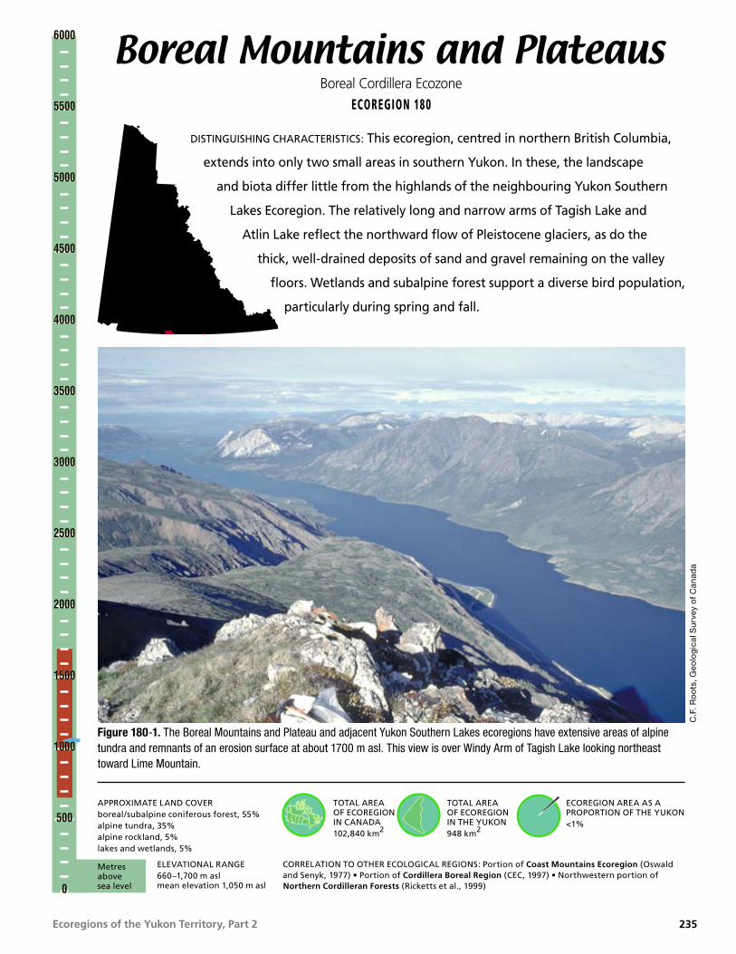
Ecoregions of the Yukon Territory, Part 2
Boreal Mountains and PlateausBoreal Cordillera Ecozone
ECOREGION 180
DISTINGUISHING CHARACTERISTICS: This ecoregion, centred in northern British Columbia,
extends into only two small areas in southern Yukon. In these, the landscape
and biota differ little from the highlands of the neighbouring Yukon Southern
Lakes Ecoregion. The relatively long and narrow arms of Tagish Lake and
Atlin Lake reflect the northward flow of Pleistocene glaciers, as do the
thick, well-drained deposits of sand and gravel remaining on the valley
floors. Wetlands and subalpine forest support a diverse bird population,
particularly during spring and fall.
Figure 180-1. The Boreal Mountains and Plateau and adjacent Yukon Southern Lakes ecoregions have extensive areas of alpine tundra and remnants of an erosion surface at about 1700 m asl. This view is over Windy Arm of Tagish Lake looking northeast toward Lime Mountain.
C.F
. Ro
ots
, Geo
log
ical
Sur
vey
of C
anad
a
TOTAL AREA OF ECOREGION IN CANADA102,840 km2
TOTAL AREA OF ECOREGION IN THE YUKON948 km2
ECOREGION AREA AS A PROPORTION OF THE YUKON<1%
APPROXIMATE LAND COVERboreal/subalpine coniferous forest, 55%alpine tundra, 35%alpine rockland, 5%lakes and wetlands, 5%
ELEVATIONAL RANGE660–1,700 m asl mean elevation 1,050 m asl
CORRELATION TO OTHER ECOLOGICAL REGIONS: Portion of Coast Mountains Ecoregion (Oswald and Senyk, 1977) • Portion of Cordillera Boreal Region (CEC, 1997) • Northwestern portion of Northern Cordilleran Forests (Ricketts et al., 1999)
6000
5500
5000
4500
4000
3500
3000
2500
2000
1500
1000
500
0
6000
5500
5000
4500
4000
3500
3000
2500
2000
1500
1000
500
0
Metres above sea level
235

Ecoregions of the Yukon Territory, Part 2
PHYSIOGRAPHYThe Boreal Mountains and Plateaus Ecoregion occupies a large block of north-central British Columbia; only two small projections enter southern Yukon. One of these surrounds and includes Tagish, Nares and Atlin lakes (in British Columbia portion of the ecoregion), and the other is a small part of the Swift River drainage, about 250 km to the east.
In the Yukon, the western part of ecoregion belongs to the Teslin Plateau and the eastern projection is part of the Nisutlin Plateau in the Cassiar Mountains (Mathews, 1986). Both are components of the Yukon Plateau, the large, diverse Northern Plateau and Mountain area described by Bostock (1948) and Hughes (1987b).
This is an area of tablelands of up to 1,700 m in elevation dissected by large valleys (Fig. 180-1). In the west part, the valleys are occupied by Tagish Lake (655 m) and Nares Lake (668 m), in the eastern part by the Swift River (less than 900 m), all of which are components of the Yukon River watershed.
BEDROCK GEOLOGYThe northern half of the ecoregion almost exactly coincides with the distribution of metamorphosed volcanic and carbonate rocks. The rocks in the two prongs of the ecoregion that lie within the Yukon are shown on 1:250,000 scale geological maps by Wheeler (1961) and Poole et al. (1960), with updated correlations by Gordey and Makepeace (compilers, 2001).
The northwestern prong of the ecoregion is part of Slide Mountain Terrane, which was thrust over adjacent Stikinia to the west (Gordey and Stevens, 1994a) in Middle Jurassic time (175 Ma), and subsequently faulted against Quesnellia to the east. In contrast, the eastern prong of the ecoregion is underlain by the Dorsey Assemblage (Stevens and Harms, 1995; Roots et al., 2000) of Dorsey Terrane, which is separated from the granitic Cassiar batholith to the east by a major fault zone. Both terrane associations are summarized in the Overview section of this report, and in Gabrielse and Yorath (editors, 1991).
The northwestern prong includes tablelands surrounding Tagish Lake and islands within the lake. Abundant bedrock protrudes through thin soil cover. Cliffs and ridges on Lime Peak, White Mountain and Jubilee Mountain are light-grey dolostone and recrystallized bioclastic limestone of Horsefeed Formation, as well as black limestone and ribbon chert of Kedahda Formation (Monger, 1975). Both units contain Permian fusilinids, fossils that resemble concentric-cored kernels of wheat. These fossils are similar to those found in Japan and China, which indicates a West Pacific origin for these rocks. Dark-green amphibolite, or greenstone, of the Mississippian Nakina Formation, represents the underwater basaltic flows and breccia included in the Cache Creek Group. Where the Atlin Road crosses the British Columbia–Yukon border, there are outcrops of biotite–hornblende monzodiorite of the Middle Jurassic Fourth of July batholith (Mihalynuk et al., 1992).
In the northeast prong of the ecoregion, subdued ground is underlain by argillite, phyllite, quartzite and chert. The edge of the ecoregion north of the Alaska Highway includes the rim of the 100-million-year-old Seagull batholith and interlayered chert and black slate, minor chert pebble conglomerate and a limestone band in which Pennsylvanian crinoids and conodonts have been found (Stevens and Harms, 1995). The valley of the Swift River also contains outcrops of relatively recent basaltic lava (Rancheria flows, about 6 Ma) which were extensively used in the Alaska Highway construction and stabilization projects.
Mineral potential is moderate in the Yukon portion of this ecoregion. Copper showings surround a small dunite lens on Jubilee Mountain; typically the surrounding altered carbonate hosts gold-bearing vein occurrences (e.g. Hart, 1996), and chromite, although there is no indication that this pod has any vertical extent. On Lime Mountain are showings of native copper in the altered volcanics, molybdenite in a small granitic plug and silver–gold vein occurrences. The Rancheria district contains numerous lead, zinc and silver vein occurrences. The eastern portion of this ecoregion lies immediately east of the Seagull Creek tin and tungsten district (Abbott, 1981a).
Boreal Mountains and Plateaus • ECOREGION 180
236

Ecoregions of the Yukon Territory, Part 2
SURFICIAL GEOLOGYThe main sources of information for this section are Morison and Klassen (1991) and Klassen (1982b) who describe the surficial geology of the Yukon part of the ecoregion.
The surface deposits of this ecoregion are similar to those of the Southern Lakes Ecoregion. They are associated with the most recent Cordilleran ice sheet, the McConnell, believed to have covered the south and central Yukon between 26.5 ka and 10 ka. Most of the Yukon portion of the ecoregion was covered by the Cassiar lobe, which flowed towards the northwest from the Cassiar Mountains.
The distribution of Quaternary deposits in this area follows a general pattern. High elevation slopes are covered with colluvium or moraine veneer over bedrock. At high elevations, the exposed bedrock is weathered and frost-shattered.
A veneer of glacial till, as well as colluvial fans or aprons, covers most mid-elevation slopes. The general composition of the till matrix in adjoining map sheets (Jackson, 1994) indicates a wide range of sand and silt content (20 to 80%). Isolated lenses of ice-rich permafrost may be present on north-facing slopes. At high elevations the Quaternary sediments contain permafrost were overlain by thick organic deposits. Drumlins indicating a northerly ice flow are found on the west shore of Taku Arm.
Glaciofluvial sand and gravel terraces flank the valley sides and pitted or hummocky deposits of sand and gravel deposits line the bottom of some valleys (Fig. 180-2). Usually these deposits are free of permafrost and have stable surfaces, but may contain undesirable, weak lithologies for potential use as aggregate.
ECOREGION 180 • Boreal Mountains and Plateaus
Figure 180-2. A mosaic of lakes and ponds forms in the Jennings Lake valley in hummocky glaciofluvial materials deposited during deglaciation. These ice-contact deposits are composed of sands and gravels and are common in the larger valleys in the ecoregion.
C.F
. Ro
ots
, Geo
log
ical
Sur
vey
of C
anad
a
237

Ecoregions of the Yukon Territory, Part 2
Floods related to ice jams, snowmelt and summer rainstorms are possible hazards in lower reaches of most streams in the area. Because of this flood risk, the steep portions of alluvial fans have the potential to release mudflows and debris flows associated with rapid increases in water discharge.
GLACIAL HISTORYThis upland region was the source area for the part of the Cordilleran Ice Sheet that drained east toward the Mackenzie Valley and north into the Yukon River Basin (Ryder and Maynard, 1991). Uplands were subjected to intense glacial erosion, with the highest peaks sculpted into classical alpine landforms such as horns, arêtes and cirques. A single thin till mantles upland areas.
CLIMATEThe two portions of this ecoregion within the Yukon near Tagish Lake and Atlin Lake have a climate similar to the Yukon Southern Lakes Ecoregion. A climate station representative of the lower valleys of this area is Atlin Lake, British Columbia,
The eastern section near Swift River has a climate similar to the Pelly Mountains Ecoregion. A climate station representative of this section is Swift River, Yukon.
HYDROLOGYTwo small areas of the ecoregion protrude northward into the southern Yukon. The larger western portion is within the Western Hydrologic Region. It includes Tagish and Atlin lakes that are part of the upper Yukon River drainage. The smaller eastern portion is within the Interior Hydrologic Region and includes a portion of the upper Swift River, which drains into the Teslin River. The western portion of the ecoregion in the Yukon, which drains the western foot slopes of the Coast Mountains, has higher relief and subsequently higher runoff and peak flows, than the eastern portion that drains the Cassiar Mountains. Within British Columbia, the ecoregion contains many major streams including the Stikine and Dease rivers while the Yukon portion contains only smaller representative streams including the Swift and Tutshi rivers. The Atlin River is within this ecosystem; however, it is not representative of hydrologic response, because it includes glacier melt
inputs from upstream of the ecosystem. A relatively large portion of this small area is water in several large lakes including Tagish and Atlin.
There are seven representative active, historical continuous, and seasonal hydrometric stations within the ecoregion: Wann, Fantail, Atlin, Swift and Tutshi rivers, and Pine and Partridge creeks. Annual streamflow is characterized by a rapid increase in snowmelt discharge to a peak in June, with secondary rainfall peaks later in the summer. Peak flow events on smaller streams may be generated by intense summer rain storm events. Mean annual runoff is the highest of all Yukon ecoregions with a range in values of 236 to 980 mm and an ecosystem mean value of 577 mm. Mean seasonal and summer flows are similarly the highest of all Yukon ecoregions with values of 39 X 10–3 and 36 X 10–3 m3/s/km2, respectively. The mean annual flood and mean maximum summer flow are moderately high and relatively high with values of 92 X 10–3 and 78 X 10–3 m3/s/km2, respectively. Minimum streamflow generally occurs during April, with the relative magnitude higher than other Yukon ecoregions due to the moderating influence of the Gulf of Alaska on winter temperatures and subsequent groundwater contributions. The minimum annual and summer flows are the highest of all Yukon ecoregions with values of 2.6 X 10⁻³ and 11 X 10–3 m3/s/km2, respectively. Only very small streams experience zero winter flows during cold winters.
PERMAFROSTPermafrost in the ecoregion is sporadic and the distribution is controlled mainly by elevation. Above an elevation of about 1,800 m, permafrost is likely continuous (Harris, 1986), but in valleys its occurrence depends on site wetness and the thickness of the organic layer. Isolated palsas have been reported (Tallman, 1973; Seppala, 1980), but overall, there is little permafrost in the valleys (Hoggan, 1992b). There is no permafrost at the Cassiar townsite at 1,060 m, but it is widespread at the abandoned asbestos mine at 1,820 m (Brown, 1967). Here, the thickness of the organic layer likely controls active layer development to a greater extent than elevation, as recorded by Harris (1987) in the Kluane Front Range.
There is extensive evidence of frost action on the plateaus of this ecoregion. Alley and Young (1978)
Boreal Mountains and Plateaus • ECOREGION 180
238

Ecoregions of the Yukon Territory, Part 2
describe well-developed blockfields, patterned ground, and frost boils from plateau surfaces, and solifluction lobes from mountainsides in southern Stikina Plateau. They also report ice-rich zones developed at depth in valley-bottom glaciolacustrine sediments.
SOILSThe soils in this ecoregion have formed under relatively mild and somewhat moist climatic conditions. Therefore, they tend to be well leached and show stronger chemical weathering than most other soils in the Yukon. The topography in the Yukon portion of this predominantly northern British Columbia ecoregion is mountainous. The predominant soil parent material is colluvium formed from the mixed lithologies present.
At higher elevations, above 1,500 m in the portion of the ecoregion around Tagish Lake, Regosols formed on talus from rock outcrops are common. Beneath extensive areas of alpine tundra vegetation, the soils are most commonly Orthic Turbic Cryosols and show evidence of patterned ground. This is the only environment where near-surface permafrost is common in the ecoregion. On mountain slopes, soils are formed under coniferous and mixed vegetation. Orthic, Eutric and Dystric Brunisols are the most common soil types of the area (Davies et al., 1983a). The acidic Dystric Brunisols are most common at subalpine elevations, adjacent to the 60th parallel where precipitation is highest.
In the British Columbia portion of the ecoregion adjacent to Swift River, soils tend to be predominantly Dystric Brunisols formed on a landscape composed primarily of moraine and colluvium (Luttmerdig et al., 1995) on the more subdued terrain of the Cassiar Mountains south of the Yukon border.
VEGETATIONThe vegetation of the Boreal Mountains and Plateaus Ecoregion varies from boreal forest in the lowlands and valleys to subalpine shrublands and alpine tundra on the rolling plateaus and higher mountains (Davis et al., 1983a).
Below treeline, white spruce dominates mature forests. Willow, soapberry, kinnikinnick, lowbush cranberry, crowberry and feathermoss are common
understory species. Because of frequent fires, lodgepole pine and trembling aspen are also common in the forest canopy. Lodgepole pine is common on well-drained sites that have burned in the last 100 years. Aspen or mixed spruce and aspen forests cover southerly slopes. Balsam poplar may be found along creeks and lakeshores. On steep, south-facing slopes, stunted aspen grows with grass, sagewort, kinnikinnick and juniper; these species reflect the drought conditions of these slopes.
At higher elevations, subalpine fir is common in valleys around treeline, but shrub birch and willow, underlain by ericaceous shrubs and lichen, dominate most of the subalpine. Dwarf willow, Dryas spp. and ericaceous shrubs dominate the alpine areas.
WILDLIFE
MammalsMountain goats and Dall sheep, common in the Boreal Mountains and Plateaus Ecoregion in British Columbia, are absent in the Yukon portion. The Carcross and Atlin woodland caribou herds use the Tagish Lake and western Atlin Lake area (Fig. 30). The herds are small and fragmented, numbering about 300. They are exposed to predation by many wolf packs. Grizzly bears, wolves, wolverine, and lynx are common. Isolated populations of marten exist in climax forests, most commonly at higher elevations. Mammal species known or expected to occur in this ecoregion are listed in Table 4.
BirdsDuring migration, staging waterbirds and shorebirds occurring in wetland areas include Red-throated and Pacific Loons, Tundra and Trumpeter Swans, small numbers of geese, Northern Pintail, scaup, scoters, Bufflehead, and many shorebirds (Swarth, 1936; Dennington, 1985; Hawkings, 1994). Breeders include Common Loon; Mallard; Green-winged Teal; scaup; scoters; Barrow’s Goldeneye; Red-breasted and Common Mergansers; Bald Eagle; Bonaparte’s, Mew, and Herring Gulls; Arctic Tern; Semipalmated Plover; Killdeer; Lesser Yellowlegs; Solitary, Spotted and Least Sandpipers; and Belted Kingfisher (Swarth, 1936; Godfrey, 1951; Canadian Wildlife Service, 1979a; Nixon et al., 1992). Common Snipe and Rusty Blackbird are common breeders
ECOREGION 180 • Boreal Mountains and Plateaus
239

Ecoregions of the Yukon Territory, Part 2
in marshy areas (Swarth, 1936). Songbirds such as Yellow Warbler, Northern Waterthrush, Common Yellowthroat, and Savannah, Fox, and Lincoln’s Sparrows nest in shrubby wetland areas (Godfrey, 1951). During the breeding season, Common Nighthawk and Tree and Cliff Swallows commonly forage over marshes, forest openings and lakes (Swarth, 1936). The rare Rufous Hummingbird is a regular summer visitor in open areas with suitable flowering plants, although breeding has not been confirmed (Godfrey, 1951).
Year-round residents of lowland forests include Northern Goshawk; Spruce Grouse; Great Horned Owl; Three-toed Woodpecker; Gray Jay; Common Raven, Black-capped, Mountain and Boreal Chickadees; and Pine Grosbeak (Swarth, 1936; Godfrey, 1951). In summer, resident species are joined by breeding Sharp-shinned and Red-tailed Hawks; Merlin; Olive-sided Flycatcher; Western Wood-Pewee; Ruby-crowned Kinglet; Yellow-rumped, Townsend’s and Blackpoll Warblers; and Dark-eyed Junco (Swarth, 1936; Godfrey, 1951). Pockets of deciduous and mixed forests on warmer slopes provide breeding habitat for Ruffed Grouse,
Northern Flicker, Hammond’s Flycatcher, and Swainson’s Thrush (Williams, 1925; Swarth, 1936; Soper, 1954). Red Crossbill and Pine Siskin also nest in these forests in some years (Swarth, 1936; Godfrey, 1951). Say’s Phoebe, Mountain Bluebird, American Robin, and Chipping Sparrow share the shrubby forest openings that commonly occur in these valleys (Swarth, 1936).
Blue Grouse are year-round residents of the subalpine forest, joined by Willow Ptarmigan that move to lower elevations in winter (Swarth, 1936). Subalpine forests also provide breeding habitat for Townsend’s Solitaire and Dark-eyed Junco, with Willow Ptarmigan, Alder Flycatcher, Dusky Flycatcher, Northern Shrike, Wilson’s Warbler, American Tree, Brewer’s, and Golden-crowned Sparrows occurring in shrubby areas (Clarke, 1945; Godfrey, 1951; Canadian Wildlife Service, unpubl.).
At higher elevations, resident species such as Rock and White-tailed Ptarmigan are joined in the breeding season by Golden Eagle, Horned Lark, American Pipit, and the coastal race of Gray-crowned Rosy Finch (Swarth, 1936; Sinclair, 1995).
Boreal Mountains and Plateaus • ECOREGION 180
240

Ecoregions of the Yukon Territory, Part 2
Figure 181-1. Lakes and eskers mark the location where stagnant McConnell glacial ice diverted the Coal River. Numerous uplands, as seen in the distance, occur within the ecoregion with elevations ranging from 1,200 to 1,800 m asl.
J. M
eikl
e, Y
uko
n G
over
nmen
t
Liard BasinBoreal Cordillera Ecozone
ECOREGION 181
DISTINGUISHING CHARACTERISTICS: This ecoregion is an area of low hills separated by
broad plains, surrounded by mountains and plateaus. The low elevation, moderate
precipitation and relatively long, warm summers result in vigorous forest growth,
most notably in the floodplains of the Liard, Meister, Frances, Hyland and Coal
rivers. The extensive boreal forest of the Liard Basin includes prime habitat
for moose, marten, snowshoe hare and lynx. Thousands of Sandhill
Cranes migrate through the Liard Basin Ecoregion each spring and fall,
following the Frances and Liard valleys.
TOTAL AREA OF ECOREGION IN CANADA34,100 km2
TOTAL AREA OF ECOREGION IN THE YUKON21,113 km2
APPROXIMATE LAND COVERboreal coniferous and mixed wood forest, 90%alpine tundra, 5%lakes and wetlands, 5%
ELEVATIONAL RANGE580–1,890 m asl mean elevation 950 m asl
CORRELATION TO OTHER ECOLOGICAL REGIONS: Equivalent to Liard River Ecoregion (Oswald and Senyk, 1977) • Portion of Cordillera Boreal Region (CEC, 1997) • Portion of Northern Cordilleran Forests (Ricketts et al., 1999)
ECOREGION AREA AS A PROPORTION OF THE YUKON4%
6000
5500
5000
4500
4000
3500
3000
2500
2000
1500
1000
500
0
6000
5500
5000
4500
4000
3500
3000
2500
2000
1500
1000
500
0
Metres above sea level
241

Ecoregions of the Yukon Territory, Part 2
PHYSIOGRAPHYThe Liard Basin Ecoregion occupies the Liard Lowland (Mathews, 1986), Liard Basin (Hughes, 1987b) or Plain (Bostock, 1948) physiographic units, and the western portion of the Hyland Plateau. About two-fifths of the ecoregion extends south into British Columbia.
This ecoregion is an area of low hills separated by broad flats and surrounded on all sides by mountains and plateaus (Fig. 181-1). More than half of the ecoregion lies below 900 m but rounded hills of 1,200 m are common in the eastern part. Only a few high points in the central part of the ecoregion are over 1,500 m, the highest being 1,887 m.
BEDROCK GEOLOGYThis ecoregion is underlain by a thick mantle of unconsolidated glacial sands and gravel over Early Tertiary fluvial sediments. These sediments have been collectively called the Liard Plain (Klassen, 1987), through which protrudes bedrock on higher ground and in river canyons. Abundant rock is exposed east of the Frances River, west of Simpson Lake, and throughout the ecoregion east of Hyland River.
The geology is unusually complicated because major faults that splay northward juxtapose contrasting rock assemblages within the ecoregion. Areas of bedrock are shown on regional geology maps by Gabrielse (1967, 1968), Gabrielse and Blusson (1969) and Roots (1966). More detailed, though generally unpublished, mapping surrounds the major mineral occurrences, principally the Sa Dena Hes Mine (e.g. Abbott, 1981b), Macmillan, Quartz Lake, and MEL-JERI properties. Stream water characteristics and metal content of silt have been systematically analyzed throughout the western region (Friske et al., 1994).
The Tintina Fault, with about 450 km of dextral offset in the last 100 million years, lies beneath the Liard Plain and trends parallel to the Liard River. Beneath the Frances River lies the Finlayson Lake Fault Zone. The Yukon–Tanana terrane lies between these faults. Across the faults to either side are slivers of Cassiar Platform, consisting of continental margin clastic and carbonate rocks. Further east are fault slices of ocean margin volcanic and ultramafic rocks; the eastern third of the ecoregion contains sedimentary rocks of the miogeocline.
Current terrane interpretations are shown on the Yukon geological map compilation (Gordey and Makepeace [compilers], 2001).
General rock types across the ecoregion are described below, beginning in the east. East of Coal River, about 20 km north of the British Columbia–Yukon border and within the dominantly Proterozoic to Carboniferous strata, is an east–west boundary between dominantly shale rocks of the Meilleur embayment to the north and carbonate of the Macdonald Platform to the south. West of Coal River, most of the area is underlain by dark shale, slate, gritty quartzite and conglomerate of the Late Proterozoic to Cambrian Hyland Group. West of Hyland River, a narrow strip extending 40 km southwest from Stewart Lake contains dark-green serpentine, ultramafic and metabasaltic rocks. A distinctive rock (eclogite, composed of garnet–pyroxene–rutile–quartz) originating at great depth, is in two places here (Erdmer, 1987). Where ultramafic rock is incorporated into overlying soil, vegetation will be sickly or stunted by the high magnesium and lack of alkali minerals. Between this strip and Frances River lie reddish weathering chert, rusty black shale and dark-coloured sandstone, with a structural window to underlying argillite and phyllite on Mount Murray and Mount Hundere.
Gravel pits along the Robert Campbell Highway and polymictic conglomerates east of Simpson Lake contain metamorphic clasts and felsic volcanic rock derived from the west (Mortensen, 1997). Between the Frances and Liard rivers, rocks are dominantly schist and phyllite, with 200 m thick Mississippian limestone near Martin and Sambo lakes and in the Middle Canyon of Frances River. Sheared granite is exposed north of Tuchitua River and on Mount Murray. These rocks comprise the Yukon–Tanana Terrane in this area. Grey slate, phyllite, limestone and biotite schist southwest of Liard River comprise the western Cassiar Platform. In the valleys, these rocks are overlain by vesicular olivine basalt flows (about 6 Ma) exposed along and near the Rancheria River, and west of the Upper Canyon of Frances River.
Despite the few areas of exposed bedrock, the region has significant mineral potential. The Sa Dena Hes mine, 45 km north of Watson Lake, yielded zinc, lead and silver from rich deposits between a Cambrian limestone and phyllite. The lead, zinc and barite veins 115 and 75 km northeast of Watson
Liard Basin • ECOREGION 181
242

Ecoregions of the Yukon Territory, Part 2
Lake, respectively, are the most extensively explored of several dozen vein occurrences in the eastern part of the ecoregion. Barite veins cut black shale and chert along the Liard River south of Watson Lake, and lignite to sub-bituminous coal south of Upper Liard, have the potential to be economic deposits.
The Coal River Springs issue along a north-trending fault and precipitate tufa on a ridge of Middle Devonian limestone (Fig. 181-2).
SURFICIAL GEOLOGY AND GEOMORPHOLOGYSeveral geological reports and maps on surficial geology of this ecoregion are available: Dyke (1990a,b,c); Jackson (1986; 1993a,b; 1994); Klassen and Morison (1981); and Klassen (1982a). The following comments are derived from these maps and reports.
This part of the Yukon was also subjected to several glaciations since the late Tertiary, but the present surface deposits are from the last glaciation. Ice flow patterns in this region are indicated by the well-defined drumlins on the floor of the Frances, Liard and Hyland River valleys. They show that lobes of McConnell ice, which originated in the Logan Mountains (Dyke, 1990a), moved southwards through the Frances River valley, and from the
Pelly and Cassiar mountains flowed east and north-eastwards in the southern part of the ecoregion.
In the alpine areas around Frances Lake, ridge crests and steep walls were modified by large-scale glacial erosion and periglacial and alpine processes. Other bedrock surfaces show little signs of erosion and are probably the remnant of preglacial surfaces.
Further south, high-elevation bedrock slopes and summits are usually covered by a veneer of colluvial moraines, thin moraines over bedrock, and weathered and mass-wasted bedrock. Till on lower slopes can be thicker than 30 m. This is a mixture of cobbly sand, silt and minor clay, which drains well to moderately well. In the Frances River Valley, a dark till results from the incorporation of black Devonian shale (Dyke, 1990a). Geochemically, most till units in the northern part of the ecoregion have a distinctive signature, due to the incorporation of short-travelled bedrock fragments. For example, the clay fraction from the shale-derived till shows a high background level of mercury (up to 100 ppb compared with 200 ppb in other till clay fractions). Tills associated with the Cretaceous monzonite and granodiorite, and with the Precambrian gneiss, have higher background concentrations of uranium than other till bodies (up to 20 ppb compared with 4 ppb in most other tills). Anomalies, usually expressed as high levels of cadmium, molybdenum, silver,
ECOREGION 181 • Liard BasinJ.
Mei
kle,
Yuk
on
Gov
ernm
ent
Figure 181-2. Coal River Springs are cool, tufa-producing springs. Tufa is a whitish precipitate of calcium carbonate forming the “terracettes” visible in this photo. The closed canopy boreal forest growing on the landscape surrounding the springs is typical of the ecoregion.
243

Ecoregions of the Yukon Territory, Part 2
uranium, zinc, arsenic or lead, are identified in areas of known mineralization, and in the Frances River valley along the Robert Campbell Highway, as well as along the shores of Frances Lake (Dyke, 1991).
Glaciofluvial sand and gravel are found in several of the major valley floors (Fig. 181-1). The Frances and Yusezyu valleys in the north and the Liard, Rancheria, and Hyland river valleys in the south have significant gravelly deposits, in some cases as thick as 30 m (Fig. 181-3). In addition to ice contact and proglacial outwash, several less common features associated with ice margins are present in this area. Ice crevasse fillings are associated with esker ridges in several areas between Nipple Mountain and the east arm of Frances Lake.
As in most mountainous settings, glacial meltwater was dammed at some point during deglaciation and fine-grained glaciolacustrine sediments and beach deposits can be found in a few areas. Slumping of
these sediments can be expected as the streams undercut their banks.
The floodplains of most large rivers, particularly the Hyland, Liard and Rancheria, encompass wetlands, many of which have thick peat deposits. Floods related to ice jams, snowmelt and summer rainstorms are possible hazards in lower reaches of most streams in the area (Dougherty et al., 1994)
GLACIAL HISTORYThe surficial geology of the Liard Basin Ecoregion is dominated by till, glaciofluvial gravels and glaciolacustrine clay and silt deposited during the McConnell Glaciation in the Yukon (Bostock, 1966). Deposits from older glaciations are preserved in the subsurface below the Liard Lowland (Klassen, 1987).
During McConnell time, ice flowed into the ecoregion from the Pelly and Selwyn mountains to
Figure 181-3. Glaciofluvial deposits as deep as 30 m are common in the ecoregion. Stream erosion at the base of these deposits creates steep, unstable bluffs along the Coal River (shown here) and lower Hyland rivers.
J. M
eikl
e, Y
uko
n G
over
nmen
t
Liard Basin • ECOREGION 181
244

Ecoregions of the Yukon Territory, Part 2
the north and the Cassiar Mountains to the west (Dyke, 1990a; Jackson and Mackay, 1991; Jackson et al., 1991). A trunk glacier hundreds of metres thick and the width of Liard Plain flowed down the Liard Valley, where it merged with ice from the northwestern Rocky Mountains. This trunk glacier most likely contacted the retreating Laurentide Ice Sheet in the Mackenzie Valley about 23 ka, and also spilled west into the Coal River basin. The streamlined topography of this region was shaped by this flow. The glacier was probably gone well before 9 ka (Jackson et al., 1991). During the postglacial period, streams incised the glaciated terrain, left flights of stream terraces, and built alluvial fans. Intense mechanical weathering and mass-wasting processes created mantles of colluvium on mountain slopes.
CLIMATEThe ecoregion has a southeast to northwest orientation, which comes under the influence of weather systems from the Pacific Ocean that frequently regenerate over northeastern British Columbia and Alberta. Precipitation is moderate; combined with a relatively extended summer, it results in good vegetative growth.
Mean annual temperatures are near –4°C, ranging from a mean of near –25°C in January to between 10 and 14°C in July. Extremes have been –59 to 34°C. These temperature regimes are modified at higher elevations. Mid-winter thawing temperatures can occur, but are not as common as in the southwestern Yukon. Although midsummer frosts can occur, they are uncommon from early June to late August.
Mean annual amounts of precipitation range from 400 to 600 mm with the heavier amounts over the higher terrain to the north and west. Monthly amounts range from 40 to 70 mm, although February through May receive only 20 to 50 mm. Rain showers and thunderstorms are predominant during the summer.
Winds are generally light, but prolonged periods of moderate easterly winds can occur during the winter. Local strong winds can occur during the summer in association with thunderstorms.
Representative climate stations are Watson Lake and Tungsten.
HYDROLOGYThe Liard Basin ecoregion is situated within the Interior Hydrologic Region (Fig. 8). This hydrologic region encompasses the lower and middle elevations of the Liard River watershed, including the Liard, Frances, Hyland, Coal and Smith River basins within the Yukon, and the Dease and Kechika basins within northern British Columbia. The Liard River is a fifth-order stream, and as such has several large streams within its drainage area. Because the headwaters of many of these streams are located in mountainous regions outside the ecoregion, the hydrologic responses of these streams are not representative of the ecoregion. There are two large lakes, Frances and Simpson, and smaller lakes include Watson, Blind, Stewart, Tillei and McPherson. The coverage by wetlands is also moderately high. Numerous large wetlands are in the many wide river valleys within the lower elevations of the ecoregion.
There are four representative (active, historical continuous, and seasonal) hydrometric stations within the ecoregion: Frances River and Big and Tom creeks within the Yukon portion, and Geddes Creek within the British Columbia portion of the ecoregion. Because of the modest relief of the ecoregion, runoff and peak flow events are relatively low. Annual streamflow is characterized by an increase in discharge in April, due to snowmelt at lower elevations, rising to a peak in May within most of the lower elevation streams. Higher elevation streams such as the Frances River experience their peak flows in June. Summer rain events will produce secondary peaks throughout the summer. Mean annual runoff is moderate but variable, with values ranging from 78 mm at lower elevations to 390 mm at higher elevations with an ecoregion average of 260 mm. Mean seasonal and summer flows are moderately low with values of 15 X 10–3 and 11 X 10–3 m3/s/km2, respectively. The mean annual flood and mean maximum summer flow are 41 X 10–3 and 33 X 10–3 m3/s/km2, respectively. The minimum annual and minimum summer flows are relatively high and moderate with values of 1.7 X 10⁻³ and 4.5 X 10⁻³ m3/s/km2, respectively. Minimum streamflow generally occurs during March. Some small streams may experience zero winter flows during cold winters.
ECOREGION 181 • Liard Basin
245

Ecoregions of the Yukon Territory, Part 2
PERMAFROSTPermafrost is sporadic throughout this ecoregion, and is rarely encountered during excavations for municipal or highway construction. Permafrost was recorded in less than 5% of holes drilled in the ecoregion in association with the proposed Alaska Highway gas pipeline (Rampton et al., 1983). When permafrost has been identified near Watson Lake, it is “warm,” and the base of frozen ground is between 2 and 4 m below the ground surface (EBA, 1982b, 1995). Beneath moist organic soils, the active layer may be less than 1 m, but at dry sites the active layer may be up to 2 m thick (Hoggan, 1991a). Where the upper surface of permafrost has been recorded at depths between 3 and 5 m, the permafrost may be degrading. Winter frost penetration of 2 m is often recorded during drilling in early summer (EBA, 1982b; Hoggan, 1991b).
Thin permafrost is found in peat plateaus at moist sites and beneath organic soils (Dyke, 1990c; Harris et al., 1992; UMA, 1992). Sand and gravel sites, even beneath a dense spruce cover, usually do not support permafrost (Hoggan, 1991b).
SOILSThe soils of the Liard Basin have formed on level to undulating landscapes of primarily morainal, glaciofluvial, and lacustrine parent materials. Much of the landscape adjacent to the Liard River is mantled by up to 50 cm of silty loess. Growing season precipitation is moderate in the ecoregion, leading to the formation of a variety of well-developed soils (Lavkulich, 1973; Rostad et al., 1977). Soils underlain by near-surface permafrost are confined to north-facing slopes and some wetlands.
Brunisolic Gray Luvisols are common on moraine with high clay content. When this moraine is covered by loess, a unique soil morphology results. Weathering in the loess produces often reddish horizons that overlie deeply developed greyish-brown clay-rich B horizons in moraine. Total profile development is often greater than 1 m deep. Where clay contents are less, Eutric Brunisols are common on sandy loam moraine under mixed and coniferous vegetation.
Hummocky and terraced glaciofluvial parent materials underlie much of the landscape where Eutric Brunisols are the dominant soils. Recently deposited alluvial materials along the Meister
and Liard rivers have produced some of the most productive forest soils in the Yukon (Fig. 181-4). These deposits are silty to fine sandy, moderately well to imperfectly drained, supporting vigorous stands of white spruce and important wildlife habitat (Zoladeski and Cowell, 1996). The soils show evidence of periodic deposition that has buried organic matter throughout the profile. The soils are classified as Cumulic Regosols (Rostad et al., 1977). These nutrient-rich, neutral-reaction soils have limited distribution, but are an important resource of the ecoregion.
Wetlands are a common, though not extensive, component of the ecoregion. Fen vegetation characterizes the ecoregion’s wetlands. Basin fens are a common wetland form; these tend not to be underlain by permafrost. The soils are classified as Typic Mesisols being developed on semi-decomposed sedges and mosses. In areas where permafrost has established within the fens, peat plateau and palsa
Figure 181-4. The Liard River floodplain upstream from Watson Lake is formed of nutrient-rich, silty alluvium. The resultant soils are termed Cumulic Regosols. Stable surfaces can support very productive forests of balsam poplar and white spruce. More active alluvial surfaces are vegetated by alder–willow shrubs.
R. F
lork
iew
icz,
Yuk
on
Gov
ernm
ent
Liard Basin • ECOREGION 181
246

Ecoregions of the Yukon Territory, Part 2
bogs are found. Bog soils are Mesic Organic Cryosols of semi-decomposed sphagnum and other mosses.
VEGETATIONMost of the Liard Basin lies below treeline and the vegetation is dominantly boreal forest. The low elevation, moderate precipitation and relatively long, warm summers result in good vegetative growth. Coniferous forests dominate the landscape. The best growth, with tree heights of 30 m or more, occurs along the nutrient rich loamy floodplains of the Liard, Meister, Frances, Hyland and Coal rivers (Applied Ecosystem Management, 1999b).
White spruce is the dominant tree species found on river terraces, where it is underlain by feathermoss and a rich shrub layer including willow, alder, rose, high-bush cranberry and ground shrubs (Zoladeski and Cowell, 1996). Younger stands are often mixed with balsam poplar. On very dry and gravelly fluvial sites, a lichen–kinnikinnick groundcover is found under lodgepole pine or white spruce. Subalpine fir forms extensive open stands in the subalpine between 900 and 1,500 m asl.
On low wooded hills and broad treed uplands, white and black spruce are found with a moss or moss-shrub understory. Where soils are drier and nutrient
poor, as on many moraine and glaciofluvial soils, lodgepole pine–black spruce forests are common. Younger stands are often mixed forests of spruce, pine, and trembling aspen, which are found on many sites; paper birch and black spruce are on north aspects, and white spruce and balsam poplar on fluvial sites.
Shrubby–herbaceous fens surrounded by permafrost-induced moss–sphagnum (peat) plateau bogs are typical wetlands in the ecoregion.
WILDLIFE
MammalsThe Liard Basin is one of the most biologically productive ecoregions in Yukon. The northern section is winter range of the Finlayson woodland caribou herd. Intensive management, including harvest restrictions and wolf population reductions in the 1980s, has greatly increased the herd size, which is now about 4,000. High calf recruitment contributed to this population growth. Moose (Fig. 181-5) also increased to high abundance, and wolves have recovered to pre-management levels (Hayes, 1995). The long-term persistence of these population levels is unknown (Hayes, 1995).
Figure 181-5. During the winter, moose congregate in the Liard River lowland. Most of these moose disperse into upland habitats during the summer.R
. Flo
rkie
wic
z, Y
uko
n G
over
nmen
t
ECOREGION 181 • Liard Basin
247

Ecoregions of the Yukon Territory, Part 2
The Nahanni Caribou herd to the east estimated at 2,000, the smaller Smith River caribou herd estimated at 200, and the Little Rancheria herd estimated at 700 to the south also inhabit the ecoregion. Moose, black bear, wolverine, marten, and lynx are all common. Grizzly bears are at one of their lowest densities in the Yukon. Alluvial spruce forests are prime marten habitat. Fishers are found in low numbers in the eastern section of the Liard Basin and Hyland Highland ecoregions. Recent burns have enhanced populations of beaver, marten, snowshoe hare and lynx. Alluvial willows and balsam poplar support healthy beaver numbers in the Liard River drainage.
Mule deer and small numbers of white-tailed deer are at their northern limit in the southeast Yukon. Mule deer typically occur in small herds of 12 to 15. About 20 to 30 white-tailed deer reside in the Yukon (M. Hoefs, pers. comm., 2002), mostly in this ecoregion. There are occasional records of cougar from the Liard Basin.
Several bat species, including the western long-eared myotis, northern long-eared myotis, long-legged myotis, big brown bat, and silver-haired bat, have recently been found in this ecoregion in British Columbia (Wilkinson et al., 1995). Bats have received little attention in the Yukon and additional species are expected to occur here. A complete list of mammal species known or expected to occur in this ecoregion is given in Table 4.
BirdsThe Liard Valley is part of the southern Tintina Trench and is used by Trumpeter and Tundra Swans, geese, ducks, and Sandhill Crane during migration (Dennington, 1986a). Thousands of Sandhill Cranes migrate through the Liard Valley each spring and fall with some branching off to follow the Frances River Valley and the rest continuing to follow the Liard system into the Pelly Mountains (Dennington, 1986b). The Liard Valley also functions as a migration corridor for many raptors and passerines (McKelvey, 1982), including Northern Harrier, Northern Goshawk, Rough-legged Hawk, American Kestrel, Northern Shrike, American Robin, and Lapland Longspur (McKelvey, 1982).
River and creek banks, as well as lake margins, provide breeding habitat for Osprey, Bald Eagle,
Canada Goose, Common Merganser, Spotted Sandpiper, Mew and Herring Gulls, and Northern Rough-winged and Bank Swallows (McKelvey, 1982). Wetlands including oxbows, sloughs, and back-channels of major rivers, support relatively high numbers of breeding and moulting diving ducks in summer (Dennington, 1985; 1988), and provide breeding and fall staging habitat for Trumpeter Swan and dabbling ducks (Theberge et al. [editors], 1979; McKelvey and Hawkings, 1990). These wetlands are also important for shorebirds such as Greater and Lesser Yellowlegs, Solitary Sandpiper, and Common Snipe. Songbirds, such as Alder Flycatcher, Yellow Warbler, Northern Waterthrush, Common Yellowthroat, Wilson’s Warbler, Savannah, Lincoln’s and Swamp Sparrows, and Red-winged and Rusty Blackbirds, inhabit these wetlands (Eckert et al., 1997; Canadian Wildlife Service, unpubl.). Marshes at Blind Lake support the only known breeding population of Black Tern in the Yukon (Eckert, 1996). In spring, migrant American Pipit and Lapland Longspur occur in open wetland areas (McKelvey, 1982).
Riparian forests along larger rivers and creeks are very productive, and support diverse and abundant songbird communities, including several species that are at the northwest edge of their range and others that reach peak densities here (Eckert et al., 1997). Riparian white spruce forests are critical for habitat specialists such as Three-toed Woodpecker, Boreal Chickadee, Red-breasted Nuthatch, Golden-crowned Kinglet, Varied Thrush, and Pine Siskin (Eckert et al., 1997). Other species that occur in these forests include Western Tanager and White-winged Crossbill (Eckert et al., 1997). Species found predominantly in balsam poplar forests are Yellow-bellied Sapsucker, Least and Hammond’s Flycatchers, Warbling Vireo, Magnolia Warbler, American Redstart, and Northern Waterthrush, while trembling aspen forests support Yellow-bellied Sapsucker, Warbling Vireo, Bohemian Waxwing, and Chipping Sparrow (Eckert et al., 1997). Species that reach their peak densities in upland lodgepole pine forests are Gray Jay, American Robin, Yellow-rumped Warbler, Dark-eyed Junco and Pine Grosbeak (Eckert et al., 1997). White-throated Sparrow reaches the western limit of its range in this area. This is one of the few Yukon ecoregions in which Pileated Woodpeckers live (Canadian Wildlife Service, unpubl.).
Liard Basin • ECOREGION 181
248

Ecoregions of the Yukon Territory, Part 2
J. M
eikl
e, Y
uko
n G
over
nmen
t
Hyland HighlandBoreal Cordillera Ecozone
ECOREGION 182
DISTINGUISHING CHARACTERISTICS: Cordilleran ice sheets during the Late Pleistocene
blanketed much of the ecoregion with fine-textured morainal and well-defined,
sandy, gravelly glaciofluvial deposits (Fig. 182-1). Most of the ecoregion drains
into the Liard River through south flowing tributary rivers. Permafrost is
relatively rare. Dominated by coniferous forests, the Hyland Highland
Ecoregion is home to moose, black bear, grizzly bear, and woodland
caribou. Thermal springs and associated vegetation are features of this
ecoregion.
Figure 182-1. The Crow Plateau within the Hyland Highland Ecoregion was glaciated from the west (left to right) creating a gently rolling landscape. Elongated sandy and gravelly landforms include eskers several kilometres long. Numerous small lakes are frequented by Trumpeter Swans in summer. The extensive upland forests provide good habitat for species such as Pine Marten.
TOTAL AREA OF ECOREGION IN CANADA25,860 km2
TOTAL AREA OF ECOREGION IN THE YUKON14,661 km2
ECOREGION AREA AS A PROPORTION OF THE YUKON3%
APPROXIMATE LAND COVERboreal coniferous and mixed wood forest, 90%alpine tundra, 5%lakes and wetlands, 5%
ELEVATIONAL RANGE300–1,900 m asl mean elevation 1,050 m asl
CORRELATION TO OTHER ECOLOGICAL REGIONS: Western portion of Liard River Ecoregion and eastern portion of the Beaver River Ecoregion (Oswald and Senyk, 1977) • Portion of Cordillera Boreal Region (CEC, 1997) • Portion of Northern Cordilleran Forests (Ricketts et al., 1999)
6000
5500
5000
4500
4000
3500
3000
2500
2000
1500
1000
500
0
6000
5500
5000
4500
4000
3500
3000
2500
2000
1500
1000
500
0
Metres above sea level
249

Ecoregions of the Yukon Territory, Part 2
PHYSIOGRAPHYThe Hyland Highland Ecoregion consists of the Hyland Highland and the Liard Ranges (Mathews, 1986) or the Hyland Plateau and Liard Plateau physiographic units of Hughes (1987b) and Bostock (1948). Bostock and Hughes have separated the Hyland and Liard plateaus along the Toobally Lakes, differentiated by the presence of intrusive rocks in the Hyland Plateau.
The highland is an elevated area higher than neighbouring plains and plateaus, but lacking the rugged summits of mountains or ranges. The Liard Ranges in the Yukon, though no higher than parts of the Hyland Plateau, are southern extensions of the La Biche, Tlogotsho and Kotaneelee ranges, part of the Mackenzie Mountains.
The highest points in the ecoregion are on the Yukon–Northwest Territories border, in the Tlogotsho Range at 1,902 m asl and between the Coal and Rock rivers at 1,900 m asl. Most of the ecoregion lies above 900 m asl. The lowest elevation is on the floodplain of the Liard and the lower La Biche rivers, which are less than 300 m asl. Local relief is usually between 300 and 750 m.
Large rivers flow southward toward the Liard River, thus dissecting the plateau area. From west to east, the upper reaches of the Coal and Rock rivers flow south, the Beaver, Whitefish and La Biche southeast. Except for Toobally Lakes, the lakes are small and uncommon, and typically occur at creek headwaters.
BEDROCK GEOLOGYAll but the northeastern fifth of this ecoregion lies within the Yukon and is underlain primarily by sedimentary rock. Abundant rock exposure lies in the Kotaneelee and La Biche ranges in the east, along secondary drainages in the central part, and in the west on north-trending ridges and flanking gullies. Where outcrops are sparse, overlying colluvium reflects the bedrock, which is predominantly limey in the southern and eastern areas, but consists of black shale, sandstone, clay and coal under the low areas to the north. A coarse-grained syenite body, about 8 km long, lies 25 km east of Toobally Lakes, and several granitic intrusions lie between Coal River and the Northwest Territories border (Abbott, 1981c).
This entire ecoregion is within the miogeocline (continenetal shelf of ancient North America). The eastern three-quarters of the ecoregion is the southern extent of both the Franklin Mountains and the adjacent Mackenzie Mountains; both are fold-and-thrust belts. The western quarter is part of the Omineca Belt where the metamorphic grade and degree of deformation is higher. Bedrock geology and isolated outcrop locations are shown on regional maps by Gabrielse and Blusson (1969), Gabrielse et al. (1973) and Douglas (1976). The bedrock of selected areas has been mapped in more detail by Abbott (1981c), Currie et al. (1998) and hydrocarbon exploration (unpublished). These later studies have contributed to the regional synthesis by Gordey and Makepeace ([compilers], 2001).
Along the eastern edge, the Lower Cretaceous Fort Saint John Group shale, siltstone and sandstone fills broad synclines, between which protrude topographic heights exposing grey-banded chert and sandstone of the Permian Fantasque Formation and shale, sandstone and limestone of the Carboniferous Mattson Formation. These anticlines range from symmetrical box-folds to steep west-dipping and gentle east-dipping limbs, and have sinuous traces (Currie et al., 1998). Underlying Devonian limestone is a potential reservoir for natural gas (Morrow et al., 1990), although the only producing gas wells to date are located immediately to the southeast in the Muskwa Plateau Ecoregion (National Energy Board, 1994).
Paleozoic sediments, which generally get older to the westward, lie under the Whitefish and upper Beaver River drainages. The Carboniferous Mattson Formation lies within the core of major synclines; the resistant, unvegetated character of the thick sandstone mid-section is particularly apparent on Last Mountain (Fig. 1 in Gabrielse and Blusson, 1969). Anticlines expose Devonian, Mississippian and older sandstone and carbonate in the south. These units “shale-out” northward into the Besa River Formation which consists of black, brown and green shale, regionally showing elevated barium and base metal content in soil and stream silt. Farther west are Silurian–Devonian black and grey dolomite underlain by the Middle Ordovician Sunblood Formation dolomite in the south, which trends south to the eastern part of the Liard Plain Ecoregion, and black shale of the time-equivalent Road River Formation in the north. Barite nodules in the Besa River shale, and numerous lead–zinc vein and skarn
Hyland Highland • ECOREGION 182
250

Ecoregions of the Yukon Territory, Part 2
occurrences in the Paleozoic carbonate units are the known mineral potential of this area.
The Rock River valley is underlain by eastward-directed thrusts that were active during late Mesozoic contraction. The overriding western side in the Toobally Lakes area consists of uplifted Late Proterozoic to Lower Cambrian volcanic rocks and the Rabbitkettle Limestone of dark grey silty limestone and phyllite. The upper Coal River and West Coal River drainages in this ecoregion are underlain by dark shale, gritty quartzite, limestone, quartz pebble conglomerate, and maroon shale of the Late Proterozoic to Cambrian Hyland Group. (Fig. 182-2) Copper, tin and tungsten showings, as well as lead–zinc vein and skarn occurrences, are scattered over the western region. Coal exploration licences currently cover the area between Coal River and the Northwest Territories border, which contains several very thick layers of lignite and sub-bituminous coal.
SURFICIAL GEOLOGYAlthough this part of the Yukon was subjected to several glaciations since the late Tertiary, the present surface deposits are associated with the last glaciation. The Liard Lobe of McConnell ice, which originated in the Selwyn Mountains (Jackson, 1994), moved through the western half of the Coal River map area in an east to northeastward direction, as indicated by drumlins found in the southwest corner of the map and in the Coal and
Rock river valleys. Alpine areas, at elevations higher than 1,050 m, consist of bedrock slopes and summits covered by a veneer of colluvium, thin moraines over bedrock, and weathered and mass-wasted bedrock. Moraine on lower slopes can be more than 30 m thick. The moraine is a mixture of cobbles, sand, silt and minor clay. Sporadic permafrost can be found in low-relief, poorly drained moraine covered by thick organic deposits. Large glaciofluvial deposits lie around Scoby Creek and Quartz Creek, and on the floor and lower slopes of the Rock River and Coal River valleys north of Quartz Creek.
Glaciolacustrine deposits are present in the Rock River valley on the present floodplain, and in the Coal River valley north of the West Coal River fork. Slumping of these sediments is expected as the streams undercut their banks.
Unstable colluvial and alluvial fans are the most common landform associated with mass movement hazards in this area. The movement of sediments on slopes (e.g. solifluction) is limited to north-facing slopes and higher elevations where alpine permafrost may be present. Extensive shale deposits are prone to large slumps. Local till and widespread glaciolacustrine deposits rich in clay and ice have produced extensive debris flows and slumps (Smith, 2000). In the eastern part of the ecoregion, mass movements are mostly triggered by failure of the Mattson Formation sandstone along steeply dipping bedding planes with attendant flow of overlying unconsolidated deposits. Failure can be triggered by undercutting of slopes by rivers, slumping of underlying bedrock, and permafrost degradation. Slumping can be expected along the Coal and Rock rivers where streams undercut glaciolacustrine deposits.
GLACIAL HISTORYThe Hyland Highland Ecoregion follows a band along the Yukon–Northwest Territories boundary and includes the headwaters of the northern tributaries to the Liard River. This ecoregion was completely covered by the last Cordilleran Ice Sheet. It contains a drainage network of rivers and meltwater channels reflecting the varying dominance of separate ice masses. The Cordilleran Ice Sheet moved northward during the McConnell Glaciation from the Cassiar Mountains and the northwestern Rocky Mountains. However, the northwestern part of this ecoregion
ECOREGION 182 • Hyland Highland
Figure 182-2. The Beaver River, like the LaBiche to the east and the Coal to the west, have been deflected eastward from their pre-McConnell Glaciation channels. In this view, the Beaver River cuts through the Beavercrow Ridge, creating a relatively rare look at the Lower Paleozoic shelf strata underlying this ecoregion.
J. M
eikl
e, Y
uko
n G
over
nmen
t
251

Ecoregions of the Yukon Territory, Part 2
was affected by eastward-flowing glaciers emanating from Mount Laporte in the Logan Mountains, and extended about 20 km east of the Yukon–Northwest Territories boundary (Fig. 182-1). The ice sheet from the south moved across the Northwest Territories boundary draining into the South Nahanni River Basin. The maximum extent of the Cordilleran Ice Sheet occurred about 23 ka (Klassen, 1987; Duk-Rodkin and Hughes, 1991; Lemmen et al., 1994; Duk-Rodkin, 1996).
Glacial Lake Nahanni was formed at the Laurentide maximum (ca. 30 ka) with an outlet to the southwest. At this time, glaciers were likely forming in the highest ranges of the Cordillera and had not yet reached their maximum extent. At its maximum, the Cordilleran Ice Sheet blocked the drainage of Lake Nahanni to the southwest causing the formation of an outlet to the east along the Mackenzie Mountain front. At this time, the Laurentide Ice Sheet was retreating from its maximum position, but still blocked the South Nahanni valley, forming a canyon between the Laurentide Ice Sheet and the mountain slope. The Cordilleran Ice Sheet barely crossed the continental divide and built a series of deltas into Glacial Lake Nahanni.
CLIMATENo climate stations exist within this ecoregion, but some inferences can be made using Fort Liard (Northwest Territories) and Smith River (British Columbia). This ecoregion is subject to intrusions of arctic air that have moved southward up the Mackenzie Valley, and to clouds and moisture from storms originating over the Pacific and redeveloping in northeastern British Columbia and northwestern Alberta. These redeveloping storms are particularly significant in spring and early summer when warm heavy rains fall on remaining snowpacks and cause flooding.
Mean annual temperatures are near –4°C, ranging from averages near –20°C in January to near 13°C in July. Extremes in the lower valley floors probably range from near –55 to near 30°C. Summers are probably fairly warm from June through August, although some frost can occasionally be expected even during these months. Prolonged cold spells could be expected from November through mid-April.
Precipitation is moderate with annual amounts of 500 to 600 mm. The heaviest precipitation occurs from June through August, with monthly amounts averaging 60 to 80 mm. Much of this rain would be showers and thunderstorms, but periods of prolonged rain could occur with the redeveloping storm centers.
No wind data are available, but periods of prolonged easterly winds could be expected, particularly during the winter months. Local strong winds could also occur with the summer thunderstorms.
Climate information could be inferred using data from Smith River and Fort Liard.
HYDROLOGYThe Hyland Highland Ecoregion is situated within the Interior Hydrologic Region (Fig. 8). The ecoregion drains the Hyland and Liard plateaus, which are areas of moderate relief. The Yukon portion of the ecoregions drains primarily southward into the Liard River, which forms the southern boundary within British Columbia. Major streams include the Beaver, Whitefish, La Biche, upper Coal and Rock rivers. With no major lakes, the area of waterbodies is small. The only intermediate-sized lakes are the Toobally Lakes, though there are numerous small lakes within the Beaver, Whitefish and Coal River headwaters. Located largely within the Coal and Beaver headwaters, wetland coverage is relatively small.
There are three representative active and historical continuous hydrometric stations within the ecoregion: Beaver River within the Yukon, and Grayling River and Teeter Creek within British Columbia. Annual streamflow is characterized by an increase in discharge in May due to snowmelt at lower elevations, rising to a snowmelt peak in June. Approximately 50% of the time, annual peak flow is due to intense summer rain events. Mean annual runoff is moderate, with values ranging from 185 to 271 mm, with an ecosystem average of 249 mm. Mean seasonal and summer flows are moderately low, with values of 12 X 10–3 and 10 X 10–3 m3/s/km2, respectively. The mean annual flood and mean maximum summer flow are moderately low, with values of 62 X 10–3 and 33 X 10–3 m3/s/km2, respectively. The timing of the minimum annual streamflow is variable, ranging from January to March, but generally occurring
Hyland Highland • ECOREGION 182
252

Ecoregions of the Yukon Territory, Part 2
during March. The mean annual minimum and mean summer minimum flows are relatively high and moderately low, with values of 1.8 X 10⁻³ and 3.3 X 10⁻³ m3/s/km2, respectively.
PERMAFROSTThere is little permafrost in Hyland Highland Ecoregion, principally because terrain elevation is less than the Selwyn Mountains to the north or Rocky Mountains to the south. Harris (1986) estimated that permafrost would be continuous above an elevation of 1,500 m, but most of the area is below this level. Permafrost distribution is sporadic and most likely in organic soils and at wet sites.
SOILSThe soils in this ecoregion have formed on rolling or inclined uplands with extensive hills and incised river valleys. Moraine and colluvial deposits cover much of the upland, while the valley floors are often filled with terraced or hummocky glaciofluvial sands and gravels. Where moraines are fine-grained, Brunisolic Gray Luvisols are common. On coarser materials and all glaciofluvial deposits, soils are generally classified as Eutric and Dystric Brunisols (Zoladeski and Cowell, 1996). Permafrost is discontinuous and scattered. Cryosols are limited to alpine environments and some north-facing lower slopes that are imperfectly drained and support thick veneers of moss and peat, which insulate the ground against summer thaw, and some bog wetland forms. Mineral soils are classified most often as Orthic Turbic Cryosols.
There are a few isolated peaks and massifs with alpine environments where patterned ground is common. Patterned ground is primarily non-sorted circles associated with Orthic Turbic Cryosols. Wetlands are common in major valley systems. These are primarily northern ribbed fens and peat plateau bogs. Under peaty ridges and bog islands within the fens and under the peat plateau bogs, permafrost may be found.
VEGETATIONThe Hyland Highland Ecoregion is dominated by open boreal forest. Only a small portion of the ecoregion reaches above treeline between 1,200 and 1,350 m. The moderate precipitation received in this area, most of which falls in spring and summer, and fairly warm summers are reflected by good forest growth on favourable sites (Fig. 182-3). The most productive forest areas occur along the La Biche, Beaver, and Coal rivers, where trees reach 20 m or more on the best sites in their first 100 years of growth.
White spruce dominates the well-drained fluvial terraces of the major rivers. The understory is usually rich in shrubs such as highbush-cranberry, rose, alder, dogwood, lingonberry, feathermosses and horsetail (Fig. 182-4). Balsam poplar is often a component of the canopy, especially in younger stands. As an early colonizer with willow of recent floodplain deposits, young balsam poplar often forms dense shrub or low tree thickets.
Black spruce grows in cool, poorly drained bogs on lowland fluvial or lacustrine sites. It is often associated with organic soils. Willow, shrub birch,
Figure 182-3. Cross-section showing the relationship of soil and vegetation distribution across a typical landscape in the Hyland Highland Ecoregion (adapted from Zolakeski and Cowell, 1996).
�������������������������
������
���������������������������������������������������������������������������������������������
�������
���
���
� �
���������������������������������������
�������������������������������������
�������������������������
�������������������������������������
���������������������������
������
�����������������
ECOREGION 182 • Hyland Highland
253

Ecoregions of the Yukon Territory, Part 2
Labrador tea and alpine blueberry are common with a range of mosses, which reflect the moisture and nutrient status of the site. Black spruce bogs are usually associated with permafrost and Cryosol soils. Larch may be present on nutrient-rich sites. Black spruce is also the climax tree species on upland moraine or glaciofluvial deposits. Feathermoss and ground shrubs such as lingonberry, shrub birch, Labrador tea and crowberry usually dominate the understory. On drier sites, lichens can have prominent cover. On these nutrient-poor sites, lodgepole pine is often present, as it is usually the first conifer to colonize the drier sites after fire. It provides the cover for black spruce to establish in the understory and
later take over the canopy (Kuch [editor], 1996). Pure stands of pine predominate in many old burns (Davis et al., 1983b).
Subalpine fir with shrub birch and lichen is prevalent at higher elevations (Fig. 182-5), replacing spruce as the dominant tree species.
Fen wetlands dominated by sedges and willows are common along the major river valleys. Natural springs on the Beaver River and Larsen Creek also host numerous species that are rare in the Yukon (Fig. 182-6). These species could be part of a refugia with pockets of vegetation, such as poison ivy (Toxicodendron rydbergii) and poverty oatgrass (Danthonia spicata), not known anywhere else north of 55°N. There are other rare species found in the Whitefish and Tropical creek areas.
The above populations are disjunct and may represent a remnant of a distribution that was at one time larger. The plants of the glacial refugia are found on the Kotaneelee Ridge. Those species are Beringian in distribution such as Porsild’s poa (Poa porsildii) and Yukon groundsel (Senecio yukonensis). They are arctic alpine species.
WILDLIFE
MammalsA number of woodland caribou herds range across the Yukon and Northwest Territories border. Of these, the best studied is the Nahanni herd estimated at about 900 in 2001. Other caribou
J. M
eikl
e, Y
uko
n G
over
nmen
t
Figure 182-5. On the north-facing aspect of the Beavercrow Ridge, white spruce forests give way to subalpine fir, above which is a minor willow and shrub birch zone, with extensive alpine communities along the crest. The sedimentary strata are dipping to the southeast.
C.D
. Eck
ert,
Yuk
on
Gov
ernm
ent
Figure 182-4. Well-developed riparian forests are found along the floodplain of the Beaver and other large rivers in the ecoregion. This site is composed of white spruce with a feathermoss–horsetail understory. Highbush-cranberry (Viburnum edule) is the most common shrub in the community.
Hyland Highland • ECOREGION 182
254

Ecoregions of the Yukon Territory, Part 2
are known to live in the alpine blocks of the upper Hyland, Coal, and La Biche watersheds in the Yukon. These caribou and the Nahanni herd all appear to use a large wintering area within Nahanni National Park and south of the park. The southernmost portion of this wintering area is near Jackpine Lake in the upper Beaver watershed. Their range use is known only from movements of a few satellite radio-collared caribou. A caribou herd with limited seasonal movements just south of the Yukon–British Columbia border has a northern fringe of its range in Yukon in the Larsen Lake area of the Beaver Watershed. Moose have not been surveyed in much of the region but surveys taking in the eastern portion of the Liard Basin and the lower La Biche indicate moose densities similar to Yukon averages of 150 to 250/1000 km2. Marten are the most economically important fur-bearer in this region, which still has a few trappers living much of the year in the bush. Trappers in the Beaver Watershed have caught 200 to 250 marten in some years, indicating some rich marten habitat in this region. A few fisher are also caught each year. Hares and lynx are generally caught in relatively low numbers, possibly because of the high proportion of mature and old forests and the scarcity of early- to mid-successional forests. In general there has been relatively little wildlife work in this remote region. Mammal species known or expected to occur in this ecoregion are listed in Table 4.
AmphibiansThe boreal toad (Bufo boreas), common throughout northern British Columbia, enters the Yukon only in the southeast (Fig. 182-7). The boreal toad is restricted to areas of high snowfall and geothermal activity, where ground freezing is limited and it can burrow below the frost line. It is known to occur in this ecoregion which hosts numerous geothermal sites. The wood frog (Rana sylvatica) is common in this ecoregion.
Figure 182-6. Hot springs in this ecoregion occur along deep-seated faults. Yukon occurrences of vascular plants, such as beggarticks (Bidens cernua ; inset), Indian paintbrush (Castilleja miniata ) and poison ivy (Toxicodendron rydbergii ) are known in the Yukon almost exclusively from these springs.
J. M
eikl
e, Y
uko
n G
over
nmen
t
Figure 182-7. The range of the boreal toad reaches its northern limit in southeast Yukon. It has been observed as far west as the Meister River in the Liard Basin Ecoregion and has been observed at Toobally Lakes and the lower Beaver River in the Hyland Highland Ecoregion. It is considered rare in Yukon.
L. M
enne
ll
ECOREGION 182 • Hyland Highland
255

Ecoregions of the Yukon Territory, Part 2
BirdsSignificant numbers of Trumpeter Swans breed in the Toobally Lakes area, along with numerous dabbling and diving ducks (CWS, Birds of the Yukon Database). The north end of North Toobally Lake serves as a spring staging area for Trumpeter Swan and ducks (Dennington, 1985), while the outlet of South Toobally Lake is important in both spring and fall as a staging area (Dennington, 1986a). Other important wetlands include Larsen Lake and the upper Whitefish River (Fig. 182-8) (Dennington, 1985; McKelvey and Hawkings, 1990). Lee Lake, just west of the confluence of the Beaver River, and Larsen Creek, and the Beaver River Wetland, northwest of the confluence of the Beaver and Whitefish rivers, provide important breeding habitat for a variety of waterfowl as well as Pied-billed Grebe, American Coot, and Sora (Eckert et al., in prep.). Songbirds associated with these wetlands include Western Wood-Pewee, Common Yellowthroat, Le Conte’s and Swamp Sparrows, and Red-winged and Rusty Blackbirds (Eckert et al., in prep). Lee Lake is one of only two Yukon locations where Marsh Wren has been documented (Eckert et al., in prep.).
Productive and diverse forests, especially along the Beaver, Smith and Whitefish rivers, and Larsen and Siwash creeks provide important breeding habitat for many species. These include some that occur at the northwest edge of their range such as Blue-headed Vireo, Cape May Warbler, Bay-breasted Warbler, Ovenbird, Mourning Warbler, and Rose-breasted Grosbeak (Sinclair, 1998; Eckert et al., in prep.). Riparian balsam poplar stands, especially the extensive forests at the Whitefish River delta, provide important breeding habitat. High densities of Least Flycatchers occur here, as well as Yellow-bellied Sapsucker; Hammond’s Flycatcher; Swainson’s Thrush; Warbling Vireo; Tennessee, Yellow; Magnolia, Yellow-rumped and Bay-breasted Warblers; Northern Waterthrush; Rose-breasted Grosbeak; and White-throated Sparrow (Eckert et al., in prep.).
Riparian white spruce forests support especially high densities of Tennessee and Bay-breasted Warblers. Other inhabitants include Three-toed and Black-backed Woodpeckers; Golden-crowned Kinglets; Swainson’s and Varied Thrushes; Blue-headed Vireos; Western Tanagers; Cape May and Yellow-rumped Warblers; Chipping and White-throated Sparrows; and Evening Grosbeaks. Yellow-bellied Sapsucker, Magnolia Warbler and American Redstart exist in areas of mixed white spruce, deciduous trees and tall shrubs (Sinclair, 1998; Eckert et al., in prep.).
Black spruce forests provide breeding habitat for Gray Jay, Boreal Chickadee, Ruby-crowned Kinglet, Hermit Thrush, Tennessee Warbler, Yellow-rumped Warbler, Dark-eyed Junco, and Pine Siskin. Lodgepole pine forests support Common Nighthawk, Gray Jay, Red-breasted Nuthatch, Yellow-rumped Warbler and Dark-eyed Junco. Higher elevation treeline in the Kotaneelee Range provides breeding habitat for Blue Grouse; Dusky Flycatcher; Townsend’s Solitaire; and White-throated, White-crowned and Golden-crowned Sparrows (Eckert, 1999a). Cedar Waxwing is most common in the Hyland Highland and Muskwa Plateau ecoregions, although it occasionally occurs further west in the Yukon (Eckert, 1995a). Year-round residents include Ruffed and Spruce Grouse, Three-toed and Black-backed Woodpeckers, Gray Jay, Common Raven, Boreal Chickadee, and White-winged Crossbill (Canadian Wildlife Service, unpubl.).
C.D
. Eck
ert,
Yuk
on
Gov
ernm
ent
Figure 182-8. A clutch of trumpeter swan eggs in the upper Whitefish River wetland. As the species returned from the brink of extinction, these were the first observed nesting locations in the Yukon.
Hyland Highland • ECOREGION 182
256