botanic ridge estate, botanic ridge wylies...
TRANSCRIPT
Neil M Craigie Pty Ltd ACN 074 582 282 ABN 29 074 582 282
Waterway Management Consultants
Director Neil McKinnon Craigie BE(Civil), MEngSci, MIEAust, CPEng Email: [email protected]
40 Jamieson Court, Cape Schanck, Vic. 3939, Australia Mobile: 0427 510 053
BOTANIC RIDGE ESTATE, BOTANIC RIDGE
WYLIES DRAIN BRANCH A CATCHMENT
SURFACE WATER MANAGEMENT STRATEGY OPTIONS REPORT
(Prepared in Support of Amendment C174 to the Casey Planning Scheme)
For: Breese Pitt Dixon P/L
19 March 2014
Neil M Craigie
Botanic Ridge Estate, Botanic Ridge WDrBrA Catchment SWMS Options Report
Neil M Craigie Pty Ltd
ii
TABLE OF CONTENTS
1. INTRODUCTION 1
2. THE REVISED DEVELOPMENT PROPOSAL 3
3. HYDROLOGIC DESIGN 5
3.1 Peak Runoff Rates for Pre-Developed Conditions 5
3.2 RORB Model Application 6
3.3 Retarding Basin Sizing 7
3.4 RORB Model Results 8
3.5 Control Structures 9
4. WATER QUALITY TREATMENT PERFORMANCE 10
4.1 2003 SWMS Scenario 10
4.2 2014 Development Scenario 11
5. MANAGEMENT OPTIONS FOR 2014 DEVELOPMENT SCENARIO 12
5.1 Option 1 Increase in Low Flow Limit to NE WLRB and RBGC 13
5.2 Option 2 Providing More Treatment Assets in Botanic Ridge 15
5.3 Conclusion 15 Figures 1-4
Botanic Ridge Estate, Botanic Ridge WDrBrA Catchment SWMS Options Report
Neil M Craigie Pty Ltd
1
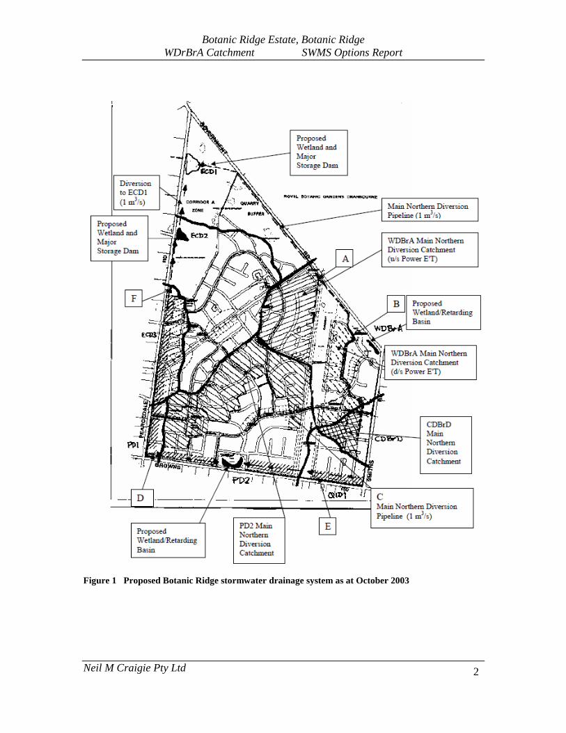
1. INTRODUCTION This report outlines the functional design options for the stormwater drainage system in the Wylies Drain Branch A catchment in the northeast sector of the Botanic Ridge Estate. The original Surface Water Management Strategy (SWMS) report prepared for Casey Council (Neil M Craigie P/L, 6 October 2003) outlined requirements for drainage design to suit urban development in what was then referred to as Stage 1 of the Botanic Ridge urban growth area. Botanic Ridge Estate was then known as the Marnebek Estate. Figure 1 shows the recommended drainage layout from the 2003 document. In essence an area of about 40 ha in the southern (PD2) catchment area draining to Browns Road was to be provided with a 1 m3/s pipeline diversion around the contour, northeasterly into the Wylies Drain Branch A (WDBrA) catchment. Another 6 ha which naturally drains southeasterly in the Christies Drain Branch D (CDBrD) catchment was also to be diverted northwards into the WDBrA system. A total of 44 ha in Botanic Ridge naturally drains to the WDrBRA catchment and thence into the Royal Botanic Gardens Cranbourne (RBGC). In conjunction with a wetland/retarding basin (WLRB) on the Browns Road frontage and allotment raintanks, this diversion system was intended to effectively offset the impacts of urban development on receiving drainage lines south of Browns Road. To protect the Royal Botanic Gardens Cranbourne (RBGC) environment from the impacts of the increased urban runoff arising from the diversions plus urbanization in the 44 ha local catchment, another WLRB was to be provided in the northeast lowpoint and the 1 m3/s capacity diversion pipeline was to be continued along the northern boundary and into the Settlers Run Golf Course drainage system. The 2003 SWMS provided for the first 5 l/s of flow arriving at the NE WLRB to be passed through and into the RBGC after wetland treatment, so as to maintain flow supply to the RBGC water features. To allow for additional water to be captured for use in the RBGC wetlands, the NE WLRB was to be fitted with a valve inlet system to allow waters to be directed out of the diversion pipeline and into the RBGC drainage system, if RBGC management desired. Development in the PD2 catchment is largely complete, the Browns Road WLRB has been established and commissioned, and the 1m3/s diversion pipeline is now fully operational for its full length around into the Settlers Run Golf Course. The original 2003 scheme was intended to provide for an average lot density of about 7 lots/ha with minimum lot size of 1,000 m2. Based on the average lot yield estimate, surface imperviousness in the Botanic Ridge study area was adopted as at most 35%.
Botanic Ridge Estate, Botanic Ridge WDrBrA Catchment SWMS Options Report
Neil M Craigie Pty Ltd
2
Figure 1 Proposed Botanic Ridge stormwater drainage system as at October 2003
Botanic Ridge Estate, Botanic Ridge WDrBrA Catchment SWMS Options Report
Neil M Craigie Pty Ltd
3
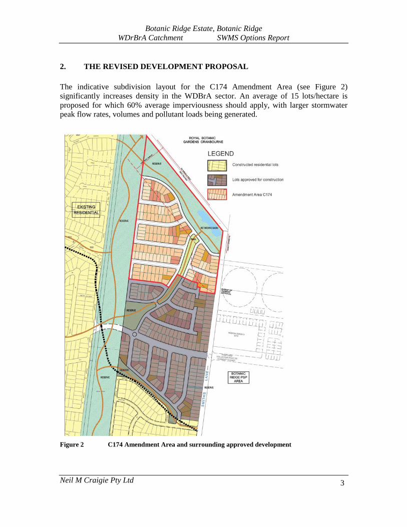
2. THE REVISED DEVELOPMENT PROPOSAL The indicative subdivision layout for the C174 Amendment Area (see Figure 2) significantly increases density in the WDBrA sector. An average of 15 lots/hectare is proposed for which 60% average imperviousness should apply, with larger stormwater peak flow rates, volumes and pollutant loads being generated.
Figure 2 C174 Amendment Area and surrounding approved development

Botanic Ridge Estate, Botanic Ridge WDrBrA Catchment SWMS Options Report
Neil M Craigie Pty Ltd
4
Figure 3 shows the overall development plan, main subcatchments, main stormwater drainage pipes, and the NE WLRB which is to be located in the northeast reserve abutting the RBGC boundary.
Figure 3 Catchment and pipe diversions relevant to design of the northeast retarding basin
Botanic Ridge Estate, Botanic Ridge WDrBrA Catchment SWMS Options Report
Neil M Craigie Pty Ltd
5
3. HYDROLOGIC DESIGN
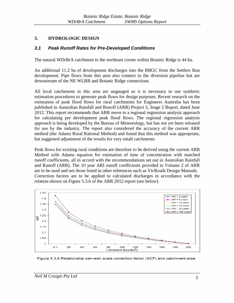
3.1 Peak Runoff Rates for Pre-Developed Conditions The natural WDrBrA catchment to the northeast corner within Botanic Ridge is 44 ha. An additional 11.2 ha of development discharges into the RBGC from the Settlers Run development. Pipe flows from this area also connect to the diversion pipeline but are downstream of the NE WLRB and Botanic Ridge connections. All local catchments in this area are ungauged so it is necessary to use synthetic estimation procedures to generate peak flows for design purposes. Recent research on the estimation of peak flood flows for rural catchments for Engineers Australia has been published in Australian Rainfall and Runoff (ARR) Project 5, Stage 2 Report, dated June 2012. This report recommends that ARR move to a regional regression analysis approach for calculating pre development peak flood flows. The regional regression analysis approach is being developed by the Bureau of Meteorology, but has not yet been released for use by the industry. The report also considered the accuracy of the current ARR method (the Adams Rural Rational Method) and found that this method was appropriate, but suggested adjustment of the results for very small catchments. Peak flows for existing rural conditions are therefore to be derived using the current ARR Method with Adams equation for estimation of time of concentration with matched runoff coefficients, all in accord with the recommendations set out in Australian Rainfall and Runoff (ARR). The 10 year ARI runoff coefficients provided in Volume 2 of ARR are to be used and not those listed in other references such as VicRoads Design Manuals. Correction factors are to be applied to calculated discharges in accordance with the relation shown on Figure 5.3.6 of the ARR 2012 report (see below).
Botanic Ridge Estate, Botanic Ridge WDrBrA Catchment SWMS Options Report
Neil M Craigie Pty Ltd
6
The peak flows in Table 1 then form the required limits on discharge out of the basin into the RBGC with full development in place.
TABLE 1 Peak Discharges for varying ARI (m3/s) – Pre-development Conditions Waterway Location Catchment 1 yr ARI 10 yr ARI 100 yr ARI
Wylies Drain Branch A
NE corner of Botanic Ridge
44 ha 0.15*1.35=0.20 0.41*1.36=0.56 0.89*1.43=1.27
3.2 RORB Model Application The RORB hydrologic model has been used to simulate catchment runoff and design the retarding basin for fully developed conditions. The model includes routines which allow the operation of the diversion systems to be fully incorporated. Figure 2 shows the subarea setup used in the RORB model. For conservatism the Settlers Run subcatchment of 11.2 ha was assumed to be effectively captured by the diversion pipeline/NE WLRB system. The total catchment area influencing design of the basin is thus 95.64 ha including the 39.9 ha PD2 diversion catchment as shown on Figure 2. The model parameter values were adopted as follows: Kc = 1.50 (MWC equation Kc=1.53A0.55), m = 0.8, Pervious area initial loss = 10 mm Pervious area runoff coefficients (CROp) = 0.6 (100 yr), 0.55 (50 yr), 0.50 (20 yr), 0.40 (10 yr), 0.30 (5 yr), 0.25 (2 yr) and 0.20 (1 yr). Subarea imperviousness was varied according to existing and proposed development densities and factoring in the transmission easement, all as shown on Figure 2. Table 2 summarises the values adopted.
TABLE 2 RORB Subareas and Imperviousness (refer to Figure 2) Subarea Area (ha) %impervious
A 20.00 45 B 19.90 45 C 4.68 40 D 20.76 60 E 10.65 49 F 8.45 35 G 11.20 40

Botanic Ridge Estate, Botanic Ridge WDrBrA Catchment SWMS Options Report
Neil M Craigie Pty Ltd
7
3.3 Retarding Basin Sizing The RORB model was run in trial and error mode with 1 m3/s continuous diversion, and varying outlet controls and storage volume until a reasonably good fit was obtained to the peak flow limits set out in Table 1. It was found that a volume of about 13,000 m3 was required with outfall pipe diameter of 675 mm. Figure 3 shows a conceptual layout for a storage with this capacity, matched to existing contours and as-built pipeline levels. Pit 7 is the existing surcharge control pit on the 1050 mm diameter diversion pipeline. An embankment to 74.50 m is proposed with spillway cut into natural surface at 74.20 m at the northwestern end. The downstream end of the 675 mm pipeline will include an energy dissipation device with outflows being distributed via a vegetated swale along the RBGC boundary. The basin floor is to contain a wetland area of at least 0.1 ha to treat the initial low flows out of the diversion pipe which are to be passed into the RBGC to maintain flows as closely as possible to existing conditions. The 2003 SWMS estimated the initial low flows to be 5 l/s but this may be varied depending on RBGC desires in regard to supply of treated water to support their water features downstream. Detailed design of the storage will be undertaken by Breese Pitt Dixon and it is entirely possible that some variation to the layout will occur to best suit other servicing constraints and landscaping design. Provided that the volume and levels are still achieved, any such changes will not impact on the results obtained in this study. The actual low flow limits and operation of the gate valve system to supply water to the RBGC when required, are issues still to be finalized in consultation with RBGC management.

Botanic Ridge Estate, Botanic Ridge WDrBrA Catchment SWMS Options Report
Neil M Craigie Pty Ltd
8
3.4 RORB Model Results Table 3 summarises the model results with the adopted storage concept. Peak outflows are lower than those expected under pre-development conditions across the ARI range. Hence the 2014 development proposal poses no threat to the RBGC in regards to peak flow management for all flood events up to and including the 100 year ARI event.
TABLE 3 RORB Model Results for fully developed conditions (Critical Durations in hours in parentheses) (Filename: Botanic Ridge AVJ WDBrA. cat)
ARI (yrs)
Asset/Location Peak Inflow (m3/s)
Peak Outflow (m3/s)
Water Level (m)
Storage Volume (m3)
1 Botanic Ridge NE RB 0.49 (2) 0.18 (9) 72.50 353 10 3.13 (2) 0.71 (6) 73.24 4,740
100 7.12 (2) 1.10 (9) 74.10 13,000
Figure 4 Concept arrangement for NE WLRB
Area below 72.5 m to incorporate 0.1 ha stormwater quality treatment wetland

Botanic Ridge Estate, Botanic Ridge WDrBrA Catchment SWMS Options Report
Neil M Craigie Pty Ltd
9
3.5 Control Structures The existing 1050 mm diameter inlet pipe to the basin is required to convey the excess over the 1 m3/s diversion capacity. The as-built pipe details show that a peak flow of 1.35 m3/s will apply with balance inflows occurring as overland flows from several road alignments and the northern reserve. However the internal weir wall in the surcharge pit (Pit 7 on Figure 3) is set at 74.80 m which is well above the proposed 100 year ARI flood level in the basin. Thus there is a need for energy dissipation facilities to be integrated with the design of the pipe extension into the storage area and wetland. It is recommended that a roughly finished landscaped rocky vegetated channel be provided for the purpose between the pipe outlet and the basin floor zone, including around the 675 mm pipe outlet. A similar treatment is recommended for the distributor swale across the RBGC boundary setback to ensure outflows are spread as widely as possible. The terminal structure on the end of the 675 mm pipe should be formed as a 3 sided pit 1.2 m long and 0.9 m wide, with the opening on the east side, forcing flows to impact on the endwall first before exiting to the swale. A medium duty gatic lid should be fitted to prevent vertical surcharge occurring. The valve system to allow low flow water to be diverted into the wetland and thence the RBGC as required, will need to be retrofitted into the existing surcharge pit (Pit 7 on Figure 3). A 150 mm diameter valve should suffice. The design and operation of this device is subject to negotiation with RBGC and MWC. A GPT (litter only) also needs to be retrofitted into the diversion pipeline system. Detail plans will be prepared by Breese Pitt Dixon P/L.

Botanic Ridge Estate, Botanic Ridge WDrBrA Catchment SWMS Options Report
Neil M Craigie Pty Ltd
10
4. WATER QUALITY TREATMENT PERFORMANCE
4.1 2003 SWMS Scenario Under the original 2003 SWMS, water quality treatment within the northern part of Botanic Ridge was to be integrated within the retarding basin as a 0.1 ha wetland. The wetland would only treat that component of the stormwater flows directed into RBGC. The balance best practice requirements were to be achieved in the wetland/lake/reuse systems within Settlers Run. A MUSIC V3 model was firstly set up with the Koo Wee Rup 2004 6 minute rainfall data sequence as is now required by MWC, and with roof area/raintank/other impervious area/pervious area data appropriate to the 2003 SWMS development scenario. Raintanks have been specified and installed for every dwelling under MR24 of the Botanic Ridge Design Guidelines. The model parameters were adjusted to suit roof runoff, other impervious runoff and pervious area runoff, using values recommended by Ecological Engineering P/L in their Pentridge Village investigations (EDAW Ecological Engineering 2008, Pentridge Village WSUD Strategy). A GPT specified to achieve the target best practice Gross Pollutant (GP) removal was included at Pit 7. Another was included at the outlet from subarea F. At the detail design stage it may be that more GPT’s are incorporated at various places into the drainage network. This model also considered pre-development loads using Melbourne Water’s default 5% imperviousness assumption. Subarea F has been developed as per the 2003 SWMS and will connect to the diversion pipeline downstream of the outlet to the NE WLRB. Subarea G is Settlers Run and does not form part of the Botanic Ridge water quality treatment system so is shown entering downstream. The results listed in Table 4 confirm that:
• pollutant loads discharged to the RBGC under the 2003 SWMS scenario would be significantly lower than under pre-development conditions;
• mean annual flows will also be reduced by almost 40%.

Botanic Ridge Estate, Botanic Ridge WDrBrA Catchment SWMS Options Report
Neil M Craigie Pty Ltd
11
The reduction in flows may be of significant concern to RBGC so further assessment of flow limit impacts is made in Section 5.1 to provide a basis for guidance. The flows and pollutant loads discharged into Settlers Run in Table 4 effectively become the targets to be met in the SWMS for Botanic Ridge.
TABLE 4 WQ treatment performance Botanic Ridge discharge to RBGC/Settlers Run as per 2003 SWMS
Total Source Loads to RBGC
(Pre-development, 44 ha catchment)
Post Development Parameter Total loads
into GPT at Pit 7
Total loads to Settlers Run from Botanic
Ridge (incl. s/a F)
Totals loads to NE WLRB
from Botanic Ridge
Total loads to RBGC from
Botanic Ridge
Flow (ML/yr) 117 279 238 70 68 Suspended Solids (kg/yr) 8,390 31,700 30,800 4,000 2,220 Total Phosphorus (kg/yr) 19 61 57 10 8
Total Nitrogen (kg/yr) 159 540 496 100 88 GP (kg/yr) 444 5,780 971 227 0
4.2 2014 Development Scenario A second model was then established to simulate the proposed 2014 development scenario with the same 5 l/s low flow outlet to the NE WLRB as used in the 2003 SWMS scenario. The raintank sizing adopted throughout was 5 KL/100 m2 roof area with only 50% of the roof area assumed to be connected to the tank. Total roof area was adopted as 200 m2/lot on average; a value that is lower than most dwellings constructed across the estate to date, based on nearmap.com assessment. Hence all results are conservative. The modelling confirmed that the raintanks are primarily of benefit in reducing flow volumes and TN; TSS and TP pollutant removal is less significant owing to the “cleaner” runoff generated from roof areas compared with other impervious areas such as road pavements. The results listed in Table 5 indicate that:
• No significant change occurs to flows or pollutant loads discharged to the RBGC compared with the 2003 SWMS development scenario.
• Mean annual flows discharged to Settlers Run are increased by 11%,
Botanic Ridge Estate, Botanic Ridge WDrBrA Catchment SWMS Options Report
Neil M Craigie Pty Ltd
12
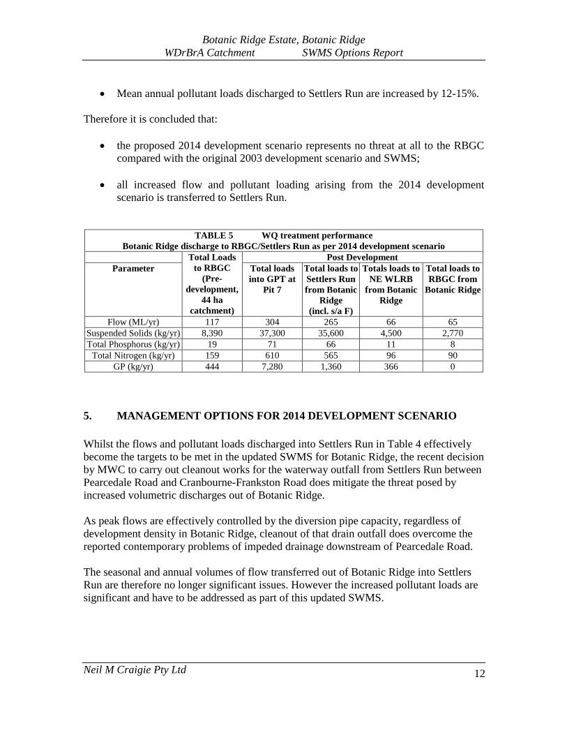
• Mean annual pollutant loads discharged to Settlers Run are increased by 12-15%. Therefore it is concluded that:
• the proposed 2014 development scenario represents no threat at all to the RBGC compared with the original 2003 development scenario and SWMS;
• all increased flow and pollutant loading arising from the 2014 development
scenario is transferred to Settlers Run.
TABLE 5 WQ treatment performance Botanic Ridge discharge to RBGC/Settlers Run as per 2014 development scenario
Total Loads to RBGC
(Pre-development,
44 ha catchment)
Post Development Parameter Total loads
into GPT at Pit 7
Total loads to Settlers Run from Botanic
Ridge (incl. s/a F)
Totals loads to NE WLRB
from Botanic Ridge
Total loads to RBGC from
Botanic Ridge
Flow (ML/yr) 117 304 265 66 65 Suspended Solids (kg/yr) 8,390 37,300 35,600 4,500 2,770 Total Phosphorus (kg/yr) 19 71 66 11 8
Total Nitrogen (kg/yr) 159 610 565 96 90 GP (kg/yr) 444 7,280 1,360 366 0
5. MANAGEMENT OPTIONS FOR 2014 DEVELOPMENT SCENARIO Whilst the flows and pollutant loads discharged into Settlers Run in Table 4 effectively become the targets to be met in the updated SWMS for Botanic Ridge, the recent decision by MWC to carry out cleanout works for the waterway outfall from Settlers Run between Pearcedale Road and Cranbourne-Frankston Road does mitigate the threat posed by increased volumetric discharges out of Botanic Ridge. As peak flows are effectively controlled by the diversion pipe capacity, regardless of development density in Botanic Ridge, cleanout of that drain outfall does overcome the reported contemporary problems of impeded drainage downstream of Pearcedale Road. The seasonal and annual volumes of flow transferred out of Botanic Ridge into Settlers Run are therefore no longer significant issues. However the increased pollutant loads are significant and have to be addressed as part of this updated SWMS.

Botanic Ridge Estate, Botanic Ridge WDrBrA Catchment SWMS Options Report
Neil M Craigie Pty Ltd
13
There are two feasible options available to offset the modelled impacts in Settlers Run:
Option 1 Given that post-development conditions will significantly reduce runoff to the RBGC compared to pre-development conditions with the current low flow limit of 5 l/s, additional flows could be discharged to the RBGC.
Option 2 If RBGC object to receiving any increased flows compared with the 2003 SWMS then it would be necessary to add further stormwater treatment assets in Botanic Ridge.
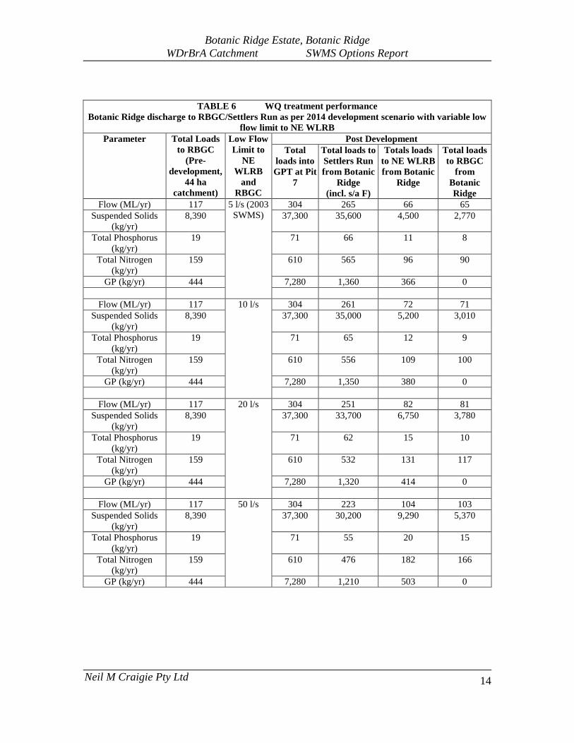
5.1 Option 1 Increase in Low Flow Limit to NE WLRB and RBGC A sensitivity analysis was carried out in the MUSIC model varying the low flow limit into the NE WLRB and thence changing inflows to RBGC. The wetland area of 0.1 ha was kept as a constant. Table 6 shows the impacts on flows and pollutant loads to both Settlers Run and the RBGC. The results show that:
• even with low flow limit increased by one order of magnitude to 50 l/s, mean annual flows and pollutant loads discharged into the RBGC will still be less than under pre-developed conditions;
• with the low flow limit increased to 50 l/s, mean annual flows and pollutant loads
into Settlers Run are maintained at or below those generated for the original 2003 development and SWMS.
Thus increasing the low flow limit to 50 l/s provides one complete effective solution to both Settlers Run and the RBGC with no significant change to required stormwater management asset design.
Botanic Ridge Estate, Botanic Ridge WDrBrA Catchment SWMS Options Report
Neil M Craigie Pty Ltd
14
TABLE 6 WQ treatment performance
Botanic Ridge discharge to RBGC/Settlers Run as per 2014 development scenario with variable low flow limit to NE WLRB
Parameter Total Loads to RBGC
(Pre-development,
44 ha catchment)
Low Flow Limit to
NE WLRB
and RBGC
Post Development Total
loads into GPT at Pit
7
Total loads to Settlers Run from Botanic
Ridge (incl. s/a F)
Totals loads to NE WLRB from Botanic
Ridge
Total loads to RBGC
from Botanic Ridge
Flow (ML/yr) 117 5 l/s (2003 SWMS)
304 265 66 65 Suspended Solids
(kg/yr) 8,390 37,300 35,600 4,500 2,770
Total Phosphorus (kg/yr)
19 71 66 11 8
Total Nitrogen (kg/yr)
159 610 565 96 90
GP (kg/yr) 444 7,280 1,360 366 0
Flow (ML/yr) 117 10 l/s 304 261 72 71 Suspended Solids
(kg/yr) 8,390 37,300 35,000 5,200 3,010
Total Phosphorus (kg/yr)
19 71 65 12 9
Total Nitrogen (kg/yr)
159 610 556 109 100
GP (kg/yr) 444 7,280 1,350 380 0
Flow (ML/yr) 117 20 l/s 304 251 82 81 Suspended Solids
(kg/yr) 8,390 37,300 33,700 6,750 3,780
Total Phosphorus (kg/yr)
19 71 62 15 10
Total Nitrogen (kg/yr)
159 610 532 131 117
GP (kg/yr) 444 7,280 1,320 414 0
Flow (ML/yr) 117 50 l/s 304 223 104 103 Suspended Solids
(kg/yr) 8,390 37,300 30,200 9,290 5,370
Total Phosphorus (kg/yr)
19 71 55 20 15
Total Nitrogen (kg/yr)
159 610 476 182 166
GP (kg/yr) 444 7,280 1,210 503 0
Botanic Ridge Estate, Botanic Ridge WDrBrA Catchment SWMS Options Report
Neil M Craigie Pty Ltd
15
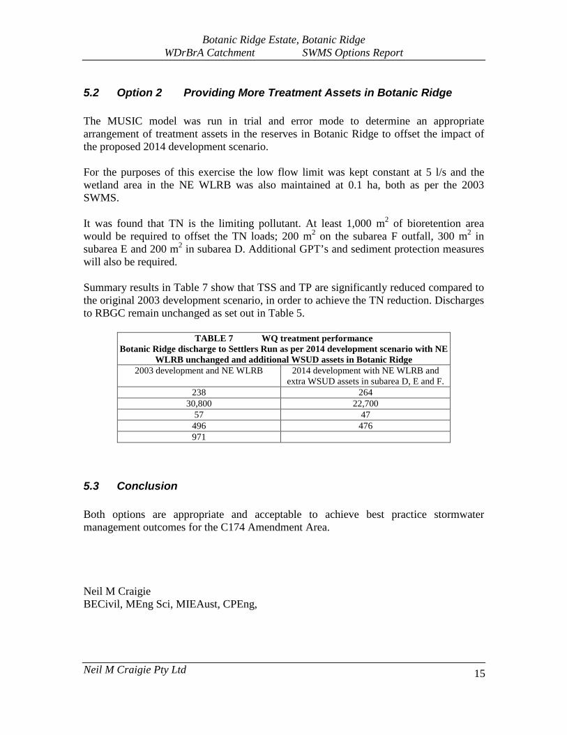
5.2 Option 2 Providing More Treatment Assets in Botanic Ridge The MUSIC model was run in trial and error mode to determine an appropriate arrangement of treatment assets in the reserves in Botanic Ridge to offset the impact of the proposed 2014 development scenario. For the purposes of this exercise the low flow limit was kept constant at 5 l/s and the wetland area in the NE WLRB was also maintained at 0.1 ha, both as per the 2003 SWMS. It was found that TN is the limiting pollutant. At least 1,000 m2 of bioretention area would be required to offset the TN loads; 200 m2 on the subarea F outfall, 300 m2 in subarea E and 200 m2 in subarea D. Additional GPT’s and sediment protection measures will also be required. Summary results in Table 7 show that TSS and TP are significantly reduced compared to the original 2003 development scenario, in order to achieve the TN reduction. Discharges to RBGC remain unchanged as set out in Table 5.
TABLE 7 WQ treatment performance Botanic Ridge discharge to Settlers Run as per 2014 development scenario with NE
WLRB unchanged and additional WSUD assets in Botanic Ridge 2003 development and NE WLRB 2014 development with NE WLRB and
extra WSUD assets in subarea D, E and F. 238 264
30,800 22,700 57 47
496 476 971
5.3 Conclusion Both options are appropriate and acceptable to achieve best practice stormwater management outcomes for the C174 Amendment Area. Neil M Craigie BECivil, MEng Sci, MIEAust, CPEng,