botetourt county road orders 1770 - 1778 - virginia department
TRANSCRIPT
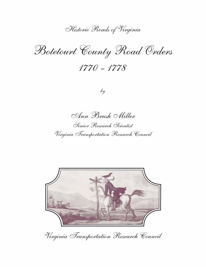
Historic Roads of Virginia
Botetourt County Road Orders
1770 - 1778
Ann Brush MillerSenior Research Scientist
Virginia Transportation Research Council
Virginia Transportation Research Council
by
Standard Title Page - Report on State Project Report No.
Report Date
No. Pages
Type Report: Final
Project No.: 78150
VTRC 07-R22 February 2007 108 Period Covered: August 2005 to January 2007
Contract No.
Title: Botetourt County Road Orders 1770-1778
Key Words: Virginia, Early Roads, Botetourt County, Southwest Virginia
Author: Ann Brush Miller
Performing Organization’s Name and Address: Virginia Transportation Research Council 530 Edgemont Road Charlottesville, VA 22903
Sponsoring Agencies’ Name and Address: Virginia Department of Transportation 1401 E. Broad Street Richmond, VA 23219
Supplementary Notes
Abstract The road history projects undertaken by the Virginia Transportation Research Council establish the feasibility of studies of early road networks and their use in the environmental review process. These projects, by gathering and publishing the early road orders of the vast parent counties, also lay the foundation for additional research by local groups over a broad area of Virginia This volume marks the twenty-fourth entry in the Historic Roads of Virginia series, first initiated by the Virginia Transportation Research Council (then the Virginia Highway & Transportation Research Council) in 1973. Botetourt County Road Orders 1770-1778 expands the coverage of early western Virginia transportation records begun in the previously published Orange County Road Orders 1734-1749 and Augusta County Road Orders 1745-1769. This information will eliminate the need for further research into the Botetourt County road order records of 1770-1778. If questions arise about early roads once a VDOT road improvement project is already underway (or nearly underway), primary historical research of this nature can take 6 to 12 months to complete. Therefore, this study can be a source of potentially significant cost savings for VDOT, including the avoided costs of project delays and avoided consultant costs for cultural resource studies should questions arise.
BOTETOURT COUNTY ROAD ORDERS 1770-1778
by
Ann Brush Miller Senior Research Scientist
Virginia Transportation Research Council
Virginia Transportation Research Council (A partnership of the Virginia Department of Transportation
and the University of Virginia since 1948)
Charlottesville, Virginia
February 2007 VTRC 07-R22
ii
DISCLAIMER
The contents of this report reflect the views of the author, who is responsible for the facts and the accuracy of the data presented herein. The contents do not necessarily reflect the official views or policies of the Virginia Department of Transportation, the Commonwealth Transportation Board, or the Federal Highway Administration. This report does not constitute a standard, specification, or regulation.
Copyright 2007 by the Commonwealth of Virginia.
iii
HISTORIC ROADS OF VIRGINIA Louisa County Road Orders 1742-1748, by Nathaniel Mason Pawlett Goochland County Road Orders 1728-1744, by Nathaniel Mason Pawlett Albemarle County Road Orders 1744-1748, by Nathaniel Mason Pawlett The Route of the Three Notch’d Road, by Nathaniel Mason Pawlett and Howard Newlon An Index to Roads in the Albemarle County Surveyor’s Books 1744-1853, by Nathaniel Mason
Pawlett A Brief History of the Staunton and James River Turnpike, by Douglas Young Albemarle County Road Orders 1783-1816, by Nathaniel Mason Pawlett A Brief History of Roads in Virginia 1607-1840, by Nathaniel Mason Pawlett A Guide to the Preparation of County Road Histories, by Nathaniel Mason Pawlett Early Road Location: Key to Discovering Historic Resources? by Nathaniel Mason Pawlett and
K. Edward Lay Albemarle County Roads 1725-1816, by Nathaniel Mason Pawlett “Backsights,” A Bibliography, by Nathaniel Mason Pawlett Orange County Road Orders 1734-1749, by Ann Brush Miller Spotsylvania County Road Orders 1722-1734, by Nathaniel Mason Pawlett Brunswick County Road Orders 1732-1749, by Nathaniel Mason Pawlett Orange County Road Orders 1750-1800, by Ann Brush Miller Lunenburg County Road Orders 1746-1764, by Nathaniel Mason Pawlett and Tyler Jefferson
Boyd Culpeper County Road Orders 1763-1764, by Ann Brush Miller Augusta County Road Orders 1745-1769, by Nathaniel Mason Pawlett, Ann Brush Miller,
Kenneth Madison Clark and Thomas Llewellyn Samuel, Jr.

iv
Amelia County Road Orders 1735-1753, by Nathaniel Mason Pawlett, Ann Brush Miller, and Kenneth Madison Clark
Fairfax County Road Orders 1749-1800, by Beth Mitchell New Kent County and Hanover County Road Orders 1706-1743, Transcribed from the Vestry
Book of St. Paul’s Parish, by Ann Brush Miller Frederick County Road Orders 1743-1772, by Gene Luckman and Ann Brush Miller
v
FOREWORD
by
Ann Brush Miller Virginia Transportation Research Council
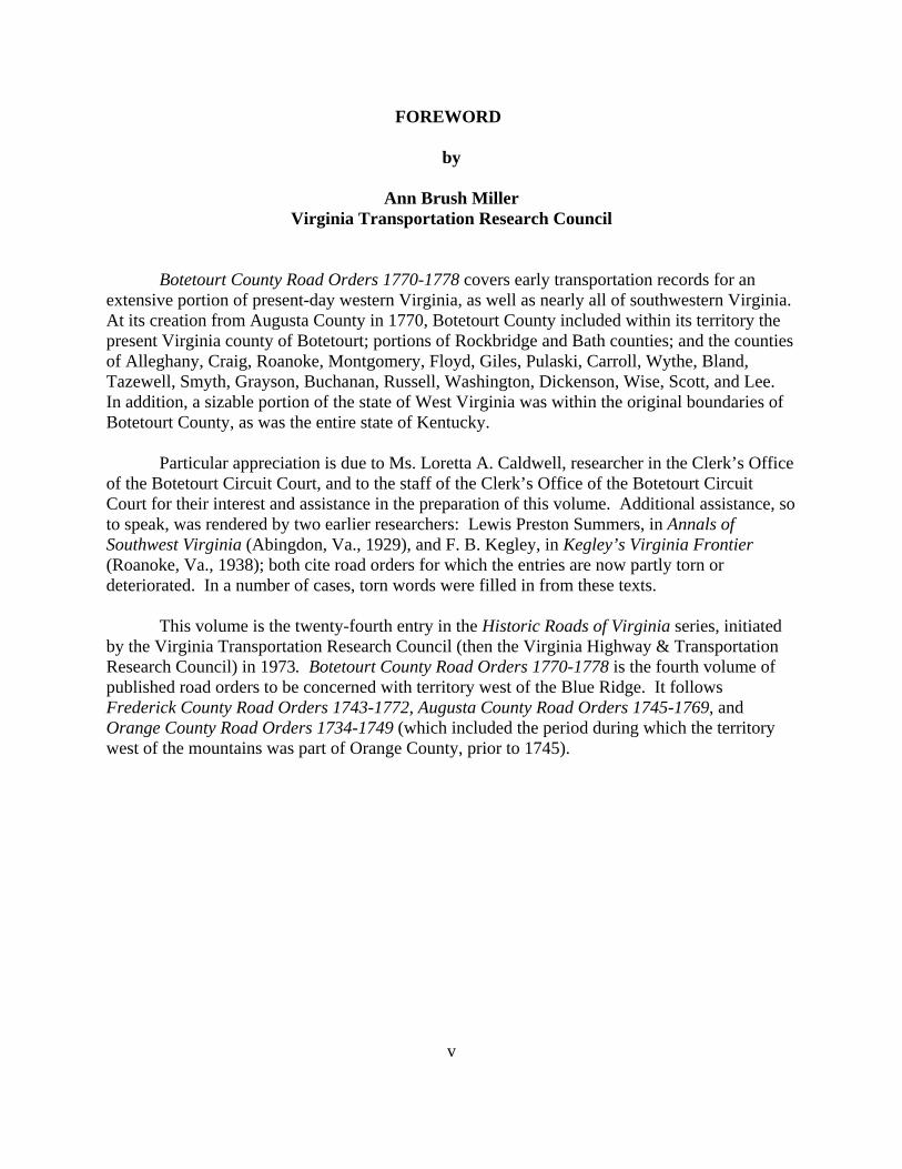
Botetourt County Road Orders 1770-1778 covers early transportation records for an extensive portion of present-day western Virginia, as well as nearly all of southwestern Virginia. At its creation from Augusta County in 1770, Botetourt County included within its territory the present Virginia county of Botetourt; portions of Rockbridge and Bath counties; and the counties of Alleghany, Craig, Roanoke, Montgomery, Floyd, Giles, Pulaski, Carroll, Wythe, Bland, Tazewell, Smyth, Grayson, Buchanan, Russell, Washington, Dickenson, Wise, Scott, and Lee. In addition, a sizable portion of the state of West Virginia was within the original boundaries of Botetourt County, as was the entire state of Kentucky.
Particular appreciation is due to Ms. Loretta A. Caldwell, researcher in the Clerk’s Office
of the Botetourt Circuit Court, and to the staff of the Clerk’s Office of the Botetourt Circuit Court for their interest and assistance in the preparation of this volume. Additional assistance, so to speak, was rendered by two earlier researchers: Lewis Preston Summers, in Annals of Southwest Virginia (Abingdon, Va., 1929), and F. B. Kegley, in Kegley’s Virginia Frontier (Roanoke, Va., 1938); both cite road orders for which the entries are now partly torn or deteriorated. In a number of cases, torn words were filled in from these texts.
This volume is the twenty-fourth entry in the Historic Roads of Virginia series, initiated
by the Virginia Transportation Research Council (then the Virginia Highway & Transportation Research Council) in 1973. Botetourt County Road Orders 1770-1778 is the fourth volume of published road orders to be concerned with territory west of the Blue Ridge. It follows Frederick County Road Orders 1743-1772, Augusta County Road Orders 1745-1769, and Orange County Road Orders 1734-1749 (which included the period during which the territory west of the mountains was part of Orange County, prior to 1745).

vi
vii
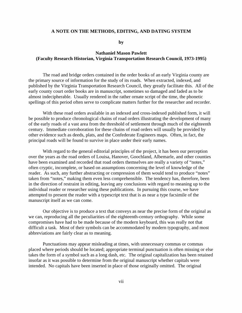
A NOTE ON THE METHODS, EDITING, AND DATING SYSTEM
by
Nathaniel Mason Pawlett (Faculty Research Historian, Virginia Transportation Research Council, 1973-1995)
The road and bridge orders contained in the order books of an early Virginia county are
the primary source of information for the study of its roads. When extracted, indexed, and published by the Virginia Transportation Research Council, they greatly facilitate this. All of the early county court order books are in manuscript, sometimes so damaged and faded as to be almost indecipherable. Usually rendered in the rather ornate script of the time, the phonetic spellings of this period often serve to complicate matters further for the researcher and recorder.
With these road orders available in an indexed and cross-indexed published form, it will be possible to produce chronological chains of road orders illustrating the development of many of the early roads of a vast area from the threshold of settlement through much of the eighteenth century. Immediate corroboration for these chains of road orders will usually be provided by other evidence such as deeds, plats, and the Confederate Engineers maps. Often, in fact, the principal roads will be found to survive in place under their early names.
With regard to the general editorial principles of the project, it has been our perception over the years as the road orders of Louisa, Hanover, Goochland, Albemarle, and other counties have been examined and recorded that road orders themselves are really a variety of “notes,” often cryptic, incomplete, or based on assumptions concerning the level of knowledge of the reader. As such, any further abstracting or compression of them would tend to produce “notes” taken from “notes,” making them even less comprehensible. The tendency has, therefore, been in the direction of restraint in editing, leaving any conclusions with regard to meaning up to the individual reader or researcher using these publications. In pursuing this course, we have attempted to present the reader with a typescript text that is as near a type facsimile of the manuscript itself as we can come.
Our objective is to produce a text that conveys as near the precise form of the original as we can, reproducing all the peculiarities of the eighteenth-century orthography. While some compromises have had to be made because of the modern keyboard, this was really not that difficult a task. Most of their symbols can be accommodated by modern typography, and most abbreviations are fairly clear as to meaning.
Punctuations may appear misleading at times, with unnecessary commas or commas
placed where periods should be located; appropriate terminal punctuation is often missing or else takes the form of a symbol such as a long dash, etc. The original capitalization has been retained insofar as it was possible to determine from the original manuscript whether capitals were intended. No capitals have been inserted in place of those originally omitted. The original
viii
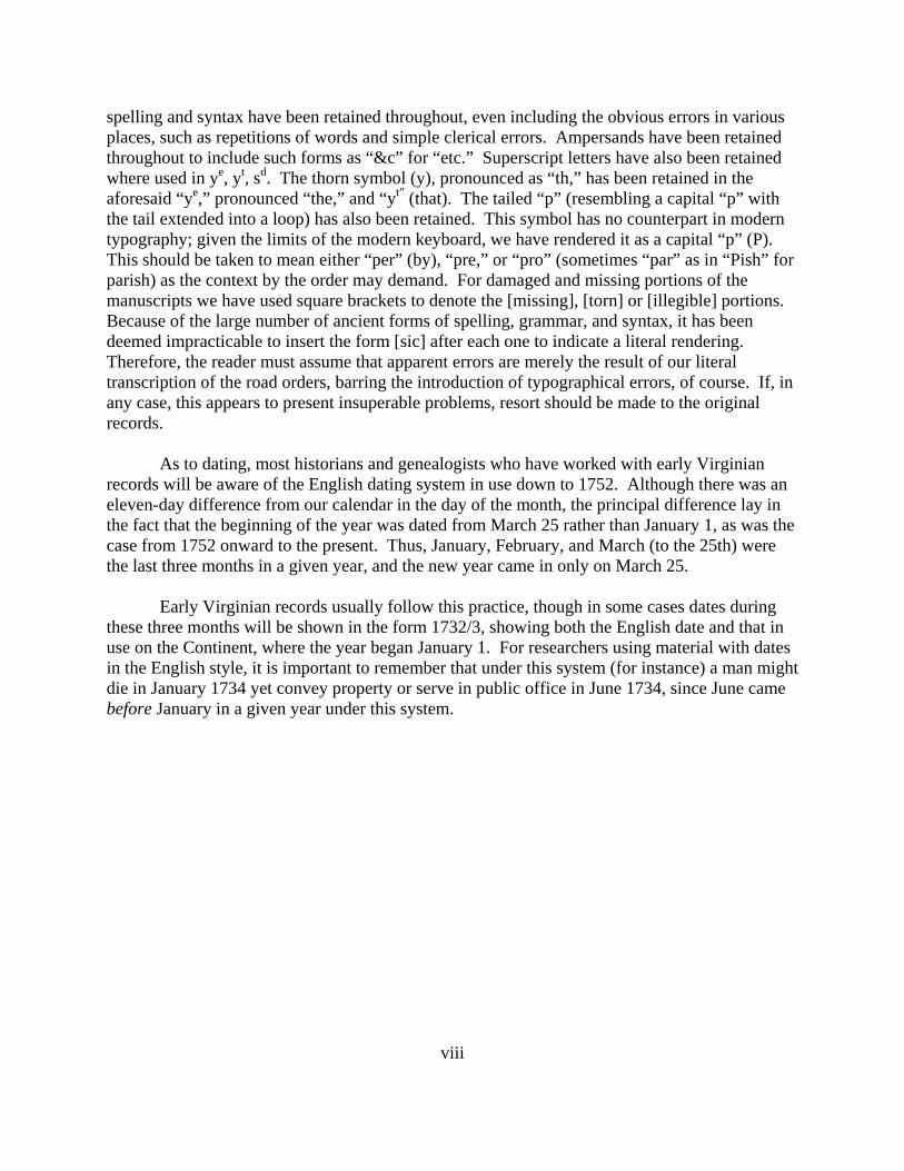
spelling and syntax have been retained throughout, even including the obvious errors in various places, such as repetitions of words and simple clerical errors. Ampersands have been retained throughout to include such forms as “&c” for “etc.” Superscript letters have also been retained where used in ye, yt, sd. The thorn symbol (y), pronounced as “th,” has been retained in the aforesaid “ye,” pronounced “the,” and “yt” (that). The tailed “p” (resembling a capital “p” with the tail extended into a loop) has also been retained. This symbol has no counterpart in modern typography; given the limits of the modern keyboard, we have rendered it as a capital “p” (P). This should be taken to mean either “per” (by), “pre,” or “pro” (sometimes “par” as in “Pish” for parish) as the context by the order may demand. For damaged and missing portions of the manuscripts we have used square brackets to denote the [missing], [torn] or [illegible] portions. Because of the large number of ancient forms of spelling, grammar, and syntax, it has been deemed impracticable to insert the form [sic] after each one to indicate a literal rendering. Therefore, the reader must assume that apparent errors are merely the result of our literal transcription of the road orders, barring the introduction of typographical errors, of course. If, in any case, this appears to present insuperable problems, resort should be made to the original records.
As to dating, most historians and genealogists who have worked with early Virginian records will be aware of the English dating system in use down to 1752. Although there was an eleven-day difference from our calendar in the day of the month, the principal difference lay in the fact that the beginning of the year was dated from March 25 rather than January 1, as was the case from 1752 onward to the present. Thus, January, February, and March (to the 25th) were the last three months in a given year, and the new year came in only on March 25.
Early Virginian records usually follow this practice, though in some cases dates during these three months will be shown in the form 1732/3, showing both the English date and that in use on the Continent, where the year began January 1. For researchers using material with dates in the English style, it is important to remember that under this system (for instance) a man might die in January 1734 yet convey property or serve in public office in June 1734, since June came before January in a given year under this system.
ix
INTRODUCTION
by
Ann Brush Miller
The roads are under the government of the county courts, subject to be controuled by the general court. They order whenever they think them necessary. The inhabitants of the county are by them laid off into precincts, to each of which they allot a convenient portion of the public roads to be kept in repair. Such bridges as may be built without the assistance of artificers, they are to be built. If the stream be such as to require a bridge of regular workmanship, the court employs workmen to build it, at the expense of the whole county. If it be too great for the county, application is made to the general assembly, who authorize individuals to build it, and to take a fixed toll from all passengers, or give sanction to such other proposition as to them appears reasonable.
—Thomas Jefferson, Notes on the State of Virginia, 1781
The establishment and maintenance of public roads were among the most important functions of the county court during the colonial period in Virginia. Each road was opened and maintained by an Overseer of the Highways appointed by the Gentlemen Justices yearly. He was usually assigned all the “Labouring Male Titheables” living on or near the road for this purpose. These individuals then furnished all their own tools, wagons, and teams and were required to labor for six days each year on the roads.
Major projects, such as bridges over rivers, demanding considerable expenditure were executed by commissioners appointed by the court to select the site and to contract with workmen for the construction. Where bridges connected two counties, a commission was appointed by each and they cooperated in executing the work.
At its creation from Augusta County in 1770, Botetourt County extended from the northwestern side of the Blue Ridge near present-day Lexington southwest and west to “the utmost limits of Virginia.” Its original territory included the southern portions of present-day Rockbridge and Bath counties and the entirety of the modern counties of Botetourt, Alleghany, Craig, Roanoke, Montgomery, Floyd, Giles, Pulaski, Carroll, Wythe, Bland, Tazewell, Smyth, Grayson, Buchanan, Russell, Washington, Dickenson, Wise, Scott, and Lee. In addition, what is now southern and western West Virginia, as well as the entire state of Kentucky, were within the original boundaries of Botetourt County.
The first major reductions to Botetourt’s territory were the 1772 creation of Fincastle County (divided into the counties of Montgomery, Washington, and Kentucky in 1777) and the 1778 creation of Greenbrier County (now in West Virginia) from portions of Botetourt, Augusta, and Montgomery counties. In lesser territorial losses, Botetourt and Augusta counties yielded territory for the creation of Rockbridge County in 1778, and in 1791, portions of Botetourt, Augusta, and Greenbrier counties were cut off to form Bath County. In addition, in the 19th
x
century, Alleghany County was formed from portions of Botetourt, Bath, and Monroe counties in 1822, and Roanoke County was created from Botetourt County in 1838. The creation of Craig County from portions of Botetourt, Roanoke, Giles, and Monroe counties in 1851 brought Botetourt County to its current boundaries.
The road orders contained in this volume cover the period from 1770, when Botetourt’s
county government became operational, through the creation of Fincastle County in 1772, and down to the creation of Greenbrier and Rockbridge counties in 1778. As such, they comprise the principal extant evidence concerning the early development of roads over a large area of western and southwestern Virginia, and adjoining regions, during the period of expanding settlement during the pre-Revolutionary era and the early years of the American Revolution.
1
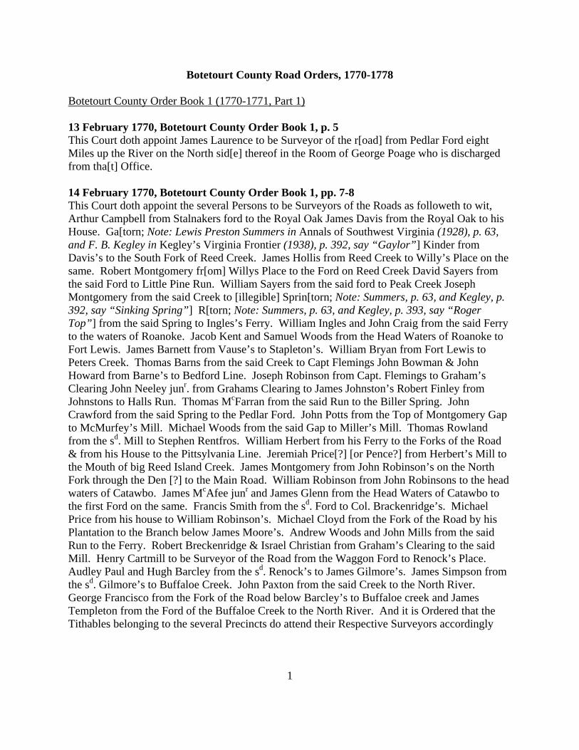
Botetourt County Road Orders, 1770-1778
Botetourt County Order Book 1 (1770-1771, Part 1) 13 February 1770, Botetourt County Order Book 1, p. 5 This Court doth appoint James Laurence to be Surveyor of the r[oad] from Pedlar Ford eight Miles up the River on the North sid[e] thereof in the Room of George Poage who is discharged from tha[t] Office. 14 February 1770, Botetourt County Order Book 1, pp. 7-8 This Court doth appoint the several Persons to be Surveyors of the Roads as followeth to wit, Arthur Campbell from Stalnakers ford to the Royal Oak James Davis from the Royal Oak to his House. Ga[torn; Note: Lewis Preston Summers in Annals of Southwest Virginia (1928), p. 63, and F. B. Kegley in Kegley’s Virginia Frontier (1938), p. 392, say “Gaylor”] Kinder from Davis’s to the South Fork of Reed Creek. James Hollis from Reed Creek to Willy’s Place on the same. Robert Montgomery fr[om] Willys Place to the Ford on Reed Creek David Sayers from the said Ford to Little Pine Run. William Sayers from the said ford to Peak Creek Joseph Montgomery from the said Creek to [illegible] Sprin[torn; Note: Summers, p. 63, and Kegley, p. 392, say “Sinking Spring”] R[torn; Note: Summers, p. 63, and Kegley, p. 393, say “Roger Top”] from the said Spring to Ingles’s Ferry. William Ingles and John Craig from the said Ferry to the waters of Roanoke. Jacob Kent and Samuel Woods from the Head Waters of Roanoke to Fort Lewis. James Barnett from Vause’s to Stapleton’s. William Bryan from Fort Lewis to Peters Creek. Thomas Barns from the said Creek to Capt Flemings John Bowman & John Howard from Barne’s to Bedford Line. Joseph Robinson from Capt. Flemings to Graham’s Clearing John Neeley junr. from Grahams Clearing to James Johnston’s Robert Finley from Johnstons to Halls Run. Thomas McFarran from the said Run to the Biller Spring. John Crawford from the said Spring to the Pedlar Ford. John Potts from the Top of Montgomery Gap to McMurfey’s Mill. Michael Woods from the said Gap to Miller’s Mill. Thomas Rowland from the sd. Mill to Stephen Rentfros. William Herbert from his Ferry to the Forks of the Road & from his House to the Pittsylvania Line. Jeremiah Price[?] [or Pence?] from Herbert’s Mill to the Mouth of big Reed Island Creek. James Montgomery from John Robinson’s on the North Fork through the Den [?] to the Main Road. William Robinson from John Robinsons to the head waters of Catawbo. James McAfee junr and James Glenn from the Head Waters of Catawbo to the first Ford on the same. Francis Smith from the sd. Ford to Col. Brackenridge’s. Michael Price from his house to William Robinson’s. Michael Cloyd from the Fork of the Road by his Plantation to the Branch below James Moore’s. Andrew Woods and John Mills from the said Run to the Ferry. Robert Breckenridge & Israel Christian from Graham’s Clearing to the said Mill. Henry Cartmill to be Surveyor of the Road from the Waggon Ford to Renock’s Place. Audley Paul and Hugh Barcley from the sd. Renock’s to James Gilmore’s. James Simpson from the sd. Gilmore’s to Buffaloe Creek. John Paxton from the said Creek to the North River. George Francisco from the Fork of the Road below Barcley’s to Buffaloe creek and James Templeton from the Ford of the Buffaloe Creek to the North River. And it is Ordered that the Tithables belonging to the several Precincts do attend their Respective Surveyors accordingly
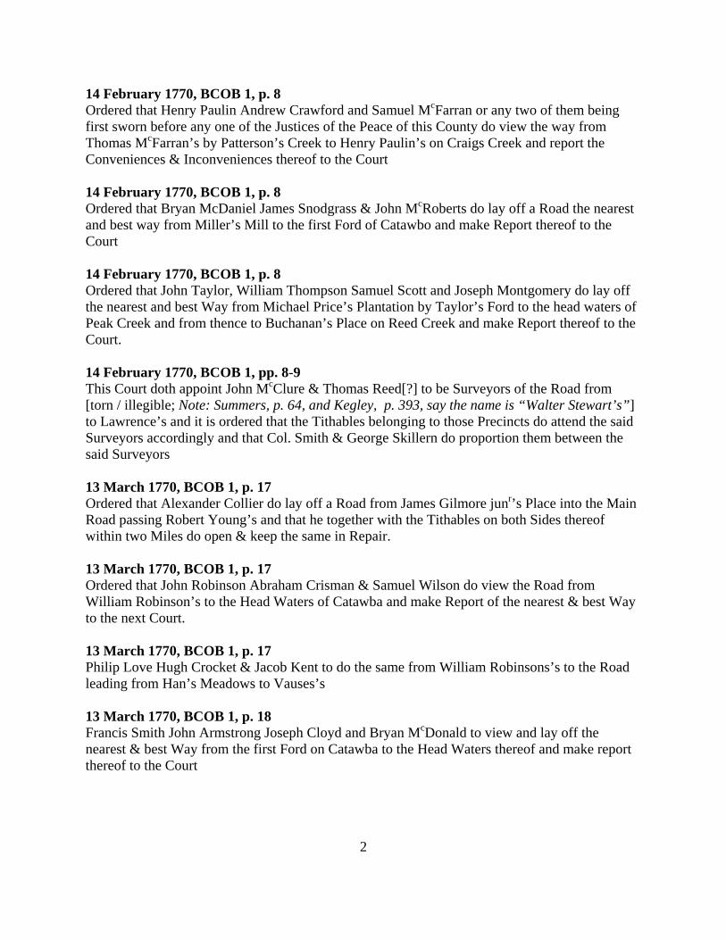
2
14 February 1770, BCOB 1, p. 8 Ordered that Henry Paulin Andrew Crawford and Samuel McFarran or any two of them being first sworn before any one of the Justices of the Peace of this County do view the way from Thomas McFarran’s by Patterson’s Creek to Henry Paulin’s on Craigs Creek and report the Conveniences & Inconveniences thereof to the Court 14 February 1770, BCOB 1, p. 8 Ordered that Bryan McDaniel James Snodgrass & John McRoberts do lay off a Road the nearest and best way from Miller’s Mill to the first Ford of Catawbo and make Report thereof to the Court 14 February 1770, BCOB 1, p. 8 Ordered that John Taylor, William Thompson Samuel Scott and Joseph Montgomery do lay off the nearest and best Way from Michael Price’s Plantation by Taylor’s Ford to the head waters of Peak Creek and from thence to Buchanan’s Place on Reed Creek and make Report thereof to the Court. 14 February 1770, BCOB 1, pp. 8-9 This Court doth appoint John McClure & Thomas Reed[?] to be Surveyors of the Road from [torn / illegible; Note: Summers, p. 64, and Kegley, p. 393, say the name is “Walter Stewart’s”] to Lawrence’s and it is ordered that the Tithables belonging to those Precincts do attend the said Surveyors accordingly and that Col. Smith & George Skillern do proportion them between the said Surveyors 13 March 1770, BCOB 1, p. 17 Ordered that Alexander Collier do lay off a Road from James Gilmore junr’s Place into the Main Road passing Robert Young’s and that he together with the Tithables on both Sides thereof within two Miles do open & keep the same in Repair. 13 March 1770, BCOB 1, p. 17 Ordered that John Robinson Abraham Crisman & Samuel Wilson do view the Road from William Robinson’s to the Head Waters of Catawba and make Report of the nearest & best Way to the next Court. 13 March 1770, BCOB 1, p. 17 Philip Love Hugh Crocket & Jacob Kent to do the same from William Robinsons’s to the Road leading from Han’s Meadows to Vauses’s 13 March 1770, BCOB 1, p. 18 Francis Smith John Armstrong Joseph Cloyd and Bryan McDonald to view and lay off the nearest & best Way from the first Ford on Catawba to the Head Waters thereof and make report thereof to the Court
3
13 March 1770, BCOB 1, p. 18 The Court doth appoint James Caughee to be Surveyor of the Road from the Long Lick to the Bedford Line into the Road leading to Captain Doggals and it is ordered that the Tithables belonging to that Precinct do attend him accordingly. 14 March 1770, BCOB 1, p. 25 Ordered that William Thompson, Joseph How John Draper Joseph Montgomery & Samuel Scott or any three of them to view the Ground from Michael Price’s by Taylors and the Buffalo Pound ford by the Head Waters of Peek Creek to Buchanon’s Place on Reed Creek and make report of the Conveniences and Inconveniences attending the same Especially to the Fords to the next Court. And the former Order relating to the same be set aside. 14 March 1770, BCOB 1, p. 25 Henry Paulin One of the Persons appointed to view the way from Thomas Mcfarrans by Pattersons’s Creek to Henry Paulin’s on Craig’s Creek having made report that a Waggon Road might easily be made It is ordered that upon one other of the viewers signing the said report before any one of the Justices of the Peace of this County Samuel Mcfarran with the Tithables belonging to that Precinct do open & keep the same in repair from Craig’s Creek Waggon Road to Patterson’s Creek and that Henry Paulin with the Tithables belonging to his Precinct do open & keep the same in Repair from Patterson’s Creek to his own House and that John Mcfarran and John Potts do appoint the Tithables to each Precinct 14 March 1770, BCOB 1, p. 25 Ordered that Samuel Crocket Samuel Woods and Charles Stapleton or any Two of them being Sworn do view the Road from Vauses to Stapletons and Report the Conveniences and Inconveniences to the next Court And that the former Order relating thereto be set aside. 14 March 1770, BCOB 1, p. 25 Ordered that Thomas Acres [Aeres?] John McAdo and Daniel McNeill or any Two of them being first Sworn do view the Way from the long Lick to the Bedford Line to join the Road leading to Pates Settlement and make Report of the Conveniences and Inconveniences attending the same to the next Court. 14 March 1770, BCOB 1, p. 25 Ordered that William Bryants shall make what alterations he shall think fit in the Road between Jas. Nielly & James Bryans so as not to Prejudice any Person. 14 March 1770, BCOB 1, p. 26 The Court doth appoint Francis Concannon to be Surveyor of the Road from Stalnakers to the Eleven Mile Creek Thomas Ramsay from the said Creek to Beaver Creek: & David Looney from Beaver Creek to fall Creek. And Its Ordered that Anthony Bledsoe do appoint the Tithables to each Precinct.
4
10 April 1770, BCOB 1, p. 30 Ordered that Thos. Rowland George Burdwell Isaiah Vinsent & Joseph Looney do view and Report the nearest and best way from where the Court House is to stand to George Skillern’s Plantation to the next Court. 10 April 1770, BCOB 1, p. 33 The Court doth appoint William McKee to be Surveyor of a Road to be opened from his House to Hall’s Mill agreeable to an Order of Augusta Court made in August 1778 And it is Ordered that he together with the Tithables within two Miles thereof on both Sides do open and keep the same in Repair according to Law. [Note: “1778” is a clerk’s error; the date of the Augusta order was August 1768.] 8 May 1770, BCOB 1, p. 47 Grand Jury Presentments The Surveyor of the Road from Rennick’s Place to Barcley’s Mill for not keeping the Road in good repair * * * The Surveyor of the Road from Barcley’s Mill to Buffalo for not keeping the Road in good repair 8 May 1770, BCOB 1, p. 48 The Court doth appoint Roger Topp Surveyor of the Road from the New River Ferry to Pigg Creek And the Hands Convenient to Work under him 8 May 1770, BCOB 1, p. 48 The Court doth appoint Moses Collier Surveyor of the Road from Michael Kirkham’s to the Ford at Hall’s in the Room of James Davis who is discharged from that office. 8 May 1770, BCOB 1, p. 62 Ordered that Benjamin Hawkins & Samuel McRoberts appoint the Tithables to Work on the Road under Ro. Finley. 8 May 1770, BCOB 1, p. 62 Ordered that Abraham Brown Peter Wallace John Paxton Richard Woods & John Bowyer or any three of them do View the Way Round the Poplar Hills from John Paxtons to Buffaloe Creek & report the Conveniences to the next Court 10 May 1770, BCOB 1, p. 83 Ordered that Bryan McDonald John McRoberts James Snodgrass James Rowland James McAfee Junr. or any three of Them being first sworn do view the way from the Court House to the first ford on Catawbo and report the Nearest and best way to the Court 10 May 1770, BCOB 1, p. 84 Ordered that Walter Crocket and John Crocket be added to the Order of Court for viewing the way from new River by the Head Waters of Peek Creek through the Cove to Ketterings Mill
5
12 June 1770, BCOB 1, p. 91 John Armstrong Bryan McDonald and Francis Smith three of the Persons appointed to View and lay off the nearest and best way from the first ford on Catawbo to the Head Waters thereof having made report that a Road may be made Round the Fields of James McCown, James Adams and William Ledgerwood It is Ordered that the same be established And that James McAfee and James Glenn do with the Tithables belonging to the said Road Open and keep the same in Repair 12 June 1770, BCOB 1, p. 92 A Report of a Road being made and returned by Daniel McNeill and John McAdam and approved by the Court. It is ordered that Daniel McNiell be Surveyor thereof 12 June 1770, BCOB 1, p. 92 Ordered that Henry Cartmill Michael Cloyd James Cloyd James Gilmore Bryan McDonald or any three or more of them being first sworn do view the several Ways proposed for Roads (by Mrs. Buchanan’s Wm. Crow’s John Smith’s and William Rowland’s) from Walter Stewart’s on the north side of the River to the Court House and Report the Conveniences and inconveniences attending each respectively as well as the several Distances to the next Court and The party Petitioning for the same to pay the Expence of measuring the sd Distances 12 June 1770, BCOB 1, p. 92 Bryan McDonald James Rowland and James Snodgrass appointed to View the nighest and best way from Miller’s Mill to the first Ford on Catawbo having reported to the Court that a Road may be easily made It is Ordered that the same be Established and that Bryan McDonald And James Snodgrass together with the Tithables that John Armstrong & James Rowland shall appoint to attend them do Open and keep the same in Repair 14 August 1770, BCOB 1, p. 117 The Court doth appoint William McBride Overseer of the Road from John Poge’s by William McBride’s Shop to the main Road between Barley’s and Brown’s and it is Ordered that the Tithables within two Miles of the said Road do work thereon 14 August 1770, BCOB 1, p. 119 A Report being made It is Ordered that a Road be established agreeable thereto from William Robinson’s to the head Waters of Catawbo And it is further Ordered that the overseer of the road do open the same and keep it in repair with the Tithables belonging to that Precinct. 14 August 1770, BCOB 1, p. 119 Ordered that George Pogue Samuel Lawrence & James Robinson do view the Way by Michael Kirkham’s to the Pedlar Ford on James river and make a Return of the Conveniences and Inconveniences attending the same to the Court 15 August 1770, BCOB 1, p. 125 Ordered that Matthew Arbuckle Robert Galaspy Jno Robinson and William Hugart do view the Way from Jacob Persinger’s to the Forks of Dunlaps Creek and make a report to the Court of the Conveniences and Inconveniences attending the same
6
16 August 1770, BCOB 1, p. 138 Ordered that Joseph Carpenter Thomas Kelly and John Crawford do view the Way leading from John Craffords to Peter Wright’s on James River and make a report of the Conveniences and Inconveniences attending the same to the Court 16 August 1770, BCOB 1, p. 143 Ordered that William Foster John Murrow & William Matthews view the Ford at [blank in book] Paxtons & the Ford at [blank in book] McGlestons and also the Way leading therefrom to the main Road and make a report of the Conveniences and Inconveniences attending the same to the Court 9 October 1770, BCOB 1, p. 144 The Court doth appoint George Skillern & Jacob Worley Overseers of that Part of the Road between Walter Stewart’s & Lawrence’s of which John McClure was formerly Overseer in the Room of the said McClure who is discharged from that Office 9 October 1770, BCOB 1, p. 144 Ordered that Joseph Cloyd Hugh Barclay Jno. McClure and Joseph Walker or any three of them being sworn before a Justice of the peace for this County do view the Way mentioned in an order of Court dated the sixteenth Day of August 1770 directed to William Foster John Murrow & William Matthews and also any other Way that may be proposed from James Simpsons to the Mouth of the South River and make a report of the Conveniences and Inconveniences attending each respectively to the Court 9 October 1770, BCOB 1, p. 145 William Hugart Robert Glasby & John Robinson the persons appointed to view the Way from Jacob Persingers to the Fork of Dunlops Creek reported that it is impossible to establish a Road there whereupon the order is discharged 9 October 1770, BCOB 1, p. 147 A Report of the Roads from the Court House to Walter Stewarts being this day returned the Court took the same into Consideration & thereupon it is their opinion that the Road as it now stands is more convenient therefore it is ordered that the same be established. From which Judgment William Crow prayed an Appeal to the [blank in book] Day of the next General Court which is granted him on his Complying with the Law by entering into Bond with Security in the Clerks Office of this County in twenty Pounds on or before Friday next 11 October 1770, BCOB 1, p. 178 Lanty Armstrong is appointed Surveyor of the Road from Eleven Miles Creek to Spring Creek and Ordered that he cause the same to be cleared & kept in good Repair 11 October 1770, BCOB 1, p. 178 Thomas Ramsay is appointed Surveyor of the Road from Spring Creek to the Forks of the Roads that leads to the Islands and Ordered that he cause the same to be cleared and kept in good Repair
7
11 October 1770, BCOB 1, p. 180 Stoval Ketering is appointed Surveyor of the Road from the Forks of Reed Creek to the South Fork of the same And Ordered that the Tithables in that Precinct attend him & that he cause the said Road to be cleared and kept in good repair 12 October 1770, BCOB 1, p. 183 A report of Samuel Crocket and Samuel Woods concerning a Road being returned It is the Opinion of the Court that no Road ought to be established thereupon 13 November 1770, BCOB 1, p. 187 James McNeil is appointed Surveyor of the Road from the Stone House to Doctor Flemings in the Room of Joseph Robinson and Ordered that he cause the same to be cleared and kept in good repair 13 November 1770, BCOB 1, p. 187 James Hall is appointed Surveyor of the Road from Hugh Cuninghams to Andrew Halls Ford And Ordered that the Tithables in that Precinct attend him & that he cause the said Road to be cleared & kept in good Repair 13 November 1770, BCOB 1, p. 188 Grand Jury Presentments The Surveyors of the Road from William Robertsons to the Head of Cuttawba the Surveyor of the Road from Doctor Neelys to the Court House for not keeping the said Roads in Repair 14 November 1770, BCOB 1, p. 188 A Report of George Poage Samuel Lawrence and James Robinson for opening a Road being returned It is Ordered the same be established accordingly & James Young and James Cloyd Miller are appointed Surveyors of the said Road And It is Ordered that all the Tithables within Five Miles on both Sides thereof do attend the said Surveyors and that they Cause their respective parts of the said Road to be Cleared & kept in good Repair 17 November 1770, BCOB 1, p. 230 Ordered that Israel Christian John Neely senr. & Edward Springer being first sworn view & Mark a Road from the lower End of the Mr Neelys [or Mc Neelys?] Meadow past Colo. Breckenridge’s Field leaving the Fences on the left Hand and passing his House into the Great Road do also view the Old Road and make Report of the Conveniences and Inconveniences thereof to the Court 11 December 1770, BCOB 1, p. 230 A Report of the Roads mentioned in an Order of this Court the 17th Day of November last being returned It is Ordered that the Alterations therein mentioned be made and that the former Surveyor thereof be continued
8
11 December 1770, BCOB 1, p. 230 John May is appointed Surveyor of the Road from Capt Israel Christians to Major John Howards And Ordered that he cause the same to be cleared and kept in good Repair and that the Tithables in that Precinct attend him 13 March 1771, BCOB 1, p. 241 The former Order not being complied with It is Ordered that George Poage Samuel Lawrence James Robinson James Cloyd Capt. & James Gilmore or any three of them being first sworn view the Way by Michael Kirkhams to the Pedlar Ford on James River and make Report of the Conveniences and Inconveniences thereof to the next Court and that the former Order on this Occasion is set aside 13 March 1771, BCOB 1, p. 241 Richard Higgan is appointed Surveyor of the Road with Arthur Campbell from Seven Miles Ford on Holston to Stalnakers And Ordered that they cause the same to be cleared and kept in good Repair 13 March 1771, BCOB 1, p. 242 Ordered that John Armstrong, Bryant Mc.Donald & James Mc.afee Junr. being first sworn view the Way from the lower Ford of Cuttawba round the Big Hill to Garrets Spring and make Report of the Conveniences and Inconveniences thereof to the Court and the former Order for this purpose is set aside 13 March 1771, BCOB 1, p. 243 Ordered that George Skillern & Caleb Worley be appointed Surveyors of the Road in the Room of John McClure who is discharged from that office 13 March 1771, BCOB 1, p. 244 Ordered that the same Titheables who wrought under Thomas McFarren before the County was taken off of Augusta do attend him and work on the road of which he is now surveyor 13 March 1771, BCOB 1, p. 245 The Court doth appoint William Walker surveyor of the Road in room of Henry Paulin who is now discharged from that office 13 March 1771, BCOB 1, p. 245 Absalom Looney & Amos Potts being sworn to view and report to the court the nearest and best way from Dennis Gettys on Sinking Creek to William Caldwell’s Mill, & James McAfee, junr., & Ludwilk [or Ludwith?] Francisco are hereby appointed Surveyors thereof, and the usual Tithables to attend him and work thereon. 14 March 1771, BCOB 1, p. 252 Ordered that Joseph Cloyd Michael Cloyd and John Neeley Junr being first sworn do view the Road from Thomas Madison’s Mill to Robert Breckenridges mill and report the conveniences and inconveniences thereof to the next Court
9
15 March 1771, BCOB 1, p. 280 Peter Wright John Robinson, and Edward McMullin being sworn to view the way from the said Wrights up Dunlops Creek to the Sweet Springs and make report thereof to the Court. Botetourt County Order Book 1 (1770-1771, Part 2) 9 April 1771, BCOB 1, p. 285 A report being made and returned by Amos Potts and Absalom Looley it is ordered that the same be established agreeable to the said report and that the said Absalom and Amos be Surveyors thereof who with the Tithables on the head of Sinking Creek and Stony Run are to open and Keep the same in repair Pack Horses 9 April 1771, BCOB 1, p. 286 Agreeable to an order of march Court a report being made and Returned by John Armstrong, Bryant Mc.Donald & James McAfee, it is Ordered that the same be established agreeable to the said report and that the said James Mc.Afee with all the Tithables on Catawbo as low as Samuel Philips’s do clear the same to where the Bridge is to be made and that John Armstrong with the Eight Tithables named on the back of the report do Clear the Way from where the Bridge is to be built to the first fording of Catawbo and that the said overseers if they find that a Bridge may be made do Build the same accordingly 10 April 1771, BCOB 1, p. 287 Ordered that Nathaniel Evans be appointed Surveyor of the Road in place of John Bowman who is Discharged from that office — 10 April 1771, BCOB 1, p. 287 Ordered that William Hugard be appointed Surveyor of the Road in Room of William McMurry who is Discharged from that office 10 April 1771, BCOB 1, p. 287 Ordered that Alexander Hanley be appointed Surveyor of the Road from John Hanleys Mill to Gilmores Gap 14 May 1771, BCOB 1, p. 323 Ordered that William Mcmurray Continue Overseer of the Road he formerly was till he puts the same in good repair — 14 May 1771, BCOB 1, p. 323 Grand Jury Presentments Robert Finley for keeping the Road of which he is Surveyor in repair [Note: This arguably should read “for not keeping.”] 14 May 1771, BCOB 1, p. 323 A report of a Road being made and returned by George Poage Samuel Lawrence James Cloyd James Robinson & James Gilmore agreeable to an order of march Court it is ordered that the
10
same be Established Accordingly James Cloyd & Edwd Farish appointed Overseers of the same & the Tithables within five miles on each side to work thereon & at the end of the Road to attend them 14 May 1771, BCOB 1, p. 324 A Report of a Road being Made and Returned by William Thompson and Joseph How agreeable to an order of March Court ordered that the same be Opened and Cleared from Michael Prices to John Taylors on New River and Established according to law it is further ordered that John Hill be be appointed Overseer from Michael Prices to John Taylors on new River & that the People near the said Road assist in working the same 14 May 1771, BCOB 1, p. 325 It is ordered that John Crocket Walter Crocket William Thompson & Joseph Howe & Samuel Scott or any three of them View the Way leading from John Taylors on New River to Buckhanans place on Read Creek and make Report the Conveniences and Inconveniences to the next Court 14 May 1771, BCOB 1, p. 325 Ordered that John Looney be appointed Overseer of the Road in the Room of John Mills Junr 15 May 1771, BCOB 1, p. 328 It is ordered that William Inglish and David Robinson Gent do allot the tithables to each of the Surveyors to work on the Road to John Taylors and Deliver unto the said Overseers to wit Michael Price and John Hill a List of the tithables to be allotted 15 May 1771, BCOB 1, p. 329 Ordered that Samuel Ingram be appointed Surveyor of the Road from Majr Inglishes to peak Creek 15 May 1771, BCOB 1, p. 329 Ordered that Walter Stewart be appointed Survey of the Road in the Room of William Robinson who is Discharged from that office 16 May 1771, BCOB 1, p. 331 Ordered that Alexander Hanley be appointed Surveyor of the Road in the Room of James Simpson, who is discharged from that office 17 May 1771, BCOB 1, p. 358 Ordered that James Robinson and Hugh Crocket do View the Way for a Road from Peter Direley’s by Carlton’s House into the Main Road between the first Crossing of Mr Baine’s plantation and also from the lower end of Captain Robinsons field to Vauses and make Report Thereof to the next Court
11
17 May 1771, BCOB 1, p. 359 Ordered that Edward Springer be appointed survey of the Road in the Room of Francis Smith who is discharged from that office 11 June 1771, BCOB 1, p. 362 Ordered that John Cowden be appointed Overseer of the Road in the Room of William McBride 11 June 1771, BCOB 1, p. 362 Ordered that thomas Rowland be appointed Surveyor of the Road from Stephen Rentfroes by the Bever Dam Spring to the Court house as was laid off by the Viewers and to keep the same in good Repair and Andrew Woods to appoint the Tithables to work thereon 11 June 1771, BCOB 1, p. 362 Ordered that David Robinson be appointed Surveyor of the Road in the place of Andrew Woods who is Discharged from that office 13 August 1771, BCOB 1, p. 371 Ordered that the Tithables from Isaac Taylors including the said Taylors to John Madisons be added to the Gang that Work under Jacob Kent and that the said Kent Clear the Road from the said Madisons to the path that leads to the Devils den and that the Tithables that Work under Majr William Inglish and John Craig Clear the Road from thence to New River 13 August 1771, BCOB 1, p. 371 Ordered that Jacob Persinger be appointed Surveyor of the Road of the County line by the Cow pasture to the Red Hill in the Room of William Dougherty who is discharged from that office 13 August 1771, BCOB 1, p. 371 Upon a petition Exhibited by Samuel Pepper [Pipper?] and Sundrie other People for a Review of a Road leading by his house Across new River and the one Called Taylors Road its the Opinion of this Court that the former order for Establishing the Road by John Taylors Stand Good 13 August 1771, BCOB 1, p. 372 Ordered that Matthew Arbuckle be appointed Surveyor of the Road in the Room of William Gillispie who is discharged from that Office 13 August 1771, BCOB 1, p. 372 William Huggard Robert Gillispie and William Gillispie to appoint the Tithables equally to work under Matthew Arbuckle Jacob Passinger and James Laurence 15 August 1771, BCOB 1, p. 374 Peter Wallace Samuel Todd James Hall View the Nighest and best way from John Moors house to Paxtons Waggon foard by Arthur McClures and Joseph Walkers and make Report thereof to the next Court
12
15 August 1771, BCOB 1, p. 374 Ordered that Andrew Callivan George Adams George Fetter George Baker David Ward and Alexander Wyley or any three of them being first sworn View the Way from the head of Holstein River to the Woolf hill Creek both the old way and new way and make Report the Conveniences and Inconveniences thereof to the next Court 16 August 1771, BCOB 1, p. 375 Ordered that William Skavenner be appointed Surveyor of the Road in the Room of John Hill Who is discharged from that office [Note: See BCOB 1, p. 402.] [Note: Pages 397 and 398 are missing from both the order book and the microfilm.] 8 October 1771, BCOB 1, p. 402 Ordered that William Sawyers and Frederick Edwards to View and Report to the next Court the Nearest and best way from fort Chisell to Willeys place and make Report thereof to the Court 8 October 1771, BCOB 1, p. 402 Ordered that John Montgomery and Walter Crocket do Devide & alot to William and David Sawyers the tithables to work on the Road of Wich they are Overseers 8 October 1771, BCOB 1, p. 402 Ordered that the hands on Plum Creek be Added to Majr Inglishes Company to Work on the Road from New River to the Seven Miles tree and [blank in book] 8 October 1771, BCOB 1, p. 402 George Taylor and William Boyles to be Added to John Craig Company and taken from William Kavanough John Geesson & Garrett Mansfield and all the Tithables in their families to Work under William Sawyers on the main Road and Discharged from working under William Inglish [Note: See BCOB 1, p. 375.] 8 October 1771, BCOB 1, p. 403 Ordered that John Adams and John Crocket to View the way from the horse pen to Walter Crocketts and make Report to the Court 11 October 1771, BCOB 1, p. 408 Ordered that John Mills Andrew Boyd and William Cross do View the Road up James River by Colonel Skillerns plantation and report the Convenience and Inconvenience to the next Court 11 October 1771, BCOB 1, p. 408 Saml Pepper agst John Taylor upon a petition for a Road Shopples [Stropples?] Creek to New River the parties being fully herd it is ordered that a former Report be Confirmed and the Road therein Mentioned Established from what Judgt Saml Pepper pray an Appeal to the next Gl. Court which was Granted him whereupon he with Ed Winston and Saml Woods entered into Bond in the Sum of one hundred pounds as the Law directs
13
11 October 1771, BCOB 1, p. 409 Ordered that andrew Henry be appointed surveyor of the Road in the Room of Thomas Rowland who is Discharged from that office 12 November 1771, BCOB 1, p. 492 Grand Jury Presentments Also Arthur Galbreath for stopping the Kings High way Between the Royal Oak and the seven mile ford on Holstens River * * * Also the Overseers of the Road from Fort Lewis to Mr Madisons and from the Big Lick to the Bedford line for not keeping the same in Repair according to Law 13 November 1771, BCOB 1, p. 494 John King is appointed Surveyor of the Road from the fork of Reed Creek to the south fork of the same in the Room of stoval Kettring who is discharged from that Office and it is ordered that the usual hands attend the said King when Required to keep the said Road in Repair as the Law directs 13 November 1771, BCOB 1, p. 508 A Report of a Road being made and Returned by Peter Wright Edward McMullin and John Robinson agreeable to a former order of this Court it is ordered that the same be Established accordingly and that the said Peter Wright be appointed Surveyor of the same and that John Robinson and Peter Wright be appointed to lay off and allott the Tithables to work on said Road when Required by said Surveyor to keep the same in Repair according to Law 13 November 1771, BCOB 1, p. 508 Alexander Willey is appointed Surveyor of the Highway in the Room of James Davies [Davis?] who is discharged from that office. And it is ordered that the usual hands attend the said Willey when Required to keep the same in Repair as the Law directs. Botetourt County Order Book 2 (1771-1772) [Note: This book was originally two separate volumes, the first consisting of Botetourt County Order Book 2, pp. 1-182, and the second of Botetourt County Order Book 1772, pp. 1-209, and were microfilmed as such. The two volumes were subsequently bound into one volume, and the second volume was repaginated as pp. 183-391. For the repaginated section in the following transcriptions, the original volume/page number is given first and the new volume/page number is given in brackets.] 16 November 1771, BCOB 2, p. 6 Ordered that Joseph Cloyd and Samuel Cloyd being first Sworn before a Justice of the Peace for this County do view the best and Most Convenient way from Stephen Trigg’s to Peek Creek and make Report of the Conveniences and inconveniences of the same to the Next Court
14
16 November 1771, BCOB 2, p. 6 Andrew Hatfield is appointed Overseer of the Highway from Michael Prices to John Taylor ford on New River in the Room of William Kavinaugh Robinson who is discharged from that Office and it is ordered that the usual hands attend the said Surveyor when Required to keep the said Road in Repair as the Law directs 12 February 1772, BCOB 2, p. 70 Ordered that Frederick Edwards, James Montgomery and Josiah[?] Ramsey or any two of them having been first Sworn before a Justice of the peace for the County do view the way from the ford of Reed Creek to Samuel Crocketts to Willeys Place and Make Report to the next Court the Conveniences and inconveniences of the said intend Road. 13 February 1772, BCOB 2, p. 72 Ordered that John Adams John Crockett and Thomas Montgomery or any two of them having been first Sworn before a Justice of the peace for this County do view the way from the Horse Pen to Walter Crocketts and make Report to the Court of the Conveniences and inconveniences of the said intended Road. 13 February 1772, BCOB 2, p. 73 William Davies is appointed Surveyor of the Road from the South Fork of Reed Creek to James Davises on the head of Holston in the Room of Gasper Kinder who is discharged from that Office and it is ordered that the usual hands attend the said Surveyor when Required to keep the said Road in Repair as the Law directs. 14 April 1772, BCOB 2, pp. 97-98 Robrt. Caldwell is appointed Surveyor of the Road from [blank in book] in the Room of James Snodgrass who is discharged from that Office It is ordered that the usual hands attend the said Surveyor to keep the said Road in Repair as the Law directs [Note: This probably refers to the road from Miller’s mill to the first ford on Catawbo; see BCOB 1, p. 92.] 14 April 1772, BCOB 2, p. 98 A Report of a Road being made and Returned agreeable to an order of February Court last from the Ford of Reed Creek to Willys place It is ordered that the Old way be established by McCalls place 14 April 1772, BCOB 2, p. 100 Peter Dierly is appointed Surveyor of the Road in the Room of Samuel Woods who is discharged from that Office And it is ordered that the usual hands attend the said Surveyor when Required to keep the said Road in Repair as the Law directs 14 April 1772, BCOB 2, p. 101 Ordered that James McGavock and James Gilmore do lay off and allot the hands to work on the Road under Hugh Barckly who is Surveyor
15
15 April 1772, BCOB 2, p. 105 Nathaniel Evans is appointed Surveyor of the Road in the Room of James McKeachey who is discharged from that Office And it is ordered that the usual hands attend the said Evans when Required to Keep the said Road in Repair as the Law directs 15 April 1772, BCOB 2, p. 106 Peter Wright and Robert Armstrong are appointed Surveyor of the Road from said Wrights to the Sweet Springs and John Robinson to allot the Tithables to work on said Road when Required by said Surveyor to Keep the said Road in Repair according to Law 15 April 1772, BCOB 2, p. 106 A Report of a Road being made and Returned by Wm Thompson Walter Crockett and John Crockett it is ordered that the same be established agreeable to said Report 15 April 1772, BCOB 2, p. 107 John Taylor is appointed Surveyor of the same Road to William Thompson’s John Blackmore to a lick in the head of Robinsons tract John Crockett from Robinsons tract to the Black lick Also George Little from the Black lick to Wm Davises and the hands on the north side of New River within two Miles of said Road on each side to attend said Surveyor when Required to Keep the said Road in Repair as the Law directs 15 April 1772, BCOB 2, p. 115 Ordered that Robert Bukannon, James Davies Hugh Gullion being first sworn before a Justice of the peace for this County do view the Way from the South fork of Reed Creek to William Davises fence and make Report of the Conveniences and inconveniences of the same to the Next Court 17 April 1772, BCOB 2, pp. 180-181 William Montgomery is appointed Surveyor of the Road from the lower ford of Reed Creek to Willeys place on said Creek And it is ordered that the hands that formerly worked on said Road or that may after this Order be appointed by the Court Attend said Surveyor when Required to Keep said Road in Repair as the Law directs [Note: The following pages were originally part of Botetourt County Order Book 1772, formerly a separate book with its own pagination (and microfilmed as such) but presently bound as part of Order Book 2. Both volumes and page numbers are noted.] 18 April 1772, BCOB 1772, p. 34 [now BCOB 2, p. 216] Richard May is appointed Surveyor of the Streets in the Town of fincastle and the people of said Town with James Hinds Thomas Tees[?] Thomas Barnes and John Stevens and their Respectent Tithables to attend the said Surveyor when Required to Keep the said Streets in Repair according to Law
16
12 May 1772, BCOB 1772, p. 35 [now BCOB 2, p. 217] William Paxton and James Templeton are appointed Surveyors of the Road from Buffeloe Creek to the County line and it is ordered that the usual hands attend the said Surveyor when Required to Keep the said Road in Repair according to Law 12 May 1772, BCOB 1772, p. 36 [now BCOB 2, p. 218] William Crow is appointed Surveyor of the Road from the new Established Road on James River to Thomas Rowlands Lands and from said Ferry down to the North side of the River to Mr Boyds and to open and Keep the same Road in Repair And it is also ordered that all the Tithables within two Miles of said Road do attend the said Surveyor when Required to Keep the same in Repair according to Law 12 May 1772, BCOB 1772, p. 36 [now BCOB 2, p. 218] A Report of a Road being made and Returned by Joseph How and Samuell Cloyd from Stephen Triggs to Peak Creek And it is Ordered that the same be Established agreeable to said Report 12 May 1772, BCOB 1772, p. 37 [now BCOB 2, p. 219] Grand Jury Presentments We also of the grand Jury present Moses Collier for not Keeping the Road in Repair from Michael Kirkham to Hugh Cunningham’s place according to Law We also present Lodwick Francisco and James McAfee for not Keeping the Road in Good Repair from the said James McAfees to Wm Catrel[?] place according to Law We also present Matthew Arbuckle for not Keeping the Road in Repair from Uriah Humphries to the red Hill Bank according to Law We also present James Lawrence for not Keeping the Road in Good Repair from Pedlar Ford and Eight Miles up the River in Repair as the law directs 12 May 1772, BCOB 1772, p. 38 [now BCOB 2, p. 220] The Tithables who are appointed by the Court to work on the Streets in Fincastle Town are exempt from working on any other Road 12 May 1772, BCOB 1772, p. 38 [now BCOB 2, p. 220] A Report of a Road being made and Returned by Peter Wallace Saml Todd and James Hall agreeable to an Order of August Court last the same is established accordingly. And Samuel Todd Surveyor of said Road And it is Ordered that the usuall hands that worked on said Road attend the said Surveyor when Required to Keep the said Road in Repair according to Law — [Note: This apparently refers to the road from John Moor’s house to Paxton’s Wagon ford; see BCOB 1, p. 374.] 12 May 1772, BCOB 1772, p. 42 [now BCOB 2, p. 224] James McCoun is appointed Surveyor of the Road in the Room of James Glen who is discharged from that Office
17
14 May 1772, BCOB 1772, p. 55 [now BCOB 2, p. 237] George Poage Robert Gillespie and Wm Gillespie are appointed to lay off and allot the Tithables to work on the Road under Matthew Arbuckle and James Lawrence 14 May 1772, BCOB 1772, pp. 66-67 [now BCOB 2, pp. 248-249] Ordered Thomas Mastin Henry Skeggs William Ingles and Jacob Laton[?] or any three of them having been first being sworn before a Justice of the peace for this County do view the way and lay off a Road from the Reed Island on the East side of New River into the great Road Below Thomas Mastins and make Report of the Conveniences and inconveniences of the said intended Road to the Next Court 11 August 1772, BCOB 1772, p. 96 [now BCOB 2, p. 278] Bosten Shaver is appointed Surveyor of the Road in the upper part of the Cowpasture in the Room of Jacob Parsinger who is discharged from that Office and it is ordered that the usual hands attend the said Surveyor when Required to Keep the said Road in Repair as the law directs
11 August 1772, BCOB 1772, p. 99 [now BCOB 2, p. 281] John Hill is appointed Surveyor of the Road from Michael Prices to John Taylors Ford in the Room of Andrew Hatfield who is discharged from that Office and it is ordered that the usual hands attend the said Surveyor when Required to Keep the said Road in Repair according to Law 11 August 1772, BCOB 1772, p. 100 [now BCOB 2, p. 282] Ordered that Samuel Davis Samuel Montgomery and James Hollis do view the Way from the Cove to William Davis on Holston and make Report of the Conveniences and Inconveniences of the said intended Road to the Court 12 August 1772, BCOB 1772, p. 101 [now BCOB 2, p. 283] Robert Gillespie is appointed Surveyor of the Road in the Room of William McMurray who is discharged from that Office and it is ordered that the usual hands attend the said Surveyor when Required to keep the said Road in Repair according to Law 12 August 1772, BCOB 1772, p. 106 [now BCOB 2, p. 288] Samuel Wallace is appointed overseer of the Road from the North Branch of James River to Buffeloe Creek with John Paxton and the tithables within three Miles of the same on both sides of the said Road are ordered to said overseer when Required to Keep the said Road in Repair as the law directs 12 August 1772, BCOB 1772, p. 111 [now BCOB 2, p. 293] Samuel Lawrence is appointed overseer of the Road in the Room of James Lawrence who is discharged from that Office and it is ordered that the usual hands attend the said Surveyor when Required to Keep said Road in Repair as the Law directs
18
13 August 1772, BCOB 1772, p. 123 [now BCOB 2, p. 305] Ordered that Peter Wright Joseph Carpenter and Thomas Kelly do view the way from Peter Wrights over the Mountain to Craigs Creek make Report of the Conveniences and inconveniences of the same to the next Court 13 August 1772, BCOB 1772, p. 124 [now BCOB 2, p. 306] John Dear and Joseph Carpenter are appointed to Lay off and allott the hands that are to work on the Road under Peter Wright and Robert Armstrong 13 August 1772, BCOB 1772, p. 127 [now BCOB 2, p. 309] Henry Smith is appointed Surveyor of the Road in the Room of Henry Paulin who is discharged from that Office and it is ordered that the usual hands attend the said Surveyor when Required to Keep said Road in Repair as the Law directs
13 August 1772, BCOB 1772, p. 127 [now BCOB 2, p. 309] Uriah Humphries is appointed Surveyor of the Road in the Room of Mathew Arbuckle who is discharged from that Office and it is ordered that the usual hands attend the said Surveyor when Required to keep said Road in Repair as the Law directs 13 August 1772, BCOB 1772, p. 128 [now BCOB 2, p. 310] Nathaniel Evans is appointed Surveyor of the Road from the Big lick to Mr John Howards House and said John Howard is appointed Surveyor of the Road from his House to the Bedford line and the Tithables within Two Miles on each side of the Road are ordered to attend the said Surveyors when Required to Keep the said Road in Repair as the law directs 14 August 1772, BCOB 1772, p. 138 [now BCOB 2, p. 320] John Madison is appointed Surveyor of the Road on the head of Roanoak in the Room of Jacob Kent who is discharged from that Office and it is ordered that the usual hands attend the said Surveyor when Required to keep the said Road in Repair as the Law directs 14 August 1772, BCOB 1772, p. 141 [now BCOB 2, p. 323] Ordered John Mills James Smith and John Mills Junr being first sworn before a Justice of the peace for this County to view the Road from Mr Boyds by a ford above Crows near the old still House into the Road between Crows and the Courthouse and make Report of the Conveniences and inconveniences of the same to the Court
19
Botetourt County Order Book 3 (1772-1776) 8 September 1772, BCOB 3, p. 2 Ordered that a Road be established from Andrew Boyds over a Ford above Wm Crows near the old Still House and that the said Crow with the Hands who now work under him do open & keep the same in repair 8 September 1772, BCOB 3, p. 4 Ordered that William McMullan Philip Barriger & Robert Ritchey being first sworn do view the Way from the Foot of the Mountain above Lipperds[?] old Place to the Corner of Michael Price’s Field and report the best and nearest Way to the Court 10 September 1772, BCOB 3, p. 13 Ordered That George Poague William Lawrence Jas Lawrence George Givens William Rowland and George Skillern of any three of them being first sworn do view the Way from the Court House to John McClure’s Mill and make Report thereof to the next Court. 10 September 1772, BCOB 3, p. 16 Ordered That John Cantley John Hamilton Archibald Hanley and Isaac Tyler or any three of them being first sworn do view the nighest and best way from the Sweet Spring to John Hanley’s on the Head of Indian Creek and make report thereof to the next Court 10 November 1772, BCOB 3, p. 54 Ordered That George Poague William Lawrence James Lawrence George Givens William Rowland and George Skillern or any three of them being first sworn do view the Roads from Stewart’s Plantation to the Court House and from the River Road to the Mouth of Catawba and from thence to the Court House together with the report of McClures Road 10 November 1772, BCOB 3, p. 54 John Bowman is appointed Surveyor of the Road from the long Lick to the Gap of the Mountain in the Room of Jas. McKeachey who is discharged from that Office 10 November 1772, BCOB 3, p. 54 Hugh Crockett is appointed Surveyor of the Road in the room of Peter Direly who is discharged from that Office 10 November 1772, BCOB 3, p. 54 John Madison is appointed Surveyor of the Road from the upper end of Hugh Crockett’s precinct to the County Line and the Hands from Isaac Taylors up the North Fork of Roan Oak to Roberts Shield’s to be added to his Company as soon as the County is divided
20
10 November 1772, BCOB 3, p. 56 Grand Jury Presentments John Craig Peter Direly Wm. Bryants and the overseers of the Road from the big Lick to Mr John Howards and John Howard the Overseer of the Road from his to the Stone House and to the Bedford Line whereupon by Consent of John May One of the Overseers he is fined ten shillings according to Law. The Overseers from Pedlar Ford on Jas. River to Wm. Gillispies The Overseers from Peter Wright’s to Wm. Huggard’s * * * George Skillern for keeping the Road from Boyds to Bowen’s Run in good repair whereupon by Consent of the sd. George he is fined Ten Shillings According to Law. [Note: This arguably should read “for not keeping.”] 10 November 1772, BCOB 3, p. 56 William Woolley is appointed Surveyor of the Road in the Room of Peter Wright who is discharged from that Office 11 November 1772, BCOB 3, p. 58 Ordered That Joseph McMurtry and George McAfee do Ascertain the Bounds Between Lodowick Francisco and James McAfee Surveyors of the Road from Caldwell’s to James McAfee’s in Catawbo 12 November 1772, BCOB 3, p. 59 Ordered That Isaiah Vinsant Robert Burdwell George Burdwell William Rowland Ephraim Willson Richard Willson with their Tithables do Work on Captain Crow’s Road 13 November 1772, BCOB 3, p. 62 Ordered That Robert Poague Leonard Huff and James Keachey do view the Way from Thomas Tosh’s Ford to the Top of the Bent Mountain and that Leonard Huff Joseph Willis and William Bell do view the way from the said Bent to William Bell’s Mill on Little River and make Report of the Conveniences and Inconveniences to the next Court 13 November 1772, BCOB 3, p. 62 Ordered That Henry Pauling Joshua Phipps Michael Cloyd and John Neely junior or any three of them being first sworn do view the Way from Richard Breckenridge’s through Creely’s Gap into the Bedford Road and make Report of the Conveniences and Inconveniences to the Court 14 November 1772, BCOB 3, p. 69 Ordered That James Rowland be Surveyor of the Road from James Johnson’s to Hall’s Run in the Room of Richard Findley and It is further ordered That William Preston and Thos Rowland allot the Tithables to work under him [Note: This was the last road order recorded prior to the creation of Fincastle County from Botetourt County (1 December 1772).]
21
9 December 1772, BCOB 3, p. 90 Ordered That William Ross, James Snodgrass and Joseph Cloyd or any Two of them being first sworn do view the Way from Little’s Mill to the Court House and make report thereof to the Court 8 February 1773, BCOB 3, p. 91 Ordered That John Paxton junior James Arnett John Ward and Gabriel Holms or any three of them being first sworn do view the nighest and best way from Peteat’s Gap to Thomas Paxton’s Mill and make Report thereof to the Court 8 February 1773, BCOB 3, p. 91 Ordered That John Bowman James McKeachy Francis McElheny and John McAdow or any three of them being first sworn do view the Way from Joseph Davis’ to John Mason’s old Place and make Report thereof to the Court 8 February 1773, BCOB 3, p. 92 This Court doth appoint Zopher Carpenter Surveyor of the Road in the room of William Wooley who is discharged from that Office 8 February 1773, BCOB 3, p. 92 Ordered That the Road from Craig’s Creek cross the Mountain to Sinking Creek be established and that Robert McAfee with the Tithables within five Miles on each Side of the said Road do open and keep the same in Repair 11 February 1773, BCOB 3, p. 104 Ordered that Robert Breckenridge be appointed Surveyor of the Road in the Room of John Neelly junr who is discharged from that Office 10 March 1773, BCOB 3, p. 146 The former Order for reviewing the Road from Tosh’s ford to the Top of the Bent Mountain and from Bells’ Mill to the Bent be Set aside and that the Persons named therein do view after being sworn & report the Conveniences and Inconveniences to the Next Court 11 March 1773, BCOB 3, p. 150 A Report of the Road from Peter Wright’s to Craig’s Creek being made and returned It is ordered that the sd. Road be established accordingly and that Joseph Carpenter be appointed Surveyor thereof who together with the Tithables thereabouts is to Open the Same and Keep it in repair 13 March 1773, BCOB 3, p. 161 This Court doth appoint Robert Burdwell Surveyor of the Road from Smallwood’s Plantation to Rowland’s Road and the Tithables between Smallwood’s and Rowland’s place to attend him and William Crow is hereby discharged from that office
22
11 May 1773, BCOB 3, p. 170 This Court doth appoint Benjamin Estill Surveyor of the Road in the Room of Henry Cartmill And the same Tithables to attend him and Work 11 May 1773, BCOB 3, p. 171 The Court doth appoint Wm Wills Surveyor of the Road from Halls’ Run to Biller Spring. In the Room of Thos. Mcferron who is dischd from that office 11 May 1773, BCOB 3, p. 171 This Court doth appoint Wm Rowland Surveyor of the Road from Craig Creek In the room of Henry Smith and Benjamin Hawkins and Matthew Arbuckle to divide and allott the Tithables to work under him & Wm Wills. 11 May 1773, BCOB 3, p. 171 Wm. Snodgrass appointed Surveyor of the Road from Little’s Mill in the Room of Joseph Cloyd who is discharged from that office but upon reconsidering this Motion It is Ordered to be set aside 11 May 1773, BCOB 3, p. 171 The Order for viewing the Road from Little’s Mill to this Court House not being complied with It is Ordered that the said Jas Snodgrass and Wm Ross together with Wm. Snodgrass in the room of Joseph Cloyd do proceed to perform the Same and make Report thereof to the Court. 12 May 1773, BCOB 3, p. 175 Ordered that a Road be established from the Bent Mountain to Bells’ Mill on Little River agreeable to a Report made by Leonard Huff, Joseph Willis and Wm Bell and Joseph Willis and Benja Huff be Surveyors thereof the former from Bells Mill to the Top of the long Ridge and the other for the residue thereof — 12 May 1773, BCOB 3, p. 176 A Report of a Road being made and returned by Leonard Huff James McKeachey and Robert Poage from Thos. Tosh’s Ford to the Top of the Bent Mountain It is Ordered that the same be established agreeable thereto and that Gilbert Marshall be appointed Surveyor thereof. And the Tithables near the Same to work thereon Under him. 13 May 1773, BCOB 3, p. 183 Peter Wright and Robert Armstrong are continued Surveyors of the Road agreeable to a former Order of this Court from Peter Wrights to the Sweet Springs It appearing to the Court that they are the most proper persons to execute that office. 13 May 1773, BCOB 3, p. 184 This Court doth appoint Wm. Cross Surveyor of the Road from Bowen’s Run to the Main Road in the room of George Skillern who is discharged from that office
23
13 May 1773, BCOB 3, p. 184 This Court doth appoint Francis Grymes Surveyor of the Road from the Stone House to the big Lick and the Tithables on both sides of said Road to attend him And work thereon 13 July 1773, BCOB 3, p. 197 Ordered that John Madison be appointed Surveyor of the Road from the Ford of the South fork of Roan Oak next below Vauses to the County Line And the Titheables who formerly wrought on the same together with those on the North fork of Roan Oak from the mouth of Bradshaws Creek to Capt. David Robinson’s including all on said Creek and Inglishes Creek And the Waters thereof do work on the said Road under him 13 July 1773, BCOB 3, p. 197 This Court doth appoint David Robinson Surveyor of the Road from from the Mouth of the Den to the Great Road and the Titheables who formerly wrought thereon and those of the South fork and the Waters thereof from James Barnetts upwards do attend him and work thereon 13 July 1773, BCOB 3, p. 197 Ordered that Andrew Lewis John Madison and Jacob Kent do View the Nighest & best way for a Road from James Barnetts to the Ford next below Vauses and make report thereof to the Court 13 July 1773, BCOB 3, p. 197 Ordered that Henry Pawling be Surveyor of the Road from John Howards to the County Line of Bedford and Robert Breckenridge is to lay off and allott the Tithables to work under him and John May respectively 13 July 1773, BCOB 3, p. 197 Ordered that William Preston David Robinson and John Robinson do View the way from the Mouth of the Den to Wm. Robinson’s on the North Fork and make Report of the Conveniences and Inconveniences to the Next Court 13 July 1773, BCOB 3, p. 199 Ordered that James Johnston Patrick Davis and Hugh Miller do view the nighest & best way for a Road from Patrick Davis’s to Andrew Donally’s in the little Levels and from James Thompsons on Anthony’s Creek to James Mazes’s on Green brier and make Report thereof to the Court 14 July 1773, BCOB 3, p. 202 This Court doth appoint Zopher Carpenter Surveyor of the Road from Fort Defiance (Boyle’s Allum Rock) and the Tithables who usually wrought thereon to attend him 15 July 1773, BCOB 3, p. 209 Ordered that Henry Holston be appointed Surveyor of the Road from Montgomery’s Gap to McMurtry’s Mill in the Room of John Potts who is discharged from that office.
24
15 July 1773, BCOB 3, p. 209 A Report of a Road being made and returned from David Little’s Mill to the Court It is Ordered that the same be established agreeable and that James Snodgrass be appointed Surveyor thereof who is to open and keep the same in repair 15 July 1773, BCOB 3, p. 209 A Report of a Road being made and returned from the Sweet Springs to John Hanley’s on the head of Indian Creek It is Ordered that the same be established agreeable to the said Report and that James Byrnsides be Surveyor thereof who with the thereon is to open and keep the same in repair 10 August 1773, BCOB 3, p. 237 Ordered that John Bowman and Philip Love divide the Titheables who Petitioned for the Road from the Top of the Bent Mountain to Bell’s Mill between Joseph Willis and Benjamin Huff thereof who are hereby to keep the same in good repair 10 August 1773, BCOB 3, p. 238 Ordered that Calep Worley be Surveyor of the Road from the said Worleys over Timber Ridge into Crow’s Road and that he with his own Titheables, Saml McClure’s, and John McClure’s open and keep the same in repair 11 August 1773, BCOB 3, p. 243 Ordered that Robert Breckenridge Wm. Fleming and Jno Neely Senr. do View the way proposed by David May for altering the Road and make report thereof to the Court 11 August 1773, BCOB 3, p. 244 Ordered that Andw. Lewis and David Robinson Divide and allott the Tithables to Work on the Road from John Madison’s to Fort Lewis 12 August 1773, BCOB 3, p. 248 Ordered that James Allesin George Clark and James Ewing do view the Way from Boyd’s ferry under the Foot of the Mountain up back Creek into a Road formerly laid off by Colo Patton to the Stone House and report the Conveniences and Inconveniences to the Court. 16 September 1773, BCOB 3, p. 280 This Court doth appoint Patrick Sharkey Surveyor of the Road in the room of Robt. Caldwell who is discharged from that office 9 November 1773, BCOB 3, p. 314 Ordered that Samuel Woods Wm. Madison James Barnett Robt. Elliott and Peter Direly or any three of them do View do View the several ways proposed from Vauses Fort to Fincastle County line and make report thereof to the Court.
25
9 November 1773, BCOB 3, p. 314 This Court doth appoint William Madison Surveyor of the Road in the Room of John Madison who is discharged from that office 10 November 1773, BCOB 3, p. 317 Grand Jury Presentments The Surveyor of the Road from John Stewart’s to John Howard’s 10 November 1773, BCOB 3, p. 317 This Court doth appoint Joseph Pryor Surveyor of the Road in the Room of John Crawford who is discharged from that office 10 November 1773, BCOB 3, p. 317 Samuel Givens the same in the Room of Saml. Lawrence 8 February 1774, BCOB 3, p. 324 This Court doth appoint George Poage Surveyor of the Road from Pedlar ford to Bullard’s Spring in the room of John Crawford who is discharged from that office 8 February 1774, BCOB 3, p. 324 This Court doth appoint Thomas Mcferran Surveyor of the Road from Bullards Spring to the Lick run 8 February 1774, BCOB 3, p. 324 This Court doth appoint John Henderson junr. Surveyor of the Road from Samuel Robinsons to the County Line and Walter Stewart from the said Robinson’s to the head of Catawbo and the hands belonging to the precincts respectively to attend them and work thereon 9 February 1774, BCOB 3, p. 333 Ordered that James Hayes James Gilmore and Thomas Willson being first Sworn do view the way for a Road from James Gilmore’s passing by Robert Youngs into the Main Road and make report thereof to the Court. 12 April 1774, BCOB 3, p. 412 Ordered that John Robinson Samuel Willson and David Robinson (Mill Wright) having been first sworn do view and Report to the Court the Conveniences and Inconveniences that would attend a Road from Jacob Browns old place down the North fork to Isaac Taylors 12 April 1774, BCOB 3, p. 414 Hugh Beard is appointed Surveyor of the Road from the Red Hill to the county line on the Cow Pasture River in the Room of Boston Shaver who is discharged from that Office 13 April 1774, BCOB 3, p. 418 John Robinson Gentleman is appointed Overseer of the Road from Peter Wrights to the Sweet Springs Jointly with Robert Armstrong in the Room of said Peter Wright

26
13 April 1774, BCOB 3, p. 420 On the Motion of William Madison in behalf of the Inhabitants of the South fork of Roan Oak to exempt them from working on the Devils den Road Motion overruled because it appeared that the same had been made and overuled yester day 13 April 1774, BCOB 3, pp. 435-436 Report of a road from Voses to the Fincastle line was Returned to Court and ordered the Surveyors of the Road with the hands Belonging to the Precinct are to open and keep the same in repair agreeable thereto and as the Law directs in Such Cases 14 April 1774, BCOB 3, p. 437 David Robinson and Wm Madison are appointed Trustees to let the Clearing and Repairing the Road as they shall direct from Voses to the Top of the Mountain to the lowest Bidder: Provided the sum for which it shall be undertaken shall not exceedd fifteen pounds Provided also that the Court of fincastle will allow the same Sum for the same purpose 14 April 1774, BCOB 3, p. 441 Ordered that Henry Smith Wm Huggart and William Mann having been first sworn do view the Road from William Huggarts to John Hanleys on the Sinks and to divide the hands Between the Overseers according to the difficulty of Keeping the same in Repair and to divide the distances accordingly. 10 May 1774, BCOB 3, p. 503 Joseph Kyle is appointed Surveyor of the Road from Halls Run Ballarts Spring in the Room of Thomas Mcfarran who is discharged from that Office 11 May 1774, BCOB 3, p. 521 Tithable precinct noted: “in the forks of James River on the east side of the Main Road that leads from John Paxtons ford to Crows ferry on James River” 12 May 1774, BCOB 3, p. 571 On the Petition of Sundry of the Inhabitants of the South fork of Roan oake leave is given them to open a Road from the Main Road and Robert Elliott is appointed overseer thereof and the Tithables in the fork are to Keep the same in Repair according to Law. 12 May 1774, BCOB 3, p. 571 On the Petition of the Inhabitants of the South fork of Roan oake the are exempt from working on the Devil den Road Sundry Witness are Sworn and examined and the Inhabitants of the north fork heard [illegible] And it is ordered that John Bowen and Philip Love appoint the Tithables on the devil den Road 13 May 1774, BCOB 3, p. 581 Thomas Arbuckle is appointed Surveyor of the Road from Hanley Mill to the head of Kerr Creek in the Room of Alexander Hanley.
27
14 June 1774, BCOB 3, p. 585 Ordered that James [partly illegible; Ross? Rop?] John Hanley and Saml Glass be appointed Surveyors of that part of the Road of which James Burnsides was Surveyor 14 June 1774, BCOB 3, p. 585 Ordered that James Hendricks Solomon Turpin John Clendonald Solomon White and William Hutcheson or any three of them lay off and divide the several Surveyors Presincts and appoint the Tithables to work under them on the aforesaid Road 14 June 1774, BCOB 3, p. 585 Ordered that Thomas Lewis James [partly illegible; Ross? Rop?] and John Robinson being sworn do view the nearest and best way from the Sweet [?] Springs to the Warm Springs and make Report of the same to the Court 14 June 1774, BCOB 3, p. 585 Ordered that Thomas Nicholas John Archer and Mathew Bracken being first sworn do view the Way from Capt John Stewart to Read [Sand?] Creek Gap and make Report of the same to the Court 14 June 1774, BCOB 3, p. 586 Ordered that James Estill William Hutcheson and David Frazer having been first Sworn do view the way from William Hutcheson on the head of Hands Creek to the pine Spring and make Report of the same to the Court 9 August 1774, BCOB 3, p. 589 Ordered that Patrick Lockhart Thomas Bowyer and Samuel McRoberts[?] do view the way from the Court house over the Mill Creek and Make Report thereof to the Next Court 8 November 1774, BCOB 3, p. 594 Ordered that Wm McClellan Thomas Rowland Mathew Ralston and Solomon Simpson or any three of them being first Sworn do view the Several ways from the Beaver dams to Wm McClellans and make Report of the Conveniences and inconveniences of the same to the next Court 8 November 1774, BCOB 3, p. 594 Ordered that Edward Carvin Moses Higgenbotham John Henley Henry Smith and Solomon Turpin or any three of them being first Sworn do view the several ways from Robert Caldwells near Craigs Creek Mountain Potts Creek Mountains to the Sweet Springs and Report the Conveniences and inconveniences of the same to the next Court 8 November 1774, BCOB 3, pp. 595-596 Ordered that William McClanahan Francis Graham Michael Cloyd Joseph Jenkins and James Robinson or any three of them being first sworn do view the Road from Bedford County line by Mr Howards to Mr Breckenridges and also any other way which they think fit or shall be
28
proposed to them from the said County line to the same place and make Report of the Conveniences and inconveniences of each Respectively to the next Court. 8 November 1774, BCOB 3, p. 596 Grand Jury Presentments And also Uriah Humphries and Samuel Laurence as Surveyors of the Road from Pedlar ford to the Reed Hill * * * Also Michael Cloyd for turning and fenceing up the High Way 9 November 1774, BCOB 3, p. 598 Ordered that John Howards Mathew Amacks Thomas Welsh’s James Stewarts David May’s John May’s Hugh Mills’s William Graham’s John Stewarts and James Robinsons Tiths do work on the Road from the said Howards’s to the said John Stewarts under John May the Surveyor of the Same when Required to keep said Road in Repair as the law directs 9 November 1774, BCOB 3, p. 598 Upon the Petition of William Anderson this Court doth Establish a ferry from the Land of William Crow over James River to the Land of William Anderson and it is ordered that the same fees be allowed the said Anderson as are established by the Act of Assembly appointing the Ferry on Crows Land 9 November 1774, BCOB 3, p. 599 Ordered that Robert Burdwell Junr James Cartmill and Wm Maxwell being sworn do view a Way from Henry Cartmills to Hutchesons Mill and make Report of the same to the Court. 10 May 1775, BCOB 3, p. 621 On the Motion of Samuel Wallace it is ordered that Audley Paul John Logan John Maxwell and James Gilmore or any three of them being first sworn do view the Road from James Buchannans Store to the North River at Paxtons Ford and the way proposed by Saml Wallace to the same place as also any other way that may be proposed and Report the Conveniences and inconveniences of any them to the next Court. 10 May 1775, BCOB 3, p. 621 On the Motion of David May Ordered that William Fleming John Neelly and William Graham being sworn do view the Road by said David May’s and also the way which he proposed to turn the same and make Report to the Court. 10 May 1775, BCOB 3, p. 622 James Gilmore is appointed Surveyor of the Road from Buffelow Creek to his own House in the Room of James Simpson 8 August 1775, BCOB 3, p. 626 Dawson Wade is appointed Surveyor of the Road from the County line to where Stephen May lives in the Room of John May
29
8 August 1775, BCOB 3, p. 627 Ordered that Samuel Brown Joseph Anderson Patrick Davies [Davis?] and Hugh Miller or any three of them being first Sworn do view they Way from the Sweet Springs Road on Dunlops Creek to Camp union and make Report thereof to the Court. 14 November 1775, BCOB 3, p. 632 A Report of a Road being made and Returned by Thomas Posey Audley Paul John Maxwell and James Gilmore from Buchanans store to the North River at Paxtons ford Ordered that the Road be established by Saml Wallace agreeable to said report and an Appeal is granted to the General Court with William Paxton his Security 14 November 1775, BCOB 3, p. 632 Ordered that Josep McMurtry Thomas Atkins Edward Carvin and Henry Holston or any three of them being first sworn do view the nighest and best way from the Mouth of Johns Creek to the fork of the said Creek at William Camacks [Cormacks?] 14 November 1775, BCOB 3, p. 633 Thomas Posey is appointed Surveyor of the Road in the Room of George Francisco who is discharged from that office 14 November 1775, BCOB 3, p. 633 Saml Wallace is appointed Surveyor of the Road from Paxtons ford on the North River to the ford on Buffelor Creek who with the former Tithables that wrought the said Road to keep the same in Repair as the law directs 15 November 1775, BCOB 3, p. 635 A Report of the Persons appointed to view the Road from the Forks of Dunleps Creek to Camp union Returned the Road Established and John Anderson and Patrick Davies [Davis?] are appointed Surveyors of the same and the Tithables on the Sink[?] from the Droop Mountain to Thomas Hambletons and on Sinking Creek and Howards to work there on when Required to keep the same in repair as the law directs 15 November 1775, BCOB 3, p. 635 Jonathan Wood is appointed Surveyor of the Road from the Beaver dam Bridge to Moores Creek in the Room of David Herbison And also David Smith on Purgatory Road in the Room of Benjamin Estill who is discharged from that Office 15 November 1775, BCOB 3, p. 635 A Report of a Bridle way from Camp Union to Andrew Donnelys being Returned the same is Established and the Tithables from Hugh Gillespies to William McCoys to work there on and James Millican is appointed Surveyor of the same 15 November 1775, BCOB 3, p. 636 On the motion of Thomas Miller the Road from the foot of the Hill on the north side of his house over[?] the Hill is Established as it has been altered by the said Miller.
30
12 March 1776, BCOB 3, p. 641 Ordered that William Kinner [Kinnen?] John Akin and John Blackburn being sworn do view the Way from Camp Union to the droop Mountain and Make Report to the Court whether a bridle way can be had or not 12 March 1776, BCOB 3, p. 641 Ordered that Edward Springer be appointed overseer of the Road from the Smiths Shop at Mr Breckenridges to the fork of the Road by James Allisons and that Mc Adam Smyth do allott what Tithables shall work there on 9 April 1776, BCOB 3, p. 644 A Report of a Road from Botetourt Courthouse to Alexander Stewarts Plantation on James River was Returned to Court and said Road is Established and Robert Burdwell is appointed Surveyor of the same and the Petitioner for said Road are to clear and keep the same in Repair as the law directs 14 May 1776, BCOB 3, p. 648 Ordered that John & Saml Robinson be appointed Surveyors of the Road in the Room of Walter Stewart and that all the tithables that formerly on the said Road to attend them and they are hereby [illegible] ordered to open the same and Keep it in Repair as it was formerly laid off by order of this Court 14 May 1776, BCOB 3, p. 648 Robert Caldwell is appointed Surveyor of the Road from fincastle Town to the Top of the Catawbo Mountain at Montgomery Gap 14 May 1776, BCOB 3, p. 648 James Warren the same from Camp Union to William McCoys place by Andrew Donnallys 14 May 1776, BCOB 3, p. 649 Grand Jury Presentments Samuel Wallace for Stopping the Highway from Buchanans Store past John Paxton * * * Also Mathew Elder for Stoping the Road from the North River to John Paxton by a fence made across the same 14 May 1776, BCOB 3, p. 650 Ordered that Samuel Wallace and Mathew Elder do immediately and keep the Road as it formerly went by John Paxtons in Repair untill the Appeal shall be entered in the General Court 14 May 1776, BCOB 3, p. 650 Ordered that William Crow Wm Bilbro James Alean being Sworn do View the way proposed by Andrew Henry for turning the Road and Make Report of the Conveniences and inconveniences attending the same to the Court
31
14 May 1776, BCOB 3, p. 650 Joseph Carrell is appointed Surveyor of the Road in the Room of James Rowland and James Robinson in the Room of Robert Breckenridge Gentleman deced[?] from General Johnstons to Stephen May’s Botetourt County Order Book 4 (1776-1780) [Note: The microfilmed records identify this book as Order Book 5; it is currently bound and identified as Order Book 4.] 15 August 1776, BCOB 4, p. 2 Ordered that Benjamin Estill be appointed Surveyor of the Road from James River to Reonixs place in the Room of David Smith and it is ordered that the hands formerly allotted to that Bounds do work thereon when Required to keep the same in Repair according to Law 15 August 1776, BCOB 4, p. 2 John Reaburn the Same in the Room of Hugh Crockett who is discharged from that Office 15 August 1776, BCOB 4, pp. 2-3 Upon a Motion of John Paxton Ordered that the Road as it Stood past his House before the appeal be opened and kept in Repair until the said appeal be determined and as it appears to the Court that the same has been stoped up by Samuel Wallace and Mathew Elder since the appeal was granted it is ordered that they immediately open those parts of the same which they have Respectively shut up that the present overseer from Buffelore Creek to the North River with the Tithables belonging to that Bounds do keep the same in Repair according to Law 11 February 1777, BCOB 4, p. 3 William Simpson is appointed Surveyor of the Road from his Shop to the line of Montgomery County in the Room of William Madison and the Tithables formerly Allotted to Work under him on the said Road do attend the said Surveyor when Required to keep the same in Repair according to Law 11 February 1777, BCOB 4, p. 4 Ordered that John Greenlee John Gilmore and James McClure being first Sworn to view the way that Crosses Poteets Gap at Arnolds to James River at Stephesons ford and Make Report to the Court 11 February 1777, BCOB 4, p. 5 Robert Burdwell is appointed Surveyor of the Road from the Beaver dam cross Path at James Rowlands to Andrew Henrys new Field and Thomas Rowlands Andw Henrys James Rowland’s Richard Willson’s Ephraim Willson’s George Hutcheson’s Thomas Hutcheson’s Samuel Henderson’s Isaih Vinsants George Burdwells & Wm Hutcheson’s Tithables are ordered to attend when Required to keep said Road in Repair as the Law directs
32
11 February 1777, BCOB 4, pp. 5-6 Ordered that John Trimble John Poage Junr James Taylor & Andrew McKinley or any three of them being first Sworn do view the Road from the fork above John Paxton’s to the North River and the way proposed by John Paxton from the same place & make Report of the Conveniences and Inconveniences and of the distances of each to the Next Court 11 March 1777, BCOB 4, p. 7 Ordered that James Moore, Wm McClelon & Matthew Ralston being first Sworn do view the way through which it is proposed to Establish a Road from the Courthouse to William Wards Saw Mill and Report the Conveniences and inconveniences thereof to the Court 11 March 1777, BCOB 4, p. 8 William Leagerwood [Ledgerwood?] is appointed Surveyor of the Road from his House to the Division of the said Road in the Room of James McAfee John Mills Junr from the Beaver Dams to James River, James Leatherdale Junr from the said Beaver Dams to Moores Creek & Wm McClelan from the said Creek Mrs Breckenridges. 11 March 1777, BCOB 4, p. 8 William Bilbro is appointed Surveyor of the Road from James River to Renixes in the Room of Benjamin Estill 8 April 1777, BCOB 4, p. 10 Samuel Caurathers is appointed Surveyor of the Road in the Room of Thomas Posey who is discharged from that Office 8 April 1777, BCOB 4, p. 10 George Givens is appointed Surveyor of the Road in the Room of Samuel Givens who is discharged from that Office 13 May 1777, BCOB 4, p. 11 John Yancy is appointed Surveyor of the Road from Buckanans Ferry to Thomas Rowlands And the Tithables before Allotted to that Road by George Skillern to work thereon when Required to keep the same in Repair According to Law 13 May 1777, BCOB 4, pp. 11-12 Andrew McKinley John Trimble & James Taylor having Reported that the way proposed for a Road by John Paxton from the fork Road to the North River to Samuel Wallace’s Field & thence through the Same as the old Road formerly Run Before it was Shut up by the said Wallace is the Best the levelest and most Convenient for Travellers Ordered that the Same be Established Accordingly that the said Wallace be discharged from the Office of Surveyor of the said Road that Joseph Walker Junr be Surveyor of the Road from the said River to James Buchanans and John Poage Junr from the said Buchanans to Buffelor Creek & that John Trimble and John Moore divid all the Tithables living within three Miles of said Road Between the said Surveyors. And it is further ordered that the said Joseph Walker with the Tithables belonging to his district do open the Road through the said Wallaces Field agreeable to this Order and that the Sheriff
33
with a Sufficient Number of his County Militia do attend the said Surveyor upon Notice of the day he shall propose to open the said Road to Demur force and Violance if any be offered by the said Wallace or any other person 13 May 1777, BCOB 4, p. 12 A Copy of the Order of Court made in August 1776 for Samuel Wallace and Matthew Elder to open the Road which they had Stoped By them having been duly and not Complied with it is Considered by the Court that they be fined for their Contempt the said Wallace in the Sum of Twenty pounds and the said Mathew the sum of five pounds. 12 August 1777, BCOB 4, p. 15 The persons appointed to View the Road from near James Arnalds Crossing Arnalds Valley by Stephen Lyons House thence through the mountain to George Willsons on Sprouts Run & crossing James River at Thomas Stevensons ford and into the Great Road near William Maxfields Report that a Good Bridle Way may be made and the Same is Established and the Persons petitioning are appointed to open the same and Keep it in Repair as the Law directs 12 August 1777, BCOB 4, p. 15 The Persons appointed to view the Road from the Courthouse to Wm Wards Saw Mill made a Report & it is ordered that a Road be established according to said Report and that the Petitioners do open and Keep the same in Repair as the Law directs 12 August 1777, BCOB 4, p. 15 David May is appointed Surveyor of the Road from John Stewarts to John Howards & it is ordered that Richard May & William Fleming do divide the Tithables between the sd. David May & Dawson Wade 12 August 1777, BCOB 4, p. 15 John McCorkle is appointed Surveyor of the Road in the Room of Joseph Walker who is discharged from that Office 11 February 1778, BCOB 4, p. 18 Ordered that John Smith John Compton & John Mills being first Sworn to view the Shore on Wm Andersons side of James River and Report to the Court the most Convenient Landing place for a ferry from Crows Land 12 February 1778, BCOB 4, p. 19 Ordered that William Cross with the Tithables Persons Belonging to his Precint do Keep the Road from George Skillrens down the River Bank to Crows in Repair as the Law directs 12 February 1778, BCOB 4, p. 19 Ordered that Patrick Lockhart James Rowland Isaiah Phipps and John Potts or any three of them being first Sworn do view the Way from the Ford on Cataba at Mr Hawkins to Israel Christians Mill and report the most Convenient way for a Road to the Court
34
[Note: This was the last road order recorded prior to the creation of Greenbrier County from Botetourt County and Montgomery County and the creation of Rockbridge County from Botetourt County and Augusta County (1 March 1778).] 10 March 1778, BCOB 4, p. 21 On Report of the Viewers appointed by last to view the Road from Mr. Benjamin Hawkins ford on Cataba to Cap. Israel Christian’s Mill the Court are of opinion that the Road ought to come on the East side of Archibald Kyles and Adam Peks Lots and Cross on the South side of said Pecks lot and on part of Capt Israel Christian’s and thence into the old Road & it is so Established as to View and lay off the Same 10 March 1778, BCOB 4, p. 21 Ordered that Patrick Lockhart John Potts and James Rowland do view the way from Benja. Hawkins ford on Cataba to the Courthouse Crossing the lands of Israel Christian Adam Peck and Archebald Kyle to the West 11 March 1778, BCOB 4, p. 24 John Reaburn is appointed Surveyor of the Road in the Room of James Barnett who is discharged from that Office 11 March 1778, BCOB 4, p. 24 Samuel McClure is appointed Surveyor of the Road in the Room of Caleb Worley on the North Side of James River who is discharged from that Office 12 August 1778, BCOB 4, p. 56 Ordered that Andrew Armstrong John Griffith and Samuel Crawford being first Sworn do view the Way proposed by John Neelly Junr from the End of the Long Meadow to James Neelly and Report the Conveniences and Inconveniences to the Court. 12 August 1778, BCOB 4, p. 56 Ordered that John Stewarts Thomas Madisons William Grahams Wm Carvins Hugh Mills’s James Goodmans Mathew Amack Saml Amack Thomas Welsh Andrew Harrison James Stewart John Depew’s John Howards Wm Becknald’s Tithables do work on the Road from John Stewarts to John Howards under David May Surveyor thereof and it is further ordered that James Robinson’s Wm Breckenridge’s & Martain Bakers be added to the Gang. 12 August 1778, BCOB 4, p. 57 William Ross[?] is appointed Surveyor of the Road in the Room of Bryant McDonald deced 12 August 1778, BCOB 4, p. 57 John Neelly Junr the Same from Thomas Barnes to James Neelly’s and the Tithables within two Miles of said to attend him to work on the Same when Required to Keep said Road in good Repair as the Law directs
35
8 September 1778, BCOB 4, p. 61 Ordered that John Depew be Surveyor of the Road from John Howard’s to the Big lick and that the Tithables within three miles of the said Road do Attend the said Surveyor when Required to Keep the Same Repair as the Law directs 9 September 1778, BCOB 4, p. 101 Isaac Robinson is appointed Surveyor of the Stone House to Thomas Barnes and the usual Tithes to attend him when Required to Keep said Road in Repair as the law directs 9 September 1778, BCOB 4, p. 107 Ordered that James Cloyd Thomas Miller William Kyle and Joseph Kyle or any three of them being first Sworn do view the Way from Capt Christians Mill to Benjamin Hawkins on Catawbo and report the best shortest and most Convenient Way to the Court 13[?] October 1778, BCOB 4, p. 108 Ordered that Andrew Armstrong Samuel Crawford and John Griffith do view the Way proposed by John Neelly Junr for altering the Road from the Long Meadow passing by his House and into the Main Road opposite General Lewises House and make Report thereof to the Court. 10 November 1778, BCOB 4, p. 109 James Shukey [Shirkey?] is appointed Surveyor of the Road in the Room of Joseph Prior who is discharged from that Office 10 November 1778, BCOB 4, p. 109 Ordered that Andrew Willson Andrew Crawford William Dehart & Thomas Arnett do view the way proposed by William Crawford from his Mill to James Willsons on Craigs Creek and report the Conveniences and inconveniences to the Court 10 November 1778, BCOB 4, p. 110 Ordered that Fredrick Smith and Robt King be appointed Surveyors of the [blank] from the Head of Catawbo to the Top of the Mountain at Montgomery line in the Room of Samuel Robinson 10 November 1778, BCOB 4, p. 111 Ordered that William Scott[?] be appointed Surveyor of the Road in the Room of Uriah Humphries 10 November 1778, BCOB 4, p. 111 Geo. Rutlidges, John Robinson’s and David Robinson’s Tithables are exempted from working under the Surveyor of the South fork Road and it ordered that they do attend the Surveyor of the North fork Road and Devils Den Road and John Robinson is appointed Surveyor of the Devils Den Road
36
10 November 1778, BCOB 4, p. 112 Joseph Snodgrass Junr Son of Joseph is appointed Surveyor of the Road from the first ford of Catabaw to Mr. [Mrs.?] Breckenridges and that Capt Armstrong do appoint the Tithables to work thereon 10 November 1778, BCOB 4, p. 112 John Drake the same from the half way Tree to the Town in the Room of Robert Caldwell who is discharged from that Office 10 November 1778, BCOB 4, p. 112 John Ross Junr is appointed Surveyor of the Road from the half way Tree to James Allisons [Allasons?] 11 November 1778, BCOB 4, p. 147 Ordered that John Withers be Surveyor of the Road over Sinking Creek Mountains to John Webbs Mill and the Tithables from the head of Craigs Creek to Caldwells Mill do attend and work thereon when Required [Note: Last road order in the year 1778.]
37
INDEX
This index is arranged by subject: Bridges; Ferries and Fords; Land Features; Mills and Mill Dams; Miscellaneous Subjects; Personal Names; Rivers, Runs, Springs, Creeks, and other Water Features; and Roads. Bridges Beaver dam bridge, 29 bridge to be built on Catawbo, 9 Ferries and Fords Boyd’s ferry, 24 Buckanan’s ferry, 32 Ford of the Buffalo Creek/the ford on Buffelor Creek, 1, 29 the Buffalo Pound ford , 3 the first ford on Catabo/Catawba/Catabaw/Catawbo/lower ford of Cuttawba, 1(2), 2(2), 4, 5(2), 8, 14, 36 Mr. Benjamin Hawkins’ ford on Cataba, 33, 34(2) the ferry, 1, 16 Crow’s ferry (on James River), 26 ferry from William Crow’s land over James River to William Anderson’s land, 28, 33 a ford above (William) Crow’s near the old still house, 18, 19 the ford at Hall’s, 4 Andrew Hall’s ford, 7 William Herbert’s ferry, 1 Seven Mile/Seven Miles ford on Holstens/Holston River, 8, 13 Ingles’s ferry, 1(2) the ford at ______ McGleston’s, 6 New River ferry, 4 the ford at ______ Paxton’s, 6 Paxton’s ford (on the North River), 28, 29(2) Paxton’s Wagon ford, 11 John Paxton’s ford, 26 Pedlar ford (on James River), 1(2), 5, 8, 16, 20, 25, 28 Ford of/on Reed Creek, 1(3), 14(2) lower ford of Reed Creek, 15 Ford (of the South Fork of Roan Oak) next below Vause’s, 23(2) Stalnaker’s ford, 1 Stepheson’s ford/ Thomas Stevenson’s ford (on James River), 31, 33 Taylor’s ford, 2 John Taylor’s ford on New River, 14, 17 [Note: See also John Taylor’s on New River.] Thomas Tosh’s ford, 20, 21, 22 The Wagon ford, 1
38
Land Features [the top of] the Bent Mountain/the Bent, 20, 21, 22(2), 24 the Big Hill, 8 Craigs Creek Mountain, 27 Creely’s Gap, 20 the Droop Mountain, 29, 30 Gilmores Gap, 9 the Mountain above Lipperd’s[?] old place, 19 the Long Ridge, 22 the hill by Thomas Miller’s house, 29 Montgomery Gap, 1, 23, 30 top of Montgomery Gap/ the top of the Catawbo Mountain (at Montgomery Gap), 1, 30 the top of the Mountain (at Montgomery line), 35 the Mountain, 18, 21, 33 the foot of the Mountain, 24 the Gap of the Mountain, 19 top of the Mountain, 26 Peteat’s/Poteet’s Gap, 21, 31 the Poplar Hills, 4 Potts Creek Mountains, 27 Read [Sand?] Creek Gap, 27 the Red Hill, 11, 25 the Red Hill Bank, 16 the Reed Hill, 28 Sinking Creek Mountains, 36 Timber Ridge, 24 Mills and Mill Dams the mill, 1 Barcley’s mill, 4 Bell’s mill/William Bell’s mill on Little River, 20, 21, 22, 24 Robert Breckenridge’s mill, 8 Caldwell’s mill, 36 William Caldwell’s mill, 8 Capt. Christian’s mill/(Capt.) Israel Christian’s mill, 33, 34, 35 William Crawford’s mill, 35 Hall’s mill, 4 Hanley mill, 26 John Hanley’s mill, 9 Hutcheson’s mill, 28 Ketterings mill, 4 Little’s mill/ David Little’s mill, 21, 22, 24 John McClure’s mill, 19 McMurfey’s mill, 1
39
McMurtry’s mill, 23 Thomas Madison’s mill, 8 Miller’s mill, 1(2), 2, 5, 14 Thomas Paxton’s mill, 21 William/Wm. Ward’s saw mill, 32, 33 John Webb’s mill, 36 [Note: “Lick” may refer to either a natural salt lick or a stream. Entries for “Big Lick,” “Black lick,” “Lick Run,” “Long Lick,” and “a lick in the head of Robinson’s tract” are indexed under Water Features, but some of these likely refer to salt licks (more properly a Miscellaneous Subject). Similarly, references to “the Beaver Dam” and “the Beaver Dams” are indexed under Water Features, but some of these may also refer to a landmark (more properly a Miscellaneous Subject). References to “the Den” and the “Devils Den” are indexed under Miscellaneous Subjects; however, some of these entries may refer to a Water Feature such as Den Creek. Similarly, it is uncertain whether references to the “Horse Pen” (indexed under Miscellaneous Subjects) refer to a landmark or to a Water Feature. All possible definitions should be considered for such entries.] Miscellaneous Subjects James Adams’s fields, 5 James Allison’s/Allason’s, 30, 36 William/Wm. Anderson’s land on James River, 28, 33 Arnold’s [at Poteet’s Gap]/James Arnald’s, 31, 33 Arnald’s Valley, 33 Augusta County, 8 Mr Baine’s plantation, 10 Barcley’s, 1 Barley’s, 5 Barne’s [Barnes’], 1 Thomas Barnes’, 34, 35 James Barnett’s, 23(2) Bedford [County], 20 Bedford line/Bedford County line, 1, 3(2), 13, 18, 20, 23, 27 Andrew Boyd’s, 19 Boyd’s/Mr. Boyd’s, 16, 18, 20 (Boyle’s Allum Rock), Fort Defiance 23 Col. Brackenridge’s, 1 Col. Breckenridge’s field/fences/house, 7 Mr. Breckenridge’s, 27, 30 the smith’s shop at Mr. Breckenridge’s, 30 Mr. [Mrs.?] Breckenridge’s, 36 Mrs. Breckenridge’s, 32 Richard Breckenridge’s, 20 Brown’s, 5 Jacob Brown’s old place, 25
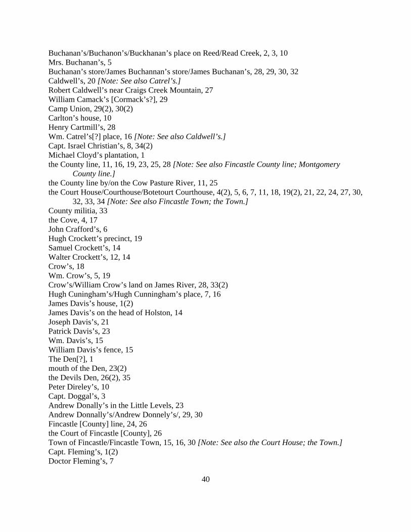
40
Buchanan’s/Buchanon’s/Buckhanan’s place on Reed/Read Creek, 2, 3, 10 Mrs. Buchanan’s, 5 Buchanan’s store/James Buchannan’s store/James Buchanan’s, 28, 29, 30, 32 Caldwell’s, 20 [Note: See also Catrel’s.] Robert Caldwell’s near Craigs Creek Mountain, 27 William Camack’s [Cormack’s?], 29 Camp Union, 29(2), 30(2) Carlton’s house, 10 Henry Cartmill’s, 28 Wm. Catrel’s[?] place, 16 [Note: See also Caldwell’s.] Capt. Israel Christian’s, 8, 34(2) Michael Cloyd’s plantation, 1 the County line, 11, 16, 19, 23, 25, 28 [Note: See also Fincastle County line; Montgomery County line.] the County line by/on the Cow Pasture River, 11, 25 the Court House/Courthouse/Botetourt Courthouse, 4(2), 5, 6, 7, 11, 18, 19(2), 21, 22, 24, 27, 30, 32, 33, 34 [Note: See also Fincastle Town; the Town.] County militia, 33 the Cove, 4, 17 John Crafford’s, 6 Hugh Crockett’s precinct, 19 Samuel Crockett’s, 14 Walter Crockett’s, 12, 14 Crow’s, 18 Wm. Crow’s, 5, 19 Crow’s/William Crow’s land on James River, 28, 33(2) Hugh Cuningham’s/Hugh Cunningham’s place, 7, 16 James Davis’s house, 1(2) James Davis’s on the head of Holston, 14 Joseph Davis’s, 21 Patrick Davis’s, 23 Wm. Davis’s, 15 William Davis’s fence, 15 The Den[?], 1 mouth of the Den, 23(2) the Devils Den, 26(2), 35 Peter Direley’s, 10 Capt. Doggal’s, 3 Andrew Donally’s in the Little Levels, 23 Andrew Donnally’s/Andrew Donnely’s/, 29, 30 Fincastle [County] line, 24, 26 the Court of Fincastle [County], 26 Town of Fincastle/Fincastle Town, 15, 16, 30 [Note: See also the Court House; the Town.] Capt. Fleming’s, 1(2) Doctor Fleming’s, 7
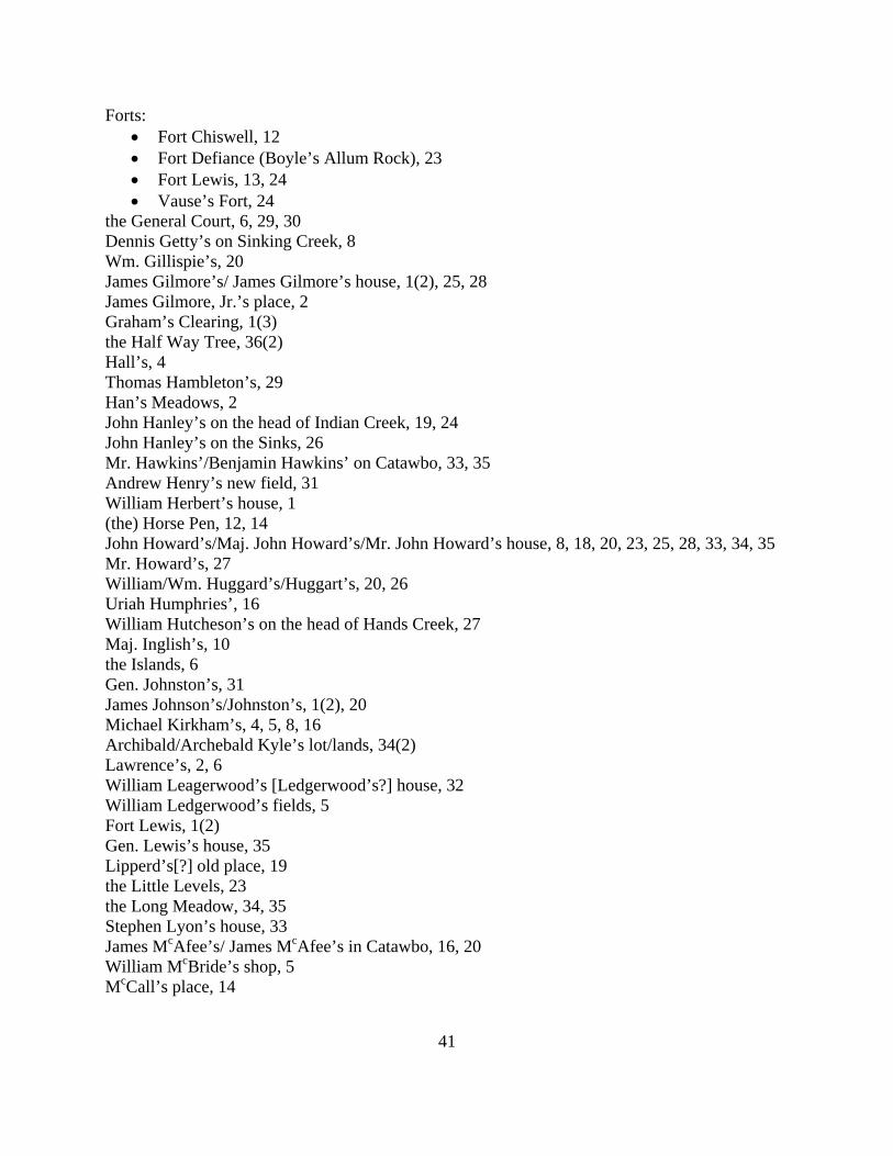
41
Forts: • Fort Chiswell, 12 • Fort Defiance (Boyle’s Allum Rock), 23 • Fort Lewis, 13, 24 • Vause’s Fort, 24
the General Court, 6, 29, 30 Dennis Getty’s on Sinking Creek, 8 Wm. Gillispie’s, 20 James Gilmore’s/ James Gilmore’s house, 1(2), 25, 28 James Gilmore, Jr.’s place, 2 Graham’s Clearing, 1(3) the Half Way Tree, 36(2) Hall’s, 4 Thomas Hambleton’s, 29 Han’s Meadows, 2 John Hanley’s on the head of Indian Creek, 19, 24 John Hanley’s on the Sinks, 26 Mr. Hawkins’/Benjamin Hawkins’ on Catawbo, 33, 35 Andrew Henry’s new field, 31 William Herbert’s house, 1 (the) Horse Pen, 12, 14 John Howard’s/Maj. John Howard’s/Mr. John Howard’s house, 8, 18, 20, 23, 25, 28, 33, 34, 35 Mr. Howard’s, 27 William/Wm. Huggard’s/Huggart’s, 20, 26 Uriah Humphries’, 16 William Hutcheson’s on the head of Hands Creek, 27 Maj. Inglish’s, 10 the Islands, 6 Gen. Johnston’s, 31 James Johnson’s/Johnston’s, 1(2), 20 Michael Kirkham’s, 4, 5, 8, 16 Archibald/Archebald Kyle’s lot/lands, 34(2) Lawrence’s, 2, 6 William Leagerwood’s [Ledgerwood’s?] house, 32 William Ledgerwood’s fields, 5 Fort Lewis, 1(2) Gen. Lewis’s house, 35 Lipperd’s[?] old place, 19 the Little Levels, 23 the Long Meadow, 34, 35 Stephen Lyon’s house, 33 James McAfee’s/ James McAfee’s in Catawbo, 16, 20 William McBride’s shop, 5 McCall’s place, 14
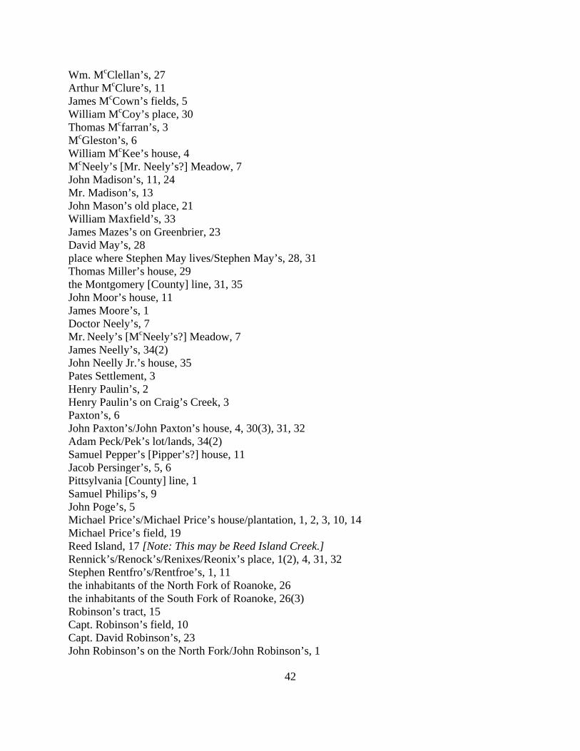
42
Wm. McClellan’s, 27 Arthur McClure’s, 11 James McCown’s fields, 5 William McCoy’s place, 30 Thomas Mcfarran’s, 3 McGleston’s, 6 William McKee’s house, 4 McNeely’s [Mr. Neely’s?] Meadow, 7 John Madison’s, 11, 24 Mr. Madison’s, 13 John Mason’s old place, 21 William Maxfield’s, 33 James Mazes’s on Greenbrier, 23 David May’s, 28 place where Stephen May lives/Stephen May’s, 28, 31 Thomas Miller’s house, 29 the Montgomery [County] line, 31, 35 John Moor’s house, 11 James Moore’s, 1 Doctor Neely’s, 7 Mr. Neely’s [McNeely’s?] Meadow, 7 James Neelly’s, 34(2) John Neelly Jr.’s house, 35 Pates Settlement, 3 Henry Paulin’s, 2 Henry Paulin’s on Craig’s Creek, 3 Paxton’s, 6 John Paxton’s/John Paxton’s house, 4, 30(3), 31, 32 Adam Peck/Pek’s lot/lands, 34(2) Samuel Pepper’s [Pipper’s?] house, 11 Jacob Persinger’s, 5, 6 Pittsylvania [County] line, 1 Samuel Philips’s, 9 John Poge’s, 5 Michael Price’s/Michael Price’s house/plantation, 1, 2, 3, 10, 14 Michael Price’s field, 19 Reed Island, 17 [Note: This may be Reed Island Creek.] Rennick’s/Renock’s/Renixes/Reonix’s place, 1(2), 4, 31, 32 Stephen Rentfro’s/Rentfroe’s, 1, 11 the inhabitants of the North Fork of Roanoke, 26 the inhabitants of the South Fork of Roanoke, 26(3) Robinson’s tract, 15 Capt. Robinson’s field, 10 Capt. David Robinson’s, 23 John Robinson’s on the North Fork/John Robinson’s, 1
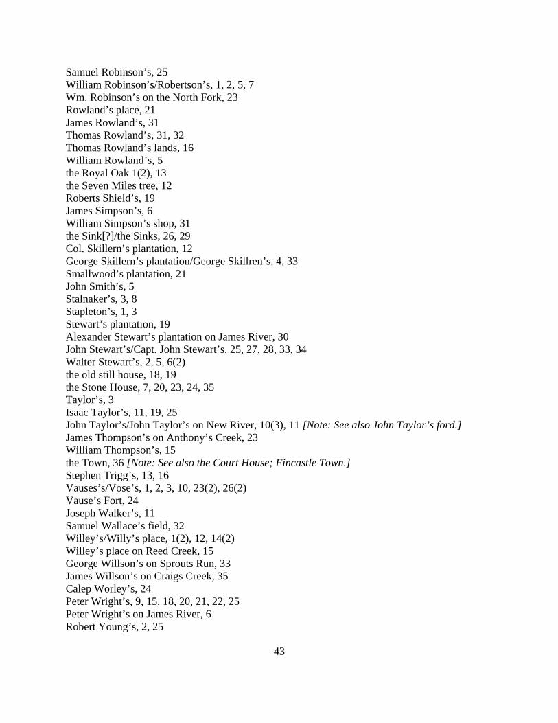
43
Samuel Robinson’s, 25 William Robinson’s/Robertson’s, 1, 2, 5, 7 Wm. Robinson’s on the North Fork, 23 Rowland’s place, 21 James Rowland’s, 31 Thomas Rowland’s, 31, 32 Thomas Rowland’s lands, 16 William Rowland’s, 5 the Royal Oak 1(2), 13 the Seven Miles tree, 12 Roberts Shield’s, 19 James Simpson’s, 6 William Simpson’s shop, 31 the Sink[?]/the Sinks, 26, 29 Col. Skillern’s plantation, 12 George Skillern’s plantation/George Skillren’s, 4, 33 Smallwood’s plantation, 21 John Smith’s, 5 Stalnaker’s, 3, 8 Stapleton’s, 1, 3 Stewart’s plantation, 19 Alexander Stewart’s plantation on James River, 30 John Stewart’s/Capt. John Stewart’s, 25, 27, 28, 33, 34 Walter Stewart’s, 2, 5, 6(2) the old still house, 18, 19 the Stone House, 7, 20, 23, 24, 35 Taylor’s, 3 Isaac Taylor’s, 11, 19, 25 John Taylor’s/John Taylor’s on New River, 10(3), 11 [Note: See also John Taylor’s ford.] James Thompson’s on Anthony’s Creek, 23 William Thompson’s, 15 the Town, 36 [Note: See also the Court House; Fincastle Town.] Stephen Trigg’s, 13, 16 Vauses’s/Vose’s, 1, 2, 3, 10, 23(2), 26(2) Vause’s Fort, 24 Joseph Walker’s, 11 Samuel Wallace’s field, 32 Willey’s/Willy’s place, 1(2), 12, 14(2) Willey’s place on Reed Creek, 15 George Willson’s on Sprouts Run, 33 James Willson’s on Craigs Creek, 35 Calep Worley’s, 24 Peter Wright’s, 9, 15, 18, 20, 21, 22, 25 Peter Wright’s on James River, 6 Robert Young’s, 2, 25
44
Personal Names Acres [Aeres?], Thomas, 3 Adams, George, 12 Adams, James, 5 Adams, John, 12, 14 Aeres [Acres?], Thomas, 3 Akin, John, 30 Alean, James, 30 Allesin, James, 24 Allison, James, 30 Allison [Allason?], James, 36 Amack, Mathew, 28, 34 Amack, Saml., 34 Anderson, John, 29 Anderson, Joseph, 29 Anderson, William/Wm., 28, 33 Arbuckle, Mathew, 18 Arbuckle, Matthew, 5, 11, 16, 17, 22 Arbuckle, Thomas, 26 Archer, John, 27 Armstrong, Andrew, 34, 35 Armstrong, Capt., 36 Armstrong, John, 2, 5(2), 8, 9 Armstrong, Lanty, 6 Armstrong, Robert, 15, 18, 22, 25 Arnald, 33 Arnald, James, 33 Arnett, James, 21 Arnett, Thomas, 35 Arnold, 31 Atkins, Thomas, 29 Baine, Mr., 10 Baker, George, 12 Baker, Martain, 34 Barckly, Hugh, 14 Barclay, Hugh, 6 Barcley, 1, 4 Barcley, Hugh, 1 Barley, 5 Barnett, James, 1, 23(2), 24, 34 Barns, Thomas, 1 Barnes, 1 Barnes, Thomas, 15, 34, 35 Barriger, Philip, 19 Beard, Hugh, 25
45
Becknald, Wm., 34 Bell, 21, 22, 24 Bell, William/Wm., 20, 22 Bilbro, William/Wm., 30, 32 Blackburn, John, 30 Blackmore, John, 15 Bledsoe, Anthony, 3 Bowen, John, 26 Bowman, John, 1, 9, 19, 21, 24 Bowyer, John, 4 Bowyer, Thomas, 27 Boyd, 20, 24 Boyd, Andrew, 12, 19 Boyd, Mr., 16, 18 Boyle, 23 Boyles, William, 12 Bracken, Mathew, 27 Brackenridge, Col., 1 Breckenridge, Mr., 27, 30, 36 Breckenridge, Mrs., 32, 36 Breckenridge, Richard, 20 Breckenridge, Robert, 1, 8, 21, 23, 24 Breckenridge, Robert, Gent., dec., 31 Breckenridge, Wm., 34 Brown, 5 Brown, Abraham, 4 Brown, Jacob, 25 Brown, Samuel, 29 Bryan, William, 1 Bryans, James, 3 Bryants, William/Wm., 3, 20 Buchanan, 2, 29 Buchanan, James, 32 Mrs. Buchanan, 5 Buchannan, James, 28 Buchanon, 3 Buckanan, 32 Buckhanan, 10 Bukannon, Robert, 15 Burdwell, George, 4, 20, 31 Burdwell, Robert, 20, 21, 30, 31 Burdwell, Robert, Jr., 28 Burnsides. James, 27 Byrnsides, James, 24 Caldwell, 20, 36
46
Caldwell, Robert/Robrt./Robt., 14, 24, 27, 30, 36 Caldwell, William, 8 Callivan, Andrew, 12 Camack [Cormack?], William, 29 Campbell, Arthur, 1, 8 Cantley, John, 19 Carlton, 10 Carpenter, Joseph, 6, 18(2), 21 Carpenter, Zopher, 21, 23 Carrell, Joseph, 31 Cartmill, Henry, 1, 5, 22, 28 Cartmill, James, 28 Carvin, Edward, 27, 29 Carvin, Wm., 34 Catrel[?], William, 16 Caughee, James, 3 Caurathers, Samuel, 32 Christian, Capt., 35 Christian, Israel (and Capt.), 1, 7, 8, 33, 34(2) Clendonald, John, 27 Clark, George, 24 Cloyd, James (and Capt.), 8, 9, 10, 35 Cloyd, Joseph, 2, 5, 6, 8, 13, 21, 22(2) Cloyd, Michael, 1, 5, 8, 20, 27, 28 Cloyd, Samuel/Samuell, 13, 16 Collier, Alexander, 2 Collier, Moses, 4, 16 Compton, John, 33 Concannon, Francis, 3 Cormack [Camack?], William, 29 Cowden, John, 11 Crafford, John, 6 Craig, John, 1, 11, 20 Crawford, Andrew, 2, 35 Crawford, John, 1, 6, 25(2) Crawford, Samuel, 34, 35 Crawford, William, 35 Crisman, Abraham, 2 Crocket, Hugh, 2, 10 Crocket, John, 4, 10, 12 Crocket, Samuel, 3, 7 Crocket, Walter, 4, 10, 12 Crockett, Hugh, 31 Crockett, Hugh, 19(2) Crockett, John, 14, 15
47
Crockett, Samuel, 14 Crockett, Walter, 12, 14, 15 Cross, William/Wm., 12, 22, 33 Crow, 18, 24, 26, 33(2) Crow, Capt., 20 Crow, William/Wm., 5, 6, 16, 19, 21, 28, 30 Cuningham, Hugh, 7 Cunningham, Hugh, 16 Davies [Davis?], James, 13, 15 Davies [Davis?], Patrick, 29(2) Davies, William, 14 Davis, James, 1(2), 4, 13, 14 [Note: See also Davies.] Davis, Joseph, 21 Davis, Patrick, 23 [Note: See also Davies.] Davis, Samuel, 17 Davis, Wm./William, 15(2), 17 [Note: See also Davies.] Dear, John, 18 Dehart, William, 35 Depew, John, 34, 35 Dierly, Peter, 14 Direley, Peter, 10 Direly, Peter, 19, 20, 24 Doggal, Capt., 3 Donally, Andrew, 23 Donnally, Andrew, 30 Donnely, Andrew, 29 Dougherty, William, 11 Drake, John, 36 Draper, John, 3 Edwards, Frederick, 12, 14 Elder, Mathew, 30(2), 31, 33 Elliott, Robert/Robt., 24, 26 Evans, Nathaniel, 9, 15, 18 Estill, Benjamin, 22, 29, 31, 32 Estill, James, 27 Ewing, James, 24 Farish, Edwd., 10 Fetter, George, 12 Findley, Richard, 20 Finley, Robert/Ro., 1, 4, 9 Fleming, Capt., 1(2) Fleming, Doctor, 7 Fleming, William/Wm., 24, 28, 33 Foster, William, 6(2) Francisco, George, 1, 29
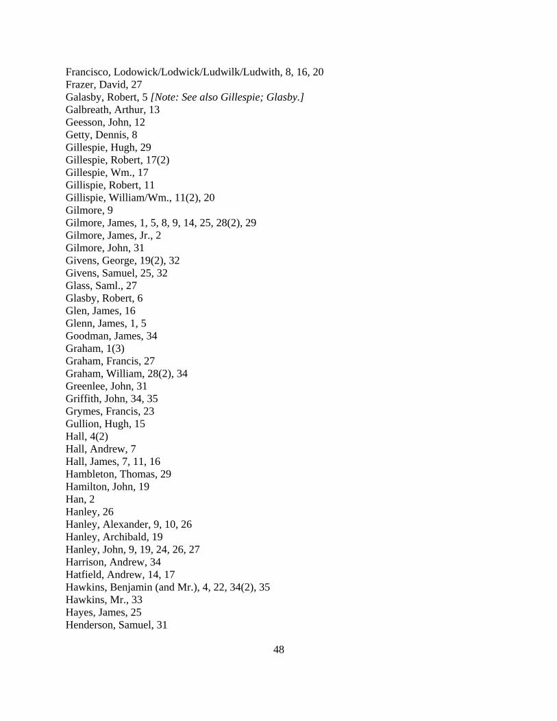
48
Francisco, Lodowick/Lodwick/Ludwilk/Ludwith, 8, 16, 20 Frazer, David, 27 Galasby, Robert, 5 [Note: See also Gillespie; Glasby.] Galbreath, Arthur, 13 Geesson, John, 12 Getty, Dennis, 8 Gillespie, Hugh, 29 Gillespie, Robert, 17(2) Gillespie, Wm., 17 Gillispie, Robert, 11 Gillispie, William/Wm., 11(2), 20 Gilmore, 9 Gilmore, James, 1, 5, 8, 9, 14, 25, 28(2), 29 Gilmore, James, Jr., 2 Gilmore, John, 31 Givens, George, 19(2), 32 Givens, Samuel, 25, 32 Glass, Saml., 27 Glasby, Robert, 6 Glen, James, 16 Glenn, James, 1, 5 Goodman, James, 34 Graham, 1(3) Graham, Francis, 27 Graham, William, 28(2), 34 Greenlee, John, 31 Griffith, John, 34, 35 Grymes, Francis, 23 Gullion, Hugh, 15 Hall, 4(2) Hall, Andrew, 7 Hall, James, 7, 11, 16 Hambleton, Thomas, 29 Hamilton, John, 19 Han, 2 Hanley, 26 Hanley, Alexander, 9, 10, 26 Hanley, Archibald, 19 Hanley, John, 9, 19, 24, 26, 27 Harrison, Andrew, 34 Hatfield, Andrew, 14, 17 Hawkins, Benjamin (and Mr.), 4, 22, 34(2), 35 Hawkins, Mr., 33 Hayes, James, 25 Henderson, Samuel, 31
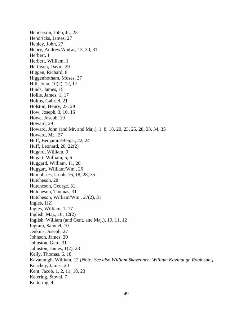
49
Henderson, John, Jr., 25 Hendricks, James, 27 Henley, John, 27 Henry, Andrew/Andw., 13, 30, 31 Herbert, 1 Herbert, William, 1 Herbison, David, 29 Higgan, Richard, 8 Higgenbotham, Moses, 27 Hill, John, 10(2), 12, 17 Hinds, James, 15 Hollis, James, 1, 17 Holms, Gabriel, 21 Holston, Henry, 23, 29 How, Joseph, 3, 10, 16 Howe, Joseph, 10 Howard, 29 Howard, John (and Mr. and Maj.), 1, 8, 18, 20, 23, 25, 28, 33, 34, 35 Howard, Mr., 27 Huff, Benjamin/Benja., 22, 24 Huff, Leonard, 20, 22(2) Hugard, William, 9 Hugart, William, 5, 6 Huggard, William, 11, 20 Huggart, William/Wm., 26 Humphries, Uriah, 16, 18, 28, 35 Hutcheson, 28 Hutcheson, George, 31 Hutcheson, Thomas, 31 Hutcheson, William/Wm., 27(2), 31 Ingles, 1(2) Ingles, William, 1, 17 Inglish, Maj., 10, 12(2) Inglish, William (and Gent. and Maj.), 10, 11, 12 Ingram, Samuel, 10 Jenkins, Joseph, 27 Johnson, James, 20 Johnston, Gen., 31 Johnston, James, 1(2), 23 Kelly, Thomas, 6, 18 Kavanough, William, 12 [Note: See also William Skavenner; William Kavinaugh Robinson.] Keachey, James, 20 Kent, Jacob, 1, 2, 11, 18, 23 Ketering, Stoval, 7 Kettering, 4
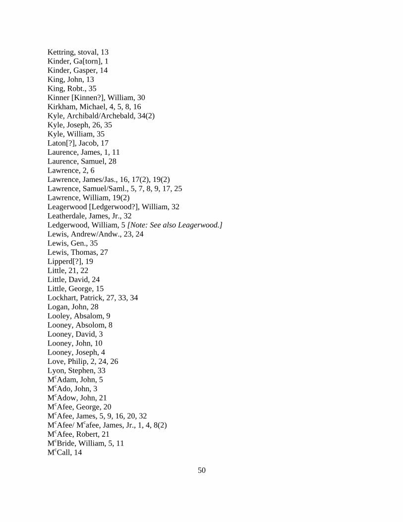
50
Kettring, stoval, 13 Kinder, Ga[torn], 1 Kinder, Gasper, 14 King, John, 13 King, Robt., 35 Kinner [Kinnen?], William, 30 Kirkham, Michael, 4, 5, 8, 16 Kyle, Archibald/Archebald, 34(2) Kyle, Joseph, 26, 35 Kyle, William, 35 Laton[?], Jacob, 17 Laurence, James, 1, 11 Laurence, Samuel, 28 Lawrence, 2, 6 Lawrence, James/Jas., 16, 17(2), 19(2) Lawrence, Samuel/Saml., 5, 7, 8, 9, 17, 25 Lawrence, William, 19(2) Leagerwood [Ledgerwood?], William, 32 Leatherdale, James, Jr., 32 Ledgerwood, William, 5 [Note: See also Leagerwood.] Lewis, Andrew/Andw., 23, 24 Lewis, Gen., 35 Lewis, Thomas, 27 Lipperd[?], 19 Little, 21, 22 Little, David, 24 Little, George, 15 Lockhart, Patrick, 27, 33, 34 Logan, John, 28 Looley, Absalom, 9 Looney, Absolom, 8 Looney, David, 3 Looney, John, 10 Looney, Joseph, 4 Love, Philip, 2, 24, 26 Lyon, Stephen, 33 McAdam, John, 5 McAdo, John, 3 McAdow, John, 21 McAfee, George, 20 McAfee, James, 5, 9, 16, 20, 32 McAfee/ Mcafee, James, Jr., 1, 4, 8(2) McAfee, Robert, 21 McBride, William, 5, 11 McCall, 14
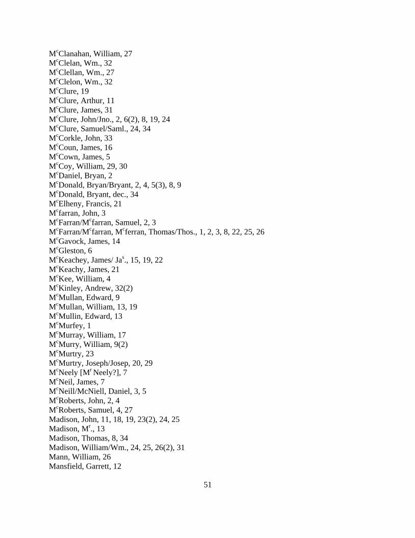
51
McClanahan, William, 27 McClelan, Wm., 32 McClellan, Wm., 27 McClelon, Wm., 32 McClure, 19 McClure, Arthur, 11 McClure, James, 31 McClure, John/Jno., 2, 6(2), 8, 19, 24 McClure, Samuel/Saml., 24, 34 McCorkle, John, 33 McCoun, James, 16 McCown, James, 5 McCoy, William, 29, 30 McDaniel, Bryan, 2 McDonald, Bryan/Bryant, 2, 4, 5(3), 8, 9 McDonald, Bryant, dec., 34 McElheny, Francis, 21 Mcfarran, John, 3 McFarran/Mcfarran, Samuel, 2, 3 McFarran/Mcfarran, Mcferran, Thomas/Thos., 1, 2, 3, 8, 22, 25, 26 McGavock, James, 14 McGleston, 6 McKeachey, James/ Jas., 15, 19, 22 McKeachy, James, 21 McKee, William, 4 McKinley, Andrew, 32(2) McMullan, Edward, 9 McMullan, William, 13, 19 McMullin, Edward, 13 McMurfey, 1 McMurray, William, 17 McMurry, William, 9(2) McMurtry, 23 McMurtry, Joseph/Josep, 20, 29 McNeely [Mr Neely?], 7 McNeil, James, 7 McNeill/McNiell, Daniel, 3, 5 McRoberts, John, 2, 4 McRoberts, Samuel, 4, 27 Madison, John, 11, 18, 19, 23(2), 24, 25 Madison, Mr., 13 Madison, Thomas, 8, 34 Madison, William/Wm., 24, 25, 26(2), 31 Mann, William, 26 Mansfield, Garrett, 12
52
Marshall, Gilbert, 22 Mason, John, 21 Mastin, Thomas, 17 Matthews, William, 6(2) Maxfield, William, 33 Maxwell, John, 28, 29 Maxwell, Wm., 28 May, David, 24, 28(2), 33, 34 May, John, 8, 20, 23, 28(2) May, Stephen, 28, 31 May, Richard, 15, 33 Mazes, James, 23 Miller, 1(2), 2, 5, 14 Miller, Hugh, 23, 28, 29, 34 Miller, James Cloyd, 7 [Note: This may be “James Cloyd, Miller;” there are other entries for
“James Cloyd, Captain.”] Miller, Thomas, 29 Millican, James, 29 Mills, John, 1, 12, 18, 33 Mills, John, Jr., 10, 18, 32 Montgomery, 1(2), 23 Montgomery, James, 1, 14 Montgomery, John, 12 Montgomery, Joseph, 1, 2, 3 Montgomery, Robert, 1 Montgomery, Samuel, 17 Montgomery, Thomas, 14 Montgomery, William, 15 Moor, John, 11 Moore, James, 1(2), 32 Moore, John, 32 Murrow, John, 6(2) Neeley, John, Jr., 1, 8 Neelly, James, 34(2) Neelly, John, 28 Neelly, John, Jr., 21, 34(2), 35 Neely, Doctor, 7 Neely, John/Jno., Sr., 7, 24 Neely, John, Jr., 20 Mr Neely [McNeely?], 7 Nicholas, Thomas, 27 Nielly, Jas., 3 Parsinger, Jacob, 17 Passinger, Jacob, 11 [Note: See also Persinger.] Pates, 3
53
Patton, Col., 24
Paul, Audley, 1, 28, 29 Paulin, Henry, 2, 3, 8, 18 Pauling, Henry, 20 Pawling, Henry, 23 Paxton, 6, 11, 28, 29(2) Paxton, John, 1, 4, 17, 26, 30(3), 31, 32(2) Paxton, John. Jr., 21 Paxton, Thomas, 21 Paxton, William, 16, 29 Pe[c]k, Adam, 34(2) Pence: See Price Pepper [Pipper?], Samuel/Saml., 11, 12 Persinger, Jacob, 5, 6, 11 [Note: See also Passinger.] Peteat, 21 Philips, Samuel, 9 Phipps, Isaiah, 33 Phipps, Joshua, 20 Poage, George, 1, 5, 7, 8, 9, 17, 25 Poage, John, Jr., 32(2) Poage, Robert, 22 Poague, George, 19(2) Poague, Robert, 20) Poge, John, 5 Posey, Thomas, 29(2), 32 Poteet, 31 Potts, Amos, 8, 9 Potts, John, 1, 3, 23, 33, 34 Preston, William, 20, 23 Price[?] [Pence?], Jeremiah, 1 Price, Michael, 1, 2, 3, 10(2), 14, 17, 19 Prior, Joseph, 35 Pryor, Joseph, 25 Ralston, Mathew, 27, 32 Ramsay, Thomas, 3, 6 Ramsey, Josiah[?}, 14 Reaburn, John, 31, 34 Reed[?], Thomas, 2 Rennick, 4 Renock, 1 Renix, 32 Reonix, 31 Rentfro, Stephen, 1 Rentfroe, Stephen, 11 Ritchey, Robert, 19
54
Robertson, William, 7 [Note: See also Robinson.] Robinson, 15 Robinson, Capt., 10 Robinson, David (and Capt. and Gent.), 10, 11, 23(3), 24, 26, 35 Robinson, David (Mill Wright), 25 Robinson, Isaac, 35 Robinson, James, 5, 7, 8, 9, 10, 27, 28, 31, 34 Robinson, John/Jno. (and Gent.), 1(2), 2, 5, 6, 9, 13, 15, 23, 25(2), 27, 30, 35 Robinson, Joseph, 1, 7 Robinson, Samuel/Saml., 25, 30, 35 Robinson, William, 1(2), 2, 5, 10 [Note: See also Robertson.] Robinson, William Kavinaugh, 14 Rop[?] [possibly Ross], James, 27(2) Ross[?] [possibly Rop], James, 27(2) Ross, John, Jr., 36 Ross, William/Wm., 21, 22 Ross[?], William, 34 Rowland, 21 Rowland, James, 4, 5, 20, 31(2), 33, 34 Rowland, Thomas/Thos., 1, 4, 11, 13, 16, 20, 27, 31, 32 Rowland, William/Wm., 5, 19(2), 20, 22 Rutlidge, George, 35 Sawyers, David, 12 Sawyers, William, 12(3) Sayers, David, 1 Sayers, William, 1 Scott, Samuel, 2, 3, 10 Scott[?], William, 35 Sharkey, Patrick, 24 Shaver, Bosten/Boston, 17, 25 Shield, Roberts, 19 Shukey [Shirkey?], James, 35 Simpson, James, 1, 6, 10, 28 Simpson, Solomon, 27 Simpson, William, 31 Skavenner, William, 12 [Note: See also William Kavanough; William Kavinaugh Robinson.] Skeggs, Henry, 17 Skillern, Col., 12 Skillern, George, 2, 4, 6, 8, 19(2), 20, 22, 32 Skillren, George, 33 Smallwood, 21 Smith, Col. 2 Smith, David, 29, 31 Smith, Francis[?], 1 Smith, Francis, 2, 5, 11
55
Smith, Fredrick, 35 Smith, Henry, 18, 22, 26, 27 Smith, James, 18 Smith, John, 5, 33 Smyth, Mc Adam, 30 Snodgrass, James/Jas., 2, 4, 5, 14, 21, 22, 24 Snodgrass, Joseph, Jr. (son of Joseph), 36 Snodgrass, Wm., 22(2) Springer, Edward, 7, 11, 30 Stalnaker, 1, 3, 8 Stapleton, 1, 3 Stapleton, Charles, 3 Stepheson, 31 Stevens, John, 15 Stevenson, Thomas, 33 Stewart, 19 Stewart, Alexander, 30 Stewart, James, 28, 34 Stewart, John (and Capt.), 25, 27, 28, 33, 34(2) Stewart, Walter, 2, 5, 6(2), 10, 25, 30 Taylor, 2, 3 Taylor, George, 12 Taylor, Isaac, 11, 19, 25 Taylor, James, 32(2) Taylor, John, 2, 10(3), 11, 12, 14, 15, 17 Tees[?], Thomas, 15 Templeton, James, 1, 16 Thompson, James, 23 Thompson, William/Wm., 2, 3, 10(2), 15(2) Todd, Samuel/Saml., 11, 16 Top[?], Roger, 1 Topp, Roger, 4 Tosh, 21 Tosh, Thomas, 20, 22 Trigg, Stephen, 13, 16 Trimble, John, 32(2) Turpin, Solomon, 27(2) Tyler, Isaac, 19 Vause, 1, 2, 3, 10, 23(2), 24 [Note: See also Vose.] Vinsant, Isaiah/Isaih, 20, 31 Vinsent, Isaiah, 4 Vose [Vause], 26(2) Wade, Dawson, 28, 33 Walker, Joseph, 6, 11, 33 Walker, Joseph, Jr., 32
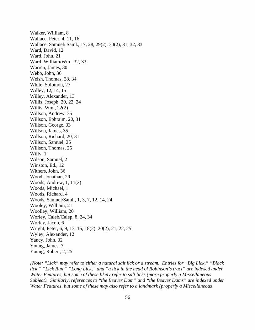
56
Walker, William, 8 Wallace, Peter, 4, 11, 16 Wallace, Samuel/ Saml., 17, 28, 29(2), 30(2), 31, 32, 33 Ward, David, 12 Ward, John, 21 Ward, William/Wm., 32, 33 Warren, James, 30 Webb, John, 36 Welsh, Thomas, 28, 34 White, Solomon, 27 Willey, 12, 14, 15 Willey, Alexander, 13 Willis, Joseph, 20, 22, 24 Willis, Wm., 22(2) Willson, Andrew, 35 Willson, Ephraim, 20, 31 Willson, George, 33 Willson, James, 35 Willson, Richard, 20, 31 Willson, Samuel, 25 Willson, Thomas, 25 Willy, 1 Wilson, Samuel, 2 Winston, Ed., 12 Withers, John, 36 Wood, Jonathan, 29 Woods, Andrew, 1, 11(2) Woods, Michael, 1 Woods, Richard, 4 Woods, Samuel/Saml., 1, 3, 7, 12, 14, 24 Wooley, William, 21 Woolley, William, 20 Worley, Caleb/Calep, 8, 24, 34 Worley, Jacob, 6 Wright, Peter, 6, 9, 13, 15, 18(2), 20(2), 21, 22, 25 Wyley, Alexander, 12 Yancy, John, 32 Young, James, 7 Young, Robert, 2, 25 [Note: “Lick” may refer to either a natural salt lick or a stream. Entries for “Big Lick,” “Black lick,” “Lick Run,” “Long Lick,” and “a lick in the head of Robinson’s tract” are indexed under Water Features, but some of these likely refer to salt licks (more properly a Miscellaneous Subject). Similarly, references to “the Beaver Dam” and “the Beaver Dams” are indexed under Water Features, but some of these may also refer to a landmark (properly a Miscellaneous
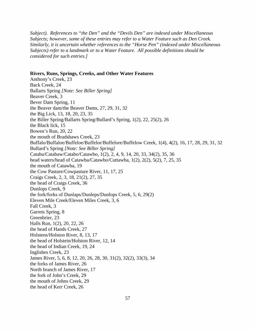
57
Subject). References to “the Den” and the “Devils Den” are indexed under Miscellaneous Subjects; however, some of these entries may refer to a Water Feature such as Den Creek. Similarly, it is uncertain whether references to the “Horse Pen” (indexed under Miscellaneous Subjects) refer to a landmark or to a Water Feature. All possible definitions should be considered for such entries.] Rivers, Runs, Springs, Creeks, and Other Water Features Anthony’s Creek, 23 Back Creek, 24 Ballarts Spring [Note: See Biller Spring] Beaver Creek, 3 Bever Dam Spring, 11 the Beaver dam/the Beaver Dams, 27, 29, 31, 32 the Big Lick, 13, 18, 20, 23, 35 the Biller Spring/Ballarts Spring/Bullard’s Spring, 1(2), 22, 25(2), 26 the Black lick, 15 Bowen’s Run, 20, 22 the mouth of Bradshaws Creek, 23 Buffalo/Buffaloe/Buffeloe/Buffelor/Buffelore/Buffelow Creek, 1(4), 4(2), 16, 17, 28, 29, 31, 32 Bullard’s Spring [Note: See Biller Spring] Cataba/Catabaw/Catabo/Catawbo, 1(2), 2, 4, 9, 14, 20, 33, 34(2), 35, 36 head waters/head of Catawba/Catawbo/Cuttawba, 1(2), 2(2), 5(2), 7, 25, 35 the mouth of Catawba, 19 the Cow Pasture/Cowpasture River, 11, 17, 25 Craigs Creek, 2, 3, 18, 21(2), 27, 35 the head of Craigs Creek, 36 Dunlops Creek, 9 the fork/forks of Dunlaps/Dunleps/Dunlops Creek, 5, 6, 29(2) Eleven Mile Creek/Eleven Miles Creek, 3, 6 Fall Creek, 3 Garrets Spring, 8 Greenbrier, 23 Halls Run, 1(2), 20, 22, 26 the head of Hands Creek, 27 Holstens/Holston River, 8, 13, 17 the head of Holstein/Holston River, 12, 14 the head of Indian Creek, 19, 24 Inglishes Creek, 23 James River, 5, 6, 8, 12, 20, 26, 28, 30, 31(2), 32(2), 33(3), 34 the forks of James River, 26 North branch of James River, 17 the fork of John’s Creek, 29 the mouth of Johns Creek, 29 the head of Kerr Creek, 26
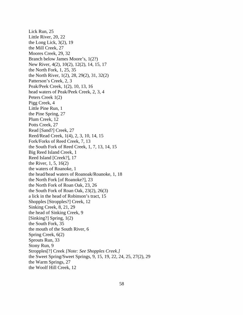
58
Lick Run, 25 Little River, 20, 22 the Long Lick, 3(2), 19 the Mill Creek, 27 Moores Creek, 29, 32 Branch below James Moore’s, 1(2?) New River, 4(2), 10(2), 12(2), 14, 15, 17 the North Fork, 1, 25, 35 the North River, 1(2), 28, 29(2), 31, 32(2) Patterson’s Creek, 2, 3 Peak/Peek Creek, 1(2), 10, 13, 16 head waters of Peak/Peek Creek, 2, 3, 4 Peters Creek 1(2) Pigg Creek, 4 Little Pine Run, 1 the Pine Spring, 27 Plum Creek, 12 Potts Creek, 27 Read [Sand?] Creek, 27 Reed/Read Creek, 1(4), 2, 3, 10, 14, 15 Fork/Forks of Reed Creek, 7, 13 the South Fork of Reed Creek, 1, 7, 13, 14, 15 Big Reed Island Creek, 1 Reed Island [Creek?], 17 the River, 1, 5, 16(2) the waters of Roanoke, 1 the head/head waters of Roanoak/Roanoke, 1, 18 the North Fork [of Roanoke?], 23 the North Fork of Roan Oak, 23, 26 the South Fork of Roan Oak, 23(2), 26(3) a lick in the head of Robinson’s tract, 15 Shopples [Stropples?] Creek, 12 Sinking Creek, 8, 21, 29 the head of Sinking Creek, 9 [Sinking?] Spring, 1(2) the South Fork, 35 the mouth of the South River, 6 Spring Creek, 6(2) Sprouts Run, 33 Stony Run, 9 Stropples[?] Creek [Note: See Shopples Creek.] the Sweet Spring/Sweet Springs, 9, 15, 19, 22, 24, 25, 27(2), 29 the Warm Springs, 27 the Woolf Hill Creek, 12
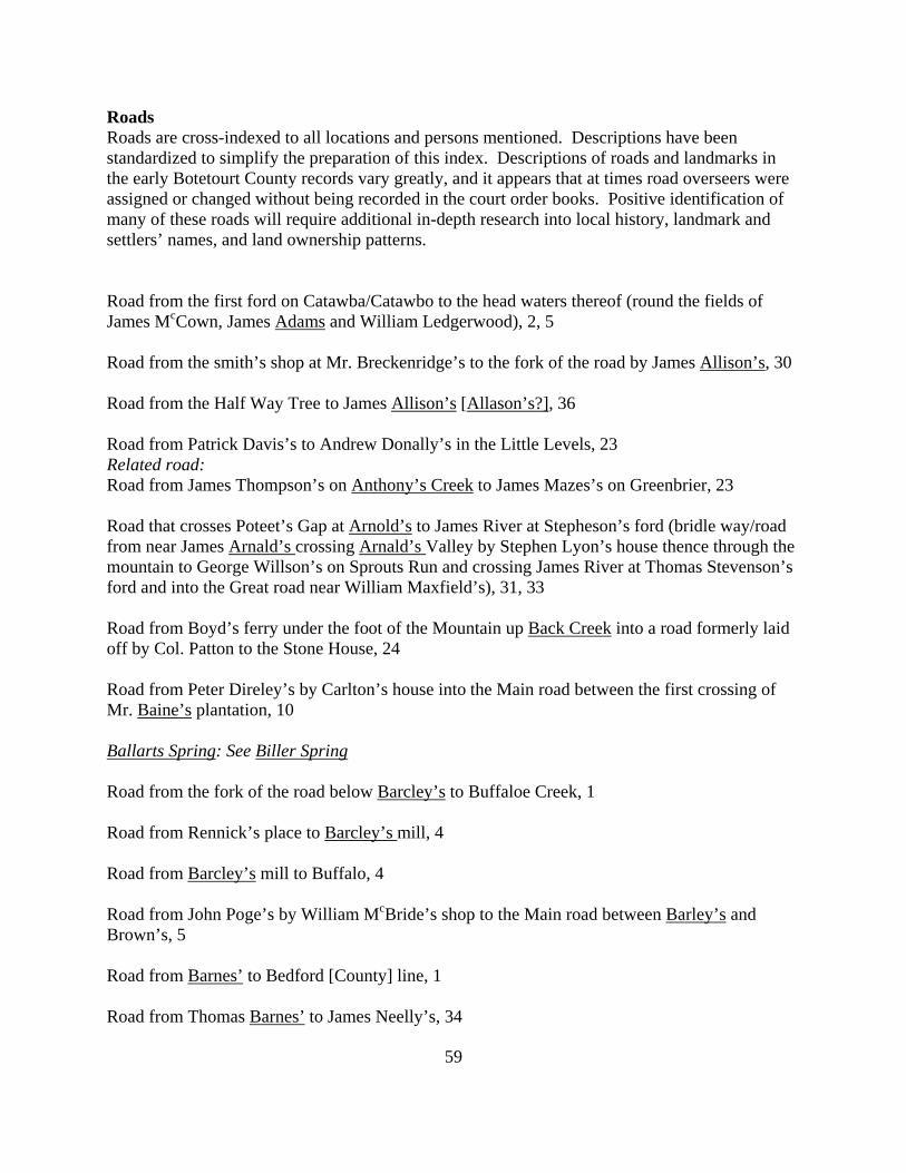
59
Roads Roads are cross-indexed to all locations and persons mentioned. Descriptions have been standardized to simplify the preparation of this index. Descriptions of roads and landmarks in the early Botetourt County records vary greatly, and it appears that at times road overseers were assigned or changed without being recorded in the court order books. Positive identification of many of these roads will require additional in-depth research into local history, landmark and settlers’ names, and land ownership patterns. Road from the first ford on Catawba/Catawbo to the head waters thereof (round the fields of James McCown, James Adams and William Ledgerwood), 2, 5 Road from the smith’s shop at Mr. Breckenridge’s to the fork of the road by James Allison’s, 30 Road from the Half Way Tree to James Allison’s [Allason’s?], 36 Road from Patrick Davis’s to Andrew Donally’s in the Little Levels, 23 Related road: Road from James Thompson’s on Anthony’s Creek to James Mazes’s on Greenbrier, 23 Road that crosses Poteet’s Gap at Arnold’s to James River at Stepheson’s ford (bridle way/road from near James Arnald’s crossing Arnald’s Valley by Stephen Lyon’s house thence through the mountain to George Willson’s on Sprouts Run and crossing James River at Thomas Stevenson’s ford and into the Great road near William Maxfield’s), 31, 33 Road from Boyd’s ferry under the foot of the Mountain up Back Creek into a road formerly laid off by Col. Patton to the Stone House, 24 Road from Peter Direley’s by Carlton’s house into the Main road between the first crossing of Mr. Baine’s plantation, 10 Ballarts Spring: See Biller Spring Road from the fork of the road below Barcley’s to Buffaloe Creek, 1 Road from Rennick’s place to Barcley’s mill, 4 Road from Barcley’s mill to Buffalo, 4 Road from John Poge’s by William McBride’s shop to the Main road between Barley’s and Brown’s, 5 Road from Barnes’ to Bedford [County] line, 1 Road from Thomas Barnes’ to James Neelly’s, 34
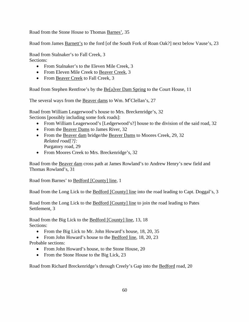
60
Road from the Stone House to Thomas Barnes’, 35 Road from James Barnett’s to the ford [of the South Fork of Roan Oak?] next below Vause’s, 23 Road from Stalnaker’s to Fall Creek, 3 Sections:
• From Stalnaker’s to the Eleven Mile Creek, 3 • From Eleven Mile Creek to Beaver Creek, 3 • From Beaver Creek to Fall Creek, 3
Road from Stephen Rentfroe’s by the Be[a]ver Dam Spring to the Court House, 11 The several ways from the Beaver dams to Wm. McClellan’s, 27 Road from William Leagerwood’s house to Mrs. Breckenridge’s, 32 Sections [possibly including some fork roads]:
• From William Leagerwood’s [Ledgerwood’s?] house to the division of the said road, 32 • From the Beaver Dams to James River, 32 • From the Beaver dam bridge/the Beaver Dams to Moores Creek, 29, 32
Related road[?]: Purgatory road, 29
• From Moores Creek to Mrs. Breckenridge’s, 32 Road from the Beaver dam cross path at James Rowland’s to Andrew Henry’s new field and Thomas Rowland’s, 31 Road from Barnes’ to Bedford [County] line, 1 Road from the Long Lick to the Bedford [County] line into the road leading to Capt. Doggal’s, 3 Road from the Long Lick to the Bedford [County] line to join the road leading to Pates Settlement, 3 Road from the Big Lick to the Bedford [County] line, 13, 18 Sections:
• From the Big Lick to Mr. John Howard’s house, 18, 20, 35 • From John Howard’s house to the Bedford line, 18, 20, 23
Probable sections: • From John Howard’s house, to the Stone House, 20 • From the Stone House to the Big Lick, 23
Road from Richard Breckenridge’s through Creely’s Gap into the Bedford road, 20
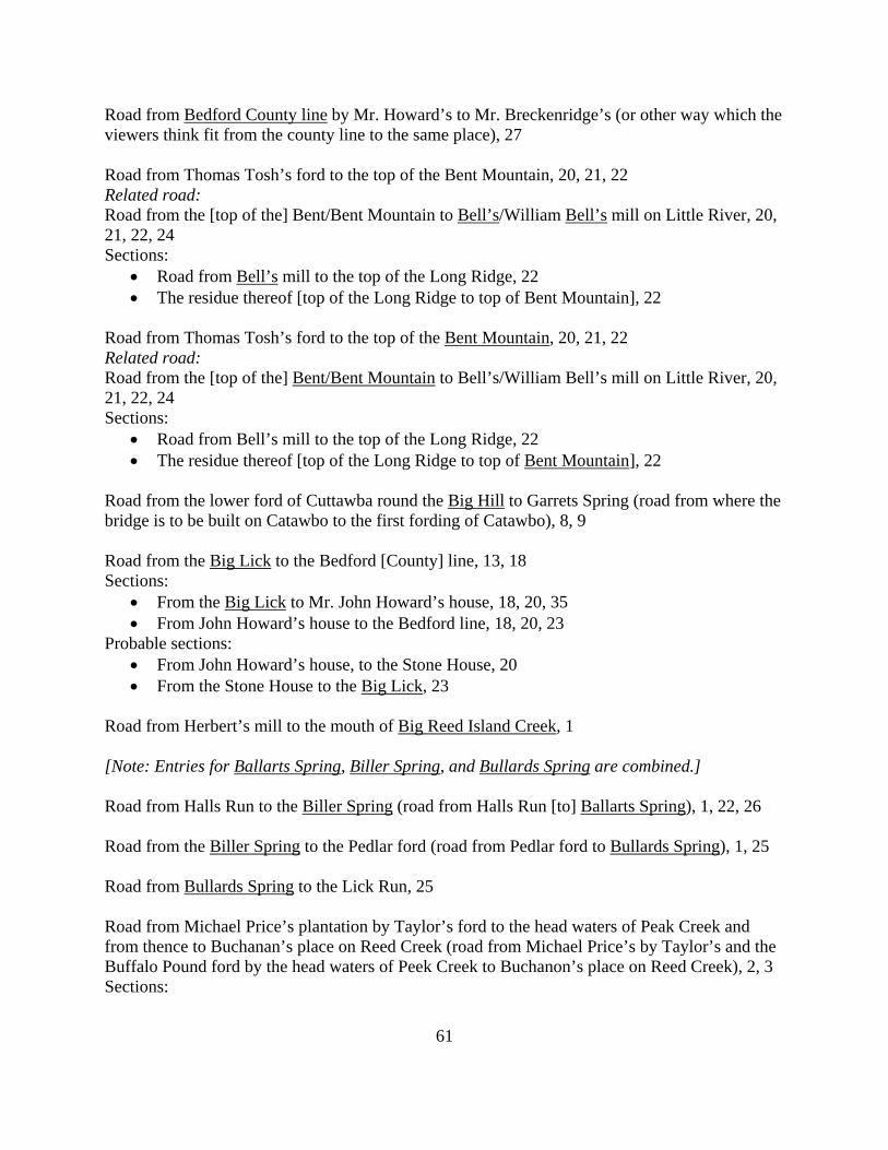
61
Road from Bedford County line by Mr. Howard’s to Mr. Breckenridge’s (or other way which the viewers think fit from the county line to the same place), 27 Road from Thomas Tosh’s ford to the top of the Bent Mountain, 20, 21, 22 Related road: Road from the [top of the] Bent/Bent Mountain to Bell’s/William Bell’s mill on Little River, 20, 21, 22, 24 Sections:
• Road from Bell’s mill to the top of the Long Ridge, 22 • The residue thereof [top of the Long Ridge to top of Bent Mountain], 22
Road from Thomas Tosh’s ford to the top of the Bent Mountain, 20, 21, 22 Related road: Road from the [top of the] Bent/Bent Mountain to Bell’s/William Bell’s mill on Little River, 20, 21, 22, 24 Sections:
• Road from Bell’s mill to the top of the Long Ridge, 22 • The residue thereof [top of the Long Ridge to top of Bent Mountain], 22
Road from the lower ford of Cuttawba round the Big Hill to Garrets Spring (road from where the bridge is to be built on Catawbo to the first fording of Catawbo), 8, 9 Road from the Big Lick to the Bedford [County] line, 13, 18 Sections:
• From the Big Lick to Mr. John Howard’s house, 18, 20, 35 • From John Howard’s house to the Bedford line, 18, 20, 23
Probable sections: • From John Howard’s house, to the Stone House, 20 • From the Stone House to the Big Lick, 23
Road from Herbert’s mill to the mouth of Big Reed Island Creek, 1 [Note: Entries for Ballarts Spring, Biller Spring, and Bullards Spring are combined.] Road from Halls Run to the Biller Spring (road from Halls Run [to] Ballarts Spring), 1, 22, 26 Road from the Biller Spring to the Pedlar ford (road from Pedlar ford to Bullards Spring), 1, 25 Road from Bullards Spring to the Lick Run, 25 Road from Michael Price’s plantation by Taylor’s ford to the head waters of Peak Creek and from thence to Buchanan’s place on Reed Creek (road from Michael Price’s by Taylor’s and the Buffalo Pound ford by the head waters of Peek Creek to Buchanon’s place on Reed Creek), 2, 3 Sections:
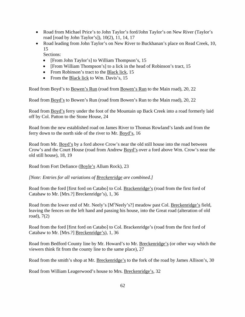
62
• Road from Michael Price’s to John Taylor’s ford/John Taylor’s on New River (Taylor’s road [road by John Taylor’s]), 10(2), 11, 14, 17
• Road leading from John Taylor’s on New River to Buckhanan’s place on Read Creek, 10, 15 Sections: • [From John Taylor’s] to William Thompson’s, 15 • [From William Thompson’s] to a lick in the head of Robinson’s tract, 15 • From Robinson’s tract to the Black lick, 15 • From the Black lick to Wm. Davis’s, 15
Road from Boyd’s to Bowen’s Run (road from Bowen’s Run to the Main road), 20, 22 Road from Boyd’s to Bowen’s Run (road from Bowen’s Run to the Main road), 20, 22 Road from Boyd’s ferry under the foot of the Mountain up Back Creek into a road formerly laid off by Col. Patton to the Stone House, 24 Road from the new established road on James River to Thomas Rowland’s lands and from the ferry down to the north side of the river to Mr. Boyd’s, 16 Road from Mr. Boyd’s by a ford above Crow’s near the old still house into the road between Crow’s and the Court House (road from Andrew Boyd’s over a ford above Wm. Crow’s near the old still house), 18, 19 Road from Fort Defiance (Boyle’s Allum Rock), 23 [Note: Entries for all variations of Breckenridge are combined.] Road from the ford [first ford on Catabo] to Col. Brackenridge’s (road from the first ford of Catabaw to Mr. [Mrs.?] Breckenridge’s), 1, 36 Road from the lower end of Mr. Neely’s [McNeely’s?] meadow past Col. Breckenridge’s field, leaving the fences on the left hand and passing his house, into the Great road (alteration of old road), 7(2) Road from the ford [first ford on Catabo] to Col. Brackenridge’s (road from the first ford of Catabaw to Mr. [Mrs.?] Breckenridge’s), 1, 36 Road from Bedford County line by Mr. Howard’s to Mr. Breckenridge’s (or other way which the viewers think fit from the county line to the same place), 27 Road from the smith’s shop at Mr. Breckenridge’s to the fork of the road by James Allison’s, 30 Road from William Leagerwood’s house to Mrs. Breckenridge’s, 32
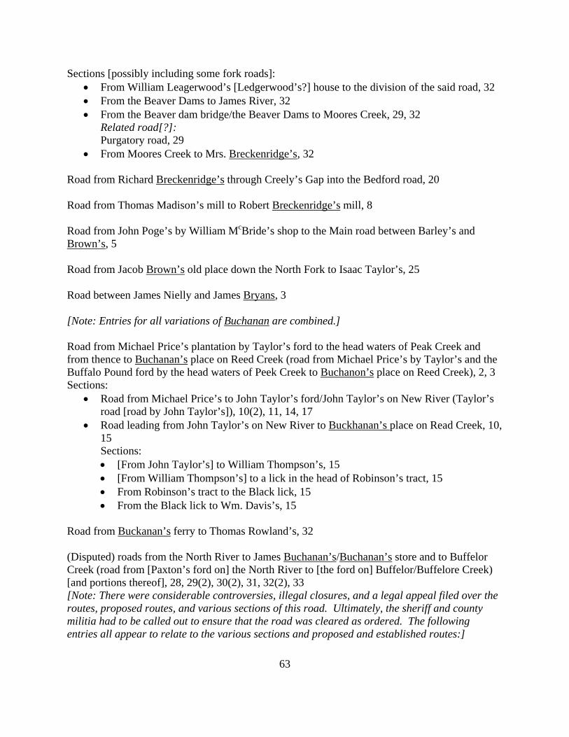
63
Sections [possibly including some fork roads]: • From William Leagerwood’s [Ledgerwood’s?] house to the division of the said road, 32 • From the Beaver Dams to James River, 32 • From the Beaver dam bridge/the Beaver Dams to Moores Creek, 29, 32
Related road[?]: Purgatory road, 29
• From Moores Creek to Mrs. Breckenridge’s, 32 Road from Richard Breckenridge’s through Creely’s Gap into the Bedford road, 20 Road from Thomas Madison’s mill to Robert Breckenridge’s mill, 8 Road from John Poge’s by William McBride’s shop to the Main road between Barley’s and Brown’s, 5 Road from Jacob Brown’s old place down the North Fork to Isaac Taylor’s, 25 Road between James Nielly and James Bryans, 3 [Note: Entries for all variations of Buchanan are combined.] Road from Michael Price’s plantation by Taylor’s ford to the head waters of Peak Creek and from thence to Buchanan’s place on Reed Creek (road from Michael Price’s by Taylor’s and the Buffalo Pound ford by the head waters of Peek Creek to Buchanon’s place on Reed Creek), 2, 3 Sections:
• Road from Michael Price’s to John Taylor’s ford/John Taylor’s on New River (Taylor’s road [road by John Taylor’s]), 10(2), 11, 14, 17
• Road leading from John Taylor’s on New River to Buckhanan’s place on Read Creek, 10, 15 Sections: • [From John Taylor’s] to William Thompson’s, 15 • [From William Thompson’s] to a lick in the head of Robinson’s tract, 15 • From Robinson’s tract to the Black lick, 15 • From the Black lick to Wm. Davis’s, 15
Road from Buckanan’s ferry to Thomas Rowland’s, 32 (Disputed) roads from the North River to James Buchanan’s/Buchanan’s store and to Buffelor Creek (road from [Paxton’s ford on] the North River to [the ford on] Buffelor/Buffelore Creek) [and portions thereof], 28, 29(2), 30(2), 31, 32(2), 33 [Note: There were considerable controversies, illegal closures, and a legal appeal filed over the routes, proposed routes, and various sections of this road. Ultimately, the sheriff and county militia had to be called out to ensure that the road was cleared as ordered. The following entries all appear to relate to the various sections and proposed and established routes:]
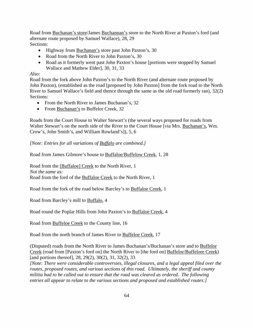
64
Road from Buchanan’s store/James Buchannan’s store to the North River at Paxton’s ford (and alternate route proposed by Samuel Wallace), 28, 29 Sections:
• Highway from Buchanan’s store past John Paxton’s, 30 • Road from the North River to John Paxton’s, 30 • Road as it formerly went past John Paxton’s house [portions were stopped by Samuel
Wallace and Mathew Elder], 30, 31, 33 Also: Road from the fork above John Paxton’s to the North River (and alternate route proposed by John Paxton), (established as the road [proposed by John Paxton] from the fork road to the North River to Samuel Wallace’s field and thence through the same as the old road formerly ran), 32(2) Sections:
• From the North River to James Buchanan’s, 32 • From Buchanan’s to Buffelor Creek, 32
Roads from the Court House to Walter Stewart’s (the several ways proposed for roads from Walter Stewart’s on the north side of the River to the Court House [via Mrs. Buchanan’s, Wm. Crow’s, John Smith’s, and William Rowland’s]), 5, 6 [Note: Entries for all variations of Buffalo are combined.] Road from James Gilmore’s house to Buffaloe/Buffelow Creek, 1, 28 Road from the [Buffaloe] Creek to the North River, 1 Not the same as: Road from the ford of the Buffaloe Creek to the North River, 1 Road from the fork of the road below Barcley’s to Buffaloe Creek, 1 Road from Barcley’s mill to Buffalo, 4 Road round the Poplar Hills from John Paxton’s to Buffaloe Creek, 4 Road from Buffeloe Creek to the County line, 16 Road from the north branch of James River to Buffeloe Creek, 17 (Disputed) roads from the North River to James Buchanan’s/Buchanan’s store and to Buffelor Creek (road from [Paxton’s ford on] the North River to [the ford on] Buffelor/Buffelore Creek) [and portions thereof], 28, 29(2), 30(2), 31, 32(2), 33 [Note: There were considerable controversies, illegal closures, and a legal appeal filed over the routes, proposed routes, and various sections of this road. Ultimately, the sheriff and county militia had to be called out to ensure that the road was cleared as ordered. The following entries all appear to relate to the various sections and proposed and established routes:]

65
Road from Buchanan’s store/James Buchannan’s store to the North River at Paxton’s ford (and alternate route proposed by Samuel Wallace), 28, 29 Sections:
• Highway from Buchanan’s store past John Paxton’s, 30 • Road from the North River to John Paxton’s, 30 • Road as it formerly went past John Paxton’s house [portions were stopped by Samuel
Wallace and Mathew Elder], 30, 31, 33 Also: Road from the fork above John Paxton’s to the North River (and alternate route proposed by John Paxton), (established as the road [proposed by John Paxton] from the fork road to the North River to Samuel Wallace’s field and thence through the same as the old road formerly ran), 32(2) Sections:
• From the North River to James Buchanan’s, 32 • From Buchanan’s to Buffelor Creek, 32
Road from Michael Price’s plantation by Taylor’s ford to the head waters of Peak Creek and from thence to Buchanan’s place on Reed Creek (road from Michael Price’s by Taylor’s and the Buffalo Pound ford by the head waters of Peek Creek to Buchanon’s place on Reed Creek), 2, 3 Sections:
• Road from Michael Price’s to John Taylor’s ford/John Taylor’s on New River (Taylor’s road [road by John Taylor’s]), 10(2), 11, 14, 17
• Road leading from John Taylor’s on New River to Buckhanan’s place on Read Creek, 10, 15 Sections: • [From John Taylor’s] to William Thompson’s, 15 • [From William Thompson’s] to a lick in the head of Robinson’s tract, 15 • From Robinson’s tract to the Black lick, 15 • From the Black lick to Wm. Davis’s, 15
Bullards Spring: See Biller Spring Road from James McAfee’s to Wm. Catrel’s[?] place, 16 May be the same as: Road from Caldwell’s to James McAfee’s in Catawbo, 20 The several ways from Robert Caldwell’s near Craigs Creek Mountain Potts Creek Mountains to the Sweet Springs, 27 Road from Dennis Getty’s on Sinking Creek to William Caldwell’s mill (pack horse road), 8, 9 Road from the mouth of Johns Creek to the fork of the same at William Camack’s [Cormack’s?], 29

66
Road from the Sweet Springs road on Dunlops Creek to Camp Union (road from the forks of Dunleps Creek to Camp Union), 29(2) May be the same as: Bridle way from Camp Union to the Droop Mountain, 30 Bridle way from Camp Union to Andrew Donnely’s (road from Camp Union to William McCoy’s place by Andrew Donnally’s), 29, 30 Road from Peter Direley’s by Carlton’s house into the Main road between the first crossing of Mr. Baine’s plantation, 10 Road from Henry Cartmill’s to Hutcheson’s mill, 28 [Note: Entries for all variations of Catawba are combined.] Road from John Robinson’s to the head waters of Catawbo, 1 Road from the head waters of Catawbo to the first ford on the same, 1 Road from the ford [first ford on Catabo] to Col. Brackenridge’s (road from the first ford of Catabaw to Mr. [Mrs.?] Breckenridge’s), 1, 36 Road from Miller’s mill to the first ford of Catawbo, 2, 5, 14 Road from William Robinson’s/Robertson’s to the head waters of Catawba/Catawbo/Cuttawba, 2, 5, 7 Road from the first ford on Catawba/Catawbo to the head waters thereof (round the fields of James McCown, James Adams and William Ledgerwood), 2, 5 Road from the Court House to the first ford on Catawbo, 4 Road from the lower ford of Cuttawba round the Big Hill to Garrets Spring (road from where the bridge is to be built on Catawbo to the first fording of Catawbo), 8, 9 Road from James McAfee’s to Wm. Catrel’s[?] place, 16 May be the same as: Road from Caldwell’s to James McAfee’s in Catawbo, 20 Roads to/from the Court House, 19
• Road from Stewart’s plantation to the Court House, 19 • Road from the River road to the mouth of Catawba and from thence to the Court House,
19 • Road from Court House to John McClure’s mill (McClure’s road), 19(2)
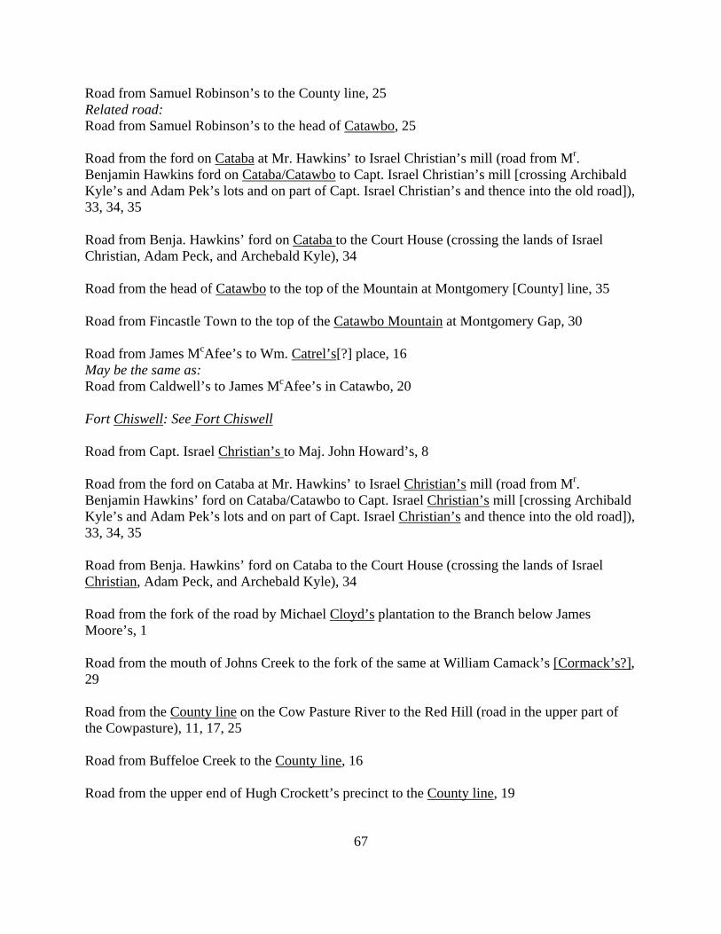
67
Road from Samuel Robinson’s to the County line, 25 Related road: Road from Samuel Robinson’s to the head of Catawbo, 25 Road from the ford on Cataba at Mr. Hawkins’ to Israel Christian’s mill (road from Mr. Benjamin Hawkins ford on Cataba/Catawbo to Capt. Israel Christian’s mill [crossing Archibald Kyle’s and Adam Pek’s lots and on part of Capt. Israel Christian’s and thence into the old road]), 33, 34, 35 Road from Benja. Hawkins’ ford on Cataba to the Court House (crossing the lands of Israel Christian, Adam Peck, and Archebald Kyle), 34 Road from the head of Catawbo to the top of the Mountain at Montgomery [County] line, 35 Road from Fincastle Town to the top of the Catawbo Mountain at Montgomery Gap, 30 Road from James McAfee’s to Wm. Catrel’s[?] place, 16 May be the same as: Road from Caldwell’s to James McAfee’s in Catawbo, 20 Fort Chiswell: See Fort Chiswell Road from Capt. Israel Christian’s to Maj. John Howard’s, 8 Road from the ford on Cataba at Mr. Hawkins’ to Israel Christian’s mill (road from Mr. Benjamin Hawkins’ ford on Cataba/Catawbo to Capt. Israel Christian’s mill [crossing Archibald Kyle’s and Adam Pek’s lots and on part of Capt. Israel Christian’s and thence into the old road]), 33, 34, 35 Road from Benja. Hawkins’ ford on Cataba to the Court House (crossing the lands of Israel Christian, Adam Peck, and Archebald Kyle), 34 Road from the fork of the road by Michael Cloyd’s plantation to the Branch below James Moore’s, 1 Road from the mouth of Johns Creek to the fork of the same at William Camack’s [Cormack’s?], 29 Road from the County line on the Cow Pasture River to the Red Hill (road in the upper part of the Cowpasture), 11, 17, 25 Road from Buffeloe Creek to the County line, 16 Road from the upper end of Hugh Crockett’s precinct to the County line, 19
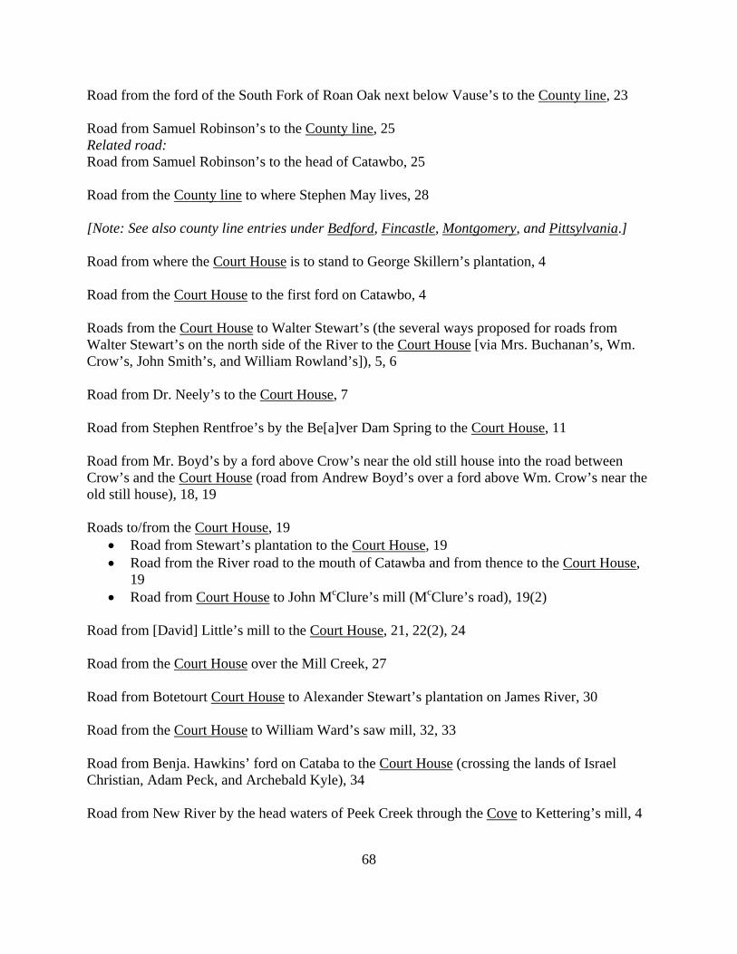
68
Road from the ford of the South Fork of Roan Oak next below Vause’s to the County line, 23 Road from Samuel Robinson’s to the County line, 25 Related road: Road from Samuel Robinson’s to the head of Catawbo, 25 Road from the County line to where Stephen May lives, 28 [Note: See also county line entries under Bedford, Fincastle, Montgomery, and Pittsylvania.] Road from where the Court House is to stand to George Skillern’s plantation, 4 Road from the Court House to the first ford on Catawbo, 4 Roads from the Court House to Walter Stewart’s (the several ways proposed for roads from Walter Stewart’s on the north side of the River to the Court House [via Mrs. Buchanan’s, Wm. Crow’s, John Smith’s, and William Rowland’s]), 5, 6 Road from Dr. Neely’s to the Court House, 7 Road from Stephen Rentfroe’s by the Be[a]ver Dam Spring to the Court House, 11 Road from Mr. Boyd’s by a ford above Crow’s near the old still house into the road between Crow’s and the Court House (road from Andrew Boyd’s over a ford above Wm. Crow’s near the old still house), 18, 19 Roads to/from the Court House, 19
• Road from Stewart’s plantation to the Court House, 19 • Road from the River road to the mouth of Catawba and from thence to the Court House,
19 • Road from Court House to John McClure’s mill (McClure’s road), 19(2)
Road from [David] Little’s mill to the Court House, 21, 22(2), 24 Road from the Court House over the Mill Creek, 27 Road from Botetourt Court House to Alexander Stewart’s plantation on James River, 30 Road from the Court House to William Ward’s saw mill, 32, 33 Road from Benja. Hawkins’ ford on Cataba to the Court House (crossing the lands of Israel Christian, Adam Peck, and Archebald Kyle), 34 Road from New River by the head waters of Peek Creek through the Cove to Kettering’s mill, 4
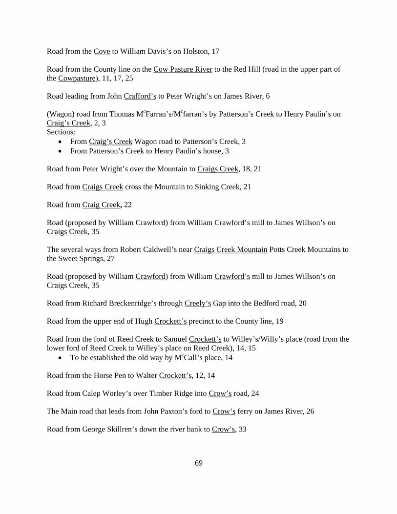
69
Road from the Cove to William Davis’s on Holston, 17 Road from the County line on the Cow Pasture River to the Red Hill (road in the upper part of the Cowpasture), 11, 17, 25 Road leading from John Crafford’s to Peter Wright’s on James River, 6 (Wagon) road from Thomas McFarran’s/Mcfarran’s by Patterson’s Creek to Henry Paulin’s on Craig’s Creek, 2, 3 Sections:
• From Craig’s Creek Wagon road to Patterson’s Creek, 3 • From Patterson’s Creek to Henry Paulin’s house, 3
Road from Peter Wright’s over the Mountain to Craigs Creek, 18, 21 Road from Craigs Creek cross the Mountain to Sinking Creek, 21 Road from Craig Creek, 22 Road (proposed by William Crawford) from William Crawford’s mill to James Willson’s on Craigs Creek, 35 The several ways from Robert Caldwell’s near Craigs Creek Mountain Potts Creek Mountains to the Sweet Springs, 27 Road (proposed by William Crawford) from William Crawford’s mill to James Willson’s on Craigs Creek, 35 Road from Richard Breckenridge’s through Creely’s Gap into the Bedford road, 20 Road from the upper end of Hugh Crockett’s precinct to the County line, 19 Road from the ford of Reed Creek to Samuel Crockett’s to Willey’s/Willy’s place (road from the lower ford of Reed Creek to Willey’s place on Reed Creek), 14, 15
• To be established the old way by McCall’s place, 14 Road from the Horse Pen to Walter Crockett’s, 12, 14 Road from Calep Worley’s over Timber Ridge into Crow’s road, 24 The Main road that leads from John Paxton’s ford to Crow’s ferry on James River, 26 Road from George Skillren’s down the river bank to Crow’s, 33
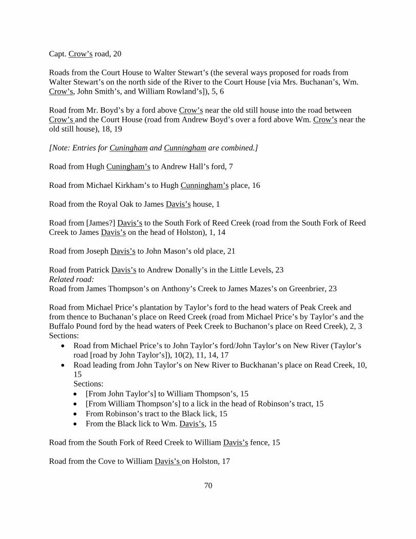
70
Capt. Crow’s road, 20 Roads from the Court House to Walter Stewart’s (the several ways proposed for roads from Walter Stewart’s on the north side of the River to the Court House [via Mrs. Buchanan’s, Wm. Crow’s, John Smith’s, and William Rowland’s]), 5, 6 Road from Mr. Boyd’s by a ford above Crow’s near the old still house into the road between Crow’s and the Court House (road from Andrew Boyd’s over a ford above Wm. Crow’s near the old still house), 18, 19 [Note: Entries for Cuningham and Cunningham are combined.] Road from Hugh Cuningham’s to Andrew Hall’s ford, 7 Road from Michael Kirkham’s to Hugh Cunningham’s place, 16 Road from the Royal Oak to James Davis’s house, 1 Road from [James?] Davis’s to the South Fork of Reed Creek (road from the South Fork of Reed Creek to James Davis’s on the head of Holston), 1, 14 Road from Joseph Davis’s to John Mason’s old place, 21 Road from Patrick Davis’s to Andrew Donally’s in the Little Levels, 23 Related road: Road from James Thompson’s on Anthony’s Creek to James Mazes’s on Greenbrier, 23 Road from Michael Price’s plantation by Taylor’s ford to the head waters of Peak Creek and from thence to Buchanan’s place on Reed Creek (road from Michael Price’s by Taylor’s and the Buffalo Pound ford by the head waters of Peek Creek to Buchanon’s place on Reed Creek), 2, 3 Sections:
• Road from Michael Price’s to John Taylor’s ford/John Taylor’s on New River (Taylor’s road [road by John Taylor’s]), 10(2), 11, 14, 17
• Road leading from John Taylor’s on New River to Buckhanan’s place on Read Creek, 10, 15 Sections: • [From John Taylor’s] to William Thompson’s, 15 • [From William Thompson’s] to a lick in the head of Robinson’s tract, 15 • From Robinson’s tract to the Black lick, 15 • From the Black lick to Wm. Davis’s, 15
Road from the South Fork of Reed Creek to William Davis’s fence, 15 Road from the Cove to William Davis’s on Holston, 17
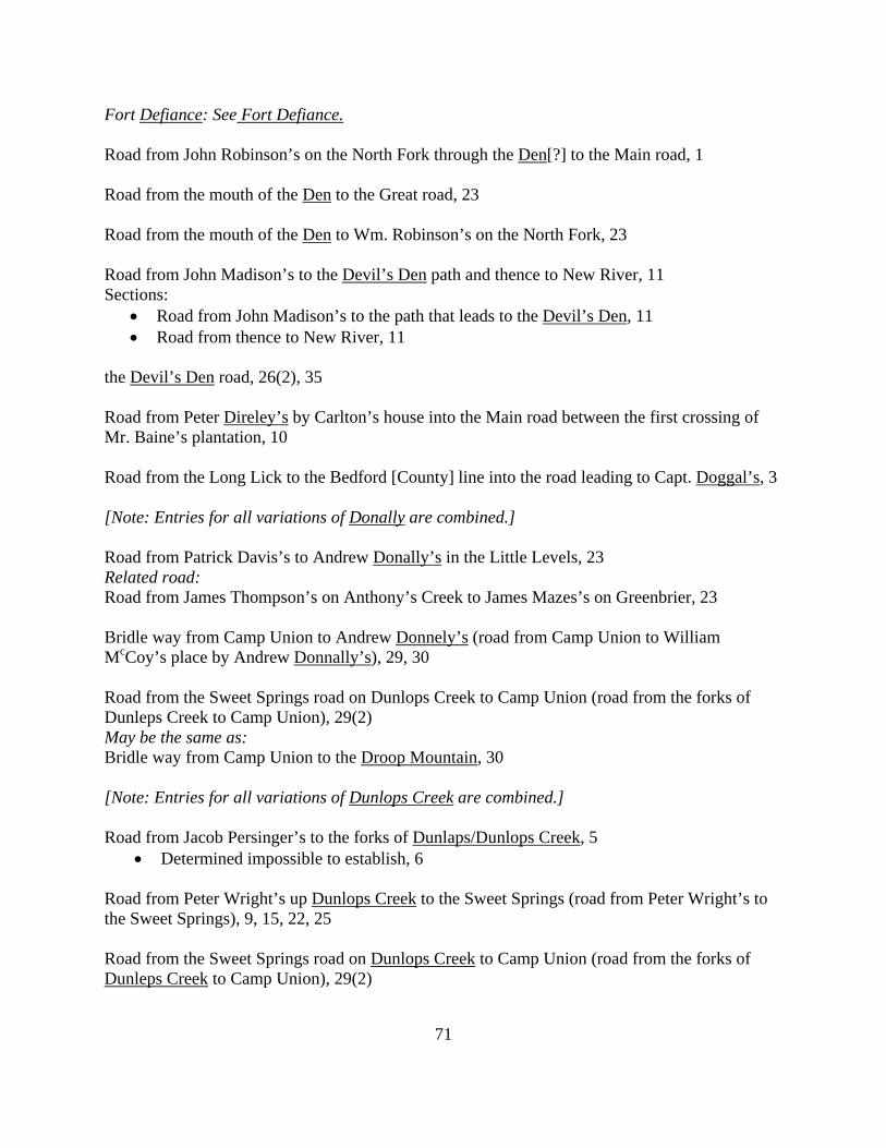
71
Fort Defiance: See Fort Defiance. Road from John Robinson’s on the North Fork through the Den[?] to the Main road, 1 Road from the mouth of the Den to the Great road, 23 Road from the mouth of the Den to Wm. Robinson’s on the North Fork, 23 Road from John Madison’s to the Devil’s Den path and thence to New River, 11 Sections:
• Road from John Madison’s to the path that leads to the Devil’s Den, 11 • Road from thence to New River, 11
the Devil’s Den road, 26(2), 35 Road from Peter Direley’s by Carlton’s house into the Main road between the first crossing of Mr. Baine’s plantation, 10 Road from the Long Lick to the Bedford [County] line into the road leading to Capt. Doggal’s, 3 [Note: Entries for all variations of Donally are combined.] Road from Patrick Davis’s to Andrew Donally’s in the Little Levels, 23 Related road: Road from James Thompson’s on Anthony’s Creek to James Mazes’s on Greenbrier, 23 Bridle way from Camp Union to Andrew Donnely’s (road from Camp Union to William McCoy’s place by Andrew Donnally’s), 29, 30 Road from the Sweet Springs road on Dunlops Creek to Camp Union (road from the forks of Dunleps Creek to Camp Union), 29(2) May be the same as: Bridle way from Camp Union to the Droop Mountain, 30 [Note: Entries for all variations of Dunlops Creek are combined.] Road from Jacob Persinger’s to the forks of Dunlaps/Dunlops Creek, 5
• Determined impossible to establish, 6 Road from Peter Wright’s up Dunlops Creek to the Sweet Springs (road from Peter Wright’s to the Sweet Springs), 9, 15, 22, 25 Road from the Sweet Springs road on Dunlops Creek to Camp Union (road from the forks of Dunleps Creek to Camp Union), 29(2)
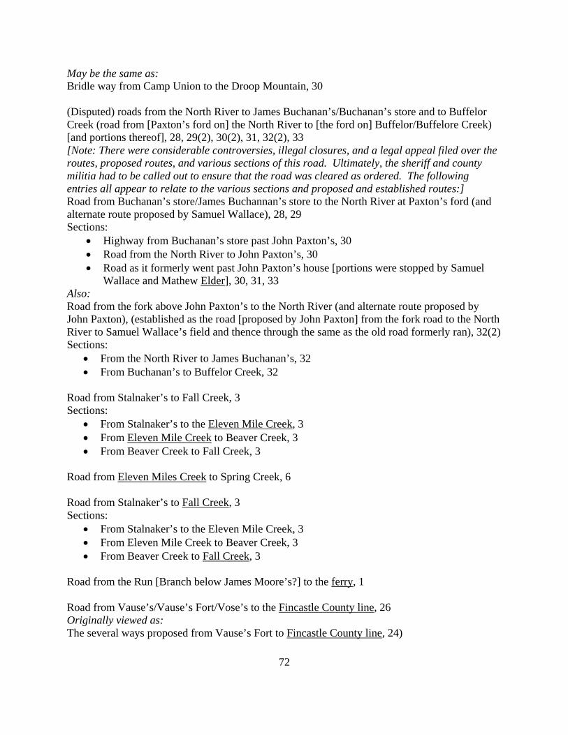
72
May be the same as: Bridle way from Camp Union to the Droop Mountain, 30 (Disputed) roads from the North River to James Buchanan’s/Buchanan’s store and to Buffelor Creek (road from [Paxton’s ford on] the North River to [the ford on] Buffelor/Buffelore Creek) [and portions thereof], 28, 29(2), 30(2), 31, 32(2), 33 [Note: There were considerable controversies, illegal closures, and a legal appeal filed over the routes, proposed routes, and various sections of this road. Ultimately, the sheriff and county militia had to be called out to ensure that the road was cleared as ordered. The following entries all appear to relate to the various sections and proposed and established routes:] Road from Buchanan’s store/James Buchannan’s store to the North River at Paxton’s ford (and alternate route proposed by Samuel Wallace), 28, 29 Sections:
• Highway from Buchanan’s store past John Paxton’s, 30 • Road from the North River to John Paxton’s, 30 • Road as it formerly went past John Paxton’s house [portions were stopped by Samuel
Wallace and Mathew Elder], 30, 31, 33 Also: Road from the fork above John Paxton’s to the North River (and alternate route proposed by John Paxton), (established as the road [proposed by John Paxton] from the fork road to the North River to Samuel Wallace’s field and thence through the same as the old road formerly ran), 32(2) Sections:
• From the North River to James Buchanan’s, 32 • From Buchanan’s to Buffelor Creek, 32
Road from Stalnaker’s to Fall Creek, 3 Sections:
• From Stalnaker’s to the Eleven Mile Creek, 3 • From Eleven Mile Creek to Beaver Creek, 3 • From Beaver Creek to Fall Creek, 3
Road from Eleven Miles Creek to Spring Creek, 6 Road from Stalnaker’s to Fall Creek, 3 Sections:
• From Stalnaker’s to the Eleven Mile Creek, 3 • From Eleven Mile Creek to Beaver Creek, 3 • From Beaver Creek to Fall Creek, 3
Road from the Run [Branch below James Moore’s?] to the ferry, 1 Road from Vause’s/Vause’s Fort/Vose’s to the Fincastle County line, 26 Originally viewed as: The several ways proposed from Vause’s Fort to Fincastle County line, 24)
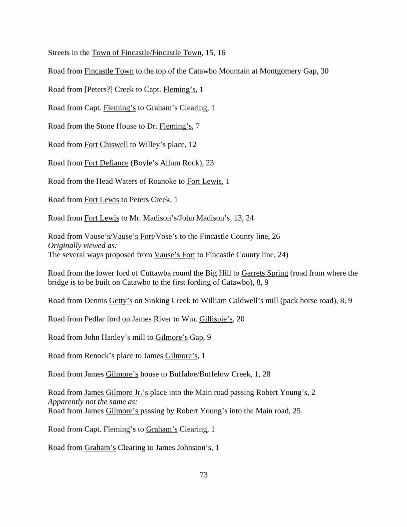
73
Streets in the Town of Fincastle/Fincastle Town, 15, 16 Road from Fincastle Town to the top of the Catawbo Mountain at Montgomery Gap, 30 Road from [Peters?] Creek to Capt. Fleming’s, 1 Road from Capt. Fleming’s to Graham’s Clearing, 1 Road from the Stone House to Dr. Fleming’s, 7 Road from Fort Chiswell to Willey’s place, 12 Road from Fort Defiance (Boyle’s Allum Rock), 23 Road from the Head Waters of Roanoke to Fort Lewis, 1 Road from Fort Lewis to Peters Creek, 1 Road from Fort Lewis to Mr. Madison’s/John Madison’s, 13, 24 Road from Vause’s/Vause’s Fort/Vose’s to the Fincastle County line, 26 Originally viewed as: The several ways proposed from Vause’s Fort to Fincastle County line, 24) Road from the lower ford of Cuttawba round the Big Hill to Garrets Spring (road from where the bridge is to be built on Catawbo to the first fording of Catawbo), 8, 9 Road from Dennis Getty’s on Sinking Creek to William Caldwell’s mill (pack horse road), 8, 9 Road from Pedlar ford on James River to Wm. Gillispie’s, 20 Road from John Hanley’s mill to Gilmore’s Gap, 9 Road from Renock’s place to James Gilmore’s, 1 Road from James Gilmore’s house to Buffaloe/Buffelow Creek, 1, 28 Road from James Gilmore Jr.’s place into the Main road passing Robert Young’s, 2 Apparently not the same as: Road from James Gilmore’s passing by Robert Young’s into the Main road, 25 Road from Capt. Fleming’s to Graham’s Clearing, 1 Road from Graham’s Clearing to James Johnston’s, 1
74
Road from Graham’s Clearing to the mill, 1 Road from the lower end of Mr. Neely’s [McNeely’s?] meadow past Col. Breckenridge’s field, leaving the fences on the left hand and passing his house, into the Great road (alteration of old road), 7(2) Road from the Reed Island on the east side of New River into the Great road below Thomas Mastin’s, 17 Road that crosses Poteet’s Gap at Arnold’s to James River at Stepheson’s ford (bridle way/road from near James Arnald’s crossing Arnald’s Valley by Stephen Lyon’s house thence through the mountain to George Willson’s on Sprouts Run and crossing James River at Thomas Stevenson’s ford and into the Great road near William Maxfield’s), 31, 33 Road from Patrick Davis’s to Andrew Donally’s in the Little Levels, 23 Related road: Road from James Thompson’s on Anthony’s Creek to James Mazes’s on Greenbrier, 23 Road from the Half Way Tree to the Town, 36 Road from the Half Way Tree to James Allison’s [Allason’s?], 36 Road from William McKee’s house to Hall’s mill, 4 Road from Michael Kirkham’s to the ford at Hall’s, 4 Road from Hugh Cuningham’s to Andrew Hall’s ford, 7 Road from [James] Johnston’s/Johnson’s to Halls Run, 1, 20 Road from Halls Run to the Biller Spring (road from Halls Run [to] Ballarts Spring), 1, 22, 26 Road from William Robinson’s to the road leading from Han’s Meadows to Vauses’s, 2 Road from William Hutcheson’s on the head of Hands Creek to the Pine Spring, 27 Road from Hanley mill to the head of Kerr Creek, 26 Road from John Hanley’s mill to Gilmore’s Gap, 9 Road from the Sweet Spring/Sweet Springs to John Hanley’s on the head of Indian Creek, 19, 24 Road from William Huggart’s to John Hanley’s on the Sinks, 26
75
Road from the ford on Cataba at Mr. Hawkins’ to Israel Christian’s mill (road from Mr. Benjamin Hawkins’ ford on Cataba/Catawbo to Capt. Israel Christian’s mill [crossing Archibald Kyle’s and Adam Pek’s lots and on part of Capt. Israel Christian’s and thence into the old road]), 33, 34, 35 Road from Benja. Hawkins’ ford on Cataba to the Court House (crossing the lands of Israel Christian, Adam Peck, and Archebald Kyle), 34 Way proposed by Andrew Henry for turning the road, 30 Road from the Beaver dam cross path at James Rowland’s to Andrew Henry’s new field and Thomas Rowland’s, 31 Road from Herbert’s mill to the mouth of Big Reed Island Creek, 1 Road from William Herbert’s ferry to the forks of the road and from his [Herbert’s] house to the Pittsylvania [County] line, 1 [Note: Entries for all variations of Holston River are combined.] Road from [James?] Davis’s to the South Fork of Reed Creek (road from the South Fork of Reed Creek to James Davis’s on the head of Holston), 1, 14 Road from Seven Miles ford on Holston River to Stalnaker’s, 8 Roads from the head of Holstein River to the Woolf Hill Creek (the old way and new way), 12 Road (the Kings Highway) between the Royal Oak and the Seven Mile ford on Holstens River, 13 Road from the Cove to William Davis’s on Holston, 17 Road from the Horse Pen to Walter Crockett’s, 12, 14 Road from Capt. Israel Christian’s to Maj. John Howard’s, 8 Road from the Big Lick to the Bedford [County] line, 13, 18 Sections:
• From the Big Lick to Mr. John Howard’s house, 18, 20, 35 • From John Howard’s house to the Bedford line, 18, 20, 23
Probable sections: • From John Howard’s house, to the Stone House, 20 • From the Stone House to the Big Lick, 23
76
Road from John Stewart’s to John Howard’s, 25, 28, 33, 34 Road from Bedford County line by Mr. Howard’s to Mr. Breckenridge’s (or other way which the viewers think fit from the county line to the same place), 27 Road from Peter Wright’s to Wm. Huggard’s, 20 Road from William Huggart’s to John Hanley’s on the Sinks, 26 Road from Uriah Humphries’ to the Red Hill Bank, 16 Road from Henry Cartmill’s to Hutcheson’s mill, 28 Road from William Hutcheson’s on the head of Hands Creek to the Pine Spring, 27 Road from the Sweet Spring/Sweet Springs to John Hanley’s on the head of Indian Creek, 19, 24 Road from [Sinking?] Spring to Ingles’s ferry, 1 Road from Ingles’s ferry to the waters of Roanoke, 1 Road from Maj. Inglish’s to Peak Creek, 10 Road from Spring Creek to the forks of the roads that leads to the Islands, 6 Road by Michael Kirkham’s to the Pedlar ford on James River, 5, 7, 8, 9 Road leading from John Crafford’s to Peter Wright’s on James River, 6 Road up James River by Col. Skillern’s plantation, 12 Road from the new established road on James River to Thomas Rowland’s lands and from the ferry down to the north side of the river to Mr. Boyd’s, 16 Road from the north branch of James River to Buffeloe Creek, 17 Road from Pedlar ford on James River to Wm. Gillispie’s, 20 The Main road that leads from John Paxton’s ford to Crow’s ferry on James River, 26 Road from William Leagerwood’s house to Mrs. Breckenridge’s, 32 Sections [possibly including some fork roads]:
• From William Leagerwood’s [Ledgerwood’s?] house to the division of the said road, 32 • From the Beaver Dams to James River, 32
77
• From the Beaver dam bridge/the Beaver Dams to Moores Creek, 29, 32 Related road[?]: Purgatory road, 29
• From Moores Creek to Mrs. Breckenridge’s, 32 Road from Botetourt Court House to Alexander Stewart’s plantation on James River, 30 Road from James River to Reonix’s/Renixes place, 31, 32 Road that crosses Poteet’s Gap at Arnold’s to James River at Stepheson’s ford (bridle way/road from near James Arnald’s crossing Arnald’s Valley by Stephen Lyon’s house thence through the mountain to George Willson’s on Sprouts Run and crossing James River at Thomas Stevenson’s ford and into the Great road near William Maxfield’s), 31, 33 Road on the north side of James River, 34 Road from the mouth of Johns Creek to the fork of the same at William Camack’s [Cormack’s?], 29 Road from Gen. Johnston’s to Stephen May’s, 31 Road from Graham’s Clearing to James Johnston’s, 1 Road from [James] Johnston’s/Johnson’s to Halls Run, 1, 20 Road from Hanley mill to the head of Kerr Creek, 26 Road from New River by the head waters of Peek Creek through the Cove to Kettering’s mill, 4 Road (the Kings Highway) between the Royal Oak and the Seven Mile ford on Holstens River, 13 Road from Michael Kirkham’s to the ford at Hall’s, 4 Road by Michael Kirkham’s to the Pedlar ford on James River, 5, 7, 8, 9 Road from Michael Kirkham’s to Hugh Cunningham’s place, 16 Road from the ford on Cataba at Mr. Hawkins’ to Israel Christian’s mill (road from Mr. Benjamin Hawkins’ ford on Cataba/Catawbo to Capt. Israel Christian’s mill [crossing Archibald Kyle’s and Adam Pek’s lots and on part of Capt. Israel Christian’s and thence into the old road]), 33, 34, 35
78
Road from Benja. Hawkins’ ford on Cataba to the Court House (crossing the lands of Israel Christian, Adam Peck, and Archebald Kyle), 34 Road from Walter Stewart’s to Lawrence’s, 2, 6 [Note: Entries for Leagerwood and Ledgerwood are combined.] Road from the first ford on Catawba/Catawbo to the head waters thereof (round the fields of James McCown, James Adams and William Ledgerwood), 2, 5 Road from William Leagerwood’s house to Mrs. Breckenridge’s, 32 Sections [possibly including some fork roads]:
• From William Leagerwood’s [Ledgerwood’s?] house to the division of the said road, 32 • From the Beaver Dams to James River, 32 • From the Beaver dam bridge/the Beaver Dams to Moores Creek, 29, 32
Related road[?]: Purgatory road, 29
• From Moores Creek to Mrs. Breckenridge’s, 32 Road (proposed by John Neelly Jr.) for altering the road from the Long Meadow passing by his house and into the Main road opposite Gen. Lewis’s house, 35 Fort Lewis: See Fort Lewis. Road from Bullards Spring to the Lick Run, 25 Road from the foot of the Mountain above Lipperd’s[?] old place to the corner of Michael Price’s field, 19 Road from [David] Little’s mill to the Court House, 21, 22(2), 24 Road from Patrick Davis’s to Andrew Donally’s in the Little Levels, 23 Related road: Road from James Thompson’s on Anthony’s Creek to James Mazes’s on Greenbrier, 23 Road from the ford [on Reed Creek?] to Little Pine Run, 1 Road from Thomas Tosh’s ford to the top of the Bent Mountain, 20, 21, 22 Related road: Road from the [top of the] Bent/Bent Mountain to Bell’s/William Bell’s mill on Little River, 20, 21, 22, 24 Sections:
• Road from Bell’s mill to the top of the Long Ridge, 22 • The residue thereof [top of the Long Ridge to top of Bent Mountain], 22
79
Road from the Long Lick to the Bedford [County] line into the road leading to Capt. Doggal’s, 3 Road from the Long Lick to the Bedford [County] line to join the road leading to Pates Settlement, 3 Road from the Long Lick to the Gap of the Mountain, 19 Road (proposed by John Neelly Jr.) from the end of the Long Meadow to James Neelly’s, 34 Road (proposed by John Neelly Jr.) for altering the road from the Long Meadow passing by his house and into the Main road opposite Gen. Lewis’s house, 35 Road from Thomas Tosh’s ford to the top of the Bent Mountain, 20, 21, 22 Related road: Road from the [top of the] Bent/Bent Mountain to Bell’s/William Bell’s mill on Little River, 20, 21, 22, 24 Sections:
• Road from Bell’s mill to the top of the Long Ridge, 22 • The residue thereof [top of the Long Ridge to top of Bent Mountain], 22
Road that crosses Poteet’s Gap at Arnold’s to James River at Stepheson’s ford (bridle way/road from near James Arnald’s crossing Arnald’s Valley by Stephen Lyon’s house thence through the mountain to George Willson’s on Sprouts Run and crossing James River at Thomas Stevenson’s ford and into the Great road near William Maxfield’s), 31, 33 Road from James McAfee’s to Wm. Catrel’s[?] place, 16 May be the same as: Road from Caldwell’s to James McAfee’s in Catawbo, 20 Road from John Poge’s by William McBride’s shop to the Main road between Barley’s and Brown’s, 5 Road from the ford of Reed Creek to Samuel Crockett’s to Willey’s/Willy’s place (road from the lower ford of Reed Creek to Willey’s place on Reed Creek), 14, 15
• To be established the old way by McCall’s place, 14 The several ways from the Beaver dams to Wm. McClellan’s, 27 Road from John Moor’s house to Paxton’s Wagon ford by Arthur McClure’s and Joseph Walker’s, 11, 16 Roads to/from the Court House, 19
• Road from Stewart’s plantation to the Court House, 19
80
• Road from the River road to the mouth of Catawba and from thence to the Court House, 19
• Road from Court House to John McClure’s mill (McClure’s road), 19(2) Road from the first ford on Catawba/Catawbo to the head waters thereof (round the fields of James McCown, James Adams and William Ledgerwood), 2, 5 Bridle way from Camp Union to Andrew Donnely’s (road from Camp Union to William McCoy’s place by Andrew Donnally’s), 29, 30 (Wagon) road from Thomas McFarran’s/Mcfarran’s by Patterson’s Creek to Henry Paulin’s on Craig’s Creek, 2, 3 Sections:
• From Craig’s Creek Wagon road to Patterson’s Creek, 3 • From Patterson’s Creek to Henry Paulin’s house, 3
Road from the ford [at McGleston’s?] leading to the Main road, 6(2) Related road: Any other way proposed from James Simpson’s to the mouth of the South River, 6 Road from William McKee’s house to Hall’s mill, 4 Road from the top of Montgomery Gap to McMurfey’s/McMurtry’s mill, 1, 23 Road from the lower end of Mr. Neely’s [McNeely’s?] meadow past Col. Breckenridge’s field, leaving the fences on the left hand and passing his house, into the Great road (alteration of old road), 7(2) Road from John Madison’s to the Devil’s Den path and thence to New River, 11 Sections:
• Road from John Madison’s to the path that leads to the Devil’s Den, 11 • Road from thence to New River, 11
Road from Thomas Madison’s mill to Robert Breckenridge’s mill, 8 Road from John Robinson’s on the North Fork through the Den[?] to the Main road, 1 Road from James Gilmore Jr.’s place into the Main road passing Robert Young’s, 2 Apparently not the same as: Road from James Gilmore’s passing by Robert Young’s into the Main road, 25 Road from John Poge’s by William McBride’s shop to the Main road between Barley’s and Brown’s, 5
81
Road from the ford [at McGleston’s?] leading to the Main road, 6(2) Related road: Any other way proposed from James Simpson’s to the mouth of the South River, 6 Road from Peter Direley’s by Carlton’s house into the Main road between the first crossing of Mr. Baine’s plantation, 10 The Main road, 12 Road from Boyd’s to Bowen’s Run (road from Bowen’s Run to the Main road), 20, 22 The Main road that leads from John Paxton’s ford to Crow’s ferry on James River, 26 (New) road from the Main road (in the South Fork of Roanoke), 26 Road (proposed by John Neelly Jr.) for altering the road from the Long Meadow passing by his house and into the Main road opposite Gen. Lewis’s house, 35 Road from Joseph Davis’s to John Mason’s old place, 21 Road from the Reed Island on the east side of New River into the Great road below Thomas Mastin’s, 17 Road that crosses Poteet’s Gap at Arnold’s to James River at Stepheson’s ford (bridle way/road from near James Arnald’s crossing Arnald’s Valley by Stephen Lyon’s house thence through the mountain to George Willson’s on Sprouts Run and crossing James River at Thomas Stevenson’s ford and into the Great road near William Maxfield’s), 31, 33 Way proposed by David May for altering the road, 24 May be the same as: Road by David May’s (alteration proposed by May), 28 Road from the County line to where Stephen May lives, 28 Road from Gen. Johnston’s to Stephen May’s, 31 Road from Patrick Davis’s to Andrew Donally’s in the Little Levels, 23 Related road: Road from James Thompson’s on Anthony’s Creek to James Mazes’s on Greenbrier, 23 Road from Graham’s Clearing to the mill, 1 Road from the Court House over the Mill Creek, 27 Road from Montgomery Gap to Miller’s mill, 1
82
Road from Miller’s mill to Stephen Rentfro’s, 1 Road from Miller’s mill to the first ford of Catawbo, 2, 5, 14 Road near Thomas Miller’s house (alteration), 29 Road from William Simpson’s shop to the Montgomery County line, 31 Road from the head of Catawbo to the top of the Mountain at Montgomery [County] line, 35 Road from the top of Montgomery Gap to McMurfey’s/McMurtry’s mill, 1, 23 Road from Montgomery Gap to Miller’s mill, 1 Road from Fincastle Town to the top of the Catawbo Mountain at Montgomery Gap, 30 [Note: Entries for Moor and Moore are combined.] Road from the fork of the road by Michael Cloyd’s plantation to the Branch below James Moore’s, 1 Road from the Run [Branch below James Moore’s?] to the ferry, 1 Road from John Moor’s house to Paxton’s Wagon ford by Arthur McClure’s and Joseph Walker’s, 11, 16 Road from William Leagerwood’s house to Mrs. Breckenridge’s, 32 Sections [possibly including some fork roads]:
• From William Leagerwood’s [Ledgerwood’s?] house to the division of the said road, 32 • From the Beaver Dams to James River, 32 • From the Beaver dam bridge/the Beaver Dams to Moores Creek, 29, 32
Related road[?]: Purgatory road, 29
• From Moores Creek to Mrs. Breckenridge’s, 32 Road from Peter Wright’s over the Mountain to Craigs Creek, 18, 21 Road from the foot of the Mountain above Lipperd’s[?] old place to the corner of Michael Price’s field, 19 Road from the Long Lick to the Gap of the Mountain, 19 Road from Craigs Creek cross the Mountain to Sinking Creek, 21
83
Road from Boyd’s ferry under the foot of the Mountain up Back Creek into a road formerly laid off by Col. Patton to the Stone House, 24 Road from Vose’s [Vause’s] to the top of the Mountain, 26 Road that crosses Poteet’s Gap at Arnold’s to James River at Stepheson’s ford (bridle way/road from near James Arnald’s crossing Arnald’s Valley by Stephen Lyon’s house thence through the mountain to George Willson’s on Sprouts Run and crossing James River at Thomas Stevenson’s ford and into the Great road near William Maxfield’s), 31, 33 Road from the head of Catawbo to the top of the Mountain at Montgomery [County] line, 35 [Note: Entries for all variations of Neely are combined.] Road from Dr. Neely’s to the Court House, 7 Road between James Nielly and James Bryans, 3 Road (proposed by John Neelly Jr.) from the end of the Long Meadow to James Neelly’s, 34 Road from Thomas Barnes’ to James Neelly’s, 34 Road (proposed by John Neelly Jr.) from the end of the Long Meadow to James Neelly’s, 34 Road (proposed by John Neelly Jr.) for altering the road from the Long Meadow passing by his house and into the Main road opposite Gen. Lewis’s house, 35 Road from the lower end of Mr. Neely’s [McNeely’s?] meadow past Col. Breckenridge’s field, leaving the fences on the left hand and passing his house, into the Great road (alteration of old road), 7(2) Road from the New River ferry to Pigg Creek, 4 Road from Michael Price’s plantation by Taylor’s ford to the head waters of Peak Creek and from thence to Buchanan’s place on Reed Creek (road from Michael Price’s by Taylor’s and the Buffalo Pound ford by the head waters of Peek Creek to Buchanon’s place on Reed Creek), 2, 3 Sections:
• Road from Michael Price’s to John Taylor’s ford/John Taylor’s on New River (Taylor’s road [road by John Taylor’s]), 10(2), 11, 14, 17
• Road leading from John Taylor’s on New River to Buckhanan’s place on Read Creek, 10, 15 Sections: • [From John Taylor’s] to William Thompson’s, 15 • [From William Thompson’s] to a lick in the head of Robinson’s tract, 15
84
• From Robinson’s tract to the Black lick, 15 • From the Black lick to Wm. Davis’s, 15
Road from New River by the head waters of Peek Creek through the Cove to Kettering’s mill, 4 Road from John Madison’s to the Devil’s Den path and thence to New River, 11 Sections:
• Road from John Madison’s to the path that leads to the Devil’s Den, 11 • Road from thence to New River, 11
Road leading by Samuel Pepper’s [Pipper’s?] house across New River, 11 Road from New River to the Seven Miles tree, 12 Road from Shopples [Stropples?] Creek to New River, 12 Road from the Reed Island on the east side of New River into the Great road below Thomas Mastin’s, 17 Road from John Robinson’s on the North Fork through the Den[?] to the Main road, 1 Road from the mouth of the Den to Wm. Robinson’s on the North Fork, 23 Road from Jacob Brown’s old place down the North Fork to Isaac Taylor’s, 25 the North Fork road, 35 Road from the [Buffaloe] Creek to the North River, 1 Not the same as: Road from the ford of the Buffaloe Creek to the North River, 1 (Disputed) roads from the North River to James Buchanan’s/Buchanan’s store and to Buffelor Creek (road from [Paxton’s ford on] the North River to [the ford on] Buffelor/Buffelore Creek) [and portions thereof], 28, 29(2), 30(2), 31, 32(2), 33 [Note: There were considerable controversies, illegal closures, and a legal appeal filed over the routes, proposed routes, and various sections of this road. Ultimately, the sheriff and county militia had to be called out to ensure that the road was cleared as ordered. The following entries all appear to relate to the various sections and proposed and established routes:] Road from Buchanan’s store/James Buchannan’s store to the North River at Paxton’s ford (and alternate route proposed by Samuel Wallace), 28, 29 Sections:
• Highway from Buchanan’s store past John Paxton’s, 30 • Road from the North River to John Paxton’s, 30
85
• Road as it formerly went past John Paxton’s house [portions were stopped by Samuel Wallace and Mathew Elder], 30, 31, 33
Also: Road from the fork above John Paxton’s to the North River (and alternate route proposed by John Paxton), (established as the road [proposed by John Paxton] from the fork road to the North River to Samuel Wallace’s field and thence through the same as the old road formerly ran), 32(2) Sections:
• From the North River to James Buchanan’s, 32 • From Buchanan’s to Buffelor Creek, 32
Road from the Long Lick to the Bedford [County] line to join the road leading to Pates Settlement, 3 (Wagon) road from Thomas McFarran’s/Mcfarran’s by Patterson’s Creek to Henry Paulin’s on Craig’s Creek, 2, 3 Sections:
• From Craig’s Creek Wagon road to Patterson’s Creek, 3 • From Patterson’s Creek to Henry Paulin’s house, 3
Road from Boyd’s ferry under the foot of the Mountain up Back Creek into a road formerly laid off by Col. Patton to the Stone House, 24 (Wagon) road from Thomas McFarran’s/Mcfarran’s by Patterson’s Creek to Henry Paulin’s on Craig’s Creek, 2, 3 Sections:
• From Craig’s Creek Wagon road to Patterson’s Creek, 3 • From Patterson’s Creek to Henry Paulin’s house, 3
Road from John Moor’s house to Paxton’s Wagon ford by Arthur McClure’s and Joseph Walker’s, 11, 16 Road round the Poplar Hills from John Paxton’s to Buffaloe Creek, 4 The Main road that leads from John Paxton’s ford to Crow’s ferry on James River, 26 (Disputed) roads from the North River to James Buchanan’s/Buchanan’s store and to Buffelor Creek (road from [Paxton’s ford on] the North River to [the ford on] Buffelor/Buffelore Creek) [and portions thereof], 28, 29(2), 30(2), 31, 32(2), 33 [Note: There were considerable controversies, illegal closures, and a legal appeal filed over the routes, proposed routes, and various sections of this road. Ultimately, the sheriff and county militia had to be called out to ensure that the road was cleared as ordered. The following entries all appear to relate to the various sections and proposed and established routes:] Road from Buchanan’s store/James Buchannan’s store to the North River at Paxton’s ford (and alternate route proposed by Samuel Wallace), 28, 29
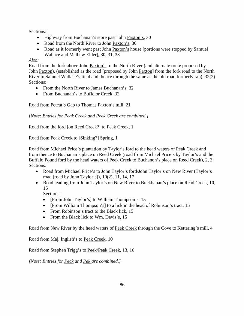
86
Sections: • Highway from Buchanan’s store past John Paxton’s, 30 • Road from the North River to John Paxton’s, 30 • Road as it formerly went past John Paxton’s house [portions were stopped by Samuel
Wallace and Mathew Elder], 30, 31, 33 Also: Road from the fork above John Paxton’s to the North River (and alternate route proposed by John Paxton), (established as the road [proposed by John Paxton] from the fork road to the North River to Samuel Wallace’s field and thence through the same as the old road formerly ran), 32(2) Sections:
• From the North River to James Buchanan’s, 32 • From Buchanan’s to Buffelor Creek, 32
Road from Peteat’s Gap to Thomas Paxton’s mill, 21 [Note: Entries for Peak Creek and Peek Creek are combined.] Road from the ford [on Reed Creek?] to Peak Creek, 1 Road from Peak Creek to [Sinking?] Spring, 1 Road from Michael Price’s plantation by Taylor’s ford to the head waters of Peak Creek and from thence to Buchanan’s place on Reed Creek (road from Michael Price’s by Taylor’s and the Buffalo Pound ford by the head waters of Peek Creek to Buchanon’s place on Reed Creek), 2, 3 Sections:
• Road from Michael Price’s to John Taylor’s ford/John Taylor’s on New River (Taylor’s road [road by John Taylor’s]), 10(2), 11, 14, 17
• Road leading from John Taylor’s on New River to Buckhanan’s place on Read Creek, 10, 15 Sections: • [From John Taylor’s] to William Thompson’s, 15 • [From William Thompson’s] to a lick in the head of Robinson’s tract, 15 • From Robinson’s tract to the Black lick, 15 • From the Black lick to Wm. Davis’s, 15
Road from New River by the head waters of Peek Creek through the Cove to Kettering’s mill, 4 Road from Maj. Inglish’s to Peak Creek, 10 Road from Stephen Trigg’s to Peek/Peak Creek, 13, 16 [Note: Entries for Peck and Pek are combined.]
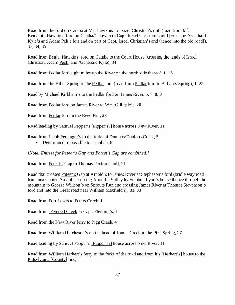
87
Road from the ford on Cataba at Mr. Hawkins’ to Israel Christian’s mill (road from Mr. Benjamin Hawkins’ ford on Cataba/Catawbo to Capt. Israel Christian’s mill [crossing Archibald Kyle’s and Adam Pek’s lots and on part of Capt. Israel Christian’s and thence into the old road]), 33, 34, 35 Road from Benja. Hawkins’ ford on Cataba to the Court House (crossing the lands of Israel Christian, Adam Peck, and Archebald Kyle), 34 Road from Pedlar ford eight miles up the River on the north side thereof, 1, 16 Road from the Biller Spring to the Pedlar ford (road from Pedlar ford to Bullards Spring), 1, 25 Road by Michael Kirkham’s to the Pedlar ford on James River, 5, 7, 8, 9 Road from Pedlar ford on James River to Wm. Gillispie’s, 20 Road from Pedlar ford to the Reed Hill, 28 Road leading by Samuel Pepper’s [Pipper’s?] house across New River, 11 Road from Jacob Persinger’s to the forks of Dunlaps/Dunlops Creek, 5
• Determined impossible to establish, 6 [Note: Entries for Peteat’s Gap and Poteet’s Gap are combined.] Road from Peteat’s Gap to Thomas Paxton’s mill, 21 Road that crosses Poteet’s Gap at Arnold’s to James River at Stepheson’s ford (bridle way/road from near James Arnald’s crossing Arnald’s Valley by Stephen Lyon’s house thence through the mountain to George Willson’s on Sprouts Run and crossing James River at Thomas Stevenson’s ford and into the Great road near William Maxfield’s), 31, 33 Road from Fort Lewis to Peters Creek, 1 Road from [Peters?] Creek to Capt. Fleming’s, 1 Road from the New River ferry to Pigg Creek, 4 Road from William Hutcheson’s on the head of Hands Creek to the Pine Spring, 27 Road leading by Samuel Pepper’s [Pipper’s?] house across New River, 11 Road from William Herbert’s ferry to the forks of the road and from his [Herbert’s] house to the Pittsylvania [County] line, 1
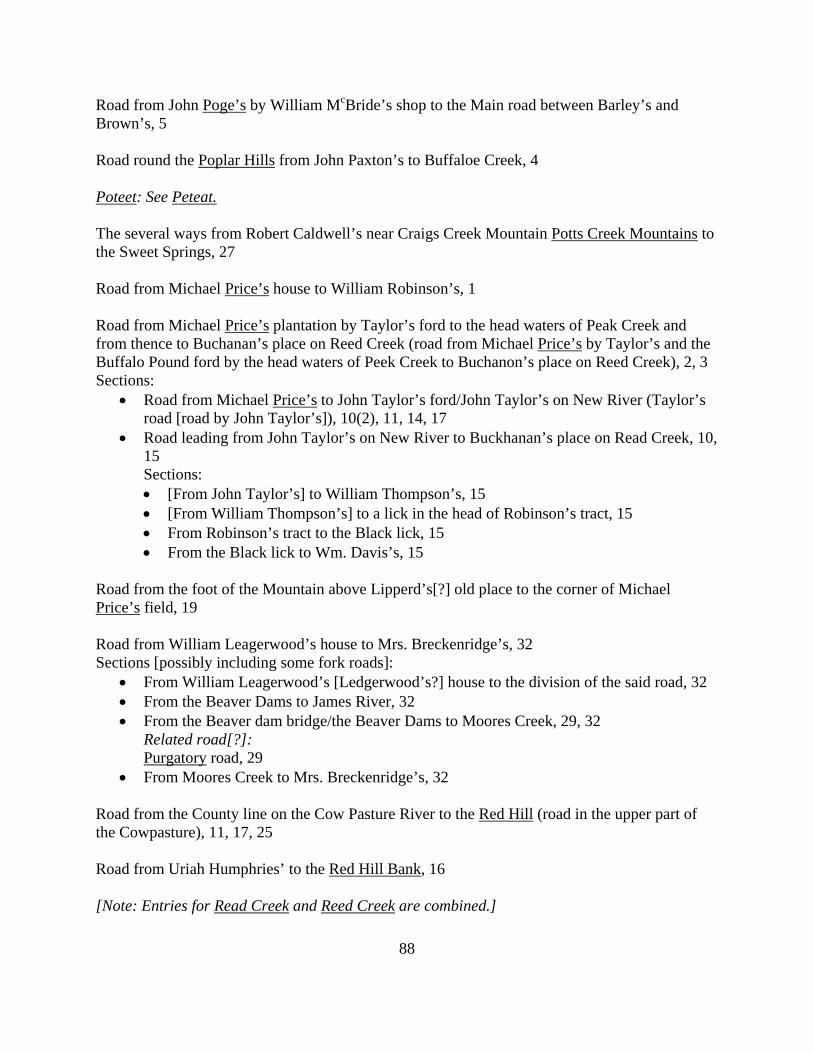
88
Road from John Poge’s by William McBride’s shop to the Main road between Barley’s and Brown’s, 5 Road round the Poplar Hills from John Paxton’s to Buffaloe Creek, 4 Poteet: See Peteat. The several ways from Robert Caldwell’s near Craigs Creek Mountain Potts Creek Mountains to the Sweet Springs, 27 Road from Michael Price’s house to William Robinson’s, 1 Road from Michael Price’s plantation by Taylor’s ford to the head waters of Peak Creek and from thence to Buchanan’s place on Reed Creek (road from Michael Price’s by Taylor’s and the Buffalo Pound ford by the head waters of Peek Creek to Buchanon’s place on Reed Creek), 2, 3 Sections:
• Road from Michael Price’s to John Taylor’s ford/John Taylor’s on New River (Taylor’s road [road by John Taylor’s]), 10(2), 11, 14, 17
• Road leading from John Taylor’s on New River to Buckhanan’s place on Read Creek, 10, 15 Sections: • [From John Taylor’s] to William Thompson’s, 15 • [From William Thompson’s] to a lick in the head of Robinson’s tract, 15 • From Robinson’s tract to the Black lick, 15 • From the Black lick to Wm. Davis’s, 15
Road from the foot of the Mountain above Lipperd’s[?] old place to the corner of Michael Price’s field, 19 Road from William Leagerwood’s house to Mrs. Breckenridge’s, 32 Sections [possibly including some fork roads]:
• From William Leagerwood’s [Ledgerwood’s?] house to the division of the said road, 32 • From the Beaver Dams to James River, 32 • From the Beaver dam bridge/the Beaver Dams to Moores Creek, 29, 32
Related road[?]: Purgatory road, 29
• From Moores Creek to Mrs. Breckenridge’s, 32 Road from the County line on the Cow Pasture River to the Red Hill (road in the upper part of the Cowpasture), 11, 17, 25 Road from Uriah Humphries’ to the Red Hill Bank, 16 [Note: Entries for Read Creek and Reed Creek are combined.]
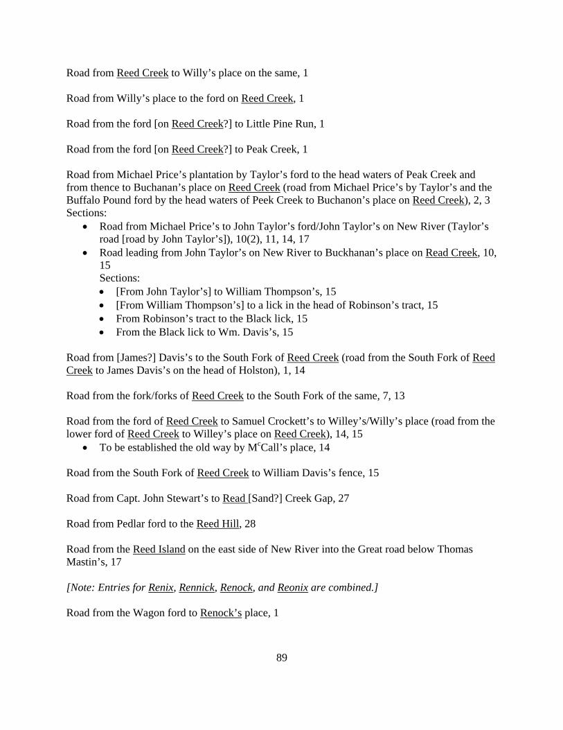
89
Road from Reed Creek to Willy’s place on the same, 1 Road from Willy’s place to the ford on Reed Creek, 1 Road from the ford [on Reed Creek?] to Little Pine Run, 1 Road from the ford [on Reed Creek?] to Peak Creek, 1 Road from Michael Price’s plantation by Taylor’s ford to the head waters of Peak Creek and from thence to Buchanan’s place on Reed Creek (road from Michael Price’s by Taylor’s and the Buffalo Pound ford by the head waters of Peek Creek to Buchanon’s place on Reed Creek), 2, 3 Sections:
• Road from Michael Price’s to John Taylor’s ford/John Taylor’s on New River (Taylor’s road [road by John Taylor’s]), 10(2), 11, 14, 17
• Road leading from John Taylor’s on New River to Buckhanan’s place on Read Creek, 10, 15 Sections: • [From John Taylor’s] to William Thompson’s, 15 • [From William Thompson’s] to a lick in the head of Robinson’s tract, 15 • From Robinson’s tract to the Black lick, 15 • From the Black lick to Wm. Davis’s, 15
Road from [James?] Davis’s to the South Fork of Reed Creek (road from the South Fork of Reed Creek to James Davis’s on the head of Holston), 1, 14 Road from the fork/forks of Reed Creek to the South Fork of the same, 7, 13 Road from the ford of Reed Creek to Samuel Crockett’s to Willey’s/Willy’s place (road from the lower ford of Reed Creek to Willey’s place on Reed Creek), 14, 15
• To be established the old way by McCall’s place, 14 Road from the South Fork of Reed Creek to William Davis’s fence, 15 Road from Capt. John Stewart’s to Read [Sand?] Creek Gap, 27 Road from Pedlar ford to the Reed Hill, 28 Road from the Reed Island on the east side of New River into the Great road below Thomas Mastin’s, 17 [Note: Entries for Renix, Rennick, Renock, and Reonix are combined.] Road from the Wagon ford to Renock’s place, 1
90
Road from Renock’s place to James Gilmore’s, 1 Road from Rennick’s place to Barcley’s mill, 4 Road from James River to Reonix’s/Renixes place, 31, 32 Road from Miller’s mill to Stephen Rentfro’s, 1 Road from Stephen Rentfroe’s by the Be[a]ver Dam Spring to the Court House, 11 Road from Pedlar ford eight miles up the River on the north side thereof, 1, 16 Roads from the Court House to Walter Stewart’s (the several ways proposed for roads from Walter Stewart’s on the north side of the River to the Court House [via Mrs. Buchanan’s, Wm. Crow’s, John Smith’s, and William Rowland’s]), 5, 6 Roads to/from the Court House, 19
• Road from Stewart’s plantation to the Court House, 19 • Road from the River road to the mouth of Catawba and from thence to the Court House,
19 • Road from Court House to John McClure’s mill (McClure’s road), 19(2)
Road from George Skillren’s down the river bank to Crow’s, 33 [Note: Entries for all variations of Roanoke are combined.] Road from Ingles’s ferry to the waters of Roanoke, 1 Road from the Head Waters of Roanoke to Fort Lewis, 1 Road on the head of Roanoak, 18 Road from the ford of the South Fork of Roan Oak next below Vause’s to the County line, 23 Road from James Barnett’s to the ford [of the South Fork of Roan Oak?] next below Vause’s, 23 (New) road from the Main road (in the South Fork of Roanoke), 26 [Note: Entries for Robertson and Robinson are combined.] Road from Michael Price’s plantation by Taylor’s ford to the head waters of Peak Creek and from thence to Buchanan’s place on Reed Creek (road from Michael Price’s by Taylor’s and the Buffalo Pound ford by the head waters of Peek Creek to Buchanon’s place on Reed Creek), 2, 3 Sections:
91
• Road from Michael Price’s to John Taylor’s ford/John Taylor’s on New River (Taylor’s road [road by John Taylor’s]), 10(2), 11, 14, 17
• Road leading from John Taylor’s on New River to Buckhanan’s place on Read Creek, 10, 15 Sections: • [From John Taylor’s] to William Thompson’s, 15 • [From William Thompson’s] to a lick in the head of Robinson’s tract, 15 • From Robinson’s tract to the Black lick, 15 • From the Black lick to Wm. Davis’s, 15
Road from the lower end of Capt. Robinson’s field to Vause’s, 10 Road from John Robinson’s on the North Fork through the Den[?] to the Main road, 1 Road from John Robinson’s to the head waters of Catawbo, 1 Road from Samuel Robinson’s to the County line, 25 Related road: Road from Samuel Robinson’s to the head of Catawbo, 25 Road from Michael Price’s house to William Robinson’s, 1 Road from William Robinson’s/Robertson’s to the head waters of Catawba/Catawbo/Cuttawba, 2, 5, 7 Road from William Robinson’s to the road leading from Han’s Meadows to Vauses’s, 2 Road from the mouth of the Den to Wm. Robinson’s on the North Fork, 23 Road from Smallwood’s plantation to Rowland’s road, 21 Road from the Beaver dam cross path at James Rowland’s to Andrew Henry’s new field and Thomas Rowland’s, 31 Road from the new established road on James River to Thomas Rowland’s lands and from the ferry down to the north side of the river to Mr. Boyd’s, 16 Road from the Beaver dam cross path at James Rowland’s to Andrew Henry’s new field and Thomas Rowland’s, 31 Road from Buckanan’s ferry to Thomas Rowland’s, 32
92
Roads from the Court House to Walter Stewart’s (the several ways proposed for roads from Walter Stewart’s on the north side of the River to the Court House [via Mrs. Buchanan’s, Wm. Crow’s, John Smith’s, and William Rowland’s]), 5, 6 Road from Stalnaker’s ford to the Royal Oak, 1 Road from the Royal Oak to James Davis’s house, 1 Road (the Kings Highway) between the Royal Oak and the Seven Mile ford on Holstens River, 13 Road from Capt. John Stewart’s to Read [Sand?] Creek Gap, 27 Road from Seven Miles ford on Holston River to Stalnaker’s, 8 Road (the Kings Highway) between the Royal Oak and the Seven Mile ford on Holstens River, 13 Road from New River to the Seven Miles tree, 12 Road from Shopples [Stropples?] Creek to New River, 12 Road from the ford [at McGleston’s?] leading to the Main road, 6(2) Related road: Any other way proposed from James Simpson’s to the mouth of the South River, 6 Road from William Simpson’s shop to the Montgomery County line, 31 Road from Dennis Getty’s on Sinking Creek to William Caldwell’s mill (pack horse road), 8, 9 Road from Craigs Creek cross the Mountain to Sinking Creek, 21 Road over Sinking Creek Mountains to John Webb’s mill, 36 Road from Peak Creek to [Sinking?] Spring, 1 Road from [Sinking?] Spring to Ingles’s ferry, 1 Road from William Huggart’s to John Hanley’s on the Sinks, 26 [Note: All variations of Skillern are combined.] Road up James River by Col. Skillern’s plantation, 12 Road from where the Court House is to stand to George Skillern’s plantation, 4
93
Road from George Skillren’s down the river bank to Crow’s, 33 Road from Smallwood’s plantation to Rowland’s road, 21 Roads from the Court House to Walter Stewart’s (the several ways proposed for roads from Walter Stewart’s on the north side of the River to the Court House [via Mrs. Buchanan’s, Wm. Crow’s, John Smith’s, and William Rowland’s]), 5, 6 (New) road from the Main road (in the South Fork of Roanoke), 26 the South Fork road, 35 Road from the ford [at McGleston’s?] leading to the Main road, 6(2) Related road: Any other way proposed from James Simpson’s to the mouth of the South River, 6 Road from Eleven Miles Creek to Spring Creek, 6 Road from Spring Creek to the forks of the roads that leads to the Islands, 6 Road that crosses Poteet’s Gap at Arnold’s to James River at Stepheson’s ford (bridle way/road from near James Arnald’s crossing Arnald’s Valley by Stephen Lyon’s house thence through the mountain to George Willson’s on Sprouts Run and crossing James River at Thomas Stevenson’s ford and into the Great road near William Maxfield’s), 31, 33 Road from Stalnaker’s ford to the Royal Oak, 1 Road from Stalnaker’s to Fall Creek, 3 Sections:
• From Stalnaker’s to the Eleven Mile Creek, 3 • From Eleven Mile Creek to Beaver Creek, 3 • From Beaver Creek to Fall Creek, 3
Road from Seven Miles ford on Holston River to Stalnaker’s, 8 Road from Vause’s to Stapleton’s, 1 Also: (New?) road from Vause’s to Stapleton’s, 3
• Not to be established, 7 Road that crosses Poteet’s Gap at Arnold’s to James River at Stepheson’s ford (bridle way/road from near James Arnald’s crossing Arnald’s Valley by Stephen Lyon’s house thence through the mountain to George Willson’s on Sprouts Run and crossing James River at Thomas Stevenson’s ford and into the Great road near William Maxfield’s), 31, 33
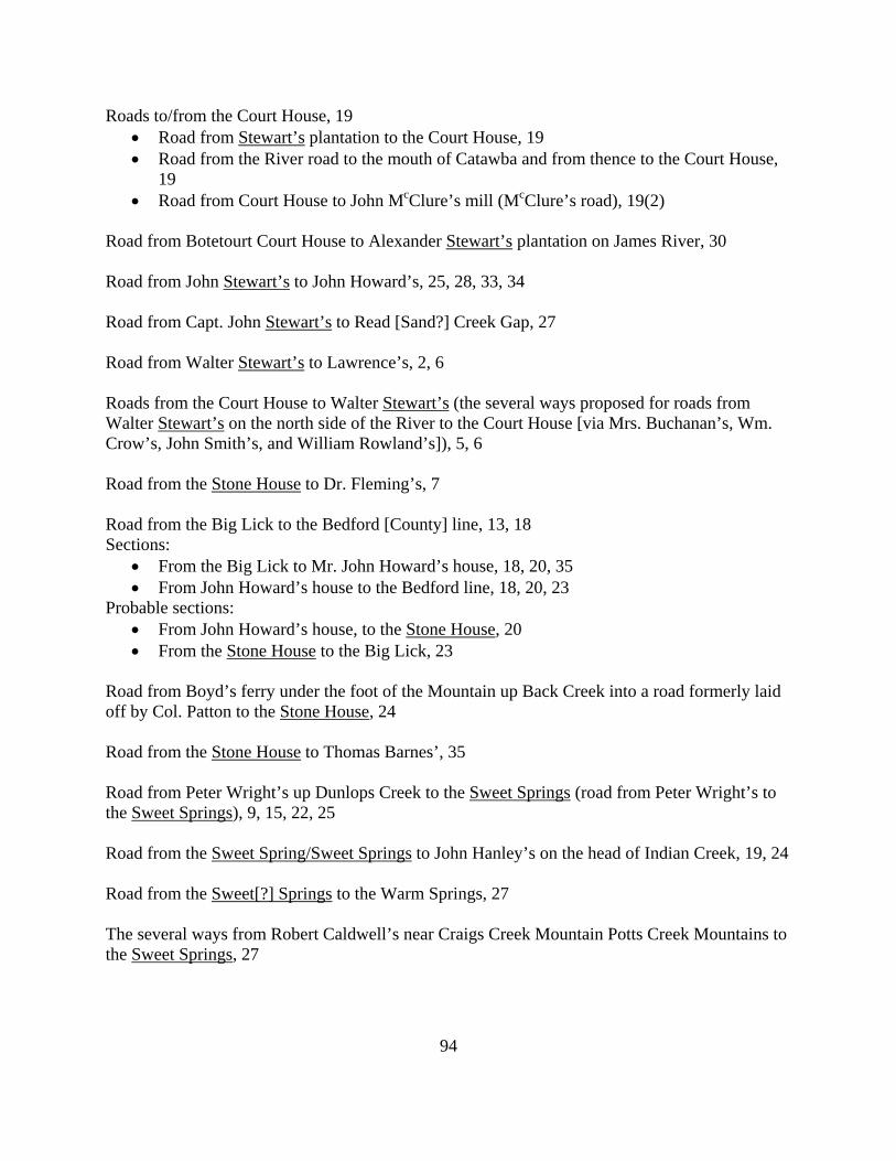
94
Roads to/from the Court House, 19 • Road from Stewart’s plantation to the Court House, 19 • Road from the River road to the mouth of Catawba and from thence to the Court House,
19 • Road from Court House to John McClure’s mill (McClure’s road), 19(2)
Road from Botetourt Court House to Alexander Stewart’s plantation on James River, 30 Road from John Stewart’s to John Howard’s, 25, 28, 33, 34 Road from Capt. John Stewart’s to Read [Sand?] Creek Gap, 27 Road from Walter Stewart’s to Lawrence’s, 2, 6 Roads from the Court House to Walter Stewart’s (the several ways proposed for roads from Walter Stewart’s on the north side of the River to the Court House [via Mrs. Buchanan’s, Wm. Crow’s, John Smith’s, and William Rowland’s]), 5, 6 Road from the Stone House to Dr. Fleming’s, 7 Road from the Big Lick to the Bedford [County] line, 13, 18 Sections:
• From the Big Lick to Mr. John Howard’s house, 18, 20, 35 • From John Howard’s house to the Bedford line, 18, 20, 23
Probable sections: • From John Howard’s house, to the Stone House, 20 • From the Stone House to the Big Lick, 23
Road from Boyd’s ferry under the foot of the Mountain up Back Creek into a road formerly laid off by Col. Patton to the Stone House, 24 Road from the Stone House to Thomas Barnes’, 35 Road from Peter Wright’s up Dunlops Creek to the Sweet Springs (road from Peter Wright’s to the Sweet Springs), 9, 15, 22, 25 Road from the Sweet Spring/Sweet Springs to John Hanley’s on the head of Indian Creek, 19, 24 Road from the Sweet[?] Springs to the Warm Springs, 27 The several ways from Robert Caldwell’s near Craigs Creek Mountain Potts Creek Mountains to the Sweet Springs, 27
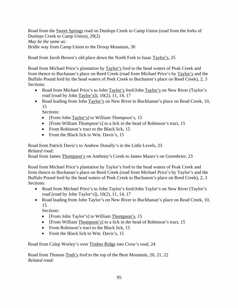
95
Road from the Sweet Springs road on Dunlops Creek to Camp Union (road from the forks of Dunleps Creek to Camp Union), 29(2) May be the same as: Bridle way from Camp Union to the Droop Mountain, 30 Road from Jacob Brown’s old place down the North Fork to Isaac Taylor’s, 25 Road from Michael Price’s plantation by Taylor’s ford to the head waters of Peak Creek and from thence to Buchanan’s place on Reed Creek (road from Michael Price’s by Taylor’s and the Buffalo Pound ford by the head waters of Peek Creek to Buchanon’s place on Reed Creek), 2, 3 Sections:
• Road from Michael Price’s to John Taylor’s ford/John Taylor’s on New River (Taylor’s road [road by John Taylor’s]), 10(2), 11, 14, 17
• Road leading from John Taylor’s on New River to Buckhanan’s place on Read Creek, 10, 15 Sections: • [From John Taylor’s] to William Thompson’s, 15 • [From William Thompson’s] to a lick in the head of Robinson’s tract, 15 • From Robinson’s tract to the Black lick, 15 • From the Black lick to Wm. Davis’s, 15
Road from Patrick Davis’s to Andrew Donally’s in the Little Levels, 23 Related road: Road from James Thompson’s on Anthony’s Creek to James Mazes’s on Greenbrier, 23 Road from Michael Price’s plantation by Taylor’s ford to the head waters of Peak Creek and from thence to Buchanan’s place on Reed Creek (road from Michael Price’s by Taylor’s and the Buffalo Pound ford by the head waters of Peek Creek to Buchanon’s place on Reed Creek), 2, 3 Sections:
• Road from Michael Price’s to John Taylor’s ford/John Taylor’s on New River (Taylor’s road [road by John Taylor’s]), 10(2), 11, 14, 17
• Road leading from John Taylor’s on New River to Buckhanan’s place on Read Creek, 10, 15 Sections: • [From John Taylor’s] to William Thompson’s, 15 • [From William Thompson’s] to a lick in the head of Robinson’s tract, 15 • From Robinson’s tract to the Black lick, 15 • From the Black lick to Wm. Davis’s, 15
Road from Calep Worley’s over Timber Ridge into Crow’s road, 24 Road from Thomas Tosh’s ford to the top of the Bent Mountain, 20, 21, 22 Related road:
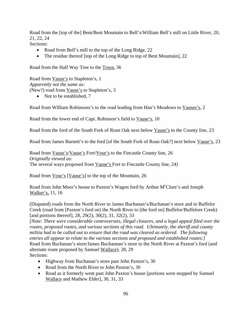
96
Road from the [top of the] Bent/Bent Mountain to Bell’s/William Bell’s mill on Little River, 20, 21, 22, 24 Sections:
• Road from Bell’s mill to the top of the Long Ridge, 22 • The residue thereof [top of the Long Ridge to top of Bent Mountain], 22
Road from the Half Way Tree to the Town, 36 Road from Vause’s to Stapleton’s, 1 Apparently not the same as: (New?) road from Vause’s to Stapleton’s, 3
• Not to be established, 7 Road from William Robinsons’s to the road leading from Han’s Meadows to Vauses’s, 2 Road from the lower end of Capt. Robinson’s field to Vause’s, 10 Road from the ford of the South Fork of Roan Oak next below Vause’s to the County line, 23 Road from James Barnett’s to the ford [of the South Fork of Roan Oak?] next below Vause’s, 23 Road from Vause’s/Vause’s Fort/Vose’s to the Fincastle County line, 26 Originally viewed as: The several ways proposed from Vause’s Fort to Fincastle County line, 24) Road from Vose’s [Vause’s] to the top of the Mountain, 26 Road from John Moor’s house to Paxton’s Wagon ford by Arthur McClure’s and Joseph Walker’s, 11, 16 (Disputed) roads from the North River to James Buchanan’s/Buchanan’s store and to Buffelor Creek (road from [Paxton’s ford on] the North River to [the ford on] Buffelor/Buffelore Creek) [and portions thereof], 28, 29(2), 30(2), 31, 32(2), 33 [Note: There were considerable controversies, illegal closures, and a legal appeal filed over the routes, proposed routes, and various sections of this road. Ultimately, the sheriff and county militia had to be called out to ensure that the road was cleared as ordered. The following entries all appear to relate to the various sections and proposed and established routes:] Road from Buchanan’s store/James Buchannan’s store to the North River at Paxton’s ford (and alternate route proposed by Samuel Wallace), 28, 29 Sections:
• Highway from Buchanan’s store past John Paxton’s, 30 • Road from the North River to John Paxton’s, 30 • Road as it formerly went past John Paxton’s house [portions were stopped by Samuel
Wallace and Mathew Elder], 30, 31, 33
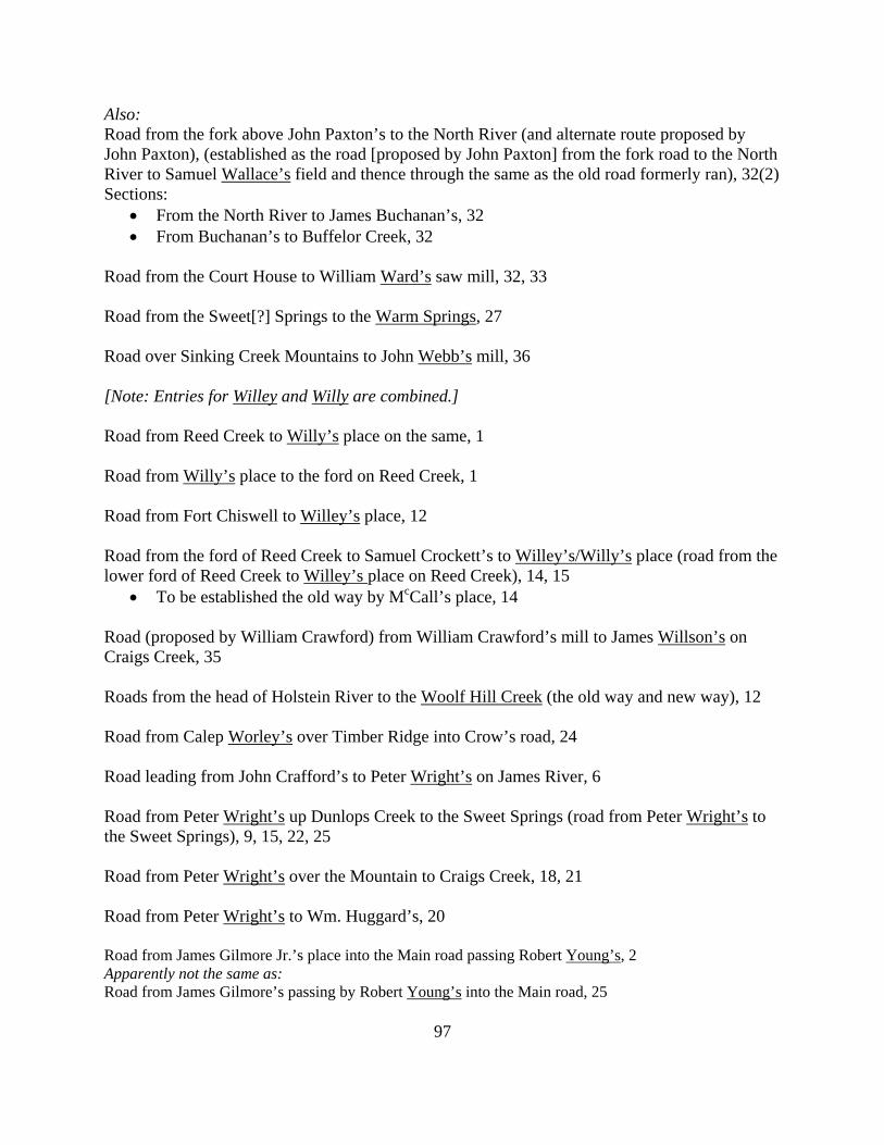
97
Also: Road from the fork above John Paxton’s to the North River (and alternate route proposed by John Paxton), (established as the road [proposed by John Paxton] from the fork road to the North River to Samuel Wallace’s field and thence through the same as the old road formerly ran), 32(2) Sections:
• From the North River to James Buchanan’s, 32 • From Buchanan’s to Buffelor Creek, 32
Road from the Court House to William Ward’s saw mill, 32, 33 Road from the Sweet[?] Springs to the Warm Springs, 27 Road over Sinking Creek Mountains to John Webb’s mill, 36 [Note: Entries for Willey and Willy are combined.] Road from Reed Creek to Willy’s place on the same, 1 Road from Willy’s place to the ford on Reed Creek, 1 Road from Fort Chiswell to Willey’s place, 12 Road from the ford of Reed Creek to Samuel Crockett’s to Willey’s/Willy’s place (road from the lower ford of Reed Creek to Willey’s place on Reed Creek), 14, 15
• To be established the old way by McCall’s place, 14 Road (proposed by William Crawford) from William Crawford’s mill to James Willson’s on Craigs Creek, 35 Roads from the head of Holstein River to the Woolf Hill Creek (the old way and new way), 12 Road from Calep Worley’s over Timber Ridge into Crow’s road, 24 Road leading from John Crafford’s to Peter Wright’s on James River, 6 Road from Peter Wright’s up Dunlops Creek to the Sweet Springs (road from Peter Wright’s to the Sweet Springs), 9, 15, 22, 25 Road from Peter Wright’s over the Mountain to Craigs Creek, 18, 21 Road from Peter Wright’s to Wm. Huggard’s, 20 Road from James Gilmore Jr.’s place into the Main road passing Robert Young’s, 2 Apparently not the same as: Road from James Gilmore’s passing by Robert Young’s into the Main road, 25