bouddi national park draft planning considerations · bouddi national park draft planning...
TRANSCRIPT
Bouddi National Park Draft Planning Considerations
Bouddi National Park Draft Planning Considerations
ii
© 2019 State of NSW and Office of Environment and Heritage
With the exception of photographs, the State of NSW and Office of Environment and Heritage are pleased to allow this material to be reproduced in whole or in part for educational and non-commercial use, provided the meaning is unchanged and its source, publisher and authorship are acknowledged. Specific permission is required for the reproduction of photographs.
OEH has compiled this publication in good faith, exercising all due care and attention. No representation is made about the accuracy, completeness or suitability of the information in this publication for any particular purpose. OEH shall not be liable for any damage which may occur to any person or organisation taking action or not on the basis of this publication.
All content in this publication is owned by OEH and is protected by Crown Copyright, unless credited otherwise. It is licensed under the Creative Commons Attribution 4.0 International (CC BY 4.0) , subject to the exemptions contained in the licence. The legal code for the licence is available at Creative Commons . OEH asserts the right to be attributed as author of the original material in the following manner: © State of New South Wales and Office of Environment and Heritage 2019.
This publication is for discussion and comment only. Publication indicates the proposals are under consideration and are open for public discussion. Provisions in the final plan of management may not be the same as those in this draft plan.
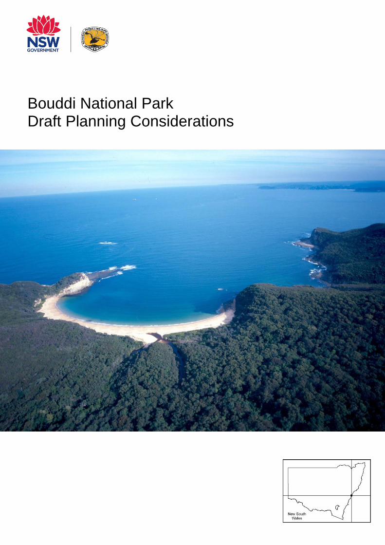
Front cover image: Maitland Bay. Photo credit: OEH
Published by: Office of Environment and Heritage 59 Goulburn Street, Sydney NSW 2000 PO Box A290, Sydney South NSW 1232 Phone: +61 2 9995 5000 (switchboard) Phone: 131 555 (environment information and publications requests) Phone: 1300 361 967 (national parks, climate change and energy efficiency information and publications requests) Fax: +61 2 9995 5999 TTY users: phone 133 677, then ask for 131 555 Speak and listen users: phone 1300 555 727, then ask for 131 555 Email: [email protected] Website: www.environment.nsw.gov.au Report pollution and environmental incidents Environment Line: 131 555 (NSW only) or [email protected] See also www.environment.nsw.gov.au/pollution ISBN 978-1-925974-06-5 OEH2019/0225 Bouddi National Park Draft Planning Considerations, June 2019 Printed on environmentally sustainable paper
Bouddi National Park Draft Planning Considerations
iii
How to use this document
This document discusses the planning matters considered in preparing the Bouddi National Park Draft Plan of Management. Matters to be considered when preparing plans of management are set out in section 72AA (1) of the National Parks and Wildlife Act 1974. The legislative and policy framework for plans of management is outlined in Appendix A.
Both the plan of management and the planning considerations are for use by park managers in developing and monitoring park management priorities. They also serve to inform communities about the values of the park and what the NSW National Parks and Wildlife Service (NPWS) is doing to care for the park.
This document will be updated where appropriate, for example, if we have new information on the values of the park (e.g. new threatened species) or management approaches (e.g. new pest management technique) or new programs. Scientific names for common names of native species mentioned in the text are included in Appendix B: and those of pests and weeds are included in Appendix D. Changes to this document cannot occur where they are inconsistent with the scheme of operations in the Bouddi National Park Draft Plan of Management.
Acknowledgments
NPWS acknowledges that Bouddi National Park is in the traditional Country of the Guringai and Darkinjung peoples.
This document was prepared by staff of NPWS, part of the Office of Environment and Heritage, in consultation with Hunter Central Coast Regional Advisory Committee.
Contacting NPWS
For more information or any inquiries about this document or Bouddi National Park, contact the NPWS Central Coast Area Office, Girrakool 2250 or by telephone on (02) 4320 4200.

Bouddi National Park Draft Planning Considerations
iv
[blank]
Bouddi National Park Draft Planning Considerations
v
Contents
1 Landscape setting ....................................................................................................... 1
2 Protecting the natural environment ........................................................................... 3
2.1 Geology and landform .......................................................................................... 3
2.2 Plants and Animals .............................................................................................. 5
3 Looking after our culture and heritage .................................................................... 18
3.1 Aboriginal culture and heritage ........................................................................... 18
3.2 Shared cultural heritage ..................................................................................... 20
4 Providing for visitor use and enjoyment ................................................................. 24
4.1 Information ......................................................................................................... 24
4.2 Recreation .......................................................................................................... 24
5 NPWS infrastructure and services ........................................................................... 32
5.1 Management facilities and infrastructure ............................................................ 32
6 Non-NPWS infrastructure and services ................................................................... 33
6.1 Non-NPWS Infrastructure ................................................................................... 33
6.2 Non-NPWS Use ................................................................................................. 34
Appendices ......................................................................................................................... 35
Appendix A: Legislation and policy ........................................................................... 35
Appendix B: Scientific plant and animal names ........................................................ 36
Appendix C: Vegetation communities in the park ...................................................... 39
Appendix D: Pests in the park ................................................................................... 45
Abbreviations ..................................................................................................................... 46
Glossary .............................................................................................................................. 46
References .......................................................................................................................... 47
Tables
Table 1. Vegetation communities in the park .......................................................................... 6
Table 2: Threatened plants in the park ................................................................................... 8
Table 3: Threatened animals in the park .............................................................................. 10
Table 4: Central Coast climate change snapshot.................................................................. 16
Table 5: Historic sites in the park .......................................................................................... 20
Table 6: Main walking tracks in the park ............................................................................... 26
Table 7: Day use areas in the park ....................................................................................... 27

Bouddi National Park Draft Planning Considerations
vi
Table 8: Camping areas in the park ...................................................................................... 28
Table 9: Powerlines through or on the edge of the park ....................................................... 33
Figures
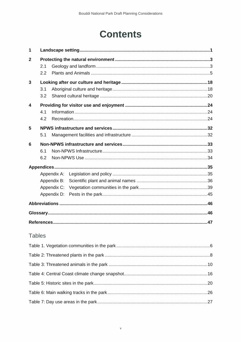
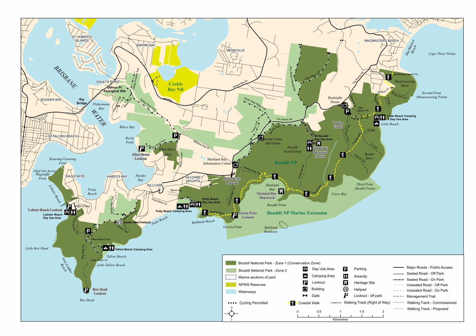
Figure 1. Map of Bouddi National Park ................................................................................ 2
!
!
!
!
!
!
!
!
!
! !!
!!
!
!
!!
!
!!!!!!
!!
!
!!
!!
!
!
!
!!!
!
!
!
!!
!
!
!!
!
!!
!
!!
!
!
!
!
!!
!
!
!
!
!
!
!
!!
!
!
!
!
!
!
!!
!
!
!
!
!
!!
!
!
!
!
!
! !!
!
!
!
!
! !
!!
!
!
!
! !
!
!
!
!!
!!
MaitlandBombora
Maitland Bay Dr
Cape Three PointsMacM
asters
Beach
FletchersGlen
FishermansBay
Rileys Bay
Taworri Rd
Putty Beach Dr
Hawke Head Dr
BouddiGrand Deep Bombi
Moor
MACMASTERS BEACHST HUBERTS
ISLANDS
ETTALONG BEACH
BENSVILLEEMPIRE BAY
Daleys Point Trail
North West Ridge Trail
The Sc
enic R
d
Grahame Dr
Mt Bouddi Rd
Empire Bay Dr
Wards
HillR
dKILLCAREHEIGHTS
KILLCARE
DALEYS POINT
HARDYS BAYWAGSTAFFE
Bouddi NP
Bouddi NP Marine Extension
CockleBay NR
DingeldeiMemorial
ShelterKourung GourungPoint
PrettyBeach
BoobiallaHouse
Strom Centreand House
Iron Ladder
Beach
Second Point(Mourawaring Point)
Bullimah Beach
Lobster Beach
Tallow Beach
Gerrin Point
MaitlandBay
Bouddi Point
Little Beach
Putty Beach
Third Point(Bombi Point)
Box Head
Maitland BayInformation Centre
À
ÀÀ
À
À
À
À
À
À
À
À
À
À
À
À
À
À
À À
ÀÀ
À
À
À
À
HardysBay
RockyPoint
RipBridge
DunlopEstate
MourawaringMoor
Beachview Esp
MacMasters Beach Trk
78 Trail
81 Trail
OldQuarry Tra il
Second Pt Trai l72 Trail
Little Beach Camping & Day Use Area
Mouraw
aring Mo or Trl
Coastal
WalkMt BouddiDay Use Area
Turke
y Trai
l
Strom
s Trail
Caves Bay
MtBo
uddi
Trk
Coastal Wal kPutty Beach Camping Area
Putty BeachDay Use Area
Maitland Bay Trk
Bullim
ahSp
urTrk
Tallow Beach Camping Area
Lobster Beach Day Use Area
Little Tallow Beach
B oxH
ead T
rk
FlannelF lower Trk
Lobster Beach Trk
Right Of Way
WagstaffePoint
Rileys T
railDa
leys P
t Nort
h Trai
l
Daleys PtAboriginal Site
Fishe
rman
Trail
Ro ck y Point Trail
Killcare Trail
Tallow Beach Trail
Little Tallow Trk
Co as talWalk
Lit tle Beach Trail
Little Valley Tra il
MacM
aster
sRidg
eTrai
l
Hardy
s Bay
Trail
BOOKER BAY
BRISBANE
WATER The Scenic Rd
LittleBeach Trk
À
À
À
Little Box Head
Third Pt Trail
À
(Half Tide Rocks)
Z
ZMaitland Bay Shipwreck
Gerrin PointLookout
Marie BylesLookout
! Hawke Head Helipad
Z
Allen StromLookout
Box HeadLookout
Lobster Beach Lookout
Z
² 0 0.5 1 1.5 2
Kilometres
Walking Track (Right of Way)
Bouddi National Park - Zone 2
NPWS ReservesMarine sections of park
Waterways
Day Use Area¯ Camping Area¯Building"
Coastal Walk
Lookout¯
"
Amenity¯
GateCycling Permitted
Sealed Road - Off Park
Management TrailWalking Track - Commissioned
Parking¯
! Helipad
Major Roads - Public Access
Sealed Road - On ParkUnsealed Road - Off ParkUnsealed Road - On Park
Bouddi National Park - Zone 1 (Conservation Zone)
Heritage SiteZLookout - off park
! ! ! !
Walking Track - Proposed
Bouddi National Park Draft Planning Considerations
1
1 Landscape setting
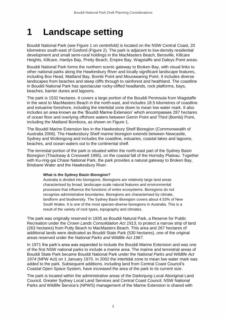
Bouddi National Park (see Figure 1 on centrefold) is located on the NSW Central Coast, 20 kilometres south-east of Gosford (Figure 2). The park is adjacent to low-density residential development and small semi-rural holdings in the MacMasters Beach, Bensville, Killcare Heights, Killcare, Hardys Bay, Pretty Beach, Empire Bay, Wagstaffe and Daleys Point areas.
Bouddi National Park forms the northern scenic gateway to Broken Bay, with visual links to other national parks along the Hawkesbury River and locally significant landscape features, including Box Head, Maitland Bay, Bombi Point and Mourawaring Point. It includes diverse landscapes from beaches and steep cliffs through to rainforest and heathland. The coastline in Bouddi National Park has spectacular rocky-cliffed headlands, rock platforms, bays, beaches, barrier dunes and lagoons.
The park is 1532 hectares. It covers a large portion of the Bouddi Peninsula from Wagstaffe in the west to MacMasters Beach in the north-east, and includes 18.5 kilometres of coastline and estuarine foreshore, including the intertidal zone down to mean low water mark. It also includes an area known as the ‘Bouddi Marine Extension’ which encompasses 287 hectares of ocean floor and overlying offshore waters between Gerrin Point and Third (Bombi) Point, including the Maitland Bombora, as shown on Figure 1.
The Bouddi Marine Extension lies in the Hawkesbury Shelf Bioregion (Commonwealth of Australia 2006). The Hawkesbury Shelf marine bioregion extends between Newcastle, Sydney and Wollongong and includes the coastline, estuaries, coastal lakes and lagoons,
beaches, and ocean waters out to the continental shelf.
The terrestial portion of the park is situated within the north-east part of the Sydney Basin Bioregion (Thackway & Cresswell 1995), on the coastal fall of the Hornsby Plateau. Together with Ku-ring-gai Chase National Park, the park provides a natural gateway to Broken Bay, Brisbane Water and the Hawkesbury River.
What is the Sydney Basin Bioregion?
Australia is divided into bioregions. Bioregions are relatively large land areas
characterised by broad, landscape-scale natural features and environmental
processes that influence the functions of entire ecosystems. Bioregions do not
recognise administrative boundaries. Bioregions are characterised by climate,
landform and biodiversity. The Sydney Basin Bioregion covers about 4.53% of New
South Wales. It is one of the most species-diverse bioregions in Australia. This is a
result of the variety of rock types, topography and climates.
The park was originally reserved in 1935 as Bouddi Natural Park, a Reserve for Public Recreation under the Crown Lands Consolidation Act 1913, to protect a narrow strip of land (263 hectares) from Putty Beach to MacMasters Beach. This area and 267 hectares of additional lands were dedicated as Bouddi State Park (530 hectares), one of the original areas reserved under the National Parks and Wildlife Act 1967.
In 1971 the park’s area was expanded to include the Bouddi Marine Extension and was one of the first NSW national parks to include a marine area. The marine and terrestrial areas of Bouddi State Park became Bouddi National Park under the National Parks and Wildlife Act 1974 (NPW Act) on 1 January 1975. In 2002 the intertidal zone to mean low water mark was added to the park. Subsequent additions, including land from Central Coast Council’s Coastal Open Space System, have increased the area of the park to its current size.
The park is located within the administrative areas of the Darkinjung Local Aboriginal Land Council, Greater Sydney Local Land Services and Central Coast Council. NSW National Parks and Wildlife Service’s (NPWS) management of the Marine Extension is shared with
Bouddi National Park Draft Planning Considerations
2
Fisheries NSW (part of the NSW Department of Primary Industries) and NSW Maritime (a division of the NSW Roads and Maritime Services).
Figure 2. Location of Bouddi National Park
The area surrounding Bouddi National Park has been extensively cleared, resulting in a high loss of biodiversity and fragmentation of habitat in the region. Long-term conservation of biodiversity depends on the protection, enhancement and connection of remaining habitat across the landscape, incorporating vegetation remnants on both public and private lands. Habitat connectivity to the park has been addressed through initiatives under Central Coast Council’s Coastal Open Space System and other mechanisms such as conservation agreements and wildlife refuges, but ongoing effort is required.
Bouddi National Park Draft Planning Considerations
3
2 Protecting the natural environment
2.1 Geology and landform
Bouddi National Park is located within the north-east part of the Sydney Basin Bioregion, on the coastal fall of the Hornsby Plateau.
Geology and landform of the Sydney Basin Bioregion
The Sydney Basin is a geological basin filled with near-horizontal sandstones and
shales of Permian to Triassic age that overlie older basement rocks of the Lachlan
Fold Belt. The dominant sandstone is often referred to as Hawkesbury sandstone,
named after the Hawkesbury River where this sandstone is particularly common. The
Sydney Basin includes uplifted landscapes in the west (such as found in Blue
Mountains National Park) and coastal landscapes of cliffs, beaches and estuaries in
the east (such as Bouddi National Park). Coastal cliffs are often spectacular and
feature exposed ‘layer cake’ geology and well-developed rock platforms.
The park is part of a system of sandstone reserves protecting a representative sample of coastal landscapes including steep coastal cliffs interspersed with small sandy beaches, barrier dune systems and rock platforms. The coastal fall is characterised by rolling to steep hills and sandstone plateau outliers. The park contains several locally significant topographic points, including Maitland Bay, Box Head, Second (Mourawaring) Point and Third (Bombi) Point. Together with First (Copacabana) Point, Second and Third points are called Cape Three Points.
Two main sedimentary rock units dominate the surface geology of the park. In order of deposition these are the Triassic Narrabeen Group and the Middle Triassic Hawkesbury Sandstone. The Narrabeen Group comprises several subgroups and formations. The Terrigal Formation is the uppermost stratum and consists of quartz-lithic sandstone interbedded with siltstone and claystone (McDonnell 1974). It occurs extensively throughout the park and is evident on the coastal slopes and headlands. Hawkesbury Sandstone overlies the Narrabeen Group and consists of medium- to coarse-grained quartz sandstone with minor shale and laminate lenses (Dept of Mines 1966; Brunker & Rose 1967). Hawkesbury Sandstone plateau outliers are located at Box Head, Killcare Heights, North-West Ridge, Wards Hill and Mount Bouddi. Elevated dunefields of aeolian (i.e. windblown) sands occur on the Bombi Moor and Mourawaring Moor. These dunefields occur between 90 and 120 metres above sea level and have resulted from past variations in climate and sea level (Chapman & Murphy 1989).
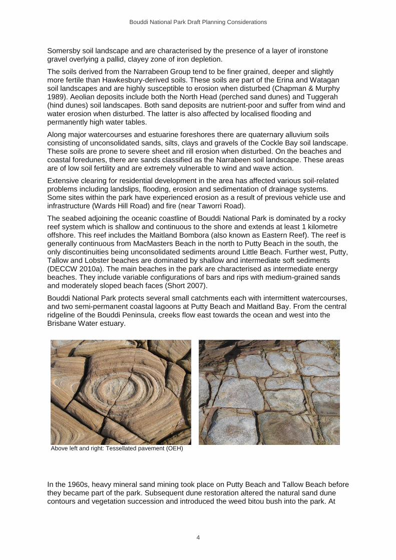
Shale lenses in sandstone contain fossils of plants, fish and amphibians. In the late 1970s part of the lower jaw (mandible) of a very large labyrinthodont (extinct amphibian), a large crocodile-like amphibian up to 3 metres in length was excavated and collected by the Australian Museum from a rock platform at Little Beach. The fossil is from the Terrigal Formation and is Early to Middle Triassic in age, about 250 to 135 million years old (Jones 2013). The park’s landscape is also characterised by interesting coastal landform features including the stratigraphy of Killcare headland, tessellated or tile-like pavements, honeycomb weathering and circular mineral patterns (known as Liesegang rings). Examples of these features can be found along the Bouddi Coastal Walk.
Soils on the Hawkesbury Sandstone include those from the Gymea, Lambert and Hawkesbury soil landscape classifications (Chapman & Murphy 1989). They are generally shallow, stony, of low fertility and considered to be a high erosion hazard. A plateau of iron-rich lateritic soils occurs at Killcare Heights. Lateritic soils are described as the
Bouddi National Park Draft Planning Considerations
4
Somersby soil landscape and are characterised by the presence of a layer of ironstone gravel overlying a pallid, clayey zone of iron depletion.
The soils derived from the Narrabeen Group tend to be finer grained, deeper and slightly more fertile than Hawkesbury-derived soils. These soils are part of the Erina and Watagan soil landscapes and are highly susceptible to erosion when disturbed (Chapman & Murphy 1989). Aeolian deposits include both the North Head (perched sand dunes) and Tuggerah (hind dunes) soil landscapes. Both sand deposits are nutrient-poor and suffer from wind and water erosion when disturbed. The latter is also affected by localised flooding and permanently high water tables.
Along major watercourses and estuarine foreshores there are quaternary alluvium soils consisting of unconsolidated sands, silts, clays and gravels of the Cockle Bay soil landscape. These soils are prone to severe sheet and rill erosion when disturbed. On the beaches and coastal foredunes, there are sands classified as the Narrabeen soil landscape. These areas are of low soil fertility and are extremely vulnerable to wind and wave action.
Extensive clearing for residential development in the area has affected various soil-related problems including landslips, flooding, erosion and sedimentation of drainage systems. Some sites within the park have experienced erosion as a result of previous vehicle use and infrastructure (Wards Hill Road) and fire (near Taworri Road).
The seabed adjoining the oceanic coastline of Bouddi National Park is dominated by a rocky reef system which is shallow and continuous to the shore and extends at least 1 kilometre offshore. This reef includes the Maitland Bombora (also known as Eastern Reef). The reef is generally continuous from MacMasters Beach in the north to Putty Beach in the south, the only discontinuities being unconsolidated sediments around Little Beach. Further west, Putty, Tallow and Lobster beaches are dominated by shallow and intermediate soft sediments (DECCW 2010a). The main beaches in the park are characterised as intermediate energy beaches. They include variable configurations of bars and rips with medium-grained sands and moderately sloped beach faces (Short 2007).
Bouddi National Park protects several small catchments each with intermittent watercourses, and two semi-permanent coastal lagoons at Putty Beach and Maitland Bay. From the central ridgeline of the Bouddi Peninsula, creeks flow east towards the ocean and west into the Brisbane Water estuary.
Above left and right: Tessellated pavement (OEH)
In the 1960s, heavy mineral sand mining took place on Putty Beach and Tallow Beach before they became part of the park. Subsequent dune restoration altered the natural sand dune contours and vegetation succession and introduced the weed bitou bush into the park. At

Bouddi National Park Draft Planning Considerations
5
Little Beach, a 50-hectare area west of Bombi Moor (known as Dunlop Estate) was mined for sand in the 1960s.
The soils of the park have naturally high erosion potential and sand mining sites and other previously disturbed areas are particulary susceptible to erosion. There is also some unauthorised use of management trails and walking tracks by trail bikes and cyclists on mountain bikes, which is causing erosion on some sections. Informal tracks created by walkers and cyclists are often poorly sited and also subject to erosion (see Section 4).
Residential development along The Scenic Road appears to have resulted in disturbance to the water quality and hydrology of many of the park’s catchments. There are three catchments in the park that are relatively unaffected by surrounding development (Maitland Bay, Rileys Bay and Tallow Beach), although the latter has been disturbed through previous sand mining operations.
Stormwater and sewage runoff from neighbouring lands reduces water quality and catchment values. In the park, toilet facilities are provided at Putty Beach, Little Beach, Tallow Beach, Lobster Beach and Mount Bouddi day use areas, and some of these may also pose a pollution risk.
2.2 Plants and animals
2.2.1 Native plants
The park is within the Wyong and Pittwater subregions of the Sydney Basin Bioregion and the Central Coast botanical division. The Central Coast botanical division covers the area between Lake Macquarie and the Shoalhaven River. Rainforests of relatively low species diversity occur in the moister or more sheltered sites and eucalypt forests are widespread. Areas of nutrient-poor sandstone, for example Hawkesbury Sandstone, characteristically support hard-leaved, shrubby vegetation with many species (McCauley 2006).
The vegetation of the Bouddi Peninsula has been documented by various authors, including:
• a number of studies on the ecology of coastal heath communities (Siddiqi 1971; Siddiqi, Carolin & Anderson 1972; Siddiqi & Carolin 1976; Siddiqi, Carolin & Myerscough 1976)
• some park-specific vegetation surveys (Strom 1986; McRae 1990; Payne 1997; Kelly 2003)
• a number of regional vegetation studies that included the park (Benson 1986; Benson & Howell 1994; Bell 2004, 2009).
Over 600 plant species within 22 vegetation communities have been recorded within the park.
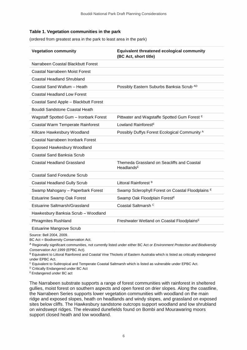
The vegetation of the park includes a variety of structural forms including saltmarsh, grassland, heath, woodland, shrubland, rainforest and open and closed forest communities. Of the 22 vegetation communities found in the park, eight have been identified as threatened ecological communities under the Biodiversity Conservation Act 2016 (BC Act). A further two communities demonstrate floristic similarities to threatened ecological communities and so, for management purposes, are treated as regionally significant (Table 1). Further investigation to confirm whether or not they meet the criteria for those threatened communities is required. The vegetation communities of the park are described in Appendix C.
Bouddi National Park Draft Planning Considerations
6
Table 1. Vegetation communities in the park
(ordered from greatest area in the park to least area in the park)
Vegetation community Equivalent threatened ecological community
(BC Act, short title)
Narrabeen Coastal Blackbutt Forest
Coastal Narrabeen Moist Forest
Coastal Headland Shrubland
Coastal Sand Wallum – Heath Possibly Eastern Suburbs Banksia Scrub AD
Coastal Headland Low Forest
Coastal Sand Apple – Blackbutt Forest
Bouddi Sandstone Coastal Heath
Wagstaff Spotted Gum – Ironbark Forest Pittwater and Wagstaffe Spotted Gum Forest E
Coastal Warm Temperate Rainforest Lowland RainforestE
Killcare Hawkesbury Woodland Possibly Duffys Forest Ecological Community A
Coastal Narrabeen Ironbark Forest
Exposed Hawkesbury Woodland
Coastal Sand Banksia Scrub
Coastal Headland Grassland Themeda Grassland on Seacliffs and Coastal
HeadlandsE
Coastal Sand Foredune Scrub
Coastal Headland Gully Scrub Littoral Rainforest B
Swamp Mahogany – Paperbark Forest Swamp Sclerophyll Forest on Coastal Floodplains E
Estuarine Swamp Oak Forest Swamp Oak Floodplain ForestE
Estuarine Saltmarsh/Grassland Coastal Saltmarsh C
Hawkesbury Banksia Scrub – Woodland
Phragmites Rushland Freshwater Wetland on Coastal FloodplainsE
Estuarine Mangrove Scrub
Source: Bell 2004, 2009.
BC Act = Biodiversity Conservation Act. A Regionally significant communities, not currently listed under either BC Act or Environment Protection and Biodiversity
Conservation Act 1999 (EPBC Act). B Equivalent to Littoral Rainforest and Coastal Vine Thickets of Eastern Australia which is listed as critically endangered
under EPBC Act. C Equivalent to Subtropical and Temperate Coastal Saltmarsh which is listed as vulnerable under EPBC Act. D Critically Endangered under BC Act E Endangered under BC act
The Narrabeen substrate supports a range of forest communities with rainforest in sheltered gullies, moist forest on southern aspects and open forest on drier slopes. Along the coastline, the Narrabeen Series supports lower vegetation communities with woodland on the main ridge and exposed slopes, heath on headlands and windy slopes, and grassland on exposed sites below cliffs. The Hawkesbury sandstone outcrops support woodland and low shrubland on windswept ridges. The elevated dunefields found on Bombi and Mourawaring moors support closed heath and low woodland.
Bouddi National Park Draft Planning Considerations
7
The dominant vegetation communities are Narrabeen Coastal Blackbutt Forest (19%) and Coastal Narrabeen Moist Forest (18%). There are also relatively large areas of Coastal Headland Shrubland (13%), Coastal Sand Wallum – Heath (10%) and Coastal Headland Low Forest (9%).
Small patches of estuarine vegetation are found on alluvial mudflats including mangroves, saltmarsh, rushland and swamp oak forest. The larger beaches are backed by simple sand dune systems with spinifex, prostrate wattle and honeysuckle banksia. The marine habitats in the park include algae-dominated fringe habitats and kelp forests.
A remnant of Killcare Hawkesbury Woodland occurs at Killcare Heights on laterite soils. This vegetation type is poorly represented within the park and has been extensively cleared off-park for agriculture (Bell 2004, 2009). Some of the exposed coastal headlands of the park (Mourawaring Moor, Bombi Moor and Putty Beach Headland) support an extremely fragile open clay heath plant community dominated by sparse clusters of stunted vegetation. These small areas are vulnerable to damage from trampling, disturbance and erosion. Measures are required to protect these areas from inappropriate use.
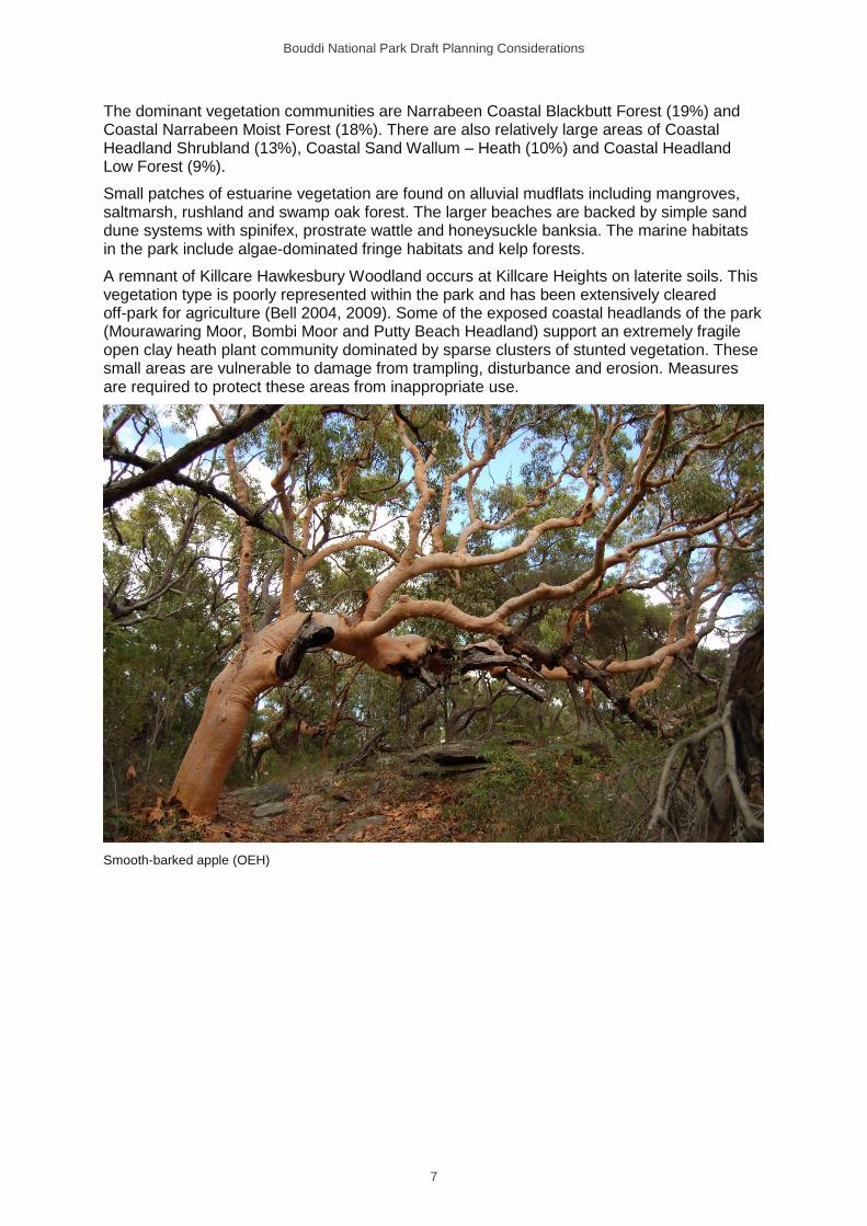
Smooth-barked apple (OEH)
Bouddi National Park Draft Planning Considerations
8
There are five threatened plant species recorded in the park (Table 2).
Table 2: Threatened plants in the park
Common name Scientific name Status
BC Act EPBC Act
Biconvex paperbark Melaleuca biconvexa Vulnerable Vulnerable
Magenta lilly pilly Syzygium paniculatum Endangered Vulnerable
Netted bottle brush Callistemon linearifolius Vulnerable
Scrub turpentine Rhodamnia rubescens Critically
endangered
Tranquillity mint-bush Prostanthera askania Endangered Endangered
BC Act = Biodiversity Conservation Act; EPBC Act = Environment Protection and Biodiversity Conservation Act.
A number of other species of conservation significance are known from the park. The wrinkled kerrawang is listed as a Rare or Threatened Australian Plant (ROTAP) (Briggs & Leigh 1996). River mangrove and grey mangrove are protected marine vegetation under the Fisheries Management Act 1994. The following species are also considered to be regionally significant (Benson 1986; Benson & Howell 1994; Payne 2001; Bell 2004, 2009):
• bearded tylophora
• brown stringybark
• a daisy (Olearia nernstii)
• forest maple
• hard fern
• howittia
• large-fruited red mahogany
• leafy wedge pea
• native ginger
• native violet
• shining grape
• silkpod
• small supplejack
• snow wood
• a wattle (Acacia quadrilateralis).
2.2.2 Native animals
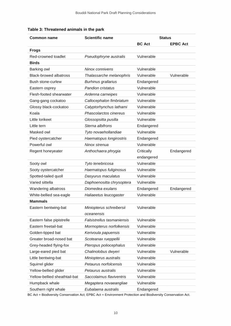
Bouddi National Park protects important coastal habitat for native animals on the NSW Central Coast. The diversity of habitats in the park supports populations of 275 native vertebrate species: 135 bird species, 49 mammals (including 5 marine mammals), 30 reptiles, 11 frogs and over 50 fish. Of these, 34 species are listed as threatened under the BC Act (Table 3).
The koala and spotted-tail quoll were previously known from the area but have not been recorded for several years. Offshore birds, such as the wandering albatross (listed as endangered under the BC Act and vulnerable under the Environment Protection and Biodiversity Conservation Act 1999, EPBC Act) and flesh-footed shearwater (listed as vulnerable under the BC Act) have also been recorded in the park, however, they do not rely on the habitat in the park.
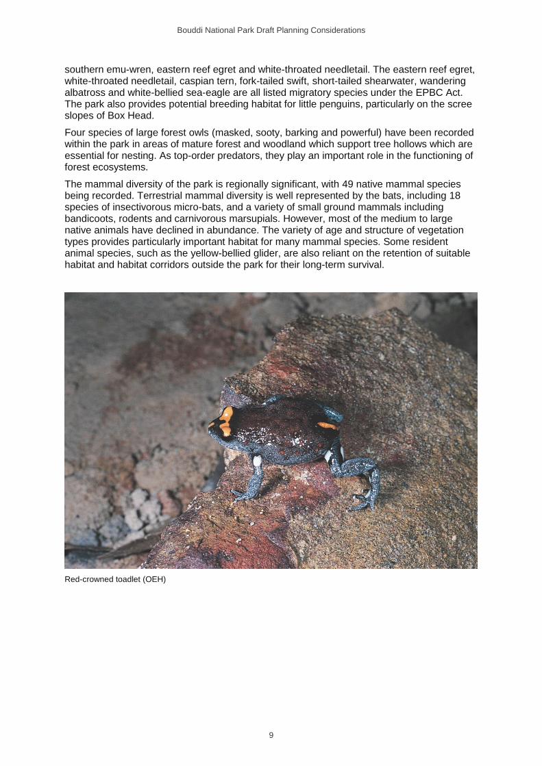
Eleven species of amphibians have been recorded including the threatened red-crowned toadlet. This species occupies drainage lines within the park and is sensitive to impacts from fire, trail maintenance and pollution.
The coastal headlands of the park provide important habitat for many locally restricted bird species, such as the peregrine falcon, brush bronzewing, tawny-crowned honeyeater,
Bouddi National Park Draft Planning Considerations
9
southern emu-wren, eastern reef egret and white-throated needletail. The eastern reef egret, white-throated needletail, caspian tern, fork-tailed swift, short-tailed shearwater, wandering albatross and white-bellied sea-eagle are all listed migratory species under the EPBC Act. The park also provides potential breeding habitat for little penguins, particularly on the scree slopes of Box Head.
Four species of large forest owls (masked, sooty, barking and powerful) have been recorded within the park in areas of mature forest and woodland which support tree hollows which are essential for nesting. As top-order predators, they play an important role in the functioning of forest ecosystems.
The mammal diversity of the park is regionally significant, with 49 native mammal species being recorded. Terrestrial mammal diversity is well represented by the bats, including 18 species of insectivorous micro-bats, and a variety of small ground mammals including bandicoots, rodents and carnivorous marsupials. However, most of the medium to large native animals have declined in abundance. The variety of age and structure of vegetation types provides particularly important habitat for many mammal species. Some resident animal species, such as the yellow-bellied glider, are also reliant on the retention of suitable habitat and habitat corridors outside the park for their long-term survival.
Red-crowned toadlet (OEH)
Bouddi National Park Draft Planning Considerations
10
Table 3: Threatened animals in the park
Common name Scientific name Status
BC Act EPBC Act
Frogs
Red-crowned toadlet Pseudophryne australis Vulnerable
Birds
Barking owl Ninox connivens Vulnerable
Black-browed albatross Thalassarche melanophris Vulnerable Vulnerable
Bush stone-curlew Burhinus grallarius Endangered
Eastern osprey Pandion cristatus Vulnerable
Flesh-footed shearwater Ardenna carneipes Vulnerable
Gang-gang cockatoo Callocephalon fimbriatum Vulnerable
Glossy black-cockatoo Calyptorhynchus lathami Vulnerable
Koala Phascolarctos cinereus Vulnerable
Little lorikeet Glossopsitta pusilla Vulnerable
Little tern Sterna albifrons Endangered
Masked owl Tyto novaehollandiae Vulnerable
Pied oystercatcher Haematopus longirostris Endangered
Powerful owl Ninox strenua Vulnerable
Regent honeyeater Anthochaera phrygia Critically
endangered
Endangered
Sooty owl Tyto tenebricosa Vulnerable
Sooty oystercatcher Haematopus fuliginosus Vulnerable
Spotted-tailed quoll Dasyurus maculatus Vulnerable
Varied sittella Daphoenositta chrysoptera Vulnerable
Wandering albatross Diomedea exulans Endangered Endangered
White-bellied sea-eagle Haliaeetus leucogaster Vulnerable
Mammals
Eastern bentwing-bat Miniopterus schreibersii
oceanensis
Vulnerable
Eastern false pipistrelle Falsistrellus tasmaniensis Vulnerable
Eastern freetail-bat Mormopterus norfolkensis Vulnerable
Golden-tipped bat Kerivoula papuensis Vulnerable
Greater broad-nosed bat Scoteanax rueppellii Vulnerable
Grey-headed flying-fox Pteropus poliocephalus Vulnerable
Large-eared pied bat Chalinolobus dwyeri Vulnerable Vulnerable
Little bentwing-bat Miniopterus australis Vulnerable
Squirrel glider Petaurus norfolcensis Vulnerable
Yellow-bellied glider Petaurus australis Vulnerable
Yellow-bellied sheathtail-bat Saccolaimus flaviventris Vulnerable
Humpback whale Megaptera novaeangliae Vulnerable
Southern right whale Eubalaena australis Endangered
BC Act = Biodiversity Conservation Act; EPBC Act = Environment Protection and Biodiversity Conservation Act.
Bouddi National Park Draft Planning Considerations
11
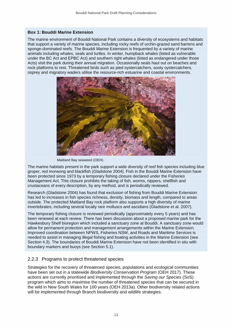
Box 1: Bouddi Marine Extension
The marine environment of Bouddi National Park contains a diversity of ecosystems and habitats that support a variety of marine species, including rocky reefs of urchin-grazed sand barrens and sponge-dominated reefs. The Bouddi Marine Extension is frequented by a variety of marine animals including whales, seals and turtles. In winter, humpback whales (listed as vulnerable under the BC Act and EPBC Act) and southern right whales (listed as endangered under those Acts) visit the park during their annual migration. Occasionally seals haul out on beaches and rock platforms to rest. Threatened birds such as pied oystercatchers, sooty oystercatchers, osprey and migratory waders utilise the resource-rich estuarine and coastal environments.
Maitland Bay seaweed (OEH)
The marine habitats present in the park support a wide diversity of reef fish species including blue groper, red morwong and blackfish (Gladstone 2004). Fish in the Bouddi Marine Extension have been protected since 1973 by a temporary fishing closure declared under the Fisheries Management Act. This closure prohibits the taking of fish, worms, nippers, shellfish and crustaceans of every description, by any method, and is periodically reviewed.
Research (Gladstone 2004) has found that exclusion of fishing from Bouddi Marine Extension has led to increases in fish species richness, density, biomass and length, compared to areas outside. The protected Maitland Bay rock platform also supports a high diversity of marine invertebrates, including several locally rare molluscs and ascidians (Gladstone et al. 2007).
The temporary fishing closure is reviewed periodically (approximately every 5 years) and has been renewed at each review. There has been discussion about a proposed marine park for the Hawkesbury Shelf bioregion which included a sanctuary zone at Bouddi. A sanctuary zone would allow for permanent protection and management arrangements within the Marine Extension. Improved coordination between NPWS, Fisheries NSW, and Roads and Maritime Services is needed to assist in managing illegal fishing and boating activities in the Marine Extension (see Section 4.3). The boundaries of Bouddi Marine Extension have not been identified in situ with boundary markers and buoys (see Section 5.1).
2.2.3 Programs to protect threatened species
Strategies for the recovery of threatened species, populations and ecological communities have been set out in a statewide Biodiversity Conservation Program (OEH 2017). These actions are currently prioritised and implemented through the Saving our Species (SoS) program which aims to maximise the number of threatened species that can be secured in the wild in New South Wales for 100 years (OEH 2013a). Other biodiversity related actions will be implemented through Branch biodiversity and wildlife strategies.
Bouddi National Park Draft Planning Considerations
12
Individual recovery plans may need to be prepared for threatened species listed under the EPBC Act, and some recovery plans were previously prepared for some species listed in New South Wales to consider management needs in more detail. There is a national recovery plan for magenta lilly pilly, an approved NSW recovery plan for tranquillity mint-bush and approved conservation advice under the EPBC Act for biconvex paperbark. Recovery plans have been prepared for yellow-bellied glider, little tern, barking owl and the large forest owls (powerful, sooty and masked owls). A national recovery plan has been prepared for the regent honeyeater.
The tranquility mint-bush has been assigned to the site-managed species stream under the SoS program. Key management sites for this threatened species have been identified by the Office of Environment and Heritage under the SoS program. Currently, there are four management sites identified including a site within Bouddi National Park. Management and monitoring actions are being implemented to ensure the population is sustained with the aim to minimise impacts from recreational activities and reduce and maintain weed levels at low densities.
2.2.4 Weeds and pest animals
Weeds and pests are plants, animals and pathogens that have negative environmental, economic and social impacts and are most commonly introduced species. An introduced species is defined in this plan as any plant or animal species not native to the park. Pests and weeds negatively impact a range of park values, including biodiversity, cultural heritage, and catchment and scenic values.
The Biosecurity Act 2015 and its regulations provide specific legal requirements for the response, management and control of biosecurity risks, including weeds and pest animals. These requirements apply equally to public lands and privately-owned land. Under this framework, Local Land Services (LLS) has prepared regional strategic weed and pest animal management plans for each of its 11 regions including the Greater Sydney Region; namely Greater Sydney Strategic Weed Management Plan (LLS 2017) and Greater Sydney Strategic Pest Management plan (LLS 2018).
The LLS plans identify priority weeds and pest animals in each of the regions, plus the appropriate management response for the region (i.e. prevention/alert, eradication, containment or asset protection).
NPWS prepares pest management strategies which identify the operations and control actions undertaken by NPWS to meet the priorities from regional strategic pest and weed management plans (OEH 2012a). The NPWS strategies also include other important programs such as the Biodiversity Conservation Program (see Sections 2.2.1 and 2.3.1).
The overriding objective of the NPWS pest management strategies is to minimise adverse impacts of introduced species on biodiversity and other park and community values while complying with legislative responsibilities. These strategies are regularly updated. Reactive programs may also be undertaken in cooperation with neighbouring land managers, particularly in response to emerging issues.
Over 100 introduced plant species have been recorded within the terrestrial part of the park. The high number of weed species in the park is largely the result of past land uses such as mining and land clearing, proximity to residential development and soil disturbance. Populations and distribution of weeds need to be monitored and appropriate treatment applied as required.
Although weeds are found generally throughout the park, the main weed infestations are asparagus ferns (other than bridal creeper), bitou bush and lantana, bridal creeper, camphor laurel, cassia, privets, blackberry, Crofton weed, morning glory and honeysuckle.
Bouddi National Park Draft Planning Considerations
13
An emerging weed for the park is sea spurge which has been found at Maitland Bay and Putty Beach in small numbers and is a priority weed under the Greater Sydney Regional Strategic Weed Management Plan. Other significant environmental weeds within the park include ochna, turkey rhubarb and black-eyed susan.
In contrast, there is limited information on pest plant species in the marine parts of Bouddi National Park, including the Bouddi Marine Extension. Invasive aquatic weeds may be present, especially Aquarium caulerpa which has been detected in Brisbane Waters.
Box 2: Bitou bush and lantana – priority control
Bitou bush and lantana are listed as Australian Government’s Weeds of National Significance. Invasion by bitou bush and lantana leads to a decline in the species diversity of affected plant communities, and the fauna that depend on them, and both are listed as a key threatening process under the BC Act (NSW SC 1999). They readily invade a wide variety of disturbed and undisturbed coastal plant communities, outcompeting native vegetation.
Bitou bush was originally planted to reduce dune erosion but spread rapidly. Established infestations are widespread throughout the park, with highest densities occurring in previously disturbed areas (sand mining), moist gullies and along cliff lines where access and control are difficult. Invasion by bitou bush threatens threatened ecological communities (in particular Themeda Grassland on Seacliffs and Coastal Headlands, and Lowland Rainforest), locally rare plants (e.g. wrinkled kerrawang) and habitat for native animals, including threatened species.
Lantana is widespread throughout the park, also impacting on Themeda grassland and Lowland Rainforest endangered ecological communities, threatened plants (tranquillity mint-bush and biconvex paperbark) and the habitat of native animals including threatened species. A national Plan to Protect Environmental Assets from Lantana (Biosecurity Queensland 2010) has been developed which establishes national conservation priorities for the control of lantana. It identifies the research, management and other actions needed to ensure the long-term survival of native species and ecological communities affected by the invasion of lantana.
Management of bitou bush and lantana will be guided by the relevant key threatening process strategies.
An integrated approach to weed management within the terrestrial parts of the park uses a range of techniques at critical times of the year, often targeting more than one species. Methods include physical removal, herbicide use including aerial spray programs, fire, biological control and revegetation. Key weed control programs include bush regeneration undertaken by NPWS staff, volunteers, contractors funded through external grants, and students through government employment initiatives. Site-specific plans may be developed to guide control programs and monitoring programs that focus on the conservation of threatened ecological communities and threatened species and improving the amenity of core recreation areas. Site-specific weed management plans are in place for the priority areas of Rileys Bay, Lobster Beach and Mourawaring Moor and will be prepared for other priority areas, including Maitland Bay and Tallow Beach.
Myrtle rust is a plant disease caused by the fungus Austropuccinia psidii It was first detected on the NSW Central Coast in 2010 and is now established along the NSW coast from the Shoalhaven River north into Queensland. It is widely distributed within the Central Coast Local Government Area and is considered to pose a threat to the park’s biological values.
Myrtle rust infects young, actively growing shoots, leaves, flower buds and fruits of plants in the family Myrtaceae. The spores of myrtle rust are spread by wind, animals and human activity. It was first identified in the park in December 2012, affecting mainly scrub turpentine. Other genera of the Myrtaceae family recorded within the park include Acmena, Angophora, Backhousia, Baeckea, Callistemon, Calytrix, Corymbia, Eucalyptus, Euryomyrtus, Harmogia, Kunzea, Leptospermum, Melaleuca, Syncarpia, Syzygium and Tristaniopsis.
Bouddi National Park Draft Planning Considerations
14
The Management Plan for Myrtle Rust on the National Parks Estate (OEH 2011c) outlines how myrtle rust will be managed. Regional priorities are implemented through the pest management strategy on national park estate. It incorporates strategies to limit the spread of myrtle rust and minimise impacts on threatened species and ecological communities. Scrub turpentine, recently listed as critically endangered under the BC Act, is the only Myrtaceae species currently affected in the park and opportunistic monitoring indicates that myrtle rust is killing the majority of known specimens.
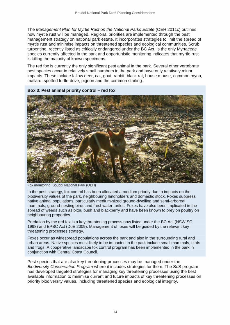
The red fox is currently the only significant pest animal in the park. Several other vertebrate pest species occur in relatively small numbers in the park and have only relatively minor impacts. These include fallow deer, cat, goat, rabbit, black rat, house mouse, common myna, mallard, spotted turtle-dove, pigeon and the common starling.
Box 3: Pest animal priority control – red fox
Fox monitoring, Bouddi National Park (OEH)
In the pest strategy, fox control has been allocated a medium priority due to impacts on the biodiversity values of the park, neighbouring landholders and domestic stock. Foxes suppress native animal populations, particularly medium-sized ground-dwelling and semi-arboreal mammals, ground-nesting birds and freshwater turtles. Foxes have also been implicated in the spread of weeds such as bitou bush and blackberry and have been known to prey on poultry on neighbouring properties.
Predation by the red fox is a key threatening process now listed under the BC Act (NSW SC 1998) and EPBC Act (DoE 2009). Management of foxes will be guided by the relevant key threatening processes strategy.
Foxes occur as widespread populations across the park and also in the surrounding rural and urban areas. Native species most likely to be impacted in the park include small mammals, birds and frogs. A cooperative landscape fox control program has been implemented in the park in conjunction with Central Coast Council.
Pest species that are also key threatening processes may be managed under the Biodiversity Conservation Program where it includes strategies for them. The SoS program has developed targeted strategies for managing key threatening processes using the best available information to minimise current and future impacts of key threatening processes on priority biodiversity values, including threatened species and ecological integrity.
Bouddi National Park Draft Planning Considerations
15
2.2.5 Fire
The primary objectives of NPWS fire management are to protect life, property, community assets and cultural heritage from the adverse impacts of fire, while also managing fire regimes in parks to maintain and enhance biodiversity. NPWS also assists in developing fire management practices that contribute to conserving biodiversity and cultural heritage across the landscape and implements cooperative and coordinated fire management arrangements with other fire authorities, neighbours and the community (OEH 2013b).
Box 4: Fire in the park
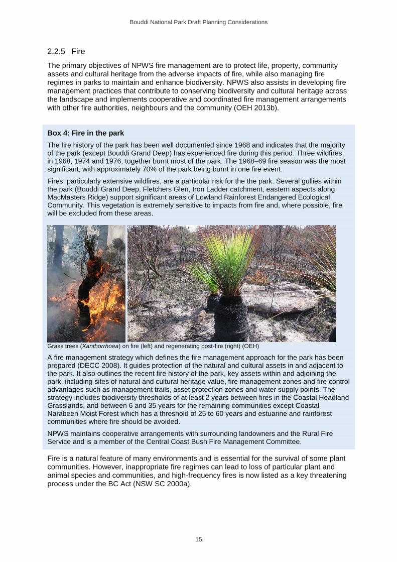
The fire history of the park has been well documented since 1968 and indicates that the majority of the park (except Bouddi Grand Deep) has experienced fire during this period. Three wildfires, in 1968, 1974 and 1976, together burnt most of the park. The 1968–69 fire season was the most significant, with approximately 70% of the park being burnt in one fire event.
Fires, particularly extensive wildfires, are a particular risk for the the park. Several gullies within the park (Bouddi Grand Deep, Fletchers Glen, Iron Ladder catchment, eastern aspects along MacMasters Ridge) support significant areas of Lowland Rainforest Endangered Ecological Community. This vegetation is extremely sensitive to impacts from fire and, where possible, fire will be excluded from these areas.
Grass trees (Xanthorrhoea) on fire (left) and regenerating post-fire (right) (OEH)
A fire management strategy which defines the fire management approach for the park has been prepared (DECC 2008). It guides protection of the natural and cultural assets in and adjacent to the park. It also outlines the recent fire history of the park, key assets within and adjoining the park, including sites of natural and cultural heritage value, fire management zones and fire control advantages such as management trails, asset protection zones and water supply points. The strategy includes biodiversity thresholds of at least 2 years between fires in the Coastal Headland Grasslands, and between 6 and 35 years for the remaining communities except Coastal Narabeen Moist Forest which has a threshold of 25 to 60 years and estuarine and rainforest communities where fire should be avoided.
NPWS maintains cooperative arrangements with surrounding landowners and the Rural Fire Service and is a member of the Central Coast Bush Fire Management Committee.
Fire is a natural feature of many environments and is essential for the survival of some plant communities. However, inappropriate fire regimes can lead to loss of particular plant and animal species and communities, and high-frequency fires is now listed as a key threatening process under the BC Act (NSW SC 2000a).
Bouddi National Park Draft Planning Considerations
16
2.2.6 Climate Change
Human-induced climate change has been listed as a key threatening process under the BC Act (NSW SC 2000b) and the associated loss of habitat is listed on the EPBC Act (TSSC 2001).
The latest information on projected changes to climate are from the NSW and ACT Regional Climate Modelling (NARClim) project (OEH 2014). The climate projections for 2020–2039 are described as ‘near future’ and projections for 2060–2079 are described as ‘far future’. The snapshot shown in Table 4 is for the Hunter Central Coast Branch which includes Bouddi National Park (OEH 2014).
Table 4: Central Coast climate change snapshot
Projected temperature changes
Maximum temperatures are projected to
increase in the near future by 0.3–1.0°C
Maximum temperatures are projected to
increase in the far future by 1.4–2.5°C
Minimum temperatures are projected to
increase in the near future by 0.4–0.8°C
Minimum temperatures are projected to
increase in the far future by 1.4–2.5°C
The number of hot days (i.e. > 35°C) will
increase
The number of cold nights (i.e. < 2°C) will
decrease
Projected rainfall changes
Rainfall is projected to decrease in spring
and winter
Rainfall is projected to increase in
summer and autumn
Projected Forest Fire Danger Index changes
Average fire weather is projected to increase
in summer and spring
Severe fire weather days are projected to
increase in summer and spring
Source: OEH 2014.
The projected increases in temperature, number of hot days and severe fire weather days (OEH 2014) are likely to influence bushfire frequency and intensity across the Hunter Central Coast Branch and the fire season is likely to be extended (DECCW 2010b). Higher rainfall in summer and autumn will lead to more frequent flooding of low-lying areas, and increased erosion and sediment-shedding from the hinterland (DECCW 2010b). Potential risks within the park are damage to infrastructure in low-lying areas at Putty Beach and Little Beach and erosion and slumping at Lobster Beach.
Climate change may significantly affect biodiversity by changing the size of populations and the distribution of species and altering the geographical extent and species composition of habitats and ecosystems. Species most at risk are those unable to migrate or adapt, particularly those with small population sizes or with slow growth rates.
The potential impact of climate change on the park is difficult to assess since it depends on the compounding effects of other pressures, particularly barriers to migration and pressure from introduced animals. Low-lying coastal ecosystems and fragmented ecosystems are at highest risk.
NPWS will continue to manage threats from climate change to park values in a collaborative way with other land managers and park neighbours. Programs to reduce the pressures arising from other threats, such as habitat fragmentation, invasive species, bushfires and pollution, will help reduce the severity of the effects of climate change.
Bouddi National Park Draft Planning Considerations
17
2.2.7 Research
The diversity of the natural and cultural values of Bouddi National Park and the Bouddi Marine Extensionprovide excellent opportunities for field-based research. The majority of previous studies have focussed on the ecology, status and distribution of plant and animal species and communities, Aboriginal sites and water quality. More recently, studies have concentrated on biodiversity and the impact of threatening processes (such as fire, weeds and pest animals), with greater emphasis on management responses.
Research in the Bouddi Marine Extension and the intertidal zone supports the biodiversity conservation benefits attributed to marine protected areas, especially for fish and rock platform invertebrates. There has been extensive research into the diversity of fish and invertebrate species in rocky reef and rocky shore habitats within the marine and intertidal sections of Bouddi National Park.
Research opportunities in the park were enhanced through the opening of the Strom Centre in 2007. The centre is the former property of the late Allen and Beryl Strom who were local conservationists, environmental educators and historians. The property was bequeathed to NPWS on the condition that it ‘be developed and used as a centre for the administration and management of Bouddi National Park and for housing educational resources including the deceased’s collection of papers, photographs and other material relating to Bouddi National Park and its surrounds’. The centre facilitates research, environmental education and fieldwork which support the management of the park. Resource information regarding the park is available to the general public (by appointment) at the Strom Centre.
Bouddi National Park Draft Planning Considerations
18
3 Looking after our culture and heritage
Both Aboriginal and non-Aboriginal people place values on cultural and natural landscapes. These values may be attached to the landscape as a whole, or to parts of the landscape (e.g. a particular plant, animal or place). All landscapes contain the imprint of human use. On any given area of land, some historical activity will have taken place. Much of the Australian environment has been influenced by past Aboriginal and non-Aboriginal land-use practices, and people continue to influence the land through residential development, agriculture, recreational use, cultural practices, the presence of introduced plants and animals, and in some cases air and water pollution.
3.1 Aboriginal culture and heritage
The Central Coast is the traditional Country of the Guringai and Darkinjung Aboriginal peoples. The Guringai People inhabited the coast from Port Jackson to north of Wyong (Gunson 1974). The Darkinjung People occupied land to the north of the Hawkesbury River and to the west of Mooney Mooney Creek. The Guringai had a close and cordial relationship with the Darkinjung, including reciprocal visits between tribes, trade and sharing feasts in either area, depending upon season (Vinnicombe 1980).
What is ‘Country’? To Aboriginal people, the landscape is made up of many features
that are interrelated. These include land, water, plants and animals, places and
stories, historical and current uses, and people and their interactions with each other
and place. These features are central to Aboriginal spirituality and contribute to
Aboriginal identity. They are inseparable and make up what is known as ‘Country’.
Aboriginal communities have an association with and connection to the land. Aboriginal communities associate natural resources with the use and enjoyment of foods and medicines, caring for the land, passing on cultural knowledge, kinship systems and strengthening social bonds. Aboriginal heritage and connection to nature are inseparable from each other and need to be managed in an integrated manner across the landscape.
Bouddi is the Aboriginal name for the eastern headland of Maitland Bay and gives the park its name. The origin of the word is uncertain and has multiple possible meanings including ‘nose’, ‘the heart’ and ‘water breaking over rocks’ (Strom 1986). Other Aboriginal place names used in the area include Bombi Trig, Bullimah, Gerrin Point, Kourung Gourung Point and Mourawaring Head (a variant name for Second Point).
Aboriginal sites provide a valuable insight into Aboriginal peoples’ traditional lifestyles, and interactions with the environment. The Aboriginal heritage within the park is important to present-day Aboriginal people.
Aboriginal sites are places with evidence of Aboriginal occupation or places that are
related to other aspects of Aboriginal culture. They are important as evidence of
Aboriginal history and as part of the culture of local Aboriginal people.
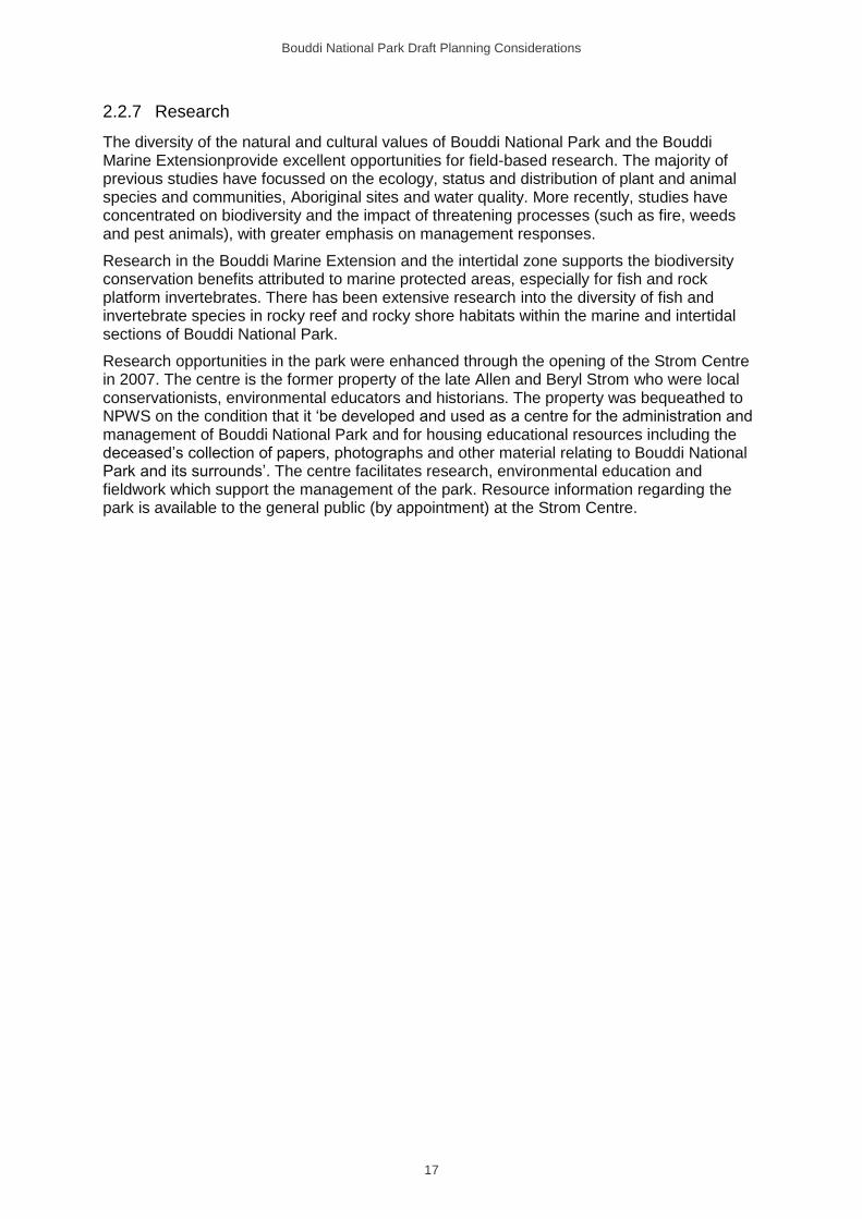
Over 70 Aboriginal sites containing more than 200 objects have been recorded in the park and nearby areas, and other sites are almost certain to exist. Aboriginal occupation is evident in the form of open middens and camp sites, rock engravings, grinding grooves, rock shelters with art (charcoal and pigment drawings, stencils and paintings) and other archaeological deposits. Figures commonly depicted in the art include humans, marine animals, kangaroos and wallabies.
Bouddi National Park Draft Planning Considerations
19
Grinding grooves, Daleys Point (OEH)
Vinnicombe (1980) carried out a detailed study of Aboriginal sites on the Bouddi Peninsula. The Hardys Bay, Pretty Beach, Rileys Bay and Fishermans Bay catchments facing Brisbane Water have the highest concentration of Aboriginal sites in the park. Evidence of Aboriginal usage of estuarine and open coastal environments is reflected in the different species of shellfish found in middens.
The Aboriginal site at Daleys Point is particularly important as it provides concentrated evidence of long-term Aboriginal occupation.
Vandalism of Aboriginal sites in the park has occurred. Protection measures such as interpretation, education and access barriers have been implemented. An effective way to protect sites from vandalism is not to publicise their location. Sites are also subject to natural erosion and the unintentional impacts of human activity.
Although the NSW Government has legal responsibility for the protection of Aboriginal sites, it acknowledges the right of Aboriginal people to make decisions about their own heritage. Aboriginal communities will be consulted and involved in the management of Aboriginal sites and related issues and in the promotion and presentation of the park’s Aboriginal culture and history. The local Aboriginal community is supported to access Country to maintain, renew or develop cultural connections and practices. NPWS supports non-commercial cultural use of wild resources, such as medicinal plants and bush tucker, subject to NPWS policies and licensing.
NPWS maintains close liaison with the Darkinjung Local Aboriginal Land Council, the Guringai Tribal Link Aboriginal Corporation and other community members regarding the ongoing management of Aboriginal values of the park.
Bouddi National Park Draft Planning Considerations
20
3.2 Shared cultural heritage
History has taken place across the landscape. This includes the history of the first Australians, that is Aboriginal people, and our shared history since European settlement. Cultural heritage comprises places and items that may have historic, scientific, cultural, social, archaeological, architectural, natural or aesthetic significance. NPWS conserves the significant heritage features of NSW parks and reserves. Heritage places and landscapes are made up of living stories as well as connections to the past which can include natural resources, objects, customs and traditions that individuals and communities have inherited and wish to conserve for current and future generations.
The establishment of Bouddi National Park was the result of efforts by local bushwalkers, environmentalists and community conservation groups. It was lobbying by Marie Byles, who recognised the area’s potential in 1922, which led to the initial reservation of 263 hectares in 1935. The efforts of locals, such as Allen and Beryl Strom, also led to numerous additions to the park over the years. Several features of the park reference this community conservation involvement, including Allen Strom Lookout and Strom’s property (bequeathed to NPWS by Beryl Strom), Dingeldei Memorial Shelter (built by local bushwalkers) and Marie Byles Lookout (just outside the park’s boundary).
European settlement of the area began in the 1820s with subsistence farming, where the main sources of income were timber getting, boat building and gathering shells for lime production. The Murray family occupied the foreshore area of Rileys Bay. Their house, built around 1836, is one of the earliest known in the area and is listed in the 1841 census (Strom 1986). The house site, now within the park, contains sandstone remains of a six-room house, including foundations, wall remnants and a fireplace. Substantial work around the site has cleared weeds from the structure.
Settlement and development were slow in the area due to its unsuitability for agriculture and the limited boat access from Sydney. Following the completion of the railway through Gosford in 1889 and construction of The Scenic Road in the late 1920s, residential subdivisions were created adjacent to the present park.
Development surrounding the existing park was mainly confined to the waterfront until the 1960s, when The Scenic Road from Kincumber to Killcare was sealed. The construction of the Rip Bridge in 1974 increased interest in the Bouddi Peninsula, rapidly turning the park into a natural island amidst residential development.
There are many historic sites or elements within the park (Table 5). They are considered to be locally significant as they demonstrate a strong connection to early settlement and land-use practices of the area.
Table 5: Historic sites in the park
Historic site Date (circa)
Murray’s house 1836
Maitland wreck 1898
Koletzke and Hesketh memorial at Lobster Beach 1921
Lobster Beach fishing shacks, foundations and landscaping 1940
Putty Beach sawmill Unknown
Bombi Point WWII radar emplacements 1939–45
Boobialla House (NPWS staff accommodation) 1940s
Maitland Bay store (now Maitland Bay Information Centre), water tank and
garden A
1945–50
Bouddi National Park Draft Planning Considerations
21
Dingledei Memorial Shelter 1962
Iron ladder associated with fishing activities at Iron Ladder Beach Unknown
Putty Beach sand mine and pipeline 1963–65
Strom’s property (includes house and Strom Centre in refurbished garage, and
house used for NPWS staff accommodation)
1963
Tallow Beach sand mine, dam, access road and power line Pre-1975
Dunlop Estate sand mine and pipeline Pre-1977
A Site is listed on Gosford Local Environment Plan 2008.
A shelter at Maitland Bay dating back to the 1940s was removed in 2002 because it was structurally unsound and considered unsafe. Non-invasive exotic plants are maintained at Maitland Bay Information Centre, Lobster Beach and Strom’s property. These provide links to previous uses of the sites and include citrus and other fruit trees, and garden plants such as hibiscus, hydrangea and lilies.
Boobialla House and Maitland Bay Store have been assessed to be of local significance. Boobialla House is a post-war fibro weekender cottage of a form and style typical of that in the immediate areas and the NSW coast in general. It has some historical significance originally as a holiday house and later as a place of residence used by NPWS staff (Suters Architects 2001).
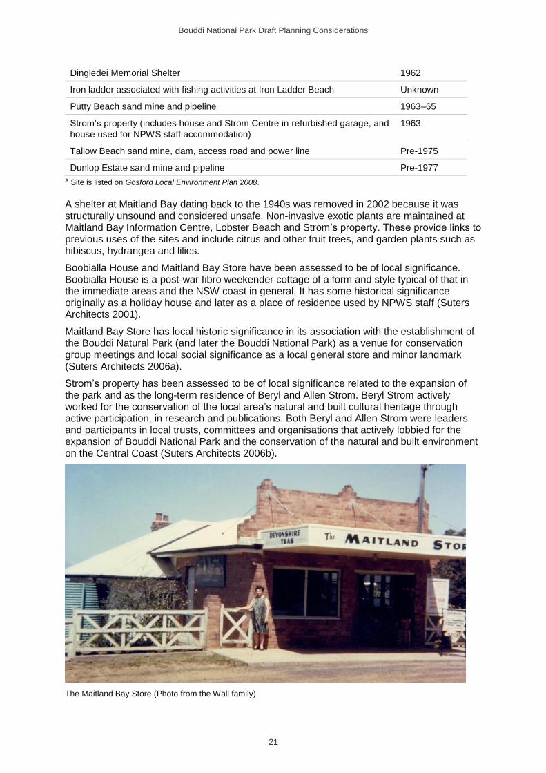
Maitland Bay Store has local historic significance in its association with the establishment of the Bouddi Natural Park (and later the Bouddi National Park) as a venue for conservation group meetings and local social significance as a local general store and minor landmark (Suters Architects 2006a).
Strom’s property has been assessed to be of local significance related to the expansion of the park and as the long-term residence of Beryl and Allen Strom. Beryl Strom actively worked for the conservation of the local area’s natural and built cultural heritage through active participation, in research and publications. Both Beryl and Allen Strom were leaders and participants in local trusts, committees and organisations that actively lobbied for the expansion of Bouddi National Park and the conservation of the natural and built environment on the Central Coast (Suters Architects 2006b).
The Maitland Bay Store (Photo from the Wall family)

Bouddi National Park Draft Planning Considerations
22
The remaining historic items listed in Table 5 are of potential heritage significance but have not been assessed. Before decisions are made about their future management, an assessment of significance is required. Should any of the items be found to be of national, state or high local historic heritage significance, a conservation management plan will be prepared. For simple structures of local heritage significance, a heritage action statement will be prepared to guide future management and works. Heritage guidelines have been prepared for Strom’s property and Maitland Bay Store.
Bouddi National Park Draft Planning Considerations
23
Box 5: Shipwrecks
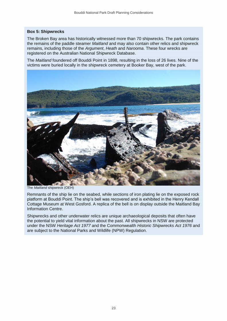
The Broken Bay area has historically witnessed more than 70 shipwrecks. The park contains the remains of the paddle steamer Maitland and may also contain other relics and shipwreck remains, including those of the Argument, Heath and Narooma. These four wrecks are registered on the Australian National Shipwreck Database.
The Maitland foundered off Bouddi Point in 1898, resulting in the loss of 26 lives. Nine of the victims were buried locally in the shipwreck cemetery at Booker Bay, west of the park.
The Maitland shipwreck (OEH)
Remnants of the ship lie on the seabed, while sections of iron plating lie on the exposed rock platform at Bouddi Point. The ship’s bell was recovered and is exhibited in the Henry Kendall Cottage Museum at West Gosford. A replica of the bell is on display outside the Maitland Bay Information Centre.
Shipwrecks and other underwater relics are unique archaeological deposits that often have the potential to yield vital information about the past. All shipwrecks in NSW are protected under the NSW Heritage Act 1977 and the Commonwealth Historic Shipwrecks Act 1976 and are subject to the National Parks and Wildlife (NPW) Regulation.
Bouddi National Park Draft Planning Considerations
24
4 Providing for visitor use and enjoyment
National parks are reserved under the NPW Act to protect and conserve areas containing outstanding or representative ecosystems, natural or cultural features or landscapes or phenomena that provide opportunities for public appreciation, inspiration and sustainable visitor or tourist use and enjoyment. Their primary purpose is to conserve nature and cultural heritage. Opportunities are provided for appropriate visitor use in a manner that does not damage conservation values.
4.1 Information
The diverse natural and cultural values of the park provide excellent opportunities for community education and interpretation. The provision of high-quality visitor information and interpretation, both on- and off-park, assists in public appreciation and understanding of the park’s values, and helps support sustainable visitor use and protection of the park’s assets.
Visitor information and interpretation facilities are provided at the NPWS Central Coast Area Office at Girrakool and at the Maitland Bay Information Centre in the park. The information centre is staffed entirely by volunteers and is open weekends and public holidays. Central Coast Council operates visitor information centres at the Entrance and Terrigal which also provide information about the park.
Interpretative displays are located throughout the park at popular day use areas, camping areas, track heads and other key destinations. Visitor information is also conveyed through the use of directional and public safety signs, publications and the NSW National Parks website and app.
Guided walks, talks and outdoor activities are provided through the NPWS Discovery program and licensed operators. Rumbalara Environmental Education Centre (operated by NSW Department of Education and Communities) uses the park and the Maitland Bay Information Centre for school activities.
4.2 Recreation
Park facilities and services provide opportunities for visitors to enjoy, appreciate and understand the value of our natural and cultural heritage. Visitor opportunities provided in national parks should be ecologically sustainable and contribute to visitor understanding and appreciation of the park.
Bouddi National Park plays an important role in the provision of nature-based tourism and recreation opportunities at a local and regional level. A diverse range of recreational activities are undertaken throughout the park including camping, picnicking, sightseeing, bushwalking, birdwatching, bike riding, land-based whale watching and fishing, and other beach activities. Visitor facilities in the park include the Maitland Bay Information Centre, three camping areas, three picnic areas, walking tracks and lookouts (see Figure 1).
4.2.1 Vehicle access
The park is readily accessible from public roads maintained by Central Coast Council including Wards Hill Road, Maitland Bay Drive, The Scenic Road, part of Putty Beach Drive, Grahame Drive, Beachview Esplanade, Albert Street, Hardys Bay Parade and part of Hawke Head Drive. Park roads that are managed by NPWS and are open to public vehicle use include part of Putty Beach Drive, part of Hawke Head Drive and Mount Bouddi Road (see
Bouddi National Park Draft Planning Considerations
25
Figure 1). Parking areas are provided at Little Beach, Mount Bouddi Day Use Area, Maitland Bay, Hawke Head Drive (access to Tallow Beach) and Putty Beach. There is a parking area at Wards Hill managed by Central Coast Council providing access to Daleys Point and Rocky Point.
Approximately 26 kilometres of management trails exist within the park, including Daleys Point Trail which is co-managed with Central Coast Council. Vehicle access to management trails is restricted to authorised vehicles only (see Section 5.1) The network of trails is available for bushwalkers and a number of these trails form part of Bouddi Coastal Walk (see Section 4.2.2).
Vehicle access on beaches is also only permitted with consent, primarily for emergency services and commercial fishers (see Section 5.2). There have been instances of illegal trail bike use in the park. Public vehicle use is only permitted on the public/park roads shown on Figure 1 and all vehicles must be registered and drivers appropriately licensed.
4.2.2 Bushwalking
Bushwalking allows visitors to be in close contact with the environment and can increase understanding and enjoyment of parks and the environment generally. There are walking opportunities across the park through a diversity of vegetation communities and leading to some of the park’s major natural and cultural attractions.
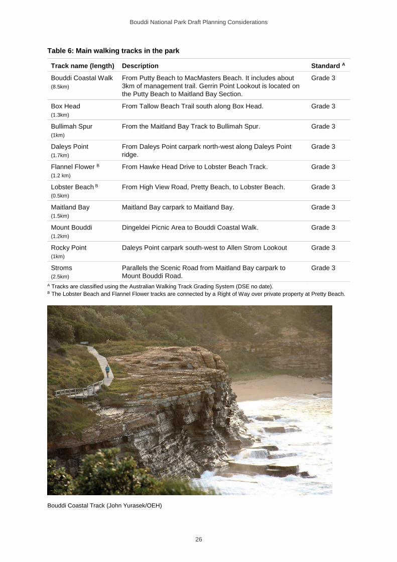
The main walking tracks in the park are listed in Table 6 and provide a range of lengths and difficulties, from shorter walks to secluded beaches and lookouts to the 8-kilometre Bouddi Coastal Walk offering spectacular scenery along the coast from Putty Beach to MacMasters Beach. There are also several shorter tracks that provide direct access to sites and attractions. All walking tracks are shown on Figure 1. In addition to the formal walking tracks, the management trails in the park also provide walking opportunities.
There are some informal tracks that have been created by walkers over time. The walking track from Bulkara Street, Wagstaffe, to Half Tide Rocks passes through the park and is well used by the local community. NPWS is working with the community to formalise this track.
Walking track grades aim to identify the suitability of a track for different user groups and abilities. All walking tracks in the park are Grade 3, generally being formed tracks with some steep sections, and where bushwalking experience is generally recommended. Some sections of track need to be upgraded to ensure a consistent standard along the length of the track.
Bouddi National Park Draft Planning Considerations
26
Table 6: Main walking tracks in the park
Track name (length) Description Standard A
Bouddi Coastal Walk
(8.5km)
From Putty Beach to MacMasters Beach. It includes about
3km of management trail. Gerrin Point Lookout is located on
the Putty Beach to Maitland Bay Section.
Grade 3
Box Head
(1.3km)
From Tallow Beach Trail south along Box Head. Grade 3
Bullimah Spur
(1km)
From the Maitland Bay Track to Bullimah Spur. Grade 3
Daleys Point
(1.7km)
From Daleys Point carpark north-west along Daleys Point
ridge.
Grade 3
Flannel Flower B
(1.2 km)
From Hawke Head Drive to Lobster Beach Track. Grade 3
Lobster Beach B
(0.5km)
From High View Road, Pretty Beach, to Lobster Beach. Grade 3
Maitland Bay
(1.5km)
Maitland Bay carpark to Maitland Bay. Grade 3
Mount Bouddi
(1.2km)
Dingeldei Picnic Area to Bouddi Coastal Walk. Grade 3
Rocky Point
(1km)
Daleys Point carpark south-west to Allen Strom Lookout Grade 3
Stroms
(2.5km)
Parallels the Scenic Road from Maitland Bay carpark to
Mount Bouddi Road.
Grade 3
A Tracks are classified using the Australian Walking Track Grading System (DSE no date). B The Lobster Beach and Flannel Flower tracks are connected by a Right of Way over private property at Pretty Beach.
Bouddi Coastal Track (John Yurasek/OEH)
Bouddi National Park Draft Planning Considerations
27
4.2.3 Day use
Day use areas are used for picnicking and as a base for interpretation and education or other activities such as sightseeing, birdwatching, bushwalking, fishing and beach activities. The day use areas and facilities provided in Bouddi National Park are detailed in Table 7.
Table 7: Day use areas in the park
Day use area
Pic
nic
tab
les
Sh
elt
er
BB
Q
Seati
ng
Ru
bb
ish
bin
To
ilets
Sh
ow
er
an
d d
rin
kin
g w
ate
r
Carp
ark
Ped
estr
ian
beach
acc
ess
Info
rmati
on
pan
els
Lo
oko
ut
/Pla
tfo
rm
Putty Beach ✓ ✓ Gas ✓ ✓ ✓ ✓ 65 ✓ ✓
Mount Bouddi (Dingeldei) ✓ ✓ Wood ✓ ✓ 8
Little Beach A ✓ Gas ✓ ✓ ✓ 12 ✓ ✓
Lobster Beach B
✓ Road
edge ✓ ✓ A Walk-in access. B Walk-in and boat access.
Maitland Bay is also a popular day destination along the Coastal Walk but has no facilities. Wood-burning barbecues have been removed from the park due to the potential fire hazard, except in the Dingeldei Memorial Shelter at Mount Bouddi Day Use Area, where two enclosed wood fireplaces have been retained due to their historical association, their use as fireplaces is not permitted.
Many vantage points in the park offer views along the coast. A formal lookout is provided at Gerrin Point which is accessible via the Bouddi Coastal Walk from Putty Beach. The other formal lookouts in the park are the Allen Strom Lookout at Rocky Point (which can be accessed on foot or bicycle via Rocky Point Trail), Box Head off Tallow Beach Trail) and Lobster Beach Lookout. Marie Byles Lookout is adjacent to the park on land managed by Central Coast Council. It provides extensive views of the park, Lion Island and northern Sydney and has important historical connections with the formation of the park. This lookout is easily accessible by vehicle.
Swimming is a popular activity at the park’s beaches. None of the beaches in the park are patrolled. Most beaches in the park are considered moderately hazardous, with the exception of Lobster Beach which is considered least hazardous (SLSA 2014). Visitors need to use caution at all beaches, but particularly at Tallow and Little Tallow beaches due to the dominance of rips and their feeder currents.
The beaches and rock platforms within the park are popular for fishing. Fishing is permitted in most areas of the park (subject to licensing requirements under the Fisheries Management Act and requirements under the Rock Fishing Safety Act 2016). Recreational fishing is not permitted in the Marine Extension which encompasses the areas between Gerrin Point and Third Point from mean high water mark out to the seaward boundary of the Marine Extension (see Figure 1) where a fishing closure has been in place since 1973 (see Box 3). There is a history of antisocial behaviour in Putty Beach and Mount Bouddi day use areas. Night closures will be considered to reduce antisocial behaviour at these sites.
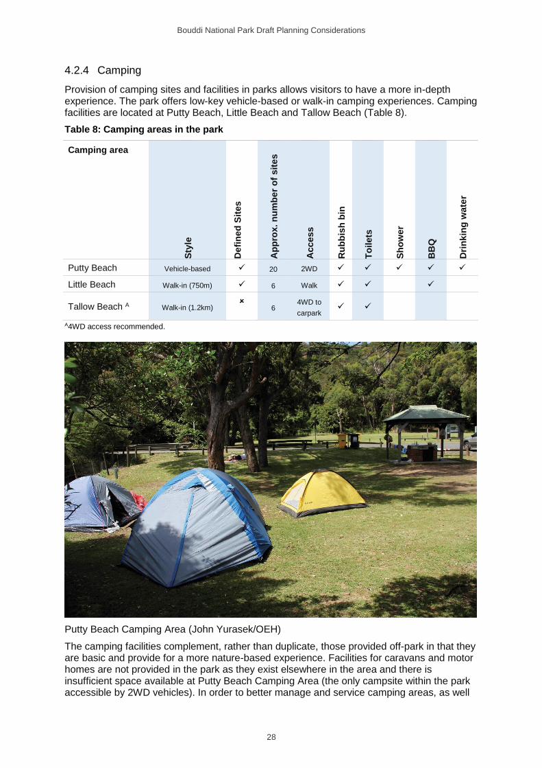
Bouddi National Park Draft Planning Considerations
28
4.2.4 Camping
Provision of camping sites and facilities in parks allows visitors to have a more in-depth experience. The park offers low-key vehicle-based or walk-in camping experiences. Camping facilities are located at Putty Beach, Little Beach and Tallow Beach (Table 8).
Table 8: Camping areas in the park
Camping area
Sty
le
Defi
ned
Sit
es
Ap
pro
x. n
um
be
r o
f sit
es
Acce
ss
Ru
bb
ish
bin
To
ilets
Sh
ow
er
BB
Q
Dri
nkin
g w
ate
r
Putty Beach Vehicle-based ✓ 20 2WD ✓ ✓ ✓ ✓ ✓
Little Beach Walk-in (750m) ✓ 6 Walk ✓ ✓ ✓
Tallow Beach A Walk-in (1.2km)
6 4WD to
carpark ✓ ✓
A4WD access recommended.
Putty Beach Camping Area (John Yurasek/OEH)
The camping facilities complement, rather than duplicate, those provided off-park in that they are basic and provide for a more nature-based experience. Facilities for caravans and motor homes are not provided in the park as they exist elsewhere in the area and there is insufficient space available at Putty Beach Camping Area (the only campsite within the park accessible by 2WD vehicles). In order to better manage and service camping areas, as well
Bouddi National Park Draft Planning Considerations
29
as minimise visitor impacts, a booking system is in place for all camping areas. Given the popularity of the park, booking is essential. Remote or bush camping outside the designated camping areas is not permitted in the park.
4.2.5 Cycling
Cycling is a popular recreational activity in the area. In accordance with the NPWS Cycling Policy (OEH 2018) and the Sustainable Mountain Biking Strategy (OEH 2011a) cycling is permitted on park roads and some management trails. The park offers routes suitable for beginners and intermediate riders on several trails, including Daleys Point, Rocky Point and Stroms trails. Cycling is also permitted on MacMasters Ridge Trail within the park.
Cycling is not permitted on the management trails on Bombi Moor or Mourawaring Moor due to the fragile sandy soils and vegetation in the area. Cycling is also not permitted on any of the park’s designated walking tracks.
Mountain biking is growing in popularity and the construction of a network of illegal mountain bike tracks over recent years is an emerging issue for the park. Mountain biking and illegal track construction is increasing and undertaken without approval or any environmental assessment. Illegal tracks are often poorly located, and their construction can result in erosion and safety issues. Some tracks are impacting the natural and cultural values in the park.
It is proposed to consider mountain biking opportunities, that may include mountain bike single tracks, through the development of a mountain bike plan in consultation with the community. In accordance with policy, new cycling experiences may be developed on existing roads or trails, by constructing new tracks or by modifying existing tracks. The appropriateness of cycling experiences is assessed for a park or for a particular location in a park against a set of planning, development and management criteria, including:
• the ecological sustainability of the proposal
• the appropriateness of the location
• the quality of the experience for cyclists
• the need to balance competing visitor demands
• opportunities and demand for cycling across the region, including on other tenures
• visitor safety
• the availability of resources to provide and maintain the experience.
Mountain biking opportunities already provided in the region include a dedicated mountain biking track in Ourimbah State Forest operated by the Central Coast Mountain Bike Club. There are over 30 kilometres of looped trails including Tommos, Rocky Ponds and Warrah Trig loops provided in Brisbane Water National Park; the popular 248 trail in Popran National Park; and the steep and challenging 18-kilometre Dubbo Gully loop trail in Dharug National Park.
Mountain biking opportunities in the park will be assessed in zone 2 (see Figure 1) and, if appropriate, developed through a separate mountain bike plan and will only be considered outside of the designated conservation area (zone 1). NPWS will engage with the mountain biking community to develop sustainable mountain biking opportunities. The development of mountain bike tracks will be subject to environmental impact assessment (under the Environmental Planning and Assessment Act 1979), compliance with NPWS policies and public consultation.
Tracks not assessed as suitable for continued use by mountain bikes will be closed and rehabilitated. The impact of bicycles on the environment, resources and users of areas within parks will be monitored and management prescriptions revised as necessary. Mountain
Bouddi National Park Draft Planning Considerations
30
biking opportunities will not be considered within zone 1 (conservation zone) (see Figure 1). Zone 1 has been mapped to protect fragile vegetation communities, soils and cultural values.
The mountain bike plan will address the assessment, development and management of mountain bike use in the park including signage, safety and maintainence of tracks.
4.2.6 Other recreation
There has been some increased interest in the use of recreational drones in the park. Flying drones in parks can annoy visitors and disturb animals. Drones can also dangerously interfere with fighting bushfires and with other activities for managing parks. For these reasons, and in accordance with the NPWS Drones in Parks Policy (OEH 2018), their use in parks is restricted and subject to consent by local NPWS management.
Drones are considered a type of aircraft and are therefore subject to the Commonwealth Civil Aviation Act 1988 and the Civil Aviation Safety Regulations 1998 (CASR).
Jet skis are used in the Tallow and Lobster beach areas and there have been complaints regarding noise and the safety of other beach users. This issue will be dealt in collaboration with NSW Maritime.
Geocaching and virtual geocaching occasionally occur in some areas of the park. Geocaching is an activity where participants use a global position satellite (GPS) to find the location of the cache. Geocachers must obtain written consent from NPWS to place a physical cache in the park.
Horse riding is a popular recreational activity that has cultural associations for many Australians. The provision of horse riding opportunities in the region was assessed under the Strategic Directions for Horse Riding in NSW National Parks (OEH 2012b). While horse riding opportunities were identified for other parks in the region, no trails have been set aside for horse riding in this park.
Dog walking is not permitted in NSW national parks. Domestic pets can be a threat to native animals and can disrupt other people’s enjoyment of parks. Occasionally dogs enter the park illegally. NPWS will continue to ensure appropriate regulatory signage prohibiting dogs in the park is in place and undertake education and/or compliance action as required.
There is some illegal access to sites within the park for rock climbing and abseiling. Rock climbing and abseiling can impact the surrounding environment through damage to vegetation and rock features and the installation of rock bolts. Abseiling and rock climbing are not permitted in the park because the safety risk is too great due to the friable sandstone.
4.2.7 Group activities
Tours and organised nature-based activities provide a range of opportunities for interpretation and promotion of the natural and cultural values of the park. Licences and consents provide a mechanism for ensuring that activities, levels of use and behaviour are appropriate to the park and specific locations are suitable for the proposed use. Walking and running events with large numbers of participants can place additional pressures on the park and park infrastructure.
Group gatherings – non-commercial
Non-commercial group gatherings include, for example, family or social gatherings and school tours. Consent is required for groups of more than 40 people, consistent with the NPW Regulation. Consent is needed for large groups to ensure the limited available space can be sustainably managed, particularly during peak visitor periods.

Bouddi National Park Draft Planning Considerations
31
Events, functions and commercial activities and research
Commercial recreational activities undertaken in the park include guided nature tours, wildlife watching, filming and photographic expeditions and sporting events e.g running events. Commerical activities require approval, irrespective of group size.
Wedding ceremonies can occur in the park with consent. Public events such as fun runs and non-commercial organised events (e.g. club-based events) also require consent, irrespective of group size.
Scientific and educational research activities that are related to conservation or park management require consent.
4.2.8 Volunteers
Volunteers make a valuable contribution towards the management of Bouddi National Park. The Mourawaring Moor, Lobster Beach and Wagstaffe bush regeneration groups and the Bouddi Bushcare group meet regularly at sites throughout the park, including Maitland Bay, Rileys Bay and Tallow Beach.
The Maitland Bay Information Centre is staffed solely by volunteers and is open to the public on weekends and public holidays.
Maitland Bay Information Centre (OEH)
Bouddi National Park Draft Planning Considerations
32
5 NPWS infrastructure and services
Management operations in the park are coordinated from the NPWS Office and field depot located at Girrakool, within Brisbane Water National Park.
5.1 Management facilities and infrastructure
Supporting infrastructure within the park includes:
• a small works depot located in the park near the Strom Centre on The Scenic Road at Killcare Heights
• Maitland Bay Information Centre located at the intersection of Maitland Bay Drive and The Scenic Road at Killcare Heights
• the Strom Centre located on The Scenic Road at Killcare Heights
• Strom’s House (located on The Scenic Road at Killcare Heights) and Boobialla House (located on The Scenic Road at MacMasters Beach) which currently provide accommodation for NPWS staff
• a helipad just off Hawke Head Drive, Pretty Beach
• a manual weather station at Strom’s House.
Park management is also supported through park boundary and regulation signs. The boundaries of the Bouddi Marine Extension are not identified in situ with boundary markers and buoys.
5.1.1 Roads and trails
A network of management trails provides management access across the terrestrial part of the park (see Figure 1). In accordance with NPWS policy, vehicle use of these trails is only available for purposes authorised by NPWS.
Four management trails, namely Little Valley Trail, MacMasters Ridge Trail, Old Wagstaffe Trail and Fishermans Trail, commence or continue onto neighbouring private land. Use of the off-park sections of some of these trails by NPWS for management purposes needs to be formalised.
A Right of Way from High View Road provides NPWS vehicle access to Flannel Flower Walking Track for track maintenance works.
Arrangements for the maintenance of a number of public access roads jointly managed with Central Coast Council need to be formalised.
5.1.2 Marine extension
NPWS management of the marine areas in the park is shared with Fisheries NSW (part of the NSW Department of Primary Industries – Fishing and Aquaculture) and NSW Maritime (a division of the NSW Roads and Maritime Services). The management of fishing in these waters (and the enforcement of the prohibition on fishing in the Bouddi Marine Extension) is the responsibility of Fisheries NSW, while recreational boating is the responsibility of NSW Maritime.
Bouddi National Park Draft Planning Considerations
33
6 Non-NPWS infrastructure and services
Many NSW national parks contain infrastructure and other assets owned and operated by other organisations or individuals that are not essential for park management. This includes public utility infrastructure (e.g. pipelines and transmission lines), access to privately owned land (in-holdings) and a range of other uses. Many of these existed before the land was reserved under the NPW Act; others may have been established under various approval processes. NPWS maintains a public register of leases, easements and rights of way.
All non-NPWS uses require relevant authorisation to lawfully occupy and use such land. This is necessary to ensure there is clarity around arrangements for access, period of occupation, management and maintenance responsibilities and any associated fees or payments.
6.1 Non-NPWS infrastructure
6.1.1 Easements
Sewer mains easements are located within the park at MacMasters Beach (between Beachview Esplanade and MacMaster Parade), at Putty Beach and at MacDonald Street, Killcare. These are maintained by Central Coast Council.
There are several powerlines managed by Ausgrid crossing or alongside the boundary of the park, as listed in Table 9. Only one of the powerlines is covered by a formal easement. In accordance with the Electricity Supply Act 1995, a network operator can operate and use the existing powerlines whether or not there is a formal easement in place.
Clearings and vehicle trails along the powerlines have significant environmental and visual impacts. No access or maintenance agreement currently exists with Ausgrid but the company must comply with the NPW Act and Regulation when carrying out any maintenance or replacement work and will require NPWS consent for certain works.
Table 9: Powerlines through or on the edge of the park
Location Voltage Status
Daleys Ave, Daleys Point A High voltage (11kV) Easement in place
Between Wards Hill Rd, Killcare Heights and
Fraser Rd, Killcare
High voltage (11kV) No easement
Alongside Wards Hill Rd, Empire Bay and Killcare
Heights A
High voltage (11kV)
Low voltage (415V)
No easement
Scenic Road, Bouddi (to service NPWS buildings) Service lines (415V) No easement
A Powerline is situated on the boundary of the park.
Ausgrid also holds a formal easement alongside the park boundary between Wards Hill Road and a property accessed off Maitland Bay Drive, Killcare Heights.
6.1.2 Trigonometric stations
The park includes the following trigonometric stations: • Bombi (located on Third Point)
• Bouddi (located 1 kilometre east of Bouddi Point)
• Gerrin (located on Gerrin Point).
Bouddi National Park Draft Planning Considerations
34
An agreement between NPWS and the former Central Mapping Authority (now NSW Spatial Services, part of the Department of Finance, Services and Innovation) provides continued right of access to the station for survey purposes, subject to environmental impact assessment. Only Bombi trig station is accessible by vehicle on a management trail through the park.
6.2 Non-NPWS uses
6.2.1 Commercial beach-hauling access
Commercial beach-hauling occurs along Putty Beach, including within the park. Commerical beach-hauling is an activity regulated under the Fisheries Management Act and managed by the NSW Department of Primary Industries. A NPWS commercial fishing vehicle access permit is required for all commercial fisherpersons accessing Putty Beach by vehicle. Before issuing vehicle access permits, NPWS will consider a number of factors such as the likely impacts on natural and cultural values and potential conflicts with park users and management operations in accordance with the Commercial Fishing Access Policy.
Bouddi National Park Draft Planning Considerations
35
Appendices
Appendix A: Legislation and policy
The following laws and policies apply to how we manage our parks (this is not a complete list):
NSW legislation
• National Parks and Wildlife Act 1974 (NPW Act) and NPW Regulation
• Environmental Planning and Assessment Act 1979
• Heritage Act 1977
• Biodiversity Conservation Act 2016 (BC Act)
• Biosecurity Act 2015
• Local Land Services Act 2013
• Rural Fires Act 1997
Other NSW laws may also apply to park management:
• Work Health and Safety Act 2011
Commonwealth legislation
• Environment Protection and Biodiversity Conservation Act 1999 (EPBC Act)
NPWS policies and strategies
A range of NPWS policies and strategies may also apply to park management:
• Park management policies, www.environment.nsw.gov.au/topics/parks-reserves-and-protected-areas/park-policies
• Pest management strategies, www.environment.nsw.gov.au/pestsweeds/RegionPestManagement.htm
• Fire management strategies, www.environment.nsw.gov.au/topics/parks-reserves-and-protected-areas/fire/fire-management-strategies
Other laws, policies and strategies may also apply. Please contact NPWS for advice.
Bouddi National Park Draft Planning Considerations
36
Appendix B: Scientific plant and animal names The following tables lists scientific names of species mentioned in the text.
Native animals
Common name Scientific name
Frogs
Red-crowned toadlet Pseudophryne australis
Birds
Barking owl Ninox connivens
Black-browed Albatross Thalassarche melanophris
Brush bronzewing Phaps elegans
Bush stone-curlew Burhinus grallarius
Caspian tern A Hydroprogne caspia
Eastern osprey Pandion cristatus
Eastern reef egret A Egretta sacra
Flesh-footed shearwater Puffinus carneipes
Fork-tailed swift A Apus pacificus
Gang-gang cockatoo Callocephalon fimbriatum
Glossy black-cockatoo Calyptorhynchus lathami
Little lorikeet Glossopsitta pusilla
Little penguins Eudyptula minor
Little tern Sterna albifrons
Masked owl Tyto novaehollandiae
Osprey Pandion haliaetus
Peregrine falcon Falco peregrinus
Pied oystercatcher Haematopus longirostris
Powerful owl Ninox strenua
Regent honeyeater Anthochaera phrygia
Short-tailed shearwater A Ardenna tenuirostris
Sooty owl Tyto tenebricosa
Sooty oystercatcher Haematopus fuliginosus
Southern emu-wren Stipiturus malachurus
Tawny-crowned honeyeater Gliciphila melanops
Varied sittella Daphoenositta chrysoptera
Wandering albatross A Diomedea exulans
White-bellied sea-eagle A Haliaeetus leucogaster
Bouddi National Park Draft Planning Considerations
37
Common name Scientific name
White-throated needletail A Hirundapus caudacutus
Mammals
Eastern bentwing-bat Miniopterus schreibersii oceanensis
Eastern false pipistrelle Falsistrellus tasmaniensis
Eastern freetail-bat Mormopterus norfolkensis
Greater broad-nosed bat Scoteanax rueppellii
Grey-headed flying-fox Pteropus poliocephalus
Golden-tipped bat Kerivoula papuensis
Humpback whale Megaptera novaeangliae
Koala Phascolarctos cinereus
Large-eared pied bat Chalinolobus dwyeri
Little bentwing-bat Miniopterus australis
Southern right whale Eubalaena australis
Spotted-tail quoll Dasyurus maculatus
Squirrel glider Petaurus norfolcensis
Yellow-bellied glider Petaurus australis
Yellow-bellied sheathtail-bat Saccolaimus flaviventris
Fish
Blackfish Girella tricuspidata
Blue groper Achoerodus viridis
Red morwong Cheilodactylus fuscus
A Migratory species under the EPBC Act.
Native plants
Common name Scientific name
Bearded tylophora Tylophora barbata
Biconvex paperbark Melaleuca biconvexa
Brown stringybark Eucalyptus capitellata
Daisy Olearia nernstii
Forest maple Cryptocarya rigida
Grey mangrove Avicennia marina
Hard fern Blechnum ambiguum
Honeysuckle banskia Banksia integrifolia subsp. integrifolia or
Banksia serrata
Howittia Howittia trilocularis
Large-fruited red mahogany Eucalyptus scias subsp. scias
Leafy wedge pea Gompholobium virgatum var. virgatum
Bouddi National Park Draft Planning Considerations
38
Common name Scientific name
Magenta lilly pilly Syzygium paniculatum
Native ginger Alpinia arundelliana
Native violet Viola betonicifolia
Netted bottle brush Callistemon linearifolius
Prostrate wattle Acacia sophorae and Acacia longifolia
River mangrove Aegiceras corniculatum
Scrub turpentine Rhodamnia rubescens
Shining grape Tetrastigma nitens
Silkpod Parsonsia velutina
Small supplejack Ripogonum fawcettianum
Snow wood Pararchidendron pruinosum
Spinafex Spinifex longifolius/ Spinifex sericeus
Swamp oak Casuarina glauca
Tranquillity mint-bush Prostanthera askania
Wattle Acacia quadrilateralis
Wrinkled Kerrawang Rulingia hermanniifolia
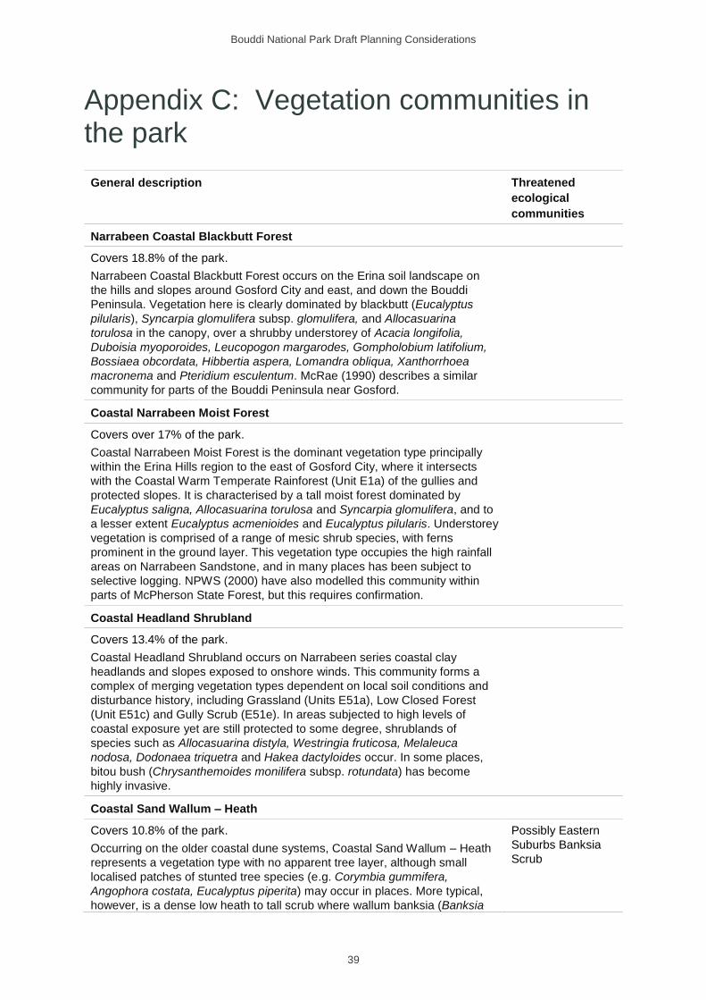
Bouddi National Park Draft Planning Considerations
39
Appendix C: Vegetation communities in the park
General description Threatened
ecological
communities
Narrabeen Coastal Blackbutt Forest
Covers 18.8% of the park.
Narrabeen Coastal Blackbutt Forest occurs on the Erina soil landscape on
the hills and slopes around Gosford City and east, and down the Bouddi
Peninsula. Vegetation here is clearly dominated by blackbutt (Eucalyptus
pilularis), Syncarpia glomulifera subsp. glomulifera, and Allocasuarina
torulosa in the canopy, over a shrubby understorey of Acacia longifolia,
Duboisia myoporoides, Leucopogon margarodes, Gompholobium latifolium,
Bossiaea obcordata, Hibbertia aspera, Lomandra obliqua, Xanthorrhoea
macronema and Pteridium esculentum. McRae (1990) describes a similar
community for parts of the Bouddi Peninsula near Gosford.
Coastal Narrabeen Moist Forest
Covers over 17% of the park.
Coastal Narrabeen Moist Forest is the dominant vegetation type principally
within the Erina Hills region to the east of Gosford City, where it intersects
with the Coastal Warm Temperate Rainforest (Unit E1a) of the gullies and
protected slopes. It is characterised by a tall moist forest dominated by
Eucalyptus saligna, Allocasuarina torulosa and Syncarpia glomulifera, and to
a lesser extent Eucalyptus acmenioides and Eucalyptus pilularis. Understorey
vegetation is comprised of a range of mesic shrub species, with ferns
prominent in the ground layer. This vegetation type occupies the high rainfall
areas on Narrabeen Sandstone, and in many places has been subject to
selective logging. NPWS (2000) have also modelled this community within
parts of McPherson State Forest, but this requires confirmation.
Coastal Headland Shrubland
Covers 13.4% of the park.
Coastal Headland Shrubland occurs on Narrabeen series coastal clay
headlands and slopes exposed to onshore winds. This community forms a
complex of merging vegetation types dependent on local soil conditions and
disturbance history, including Grassland (Units E51a), Low Closed Forest
(Unit E51c) and Gully Scrub (E51e). In areas subjected to high levels of
coastal exposure yet are still protected to some degree, shrublands of
species such as Allocasuarina distyla, Westringia fruticosa, Melaleuca
nodosa, Dodonaea triquetra and Hakea dactyloides occur. In some places,
bitou bush (Chrysanthemoides monilifera subsp. rotundata) has become
highly invasive.
Coastal Sand Wallum – Heath
Covers 10.8% of the park.
Occurring on the older coastal dune systems, Coastal Sand Wallum – Heath
represents a vegetation type with no apparent tree layer, although small
localised patches of stunted tree species (e.g. Corymbia gummifera,
Angophora costata, Eucalyptus piperita) may occur in places. More typical,
however, is a dense low heath to tall scrub where wallum banksia (Banksia
Possibly Eastern
Suburbs Banksia
Scrub

Bouddi National Park Draft Planning Considerations
40
General description Threatened
ecological
communities
aemula) is characteristic, with other common shrub species such as Pimelea
linifolia, Ricinocarpus pinifolius, Allocasuarina distyla, Monotoca scoparia,
Lambertia formosa and several Acacia and Fabaceous species. This
vegetation type occurs in generally more exposed areas than the better
structured forests and woodlands.
Coastal Headland Low Forest
Covers 8.9% of the park.
Coastal Headland Low Forest occurs on coastal clay headlands and slopes
exposed to onshore winds. This community forms a complex of merging
vegetation types dependent on local soil conditions and disturbance history,
including Grassland (Units E51a), Shrubland (Unit E51b & E51d) and Gully
Scrub (E51e). In areas with protection from on-shore winds away from the
immediate coastline, a low closed forest develops. Stunted canopy species
such as Eucalyptus capitellata, Eucalyptus paniculata subsp. paniculata,
Eucalyptus umbra and Angophora costata occur over a sparse shrub layer,
and a normally well-developed herb layer including Lomandra longifolia and
Macrozamia reducta. The ground surface is also often rocky supporting a thin
soil.
Coastal Sand Apple – Blackbutt Forest
Covers 5.4% of the park.
Coastal Sand Apple – Blackbutt Forest occurs in coastal areas on Quaternary
Pleistocene Sand deposits, in areas protected from seaward exposure and
with good drainage. This vegetation type is characteristic of the NSW North
Coast and becomes very disjunct in the Central Coast area. In most
locations, blackbutt (Eucalyptus pilularis), red bloodwood (Corymbia
gummifera) and smooth-barked apple (Angophora costata) dominate the tree
layer, often with Banksia serrata. Understorey vegetation typically includes a
range of Fabaceae species, together with Monotoca scoparia, Eriostemon
australasius, Monotoca elliptica, Pteridium esculentum, Themeda australis,
Gonocarpus teucrioides and Amperea xiphoclada var. xiphoclada. Grasstrees
(e.g. Xanthorrhoea arborea) are often locally common.
Bouddi Sandstone Coastal Heath
Covers 5% of the park.
On the windswept ridgetops of Bouddi Ridge in Bouddi National Park, and
other parts of the Bouddi Peninsula, outcrops of Hawkesbury Sandstone
support heath vegetation dominated by Allocasuarina distyla and Banksia
ericifolia var. ericifolia. A range of other species is present, including
interesting occurrences of stunted Syncarpia glomulifera, Eucalyptus umbra,
Eucalyptus scias and Angophora costata, together with shrubs such as
Hakea teretifolia, Baeckea brevifolia, Platysace lanceolata, Isopogon
anemonifolius, Xanthosia pilosa, Philotheca buxifolia, Xanthorrhoea media
and Dillwynia retorta. This vegetation type is a coastal variation of the more
inland coastal heaths, but is distinct and disjunct enough to be treated as a
subcommunity in its own right.
Wagstaff Spotted Gum – Ironbark Forest
Covers 3.5% of the park.
Wagstaff Spotted Gum– Ironbark Forest occurs only on the Narrabeen
Sandstone ridgelines around Wagstaff and Pretty Beach, with disjunct
locations across the entrance to Brisbane Water at Mount Ettalong, and
Pittwater and
Wagstaffe Spotted
Gum Forest
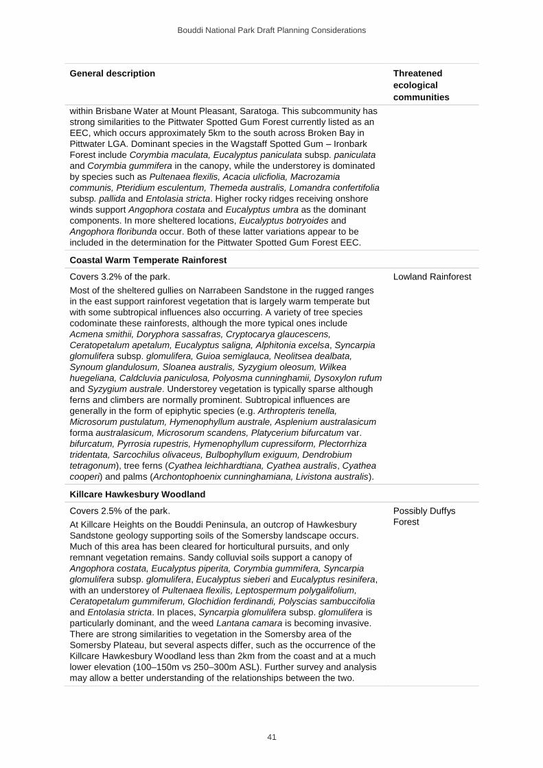
Bouddi National Park Draft Planning Considerations
41
General description Threatened
ecological
communities
within Brisbane Water at Mount Pleasant, Saratoga. This subcommunity has
strong similarities to the Pittwater Spotted Gum Forest currently listed as an
EEC, which occurs approximately 5km to the south across Broken Bay in
Pittwater LGA. Dominant species in the Wagstaff Spotted Gum – Ironbark
Forest include Corymbia maculata, Eucalyptus paniculata subsp. paniculata
and Corymbia gummifera in the canopy, while the understorey is dominated
by species such as Pultenaea flexilis, Acacia ulicfiolia, Macrozamia
communis, Pteridium esculentum, Themeda australis, Lomandra confertifolia
subsp. pallida and Entolasia stricta. Higher rocky ridges receiving onshore
winds support Angophora costata and Eucalyptus umbra as the dominant
components. In more sheltered locations, Eucalyptus botryoides and
Angophora floribunda occur. Both of these latter variations appear to be
included in the determination for the Pittwater Spotted Gum Forest EEC.
Coastal Warm Temperate Rainforest
Covers 3.2% of the park.
Most of the sheltered gullies on Narrabeen Sandstone in the rugged ranges
in the east support rainforest vegetation that is largely warm temperate but
with some subtropical influences also occurring. A variety of tree species
codominate these rainforests, although the more typical ones include
Acmena smithii, Doryphora sassafras, Cryptocarya glaucescens,
Ceratopetalum apetalum, Eucalyptus saligna, Alphitonia excelsa, Syncarpia
glomulifera subsp. glomulifera, Guioa semiglauca, Neolitsea dealbata,
Synoum glandulosum, Sloanea australis, Syzygium oleosum, Wilkea
huegeliana, Caldcluvia paniculosa, Polyosma cunninghamii, Dysoxylon rufum
and Syzygium australe. Understorey vegetation is typically sparse although
ferns and climbers are normally prominent. Subtropical influences are
generally in the form of epiphytic species (e.g. Arthropteris tenella,
Microsorum pustulatum, Hymenophyllum australe, Asplenium australasicum
forma australasicum, Microsorum scandens, Platycerium bifurcatum var.
bifurcatum, Pyrrosia rupestris, Hymenophyllum cupressiform, Plectorrhiza
tridentata, Sarcochilus olivaceus, Bulbophyllum exiguum, Dendrobium
tetragonum), tree ferns (Cyathea leichhardtiana, Cyathea australis, Cyathea
cooperi) and palms (Archontophoenix cunninghamiana, Livistona australis).
Lowland Rainforest
Killcare Hawkesbury Woodland
Covers 2.5% of the park.
At Killcare Heights on the Bouddi Peninsula, an outcrop of Hawkesbury
Sandstone geology supporting soils of the Somersby landscape occurs.
Much of this area has been cleared for horticultural pursuits, and only
remnant vegetation remains. Sandy colluvial soils support a canopy of
Angophora costata, Eucalyptus piperita, Corymbia gummifera, Syncarpia
glomulifera subsp. glomulifera, Eucalyptus sieberi and Eucalyptus resinifera,
with an understorey of Pultenaea flexilis, Leptospermum polygalifolium,
Ceratopetalum gummiferum, Glochidion ferdinandi, Polyscias sambuccifolia
and Entolasia stricta. In places, Syncarpia glomulifera subsp. glomulifera is
particularly dominant, and the weed Lantana camara is becoming invasive.
There are strong similarities to vegetation in the Somersby area of the
Somersby Plateau, but several aspects differ, such as the occurrence of the
Killcare Hawkesbury Woodland less than 2km from the coast and at a much
lower elevation (100–150m vs 250–300m ASL). Further survey and analysis
may allow a better understanding of the relationships between the two.
Possibly Duffys
Forest
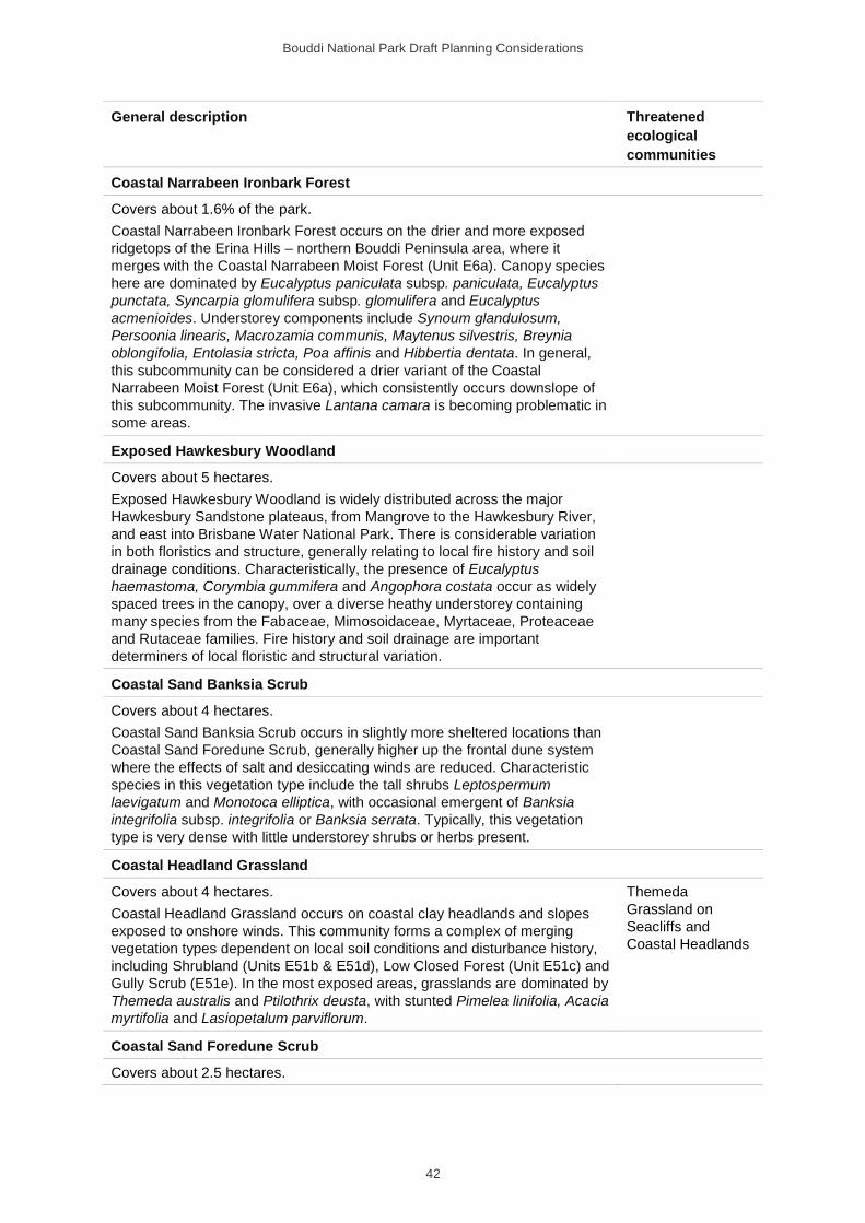
Bouddi National Park Draft Planning Considerations
42
General description Threatened
ecological
communities
Coastal Narrabeen Ironbark Forest
Covers about 1.6% of the park.
Coastal Narrabeen Ironbark Forest occurs on the drier and more exposed
ridgetops of the Erina Hills – northern Bouddi Peninsula area, where it
merges with the Coastal Narrabeen Moist Forest (Unit E6a). Canopy species
here are dominated by Eucalyptus paniculata subsp. paniculata, Eucalyptus
punctata, Syncarpia glomulifera subsp. glomulifera and Eucalyptus
acmenioides. Understorey components include Synoum glandulosum,
Persoonia linearis, Macrozamia communis, Maytenus silvestris, Breynia
oblongifolia, Entolasia stricta, Poa affinis and Hibbertia dentata. In general,
this subcommunity can be considered a drier variant of the Coastal
Narrabeen Moist Forest (Unit E6a), which consistently occurs downslope of
this subcommunity. The invasive Lantana camara is becoming problematic in
some areas.
Exposed Hawkesbury Woodland
Covers about 5 hectares.
Exposed Hawkesbury Woodland is widely distributed across the major
Hawkesbury Sandstone plateaus, from Mangrove to the Hawkesbury River,
and east into Brisbane Water National Park. There is considerable variation
in both floristics and structure, generally relating to local fire history and soil
drainage conditions. Characteristically, the presence of Eucalyptus
haemastoma, Corymbia gummifera and Angophora costata occur as widely
spaced trees in the canopy, over a diverse heathy understorey containing
many species from the Fabaceae, Mimosoidaceae, Myrtaceae, Proteaceae
and Rutaceae families. Fire history and soil drainage are important
determiners of local floristic and structural variation.
Coastal Sand Banksia Scrub
Covers about 4 hectares.
Coastal Sand Banksia Scrub occurs in slightly more sheltered locations than
Coastal Sand Foredune Scrub, generally higher up the frontal dune system
where the effects of salt and desiccating winds are reduced. Characteristic
species in this vegetation type include the tall shrubs Leptospermum
laevigatum and Monotoca elliptica, with occasional emergent of Banksia
integrifolia subsp. integrifolia or Banksia serrata. Typically, this vegetation
type is very dense with little understorey shrubs or herbs present.
Coastal Headland Grassland
Covers about 4 hectares.
Coastal Headland Grassland occurs on coastal clay headlands and slopes
exposed to onshore winds. This community forms a complex of merging
vegetation types dependent on local soil conditions and disturbance history,
including Shrubland (Units E51b & E51d), Low Closed Forest (Unit E51c) and
Gully Scrub (E51e). In the most exposed areas, grasslands are dominated by
Themeda australis and Ptilothrix deusta, with stunted Pimelea linifolia, Acacia
myrtifolia and Lasiopetalum parviflorum.
Themeda
Grassland on
Seacliffs and
Coastal Headlands
Coastal Sand Foredune Scrub
Covers about 2.5 hectares.
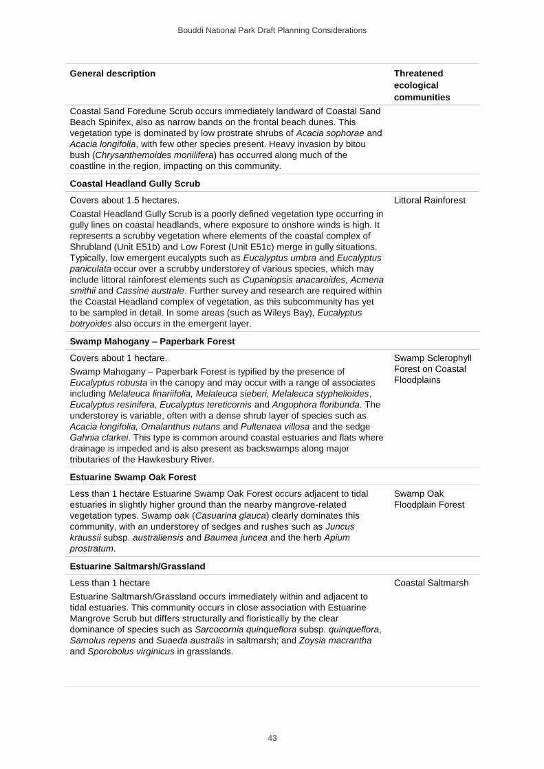
Bouddi National Park Draft Planning Considerations
43
General description Threatened
ecological
communities
Coastal Sand Foredune Scrub occurs immediately landward of Coastal Sand
Beach Spinifex, also as narrow bands on the frontal beach dunes. This
vegetation type is dominated by low prostrate shrubs of Acacia sophorae and
Acacia longifolia, with few other species present. Heavy invasion by bitou
bush (Chrysanthemoides monilifera) has occurred along much of the
coastline in the region, impacting on this community.
Coastal Headland Gully Scrub
Covers about 1.5 hectares.
Coastal Headland Gully Scrub is a poorly defined vegetation type occurring in
gully lines on coastal headlands, where exposure to onshore winds is high. It
represents a scrubby vegetation where elements of the coastal complex of
Shrubland (Unit E51b) and Low Forest (Unit E51c) merge in gully situations.
Typically, low emergent eucalypts such as Eucalyptus umbra and Eucalyptus
paniculata occur over a scrubby understorey of various species, which may
include littoral rainforest elements such as Cupaniopsis anacaroides, Acmena
smithii and Cassine australe. Further survey and research are required within
the Coastal Headland complex of vegetation, as this subcommunity has yet
to be sampled in detail. In some areas (such as Wileys Bay), Eucalyptus
botryoides also occurs in the emergent layer.
Littoral Rainforest
Swamp Mahogany – Paperbark Forest
Covers about 1 hectare.
Swamp Mahogany – Paperbark Forest is typified by the presence of
Eucalyptus robusta in the canopy and may occur with a range of associates
including Melaleuca linariifolia, Melaleuca sieberi, Melaleuca styphelioides,
Eucalyptus resinifera, Eucalyptus tereticornis and Angophora floribunda. The
understorey is variable, often with a dense shrub layer of species such as
Acacia longifolia, Omalanthus nutans and Pultenaea villosa and the sedge
Gahnia clarkei. This type is common around coastal estuaries and flats where
drainage is impeded and is also present as backswamps along major
tributaries of the Hawkesbury River.
Swamp Sclerophyll
Forest on Coastal
Floodplains
Estuarine Swamp Oak Forest
Less than 1 hectare Estuarine Swamp Oak Forest occurs adjacent to tidal
estuaries in slightly higher ground than the nearby mangrove-related
vegetation types. Swamp oak (Casuarina glauca) clearly dominates this
community, with an understorey of sedges and rushes such as Juncus
kraussii subsp. australiensis and Baumea juncea and the herb Apium
prostratum.
Swamp Oak
Floodplain Forest
Estuarine Saltmarsh/Grassland
Less than 1 hectare
Estuarine Saltmarsh/Grassland occurs immediately within and adjacent to
tidal estuaries. This community occurs in close association with Estuarine
Mangrove Scrub but differs structurally and floristically by the clear
dominance of species such as Sarcocornia quinqueflora subsp. quinqueflora,
Samolus repens and Suaeda australis in saltmarsh; and Zoysia macrantha
and Sporobolus virginicus in grasslands.
Coastal Saltmarsh
Bouddi National Park Draft Planning Considerations
44
General description Threatened
ecological
communities
Hawkesbury Banksia Scrub – Woodland
Less than 1 hectare. Hawkesbury Banksia Scrub – Woodland is a structurally
variable vegetation community, ranging from a tall dense scrub dominated by
Banksia ericifolia var. ericifolia, to a more open scrub or low heath with
scattered eucalypt emergents. Both forms can occur in a mosaic pattern at
the one location, depending on fire history of the site. Species typical of the
sparse emergent layer can include any one of Eucalyptus haemastoma,
Banksia serrata, Eucalyptus umbra, Angophora costata or Corymbia
gummifera. Below this, Banksia ericifolia var. ericifolia can be dominant (with
occasional Angophora hispida), and a variety of other shrubs such as
Banksia oblongifolia, Epacris pulchella, Hakea dactyloides, Lambertia
formosa, Leptospermum trinervium, Platysace linearifolia, Acacia linifolia,
Acacia suaveolens and Hakea teretifolia. Sedges and herbs are also
prominent and include Lepyrodia scariosa, Cyathochaeta diandra, Ptilothrix
deusta, Actinotus minor and Xanthosia pilosa.
Phragmites Rushland
Less than 1 hectare. Phragmites Rushland occurs in a few localities within
Gosford, generally in manmade dams and drainage lines in swampy
environments. Phragmites australis clearly dominates these areas, where it
has generally invaded following human disturbance of swampy areas.
Freshwater
Wetland on Coastal
Floodplains
Estuarine Mangrove Scrub
Less than 1 hectare. Estuarine Mangrove Scrub occurs immediately within
and adjacent to tidal estuaries. This community can be quite variable
structurally but is always dominated by the mangrove Avicennia marina
subsp. australasica, together with Aegiceras corniculatum along major river
systems (e.g. Hawkesbury River). Tidal gradients within this community also
introduce local variations where saltmarsh can be undergoing mangrove
colonisation.
Source: Adapted from Bell (2009).
Bouddi National Park Draft Planning Considerations
45
Appendix D: Pests in the park
The following table summaries key information on pests in the park at the time of publication of this plan. The most recent information on the status of pests and whether they have a threat abatement plan can be found on the Office of Environment and Heritage website. The Local Land Service Act declares certain animals to be pests.
Common name Scientific name Common name Scientific name
Weeds Pest animals
Aquarium caulerpa Caulerpa taxifolia Black rat Rattus rattus
Bitou bush A B D Chrysanthemoides
monilifera subsp.
rotundata
Common myna G Sturnus tristis
Blackberry A D Rubus fruticosus agg. Common starling Sturnus vulgaris
Black-eyed susan Thunbergia alata Fallow deer B G Dama dama
Bridal creeper A Asparagus
asparagoides
Feral cat B C G Felis catus
Camphor laurel F Cinnamomum
camphora
Goat B C G Capra hircus
Cassia F Senna pendula House mouse Mus musculus
Crofton weed F Ageratina adenophora Mallard Anas platyrhynchos
Honeysuckle Lonicera japonica Pigeon Columba livia
Lantana A B D Lantana camara Rabbit B C G Oryctolagus cuniculus
Morning glory Ipomoea cairica, I.
indica
Red fox B C G Vulpes vulpes
OchnaF Ochna serrulata Spotted turtle-dove Streptopelia chinensis
Other asparagus ferns A
A. aethiopicus,
A. plumosus,
A. scandens
Privets F Ligustrum sinense, L. lucidum
Sea Spurge E Euphorbia paralias
Turkey rhubarb F Acetosa sagittata
A Declared Weed of National Significance. B Declared key threatening process under the Biodiversity Conservation Act. C Declared key threatening process under the Environment Protection and Biodiversity Conservation Act. D Statewide priority weed under the Biosecurity Act. E Regional priority weed (LLS 2017). F Other weeds of regional concern (LLS 2017). G Regional priority pest animal (LLS 2018).
Bouddi National Park Draft Planning Considerations
46
Abbreviations
EEC Endangered ecological community
LGA Local government area
NPWS National Parks and Wildlife Service
NSW New South Wales
OEH Office of Environment and Heritage
SoS Saving Our Species
LLS Local Land Services
Glossary
The terms listed in this glossary have specific meanings in this plan of management.
Term Definition
Asset protection zone Area where the overall fuel hazard is maintained at moderate or
below, often by mechanical means (e.g. mowing or slashing). The
objective of an asset protection zone is to protect human life and
property, and this objective takes precedence over biodiversity
conservation in these zones.
Land management zone Area of land zoned to meet relevant land management objectives.
Management trail Vehicle trail that forms part of the park, maintained by NPWS for
park management and other authorised purposes. These trails are
not available for public vehicle access. They are available for public
use by walkers. Some are also available for cyclists.
Park road Road that forms part of the park, maintained by NPWS for public
vehicle access.
Public road Road that is not part of the park and maintained by NSW Roads and
Maritime Services or a local council for public vehicle access.
Single tracks A narrow track for cycling, only wide enough to accommodate riders
in single file.
Bouddi National Park Draft Planning Considerations
47
References
Bell SAJ 2004, The natural vegetation of the Gosford Local Government Area, Central Coast, New South Wales: Vegetation Community Profiles, unpublished report to Gosford City Council, April 2004, Eastcoast Flora Survey.
Bell SAJ 2009. The natural vegetation of Gosford Local Government Area, Central Coast, New South Wales: Technical Report, revised & updated, Version 3.0, unpublished Report to Gosford City Council, November 2009. Eastcoast Flora Survey.
Benson DH 1986, The vegetation of the Gosford and Lake Macquarie 1:100 000 vegetation map sheet, Cunninghamia 1(4): 467–89.
Benson DH & Howell J 1994, The natural vegetation of the Sydney 1:100 000 map sheet, Cunninghamia 3(4): 677–787.
Biosecurity Queensland 2010, Plan to Protect Environmental Assets from Lantana, prepared on behalf of the National Lantana Management Group, Department of Employment, Economic Development and Innovation, Yeerongpilly, Queensland.
Briggs JD & Leigh JH 1996, Rare or Threatened Australian Plants, revised edition, CSIRO Publishing, Collingwood, Victoria.
Brunker RL & Rose G 1967, Sydney Basin 1:500 000 Geological Sheet (Special), Geological Survey of New South Wales, Sydney.
Chapman GA & Murphy CL 1989, Soil Landscapes of the Sydney 1:100 000 Sheet, Soil Conservation Service, Sydney.
Commonwealth of Australia 2006, A Guide to the Integrated Marine and Coastal Regionalisation of Australia, Version 4.0, Department of the Environment and Heritage, Canberra, Australia, www.environment.gov.au/resource/guide-integrated-marine-and-coastal-regionalisation-australia-version-40-june-2006-imcra.
DECC 2008, Bouddi National Park and Cockle Bay Nature Reserve Fire Management Strategy, National Parks and Wildlife Service, Central Coast Hunter Range Region, Department of Environment and Climate Change NSW, www.environment.nsw.gov.au/research-and-publications/publications-search/bouddi-national-park-and-cockle-bay-nature-reserve-fire-management-strategy.
DECCW 2010a, Seabed Habitat Mapping of the Continental Shelf of NSW, Department of Environment, Climate Change and Water NSW, Sydney South.
DECCW 2010b, NSW Climate Impact Profile: The impacts of climate change on the biophysical environment of New South Wales, Department of Environment, Climate Change and Water, Sydney, http://climatechange.environment.nsw.gov.au/Impacts-of-climate-change/2010-NSW-climate-impact-reporting.
Department of the Environment 2009, Listed Key Threatening Processes, www.environment.gov.au/cgi-bin/sprat/public/publicgetkeythreats.pl.
Department of Mines 1966, Sydney 1:250 000 Geological Series Sheet, 3rd edition, Department of Mines, Sydney.
Bouddi National Park Draft Planning Considerations
48
Gladstone W 2004, Effects of a Marine Protected Area on some Central Coast Rocky Reef Fishes, Centre for Sustainable Use of Coasts and Catchments, University of Newcastle, Central Coast Campus.
Gladstone W, Loisier A & Herbert C 2007, Central Coast Rocky Shores Biodiversity Assessment, final report (Project CAE 06017) University of Newcastle, Central Coast Campus.
Greater Sydney LLS 2017, Greater Sydney Regional Strategic Weed Management Plan 2017–2022, Greater Sydney Local Land Services, https://greatersydney.lls.nsw.gov.au/__data/assets/pdf_file/0010/722368/Greater-Sydney-Regional-Weed-Mgmt-Plan-29-June-2017_FINAL-web-res.pdf.
Greater Sydney LLS 2018, Greater Sydney Regional Strategic Pest Animal Management Plan 2018–2023, Greater Sydney Local Land Services, https://greatersydney.lls.nsw.gov.au/__data/assets/pdf_file/0003/820794/greater-sydney-strategic-pest-plan-web.pdf.
Gunson N 1974, Reminiscences of Lancelot Threlkeld Missionary to the Aborigines 1824-1859, 2 volumes, Australian Institute of Aboriginal Studies, Canberra.
Jones R 2013, Pers comm (email 24/09/13), Australian Museum, Sydney.
Kelly D 2003, Bouddi Peninsula Plant Species List, unpublished report to NSW National Parks and Wildlife Service.
McCauley A 2006, Vegetation Survey and Mapping of the Hunter, Central and Lower North Coast Region of NSW, A report prepared for the Hunter-Central Rivers Catchment Management Authority by the HCCREMS team at the Environment Division of Hunter Councils Inc., NSW.
McDonnell KL 1974, Depositional Environments of the Triassic Gosford Formation, Journal of the Geological Society of Australia, 21(1): 107–32.
McRae RHD 1990, Vegetation of Bouddi Peninsula, New South Wales. Cunninghamia 2(2): 263–93.
NSW SC 1998, Final Determination to List Predation by the European Red Fox Vulpes vulpes (Linnaeus1758) as a Key Threatening Process on Schedule 3 of the TSC Act, New South Wales Scientific Committee, www.environment.nsw.gov.au/determinations/EuropeanRedFoxKTPListing.htm.
NSW SC 1999, Final Determination to List Invasion of Native Plant Communities by Bitou Bush and Boneseed as a Key Threatening Process on Schedule 3 of the TSC Act, New South Wales Scientific Committee, www.environment.nsw.gov.au/determinations/BitouBushBoneseedKTPListing.htm.
NSW SC 2000a, Final Determination to List High Frequency Fire Resulting in the Disruption of Life Cycle Processes in Plants and Animals and Loss of Vegetation Structure and Composition as a Key Threatening Process on Schedule 3 of the TSC Act, New South Wales Scientific Committee, www.environment.nsw.gov.au/threatenedspecies/EcologicalConsequencesFiresKTPListing.htm.
Bouddi National Park Draft Planning Considerations
49
NSW SC 2000b, Final Determination to List Anthropogenic Climate Change as a Key Threatening Process on Schedule 3 of the TSC Act, New South Wales Scientific Committee, www.environment.nsw.gov.au/threatenedspecies/HumanClimateChangeKTPListing.htm.
OEH 2011a, Sustainable Mountain Bike Strategy, Office of Environment and Heritage, Sydney, www.environment.nsw.gov.au/parkmanagement/SustainableMtBStrategy.htm.
OEH 2011b, NSW Threat Abatement Plan for Predation by the Red Fox (Vulpes vulpes), NSW Office of Environment and Heritage, Sydney
OEH 2011c, Management Plan for Myrtle Rust on the National Parks Estate, Office of Environment and Heritage, Sydney. www.environment.nsw.gov.au/pestsweeds/20110683myrtlerustmp.htm.
OEH 2012a, Regional Pest Management Strategy 2012–17, Central Coast Hunter Region: A new approach for reducing impacts on native species and park neighbours, Office of Environment and Heritage, Sydney, www.environment.nsw.gov.au/pestsweeds/RegionPestManagement.htm.
OEH 2012b, Strategic Directions for Horse Riding in NSW National Parks, Office of Environment and Heritage, Sydney www.environment.nsw.gov.au/research-and-publications/publications-search/strategic-directions-for-horse-riding-in-nsw-national-parks
OEH 2013a, Saving our Species, Office of Environment and Heritage, Sydney, www.environment.nsw.gov.au/savingourspecies/about.htm.
OEH 2013b, Living with Fire in NSW National Parks: A strategy for managing bushfires in national parks and reserves 2012–2021, revised edition, Office of Environment and Heritage, Sydney, www.environment.nsw.gov.au/fire/120690livfire.htm.
OEH 2014, Central Coast: Climate change snapshot, Office of Environment and Heritage, Sydney, www.climatechange.environment.nsw.gov.au/Climate-projections-for-NSW/Climate-projections-for-your-region/Central-Coast-Climate-Change-Downloads.
OEH 2017 Biodiversity Conservation Program, Office of Environment and Heritage, www.environment.nsw.gov.au/threatenedspecies/pas.htm.
OEH 2018a, Cycling Policy, Office of Environment and Heritage, viewed 14 January 2019, www.environment.nsw.gov.au/topics/parks-reserves-and-protected-areas/park-policies/cycling.
OEH 2018b, NPWS Drones in Parks Policy, Office of Environment and Heritage, viewed 14 January 2019, www.environment.nsw.gov.au/topics/parks-reserves-and-protected-areas/park-policies/drones-in-parks.
Payne, R 1997, Vegetation Survey: Cockle Bay Nature Reserve and Additions to Bouddi National Park, unpublished report for NSW National Parks and Wildlife Service, Central Coast Hunter Range Region.
Short AD 2007, Beaches of the NSW Coast, 2nd edition, Australian Beach Safety and Management Program, Sydney University Press, Sydney.
Siddiqi MY 1971, An ecological analysis of coastal heath in New South Wales, PhD Thesis, University of Sydney.
Siddiqi MY & Carolin RC 1976, Studies in the ecology of coastal heath in New South Wales. II. The effects of water supply on the growth of Banksia serratifolia, B. aspleniifolia and B. ericifolia, Proceedings of the Linnean Society of New South Wales 101: 38–52.
Bouddi National Park Draft Planning Considerations
50
Siddiqi MY, Carolin RC & Anderson DJ 1972, Studies in the ecology of coastal heath in New South Wales. I. Vegetation structure, Proceedings of the Linnean Society of New South Wales 97: 211–24.
Siddiqi MY, Carolin RC & Myerscough PJ 1976, Studies in the ecology of coastal heath in New South Wales. III. Regrowth after fire, Proceedings of the Linnean Society of New South Wales 101: 53–63.
SLSA 2014, Beach Safe: Find a beach, Surf Life Saving Australia, Rosebery, NSW, http://beachsafe.org.au/.
Strom B 1986, Bouddi Peninsula Study: Coastcare, Association for Environmental Education, Killcare.
Suters Architects 2001, Boobialla House Bouddi National Park - Heritage Assessment, Final Draft, unpublished report to NPWS.
Suters Architects 2006a, Heritage Assessment and guidelines: Bouddi National Park - Maitland Bay Information Centre, The Scenic Road, Killcare Heights, unpublished report to NPWS.
Suters Architects 2006b, Heritage Assessment and guidelines: Bouddi National Park, Strom’s Property, The Scenic Road, Killcare Heights, unpublished report to NPWS
Thackway R & Cresswell I 1995, An Interim Biogeographic Regionalisation for Australia: A framework for establishing the national system of reserves, Version 4.0, Australian Nature Conservation Agency, Canberra.
TSSC 2001, Commonwealth Listing Advice on Loss of Terrestrial Climatic Habitat Caused by Anthropogenic Emissions of Greenhouse Gases, Threatened Species Scientific Committee, www.environment.gov.au/cgi-bin/sprat/public/publicshowkeythreat.pl?id=7.
Vinnicombe P 1980, Predilection and prediction: a study of Aboriginal sites in the Gosford–Wyong regions, unpublished report, NSW National Parks and Wildlife Service.