bournemouth borough council level 1 strategic flood risk ... · 2017s5963 - level 1 sfra report...
TRANSCRIPT
Bournemouth Borough Council Level 1 Strategic Flood Risk Assessment
Final Report
October 2017
Town Hall,
Bourne Avenue,
Bournemouth,
BH2 6DY

2017s5963 - Level 1 SFRA Report Bournemouth v3.0 FINAL.docx i
JBA Project Manager Phil Emonson BSc MSc FRGS MCIWEM C.WEM MEPS JBA Consulting Bradley House Park Five Harrier Way EXETER Devon EX2 7HU
Revision History
Revision Ref / Date Issued Amendments Issued to
DRAFT v1.0/June 2017 - Malcolm Hodges
FINAL v2.0/July 2017 Amendments following client review
Malcolm Hodges
FINAL v3.0/October 2017 Amendments to include additional groundwater data
Malcolm Hodges
Contract This report describes work commissioned by Christchurch and East Dorset Councils, on behalf of Bournemouth Borough Council, by a letter dated 18th April 2017. Christchurch and East Dorset Councils’ representative for the contract was Simon Trueick. Lucy Archer-Lock, Georgina Latus and Rachel Hopgood of JBA Consulting carried out this work.
Prepared by .................................................. Lucy Archer-Lock BSc
Technical Assistant
Georgina Latus BSc
Assistant Analyst
Rachel Hopgood MEng
Engineer
Reviewed by ................................................. Phil Emonson BSc MSc FRGS MCIWEM C.WEM MEPS
Principal Analyst
....................................................................... Alastair Dale BSc PGDip MIAHR
JBA Director
Purpose This document has been prepared as a Draft Report for Bournemouth Borough Council. JBA Consulting accepts no responsibility or liability for any use that is made of this document other than by the Client for the purposes for which it was originally commissioned and prepared.
JBA Consulting has no liability regarding the use of this report except to Bournemouth Borough Council.
2017s5963 - Level 1 SFRA Report Bournemouth v3.0 FINAL.docx ii
Acknowledgements JBA wish to acknowledge assistance and thank Bournemouth Borough Council, Dorset County Council, the Environment Agency and Wessex Water.
Copyright © Jeremy Benn Associates Limited 2017
Carbon Footprint A printed copy of the main text in this document will result in a carbon footprint of 404 if 100% post-consumer recycled paper is used and 514g if primary-source paper is used. These figures assume the report is printed in black and white on A4 paper and in duplex.
JBA is aiming to reduce its per capita carbon emissions.

2017s5963 - Level 1 SFRA Report Bournemouth v3.0 FINAL.docx iii
Executive Summary
Introduction
This Strategic Flood Risk Assessment replaces the Level 1 SFRA originally published by a consortium of five Councils (Bournemouth, Christchurch, East Dorset, North Dorset and Salisbury) in February 2008. The main purpose of the SFRA update is to provide a comprehensive and robust evidence base to support the production of the Local Plan and to support the selection of site allocations.
SFRA Objectives
The key objectives of the 2017 SFRA are:
• To provide up to date information and guidance on flood risk for Bournemouth Borough Council, taking into account the latest flood risk information (including the probable impacts of climate change), the current state of national planning policy and legislation, and relevant studies.
• To provide a basis for applying the flood risk Sequential Test, and if necessary the Exception Test
• To provide a comprehensive set of maps presenting flood risk from all sources that can be used as part of the evidence base for the Local Plan.
• To identify the requirements for site-specific flood risk assessments and the application of Sustainable Drainage Systems (SuDS).
SFRA Outputs
• Assessment of all potential sources of flooding
• Assessment of the potential impact of climate change on flood risk
• An assessment of surface water management issues and the application of Sustainable Drainage Systems (SuDS)
• A review and update of new and amended data sources (e.g. Catchment Flood Management Plans, Preliminary Flood Risk Assessment, Updated Flood Maps and modelling, etc.)
• Recommendations of the criteria that should be used to assess future development proposals and the development of a Sequential Test and sequential approach to flood risk
• Guidance for developers including requirements for site-specific flood risk assessments
• Mapping of location and extent of functional floodplain
• Mapping areas at risk from other sources including tidal, surface water and groundwater
• Mapping areas covered by an existing flood alert / warning
• Opportunities to reduce flood risk
• High-level screening of proposed development sites against flood risk information
• Flood defence infrastructure.
Summary of Level 1 Assessment
Sources of flood risk
• The historical flood record shows that Bournemouth has been subject to flooding predominantly from pluvial (surface water) sources. Significant historic flood events in Bournemouth to note are the events of August 2011, Winter 2013/14, July 2015 and September 2016 which caused widespread flooding and disruption.
• Surface water flood risk to the borough has been assessed based on national and local datasets. Both of these sources show significant surface water flood risk to properties and highways throughout Bournemouth with multiple overland flow routes and areas of ponding shown. Flow routes generally follow the existing or historical routes of watercourses, or the road network.

2017s5963 - Level 1 SFRA Report Bournemouth v3.0 FINAL.docx iv
• Flood risk from groundwater has been assessed based on broadscale soil mapping and groundwater susceptibility data. The majority of the borough is shown to have limited potential for groundwater flooding. However, the susceptibility mapping indicates that there is significant potential for groundwater flooding in some areas, particularly those close to the River Stour, although a more detailed assessment would be required to assess the likely locations and extent of groundwater flooding throughout Bournemouth. It is, however, noted that Wessex Water has not indicated any significant issues with groundwater inundation of Bournemouth sewers.
• The key watercourses flowing through the borough are the River Stour, which flows along the north-east boundary, and the Bourne stream, in the south west of Bournemouth. There are several locations close to the River Stour where there is risk of fluvial flooding to properties and highways. The extent of flood risk from the Stour is expected to increase as a result of climate change. There are several small reaches of defence along the Stour providing a 1 in 100-year standard of protection to some areas. This standard of protection is likely to reduce as a result of climate change, increasing flood risk. The Bourne stream has a relatively constrained floodplain and areas at fluvial flood risk are generally limited to a narrow corridor close to the watercourse. The fluvial flood risk to the majority of Bournemouth is low, with most areas located in Flood Zone 1.
• Tidal flood risk is generally fairly low in Bournemouth, with tidal Flood Zones limited to areas along the seafront. Climate change projections indicate that sea level rise could result in a 1 in 200-year tide level of 3.3mAOD by 2133 and a 1 in 1,000-year tide level of 3.4mAOD. This may impact low lying areas along the seafront and in the south east of the borough.
• The risk of flooding from reservoirs is expected to be low due to the standard of inspection and maintenance required under the Reservoirs Act 1975. In the unlikely event of reservoir breach, Environment Agency mapping indicates that only areas close to the River Stour and its floodplain would be affected.
• Historical incidents of sewer flooding provided by Wessex Water indicate that there have been approximately 250 incidents across Bournemouth for foul and surface water sewers from 2004 onwards. These events were caused by inadequate hydraulic capacity during storm events, with the source of flooding predominantly from manholes in gardens and on paths/roads. This includes a number of events during Summer 2010, Summer 2011, Winter 2012/2013, Winter 2013/2014 and Summer 2015. The incidents recorded by Wessex Water do not reflect sewer flooding caused by blockages.
Key policies
There are many relevant national and local policies which have been considered within the SFRA, such as the Catchment Flood Management Plan, River Basin Management Plan, the Preliminary Flood Risk Assessment, the Local Flood Risk Management Strategy, the Shoreline Management Plan and the Surface Water Management Plan. Other policy considerations have also been incorporated such as sustainable development principles, climate change and flood risk management.
Development and Flood Risk
The Sequential and Exception Test procedures for both Local Plans and Flood Risk Assessments have been documented, along with guidance for planners and developers. Links have been provided for various guidance documents and policies published by other Risk Management Authorities such as Bournemouth’s Lead Local Flood Authority Team and the Environment Agency.
Recommendations
Development management
Sequential approach to development
The National Planning Policy Framework supports a risk-based and sequential approach to development and flood risk in England, so that development is in the lowest flood risk areas where possible; it is recommended that this approach is adopted for all future developments within the borough.
New development and re-development of land should wherever possible seek opportunities to reduce overall level of flood risk at the site.
2017s5963 - Level 1 SFRA Report Bournemouth v3.0 FINAL.docx v
Site-specific flood risk assessments
Site specific FRAs are required by developers to provide a greater level of detail on flood risk and, where necessary, demonstrate the development passes part b of the Exception Test.
Developers should, where required, undertake more detailed hydrological and hydraulic assessments of the watercourses to verify flood extent (including latest climate change allowances), inform development zoning within the site and prove, if required, whether the Exception Test can be passed. The assessment should also identify the risk of existing flooding to adjacent land and properties to establish whether there is a requirement to secure land to implement strategic flood risk management measures to alleviate existing and future flood risk.
Sequential and Exception tests
The Strategic Flood Risk Assessment has identified that areas of the borough are at high risk of flooding from both fluvial and surface water sources. Therefore, a large number of proposed development sites will be required to pass the Sequential and, where necessary, Exception Tests in accordance with the National Planning Policy Framework. Bournemouth Borough Council should use the information in this SFRA when deciding which development sites to take forward in their Local Plan.
It is recommended that the Council considers using the SFRA climate change maps when applying the Sequential Test for site allocations and windfall sites.
Developers should consult with Bournemouth Borough Council LLFA team, the Environment Agency and Wessex Water, where necessary, at an early stage to discuss flood risk including requirements for site-specific FRAs, detailed hydraulic modelling, and drainage assessment and design.
Windfall sites
The acceptability of windfall applications in flood risk areas should be considered at the strategic level through a policy setting out broad locations and quantities of windfall development that would be acceptable or not in Sequential Test terms.
Council review of planning applications
The Council should consult the Environment Agency’s ‘Flood Risk Standing Advice for Local Planning Authorities’, last updated 15 April 2015, when reviewing planning applications for proposed developments at risk of flooding.
Residual risk
The risk to development from reservoirs is residual but developers should consider reservoir flooding during the planning stage. They should seek to contact the reservoir owner to obtain information and should apply the sequential approach to locating development within the site. Developers should also consult with relevant authorities regarding emergency plans in case of reservoir breach.
There is also a residual risk from breach of flood defences which will need to be considered in a site-specific flood risk assessment.
Drainage assessments and promotion of SuDS
Drainage strategies and Sustainable Drainage
Planners should be aware of the conditions set by the Lead Local Flood Authority for surface water management and ensure development proposals and applications are compliant with the Council’s policy. It is recommended that these policies be incorporated into the Local Plan. Wherever possible, sustainable drainage (SuDS) should be promoted:
• It should be demonstrated through a Surface Water Drainage Strategy, that the proposed drainage scheme, and site layout and design, will prevent properties from flooding from surface water. A detailed site-specific assessment of SuDS would be needed to incorporate SuDS successfully into the development proposals. All development should adopt source control SuDS techniques to reduce the risk of frequent low impact flooding due to post-development runoff
• For proposed developments, it is imperative that a site-specific infiltration test is conducted early on as part of the design of the development, to confirm whether the water table is low enough to allow for SuDS techniques that are designed to encourage infiltration

2017s5963 - Level 1 SFRA Report Bournemouth v3.0 FINAL.docx vi
• Where sites lie within or close to Groundwater Source Protection Zones or aquifers, there may be a requirement for a form of pre-treatment prior to infiltration. Further guidance can be found in the CIRIA SuDS manual on the level of water quality treatment required for drainage via infiltration
• Consideration must also be given to residual risk and maintenance of sustainable drainage and surface water systems
• SuDS proposals should contain an adequate number of treatment stages to ensure any pollutants are dealt with on site and do not have a detrimental impact on receiving waterbodies
• The promotion and adoption of water efficient practices in new development will help to manage water resources and work towards sustainable development and will help to reduce any increase in pressure on existing water and wastewater infrastructure
Safe access and egress
Safe access and egress will need to be demonstrated at all development sites; the development should be above the 1 in 100-year flood level, plus an allowance for climate change, and emergency vehicular access should be possible during times of flood. Finished Floor Levels should be above the 1 in 100-year (1% Annual Exceedance Probability) flood level, plus an allowance for climate change and the freeboard recommended under Environment Agency guidance.
Future flood management
• Development should take a sequential approach to site layout
• In some areas defences may be required to provide protection to existing properties and new development throughout its lifetime
• Upstream storage schemes are often considered as one potential solution to flooding. However, this is not a solution for everywhere. Upstream storage should be investigated fully before being adopted as a solution
• Floodplain restoration represents a sustainable form of strategic flood risk solution, by allowing watercourses to return to a more naturalised state.
Use of Strategic Flood Risk Assessment data
Strategic Flood Risk Assessments are high-level strategic documents and, as such, do not go into detail on an individual site-specific basis. The Strategic Flood Risk Assessment has been developed using the best available information at the time of preparation.
The Strategic Flood Risk Assessment should be updated when new information on flood risk, new planning guidance or legislation becomes available.
The Environment Agency regularly reviews their flood risk mapping, and it is important that they are approached to determine whether updated information is available prior to commencing a detailed Flood Risk Assessment. It is recommended that the Strategic Flood Risk Assessment is reviewed internally on an annual basis, allowing a cycle of review, followed by checking with the above bodies for any new information to allow a periodic update.

Contents
2017s5963 - Level 1 SFRA Report Bournemouth v3.0 FINAL.docx vii
Executive Summary ............................................................................................................ iii
1 Introduction ............................................................................................................ 1
1.1 Purpose of the Strategic Flood Risk Assessment .............................................................. 1 1.2 Levels of SFRA .................................................................................................................. 1 1.3 SFRA outputs ..................................................................................................................... 1 1.4 SFRA user guide ................................................................................................................ 2 1.5 Consultation ....................................................................................................................... 3 1.6 Use of SFRA data .............................................................................................................. 3
2 The Planning Framework and Flood Risk Policy ................................................... 5
2.1 Introduction ........................................................................................................................ 5 2.2 Flood Risk Regulations (2009) and Flood and Water Management Act (2010) ................. 5 2.3 National Planning Policy and Guidance ............................................................................. 8 2.4 Water Cycle Studies ........................................................................................................... 10 2.5 Surface Water Management Plans .................................................................................... 11 2.6 Catchment Flood Management Plans ................................................................................ 11 2.7 River Basin Management Plans ......................................................................................... 12 2.8 Shoreline Management Plans ............................................................................................ 12 2.9 Implications for Bournemouth ............................................................................................ 12 2.10 Key strategic planning links ................................................................................................ 14
3 The sequential, risk-based approach .................................................................... 15
3.1 Flood risk and sequential approach overview .................................................................... 15 3.2 Applying the Sequential Test and Exception Test in the preparation of a Local Plan......... 18 3.3 Applying the Sequential Test and Exception Test to individual planning applications ........ 20 3.4 Actual flood risk .................................................................................................................. 21 3.5 Residual flood risk .............................................................................................................. 22 3.6 Impact of additional development on flood risk .................................................................. 22
4 Climate change ...................................................................................................... 23
4.1 Climate change and the NPPF ........................................................................................... 23 4.2 Revised climate change guidance...................................................................................... 23 4.3 Climate change allowances ............................................................................................... 23 4.4 Peak river flows .................................................................................................................. 23 4.5 Peak rainfall intensities ...................................................................................................... 25 4.6 Sea level allowances .......................................................................................................... 25 4.7 Offshore wind speed and extreme wave height ................................................................. 25 4.8 Using climate change allowances ...................................................................................... 26 4.9 Groundwater ...................................................................................................................... 26 4.10 The impact of climate change in Bournemouth .................................................................. 26
5 Methodology used in preparing the SFRA ............................................................. 28
5.1 SFRA Methodology ............................................................................................................ 28 5.2 Summary of SFRA mapping for all sources of flood risk .................................................... 28 5.3 Other relevant flood risk information .................................................................................. 30
6 Understanding flood risk in Bournemouth Borough ............................................... 31
6.1 Historic flooding.................................................................................................................. 31 6.2 Topography, geology and soils .......................................................................................... 31 6.3 Fluvial flood risk ................................................................................................................. 34 6.4 Surface water flood risk ...................................................................................................... 35 6.5 Groundwater flood risk ....................................................................................................... 35 6.6 Tidal flood risk .................................................................................................................... 35 6.7 Flooding from sewers ......................................................................................................... 36 6.8 Flooding from reservoirs .................................................................................................... 36 6.9 Flood Defences .................................................................................................................. 37 6.10 Flood warning and emergency planning ............................................................................ 43 6.11 Cross boundary considerations .......................................................................................... 44 6.12 Summary of flood risk by location ...................................................................................... 44

Contents
2017s5963 - Level 1 SFRA Report Bournemouth v3.0 FINAL.docx viii
7 FRA requirements and flood risk management guidance ..................................... 53
7.1 Over-arching principles ...................................................................................................... 53 7.2 Requirements for site-specific flood risk assessments ....................................................... 53 7.3 Flood risk management guidance – mitigation measures .................................................. 54 7.4 Flood risk management guidance – resistance measures ................................................. 59 7.5 Flood risk management guidance – resilience measures .................................................. 59 7.6 Reducing flood risk from other sources .............................................................................. 60
8 Surface water management and SuDS ................................................................. 62
8.1 What is meant by surface water flooding? ......................................................................... 62 8.2 Role of the LLFA and Local Planning Authority in surface water management .................. 62 8.3 Sustainable Drainage Systems (SuDS) ............................................................................. 63 8.4 Sources of SuDS guidance ................................................................................................ 67 8.5 Other surface water considerations .................................................................................... 68
9 Strategic flood risk solutions .................................................................................. 71
9.1 Introduction ........................................................................................................................ 71 9.2 Flood storage schemes ...................................................................................................... 71 9.3 Catchment and floodplain restoration ................................................................................. 71 9.4 Flood defences................................................................................................................... 72
10 Summary ............................................................................................................... 73
10.1 Overview ............................................................................................................................ 73 10.2 SFRA summary .................................................................................................................. 73
11 Recommendations ................................................................................................. 75
11.1 Development management ................................................................................................ 75 11.2 Technical recommendations .............................................................................................. 77
Appendices ......................................................................................................................... I
A Flood Risk Mapping ............................................................................................... I
B Flood Warning Coverage ....................................................................................... II
C Historic Flood Events ............................................................................................. III

2017s5963 - Level 1 SFRA Report Bournemouth v3.0 FINAL.docx ix
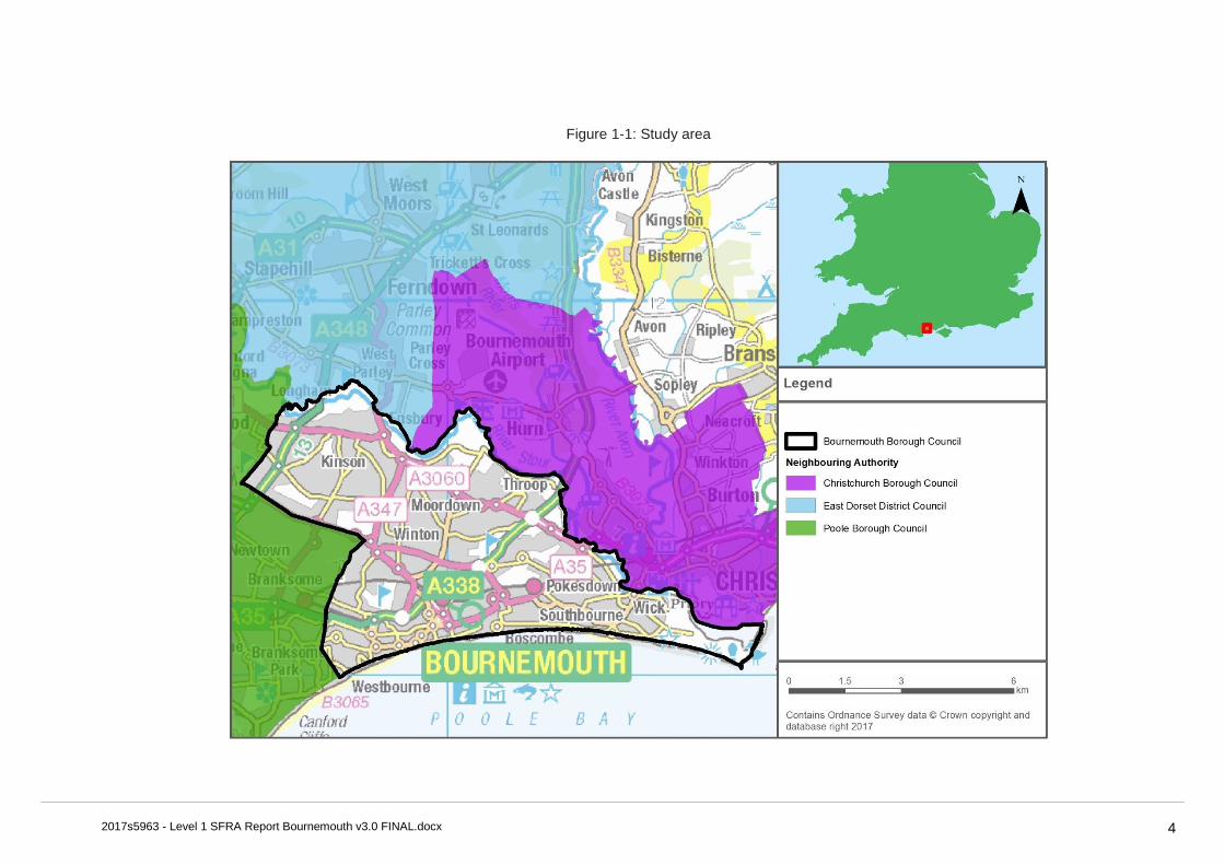
List of Figures Figure 1-1: Study area ........................................................................................................ 4
Figure 2-1: Flood Risk Regulation Requirements .............................................................. 5
Figure 2-2: Flood risk and the preparation of Local Plans† ................................................ 10
Figure 2-3: Strategic planning links and key documents for flood risk ............................... 14
Figure 3-1: Concept of Flood Zones ................................................................................... 15
Figure 3-2: Applying the Sequential Test in the preparation of a local plan ....................... 19
Figure 3-3: Applying the Exception Test in the preparation of a local plan ........................ 20
Figure 6-1: Bournemouth Topography ............................................................................... 33
Figure 6-2: Location of defences near Wick ....................................................................... 38
Figure 6-3: Design Standard of Protection for defences near Wick ................................... 39
Figure 6-4: Location of defences near Tuckton .................................................................. 40
Figure 6-5: Design Standard of Protection for defences near Tuckton .............................. 40
Figure 6-6: Location of defences near Townsend .............................................................. 41
Figure 6-7: Design Standard of Protection for defences near Townsend .......................... 42
Figure 7-1: Approach for development planning (Figure 3.1 of SC120014) ...................... 56
Figure 8-2: SuDS management train .................................................................................. 65
Figure 8-3: Groundwater Source Protection Zones ............................................................ 70
List of Tables Table 1-1: SFRA report contents ........................................................................................ 2
Table 2-1: Roles and responsibilities of Risk Management Authorities in Bournemouth ... 13
Table 3-1: Flood Zone descriptions .................................................................................... 16
Table 3-2: RoFfSW risk categories ..................................................................................... 17
Table 4-1: Peak river flow allowances for the South West river basin district .................... 24
Table 4-2: Peak rainfall intensity allowance in small and urban catchments ..................... 25
Table 4-3: Sea level allowance for each epoch in mm per year......................................... 25
Table 4-4: Peak rainfall intensity allowance in small and urban catchments ..................... 25
Table 6-1: Watercourses in the study area ......................................................................... 34
Table 6-2: Defence asset condition rating .......................................................................... 37
Table 7-2: Considerations for identifying primary sources of uncertainties in development planning (Table 3.1 of SC120014) .................................................................... 56
Table 7-3: Scoring matrix to derive confidence rating (from Table 3.3 of SC120014) ....... 57
Table 7-4: Residual uncertainty allowance for development planning (from Table 3.4 of SC120014) ........................................................................................................ 57
Table 8-2: Example SuDS design constraints and possible solutions ............................... 65

2017s5963 - Level 1 SFRA Report Bournemouth v3.0 FINAL.docx x
Using this document
Abbreviations and Glossary of Terms
Term Definition
1D model One-dimensional hydraulic model
2D model Two-dimensional hydraulic model
AEP Annual Exceedance Probability
BBC Bournemouth Borough Council
Brownfield Previously developed parcel of land
CC Climate change - Long term variations in global temperature and weather patterns caused by natural and human actions.
CDA Critical Drainage Area - A discrete geographic area (usually a hydrological catchment) where multiple and interlinked sources of flood risk (surface water, groundwater, sewer, main river and/or tidal) cause flooding in one or more Local Flood Risk Zones during severe weather thereby affecting people, property or local infrastructure.
CFMP Catchment Flood Management Plan- A high-level planning strategy through which the Environment Agency works with their key decision makers within a river catchment to identify and agree policies to secure the long-term sustainable management of flood risk.
CIRIA Construction Industry Research and Information Association
Defra Department for Environment, Food and Rural Affairs
Designated Feature A form of legal protection or status reserved for certain key structures or features that are privately owned and maintained, but which make a contribution to the flood or coastal erosion risk management of people and property at a particular location.
DG5 Register A water-company held register of properties which have experienced sewer flooding due to hydraulic overload, or properties which are 'at risk' of sewer flooding more frequently than once in 20 years.
DTM Digital Terrain Model
EA Environment Agency
EU European Union
FEH Flood Estimation Handbook
Flood defence Infrastructure used to protect an area against floods as floodwalls and embankments; they are designed to a specific standard of protection (design standard).
Flood Risk Area An area determined as having a significant risk of flooding in accordance with guidance published by Defra and WAG (Welsh Assembly Government).
Flood Risk Regulations Transposition of the EU Floods Directive into UK law. The EU Floods Directive is a piece of European Community (EC) legislation to specifically address flood risk by prescribing a common framework for its measurement and management.
Floods and Water Management Act
Part of the UK Government's response to Sir Michael Pitt's Report on the Summer 2007 floods, the aim of which is to clarify the legislative framework for managing surface water flood risk in England.
Hyperlinks
Hyperlinks have been provided where there are useful reference points. These are shown as green bold text.

2017s5963 - Level 1 SFRA Report Bournemouth v3.0 FINAL.docx xi
Term Definition
Fluvial Flooding Flooding resulting from water levels exceeding the bank level of a main river
FRA Flood Risk Assessment - A site specific assessment of all forms of flood risk to the site and the impact of development of the site to flood risk in the area.
FWMA Flood and Water Management Act
FZ Flood Zones
Greenfield Undeveloped parcel of land
Ha Hectare
HELAA Housing and Economic Land Availability Assessment. A technical piece of evidence to support local plans and Sites & Policies Development Plan Documents (DPDs). Its purpose is to demonstrate that there is a supply of housing and economic development land in the District which is suitable and deliverable.
Indicative Flood Risk Area
Nationally identified flood risk areas, based on the definition of ‘significant’ flood risk described by Defra and WAG.
JBA Jeremy Benn Associates
LFRMS Local Flood Risk Management Strategy
LIDAR Light Detection and Ranging
LLFA Lead Local Flood Authority - Local Authority responsible for taking the lead on local flood risk management
mAOD metres Above Ordnance Datum
Main River A watercourse shown as such on the Main River Map, and for which the Environment Agency has responsibilities and powers
Major development Residential development: 10 dwellings or more, or site area of 0.5 hectares or more is dwelling numbers are unknown.
Non-residential development: provision of a building or buildings where the total floor space to be created is 1,000 square metres or more, or where the flood area is not yet known, a site area of one hectare or more.
NPPF National Planning Policy Framework
NRD National Receptor Database
Ordinary Watercourse All watercourses that are not designated Main River. Local Authorities or, where they exist, IDBs have similar permissive powers as the Environment Agency in relation to flood defence work. However, the riparian owner has the responsibility of maintenance.
OS NGR Ordnance Survey National Grid Reference
PFRA Preliminary Flood Risk Assessment
Pitt Review Comprehensive independent review of the 2007 summer floods by Sir Michael Pitt, which provided recommendations to improve flood risk management in England.
Pluvial flooding Flooding as a result of high intensity rainfall when water is ponding or flowing over the ground surface (surface runoff) before it enters the underground drainage network or watercourse, or cannot enter it because the network is full to capacity.
PPG National Planning Policy Guidance
Resilience Measures Measures designed to reduce the impact of water that enters property and businesses; could include measures such as raising electrical appliances.
Resistance Measures Measures designed to keep flood water out of properties and businesses; could include flood guards for example.
RFCC Regional Flood and Coastal Committee
Risk In flood risk management, risk is defined as a product of the probability or likelihood of a flood occurring, and the consequence of the flood.
Return Period Is an estimate of the interval of time between events of a certain intensity or size, in this instance it refers to flood events. It is a statistical measurement denoting the average recurrence interval over an extended period of time.

2017s5963 - Level 1 SFRA Report Bournemouth v3.0 FINAL.docx xii
Term Definition
Sewer flooding Flooding caused by a blockage or overflowing in a sewer or urban drainage system.
SHLAA Strategic Housing Land Availability Assessment - The Strategic Housing Land Availability Assessment (SHLAA) is a technical piece of evidence to support local plans and Sites & Policies Development Plan Documents (DPDs). Its purpose is to demonstrate that there is a supply of housing land in the District which is suitable and deliverable.
SFRA Strategic Flood Risk Assessment
SMP Shoreline Management Plan
SoP Standard of Protection - Defences are provided to reduce the risk of flooding from a river and within the flood and defence field standards are usually described in terms of a flood event return period. For example, a flood embankment could be described as providing a 1 in 100-year standard of protection.
Stakeholder A person or organisation affected by the problem or solution, or interested in the problem or solution. They can be individuals or organisations, includes the public and communities.
STW Sewage Treatment Works
SuDS Sustainable Drainage Systems - Methods of management practices and control structures that are designed to drain surface water in a more sustainable manner than some conventional techniques
Surface water flooding Flooding as a result of surface water runoff as a result of high intensity rainfall when water is ponding or flowing over the ground surface before it enters the underground drainage network or watercourse, or cannot enter it because the network is full to capacity, thus causing what is known as pluvial flooding.
SWMP Surface Water Management Plan - The SWMP plan should outline the preferred surface water management strategy and identify the actions, timescales and responsibilities of each partner. It is the principal output from the SWMP study.
uFMfSW Updated Flood Map for Surface Water
WFD Water Framework Directive

2017s5963 - Level 1 SFRA Report Bournemouth v3.0 FINAL.docx 1
1 Introduction
1.1 Purpose of the Strategic Flood Risk Assessment
This Strategic Flood Risk Assessment (SFRA) 2017 document replaces the Level 1 SFRA that was published for a consortium of five Councils (Bournemouth, Christchurch, East Dorset, North Dorset and Salisbury) in February 2008. The SFRA study area for this SFRA is shown in Figure 1-1. The main purpose is to provide a comprehensive and robust flood risk evidence base to support the production of the Local Plan and to support the selection of site allocations.
The key objectives of the 2017 SFRA are:
• to provide up to date information and guidance on flood risk for Bournemouth Borough Council (BBC), taking into account the latest flood risk information (including the probable impacts of climate change), the current state of national planning policy and legislation and relevant studies;
• to provide the basis for applying the flood risk Sequential Test, and if necessary the Exception Test;
• to provide a comprehensive set of maps presenting flood risk from all sources that can be used as part of the evidence base for the local plan, and
• identify the requirements for site-specific flood risk assessments and the application of Sustainable Drainage Systems
1.2 Levels of SFRA
The Planning Practice Guidance advocates a tiered approach to risk assessment and identifies the following two levels of SFRA:
1. Level One: where flooding is not a major issue and where development pressures are low. The assessment should be sufficiently detailed to allow application of the Sequential Test.
2. Level Two: where land outside Flood Zones 2 and 3 cannot appropriately accommodate all the necessary development creating the need to apply the NPPF’s Exception Test. In these circumstances the assessment should consider the detailed nature of the flood characteristics within a Flood Zone and assessment of other sources of flooding.
This report fulfils the Level One SFRA requirements.
1.3 SFRA outputs
To meet the objectives, the following outputs have been prepared:
• Assessment of all potential sources of flooding
• Assessment of the potential impact of climate change on flood risk
• An assessment of surface water management issues and the application of Sustainable Drainage Systems (SuDS)
• A review and update of new and amended data sources (e.g. Catchment Flood Management Plans, Preliminary Flood Risk Assessment, Updated Flood Maps and modelling, etc)
• Recommendations of the criteria that should be used to assess future development proposals and the development of a Sequential Test and sequential approach to flood risk
• Guidance for developers including requirements for site-specific flood risk assessments
“Local Plans should be supported by a strategic flood risk assessment and develop policies to manage flood risk from all sources, taking account of advice from the Environment Agency and other relevant flood risk management bodies, such as Lead Local Flood Authorities and Internal Drainage Boards. Local Plans should apply a sequential, risk-based approach to the location of development to avoid, where possible, flood risk to people and property and manage any residual risk, taking account of the impacts of climate change”. (National Planning Policy Framework, paragraph 100)

2017s5963 - Level 1 SFRA Report Bournemouth v3.0 FINAL.docx 2
• Mapping of location and extent of functional floodplain
• Mapping areas at risk from other sources including surface water, sewer, ground water, reservoir inundation
• Mapping areas covered by an existing flood alert / warning
• Opportunities to reduce flood risk
• High-level screening of proposed development sites against flood risk information
• Flood defence infrastructure.
1.4 SFRA user guide
Table 1-1: SFRA report contents
Section Contents
1. Introduction Provides a background to the study, defines objectives, outlines the approach adopted and the consultation performed.
2. The Planning Framework and Flood Risk Policy
Includes information on the implications of recent changes to planning and flood risk policies and legislation, as well as documents relevant to the study.
3.The Sequential, risk based approach Describes the Sequential Approach and application of Sequential and Exception Tests.
Outlines cross-boundary issues and considerations.
4. Climate change Outlines climate change guidance and the implications for Bournemouth.
5. Sources of information used in preparing the SFRA
Outlines what information has been used in the preparation of the SFRA.
6. Understanding flood risk in Bournemouth Introduces the assessment of flood risk and provides an overview of the characteristics of flooding affecting the borough.
Provides a summary of responses that can be made to flood risk, together with policy and institutional issues that should be considered.
Outlines the flood warning service in Bournemouth and provides advice for emergency planning, evacuation plans and safe access and egress.
7. FRA requirements and flood risk management guidance
Identifies the scope of the assessments that must be submitted in FRAs supporting applications for new development.
Provides guidance for developers and outlines conditions set by the LLFA that should be followed.
8. Surface water management and SuDS Advice on managing surface water run-off and flooding and the application of SuDS.
9. Strategic flood risk solutions Overview of possible strategies to reduce flood risk
10. Summary Review of the Level 1 SFRA.
11. Recommendations Identifies recommendations for the council to consider as part of Flood Risk Management policy.
Appendix A: Flood risk mapping
Interactive maps showing flood risk information from all sources
Appendix B: Flood warning coverage
Maps of flood alerts and flood warning coverage
Appendix C: Historic flood events
Heat map of flood history

2017s5963 - Level 1 SFRA Report Bournemouth v3.0 FINAL.docx 3
1.5 Consultation
The following parties have been consulted during the preparation of this version of the SFRA:
• Environment Agency
• Bournemouth Borough Council
• Dorset County Council
• Dorset Fire & Rescue
• Wessex Water
• Neighbouring local authorities
o Christchurch Borough Council
o East Dorset District Council
1.6 Use of SFRA data
It is important to recognise that SFRAs are high level strategic documents and, as such, do not go into detail on an individual site-specific basis. The SFRA has been developed using the best available information at the time of preparation. This relates both to the current risk of flooding from rivers, and the potential impacts of future climate change.
SFRAs should be a ‘living document’, and as a result should be updated periodically taking into account new information on flood risk, new planning guidance or legislation. New information on flood risk may be provided by Bournemouth Borough Council, the Highways Authority, Dorset County Council, Bournemouth Water, Wessex Water and the Environment Agency. Such information may be in the form of:
• New hydraulic modelling results
• Flood event information following a flood event
• Policy/ legislation updates
• Environment Agency flood map updates
• New flood defence schemes etc.
The Environment Agency regularly reviews their flood risk mapping, and it is important that they are approached to determine whether updated (more accurate) information is available prior to commencing a detailed Flood Risk Assessment. It is recommended that the SFRA is reviewed internally, in line with the Environment Agency’s Flood Zone map updates to ensure latest data is still represented in the SFRA, allowing a cycle of review and a review of any updated data by checking with the above bodies for any new information.
2017s5963 - Level 1 SFRA Report Bournemouth v3.0 FINAL.docx 4
Figure 1-1: Study area

2017s5963 - Level 1 SFRA Report Bournemouth v3.0 FINAL.docx 5
2 The Planning Framework and Flood Risk Policy
2.1 Introduction
The overarching aim of development and flood risk planning policy in the UK is to ensure that the potential risk of flooding is taken into account at every stage of the planning process. This section of the SFRA provides an overview of the planning framework, flood risk policy and flood risk responsibilities.
2.2 Flood Risk Regulations (2009) and Flood and Water Management Act (2010)
2.2.1 Flood Risk Regulations, 2009
The Flood Risk Regulations (2009) translate the current EU Floods Directive into UK law and place responsibility upon all Lead Local Flood Authorities (LLFAs) to manage localised flood risk. Under the Regulations, the responsibility for flooding from rivers, the sea and reservoirs lies with the Environment Agency; however, responsibility for local and all other sources of flooding rests with LLFAs. In the instance of this SFRA, the LLFA is Bournemouth Borough Council. Detail on the responsibilities of LLFAs is provided in Section 2.9.
Figure 2-1 illustrates the steps that have / are being taken to implement the requirements of the EU Directive in the UK via the Flood Risk Regulations.
Figure 2-1: Flood Risk Regulation Requirements
2.2.2 Preliminary Flood Risk Assessments (PFRAs)
Under this action plan and in accordance with the Regulations, LLFAs had the task of preparing a Preliminary Flood Risk Assessment (PFRA) report.
PFRAs report on significant past and future flooding from all sources except from Main Rivers and reservoirs, which are covered by the Environment Agency, and sub-standard performance of the adopted sewer network (covered under the remit of Wessex Water). PFRAs are a high-level screening exercise and consider floods which have significant harmful consequences for human health, economic activity, the environment and cultural heritage.
The PFRA document that covers the study area was published by Bournemouth Borough Council in June 2011.

2017s5963 - Level 1 SFRA Report Bournemouth v3.0 FINAL.docx 6
The Regulations required the LLFA to identify significant Flood Risk Areas on a six year cycle, with the first reporting being performed in 2011. The threshold for designating significant Flood Risk Areas as first defined by Defra and the PFRA was the process by which these locations were identified. Of the ten national indicative Flood Risk Areas that were originally identified by Defra/Environment Agency, none encroach on the administrative area of Bournemouth Borough Council and the indicative designations were accepted.
Given that the local flood risks across both Bournemouth did not meet the national significance threshold set by Defra in 2011 or 2017, no additional Flood Risk Areas have been identified within the study area by Bournemouth Borough Council.
However, it should be noted that areas lying outside the national indicative Flood Risk Areas are still at risk of flooding from local sources in Bournemouth. A definition of a “locally significant event” was therefore proposed by Dorset County Council and agreed by the South West Flood Managers Group as a consistent definition for identifying Flood Risk Areas in South West PFRAs and informing flood risk management strategies across the South West region.
The process of review of the PFRAs was performed in 2017 and the Environment Agency issued guidance to Lead Local Flood Authorities in Review of preliminary flood risk assessments (Flood Risk Regulations 2009): guidance for Lead Local Flood Authorities in England (Environment Agency, January 2017). The January 2017 guidance provided templates to enable LLFAs to perform the review and also included updates to the locations of the Indicative Flood Risk Areas (FRAs) (showing locations predicted to be at significant local flood risk). The updated guidance did not identify new FRAs in Bournemouth.
Bournemouth Borough Council have submitted a draft update to the Environment Agency for review. This update is understood to include no major changes from the original document but information on the detailed surface water modelling undertaken in Bournemouth has been included, although the outputs have not been agreed as local flood maps. The flood history data has also been updated. Further information on this update can be sought from the Council.
2.2.3 Flood Risk Management Plans (FRMPs)
Under the Regulations, the Environment Agency exercised an ‘Exception’ and did not prepare a PFRA for risk from rivers, reservoirs and the sea. Instead, a Flood Risk Management Plan (FRMP) was prepared and published. The FRMP summarises the flooding affecting the area and describe the measures to be taken to address the risk in accordance with the Flood Risk Regulations. The final South West River Basin District Flood Risk Management Plan was issued in March 2016 and covers the period 2015 to 20211. The FRMP draws on previous policies and actions identified in Catchment Flood Management Plans (Section 2.6) and also incorporates information from Local Flood Risk Management Strategies (Section 2.2.5).
2.2.4 Flood and Water Management Act (FWMA), 2010
Following the 2007 floods, Sir Michael Pitt was appointed to chair an independent review into the floods. The final report was published in June 2008. The Flood and Water Management Act (2010)2 implements Sir Michael Pitt’s recommendations and aims to create a simpler and more effective means of managing both flood risk and coastal erosion.
The FWMA established Lead Local Flood Authorities (LLFAs). Duties for LLFAs include:
• Local Flood Risk Management Strategy (LFRMS): LLFAs must develop, maintain, apply and monitor a LFRMS to outline how they will manage flood risk, identify areas vulnerable to flooding and target resources where they are needed most.
• Flood Investigations: When appropriate and necessary LLFAs must investigate and report on flooding incidents (Section 19 investigations).
• Register of Flood Risk Features: LLFAs must establish and maintain a register of structures or features which, in their opinion, are likely to have a significant effect on flood risk in the LLFA area.
1 Environment Agency, (March, 2016), South West River Basin District Flood Risk Management Plan 2015 to 2021
2 Flood and Water Management Act (2010): http://www.legislation.gov.uk/ukpga/2010/29/pdfs/ukpga_20100029_en.pdf

2017s5963 - Level 1 SFRA Report Bournemouth v3.0 FINAL.docx 7
• Designation of Features: LLFAs may exercise powers to designate structures and features that affect flood risk, requiring the owner to seek consent from the authority to alter, remove or replace it.
• Consenting: When appropriate LLFAs will perform consenting of works on ordinary watercourses.
Bournemouth Borough Council is the LLFA for its administrative area.
2.2.5 Bournemouth Local Flood Risk Management Strategy (2015)
The LFRMS is used as a means by which the LLFA co-ordinates flood risk management on a day to day basis. The LFRMS also sets measures to manage local flood risk i.e. flood risk from surface water, groundwater and ordinary watercourses.
The following objectives proposed in the Strategy for managing flood risk across Bournemouth are:
• To improve the understanding of the causes of local flooding;
• To identify what practical solutions can be implemented to resolve local flooding. Alternatively, if a wide-scale solution is not practical then, where possible, to assist owners in improving the resilience / protection of their properties;
• To use all available data to try and ensure that any new developments are not at risk of flooding and where possible, that any re-development can reduce existing problems;
• To assist the wider community in improving resilience and minimise the consequence of future flood risk.
The Strategy also sets out how the LLFA intends to achieve these objectives. The Strategy should be reviewed and updated regularly. The Strategy states that it will be reviewed initially after 2 years of adoption by the Council by the Flood Advisory Group. Depending on the consultation on their findings, a longer period until the next review may be recommended but will be no longer than 4 years.
The Strategy should also be reviewed and updated when key triggers are activated. An example of a key trigger would be issues such as amendments to partner responsibilities, updates to legislation, alterations in the nature or understanding of flood risk or a significant flood event.
2.2.6 LLFAs, surface water and SuDS
On 18 December 2014 a Written Ministerial Statement made by the Secretary of State for Communities and Local Government set out changes to the planning process that would apply for major development from 6 April 2015. When considering planning applications, local planning authorities should consult the LLFA on the management of surface water in order to satisfy that:
• the proposed minimum standards of operation are appropriate
• there are clear arrangements for on-going maintenance over the development’s lifetime, through the use of planning conditions or planning obligations.
In March 2015 the LLFA was made a statutory consultee for planning applications for major development and this came into effect on 15 April 2015. As a result, Bournemouth Borough Council will be required to provide technical advice on surface water drainage strategies and designs put forward for new major developments.
Major developments are defined as
• residential development: 10 dwellings or more, or residential development with a site area of 0.5 hectares or more where the number of dwellings is not yet known; and
• Non-residential development: provision of a building or buildings where the total floor space to be created is 1,000 square metres or more or, where the floor area is not yet known, a site area of 1 hectare or more.
There is also an aspiration for Bournemouth Borough Council to produce a local SuDS guidance document for both major and minor development but this has not been available at the time of writing this SFRA. Should this become available, the local planning authority should liaise with the LLFA to confirm SuDS requirements. Developers will need to meet the requirements within this document.

2017s5963 - Level 1 SFRA Report Bournemouth v3.0 FINAL.docx 8
2.2.7 The National Flood and Coastal Erosion Risk Management Strategy for England (2011)
The National Flood and Coastal Erosion Risk Management Strategy for England provides the overarching framework for future action by all risk management authorities to tackle flooding and coastal erosion in England. It was prepared by the Environment Agency with input from Defra.
This strategy builds on existing approaches to flood and coastal risk management and promotes the use of a wide range of measures to manage risk. It describes how risk should be managed in a co-ordinated way within catchments and along the coast and balance the needs of communities, the economy and the environment.
The strategy encourages more effective risk management by enabling people, communities, business, infrastructure operators and the public sector to work together to:
• ensure a clear understanding of the risks of flooding and coastal erosion, nationally and locally, so that investment in risk management can be prioritised more effectively;
• set out clear and consistent plans for risk management so that communities and businesses can make informed decisions about the management of the remaining risk;
• manage flood and coastal erosion risks in an appropriate way, taking account of the needs of communities and the environment;
• ensure that emergency plans and responses to flood incidents are effective and that communities are able to respond effectively to flood forecasts, warnings and advice;
• help communities to recover more quickly and effectively after incidents.
The Strategy is reviewed every six years and is this due for re-issue in 2017. The reissued document has not been available within the timescales of this SFRA. It may therefore be necessary to update the SFRA, once this becomes available, to reflect any changes in the strategy for the area as this may affect strategic planning.
2.3 National Planning Policy and Guidance
The National Planning Policy Framework (NPPF)3 was issued in 2012 to replace the previous documentation as part of reforms to make the planning system less complex and more accessible, and to protect the environment and promote sustainable growth. It replaces most of the Planning Policy Guidance Notes (PPGs) and Planning Policy Statements (PPSs) that were referred to in the previous version of the SFRA. The NPPF sets out the Government’s requirements for the planning system and provides a framework within which local people and councils can produce distinctive local and neighbourhood plans to reflect the needs and properties of their communities. The NPPF must be taken into account by local planning authorities when preparing Local Plans and for applicants preparing planning submissions.
National Planning Practice Guidance (NPPG) was published in 2014 and sets out how the NPPF should be implemented. NPPG: Flood Risk and Coastal Change advises on how planning can account for the risks associated with flooding and coastal change in plan making and the application process. It sets out Flood Zones, the appropriate land uses for each zone, flood risk assessment requirements, including the Sequential and Exception Tests and the policy aims for developers and authorities regarding each Flood Zone. Further details on Flood Zones and associated policy is provided in Table 3-1 and throughout this report. The Sequential and Exception tests are covered in greater detail in Section 3.
3 National Planning Policy Framework (Department for Communities and Local Government, March 2012)

2017s5963 - Level 1 SFRA Report Bournemouth v3.0 FINAL.docx 9
A description of how flood risk should be taken into account in the preparation of Local Plans is outlined in Diagram 1 contained within the Planning Practice Guidance (Figure 2-2).
The Sequential Test
“The Sequential Test ensures that a sequential approach is followed to steer new development to areas with the lowest probability of flooding. The flood zones, as refined in the Strategic Flood Risk Assessment for the area, provide the basis for applying the Test. The aim is to steer new development to Flood Zone 1 (areas with a low probability of river or sea flooding). Where there are no reasonably available sites in Flood Zone 1, local planning authorities in their decision making should take into account the flood risk vulnerability of land uses and consider reasonably available sites in Flood Zone 2 (areas with a medium probability of river or sea flooding), applying the Exception Test if required. Only where there are no reasonably available sites in Flood Zones 1 or 2 should the suitability of sites in Flood Zone 3 (areas with a high probability of river or sea flooding) be considered, taking into account the flood risk vulnerability of land uses and applying the Exception Test if required”.
(National Planning Practice Guidance, paragraph 019)
The Exception Test
“The Exception Test, as set out in paragraph 102 of the NPPF, is a method to demonstrate and help ensure that flood risk to people and property will be managed satisfactorily, while allowing necessary development to go ahead in situations where suitable sites at lower risk of flooding are not available.
Essentially, the two parts to the Test require proposed development to show that it will provide wider sustainability benefits to the community that outweigh flood risk, and that it will be safe for its lifetime, without increasing flood risk elsewhere and where possible reduce flood risk overall.”.
(National Planning Practice Guidance, paragraph 023)

2017s5963 - Level 1 SFRA Report Bournemouth v3.0 FINAL.docx 10
Figure 2-2: Flood risk and the preparation of Local Plans†
† Diagram 1 of NPPG: Flood Risk and Coastal Change (paragraph 004, Reference ID: 7-005-20140306) March 2014
2.4 Water Cycle Studies
Climate Change is predicted to present unprecedented new challenges, such as more frequent and extreme rainfall events and rising global temperatures, which are expected to exert greater pressure on the existing infrastructure. Planning for water management therefore has to take these potential challenges into account. A large number of new homes for instance may cause the existing water management infrastructure to be overwhelmed which would result in adverse effects on the environment, both locally and in wider catchments.
Water Cycle Studies assist Local Authorities to select and develop sustainable development allocations so that there is minimal impact on the environment, water quality, water resources, and infrastructure and flood risk. This can be achieved in areas where there may be conflict between any proposed development and the requirements of the environment through the recommendation of potential sustainable solutions.
At the time of undertaking this SFRA, there was no specific requirement for Bournemouth Borough Council to prepare or publish any water cycle studies for the study area4. However, a water cycle study may be recommended if there is a requirement for a SWMP and/or it is uncertain whether the environmental capacity of the water cycle to cope with future proposed development is adequate.
4 Dorset County Council, (December, 2010), Bournemouth, Dorset and Poole Level 1 SFRA for minerals and waste (Volume 1 SFRA Report – Section 4.8).

2017s5963 - Level 1 SFRA Report Bournemouth v3.0 FINAL.docx 11
2.5 Surface Water Management Plans
Surface Water Management Plans (SWMPs) outline the preferred surface water management strategy in a given location. SWMPs are undertaken by LLFAs in consultation with key local partners who are responsible for surface water management and drainage in their area. SWMPs establish a long-term action plan to manage surface water in a particular area and are intended to influence future capital investment, drainage maintenance, public engagement and understanding, land-use planning, emergency planning and future developments.
2.5.1 Bournemouth Borough Council SWMP (2010)
Bournemouth Borough Council was awarded a grant in September 2009 to fund the development and preparation of a SWMP. This grant was awarded because Bournemouth was found to have approximately 4,000 properties theoretically at risk of flooding based on the national mapping of Areas Susceptible to Surface Water Flooding (AStSWF) used at the strategic assessment level. The SWMP also references a local SuDS guidance document; more detail is provided in Section 8.4.1.
The Bournemouth Borough Council SWMP was consequently prepared and published in November 2010. The SWMP comprises an intermediate assessment of flood risk across the borough in order to provide a greater understanding of localised surface water flooding. The assessment identifies the nature and source as well as the frequency and severity of flooding across the study area based on a variety of more detailed surface water modelling methods.
The results of the modelling identified 20 priority high risk areas for further detailed assessment. Feasibility outline options were developed for these areas using consideration of local topography and engineering solutions. In all cases, the options recommended will require further assessment to determine specific dimensions, benefits and costs. Such assessments will aim to ensure that a cost-effective solution can be established and taken forward to mitigate the risk of flooding in these areas.
2.6 Catchment Flood Management Plans
Catchment Flood Management Plans (CFMPs) are high-level strategic plans providing an overview of flood risk across each river catchment. The Environment Agency use CFMPs to work with other key-decision makers to identify and agree long-term policies for sustainable flood risk management.
There are six pre-defined national policies provided in the CFMP guidance and these are applied to specific locations through the identification of ‘Policy Units’. These policies are intended to cover the full range of long-term flood risk management options that can be applied to different locations in the catchment.
The six national policies are:
1. No active intervention (including flood warning and maintenance). Continue to monitor and advise.
2. Reducing existing flood risk management actions (accepting that flood risk will increase over time).
3. Continue with existing or alternative actions to manage flood risk at the current level (accepting that flood risk will increase over time from this baseline).
4. Take further action to sustain the current level of flood risk (responding to the potential increases in risk from urban development, land use change and climate change).
5. Take action to reduce flood risk (now and/or in the future)
6. Take action with others to store water or manage run-off in locations that provide overall flood risk reduction or environmental benefits, locally or elsewhere in the catchment.
2.6.1 Dorset Stour CFMP (2009)
The study area is covered by the Dorset Stour CFMP. The primary policy unit for Bournemouth is Sub Area 1. This area is covered by Policy Option 4, which is for areas of low to moderate or high flood risk where the Environment Agency are already managing the flood risk effectively but where further action may be needed to keep pace with climate change.
The proposed actions to implement this policy include:

2017s5963 - Level 1 SFRA Report Bournemouth v3.0 FINAL.docx 12
• Strengthening Development Control advice, including the use of SuDS through Local Development Framework policies to ensure no increase in runoff from new developments and seek opportunities to reduce runoff where possible.
• Development Surface Water Management Plans.
• Undertake a study of Ilford, railway and Tuckton bridges under flood conditions and from extreme tides.
• Assess potential for improving current defences to retain standard of protection in the future, as part of the System Asset Management Plan.
• Install monitoring equipment to quantify surface water flooding in urban areas.
• Increase coverage of Flood Warnings Direct service [note: this has now been replaced by the Flood Warning Service (FWS)], in Bournemouth and Christchurch.
• Improve and development emergency response and Major Incident Plans.
2.7 River Basin Management Plans
River Basin Management Plans (RBMPs) are prepared under the Water Framework Directive (WFD) and assess the pressure facing the water environment in River Basin Districts. Bournemouth falls within the South West River Basin District.
The updated 2015 South West River RBMP identified a number of pressures on the water environment and significant water management issues.
The RBMP describes how development and land-use planning needs to consider a number of issues relevant to the RBMP including sustainable drainage systems, green and blue infrastructure, sewage treatment options (tertiary phosphate treatments), water efficiency measures, infrastructure and development locations and the reduction of nutrients from diffuse pollution. The RBMP provides a summary of measures to protect and improve the water environment in the river basin district.
2.8 Shoreline Management Plans
The Shoreline Management Plan (SMP) forms part of Defra’s strategy for flood and coastal defence. It provides a large-scale assessment of risks associated with coastal evolution and presents the policy framework to address these risks in a sustainable manner. The SMP policies defined by Defra are:
• Hold the line – maintain or upgrade the level of protection provided by defences.
• Advance the line – build new defences seaward of the existing defence line.
• Managed realignment – allowing retreat of the shoreline, with management to control or limit the movement.
• No active intervention – a decision not to invest in providing or maintaining defences.
Coastal flooding of the Bournemouth coastline is managed through the Poole and Christchurch Bays SMP. Development and land-use planning across the Borough will also need to consider the policies outlined by the SMP.
2.8.1 Poole to Christchurch Bays SMP (2010)
The Poole and Christchurch Bays Shoreline Management Plan (SMP2) was published in October 2010 following a review of the original SMP produced in 1999. The SMP covers a total of 190km of coastline between Durlston Head in the west and Hurst Spit in the east.
The long-term policy for the majority of the coastline within Bournemouth Borough Council’s administrative area is to ‘Hold / Advance the Line. However, the long-term policy for the coastline between Hengistbury Head and Southbourne is ‘Managed Realignment’ of the shoreline.
2.9 Implications for Bournemouth
The roles and responsibilities under the Flood and Water Management Act 2010 and the Flood Risk Regulations 2009 are summarised in Table 2-1.

2017s5963 - Level 1 SFRA Report Bournemouth v3.0 FINAL.docx 13
Table 2-1: Roles and responsibilities of Risk Management Authorities in Bournemouth
Risk Management
Authority (RMA)
Strategic Level Roles
Operational Level Roles
Environment Agency
National Statutory Strategy
Reporting and supervision (overview role)
• Preliminary Flood Risk Assessment (per River Basin District)*
• Managing flooding from main rivers and reservoirs and communication flood risk warnings to the public, media and partner organisations.
• Identifying Significant Flood Risk Areas*
• Preparation of Flood Risk and Hazard Maps
• Preparation of Flood Risk Management Plans
• Enforcement authority for Reservoirs Act 1975
• Managing RFCCs and supporting funding decisions, working with LLFAs and local communities.
• Emergency planning and multi-agency flood plans, developed by local resilience forums
Lead Local Flood Authority
(Bournemouth Borough Council)
Input to National Strategy.
Formulate and implement Local Flood Risk Management Strategies
• Responsible for enforcing and consenting works for Ordinary Watercourses, risk assessing Ordinary Watercourses.
• Managing local sources of flooding from surface water runoff and groundwater and carrying out practical works to manage flood risk from these sources where necessary.
• Preparing and publishing a PFRA
• Identifying Flood Risk Areas
• Preparing Flood Hazard and Flood Risk Maps
• Preparing Flood Risk Management Plans (where local flood risk is significant)
• Investigating certain incidents of flooding in Section 19 Flood Investigations
• Statutory roles in planning for surface water drainage.
• Keeping asset registers of structures and features which have a significant effect on local flood risk.
• Acting consistently with LFRMS in realising FRM activity and have due regard in the discharge of other functions of the strategy
Local Planning Authority
(Bournemouth Borough Council)
Input to National and Local Authority Plans and Strategy
(e.g. Bournemouth Local Plan – to develop a spatial strategy for growth within the area which accounts for flood risk)
• Preparation of a Local Plan to guide development.
• The competent determining authority for planning applications which has the ultimate decision on the suitability of a site in relation to flood risk and management of surface water run-off.
• Responsibilities for emergency planning as a responder to a flood event.
• Own and manage public spaces which can potentially be used for flood risk management.
Water and wastewater providers
(Wessex Water and Bournemouth
Water)
Input into Local Authority Plans and site-specific planning applications /decisions
• Maintain surface, foul and combined public sewers to ensure the area is effectively drained.
• Assess whether the public system has the capacity to accept flows from a proposed development as part of their pre-application service
• Comment on the available capacity of foul and surface water sewers as part of the planning application process.
• Provide solutions that identify the necessary mitigation measures for drainage of proposed developments.
• Providing consent, prior to commencing work, if installing water systems, or altering existing systems, is intended.

2017s5963 - Level 1 SFRA Report Bournemouth v3.0 FINAL.docx 14
2.10 Key strategic planning links
Figure 2-3 outlines the key strategic planning links for flood risk management and associated documents. It shows how the Flood Risk Regulations and Flood and Water Management Act, have introduced a wider requirement for the mutual exchange of information and the preparation of strategies and management plans.
Figure 2-3: Strategic planning links and key documents for flood risk

2017s5963 - Level 1 SFRA Report Bournemouth v3.0 FINAL.docx 15
3 The sequential, risk-based approach
3.1 Flood risk and sequential approach overview
Flood risk is defined as the combination of the probability of a flood occurring with its potential consequences. It is often useful to express the definition as follows:
The sequential approach is designed to ensure areas with little or no risk of flooding (from any source) are developed in preference to areas at higher risk, with the aim of keeping development outside of medium and high flood risk areas (Flood Zones 2 and 3) and other sources of flooding, where possible. This reduces receptor presence and vulnerability in areas where there is a high probability of flooding, reducing the risk. A concept diagram showing the classification of Flood Zones graphically is included in Figure 3-1.
Figure 3-1: Concept of Flood Zones
When drawing up a local plan, it is often the case that it is not possible for all new development to be allocated on land that is not at risk from flooding. In these circumstances the Flood Zone maps (that show the extent of inundation assuming that there are no defences) are too simplistic and a greater understanding of the scale and nature of the flood risks is required.
Flood Risk
Probability Flood Hazard
Magnitude Receptor Presence
Receptor Vulnerability
Consequences

2017s5963 - Level 1 SFRA Report Bournemouth v3.0 FINAL.docx 16
3.1.1 Flood Zones
Table 1 of NPPG Flood Risk and Coastal Change identifies the following Flood Zones. These apply to both Main River and ordinary watercourses as well as flood risk from the sea. Flood risk vulnerability and flood zone compatibility is set out in Table 3 of the NPPG. It should be noted that Flood Zones 1 to 3a describe the risk for a scenario where there are no flood risk management measures in place (such as flood defences), whereas Flood Zone 3b includes the presence of flood defences, on the basis that it is describing areas that can actually store water during a flood. Table 3-1 summarises this information and also provides information on when an FRA would be required.
Table 3-1: Flood Zone descriptions
Zone Probability Description
Zone 1
Low
This zone comprises land assessed as having a less than 1 in 1000 annual probability of river or sea flooding in any year (<0.1%).
All land uses are appropriate in this zone.
For development proposals on sites comprising one hectare or above the vulnerability to flooding from other sources as well as from river and sea flooding, and the potential to increase flood risk elsewhere through the addition of hard surfaces and the effect of the new development on surface water run-off, should be incorporated in a flood risk assessment.
Zone 2
Medium
This zone comprises land assessed as having between a 1 in 100 and 1 in 1,000 annual probability of river flooding (0.1% - 1%) or between 1 in 200 and 1 in 1,000 annual probability of sea flooding (0.1% – 0.5%) in any year.
Essential infrastructure, water compatible infrastructure, less vulnerable and more vulnerable land uses (as set out by NPPF) are appropriate in this zone. Highly vulnerable land uses are allowed as long as they pass the Exception Test.
All developments in this zone require an FRA.
Zone 3a
High
This zone comprises land assessed as having a greater than 1 in 100 annual probability of river flooding (>1.0%) or a greater than 1 in 200 annual probability of flooding from the sea (>0.5%) in any year. Developers and the local authorities should seek to reduce the overall level of flood risk, relocating development sequentially to areas of lower flood risk and attempting to restore the floodplain and make open space available for flood storage.
Water compatible and less vulnerable land uses are permitted in this zone. Highly vulnerable land uses are not permitted. More vulnerable and essential infrastructure are only permitted if they pass the Exception Test.
All developments in this zone require an FRA.
Zone 3b
Functional Floodplain
This zone comprises land where water has to flow or be stored in times of flood. Local planning authorities should identify, in their SFRA, areas of functional floodplain, in agreement with the Environment Agency. The identification of functional floodplain should take account of local circumstances. The approach for identifying the functional floodplain is detailed in Section 5.2.1 of this SFRA report.
Only water compatible and essential infrastructure are permitted in this zone and should be designed to remain operational in times of flood, resulting in no loss of floodplain or blocking of water flow routes. They must also be safe for users and not increase flood risk elsewhere. Essential Infrastructure will only be permitted if it passes the Exception Test.
All developments in this zone require an FRA.
3.1.2 Surface water flood risk information
In 2016, the Environment Agency, working with LLFAs, produced the Risk of Flooding from Surface Water (RoFfSW) dataset. This superseded the previous Flood Map for Surface Water and Areas Susceptible to Surface Water Flooding maps. The RoFfSW is a national scale map and assesses flooding scenarios as a result of rainfall with the following chance of occurring in any given year. It is intended to provide a consistent standard of assessment for surface water flood risk across

2017s5963 - Level 1 SFRA Report Bournemouth v3.0 FINAL.docx 17
England and Wales in order to help LLFAs, the Environment Agency and any potential developers to focus their management of surface water flood risk.
The RoFfSW is derived primarily from identifying topographical flow paths of existing watercourses or dry valleys that contain some isolated ponding locations in low lying areas. They provide a map which displays different levels of surface water flood risk depending on the annual probability of the land in question being inundated by surface water (Table 3-2).
Table 3-2: RoFfSW risk categories
Risk Definition
High Probability of flooding greater than 1 in 30 (3.3%) each year.
Medium Probability of flooding between 1 in 100 (0.1%) and 1 in 30 (3.3%) each year.
Low Probability of flooding between 1 in 1,000 (0.1%) and 1 in 100 (1%) each year.
Very Low Probability of flooding of less than 1 in 1,000 (0.1%) each year
Although the RoFfSW offers improvement on previously available datasets, the results should not be used to understand flood risk for individual properties. The results should be used for high level assessments such as SFRAs for local authorities. If a particular site is indicated in the Environment Agency mapping to be at risk from surface water flooding, a more detailed assessment should be considered to more accurately illustrate the flood risk at a site-specific scale. Such an assessment will use the RoFfSW in partnership with other sources of local flooding information to confirm the presence of a surface water risk at that particular location.
The surface water map is available via the Long term flood risk information page on the government’s website, and is also provided in Appendix A of this SFRA. In addition to showing the extent of surface water flooding, there are depth and velocity maps for each risk category.
In addition to the national dataset, Bournemouth Borough Council have undertaken detailed surface water modelling for the majority of the study area. This is discussed further in Section 5.2.2. Results mapping has been produced for a range of return periods and storm durations. A worst-case composite grid of all tested storm durations for the 1 in 100-year return period event has been supplied for use in this SFRA. This can be used to delineate areas which are considered to be at medium to high risk of surface water flooding.
These maps should be used when considering other sources of flooding when applying the Sequential and Exception tests. Mapping from the local and national datasets show good agreement in some areas but there are a number of locations where differences are shown due differing assumptions and modelling methods. Given the residual uncertainties in both datasets, it is recommended that both sources are used when planning for flood risk at a strategic level.
3.1.3 Groundwater flood risk information
Groundwater flood risk is often difficult to quantify and there is limited data available with which to assign a probability to a flood event and assess the risk. The risk of groundwater emergence is often assessed qualitatively based on soil conditions, topography and the location of nearby water sources to give an indication of susceptibility. Local borehole records and records of previous flood events can also be used to supplement this information and identify locations which are at risk.
For this SFRA, the BGS susceptibility to groundwater flooding dataset has been used, supplemented with flood history data where available. It is important to note that the BGS dataset maps susceptibility only and does not give an indication of the actual level of risk. Further information on the susceptibility dataset and its limitations can be found in Section 5.2.3.
3.1.4 Reservoir flood risk information
The risk of reservoir flooding is usually considered to be low. Whilst the consequences would be significant (with the potential for deep, fast-flowing water with little warning), the probability of reservoir breach is generally expected to be very low due to the inspection and maintenance regime required under the Reservoirs Act 1975.
Reservoir flood mapping usually considers the maximum area with the potential to flood from reservoir breach rather than quantifying the risk. Sites requiring an evacuation plan which lie within this area will need to consider the potential hazard to occupants in the plan and recommend

2017s5963 - Level 1 SFRA Report Bournemouth v3.0 FINAL.docx 18
mitigation for this where required. Other vulnerable sites, particularly those located immediately downstream of a reservoir may also need to mitigate this risk.
3.1.5 Sewer flood risk information
There is limited information with which to quantify sewer flood risk, especially as flooding can occur as a result of blockage or damage as well as through lack of capacity. Flood history data can be used to identify locations where there has previously been sewer flooding (either foul or surface water). This is a useful starting point in identifying areas where there may be a lack of sewer capacity or a recurring blockage issue. However, it should be remembered that sewer flooding could occur anywhere there is a sewer system in place. Additionally, areas which have previously flooded may no longer be at high risk if the underlying issue has been resolved. The sewerage undertaker for the area may be able to provide further information on where there are known issues.
Wessex Water is the statutory provider of wastewater services in the Bournemouth area. Wessex Water has provided details of incidents of sewer flooding in the area to indicate possible areas of sewer incapacity. Flood risk has been reduced in some areas by flood alleviation schemes.
3.2 Applying the Sequential Test and Exception Test in the preparation of a Local Plan
3.2.1 The Sequential Test
When preparing a Local Plan, the Local Planning Authority should demonstrate it has considered a range of site allocations, using SFRAs to apply the Sequential and Exception Tests where necessary.
The Sequential Test should be applied to the whole study area to increase the likelihood of allocating development in areas not at risk of flooding. It is recommended that the Council considers using the SFRA climate change maps, where available, when applying the Sequential Test for site allocations and windfall sites. The Sequential Test can be undertaken as part of a Local Plan Sustainability Appraisal. Alternatively, it can be demonstrated through a free-standing document, or as part of Strategic Housing Land (or employment) Availability Assessments (SHLAAs). The NPPG for Flood Risk and Coastal Change describes how the Sequential Test should be applied in the preparation of a local plan (Figure 3-2).

2017s5963 - Level 1 SFRA Report Bournemouth v3.0 FINAL.docx 19
Figure 3-2: Applying the Sequential Test in the preparation of a local plan
3.2.2 Applying the Sequential Test for areas at risk of surface water flooding
The NPPF states that other sources of flooding should be considered when applying the Sequential Test (see Figure 3-2). This is of particular importance in Bournemouth where it is known that there are areas at significant surface water flood risk which are shown to be located in Flood Zone 1 due to the low risk from fluvial and tidal sources. Furthermore, Bournemouth Local Flood Risk Management Strategy states that all available data should be used to try to ensure that any new developments are not at risk of flooding.
In applying the Sequential Test, the Local Planning Authority should consider the risk of flooding from surface water (and other sources) and aim to allocate development outside of areas shown to be at medium or high risk in either the national or local mapping. As with flooding from fluvial and tidal sources, a sequential approach should be used to first allocate sites in areas at the lowest risk before considering sites at higher risk.
3.2.3 The Exception Test
The Exception Test should only be applied following the application of the Sequential Test and as set out in Table 3 of the NPPG Flood Risk and Coastal Change. The NPPG describes how the Exception Test should be applied in the preparation of a Local Plan (Figure 3-3).

2017s5963 - Level 1 SFRA Report Bournemouth v3.0 FINAL.docx 20
Figure 3-3: Applying the Exception Test in the preparation of a local plan
3.3 Applying the Sequential Test and Exception Test to individual planning applications
3.3.1 Sequential Test
Local circumstances must be used to define the area of application of the Sequential Test (within which it is appropriate to identify reasonably available alternatives). The criteria used to determine the appropriate search area relate to the catchment area for the type of development being proposed. For some sites this may be clear, in other cases it may be identified by other local plan policies. A pragmatic approach should be taken when applying the Sequential Test.
Bournemouth Borough Council, with advice from the Environment Agency, are responsible for considering the extent to which Sequential Test considerations have been satisfied, and will need to be satisfied that the proposed development would be safe and not lead to increased flood risk elsewhere.
The Sequential Test does not need to be applied for individual developments under the following circumstances:
• The site has been identified in development plans through the Sequential Test
• Applications for minor development or change of use (except for a change of use to a caravan, camping or chalet site, or to a mobile home or park home site)
It is normally reasonable to presume and state that individual sites that lie in Flood Zone 1 satisfy the requirements of the Sequential Test. However, consideration should be given to risks from all sources, areas with critical drainage problems and critical drainage areas. For Bournemouth the flood risk from surface water is of particular importance.
3.3.2 Exception Test
If, following application of the Sequential Test, it is not possible for the development to be located in areas with a lower probability of flooding the Exception Test must then be applied if deemed appropriate. The aim of the Exception Test is to ensure that more vulnerable uses, such as residential development can be implemented safely and are not located in areas where the hazards
Is the Exception test required/
Table 3 of NPPF Planning Practice
Guidance)
Does the development pass both
parts of the Exception test?
Has the Sequential test been applied?
Carry out Sequential Test (Figure 3-1)
Development is in an appropriate
location under NPPF flood risk policy
(Tables 2 and 3 of NPPF Planning
Practice Guidance)
Development can be considered for
allocated or permission
Development is not appropriate and
should not be allocated or permitted
YES
YES
YES
START
NO
NO
NO
Has the Sequential test been
applied?

2017s5963 - Level 1 SFRA Report Bournemouth v3.0 FINAL.docx 21
and consequences of flooding are inappropriate. For the test to be satisfied, the following two elements have to be accepted for development to be allocated or permitted:
• It must be demonstrated that the development provides wider sustainability benefits to the community that outweigh flood risk, informed by a SFRA where one has been prepared.
Local Planning Authorities will need to consider what criteria they will use to assess whether this part of the Exception Test has been satisfied, and give advice to enable applicants to provide evidence to demonstrate that it has been passed. If the application fails to prove this, the Local Planning Authority should consider whether the use of planning conditions and / or planning obligations could allow it to pass. If this is not possible, this part of the Exception Test has not been passed and planning permission should be refused5.
• A site-specific Flood Risk Assessment must demonstrate that the development will be safe for its lifetime, taking account of the vulnerability of its users, without increasing flood risk elsewhere, and, where possible, will reduce flood risk overall.
The site-specific Flood Risk Assessment should demonstrate that the site will be safe and the people will not be exposed to hazardous flooding from any source. The following should be considered6:
• The design of any flood defence infrastructure
• Access and egress
• Operation and maintenance
• Design of the development to manage and reduce flood risk wherever possible
• Resident awareness
• Flood warning and evacuation procedures
• Any funding arrangements required for implementing measures
The NPPG provides detailed information on how the Test can be applied.
3.4 Actual flood risk
If it has not been possible for all future development to be situated in Zone 1, and in areas at low risk from other sources of flooding, then a more detailed assessment is needed to understand the implications of locating proposed development in Zones 2 or 3. This is accomplished by considering information on the “actual risk” of flooding. The assessment of actual risk takes account of the presence of flood risk management measures (such as defences) and provides a picture of the safety of existing and proposed development. It should be understood that the standard of protection afforded by flood risk management measures (such as defences) is not constant and it is presumed that the required minimum standards for new development are:
• residential development should be protected against flooding with an annual probability of river flooding of 1% (1 in 100-year chance of flooding) in any year; and
• residential development should be protected against flooding with an annual probability of tidal (sea) flooding of 0.5% (1 in 200-year chance of flooding) in any year.
The assessment of the actual risk should take the following issues into account:
• The level of protection afforded by existing flood risk management measures (such as defences) might be less than the appropriate standards and hence may need to be improved if further growth is contemplated
• The flood risk management policy for the flood risk management measures (such as defences) will provide information on the level of future commitment to maintain existing standards of protection. If there is a conflict between the proposed level of commitment
5 NPPF Planning Practice Guidance: Flood Risk and Coastal Change (paragraph 037, Reference ID: 7-056-20140306) March 2014
6 NPPF Planning Practice Guidance: Flood Risk and Coastal Change (paragraph 038, Reference ID: 7-056-20140306) March 2014

2017s5963 - Level 1 SFRA Report Bournemouth v3.0 FINAL.docx 22
and the future needs to support growth, then it will be a priority for the Flood Risk Management Strategy to be reviewed
• The standard of safety must be maintained for the intended lifetime of the development. Over time the effects of climate change may reduce the standard of protection afforded by flood risk management measures (such as defences), due to increased river flows and levels, and so commitment is needed to invest in the maintenance and upgrade of defences if the present-day levels of protection are to be maintained and where necessary land secured that is required for affordable future flood risk management measures
• The assessment of actual risk can include consideration of the magnitude of the hazard posed by flooding. By understanding the depth, velocity, speed of onset and rate of rise of floodwater it is possible to assess the level of hazard posed by flood events from the respective sources. This assessment will be needed in circumstances where a) the consequences of flooding need to be mitigated or b) where it is proposed to place lower vulnerability development in areas of flood risk.
3.5 Residual flood risk
Residual risk refers to the risks that remain after measures have been taken to alleviate flooding (such as flood defences). It is important that these risks are quantified to confirm that the consequences can be safely managed. The residual risk can be:
• The effects of a flood with a magnitude greater than that for which the defences or management measures have been designed to alleviate (the ‘design flood’). This can result in overtopping of flood banks, failure of flood gates to cope with the level of flow or failure of pumping systems to cope with the incoming discharges; and/or
• The failure of the defences or flood risk management measures to perform their intended duty. This could be breach failure of flood embankments, failure of flood gates to operate in the intended manner, or failure of pumping stations.
Should such events occur, it may result in rapid inundation of the local community behind the flood defences and may pose a risk to life.
There are several formal flood defences located within the study area. Such flood defences primarily include flood embankments located along reaches of the River Stour between the administrative areas of Bournemouth and Christchurch. Flood defences in the study area are discussed in Section 6.9.
There is also a potential residual risk from the reservoirs in and surrounding the borough. The residual risk from these sources are discussed further in Section 6.8.
3.6 Impact of additional development on flood risk
When allocating land for development, consideration must be given to the potential cumulative impact of development on flood risk. The increase in impermeable surfaces and resulting increase in runoff increases the chances of surface water flooding if suitable mitigation measures, such as SuDS, are not put in place. Additionally, the increase in runoff may result in more flow entering watercourses, increasing the risk of fluvial flooding downstream.
Consideration must also be given to the potential cumulative impact of the loss of floodplain as a result of development. The effect of the loss of floodplain storage should be assessed, at both the development and elsewhere within the catchment and, if required, the scale and scope of appropriate mitigation should be identified.
Whilst the increase in runoff, or loss in floodplain storage, from individual developments may only have a minimal impact on flood risk, the cumulative effect of multiple developments may be more severe without appropriate mitigation measures.
The cumulative impact of development should be considered at the planning application and development design stages and the appropriate mitigation measures undertaken to ensure flood risk is not exacerbated, and in many cases the development should be used to improve the flood risk.

2017s5963 - Level 1 SFRA Report Bournemouth v3.0 FINAL.docx 23
4 Climate change
4.1 Climate change and the NPPF
The NPPF sets out how the planning system should help minimise vulnerability and provide resilience to the impacts of climate change. NPPF and NPPG describe how FRAs should demonstrate how flood risk will be managed over the lifetime of the development, taking climate change into account.
4.2 Revised climate change guidance
The Environment Agency published updated climate change guidance on 19 February 2016, which supports the NPPF and must now be considered in all new developments and planning applications. The document contains guidance on how climate change should be taken into account when considering development, specifically how allowances for climate change should be included with FRAs. The Environment Agency can give a free preliminary opinion to applicants on their proposals at pre-application stage. There is a charge for more detailed pre-application planning advice.
4.3 Climate change allowances
Making an allowance for climate change will help reduce the vulnerability of the development and provide resilience to flooding in the future.
The 2016 climate change guidance includes climate change predictions of anticipated change for peak river flow, peak rainfall intensity, sea level, offshore wind speed and extreme wave height. There allowances are based on climate change projections and difference scenarios of carbon dioxide emissions to the atmosphere.
Due to the complexity of projecting climate change, there are uncertainties attributed to climate change allowances. As a result, the guidance presents a range of possibilities to reflect the potential variation in climate change impacts over three periods.
4.4 Peak river flows
Climate change is expected to increase the frequency, extent and impact of flooding, reflected in peak river flows. Wetter winters and more intense rainfall may increase fluvial flooding and surface water runoff and there may be increased storm intensity in summer. Rising river levels may also increase flood risk.
The peak river flow allowances provided in the guidance show the anticipated changes to peak flow for the river basin district within which the subject watercourse is located. Once the river basin district has been identified, guidance on uplift in peak flows are provided for three allowance categories, Central, Higher Central and Upper End which are based on the 50th, 70th and 90th
percentiles respectively. The allowance category to be used is based on the vulnerability classification of the development and the flood zones within which it is located.
These allowances (increases) are provided, in the form of figures for the total potential changed anticipated, for three climate change periods:
• The ‘2020s’ (2015 to 2039)
• The ‘2050s’ (2040 to 2069)
• The ‘2080s’ (2070 to 2115)
The time period used in the assessment depends upon the expected lifetime of the proposed development. Residential development should be considered for a minimum of 100 years, whilst the lifetime of a non-residential development depends upon the characteristics of that development. Further information on what is considered to be the lifetime of development is provided in the NPPG.
The allowances for the South West River Basin District are provided in Table 4-1. All watercourses in Bournemouth lie within the South West River Basin District.

2017s5963 - Level 1 SFRA Report Bournemouth v3.0 FINAL.docx 24
Table 4-1: Peak river flow allowances for the South West river basin district
Allowance category Total potential change anticipated for ‘2020s’ (2015 to
39)
Total potential change anticipated for ‘2050s’ (2040 to
2069)
Total potential change anticipated for ‘2080s’ (2070 to
2115)
Upper end 25% 40% 85%
Higher central 20% 30% 40%
Central 10% 20% 30%
4.4.1 High++ allowances
High++ allowances only apply in assessments for developments that are very sensitive to flood risk, for example large scale energy generating infrastructure, and that have lifetimes beyond the end of the century. H++ estimates represent the upper limit of plausible climate projections and would not normally be expected for schemes of plans to be designed to or incorporate resilience for the H++ estimate. Further information is provided in the Environment Agency publication, Adapting to Climate Change: Advice for Flood and Coastal Erosion Risk Management Authorities.
4.4.2 Which peak river flow allowance to use?
The flood zone and flood risk vulnerability classification should be considered when deciding which allowances apply to the development or the plan. Vulnerability classifications are found in the NPPG. The guidance states the following:
Flood Zone 2
Vulnerability classification Central Higher Central Upper end
Essential infrastructure ✓ ✓
Highly vulnerable ✓ ✓
More vulnerable ✓ ✓
Less vulnerable ✓
Water compatible None
Flood Zone 3a
Vulnerability classification Central Higher Central Upper end
Essential infrastructure ✓
Highly vulnerable Development not permitted
More vulnerable ✓ ✓
Less vulnerable ✓ ✓
Water compatible ✓
Flood Zone 3b
Vulnerability classification Central Higher Central Upper end
Essential infrastructure ✓
Highly vulnerable
Development not permitted More vulnerable
Less vulnerable
Water compatible ✓

2017s5963 - Level 1 SFRA Report Bournemouth v3.0 FINAL.docx 25
4.5 Peak rainfall intensities
Climate change is predicted to result in wetter winters and increased summer storm intensity in the future. This increased rainfall intensity will affect land and urban drainage systems, resulting in surface water flooding, due to the increased volume of water entering the systems. The table below shows anticipated changes in extreme rainfall intensity in small and urban catchments. These allowances should be used for small catchments and urban drainage sites. For catchments larger than 5km2, the guidance suggests the peak river flow allowances should be used.
For flood risk assessments, both the central and upper end allowances should be assessed to understand the range of impact.
Table 4-2: Peak rainfall intensity allowance in small and urban catchments
Applies across all of England
Total potential change anticipated
for 2010 to 2039
Total potential change anticipated
for 2040 to 2059
Total potential change anticipated
for 2060 to 2115
Upper end 10% 20% 40%
Central 5% 10% 20%
4.6 Sea level allowances
Climate change is predicted to result in sea level rise. This will increase the risk of tidal flooding from the sea or from watercourses which are tidally influenced. It is also expected to increase the rate of coastal erosion. There is a single sea level rise allowance for each epoch for each area. The allowances for South West England are given in Table 4-3. Sea level rise allowances should be applied from the 1990 base year.
Table 4-3: Sea level allowance for each epoch in mm per year
Area 1990 to 2025 2026 to 2055 2056 to 2085 2086 to 2115
South West 3.5 8 11.5 14.5
4.6.1 High++ allowances
High++ allowances only apply in assessments for developments that are very sensitive to flood risk, for example large scale energy generating infrastructure, and that have lifetimes beyond the end of the century. H++ estimates represent the upper limit of plausible climate projections and would not normally be expected for schemes of plans to be designed to or incorporate resilience for the H++ estimate. Further information is provided in the Environment Agency publication, Adapting to Climate Change: Advice for Flood and Coastal Erosion Risk Management Authorities.
4.7 Offshore wind speed and extreme wave height
Wave heights may increase due to climate change as a result of increased water depths. There may also be an increase in the frequency, duration and severity of storms. This may increase the risk of tidal flooding from wave overtopping. There is a single allowance and a sensitivity test for all of England for each of two epochs, for both wind speed and extreme wave height. These are given in Table 4-4.
Table 4-4: Peak rainfall intensity allowance in small and urban catchments
Applies around all the English coast 1990 to 2055 2056 to 2115
Offshore wind speed allowance +5% +10%
Offshore wind speed sensitivity test +10% +10%
Extreme wave height allowance +5% +10%
Extreme wave height sensitivity test +10% +10%

2017s5963 - Level 1 SFRA Report Bournemouth v3.0 FINAL.docx 26
4.8 Using climate change allowances
To help decide which allowances to use to inform the flood levels in the SFRA, the following should be considered:
• likely depth, speed and extent of flooding for each allowance of climate change over time considering the allowances for the relevant epoch (2020s, 2050s and 2080s)
• vulnerability of the proposed development types or land use allocations to flooding
• ‘built in’ resilience measures used, for example, raised floor levels
• capacity or space in the development to include additional resilience measures in the future, using a ‘managed adaptive’ approach
4.9 Groundwater
The effect of climate change on groundwater flooding problems, and those watercourses where groundwater has a large influence on winter flood flows, is more uncertain. Milder wetter winters may increase the frequency of groundwater flooding incidents in areas that are already susceptible, but warmer drier summers may counteract this effect by drawing down groundwater levels to a greater extent during the summer months.
4.10 The impact of climate change in Bournemouth
For the purposes of this SFRA, the impact of climate change has been assessed using the following approach, which has been agreed with the Environment Agency:
• Where detailed modelling is available including the latest climate change allowances, the outputs from this have been used;
• For fluvial sources, where no detailed modelling outputs are available, the current extent of Flood Zone 2 has been assumed to be the future Flood Zone 3 extent;
• For tidal sources, where no detailed modelling outputs are available, the future risk has been assessed by comparing future tide levels with local topography;
• For risk from other sources, no quantitative assessment has been undertaken.
Assessment has been undertaken on Flood Zone 3 only, as this provides the greatest constraint on areas which can be developed, but it should also be noted that the extent of Flood Zone 2 is likely to increase. Where future tide levels have been used to assess risk, it should be noted that this does not include the risk of wave overtopping, which should also be considered for site-specific flood risk assessment, where appropriate. This assessment has been undertaken for strategic planning purposes only and developers of individual sites will need to assess the potential impacts of climate change, on flood risk from all sources, in more detail.
The River Stour runs along the northern boundary of Bournemouth. Hydraulic model results including the most recent climate change allowances are available for this watercourse from a Level 2 Strategic Flood Risk Assessment in the adjacent borough of Christchurch. Model results show that climate change increases the extent of flooding for the 1 in 100-year event when inflows are increased by 30%, 40% and 85%. The increase in extents is notable in locations including Ensbury, Tuckton and Wick where flood extents present a greater flood risk to properties and highways. Whilst the increase in flood risk is most significant in the event in which flows are increased by 85%, although the additional 30% and 40% events also show an increase in risk.
The Bourne stream, in the west of the borough, is also included in the Environment Agency’s fluvial flood zones. No detailed model outputs showing flood extents for the climate change allowances are available for this watercourse and the current Flood Zone 2 extent has been assumed to be the future Flood Zone 3. However, the flood zones show little difference between Flood Zone 2 and Flood Zone 3. Developed areas close to the watercourse are typically located on high ground, with flood extents confined to open space along the watercourse corridor. It is therefore expected that there will generally be no significant increase in fluvial flood extent in this area as a result of climate change, although there is likely to be an increase in the depth of flooding. However, it should be noted that there are a number of roads crossing the watercourse which may constrain flow if their capacity is not large enough for the increased flows.
There are a number of additional small watercourses and drains located in Bournemouth which are not shown in the Environment Agency’s Flood Map for Planning. These generally have small urban

2017s5963 - Level 1 SFRA Report Bournemouth v3.0 FINAL.docx 27
catchments where peak rainfall intensity increases are likely to have an effect. The flood risk from these watercourses is likely to be closely linked to the flood risk from surface water and from sewers. No data is available with which to undertake a detailed assessment of the likely effects of climate change on flood extent. However, flood risk from these sources is likely to increase as a result of increased rainfall intensities with deeper and faster flowing overland flows and increased depth and extent of ponding.
Present day Environment Agency flood zones show that Bournemouth is currently at low risk of tidal flooding from still water with the exception of a few small areas along the sea front. Data on the risk of inundation from wave overtopping has not been available for this study. Sea level rise allowances, compared to current extreme sea levels indicate that the 1 in 200-year tidal flood level will reach around 3.3mAOD by 2133 and the 1 in 1,000-year level will reach around 3.4mAOD. Comparison with local topography indicates that the increase in flood extent is expected to be small, although there may be issues with coastal erosion.

2017s5963 - Level 1 SFRA Report Bournemouth v3.0 FINAL.docx 28
5 Methodology used in preparing the SFRA
5.1 SFRA Methodology
The flood risk from all sources to the study area has been assessed using the available data. The data and method used to assess flood risk from each source is detailed in Section 5.2. An overview of flood risk for the entire study area has been prepared in addition to a more detailed assessment of areas within Bournemouth. Detailed mapping of the flood risk data has also been prepared and is included in Appendix A.
5.2 Summary of SFRA mapping for all sources of flood risk
5.2.1 Fluvial
The assessment of fluvial flood risk has primarily been based on the Environment Agency’s Flood Map for Planning which delineates Flood Zones 2 and 3. This mapping is based on broadscale modelled flood extents, supplemented with the outputs from detailed modelling studies where available, and is updated regularly by the Environment Agency. The Flood Map for Planning does not, however, separate Flood Zone 3a and Flood Zone 3b (the Functional Floodplain). For this strategic assessment, mapping of the Functional Floodplain has therefore been undertaken based on the following hierarchy, which has been agreed with the Environment Agency:
• Where available, 1 in 20-year flood extents from detailed modelling (modelled with defences) has been used;
• Where the 1 in 20-year extent is not available, the 1 in 25-year defended extent has been used;
• Where neither the 1 in 20-year or the 1 in 25-year extents were available, the 1 in 100-year defended outline was used;
• Where none of the data described above were available, the whole of Flood Zone 3 has been assumed to be Flood Zone 3b.
The Flood Zones, including Functional Floodplain, are defined in Section 3.1.1. It should be noted that the delineation of the entirety of Flood Zone 3 as Functional Floodplain is likely to be an overestimation in some locations as Flood Zone 3a takes no account of the presence of defences, whereas Flood Zone 3b would not normally include land afforded some measure of protection by defences. The extents will thus potentially be most unrepresentative in areas with a relatively flat floodplain where defences are present, but Zone 3b has not been specifically modelled. Where development needs to be allocated in these areas, or where unallocated development is proposed, additional modelling may need to be undertaken to confirm the extents of the Flood Zone 3b. Consideration must also be given to the ‘functionality’ of the floodplain with respect to the presence of existing development and infrastructure.
5.2.2 Surface Water
Mapping of surface water flood risk in Bournemouth has used both the national Risk of Flooding from Surface Water (RoFfSW) dataset, published online by the Environment Agency, alongside the results of detailed modelling undertaken by the Lead Local Flood Authority (Bournemouth Borough Council). Further information on these datasets can be found in Section 3.1.2.
The local detailed modelling study tested a range of storm durations and flood return periods. For the purposes of this SFRA, the worst-case composite 1 in 100-year extent (medium risk of flooding) has been used to supplement the data in the national dataset. For consistency between the two sources, areas with a hazard rating below 0.575 have been filtered out and areas of flooding of less than 100 square metres have been removed. Following this filtering process, reasonable agreement between the two datasets was shown, although there were several areas where the local dataset gives a larger extent.
For the SFRA mapping, the RoFfSW data has been overlain on the 1 in 100-year extent from the local modelling. It should be noted that the local modelling is for the Holdenhurst STW catchment only and areas in the north west of Bournemouth are therefore not covered. Modelling is currently being undertaken by Wessex Water for the remaining Kinson STW catchment but this has not been
2017s5963 - Level 1 SFRA Report Bournemouth v3.0 FINAL.docx 29
available in the timescales for the issue of this version of the SFRA. Information from the Kinson STW study is currently expected to be available at the end of November 2017.
5.2.3 Groundwater
Mapping of groundwater flood risk has been based on the BGS susceptibility to groundwater flooding dataset, which was supplied by Dorset County Council. The BGS dataset is a national dataset on the susceptibility of groundwater flooding, covering England, Wales and Scotland. Based on geological and hydrogeological information, the digital data can be used to identify areas where geological conditions could enable groundwater flooding to occur and where groundwater may come close to the ground surface.
The dataset has been generated using ESRI ArcMap software creating a GIS layer comprised of polygons that indicate the susceptibility to groundwater flooding. The susceptibility is split into three classes (A, B and C) of susceptibility to groundwater flooding. These are defined as follows:
• A: Limited potential for groundwater flooding to occur
• B: Potential for groundwater flooding of property situated below ground level
• C: Potential for groundwater flooding to occur at surface
Onshore areas outside of these classes are not considered to be prone to groundwater flooding based on the data used.
The dataset does not show the likelihood of groundwater flooding occurring and does not take account of the chance of flooding from groundwater rebound. It covers the borough at strategic scale, and only isolated locations within the overall susceptible area are actually likely to suffer the consequences of groundwater flooding.
The susceptibility data should be used only in combination with other information, for example local data or historical data. It should not be used as sole evidence for any specific flood risk management, land use planning or other decisions at any scale. However, the data can help to identify areas for assessment at a local scale where finer resolution datasets exist.
Assessment of groundwater flood risk has also been based on historical records of groundwater flooding. It is important to note that, whilst these give an indication of areas where there may be an ongoing issue with groundwater flooding, there may be additional areas which are also at risk. The underlying geology and soils have also been used to provide an indication of the likelihood of groundwater flood emergence.
5.2.4 Tidal
The assessment of tidal flood risk has primarily been based on the Environment Agency’s Flood Map for Planning (Rivers and Sea) which delineates Flood Zones 2 and 3. This mapping is based on broadscale modelled flood extents, supplemented with the outputs from detailed modelling studies where available, and is updated regularly by the Environment Agency.
5.2.5 Sewers
Sewer flooding is usually defined as flooding caused by a blockage or overflowing in a sewer or urban drainage system. Although local modelling has been undertaken of parts of the sewer system, as part of local modelling of surface water flood risk, it is difficult to separate instances of sewer flooding from flooding from other sources such as surface water. Therefore, there is no consistent dataset available defining the probability of sewer flooding. Assessment of the risk of flooding from sewers has therefore been undertaken based on records of historical incidents of sewer flooding provided by Wessex Water, which is the statutory provider of wastewater services in the Bournemouth area. It is important to note that, whilst these give an indication of areas where there may be an ongoing issue with sewer flooding, there may be additional areas which are also at risk.
Flood risk has been reduced in some areas by flood alleviation schemes. Wessex Water will continue to assess existing areas of incapacity via hydraulic modelling to prioritise investment. Drainage Area Plans and modelling exercises will be utilised to assess improvements required for new development in Bournemouth. The Wessex Area Sewerage Plan with web based interactive maps will be available for interrogation in 2018 and will provide further sewer capacity information based on a number of Wessex Water datasets.

2017s5963 - Level 1 SFRA Report Bournemouth v3.0 FINAL.docx 30
5.2.6 Reservoirs
The risk of inundation, as a result of reservoir breach or failure, of a number of reservoirs within the area has been mapped using the outlines produced as part of the National Inundation Reservoir Mapping (NIRIM) study. This data has been supplied by the Environment Agency. The data shows the maximum extent of flooding in the event of reservoir failure.
5.2.7 Suite of Maps
All of the mapping can be found in the appendices to this SFRA and is presented in the following structure:
• Appendix A: Mapping of all sources of flood risk across the borough. These are a series of maps that show all sources of flooding in Bournemouth Borough Council, as well as other supporting map layers.
• Appendix B: Environment Agency Flood Warning coverage.
• Appendix C: Heat map of flood history.
5.3 Other relevant flood risk information
Users of this SFRA should also refer to other relevant information on flood risk where available and appropriate. This information includes:
• Dorset Stour Catchment Flood Management Plan (2012)
• Bournemouth Borough Council Local Flood Risk Management Strategy (2015)
• Bournemouth Borough Council Surface Water Management Plan (2010)
2017s5963 - Level 1 SFRA Report Bournemouth v3.0 FINAL.docx 31
6 Understanding flood risk in Bournemouth Borough
6.1 Historic flooding
Flood incident data provided by Bournemouth Borough Council, the Environment Agency and Wessex Water has been used to give information on historic flood events within Bournemouth. In addition, a desk study of local policy documents and online news reports was undertaken to add further sources of information on historic flooding within the study area. As data was from multiple sources, to standardise the data the Source-Pathway-Receptor model was used. The Source-Pathway-Receptor model is helpful as it provides an understanding of the processes that influence flood risk, and makes it possible to identify methods to mitigate flood risk by addressing the source, blocking or altering the pathway, and even by removing the receptor.
• Source – the origin of flood water
• Pathway – a route of means by which a receptor can be affected by flooding
• Receptor – something that can be adversely affected by flooding
It is apparent from the history of documented flood events in Bournemouth that the main source of flooding is from ‘pluvial’ (surface water runoff) sources. Significant historic flood events in Bournemouth to note are the events of August 2011, Winter 2013/14, July 2015 and September 2016 which caused widespread flooding and disruption. A heat map of the flood history in the District is available in Appendix C.
6.2 Topography, geology and soils
The topography, geology and soils are all important in influencing the way the catchment responds to a rainfall event. The degree to which a material allows rainwater to percolate through it (often referred to as the permeability), affects the extent and magnitude of overland flow and therefore the amount of run-off reaching a receiving watercourse. Steep slopes or clay rich (low permeability) soils will promote rapid surface runoff, whereas more permeable rock such as limestone and sandstone and flat ground may result in a more subdued runoff response to rainfall.
6.2.1 Topography
The topography of the study area can be seen in Figure 6-1. Elevations are highest in the north west, reaching approximately 65 metres Above Ordnance Datum (m AOD). The majority of the developed area of Bournemouth is raised above extreme sea levels, with the exception of a narrow area along the seafront. In the south west, elevations slope down towards the River Bourne. The north-east and south-east edges of the borough are defined by relatively lower, flatter topography forming the floodplain of the River Stour.
6.2.2 Geology and soils
The geology of the catchment can be an important influencing factor on the way that water runs off the ground surface. This is primarily due to variations in the permeability of the surface material and bedrock stratigraphy.
The British Geological Survey website 1:625,000 scale mapping shows the bedrock in the borough to be predominantly Bracklesham Group and Barton Group comprised of sand, silt and clay, with superficial deposits of sand and gravel between Bournemouth and Boscombe to the east. The catchment responses within areas of mixed geologies will depend on the local geology. Areas dominated by sand, silt and clay will have a quicker catchment response than those predominantly comprised of more permeable chalk. The 1:50,000 scale mapping shows that the bedrock across the borough is largely comprised of sand.
The Soilscapes website indicates that soils in the borough are predominantly freely draining, very acid, sandy and loamy types. To the west of the borough, there is an area of naturally wet, very acid sandy and loamy soils.
Whilst soils in the area are typically classified as freely draining, the urbanised nature of the borough means that permeability of the ground surface is reduced by the presence of impermeable surfaces such as roads and buildings. Urban creep in urban areas will increase surface water runoff from impermeable areas resulting in an increased risk of flooding and pollution. Sustainable Drainage

2017s5963 - Level 1 SFRA Report Bournemouth v3.0 FINAL.docx 32
Systems (SuDS) should seek to mimic natural arrangements as closely as possible to reduce flood risk and improve water quality.
The underlying geology and aquifer designation has implications for what sustainable drainage solutions may be suitable for a site. For example, infiltration SuDS will depend on the permeability of underlying deposits. Further information on geology is available via the British Geological Society’s Geology of Britain website.
The British Geological Society have also produced an Infiltration SuDS map which gives a preliminary indication of the suitability of the ground for infiltration SuDS.

2017s5963 - Level 1 SFRA Report Bournemouth v3.0 FINAL.docx 33
Figure 6-1: Bournemouth Topography

2017s5963 - Level 1 SFRA Report Bournemouth v3.0 FINAL.docx 34
6.2.3 Hydrology
The principal watercourses flowing through the SFRA area are the River Stour and the Bourne stream. A summary of the principal watercourses in the SFRA is provided in Table 6-1. Mapping indicating the location of the principal watercourses can be found in Appendix A.
Table 6-1: Watercourses in the study area
Watercourse Classification Description
River Stour Main River The River Stour flows along the northern and eastern
borough boundaries of the borough. It flows into Christchurch
harbour, joining the River Avon, close to the south east of the
borough.
Bourne stream Ordinary Watercourse The Bourne stream is a 3.3km stretch of ordinary
watercourse that rises just outside the Borough near to
Branksome. The Bourne flows in a south easterly direction
into the Borough to Poole Bay.
Kinson stream Ordinary Watercourse The Kinson stream is an ordinary watercourse draining a
predominantly urban area on north west Bournemouth. It
flows in open channel through Kinson Common but is
culverted at its downstream end until it joins the River Stour
north of Kinson.
6.3 Fluvial flood risk
The primary source of fluvial flood risk in Bournemouth is the River Stour and its tributaries. The River Stour flows through predominantly rural areas at the edge of the borough, however the watercourse flows in close proximity to urbanised areas such as Ensbury, Red Hill and Wick, where it poses a flood risk to properties. On the downstream reaches of the Stour flood risk may also be greater under climate change conditions as mean sea levels increase, affecting fluvial flood risk from the Stour.
The present day and future flood extents for the Stour are likely to limit the scope of development in some areas along the north-east boundary of the borough as development should be located outside of areas shown to be at risk, where possible, in accordance with the requirements of the Sequential Test.
Model results from a Level 2 SFRA in the adjacent borough of Christchurch show that climate change increases the extent of flooding for the 1 in 100-year event when inflows are increased by 30%, 40% and 85%. The increase in extents is notable in locations including Ensbury, Tuckton and Wick where flood extents present a greater flood risk to properties and highways. Model results show that fluvial flood extents and depths may also increase due to sea level rise predicted with climate change. When models were run with tidal levels predicted for 2093 and 2133, with a 1 in 2-year flow, flooding was more extensive in the area surrounding the mouth of the River Stour and into Wick. Fluvial flood risk was however shown not to be influenced upstream of the Iford Bridge with increased tidal levels in the events tested.
It should be noted that the Environment Agency are currently undertaking updated modelling of the Lower Stour but this has not been available in the timescales for completion of this SFRA.
There are several small reaches of flood defence towards the downstream end of the Stour, as detailed in Section 6.9. The implications of these defences on development are also summarised in Section 6.9.
The Bourne stream, in the south west of the borough, has also been identified as a potential source of fluvial flood risk. The Environment Agency Flood Zones indicate that the present-day risk to properties from this source is relatively low, as the floodplain is largely constrained to a narrow corridor within public open space. The risk of fluvial flooding from this source is not expected to increase significantly as a result of climate change (see Section 4.10) as nearby properties are located on higher ground, although assessment may be required of the effect of increased tide levels on downstream fluvial flood extents. There may also be a current and future risk of flooding of highways crossing the watercourse where they are low-lying.
Mapping indicating the fluvial flood risk for the borough can be found in Appendix A.

2017s5963 - Level 1 SFRA Report Bournemouth v3.0 FINAL.docx 35
6.4 Surface water flood risk
Surface water is the predominant source of flood risk in Bournemouth. Surface water flooding (or ‘pluvial’ flooding) is often caused by intense short duration rainfall, and usually occurs in lower lying areas, often where the natural (or artificial) drainage system is unable to accommodate the volume of water. Surface water flooding can be linked to issues of poor drainage, drainage blocked by debris, extreme weather, urban creep and lack of sewer capacity.
The Risk of Flooding from Surface Water (RoFfSW) and local surface water mapping predominantly shows flow routes following existing watercourses and roads, with some isolated ponding occurring in lower lying areas. There are also a number of flow routes shown along lower lying valleys in the topography. It is likely that these were previously the routes of small watercourses which have now been culverted or have been lost, with their catchments draining to the sewer system.
There are a large number of properties and roads shown to be at risk from surface water flooding in the present day. It is likely that this will further increase due to increased rainfall intensities as a result of climate change. Risk of flooding from surface water may limit the development potential of some areas unless appropriate mitigation measures can be implemented. There may, however, be potential for future development to reduce the current level of risk shown throughout the borough, either by reducing impermeable surfaces or providing storage for surface water flows.
The RoFfSW mapping for the borough can be found in Appendix A.
6.5 Groundwater flood risk
Compared with other sources of flooding, current understanding of the risks posed by groundwater flooding is limited and mapping of flood risk from groundwater sources is in its infancy. Under the Flood and Water Management Act (2010), LLFAs have powers to undertake risk management functions in relation to groundwater flood risk. Groundwater level monitoring records are available for areas on Major Aquifers. However, for low lying valley areas, which can be susceptible to groundwater flooding caused by a high water-table in mudstones, clays and superficial alluvial deposits, very few records are available. Additionally, there is increased risk of groundwater flooding where long reaches of watercourses are culverted as a result of elevated groundwater levels not being able to naturally pass into watercourses and be conveyed to less susceptible areas.
Mapping of the district has been provided showing the BGS susceptibility to groundwater flooding dataset. This dataset presents information on areas which may be susceptible to groundwater flooding due to their geology and topography but does not indicate the level of risk. The BGS susceptibility data should be used only in combination with other information, for example local or historical data. It should not be used as sole evidence for any specific flood risk management, land use planning or other decisions at any scale. However, the data can help to identify areas for assessment at a local scale where finer resolution datasets exist. It should be noted that although an area may be designated as susceptible to groundwater flooding, this does not mean that groundwater flooding will definitely be a problem within these areas, rather it provides an indication of the potential hazard from this source.
The mapping shows that the majority of the borough has limited potential for groundwater flooding although there are some small areas where groundwater may emerge in basements or above ground within the main settlement. Mapping shows that areas in the north of the borough, close to the River Stour, have a high susceptibility with potential for groundwater emergence. Mapping of the borough showing the BGS susceptibility to groundwater flooding dataset can be found in Appendix A.
6.6 Tidal flood risk
Present day Environment Agency flood zones show that Bournemouth is currently at low risk of tidal flooding from still water with the exception of a few small areas along the sea front. The flood zones indicate that land to the south of Christchurch harbour is at risk of flooding from tidal sources from the River Stour. There are some properties and highways at risk of flooding around Wick. Sea level rise allowances, compared to current extreme sea levels indicate that the 1 in 200-year tidal flood level will reach around 3.3mAOD by 2133 and the 1 in 1,000-year level will reach around 3.4mAOD. Comparison with local topography indicates that the increase in flood extent is expected to be small along the southern boundary of Bournemouth, although there may be issues

2017s5963 - Level 1 SFRA Report Bournemouth v3.0 FINAL.docx 36
with coastal erosion. In the south east of the borough, near Christchurch harbour, land is low-lying and increases in sea level may have a more significant effect.
Mapping indicating the tidal flood risk for the borough can be found in Appendix A
6.7 Flooding from sewers
Historical incidents of sewer flooding provided by Wessex Water indicate that there have been many recorded incidents across Bournemouth for foul and surface water sewers from 2004 onwards. These events were caused by inadequate hydraulic capacity, with the source of flooding predominantly from manholes in gardens and on paths/roads. This includes a number of events during Summer 2010, Summer 2011, Winter 2012/2013, Winter 2013/2014 and Summer 2015. A flood alleviation scheme to reduce surface water flood risk for existing properties was completed at Leybourne Avenue in 2013. The recently completed Kinson Drainage Area Plan will assist Wessex Water in prioritising investment to reduce sewer flooding in the Kinson catchment. Wessex Water are working closely with Bournemouth Borough Council to investigate affordable mitigation measures.
6.8 Flooding from reservoirs
Reservoirs with an impounded volume greater than 25,000 cubic metres are governed by the Reservoir Act 1975 and are listed on a register held by the Environment Agency. The level and standard of inspection and maintenance required under the Act means that the risk of flooding from reservoirs is relatively low. Recent changes to legislation under the Flood and Water Management Act require the Environment Agency to designate the risk of flooding from these reservoirs. The Environment Agency is currently progressing a ‘Risk Designation’ process so that the risk is formally determined.
Reservoir flooding is very different from other forms of flooding. It may happen with little or no warning and evacuation will need to happen immediately. The likelihood of such flooding is difficult to estimate, but it is less likely than flooding from rivers or surface water. It may not be possible to seek refuge upstairs from floodwater as buildings could be unsafe or unstable due to the force of water from the reservoir breach or failure.
There is a residual risk of inundation to the borough because of reservoir breach or failure of reservoirs outside the borough. Outlines from the Risk of Flooding from Reservoirs dataset (informed from the National Inundation Reservoir Mapping (NIRIM) study) show the worst-case inundation extents across Bournemouth. Reservoir breaches would primarily affect the northern boundary of the district, along the River Stour corridor, and parts of the eastern boundary. Maps of the flood extent can be found on the Environment Agency’s ‘Long term flood risk information’
website.
The Environment Agency maps represent a credible worst-case scenario. In these circumstances, it is the time to inundation, the depth of inundation, the duration of flooding and the velocity of flood flows that will be most influential.
The risk to development from reservoirs is residual but developers should consider reservoir flooding during the planning stage.
• Developers should seek to contact the reservoir owner to obtain information which may include
o reservoir characteristics: type, dam height at outlet, area/volume, overflow location;
o operation: discharge rates / maximum discharge;
o discharge during emergency drawdown; and
o inspection / maintenance regime.
• Developers should apply the sequential approach to locating development within the site. The following questions should be considered
o can risk be avoided through substituting less vulnerable uses or by amending the site lay-out?
o can it be demonstrated that less vulnerable uses for the site have been considered and reasonably discounted? and

2017s5963 - Level 1 SFRA Report Bournemouth v3.0 FINAL.docx 37
o can layout be varied to reduce the number of people or flood risk vulnerability or building units located in higher risk parts of the site?
• Consult with relevant authorities regarding emergency plans in case of reservoir breach
• In addition to the risk of inundation those considering development in areas affected by breach events should also assess the potential hydraulic forces imposed by the rapid flood event and check that the proposed infrastructure fabric can withstand the loads imposed on the structures by a breach event.
6.9 Flood Defences
A high-level review of formal flood defences was carried out for this SFRA interrogating existing information that gives their condition and standard of protection. Details of the flood defence locations and condition were provided by the Environment Agency for the purpose of preparing this assessment. The assessment has considered man-made defences and not natural defences which may arise for instance due to the presence of naturally high ground adjacent to a settlement.
These types of defences and their location is summarised in the sections below.
The Shoreline Management Plan (SMP) forms part of Defra’s strategy for flood and coastal defence, as outlined in Section 2.8. Coastal flooding of the Bournemouth coastline is managed through the Poole and Christchurch Bays Shoreline Management Plan (SMP2). The SMP covers a total of 190km of coastline between Durlston Head in the west and Hurst Spit in the east. Development and land-use planning across the Borough will need to consider the policies outlined by the SMP.
The long-term policy for the majority of the coastline within Bournemouth Borough Council’s administrative area is to ‘Hold / Advance the Line. However, the long-term policy for the coastline between Hengistbury Head and Southbourne is ‘Managed Realignment’ of the shoreline.
6.9.1 Defence standard of protection and residual risk
One of the principal aims of the SFRA is to outline the present risk of flooding across Bournemouth including consideration of the effect of flood risk management measures (including flood banks and defences). The modelling that informs understanding of flood risk within the district is typically of a catchment-wide nature, suitable for preparing evidence on possible site options for development. In cases where a specific site risk assessment is required, more detailed studies should be performed to seek to refine the current understanding of flood risk from all sources.
Consideration of the residual risk behind flood defences has been undertaken as part of this study. The residual risk of flooding in a flood event or from failure of defences should also be carefully considered. Developers should also consider the standard of protection provided by defences and residual risk as part of a detailed Flood Risk Assessment (FRA).
6.9.2 Defence condition
Formal structural defences are given a rating based on a grading system for their condition7. A summary of the grading system used by the Environment Agency for condition is provided in Table 6-2. This detail, in addition to descriptions and standard of protection for each, were provided by the Environment Agency for the purpose of preparing this SFRA which reports on the standard of protection using this information.
Table 6-2: Defence asset condition rating
Grade Rating Description 1 Very Good Cosmetic defects that will have no effect on
performance. 2 Good Minor defects that will not reduce the overall
performance of the asset. 3 Fair Defects that could reduce the performance of the
asset. 4 Poor Defects that would significantly reduce the
performance of the asset. Further investigation required.
5 Very Poor Severe defects resulting in complete performance failure.
7 Condition Assessment Manual, Environment Agency (2006)

2017s5963 - Level 1 SFRA Report Bournemouth v3.0 FINAL.docx 38
Source: Condition Assessment Manual – Environment Agency 2006
The condition of existing flood defences and whether they will continue to be maintained and/or improved in the future requires consideration as part of the risk based sequential approach and, in light of this, whether possible site options for development are appropriate and sustainable. In addition, detailed FRAs will need to thoroughly explore the condition of defences, especially where these defences are informal and demonstrate a wide variation of condition grades. It is important that all of these assets are maintained to a good condition and their function remains unimpaired.
A review of key defences across Bournemouth Borough, their condition and standard of protection is included in the following sections. Formal flood defences within Bournemouth Borough have been derived from the Environment Agency Spatial Flood Defences dataset. The type of flood defences in the District have been determined from the asset type field. This SFRA has not considered natural defences (i.e. naturally high ground).
6.9.3 Defences in Bournemouth Borough
There are several areas with formal flood defences in Bournemouth Borough along sections of the River Stour between the southern administrative areas of Bournemouth and Christchurch.
Wick
Near Wick, there are there are a number of lengths of embankment, interspersed with a small length of wall, providing protection from fluvial and tidal sources of flooding from the River Stour (Figure 6-2). The overall condition of the defences is typically ‘Good’ or ‘Fair’. These defences were upgraded in winter 2014/15.
Figure 6-2: Location of defences near Wick
The standard of protection is shown as 1% AEP (1 in 100-year flood event) where this data is available (Figure 6-3), although hydraulic modelling undertaken for the adjacent Christchurch Borough indicates that protection is provided to some areas in the present day 1 in 200-year tidal flood event. Mapping of Flood Zones included in Appendix A of this SFRA therefore shows this area as an Area Benefitting from Defences (ABD) to reflect the updated modelling.

2017s5963 - Level 1 SFRA Report Bournemouth v3.0 FINAL.docx 39
The Environment Agency Flood Zones currently show no ABDs in the vicinity. However, it is understood that the Lower Stour model is due to be updated by the Environment Agency in late 2017 which is likely to result in updates to the Environment Agency’s Flood Zone mapping.
These defences may provide some protection to the surrounding area in smaller events. With climate change, the standard of protection provided is expected to decrease due to increased water levels and more frequent flooding.
Figure 6-3: Design Standard of Protection for defences near Wick
Tuckton
Near Tuckton, there are several lengths of embankment within Bournemouth Borough protecting from fluvial and tidal sources of flooding from the River Stour (Figure 6-4). Most of the defences are in private ownership but are maintained by the Environment Agency. The defences were mostly constructed in 1992 with a design standard of 1% AEP (Figure 6-5). There are small lengths where this varies, including near Old Bridge Road, where the standard of protection is 50% AEP (1 in 2-year flood event) for a small length of defence constructed in 2007. Most of the defences along this stretch have a condition rating of ‘Fair’.
Environment Agency Flood Zones show an ABD in this area, indicating that the defences currently provide protection to some areas in the 1 in 100-year event, although there is a residual risk from defence breach. With climate change, the standard of protection provided is expected to decrease due to increased water levels and more frequent flooding.
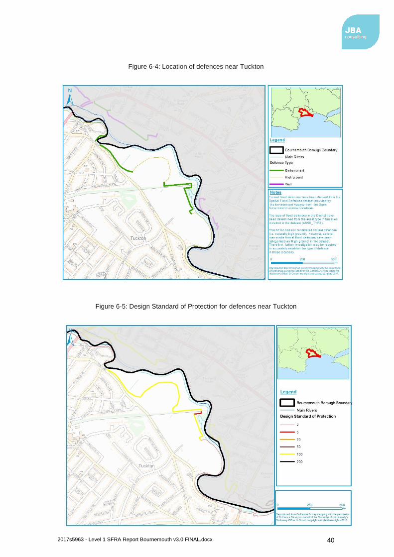
2017s5963 - Level 1 SFRA Report Bournemouth v3.0 FINAL.docx 40
Figure 6-4: Location of defences near Tuckton
Figure 6-5: Design Standard of Protection for defences near Tuckton

2017s5963 - Level 1 SFRA Report Bournemouth v3.0 FINAL.docx 41
Townsend
North of Townsend, there is a length of embankment and wall that crosses into Christchurch Borough (Figure 6-6). Environment Agency Flood Zones show an ABD in this area, indicating that the defences currently provide protection to some areas in the 1 in 100-year event, although there is a residual risk from defence breach. With climate change, the standard of protection provided is expected to decrease due to increased water levels and more frequent flooding.
Figure 6-6This is south of the River Stour and adjacent to an unnamed drain and provides protection from fluvial flooding. The defence is in private ownership but is maintained by the Environment Agency. The standard of protection provided is 1.5% AEP (1 in 65-year flood event), and the condition of the embankments and wall is ‘Fair’.
Environment Agency Flood Zones show an ABD in this area, indicating that the defences currently provide protection to some areas in the 1 in 100-year event, although there is a residual risk from defence breach. With climate change, the standard of protection provided is expected to decrease due to increased water levels and more frequent flooding.
Figure 6-6: Location of defences near Townsend
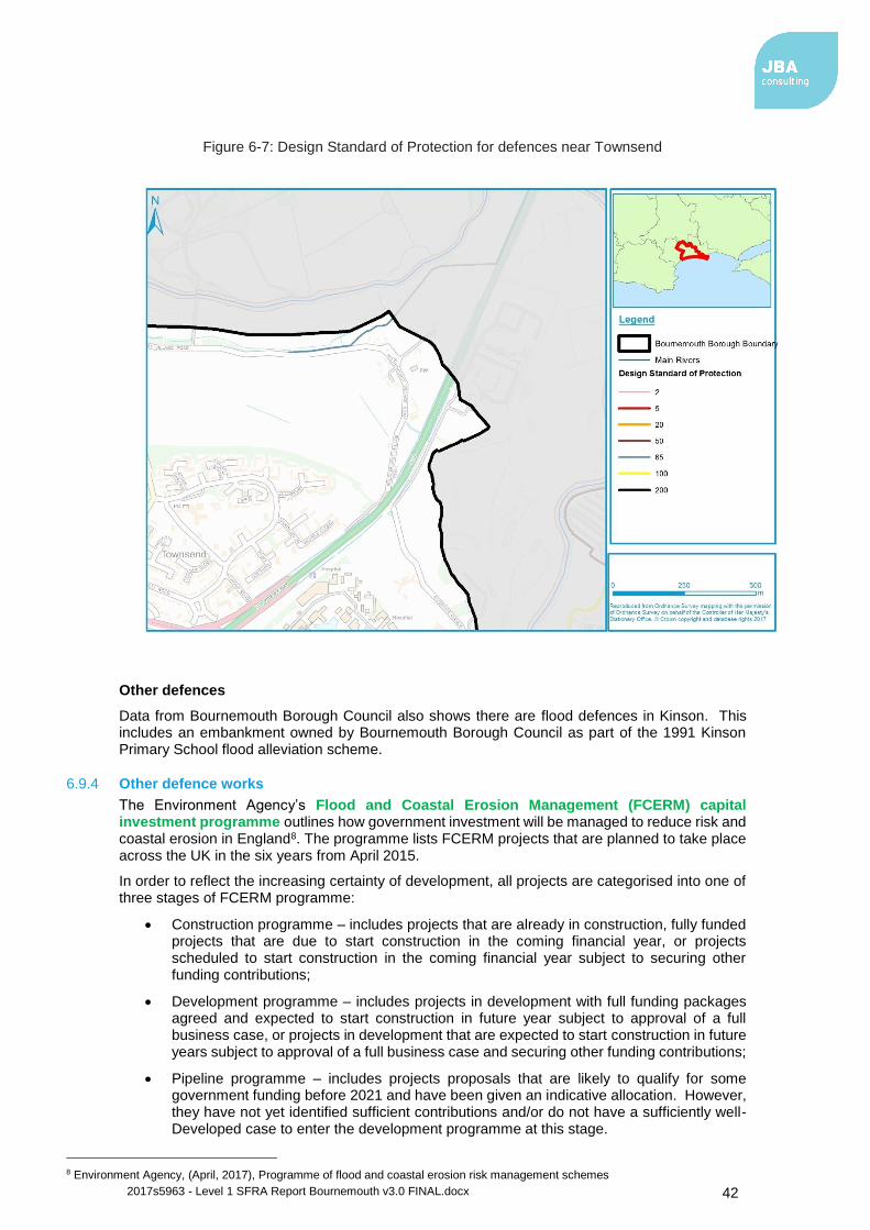
2017s5963 - Level 1 SFRA Report Bournemouth v3.0 FINAL.docx 42
Figure 6-7: Design Standard of Protection for defences near Townsend
Other defences
Data from Bournemouth Borough Council also shows there are flood defences in Kinson. This includes an embankment owned by Bournemouth Borough Council as part of the 1991 Kinson Primary School flood alleviation scheme.
6.9.4 Other defence works
The Environment Agency’s Flood and Coastal Erosion Management (FCERM) capital investment programme outlines how government investment will be managed to reduce risk and coastal erosion in England8. The programme lists FCERM projects that are planned to take place across the UK in the six years from April 2015.
In order to reflect the increasing certainty of development, all projects are categorised into one of three stages of FCERM programme:
• Construction programme – includes projects that are already in construction, fully funded projects that are due to start construction in the coming financial year, or projects scheduled to start construction in the coming financial year subject to securing other funding contributions;
• Development programme – includes projects in development with full funding packages agreed and expected to start construction in future year subject to approval of a full business case, or projects in development that are expected to start construction in future years subject to approval of a full business case and securing other funding contributions;
• Pipeline programme – includes projects proposals that are likely to qualify for some government funding before 2021 and have been given an indicative allocation. However, they have not yet identified sufficient contributions and/or do not have a sufficiently well-Developed case to enter the development programme at this stage.
8 Environment Agency, (April, 2017), Programme of flood and coastal erosion risk management schemes

2017s5963 - Level 1 SFRA Report Bournemouth v3.0 FINAL.docx 43
Based on the information published by the EA, there are no FCERM projects within the development programme for Bournemouth.
6.10 Flood warning and emergency planning
6.10.1 Emergency planning
Emergency planning is one option to help manage flood related incidents. From a flood risk perspective, emergency planning can be broadly split into three phases: before, during and after a flood. The measures involve developing and maintaining arrangements to reduce, control or mitigate the impact and consequences of flooding and to improve the ability of people and property to absorb, respond to and recover from flooding.
6.10.2 NPPF
In development planning, a number of emergency planning activities are already integrated in national building control and planning policies e.g. the NPPF Flood Risk Vulnerability and Flood Zone ‘Compatibility’ table seeks to avoid inappropriate development in areas at risk from all sources of flooding. However; safety is a key consideration for any new development and includes residual risk of flooding, the availability of adequate flood warning systems for the development, safe access and egress routes and evacuation procedures.
The NPPF Planning Practice Guidance outlines how developers can ensure safe access and egress to and from development in order to demonstrate that development satisfies the second part of the Exception Test. As part of an FRA, the developer should review the acceptability of the proposed access in consultation with Bournemouth Borough Council (where appropriate) and the Environment Agency.
There are circumstances where a flood warning and evacuation plan9 is required and / or advised:
• It is a requirement under the NPPF that a flood warning and evacuation plan is prepared for sites at risk of flooding used for holiday or short-let caravans and camping and are important at any site that has transient occupants (e.g. hostels and hotels) and for essential ancillary sleeping or residential accommodation for staff required by uses in this category [water-compatible development], subject to a specific warning and evacuation plan.
• The Environment Agency and DEFRAs standing advice for undertaking flood risk assessments for planning applications states that details of emergency escape plans will be required for any parts of the building that are below the estimated flood level.
It is recommended that Emergency Planners at Bournemouth Borough Council (where appropriate) are consulted prior to the production of any emergency flood plan.
In addition to the flood warning and evacuation plan considerations listed in the NPPF / PPG, it is advisable that developers also acknowledge the following:
• How to manage the consequences of events that are un-foreseen or for which no warnings can be provided e.g. managing the residual risk of a breach.
• Proposed new development that places additional burden on the existing response capacity of the Councils will not normally be considered to be appropriate.
• Developers should encourage those owning or occupying developments, where flood warnings can be provided, to sign up to receive them. This applies even if the development is defended to a high standard.
• The vulnerability of site occupants.
• Situations may arise where occupants cannot be evacuated (e.g. prisons) or where it is safer to remain “in-situ” and / or move to a higher floor or safe refuge area (e.g. at risk of a breach). These allocations should be assessed against the outputs of the SFRA and where applicable, a site-specific Flood Risk Assessment to help develop emergency plans.
A number of additional emergency planning resources are available from:
• 2004 Civil Contingencies Act
9 Flood warning and evacuation plans may also be referred to as an emergency flood plan or flood response plan.

2017s5963 - Level 1 SFRA Report Bournemouth v3.0 FINAL.docx 44
• DEFRA (2014) National Flood Emergency Framework for England
• How to register with the Environment Agency’s Flood Warnings Direct service
• National Flood Forum
• GOV.UK Make a Flood Plan guidance and templates
• FloodRe
• Emergency Planning
6.10.3 Flood warnings
Flood warnings can be received and, along with evacuation plans, can inform emergency flood plans or flood response plans. The Environment Agency is the lead organisation for providing warnings of fluvial flooding (for watercourses classed as Main Rivers) and coastal flooding in England. Flood Warnings are supplied via the Flood Warning Service to homes and business within Flood Zones 2 and 3 (replacing the Floodline Warnings Directive, FWD, service in April 2017).
Within the district, there are three flood alert areas (FAA) and seven flood warning areas (FWA). These are shown in Appendix B.
6.11 Cross boundary considerations
Bournemouth Borough is bounded to the North East by the River Stour, which poses a flood risk to nearby areas. The Stour originates in Wiltshire, flowing through North Dorset and East Dorset before reaching Bournemouth. Christchurch Borough is located on the opposite bank of the Stour near Bournemouth. Anything which occurs to affect the flow in these areas could have a significant impact on flood risk in parts of Bournemouth. Conversely, schemes or development constructed in Bournemouth may have an effect on areas of East Dorset and Christchurch.
The Bourne stream originates just outside the borough in Poole. Development of areas in Poole which drain towards the watercourse may have a significant effect on flood risk in areas surrounding the Bourne stream. There are also several small overland surface water flow routes crossing the boundary.
6.12 Summary of flood risk by location
This section summarises the flood risk from all sources at key locations within the study area. More detailed mapping of the study area can be found in Appendix A.

2017s5963 - Level 1 SFRA Report Bournemouth v3.0 FINAL.docx 45
North West (Kinson/ Winton)
Flood risk summary
Flood history Flooding events have been recorded in the north west of the borough, predominantly from fluvial and pluvial sources, including a number of events on Wimborne Road.
Fluvial flood risk Fluvial flood risk at Winton or Kinson and their surrounding areas is considered to be low. However, several areas are shown to be at risk in the vicinity of the River Stour. Hydraulic model results for the River Stour indicate that climate change will increase the risk of flooding to some properties and highways in the vicinity of the River Stour, although flood risk remains low across most of this area.
Tidal flood risk Tidal flood risk in this area is considered to be negligible.
Surface water flood risk Areas at surface water flood risk are predominantly located along existing watercourses and roads. Towards Ensbury, ponding occurs adjacent to Whitelegg Way and along roads and gardens north of Wimborne Road in the 1% AEP event. In the 0.1% AEP event, surface water flooding covers most of the road network to the north of Wimborne Road, presenting a risk to properties. In Winton, risk is predominantly confined to roads, such as Charminster Avenue and Queens Park Avenue in the vicinity of an unnamed drain. This presents some risk to properties in larger events, including towards Haddon Hill.
Groundwater flood risk There is limited susceptibility to groundwater emergence south of Kinson. In Kinson and Ensbury, susceptibility to groundwater emergence is high in proximity to the River Stour.
Other sources of flood risk There is a risk of flooding from reservoirs in the vicinity of the River Stour along the northern borough boundary.

2017s5963 - Level 1 SFRA Report Bournemouth v3.0 FINAL.docx 46
North West (Kinson/ Winton)
Historical incidents of sewer flooding provided by Wessex Water indicate that there have been instances of sewer flooding recorded, including a number of events on Kinson Road and Leybourne Avenue.
Strategic flood risk considerations
Development should be located outside of areas shown to be at current or future risk of flooding where possible. If there is a need to locate development in areas at risk it is likely that a Level 2 SFRA study will be required to provide evidence for the Exception Test.
There are no formal flood defences located in this area. Defences could be provided in this area to allow development to be made safe for its lifetime and to provide protection to existing properties from current and future flood risk. Any flood defence work should be undertaken in accordance with the Catchment Flood Management Plan for the area.
Potential for use of Sustainable Drainage Systems
There are significant areas shown to be at risk of surface water flooding and development in this area could provide opportunity to reduce this through reduction in impermeable surfaces and use of SuDS.
Significant constraints for infiltration SuDS are indicated in Ensbury and to the north of Kinson. Kinson itself and many areas to the south are highly or probably compatible with infiltration SuDS. Mapping shows potential for ground stability geohazards throughout the area which may require further investigation. The majority of this area has low susceptibility to groundwater contamination with the exception of some areas adjacent to watercourses.
There is also a Groundwater Source Protection Zone in this area. Measures will need to be implemented to reduce the risk of mobilisation of pollutants and avoid contamination of this source.

2017s5963 - Level 1 SFRA Report Bournemouth v3.0 FINAL.docx 47
North East (Moordown)
Flood risk summary
Flood history There have been a number of recorded flooding events in the north east of the borough, predominantly from fluvial and pluvial sources.
Fluvial flood risk Fluvial flood risk at Moordown and the surrounding area is considered to be low. However, several areas are shown to be at risk in the vicinity of the River Stour. Hydraulic model results for the River Stour indicate that climate change will increase flood extents to the north of Holdenhurst, increasing the risk of flooding to properties and highways in the vicinity.
Tidal flood risk Tidal flood risk in this area is considered to be negligible.
Surface water flood risk In Moordown, in the 1% AEP event risk is largely along isolated areas of the road network, with some ponding occurring. In the 0.1% AEP event, risk is more widespread, and is less isolated to the road network, particularly to the north of Castle Lane West.
Groundwater flood risk There is generally limited susceptibility to groundwater emergence in this area. Along the borough boundary north of Townsend, towards the River Stour, susceptibility is slightly higher, with potential for groundwater flooding of property situated below ground level.
Other sources of flood risk There is a risk of flooding from reservoirs to areas in the vicinity of the River Stour corridor. This is due to their location downstream of reservoirs near Longham. However, the maximum extent of flooding is generally limited to undeveloped areas.
Historical incidents of sewer flooding provided by Wessex Water indicate that there have been instances of sewer flooding recorded, including multiple events on Queens Park Avenue.

2017s5963 - Level 1 SFRA Report Bournemouth v3.0 FINAL.docx 48
North East (Moordown)
Strategic flood risk considerations
Development should be located outside of areas shown to be at current or future risk of flooding where possible. If there is a need to locate development in areas at risk it is likely that a Level 2 SFRA study will be required to provide evidence for the Exception Test.
Defences are present in the area around Holdenhurst and are shown by the Environment Agency’s Flood Map for Planning to provide a 1 in 100-year standard of protection to some areas. Regular inspection and maintenance will be required to maintain this standard of protection. In future, this standard of protection is likely to reduce as a result of increased water levels and frequency of flooding due to climate change and upgraded defences may be required. Any flood defence work should be undertaken in accordance with the Catchment Flood Management Plan for the area.
Potential for use of Sustainable Drainage Systems
There are significant areas shown to be at risk of surface water flooding and development in this area could provide opportunity to reduce this through reduction in impermeable surfaces and use of SuDS.
In areas near the boundary, e.g. Holdenhurst, mapping shows that there are opportunities for bespoke infiltration SuDS. Greater opportunities for infiltration SuDS exist to the west of Throop and to the south of the A3060. Mapping shows potential for ground stability geohazards throughout the area which may require further investigation. The majority of this area has low susceptibility to groundwater contamination with the exception of some areas adjacent to watercourses.

2017s5963 - Level 1 SFRA Report Bournemouth v3.0 FINAL.docx 49
South West (Bournemouth)
Flood risk summary
Flood history Flood events in Bournemouth have been recorded in a number of locations, including Surrey Road, Branksome Wood Road and Bath Road, mainly from pluvial and fluvial sources. The pathway includes surface runoff, debris blockage and drainage capacity being exceeded.
Fluvial flood risk There is an area of fluvial flood risk in Bournemouth in the land immediately surrounding the Bourne stream running parallel to Surrey Road, down to Exeter Road that poses a greater than 1% AEP flood risk. However, this does not pose a significant risk to properties. In the majority of this area of Bournemouth the fluvial flood risk is low.
Tidal flood risk Tidal flood risk of greater than 1% AEP is present along the coastline in Bournemouth posing a significant flood risk to the land in this vicinity. This is generally limited to a narrow area along the seafront. The risk from still water and wave overtopping is expected to increase along the seafront with the effects of climate change.
Surface water flood risk Within Bournemouth, surface water flood risk is largely located along the Bourne and the road network, including Bradley Road, which provides an overland flow route towards the Bourne in the 1% AEP event and above. Some isolated ponding occurs in open spaces and gardens.
Groundwater flood risk BGS susceptibility mapping shows that there is generally low susceptibility to groundwater emergence in this area with only small areas shown as having potential for groundwater flooding.
2017s5963 - Level 1 SFRA Report Bournemouth v3.0 FINAL.docx 50
South West (Bournemouth)
Other sources of flood risk This area of Bournemouth is outside of the maximum flood extent of reservoirs.
Historical incidents of sewer flooding provided by Wessex Water indicate that there have been instances of sewer flooding recorded, including a number of events on the Triangle, Branksome Wood Road and Old Christchurch Road. Wessex Water are considering a strategic sewerage scheme to reduce the risk of sewer flooding and increase resilience within the central Bournemouth catchment. A long term strategy is due to be submitted within the next Wessex Water Business Plan 2020-2025 and span future business plan periods.
Strategic flood risk considerations
Development should be located outside of areas shown to be at current or future risk of flooding where possible. If there is a need to locate development in areas at risk it is likely that a Level 2 SFRA study will be required to provide evidence for the Exception Test.
Predicted extreme sea levels, including an allowance for climate change, indicate that the areas impacted by sea level rise are generally limited to a narrow area along the seafront. However, it may be necessary to consider defences if significant redevelopment is proposed in this area and to provide protection to existing properties. There may also be coastal erosion issues which have not be considered as part of this assessment. Any coastal defence work should be undertaken in accordance with the Shoreline Management Plan for the area.
Potential for use of Sustainable Drainage Systems
There are significant areas shown to be at risk of surface water flooding and development in this area could provide opportunity to reduce this through reduction in impermeable surfaces and use of SuDS.
The SuDS infiltration maps indicate that most of this area is highly compatible for infiltration SuDS, with the exception of a limited number of locations such as the area surrounding the length of the Bourne, where there is potential for groundwater flooding. There are some areas where significant potential for ground stability geohazards is shown. The susceptibility of this area to groundwater contamination through infiltration is largely shown to be low.

2017s5963 - Level 1 SFRA Report Bournemouth v3.0 FINAL.docx 51
South East (Wick, Southborne)
Flood risk summary
Flood history There is a history of flooding within the south east of the borough, with the majority of events caused by pluvial and fluvial sources. This includes several events on Wick Lane and Tuckton Road.
Fluvial flood risk Wick is exposed to significant fluvial flooding greater than 1% AEP. The village is located on the southern bank of the River Stour, and within close proximity to the Christchurch harbour. The majority of properties south of Wick Lane and Roscrea Drive are at low risk of Fluvial flooding as they are not within the immediate vicinity of the River Stour. Southbourne is situated to the South West of Wick and is not at risk of fluvial flooding. Hydraulic model results for the River Stour indicate that climate change will increase the risk of flooding to some properties and highways in the vicinity of the River Stour, notably near Tuckton, although flood risk remains low across most of this area
Tidal flood risk Wick is exposed to tidal risk from the North East where the Christchurch harbour is situated. In these fringes of the village there is a tidal flood risk of greater than 1% AEP. Areas of the town located to the south and the west are at low risk from tidal flooding. Southbourne has a low tidal flood risk. There is a small area exposed to a greater than 1% AEP tidal flood risk along the south coastal boundary of the town. Areas at risk are likely to increase in future as a result of climate change.
Surface water flood risk Surface water flood risk is mostly located along the road network although there is some isolated ponding. In the 0.1% AEP event, risk is more widespread and there is a risk to properties. Significant ponding occurs in Tuckton in open land adjacent to Iford Lane in the 0.1% event.

2017s5963 - Level 1 SFRA Report Bournemouth v3.0 FINAL.docx 52
South East (Wick, Southborne)
Groundwater flood risk There is generally low susceptibility to groundwater emergence in this area. However, between Tuckton and Iford, there is potential for groundwater for flooding of property below ground level, and a small area is also susceptible to surface flooding.
Other sources of flood risk There is a risk of flooding from reservoirs along the eastern boundary of the district in the vicinity of the River Stour to the north of Wick.
Historical incidents of sewer flooding provided by Wessex Water indicate that there have been instances of sewer flooding recorded, including on Iford Lane.
Strategic flood risk considerations
Development should be located outside of areas shown to be at current or future risk of flooding where possible. If there is a need to locate development in areas at risk it is likely that a Level 2 SFRA study will be required to provide evidence for the Exception Test.
Defences are present in the areas around Wick and Tuckton and are shown by the Environment Agency’s Flood Map for Planning to provide a 1 in 100-year standard of protection to some areas. Regular inspection and maintenance will be required to maintain this standard of protection. In future, this standard of protection is likely to reduce as a result of increased water levels and frequency of flooding due to climate change and upgraded defences may be required. Any flood defence work should be undertaken in accordance with the Catchment Flood Management Plan for the area.
Predicted extreme sea levels, including an allowance for climate change, indicate that some low-lying areas may be at risk of tidal flooding in future. It may be necessary to consider defences if significant redevelopment is proposed in these areas or if required to protect existing properties. There may also be coastal erosion issues which have not be considered as part of this assessment. Any coastal defence work should be undertaken in accordance with the Shoreline Management Plan for the area.
Potential for use of Sustainable Drainage Systems
There are significant areas shown to be at risk of surface water flooding and development in this area could provide opportunity to reduce this through reduction in impermeable surfaces and use of SuDS.
The SuDS infiltration maps indicate that a large portion of the western area is highly compatible for infiltration SuDS, but opportunities are reduced adjacent to the River Stour and on Hengistbury Head. There is some potential for ground stability geohazards shown in the area. Susceptibility to groundwater contamination is low for the majority of this area.

2017s5963 - Level 1 SFRA Report Bournemouth v3.0 FINAL.docx 53
7 FRA requirements and flood risk management guidance
7.1 Over-arching principles
This SFRA focuses on delivering a strategic assessment of flood risk within Bournemouth Borough Council. Due to the strategic scope of the study, prior to any construction or development, site-specific assessments will need to be undertaken for individual development proposals (where required) so all forms of flood risk at a site are fully addressed. It is the responsibility of the developer to provide an FRA with an application.
It should be acknowledged that a detailed FRA may show that a site is not appropriate for development with a particular flood vulnerability or even at all. Where the FRA shows that a site is not appropriate for a particular usage, proposed development with a lower vulnerability classification may be appropriate.
Flood Mapping included in this SFRA is a useful starting point when assessing flood risk to a proposed development and an assessment of flood risk at the site should demonstrate that this information has been considered. Where more recent or detailed information has been made available since the completion of this SFRA (e.g. updates to the Environment Agency’s Flood Map for Planning), this should also be included. It is known that the Environment Agency are currently undertaking an updated modelling study for the Lower Stour which is due to be completed in late 2017 which will provide further information on flood risk to some areas.
7.2 Requirements for site-specific flood risk assessments
7.2.1 What are site specific FRAs?
Site specific FRAs are carried out by (or on behalf of) developers to assess flood risk to and from a site. They are submitted with planning applications and should demonstrate how flood risk will be managed over the development’s lifetime, taking into account climate change and vulnerability of users.
Paragraph 068 of the NPPG Flood Risk and Coastal Change Planning Practice Guidance sets out a checklist for developers to assist with site specific flood risk assessments.
Site specific FRAs are required in the following circumstances:
• Proposals for new development (including minor development and change of use) in Flood Zones 2 and 3
• Proposals for new development (including minor development and change of use) in an area within Flood Zone 1 which has critical drainage problems (as notified to the LPA by the Environment Agency)
• Proposals of 1 hectare or greater in Flood Zone 1
• Where proposed development or a change of use to a more vulnerable class may be subject to other sources of flooding
• Proposals of less than one hectare in Flood Zone 1 where they could be affected by sources of flooding other than rivers and the sea (e.g. surface water)
7.2.2 Objectives of site specific FRAs
Site specific FRAs should be proportionate to the degree of flood risk, as well as appropriate to the scale, nature and location of the development. Site specific FRAs should establish
• whether a proposed development is likely to be affected by current or future flooding from any source;
• whether a proposed development will increase flood risk elsewhere;
• whether the measures proposed to deal with the effects and risks are appropriate;
• the evidence, if necessary, for the local planning authority to apply the Sequential Test; and
• whether, if applicable, the development will be safe and pass the Exception Test.

2017s5963 - Level 1 SFRA Report Bournemouth v3.0 FINAL.docx 54
FRAs for sites located in Bournemouth should follow the approach recommended by the NPPF (and associated guidance) and guidance provided by the Environment Agency and Bournemouth Borough Council. Guidance and advice for developers on the preparation of site specific FRAs include
• Standing Advice on Flood Risk (Environment Agency);
• Flood Risk Assessment for Planning Applications (Environment Agency); and
• Site-specific Flood Risk Assessment: CHECKLIST (NPPF PPG, Defra).
FRAs should provide assessment of sources of flood risk that are present at the site or which may affect site access. Where flood risk from a particular source is considered negligible, a detailed assessment of flood risk from that source is unlikely to be required. The FRA should instead focus on other sources which pose a more significant risk.
Guidance for local planning authorities for reviewing flood risk assessments submitted as part of planning applications has been published by Defra in 2015 – Flood Risk Assessment: Local Planning Authorities. In circumstances where an FRA is prepared for land that has not been allocated (windfall site) the assessment should include evidence that can be used to support an assessment that the application site proposals satisfy the requirements of the Sequential and Exception Tests. All FRA’s for windfall sites should contain evidence that the extent of Flood Zones is correctly identified, particularly in circumstances where the sites contain smaller scale watercourses that would not have been mapped when collating national data.
7.3 Flood risk management guidance – mitigation measures
Mitigation measures should be seen as a last resort to address flood risk issues. Consideration should first be given to minimising risk by planning sequentially across a site. Once risk has been minimised as far as possible, only then should mitigation measures be considered.
7.3.1 Site layout and design
Flood risk should be considered at an early stage in deciding the layout and design of a site to provide an opportunity to reduce flood risk within the development.
The NPPF states that a sequential, risk-based approach should be applied to try to locate more vulnerable land use away from flood zones, to higher ground, while more flood-compatible development (e.g. vehicular parking, recreational space) can be located in higher risk areas. However, vehicular parking in floodplains should be based on the nature of parking, flood depths and hazard including evacuation procedures and flood warning.
Waterside areas, or areas along known flow routes, can act as Green Infrastructure, being used for recreation, amenity and environmental purposes, allowing the preservation of flow routes and flood storage, and at the same time providing valuable social and environmental benefits contributing to other sustainability objectives. Landscaping should ensure safe access to higher ground from these areas, and avoid the creation of isolated islands as water levels rise.
7.3.2 Making space for water
The NPPF sets out a clear policy aim in Flood Zone 3 to create space for flooding by restoring functional floodplain.
All new development close to rivers should consider the opportunity presented to improve and enhance the river environment. Developments should look at opportunities for river restoration and enhancement as part of the development. Options include backwater creation, de-silting, in-channel habitat enhancement and removal of structures. When designed properly, such measures can have benefits such as reducing the costs of maintaining hard engineering structures, reducing flood risk, improving water quality and increasing biodiversity. Social benefits are also gained by increasing green space and access to the river.
The provision of a buffer strip can ‘make space for water’, allow additional capacity to accommodate climate change and ensure access to the watercourse and structures is maintained for future maintenance purposes.
It also enables the avoidance of disturbing riverbanks, adversely impacting ecology and having to construct engineered riverbank protection. Building adjacent to riverbanks can also cause
2017s5963 - Level 1 SFRA Report Bournemouth v3.0 FINAL.docx 55
problems to the structural integrity of the riverbanks and the building itself, making future maintenance of the river much more difficult.
Bournemouth Borough Council can use Section 106 agreements of the Town and Country Planning Act 1990 to use planning to manage flood risk; in line with the ‘Making Space for Water’ concept, Section 106 agreements can be put in place to ensure new SuDS features will be maintained in the future.
Catchment and floodplain restoration
Floodplain restoration represents the most sustainable form of strategic flood risk solution, by allowing watercourses to return to a more naturalised state, and by creating space for naturally functioning floodplains working with natural processes.
Although the restoration of floodplain is difficult in previously developed areas where development cannot be rolled back, the following measures should be adopted:
• Promoting existing and future brownfield sites that are adjacent to watercourses to naturalise banks as much as possible. Buffer areas around watercourses provide an opportunity to restore parts of the floodplain
• Removal of redundant structures to reconnect the river and the floodplain. There are a number of culverted sections of watercourse located throughout the district which if returned to a more natural state would potentially reduce flood risk to the local area
• Apply the Sequential Approach to avoid new development within currently undefended floodplain.
For those sites considered within the Local Plan and / or put forward by developers, that also have watercourses flowing through or past them, the sequential approach should be used to locate development away from these watercourses. This will ensure the watercourses retain their connectivity to the floodplain. Loss of floodplain connectivity in rural upper reaches of tributaries which flow through urban areas in the District, could potentially increase flooding within the urban areas. This will also negate any need to build flood defences within the sites. It is acknowledged that sites located on the fringes of urban areas within the district are likely to have limited opportunity to restore floodplain in previously developed areas.
7.3.3 Raised floor levels
The raising of internal floor levels within a development avoids damage occurring to the interior, furnishings and electrics in times of flood.
The Environment Agency has developed a new fluvial freeboard guide SC120014/S10 to replace the Fluvial Freeboard Guidance Note (report W187) published in 2000, incorporating advanced models, tools and methods, and reflecting the shift from flood defence to flood risk management. The guide is written to allow flood risk management authorities, developers and engineering consultants to identify and manage the uncertainty in their flood risk assessments and flood defence designs.
The guide’s methodology shifts from adding freeboard values to design defence crest levels, towards considering a range of possible management responses, and can be applied to all sources of flood risk rather than just fluvial sources.
The new guide should be used when:
• Planning a new development
• Appraising and designing a new flood scheme
• Assessing the standard of protection of an existing flood defence
The new guide addresses issues with the old guide to ensure:
• There is a structured method for identifying uncertainties
• Factors of safety used in the design process are not duplicated
10 Environment Agency, 2017. Accounting for residual uncertainty: updating the freeboard guide. Report SC120014.

2017s5963 - Level 1 SFRA Report Bournemouth v3.0 FINAL.docx 56
• When managing uncertainty, users account for all appropriate actions across the source, pathway and receptor
• Uncertainties are identified, managed and tracked as a project moves towards design and delivery
• There is a hierarchy of methods to keep management of uncertainty proportional to the decision
There are 3 principal stages for the assessment as detailed in Figure 7-1.
Figure 7-1: Approach for development planning (Figure 3.1 of SC120014)
Using the guidance document, users should first identify and record all primary sources of uncertainty as listed in Table 3.1 of SC120014 (Figure 7-1). Stage 2 involves assigning an uncertainty score between 1 (highly likely to be locally reliable) and 10 (very unlikely to be locally reliable) to each source of uncertainty identified in Stage 1. For Stage 3, a confidence rating is then assigned based on the 2 highest scores identified from Stage 2 (Table 7-3). This is used to inform a recommended residual uncertainty allowance (Table 7-4). Case study examples are provided in the guidance document to show how to apply each stage in practice.
Table 7-2: Considerations for identifying primary sources of uncertainties in development planning (Table 3.1 of SC120014)
Consideration Description How appropriate is the flood risk analysis?
Does it contain the important local features such as culverts or de facto defences (that is, structures acting as but not designed as defences)? Is the analysis up-to-date? For example, does it incorporate local land use change or a new flood wall? The age of the analysis can be a factor.
How well is the floodplain modelled? The type and resolution of the floodplain topography data are important as the floodplain could have important pathways or features such as drainage channels and road embankments which need to be resolvable. Examples of topographic survey include: synthetic aperture radar (SAR), light detection and ranging (LIDAR) and fast laser imaging mapping and profiling (FLI-MAP). Each survey and survey technique will have a different resolution. Selecting the right resolution is important.
How well has the potential for defence failure been modelled?
If flood defences or assets influence residual water levels at the site, the number and type of breaches will affect the confidence in the

2017s5963 - Level 1 SFRA Report Bournemouth v3.0 FINAL.docx 57
Consideration Description
flood risk analysis. See Box 3.1 of the guidance for exceptions when credible failures might not be considered.
What is the confidence in the hydrology? This is the basis for deriving inflows for fluvial, surface run-off or groundwater sources (for example, length of records). Has a considered approach to the use of data and hydrological analysis been followed?
How good are the coastal/ estuarine/ tidal boundaries?
The boundaries form the basis for deriving nearshore conditions such as waves and sea level. Has a considered approach to the use to the selection of the boundary conditions been followed?
How have the fluvial threats been represented?
Assess the appropriateness of the modelling technique.
How have coastal threats been represented?
Assess the detail of wave overtopping and tidal inundation in comparison to the complexity of the site.
How has surface run-off been represented?
Assess the detail of the modelling in comparison to the complexity of the site.
How have groundwater hazards been represented?
Assess the detail of the modelling in comparison to the complexity of the site. Local policy may indicate when analysis is required.
What is the strength of the evidence? How strongly does the evidence support/ validate flooding representation (for example, calibration of modelling against observed events)?
Table 7-3: Scoring matrix to derive confidence rating (from Table 3.3 of SC120014)
Table 7-4: Residual uncertainty allowance for development planning (from Table 3.4 of SC120014)

2017s5963 - Level 1 SFRA Report Bournemouth v3.0 FINAL.docx 58
The allowance for climate change is not included in the residual uncertainty allowance. However, the residual uncertainty allowance can be added to the site deigns water level to consider an appropriate climate change allowance, and ensure a development is safe for its lifetime.
7.3.4 Development and raised defences
Construction of localised raised floodwalls or embankments to protect new development is not a preferred option, as a residual risk of flooding will remain. Compensatory storage must be provided where raised defences remove storage from the floodplain. It would be preferable for schemes to involve an integrated flood risk management solution.
Temporary or demountable defences are not acceptable forms of flood protection for a new development but might be appropriate to address circumstances where the consequences of residual risk are severe. In addition to the technical measures the proposals must include details of how the temporary measures will be erected and decommissioned, responsibility for maintenance and the cost of replacement when they deteriorate.
7.3.5 Modification of ground levels
Modifying ground levels to raise the land above the required flood level is an effective way of reducing flood risk to a particular site in circumstances where the land does not act as conveyance or storage for flood waters. However, care must be taken at locations where raising ground levels could adversely affect existing communities and property; in most areas of fluvial flood risk, raising land above the floodplain would reduce conveyance or flood storage in the floodplain and could adversely impact flood risk downstream or on neighbouring land.
Compensatory flood storage should be provided, and would normally be on a level for level, volume for volume basis on land that does not currently flood but is adjacent to the floodplain (in order for it to fill and drain). It should preferably be in the vicinity of the site and within the red line of the planning application boundary.
Raising ground levels can also deflect flood flows, so analyses should be performed to demonstrate that there are no adverse effects on third party land or property.
Raising levels can also create areas where surface water might pond during significant rainfall events. Any proposals to raise ground levels should be tested to ensure that it would not cause increased ponding or build-up of surface runoff on third party land.
Any proposal for modification of ground levels will need to be assessed as part of a detailed flood risk assessment.
7.3.6 Developer contributions
In some cases, and following the application of the sequential test, it may be necessary for the developer to make a contribution to the improvement of flood defence provision that would benefit both proposed new development and the existing local community. Developer contributions can also be made to maintenance and provision of flood risk management assets, flood warning and the reduction of surface water flooding (i.e. SuDS). The LFRMS Action Plan reinforces that developers may be required to make necessary contributions to the cost of SuDS and flood risk management activities.
DEFRA’s Flood and Coastal Risk Management Grant in Aid (FCRMGiA)11 can be obtained by operating authorities to contribute towards the cost of a range of activities including flood risk management schemes that help reduce the risk of flooding and coastal erosion. Some schemes are only partly funded by FCRMGiA and therefore any shortfall in funds will need to be found from elsewhere when using Resilience Partnership Funding, for example local levy funding, local businesses or other parties benefitting from the scheme.
For new development in locations without existing defences, or where the development is the only beneficiary, the full costs of appropriate risk management measures for the life of the assets proposed must be funded by the developer.
However, the provision of funding by a developer for the cost of the necessary standard of protection from flooding or coastal erosion does not mean the development is appropriate as other
11 Principles for implementing flood and coastal resilience funding partnerships (Environment Agency, 2012)

2017s5963 - Level 1 SFRA Report Bournemouth v3.0 FINAL.docx 59
policy aims must also be met. Funding from developers should be explored prior to the granting of planning permission and in partnership with the Council and the Environment Agency.
The appropriate route for the consideration of strategic measures to address flood risk issues is the LFRMS. The LFRMS should describe the priorities with respect to local flood risk management, the measures to be taken, the timing and how they will be funded. It will be preferable to be able to demonstrate that strategic provisions are in accordance with the LFRMS, can be afforded and have an appropriate priority.
The Environment Agency is also committed to working in partnership with developers to reduce flood risk. Where assets are in need of improvement or a scheme can be implemented to reduce flood risk, the Environment Agency request that developers contact them to discuss potential solutions.
Community Infrastructure Levy
The Community Infrastructure Levy (CIL) allows local authorities to raise funds from developers undertaking new building projects in their administrative area. The CIL rate is set locally, within a Charging Schedule. The CIL can be used for a variety of local infrastructure needs arising from new development in the Borough including flood defences if included in the Regulation 123 list under the Community Infrastructure Levy Regulations 2010 (as amended). Flood defences are not currently included on the list for Bournemouth. Further information on CIL can be found on the Council’s website.
7.4 Flood risk management guidance – resistance measures
There may be instances where flood risk to a development remains despite implementation of such planning measures as those outlined above. For example, where the use is water compatible, where an existing building is being changed, where residual risk remains behind defences, or where floor levels have been raised but there is still a risk at the 1 in 1,000-year scenario. In these cases, (and for existing development in the floodplain), additional measures can be put in place to reduce damage in a flood and increase the speed of recovery. These measures should not normally be relied on for new development as an appropriate mitigation method. Most of the measures should be regarded as reducing the rate at which flood water can enter a property during an event and considered an improvement on what could be achieved with sand bags. They are often deployed with small scale pumping equipment to control the flood water that does seep through these systems. The effectiveness of these forms of measures are often dependant on the availability of a reliable forecasting and warning system to user the measures are deployed in advance of an event. The following measures are often deployed:
Permanent barriers
Permanent barriers can include built up doorsteps, rendered brick walls and toughened glass barriers.
Temporary barriers
Temporary barriers consist of moveable flood defences which can be fitted into doorways and/or windows. The permanent fixings required to install these temporary defences should be discrete and keep architectural impact to a minimum. On a smaller scale automatic airbrick replacements and covers for air vents can also be fitted to prevent the ingress of flood water.
Community resistance measures
These include demountable defences that can be deployed by local communities to reduce the risk of water ingress to a number of properties. The methods require the deployment of inflatable (usually with water) or temporary quick assembly barriers in conjunction with pumps to collect water that seeps through the systems during a flood.
7.5 Flood risk management guidance – resilience measures
Measures designed to keep flood water out of properties and businesses.
Measures designed to reduce the impact of water that enters property and businesses.

2017s5963 - Level 1 SFRA Report Bournemouth v3.0 FINAL.docx 60
Flood-resilient buildings are designed and constructed to reduce the impact of flood water entering the building. These measures aim to ensure no permanent damage is caused, the structural integrity of the building is not compromised and the clean up after the flood is easier. Interior design measures to reduce damage caused by flooding include
• electrical circuitry installed at a higher level with power cables being carried down from the ceiling rather than up from the floor level;
• water-resistant materials for floors, walls and fixtures; and
• non-return valves to prevent waste water from being forced up bathroom and kitchen plugs, or lavatories.
7.6 Reducing flood risk from other sources
7.6.1 Groundwater
Groundwater flooding has a very different flood mechanism to any other and for this reason many conventional flood defence and mitigation methods are not suitable. The only way to fully reduce flood risk would be through building design (development form), ensuring floor levels are raised above the water levels caused by a 1 in 100-year plus climate change event. Site design would also need to preserve any flow routes followed by the groundwater overland to ensure flood risk is not increased downstream.
Infiltration SuDS can cause increased groundwater levels and subsequently may increase flood risk on or off of the site. Developers should provide evidence and ensure that this will not be a significant risk.
When redeveloping existing buildings, it may be acceptable to install pumps in basements as a resilience measure. However, for new development this is not considered an acceptable solution.
7.6.2 Surface water and sewer flooding
Developers should discuss public sewerage capacity with the water utility company at the earliest possible stage. The development must improve the drainage infrastructure to reduce flood risk on site and the wider area. It is important that a drainage impact assessment shows that this will not increase flood risk elsewhere, and that the drainage requirements regarding runoff rates and SuDS for new development are met.
If residual surface water flood risk remains, the likely flow routes and depths across the site should be modelled. The site should be designed so that these flow routes are preserved and building design should provide resilience against this residual risk.
When redeveloping existing buildings, the installation of some permanent or temporary flood-proofing and resilience measures could protect against both surface water and sewer flooding. Non-return valves prevent water entering the property from drains and sewers. Non-return valves can be installed within gravity sewers or drains within a property’s private sewer upstream of the public sewerage system. These need to be carefully installed and must be regularly maintained. Consideration must also be given to attenuation and flow ensuring that flows during the 100-year plus climate change storm event are retained within the site if any flap valves shut. This must be demonstrated with suitable modelling techniques.
7.6.3 Sustainable Drainage Systems
Sustainable Drainage Systems (SuDS) aim to mimic the natural processes of greenfield surface water drainage by encouraging water to flow along natural flow routes and thereby reduce runoff rates and volumes during storm events while providing some water treatment benefits. SuDS also have the advantage of providing effective blue and green infrastructure and ecological and public amenity benefits when designed and maintained properly.
The inclusion of SuDS within developments should be seen as an opportunity to enhance ecological and amenity value, and promote green infrastructure, incorporating above ground facilities into the development landscape strategy. SuDS must be considered at the outset, during preparation of the initial site conceptual layout to ensure that enough land is given to design spaces that will be an asset to the development rather than an after-thought. Advice on best practice is available from the Environment Agency and the Construction Industry Research and Information Association (CIRIA).

2017s5963 - Level 1 SFRA Report Bournemouth v3.0 FINAL.docx 61
More detailed guidance on the use of SuDS is providing in Section 8.

2017s5963 - Level 1 SFRA Report Bournemouth v3.0 FINAL.docx 62
8 Surface water management and SuDS
8.1 What is meant by surface water flooding?
Surface water flooding describes flooding from sewers, drains, and ditches that occurs during heavy rainfall.
Surface water flooding includes
• pluvial flooding: flooding as a result of high intensity rainfall when water is ponding or flowing over the ground surface (overland surface runoff) before it either enters the underground drainage network or watercourse or cannot enter it because the network is full to capacity;
• sewer flooding: flooding that occurs when the capacity of underground water conveyance systems is exceeded, resulting in flooding inside and outside of buildings. Normal discharge of sewers and drains through outfalls may be impeded by high water levels in receiving waters which may cause water to back up and flood around buildings or in built up areas. Sewer flooding can also arise from operational issues such as blockages or collapses of parts of the sewer network; and
• overland flows entering the built-up area from the rural/urban fringe: includes overland flows originating from groundwater springs.
8.2 Role of the LLFA and Local Planning Authority in surface water management
From April 2015, local planning policies and decisions on planning applications relating to major development or major commercial development should ensure that Sustainable Drainage Systems for management of run-off are put in place. The approval of sustainable drainage solution lies with the Local Planning Authority.
In April 2015 Bournemouth Borough Council, in its role as a Lead Local Flood Authority (LLFA), was made a statutory consultee on the management of surface water and, as a result, will be required to provide technical advice on surface water drainage strategies and designs put forward for new major developments.
Major developments are defined as
• residential development: 10 dwellings or more, or residential development with a site area of 0.5 hectares or more where the number of dwellings is not yet known; and
• non-residential development: provision of a building or buildings where the total floor space to be created is 1,000 square metres or more or, where the floor area is not yet known, a site area of one hectare or more.
The LLFA will also provide advice on minor development on a non-statutory basis. There is an aspiration for Bournemouth Borough Council to produce a local SuDS guidance document for both major and minor development but this has not been available at the time of writing this SFRA.
When considering planning applications, local planning authorities should seek advice from the relevant flood risk management bodies, principally the LLFA, on the management of surface water (including what sort of SuDS they would consider to be reasonably practicable), satisfy themselves that the proposed minimum standards of operation are appropriate and ensure, through the use of planning conditions or planning obligations, that there are clear arrangements for on-going maintenance over the development’s lifetime. Judgement on what SuDS system would be reasonably practicable should be through reference to Defra’s ‘Non-statutory technical standards for SuDS’ document and local SuDS guidance, should this become available, and should take into account design and construction costs.
It is essential that developers consider sustainable drainage at an early stage of the development process – ideally at the master-planning stage. This will assist with the delivery of well designed, appropriate and effective SuDS. Proposals should also comply with the key SuDS principles regarding solutions that deliver multiple long-term benefits. These four principles are shown in Figure 8-1.

2017s5963 - Level 1 SFRA Report Bournemouth v3.0 FINAL.docx 63
Figure 8-1: Four pillars of SuDS design
Source: The SuDS Manual (C753)
8.3 Sustainable Drainage Systems (SuDS)
Sustainable Drainage Systems (SuDS) are designed to maximise the opportunities and benefits that can be secured from surface water management practices.
SuDS provide a means of dealing with the quantity and quality of surface water whilst offering additional benefits over traditional systems of improving amenity and biodiversity. The correct use of SuDS can also allow developments to counteract the negative impact that urbanisation has on the water cycle by promoting infiltration and replenishing ground water supplies. SuDS if properly designed can improve the quality of life within a development offering addition benefits such as:
• Improving air quality
• Regulating building temperatures
• Reducing noise
• Providing education opportunities
• Cost benefits over underground piped systems
Given the flexible nature of SuDS they can be used in most situations within new developments as well as being retrofitted into existing developments. SuDS can also be designed to fit into the majority of spaces. For example, permeable paving could be used in parking spaces or rainwater gardens into traffic calming measures.
If is a requirement for all new major development proposals to ensure that Sustainable Drainage Systems for management of runoff are put in place. Likewise, minor developments should also ensure sustainable systems for runoff management are provided. The developer is responsible for ensuring the design, construction and future/ongoing maintenance of such a scheme is carefully and clearly defined, and a clear and comprehensive understanding of the existing catchment hydrological processes and existing drainage arrangements is essential.
8.3.1 Types of SuDS System
There are many different SuDS techniques that can be implemented in attempts to mimic pre-development drainage (Table 8-1). Techniques can include soakaways, infiltration trenches, permeable pavements, grassed swales, green roofs, ponds and wetlands and these do not necessarily need to take up a lot of space. The suitability of the techniques will be dictated in part by the development proposal and site conditions. Advice on best practice is available from the Environment Agency and the Construction Industry Research and Information Association (CIRIA) e.g. the CIRIA SuDS Manual C753 (2015).

2017s5963 - Level 1 SFRA Report Bournemouth v3.0 FINAL.docx 64
Table 8-1: Examples of SuDS techniques and potential benefits
SuDS Technique Flood
Reduction
Water Quality Treatment &
Enhancement
Landscape and Wildlife
Benefit
Living roofs ✓ ✓ ✓
Basins and ponds
Constructed wetlands
Balancing ponds
Detention basins
Retention ponds
✓
✓
✓
✓
✓
✓
✓
✓
✓
✓
✓
✓
✓
✓
✓
Filter strips and swales ✓ ✓ ✓
Infiltration devices
Soakaways
Infiltration trenches and basins
✓
✓
✓
✓
✓
✓
✓
✓
✓
Permeable surfaces and filter drains
Gravelled areas
Solid paving blocks
Porous pavements
✓
✓
✓
✓
✓
✓
✓
✓
Tanked systems
Over-sized pipes/tanks
Storm cells
✓
✓
✓
8.3.2 Treatment
A key part of the four pillars of SuDS is to provide the maximum improvement to water quality through the use of the “SuDS management train”. To maximise the treatment within SuDS, CIRIA recommends12 the following good practice is implemented in the treatment process:
1. Manage surface water runoff close to source: This makes treatment easier due to the slower velocities and also helps isolate incidents rather than transport pollutants over a large area.
2. Treat surface water runoff on the surface: This allows treatment performance to be more easily inspected and managed. Sources of pollution and potential flood risk is also more easily identified. It also helps with future maintenance work and identifying damaged or failed components.
3. Treat a range of contaminants: SuDS should be chosen and designed to deal with the likely contaminants from a development and be able to reduce them to acceptably low levels.
4. Minimise the risk of sediment remobilisation: SuDS should be designed to prevent sediments being washed into receiving water bodies or systems during events greater than what the component may have been designed.
5. Minimise the impact of spill: Designing SuDS to be able to trap spills close to the source or provide robust treatment along several components in series.
The number of treatment stages required depends primarily on the source of the runoff. A drainage strategy will need to demonstrate that an appropriate number of treatment stages are delivered.
8.3.3 SuDS Management
SuDS should not be used individually but as a series of features in an interconnected system designed to capture water at the source and convey it to a discharge location. Collectively this concept is described as a SuDS Management Train (see Figure 8-2). The number of treatment
12 C753 CIRIA SuDS Manual (2015)

2017s5963 - Level 1 SFRA Report Bournemouth v3.0 FINAL.docx 65
stages required within the Management Train depends primarily on the source of the runoff and the sensitivity of the receiving waterbody or groundwater. A drainage strategy will need to demonstrate that an appropriate number of treatment stages are delivered.
Figure 8-2: SuDS management train
SuDS components should be selected based on design criteria and how surface water management is to be integrated within the development and landscaping setting. By using a number of SuDS features in series it is possible to reduce the flow and volume of runoff as it passes through the system as well as minimising pollutants which may be generated by a development.
8.3.4 Overcoming SuDS constraints
The design of a SuDS system will be influenced by a number of physical and policy constraints. These should be taken into account and reflected upon during the conceptual, outline and detailed stages of SuDS design. Table 8-2 details some possible constraints and how they may be overcome.
Table 8-2: Example SuDS design constraints and possible solutions
Considerations Solution
Land availability SuDS can be designed to fit into small areas by utilising different systems. For example, features such as permeable paving and green roofs can be used in urban areas where space may be limited.
Contaminated soil or groundwater below site
SuDS can be placed and designed to overcome issues with contaminated groundwater or soil. Shallow surface SuDS can be used to minimise disturbance to the underlying soil. The use of infiltration should also be investigated as it may be possible in some locations within the site. If infiltration is not possible linings can be used with features to prevent infiltration.

2017s5963 - Level 1 SFRA Report Bournemouth v3.0 FINAL.docx 66
Considerations Solution
High groundwater levels
Non-infiltrating features can be used. Features can be lined with an impermeable line or clay to prevent the egress of water into the feature. Additional, shallow features can be utilised which are above the groundwater table.
Steep slopes Check dams can be used to slow flows. Additionally, features can form a terraced system with additional SuDS components such as ponds used to slow flows.
Shallow slopes Use of shallow surface features to allow a sufficient gradient. If the gradient is still too shallow pumped systems can be considered as a last resort.
Ground instability Geotechnical site investigation should be done to determine the extent of unstable soil and dictate whether infiltration would be suitable or not.
Sites with deep backfill
Infiltration should be avoided unless the soil can be demonstrated to be sufficiently compacted. Some features such as swales are more adaptable to potential surface settlement.
Open space in floodplain zones
Design decisions should be done to take into consideration the likely high groundwater table and possible high flows and water levels. Features should also seek to not reduce the capacity of the floodplain and take into consideration the influence that a watercourse may have on a system. Facts such as siltation after a flood event should also be taken into account during the design phase.
Future adoption and maintenance
Local Planning Authority should ensure development proposals, through the use of planning conditions or planning obligations, have clear arrangements for on-going maintenance over the development’s lifetime.
For SuDS techniques that are designed to encourage infiltration, it is imperative that the water table is low enough and a site-specific infiltration test is conducted early on as part of the design of the development. Infiltration should be considered with caution within areas of possible subsidence or sinkholes. Where sites lie within or close to groundwater protection zones (GSPZs) or aquifers, further restrictions may be applicable and guidance should be sought from the LLFA and the Environment Agency.
8.3.5 Infiltration SuDS mapping
BGS Infiltration SuDS mapping has been supplied by Dorset County Council for use in this SFRA. This mapping has been produced to indicate which areas are likely to have ground conditions which are compatible with the use of infiltration SuDS. The Infiltration SuDS map is split into two map series:
• Infiltration SuDS Map: Summary which provides screening data on the suitability of each area for infiltration SuDS
• Infiltration SuDS Map: Detail which gives more detailed information on the properties of the sub-surface
The Summary map has been used for the purposes of this SFRA and is included in Appendix A.
The Summary map is split into four sets of mapping:
• Infiltration constraints summary layer which indicates whether there is significant potential for any of the following hazards: soluble rock hazards, landslide hazards, shallow mining hazards (non-coal), made ground or persistently shallow groundwater.
• Drainage summary layer which provides an overview of the extent to which the ground will drain.
• Ground stability summary layer which provides an overview of the potential for ground instability as a result of infiltration.
• Groundwater protection summary layer which provides an overview of sub-surface factors that may impact infiltration SuDS in respect of protecting groundwater quality.
This mapping should be used for strategic purposes only and is not considered to be a replacement for a soakaway test or a site investigation in determining site-specific ground conditions. It should also be noted that whilst the mapping may show that an area is unlikely to be suitable for infiltration

2017s5963 - Level 1 SFRA Report Bournemouth v3.0 FINAL.docx 67
SuDS, other types of SuDS should still be considered. For example, features can be lined to prevent infiltration to the ground.
8.4 Sources of SuDS guidance
The Bournemouth Borough Council Local Flood Risk Management Strategy (2015)13 states that developers will be expected to consider flooding as part of the planning process for new developments. SuDS should be incorporated into new developments were possible to reduce the overall impact of the development, and to improve building resistance and resilience. SuDS are expected to have a number of wider environmental benefits beyond flood alleviation. Long term maintenance is expected to be in place for any major developments (those with at least 10 properties). Whilst small developments do not have the same requirements, SuDS should be incorporated into all developments to ensure that there is no increase in the amount of surface water leaving the site, and are required unless there is no technical solution available. Details of the proposed SuDS, including a maintenance plan, should be submitted as part of a planning application.
8.4.1 Sustainable Urban Drainage Systems Adopted Planning Guidance Note (2003)
Bournemouth’s Sustainable Urban Drainage Systems Adopted Planning Guidance includes information on SuDS and their multiple benefits and points to key policies relating to SuDS. Whilst several of the underlying policies and guidance documents have been subsequently updated, the document still contains important guidance on use of SuDS in Bournemouth. This should be considered alongside more recent national guidance and standards.
8.4.2 C753 CIRIA SuDS Manual (2015)
The C753 CIRIA SuDS Manual (2015)14 replaces and updates the previous version (C697) providing up to date guidance on planning, design, construction and maintenance of SuDS. The document is designed to help the implementation of these features into new and existing developments, whilst maximising the key benefits regarding flood risk and water quality. The manual is divided into five sections ranging from a high level overview of SuDS, progressing to more detailed guidance with progression through the document. It is recommended that developers and the LPA utilise the information within the manual to help design and approve SuDS which are appropriate for a development.
8.4.3 Surface Water Advice Note – Using SuDS on new developments (June 2015)
When considering SuDS as part of a major planning application, local planning authorities need to satisfy themselves that the minimum standard of operation is appropriate for SuDS, and ensure through the use of planning conditions that clear arrangements are in place for their ongoing maintenance over the lifetime of the development.
The NPPF expects local planning authorities to give priority to the use of SuDS in determining planning applications. Where SuDS are used, it must be established that these options are feasible, can be adopted and properly maintained and would not lead to any other environmental problems. This is a material planning consideration for all major applications as of the 6 April 2015 and should therefore be given full consideration in an application.
8.4.4 Non-Statutory Technical Guidance, Defra (March 2015)
Non-Statutory Technical guidance has been developed by Defra to sit alongside PPG to provide non-statutory standards as to the expected design and performance for SuDS.
In March 2015, the latest guidance was released providing amendments as to what is expected by the LPA to meet the National standards. The guidance provides a valuable resource for developers and designers outlining peak flow control, volume control, structural integrity of the SuDS, and flood considerations both within and outside the development as well as maintenance and construction considerations. It considers the following: flood risk inside and outside the development, peak flow, volume control, structural integrity, designing for maintenance considerations and construction.
13 https://www.bournemouth.gov.uk/environment-and-sustainability/Documents/lfrms-nov-2015.pdf
14 C753 CIRIA SuDS Manual (2015):
http://www.ciria.org/Memberships/The_SuDs_Manual_C753_Chapters.aspx
2017s5963 - Level 1 SFRA Report Bournemouth v3.0 FINAL.docx 68
The LPA will make reference to these standards when determining whether proposed SuDS are considered reasonably practicable.
8.4.5 Surface Water Management plan
The Bournemouth Borough Council Surface Water Management Plan (2010)15 assesses the surface water flood risk in the borough as required by the Surface Water Management Plan guidance (Defra, March 2010). Existing data was collected from a number of sources, including Bournemouth Borough Council and the Environment Agency.
Flood extents across the borough were derived from hydraulic modelling outputs representing surface water flooding, providing a more detailed assessment than the EA’s surface water mapping. This allowed identification of key areas at risk of surface water flooding, to see where measures could be implemented to mitigate flood risk. Broad scale options were produced considering the local topography and engineering solutions. Model validation showed that the predicted flood outlines are in agreement with historic events. It is noted that a number of factors that could influence surface water flooding, such as blockage of trash screens for culverted surface water systems, were not represented within the model, so should be investigated further to identify the associated risk.
The report recommends that detailed assessments are carried out for the locations which were identified to be at high risk of surface water flooding, in order to confirm the flood risk, identify the causes and assess potential mitigation measures.
8.5 Other surface water considerations
8.5.1 Groundwater Vulnerability Zones
The Environment Agency have published new groundwater vulnerability maps in 2015. These maps provide a separate assessment of the vulnerability of groundwater in overlying superficial rocks and those that comprise the underlying bedrock. The maps show the vulnerability of groundwater at a location based on the hydrological, hydrogeological and soil properties within a one-kilometre grid square.
Two maps are available:
• Basic groundwater vulnerability map: this shows the likelihood of a pollutant discharged at ground level (above the soil zone) reaching groundwater for superficial and bedrock aquifers and is expressed as high, medium and low vulnerability
• Combined groundwater vulnerability map: this map displays both the vulnerability and aquifer designation status (principal or secondary). The aquifer designation status is an indication of the importance of the aquifer for drinking water supply.
The groundwater vulnerability maps should be considered when designing SuDS. Depending on the height of the water table at the location of the proposed development site, restrictions may be placed on the types of SuDS appropriate to certain areas.
8.5.2 Groundwater Source Protection Zones (GSPZ)
The Environment Agency defines Groundwater Source Protection Zones in the vicinity of groundwater abstraction points. These areas are defined to protect areas of groundwater that are used for potable supply, including public/private potable supply, (including mineral and bottled water) or for use in the production of commercial food and drinks. The Groundwater SPZ requires attenuated storage of runoff to prevent infiltration and contamination. The definition of each zone is shown below:
• Zone 1 (Inner Protection Zone) – Most sensitive zone: defined as the 50-day travel time from any point below the water table to the source. This zone has a minimum radius of 50 metres
• Zone 2 (Outer Protection Zone) – Also sensitive to contamination: defined by a 400-day travel time from a point below the water table. This zone has a minimum radius around the source, depending on the size of the abstraction
• Zone 3 (Total Catchment) - Defined as the area around a source within which all groundwater recharge is presumed to be discharged at the source. In confined aquifers,
15 https://www.bournemouth.gov.uk/BinsRecycling/GoGreen/RecyclingWastePDF/SurfaceWaterManagementPlanDraft.pdf

2017s5963 - Level 1 SFRA Report Bournemouth v3.0 FINAL.docx 69
the source catchment may be displaced some distance from the source. For heavily exploited aquifers, the final Source Catchment Protection Zone can be defined as the whole aquifer recharge area where the ratio of groundwater abstraction to aquifer recharge (average recharge multiplied by outcrop area) is >0.75. Individual source protection areas will still be assigned to assist operators in catchment management
• Zone 4 (Zone of special interest) – A fourth zone SPZ4 or ‘Zone of Special Interest’ usually represents a surface water catchment which drains into the aquifer feeding the groundwater supply (i.e. catchment draining to a disappearing stream). In the future this zone will be incorporated into one of the other zones, SPZ 1, 2 or 3, whichever is appropriate in the particular case, or become a safeguard zone
The location of GSPZ in relation to the borough are shown in Figure 8-3. The majority of the borough is located outside of a Groundwater Source Protection Zone, however there is one Groundwater SPZ in the north of the borough.
Depending on the nature of the proposed development and the location of the development site with regards to the SPZs, restrictions may be placed on the types of SuDS appropriate to certain areas. For example, infiltration SuDS are generally accepted within Zone 3, whereas in Zones 1 or 3, the Environment Agency will need to be consulted and infiltration SuDS may only be accepted if correct treatments and permits are put in place. Any restrictions imposed on the discharge of site generated runoff by the Environment Agency will be determined on a site by site basis using risk-based approach.
8.5.3 Nitrate Vulnerable Zones
Nitrate Vulnerable Zones (NVZs) are areas designated as being at risk from agricultural nitrate pollution. Nitrate levels in waterbodies are affected by surface water runoff from surrounding agricultural land entering receiving waterbodies.
Nitrate Vulnerable Zones were assessed using the proposed 2017 Nitrate Vulnerable Zones (England) 2017 to 2020, published in December 2016 by the Environment Agency on behalf on the Secretary of State for Environment, Food and Rural Affairs. These are available to view on the Environment Agency’s Interactive Maps. The mapping shows there are no NVZs within the borough.

2017s5963 - Level 1 SFRA Report Bournemouth v3.0 FINAL.docx 70
Figure 8-3: Groundwater Source Protection Zones

2017s5963 - Level 1 SFRA Report Bournemouth v3.0 FINAL.docx 71
9 Strategic flood risk solutions
9.1 Introduction
Strategic flood risk solutions may offer a potential opportunity to reduce flood risk in the district. The following sections outline different options which could be considered for strategic flood risk solutions. Any strategic solutions should ensure they are consistent with wider catchment policy and the local policies set out by Bournemouth Borough Council.
9.2 Flood storage schemes
Flood storage schemes aim to reduce the flows passed downriver to mitigate downstream flooding. Development increases the impermeable area within a catchment, creating additional and faster runoff into watercourses. Flood storage schemes aim to detain this additional runoff, releasing it downstream at a slower rate, to avoid any increase in flood depths and/or frequency downstream. Methods to provide these schemes include16:
• enlarging the river channel;
• raising the riverbanks; and/or
• constructing flood banks set back from the river.
Flood storage schemes have the advantage that they generally benefit areas downstream, not just the local area.
9.2.1 Promotion of SuDS
Surface water flood risk is present in the area. By considering SuDS at an early stage in the development of a site, the risk from surface water can be mitigated to a certain extent within the site as well as reduce the risk that the site poses to third party land. Regionally SuDS should be promoted on all new developments to ensure the quantity and quality of surface water is dealt with sustainably to reduce flood risk. Given the various policies and guidance available on SuDS, developers should use this information to produce technically proficient and sustainable drainage solutions that conform with the non-statutory standards for SuDS (2015).
9.3 Catchment and floodplain restoration
Compared to flood defences and flood storage, floodplain restoration represents the most sustainable form of strategic flood risk solution, by allowing watercourses to return to a more naturalised state, and by creating space for naturally functioning floodplains working with natural processes.
Although the restoration of floodplain is difficult in previously developed areas where development cannot be rolled back, the following measures should be adopted:
• Promoting existing and future brownfield sites that are adjacent to watercourses to naturalise banks as much as possible. Buffer areas around watercourses provide an opportunity to restore parts of the floodplain
• Removal of redundant structures to reconnect the river and the floodplain.
• Apply the Sequential Approach to avoid new development within the floodplain.
For those sites considered within the Local Plan and / or put forward by developers, that also have watercourses flowing through or past them, the sequential approach should be used to locate development away from these watercourses. This will ensure the watercourses retain their connectivity to the floodplain. Loss of floodplain connectivity could potentially increase flooding.
9.3.1 Upstream natural catchment management
Opportunities to work with natural processes to reduce flood and erosion risk as well as benefit the natural environment and reduce costs of schemes should be sought, through integrated catchment management. It also requires partnership working with neighbouring authorities, organisations and water management bodies.
16 http://evidence.environment-agency.gov.uk/FCERM/en/FluvialDesignGuide/Chapter10.aspx?pagenum=2

2017s5963 - Level 1 SFRA Report Bournemouth v3.0 FINAL.docx 72
Consideration of ‘re-wilding’ rivers upstream could provide cost efficiencies as well as considering multiple sources of flood risk; for example, reducing peak flows upstream such as through felling trees into streams or building earth banks to capture runoff, could be cheaper and smaller-scale measures than implementing flood walls for example. With flood prevention schemes, consideration needs to be given to the impact that flood prevention has on the WFD status of watercourses. It is important that any potential schemes do not have a negative impact on the ecological and chemical status of waterbodies.
9.3.2 Structure removal and / or modification (e.g. weirs)
Structures, both within watercourses and adjacent to them can have significant impacts upon rivers including alterations to the geomorphology and hydraulics of the channel through water impoundment and altering sediment transfer regime, which over time can significantly impact the channel profile including bed and bank levels, alterations to flow regime and interruption of biological connectivity, including the passage of fish and invertebrates.
Many artificial in‐channel structures (examples include weirs and culverts) are often redundant and / or serve little purpose and opportunities exist to remove them where feasible. The need to do this is heightened by climate change, for which restoring natural river processes, habitats and connectivity are vital adaptation measures. However, it also must be recognised that some artificial structures may have important functions or historical/cultural associations, which need to be considered carefully when planning and designing restoration work.
In the case of weirs, whilst weir removal should be investigated in the first instance, in some cases it may be necessary to modify a weir rather than remove it. For example, by lowering the weir crest level or adding a fish pass. This will allow more natural water level variations upstream of the weir and remove a barrier to fish migration.
9.3.3 Bank stabilisation
Bank erosion should be avoided and landowners encouraged to avoid using machinery and vehicles close to or within the watercourse.
There are several techniques that can be employed to restrict the erosion of the banks of a watercourse. In an area where bankside erosion is particularly bad and/or vegetation is unable to properly establish, ecologically sensitive bank stabilisation techniques, such as willow spiling, can be particularly effective. Live willow stakes thrive in the moist environment and protect the soils from further erosion allowing other vegetation to establish and protect the soils.
9.3.4 Re-naturalisation
There is potential to re-naturalise a watercourse by re-profiling the channel, removing hard defences, re-connecting the channel with its floodplain and introducing a more natural morphology (particularly in instances where a watercourse has historically been modified through hard bed modification). Detailed assessments and planning would need to be undertaken to gain a greater understanding of the response to any proposed channel modification.
9.4 Flood defences
Flood mitigation measures should only be considered if, after application of the Sequential Approach, development sites cannot be located away from higher risk areas. If defences are constructed to protect a development site, it will need be demonstrated that the defences will not have a resulting negative impact on flood risk elsewhere, and that there is no net loss in floodplain storage.

2017s5963 - Level 1 SFRA Report Bournemouth v3.0 FINAL.docx 73
10 Summary
10.1 Overview
This SFRA 2017 document replaces the Level 1 SFRA published in 2008. This Level 1 SFRA delivers a strategic assessment of risk from all sources of flooding in Bournemouth. It also provides an overview of policy and provides guidance for planners and developers.
10.2 SFRA summary
10.2.1 Sources of flood risks
• The historical flood record shows that Bournemouth has been subject to flooding predominantly from pluvial (surface water) sources. Significant historic flood events in Bournemouth to note are the events of August 2011, Winter 2013/14, July 2015 and September 2016 which caused widespread flooding and disruption.
• Surface water flood risk to the borough has been assessed based on national and local datasets. Both of these sources show significant surface water flood risk to properties and highways throughout Bournemouth with multiple overland flow routes and areas of ponding shown. Flow routes generally follow the existing or historical routes of watercourses, or the road network.
• Flood risk from groundwater has been assessed based on broad-scale soil mapping and groundwater susceptibility data. This shows that the majority of Bournemouth has limited potential for groundwater emergence. The susceptibility mapping indicates that groundwater flooding is more likely in low-lying areas close to the River Stour, although more detailed assessment would be required to assess the likely locations and extent of groundwater flooding throughout Bournemouth.
• The key watercourses flowing through the borough are the River Stour, which flows along the north-east boundary, and the Bourne stream, in the south west of Bournemouth. There are several locations close to the River Stour where there is risk of fluvial flooding to properties and highways. The extent of flood risk from the Stour is expected to increase as a result of climate change. There are several small reaches of defence along the Stour providing a 1 in 100-year standard of protection to some areas. This standard of protection is likely to reduce as a result of climate change, increasing flood risk. The Bourne stream has a relatively constrained floodplain and areas at fluvial flood risk are generally limited to a narrow corridor close to the watercourse. The fluvial flood risk to the majority of Bournemouth is low, with most areas located in Flood Zone 1.
• Tidal flood risk is generally fairly low in Bournemouth, with tidal Flood Zones limited to areas along the seafront. Climate change projections indicate that sea level rise could result in a 1 in 200-year tide level of 3.3mAOD by 2133 and a 1 in 1,000-year tide level of 3.4mAOD. This may impact low lying areas along the seafront and in the south east of the borough.
• The risk of flooding from reservoirs is expected to be low due to the standard of inspection and maintenance required under the Reservoirs Act 1975. In the unlikely event of reservoir breach, Environment Agency mapping indicates that only areas close to the River Stour and its floodplain would be affected.
• Historical incidents of sewer flooding provided by Wessex Water indicate that there have been many recorded incidents across Bournemouth for foul and surface water sewers from 2004 onwards. These events were caused by inadequate hydraulic capacity, with the source of flooding predominantly from manholes in gardens and on paths/roads. This includes a number of events during Summer 2010, Summer 2011, Winter 2012/2013, Winter 2013/2014 and Summer 2015.
10.2.2 Key policies
There are many relevant regional and local key policies which have been considered within the SFRA, such as the CFMPs, RBMPs, SMPs the PFRA and LFRMS. Other policy considerations have also been incorporated, such as sustainable development principles, climate change and flood risk management.

2017s5963 - Level 1 SFRA Report Bournemouth v3.0 FINAL.docx 74
10.2.3 Development and flood risk
The Sequential and Exception Test procedures for both Local Plans and FRAs have been documented, along with guidance for planners and developers. Links have been provided for various guidance documents and policies published by other Risk Management Authorities such as the LLFA and the Environment Agency.

2017s5963 - Level 1 SFRA Report Bournemouth v3.0 FINAL.docx 75
11 Recommendations A review of national and local policies has been conducted against the information collated on flood risk in this SFRA. Following this, several recommendations have been made for the Council to consider.
11.1 Development management
11.1.1 Sequential approach to development
The NPPF supports a risk-based and sequential approach to development and flood risk in England, so that development is located in the lowest flood risk areas where possible; it is recommended that this approach is adopted for all future developments within the borough.
New development and re-development of land should wherever possible seek opportunities to reduce overall level of flood risk at the site, for example by:
• Reducing volume and rate of runoff through the use of SuDS, as informed by national and local guidance
• Relocating development to zones with lower flood risk
• Creating space for flooding
• GI should be considered within the mitigation measures for surface water runoff from potential development and consider using Flood Zones 2 and 3 as public open space
11.1.2 Site-specific flood risk assessments
Site specific FRAs are required by developers to provide a greater level of detail on flood risk and any protection provided by defences and, where necessary, demonstrate the development passes part b of the Exception Test.
Developers should, where required, undertake more detailed hydrological and hydraulic assessments of the watercourses to verify flood extent (including latest climate change allowances), inform development zoning within the site and prove, if required, whether the Exception Test can be passed. The assessment should also identify the risk of existing flooding to adjacent land and properties to establish whether there is a requirement to secure land to implement strategic flood risk management measures to alleviate existing and future flood risk. Any flood risk management measures should be consistent with the wider catchment policies set out in the CFMP, SMP, FRMPs and LFRMS.
11.1.3 Sequential and Exception tests
The SFRA has identified that areas of Bournemouth are at high risk of flooding, predominantly from surface water and fluvial sources. Therefore, it is possible that a large number of development sites will be required to pass the Sequential and, where necessary, Exception Tests in accordance with the NPPF. The Council should use the information in this SFRA when deciding which development sites to take forward in their Local Plan.
It is recommended that the Council considers using the SFRA climate change maps when applying the Sequential Test for site allocations and windfall sites.
Developers should consult with the Council, the Environment Agency and Wessex Water at an early stage to discuss flood risk, including requirements for site-specific FRAs, detailed hydraulic modelling and drainage assessment and design.
11.1.4 Windfall sites
Windfall sites are sites that have not been specifically identified in the Local Plan or other Council assessment documents, that do not have planning permission and have unexpectedly become available. Local authorities can make a realistic allowance for windfall development based on past trends.

2017s5963 - Level 1 SFRA Report Bournemouth v3.0 FINAL.docx 76
The acceptability of windfall applications in flood risk areas should be considered at the strategic level through a policy setting out broad locations and quantities of windfall development that would be acceptable or not in Sequential Test terms17.
11.1.5 Council review of planning applications
The Council should consult the Environment Agency’s ‘Flood Risk Standing Advice (FRSA) for Local Planning Authorities’, last updated 15 April 2015, when reviewing planning applications for proposed developments at risk of flooding. When considering planning permission for developments, planners may wish to consider the following:
• Will the natural watercourse system which provides drainage of land be adversely affected?
• Will a minimum 8m width access strip be provided adjacent to the top of both banks of any Main River (5m for Ordinary Watercourses, 20m for Commissioner watercourses and 9m for IDB watercourses), for maintenance purposes and is appropriately landscaped for open space and biodiversity benefits?
• Will the development ensure no loss of open water features through draining, culverting or enclosure by other means and will any culverts be opened up?
• Have SuDS been given priority as a technique to manage surface water flood risk?
• Will there be a betterment in the surface water runoff regime; with any residual risk of flooding, from drainage features either on or off site not placing people and property at unacceptable risk?
• Is the application compliant with the conditions set out by the LLFA?
11.1.6 Drainage strategies and SuDS
Planners should be aware of the conditions set by the LLFA for surface water management and ensure development proposals and applications are compliant with the Council’s policy. It is recommended that these policies be incorporated into the Local Plan. Wherever possible, SuDS should be promoted:
• It should be demonstrated through a Surface Water Drainage Strategy, that the proposed drainage scheme, and site layout and design, will prevent properties from flooding from surface water. A detailed site-specific assessment of SuDS would be needed to incorporate SuDS successfully into the development proposals. All development should adopt source control SuDS techniques to reduce the risk of frequent low impact flooding due to post-development runoff
• For proposed developments, it is imperative that a site-specific infiltration test is conducted early on as part of the design of the development, to confirm whether the water table is low enough to allow for SuDS techniques that are designed to encourage infiltration
• Where sites lie within or close to Groundwater SPZs or aquifers, there may be a requirement for a form of pre-treatment prior to infiltration. Further guidance can be found in the CIRIA SuDS manual on the level of water quality treatment required for drainage via infiltration, and the LLFA’s SuDS guidance and requirements
• Consideration must also be given to residual risk and maintenance of sustainable drainage and surface water systems
• SuDS proposals should contain an adequate number of treatments stages to ensure any pollutants are dealt with on site and do not have a detrimental impact on receiving waterbodies
• The promotion and adoption of water efficient practices in new development will help to manage water resources and work towards sustainable development and will help to reduce any increase in pressure on existing water and wastewater infrastructure
11.1.7 Cumulative impact of development and cross-boundary issues
The cumulative impact of development should be considered at the planning application and development design stages and the appropriate mitigation measures undertaken to ensure flood
17http://webarchive.nationalarchives.gov.uk/20140328084622/http:/www.environment-agency.gov.uk/static/documents/Sequential_test_process_4.pdf
2017s5963 - Level 1 SFRA Report Bournemouth v3.0 FINAL.docx 77
risk is not exacerbated, and in many cases the development should be used to improve the flood risk.
Bournemouth Borough is bounded to the North East by the River Stour, which poses a flood risk to nearby areas. The Stour originates in Wiltshire, flowing through North Dorset and East Dorset before reaching Bournemouth. Christchurch Borough is located on the opposite bank of the Stour near Bournemouth. Anything affecting flow in these areas could have a significant impact on flood risk in parts of Bournemouth. Conversely, schemes or development constructed in Bournemouth may have an effect on areas of East Dorset and Christchurch.
The Bourne stream originates just outside the borough in Poole. Development of areas in Poole which drain towards the watercourse may have a significant effect on flood risk in areas surrounding the Bourne stream. There are also several small overland surface water flow routes crossing the boundary.
11.1.8 Residual risk
The risk to development from reservoirs is residual but developers should consider reservoir flooding during the planning stage. They should seek to contact the reservoir owner to obtain information and should apply the sequential approach to locating development within the site. Developers should also consult with relevant authorities regarding emergency plans in case of reservoir breach.
There is also a residual risk from breach of flood defences which will need to be considered in a site-specific flood risk assessment.
11.1.9 Safe access and egress
Safe access and egress will need to be demonstrated at all development sites and emergency vehicular access should be possible during times of flood. Finished Floor Levels should be updated using the Environment Agency’s new fluvial freeboard guide SC120014/S18. The guide methodology shifts from adding freeboard values to design defence crest levels, towards considering a range of possible management responses, and can be applied to all sources of flood risk rather than just fluvial sources.
11.1.10 Future flood management
• Development should take a sequential approach to site layout
• In some areas defences may be required to provide protection to existing properties and new development throughout its lifetime
• Upstream storage schemes are often considered as one potential solution to flooding. However, this is not a solution for everywhere. Upstream storage should be investigated fully before being adopted as a solution
• Floodplain restoration represents a sustainable form of strategic flood risk solution, by allowing watercourses to return to a more naturalised state.
11.2 Technical recommendations
11.2.1 Potential modelling improvements
• The Environment Agency is currently undertaking updated modelling of the Lower Stour, which is due to be completed in late 2017. Once these results are available they should be considered, alongside SFRA mapping, for strategic planning and to inform site-specific risk assessment.
• The Environment Agency’s Flood Zone maps do not cover every watercourse (for example if <3km2 in catchment area). The SFRA has identified a number of small urban watercourses in Bournemouth for which no detailed modelling is available. Hydraulic modelling of these watercourses may be required at site-specific assessment stage to better understand the risk. If a watercourse or drain is shown on OS mapping but it not covered by a Flood Zone, this does not mean that there is no potential flood risk.
18 Environment Agency, 2017. Accounting for residual uncertainty: updating the freeboard guide. Report SC120014.

2017s5963 - Level 1 SFRA Report Bournemouth v3.0 FINAL.docx 78
• No detailed model outputs have been available for the Bourne stream. It may be necessary to undertake detailed modelling if development is proposed in this area or to assess the existing flood risk to the road crossings in more detail.
• No detailed modelling has been available for tidal flood risk in the majority of Bournemouth and existing and future flood extents have been based on Environment Agency Flood Zones and a comparison of the climate change allowances for sea level rise with local topography. Additional coastal modelling may be required in this area, included an assessment of the impacts of wave overtopping.
• Locations where surface water flooding is the predominant flood risk could be investigated further by use of surface water hydraulic modelling. Similarly, for any locations which suffer from sewer flooding or sewer capacity issues, this data can be incorporated into hydraulic models to more accurately represent the surface water system. This modelling has already been undertaken by Wessex Water and Bournemouth Borough Council at a catchment scale for the majority of Bournemouth, with the remaining area to follow in due course. Some outputs from this have been used in this SFRA but further information should be sought from the Bournemouth Borough Council Lead Local Flood Authority team where more detail is required.
11.2.2 Updates to SFRA
It is important to recognise that the SFRA has been developed using the best available information at the time of preparation. This relates both to the current risk of flooding and the potential impacts of climate change.
The Environment Agency regularly reviews their flood risk mapping, and it is important that they are approached to determine whether updated (more accurate) information is available prior to commencing a site-specific FRA. For example, it is known that the Environment Agency are currently updating modelling of the Lower Stour, with the results expected to be available in late 2017.
The Environment Agency are also due to update their National Flood and Coastal Erosion Risk Management Strategy for England and the implications resulting from the update will need to be considered when this information is available.
Wessex Water and Bournemouth Borough Council are also undertaking surface water and sewer modelling of the remaining area of Bournemouth and the results of this should be considered when available.
The SFRA should be periodically updated when new information on flood risk, flood warning or new planning guidance or legislation becomes available. New information on flood risk may be provided by the Council (in its role as LLFA), the Highways Authority, Wessex Water or the Environment Agency. It is recommended that the SFRA is reviewed internally on an annual basis, allowing a cycle of review, followed by checking with the above bodies for any new information to allow a periodic update.

2017s5963 - Level 1 SFRA Report Bournemouth v3.0 FINAL.docx I
Appendices
A Flood Risk Mapping

2017s5963 - Level 1 SFRA Report Bournemouth v3.0 FINAL.docx II
B Flood Warning Coverage

2017s5963 - Level 1 SFRA Report Bournemouth v3.0 FINAL.docx III
C Historic Flood Events

Offices at Coleshill
Doncaster
Dublin
Edinburgh
Exeter
Glasgow
Haywards Heath
Isle of Man
Limerick
Newcastle upon Tyne
Newport
Peterborough
Saltaire
Skipton
Tadcaster
Thirsk
Wallingford
Warrington
Registered Office South Barn
Broughton Hall
SKIPTON
North Yorkshire
BD23 3AE
United Kingdom
t:+44(0)1756 799919
Jeremy Benn Associates Ltd
Registered in England 3246693
Visit our website
www.jbaconsulting.com