bowen hills urban development area development scheme · 3.2.8 land not included in a zone ......
TRANSCRIPT
Bowen HillsUrban Development Area
Development Scheme
Effective 3 July 2009Last amended 1 April 2010

12
Bowen Hills Urban Development Area Development Scheme
Contents
Introduction ................................ 11.1 The Urban Land Development Authority ........ 11.2 Urban Development Areas ............................. 11.3 Purpose of the development scheme ............ 11.4 Elements of the development scheme ........... 1
Strategic Context ........................ 22.1 Location ........................................................ 22.2 Vision ............................................................ 32.3 Structure plan ............................................... 4
Land Use Plan ............................. 6Context3.1 Purpose of the land use plan ......................... 63.2 Development assessment procedures ........... 6
3.2.1 Land use plan outcomes .................... 6
3.2.2 UDA vision .......................................... 6
3.2.3 Development requirements ................ 6
3.2.4 Levels of assessment .......................... 7
3.2.5 Development consistent with the land use plan .............................................. 7
3.2.6 Sub-precinct development requirements ...................................... 7
3.2.7 Consideration in principle ................... 7
3.2.8 Land not included in a zone ................ 7
3.2.9 Notification requirements ................... 8
3.2.10 Relationship with local government planning scheme and IPA .................... 8
3.3 UDA zones ..................................................... 8
UDA-wide development criteria3.4 Purpose of development criteria ................... 93.5 Maximum development yield and
development contributions .......................... 93.5.1 Context ............................................... 9
3.5.2 Maximum development yield .............. 9
3.5.3 Development contribution rate ........... 9
3.5.4 Development agreement .................. 10
3.5.5 Transitional provisions ..................... 10
3.6 Affordable housing ...................................... 113.7 Urban design and sustainability .................. 123.8 Transport, access, on-site parking
and servicing ............................................... 183.9 Environment ................................................ 193.10 Lot design .................................................... 19
PrecinctsPrecinct 1: Bowen Hills Heart ............................. 21Precinct 2: Ekka Precinct .................................... 27Precinct 3: RBH Precinct ..................................... 32Precinct 4: Water Street Precinct ........................ 36Precinct 5: Markwell Street West Precinct .......... 40Precinct 6: Montpelier Precinct .......................... 43Precinct 7: Perry Park Precinct ........................... 46Precinct 8: Thompson Street Precinct ................ 48Precinct 9: Breakfast Creek Precinct ................... 51
Introduction ........................... 1
Strategic Context ................... 2
Land Use Plan ........................ 6
Infrastructure Plan .............. 54
Implementation Strategy ..... 56
Schedules.............................. 61
MapsMap 1: Bowen Hills Urban Development
Area boundary ........................................ 2Map 2: Bowen Hills Urban Development
Area structure plan ................................. 5Map 3: Bowen Hills UDA plot ratios under
BCC City Plan ........................................ 10Map 4: Heritage place map ............................... 14Map 5: Frontages and gateways ....................... 16Map 6: Public realm and movement networks .. 17Map 7: Zoning and precinct plan ...................... 20Map 8: Precinct 1 .............................................. 21Map 9: Precinct 2 .............................................. 27Map 10: Precinct 3 .............................................. 32Map 11: Precinct 4 .............................................. 36Map 12: Precinct 5 .............................................. 40Map 13: Precinct 6 .............................................. 43Map 14: Precinct 7 .............................................. 46Map 15: Precinct 8 .............................................. 48Map 16: Precinct 9 .............................................. 51
Infrastructure Plan ................... 54
Implementation Strategy .......... 565.1 Introduction ................................................ 565.2 Urban land availability for development ...... 575.3 Housing options .......................................... 585.4 Ecological sustainability .............................. 595.5 Best practice urban design .......................... 595.6 Urban infrastructure provision ...................... 60
Schedules................................... 61Schedule 1: Exempt development ...................... 61Schedule 2: Definitions ...................................... 64Schedule 3: Amendments ................................. 71
12Bowen Hills Urban Development Area Development Scheme
Effective 3 July 2009
1.0Introduction
1.1 The Urban Land Development Authority
The Urban Land Development Authority (ULDA) is a statutory authority under the Urban Land Development Authority Act 2007 (the Act) and is a key element of the Queensland Housing Affordability Strategy.
The role of the ULDA is to facilitate the development of declared Urban Development Areas (UDAs) to move land quickly to market and achieve housing affordability and urban development outcomes. This enables the Government to be more effective and proactive in providing land for urban development. The ULDA is also a vehicle to deliver the Government's transit oriented development (TOD) projects throughout the State where they occur in UDAs.
The ULDA, which became operational on 26 November 2007, is working with local governments, community, local landowners and the development industry to deliver commercially viable developments that include diverse, affordable, sustainable housing and use best-practice urban design principles.
1.2 Urban Development Areas
The Bowen Hills Urban Development Area (UDA) was declared by regulation by the Minister for Infrastructure and Planning on 27 March 2008.
1.3 Purpose of the development scheme
The Bowen Hills UDA Development Scheme has been prepared in accordance with the Act and is applicable to all development on land within the boundaries of the UDA. It is a statutory instrument and has the force of law.
From the date of approval, it replaces the Interim Land Use Plan for the UDA which commenced upon declaration and remained in place during the period of preparation of this development scheme. A development scheme is one of the primary mechanisms the ULDA uses to deliver on the main purposes of the Act.
As prescribed by the Act, the main purposes of the Development scheme are to facilitate:
(i) the availability of land for urban purposes
(ii) the provision of a range of housing options to address diverse community needs
(iii) the provision of infrastructure for urban purposes
(iv) planning principles that give effect to ecological sustainability and best practice urban design
(v) the provision of an ongoing availability of affordable housing options for low to moderate income households.
Through the development scheme, development in the Bowen Hills UDA will contribute to achieving the following goals:
Promoting and maintaining liveable communities.
Communities within the Bowen Hills UDA will be diverse, safe and healthy, have access to services, jobs and learning, foster active local participation and will be pleasant places to live, work and visit while enhancing the value of existing neighbourhoods.
Promoting planning and design excellence.
The Bowen Hills UDA will become a modern, resilient and adaptable urban form that promotes connectivity, safety and accessibility whilst recognising local values and aspirations.
Providing economic benefit.
Economic benefit is maximised in the Bowen Hills UDA by facilitating the release of urban land, considering lifecycle costs, operational savings, long term employment opportunities, creating partnering opportunities and creating long term value.
Protecting ecological values and optimising resource use.
The Bowen Hills UDA protects and manages natural systems, habitats and biodiversity, and promotes the innovative and efficient use and management of precious resources such as materials, water and energy to minimise impacts on the climate.
1.4 Elements of the development scheme
The Bowen Hills UDA Development Scheme consists of three components being:
the land use plan
the infrastructure plan
the implementation strategy.
The land use plan regulates orderly development and articulates the preferred form of development in the UDA, its precincts and sub-precincts.
The infrastructure plan details essential infrastructure. The implementation strategy outlines proposed financing mechanisms to deliver the infrastructure.
The implementation strategy describes how the ULDA will deliver the purpose of the Act drawing together the components of the land use plan and infrastructure plan.
32Bowen Hills Urban Development Area Development SchemeEffective 3 July 2009
2.0 Strategic Context
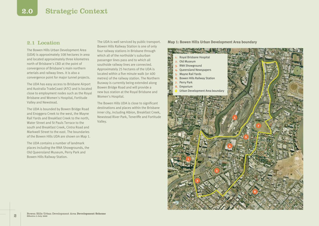
Map 1: Bowen Hills Urban Development Area boundary2.1 LocationThe Bowen Hills Urban Development Area (UDA) is approximately 108 hectares in area and located approximately three kilometres north of Brisbane's CBD at the point of convergence of Brisbane's main northern arterials and railway lines. It is also a convergence point for major tunnel projects.
The UDA has easy access to Brisbane Airport and Australia TradeCoast (ATC) and is located close to employment nodes such as the Royal Brisbane and Women's Hospital, Fortitude Valley and Newstead.
The UDA is bounded by Bowen Bridge Road and Enoggera Creek to the west, the Mayne Rail Yards and Breakfast Creek to the north, Water Street and St Pauls Terrace to the south and Breakfast Creek, Cintra Road and Markwell Street to the east. The boundaries of the Bowen Hills UDA are shown on Map 1.
The UDA contains a number of landmark places including the RNA Showgrounds, the Old Queensland Museum, Perry Park and Bowen Hills Railway Station.
The UDA is well serviced by public transport. Bowen Hills Railway Station is one of only four railway stations in Brisbane through which all of the northside's suburban passenger lines pass and to which all southside railway lines are connected. Approximately 25 hectares of the UDA is located within a five minute walk (or 400 metres) of the railway station. The Northern Busway is currently being extended along Bowen Bridge Road and will provide a new bus station at the Royal Brisbane and Women's Hospital.
The Bowen Hills UDA is close to significant destinations and places within the Brisbane inner city, including Albion, Breakfast Creek, Newstead River Park, Teneriffe and Fortitude Valley.
1
2
3
4
6
8
5
7
1. Royal Brisbane Hospital2. Old Museum3. RNA Showground4. Queensland Newspapers5. Mayne Rail Yards6. Bowen Hills Railway Station7. Perry Park8. Emporium— Urban Development Area boundary

32Bowen Hills Urban Development Area Development Scheme
Effective 3 July 2009
2.0Strategic Context
Looking south, over the Bowen Hills UDA, towards Brisbane City 2.2 VisionThe Bowen Hills Urban Development Area (UDA) is where Brisbane's two main northern arterials converge. It is also where all of the city's northern railway lines join. Bowen Hills will soon be where northbound traffic emerges from the Clem Jones Tunnel, after having travelled under the city centre. In only a few more years it will also be where traffic seeking to access the city centre emerges from the Airport Link tunnel.
In almost every sense, Bowen Hills should be regarded as the northern gateway to Brisbane's city centre. That it has not assumed this status before now is due to the influence of several unrelated, but compounding circumstances.
Although famed for its large events, the Royal National Association (RNA) Showgrounds is an inaccessible cluster of compounds for most of the year. Likewise, the Mayne Railway Yards are off limits for all but railway workers. Other transport infrastructure such as the Inner City Bypass, the progressively emerging elevated roadways of the Clem Jones Tunnel connections and the tired condition of the Bowen Hills Railway Station do not lay the foundations for creating an inviting place for people.
Other factors that have, in the past, limited the potential of Bowen Hills include:
the lack of land use diversity, community facilities and services, which has detracted from the amenity and attractiveness of Bowen Hills as a destination
a lack of public places for informal gathering and significant buildings that offer civic space around the Bowen Hills Railway Station
narrow, indirect, poorly lit and difficult to navigate routes to the Bowen Hills Railway Station
a poor, fragmented public realm
a lack of active street edges
a street network that lacks permeability
vehicle dominated roads and exposed pedestrian environments
small land parcels under fragmented ownership.
However, circumstances are about to change and Bowen Hills is set to capitalise on its gateway location.
Bowen Hills is ideally located to take advantage of both the continuing interest in residential accommodation and the high demand for new office floor space in the inner city and near city locations. It is close to Brisbane's CBD, has good access to the Brisbane Airport and Australia TradeCoast, has an excellent standard of rail service and contains several large sites that are underutilised and prime for redevelopment.

54Bowen Hills Urban Development Area Development SchemeEffective 3 July 2009
2.0 Strategic Context
Under the development scheme, Bowen Hills will become the northern gateway to the centre of Brisbane and will develop as a vibrant, inner urban locality, accommodating a wide, integrated and balanced range of uses that are connected by a high quality public realm.
Taking advantage of its strategic gateway location and high frequency public transport, future development within comfortable walking distance of the Bowen Hills Railway Station will exemplify best practice inner city transit oriented development (TOD) and deliver the densities required to increase public transport patronage and support a concentration of activity throughout the daytime and evening.
Through the development scheme, Bowen Hills will achieve a range of housing options and contribute to making housing more affordable.
Housing in the area will deliver choice and diversity by offering a mix of densities, types, designs, tenures and levels of affordability that cater to a range of lifestyles, incomes and lifecycle needs.
The transformation of this area will demonstrate the principles of sub-tropical urban design through innovative architecture and public realm improvements.
A network of public transport and pedestrian and bicycle paths will ensure the area is a well connected place and that people who live and/or work there can incorporate physical activity and healthy living into their daily lives.
The successful renewal of Bowen Hills and the creation of a unique and complementary employment centre is critical to enhancing the appeal and competitiveness of Brisbane's city centre.
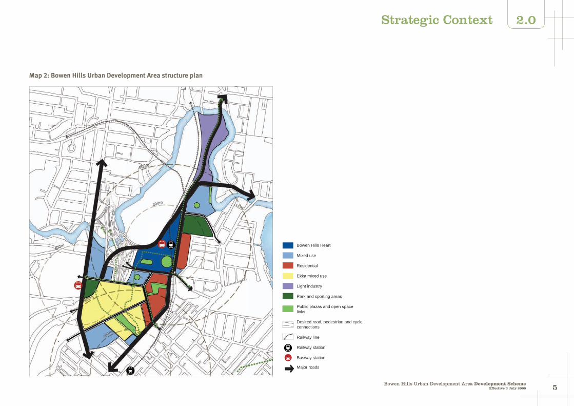
2.3 Structure planThe structure plan (refer to Map 2) for the Bowen Hills UDA illustrates the following key elements of the vision.
At the heart of Bowen Hills will be a high intensity mixed use precinct taking advantage of the transit oriented development opportunities afforded by the Bowen Hills Railway Station.
This precinct will also feature a high quality public realm including a plaza adjacent to the station and a network of pedestrian and cycle connections.
South and east of the heart will be residential precincts reinforcing and taking advantage of the area's facilities and services. East of Abbotsford Road the residential development will scale down to a low intensity form fronting Cintra Street. South of Campbell Street the ground floor levels of residential developments fronting connecting streets will be characterised by active uses contributing to the establishment of high quality streetscapes.
Mixed use precincts south and west of the heart will provide for hospital related activities and provide a strong built form along O'Connell Terrace and Bowen Bridge Road, complementing the prominent built form of the hospital complex and creating a clearly defined northern gateway to the city centre.
The RNA Showgrounds will continue to be a venue for major events but will benefit from a program of redevelopment and renewal that will see extensive mixed use activities established there.
This will activate the showgrounds year round and contribute to the creation of vibrant precincts that have a positive interface with, and enliven, perimeter streets. Pedestrian connectivity through the showgrounds will enhance the permeability of the precinct.
Existing areas of public open space at Bowen Park and Perry Park will be retained and enhanced to provide improved recreation and sporting opportunities.
The precinct between Gregory Terrace and Water Street will provide for intensive mixed use development close to Brunswick Street with significant residential redevelopment opportunities adjacent to the RNA Showgrounds site.
The precinct between Perry Park and the Inner City Bypass will be characterised by mixed use activities of moderate intensity, taking advantage of the proximity to both the heart of Bowen Hills and the Breakfast Creek corridor.
The industrial activities north of the Inner City Bypass will continue to provide services to the inner city and business support for the activities in nearby areas. Public access along the Breakfast Creek corridor as redevelopment occurs.
This vision is spatially illustrated in Map 2: Bowen Hills Urban Development Area structure plan.
54Bowen Hills Urban Development Area Development Scheme
Effective 3 July 2009
2.0Strategic Context
Map 2: Bowen Hills Urban Development Area structure plan
links
Bowen Hills Heart
Mixed use
Residential
Ekka mixed use
Light industry
Park and sporting areas
Public plazas and open space
Desired road, pedestrian and cycle connections
Railway line
Railway station
Busway station
Major roads

76Bowen Hills Urban Development Area Development SchemeEffective 3 July 2009
3.0 Land Use Plan: Context
Figure 1: Components of the land use plan and their relationship
Vision
Broad outcomes and Structure Plan
UDA wide criteria
Affordable housing
Urban design and sustainability
Transport, access, on-site parking and servicing
Environment
Lot design
Precincts
Precinct and zoning plan
Precincts
Precinct intent
Precinct outcomes
Preferred land uses
Level of assessment table
Development requirements
Sub-precincts (where applicable)
Sub-precinct criteria
3.2.2 UDA vision
The vision for the UDA specifies planning outcomes which:
(i) seek to achieve for the UDA the purposes of the Act
(ii) are the basis for the requirements about the carrying out of development for the UDA.
The UDA planning outcomes are spatially represented in Map 2.
3.2.3 Development requirements
The development requirements are as follows:
(i) maps that indicate the future development of the following:
the whole UDA
designated parts of the UDA (precincts)
designated parts of precincts (sub-precincts)
(ii) criteria for the whole UDA (UDA-wide criteria)
(iii) zones, statements of intent, outcomes, preferred land uses and development intensity and built from requirements for each precinct (precinct criteria) and sub-precinct criteria
(iv) tables specifying the level of assessment for development for each precinct (level of assessment table).
3.1 Purpose of the land use plan
The purpose of the land use plan is to regulate orderly development and articulate the preferred form of development within the Urban Development Area (UDA), its precincts and sub-precincts.
Figure 1 details the components of the land use plan and explains their relationship to each other.
3.2 Development assessment procedures
3.2.1 Land use plan outcomes
The land use plan seeks to achieve outcomes for the Bowen Hills UDA which are specified in the following:
(i) the broad statements of planning intent for the UDA specified in the vision
(ii) the requirements about the carrying out of development within the UDA.
76Bowen Hills Urban Development Area Development Scheme
Effective 3 July 2009
3.0Land Use Plan: Context
3.2.4 Levels of assessment
The levels of assessment for the carrying out of development for the UDA are specified in the land use plan in the relevant level of assessment table which states in:
(i) column 1, UDA exempt development
(ii) column 2, UDA self assessable development (self assessable development)
(iii) column 3A, UDA assessable development which is not prohibited (permissible development)
(iv) column 3B, UDA assessable development which is prohibited (prohibited development).
3.2.5 Development consistent with the land use plan
Self-assessable development which complies with any applicable development requirements is consistent with the land use plan.
Permissible development is consistent with the land use plan where:
(i) the development complies with the requirements about the carrying out of development for the UDA, or
(ii) the development does not comply with the requirements about the carrying out of development for the UDA but:
the development does not conflict with the structure plan or otherwise compromise the vision for the UDA
there are sufficient grounds to approve the development despite the non compliance with the UDA development requirements.
Otherwise, the permissible development is inconsistent with the land use plan and must be refused.
Identification of development as permissible development does not mean that a UDA development approval (with or without conditions) will be granted.
Permissible development requires a UDA development application to be lodged with the Urban Land Development Authority (ULDA) for assessment and decision. Approval is required for permissible development to be undertaken.
Prohibited development is inconsistent with the land use plan.
Prohibited development may not be carried out in the UDA.
In this section 'grounds' means matters of public interest which include the matters specified as the main purposes of the Act as well as:
superior design outcomes
overwhelming community need.
'Grounds' does not include the personal circumstances of an applicant, owner or interested third party.
3.2.6 Sub-precinct development requirements
Permissible development in a sub-precinct may not occur unless a detailed plan for the sub-precinct (sub-precinct plan) has been approved or the ULDA advises that, in its opinion, a sub-precinct plan is not required
as the development will not compromise the principles and outcomes of the sub-precinct and will not unreasonably prejudice the opportunities for the development of the remaining area in the sub-precinct.
In respect of the first permissible development that requires a sub-precinct plan, a UDA development application relating to all land in the sub-precinct and a sub-precinct plan must be made.
Any variation to an approved sub-precinct plan will require a new sub-precinct plan which must be accompanied by a UDA development application.
A sub-precinct plan must demonstrate how sub-precinct principles and outcomes are achieved and include the following:
such additional requirements for development in the sub-precinct
such other matters specified in a guideline issued by the ULDA.
A sub-precinct plan must be consistent with the vision for the UDA.
3.2.7 Consideration in principle
The ULDA may accept, for consideration in principle, a proposed UDA development application (application for consideration in principle).
The ULDA will consider the application for consideration in principle and may decide the following:
(i) whether it supports the application, with or without qualifications that may amend
the application
(ii) whether it opposes the application
(iii) whether it cannot accept the proposal until a detailed assessment is made and those details should be the subject of a UDA development application, or
(iv) whether it has no established view on the proposal and no indication of support or opposition can be given at that time.
The ULDA when considering a UDA development application:
(i) is not bound by any decision made regarding an application for consideration in principle
(ii) may give such weight as it considers appropriate to the decision in respect of the application for consideration in principle.
3.2.8 Land not included in a zone
This section applies to land which is not shown in the land use plan as being included in a zone or precinct (unallocated land).
Where the unallocated land is adjoined by land included in the same precinct, the unallocated land is deemed to be included in that zone or precinct.
Where the unallocated land is adjoined by land included in different zones or precincts, the unallocated land is deemed to be included in those zones or precincts with the centreline of the unallocated land being the boundary between the zones or precincts.
98Bowen Hills Urban Development Area Development SchemeEffective 3 July 2009
3.0
3.2.9 Notification requirements
A UDA development application will require public notification if the development application:
(i) is accompanied by a sub-precinct plan
(ii) is for a use, or of a size or type which, in the opinion of the ULDA, warrants public notification.
3.2.10 Relationship with local government planning scheme and IPA
This development scheme replaces the Bowen Hills Interim Land Use Plan (ILUP).
Unless this development scheme specifically applies a provision of a planning instrument or a plan, policy or code made under the Integrated Planning Act 1997 (IPA) or another Act, the development scheme is inconsistent with the provisions of the planning instrument or plan, policy or code.
The development scheme prevails to the extent of an inconsistency with any of the following instruments:
(i) a planning instrument
(ii) a plan, policy or code made under the IPA or another act.
3.3 UDA zonesLand within a UDA may be allocated a zone.
The zones that may apply within a UDA are grouped in the following four categories: mixed use, residential, employment and other.
Within each of these categories there are a number of zones. These zones are described below.
Mixed use category
The Mixed Use Centre Zone caters for the widest range, highest order and greatest intensity of commercial, retail, administrative, civic, community, indoor entertainment and leisure facilities, cultural activities and mixed residential.
The Mixed Use Zone caters for a range of commercial, retail, administrative, civic, community, indoor entertainment and leisure facilities, cultural activities and residential uses.
The Mixed Use Residential Zone caters for predominantly residential uses where the gross floor area of non-residential uses does not exceed the gross floor area of residential uses.
Residential category
The Residential Medium Intensity Zone caters for a range of residential types including houses, multiple residential and other residential (including special needs accommodation). The zone also caters for housing that is affordable, accessible and appropriate, reflecting local housing need.
Densities in this zone will generally be between 30 and 60 dwellings per hectare.
The Residential High Intensity Zone caters for a range of residential types including multiple residential and
other residential (including special needs accommodation). The zone also caters for housing that is affordable, accessible and appropriate, reflecting local housing need.
Densities in this zone will generally be between 60 and 100 dwellings per hectare.
The Residential Very High Intensity Zone caters for a range of residential types including multiple residential and other residential (including special needs accommodation). The zone also caters for housing that is affordable, accessible and appropriate, reflecting local housing need.
Densities in this zone will generally be over 100 dwellings per hectare.
Non-residential land uses such as local shops, food premises, schools, churches and community infrastructure that provide direct support to residential uses may be suitable in all residential zones. Non-residential uses can only be established where residential character and amenity are maintained and when the uses cater for the needs of the immediate community and do not undermine the viability of any centres. Home based businesses may occur in all residential zones where residential character and amenity are maintained.
Employment category
The Medium Impact Employment Zone caters for commercial, service and light industry uses which service the population and visitors and facilitate the expansion of small to medium scale business activities.
The Medium Impact Employment Zone can also cater for showrooms (including supporting office and retail) and display facilities, services and trades, such as mechanical workshops and service stations and facilities required by the travelling public such as food premises, visitor accommodation, recreation and amusement. Non-commercial development can also be accommodated where such development complements the intended commercial/enterprise character of the locality.
Other category
The Civic and Open Space Zone caters for a full range of publicly accessible outdoor recreation and sport uses, from informal sports or events on a casual basis and the facilities associated with these such as picnic amenities, children's playground, non-organised sporting facilities, outdoor cultural and educational activities, public swimming pools, outdoor courts and parkland, and sports grounds. Any structures in the civic and open space zone will only occupy a small part of any site and may include facilities for spectators, club buildings and associated off-street parking facilities.
The Complementary Land Zone applies to land that accommodates major infrastructure. In addition to providing for this infrastructure, the zone caters for a range of activities and facilities for recreational and community purposes including pedestrian and cycle paths, landscaped areas and incidental open space.
Land Use Plan: Context

98Bowen Hills Urban Development Area Development Scheme
Effective 3 July 2009
3.0
3.5.2 Maximum development yield
The maximum development yield allowable under this development scheme will be the greater of that:
(i) shown in the applicable development intensity and built form requirements where a ULDA development agreement has been entered into with the ULDA in accordance with the infrastructure plan and implementation strategy
(ii) as provided for under section 3.2.5 where a ULDA development agreement has been entered into with the ULDA in accordance with the infrastructure plan and implementation strategy
(iii) shown in Map 3 or
(iv) where evidence is provided that there is a BCC development approval that has not lapsed (a valid approval) - the development yield permitted by the valid approval.
3.5.3 Development contribution rate
The development contribution rate included in a development agreement entered into pursuant to section 3.5.2 shall:
be at a rate determined for the UDA or a precinct in the UDA
except as provided for in section 3.2.5, equate to a charge applied for every square metre of additional GFA in excess of that shown on Map 3 or permitted under a valid approval
However, it is not considered responsible to use public money to pay for the infrastructure when the infrastructure and associated higher development yield will result in a windfall gain to private land owners.
To fund these works, and to retain an incentive for the landowner to develop, a portion of the uplift of land value gained through the higher development yield created through the development scheme will be required to be paid as a development contribution.
In addition, to achieve sustainable and healthy high density outcomes, proactive intervention will be required in the provision of affordable housing and achievement of ecologically sustainable outcomes.
The contribution arising from the uplift of land value, called a major infrastructure and affordable housing development contribution, will be applied within the UDAs to fund the provision of major infrastructure, affordable housing and ecological sustainability.
For fairness, landowners that do not want to develop above current permitted BCC City Plan densities should not be required to pay the major infrastructure and affordable housing development contribution. In this circumstance only the standard BCC Infrastructure Charges Schedule (ICS) type charge would apply. However, the 5% diversity requirement under the ULDA's Affordable Housing Strategy will still apply.
3.4 Purpose of development criteria
The following development criteria apply to all UDA assessable and self-assessable development in the Bowen Hills UDA. To the extent that they are relevant, they are to be taken into account in the preparation of UDA development applications and the assessment of those applications by the ULDA.
In addition to these UDA-wide development requirements, land may be subject to precinct specific development requirements and sub-precinct development principles. Precincts and sub-precincts for the Bowen Hills UDA are identified in Map 7: Zoning and precinct plan.
UDA-wide development criteria should be read in conjunction with the relevant precinct specific development requirements or sub-precinct development principles.
The infrastructure plan and implementation strategy may include further information, which should be taken into account in design and project feasibility planning for development proposals.
The Bowen Hills UDA-wide development criteria cover the following topics:
maximum development yield and development contributions
affordable housing
urban design and sustainability
transport, access, on-site parking and servicing
environment
lot design.
3.5 Maximum development yield and development contributions
3.5.1 Context
The development scheme provides higher development yield in many of the precincts within the declared UDAs.
Within the Bowen Hills UDA, considerable infrastructure investment is required to enable a higher development yield across the UDA above that currently allowed for under the Brisbane City Council City Plan 2000.
The infrastructure works required to service this higher development yield are greater than can be funded by Brisbane City Council's (BCC) standard infrastructure charging regime.
Consequently, the creation of a healthy, sustainable and well serviced community in the Bowen Hills UDA will require positive intervention by the ULDA in relation to the achievement of essential infrastructure, affordable, accessible and appropriate housing and ecologically sustainable outcomes.
Land Use Plan: UDA-wide development criteria

1110Bowen Hills Urban Development Area Development SchemeEffective 3 July 2009
3.0
apply in addition to any other infrastructure contribution required under this development scheme and
be apportioned to infrastructure, affordable housing outcomes (the affordable housing contribution) and ecologically sustainable development outcomes, as determined by the ULDA.
3.5.4 Development agreement
The development agreement entered into pursuant to section 3.5.2 may include amongst other things provisions prescribing:
the amount, timing and bonding of monetary contributions
the arrangements for providing a bank guarantee securing payment of the monetary contribution
the arrangements for credit for the provision of works or product in lieu of monetary contributions
mechanisms to ensure an affordable product retains its affordability over the long term and
any other matter that the ULDA deems appropriate in the achievement of the Act's purpose.
3.5.5 Transitional provisions
For the purposes of calculating the total development contribution to be included in a development agreement entered into pursuant to section 3.5.2, the ULDA may adopt a development yield greater than that shown in Map 3, where the landowner purchased the property prior to 27 March
Map 3: Bowen Hills UDA plot ratios under BCC City Plan 2008 (being the date of declaration of the Bowen Hills UDA) on the basis of a reasonable expectation that a higher development yield than that shown in Map 3 would have been approved by BCC.
In support of a claim under this section, a land owner is to provide information that demonstrates a higher development yield would have been achieved. This information may include:
a valuation showing that the purchase price was based on achieving a higher development yield
a development feasibility prepared at or about the time of purchase, but prior to 27 March 2008, based on the higher development yield
evidence, prepared prior to March 27 2008, from BCC that a higher development yield was supported or had a likelihood of approval or
any other material that supports a landowner's request.
A development agreement entered into pursuant to section 3.5.2, and including a total development contribution calculated from the application of this section, may also include provisions stating the total development contribution will revert to that applying under section 3.5.3 where development has not substantially commenced within the time stated in the development agreement, such time being not less than three years from when the development agreement was entered into.
Land Use Plan: UDA-wide development criteria
1110Bowen Hills Urban Development Area Development Scheme
Effective 3 July 2009
3.0
3.6 Affordable housingHousing diversity
All residential development (including residential components of a mixed use development) must deliver housing choice to suit a variety of households including: families, singles, couples, work-at-home occupiers, students, retirees, group accommodation households and people with special needs by offering universal design and a variety in size, configuration, cost, adaptability, location and tenure.
Except as set out in section 3.5, all residential and mixed use developments must have a minimum of 5% of the gross floor area of all residential dwellings as affordable to rent by households on the median household income for the Brisbane City Council local government area (the affordable housing component).
Where an applicant cannot demonstrate that this requirement will be achieved by the proposed development:
the applicant will need to enter into a development agreement with the ULDA by which the applicant agrees to pay to the ULDA an equivalent monetary contribution prior to the development approval for building work being given
if a subsidy is proposed by the applicant to achieve the affordability criteria - the subsidy must be protected by a legal arrangement to the ULDA's satisfaction.
This residential development is to be accessible, appropriate and designed in accordance with universal and sustainable design principles1 to meet the changing needs of people and households over time.
The affordable housing component of a development must be distributed throughout the development and:
(i) be finished to a suitable standard with all reasonable fixtures, services and appliances
(ii) achieve high quality design outcomes to avoid identifying them or setting them apart in the community.
Development agreement - affordable housing
The development scheme may incorporate provisions that, where a proponent elects to utilise the increased density permitted by the development scheme, a percentage of the uplift of land value must be shared with the ULDA as a development contribution.
This contribution will assist the ULDA to:
deliver essential infrastructure
provide affordable housing
achieve ecologically sustainable outcomes.
1 Refer to "Smart and Sustainable Homes Design Objectives", Department of Public Works (2008). Booklet available from www.build.qld.gov.au/smart_housing/pdf/design_objectives_08
A development agreement will be required to be entered into with the ULDA where the applicant wishes to avail themselves of the higher development yield.
A development agreement will include specific provisions in relation to affordable housing.
A development agreement will be required where:
a housing diversity requirement leads to the provision of housing product that requires a subsidy to meet the affordable housing target
a proponent is permitted to 'convert' provision of affordable housing product to a contribution in lieu
agreement is reached with a proponent to 'convert' a monetary contribution to the provision of product in lieu.
The provisions of a development agreement relating to the provision of affordable housing may include, among other things:
amount, timing and bonding of monetary contributions
provision of monetary contributions in lieu of built product (refer Appendix A of the ULDA's Affordable Housing Strategy for development agreement inclusions)
provision of a bank guarantee securing payment of the monetary contribution
provision of built product in lieu of monetary contributions (refer Appendix B of the Affordable Housing Strategy for development agreement inclusions)
mechanisms to ensure an affordable product retains its affordablility over the long term.
Mechanisms to retain affordability
The ULDA is seeking to maximise affordable housing outcomes in the UDAs over the long term.
Affordable housing product delivered using some level of subsidy will require mechanisms to ensure:
affordable purchase product is not resold providing a windfall gain to the first purchaser
affordable rental product remains affordable to the target group for a significant period of time.
There are a number of ways of achieving this outcome.
Where the affordable housing provider has been approved for the National Rental Affordability Scheme (NRAS) they will be required to retain affordability for ten years under Australian Government‘s program requirements.
Formal management agreements can be made with either the Department of Communities or a registered community housing organisation.
Establishment of a shared equity arrangement with an approved equity partner.
Land Use Plan: UDA-wide development criteria
1312Bowen Hills Urban Development Area Development SchemeEffective 3 July 2009
3.0
3.7 Urban design and sustainability
The form, type and arrangement of buildings, streets and public spaces within the Bowen Hills UDA must demonstrate good urban design and sustainability by addressing each of the elements contained in this section.
All elements of this section must be achieved to the greatest extent practical, having regard to each of the other elements.
Placemaking
Development is to contribute to a sense of place by:
promoting place identity and distinctive character
individually and collectively creating an attractive and appealing place for residents, workers and visitors
contributing to permeability of the site and the surrounding area
contributing to the legibility of the UDA
contributing to a public realm that is inclusive, accessible and safe
creating a positive relationship between public and private realms, in particular at street and first floor levels
contributing to a wide range and rich variety of activities and uses
providing opportunities for formal and informal gathering and interaction
connecting with the surrounding areas
encouraging pedestrian and cycle use
facilitating public transport access and use
helping to build and support a local economy
helping attract and retain a diverse population.
Sub-tropical design
Development is to be climatically responsive by employing appropriate design principles and strategies that ensure:
buildings are orientated to optimise seasonal solar gain and loss, taking into consideration major site views and vistas
building form allows for cross ventilation and supports a naturally ventilated and comfortable environment
weather protection and sun shading (including eaves and overhangs) are incorporated into facades and roof forms to reduce direct solar heat and provide rain protection appropriate to each facade orientation
building design incorporates light and shade providing well detailed and articulated facades
roles and responsibilities of government
registered Not for Profit housing organisations and the private sector
policy and program development required to support affordable housing delivery including addressing priorities such as conenants and management plans on title and the potential for development of a shared equity scheme.
Exemptions
The following development types are exempt from providing the affordable housing contributions specified above:
development for the purpose of affordable housing (including social and community housing) and developed by:
the Queensland Department of Housing
a registered community housing or non-profit organisation
part of a consortium with a registered community housing or non-profit organisation for the provision of affordable housing equivalent to the value of the affordable housing contribution
development for the purpose of community facilities and services
development by a government, non-profit or charitable institution providing a community benefit
development for the purpose of a public utility installation.
Limiting the trading of a dwelling to a particular target and income group through a title covenant. This means that affordable owner occupied units are only on-sold to other eligible buyers, with transfer of ownership occuring through a controlled process which excludes wills, private sales or bequests.
Placing a covenant and management plan on the title of a property which ensures it is rented at affordable levels of rent to an indentified target group for 15 years or more and managed by a registered Not For Profit community housing organisation.
The preferred mechanism will be determined on a project by project basis between the ULDA and the development proponent at the time of development approval and will be set out in the development agreement.
Other matters
In addition to the above provisions the ULDA will develop a detailed implementation plan for it’s Affordable Housing Strategy covering issues such as:
monitoring and evaluation
applying the strategy with the development assessment process
universal and sustainable design guidelines
facilitating access to Australian Government and Queensland Governement affordable housing programs
Land Use Plan: UDA-wide development criteria

1312Bowen Hills Urban Development Area Development Scheme
Effective 3 July 2009
3.0
outdoor/semi-outdoor living and 'indoor to outdoor' integration is provided by the use of balconies, courtyards, roof gardens and large windows creating open facades.
Community safety and well-being
Crime Prevention through Environmental Design (CPTED) principles should underpin the design of all development within the UDA.
In particular, regard should be given to the Crime Prevention through Environmental Design (CPTED) Guidelines for Queensland.
Development is to incorporate appropriate safety features in line with current standards and best practice guidance including fire safety, emergency vehicle access and flood immunity2.
Development must promote community health and well-being through a design3 that supports a healthy and active lifestyle.
All buildings, as well as public and private spaces are to be designed to be inclusive and accessible and comply with best practice standards4.
While recognising the desire for buildings to incorporate sub-tropical design solutions,
2 Refer to State Planning Policy 1/03, section A4.2 and the State Planning Policy 1/03 Guideline, Appendix 5, Table A. The Defined Flood Event (DFE) is the 1% Annual Exceedance Probability (AEP) flood.
3 For example, the design principles in the "Healthy by Design Guidelines" (National Heart Foundation, Victoria 2004)
4 Including for example: disability discrimination legislation; Australian Standard 1428; and Smart and Sustainable Homes Design Objectives, Department of Public Works (2008).
buildings overlooking rail corridors must also ensure that the safety and operational integrity of railways are protected by incorporating appropriate design solutions that obstruct the throwing of objects at trains or onto the overhead line equipment (OHLE) that may cause damage or service interference.
Development adjacent to a rail corridor must also be designed to ameliorate the risks associated with proximity to a rail corridor such as collisions with rolling stock or dangerous goods and pedestrian tresspass.
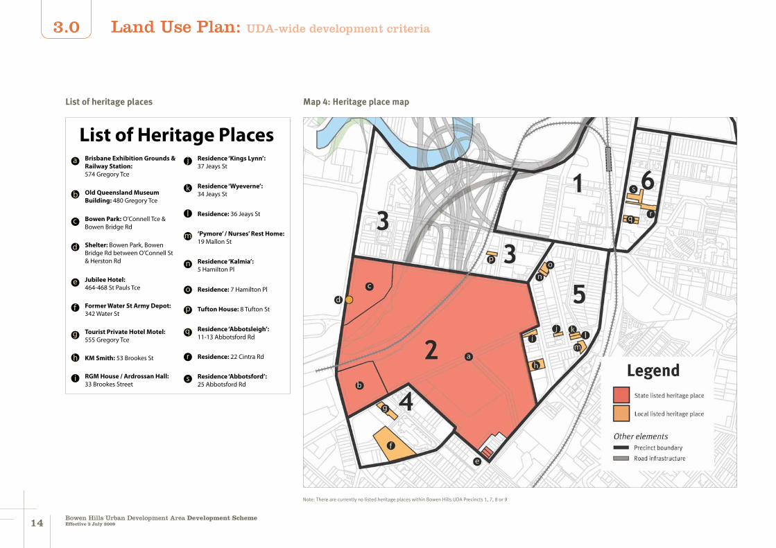
Heritage, character and culture
The removal or demolition of any building or structure forming part of a heritage place as identified on Map 4, will be considered only in those circumstances where the retention of the building or structure would prejudice the delivery of the identified precinct outcome.
In those circumstances where approval is given to remove or demolish an identified heritage building or structure, the heritage building or structure, its context and its heritage significance is to be appropriately documented prior to its removal or demolition and submitted to the ULDA.
Development on, or adjoining, a heritage place as identified on Map 4 must respect the heritage values of the site by sensitively managing the interface between development opportunities and the heritage place.
To help create place identity and a distictive
character for the UDA, development should seek to protect, incorporate, re-use or re-interpret the heritage, character, cultural features and history of the UDA and surrounding area.
Building form
(a) General provisions
Buildings are to be well articulated with external balconies, doors and doorways, windows, shade and screening devices, outdoor planting and mixed use tenancies. The use of materials and design details are to contribute both individually and collectively to a distinctive Bowen Hills character.
Residential building design is to ensure visual and noise privacy, adequate balcony size, adequate storage space, adequate room sizes, functional room relationship and the provision of useable and well connected common outdoor spaces.
(b) Ground level detail
Ground level building elements are to introduce a variety of details and finishes.
Entries
Front entries to all buildings are to be emphasised through architectural and landscape treatment, pedestrian paths and awnings so as to be obvious without the need for signage and address requirements for active frontages.
Screening and awnings
Buildings are to respond to local microclimatic conditions by incorporating
appropriate weather protection, screening and shading structures on the building facades to channel breezes, filter sunlight, block out night lighting and provide rain protection.
At street level, awnings are to be used to provide all year protection from sun and rain. In particular:
awnings to primary frontage retail activities must be continuous across the entire street alignment and extend over the footpath to within 0.9 metres of the street kerb
awnings to secondary frontage commercial and mixed use buildings need not necessarily be continuous but must extend over the footpath to within 0.9 metres of the street kerb for the width of the building's main entry
buildings on corners should provide an awning over the main entry on each frontage
for residential buildings where awnings are not provided, street trees are to provide protection from climatic conditions and separate pedestrians from traffic movement.
Land Use Plan: UDA-wide development criteria
1514Bowen Hills Urban Development Area Development SchemeEffective 3 July 2009
3.0
List of heritage places
List of Heritage Places
g
KM Smith: 53 Brookes St
a Brisbane Exhibition Grounds & Railway Station: 574 Gregory Tce
b Old Queensland Museum Building: 480 Gregory Tce
d
Jubilee Hotel: 464-468 St Pauls Tce
e
Former Water St Army Depot: 342 Water St
f
Tourist Private Hotel Motel: 555 Gregory Tce
c Bowen Park: O’Connell Tce & Bowen Bridge Rd
h
RGM House / Ardrossan Hall: 33 Brookes Street
i
Residence ‘Kings Lynn’: 37 Jeays St
j
Residence ‘Wyeverne’: 34 Jeays St
k
Residence: 36 Jeays Stl
‘Pymore’ / Nurses’ Rest Home: 19 Mallon St
m
Residence ‘Kalmia’: 5 Hamilton Pl
n
Residence: 7 Hamilton Plo
p
q
r
s
Tufton House: 8 Tufton St
Residence ‘Abbotsleigh’: 11-13 Abbotsford Rd
Residence: 22 Cintra Rd
Residence ‘Abbotsford’: 25 Abbotsford Rd
Shelter: Bowen Park, Bowen Bridge Rd between O’Connell St & Herston Rd
Note: There are currently no listed heritage places within Bowen Hills UDA Precincts 1, 7, 8 or 9
Map 4: Heritage place map
Land Use Plan: UDA-wide development criteria
1514Bowen Hills Urban Development Area Development Scheme
Effective 3 July 2009
3.0
Landscaping
Landscaping is to contribute to the visual amenity and liveability of Bowen Hills.
For residential development, landscaping must cover a substantial area of the site and provide on-site recreation opportunities.
For non-residential and mixed use development, landscaping must be designed and located to provide a positive visual and amenity contribution to the public realm.
In general, landscaping is to be designed and located so that it:
addresses streets and open spaces and contributes to the amenity of the public realm
does not undermine personal and property security of the surveillance of footpaths and public open space
deters crime and vandalism
responds to microclimatic opportunities.
Fences and walls
Except for specific feature walls associated with specific uses, fences or walls to ground floor residential uses must be visually permeable 50 per cent permeability generally provides an appropriate level of visual permeability.
Storage and bin areas
External storage and bin areas should be contained within the buildings and / or should not be visible from the public realm.
Building design and external storage and bin areas must facilitate the efficient sorting
and disposal of waste to maximise recycling opportunities.
Windows to retail tenancies
Window sills to retail tenancies should be within 100 - 300 millimetres above the corresponding footpath level. Floor levels behind the windows can be higher than this on sloping footpaths.
Use of reflective glass in windows is not appropriate.
(c) Upper level detail
The upper level elements of buildings must incorporate appropriate elements such as overhangs and sun shading to detail the top of the building against the skyline.
Balconies
Covered balconies are encouraged in all locations to reflect a sub-tropical character and provide external spaces that can be used under a variety of weather conditions.
Balconies should overlook streets and public spaces providing surveillance and connection with the street.
In all locations, balconies must be appropriately located and/or screened to maximise privacy between buildings and/or to the public realm.
Roof form
Roofs are to be appropriately designed to ensure plant and equipment is integrated with the overall roof design.
Varied roof forms, building heights and
massing of elements is encouraged.
(d) Building arrangement
High rise buildings must have distinct lower, middle and upper sections so as to:
maintain a strong relationship with the street by framing and activating the public realm and entrance spaces while reinforcing the street hierarchy
deliver a variety of setbacks on the ground floor to create plazas, outdoor dining areas or open vistas
create internal communal open spaces and courtyards in both residential and commercial developments
reduce the visual bulk of the building
provide roof forms that are more visible and accentuated so as to enliven the skyline of the Bowen Hills UDA.
Where residential uses are located above podiums, it is expected that the tower footprints will be smaller to provide roofspace for terraces, roof gardens etc.
(e) Building frontages
Buildings in the UDA must contribute to an active and safe public realm.
Map 5 identifies the different frontages within the Bowen Hills UDA and describes their role for contributing to an active and safe public realm.
Primary active frontages
Buildings on primary active frontages must:
activate the street for extended hours
of the day and night by building up to or near the street edge, generally parallel to the street alignment and supporting a mix of uses
be visually and physically permeable, containing many windows and entrances
reinforce the priority of pedestrian by addressing the street, having strongly expressed pedestrian entrances, minimising the number and size of vehicle access points and using appropriate street treatments. If vehicle access points are unavoidable, they should be integrated into the building design to minimise their impact on the safety and amenity of the public realm
contribute to comfort for pedestrians by delivering continuous awnings, providing shelter over footpaths
incorporate car parking which is either located below ground level or not visible from the public realm
provide opportunities to overlook the street, increase surveillance and reinforce the active frontage, particularly from upper floors.
Secondary active frontages
Buildings on secondary active frontages need not be activated by retail and commercial uses but must:
address the street and public realm, providing casual surveilance
provide facades that contain well-detailed and articulated access points at frequent
Land Use Plan: UDA-wide development criteria
1716Bowen Hills Urban Development Area Development SchemeEffective 3 July 2009
3.0
intervals along pedestrian networks and do not include blank walls
provide awnings located at key entry points.
Other frontages
Buildings on other frontages must:
address the street and public realm but may have a wider variety of setbacks to allow for privacy to be maintained between streets and dwellings and cater for courtyards, balconies and deep planting areas
locate basements, where possible, within building footprints and set back from street alignments to allow areas for deep planting
emphasise entries through architectural and landscape treatment, pedestrian movement paths, awnings and height.
Gateways and landmark buildings
A number of gateways are identified within the Bowen Hills UDA. These gateways, as shown on Map 5, represent the main entry points and approaches to the Bowen Hills Heart and are located at:
the intersection of O'Connell Terrace and Bowen Bridge Road
the intersection of Hudd Street and Abbotsford Road and the southern entrance to the Bowen Hills Rail Station
the intersection of Edmondstone Road and Abbotsford Road
the intersection of Abbotsford Road,
Montpelier Road, Campbell Street and Markwell Street
the intersection of Brookes Street and St Pauls Terrace
the southern side of the intersection of Brunswick Street and Greggory Terrace
where the on and off ramps from Airport Link connect to Campbell Street.
These gateways are to be reinforced through landmark buildings.
Landmark buildings reinforce gateways within the UDA by providing visual cues that announce the arrival within, or approach to, the Bowen Hills Heart and contribute to the identification of Bowen Hills as a distinct destination. Landmark buildings should also:
complete and frame vistas and views
increase legibility and add to the sense of place
provide a sense of scale at open spaces.
Landmark buildings may be created through a change of scale, materials and/or architectural treatment.
Private open space
(a) Common areas
Common private open space must be provided in all residential developments and:
provide for a mixture of outdoor uses and activities
be positioned for good solar orientation
be landscaped appropriately for a subtropical environment
Land Use Plan: UDA-wide development criteria
Map 5: Frontages and gateways

1716Bowen Hills Urban Development Area Development Scheme
Effective 3 July 2009
3.0
minimise water use
respect privacy of users and residents, including those on neighbouring properties.
(b) Balconies and other private open space
All residential units must incorporate generous balconies or private open space, attached to major internal living areas and providing room for outdoor private activity and furnishings such as a table, chairs, planting, a BBQ and shade. Balconies should be sized proportionately to the unit size and must not be less than 9m2 with a minimum dimension of three metres. However, it is considered desirable that 16m2 of private open space or balcony be achieved for all dwelling units.
Balconies must be appropriately located and/or screened to maximise privacy between buildings and/or the public realm and to protect amenity from transport corridor impacts, without compromising CPTED principles.
Ground floor private open space must provide privacy but still allow overlooking of the street to promote casual surveillance. Fences should be no higher than 1500mm and are to be visually permeable.
Lighting
External lighting should be designed to light up the building, particularly entrances and vegetated areas, without overspilling into other buildings or the sky.
External materials should not cause unreasonable glare.
Accessibility, permeability and movement
In support of TOD principles, priority should be given to pedestrian, cycle and public transport modes, over private vehicle use. This priority applies both to movement within the UDA and to the UDA.
Map 6 details the public realm and movement networks proposed within the UDA and how they are intended to connect with the public realm and movement networks outside the UDA.
Development within the UDA must contribute to a network of pedestrian and cycle-safe roads and highly interconnected, attractive and efficient bikeways that give a choice of routes connecting major activity nodes with each other and also linking them to residential areas.
Development is to give high priority to connectivity, directness of route and facilities by:
providing access to existing and proposed pedestrian and cycle networks
prioritising pedestrian and cycle movements over vehicle movements.
Land Use Plan: UDA-wide development criteria
Map 6: Public realm and movement networks
1918Bowen Hills Urban Development Area Development SchemeEffective 3 July 2009
3.0
3.8 Transport, access, on-site parking and servicing
Transport Corridors
Development does not unreasonably constrain future provision of public transport infrastructure (including rail, light rail, road, busway and cycle infrastructure) and does not adversely impact on the function or operation of existing or future public transport corridors including rail, light rail or busway corridors.5
Car parking
On-site car parking areas, loading bays and service areas are either integrated within or under buildings and sleeved by active frontages, or are located away from the public realm behind buildings.
The use of large blank screens to mask loading areas is not appropriate.
Slope should be used to create basement or semi-basement parking areas.
Vehicle service areas, cross-overs and car parking must not detract from the character of active edges and the public realm.
5 As the planning for the future provision of infrastructure is ongoing, the ULDA may obtain advice from any public sector entity responsible for the planning for or provision of the infrastructure as to whether the proposed development is likely to constrain the provision of future public transport infrastructure or adversely impact on the function or operation of any existing or proposed public transport corridors. The ULDA may have regard to any such advice in deciding the development application.
Development is required to provide on-site car parking in accordance with the rates set out in the precinct development criteria or sub-precinct development principles. Where a request is made to provide on-site car parking at a rate exceeding that prescribed for the precinct, the request must be accompanied by a strategy to maximise use of pedestrian, cycle and public transport opportunities over private vehicle use.
Where possible, underground car parking areas are to be naturally ventilated. Ventilation grills and structures should be integrated into the building design, located away from the primary street facade and oriented away from windows of habitable rooms and private open space.
Circulation
Development is to support increased accessibility, permeability and movement for pedestrians and cyclists and appropriate movement by vehicles, including emergency vehicles.
Pedestrian and cycle way paths6 and high quality cycling facilities are to be incorporated in all new roads within sub-precincts.
Development is to be designed to include safe and highly visible connections to pedestrian and cycle networks through building and landscape design elements and treatments.
6 See for example Austroads - Guide to Traffic Engineering Practice Standards for Pedestrian and Cycle Pathways.
End of trip facilities
End of trip facilities for pedestrians and cyclists are to be provided as part of development for non-residential purposes, including secure, undercover bicycle storage facilities, showers and lockers. Such facilities are to be provided to a standard consistent with AS2890.3.
Bicycle facility targets for apartments are:
residents - to have secure space per dwelling according to AS2890.3
visitors - to have secure space per 400m2 according to AS2890.3.
Bicycle facility targets for sites other than apartments are:
residents - to have secure space per 200m2 net lettable area (NLA) according to AS2890.3
visitors - to have secure space per 1000m2 NLA according to AS2890.3.
Land Use Plan: UDA-wide development criteria
1918Bowen Hills Urban Development Area Development Scheme
Effective 3 July 2009
3.0
Amended (refer to Schedule 3)
development areas between 5m AHD and 20m AHD requiring the disturbance of greater than or equal to 100m3 of soil below 5m AHD.
Acid sulfate soils will be treated in accordance with current best practice in Queensland7.
General noise requirements
The design, siting and layout of development must address noise impacts and where necessary incorporate appropriate noise mitigation measures.
Development is to achieve acceptable noise levels for noise sensitive uses in affected areas8
Where determined necessary by the ULDA, an acoustic report will be required to evaluate and address potential noise impacts and recommend appropriate noise mitigation measures.
General air quality
Development must:
limit exposure and risk associated with pollutants that could have a potentially adverse affect on human health
be in accordance with best practice air quality guidelines and standards9.
7 Consideration should be given to State Planning Policy (SPP) 2/02 Planning and Management Involving Acid Sulfate Soils and the Queensland Acid Sulfate Soils Technical Manual.
8 Refer to the Environmental Protection (Noise) Policy 2008.
9 Refer to Brisbane City Council's Air Quality Planning Scheme Policy and the Queensland EPA Guidelines on Odour Impact Assessment from Developments.
Water management
Development is to demonstrate, to the greatest extent possible, current best practice Water Sensitive Urban Design (WSUD) and Integrated Water Cycle Management (IWCM) principles for Australia.
Biodiversity and habitat
Development must not aversely affect significant vegetation.
Development is to be set back a minimum of 10 metres from the high water mark, except where stated otherwise in a precinct or sub-precinct.
Energy efficiency
Development must promote energy efficiency by encouraging:
alternative energy supply through the use of renewable energy sources
passive thermal design of buildings
energy efficient plant and equipment
use of natural light and energy efficient lighting.
Lifecycle costs and materials
Development is to incorporate sustainable features and smart design to reduce construction and operating costs.
Development is to encourage the efficient use of resources and waste minimisation.
At the time of construction, conduits for future electricity cables are to be installed within all new roads, road widenings and upgrades.
Land Use Plan: UDA-wide development criteria
3.10 Lot designLots must have an appropriate area and dimension for the siting and construction of the buildings, the provision of outdoor space, the relationship to adjoining development and public realm, safe and convenient convenient vehicle access, servicing and parking.
Lot frontages must address streets and civic and open space. This is to facilitate personal and property security, surveillance of footpaths and public open space and to deter crime and vandalism.
Lot sizes and dimensions must enable buildings to be sited to:
protect natural and cultural features, including significant vegetation and heritage places identified in Map 4
address site constraints including slope, soil erosion, flooding and drainage10
retain special features such as trees
ensure that lots are not subject to unreasonable risk, hazard, noise impacts or air quality impacts
ensure reasonable buffers between existing or potential incompatible land uses
maximise solar orientation benefits to assist energy rating targets.
10 Having regard to State Planning Policy 1/03: Mitigating the adverse impacts of Flood, Bushfire and Landslide.
3.9 EnvironmentSafety and risk
Development adjacent to a rail corridor is to be designed to ameliorate the risks associated with proximity to a rail corridor (such as collisions with rolling stock or dangerous goods).
Development in operational airspace, as per Brisbane Airport Master Plan, must not cause a permanent or temporary obstruction or potential hazard to aircraft movements.
Contaminated land
Development must ensure that all land and groundwater will be fit for purpose.
Remediation will meet Environmental Protection Agency (EPA) guidelines for the assessment and management of contaminated land in Queensland.
Acid Sulfate Soils (ASS)
The following site works will trigger an ASS investigation:
development areas below 5m Australian Height Datum (AHD) involving the disturbance of greater than 100m3 of soil
development areas below 5m AHD requiring the placement of greater than or equal to 500m3 of fill material in layer of greater than or equal to 0.5m in average depth

2120Bowen Hills Urban Development Area Development SchemeEffective 3 July 2009
3.0
Introduction
The Bowen Hills UDA is divided into nine precincts and four (4) sub-precincts. Land within the UDA is also allocated a zone.
The location and boundaries of the precincts and sub-precincts are shown on Map 7: Zoning and precinct plan.
The zones are explained in detail in section 3.3 of the land use plan.
Map 7: Zoning and precinct plan
Land Use Plan: Precincts

2120Bowen Hills Urban Development Area Development Scheme
Effective 3 July 2009
3.0
Precinct 1: Bowen Hills Heart
Legend
1 UDA Heart
Precinct
Mixed use centre zone
Zones
Desired road connections
Precinct boundary
Road infrastructure
Other elements
Rail infrastructure
Sub-precinct boundary
Precinct intent
Precinct 1 is the symbolic 'heart' of Bowen Hills. It will be a vibrant centre containing the highest intensity and greatest concentration of retail, commercial and residential activities. It will have a city centre character with streets lined by taller buildings close to the street alignment.
Development will address streets and public spaces and deliver retail and other uses such as cafes and restaurants at ground level. This will contribute to an active public realm both day and night.
Public spaces will provide the centre with opportunities to play and display. These spaces are clustered around the important gateway formed at the corner of Hudd Street and Abbotsford Road, where a number of taller
buildings provide a landmark for the gateway
and frame long distance views north and south.
The precinct will accommodate a new local
road network and deliver new pedestrian
routes through both civic spaces and along
urban streets.
Hudd Street and Mayne Road will form major
activity spines and become the focus of retail
shopping and social life. Small-scale shops,
food premises and businesses will line these
streets and help to activate the precinct day
and night.
Rail and bus services will access the area and
provide an intermodal transport interchange.
Within this precinct walking and cycling movements will be given priority over private vehicle movements.
Buildings will span across the railway corridor creating opportunities for additional development, public plazas and a new access to Bowen Hills Railway Station.
A major new civic plaza to the south of the intersection of Hudd Street and Abbotsford Road will deliver a multi-purpose community and cultural hub providing space for social interaction, community and group activities, information, art and cultural activities and events.
Precinct 1 will demonstrate the principle of transit oriented development and enable reduced rates of on-site car parking.
Map 8: Precinct 1
Land Use Plan: Precincts

2322Bowen Hills Urban Development Area Development SchemeEffective 3 July 2009
3.0
While the precinct is being established and the Bowen Hills Railway Station is being up-graded, a strategy will be implemented that responds to market demand by providing additional car parking for the precinct in the short term.
Precinct outcomes
Buildings within the precinct will deliver transit oriented development outcomes by accommodating significant scale and incorporating a mix of commercial, residential and civic functions focused on the Bowen Hills Railway Station and new bus facility.
Development will deliver continuous active street edges which have a strong relationship with the street and incorporate high quality design based on sub-tropical design principles.
Hudd Street will be widened on the southern alignment, extended through to Abbotsford Road and developed as a new 'main street'. It will become one of the most important public streets within Bowen Hills due to its proximity to the Bowen Hills Railway Station and new bus facility and the range and intensity of the adjacent uses. It will be an attractive tree lined avenue with generous footpaths to optimise the area available for commercial and pedestrian activity to spill out into the street.
Hudd Street will accommodate four lanes of vehicle traffic with two way vehicle movement, a cycle way with median buffer, on-street parking outside of peak traffic
periods and bio-retention planting areas.
Jamieson and Edgar Streets will be realigned and remodelled to create an attractive and pedestrian friendly space through which vehicles are likely to pass but where vehicle speeds will be kept low. A road surface that is flush with the adjacent pavements allows for the seamless flow of pedestrians across the street and the inclusion of trees in tree pits maximises the volume of street area available for outdoor commercial use and pedestrian enjoyment.
Edgar Street will be extended through to Mayne Road.
Development will address Abbotsford Road and the residential area to the east and enhance the awareness and attractiveness of, and pedestrian and cycle access to, Bowen Hills Railway Station and the new bus facility.
The design of the new civic plaza will need to consider noise impacts from Campbell Street and Abbotsford Road and the rail corridor, as well as minimise noise impacts from the plaza on surrounding residents and businesses. Buildings in proximity to the plaza will need to be designed to minimise exposure to noise from the space.
Development within, over or under an existing or future rail station or rail corridor must protect the station and corridor's function and operation.
Development within the precinct is to integrate the existing and proposed
public transport facilities with transit supportive land uses and be linked by continuous, safe and secure pedestrian and cyclist pathways.
Preferred land uses
The preferred land uses for the Bowen Hills Heart are:
child care centre
community facility
educational establishment
food premises - where located at ground level and not exceeding 250m2 of GFA per tenancy
home based business
indoor sport, recreation and entertainment
market
medical centre
multiple residential
office
other residential
service industry - not exceeding 250m2 of GFA per tenancy
shop - where located at ground level and not exceeding 250m2 of GFA per tenancy
visitor accommodation.
Sub-precinct 1a
Sub-precinct 1a - principles
Sub-precinct 1a is intended to accommodate a range of activities including office development, a sub-regional shopping centre, residential towers and new civic/public open space.
Development within the precinct is to contribute to improved permeability and support enhancement of the local road network.
Development of this large site is to result in a collection of buildings and a series of intimate civic spaces, rather than a single complex.
Residential development within the precinct is to be located and designed to minimise impacts from surrounding uses and infrastructure and deliver and maintain reasonable levels of amenity.
Given the uses intended for this sub-precinct, car parking rates are expected to be slightly higher than those elsewhere in the precinct. However, development within the sub-precinct must still be designed to maximise access to public transport and deliver pedestrian friendly street environments.
Sub-precinct 1a - outcomes
Sub-precinct 1a is to deliver the necessary large floor plate retail uses such as supermarkets, department and discount department stores for residents, the workforce and visitors to the UDA.
Land Use Plan: Precincts
2322Bowen Hills Urban Development Area Development Scheme
Effective 3 July 2009
3.0
The preferred retail floor space mix within the sub-precinct is two full-line supermarkets, a discount department store, a department store, several mini-majors, food court and other food and non-food specialty floor space.
Large floor plate retail is to be sleeved by small-scale (i.e. less than 250m2) shops, food premises and business to ensure activity and visual interest on streets and to civic and public open spaces.
The sub-precinct must accommodate a 1.6 metre widening of Mayne Road which will provide for four lanes of vehicular traffic, two-way vehicle movement, a shared street and a cycle way with on-street parking allowed outside of peak traffic periods.
Mayne Road will also deliver generous footpaths with planting in space saving tree pits to ensure that every opportunity for commercial and pedestrian activity to spill out into the street is maximised.
Development is to contribute to the establishment of Mayne Road as a main activity spine, activated at the ground floor level by small-scale businesses and shop tenancies that encourage visual interest (e.g. galleries) and provide a high level of pedestrian and cycle access and connectivity to adjoining areas.
Development is to provide for a new road through the site linking Hudd Street and Mayne Road through to O'Connell Terrace, via Tufton Street. This road will be the principal means of access into the Bowen Hills Heart from the area south of Campbell Street and will need to accommodate four lanes of vehicle traffic and two way vehicle movement with a dedicated cycle way, enhanced pedestrian footpath widths and on-street parking outside of peak traffic periods.
On the site's western boundary, development may need to be setback from the existing rail corridor to protect future rail requirements.
Building heights in the sub-precinct are expected to range from 12 - 18 storeys.
Footprints for residential towers are to be no greater than 1,200m2.
Commercial and residential buildings need to incorporate awnings over entries.
Car parking should be delivered within the building footprint or under streets as needed.
Sub-precinct 1a - preferred land uses
The preferred uses for sub-precinct 1a are:
child care centre
community facility
food premises
home based business
indoor sport, recreation and entertainment
medical centre
multiple residential
office
other residential
service industry
shop
shopping centre - up to 40,000m2 of floor space and where sleeved to any street, civic or public open space with small-scale business, food premises and shops
visitor accommodation.
Land Use Plan: Precincts
2524Bowen Hills Urban Development Area Development SchemeEffective 3 July 2009
3.0
Sub-precinct 1b
Sub-precinct 1b - principles
Sub-precinct 1b is to be developed as a mixed-use development with a significant employment focus.
To ensure vibrancy, extended daytime and night-time activity and enable development to deliver the densities to support public transport, a residential component to the mixed-use development is required.
The integration of residential and non-residential uses will require careful location and design to deliver and maintain reasonable levels of amenity.
Development within the precinct must contribute to improved permeability and support enhancement of the local road network.
Sub-precinct 1b - outcomes
Development must provide for a new local street through the site linking Abbottsford Road at Edmondstone Street through to Hudd Street and a new bus facility.
The new bus facility is contemplated in the vicinity of Hudd Street and the southern access to Bowen Hills Railway Station to facilitate convenient rail/bus interchange.
The new bus facility must be designed to accommodate access by bus only, provide for four lanes of bus traffic and two way bus movement, be fenced on
Land Use Plan: Precincts
curbs to stop unsafe pedestrian crossing and provide covered pedestrian areas with seating and informational signage.
The bus facility must demonstrate best practice Crime Prevention Through Environmental Design (CPTED) principles. For example the frontages should be activated for pedestrians by incorporating retail, restaurants/cafes and other pedestrian-activating uses (such as banks, community facilities) on the ground floor level.
Development of this sub-precinct must result in a collection of diverse buildings and civic spaces with a strong urban character.
Development within the sub-precinct must contribute to the development of Hudd Street as a 'main street'.
Hudd Street and the frontage to the transit facility must be activated for pedestrians by incorporating retail, restaurants/cafes and other pedestrian-activating uses (e.g. banks, community facilities, galleries) on the ground floor level.
Sub-precinct 1b - preferred land uses
The preferred uses in sub-precinct 1b are:
child care centre
community facility
educational establishment
food premises - where located at ground level and not exceeding 250m2 of GFA per tenancy
home based business
indoor sport, recreation and entertainment
medical centre
multiple residential
office
other residential
service industry -not exceeding 250m2 of GFA per tenancy
shop - where located at ground level and not exceeding 250m2 of GFA per tenancy
visitor accommodation.

2524Bowen Hills Urban Development Area Development Scheme
Effective 3 July 2009
3.0
Column 1Exempt development
Column 2 UDA self assessable development
Column 3 – UDA assessable development
Column 3APermissible development
Column 3BProhibited development
All development specified in Schedule 1.
Material change of use for:
sales office and display home
home based business.
Environmentally relevant activities for which a code of environmental compliance has been made under the Environmental Protection Regulation 1998.
Material change of use for a "preferred land use" where not involving building work and complying with the applicable1 car parking ratios.
Operational work in accordance with the agreed standards as stated in a UDA development approval.
All development (other than development specified in Column 3b) carried out in a heritage place as identified in Map 4.
All development (other than development specified in Column 1, Column 2 or Column 3b) carried out on premises adjoining a heritage place as identified in Map 4.
All other development not specified in Column 1, Column 2 or Column 3B.
All development within a sub-precinct unless:
in accordance with an approved sub-precinct plan, or
where in the opinion of the ULDA, a sub-precinct plan is not required as the development will not compromise the principles and outcomes of the sub-precinct and will not unreasonably prejudice the opportunities for the development of the remaining area in the sub-precinct.
Material change of use for:
extractive industry
general industry
heavy industry
house, or
relocatable home and caravan park.
1 as required for the precinct or previously approved.
Precinct 1: Bowen Hills Heart - level of assessment table
Land Use Plan: Precincts

2726Bowen Hills Urban Development Area Development SchemeEffective 3 July 2009
3.0
Precinct 1: Development intensity and built form requirements
Maximum plot ratio 8.0
Minimum site area 1,500m2
Maximum building height
Within sub-precinct 1a Up to 18 storeys
Elsewhere in the precinct
Up to 24 storeys (with potential for up to 30 storey landmark buildings)
Maximum building bulk
Within sub-precinct 1a 1200m2 footprints for residential towers
Elsewhere in the precinct
2000m2 footprints above level 6
Frontage setbacks
Ground level0 - 6 metres with continuous awnings over footpaths
Levels 2 - 6 0 - 3 metres
Above level 6 0 - 6 metres
Minimum side boundary setbacks
Up to level 4 0 metres
Levels 5 & 6 3 metres
Level 7 and above 18 metres to adjacent towers
Minimum rear boundary setbacks
Up to level 4 0 metres
Levels 5 & 6 9 metres
Level 7 and above 18 metres to adjacent towers
Car parking configuration
Within sub-precinct 1aWithin building footprint or under streets as needed
Elsewhere in the precinct
Within building footprint
Car parking ratio
For residentialOn average - 1 space per dwelling (including visitor parking)
For business
In sub-precinct 1a - a maximum of 1 space per 100m2 of GFA
Elsewhere in the precinct - a maximum of 1 space per 200m2 of GFA
For shopping centre A maximum of 1 space per 50m2 of GFA
For all other uses A maximum of 1 space per 200m2 of GFA
Land Use Plan: Precincts

2726Bowen Hills Urban Development Area Development Scheme
Effective 3 July 2009
3.0
Amended (refer to Schedule 3
Precinct 2: Ekka Precinct
Legend
Precinct
2 Ekka precinct
Zones
Mixed use zone
Civic and open space zone
Precinct boundary
Sub-precinct boundary
Road infrastructure
Other elements
Desired pedestrian connections
H Heritage place (refer to heritage map)
Precinct intent
The Ekka Precinct encompasses the RNA Showgrounds with its warehouse style show pavilions and exhibition show-ring as well as the former Queensland Museum, Bowen Park on the corner of O'Connell Terrace and Bowen Bridge Road and the Jubilee Hotel and adjacent restaurant.
A significant number of heritage properties exist within the precinct including the former Queensland Museum, early show pavilions, the exhibition show-ring grandstands and other RNA related infrastructure.
It is intended that a significant portion of the precinct will continue to accommodate the RNA Showgrounds and the associated showground activities. While continuing to be a venue for major events, it is acknowledged that the RNA
Map 9: Precinct 2
Land Use Plan: Precincts
Map 9(a): Precinct 2 building heights
Legend
Building heights on sites than 10,000m2
Building heights on other sites
Up to 5 storeys
Up to 16 storeys
Up to 12 storeys
Up to 24 storeys
Up to 30 storeys

2928Bowen Hills Urban Development Area Development SchemeEffective 3 July 2009
3.0
Precinct outcomes
Development will need to take account of the precinct's heritage character.
Development adjoining Bowen Park must respect the park's high heritage value and enhance its amenity and safety.
To improve safety within and around Bowen Park, development adjoining the park must overlook the area providing activation and surveillance and promoting pedestrian movement along this edge.
Pedestrian and cycle connectivity through the showgrounds is required to enhance the permeability of the precinct.
Development around the Jubilee Hotel and adjacent to Fortitude Valley must be located and designed to deliver and maintain reasonable levels of amenity. In particular, new residential development must incorporate high levels of noise insulation to reduce the transmission of low frequency bass noise into bedrooms.
Development within 200 metres of the Clem Jones Tunnel north ventilation outlet and above RL+45m AHD must be designed and oriented to:
avoid unreasonable impacts on the performance of the ventilation outlet
mitigate potential air quality impacts on occupants resulting from the ventilation outputs.
Preferred land uses
The preferred uses in the EKKA Precinct are:
food premises - where located at ground level and not exceeding 250m2 of GFA per tenancy
home based business
indoor sport, recreation and entertainment
multiple residential
office
other residential
service industry not exceeding 250m2 of GFA per tenancy
shop - where located at ground level and not exceeding 250m2 of GFA per tenancy
visitor accommodation.
Sub-precinct 2a
Sub-precinct 2a - Principles
While continuing to accommodate the RNA Showgrounds and the associated showground activities, sub-precinct 2a is also intended to incorporate new business development addressing O'Connell Terrace and Bowen Park.
The sub-precinct offers significant opportunity for growth of the hospital, educational and research sectors and medical / allied health services along O'Connell Terrace. Hotel or short-term accommodation uses would also be permitted within this precinct to enliven and provide passive surveillance of O'Connell Terrace.
O'Connell Terrace is the important east-west bus connection in the UDA and the only pedestrian route between Bowen Hills Railway Station and the RBWH.
Small-scale shops, fast food outlets and businesses will serve the needs of the local workforce and visitors to the area and activate O'Connell Terrace. A regional or sub-regional shopping centre would not be supported in the sub-precinct.
Sub-precinct 2a - Outcomes
A 0.4 - 4.4 metre road widening is required along the southern alignment of O'Connell Terrace.
Development along O'Connell Terrace must include uses and streetscape treatment that facilitate pedestrian and cyclist amenity and safety.
Buildings along O'Connell Terrace must be built to their front alignments to define streets and public places.
Building facades must contain well-detailed and articulated access points.
It is expected that the existing Industrial Pavilion will be replaced with a new exhibition centre, with a hotel constructed on top of the new building.
The existing walls along Gregory Terrace must be retained.
Development must create a positive visual and functional relationship with the adjoining Old Queensland Museum site.
Any development adjoining Bowen Park
Land Use Plan: Precincts
Showgrounds will benefit from a program of redevelopment and renewal that will see extensive mixed use activities established.
Redevelopment on the site is intended to act as a connector between the Royal Brisbane and Women's Hospital (RBWH) and the UDA Heart, and the RBWH and Fortitude Valley.
Redevelopment will also help to activate the showground year round and contribute to the creation of vibrant precincts that have a positive interface with and enliven perimeter streets.
Bowen Park is to be retained as a key open space area.
A new pedestrian link is contemplated between the RBWH, the hospital busway station, O'Connell Terrace and Bowen Park.
This precinct contains the Jubilee Hotel and is adjacent to Fortitude Valley both of which are recognised as important entertainment hubs. New development within this precinct must balance the needs of these hubs as entertainment and live music venues with the needs of new residents and other commercial operators.
2928Bowen Hills Urban Development Area Development Scheme
Effective 3 July 2009
3.0
must respect the park's high heritage value and enhance its amenity and safety by improving its physical and visual links with adjoining sites and their uses.
Development within this precinct should provide 10 metre wide active transport corridors through the precinct from Gregory Terrace to O'Connell Terrace, from Bowen Park to O'Connell Terrace and from O'Connell Terrace to Bowen Bridge Road.
Development may need to be setback from the existing rail corridor to protect future rail requirements and an extension of bus services to Fortitude Valley.
Sub-precinct 2a - preferred land uses
The preferred uses in sub-precinct 2a are-
educational establishment
food premises - where located at ground level and not exceeding 250m2 of GFA per tenancy
home based business
hospital
multiple residential
office
other residential
research and technology facility
service industry
shop - where located at ground level and not exceeding 250m2 of GFA per tenancy
service industry
RNA show activities
visitor accommodation.
Sub-precinct 2b
Sub-precinct 2b - principles
While continuing to accommodate the RNA Showgrounds and the associated showground activities, sub-precinct 2b is also intended to be developed for residential and commercial development.
There is opportunity within the sub-precinct for local convenience retail (approximately 5,000 - 7,000m2 of floor space) and small-scale shops, fast food premises and business. A regional or sub-regional shopping centre would not be supported in the sub-precinct.
Consideration of other non-core retail uses such as retail showrooms and fresh produce markets would be considered within this sub-precinct.
Sub-precinct 2b - outcomes
Development in the precinct must maintain the presence, legibility and sense of entry to the Showgrounds.
Development along Exhibition Street must address both Exhibition Street and the Showgrounds, enhance the local streetscape and take into consideration views which can be gained from surrounding sites and buildings.
Development along St Pauls Terrace must address St Pauls Terrace and the Showgrounds and take into consideration views which can be gained from surrounding sites and buildings.
Development within this precinct should provide a 10 metre wide active transport corridor from Gregory Terrace through to the Green Square development and on to Fortitude Valley.
Sub-precinct 2b - preferred land uses
The preferred uses in sub-precinct 2b are:
child care centre
educational establishment
food premises - where located at ground level and not exceeding 250m2 of GFA per tenancy
home based business
market
multiple residential
office
other residential
shop - where located at ground level and not exceeding 250m2 of GFA per tenancy
shopping centre - not exceeding 7,000m2 of floor space
RNA show activities
visitor accommodation.
Land Use Plan: Precincts
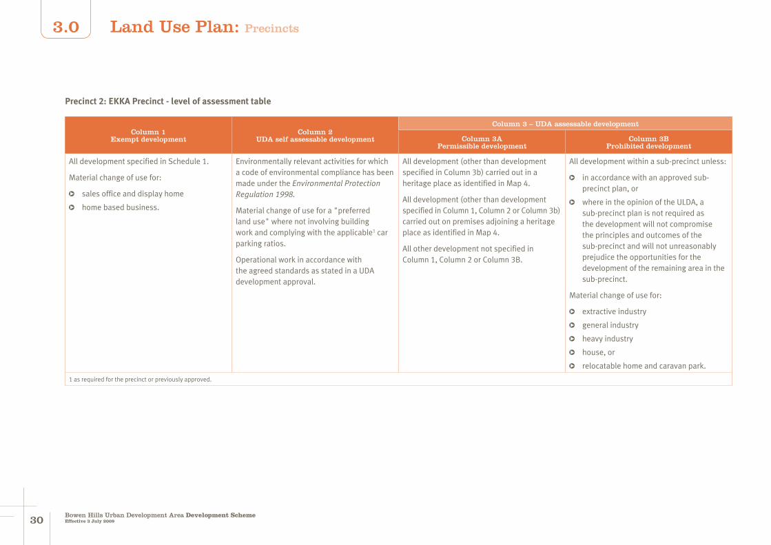
3130Bowen Hills Urban Development Area Development SchemeEffective 3 July 2009
3.0
Column 1Exempt development
Column 2 UDA self assessable development
Column 3 – UDA assessable development
Column 3APermissible development
Column 3BProhibited development
All development specified in Schedule 1.
Material change of use for:
sales office and display home
home based business.
Environmentally relevant activities for which a code of environmental compliance has been made under the Environmental Protection Regulation 1998.
Material change of use for a "preferred land use" where not involving building work and complying with the applicable1 car parking ratios.
Operational work in accordance with the agreed standards as stated in a UDA development approval.
All development (other than development specified in Column 3b) carried out in a heritage place as identified in Map 4.
All development (other than development specified in Column 1, Column 2 or Column 3b) carried out on premises adjoining a heritage place as identified in Map 4.
All other development not specified in Column 1, Column 2 or Column 3B.
All development within a sub-precinct unless:
in accordance with an approved sub-precinct plan, or
where in the opinion of the ULDA, a sub-precinct plan is not required as the development will not compromise the principles and outcomes of the sub-precinct and will not unreasonably prejudice the opportunities for the development of the remaining area in the sub-precinct.
Material change of use for:
extractive industry
general industry
heavy industry
house, or
relocatable home and caravan park.
1 as required for the precinct or previously approved.
Precinct 2: EKKA Precinct - level of assessment table
Land Use Plan: Precincts
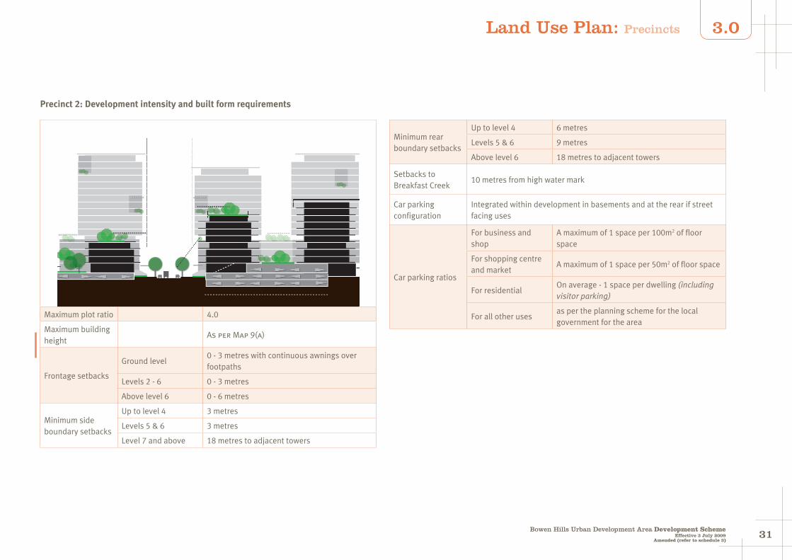
3130Bowen Hills Urban Development Area Development Scheme
Effective 3 July 2009
3.0
Amended (refer to schedule 3)
Maximum plot ratio 4.0
Maximum building height
As per Map 9(a)
Frontage setbacks
Ground level 0 - 3 metres with continuous awnings over footpaths
Levels 2 - 6 0 - 3 metres
Above level 6 0 - 6 metres
Minimum side boundary setbacks
Up to level 4 3 metres
Levels 5 & 6 3 metres
Level 7 and above 18 metres to adjacent towers
Minimum rear boundary setbacks
Up to level 4 6 metres
Levels 5 & 6 9 metres
Above level 6 18 metres to adjacent towers
Setbacks to Breakfast Creek
10 metres from high water mark
Car parking configuration
Integrated within development in basements and at the rear if street facing uses
Car parking ratios
For business and shop
A maximum of 1 space per 100m2 of floor space
For shopping centre and market
A maximum of 1 space per 50m2 of floor space
For residentialOn average - 1 space per dwelling (including visitor parking)
For all other usesas per the planning scheme for the local government for the area
Precinct 2: Development intensity and built form requirements
Land Use Plan: Precincts
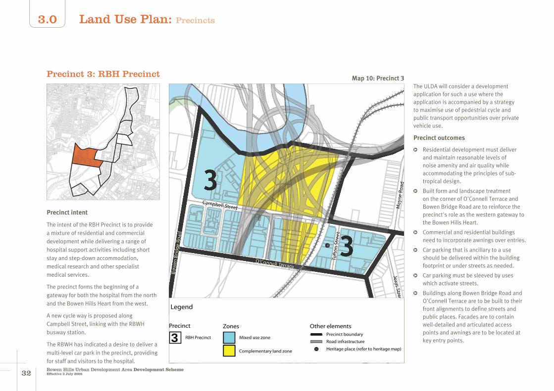
3332Bowen Hills Urban Development Area Development SchemeEffective 3 July 2009
3.0
Precinct 3: RBH PrecinctThe ULDA will consider a development application for such a use where the application is accompanied by a strategy to maximise use of pedestrial cycle and public transport opportunities over private vehicle use.
Precinct outcomes
Residential development must deliver and maintain reasonable levels of noise amenity and air quality while accommodating the principles of sub-tropical design.
Built form and landscape treatment on the corner of O'Connell Terrace and Bowen Bridge Road are to reinforce the precinct's role as the western gateway to the Bowen Hills Heart.
Commercial and residential buildings need to incorporate awnings over entries.
Car parking that is ancillary to a use should be delivered within the building footprint or under streets as needed.
Car parking must be sleeved by uses which activate streets.
Buildings along Bowen Bridge Road and O'Connell Terrace are to be built to their front alignments to define streets and public places. Facades are to contain well-detailed and articulated access points and awnings are to be located at key entry points.
Legend
Other elementsPrecinct boundary
Road infrastructure
H Heritage place (refer to heritage map)
Precinct
3 RBH Precinct Mixed use zone
Zones
Complementary land zone
Precinct intent
The intent of the RBH Precinct is to provide a mixture of residential and commercial development while delivering a range of hospital support activities including short stay and step-down accommodation, medical research and other specialist medical services.
The precinct forms the beginning of a gateway for both the hospital from the north and the Bowen Hills Heart from the west.
A new cycle way is proposed along Campbell Street, linking with the RBWH busway station.
The RBWH has indicated a desire to deliver a multi-level car park in the precinct, providing for staff and visitors to the hospital.
Map 10: Precinct 3
Land Use Plan: Precincts
3332Bowen Hills Urban Development Area Development Scheme
Effective 3 July 2009
3.0
Land around and above the Inner City By-pass, the Clem Jones Tunnel and Airport Link will cater for a range of activities and facilities for recreational and community purposes including pedestrian and cycle paths, landscaped areas and incidental open space.
Development within 200 metres of the Clem Jones Tunnel north ventilation outlet and above RL+45m AHD must be designed and oriented to:
avoid unreasonable impacts on the performance of the ventilation outlet
mitigate potential air quality impacts on occupants resulting from the ventilation outputs.
Preferred land uses
child care centre
educational establishment
hospital
food premises
indoor sport, recreation and entertainment
medical centre
multiple residential
office
other residential
research and technology facility shop - where located at ground level and not exceeding 250m2 of GFA per tenancy
service industry
visitor accommodation.
Map 10: Precinct 3
Land Use Plan: Precincts

3534Bowen Hills Urban Development Area Development SchemeEffective 3 July 2009
3.0
Column 1Exempt development
Column 2 UDA self assessable development
Column 3 – UDA assessable development
Column 3APermissible development
Column 3BProhibited development
All development specified in Schedule 1.
Material change of use for:
sales office and display home
home based business.
Environmentally relevant activities for which a code of environmental compliance has been made under the Environmental Protection Regulation 1998.
Material change of use for a "preferred land use" where not involving building work and complying with the applicable1 car parking ratios.
Operational work in accordance with the agreed standards as stated in a UDA development approval.
All development (other than development specified in Column 3b) carried out in a heritage place as identified in Map 4.
All development (other than development specified in Column 1, Column 2 or Column 3b) carried out on premises adjoining a heritage place as identified in Map 4.
All other development not specified in Column 1, Column 2 or Column 3B.
Material change of use for:
extractive industry
general industry
heavy industry, or
house.
1 as required for the precinct or previously approved.
Precinct 3: RBH Precinct - level of assessment table
Land Use Plan: Precincts
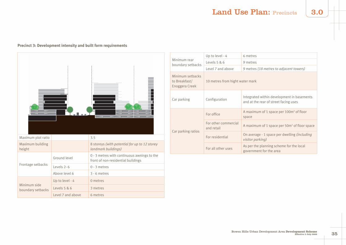
3534Bowen Hills Urban Development Area Development Scheme
Effective 3 July 2009
3.0
Maximum plot ratio 3.5
Maximum building height
8 storeys (with potential for up to 12 storey landmark buildings)
Frontage setbacks
Ground level 0 - 3 metres with continuous awnings to the front of non-residential buildings
Levels 2- 6 0 - 3 metres
Above level 6 3 - 6 metres
Minimum side boundary setbacks
Up to level - 4 0 metres
Levels 5 & 6 3 metres
Level 7 and above 6 metres
Minimum rear boundary setbacks
Up to level - 4 6 metres
Levels 5 & 6 9 metres
Level 7 and above 9 metres (18 metres to adjacent towers)
Minimum setbacks to Breakfast/Enoggera Creek
10 metres from hight water mark
Car parking ConfigurationIntegrated within development in basements and at the rear of street facing uses
Car parking ratios
For officeA maximum of 1 space per 100m2 of floor space
For other commercial and retail
A maximum of 1 space per 50m2 of floor space
For residentialOn average - 1 space per dwelling (including visitor parking)
For all other usesAs per the planning scheme for the local government for the area
Precinct 3: Development intensity and built form requirements
Land Use Plan: Precincts

3736Bowen Hills Urban Development Area Development SchemeEffective 3 July 2009
3.0
Precinct 4: Water Street Precinct
Precinct intent
The Water Street Precinct is intended to provide medium intensity, mixed use development with retail and restaurants at ground level and offices and residential above.
This precinct shares a significant interface with the RNA Showgrounds and may integrate with some of the RNA's redevelopment aspirations.
This precinct contains the Tivoli which is recognised as an important entertainment venue. New development within this precinct must balance the needs of the Tivoli as an entertainment and live music venue with the needs of new residents and other commercial operators.
Precinct outcomes
A new road is required connecting Diggles Close to Water Street.
On secondary active frontages, buildings must be built to their front alignments to define streets and public places. Facades on these frontages are to contain well-detailed and articulated access points and awnings are to be located at key entry points.
On tertiary frontages, buildings must address the street and public realm but may accommodate a wider variety of setbacks for courtyards, deep planting areas and balconies.
Car parking must be delivered within the building footprint and setback from street alignments.
Development around the Tivoli must be located and designed to deliver and maintain reasonable levels of amenity. In particular, new residential development must incorporate high levels of noise insulation to reduce the transmission of low frequency bass noise into bedrooms.
Preferred land uses
The preferred uses in the precinct are:
community facilities
food premises where located at ground level and not exceeding 250m2 of GFA per tenancy
home based business
Map 11: Precinct 4
Land Use Plan: Precincts
Legend
Precinct
4 Water Street Precinct
Zones
Mixed use zoneDesired road connections
Precinct boundary
Other elements
H Heritage place (refer to heritage map)

3736Bowen Hills Urban Development Area Development Scheme
Effective 3 July 2009
3.0
indoor sport, recreation and entertainment
multiple residential
office
other residential
shop where located at ground level and not exceeding 250m2 of GFA per tenancy
service industry not exceeding 250m2 of GFA per tenancy.
Map 11: Precinct 4
Land Use Plan: Precincts
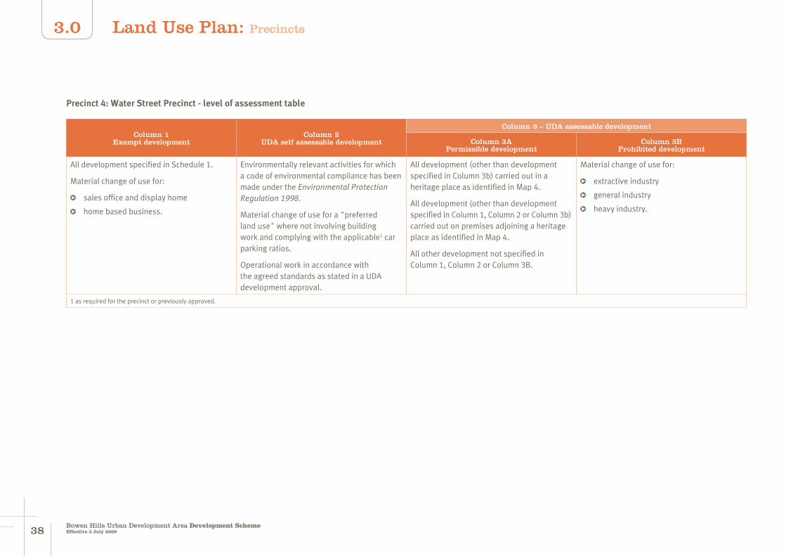
3938Bowen Hills Urban Development Area Development SchemeEffective 3 July 2009
3.0
Column 1Exempt development
Column 2 UDA self assessable development
Column 3 – UDA assessable development
Column 3APermissible development
Column 3BProhibited development
All development specified in Schedule 1.
Material change of use for:
sales office and display home
home based business.
Environmentally relevant activities for which a code of environmental compliance has been made under the Environmental Protection Regulation 1998.
Material change of use for a "preferred land use" where not involving building work and complying with the applicable1 car parking ratios.
Operational work in accordance with the agreed standards as stated in a UDA development approval.
All development (other than development specified in Column 3b) carried out in a heritage place as identified in Map 4.
All development (other than development specified in Column 1, Column 2 or Column 3b) carried out on premises adjoining a heritage place as identified in Map 4.
All other development not specified in Column 1, Column 2 or Column 3B.
Material change of use for:
extractive industry
general industry
heavy industry.
1 as required for the precinct or previously approved.
Precinct 4: Water Street Precinct - level of assessment table
Land Use Plan: Precincts
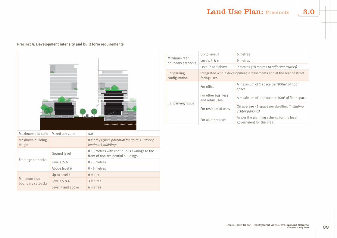
3938Bowen Hills Urban Development Area Development Scheme
Effective 3 July 2009
3.0
Maximum plot ratio Mixed use zone 4.0
Maximum building height
8 storeys (with potential for up to 12 storey landmark buildings)
Frontage setbacks
Ground level 0 - 3 metres with continuous awnings to the front of non-residential buildings
Levels 2- 6 0 - 3 metres
Above level 6 0 - 6 metres
Minimum side boundary setbacks
Up to level 4 0 metres
Levels 5 & 6 3 metres
Level 7 and above 6 metres
Minimum rear boundary setbacks
Up to level 4 6 metres
Levels 5 & 6 9 metres
Level 7 and above 9 metres (18 metres to adjacent towers)
Car parking configuration
Integrated within development in basements and at the rear of street facing uses
Car parking ratios
For officeA maximum of 1 space per 100m2 of floor space
For other business and retail uses
A maximum of 1 space per 50m2 of floor space
For residential usesOn average - 1 space per dwelling (including visitor parking)
For all other usesAs per the planning scheme for the local government for the area
Precinct 4: Development intensity and built form requirements
Land Use Plan: Precincts

4140Bowen Hills Urban Development Area Development SchemeEffective 3 July 2009
3.0
Precinct 5: Markwell Street West Precinct
Precinct intent
This precinct already contains a number of existing housing developments and is intended to deliver further residential development and become a predominantly residential area.
To contribute to the liveability of the precinct, new open space opportunities and pedestrian connections will be created.
Opportunities exist within the precinct for buildings to incorporate non-residential uses on lower levels.
Precinct outcomes
Buildings fronting Campbell Street must be built up to or close to the road alignment to define the street. Facades must contain well-detailed and
articulated access points and deliver continuous awnings to the street.
Mixed use development at the intersection of Hamilton Place and Brookes Street opposite O'Connell Terrace must be built up to or close to the road alignment to define the street. Facades must contain well-detailed and articulated access points and deliver continuous awnings to the street.
Development along Brookes Street must include uses and streetscape treatment that facilitates pedestrial and cycle amenity and safety.
Preferred land uses
The preferred uses in the mixed use zone are:
food premises - where located at ground level and not exceeding 250m2 of GFA per tenancy
home based business
multiple residential
office
other residential
shop - where located at ground level and not exceeding 250m2 of GFA per tenancy
service industry - not exceeding 250m2 of GFA per tenancy.
The preferred uses in the residential high intensity zone are:
home based business
multiple residential
other residential.
Legend
Precinct
Zones
Mixed use residential zone
Residential very high intensity zone
Precinct boundary
Other elements
H Heritage place (refer to heritage map)
5 Markwell Street West Precinct
Civic and open space zone
Map 12: Precinct 5
Land Use Plan: Precincts

4140Bowen Hills Urban Development Area Development Scheme
Effective 3 July 2009
3.0
Precinct 5: Markwell Street West Precinct - level of assessment table
Column 1Exempt development
Column 2 UDA self assessable development
Column 3 – UDA assessable development
Column 3APermissible development
Column 3BProhibited development
All development specified in Schedule 1.
Material change of use for:
sales office and display home
home based business.
Environmentally relevant activities for which a code of environmental compliance has been made under the Environmental Protection Regulation 1998.
Material change of use for a "preferred land use" where not involving building work and complying with the applicable1 car parking ratios.
Operational work in accordance with the agreed standards as stated in a UDA development approval.
All development (other than development specified in Column 3b) carried out in a heritage place as identified in Map 4.
All development (other than development specified in Column 1, Column 2 or Column 3b) carried out on premises adjoining a heritage place as identified in Map 4.
All other development not specified in Column 1, Column 2 or Column 3B.
Material change of use for:
extractive industry
general industry
heavy industry.
1 as required for the precinct or previously approved.
Map 12: Precinct 5
Land Use Plan: Precincts

4342Bowen Hills Urban Development Area Development SchemeEffective 3 July 2009
3.0
In the residential high intensity zone
Maximum plot ratio 3.0
Maximum building height
12 storeys
Frontage setbacks
Ground level 3 - 6 metres with awnings over entrances
Levels 2- 6 3 - 6 metres
Level 7 and above 3 - 6 metres
Minimum side boundary setbacks
Up to level 4 0 metres, built to boundaries
Levels 5 & 6 3 metres
Level 7 and above 3 metres
Minimum rear boundary setbacks
Up to level 4 0 metres
Levels 5 & 6 9 metres
Level 7 and above 9 metres (18 metres to adjacent towers)
Car parking configuration
Integrated within development in basements and at the rear of street facing uses
Car parking ratios
For residentialOn average - 1 space per dwelling (including visitor parking)
For all other usesAs per the planning scheme for the local government for the area
In the mixed use residential zone
Maximum plot ratio 4.0
Maximum building height
12 storeys
Frontage setbacks
Ground level0 - 3 metres with continuous awnings to the front of buildings
Levels 2- 6 0 - 3 metres
Level 7 and above 0 - 3 metres
Minimum side boundary setbacks
Up to level 4 0 metres
Levels 5 & 6 0 metres
Level 7 and above 0 metres
Minimum rear boundary setbacks
Up to level 4 6 metres
Levels 5 & 6 6 metres
Level 7 and above 9 metres (18 metres to adjacent towers)
Car parking configuration
Basement
Car parking ratios
For residentialOn average - 1 space per dwelling (including visitor parking)
For office A maximum of 1 space per 100m2 of GFA
For shop, food premises & service industry
A maximum of 1 space per 50m2 of GFA
For all other usesAs per the planning scheme for the local government for the area
Precinct 5: Development intensity and built form requirements
Land Use Plan: Precincts
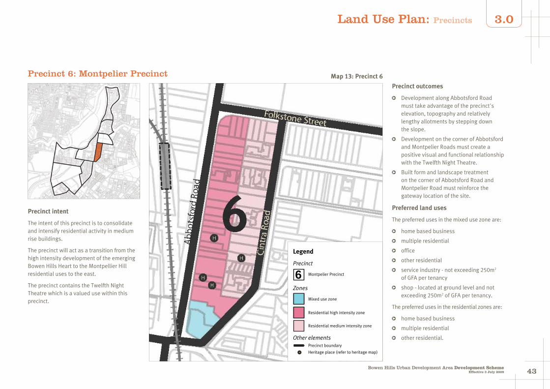
4342Bowen Hills Urban Development Area Development Scheme
Effective 3 July 2009
3.0
Precinct 6: Montpelier Precinct
Precinct intent
The intent of this precinct is to consolidate and intensify residential activity in medium rise buildings.
The precinct will act as a transition from the high intensity development of the emerging Bowen Hills Heart to the Montpellier Hill residential uses to the east.
The precinct contains the Twelfth Night Theatre which is a valued use within this precinct.
Precinct outcomes
Development along Abbotsford Road must take advantage of the precinct's elevation, topography and relatively lengthy allotments by stepping down the slope.
Development on the corner of Abbotsford and Montpelier Roads must create a positive visual and functional relationship with the Twelfth Night Theatre.
Built form and landscape treatment on the corner of Abbotsford Road and Montpelier Road must reinforce the gateway location of the site.
Preferred land uses
The preferred uses in the mixed use zone are:
home based business
multiple residential
office
other residential
service industry - not exceeding 250m2 of GFA per tenancy
shop - located at ground level and not exceeding 250m2 of GFA per tenancy.
The preferred uses in the residential zones are:
home based business
multiple residential
other residential.
Legend
Precinct
Zones
Mixed use zone
Residential high intensity zone
Precinct boundary
Other elements
H Heritage place (refer to heritage map)
6 Montpelier Precinct
Residential medium intensity zone
Map 13: Precinct 6
Land Use Plan: Precincts
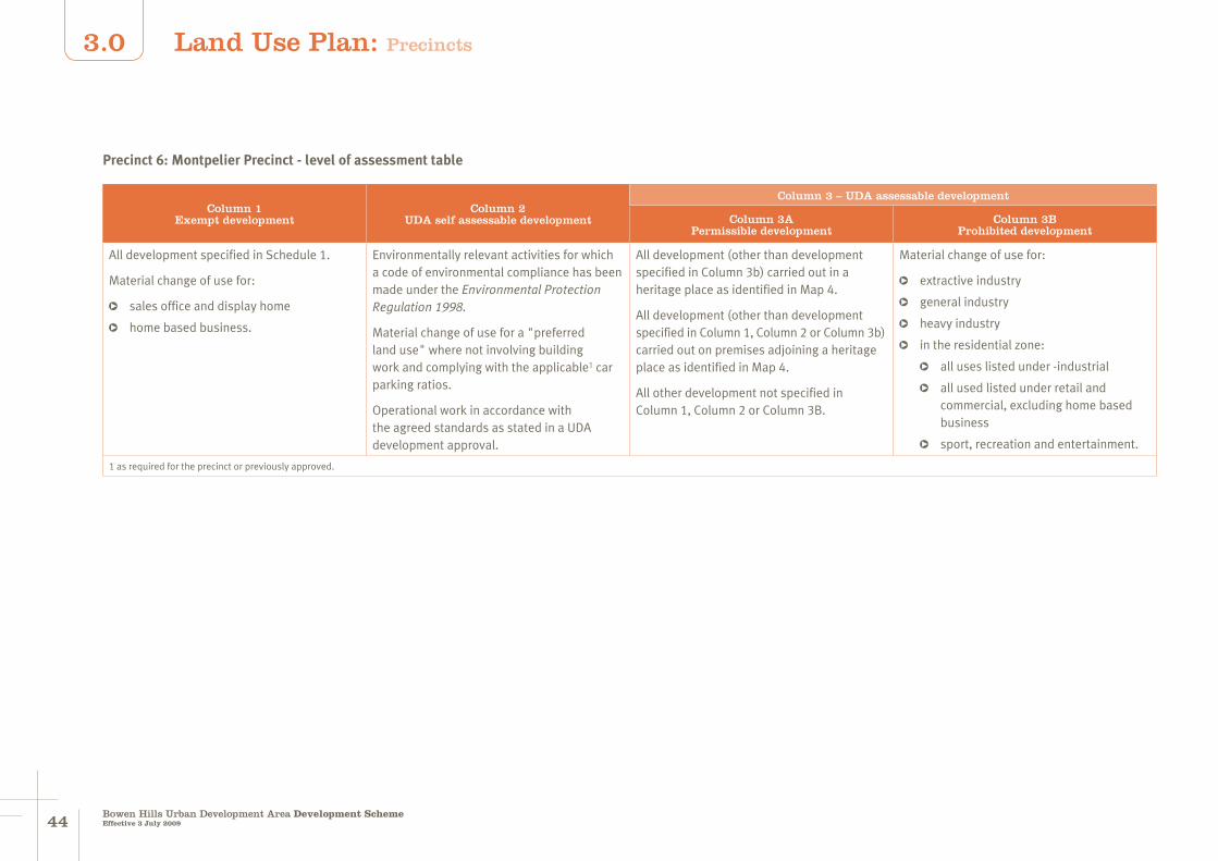
4544Bowen Hills Urban Development Area Development SchemeEffective 3 July 2009
3.0
Precinct 6: Montpelier Precinct - level of assessment table
Column 1Exempt development
Column 2 UDA self assessable development
Column 3 – UDA assessable development
Column 3APermissible development
Column 3BProhibited development
All development specified in Schedule 1.
Material change of use for:
sales office and display home
home based business.
Environmentally relevant activities for which a code of environmental compliance has been made under the Environmental Protection Regulation 1998.
Material change of use for a "preferred land use" where not involving building work and complying with the applicable1 car parking ratios.
Operational work in accordance with the agreed standards as stated in a UDA development approval.
All development (other than development specified in Column 3b) carried out in a heritage place as identified in Map 4.
All development (other than development specified in Column 1, Column 2 or Column 3b) carried out on premises adjoining a heritage place as identified in Map 4.
All other development not specified in Column 1, Column 2 or Column 3B.
Material change of use for:
extractive industry
general industry
heavy industry
in the residential zone:
all uses listed under -industrial
all used listed under retail and commercial, excluding home based business
sport, recreation and entertainment.
1 as required for the precinct or previously approved.
Land Use Plan: Precincts

4544Bowen Hills Urban Development Area Development Scheme
Effective 3 July 2009
3.0
Precinct 6: Development intensity and built form requirements
Maximum plot ratio
Residential medium intensity zone
1.0
Other zones 2.0
Maximum building height
Residential medium intensity zone
4 storeys
Other zones 8 storeys
Frontage setbacks
Ground level 3 - 6 metres with continuous awnings for retail and awnings over entries for other uses
Levels 2 and above3 - 6 metres with residential balconies to 3 metres
Minimum side boundary setbacks
Up to level 4 3 metres
Levels 5 & above 3 metres
Minimum rear boundary setbacks
Up to level 4 6 metres, deep planting zone
Levels 5 & above 9 metres
Car parking configuration
Within building footprint in basement and semi-basement
Car parking ratios
For residentialOn average - 1 space per dwelling (including visitor parking)
For office A maximum of 1 space per 100m2 of GFA
For shop, food premises & service industry
A maximum of 1 space per 50m2 of GFA
For all other usesAs per the planning scheme for the local government for the area
Land Use Plan: Precincts
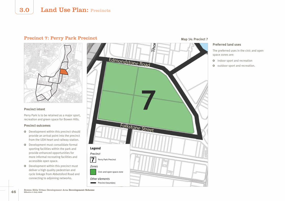
4746Bowen Hills Urban Development Area Development SchemeEffective 3 July 2009
3.0
Precinct 7: Perry Park Precinct
Precinct intent
Perry Park is to be retained as a major sport, recreation and green space for Bowen Hills.
Precinct outcomes
Development within this precinct should provide an arrival point into the precinct from the UDA heart and railway station.
Development must consolidate formal sporting facilities within the park and provide enhanced opportunities for more informal recreating facilities and accessible open space.
Development within this precinct must deliver a high quality pedestrian and cycle linkage from Abbotsford Road and connecting to adjoining networks.
Legend
Precinct
Civic and open space zone
Zones
Other elementsPrecinct boundary
7 Perry Park Precinct
Preferred land uses
The preferred uses in the civic and open space zones are:
indoor sport and recreation
outdoor sport and recreation.
Map 14: Precinct 7
Land Use Plan: Precincts

4746Bowen Hills Urban Development Area Development Scheme
Effective 3 July 2009
3.0
Precinct 7: Perry Park Precinct - level of assessment table
Column 1Exempt development
Column 2 UDA self assessable development
Column 3 – UDA assessable development
Column 3APermissible development
Column 3BProhibited development
All development specified in Schedule 1.
Material change of use for:
sales office and display home
home based business.
Environmentally relevant activities for which a code of environmental compliance has been made under the Environmental Protection Regulation 1998.
Material change of use for a "preferred land use" where not involving building work and complying with the applicable1 car parking ratios.
Operational work in accordance with the agreed standards as stated in a UDA development approval.
All development (other than development specified in Column 3b) carried out in a heritage place as identified in Map 4.
All development (other than development specified in Column 1, Column 2 or Column 3b) carried out on premises adjoining a heritage place as identified in Map 4.
All other development not specified in Column 1, Column 2 or Column 3B.
Material change of use for:
industrial
residential.
1 as required for the precinct or previously approved.
Map 14: Precinct 7
Land Use Plan: Precincts

4948Bowen Hills Urban Development Area Development SchemeEffective 3 July 2009
3.0
Precinct 8: Thompson Street Precinct
Precinct intent
This precinct is intended to be a predominantly commercial precinct, providing for showrooms facing the street.
Commercial uses are intended to occupy buildings from the ground level with top levels delivering residential development.
Commercial development is expected to capitalize on the precinct's strong association with the Bowen Hills Heart.
Residential development is expected to take advantage of the precinct's proximity to Perry Park and the open space and waterway amenity of Breakfast Creek.
A new civic space will provide a focal point for this precinct.
Legend
Precinct
Mixed use zone
Zones
Other elementsPrecinct boundary
8 Thompson Street Precinct
Medium impact employment zone
Precinct outcomes
buildings must address the street
buildings must to be activated at ground level.
Preferred land uses
The preferred uses in Precinct 8 are:
educational establishment
home based business
multiple residential
office
other residential
service industry
showroom, storage and display facilities.
Map 15: Precinct 8
Land Use Plan: Precincts

4948Bowen Hills Urban Development Area Development Scheme
Effective 3 July 2009
3.0
Precinct: 8 Thompson Street Precinct (mixed use zone) - level of assessment table
Column 1Exempt development
Column 2 UDA self assessable development
Column 3 – UDA assessable development
Column 3APermissible development
Column 3BProhibited development
All development specified in Schedule 1.
Material change of use for:
sales office and display home
home based business.
Environmentally relevant activities for which a code of environmental compliance has been made under the Environmental Protection Regulation 1998.
Material change of use for a "preferred land use" where not involving building work and complying with the applicable1 car parking ratios.
Operational work in accordance with the agreed standards as stated in a UDA development approval.
All development (other than development specified in Column 3b) carried out in a heritage place as identified in Map 4.
All development (other than development specified in Column 1, Column 2 or Column 3b) carried out on premises adjoining a heritage place as identified in Map 4.
All other development not specified in Column 1, Column 2 or Column 3B.
Material change of use for:
extractive industry
general industry
heavy industry.
1 as required for the precinct or previously approved.
Land Use Plan: Precincts

5150Bowen Hills Urban Development Area Development SchemeEffective 3 July 2009
3.0
Maximum plot ratio
3.0 (+ an additional 1.0 for residential)
Maximum building height
8 storeys
Frontage boundary setbacks
Ground level 0 - 3 metres with active frontages and awnings over entrances
Levels 2 - 6 0 - 3 metres
Levels 6 and above 3 - 6 metres with balconies to 3 metres
Minimum side boundary setbacks
Up to level 4 storeys 0 metres
Levels 5 and 6 3 metres
Level 7 & above 3 metres
Minimum rear boundary setbacks
Up to level 4 storeys 0 metres
Levels 5 and 6 6 metres
Level 7 & above 9 metres
Minimum setbacks to Breakfast/Enoggera Creek
10 metres from high water mark
Car parking configuration
Integrated within development in basements and at the rear of street facing uses
Car parking ratios
For residentialAn average of 1 space per dwelling (including visitor parking)
For business, service industry, showroom and warehouse
A maximum of 1 space per 75m2 of GFA
For shop & food premises
A maximum of 1 space per 50m2 of GFA
For all other usesAs per the planning scheme for the local government for the area
Precinct 8: Development intensity and built form requirements
Land Use Plan: Precincts
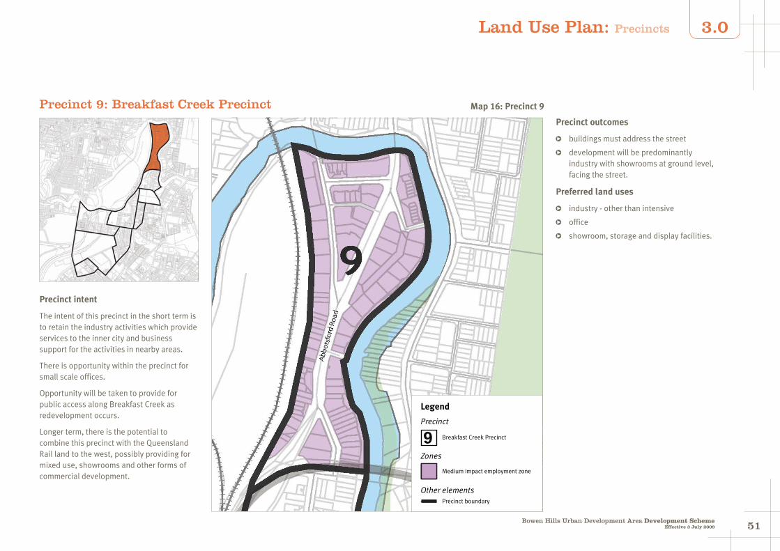
5150Bowen Hills Urban Development Area Development Scheme
Effective 3 July 2009
3.0
Precinct 9: Breakfast Creek Precinct
Precinct intent
The intent of this precinct in the short term is to retain the industry activities which provide services to the inner city and business support for the activities in nearby areas.
There is opportunity within the precinct for small scale offices.
Opportunity will be taken to provide for public access along Breakfast Creek as redevelopment occurs.
Longer term, there is the potential to combine this precinct with the Queensland Rail land to the west, possibly providing for mixed use, showrooms and other forms of commercial development.
Legend
Precinct
Medium impact employment zone
Zones
Other elementsPrecinct boundary
9 Breakfast Creek Precinct
Precinct outcomes
buildings must address the street
development will be predominantly industry with showrooms at ground level, facing the street.
Preferred land uses
industry - other than intensive
office
showroom, storage and display facilities.
Map 16: Precinct 9
Land Use Plan: Precincts

5352Bowen Hills Urban Development Area Development SchemeEffective 3 July 2009
3.0
Precinct 9: Breakfast Creek Precinct - level of assessment table
Column 1Exempt development
Column 2 UDA self assessable development
Column 3 – UDA assessable development
Column 3APermissible development
Column 3BProhibited development
All development specified in Schedule 1.
Material change of use for:
sales office and display home
home based business.
Environmentally relevant activities for which a code of environmental compliance has been made under the Environmental Protection Regulation 1998.
Material change of use for a "preferred land use" where not involving building work and complying with the applicable1 car parking ratios.
Operational work in accordance with the agreed standards as stated in a UDA development approval.
All development (other than development specified in Column 3b) carried out in a heritage place as identified in Map 4.
All development (other than development specified in Column 1, Column 2 or Column 3b) carried out on premises adjoining a heritage place as identified in Map 4.
All other development not specified in Column 1, Column 2 or Column 3B.
Material change of use for:
home based business
house
multiple residential
other residential
relocatable home and caravan park.
1 as required for the precinct or previously approved.
Land Use Plan: Precincts

5352Bowen Hills Urban Development Area Development Scheme
Effective 3 July 2009
3.0
Precinct 9: Development intensity and built form requirements
Maximum plot ratio 1.0
Maximum building height 4 storeys
Front boundary controls 0 - 3 metres with awnings over entrances
Minimum side boundary setbacks 0 metres
Minimum rear boundary controls 6 metres
Minimum setback to Breakfast/ Enoggera Creeks
10 metres from high water mark
Car parking configuration At the rear of street facing uses
Car parking ratios
For industryA maximum of 1 space for every 50m2 of floor space
For all other usesAs per the planning scheme for the local government for the area
Land Use Plan: Precincts

5554Bowen Hills Urban Development Area Development SchemeEffective 3 July 2009
4.0 Infrastructure Plan
Listed below is the infrastructure required to be delivered in order to achieve the ULDA's vision for the Bowen Hills UDA.
The funding mechanisms to achieve the delivery of this infrastructure are detailed in Chapter 5.0 Implementation Strategy.
Proposed catalyst infrastructure
Infrastructure Description of works
Bowen Hills Railway Station Stage 1 upgrade to improve safety, amenity and visual and physical access from Hudd Street.
Hudd Street Delivery of Hudd Street as a "main" street, through its widening and extension to Abbotsford Road.
Abbotsford Road Street tree planting around Hudd Street intersection.
Jamieson Street Realignment and public realm improvements east to Abbotsford Road and south to Campbell Street.
Proposed infrastructure improvements
Infrastructure Description of works
Road and street improvements New road west of the railway corridor linking Hudd Street through to Abbotsford Road at Edmondstone Street.
Widening of Mayne Road and public realm improvements.
Widening of O'Connell Terrace and public realm improvements.
Widening of Cambell Street east of Mayne Road through to Abbotsford Road and public realm improvements.
Widening of Tufton Street and public realm improvements.
Extension of Edgar Street and public realm improvements.
Extension of Tufton Street through to the junction of Mayne Road and Hudd Street.
Extension of Diggles Close to connect with Water Street.
Public realm improvements to Hazelmount Street.
Public realm improvements to Brookes Street between Gregory and O'Connell Terraces.
Public realm improvements to Hamilton Place.
Public realm improvements to Markwell Street.
Public realm improvements to Abbotsford Road.
Intersection modifications to the junction of Campbell Street and Abbotsford Road / Markwell Street to allow for additional right turn lane when accessing Markwell Street heading south.
Intersection modifications at the junction of Campbell Street, Hamilton Place and Mayne Road.
Intersection modifications at the junction of Abbotsford Road, Edmondstone Street and the new road west of the railway corridor, allowing for a dedicated turn left lane into Abbotsford Road.

5554
4.0Infrastructure Plan
Bowen Hills Urban Development Area Development SchemeEffective 3 July 2009
Amended (refer to Schedule 3)
Proposed infrastructure improvements
Infrastructure Description of works
Intersection modifications at the junction of Gregory Terrace and Brookes Street by removal of the pedestrian crossing on the southern side of Brookes Street.
Intersection modifications at the junction of O'Connell Terrace, Hamilton Place and Brookes Street to allow for both lanes from O'Connell Terrace to turn right into Brookes Street.
Intersection modifications at the junction of Brookes Street and St Pauls Terrace to allow for two lanes to turn right from Brookes Street into St Pauls Terrace heading south.
Intersection signalisation at the junction of Hudd Street and the new road west of the railway corridor linking through to Abbotsford Road at Edmondstone Street.
Intersection signalisation at the junction of Tufton Street and O'Connell Terrace.
New shared pedestrian and vehicle route linking Gregory and St Pauls Terraces west of Alexandria Street.
Proposed water and sewerage infrastructure
Infrastructure Description of works
Water and sewer networks within the UDA will be upgraded at the time of developments being undertaken.
Proposed community facilities, transport and affordable housing
Infrastructure Description of works
Community facilities New public plaza linking Mayne Road through to the Tufton Street extension north of Campbell Street.
New public plaza south of Hudd Street, west of Abbotsford Road and east of the realigned Jamieson Street (Market Plaza).
Public realm improvements to Perry Park.
New public open green space linking Gregory and St Pauls Terraces, west of Alexandria Street.
New public open green space in precinct 3.
New public open space connecting with the existing green space in precinct 5.
New public open space in precinct 8.
Transport Upgrades to Bowen Hills Railway Station.
New bus station linking to the Bowen Hills Railway Station.
Public utilities Zone substation.

5756Bowen Hills Urban Development Area Development SchemeEffective 3 July 2009
5.0 Implementation Strategy
5.1 Introduction
As described in earlier sections of the development scheme, the purpose of the ULDA Act is to facilitate:
(i) the availability of land for urban purposes
(ii) the provision of a range of housing options to address diverse community needs
(iii) the provision of infrastructure for urban purposes
(iv) planning principles that give effect to ecological sustainability and best practice urban design
(v) the provision of an ongoing availability of affordable housing options for low to moderate income households.
The mission formulated by the ULDA to achieve the purposes of the Act is to create vibrant inclusive communities and to:
Create sustainable world class precincts all Queenslanders can be proud of. These outstanding new urban communities will incorporate best practice urban design principles and a range of affordable housing options.
In achieving that vision, the values the ULDA seek to exhibit in its achievement of that outcome are:
bold leadership
collaboration and partnership
creativity and innovation
sustainability
integrity.
Consequently, the implementation strategy and actions of the ULDA need to address aspects broader than the Act's purposes and need to address, not only what is to be achieved, but also how it is to be achieved.
In many aspects this implementation strategy will be a living document, responding to circumstances as they arise, learning from the lessons as the UDA develops and adopting innovation arising from technological change and innovation from industry.
However, the following section provides a framework, indicating the implementation strategy elements, desired outcomes and planned actions formulated at this time to give effect to the Act's purposes and the ULDA's mission.
The key elements determined as essential in the achievement of the ULDA's mission are indicated below and detailed in the following sections:
urban land availability for development
housing options
ecological sustainability
best practice urban design
urban infrastructure provision.
All elements in each section must be achieved to the greatest extent practical having regard to each of the other elements of the implementation strategy.
However, the ULDA also recognises that there are other aspects to creation of development in the UDA that bear recognition. In particular leadership and placemaking.
Leadership
The ULDA has been provided with an Act that allows for a 'blank slate' approach to urban development. This blank slate allows the ULDA to try alternative methods of delivering successful urban development outcomes.
The ULDA recognises that while it has the ability to have a direct impact on outcomes within the UDA, it also has a potential to have an indirect outcome by way of demonstration of the impact of alternative approaches.
Consequently, if successful, the processes, provisions or systems put in place may be suitable for adoption by other authorities in the State.
Place making
The ULDA recognises that the creation of successful urban spaces starts with establishing a vision for the UDA which is meaningful, respects the location and site's characteristics and will find acceptance by the wider community, and in particular the development community so that development occurs. The land use plan and infrastructure strategy provide the main means of achieving good urban spaces.
However, the ULDA recognises that there are other, more subtle aspects that need to be considered to create truly special places, that do not neatly fit into the following structure, namely:
the arrangement and type of uses within spaces
the role of the community in the development and change of spaces over time
event management to enliven and activate spaces.
These aspects are not addressed in this section but will be instituted as part of the ULDA's activities as the UDA develops.

5756Bowen Hills Urban Development Area Development Scheme
Effective 3 July 2009
5.0Implementation Strategy
5.2 Urban land availability for development
The development scheme, to be successful and achieve the ULDA's aims, needs to lead to development on the ground, rather than be just a planning document. For landowners and the development industry, the development scheme's provisions need to create an environment where commercially viable development projects are fostered.
A measure of this success will be the willingness of private industry to seek to develop sites within the UDA.
Element Measure Actions
Urban land availability for development
Development occurs within the UDA.
A development scheme that:
includes development requirements that allow a commercial outcome
provide certainty of development potential (uses and yield)
responds to changes in market conditions
allows for alternative design solutions.
An infrastructure strategy that:
ensures necessary infrastructure is co-ordinated and constructed to facilitate development
does not require development contributions that are so high that land owners have no incentive to redevelop their properties
has a charging regime that balances upfront costs with payments over time, and recognises the importance of time of payments to the industry
has a transparent and easily calculable development contribution schedule.
An approval system that:
minimises time delay to the developer
highlights early the level of detail required for a specific development application
allows for consideration of alternative solutions in an expeditious manner
allows a development proponent to be provided with a degree of certainty early in the process 50 that a development proposal will be acceptable
provides consistency from the pre-lodgement process, through approval to project commencement.
The ULDA will seek to facilitate development in specific areas by:
working with landowners to find solutions to specific issues
building catalyst infrastructure where it will lead to early development within a precinct
brokering discussions with government agencies where required to facilitate resolution of issues
working with government agencies to bring land to the market where the land is surplus to their requirements
undertaking studies to address area wide issues.
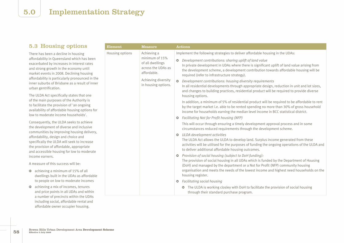
5958Bowen Hills Urban Development Area Development SchemeEffective 3 July 2009
5.0 Implementation Strategy
5.3 Housing optionsThere has been a decline in housing affordability in Queensland which has been exacerbated by increases in interest rates and strong growth in the economy until market events in 2008. Declining housing affordability is particularly pronounced in the inner suburbs of Brisbane as a result of inner urban gentrification.
The ULDA Act specifically states that one of the main purposes of the Authority is to facilitate the provision of 'an ongoing availability of affordable housing options for low to moderate income households'.
Consequently, the ULDA seeks to achieve the development of diverse and inclusive communities by improving housing delivery, affordability, design and choice and specifically the ULDA will seek to increase the provision of affordable, appropriate and accessible housing for low to moderate income earners.
A measure of this success will be:
achieving a minimum of 15% of all dwellings built in the UDAs as affordable to people on low to moderate incomes
achieving a mix of incomes, tenures and price points in all UDAs and within a number of precincts within the UDAs including social, affordable rental and affordable owner occupier housing.
Element Measure Actions
Housing options Achieving a minimum of 15% of all dwellings across the UDAs as affordable.
Achieving diversity in housing options.
Implement the following strategies to deliver affordable housing in the UDAs:
Development contributions: sharing uplift of land value In private development in UDAs where there is significant uplift of land value arising from the development scheme, a development contribution towards affordable housing will be required (refer to infrastructure strategy).
Development contributions: housing diversity requirements In all residential developments through appropriate design, reduction in unit and lot sizes, and changes to building practices, residential product will be required to provide diverse housing options.
In addition, a minimum of 5% of residential product will be required to be affordable to rent by the target market i.e. able to be rented spending no more than 30% of gross household income for households earning the median level income in BCC statistical district.
Facilitating Not for Profit housing (NFP)
This will occur through ensuring a timely development approval process and in some circumstances reduced requirements through the development scheme.
ULDA development activities The ULDA Act allows the ULDA to develop land. Surplus income generated from these activities will be utilised for the purposes of funding the ongoing operations of the ULDA and to deliver additional affordable housing outcomes.
Provision of social housing (subject to DoH funding): The provision of social housing in all UDAs which is funded by the Department of Housing (DoH) and managed by the department or a Not for Profit (NFP) community housing organisation and meets the needs of the lowest income and highest need households on the housing register.
Facilitating social housing
The ULDA is working closley with DoH to facilitate the provision of social housing through their standard purchase program.
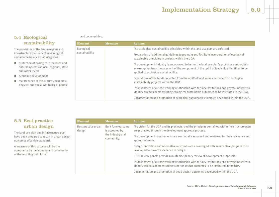
5958Bowen Hills Urban Development Area Development Scheme
Effective 3 July 2009
5.0Implementation Strategy
5.4 Ecological sustainability
The provisions of the land use plan and infrastructure plan reflect an ecological sustainable balance that integrates:
protection of ecological processes and natural systems at local, regional, state and wider levels
economic development
maintenance of the cultural, economic, physical and social wellbeing of people
and communities.
Element Measure Actions
Ecological sustainability
The ecological sustainability principles within the land use plan are enforced.
Preparation of additional guidelines to promote and facilitate incorporation of ecological sustainable principles in projects within the UDA.
The development industry is encouraged to better the land use plan's provisions and obtain an exemption from the payment of the component of the uplift of land value identified to be applied to ecological sustainability.
Expenditure of the funds collected from the uplift of land value component on ecological sustainability projects within the UDA.
Establishment of a close working relationship with tertiary institutions and private industry to identify projects demonstrating ecological sustainable outcomes to be instituted in the UDA.
Documentation and promotion of ecological sustainable examples developed within the UDA.
5.5 Best practice urban design
The land use plan and infrastructure plan have been prepared to result in urban design outcomes of a high standard.
A measure of this success will be the acceptance by the industry and community of the resulting built form.
Element Measure Actions
Best practice urban design
Built form outcome is accepted by the industry and community.
The vision for the UDA and its precincts, and the principles contained within the structure plan are protected through the development approval process.
The development requirements are continually assessed and reviewed for their relevance and appropriateness.
Design innovation and alternative outcomes are encouraged with an incentive program to be developed to reward excellence in design.
ULDA review panels provide a multi-disciplinary review of development proposals.
Establishment of a close working relationship with tertiary institutions and private industry to identify projects demonstrating superior design outcomes to be instituted in the UDA.
Documentation and promotion of good design outcomes developed within the UDA.

6160Bowen Hills Urban Development Area Development SchemeEffective 3 July 2009
5.0 Implementation Strategy
Amended (refer to Schedule 3)
5.6 Urban infrastructure provision
Funding principles to facilitate development
Prudent investment in infrastructure is necessary to facilitate the increase in development intensity required to deliver the vision for the UDA.
Contributions towards the delivery of this infrastructure will be shared as the funding of the required infrastructure is not commercially viable for any one developer, owner or government entity due to the fragmentation of land ownership or the overall sizeable costs of some of the infrastructure works.
The use of public funds as the primary source of funding to pay for the necessary infrastructure, resulting in a significant increase in development yield and hence a windfall gain to private land owners, is not considered appropriate.
Consequently, redevelopment of areas within the UDA are not likely to occur unless a specific infrastructure funding package can be developed, which is acceptable to landowners, the industry and government.
The overarching infrastructure funding principles proposed to facilitate redevelopment are:
(i) infrastructure funding will be based on ensuring that the vision of the UDA can be achieved
(ii) infrastructure and activities will be funded in a fair and equitable manner and will be based on the most appropriate mechanism. These include:
user charges
special rates and charges
state and federal funding
conditions for the provision of infrastructure
state infrastructure agreements and
negotiated infrastructure agreements
(iii) where infrastructure can be fairly apportioned to users, infrastructure charges as per the Integrated Planning Act 1997 will be used. Impact mitigation payments may be imposed if unanticipated development occurs
(iv) special rates and charges will be used generally for maintaining infrastructure and for infrastructure / projects / activities / services where there is a direct nexus between development within the UDA and the item(s) that are being charged. In some instances special rates and charges will be used for establishing strategic infrastructure and services
(v) land value uplift will be captured and expended on infrastructure and projects that are of a strategic nature and have a community benefit. This may include part funding some of the items captured under the infrastructure charges schedule or special rates and charges or infrastructure not included in these charging mechanisms. This could
include funding affordable housing, shortfalls or gaps in funding required for infrastructure provision and / or strategic projects of a broad nature for community assets and high level shared infrastructure
(vi) State infrastructure funding will be sought through normal budgetary processes and will be part of approved State agency capital programs.
Financing of works
Network infrastructure
The funding of network infrastructure will be achieved through an Infrastructure Contribution Schedule (ICS).
The ICS will cover the following items:
water
sewer
waterways
transport
community facilities.
The methodology to calculate the rates for these items will be consistent with the Integrated Planning Act 1997 methodology.
These contributions will be required to be paid prior to development commencing.
Major infrastructure and affordable housing
The major infrastructure works, affordable housing and ecologically sustainable outcomes will be funded by way of the sharing of the land value uplift arising from the ULDA's development scheme. To ensure transparency and simplicity the land value
uplift will be at a rate determined for the UDA or a precinct within the UDA and equate to a charge applied for every square metre of additional GFA in excess of that shown on Map 3 or in a development approval.
This rate will be determined by considering various development scenarios and developing a business model, using standard industry assumptions and using this information to then determine the residual land value.
The contribution will apply as per section 3.5.3 of the land use plan.
Local area improvement works
In addition to major infrastructure and affordable housing, the ULDA will identify key infrastructure considered necessary to initiate the redevelopment of the UDA. This may include works such as new or upgraded streets and roads, improved road connections and improved public transport access.
The infrastructure plan in the development scheme identifies those local area works that are proposed to be constructed by the ULDA within the first five years to catalyse development (the catalyst works).
Infrastructure contributions
Charges for infrastructure will be determined and reviewed from time to time and be published in the ULDA's infrastructure contributions framework.
Where special rates and charges are proposed consultation with the local community will assist in determining the contribution area and scope and scale of works.
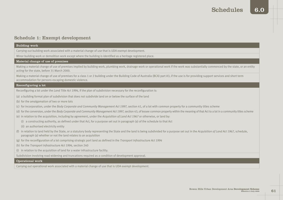
6160Bowen Hills Urban Development Area Development Scheme
Effective 3 July 2009
6.0Schedules
Schedule 1: Exempt development
Building work
Carrying out building work associated with a material change of use that is UDA exempt development.
Minor building work or demolition work except where the building is identified as a heritage registered place.
Material change of use of premises
Making a material change of use of premises implied by building work, plumbing work, drainage work or operational work if the work was substantially commenced by the state, or an entity acting for the state, before 31 March 2000.
Making a material change of use of premises for a class 1 or 2 building under the Building Code of Australia (BCA) part A3, if the use is for providing support services and short term accommodation for persons escaping domestic violence.
Reconfiguring a lot
Reconfiguring a lot under the Land Title Act 1994, if the plan of subdivision necessary for the reconfiguration is:
(a) a building format plan of subdivision that does not subdivide land on or below the surface of the land
(b) for the amalgamation of two or more lots
(c) for incorporation, under the Body Corporate and Community Management Act 1997, section 41, of a lot with common property for a community titles scheme
(d) for the conversion, under the Body Corporate and Community Management Act 1997, section 43, of lessee common property within the meaning of that Act to a lot in a community titles scheme
(e) in relation to the acquisition, including by agreement, under the Acquisition of Land Act 1967 or otherwise, or land by:
(i) a constructing authority, as defined under that Act, for a purpose set out in paragraph (a) of the schedule to that Act
(ii) an authorised electricity entity
(f) in relation to land held by the State, or a statutory body representing the State and the land is being subdivided for a purpose set out in the Acquisition of Land Act 1967, schedule, paragraph (a) whether or not the land relates to an acquisition
(g) for the reconfiguration of a lot comprising strategic port land as defined in the Transport Infrastructure Act 1994
(h) for the Transport Infrastructure Act 1994, section 240
(i) in relation to the acquisition of land for a water infrastructure facility.
Subdivision involving road widening and truncations required as a condition of development approval.
Operational work
Carrying out operational work associated with a material change of use that is UDA exempt development.

6362Bowen Hills Urban Development Area Development SchemeEffective 3 July 2009
6.0 Schedules
Amended (refer to Schedule 3)
Clearing of vegetation:
(a) other than significant vegetation as defined in Schedule 2
(b) carried out by, or on behalf of Brisbane City Council or a public sector entity, where the works being undertaken are authorised under a state law
(c) in accordance with the conditions of a UDA development approval for material change of use or reconfiguring a lot.
Erecting no more than one satellite dish on a premises, where the satellite dish has no dimension greater than 1.8 metres.
Filling or excavation:
(a) to a depth of one vertical metre or less from ground level on land to that is not referred to in Brisbane City Plan's Acid Sulphate Soil Code, Wetland Code and/or Waterway Code and where the site is not listed on the Contaminated Land Register or Environmental Management Register, or
(b) where top dressing to a depth of less than 100 vertical millimetres from ground level on land that is not referred to in Brisbane City Plan’s Wetland Code and/or Waterway Code.
Placing an advertising device on premises.
Operational work (including maintenance and repair work) if the work is carried out by or on behalf of a public sector entity authorised under a state law to carry out the work.
Plumbing or drainage work
Carrying out plumbing or drainage work.
All aspects of development
All aspects of development a person is directed to carry out under a notice, order or direction made under a state law.
All aspects of development including maintenance that are incidental to and necessarily associated with a park.
All aspects of development including maintenance that are incidental to and necessarily associated with the RNA show activities.
All aspects of development undertaken by the State, or a statutory body representing the State, for the purposes of social housing.
All aspects of development for a utility installation, being an undertaking for the supply of water, hydraulic power, electricity or gas, of any development required for the purpose of that undertaking by way of:(a) development of any description at or below the surface of the ground
(b) the installation of any plant inside a building or the installation or erection within the premises of a generating station of any plant or other structures or erections required in connection with the station
(c) the installation or erection of an electricity distribution or supply network (and any components of such a network) which operates at voltages up to and including 33 kilovolts, excluding new substations
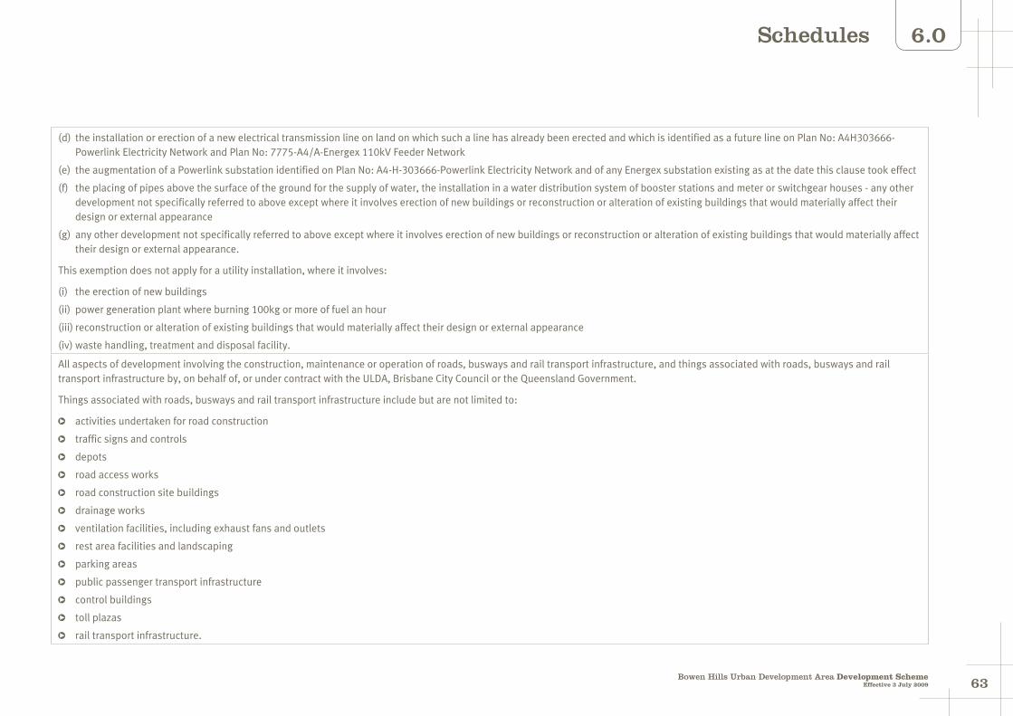
6362Bowen Hills Urban Development Area Development Scheme
Effective 3 July 2009
6.0Schedules
(d) the installation or erection of a new electrical transmission line on land on which such a line has already been erected and which is identified as a future line on Plan No: A4H303666- Powerlink Electricity Network and Plan No: 7775-A4/A-Energex 110kV Feeder Network
(e) the augmentation of a Powerlink substation identified on Plan No: A4-H-303666-Powerlink Electricity Network and of any Energex substation existing as at the date this clause took effect
(f) the placing of pipes above the surface of the ground for the supply of water, the installation in a water distribution system of booster stations and meter or switchgear houses - any other development not specifically referred to above except where it involves erection of new buildings or reconstruction or alteration of existing buildings that would materially affect their design or external appearance
(g) any other development not specifically referred to above except where it involves erection of new buildings or reconstruction or alteration of existing buildings that would materially affect their design or external appearance.
This exemption does not apply for a utility installation, where it involves:
(i) the erection of new buildings
(ii) power generation plant where burning 100kg or more of fuel an hour
(iii) reconstruction or alteration of existing buildings that would materially affect their design or external appearance
(iv) waste handling, treatment and disposal facility.
All aspects of development involving the construction, maintenance or operation of roads, busways and rail transport infrastructure, and things associated with roads, busways and rail transport infrastructure by, on behalf of, or under contract with the ULDA, Brisbane City Council or the Queensland Government.
Things associated with roads, busways and rail transport infrastructure include but are not limited to:
activities undertaken for road construction
traffic signs and controls
depots
road access works
road construction site buildings
drainage works
ventilation facilities, including exhaust fans and outlets
rest area facilities and landscaping
parking areas
public passenger transport infrastructure
control buildings
toll plazas
rail transport infrastructure.

6564Bowen Hills Urban Development Area Development SchemeEffective 3 July 2009
6.0 Schedules
Schedule 2: DefinitionsRetail
Food premises
Fast food premises
Market
Service station
Shop
Shopping centre
Showroom, storage and display facilities.
Rural
Agriculture
Animal keeping and husbandry.
Service, community and other
Car park
Cemetery
Child care centre
Community facility
Crematorium
Educational establishment
Emergency services
Environmentally relevant activities
Funeral parlour
Hospital
Landing
Marina
Place of assembly
RNA showgrounds
Utility installation.
Sport, recreation and entertainment
Indoor sport, recreation and entertainment
Outdoor sport, recreation and entertainment
Park.
Tourism
Tourist facility
Visitor accommodation.
Administrative terms
Affordable housing
Authority
Basement
Building height
Development scheme
Filling or excavation
Ground level
Gross floor area
High water mark
Mezzanine
Minor building or demolition work
Noise sensitive use
Plot ratio
Private open space
Setback
Significant vegetation
Site cover
Storey
Tidal works
Uplift of land value
Urban design.
Use definitions
Commercial
Business
Home based business
Medical centre
Office
Sales office and display home
Veterinary clinic
Veterinary hospital.
Industrial
Extractive industry
General industry
Heavy industry
Light industry
Service industry
Warehouse.
Residential
House
Multiple residential
Other residential
Relocatable home and caravan park.

6564Bowen Hills Urban Development Area Development Scheme
Effective 3 July 2009
6.0Schedules
Use Definitionspractices, counselling rooms, psychiatric and psychological consulting rooms, premises used for nursing services and the like. The term does not include home based businesses, hospitals, retirement villages or aged care facilities.
(d) Office
Premises used primarily for administration, clerical, technical or professional activities where any goods or materials made, sold or hired on the premises are ancillary.
(e) Sales office and display home
Premises, including a caravan or relocatable home structure, used for the promotion and/or sale of land and/or buildings within an estate, where such premises are located within the estate which is proposed to be promoted or sold.
(f) Veterinary clinic
Premises used for the veterinary care, surgery and treatment of animals, whether or not provision is made for the overnight short stay accommodation of the animals on the premises. The term does not include animal keeping and husbandry or veterinary hospital.
(g) Veterinary hospital
Premises used for the treatment of sick or injured animals where such animals are accommodated overnight or for long stay periods on the premises. The term does not include animal keeping and husbandry or veterinary clinic.
Industrial
(a) Extractive industry
Premises used for extraction of sand, gravel, soil, rock, stone or similar substance from land. The term includes ancillary storage, loading or cartage and any crushing, screening, washing, blending or other treatment processes of material extracted from the site.
(b) General industry
Premises used for making, assembling, dismantling, break up, servicing, storing, repairing goods, or treating waste where potential impacts exist. The use includes, but is not limited to the following:
fuel burning
boat maintenance
battery recycling
water treatment
beverage production
bottling and canning
concrete batching
tyre retreading
metal forming
edible oil processing
seafood processing
milk processing.
(c) Heavy industry
Premises used for making, assembling, dismantling, break up, servicing, storing, repairing goods or treating waste of significant impacts which are likely to be noxious and/or hazardous and require isolation or significant buffering from other buildings and uses. The use includes, but is not limited to the following:
alcohol distilling
boiler making
metal recovery
sugar milling or refining
meat processing
crushing, milling and grinding
rendering
pet, stock or aquaculture food manufacturing
textile manufacturing
tyre manufacturing
chemical manufacturing, processing or mixing
chemical storage
coke producing
gas producing
paint manufacturing
crude oil or petroleum product storage (excluding service stations)
oil refining or processing
fuel gas refining or processing
Commercial
(a) Business
Premises used for administration, clerical, technical, professional, medical or veterinarian services or other business activity where no goods or materials are made, sold or hired on the premises.
(b) Home based business
House or multiple residential unit used for an occupation or business activity as a secondary use where:
(i) the floor area used specifically for the home business does not exceed 50m2
(ii) any visitor accommodation does not exceed 4 visitors
(iii) there is no hiring out of materials, goods, appliances or vehicles
(iv) there is no repairing, servicing, cleaning or loading of vehicles not normally associated with a house
(v) the maximum height of a new building, structure or object does not exceed the height of the house and the setback is the same as, or greater than, buildings on adjoining properties.
(c) Medical centre
Premises used for the medical care and treatment of persons not resident on the site. The term includes medical centre, dental clinics, pathology labs, naturopath clinics, chiropractic clinics, natural medicine
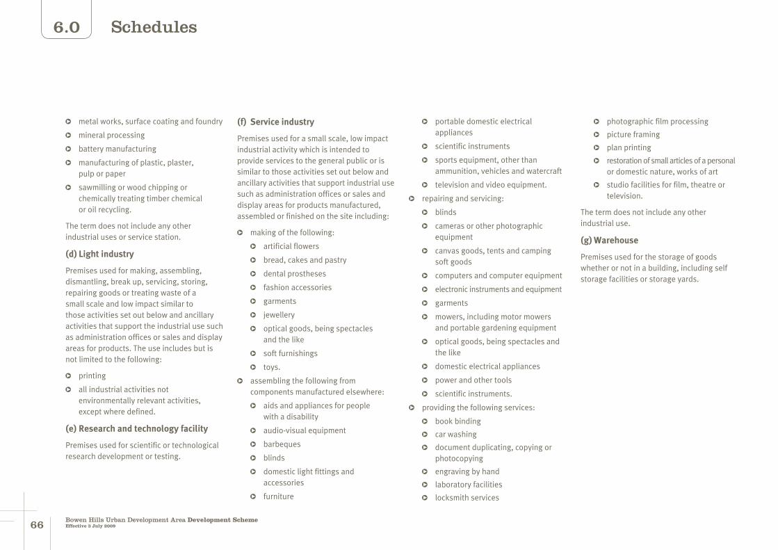
6766Bowen Hills Urban Development Area Development SchemeEffective 3 July 2009
6.0 Schedules
metal works, surface coating and foundry
mineral processing
battery manufacturing
manufacturing of plastic, plaster, pulp or paper
sawmilling or wood chipping or chemically treating timber chemical or oil recycling.
The term does not include any other industrial uses or service station.
(d) Light industry
Premises used for making, assembling, dismantling, break up, servicing, storing, repairing goods or treating waste of a small scale and low impact similar to those activities set out below and ancillary activities that support the industrial use such as administration offices or sales and display areas for products. The use includes but is not limited to the following:
printing
all industrial activities not environmentally relevant activities, except where defined.
(e) Research and technology facility
Premises used for scientific or technological research development or testing.
(f) Service industry
Premises used for a small scale, low impact industrial activity which is intended to provide services to the general public or is similar to those activities set out below and ancillary activities that support industrial use such as administration offices or sales and display areas for products manufactured, assembled or finished on the site including:
making of the following:
artificial flowers
bread, cakes and pastry
dental prostheses
fashion accessories
garments
jewellery
optical goods, being spectacles and the like
soft furnishings
toys.
assembling the following from components manufactured elsewhere:
aids and appliances for people with a disability
audio-visual equipment
barbeques
blinds
domestic light fittings and accessories
furniture
portable domestic electrical appliances
scientific instruments
sports equipment, other than ammunition, vehicles and watercraft
television and video equipment.
repairing and servicing:
blinds
cameras or other photographic equipment
canvas goods, tents and camping soft goods
computers and computer equipment
electronic instruments and equipment
garments
mowers, including motor mowers and portable gardening equipment
optical goods, being spectacles and the like
domestic electrical appliances
power and other tools
scientific instruments.
providing the following services:
book binding
car washing
document duplicating, copying or photocopying
engraving by hand
laboratory facilities
locksmith services
photographic film processing
picture framing
plan printing
restoration of small articles of a personal or domestic nature, works of art
studio facilities for film, theatre or television.
The term does not include any other industrial use.
(g) Warehouse
Premises used for the storage of goods whether or not in a building, including self storage facilities or storage yards.

6766Bowen Hills Urban Development Area Development Scheme
Effective 3 July 2009
6.0Schedules
Residential
(a) House
Premises used for residential purposes where freestanding on its own lot used as one self contained dwelling.
(b) Multiple residential
Premises used for residential purposes if there are two or more dwelling units on any one lot. Multiple residential dwelling units may be contained on one lot or each dwelling unit may be contained on its own lot subject to community title schemes. The term multiple residential does not include a house, as defined herein.
(c) Other residential
Premises used for the accommodation and care of aged and retired people, small groups of disadvantaged persons or persons who are being nursed, require ongoing supervision/support or are convalescing. This term may include but is not limited to ancillary dining and recreation facilities, administration offices, laundries, kitchens, ancillary medical facilities and residential accommodation for management and staff.
(d) Relocatable home and caravan park
Premises used for the parking or location of relocatable homes, caravans, self contained cabins, tents and similar structures for the purpose of providing residential accommodation.
The term includes ancillary facilities such as amenities, laundries, kitchens, a kiosk and recreation facility residential accommodation for persons associated with the development. It also includes a manager's office and residence.
Retail
(a) Fast food premises
Premises used for the preparation and sale of food to the public generally for immediate consumption off the premises. The term may include drive through facilities and ancillary facilities for the consumption of food on the premises.
(b) Food premises
Premises used for the preparation and sale of food and drink to the public for consumption on or off the site. The term includes a cafe, restaurant, coffee shop, bistro, tea room, milk bar, snack bar, kiosk, take-away, but does not include fast food premises as separately defined.
(c) Market
Premises used for the display and sale of goods to the public on a regular but infrequent basis, where goods are primarily sold from temporary structures such as stalls, booths or trestle tables. The use includes ancillary food and beverage sales and ancillary entertainment provided for the enjoyment of customers.
(d) Service station
Premises used for the retail sale of fuel including petrol, liquid petroleum and automotive distillate to refuel motor vehicles.
(e) Shop
Premises used for the display, sale or hire of goods to the public. The term includes the incidental storage of goods on the premises and the ancillary or incidental preparation of food. It also includes hairdressing, minor appliance repairs, alterations, retail dry cleaning, liquor store, department store, discount department store, discount variety stores and betting agencies. The term does not include the types of repairs as separately defined by light industry.
(f) Shopping centre
Premises used for display, sale or hire of goods comprising two or more individual tenancies, comprising primarily shops and which function as an integrated complex.
(g) Showroom, storage and display facilities
Premises used for the display and sale of goods, by retail or by auction. The term also includes storage.
Rural
(a) Agriculture
Premises used for commercial purposes for the:
growing and harvesting of trees, crops, pastures, flowers, fruit, turf, vegetables and the like for commercial or business purposes. The definition includes the storage and packing of produce grown on the subject site and the repair and servicing of machinery and other ancillary activities
breeding, keeping, rearing, training, boarding or stabling of animals.
(b) Animal keeping and husbandry
Premises used for keeping, depasturing, grazing or stabling of any animal, bird, insect and reptile. The term includes the use of land for keeping, breeding, stabling, training or boarding animals.
6968Bowen Hills Urban Development Area Development SchemeEffective 3 July 2009
6.0 Schedules
Service, community and other
(a) Car park
Premises used for the parking of motor vehicles where such parking is not ancillary to some other development on the same site.
(b) Cemetery
Premises used for the interment of the dead. The term does not include a crematorium or funeral parlour.
(c) Child care centre
Premises used for the minding or care, but not residence of children generally under school age. The use includes but is not limited to a kindergarten, creche or early childhood centre.
(d) Community facility
Premises used for social or community purposes, such as a community centre, library, public building or the like.
(e) Crematorium
Premises used for cremating human corpses after death. The term does not include a funeral parlour or cemetery.
(f) Educational establishment
Premises used for systematic training and instruction, including any other ancillary facility. This definition includes prep facilities, primary school, secondary school,
college, university, technical institute, academy or other educational centre.
This term may include residential accommodation and other ancillary uses provided for the employees and the students of such premises.
(g) Emergency services
Premises used for services which respond to community need in an emergency.
(h) Environmentally relevant activities
As defined in the Environmental Protection Act 1994.
(i) Funeral parlour
Premises used for arranging and conducting funerals, memorial services and the like, but does not include burial and cremation. The definition includes the storage and preparation of bodies for burial or cremation and includes a mortuary and funeral chapel. The term does not include a cemetery or crematorium.
(j) Hospital
Premises used for the medical or surgical care or treatment of persons accommodated on the premises to receive this care or treatment.
The use includes care or treatment of persons such as emergency patients or out-patients not residing on the premises
(k) Landing
Structure for mooring or launching boats and / or for passengers to embark and disembark.
(l) Place of assembly
Premises used for worship and activities of a religious organisation, community or association.
(m) RNA Showgrounds
Premises used for RNA activities.
(n) Utility installation
Premises used for the purpose of providing utility or telecommunications services, which does not fall within the Schedule of Facilities and Areas under the Telecommunications Act 1997. The term may include but is not limited to:
a telecommunications tower more than 5m in height
an equipment shelter of more than 7.5m2 in area and 3m in height.
Sport, recreation and entertainment
(a) Indoor entertainment
Premises used for sport, physical exercise, recreation and public entertainment predominantly within a building. The term includes facilitates commonly described as sports centre, gymnasium, convention centres, amusement and leisure centres, cinema, nightclub, adult entertainment theatre and hotel.
(b) Outdoor sport and recreation
Premises used for any sporting or recreational activity, or other leisure past time, which is conducted wholly or mainly outside of a building.
The term includes such typical premises as (outdoor) public swimming pools, golf courses and driving ranges, outdoor courts and sportsgrounds, and the like. The term also includes the provision of a clubhouse and other ancillary facilities.
(c) Park
Premises used by the public for free recreation and enjoyment, but used infrequently for events.
Facilities for park users may include children's playground equipment, informal sports fields, vehicle parking and other public conveniences.

6968Bowen Hills Urban Development Area Development Scheme
Effective 3 July 2009
6.0Schedules
Tourism
(a) Tourist facility
Premises used, or intended to be used, for providing entertainment, recreation or similar facilities for the general touring or holidaying public. The term includes associated short term accommodation or facilities providing meals.
(b) Visitor accommodation
Premises used for short term accommodation for the general touring, holidaying or visiting public. The term includes associated facilities providing meals.
Administrative Terms (f) Filling or excavation
Operational work for filling or excavating that materially affects premises or their use.
(g) Ground level
The levels on a site which precede development excluding any site works that are subject to a related development approval, unless approved by the ULDA or established as part of a reconfiguration of the land preceding development.
(h) Gross floor area
The total floor area of all storeys of a building, including mezzanines, measured from the outside of external walls or the centre of a common wall, excluding areas used for:
building services
ground floor public lobby
a public mall in a shopping complex
the parking, loading and manoeuvring of motor vehicles
private balconies whether roofed or not.
(i) High water mark
Means the ordinary high-water mark at spring tides.
(j) Mezzanine
An intermediate floor within a room.
(k) Minor building or demolition work
internal building or demolition work
external building work up to 25m2 for roofs over existing decks or paved areas, sun hoods, carports and the like
building work up to 10% of approved GFA or lawfully existing GFA at the time of commencement of this development scheme
raising a house where the resultant height does not exceed 8.5m
external demolition of post-1946 additions, alterations, extensions or outbuildings or pre-1946 free standing outbuildings at the rear of the building.
(l) Noise sensitive use
Means any of the following:
house, multiple residential, other residential
childcare centre, community facility, hospital or place of assembly
park.
(m) Plot ratio
The ratio between the gross floor area of a building and the total area of the site.
(n) Podium
A continuous projecting base of a building.
(a) Affordable housing
Affordable housing is housing which can be reasonably afforded by low to moderate income households. Housing can reasonably be afforded by low income households, if the household spends no more than 30% of its combined annual gross income on rent or 35% of its combined annual gross income on home ownership.
Affordable housing encompasses:
private rental housing and home purchase options (including housing aimed at the first home owners market)
social housing (including public and community housing).
(b) Authority
The Urban Land Development Authority.
(c) Basement
A storey either below ground level or where the underside of the ceiling projects no more than one metre above ground level.
(d) Building height
The maximum vertical distance between the natural ground level and the roof or parapet at any point but not including an antenna, aerial, chimney, flagpole or the like.
(e) Development scheme
As defined in the Urban Land Development Authority Act 2007.
7170Bowen Hills Urban Development Area Development SchemeEffective 3 July 2009
6.0 Schedules
(o) Private open space
An outdoor area for the exclusive use of the occupants.
(p) Public realm
Refers to spaces that are used by the general public including streets, squares, parks and environmental areas.
(q) Setback
The shortest distance measured horizontally from the outer most projection of the building or structure to the vertical projection of the boundary of the lot.
(r) Significant vegetation
Vegetation, whether living or dead, including its root zone1 that:
maintains biodiversity
preserves natural landforms
contributes to the character of a landscape
has cultural or historical value
has amenity value.
Below is a list of known significant vegetation within the Bowen Hills UDA:
all vegetation including marine plants along Breakfast / Enoggera Creek2
1 The zone of the soil and roots described by the vertical projection of the foliage limit of the tree, to the depth of 1 metre and including buttress roots on and above the soil surface.
2 Includes all vegetation within 10m of the high water mark.
all trees3 in Bowen Park
all trees3 in Perry Park
all trees3 surrounding the secondary oval in the RNA grounds on Lot 3 on SP109738
all trees3 to the north and north-east of the main oval in the RNA grounds on Lot 481 on SP196765
all trees3 in the RNA grounds on Lot 484 on SL4553.
(s) Site cover
The proportion of the site covered by buildings, including roof overhangs.
(t) Storey
Means a space within a building which is situated between one floor level and the floor level next above, or if there is no floor above, the ceiling or roof above. This does not mean:
(i) a space that contains only:
a lift shaft, stairway or meter room
a bathroom, shower room, laundry, toilet or other sanitary compartment
accommodation intended for not more than 3 vehicles
a combination of the above, or
(ii) a mezzanine.
3 Other than species listed by the ULDA as pest vegetation or with a diameter of less than 60cm measured at 1 metre above the ground level.
(u) Sub-precinct plan
Refer to sub-precinct development Requirements in Section 3.2.6 of the land use plan.
(v) Tidal works
As defined in the Coastal Protection and Management Act 1995.
(w) Uplift of land value
The increase in development yield or land value arising from the development scheme4.
(x) Urban design
Refers to the holistic design of urban environments, including the overall townscape, individual buildings, street networks, streetscapes, parks and other public spaces.
4 Refer to the ULDA Affordable Housing Strategy for more information.

7170Bowen Hills Urban Development Area Development Scheme
Effective 3 July 2009
6.0Schedules
Schedule 3: Amendments
Amendment 1: 1 April 2010
page 19 - Conduits for future electricity cables are to be installed within all new roads, road widenings and upgrades.
page 27 - Map 9(a): Precinct 2 building heights
page 31 - As per Map 9(a)
page 60 - (vi) State infrastructure funding will be sought through the normal budgetary processes and will be part of approved State agency capital programs

Contact UsVisit our website at: www.ulda.qld.gov.au
Write to us at:Urban Land Development AuthorityPO Box 3643South Brisbane BC QLD 4101
Telephone us: 1300 130 215Fax us: (07) 302 44199
July 2009