bridgeport, ct 18 november 2016
TRANSCRIPT

BRIDGEPORT, CT
18 NOVEMBER 2016
BARNUMSTATION
TRANSIT-ORIENTED DEVELOPMENT (TOD) PLAN
ACKNOWLEDGEMENTSOVERSIGHT COMMITTEE MEMBERS
Mayor Joseph Ganim | City of BridgeportJohn Gomes, CAO | City of Bridgeport
John Urquidi, City Engineer | City of BridgeportGuillermo Marin | East Side NRZ
Keith Williams | East End NRZFrancisco Borres | Mill Hill NRZTom Stilley | DuPont Properties
Michael Taylor | Vita Nuova/DuPont representativeMarian Whiteman | General Electric CompanyPam Elkow | General Electric Representative
Marc Brunetti | Yale New Haven Health/Bridgeport HospitalTodd McClutchy | JHM Group
Kim Morque | Spinnaker Real Estate PartnersLud Spinelli | Optimus Healthcare
Kevin Reed | Bridgeport Trade and Technology CenterMelissa Kaplan-Macey | Regional Plan Association
James Slaughter | Park City Communities
STAFF SUPPORT, CITY OF BRIDGEPORT – OPEDDean Mack, Planner II
Lynn Haig, Planning DirectorCurtis Denton, GIS Administrator
Frank Croke, Senior Economic Development AssociateParag Agrawal, Former Planning Director
Emily Provonsha, Former Planner II
FUNDED BYState of Connecticut, Office of Policy and Management (OPM)Transit-Oriented Development (TOD) Planning Grant Program
PLANNING TEAMGoody Clancy | VHB | W-ZHA
Simpson. Grumpertz & Heger | VJ Associates
CONTENTSIn This Document
Connecticut’s Next Great Economic Growth Center: ..........1 Bridgeport’s Barnum Station District
A Transformative Vision .................................................................4
A Market-Driven Opportunity .......................................................6
A Community-Driven Opportunity ............................................. 11
The Framework ............................................................................... 13
Taking Action ..................................................................................34
Tower Place/Station District Development Guidelines (companion document)
Appendix

BARNUM STATION
CONNECTICUT’SNEXT GREAT
ECONOMIC GROWTH CENTER: BRIDGEPORT’S
DISTRICT
Transit-served districts are the principal economic growth centers of urban regions in the 21st century. Across the nation, growth is especially robust within established transit-served downtowns or in emerging growth districts clustered around new transit stations. Nowhere are these factors more critical
to sustainable economic development than in Southwest Connecticut, where the regional highway network along the I-95 corridor has little capacity to support long-term growth while rail service along the Northeast Corridor offers significant untapped capacity. Increasing use of transit for work trips and concentrating development around transit stations are among the most effective strategies the City and State can take to advance economic development both locally and within the region. Bridgeport’s Barnum Station and adjoining areas of East Bridgeport offer a major opportunity to benefit from these trends, supporting both regional and local economic development goals on a large scale.
1BARNUM STATION TOD PLAN |

The City of Bridgeport and State of Connecticut have taken important steps to bring the economic and community benefits of transit service to East Bridgeport. They have advanced the design and funding of Barnum Station, a new rail station on the Northeast Corridor built to accommodate express and local Metro North service, as well as possible Amtrak service.1 The station will be located where it can serve not only Bridgeport’s second-largest concentration of workers and more than 4,000 nearby residents, but also Fairfield County’s largest concentration of vacant developable land next to frequent rail transit service. The state and city have also funded this plan, which translates the new opportunity offered by transit service into a larger vision for revitalization, and prioritized strategies to realize the vision.
This plan focuses on two geographical scales around the stations (see map on facing page). The Barnum Station Area (“Station Area”) is an
1 Over the last several years, Connecticut has focused significant resources on assisting its communities to plan for future transit-oriented development. In 2013, the state studied and confirmed the feasibility of constructing a new rail station, known as Barnum Station, in East Bridgeport and identified its potential to catalyze TOD. In 2015, the state committed additional resources to advance design for a station that could accommodate enhanced Metro-North commuter service as well as Amtrak service along the New Haven Main Line. The state also committed resources to support this planning study of economic and community development strategies in order to spur equitable neighborhood revitalization around the new station.
area within about a half-mile or 15-minute walk of the station site – the typical limit of how far people will walk to a rail station on a regular basis. The Barnum Station District (“Station District”) is a smaller area within about three blocks of the station, significant both because of its convenient walking access to transit and its large concentration of vacant land available for redevelopment and under city control.
The Barnum Station District presents a unique opportunity for the City of Bridgeport to improve its economy and transform its economic position within Southwest Connecticut and the New York Consolidated Metropolitan Area. Properly planned and executed, the Station District will possess the place-based characteristics that the Regional Plan Association (RPA) considers requisite for economic growth. In its publication, “Charting a New Course: A Vision for a Successful Region, 2016”, the RPA identifies “Downtowns and Centers”, and particularly “Regional Centers”, as the category of place that contributes most to economic development in the New York region, which includes Bridgeport and southwestern Connecticut. These centers offer employment opportunities in a mixed-use, walkable setting served by transit. Employers, workers, and residents increasingly locate in such transit-oriented developments (TOD) – and this is the Barnum Station District opportunity.
MAJOR FINDINGS• The Barnum Station District has the potential to
become a Regional Center – a choice address for office space and related mixed-use development, within 3 blocks of Barnum Station. This major economic development opportunity has few parallels along the Northeast Corridor, and is a prime opportunity to expand economic growth in southwestern Connecticut.
• The Barnum Station District has the potential, over a 25-year period, to attract and spawn 4,000 or more new jobs within walking distance of the station. Unlike many transit-oriented development opportunities where housing primarily drives development, the Barnum Station District is
uniquely well positioned to serve as a center for employment. This stems from the large scale of its development sites, scarcity of other large transit-served sites in Fairfield County, and accessible workforce.
• The broader area within 1/2 mile of the station should also accommodate complementary residential development, light industry and community services for surrounding city neighborhoods. Ongoing mixed-income residential development is already helping reposition vacant blocks and waterfront near the station as attractive places to live.
• Public control of nearly 25 acres of vacant land near Barnum Station – more than at any comparable site in the region – enables efficient, well-planned redevelopment at sufficient scale to establish a strong new position in the real estate market.
• Even before new development is considered, the area around the station already accommodates more than 4,500 jobs and 2,000 households, making it an active mixed-use area that will make extensive use of Barnum Station from its opening day.
| BARNUM STATION TOD PLAN2
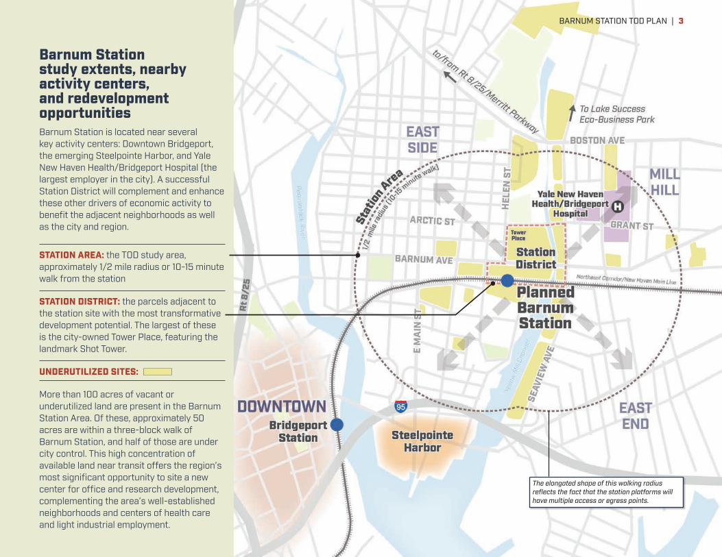
Barnum Station study extents, nearby activity centers, and redevelopment opportunitiesBarnum Station is located near several key activity centers: Downtown Bridgeport, the emerging Steelpointe Harbor, and Yale New Haven Health/Bridgeport Hospital (the largest employer in the city). A successful Station District will complement and enhance these other drivers of economic activity to benefit the adjacent neighborhoods as well as the city and region.
STATION AREA: the TOD study area, approximately 1/2 mile radius or 10-15 minute walk from the station
STATION DISTRICT: the parcels adjacent to the station site with the most transformative development potential. The largest of these is the city-owned Tower Place, featuring the landmark Shot Tower.
UNDERUTILIZED SITES:
More than 100 acres of vacant or underutilized land are present in the Barnum Station Area. Of these, approximately 50 acres are within a three-block walk of Barnum Station, and half of those are under city control. This high concentration of available land near transit offers the region’s most significant opportunity to site a new center for office and research development, complementing the area’s well-established neighborhoods and centers of health care and light industrial employment.
The elongated shape of this walking radius reflects the fact that the station platforms will have multiple access or egress points.
BARNUM STATION TOD PLAN | 3

The new opportunities for transit access and employment possible in the Barnum Station District will complement the significant presence of existing employers and jobs in the larger Barnum Station Area. Bridgeport Hospital, a member of the Yale New Haven Health System, is a ten-minute walk from the station site. Bridgeport’s largest employer, the hospital anticipates expanding its 2,600 staff further, and would value Barnum Station’s improved connections to regional workforce and its other health care facilities, including Yale New Haven Hospital and Yale Medical School. The Bridgeport Trade and Technology Center (BTTC) is another significant employment center. This facility, located in a 550,000sf former Singer Sewing Machine factory five minutes’ walk from the station site, provides flexible office and light industrial space opportunities to a wide variety of small and mid-size businesses, as well as educational institutions. Tenant businesses employ a significant number of local neighborhood residents. The BTTC has helped a number of small businesses start, grow and “graduate” to larger space on other sites. Finally, the Barnum Station Area is home to a number of other prospering light industrial and service businesses, some with competitive niche positions in precision manufacturing and health services. Ample space is present in the Barnum Station Area to ensure these and other health care and light industrial employers can remain and grow. At the same time, the Barnum Station District can attract and accommodate the office-inclined and research-related employers that would be especially attracted to a location adjacent to transit. This combination of employers would provide a rich spectrum of job opportunities, rejuvenate Bridgeport’s tax base, efficiently use land and infrastructure, and potentially offer the mix of research, production and business facilities that especially drive innovation and business growth.
Development near the station also provides an unparalleled opportunity to strengthen existing neighborhoods around it. The broader Barnum Station Area (“Station Area”) – approximately a 10-15 minute walk from the station site – was dominated historically by heavy industries with housing nearby. This industrial era ended decades ago, leaving a legacy of contaminated brownfields, vacant sites, and decaying buildings for
Residents and stakeholders from the East Side, Mill Hill, and East End neighborhoods have been engaged as part of this study to create the vision for the Station Area and help identify priority improvements.
BARNUM AVE
SEAVIEW AVE
HAL
LETT
ST
HEL
EN S
T
ABOVE: Toned sites in the aerial image above highlight the core of approximately 50 acres of large redevelopable sites within three blocks of the planned station. RIGHT: This plan sets up a new century of inclusive economic prosperity for East Bridgeport, succeeding the heavy industry that flourished here during the first half of the 20th Century and is now gone.
| BARNUM STATION TOD PLAN4

The Bridgeport Trade and Technology Center provides flexible office and light industrial space for more than 50 businesses, generating local employment and entrepreneurship opportunities blocks from Barnum Station.
Yale New Haven Health/Bridgeport Hospital, the city’s largest employer, is a ten-minute walk from Barnum Station, and values the opportunity for its staff to utilize rail transit.
current residents to contend with. These sites are problems today, but prime opportunities for TOD and supportive uses tomorrow. Barnum Station and new mixed-use walkable development near it will help connect residents to jobs, transit, and open spaces; connect children to local schools; and connect neighborhoods to each other. Proactive efforts to maintain affordable housing options and expand pathways to career opportunities in the Barnum Station Area will enable current and future residents to fully participate in the economic growth potential.
While significant state and Federal investment has been and will be dedicated to the new rail station, capturing the full economic development opportunity of Barnum Station depends on significant additional public investment. Principal areas of investment include:
• The affordable housing and education/job training initiatives mentioned above will require public investment in partnership with community housing and educational organizations.
• Streets require reconstruction with improved sidewalks, lighting, bus stops, bike facilities and turn lanes enabling all modes of transportation to safely and conveniently access the station and area redevelopment sites.
• Demolition and remediation of vacant buildings and soils is necessary on some sites.
• Unique waterfront park opportunities can be captured only with investment in pathways and landscaping.
While the costs of these elements together could total half again as much as the station, they can all be addressed in stages. Strategic first investments provide an essential foundation to attract private-sector investment and serve immediate neighborhood needs, while later investments can be paced with private-sector redevelopment projects. This plan document explains how to most effectively focus these investments to maximize the return they deliver to Barnum Station Area neighborhoods, Bridgeport as a whole, and the state of Connecticut.
BARNUM STATION TOD PLAN | 5

TRANSFORMATIVEAVISION
Barnum Station is a major economic development opportunity with few parallels along the Northeast Corridor. New transit service with regional access and a large amount of available land combine to create transformative potential for business/industry growth, new jobs, workforce attraction/retention, and neighborhood revitalization.
1
The station area, unlike any comparable location along the Northeast Corridor, contains large amounts of underutilized land in both public and private-sector ownership, enhancing opportunities for major new development. More than 100 acres of underutilized land are within a 10-15 minute walk of the station site.
2
The Barnum Station District has the potential to develop into a Regional Center over the longer term, supporting significant new employment with 4,000 or more new jobs located within walking distance of the station. A large jobs component near transit is a relatively unique focus compared to residential-based TODs in many similar areas, providing a competitive distinction and greater economic benefits.
3
5
Near-term: Improve regional transit access to increase economic opportunity for employers and residents.
Long-term: Catalyze economic development in East Bridgeport, revitalizing vacant and underused land while connecting neighborhoods.
WITHIN A 10-MINUTE WALK OF THE STATION...
TODAY* OPPORTUNITY
Employees 3,200 + 4,000-8,000
Businesses 180 + 100 or more
Residents 4,500 + 1,000-2,000
Housing units 1,800 + 500-1,000* Sources: ACS, ESRI
A COMPLEMENT TO DOWNTOWN AND STEELPOINTE HARBOR
Downtown* Steelpointe
Employees 17,000
Businesses 620
Residents 1,000 1,500-3,000
Housing units 1,800 1,000-1,500* Sources: ACS, ESRI
The Barnum Station District will appeal to different market segments from those attracted to Downtown and Steelpointe, which will mature as mixed-use districts before large-scale Barnum Station District redevelopment occurs.
WATERVIEW AVE
Yellow MillChannel
I-95
Steelpointe Harbor
| BARNUM STATION TOD PLAN6

1
2
The Barnum Station District will complement and enhance Downtown Bridgeport by providing growth and expansion opportunities. The Downtown area is constrained by surrounding highways and water. The Barnum Station area can accommodate growth and expansion that will strengthen the city overall. Even including potential growth opportunity, it represents less than two-thirds of the jobs within walking distance of the Downtown Bridgeport station.
44
3The Station Area should also accommodate complementary residential development, light industry and community services for surrounding urban neighborhoods. An equitable economic development model will provide greater access to opportunity for current residents, improve quality of life, and strengthen the local and regional economy.
5
The Yellow Mill Channel offers a signature placemaking opportunity to support a new generation of private investment. The proposed Yellow Mill Greenway capitalizes on prime waterfront access and reveals the hidden potential of this urban waterway between neighborhoods.
6
6
BARNUM AVE
SEAVIEW AVE
BARNUM STATION
I-95
ARCT
IC S
T
HELEN ST
DowntownBridgeport
BARNUM STATION TOD PLAN | 7

What types of land use close to Barnum Station would maximize economic development opportunity? Market positioning analysis conducted for this plan indicates that high-density employment uses—like office, healthcare, and research, that bring relatively high numbers of employees per unit land area—deserve priority. Such uses not only would be most attracted to Barnum Station’s transit access, but also would likely produce the greatest economic returns to the City and region, over time. Multi-family housing and light industry also deserve significant presence in the half-mile radius surrounding Barnum Station, owing to ongoing market interest and the additional housing and job options they can provide the community. But on sites within 3 blocks of the station, prioritizing high-density employment uses for at least half of developed floor area would do the most to generate economic benefits.
There is little doubt that Barnum Station will generate housing demand once it is operational. Indeed, the Station Area is already seeing increased housing demand from a combination of households coming from Bridgeport, from neighboring communities, and from New York City. Likewise, the area’s established position as a place for light industry is expected to continue to drive incremental growth in demand for flex space. A big question for this plan, however, was whether the station, and presence of large redevelopment sites near it, would generate demand for office development nearby. New analysis indicates that the station and surrounding land can indeed establish an important new address for office development. The basis of this opportunity is explained further below.
Location and AccessBridgeport is the most populous city in Connecticut and well-located in one of the country’s most powerful economic regions. It is located in Fairfield County on the Northeast Corridor and is part of the New York Combined Statistical Area, which has the highest gross domestic product of any Metro Area in the United States. Depending on traffic, it is approximately a half-hour drive from Stamford (a business and finance center) and New Haven (a medical and education center). It is also approximately 60 miles away from Manhattan. The entire Barnum Station Area is well-served by highways and roads today, located within minutes of I-95, Routes 8 and 25, and the Merritt Parkway. Traffic congestion is a growing issue on these highways, however.
With a new rail station, the Barnum Station District will gain frequent and efficient passenger rail service to New Haven, Stamford and New York. The station will be designed with center-track platforms suitable for service by both local and express trains, like platforms at the Stamford and New Haven stations. This means Barnum Station will be served by local and express Metro North trains, offering faster connections to New York and extensive access to workforce around nearby stations. Potential Amtrak service would add significant access to other regions, reaching New York in as little as an hour and Boston in as little as 2.5 hours. The Barnum Station District
The Barnum Station Area represents one of the largest transit-oriented development opportunities on the Northeast Corridor north of New York City.
MARKET-DRIVENAOPPORTUNITY
The Barnum Station District is well-positioned to attract new growth and provide improved transit access to the regional economy.
| BARNUM STATION TOD PLAN8

would offer convenient access to major urban centers with premium rail service, at a fraction of the real estate costs found in many other Northeast Corridor station locations. In addition, the high-speed fiber optic infrastructure also available within the Station District makes it accessible to the world. The Barnum Station District’s access advantages makes it well-positioned to evolve into a “Regional Center” growth magnet as defined by the Regional Plan Association (RPA).2 Regional Centers are walkable, mixed-use, transit-served districts with a high employment concentration.
Market PositioningOnce the Barnum Station is complete, all of this rail, road and technology infrastructure will serve an extraordinary concentration of land ready for redevelopment. There are almost 100 acres of under-utilized land within a 15-minute walk from the station. Three large redevelopment sites within a five-minute walk of the station are owned by the City: the station site itself (7.5 acres), the adjacent Tower Place site (10 acres), and the nearby Department of Health site (6.5 acres). Other large parcels in private ownership are also available, making nearly 50 acres available for redevelopment within a 10-minute walk from the station.
2 RPA analysis identifies Regional Centers, and revitalization in cities including Bridgeport, as vital to maintaining and expanding economic growth in the New York Metropolitan area between now and 2040. Refer to Charting a New Course: A Vision for a Successful Region, Regional Plan Association, June 2016.
To best serve economic development in the New York City metropolitan area, the Regional Plan Association recommends increasing the growth rate for jobs in Regional Centers by more than 38% – making them the locations for nearly 14% of new jobs, second only to the 17% share targeted to the region’s major downtowns. The Barnum Station District is well positioned to serve as a new Regional Center.
This makes the Barnum Station District one of the largest transit-oriented development opportunities on the Northeast Corridor north of New York City. Unlike other locations, the Barnum Station TOD Plan ensures that new development will contribute to an integrated urban district. It will guide transformation of the Barnum Station District into a Regional Center that complements Downtown Bridgeport. Development opportunities on large sites within this Regional Center context provide the Barnum Station District with a distinct competitive advantage over other transit-oriented locations.
Market PotentialToday, Bridgeport’s office market is challenged with high vacancy and low rents. Within the broader New York Region, Southwest Connecticut and Fairfield County have been losing their share of regional jobs over the last 20 years. The RPA predicts that if current trends and policies continue, Southwest Connecticut’s share of super-regional employment will continue to shrink and Fairfield County will lose employment by 2040. In response, the State of Connecticut is
Source: Charting a New Course, Regional Plan Association, 2016, with data from Moody’s Analytics, Bureau of Labor Statistics
Job growth in Southwestern Connecticut has lagged other parts of the New York metropolitan region. Repositioning the Barnum Station District as a Regional Center for office and mixed-use development would be instrumental making Southwestern Connecticut more competitive for job growth.
15 Charting a New Course | Regional Plan Association | June 2016
age of 58,000 jobs annually. The biggest job growth came from high-wage sectors such as professional and technical services and management services, low-wage industries such as retail and food services, and health care and education, which showed growth across occupa-tions with a broad range of skills and incomes. Financial services, which provided much of the region’s growth in earnings, actually declined slightly in employment, partly because of continuing fallout from the financial crisis. Manufacturing continued its long-term decline, falling at the rate of 3% per year.
Unlike the preceding decades, New York City grew faster than any other part of the region, slightly more than Long Island and the Hudson Valley, twice as much as northern New Jersey, and much more than southwestern Connecti-cut. This pattern strengthened over the last decade. From 1996-2001, New York City grew at a rate similar to the rest of the region. It declined relative the rest of the region in the years immediately following 2001, but since 2004 has grown much faster than the rest of the region.
Many of the factors contributing to these trends appear to be durable. Both domestic and global cities that have dense concentrations of high-skill workers like New York are increasing their dominance in high-value, high-wage industries. Millennials, many now in their 30s, are still favoring walkable, transit-oriented places more than their parents did at the same age. Retiring boomers, too, are
are comparable, with both coming four years after the trough of the region’s two deepest postwar recessions, and the period as a whole includes two strong expansions followed by recessions.
showing a strong preference for less auto-dependent places, and many are looking to move to smaller, more centrally located homes.2 Even if the majority of millen-nials live in suburban communities as they get older, the share living in cities or small downtowns will still likely be large enough to anchor significant urban growth. While many of the industry trends are likely to moderate, sec-2 Eighty percent of 18-34 year-olds would like to live in places where they don’t need a car to get around (Rockefeller Millennials Survey, Rockefeller Foundation and Transporta-tion for America, 2014), a finding that would have been unlikely with baby boomers at a similar age. A survey by the American Planning Association (Investing in Economic Growth and Competitiveness, 2014) found convergence of current preferences across generations, with millennials, boomers and Generation X’ers born in between desiring to move away from auto-dependent neighborhoods.
Figure 3: Change in Jobs by Industry,1996-2015
-400K -40K
-19K -16K
-5K -1K
+9K +17K
+38K +73K +83K +92K
+109K +156K +161K
+176K +251K
+285K +485K
-500K -400K -300K -200K -100K 0 100K 200K 300K 400K 500K K600K
Manufacturing Finance and insurance Wholesale trade Information Utilities Mining
Transportation & WarehousingReal Estate, Rental & Leasing
Management of Companies & EnterprisesArts, Entertainment & Recreation
ConstructionGovernment
Other ServicesAdministrative & Support, Waste Management, Remediation Services
Educational ServicesRetail Trade
Professional, Scientific & Technical ServicesAccommodation & Food Services
Health Care & Social Assistance
Source: Moody’s Analytics, Bureau of Labor Statistics
Figure 4: Job Index from 1996-2015 for Subregions
95
100
105
110
115
120
125
2000 2005 2010 2015
Job Index from 1996-2015 for Subregions
Southwestern CT
Hudson Valley Long Island
Northern NJ
NYC
Source: Moody’s Analytics, Bureau of Labor Statistics
JOB INDEX FROM 1996-2015 FOR SUBREGIONS
120
110
100
952000
NYCLong IslandHudson Valley
Northern NJ
Southwestern CT
2005 2010 2015
125
115
105
BARNUM STATION TOD PLAN | 9

working proactively with its communities and employers to regain its competiveness as a great place to work.
Notwithstanding the current office market outlook, if new policies and investments are made that direct development toward existing urban concentrations and transit-accessible areas, RPA forecasts that employment growth will be higher in the New York Region and that Southwest Connecticut’s and Fairfield County’s share of regional employment will increase. RPA’s “Aspirational Vision” sees growth
It is realistic to assume that the market can support between 800,000 and 1.7 million square feet of office space [near the station] by 2040.
Source: Charting a New Course, Regional Plan Association, 2016, with data from Moody’s Analytics, Bureau of Labor Statistics
Job growth in the New York metropolitan region through 2040 is expected to be heaviest in the office and institutional sectors (including health care, education and research), fueling demand for office space and other workspace with high density of employees, appropriate for the Barnum Station District.
channeled in a more sustainable fashion with Downtowns and Regional Centers realizing the greatest and fastest employment growth. Downtown Bridgeport and the Barnum Station District will be well-positioned to capture this growth. Transit-accessible, moderate- to high-density, mixed-use environments are what businesses and employees demand. Assuming the Barnum Station District evolves into such a center, it is realistic to assume that the market can support between 800,000 to 1.7 million square feet of office space by 2040. This projection assumes that the Barnum Station District captures a reasonable share of RPA’s projected Fairfield County employment.
Office niches that make sense for the Barnum Station District include healthcare, education and smaller professional and business service industries. The healthcare industry may include doctors’ offices and/or institutional investment in the Station Area. The same is true for education where existing local institutions may desire expansion space within easy walking distance to rail. At the same time, a number of additional site opportunities for flex space serving light industry will remain available in East Bridgeport. This will ensure continued availability of a broad spectrum of jobs accessible to Bridgeport residents. It also supports continued competitiveness of Bridgeport businesses in precision manufacturing and health care sectors that help drive economic development in Connecticut.
ImplementationRealizing the Station District’s full potential will be a long-term endeavor. It will require strict adherence to the Plan and a willingness to turn down short-term, sub-optimal opportunities in order to preserve long-term potential. This is particularly true on the station and Tower Place sites. Development in these key locations should be of sufficient scale and appropriate character to launch the Barnum Station District on the super-regional map. Properly developed, the Station and Tower Place sites will be catalysts for Bridgeport’s future economic growth. See “Taking Action” on page 32 for more recommendations on how to capture the Station District’s full economic potential.
17 Charting a New Course | Regional Plan Association | June 2016
tured implicitly to the extent that the region’s high relative costs result from past limits on housing supply or other constraints. By contrast, the NYMTC forecast puts greater emphasis on the region’s development constraints. It uses third-party forecasts, including Moody’s, as a base, and then adjusts industry totals on a county basis to account for local development capacity.3 Given the differences in approach, the Moody’s forecast is a more appropriate basis for determining how much the regional economy could grow based solely on demand and competitiveness with other domestic and international regions, uncon-strained by the supply of housing, transportation and other infrastructure.
The adjusted Moody’s forecast doesn’t represent the highest possible job growth for the region. If either global or national growth is stronger than Moody’s baseline pre-diction, then the region could see more job growth even if the region’s relative competitiveness remains unchanged.
The type of job growth will affect the type of skills that are needed and the type of work spaces the region will need to create. Compared with past trends, the adjusted Moody’s forecast projects more moderate declines in manufacturing, slower growth in retail trade, modest growth in finance and slower growth in nearly every service category, whether in export industries like profes-sional services or locally driven industries such as health care and social assistance. Differences between past trends and future growth are consistent with slowing growth in the working age population and potential for labor-reducing automation in industries from retail trade to health care. They don’t necessarily mean that wages will continue to stagnate or that income inequality will get bet-
3 A full explanation of the process can be found in Draft 2050 Socioeconomics and Demographics Forecast Report, New York Metropolitan Transportation Council, March 2015.
ter or worse, because there could be substantial change in the types of occupations and skill requirements within industries.
The largest share of the growth, about one million jobs, will be in office industries such as finance and professional services. At current rates of office space per worker, that could require as much as 200 million square feet of office space, about eight times the amount projected to be built in the Hudson Yards district of Manhattan. But employers are putting more workers into less space, a trend that is likely to continue and hold down the amount of new space that is needed. Industrial jobs—manufacturing, transpor-tation, warehousing and construction—are projected to decline slightly, but space will be needed for a million workers in factories, warehouses and other industrial loca-tions. Retail and service jobs will grow much less than in the recent past, while health and education will still repre-sent the fastest growing sector. The demand for hospitals, other medical institutions and higher education facilities is likely to continue growing throughout the region, while the need for new primary and secondary school space will vary by the demographics of different localities.
A Larger and More Diverse PopulationSeveral converging trends will shape the tri-state area’s population and labor force in the next 25 years. The fastest growing age group—those over 65—is also the cohort that has consistently had more out-migration than in-migration. Compared with previous decades, older adults are healthier and work longer, which could delay post-retirement migration. The age group that has nearly always had more people moving in than moving out—people in their 20s and early 30s—is likely to be sought after throughout the U.S. as a shrinking labor force puts a premium on new entrants to the workforce. So far, the region has retained its appeal for young adults. The flow of new immigrants to the region is likely to continue, but the number and composition could change in response to changes in relative wages in other parts of the world or to new national policies regulating immigration.
The factors that will have the biggest influence on migra-tion, and therefore on population growth, are career opportunities and the cost of living. The chance to pros-per and get ahead has always been the region’s primary attraction, while lack of affordability, particularly high housing costs, is arguably its main inhibitor. So the num-ber and quality of jobs that are created and the relative cost of living compared with other regions will be the main determinants of how much the region’s population grows. Job and population growth are mutually reinforcing. More jobs attract more people and a larger labor supply attracts
Figure 6: Job Growth by Sector, 2015-2040
Current Trends Potential Growth
-1%
7%
21%
31%
16%
-5%
-2%
11%
22%
7%
Industrial
Retail &Services
O�ce
Institutional
Self-Employed
Source: Regional Plan Association; Moody’s Analytics, Quarterly Census of Economics and Wages
JOB GROWTH BY SECTOR, 2015–2040
Current Trends
Self-Employed
Institutional
Office
Industrial
Retail & Services
Potential Growth
| BARNUM STATION TOD PLAN10

The Barnum Station Area vision sets the stage for longer-term economic opportunities while also addressing immediate community concerns. Vital elements needed to establish Regional Center scale development around transit – like safe, inviting, well-lit sidewalks; clear shovel-ready development sites; easier driving routes on key area streets; and a broader range of retail and housing choices – are also needed to enhance quality of life for residents and productivity of employers today. These community goals emerged from conversations with members of the public and the Barnum Station TOD Oversight Committee, as well as major themes highlighted in several previous and concurrent planning efforts.
The TOD plan builds on previous work and is grounded in community needs. An interactive kickoff workshop held May 24, 2016 at the Summerfield United Methodist Church in Mill Hill allowed participants to discuss their vision for the future of the area in small groups. Common themes included:
• Walkability, access to the station, and improved connections between neighborhoods
• More open space, including sports fields, waterfront access, and a multi-use Yellow Mill Greenway north to the new Harding High School site
• Development that fits the neighborhood, serves the community’s needs (including affordable fresh food), provides job opportunities, and reflects its character and heritage
• New housing that includes reusing vacant lots within the neighborhoods and creating opportunities for homeownership
Community members came together to discuss their vision for the Barnum Station Area.
COMMUNITY-DRIVENAOPPORTUNITY
BARNUM STATION TOD PLAN | 11
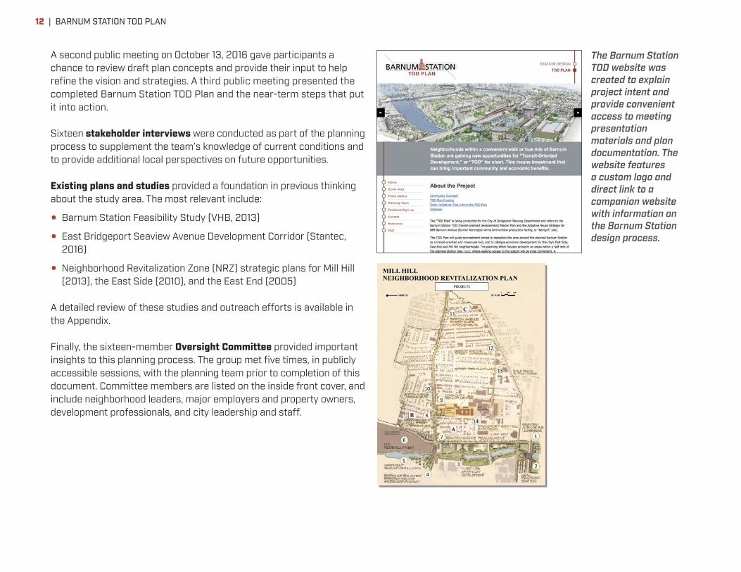
A second public meeting on October 13, 2016 gave participants a chance to review draft plan concepts and provide their input to help refine the vision and strategies. A third public meeting presented the completed Barnum Station TOD Plan and the near-term steps that put it into action.
Sixteen stakeholder interviews were conducted as part of the planning process to supplement the team’s knowledge of current conditions and to provide additional local perspectives on future opportunities.
Existing plans and studies provided a foundation in previous thinking about the study area. The most relevant include:
• Barnum Station Feasibility Study (VHB, 2013)
• East Bridgeport Seaview Avenue Development Corridor (Stantec, 2016)
• Neighborhood Revitalization Zone (NRZ) strategic plans for Mill Hill (2013), the East Side (2010), and the East End (2005)
A detailed review of these studies and outreach efforts is available in the Appendix.
Finally, the sixteen-member Oversight Committee provided important insights to this planning process. The group met five times, in publicly accessible sessions, with the planning team prior to completion of this document. Committee members are listed on the inside front cover, and include neighborhood leaders, major employers and property owners, development professionals, and city leadership and staff.
The Barnum Station TOD website was created to explain project intent and provide convenient access to meeting presentation materials and plan documentation. The website features a custom logo and direct link to a companion website with information on the Barnum Station design process.
| BARNUM STATION TOD PLAN12

This Transit-Oriented Development Plan for the Barnum Station Area provides an overall framework for long term development and enhancements within the area. Larger-scale real estate development in the Station District is not anticipated until around the planned 2021 opening of Barnum Station, and could proceed gradually for decades. At the same time, some development prior to 2021 is possible and desirable to respond to current market opportunity and help attract additional development.
Thus, this framework is flexible so it can respond to evolving market opportunities over time. At its foundation is the principle of “designing for people” to ensure new development and infrastructure promote an attractive pedestrian environment. This will maximize benefits of the station investment for established neighborhoods and employers. It will also leverage East Bridgeport’s block structure and waterfront access as assets to help maximize market-driven investment in transit-oriented development.
Residents of the East Side, Mill Hill, and East End neighborhoods are within a 10-15 minute walk of the station (approx. half-mile radius). There are more than 100 acres of vacant or underused land ripe for transit-oriented redevelopment in the same area. These sites are the focus of land use recommendations in this study.
FRAMEWORKTHE
BARNUM STATION TOD PLAN | 13

What the Framework Does • Describes a strategy that maximizes opportunity for the region,
city and adjacent neighborhoods
• Investment in the station and other strategic public improvements will be transformative in supporting regionally significant TOD and neighborhood revitalization
• Sets the stage and creates conditions for success
• Funding for infrastructure upgrades and open space improvements
• Site demolition/cleanup in advance of any development to maximize opportunity
• Standards/expectations for reinvestment in critical places
Framework StrategiesKey plan framework strategies include:
Get the most from Barnum Station: Secure funding to complete design, approval, and construction of a pedestrian-friendly, attractive transit hub that anchors the station district, unites the East Side, Mill Hill, and East End neighborhoods and links residents to jobs and other destinations in the region. SEE PAGE 15.
Make the Station District shovel-ready for redevelopment into a Regional Center: Set the stage for catalytic investment on the city-owned station site and Tower Place site by removing obsolete structures and cleaning the soil. These steps are crucial to help potential investors view the area as an attractive opportunity, and to improve community safety. SEE PAGE 19.
Prioritize high-value land use through the TOD study area: Transform vacant land into prime TOD sites with a flexible framework responsive to the market. Prioritize land closest to the station for transformative high-value development, emphasize high-quality design, and implement equitable TOD principles. SEE PAGE 22.
Connect neighborhoods and the station along great streets: Link people to transit, jobs, amenities, and community resources with investments in pedestrian, bicycle, and traffic projects. Create an environment more supportive of TOD by safely accommodating all modes of travel. SEE PAGE 28.
Grow the Yellow Mill Greenway: Reposition the TOD area for reinvestment in a way that addresses community needs and improves resiliency. The Greenway will help transform the perception of the area, connect neighborhoods, and support healthy lifestyles. SEE PAGE 32.
These strategies are described in greater detail on the following pages.
ImplementationImplementation will require cross-sector collaboration among many agencies and stakeholders and creative financing solutions to maximize limited public funds and leverage private investment. Tools include public-private partnerships for key development sites, financing (tax-increment financing, etc) to fund needed infrastructure upgrades, and public space programming partnerships that leverage local stakeholders and regional partners. These are described further in the Taking Action section beginning on page 34.
Timing:
• Near-term improvements can both catalyze larger changes to come and accomplish current neighborhood goals
• The most significant opportunity is long-term with limited potential for immediate large-scale change
• Most transformative development opportunities will come only after the station is operational (station opening targeted for 2021)
• Fulfilling the vision requires public commitment and trust in the long-term opportunity
• Preserve key sites, especially those in the Barnum Station District, for optimum development that leverages the benefits of transit
1
4
5
2
3
| BARNUM STATION TOD PLAN14

New transit service is the catalyst for unlocking TOD potential, and the station design and site layout are critical to leveraging the greatest possible benefits for the Barnum Station District. An attractive, pedestrian-friendly site design will welcome the community and improve the outside perception of the area. Distinctive design of station platforms, canopies, access points, walks, signage, bridges, and bus shelters should be employed to brand the station as a prominent resource with strong sense of place. Pedestrian accessibility to the station should be promoted with good lighting, active public space, and street edges designed to encourage walking and mask parking. Two new north-south connections, the Helen Street concourse and the Yellow Mill Greenway trail, provide valuable new connections
through the 1,500-foot length of rail embankment between Hallett Street and Seaview Avenue.
The station site is also a strategic development opportunity with significant capacity. The initial site design must preserve the ability for future phased real estate development. The design quality and pedestrian-orientation of these buildings should set the standard for new development in the area. The framework for capturing this development opportunity is described in the diagram below.
Convenient intermodal connections between rail service, bus service and personal vehicles are also important to maximize usefulness of
TOD FRAMEWORK STRATEGY Get the most from Barnum Station
Initial ridership estimates indicate that, in the year of opening, over half of riders will arrive at the station by walking.
Safe walk/bike routes into neighborhoods
Active plaza with pop-up retail, seating, attractive landscaping, art
Zone for parking structure(s): near tracks, away from street
Pedestrian-friendly design: landscape, ground-level program
Barnum Avenue easement for wider sidewalk
Potential Yellow MillGreenway connection
Flexible parking placement
1
Design Principles for TOD-supportive Station Site
BARNUM STATION TOD PLAN | 15

Barnum Station. The station design includes bus stops flanking Barnum Avenue, connected to rail platforms with safe, convenient and amply sized walks and crosswalks. The station site also offers opportunity for buses to turn around, enabling it to serve as a bus route terminal point. Greater Bridgeport Transit has endorsed these features as ones that can enable expanded feeder bus service to the station, expanding transit service to the broader region. Initial station design and TIGER grant funding envision 1,000 parking spaces to ultimately be available at or near the station. These spaces should be provided as part of a broader parking strategy for the Station District, ideally located on multiple sites within one to two blocks of the station, and available for use by additional land uses, such as overnight residential parking, at times of low commuter parking demand. Surface lots are an appropriate means of providing commuter parking in the near term, and can be a desirable interim use for sites slated fro longer-term redevelopment. Over time, parking lots can be replaced by parking structures to make room and additional parking capacity for mixed-use building development.
Preliminary design of the platforms and site is a separate but closely related project commissioned by the Connecticut Department of Transportation. It includes 15% conceptual design of the station and site layout, ridership and traffic analysis, and environmental analysis for NEPA/CEPA documentation. The TOD project team has closely coordinated with the station design team to ensure both projects build off each other to maximize positive impacts for the state, region, city, and local neighborhoods.
| BARNUM STATION TOD PLAN16

Conceptual site plan showing anticipated layout of the new Barnum Station. The station’s platforms would be primarily accessed via a new pedestrian concourse at grade level, on axis with Helen Street. Platforms are located between pairs of tracks to accommodate stops by both express and local trains, and convenient interchange between them. The platform and track improvements require a widening of the existing rail embankment and reconstruction of bridges over Pembroke Street, Hallett Street, and Seaview Avenue, enabling associated pedestrian improvements on those streets.
BARNUM STATION TOD PLAN | 17

Transit riders and East Side residents will benefit from a new connection aligned with Helen Street. | SAMPLE CONCEPT—NOT A PROPOSAL
New Barnum StationDistrict development
New Barnum StationDistrict development
Prominent , attractively designed station, platforms and canopy
Access to trainplatforms
Broad, well-lit public concourse connecting Helen St. and Barnum Ave. to Church St. (extended)
Bus stop “kiss+ ride”+retail at Barnum Ave.
Future phases of Crescent Crossing housing development
Existing Shot Tower
Helen Street Concourse
| BARNUM STATION TOD PLAN18
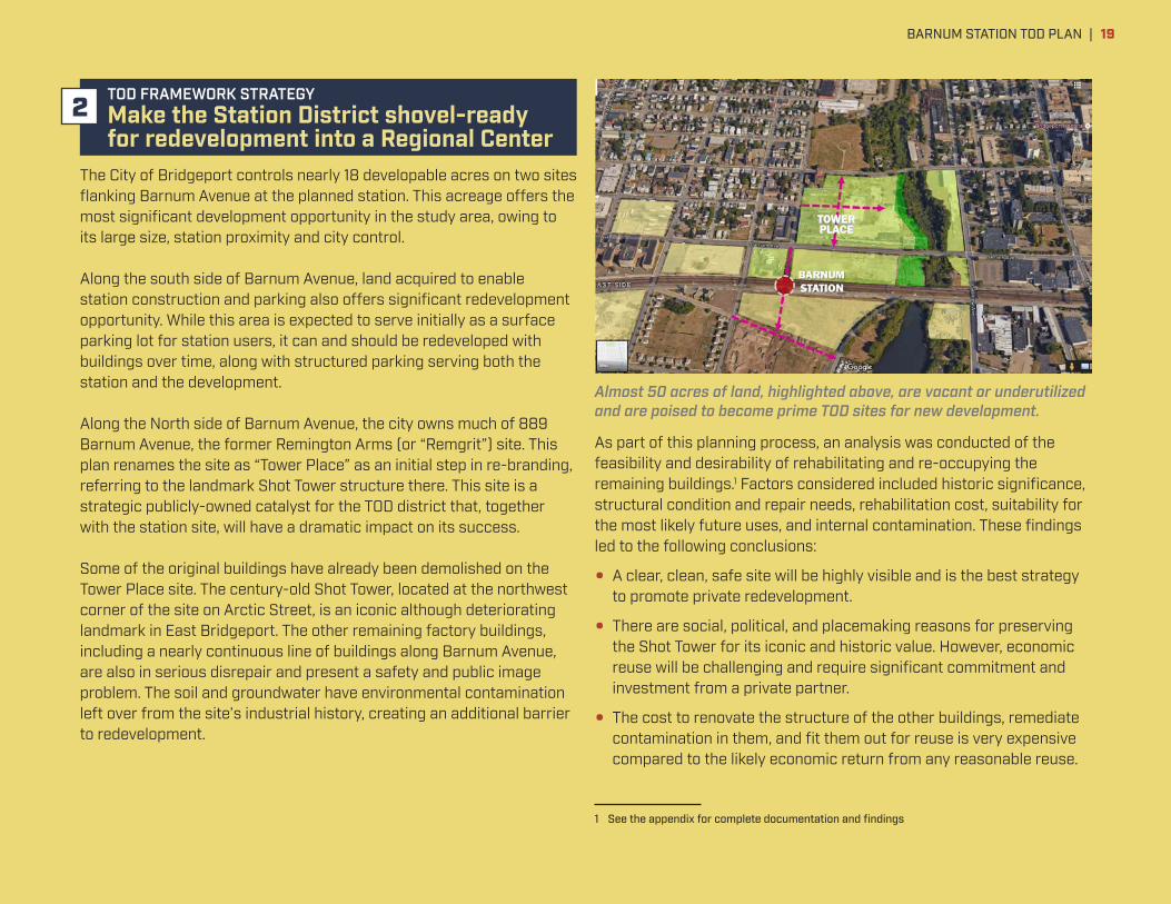
The City of Bridgeport controls nearly 18 developable acres on two sites flanking Barnum Avenue at the planned station. This acreage offers the most significant development opportunity in the study area, owing to its large size, station proximity and city control.
Along the south side of Barnum Avenue, land acquired to enable station construction and parking also offers significant redevelopment opportunity. While this area is expected to serve initially as a surface parking lot for station users, it can and should be redeveloped with buildings over time, along with structured parking serving both the station and the development.
Along the North side of Barnum Avenue, the city owns much of 889 Barnum Avenue, the former Remington Arms (or “Remgrit”) site. This plan renames the site as “Tower Place” as an initial step in re-branding, referring to the landmark Shot Tower structure there. This site is a strategic publicly-owned catalyst for the TOD district that, together with the station site, will have a dramatic impact on its success.
Some of the original buildings have already been demolished on the Tower Place site. The century-old Shot Tower, located at the northwest corner of the site on Arctic Street, is an iconic although deteriorating landmark in East Bridgeport. The other remaining factory buildings, including a nearly continuous line of buildings along Barnum Avenue, are also in serious disrepair and present a safety and public image problem. The soil and groundwater have environmental contamination left over from the site’s industrial history, creating an additional barrier to redevelopment.
As part of this planning process, an analysis was conducted of the feasibility and desirability of rehabilitating and re-occupying the remaining buildings.1 Factors considered included historic significance, structural condition and repair needs, rehabilitation cost, suitability for the most likely future uses, and internal contamination. These findings led to the following conclusions:
• A clear, clean, safe site will be highly visible and is the best strategy to promote private redevelopment.
• There are social, political, and placemaking reasons for preserving the Shot Tower for its iconic and historic value. However, economic reuse will be challenging and require significant commitment and investment from a private partner.
• The cost to renovate the structure of the other buildings, remediate contamination in them, and fit them out for reuse is very expensive compared to the likely economic return from any reasonable reuse.
1 See the appendix for complete documentation and findings
TOD FRAMEWORK STRATEGY Make the Station District shovel-ready for redevelopment into a Regional Center
Almost 50 acres of land, highlighted above, are vacant or underutilized and are poised to become prime TOD sites for new development.
TOWER PLACE
2
BARNUM STATION TOD PLAN | 19

Based on these findings, the immediate next steps are to stabilize and secure the Shot Tower and Building 330 at the corner of Barnum and Helen, demolish the remaining buildings, remediate the soil, and create an attractive interim condition using landscape and possible interim uses (such as commuter parking, driver training, solar power generation). Temporary uses such as community events and station parking can be part of a strategy to activate this site. These improvements will create a more positive image for the Tower Place
site while setting the stage for future private investment in this key location.
Design standards and interim reuse strategies to ensure high-quality development are described in a companion document, the Barnum Station District Development Guidelines. That document also provides a more detailed action plan for near-term improvements.
The Tower Place site is an eyesore and a threat to the neighborhood today (this page), but preparing the site for redevelopment will begin its transformation into a valuable community asset (facing page)
| BARNUM STATION TOD PLAN20

City-owned land in the Station District has potential to become transformative transit-oriented development | SAMPLE CONCEPT—NOT A PROPOSAL
BARNUM AVE
BARNUM STATION
ARCT
IC S
T
HELEN ST
DowntownBridgeport
Potential Station District development
Variety of development opportunities on Tower Place and adjoining parcels with emphasis on high-density employment settings like office, health care and research.
Yellow Mill greenway adding recreational amenity, attractive setting, and flood protection
Pedestrian concourse linking East Side neighborhood areas south and north of tracks
Existing Shot Tower, to remain as landmark and connection to the Station District’s industrial past
BARNUM STATION TOD PLAN | 21

The Barnum Station TOD study area is a unique redevelopment opportunity in the Northeast Corridor. The significant amount of vacant and underutilized land within walking distance of the station site is
currently a source of visual blight and an economic drain on the city. Once the station opens, however, this same land will offer prime TOD sites to attract users who value transit proximity.
Walkability and intensive development of diverse land uses are key requirements for truly transit-oriented development. Several land use scenarios were explored to understand potential benefits and other implications. A scenario with intermediate amounts of development was selected as the most appropriate basis for further traffic analysis and recommendations on development regulation. The scenario optimizes cost-effectiveness, creates the minimum “critical mass” of development along Barnum Avenue needed to establish “Regional Center” market position, and can grow if market conditions warrant.
• It focuses high-intensity job-creating development in the Station District, closest to the station, to concentrate uses near transit that benefit most from its proximity. High-intensity Regional Center type employment means employee densities in the range of 130 to 330 workers per acre (roughly 2 to 5 workers per 1,000sf building area, at a floor-area ratio of at least 1.5). This is typical of office-type development. By comparison, light industrial uses commonly include fewer than 20 workers per acre.
• Other sites further away in the Station Area redevelop with transit-supportive mixed uses. These include pedestrian-friendly light industrial and artisanal manufacturing, office, and some housing to continue providing a diverse jobs base for current and future residents.
• The existing housing stock benefits from increased investment to restore vacant houses. New housing on vacant sites provides additional living choices within walking or biking distance to the station.
To achieve these land use objectives, the city should update its development regulations, using two mechanisms. The first, zoning, should be modified to change use allowances and permissible height in appropriate areas. The second, design guidelines, should be applied along Barnum Avenue and nearby streets to encourage pedestrian-friendly building design. See pages 26-27 for priority design guidelines standards.
Over 100 acres of vacant or underutilized land exists within a 10-15 minute walk of the station, including the vacant station land itself.
TOD FRAMEWORK STRATEGY Prioritize high-value land use throughout the Station Area
Office and housing near the station will capitalize on convenient access to high-quality transit to provide new jobs and housing choices.
3
| BARNUM STATION TOD PLAN22

Equitable TODThe Barnum Station Area today has a significant proportion of residents that are considered potential “core transit riders” due to lack of a personal vehicle, low household income, renting housing, and/or spending more than 30% of their income on housing. Many
of these households are also likely to be sensitive to potential housing cost increases resulting from new transit service and/or other improvements that could force them to leave the neighborhood. Equitable transit-oriented development (eTOD) is an
approach to change that can ensure greater access to opportunity for these current residents while providing benefits to the broader community. Maintaining and creating quality affordable housing options will be important to ensure long-time residents can remain in the neighborhood to benefit from the improvements associated with new transit service. Proactive acquisition of property at today’s relatively low prices by the city or community development organizations like Bridgeport Neighborhood Trust is one of the most cost-effective means of advancing this goal.
Pathways to new jobs in the Barnum Station Area are equally important. Partnerships between employers and educators – like Harding High School’s medical career pathway program operated in partnership with Yale New Haven Health/Bridgeport Hospital – should be expanded and applied to other industries. Housatonic Community College, the University of Bridgeport and other potential academic partners should also be engaged to provide more and better instruction tailored to workforce needs in the area.
34% of households within a ten minute walk of the station site have income below the poverty level
62% of households within a ten minute walk of the station site spend more than 30% of their income on rentSource: ACS, 2010-2014
eTOD Applied in Other CitiesCities like Denver, Minneapolis, Atlanta, and others are in various stages of implementing eTOD. Mile High Connects in Denver ensures transit expansion also provides broad community benefits like housing, employment, education, and health. The Central Corridor Funders Collaborative in Minneapolis monitors and reports on equity indicators to track progress across a variety of sectors.
These organizations use a proactive approach to equip residents and businesses with skills and tools rather than reacting once change has already happened. Cross-sector collaboration allows them to have a broader reach and make a bigger impact. Dedicated funding sources allow them to make investments in the people and resources already present in the community.
A primary resource for eTOD case studies and tools is Enterprise Community Partners, a nationwide, mission-driven organization whose goal is to create opportunity in diverse, thriving communities1. Enterprise has identified significant benefits of eTOD such as:
• Improved access to employment opportunities
• Lower cost-of-living for low- and moderate-income households
• Improved health and well-being
• More efficient transportation networks
• Local and regional economic development
• Strengthened municipal finances
1 “Promoting Opportunity Through Equitable Transit-Oriented Development (eTOD): Making the Case” Enterprise Community Partners, 2015.
23BARNUM STATION TOD PLAN |

FUTURE LAND USE FRAMEWORKCertain changes to current zoning policy are desirable or necessary to fully capture the opportunity for the Barnum Station District and portions of the surrounding Station Area. A mixture of commercial and residential uses is generally desirable on all blocks, if possible, to keep streets active throughout the day and week, and to remain open to multiple real estate market opportunities.
13
2
4
High-intensity employment priority areas: Allow office, research, university, artisanal manufacturing, residential. Exclude light industrial. Target at least 50% of developed floor area for employment uses.
Walkable light industrial acceptable areas: Welcome light-industrial, but apply design standards to ensure safe, inviting walking conditions along these properties.
Housing priority areas: Priority residential development, reinforcing established neighborhood patterns. Primarily multifamily, mixed-income with significant market-rate component.
Retail priority: High-visibility locations where active ground floor retail most desirable and economically feasible to offer neighborhood shopping, enhance safety. Include ground floor storefront space suitable for immediate or future retail occupancy.
Pedestrian design overlay: Here, zoning should be supplemented by additional design guidelines promoting safe and inviting walking conditions.
Yellow Mill Greenway: Includes existing waterways and 100-year floodplain. Should be left undeveloped as visual and recreational amenity, enhancing value of real estate and improving storm resilience.
| BARNUM STATION TOD PLAN24

HIGH-INTENSITY EMPLOYMENT
WALKABLE LIGHT INDUSTRIAL
NEIGHBORHOOD RETAIL
NEIGHBORHOOD HOUSING
Example Development PossibilitiesThese images demonstrate desirable qualities of transparency, quality materials, and attractive design in buildings serving each of the major land use categories envisioned in the Barnum Station Area.
1
3
2
4
BARNUM STATION TOD PLAN | 25

Priority Design Guidelines Standards
WALKABLE STREETSAlong principal walking streets, real estate development should be designed to make walking safe and inviting. See page 31 for primary pedestrian corridors where pedestrian-scaled design is most important. Key design standards include:
• Building facades should be located close to the street edge, typically within 10 feet or matching prevailing setbacks.
• Driveways should be minimized, with no more than one per parcel. Avoid locating any driveways along Barnum Avenue.
• Building facades should include a significant amount of transparent glazing so that building occupants can easily see street areas, enhancing safety and security. Ground floor retail facades should include transparent glass storefront over at least 2/3 of their area. Ground floor facades for other commercial and institutional uses should include transparent glazing over at least half their area. Facades of residential floors should include transparent glazing over at least 1/3 of their area.
• Site areas between the sidewalk and building façade should be landscaped with attractive plantings or pavers. No parking should be located in these areas. Parking should be located behind occupied building area; limited areas of parking to the side of buildings may be acceptable. Attractive fencing or landscaping should screen parking lots or open yard areas.
BUILDING HEIGHT AND MASSING TRANSITIONSBuildings exceeding three or four stories in height are appropriate in the Barnum Station District, but should transition in height and scale to fit with the character of existing neighborhoods in the adjacent area. In the diagram below, toned edges along streets indicate where new development in areas of greater height and density should reflect the height and scale of existing development across the street. Taller building masses, such as those exceeding four stories, should be set back from the street edge a sufficient distance (at least 30 feet) so that the taller segments are less visible to pedestrians and facing properties, creating a more comfortable architectural environment. The diagram also indicates three view corridors that should be maintained, enabling views to the upper portion of the Shot Tower. Buildings within these view corridors should be low enough that the upper portion of the tower remains visible from the viewpoints indicated.
| BARNUM STATION TOD PLAN26

Helen Street concept—Looking from Arctic St. toward Barnum Ave.
Windows and bays in scale with those
on neighborhood houses
Preserved Shot Tower building
Potential newdevelopment
Existing East Side homes
Frequent windows at ground level Facade setback
from sidewalk
New street trees
Main facade no taller than three stories, similar height as existing houses
Upper floor set back at least 30 feet from main facade
Seaview Avenue concept—Looking from Holly St. toward Williston St. and Crescent Ave.
Windows and bays in scale with windows and bays on neighborhood houses
Frequent windowsat ground levelFacade setback
from sidewalkSidewalk area widened onto adjoining property
Frequent doors facing the street
New street trees
Main facade alignment varies to echo scale of neighborhood houses
Upper floor set back from main facade
Potential newdevelopment
Potential newdevelopment
Existing East End homes
View Today
View Today
MAKING A GOOD FIT BETWEEN NEIGHBORHOODS AND NEW DEVELOPMENTIllustrations on this page demonstrate application of the design guidelines principles described on page 26. Two prominent locations are shown, where new development is likely to be of greater scale or intensity than existing properties across the street. Following these
example design standards will help manage comfortable transitions between different land uses and scales, helping ensure that existing and new development all maintains high value.
BARNUM STATION TOD PLAN | 27

Residents, employees, and business owners will greatly benefit from improved transit access provided there are convenient, attractive pedestrian and bicycle routes and bus facilities connecting people to the station. As mentioned before, the Barnum Station Design project forecasts that over half of the boardings in the station’s opening year will arrive on foot. This emphasizes the importance of pedestrian improvements like sidewalk repairs, new crosswalks and curb bump-outs at intersections, and improved street lighting. Vehicular improvements will also be important. New traffic signals and turn lanes at certain busy intersections will be needed to facilitate the flow of cars into and through the area.
Barnum Avenue is the primary east-west connecting street linking neighborhoods to the station and will become a signature address for new development. Potential improvements are somewhat limited by its existing width and buildings along its edges. However, the
station and Tower Place sites in particular offer the opportunity to gain supplemental sidewalk easement zones on the parcels to provide much needed additional width for improvements like wider sidewalks, landscaping, and an off-street multi-use path.
Approximately 30% of housing units within a ten-minute walk of the station site do not have a vehicle available.
A sizeable proportion of workers in this area already commute via transit (13%) or walking (9%)Source: ACS, 2010-2014
TOD FRAMEWORK STRATEGY Connect neighborhoods and the station along great streets
4
A potential future condition for Barnum Avenue at the station site would be similar to that shown above, including two travel lanes, a center turn lane, prominent crosswalks, bike lanes, on-street parking, and wider sidewalks, with new development on either side.
| BARNUM STATION TOD PLAN28

Wider sidewalk New turn lanes at Seaview Ave. + Helen St.
Street trees and “tree lawn” between pedestrians and traffic
Dedicated bike path
Yellow Mill Greenway recreational trail to Waterview Park and Yellow Mill Channel
Park space
New street lights
Barnum Station entrance
Bus stop
Barnum Station District Redevelopment
Yellow Mill Greenway recreational trail to Boston Avenue, new Harding H.S. and beyond
Potential Barnum Avenue improvements near the station
Wider sidewalks, safer bike routes, and attractive landscaping will support pedestrians and bicyclists.SAMPLE CONCEPT—NOT A PROPOSAL
BARNUM STATION TOD PLAN | 29

Other important connections include:
• Helen Street concourse see page 14.
• Seaview Avenue is a primary north-south connection in the Station Area, linking it to I-95 on the south and Boston Avenue on the north. Planned improvements are described in the separate “East Bridgeport Seaview Avenue Development Corridor” study by MetroCOG.
• Arctic/Grant Street is another east-west connection linking neighborhoods and Yale New Haven Health/Bridgeport Hospital, providing an important connection for employees there.
• Waterview Avenue links the station to Steelpointe Harbor, a new retail and housing development south of I-95. A Complete Streets retrofit will improve this vital connection between emerging activity centers and enhance access to the Yellow Mill Greenway.
• Neighborhood streets can serve as defined bike-friendly routes with additional signage and markings.
Gateways into the Station Area will define a new sense of arrival for drivers. Locations shown on the facing diagram include prominent intersections. Seaview Avenue, Boston Avenue, and East Main Street and Barnum Avenue are important access points from regional highways to the station.
Projects like this raised intersection with high-visibility crosswalks that improve the walking and biking environment near the station will increase activity and benefit neighborhoods.
Improved pedestrian and bike routes along Waterview Avenue and other important corridors will support greater access to the station site.
| BARNUM STATION TOD PLAN30
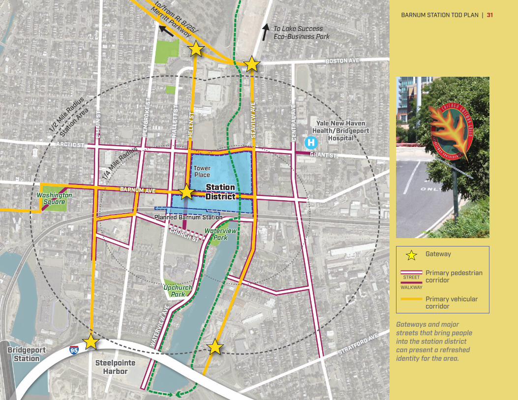
Gateways and major streets that bring people into the station district can present a refreshed identity for the area.
Gateway
Primary pedestrian corridor
Primary vehicular corridor
STREET
WALKWAY
BARNUM STATION TOD PLAN | 31

The Yellow Mill Greenway initiative is a transformational effort that will provide the East Side, Mill Hill, and East End neighborhoods with much-needed open space amenities while also attracting a new generation of investment in jobs and real estate. Creative thinking over the past several years has identified this opportunity and need, and it is reflected in several neighborhood and citywide plans.1
Key features of the greenway include:
• Public waterfront access along the Yellow Mill Channel south of the tracks. This area is a largely untapped resource that the citywide Waterfront Plan identifies as a near-term opportunity. A public path along the waterfront can be created in stages along with redevelopment of adjoining parcels. Improvements to Waterview Park near the Crescent Crossing residential development is another impactful project identified for near-term action.
• A multi-use pedestrian and bicycle path that links neighborhoods, schools, jobs, transit and open spaces from Pleasure Beach on Long Island Sound, north to the new Harding High School site and beyond. This multi-use path is an important transportation alternative given the constrained neighborhood streets that lack space to widen sidewalks or add bike lanes.
• The station project expects to replace a culvert under the tracks at the northern tip of Yellow Mill Channel. Taking advantage of this opportunity, the City would like to incorporate a ped/bike connection in this location that extends under the tracks to allow future development of a continuous multi-use path north of the tracks along the Greenway.
• Attractive green space north of the tracks where largely overgrown wetlands exist today. New green space combining active and passive
1 Including the Bridgeport Parks Master Plan (2011), Mill Hill NRZ Strategic Plan (2013), and the East Bridgeport Seaview Avenue Development Corridor study (2016).
areas will provide recreation and health benefits, increase climate resiliency, and assist with environmental remediation.
Near-term implementation of sections of the Yellow Mill Greenway along the waterfront and at the station site will demonstrate a significant commitment to the station area and these neighborhoods. Current residents will benefit from increased mobility and green space, and the investment in open space will help attract a new generation of employers who value open space, healthy lifestyles, and transportation options.
TOD FRAMEWORK STRATEGY Grow the Yellow Mill Greenway
There are approximately 3.7 acres of park space per 1,000 residents within a half-mile of the station site, less than 30% of the citywide average.
The Yellow Mill Channel as it exists today, an overgrown missed opportunity (top). Phased improvements such as a multi-use path will transform its image and function (above).
5
| BARNUM STATION TOD PLAN32
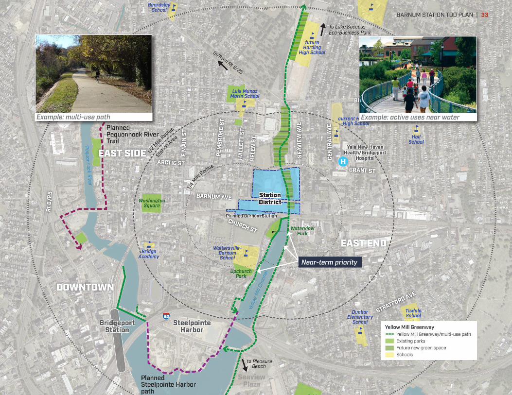
Near-term priority
Example: multi-use path Example: active uses near water
BARNUM STATION TOD PLAN | 33

TAKING ACTIONRealizing the Station District’s full potential will be a long term endeavor. It will require strict adherence to the Plan and a willingness to turn down short term, sub-optimal opportunities in order to preserve long-term potential. This is particularly true on the station and Tower Place sites. Development in these key locations should be of sufficient scale and appropriate character to launch the Barnum Station District on the super-regional map. Properly developed, the Station and Tower Place sites have the potential to be the catalysts for Bridgeport’s future economic development. Lower-density development prospects such as light-industrial use should be encouraged on one of the many large, vacant sites outside of the Barnum Station District.
The Barnum Station District’s transformative development potential is largely dependent on the environment created at and around the Station. Achieving a dynamic, attractive, mixed-use walkable environment in the long-term will require significant public investment in the Station District in the near-term. These investments will demonstrate the public sector’s commitment to the broader Barnum Station Area’s transformation and “set the table” for future private investment while also providing immediate benefits to the surrounding neighborhoods.
Near-term actions STRATEGY 1
GET THE MOST FROM BARNUM STATIONAdvance station design and secure construction funding. Ensure that the station concourse pedestrian connection and the Yellow Mill Greenway multi-use path under the tracks are attractive, high-quality places. Design new bus stop shelters and rail bridges to be distinctive, attractive and integrated with station design. Include pedestrian, transit and bike facilities as well as landscaping in improvements of streets adjoining station site. Without new transit service, the economic development opportunities in East Bridgeport are very different (primarily the extension of current trends).
POTENTIAL COST RANGES, RECOMMENDED TIMEFRAMES
Potential long term total Near term priority component$250-$300 million (through 2021) 15% station design already funded
POTENTIAL FUNDING SOURCES
Primarily Federal capital funding
| BARNUM STATION TOD PLAN34

STRATEGY 2
MAKE THE STATION DISTRICT SHOVEL-READY FOR REDEVELOPMENT INTO A REGIONAL CENTERSecure the Tower Place site immediately. This critical step will help the community see the site more as a link between neighborhoods and less as a barrier or obstacle.
• Secure funding to demolish most remaining buildings and stabilize the Shot Tower. As a first priority, focus on demolishing buildings along Barnum Avenue, to open views across the whole Tower Place site and remove unsightly structures.
• Smooth site and resurface with grass or suitable cover plantings, and/or paved areas enabling interim use. Enclose site perimeter with transparent fencing.
• Remediate environmental contamination in the soil, groundwater, and the Shot Tower, leveraging established remediation commitments by former owners. This may be done in conjunction with redevelopment by new developer entities, to determine how to most effectively target remediation efforts.
• Activate the newly-cleared site with interim public or private uses.
POTENTIAL COST RANGES, RECOMMENDED TIMEFRAMES
Potential long term total Near term priority component$15-$25 million (through 2027) $2 million Shot Tower stabili-
zation; $8 million demolition & remediation of other structures (may be phased over 3-5 years)
POTENTIAL FUNDING SOURCES
State and Federal brownfields grants
STRATEGY 3
PRIORITIZE HIGH-VALUE LAND USE THROUGHOUT THE STATION AREAUpdate zoning/development regulations to encourage TOD. Land zoned for light industry near the station should be rezoned to allow for greater flexibility of uses, including the addition of office and housing:
• Concentrate high-value job-creating uses like office near the station along Barnum Avenue in a walkable mixed-use environment.
• Encourage new housing choices near transit south of the station to complement Crescent Crossing.
• Allow a compatible mix of office, housing, and light industry in walkable mixed-use patterns in the Station Area, further away from the station.
• Prioritize retail use at intersections with significant pedestrian and vehicular traffic. Neighborhood-scale retail encouraged; big box retail prohibited.
POTENTIAL COST RANGES, RECOMMENDED TIMEFRAMES
Potential long term total Near term priority component$250,000 or less (through 2018) $100,000 or less (through 2017)
POTENTIAL FUNDING SOURCES
Regular city planning/zoning staff budget
BARNUM STATION TOD PLAN | 35

STRATEGY 4
CONNECT NEIGHBORHOODS AND THE STATION ALONG GREAT STREETSEnsure critical Complete Streets projects are implemented prior to completion of the station construction so that improved pedestrian and bicycle facilities are ready when the station opens. This will greatly increase the immediate impact of the station and help connect neighborhoods to each other.
• Improve Barnum Avenue as an attractive Complete Street that provides a signature address to attract future development
• Implement the Seaview Avenue corridor improvements
• Improve Waterview Avenue, Hallett Street and Arctic/Grant Streets as Complete Streets
• Improve pedestrian and bicycle connections and bus facilities on other neighborhood streets to provide safe, attractive alternatives to car trips.
POTENTIAL COST RANGES, RECOMMENDED TIMEFRAMES
Potential long term total Near term priority component$25-40 million (through 2040) $2-5 million focused on Barnum,
Seaview, Pembroke over 1-5 years
POTENTIAL FUNDING SOURCES
State, City
STRATEGY 5
GROW THE YELLOW MILL GREENWAYBegin implementing the Yellow Mill Greenway.
• Create public waterfront access along the Yellow Mill Channel south of the railroad tracks (Pilot Site 1 for early implementation of the citywide Waterfront Plan)
• Secure funding for the multi-use trail underpass as part of the station project
• Advocate, fundraise, and secure right-of-way and design for this transformative green corridor along the waterfront, through partnerships with public open space organizations and private property owners/developers
POTENTIAL COST RANGES, RECOMMENDED TIMEFRAMES
Potential long term total Near term priority component$10-20 million (through 2030) $2-5 million focused on
recreational paths linking Barnum Ave and Steelpointe Harbor via Waterview Avenue and Yellow Mill Channel
POTENTIAL FUNDING SOURCES
Grants from private and foundation sources, State
| BARNUM STATION TOD PLAN36

Development leadership and funding
Successful implementation of real estate development and infrastructure improvements will require cross-sector collaboration and creative approaches to financing and partnerships. Important approaches to partnership and funding for different categories of investment are as follows:
• Real Estate Development
• Partnerships: The City has an important opportunity to engage experienced, high-capacity developers who have a strong track record of successful transit-oriented development projects. Its control of large parcels at Tower Place, the station site and the “salt pile” site enables issuance of Requests of Interest (ROI’s) and Requests for Proposals (RFP’s) to attract and ultimately select developer teams, on mutually agreeable terms, capable of producing quality real estate development that meets the objectives of this plan and other relevant city policies. The City should also work closely with current property owners to advise them of the emerging TOD opportunities in the area. It should then work with those who have interest in reinvesting in their properties, to encourage redevelopment consistent with plan goals.
• Funding: It is likely that real estate redevelopment will require some level of gap financing, at least while the Barnum Station District is in the earlier stages of market repositioning. Commonly, a combination of several gap financing tools are necessary for a given project. Tools that appear most promising for redevelopment in the Station District and Station Area are listed below. Those tools that are geared toward affordable housing should be used sparingly, focused primarily on revitalizing existing homes, limiting cost increases for existing rental housing stock, building new infill housing on established neighborhood blocks, or supporting an affordable housing component within a predominantly market-rate new housing development. This is to
ensure that most newly constructed housing targets households able to pay market prices prevalent in the region, to broaden the spectrum of household incomes in the Station Area and attain a stronger market position.
> New Markets Tax Credits (NMTC). NMTC’s can be deployed in locations where there is distress (high poverty rate, low family median income, and a high unemployment rate). Census Tracts west of the Yellow Mill River and its tributary satisfy all the criteria for distressed. The census tracts east of the Yellow Mill River and its tributary do not satisfy all of the criteria for distressed; their poverty rate is not sufficiently low. Bridgeport has successfully leveraged NMTC’s to realize economic development downtown, through financing of the Historic Arcade building, 144 Golden Hill, the Citytrust building, Bijou Square and the Bridgeport Urban Green. Utilizing NMTC’s requires the participation of entities have received allocations of NMTC’s. Such entities who have been or may be active in Bridgeport include:
• Local Initiatives Support Corporation (LISC) – LISC was involved in the Arcade and 144 Golden Hill projects in Bridgeport.
• National Development Council (NDC) – NDC was also involved in the Arcade and 144 Golden Hill projects.
• MHIC NE New Markets CDE II LLC – MHIC applies their allocation to real estate projects that support community development. Connecticut is listed as a state where they invest.
• Mid-City Community CDE, LLC – Mid-City Community CDE also supports real estate projects that support community development. Connecticut is listed as a state where they invest.
• Primary Care Development Corporation – This CDE invests in health centers to support community development.
BARNUM STATION TOD PLAN | 37
This group may be appropriate if health and education development program is included. Connecticut is listed as a state where they invest.
> Community Development Financial Institutions (CDFI). CDFI’s lend to projects that support community economic development in distressed areas. CDFIs can be community banks and credit unions, and non-regulated institutions such as non-profit local funds or venture capital funds. The following CDFI’s are active in Bridgeport:
• Community Economic Development Fund – Loans for small businesses
• Capital for Change (the merger of the Connecticut Housing Investment Fund, the Greater New Haven Community Loan Fund, and Community Capital Fund):
> Connecticut Housing Investment Fund – Finances affordable housing and neighborhood revitalization projects
> Greater New Haven Community Loan Fund – Housing loans
> Community Capital Fund, Inc. – Bridgeport – Small business and affordable housing loans
> Federal Environmental Protection Agency Brownfields Grants and Connecticut Office of Brownfield Remediation and Development Grants, to clean brownfield sites
> Federal and State Historic Tax Credits, for historic building rehabilitation. Note that buildings currently on the Tower Place site are not currently designated historic structures. Because historic tax credits come with stipulations about level of restoration and types of reuse, it is recommended that application for historic tax credits be discussed with a prospective redevelopment partner to verify whether historic tax credits will be cost-effective for a proposed building re-use project.
> Federal TIGER Grants, for transportation-related projects. This program has helped fund Barnum Station design activities.
> State Urban and Industrial Sites Reinvestment Tax Credit, for projects that generate a significant number of jobs and capital investments in underserved areas. The Study Area would be eligible for the Urban Site Investment Tax Credit.
> State Local Capital Improvement Program, to support city investments in infrastructure
> City Tax Increment Financing (TIF), utilizing the future increase in tax revenues of new and existing real estate to help fund infrastructure, development project gap financing, or other related costs. Funds may be invested using a “pay-as-you-go” method utilizing the city’s general fund, and/or through bonds that are repaid using TIF revenues. Because recent development projects have often relied upon tax abatement as a gap financing method, practical use of TIF may not be feasible for several years until the development market is strong enough to not require tax abatement. However, the City should work with property owners to designate the TIF district boundaries and policies in the near future, so the tool is in place for future use.
• Park/Path/Greenway infrastructure
• Partnerships: Work with organizations such as Trust for Public Land or The Nature Conservancy who can take an active role in planning public green spaces and soliciting private contributions to support community outreach, design, capital improvements and programming. Seek programming partners such as:
> For fitness/exercise programming, Yale New Haven Health/Bridgeport Hospital, other health care organizations or private fitness businesses
> For activating Waterview Park, the Barnum Station Concourse and/or other gathering places, mobile food vendors, musicians, cultural organizations
| BARNUM STATION TOD PLAN38

> For educational/nature programming, the Connecticut Audubon Society, Bridgeport Public Schools, Discovery Museum and/or other educational or conservation partners
• Funding: Solicit private donations, foundation and State grants, through collaboration with partners such as those mentioned above. The Federal Safe Routes to School program could also be a promising source, as Yellow Mill Greenway pathways could be useful connections to the Barnum Station Area’s many public schools.
• Street infrastructure
• Partnerships: Work with the Connecticut Department of Transportation to coordinate design of improvements to state roadways, such as the intersections of Seaview Avenue with Boston Avenue and Interstate 95. Work with developers to confirm location and design of any new streets or site access points.
• Funding: Pursue State funding for improvements to state as well as city roadways. Ensure Barnum Station project funds improvements to adjoining streets. Utilize Tax-Increment Financing (TIF) for street improvements related to new real estate development. See also real estate funding sources listed above.
• Station/transit infrastructure
• Partnerships: Continue established collaboration of the City with the Connecticut Department of Transportation, MetroCOG, Metro-North, Amtrak, FTA and other partners on station planning and design.
• Funding: Pursue Federal FTA funding as primary capital funding source for station. Federal and/or State grants for transit, brownfields remediation, street improvements and/or park/trail construction may also be needed to address related needs on and around the station site. See also real estate funding sources listed above
Near-term recreational path improvements better connecting Waterview Park, shown here, to the Yellow Mill Channel (visible in distance), Barnum Station and Steelpointe Harbor, would quickly raise the profile of the Barnum Station Area as an attractive waterfront location to live, work, learn and play.
BARNUM STATION TOD PLAN | 39

www.barnumstation.com
City of Bridgeport, CT Connecticut Department of Economic and Community Development
Connecticut Office of Policy and Management