briefing book - harpswell, maine
TRANSCRIPT

Holt & LachmanHolt & LachmanHolt & LachmanHolt & Lachman Architects + PlannersArchitects + PlannersArchitects + PlannersArchitects + Planners A r c h i t e c t u r e | C o m m u n i t y D e s i g n | P r e s e r v a t i o nA r c h i t e c t u r e | C o m m u n i t y D e s i g n | P r e s e r v a t i o nA r c h i t e c t u r e | C o m m u n i t y D e s i g n | P r e s e r v a t i o nA r c h i t e c t u r e | C o m m u n i t y D e s i g n | P r e s e r v a t i o n
- Please review this booklet and bring it with you to the Workshop -
BRIEFING BOOK Creating a Community Vision for the future of Mitchell Field
Harpswell, Maine Community Design Workshop
Sunday, July 15th – 2007 Harpswell Islands School
The Workshop is sponsored by: The Town of Harpswell
Mitchell Field Steering Committee: Judith Redwine, Tony Barrett,
Melinda Small, Kim Johnson, Don Miskill, Sally Carignan, David
Wessel, Jim Hays, David Hackett
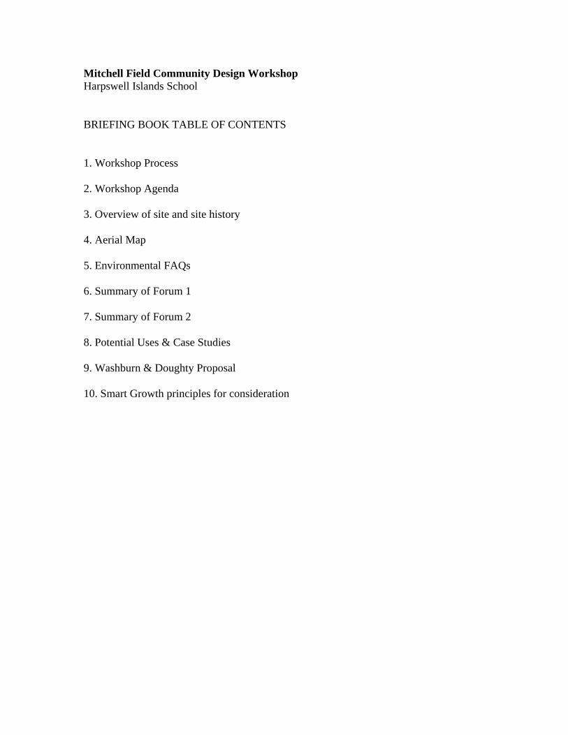
Mitchell Field Community Design Workshop Harpswell Islands School BRIEFING BOOK TABLE OF CONTENTS 1. Workshop Process 2. Workshop Agenda 3. Overview of site and site history 4. Aerial Map 5. Environmental FAQs 6. Summary of Forum 1 7. Summary of Forum 2 8. Potential Uses & Case Studies 9. Washburn & Doughty Proposal 10. Smart Growth principles for consideration
Mitchell Field Community Design Workshop Harpswell Islands School
PROCESS THANK YOU for your participation in the Mitchell Field Community Design Workshop. To make the most of this exciting and important event, please review the material in this Briefing Book ahead of time and bring the booklet with you for reference during the Workshop. Participation in the Community Design Workshop is free and open to all interested parties. The people who attend will represent a wide spectrum of ideas, opinions, interests, skills, and expertise. Your enthusiasm and wisdom will form the basis for creating a strong graphic vision that expresses the community’s vision for the future of Mitchell Field. Design Teams Participants will be assigned to a Design Team. Upon your arrival on Sunday you will receive further resources and your team assignment. Each team will have a cross-representation of residents, business and property owners, public officials, design professionals and other interested citizens. Each team member will contribute in their own way using whatever skills, talents and knowledge they have to creatively collaborate on a vision. Each team will include a: Facilitator who has been oriented and trained in the process. Our Facilitators are graduate planning students from the Muskie School for Public Service’s Community Planning and Development program. Design Professional (architect or landscape architect). The Maine Chapter of the American Institute of Architects is providing continuing education credits for their membership. The design professional is encouraged to draw sketches, maps, diagrams, and designs. The presence of a design professional is not meant to substitute for your full participation. Rather, their presence is a resource, so please solicit their skills to help translate your ideas into final form. Presenter to be selected by the team members, who will present your team’s conclusions to the larger group at the conclusion of the Workshop. YOU! Please come ready to brainstorm and develop designs for the potential reuse of Mitchell Field! Team Resources 1. Each team member will receive a copy of this Briefing Book. Other resource
handouts will be available during the day of the Workshop. 2. Each team will have base maps, graphic materials, and other materials to explore
and present their findings. 3. Resource Rovers: experts will be available for input during the Workshop.

Mitchell Field Community Design Workshop
Agenda July 15, 2007. 12 – 5 PM
11:00 – 12:00 (Optional) Lunch & Participant Registration (1 hour) 12:00 – 12:15 Registration and Check-in (15 minutes) 12:15 – 12:45 Orientation session (30 minutes) 12:45 – 4:15 Team sessions (3 hours, 30 minutes) 4:15 – 5:00 Final presentations (45 minutes)
For more information or to pre-register visit harpswell.maine.gov or call 833-5771
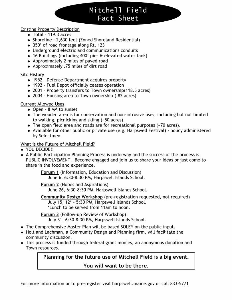
MITCHELL FIELD FACT SHEET DRAFT
Existing Property Description � Total – 119.3 acres � Shoreline – 2,630 feet (Zoned Shoreland Residential) � 350’ of road frontage along Rt. 123 � Underground electric and communications conduits � 16 Buildings (including 400’ pier & elevated water tank) � Approximately 2 miles of paved road � Approximately .75 miles of dirt road
Site History � 1952 – Defense Department acquires property � 1992 - Fuel Depot officially ceases operation � 2001 – Property transfers to Town ownership(118.5 acres) � 2004 - Housing area to Town ownership (.82 acres)
Current Allowed Uses � Open – 8 AM to sunset � The wooded area is for conservation and non-intrusive uses, including but not limited
to walking, picnicking and skiing (~50 acres). � The open field area and roads are for recreational purposes (~70 acres). � Available for other public or private use (e.g. Harpswell Festival) - policy administered
by Selectmen
What is the Future of Mitchell Field? � YOU DECIDE!! � A Public Participation Planning Process is underway and the success of the process is
PUBLIC INVOLVEMENT. Become engaged and join us to share your ideas or just come to share in the food and experience.
Forum 1 (Information, Education and Discussion) June 6, 6:30-8:30 PM, Harpswell Islands School.
Forum 2 (Hopes and Aspirations) June 26, 6:30-8:30 PM, Harpswell Islands School.
Community Design Workshop (pre-registration requested, not required) July 15, 12* – 5:30 PM, Harpswell Islands School. *Lunch to be served from 11am to noon.
Forum 3 (Follow-up Review of Workshop) July 31, 6:30-8:30 PM, Harpswell Islands School.
� The Comprehensive Master Plan will be based SOLEY on the public input. � Holt and Lachman, a Community Design and Planning firm, will facilitate the
community discussion. � This process is funded through federal grant monies, an anonymous donation and
Town resources.
Planning for the future use of Mitchell Field is a big event.
You will want to be there.
Mitchell Field
Fact Sheet

1
Mitchell Field Community Design Workshop Harpswell Islands School ENVIRONMENTAL Q&A
Q1. I heard that the old fuel depot is environmentally dangerous for children to visit, is it? A. Mitchell Field is perfectly safe for everyone to visit, walk on, roll in the grass and to eat a bean supper. Q2. What caused the environmental contamination at Mitchell Field? A. Petroleum fuels. Almost all commercial and military fuel terminals today have petroleum contaminated soils and groundwater. When and if these properties are redeveloped for other use, this soil contamination is examined, tested and remediated for the appropriate reuse of the property. Q3. The property deed allows only 450 gallons per day to be pumped from Mitchell Field. Why? A. This very low limit has been suggested by some as indicative of the limited capabilities of the land to support business or residential activity. Not true. It appears that Maine Department of Environmental Protection (DEP) set this low limit based on the town’s stated use for the property – recreational and light commercial. Maine DEP is currently working to significantly increase the water withdrawal rates of the new water supply well and change this deed restriction. Q4. When will Maine DEP relax some of the deed restrictions on use to allow broader use of the property? A. Maine DEP is working with the town to ensure that all reasonable uses for Mitchell Field will be permitted. They see no obstacles to any of the ideas being discussed in the Master Plan process. Q5. How can it be safe? I heard that schools, retirement housing and residences can’t be built at Mitchell Field. A. Maine Department of Health & Human Services requires adequate and safe drinking water for residential, school and hospital use. Safe drinking water has been the environmental concern at Mitchell Field, not any substance that a person might come into contact with normal use. Q6. The property deed does not allow residential use without the prior written consent of Maine DEP. Why? A. The environmental risk analysis for the fuel depot was only conducted under a “trespass” and “light commercial” scenario. A “residential” scenario was not examined because it was not requested by the town or the Navy. Based on the current condition of the property and similar brownfield sites (i.e. Loring), Maine DEP believes that residential uses on Mitchell Field may be feasible. Prior to
2
such an allowance the Maine DEP would require an environmental risk analysis to be conducted for the residential scenario use. An environmental risk analysis will be required for any future uses of the site that fall outside of the “trespass” and “light commercial” scenario already studied. Q7. I heard that the town is prohibited from digging any holes at Mitchell Field. Is this true? Why? A. A reasonable amount of excavation will be allowed with Maine DEP oversight. The Maine DEP’s primary concern is exposure to contaminated groundwater. Maine DEP wants to be able to test any removed soil and so requires permission to be granted in advance. Maine DEP expects no problem with soil excavation related to future development of the site. The groundwater contamination is localized to the areas where the original spills occurred, about 10-20% of the property. There has been little migration since the source-contaminated soil has been removed. However, these areas are not marked on the property and to be safe, Maine DEP has imposed the digging restriction for the entire property. If a location is underlain by contaminated groundwater, this groundwater lies 10 feet or more below the surface, so one would have to dig down quite a ways to even encounter contaminated water. Maine DEP uses the ‘ingestion’ threshold level for safe drinking water not the ‘dermal’ exposure limit which is much higher. A person’s exposure to benzene is far greater when one spills gas on a hand while filling a lawnmower engine than digging down and touching contaminated groundwater at Mitchell Field. Q8. Where did the fuel spills occur? A. In and around the tank farms, the main gate area and the drum storage area. After the facility closed, a soil testing survey indicated that approximately 10-20% of the property had petroleum-contaminated soil. Q9. How did the spills happen? A. Valve failures, corrosion, heavy snow loads on the tanks and operator errors. The visible and obvious spills were attended by the Navy’s standard operating procedures as they occurred. All the recorded spills involved relatively small volumes. However, since water tends to accumulate at the bottom of tanks and the low spots in pipelines, insidious corrosion would result in unseen tank bottom leaks. Only when tanks recorded product losses greater than normal evaporation, were they taken out of service and inspected. Today, tanks are built with fiberglass bottoms and double walls. We suspect that this insidious and gradual corrosion caused the greatest number of spills in both quantity and volume. Q10. How much fuel was spilled over the years? A. No one knows – less than a tanker spill but more than the 7 reported spills. Q11. Were spills cleaned up?
3
A. Yes, the primary concern was with petroleum going into the bay; to prevent obvious and visible effects on bird & marine life, fishing and recreation. Surface and visible spills were addressed as they occurred. However, throwing used motor oil into the woods was a commonly accepted practice back in the old days, so spills that were absorbed into the ground were less of a concern during operations (it was difficult to clean up under a tank). It is this soil contamination that was the main problem when the facility closed and is the cause of residual groundwater contamination today. Q12. What about the old dump at the Fuel Depot? I heard that there was nasty stuff thrown in there? A. During site remediation, the 3-acre landfill was examined by digging 22 test pits and trenches. 75% of the material was soil, rocks, stumps and organic debris. Much of the rest of the material was construction & demolition debris. There was some small quantities of incinerator ash and what was thought to be tank bottom sludge. The ash and sludge was tested and found to be inert and stable. The landfill was closed and capped in accordance with Maine DEP procedures in 1997. Q13. I thought that the Navy cleaned up all the contamination before releasing the property to the town? A. Yes, the soil contamination was cleaned up to Maine DEP standards. Petroleum spills are frequent occurrences (when a car flips in an accident or when one’s oil heating tank leaks) and there are several accepted remediation methods. At Mitchell Field the entire property surface was tested for residual petroleum contamination. The contaminated soil was remediated utilizing a variety of generally accepted practices including reuse of petroleum-saturated material in cold-mix asphalt (reused for paving some of the on-site roads), removal of contaminated soils from the site, and thermal treatment of soils to treat and redeposit soils in the evacuated areas. Some petroleum migrated into the bedrock where small amounts contaminate the groundwater today. Of all the industrial environmental contamination that can occur in Maine, petroleum is relatively benign and easy to fix. There is also natural attenuation – which means that overtime nature does the clean-up job. Microbes in the sub-surface groundwater consume the petroleum. That is why the contaminated groundwater, once the overlying contaminated soil source has been removed, has slowly been improving. Q14. Wasn’t an abutter’s well contaminated with Benzenei?
i The EPA has set the Maximum Contaminant Level (MCL) for benzene at 5 parts per billion (ppb) because, given present technology and resources, this is the lowest level to which water systems can reasonably be required to remove this contaminant should it occur in drinking water. City air can often average 5 ppb. Gasoline typically contains up to 1% benzene – 10,000,000 ppb. Auto exhaust can vary between 30,000 to 50,000 ppb benzene. Cigarettes produce benzene at concentrations of 350,000 ppb. When you breath gasoline vapors while filling up your car or second-hand cigarette smoke, one’s exposure to benzene is far in excess of the levels found in Mitchell Field groundwater.

4
A. Yes, a neighbor adjacent to the fuel depot had a contaminated well. The navy spilled fuel near the gate and contaminated soils slowly released into the sub-surface groundwater. Once the Navy removed the contaminated soil source, the nearby water wells cleaned up. The groundwater lower down on Mitchell Field under the tank farm site is still contaminated and is subject to an ongoing monitoring program by Maine DEP. Q15. My Uncle remembers seeing stacks of rusting drums near the dump? A. When the facility closed, the drums had all been removed from two storage locations. We assume that these drums contained lubricants and other petroleum-related materials for use at the depot. There was some soil contamination that was determined to be minor and not requiring active remediation. Monitoring wells were installed and continue to be checked currently. Q16. What about hazardous chemicals? A. The facility used hazardous chemicals but not in industrial quantities (pesticides, solvents and other household chemicals for the ongoing operation). The electrical transformers contained PCBs. All these materials were removed by the Navy when the facility closed. The landfill was tested for residual pesticide and PCBs and no traces were found. Q17. How about the lead contaminated soils? A. As with old buildings that were painted with lead-based paint, lead has been tested in the soil around the buildings and the houses. Lead abatement was undertaken and lead containing materials removed. Lead around the two Navy houses has recently been tested and the town is pursuing clean-up with the Navy. Q18. What about asbestos? A. There were asbestos containing materials (ACM) used in the buildings – mainly floor tiles, mastic and roofing materials. The ACM was removed or the entire building removed and disposed of in accordance with Maine DEP procedures. We think that the Generator and pipeline pump house still have asbestos shielding and pipe wrap. These materials are stable but will need to be handled if and when that building is used for another use.

Mitchell Field Community Design Workshop Harpswell Islands School
SUMMARY OF FORUM 1
On June 6, 2007, Mitchell Field Forum #1 was held at Harpswell Island School
from 6:30 – 8:30 PM. Approximately sixty (60) citizens attended the forum.
The forum began with presentations on the existing conditions of the Mitchell Field site. First, experts Randy Tome, Andrew Johnston, and Barney Baker spoke about the site’s infrastructure. Randy Tome, an engineer at Woodard and Curran, discussed the buildings. Andrew Johnston, an engineer at SYTDesign, spoke about the water tower, the roads, the water system, and the electrical system on the site. Barney Baker, from Baker Design Consultants, discussed shoreland zoning, the pier structure, and water access. Afterwards, Naji Akliadiss, Hank Andolsek, and Jean Firth, all from the Department of Environmental Protection (DEP), spoke to the environmental conditions of the site. Naji Akliadiss explained the extent of soil and groundwater contamination on the site, as well as the remediation efforts that have gone on, and the deed limitations of water usage and on-site activities. Hank Andolsek discussed current on-site environmental activities. Jean Firth spoke about the Voluntary Remedial Action Program.
Participants then had the opportunity to ask questions of these infrastructure and environmental experts. A summary of the main ideas from the forum follows. Environmental Conditions:
• Mitchell Field is basically safe for people to recreate, and can be made safe for any proposed use
• The amount of water available from the wells can be increased for most any proposed use
• Depending on proposed uses, additional testing and remediation will be done • The DEP is very cooperative and eager to continue working with the town to
realize the full potential of Mitchell Field Infrastructure Conditions :
• Proposed uses will drive necessary repairs and costs for infrastructure • Road system is generally well built and forms good basis for future development
and use • Electrical system is relatively new and has capacity for many uses • The buildings are at the end of their useful life • The water tower requires additional testing to verify its condition. It appears in
good shape, but is 50+ years old. • The pier has significant structural issues. Future use will determine required
repairs and costs
Mitchell Field Community Design Workshop Harpswell Islands School
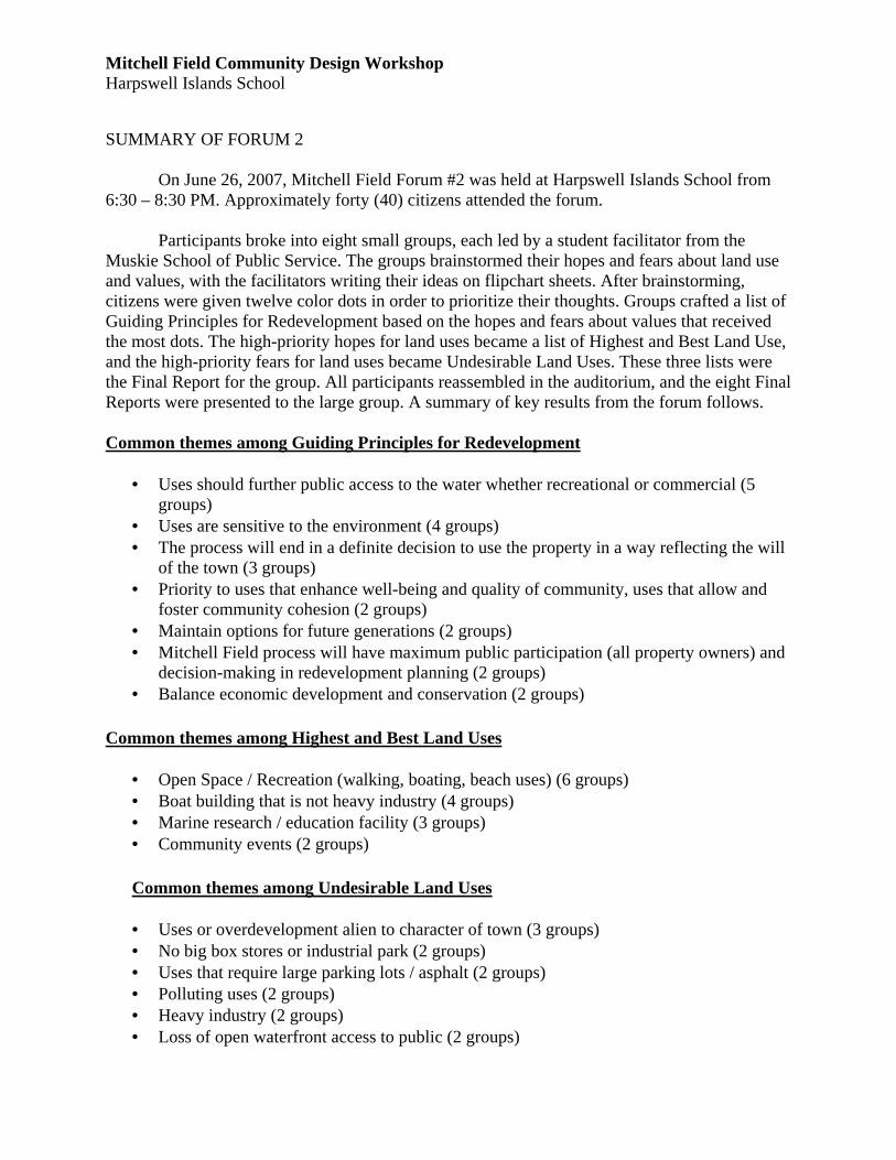
SUMMARY OF FORUM 2
On June 26, 2007, Mitchell Field Forum #2 was held at Harpswell Islands School from
6:30 – 8:30 PM. Approximately forty (40) citizens attended the forum. Participants broke into eight small groups, each led by a student facilitator from the Muskie School of Public Service. The groups brainstormed their hopes and fears about land use and values, with the facilitators writing their ideas on flipchart sheets. After brainstorming, citizens were given twelve color dots in order to prioritize their thoughts. Groups crafted a list of Guiding Principles for Redevelopment based on the hopes and fears about values that received the most dots. The high-priority hopes for land uses became a list of Highest and Best Land Use, and the high-priority fears for land uses became Undesirable Land Uses. These three lists were the Final Report for the group. All participants reassembled in the auditorium, and the eight Final Reports were presented to the large group. A summary of key results from the forum follows. Common themes among Guiding Principles for Redevelopment
• Uses should further public access to the water whether recreational or commercial (5 groups)
• Uses are sensitive to the environment (4 groups) • The process will end in a definite decision to use the property in a way reflecting the will
of the town (3 groups) • Priority to uses that enhance well-being and quality of community, uses that allow and
foster community cohesion (2 groups) • Maintain options for future generations (2 groups) • Mitchell Field process will have maximum public participation (all property owners) and
decision-making in redevelopment planning (2 groups) • Balance economic development and conservation (2 groups)
Common themes among Highest and Best Land Uses
• Open Space / Recreation (walking, boating, beach uses) (6 groups) • Boat building that is not heavy industry (4 groups) • Marine research / education facility (3 groups) • Community events (2 groups)
Common themes among Undesirable Land Uses • Uses or overdevelopment alien to character of town (3 groups) • No big box stores or industrial park (2 groups) • Uses that require large parking lots / asphalt (2 groups) • Polluting uses (2 groups) • Heavy industry (2 groups) • Loss of open waterfront access to public (2 groups)

Mitchell Field Community Design Workshop Harpswell Islands School
POTENTIAL USES AND TEMPLATES This section contains a series of potential uses which may offer insight into exploring potential redevelopment options for Mitchell Field. The potential uses are based on highest and best land uses decided upon by community members at Forum #2 (June 26) and in other community input opportunities conducted last year by the committee. The templates are basic guidelines for approaching specific development uses or building types. These can be useful in helping us envision potential, explore possibilities, and test our experiments. It should be understood that these case studies are not meant to be suggestions on architectural style, or endorsements for what’s appropriate for Mitchell Field. The underlying development pattern that is presented in a case study is what’s important to consider: How much land area does a development pattern or building type use? What is the potential to adapt the development pattern to the hopes and aspirations of Harpswell? How might we borrow and piece together the best ideas from a variety of sources to craft something that is unique to Harpswell? What might be the right balance of uses, densities, building types, and open space for Mitchell Field? Some of the studies present examples that are assumed to be community built; that is, these are developments that, most likely, the town of Harpswell would pay for and own - things like community centers, municipal pools, parks and green spaces, recreation facilities, trails, and the like. Other case studies look at developments that, most likely, would be created by the private sector. These are developments that would likely put property and value on the tax roles. By and large, towns pay for community amenities with property taxes. Possibly, some of these case studies might offer lessons on how to balance public amenities and compact private development to enhance both the public and private realm. The potential uses are presented in the following order:
� Community Center (case study of Kittery, ME) � Recreation – High Intensity (templates for parks, track & field, playlots & playgrounds) � Recreation – Low Intensity (templates for trails, and natural preserves) � Commercial (template for neighborhood-scaled retail and offices) � Housing – [mixed-use office with housing] � Housing – [workforce housing] (case study from Ferry Landing, Saco) � Housing – [market-rate townhouses with affordable senior apartments] � Housing – [mixed-income housing] (case study from Wyndcrest, MA) � Housing – [pocket neighborhood] (Danielson Grove) � Housing – [pocket neighborhood] (Greenwood Ave Cottages) � Housing – Matsusaka Townhouses � Housing – Cony Village � Information – Waterfront Rehabilitation Uses and Considerations � Marine Research and Educational Facility � Arboretum and Botanical Garden � Wind Farm
Note: Line item costs of all features listed will be developed for use at the Community Design Workshop event. Other templates will also be available at the event (e.g. community garden, boat ramp).
Mitchell Field Community Design Workshop Harpswell Islands School
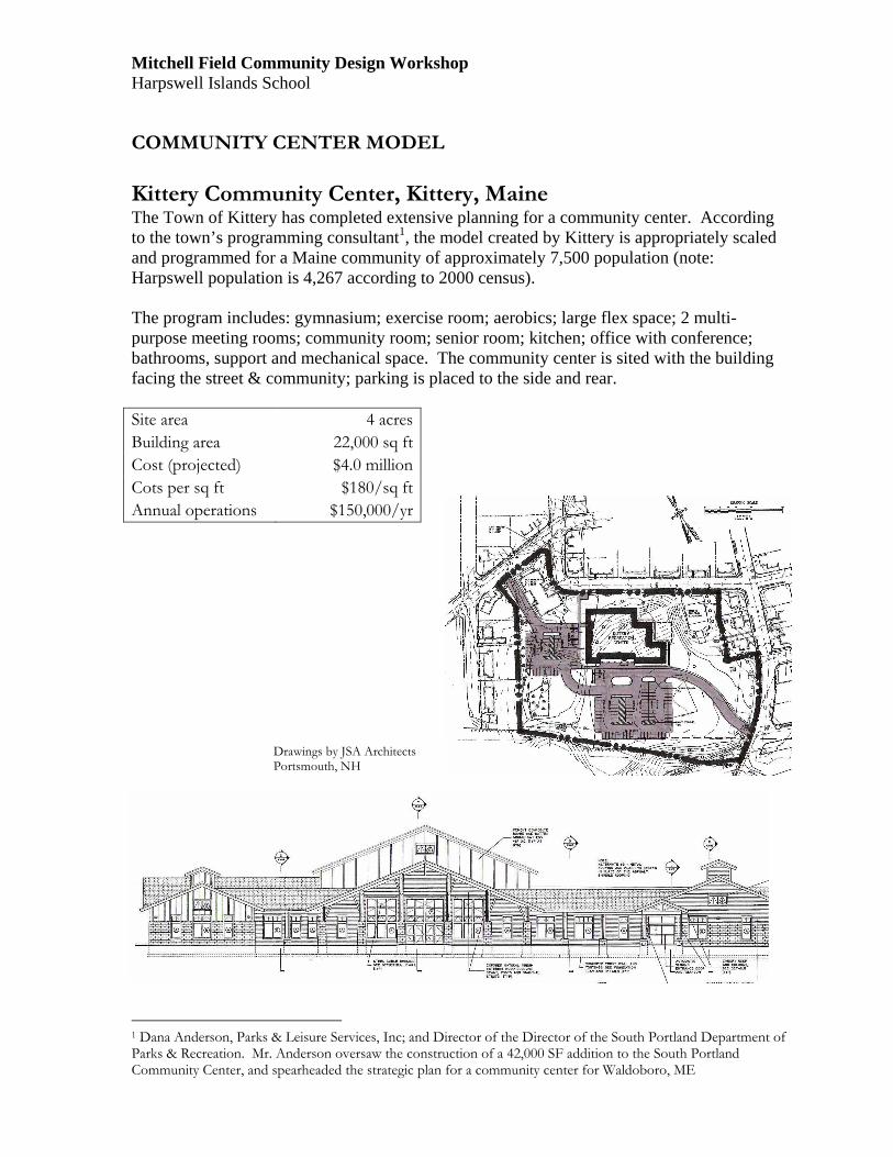
COMMUNITY CENTER MODEL
Kittery Community Center, Kittery, Maine The Town of Kittery has completed extensive planning for a community center. According to the town’s programming consultant1, the model created by Kittery is appropriately scaled and programmed for a Maine community of approximately 7,500 population (note: Harpswell population is 4,267 according to 2000 census). The program includes: gymnasium; exercise room; aerobics; large flex space; 2 multi-purpose meeting rooms; community room; senior room; kitchen; office with conference; bathrooms, support and mechanical space. The community center is sited with the building facing the street & community; parking is placed to the side and rear.
Site area 4 acres
Building area 22,000 sq ft
Cost (projected) $4.0 million
Cots per sq ft $180/sq ft
Annual operations $150,000/yr
1 Dana Anderson, Parks & Leisure Services, Inc; and Director of the Director of the South Portland Department of Parks & Recreation. Mr. Anderson oversaw the construction of a 42,000 SF addition to the South Portland Community Center, and spearheaded the strategic plan for a community center for Waldoboro, ME
Drawings by JSA Architects Portsmouth, NH

Mitchell Field Community Design Workshop Harpswell Islands School
HIGH INTENSITY RECREATION
High-Intensity Recreation includes landscaped parks and village greens with amenities, track & fields, and playgrounds.
1. Formal Parks Formal parks, not including playing fields, can range from “pocket parks” (under an acres), to village parks and town greens (1-4 acres), to community parks (6 acres or more). They are landscaped and typically include hardscape, lighting, pedestrian amenities, and special features (gazebos, fountains, public art, etc). They can cost from $50K/acre to $250K/acre or more to develop, depending on the level of design detail, materials, special features, and site conditions.
2. Track & Field
It would cost approximately $750,000 to construct a new track with bleachers, locker/rest room/equipment facilities. An upgraded facility could be rented out and used regionally. A track & field facility requires about 5 acres of land (parking not included).
3. Playlots & Playgrounds
Playlots, designed for pre-school children, are generally enclosed for safety, but are integral parts of neighborhood design. They typically range from 1,000 SF to a quarter-acre (which will serve 50 children). Playgrounds are for older children and adults, and include playground equipment, open turf areas, shaded areas, field games (e.g., softball), court games (e.g., basketball), and pedestrian amenities. A small playground of 3 acres serves 250 families; typical community playgrounds are 8 acres and up.

Mitchell Field Community Design Workshop Harpswell Islands School
LOW-INTENSITY RECREATION
Low-Intensity Recreation includes trails, natural preserves, and passive open space.
1. Trails Trails can be as simple as a path through a meadow, or paved for multiple recreational use. Pedestrian and bicycle trails between schools and neighborhoods (existing and new) are highly encouraged. Mitchell Field is currently used for passive recreation. Even without new infrastructure, there is an expense to maintain use as passive recreation which can including:
� Lawn & grounds maintenance � Garbage removal � Public safety patrols
Minimal investment in new infrastructure can increase use of passive recreation. Such investment might include: � Development of signage � Development of trails � Installation of public facilities (bathrooms, water fountains, simple shelters, benches, etc) Line item costs of such features will be developed for use at the Community Design Workshop event.
Mitchell Field Community Design Workshop Harpswell Islands School
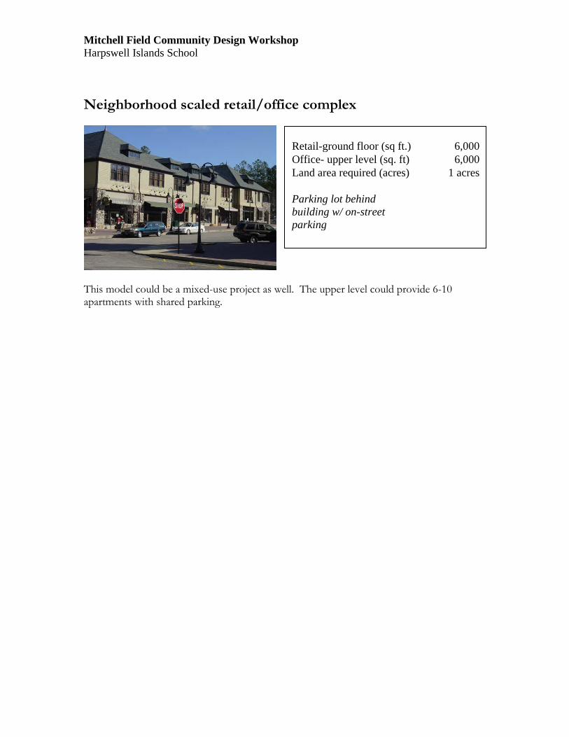
Neighborhood scaled retail/office complex
This model could be a mixed-use project as well. The upper level could provide 6-10 apartments with shared parking.
Retail-ground floor (sq ft.) 6,000 Office- upper level (sq. ft) 6,000 Land area required (acres) 1 acres Parking lot behind building w/ on-street parking

Mitchell Field Community Design Workshop Harpswell Islands School HOUSING MODELS
Danielson Grove Cottages – single family houses This 'pocket neighborhood' offers a mix of 1, 2, & 3 bedroom homes. Each home is on a private lot, sensitively arranged around stunning garden courtyards. Designed with community in mind, our 'better rather than bigger' homes are BuiltGreen/Energy Star Certified. The whole development is on 41,800 square feet (.95 acre).
NOT TO SCALE (SEE TEMPLATE)
Mitchell Field Community Design Workshop Harpswell Islands School HOUSING MODELS
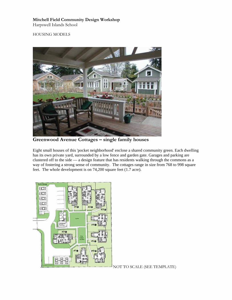
Greenwood Avenue Cottages – single family houses
Eight small houses of this 'pocket neighborhood' enclose a shared community green. Each dwelling has its own private yard, surrounded by a low fence and garden gate. Garages and parking are clustered off to the side — a design feature that has residents walking through the commons as a way of fostering a strong sense of community. The cottages range in size from 768 to 998 square feet. The whole development is on 74,200 square feet (1.7 acre).
NOT TO SCALE (SEE TEMPLATE)
Mitchell Field Community Design Workshop Harpswell Islands School HOUSING MODELS
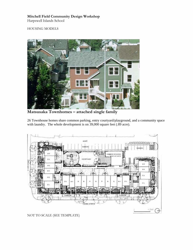
Matsusaka Townhomes – attached single family 26 Townhouse homes share common parking, entry courtyard/playground, and a community space with laundry. The whole development is on 39,000 square feet (.89 acre).
NOT TO SCALE (SEE TEMPLATE)
Mitchell Field Community Design Workshop Harpswell Islands School HOUSING MODELS
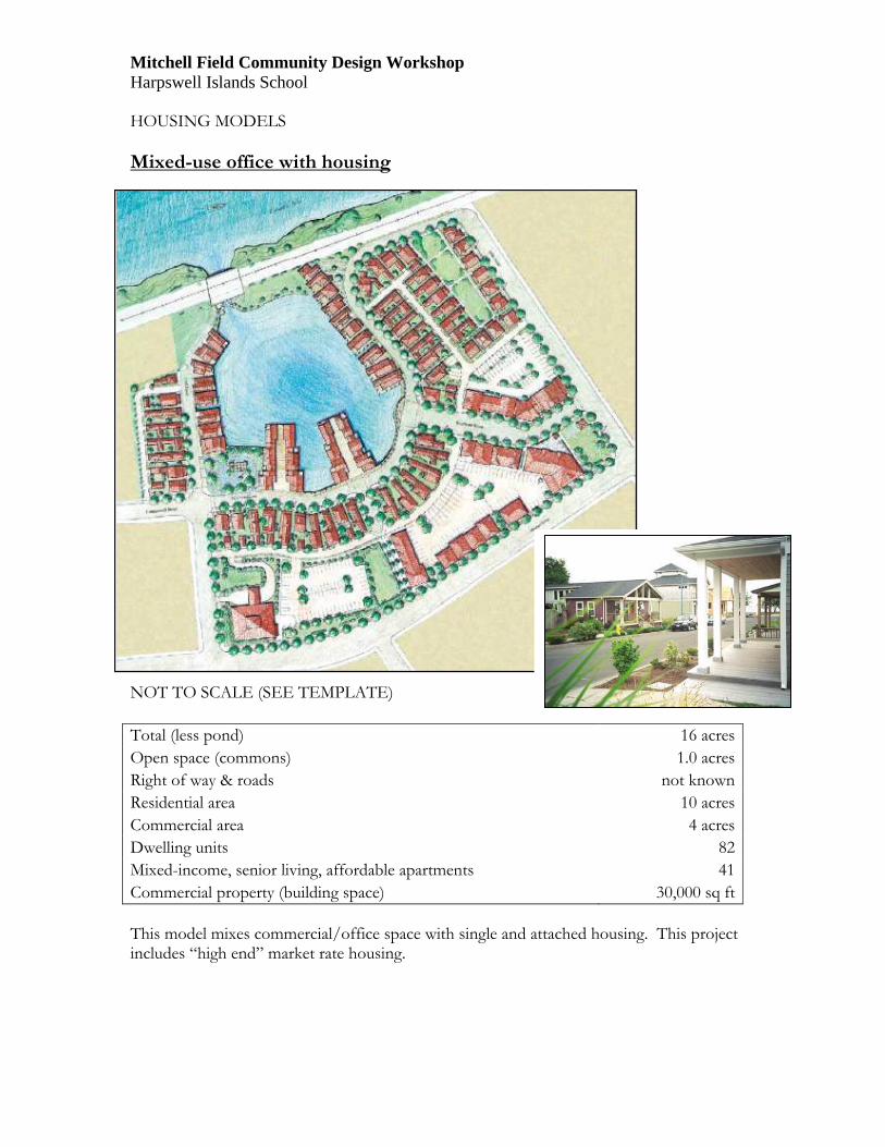
Mixed-use office with housing NOT TO SCALE (SEE TEMPLATE)
This model mixes commercial/office space with single and attached housing. This project includes “high end” market rate housing.
Total (less pond) 16 acres
Open space (commons) 1.0 acres
Right of way & roads not known
Residential area 10 acres
Commercial area 4 acres
Dwelling units 82
Mixed-income, senior living, affordable apartments 41
Commercial property (building space) 30,000 sq ft

Mitchell Field Community Design Workshop Harpswell Islands School HOUSING MODELS
FERRY LANDING – Saco, Maine
Ferry Landing is a 28-unit subdivision mainly targeting the retirement population. A homeowner's association takes care of all exterior maintenance. This project includes “high end” market rate housing.
Right of way & roads area 1.4 acres
Residential parcels area (total) 8.8 acres
Number of units 28
Housing types Single family
NOT TO SCALE (SEE TEMPLATE)

Mitchell Field Community Design Workshop Harpswell Islands School HOUSING MODELS
WYNDCREST - Massachusetts
NOT TO SCALE (SEE TEMPLATE)
The six acre site included includes 26 homes (13 single-family, 5 cottages, and 8 townhouses) and two neighborhood greens. Wyndcrest has been widely recognized for its successful integration of affordable housing with market-rate housing.
Total area 6 acres
Open space (association) .5 acres
Right of way & roads area 1 acres
Residential parcels area (total) 4.5 acres
Number of units 26
Housing types single, duplex, townhouse
Mitchell Field Community Design Workshop Harpswell Islands School HOUSING MODELS
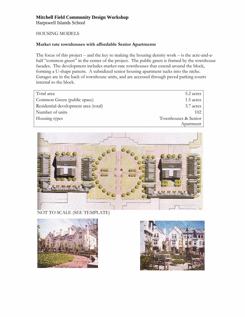
Market rate townhouses with affordable Senior Apartments The focus of this project – and the key to making the housing density work – is the acre-and-a-half “common green” in the center of the project. The public green is framed by the townhouse facades. The development includes market-rate townhouses that extend around the block, forming a U-shape pattern. A subsidized senior housing apartment tucks into the niche. Garages are in the back of townhouse units, and are accessed through paved parking courts internal to the block.
Total area 5.2 acres
Common Green (public space) 1.5 acres
Residential development area (total) 3.7 acres
Number of units 102
Housing types Townhouses & Senior Apartment
NOT TO SCALE (SEE TEMPLATE)
Mitchell Field Community Design Workshop Harpswell Islands School
HOUSING MODELS
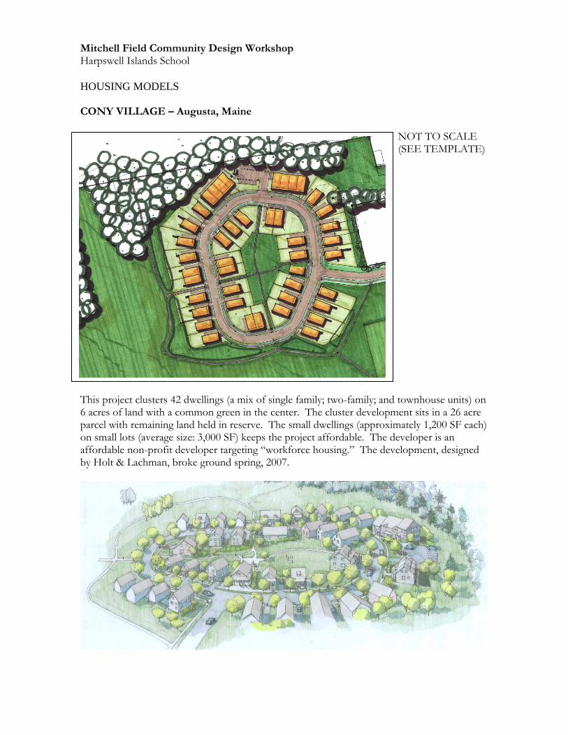
CONY VILLAGE – Augusta, Maine NOT TO SCALE (SEE TEMPLATE) This project clusters 42 dwellings (a mix of single family; two-family; and townhouse units) on 6 acres of land with a common green in the center. The cluster development sits in a 26 acre parcel with remaining land held in reserve. The small dwellings (approximately 1,200 SF each) on small lots (average size: 3,000 SF) keeps the project affordable. The developer is an affordable non-profit developer targeting “workforce housing.” The development, designed by Holt & Lachman, broke ground spring, 2007.
Mitchell Field Community Design Workshop Harpswell Islands School
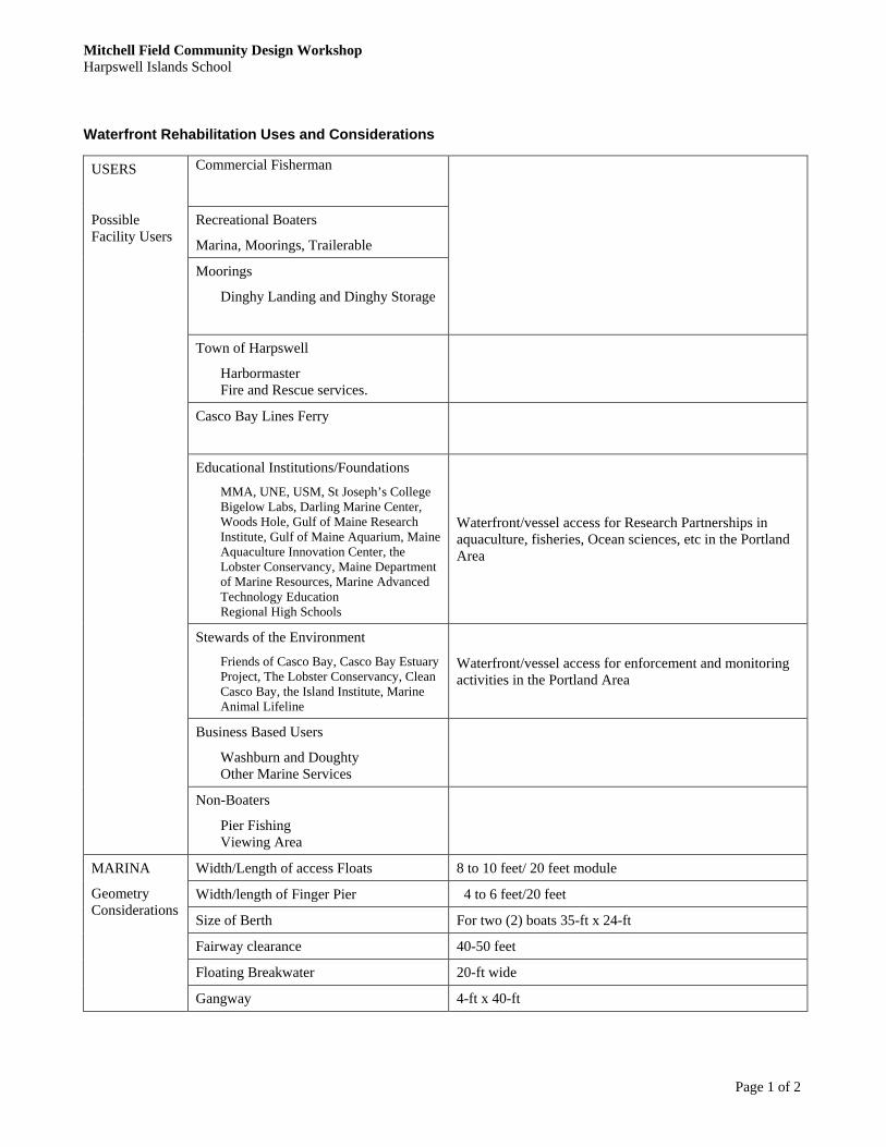
Waterfront Rehabilitation Uses and Considerations
Page 1 of 2
Commercial Fisherman
Recreational Boaters
Marina, Moorings, Trailerable
Moorings
Dinghy Landing and Dinghy Storage
Town of Harpswell
Harbormaster Fire and Rescue services.
Casco Bay Lines Ferry
Educational Institutions/Foundations
MMA, UNE, USM, St Joseph’s College Bigelow Labs, Darling Marine Center, Woods Hole, Gulf of Maine Research Institute, Gulf of Maine Aquarium, Maine Aquaculture Innovation Center, the Lobster Conservancy, Maine Department of Marine Resources, Marine Advanced Technology Education Regional High Schools
Waterfront/vessel access for Research Partnerships in aquaculture, fisheries, Ocean sciences, etc in the Portland Area
Stewards of the Environment
Friends of Casco Bay, Casco Bay Estuary Project, The Lobster Conservancy, Clean Casco Bay, the Island Institute, Marine Animal Lifeline
Waterfront/vessel access for enforcement and monitoring activities in the Portland Area
Business Based Users
Washburn and Doughty Other Marine Services
USERS
Possible Facility Users
Non-Boaters
Pier Fishing Viewing Area
Width/Length of access Floats 8 to 10 feet/ 20 feet module
Width/length of Finger Pier 4 to 6 feet/20 feet
Size of Berth For two (2) boats 35-ft x 24-ft
Fairway clearance 40-50 feet
Floating Breakwater 20-ft wide
MARINA
Geometry Considerations
Gangway 4-ft x 40-ft
Mitchell Field Community Design Workshop Harpswell Islands School
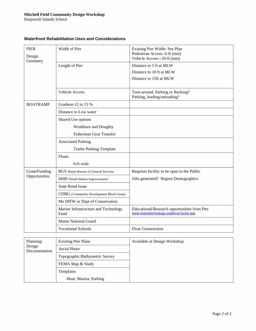
Waterfront Rehabilitation Uses and Considerations
Page 2 of 2
Width of Pier
Existing Pier Width- See Plan Pedestrian Access- 6-ft (min) Vehicle Access-~20-ft (min)
Length of Pier
Distance to 5 ft at MLW
Distance to 10 ft at MLW
Distance to 15ft at MLW
PIER
Design Geometry
Vehicle Access Turn-around, Parking or Backing? Parking, loading/unloading?
Gradient-12 to 15 %
Distance to Low water
Shared Use options
Washburn and Doughty
Fisherman Gear Transfer
Associated Parking
Trailer Parking Template
BOATRAMP
Floats
6-ft wide
BGS Maine Bureau of General Services
SHIP (Small Harbor Improvement)
State Bond Issue
CDBG (Community Development Block Grant)
Me DIFW or Dept of Conservation
Requires facility to be open to the Public
Jobs generated? Region Demographics
Marine Infrastructure and Technology Fund
Educational/Research opportunities from Pier www.mainetechnology.org/bond-funds.asp
Maine National Guard
Grant/Funding Opportunities
Vocational Schools Float Construction
Existing Pier Plans
Aerial Photo
Topographic/Bathymetric Survey
FEMA Map & Study
Planning/ Design Documentation
Templates
-Boat, Marina, Parking
Available at Design Workshop
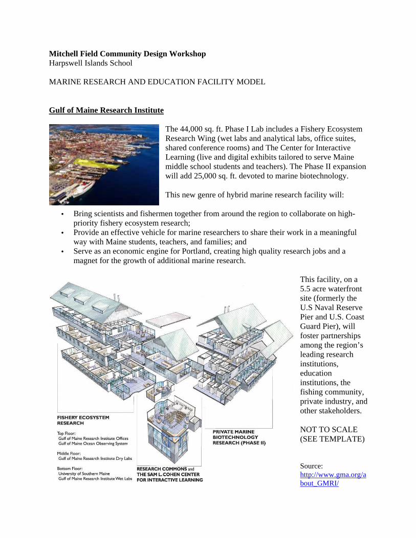
Mitchell Field Community Design Workshop Harpswell Islands School MARINE RESEARCH AND EDUCATION FACILITY MODEL
Gulf of Maine Research Institute
The 44,000 sq. ft. Phase I Lab includes a Fishery Ecosystem Research Wing (wet labs and analytical labs, office suites, shared conference rooms) and The Center for Interactive Learning (live and digital exhibits tailored to serve Maine middle school students and teachers). The Phase II expansion will add 25,000 sq. ft. devoted to marine biotechnology.
This new genre of hybrid marine research facility will:
• Bring scientists and fishermen together from around the region to collaborate on high-priority fishery ecosystem research;
• Provide an effective vehicle for marine researchers to share their work in a meaningful way with Maine students, teachers, and families; and
• Serve as an economic engine for Portland, creating high quality research jobs and a magnet for the growth of additional marine research.
This facility, on a 5.5 acre waterfront site (formerly the U.S Naval Reserve Pier and U.S. Coast Guard Pier), will foster partnerships among the region’s leading research institutions, education institutions, the fishing community, private industry, and other stakeholders.
NOT TO SCALE (SEE TEMPLATE)
Source: http://www.gma.org/about_GMRI/

Mitchell Field Community Design Workshop Harpswell Islands School ARBORETUM MODEL Strybing Arboretum & Botanical Gardens
"Strybing Arboretum and Botanical Gardens is a living museum for the enjoyment and exploration of the natural world" is the way Strybing's mission statement begins. Strybing Arboretum and Botanical Gardens is a public garden serving San Francisco residents and visitors with its diverse collection of plants from around the world, educational programs and conservation of rare and unique plants. Fifty-five acres of Golden Gate Park in San Francisco is dedicated to Strybing Arboretum & Botanical Gardens with over 7,000 different species of plants from around the world.
Strybing Arboretum & Botanical Gardens is open to the public, admission free, 365 days a year. Strybing is owned and operated by the San Francisco Recreation and Park Department in cooperation with the non-profit, member-supported Strybing Arboretum Society.
NOT TO SCALE (SEE TEMPLATE)
Source: http://www.inetours.com/Pages/SFNbrhds/GGP_Strybing.html
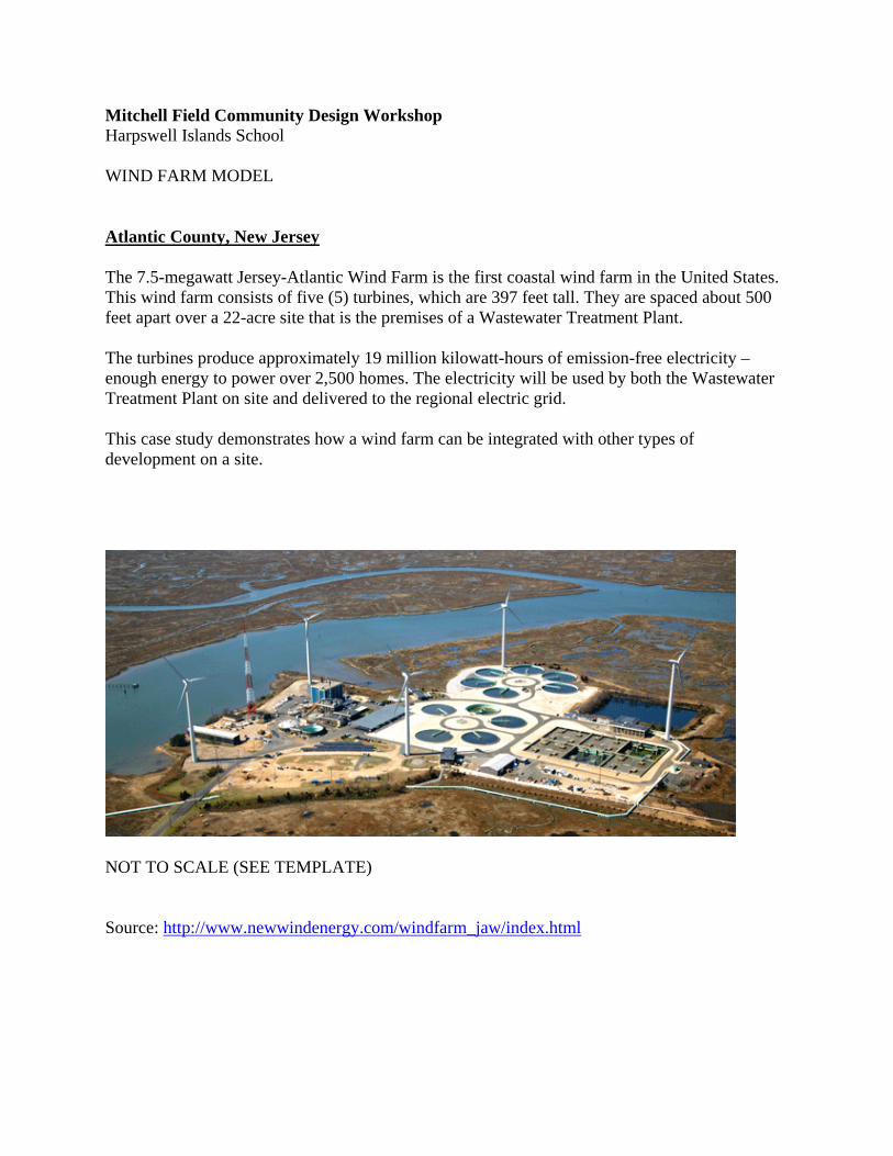
Mitchell Field Community Design Workshop Harpswell Islands School WIND FARM MODEL
Atlantic County, New Jersey
The 7.5-megawatt Jersey-Atlantic Wind Farm is the first coastal wind farm in the United States. This wind farm consists of five (5) turbines, which are 397 feet tall. They are spaced about 500 feet apart over a 22-acre site that is the premises of a Wastewater Treatment Plant.
The turbines produce approximately 19 million kilowatt-hours of emission-free electricity – enough energy to power over 2,500 homes. The electricity will be used by both the Wastewater Treatment Plant on site and delivered to the regional electric grid.
This case study demonstrates how a wind farm can be integrated with other types of development on a site.
NOT TO SCALE (SEE TEMPLATE) Source: http://www.newwindenergy.com/windfarm_jaw/index.html
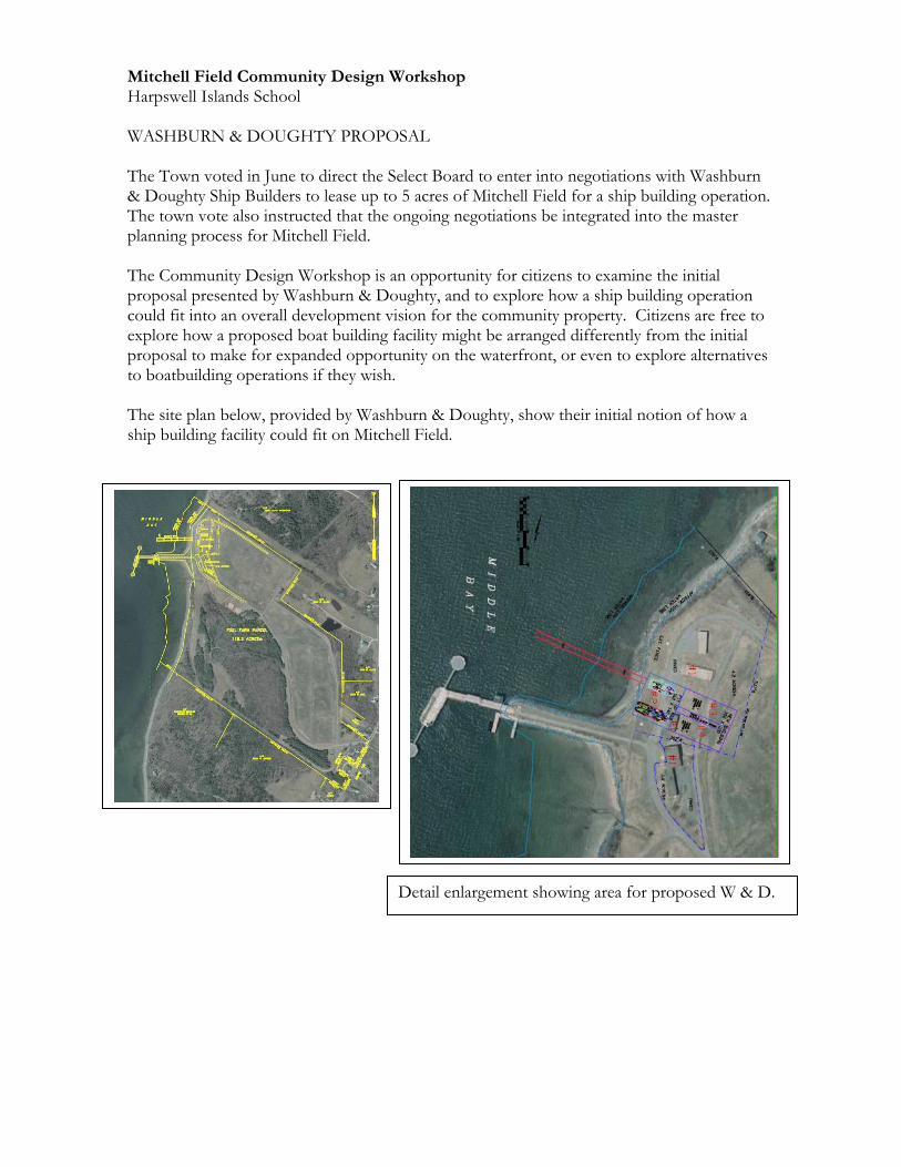
Mitchell Field Community Design Workshop Harpswell Islands School WASHBURN & DOUGHTY PROPOSAL
The Town voted in June to direct the Select Board to enter into negotiations with Washburn & Doughty Ship Builders to lease up to 5 acres of Mitchell Field for a ship building operation. The town vote also instructed that the ongoing negotiations be integrated into the master planning process for Mitchell Field. The Community Design Workshop is an opportunity for citizens to examine the initial proposal presented by Washburn & Doughty, and to explore how a ship building operation could fit into an overall development vision for the community property. Citizens are free to explore how a proposed boat building facility might be arranged differently from the initial proposal to make for expanded opportunity on the waterfront, or even to explore alternatives to boatbuilding operations if they wish. The site plan below, provided by Washburn & Doughty, show their initial notion of how a ship building facility could fit on Mitchell Field.
Detail enlargement showing area for proposed W & D.

Mitchell Field Community Design Workshop Harpswell Islands School WASHBURN & DOUGHTY PROPOSAL
The current W & D facility in East Boothby is situated in the village, abutting a boatbuilder on the waterfront to the west, and a residential neighborhood. The land site is slightly less than two acres, and is building itself, mostly over the water, has about a one acre footprint. The site and building is on a narrow corridor that uses approximately 250 linear feet of harbor front. The parking lot for the approximately 60 employees is made available for town use when not being used by Washburn & Doughty.
The image to the left, provided by Washburn & Doughty, is an illustration showing the approximate location they envision for their boat building facility. Based on their existing facility in East Boothbay, the building might be 175’ wide, 250’ long, and up to 50’ high to accommodate building of tugs.

Mitchell Field Community Design Workshop Harpswell Islands School
PRINCIPLES OF SMART GROWTH
The Environmental Protection Agency (EPA) 10 guidelines for smart growth are:
1. Mix land uses
2. Take advantage of compact building design
3. Create housing opportunities and choices for a range of household types, family size
and incomes
4. Create walkable neighborhoods
5. Foster distinctive, attractive communities with a strong sense of place
6. Preserve open space, farmland, natural beauty, and critical environmental areas
7. Reinvest in and strengthen existing communities & achieve more balanced regional
development
8. Provide a variety of transportation choices
9. Make development decisions predictable, fair and cost-effective
10. Encourage citizen and stakeholder participation in development decisions