bring lidar in a new light: use of holograms to extend...
TRANSCRIPT

Bring Lidar in a new light:
use of holograms to extend your
research

2
Agenda
• Introduction to Zebra Imaging Technology
• Lidar Value
• Two workflow export for hologram creation
• Demonstration of hologram technology

3
Holographic Displays
Copyright 2012 Zebra Imaging. All Rights Reserved.
Incline
Horizontal
Film-based 3D images made from digital/digitized data, displayed with a simple light

4
• Interactive, true-3D
– Reach into the model, walk around
– See the whole design, not just portions
– Full parallax
– Viewable from 360°
• No special equipment
– No glasses or goggles
– No computers or projectors
– No special software
• No special user training
– Easy-to-use
– Closes communications gaps immediately
Zebra Technology - 3D Holographic Prints communicates whole designs in true-3D
5
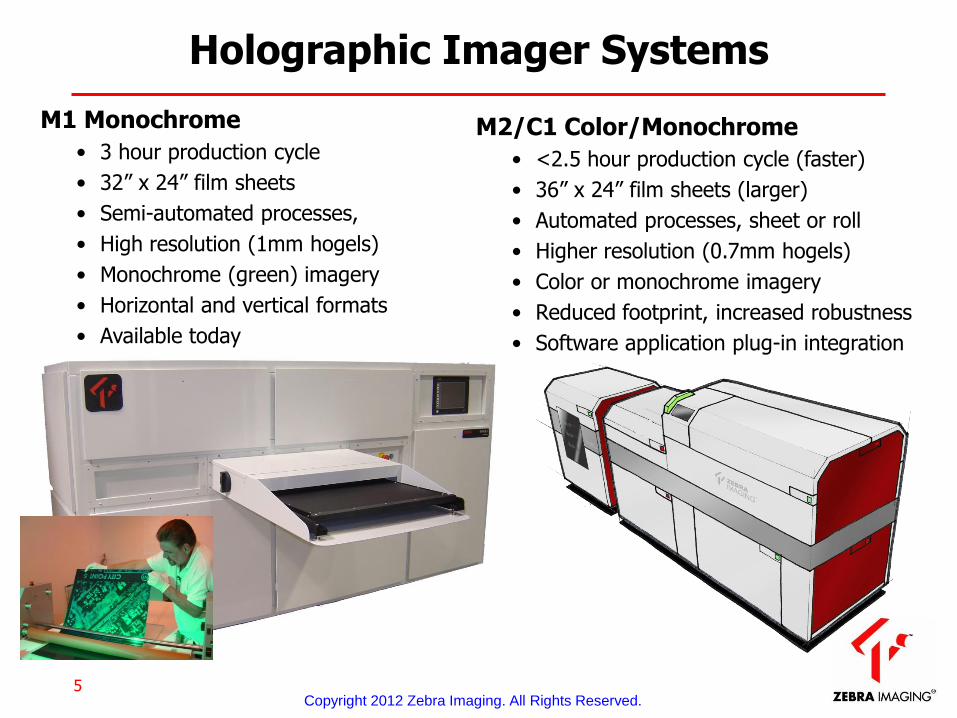
Holographic Imager Systems
M1 Monochrome
• 3 hour production cycle
• 32” x 24” film sheets
• Semi-automated processes,
• High resolution (1mm hogels)
• Monochrome (green) imagery
• Horizontal and vertical formats
• Available today
Copyright 2012 Zebra Imaging. All Rights Reserved.
M2/C1 Color/Monochrome
• <2.5 hour production cycle (faster)
• 36” x 24” film sheets (larger)
• Automated processes, sheet or roll
• Higher resolution (0.7mm hogels)
• Color or monochrome imagery
• Reduced footprint, increased robustness
• Software application plug-in integration

6
Key Values of Holographic Displays
• Correct 3D from every vantage point (“full parallax”)
• Wide viewing angle
• Portable, sturdy, and easy to use
• Monochrome or Full Color
• Scalable
• No distortion
• Large depth volume
• Multi-view channel, 3D overlay capability
• Multi-source fusion
• Collection source and software-application independent
Effortless comprehension and common-view collaboration for multiple simultaneous viewers
Dissemination of accurate 3D visuals in intuitively understood formats
Copyright 2012 Zebra Imaging. All Rights Reserved.
7
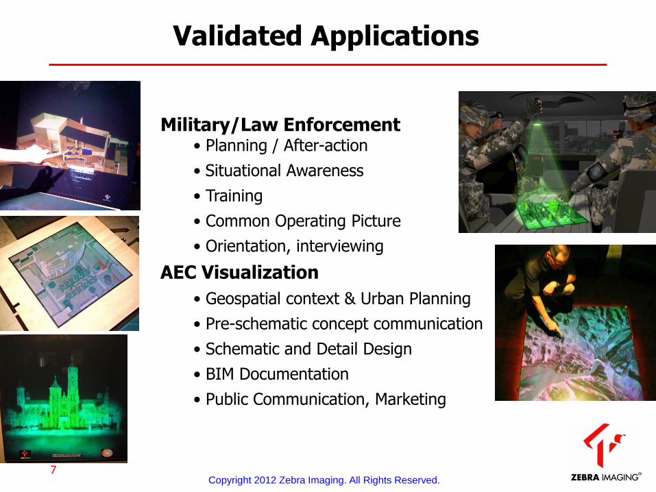
Validated Applications
Military/Law Enforcement
• Planning / After-action
• Situational Awareness
• Training
• Common Operating Picture
• Orientation, interviewing
AEC Visualization
• Geospatial context & Urban Planning
• Pre-schematic concept communication
• Schematic and Detail Design
• BIM Documentation
• Public Communication, Marketing
Copyright 2012 Zebra Imaging. All Rights Reserved.

8
Rendering Features
Copyright 2012 Zebra Imaging. All Rights Reserved.
GIS
Digital Elevation Maps (legacy)
• Geo-referenced
• Triangulated meshes
• Various DTED levels
Point-clouds
• Geo-referenced
• Shaded
• Geo-rectified color/textures
• Variable point sizes, shapes
Point-clouds (object-based)
• Detail and edge-enhanced
• Integrated shading
• Texture mapping

9
Detail Enhancement
Copyright 2012 Zebra Imaging. All Rights Reserved.
Terrain and Textures Edge-enhanced shading, expanded points
Scan data provided by Smart MultiMedia
Scan data provided by Army Geospatial Center

10
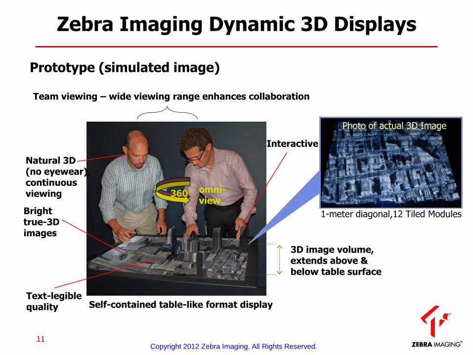
Dynamic 3D display for interactive graphic-intensive applications
– Easy to see 3D
• No glasses or eye fatigue
• No view-position distortion, flipping, or “sweet spot”
• Correct 3D from every vantage point
• Wide 360o visibility for team/collaborative viewing
– Electronically updated in near real-time
• Compatible with visualization software applications
• “3D Multi-touch” interaction-capable
– Modular & scalable design • Man-portable to > 6x6 feet
• Horizontal, vertical, inclined orientations
Dynamic 3D Display Features
DARPA-Sponsored Development Program initiated 2004
11
Bright true-3D images
Text-legible quality
Interactive
3D image volume, extends above & below table surface
Team viewing – wide viewing range enhances collaboration
omni- view
360°
Prototype (simulated image)
Natural 3D (no eyewear), continuous viewing
Photo of actual 3D Image
Zebra Imaging Dynamic 3D Displays
Self-contained table-like format display
1-meter diagonal,12 Tiled Modules
Copyright 2012 Zebra Imaging. All Rights Reserved.

12
3D scene data, via Ethernet
3D Display
Self-contained 3D Display
Modules
Application Workstation
Application SW
Zebra software
3D image
3D data
Functional Schematic – Zebra 3D Display
• OpenGL – visualization, GIS • OSG – simulation, virtual words, MMO games • DirectX – Windows-based graphics
Links to software applications based on specific APIs, including:
Copyright 2012 Zebra Imaging. All Rights Reserved.

Copyright 2012 Zebra Imaging. All Rights Reserved.
Case for Lidar in
holographic display

14
LIDAR + Holographic Display Utility Case
Copyright 2012 Zebra Imaging. All Rights Reserved.
• Come to consensus
• Provide instructional pre-visualization
• Express circumstances and context clearly

15
Holographic Displays for Rapid Consensus
Copyright 2012 Zebra Imaging. All Rights Reserved.
Come to consensus over complex, multi-disciplinary problems (understand the design challenge)
• A problem/change/challenge is encountered
• Engineering, MEP need to avoid defensiveness & put their heads together to discuss, brainstorm solutions
• Finance needs to buy-in on level-of-effort, cost validation, priority
• Client needs to understand the trades, other stakeholders weigh in
• LIDAR acquires “ground truth”
• Comprehensive Holographic Display is produced
• An in-field meeting is called to review
16
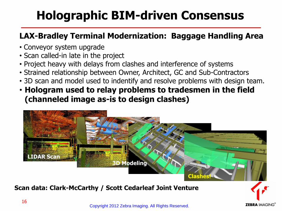
Holographic BIM-driven Consensus
Copyright 2012 Zebra Imaging. All Rights Reserved.
LAX-Bradley Terminal Modernization: Baggage Handling Area
• Conveyor system upgrade • Scan called-in late in the project • Project heavy with delays from clashes and interference of systems • Strained relationship between Owner, Architect, GC and Sub-Contractors • 3D scan and model used to indentify and resolve problems with design team.
• Hologram used to relay problems to tradesmen in the field (channeled image as-is to design clashes)
Scan data: Clark-McCarthy / Scott Cedarleaf Joint Venture
LIDAR Scan 3D Modeling
Clashes!
17
Holographic Displays instruct and plan
Copyright 2012 Zebra Imaging. All Rights Reserved.
Provide instructional pre-visualization in an intuitively understood form
• People in complex environments and critical structures need protection and safety
• LIDAR acquires key structures and details
• Way-finding/route-map, or baseline Holographic Displays are produced
• First responders, safety personnel, occupants can study periodically
• Immediate, straightforward consultation in an emergency
• Planners consult for modification, events contingencies

18
Holograms for stark visual clarity
Copyright 2012 Zebra Imaging. All Rights Reserved.
Brunswick, Georgia Hospital storm surge flood models
• County-wide aerial LIDAR acquisition
• Lidar with aerial overlay
• CAT 3, CAT 5 Hurricane storm surge modeling / superposition
• Holographic display and overlay presentation to board, safety personnel
• Modification of safety and evacuation plans

19
Holographic Displays make the case
Copyright 2012 Zebra Imaging. All Rights Reserved.
Express spatially-critical circumstances and context clearly and accurately
• Incident evidence must be archived, analyzed and courtroom -communicated
• LIDAR acquires post-event conditions, locations, dimensions
• Archive, analysis, and evidentiary Holographic Displays are produced
• Forensic specialists make visual consultations for lines-of-sight, burn patterns
• Insurance adjusters retain archives for liability
• A jury clearly understands physical elements critical to the case

20
Holograms communicate truth…fast
Copyright 2012 Zebra Imaging. All Rights Reserved.
Forensic documentation (Structure issues or failure)
• LIDAR acquisition of scene
• Analysis can be applied: line of site, trajectory
• Placement, reconstruction, illustration of critical details
• Possible holographic display to jury or reviewers
• Hopeful for clarity of understanding and judgment
Data provided by Packer Engineering

21
Workflow for holographic print Sensor-to-User 3D (Zebra Assembled)
Hologram Production
Utilization Creation, Assembly & Fusion
Collection
Zebra Print Center
Contract/Data Firms
Publish data to hologram production
Copyright 2012 Zebra Imaging. All Rights Reserved.
Clients
• Data is supplied via secure FTP in a standard format (XYZ, PTC, LAS, VRML, ASCII, etc.)
• Verification renderings/movies are provided via email
• Holographic Display is recorded, laminated, integrated with light (optional) and shipped
Turnaround times in less than 1 week, with rush service available
Zebra/Client

22
Workflow for holographic print
Two Export Products
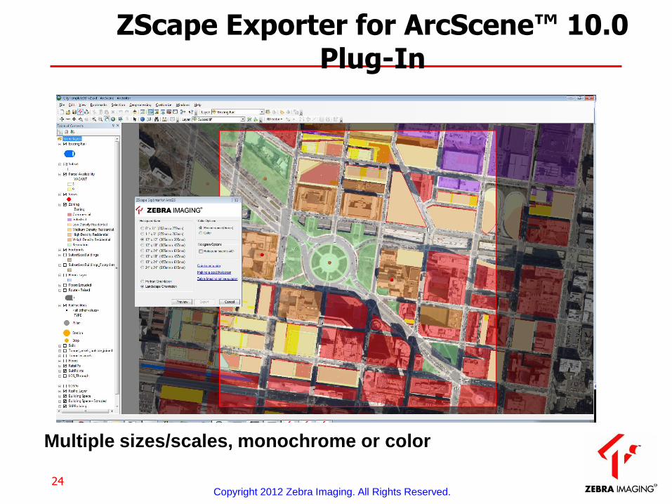
• ZScape Exporter for Esri ArcGIS 10.0 ArcScene ™
– Update of exporter for new Lidar features at 10.1
• ZScape Preview for 3D models
– Existing technology to access point clouds and lidar
Copyright 2012 Zebra Imaging. All Rights Reserved.

23
Esri ArcGIS ArcScene – Build 3D project
Copyright 2012 Zebra Imaging. All Rights Reserved.
24
Multiple sizes/scales, monochrome or color
ZScape Exporter for ArcScene™ 10.0 Plug-In
Copyright 2012 Zebra Imaging. All Rights Reserved.
25
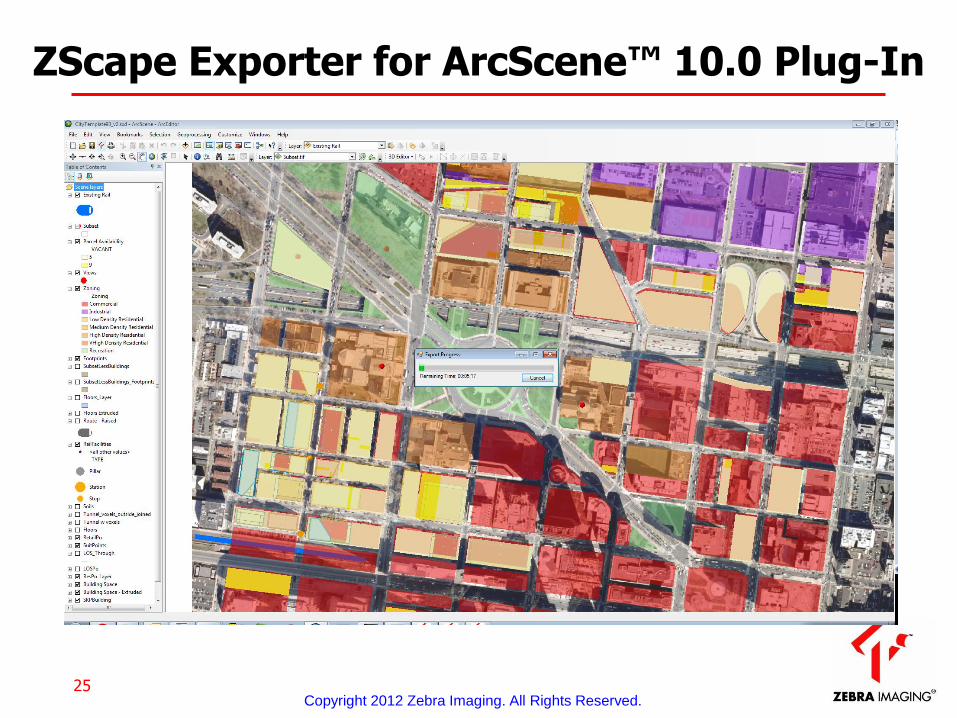
ZScape Exporter for ArcScene™ 10.0 Plug-In
Copyright 2012 Zebra Imaging. All Rights Reserved.
26
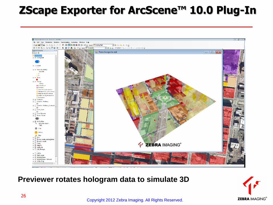
Previewer rotates hologram data to simulate 3D
ZScape Exporter for ArcScene™ 10.0 Plug-In
Copyright 2012 Zebra Imaging. All Rights Reserved.
27
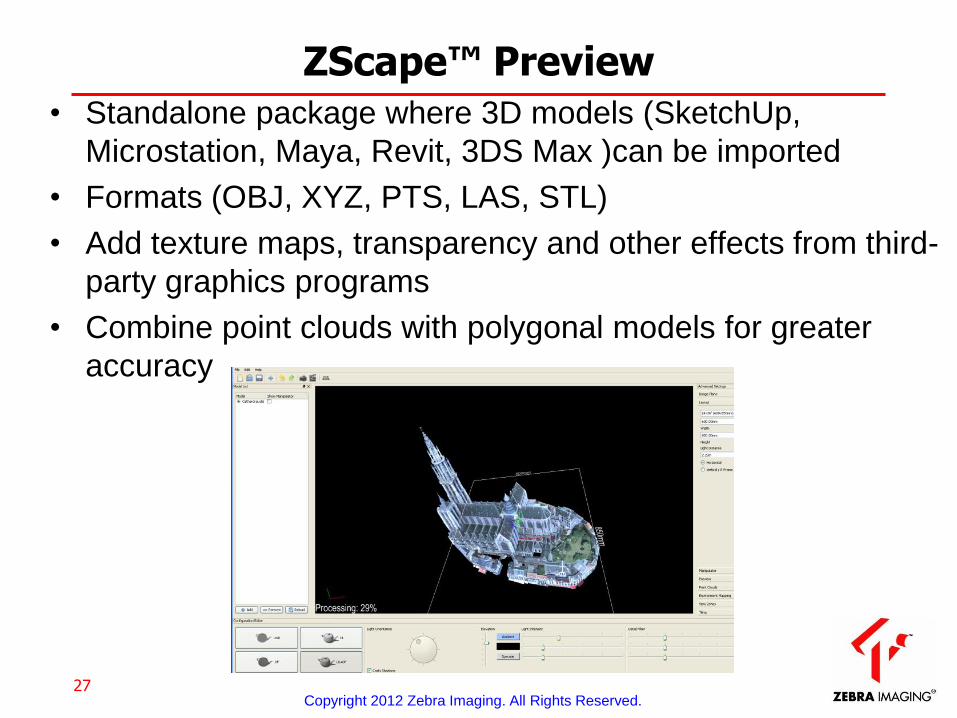
ZScape™ Preview • Standalone package where 3D models (SketchUp,
Microstation, Maya, Revit, 3DS Max )can be imported
• Formats (OBJ, XYZ, PTS, LAS, STL)
• Add texture maps, transparency and other effects from third-
party graphics programs
• Combine point clouds with polygonal models for greater
accuracy
Copyright 2012 Zebra Imaging. All Rights Reserved.

28
Zscape Preview
Copyright 2012 Zebra Imaging. All Rights Reserved.

Hologram Display Demonstration
Copyright 2012 Zebra Imaging. All Rights Reserved.