british enterprise.pdf
TRANSCRIPT

Report on the investigation of
the grounding of
British Enterprise
Ahirkapi Anchorage Area
Istanbul, Turkey
on
11 December 2004
Marine Accident Investigation BranchCarlton HouseCarlton PlaceSouthampton
United Kingdom SO15 2DZ
Report No 25/2005December 2005

Extract from
The United Kingdom Merchant Shipping
(Accident Reporting and Investigation)
Regulations 2005 – Regulation 5:
“The sole objective of the investigation of an accident under the Merchant Shipping(Accident Reporting and Investigation) Regulations 2005 shall be the prevention offuture accidents through the ascertainment of its causes and circumstances. It shall notbe the purpose of an investigation to determine liability nor, except so far as isnecessary to achieve its objective, to apportion blame.”
NOTE
This report is not written with litigation in mind and, pursuant to Regulation 13(9) of theMerchant Shipping (Accident Reporting and Investigation) Regulations 2005, shall beinadmissible in any judicial proceedings whose purpose, or one of whose purpose is toattribute or apportion liability or blame.
CONTENTSPage
GLOSSARY OF ABBREVIATIONS AND ACRONYMS
SYNOPSIS 1
SECTION 1 - FACTUAL INFORMATION 3
1.1 Particulars of British Enterprise and accident 31.2 Narrative 51.3 The crew 131.4 Vessel’s certification 131.5 The Istanbul Bogazi 141.6 Vessel Traffic Service 141.7 Tides and currents in the Istanbul Bogazi 141.8 The chart in use 16
SECTION 2 - ANALYSIS 18
2.1 Aim 182.2 The hydrographic history of Ye?ilk?y Bank and the possible
reasons for a localised reduction in water depth 182.2.1 Survey history of Ye?ilk?y Bank 182.2.2 Chart history of Ye?ilk?y Bank 192.2.3 Chart scale 302.2.4 “Charlie” anchorage 302.2.5 Changes to the seabed and decrease in charted water depth 302.2.6 Conclusion 31
2.3 Grounding of British Enterprise 312.4 Previous groundings in C5 anchorage 34
2.4.1 Henza 342.4.2 Marshal Vasilevskiy 36
2.5 Reporting information concerning hazards to navigation 362.6 Promulgation of information concerning hazards to navigation 372.7 Promulgation of information between hydrographic authorities 39
SECTION 3 - CONCLUSIONS 40
3.1 Safety issues 40
SECTION 4 - ACTION TAKEN 41
4.1 Action taken by British Petroleum Shipping Limited 41
SECTION 5 - RECOMMENDATIONS 42
Ye ilk y
Ye ilk y
Ye ilk y

GLOSSARY OF ABBREVIATIONS AND ACRONYMS
AIS - Automatic identification system
BA - British Admiralty
Bogazi - Strait
CCTV - Closed-circuit television
CHIRP - Confidential Hazardous Incident Reporting Programme - anindependent body dedicated to receiving confidential reportsconcerning accidents and incidents, to improve safety at sea.
DF - Direction finding
DSC - Digital selective calling
E/K - Even keel
ENC - Electronic navigation chart
IHO - International Hydrographic Organisation
IMO - International Maritime Organization
LNG - Liquefied Natural Gas
LPG - Liquid Petroleum Gas
LT - Local time
R/T - Radio telephony
Seiches - Seiches are oscillations in enclosed bodies of water caused byseismic waves
SMS - Safety Management System
SOLAS - Safety of Life at Sea
THO - Turkish Hydrographic Organisation
TSS - Traffic Separation Scheme
TSVTS - Turkish Straits Vessel Traffic Service
UKC - Under keel clearance
UKHO - United Kingdom Hydrographic Office
VHF - Very High Frequency
VTS - Vessel Traffic Service
SYNOPSIS
On 11 December 2004, at about 1405, the UK registered tanker British Enterprisegrounded in the Port of Istanbul, Ahirkapi Anchorage Area. The vessel was agroundfor 5 days before she was floated off following a lightening operation. There was nodamage to the vessel and no pollution.
British Enterprise had loaded a cargo of crude oil at the port of Batumi on the BlackSea, and sailed at 0412 on 9 December bound for Agio Theodorio, Greece.
The vessel passed southbound through the Istanbul Bo?azi during the morning of 11December. The master then advised the VTS he wished to take bunkers, andrequested an anchor position. Permission was granted and he was instructed toanchor in “Charlie flammable cargo and explosives anchorage”.
The master anchored the vessel in section C6 of the anchorage later that morning at0546.
Once bunkering was completed, and the barges were gone and clear, the masterinformed the VTS he was ready to depart, and was duly granted permission to sailfrom the port. The anchor was weighed at 1343, the master turned the vessel aroundusing rudder and engine, and began proceeding out of C6 anchorage, intending tocross C5 anchorage before heading out to sea. She had a maximum draught of 11.17metres.
At 1405, as British Enterprise passed through C5 anchorage, the master noticed thevessel’s speed had reduced to zero and, realising she was aground, he immediatelystopped her engine. The bridge team checked the position and, after confirming thatthe chart showed sufficient water depth for the vessel (between 13 and 14 metres),the master attempted to manoeuvre her clear of what appeared to be an unchartedshoal or obstruction.
At 1440, the master realised the vessel was hard aground, and he advised the VTS ofthe situation.
The master had noticed the vessel was listing slightly to port. As the echo sounderindicated an under keel clearance of 2 metres under the bow, the master believed shewas aground on a shoal under his starboard quarter. He ordered the chief officer tobegin gravitating ballast water into a number of forward and port side segregatedballast tanks.
About 1000 tonnes of ballast had been taken on board by 1520, but attempts tomanoeuvre the vessel clear were still unsuccessful. The master then updated theVTS with a situation report. VTS ordered him to cease all ballasting and enginemovements immediately.
Pilots and port officials boarded British Enterprise later that day and informed themaster that, if he was unable to re-float the vessel within 48 hours, the authoritieswould appoint a salvor.
1
Bo azi

2
During the following 48 hours, the ship’s crew attempted to re-float the vessel usingrudder and engine movements. They were unsuccessful.
Turkish authorities re-boarded British Enterprise at 2325 on 13 December, and themaster signed a Salvage and Assistance Agreement (Turkish Open Form) with thestate controlled General Management of Coastal Safety and Salvage Administration.
During the following 3 days, ballast water and cargo were unloaded from BritishEnterprise into lightening vessels. The vessel was successfully re-floated at 1510 on16 December.
The vessel’s cargo was loaded back onboard, and the vessel sailed from the port at2000 on 23 December.
On the day following the grounding, the master had informed the UK HydrographicOffice (UKHO) of the uncharted shoal using a hydrographic note. The UKHOforwarded the information to the Turkish Hydrographic Organisation (THO) on 20December. The area of grounding was later surveyed by the Turkish Navy and a bankwith a shoal area with least depth of 6.1m was discovered. The difference betweencharted and actual water depth was such that the THO issued a notice to mariners on29 January 2005 for all relevant Turkish nautical charts, which included a block for thelargest scale Turkish chart.
During the investigation, it was found that at least two other vessels had grounded inC5 anchorage in recent years. Investigations carried out after these accidents had notidentified the shoal area.
Research into the survey history of the area has indicated the presence of a shoal withabout 10m least depth on 19th century and early 20th century charts, which is not shownon modern charts. The area lies close to a geological fault line, and it is possible thatseismic activity, and the very strong currents that can be experienced in the area, havecombined to make the bottom topography unstable. A 1979 survey of the area failed tofind any evidence of its existence.
Since the accident, BP Shipping Limited has taken a number of actions to avoid asimilar accident in the future. As a result of the MAIB investigation, recommendationshave been made to organisations representing ships’ masters and officers to, amongother things, ensure that uncharted navigational hazards that may be identified arepromptly reported to the correct authority. In addition, a recommendation has beenmade to:
- The International Harbour Masters Association: to, bearing in mind theprotracted time that can elapse between discovery of uncharted dangers tonavigation and promulgation of the appropriate chart corrections, remind itsmembers of the importance of harbour authorities and/or coastal states issuingappropriate navigation warnings.

3
SECTION 1 - FACTUAL INFORMATION
1.1 PARTICULARS OF BRITISH ENTERPRISE AND ACCIDENT
Vessel details See Figure 1
Registered owner : Indico Star Shipping Limited, British VirginIslands
Manager(s) + bareboat charterer : BP Shipping Limited
Port of registry : London
Flag : United Kingdom
Type : Double hulled, tanker
Built : 2001, Daedong, South Korea
Classification society : Lloyd’s Register of Shipping
Length overall : 176.17 metres
Gross tonnage : 23682
Net tonnage : 8834
Engine power and type : 7800kW Motor
Other relevant info : Single screw fixed propeller
Accident details
Time and date : 1405LT on 11 December 2004
Location of accident : C5 Anchorage, Istanbul, Turkey
Persons on board : 24
Injuries/fatalities : None
Damage : Cosmetic damage to hull coating

4
Vess
el a
grou
nd
Figure 1
5
1.2 NARRATIVE
(All times are UTC/GMT +2 hours)
British Enterprise arrived at her load port of Batumi, Georgia, in ballast conditionon the evening of 6 December 2004. The vessel berthed mid-morning the nextday, where she loaded a full cargo of 34,500 tonnes of Keimer crude oil.
In the early hours of 9 December, the vessel sailed from Batumi with a draughtof 11.01m E/K bound for Agio Theodori, Greece.
The vessel had an uneventful trip across the southern Black Sea, and arrived offthe northern entrance to the Istanbul Bogazi at 2218 on 10 December.
A pilot boarded the vessel at 0311 the following morning, the vessel safelytransited the Istanbul Bogazi, and the pilot disembarked at 0430.
The master then called the VTS via VHF radio, and requested a position wherehe could anchor the vessel and load bunker fuel. The VTS operator advised themaster to anchor her “within Charlie anchorage in a safe position”.
The master manoeuvred the vessel towards the anchorage and anchored in C6anchorage at 0546 (see Figure 2).
Bunkering operations were completed at 1330 after loading 450 tonnes of fueloil and 30 tonnes of gas oil. At this time, the draught was 10.76 metres forwardand 11.17 metres aft.
The relevant bridge checks and tests were satisfactorily completed as the vesselwas made ready for departure. The master called the VTS advising them of hiswish to depart, and permission was duly granted for him to do so.
The bridge team consisted of the master, third officer, the second officer whowas acting as helmsman and two lookouts.
British Enterprise was lying to a northerly wind, and therefore it was necessaryto turn her around to proceed to sea. As there were two vessels anchored on hisstarboard side in C2 and C7 anchorages, the master decided to swing thevessel around to port, and, to that end, once the anchor was aweigh at 1343, heordered the helm to be put hard to port, and he put the engine telegraph to slowand then to half ahead. He chose to swing the vessel to port because there wassufficient water to do so and it meant that he did not have to swing towards theother two vessels.
At about 1350, the vessel had swung about 40º, and the master decided, ratherthan approach too close to the shallows inshore, to halt her forward movement.He ordered the helm to be placed amidships, and put the engine telegraph toslow, then half astern.

6
Figure 2
Extra
ct fr
om B
A22
86 s
how
ing
char
lie a
ncho
rage
Rep
rodu
ced
from
Adm
iralty
Cha
rt 22
86 b
y pe
rmis
sion
of
the
Con
trolle
r of H
MSO
and
the
UK
Hyd
rogr
aphi
c O
ffice

7
At 1355, with the vessel at a safe distance from the charted shallows offYe?ilk?y, the master stopped the engine and ordered the helm to be placed hardto port once again. He put the engine telegraph to half ahead and resumedswinging the vessel to port. Once British Enterprise’s heading was about 240º,the master ordered the helmsman to begin steadying on that course.
At 1405, the vessel gently ran aground at a speed of about 5 knots. The master,on realising the speed had reduced to zero, immediately stopped the vessel’sengine. There was no vibration or any other indication that she had taken theground.
The master and third officer checked the vessel’s position and assuredthemselves she should still have sufficient water according to charted depths asindicated on the British Admiralty chart in use, BA2286, The SouthernApproaches to Istanbul Bogazi (The Bosporus). The master began implementingthe company emergency contingency plans, which included sounding andchecking all tanks and voids, and inspecting the vessel for cargo leakage. Themaster then attempted to manoeuvre her clear of the uncharted shoal orobstruction.
British Enterprise’s position remained static, and, realising she was hardaground, the master ordered the appropriate signals to be exhibited. At 1440 heinformed the VTS via VHF radio that the vessel had grounded. The VTSoperator acknowledged the call.
The master had noticed British Enterprise was listing slightly to the port side(about 0.8º), and as the forward transducer of the echo sounder was showing 2metres of clear water under the bow, the master deduced the vessel was incontact with the seabed under the starboard quarter.
Taking this information into consideration, he ordered the chief officer to beginflooding seawater into the vessel’s fore peak and port side forward segregatedballast tanks.
Meanwhile, the master continued trying to manoeuvre the vessel off what hebelieved to be an un-charted shoal, using the rudder and main engine. He wasunsuccessful.
At 1520, the master informed the VTS of the situation, and the VTS operatorordered him to cease all operations, including ballasting, until advised further.The master immediately complied with this order.
During this period, the master, officers and crew were completing all checksrequired by the manager’s contingency plans, including internally soundingaround the various ship’s compartments and tanks.
The master began sending a company casualty report to all interested parties.
Ye ilk y

8
The soundings of the internal tanks and compartments confirmed that no wateringress had occurred, other than that ordered by the master shortly after thegrounding, and no cargo had been lost. The crew were instructed to continuesounding all spaces at intervals of 30 minutes.
Port officials boarded British Enterprise at 2235, and informed the master hecould attempt to re-float her after submitting a plan to the harbourmaster. BPShipping Limited wished to begin salvage operations immediately, utilising itsextensive knowledge and connections, however, the master was told that hecould not use any external assistance such as salvors or tugs, and he could notpump out any ballast to the sea or lighten any cargo. The master was alsoinformed that if, after a 48-hour period, the vessel was still aground, the statewould appoint a salvor, in accordance with local regulations.
The following day, an oil boom was rigged around British Enterprise to protectthe environment in case of pollution. In response to a request from the ship’smanagers, the harbourmaster granted permission for an underwater survey ofthe hull and seabed to be undertaken by a team of divers.
The divers entered the water at 1645 on 12 December, and recorded theirfindings on video. No hull damage was found, other than the hull coating beingscored and scraped. The divers reported that just 42 metres of the vessel’s mid-length section, between frames 57 and 72, was aground, and there was about 4metres depth of clear water under the stern, and between 1 and 2 metres underthe fore part of the hull. They also reported they had found a small “hill” of sandand shells on the port side of the vessel at about mid-hull length (see Figures3, 4, 5, 6 and 7).
That evening, the master faxed a contingency plan to the harbourmaster,describing how they intended to attempt to re-float the vessel the following day.The harbourmaster agreed to the plan.
At about 0830 the following day, the master unsuccessfully attempted tomanoeuvre British Enterprise clear of the shoal using main engine and rudder.
Another contingency plan was drawn up and submitted to the harbourmaster.This plan entailed pumping overboard the segregated ballast which had beentaken just after the grounding. However, concerned about the possibility ofpollution from contaminated ballast water, the harbourmaster refused to grantpermission for the operation.
Samples of the ballast water were taken and landed ashore for analysis. No oilwas found in the samples, but understandably, permission to pump thesegregated ballast overboard was still refused as even though MARPOL allowsdischarge of segregated ballast to the sea, the internal condition of the vesselwas unknown.
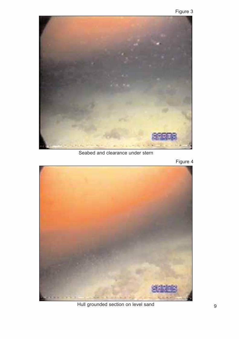
9
Seabed and clearance under stern
Figure 3
Hull grounded section on level sand
Figure 4

10
Vessel aground showing broken seabed
Figure 5
Showing keel clearance under the bow, and unbroken seabed
Figure 6

11
The divers’ report confirmed that the depth of water at the vessel’s position wasmuch less than had been charted, so that day, the master sent the UKHO ahydrographic note informing them of the uncharted shoal. The minimum depthof water found in the vessel’s position, which was reported to the UKHO,confirmed by the divers and notified to British Enterprise, was 9.6 metres.
On the same day, at 2325, a state appointed salvage master boarded the vesseland, as the 48-hour period had lapsed, the master signed a Salvage andAssistance Agreement with the General Management of Coastal Safety andSalvage Administration, a department within the Turkish Maritime Administration.
The officials then left the vessel to prepare for the salvage operation.
At 0055 on 14 December, a salvage tug was made fast to the vessel’s stern.
During the next 2 days, about 2300 tonnes of cargo and 500 tonnes of ballastwere unloaded into lightening vessels. An unsuccessful attempt was made tomanoeuvre British Enterprise clear of the shoal during the evening of 15December (see Figures 8 and 9).
Port side of hull showing broken seabed and hill
Figure 7

12
Cargo lightening operation and tug in attendence
Figure 8
Cargo lightening operation
Figure 9
The following day, a further 350 tonnes of ballast water was unloaded into slopbarges and, with the aid of tugs, and use of the engine and rudder, the vesselwas re-floated at 1510 on 16 December. The vessel was then moved and safelyanchored in an adjacent anchorage.
After British Enterprise was re-floated, VTS operators, using VHF radio, beganwarning other vessels that were intending to anchor in Charlie anchorage toavoid C5.
On 20 December 2004, the UKHO forwarded the information contained in thehydrographic note that had originated from British Enterprise to the TurkishHydrographic Organisation.
Over the 7 days following the re-floating of the vessel, the cargo was reloadedand formalities associated with the grounding and subsequent salvage werecompleted. The vessel was able to resume her passage to Agio Theodorio at2000 on 23 December 2004, 12 days after grounding.
The Turkish Hydrographic Organisation (THO), which is the only body permittedto carry out marine survey operations in Turkish waters, was requested by theTurkish Maritime Administration to conduct a survey of the anchorage areaswhich might have been affected by seismic activities since 1999, which includedthe area where British Enterprise grounded. The survey was completed, theTHO analysed the results and concluded that the differences between thecharted and the actual depth was such that they should issue a notice tomariners, to update their charts of the area.
The THO issued a notice to mariners, 19/2005, on 29 January 2005, givingdetails of the actual soundings found during the survey, and included a blockupdate for insertion onto the largest scale Turkish chart.
1.3 THE CREW
British Enterprise had a complement of 24, including the master, chief officer,three deck officers, chief engineer, four engineer officers, a deck assistant, adeck cadet, a bosun and five deck crew.
The master was the holder of a Class 1 Certificate of Competency, and hadsailed onboard tankers for many years.
1.4 VESSEL’S CERTIFICATION
The vessel’s statutory certification was inspected and found to be in order.
13

1.5 THE ISTANBUL BOGAZI
The Istanbul Bogazi is a 35-km natural deep water channel which winds its waythrough the city of Istanbul. In places, it is as little as 700 metres wide.
The channel is the only maritime passage linking the Black Sea with theMediterranean.
In 1938, the annual number of vessels passing through the straits was 4,500.Recent statistics show that 50,000 vessels now pass through the straits eachyear. This is three times the traffic using the Suez Canal and includes vesselscarrying oil, LNG, LPG and chemicals. Approximately 80 million tonnes of oiland oil products were transported through the straits in 2000. Further increasesin traffic volume are expected as oil and gas reserves in the east of the regionare further developed.
Bearing in mind the strategic importance of the waterway, and the fact that amajor casualty could have a significant detrimental effect on the environment,Turkey has taken steps to improve the safety of navigation in the area. It hasdone this by promulgating rules and regulations concerning traffic transiting thestraits, and developing a Traffic Separation Scheme that has been adopted byIMO. A Vessel Traffic Service (VTS) has recently been established.
1.6 VESSEL TRAFFIC SERVICE
The Turkish Straits Vessel Traffic Service (TSVTS) provides full coverage of boththe Istanbul Bogazi and the Canakkale Bogazi.
Istanbul Bogazi traffic is monitored using a combination of a series of fixedradars, ENC, AIS, CCTV and VHF equipment such as VHF R/T, DSC and DF(see Figures 10, 11 and 12).
Administration of the VTS is undertaken by the Director General for CoastalSafety and Salvage Administration, and the authority is the Undersecretariat forMaritime Affairs.
The VTS is in compliance with IMO Resolutions A.857(20) and A.827(19), andprovides information, navigational assistance and a traffic organisation service.
1.5 TIDES AND CURRENTS IN THE ISTANBUL BOGAZI
Tidal influence has virtually no effect on water levels in the Istanbul Bogazi andMarmara Sea. The average spring range is just 10cm.
The local Sailing Directions also state that the annual range in mean sea leveldue to meteorological pressure effects is about 5cm; exceptionally, a rise of15cm and a fall of 18cm have been recorded. Superimposed on this arevariations resulting from changes in the amount of water entering or leaving theBlack Sea of from 50cm to 1.5 metres.
14

15
Figure 10
Exterior and interior views of VTS centre
Figure 11

Strong and steady winds can exercise a considerable effect on the water level,with local rise and falls of up to 30cm being recorded.
Seiches, caused by seismic disturbance, which may be some distance away,may also occur with little or no warning, and can raise or lower the sea level byas much as 1 metre.
Very strong currents run through the Istanbul Bogazi. The predominant currentflows southward, with typical rates of 3 to 4 knots and, exceptionally, rates of 6to 8 knots may be experienced. Occasional northward flowing currents with ratesof up to 2 to 3 knots may also be experienced.
There is no evidence that suggests that any extraordinary environmental effectsinfluenced the depth of water in Ahirkapi Anchorage Area on the day of theaccident.
16
VTS system
Figure 12
1.6 THE CHART IN USE
British Enterprise, in common with numerous other vessels under many differentflags, was supplied with a United Kingdom worldwide chart outfit. The chartswere kept up-to-date by information and updates received onboard containedwithin weekly Admiralty Notices to Mariners.
British Admiralty (BA) charts and Notices to Mariners are published by theUnited Kingdom Hydrographic Office (UKHO).
The UKHO produces and maintains a worldwide chart folio system comprising amixture of charts compiled using either primary or derived data.
The UKHO charts the waters of the United Kingdom, UK overseas territories,certain Commonwealth countries and some other areas. In these areas chartsare compiled from primary data, such as hydrographic surveys and maps.
Outside these areas, derived charts are either re-compiled using the data shownon the chart produced by another hydrographic office, or are published as amodified reproduction in the familiar Admiralty style.
In recent years, as the international standardisation of charts has improved, theUKHO has been accepting into its chart series more modified reproductions ofnational charts produced by other hydrographic offices. Many benefits stem fromthis, including better chart coverage in certain areas and quicker turn roundtimes for new editions.
The UKHO and the Turkish Hydrographic Office (THO) enjoy a close workingrelationship, and many charts produced by the THO are incorporated into theUK chart series, either by re-compilation or as modified reproductions.
The chart being used on the bridge of British Enterprise, BA2286, was re-compiled from Turkish chart TR2923.
17

SECTION 2 - ANALYSIS
2.1 AIM
The purpose of the analysis is to determine the contributory causes andcircumstances of the accident as a basis for making recommendations toprevent similar accidents occurring in the future.
2.2 THE HYDROGRAPHIC HISTORY OF YE?ILK?Y BANK AND THE POSSIBLEREASONS FOR A LOCALISED REDUCTION IN WATER DEPTH
2.2.1 Survey history of Ye?ilk?y Bank
The sea of Marmara and Istanbul Bogazi have been the subject of manyhydrographic surveys by various countries throughout history.
• The Spanish surveyed the area prior to 1812.
• About the same time, the French surveyed the area.
• The area was surveyed twice in the 1850s.
• In 1879, another survey of the area was completed by the Royal Navy vesselH.M.S. Fawn, and information from this was used to compile BA2286, seeSection 2.2.2.
• The THO undertook a survey of the area in 1979, details of which wereunavailable to this investigation, and a chart was published in 1980, seeSection 2.2.2.
After the accident, THO re-surveyed the area, and issued a notice to marinerson 29 January 2005, see Section 2.2.2.
2.2.2 Chart history of Ye?ilk?y Bank
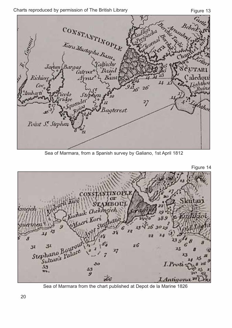
A Spanish chart of the Sea of Marmara was published in 1812, and a bankextending south of Point St. Stephen, now Ye?ilk?y, is clearly defined (seeFigure 13).
A chart from the 1830s also shows evidence of a bank extending south ofStephano Point, now Ye?ilk?y. The chart was based on a French chart of 1826,with further corrections up to 1831 (see Figure 14).
A larger scale Admiralty chart of the area (chart 2286) was published in 1882,based on the survey of 1879 (see Figure 15).
The MAIB has superimposed C5 anchorage on the 1879 survey details (seeFigure 16), and, after converting the imperial soundings to metric, the resultswere put on a plan of C5 anchorage (see Figure 17).
Figure 17 shows that in 1879 Ye?ilk?y Bank extended well into what is now C5anchorage, and showed a reported depth of water of about 11 metres at theposition where British Enterprise grounded.
18
Ye ilk y
Ye ilk y
Ye ilk y
Ye ilk y
Ye ilk y
YE ILK Y

Admiralty chart 1198 The Bosporus was published on 4 March 1905 usinginformation from the surveys conducted in 1853, 1854 and 1880 (see Figures18 and 19). Like chart 2286, published in 1882, chart 1198 is of a larger scalethan the present chart, and the bank within the anchorage area off Ye?ilk?y isshown in good detail. However, a chart of this scale does not exist today.
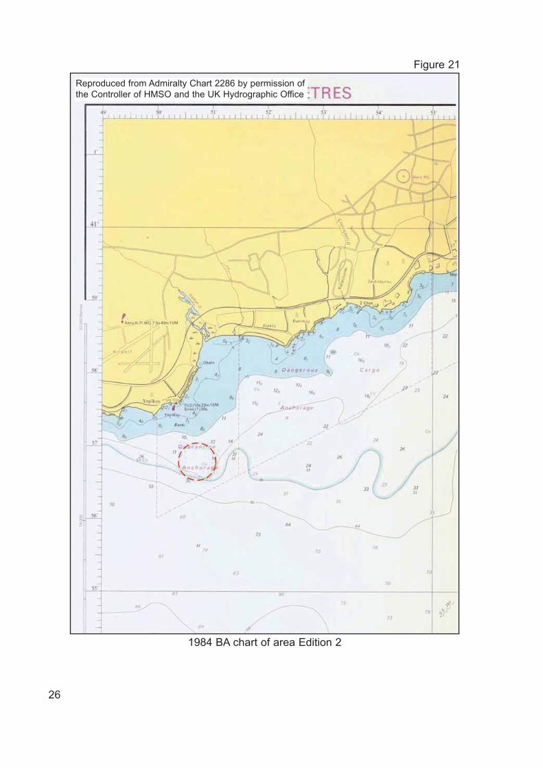
The UKHO published a new metric version of BA2286 in 1975. Figure 20shows an extract from the first edition of the 1975 chart, with C5 anchoragesuperimposed. No new British survey had been undertaken and, in accordancewith International Hydrographic Organisation (IHO) guidelines, the UKHO usedTurkish chart TR2923, which had been published between 1965 and 1971, asthe source of the latest hydrographic information.
The only evidence of the bank extending into what is now C5 anchorage is thesingle charted sounding of 10.1 metres.
In 1980, the THO published a new edition of TR2923, using data from the 1979survey. The second edition of British chart, BA2286, was published in 1984(see Figure 21), using information from this chart.
It can be seen that the 10.1 metre sounding shown on the first edition of theBritish chart is no longer marked.
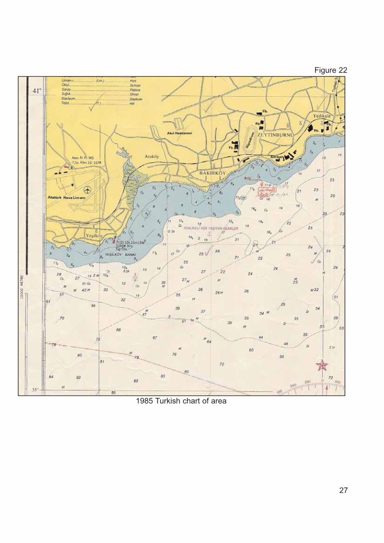
A new edition of Turkish chart TR2923 was published in 1985, and this wasused for the third edition of British chart BA2286, which was published in 1989(see Figure 22).
The UKHO published further new editions of BA2286 during the next few years,which included information from all Turkish notices to mariners, however, therewere no changes to the relevant charted soundings.
Another new edition of Turkish chart, TR2923, was published on 9 September2000. This depicted the new anchorage area south of Ye?ilk?y Light (seeFigure 23).
A sixth edition of British chart BA2286 was published on 27 March 2003. Thiswas the most recent BA chart in existence at the time of the accident.
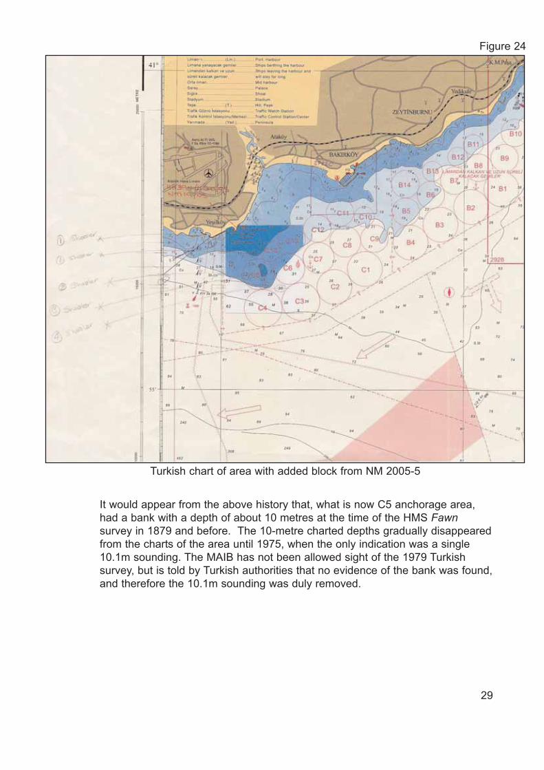
After the accident, Turkish notice to mariners 19/2005 was issued on 29January 2005, following a survey of the area by THO. The survey revealed theminimum sounding within C5 anchorage to be 6.1 metres. The notice tomariners was accompanied by a chart block correction for chart TR2923. Figure24 shows the block inserted onto the chart.
Information regarding this recent survey was received at the UKHO, and chartBA2286 was updated by Notice to Mariners 1121/2005 issued on 3 March 2005.
19
Ye ilk y
Ye ilk y
20
Sea of Marmara, from a Spanish survey by Galiano, 1st April 1812
Figure 13
Sea of Marmara from the chart published at Depot de la Marine 1826
Figure 14
Charts reproduced by permission of The British Library

21
Extract from the survey sheet (A6805) 1879 by HMS Fawn
Figure 15

22
C5 sector superimposed upon 1879 survey report(soundings in fathoms)
Figure 16

23
C5 Anchorage depths from 1879 survey(soundings in metres)
Figure 17

24
The Bosporus, chart number 1198, published March 1905, new editionNovember 1915 (soundings in fathoms)
Figure 18
C5 anchorage superimposed upon the 19th November 1915 edition of chart 1198 published 4th March 1905 (soundings in fathoms)
Figure 19
Charts reproduced by permission of The British Library

25
1975 BA chart of area Edition 1(soundings in metres)
Figure 20Reproduced from Admiralty Chart 2286 by permission of the Controller of HMSO and the UK Hydrographic Office
26
1984 BA chart of area Edition 2
Figure 21Reproduced from Admiralty Chart 2286 by permission of the Controller of HMSO and the UK Hydrographic Office
27
1985 Turkish chart of area
Figure 22

28
2000 Turkish chart of area showing Charlie anchorage area
Figure 23
It would appear from the above history that, what is now C5 anchorage area,had a bank with a depth of about 10 metres at the time of the HMS Fawnsurvey in 1879 and before. The 10-metre charted depths gradually disappearedfrom the charts of the area until 1975, when the only indication was a single10.1m sounding. The MAIB has not been allowed sight of the 1979 Turkishsurvey, but is told by Turkish authorities that no evidence of the bank was found,and therefore the 10.1m sounding was duly removed.
29
Turkish chart of area with added block from NM 2005-5
Figure 24

2.2.3 Chart scale
The scale of a chart is the ratio of a given distance on the chart to the actualdistance it represents on the earth. Charts are constructed on various scalesfrom 1:2,500 to 1:14,000,000.
Large scale charts, normally less than 1:50,000, are used for harbours,anchorages and rivers.
Coastal charts, 1:50,000 to 1:150,000, are used for inshore navigation.
Large scale charts contain much more detail, and for this reason, mariners areadvised to use the largest scale chart available for navigation.
British Admiralty chart 2286 and Turkish chart 2923 are scale 1:50,000, and arethe largest scale charts available for “Charlie” anchorage. A larger scale chartwould enable more soundings, and therefore more detail of the bottomtopography to be shown. This in turn would also facilitate more accuratenavigation, helping masters to make better informed decisions on where tosafely anchor their vessels, and also allowing the navigator more space onwhich to plot regular positions and plan the passage safely.
Taking into consideration the increased size and draught of vessels that nowtransit the Turkish Straits, and the proximity of the anchorages to the coast andlocal shoals, the MAIB believes the 1:50,000 scale to be inappropriate for thesebusy anchorages.
2.2.4 “Charlie” anchorage
When the decision was taken in the late 1990s to designate the area “Charlieflammable cargo and explosives anchorage”, a new survey was not undertaken.This was because the area had been used as an anchorage for many years andthe Turkish Hydrographic Office had not received any reports or informationregarding unreliable depths.
2.2.5 Changes to the seabed and decrease in charted water depth
In August 1999, the region suffered a strong earthquake, which resulted in majorloss of life and which caused severe damage to coastal communities in theimmediate vicinity.
Charlie anchorage is situated close to a geological fault line.
It is therefore possible that seismic activity during the 1999 earthquake alteredthe seabed to the extent the water depth was reduced to its current minimum6.1 metres depth. However, research conducted after the accident has beenunable to conclude whether this was the case.
The MAIB investigators also considered whether the bank was the result of spoildumping. This seemed possible, especially as major construction projects havebeen completed in the vicinity in recent years. No evidence could be found to
30
support this theory, and local and national authorities discounted it due to theheavy restrictions placed on dredging operations by the state in Turkish waters.Illegal spoil dumping would also be unlikely to occur undetected because of theTurkish naval units which patrol the area.
2.2.6 Conclusion
It is possible the bank had been reduced due to the effect of strong localcurrents or seismic activity between 1879 and 1979, see Section 1.7. It is alsopossible that the present bank formed after the strong earthquake in 1999, seeSection 2.2.5, or that the bank was not detected during the 1979 surveybecause of the limitations of the survey equipment then in use.
2.3 GROUNDING OF BRITISH ENTERPRISE
The draughts of British Enterprise, when departing C6 anchorage, were 10.76metres forward and 11.17 metres aft.
When assessing how British Enterprise would depart from C6 anchorage, themaster took into account the presence of other vessels which were anchored inC2 and C7 anchorages between 0.4 and 0.5 mile from his vessel.
British Enterprise was lying to a moderate northerly wind, and the masterelected to swing the vessel to port once the anchor was aweigh, rather than toswing her to starboard towards the other anchored vessels. Once the anchorwas housed, he ordered the helm to be put hard to port, and the enginerevolutions were increased to half ahead. The vessel’s bow began swinging toport, but the fact that she was loaded and the stern was being pushed up intothe wind, slowed the swing. The master elected to stop the vessel andmanoeuvre her astern before continuing the swing to port, rather than approachtoo close to the shallows ahead and inshore. The master was fully aware of thevessel’s position and the charted depth of water in the vicinity, and was allowingmore sea room to safely complete his swing to port (see Figure 25).
Once the vessel had been manoeuvred astern and the master was satisfiedwith his position, he ordered the helm to port again and the engine ahead tocontinue the swing. His intention was to cross C5 anchorage passing betweenthe 14 and 13 metre charted soundings en route to the shipping lanes.
Bearing in mind the maximum draught of the vessel was 11.17 metres, it wasconcluded that it was not unreasonable for British Enterprise to proceed throughC5 anchorage, as the vessel had a calculated under keel clearance of at least15% of her draught. The ship managers’ operational guidance was for mastersto allow an under keel clearance of 10% of the draught in the approach to ports.The master had no reason to doubt the accuracy of the charted depths in sucha busy anchorage.
The vessel grounded with little or no vibration and the master stopped theengine immediately he became aware her speed had reduced to zero. Theengineers on watch in the engine room were not aware of the situation until themaster informed them. 31

The vessel’s echo sounder was operating at the time with the forwardtransducer selected. No alarm setting had been entered and therefore thebridge team were given no warning that they were entering shallow water. In thissituation it is unlikely that an echo sounder alarm would have given the mastersufficient time to avoid the vessel grounding, however, it is good practice to usethe warning features provided on bridge instrumentation including the echosounder depth alarm.
32
Vessel manoeuvres prior to grounding
Figure 25
When the vessel grounded, the master immediately implemented the companyemergency contingency procedures, and then attempted to manoeuvre thevessel off the shoal using engine and rudder before any attempt was made tocheck the depth of water around the vessel. After about 30 minutes he realisedthe vessel was hard aground and he ordered the correct signals to be exhibited.He then reported the incident to the port state by informing the VTS.
National and international maritime rules and regulations require masters toinform the nearest coastal state immediately a vessel grounds. The master inthis case first attempted to manoeuvre his vessel clear of the shoal, and onlyinformed the VTS when he realised he was not going to be successful. Therequirement to inform immediately gives the coastal state maximum time toarrange any assistance required by the vessel and to begin to put in place anymeasures that may be required to protect the environment. Delays in informingthe coastal state may have serious consequences, and all mariners should befully aware of their obligations to inform without delay.
Once the master had informed the VTS of the grounding, he decided to beginballasting the vessel. He believed her starboard quarter was aground becauseshe appeared to be listed to port and the echo sounder indicated 2 metres ofwater under the bow. He hoped that by taking ballast forward and to port, hewould be able to refloat the vessel and manoeuvre her clear of the shoal.
In some grounding situations, it may be necessary to load ballast so as to stopthe vessel being driven harder aground or, for example, to allow more time toevacuate crew and passengers from a vessel off a dangerous shoreline. Suchaction should only be taken after sounding round and very carefully consideringall relevant factors including tide, wind, weather forecasts, nature of the seabedand the present danger to the vessel.
In British Enterprise’s situation, the decision to take ballast aggravated thesituation by grounding the vessel more heavily. Had this caused structuraldamage to the vessel, the situation would have deteriorated further. Anexamination of the chart shows that the seabed in that area consists of sand,shells, and more importantly coral. By taking ballast, and increasing thedisplacement of the vessel, there was a danger that any coral under the vesselcould have damaged the hull. The forces acting on a vessel aground aredifferent to those of a vessel afloat, and therefore care must be taken whenchanging the stability condition and weight distribution of a vessel aground soas not to inflict structural damage or worsen any damage already caused.
Subsequent actions taken by the master, officers and crew in this difficult andprotracted situation were professional and well co-ordinated. These actionsincluded informing the UKHO of the discrepancy between the actual andcharted depths which ultimately led to the publication of the Turkish notice tomariners advising other mariners of the unreported shoal in C5 anchorage.
33

2.4 PREVIOUS GROUNDINGS IN C5 ANCHORAGE
There have been at least two other groundings of vessels in C5 anchorage inrecent years:
2.4.1 Henza
The Turkish flag bulk carrier Henza, on a voyage from the Black Sea to China,laden with 63,478 metric tonnes of fertiliser, grounded in C5 anchorage on 17February 2003 (Figures 26 and 27).
34
Chart extract showing three grounded vessels
Figure 26

An investigation into the grounding was completed by the port authority. Theinvestigation concluded that, as the vessel had a maximum draught of 13.05metres, and she grounded in an area with a charted depth of between 13 and14 metres, the principal causal factors were the actions of the master and hisnavigating team. The investigation did not uncover any discrepancy betweenthe actual and charted depths, therefore no re-survey of the area was made.
The vessel was aground for more than 3 weeks while the Director General forCoastal Safety and Salvage Administration salvors discharged 8,900 tonnes ofcargo into lightening vessels to re-float her. The quantity of cargo unloadedequated to a bodily reduction in draught of about 1.43 metres, which shouldhave suggested that the actual depth of water was considerably less than wascharted.
35
Chart extract showing three grounded vessels
Figure 27

2.4.2 Marshal Vasilevskiy
The Russian flag tanker Marshal Vasilevskiy, loaded with a cargo of 52,000tonnes of heavy fuel oil, ran aground while heading on a course of 066º with herbridge in position 40º 56.965´N, 028º 50.785´E in C5 anchorage on 30November 2001 (see Figures 26 and 27). Marshal Vasilevskiy had a length of242 metres and she had overshot her intended anchoring position. The vessel’sdraught was 11.88 metres and, whereas there was no sounding indicated at theprecise grounding position, the chart gave the impression that a depth of about13 metres could be expected.
The salvage of Marshal Vasilveskiy took approximately 7 days and was carriedout by the state salvors.
The port authority investigated this accident and assessed that the cause wasclearly navigational error and therefore no further investigation, including asurvey of the seabed, were necessary. Again a valuable opportunity to identifythis uncharted shoal was missed.
2.5 REPORTING INFORMATION CONCERNING HAZARDS TO NAVIGATION
Despite two previous major groundings on the bank in C5 anchorage in recentyears, the existence of the bank was only reported after the grounding of BritishEnterprise, despite there being a discrepancy on each occasion between thevessels’ draughts and the charted depth.
A large number of ships transit the Istanbul Bogazi and use the anchorages offthe Port of Istanbul. Bearing this, and the large difference between the chartedand actual depth in C5 anchorage, in mind, it is statistically highly likely thatmasters and pilots of other vessels have become aware of the shoal but havenot reported it. They might have become aware of it after momentarilygrounding, or by having noticed an anomalous depth indication on the echosounder. Anecdotal evidence confirms this to be the case.
The International Convention for the Safety of Life at Sea SOLAS, 1974,Chapter V, Regulation 31, states that the master of every ship which meets withany of the following:
(a) Dangerous ice,
(b) A dangerous derelict,
(c) Or any other danger to navigation,
(d) Or tropical storm,
(e) Or encounters sub-freezing air temperatures associated with gale forcewinds causing severe ice accretion on superstructures,
(f) Or winds of Force 10 or above on the Beaufort scale for which no stormwarning has been received,
is bound to communicate the information by all means at his disposal toships in the vicinity, and also to the competent authority.36

There is therefore an obligation upon masters to report hazards to navigation,such as uncharted shallow water hazardous to safe navigation, to a competentauthority.
There are a number of reasons why masters (and pilots) might have elected notto report the existence of the shoal, including:
• Tankers are operated on notoriously tight schedules. Any delay is measuredin decimals of an hour and can lead to the vessel being off-hire. Mastersmight have felt pressurised not to report the incident so as not to delay theirvessel and incur penalties.
• It is possible that on realising there was no apparent damage to their vesselor risk of pollution they elected not to report the incident to avoid mediainterest and the possible reaction of the coastal state.
• It may be that masters did not wish to report an incident to protect their ownand their crews’ employment position.
• It might have been through negligence or apathy.
Whatever the reasons, the existence of the bank remained unreported for manyyears until the master of British Enterprise reported it to the UKHO. It isdisappointing and dangerous that such reports have not been made. Although itis a master’s obligation to report a hazard to navigation, any officer or crewmanwho believes inappropriate action has been taken in such a situation, maycontact confidential hazardous incident reporting bodies such as the UK’sCHIRP.
2.6 PROMULGATION OF INFORMATION CONCERNING HAZARDS TONAVIGATION
SOLAS Chapter V, regulation 4 – Navigational Warnings as amended byResolution A.706(17) states:
Each contracting government shall take all steps necessary to ensurethat, when intelligence of any dangers is received from whateverreliable source, it shall be promptly brought to the knowledge of thoseconcerned and communicated to other interested governments.
The World-Wide Navigational Warning Service was established through the jointefforts of the International Hydrographic Organisation (IHO) and theInternational Maritime Organization (IMO) to co-ordinate global services for thepromulgation of navigation warnings. These navigation warnings are used toinform mariners of dangers to navigation, and are often used to promulgateinformation prior to and while a notice to mariners is in the process of beingissued and promulgated.
37
Navigation warnings are of three types:
a) NAVAREA warnings
In the context of NAVAREA warnings, the world is divided into 16 geographicalareas. Each area has one authority designated as the area co-ordinator and ischarged with ensuring long-range navigational warnings are properly collatedand issued.
Among the subjects of such warnings would be newly discovered hazards tonavigation in or near main shipping lanes.
b) COASTAL warnings
Coastal navigation warnings are issued for newly discovered hazards tonavigation of a lesser direct importance to international shipping. They arepromulgated to vessels/stations in the sea area surrounding the hazard. Amongthe subjects of such warnings are dangerous wrecks and amended shoaldepths.
c) LOCAL warnings
Local navigation warnings are issued to supplement the coastal warning service.They usually refer particularly to inshore waters, and are often originated bycoastguard, port or pilotage authorities, and they concern events inshore of thepilotage station which do not affect coastal navigation off the port.
Once British Enterprise was successfully re-floated, the VTS operators began toadvise vessels, when they requested to provide an anchor position, to keepclear of C5 anchorage if the vessel’s draught was more than 5 metres. The localauthorities considered this was an effective method of warning mariners, asindividual vessels were directly informed and other vessels in the area wouldbecome aware of the situation when overhearing the conversation whilemonitoring the port’s radio frequency.
Apart from the warnings mentioned above, no other navigation warnings havebeen issued either by radio or Navtex concerning the uncharted shoal in C5anchorage.
A decrease in charted depth, from 13 metres to 6.1 metres, in a busy,dangerous cargo anchorage is a significant danger to navigation and theenvironment. The MAIB believes the danger to be such that at least a formallocal navigation warning, if not a coastal warning should have been issued andpromulgated.
38

2.7 PROMULGATION OF INFORMATION BETWEEN HYDROGRAPHICAUTHORITIES
The methods adopted for promulgating information between different nationalhydrographic offices varies widely. In some instances notices to marinersgenerated by one organisation are sent to all other relevant hydrographic officeswhich generate charts of the area. However, some hydrographic organisationsexpect others to monitor the notice to mariners they issue, to ensure their owncharts are kept up to date.
In this instance, the UKHO received a Hydrographic Note from BritishEnterprise, and they duly forwarded the information to the THO on 20December 2004.
After requests by the UKHO for situation updates, the THO informed the UKHOthat they were going to issue a notice to mariners with a block update to theirchart. This was issued on 29 January 2005.
A copy of all THO notice to mariners is sent to the UKHO, where they aretranslated, their content scrutinised, and the information re-promulgated as BAnotices to mariners and/or added to UK charts as necessary.
The UKHO assessed the importance of the Turkish notice, and duly issued itsown notice to mariners (1121/2005) on 3 March 2005 updating BA chart 2286.
Other national hydrographic offices and organisations also publish charts basedon the Turkish hydrographic data for the area including Russia and the UnitedStates of America. US charts were updated by notice to mariners in April 2005,but the Russian chart of the area was not corrected until 13 August 2005.
The delay before chart updates appear on working charts, highlights theimportance attached to issuing timely navigation warnings to keep marinersappraised of navigational hazards from the time that they are reported, seeSection 2.6.
39

SECTION 3 - CONCLUSIONS
3.1 SAFETY ISSUES
The following safety issues have been identified from the foregoing analysis. They arenot presented in any order of priority.
1. The seabed topography in the vicinity of C5 anchorage was either very unstableor inaccurately charted. [2.2]
2. The 1:50,000 scale of the chart covering the anchorage area did not containsufficient detail to allow masters to make informed decisions on anchoringpositions and passage planning. [2.2]
3. It is possible that recent seismic activity may partially explain the discrepancybetween charted and actual water depth. [2.2]
4. The echo sounder alarm was not active on British Enterprise as shemanoeuvred in shallow water. [2.3]
5. The master did not inform the port state as soon as the vessel ran aground. [2.3]
6. Ballast was loaded in an attempt to re-float the vessel, despite the fact thatthose onboard had little or no information concerning the nature of the seabed orhow the vessel was lying. [2.3]
7. At least two other serious groundings had occurred on the same shoal in the five years prior to this accident, yet the subsequent investigations had notdiscovered the shoal’s existence. [2.4]
8. It is highly likely that other vessels have grounded on the shoal, or detected itspresence, however, no reports of its existence had been received by competentauthorities before this accident. [2.5]
9. Neither the VTS, nor the port authority, issued a formal local or coastalnavigation warning regarding the hazard to navigation posed by the unchartedshoal in a busy anchorage within the port area. [2.6]
10. The information contained within the Turkish notice to mariners was not used toupdate Russian charts of the area until eight months after the accident. [2.7]
40
SECTION 4 - ACTION TAKEN
4.1 ACTION TAKEN BY BRITISH PETROLEUM SHIPPING LIMITED
• A note has been circulated to its fleet to remind officers to report any chartinaccuracies.
• A policy has been established that will ensure that an echo sounder display willbe sited at the front of the wheelhouse clearly visible from the main conningposition in all future new buildings.
• A cautionary note has been issued to its fleet which gives guidance with respectto ballasting a vessel that has grounded.
• Before granting permission for one of its vessels to bunker while on ladenpassage, a formal task risk assessment must be carried out by the vessel inconjunction with company marine and commercial superintendents.
• The company’s Ports and Terminals team now review Lloyd’s casualty data andother sources of industry information for any intelligence concerning navigationhazards.
4.2 ACTION TAKEN BY THE TURKISH HYDROGRAPHIC ORGANISATION(THO)
The THO has undertaken to:
• Publish a larger scale chart in 2006 covering Ahirkapi Anchorage areas offIstanbul.
41

SECTION 5 - RECOMMENDATIONS
The International Harbour Masters Association is recommended to:
2005/228 Remind its members of the importance of issuing appropriate andeffective navigation warnings after new hazards to navigation have beenreported, bearing in mind the protracted time that can elapse betweendiscovery of uncharted dangers to navigation and promulgation of theappropriate chart updates by the relevant hydrographic organisation.
The International Federation of Shipmasters’ Association and The Nautical Institute are recommended to circulate or publish a reminder to theirmembers:
2005/229 To be aware of the importance of the chart source data, its age, and likely 2005/230 accuracy when operating with limited under keel clearance or in shallow
water.
Of the obligation to report hazards to navigation, including inaccuracies inpublished charted depth, to the appropriate organisations.
Of the obligation to report to the coastal state if their vessel runs aground,as soon as practicable after the event.
To consider carefully the inherent dangers before ballasting any vesselwhich has run aground.
Marine Accident Investigation BranchDecember 2005
42
Safety recommendations shall in no case create a presumption of blame or liability