broadband mapping in slovenia - itu.int · geoportal enables users quick insight to the various...
TRANSCRIPT

AKOS GEOportal
Broadband mapping in Slovenia
Marko Simončič

Short introduction of mapping
History and background of mapping in Slovenia
Legal background
Presentation of AKOS GEOportal
Questions and discussion?

• 1974 - Land Cadastre Act
– Data on public infrastructure networks and facilities were collected
– Managed for territory of municipalities by a local surveying authority
– Data were not properly maintained and data were incomplete
– Used mainly for the needs of local communities
• 1991- After gaining independence, Slovenia started to redesign the entire legal system.
• 2002 - The Spatial Planning Act was adopted
• 2004 – Slovenian Surveying and Mapping Authority started with the development of the centraldatabase, called consolidated cadastre of public infrastructure,
• 2006 - Real Estate Records Act
• 2012 – The Information Society Directorate in coorporation with AKOS and mapping authority startedwith mapping process of Network termination points,
• December 2013 – Based on Electronic Communications Act, AKOS issued General act on entry, collection and access to data on Network termination points,
• 2015 – AKOS establish its own database:
March 2015 – AKOS published the first public tender for consulting services
June 2015 – Project group to launch a mapping project was appointed and project was launched
Key milestons in BB mapping

6/27/2019 4
AKOS mapping
AKOS established its own database which includes several publicaly available databases andnon-public databases in order to get complete picture of the networks coverage and
availability in Slovenia. (Decree on the provision and re-use of public information)
BASIC DATA:
• Consolidated cadastre of public infrastructure (PUBLIC)
• Network termination points database (PUBLIC)
ADDITIONAL:
• Register of spatial units (PUBLIC)
• AJPES business register (PUBLIC)
• The building cadastre (PUBLIC)
• Central population register (NON-PUBLIC)
AKOS:
• Retail mapping (prices, technologies, speed, services – 100m grid)
• Wholesale mapping (prices, technologies, services – 100m grid)

Article 14 of Electronic Communications Act (ZEKom-1)(entry in the register)
The owner of a communications network and associated infrastructure must supply information directly to thebody responsible for surveying and mapping (GURS).
Data about locations, type, usage, including number of communications lines (optic fibre, copper pair, coaxialcable) and capacity.
Publically available dataEvery amendment to this information shall be reported to the competent body within three months of its
occurrence.
Article 15 of Electronic Communications Act (ZEKom-1)(supervision)
The Agency shall oversee the implementation of the provisions of this Chapter and of the regulations and actsissued pursuant thereto, and cooperate with the inspectorate responsible for construction in doing so.
The Agency has a possibility to act as a supervisor whether the input data is reported or not and if the data iscorrect.
The fine for the medium or large firm (in case they don‘t report data) is from 50.000 - 400.000 €.
Legal background - ECA

Technical parameters – open source policy

The main purpose of the AKOS Geoportal is to reduce the cost of building very high-speed networks (VHCN)and to encourage sharing and joint construction.
AKOS geoportal allows public access to AKOS data and provide access tothe data that has not been accessible so far in one place. Main goals of providing these data are related to higher transparency of operation and proactive publication of spatial information.
AKOS GEOportal purpose

New options for public
Geoportal enables users quick insight to the various types of electronic communications infrastructure and their descriptive data, the results of analysis and associated spatial layers,
To review fixed and mobile networks coverage,
The information displayed in the geoportal enables users to compareproviders and options for electonic communication network access for every address in Slovenia,
New options for showing spatial analysis results
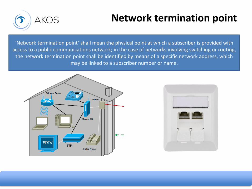
Network termination point
‘Network termination point’ shall mean the physical point at which a subscriber is provided with access to a public communications network; in the case of networks involving switching or routing,
the network termination point shall be identified by means of a specific network address, which may be linked to a subscriber number or name.

Technology Household Type of objectsLocation/address Owner Minimum speed Connection
Network termination point

Electronic communications
Electronic communications - points, lines, polygons (electronic communication network are transmission systems and other sources that allow the transmission of signals by wire, radio waves,
optical or other electromagnetic means, including satellite networks, fixed and mobile terrestrial networks, electrical cable systems , if they are used for transmission of signals, networks used for
radio and television broadcasting and cable television networks regardless of the type of information transmitted)

Type of object Position of line Type of line Owner Accuracy
Network termination point

Fixed broadband coverage (by speed)
Category Speed(mbps)
Households(%)
1. Category < 30 98,74
2. Category 30 < 100 89,41
3. Category > 100 80,45
Methodology: - 200m grid cell (homes passed definition)- At least one household with NTP in one cell
Input data: - cadastre of building, Central population register (households), Network termination points database

Mobile coverage (by technology)
Technology Territorialcoverage
Householdscoverage (%)
3G 99 99,97
4G 97 99,25
Methodology: - 25m grid cell- Calculation made in ATDI (ICS Telecom EV)- Model ITU-R P.1812-4- This propagation prediction method takes account of the following model elements: – line-of-sight (LoS) – diffraction (embracing smooth-Earth, irregular terrain and sub-path cases) – tropospheric scatter– anomalous propagation (ducting and layer reflection/refraction) – height-gain variation in clutter– location variability– building entry losses (from Recommendation ITU-R P.2040).
Input data:• Radio terminals• The frequency• Percentage time• locations• Terrain profile• Radio-climatic zones• Terminal distances from the coast• Basic radio-meteorological parameters• Incidence of ducting• Effective Earth radius• Parameters derived from the path profile
analysis

Drive tests – base stations and measurement of the strength of mobile signals on the road network
Simulation + measurements
Drive tests

Intentions on planned construction(telecommunications, electricity, gas, water supply, sewage, roads, railways and other infrastructures)
Intentions on planned construction
Investor Type of investition Description of investitionYear of intention Link to the intention

27. 06. 2019
Intentions on planned construction –dedicated portal

Geoportal enables the production of a printable map in PDF format.
Map consists of currently displayed layers with the current view and scale.
Printable map - pdf

Search by exact address enables usersclose up view of the location, NTFsshows type of communicationtechnology on the building address.
Search by exact address

Geoportal allows users to make quickwebsite analysis. Analysis can be make on two spatial levels: municipality andsettlement. User can get data for choosenterritory on:
Investors: name of the owner/operator of the communication network and typeof NTPs
Type of NTPs: copper, cable, optical, wireless, other
Minimum capacity: number of NTPs byminumum capacity
Fast web analysis

Geoportal content is now regularly updated (implementation of WFS for all data).
The results of different analysis could be published in a manner of transperency of callculation andmethodology review (e.g. geographical segmentation).
We plan to improve the user interface and presentation of spatial layers with descriptive data of the geoportal for even better user experience.
New set of data: network incidents, end users dipute, postal contact points, etc.
Future plans

Thank you for your attention
https://gis.akos-rs.si/