brownhill creek recreation park management plan · brownhill creek recreation park management plan...
TRANSCRIPT

Mount Lofty Ranges
June 2003
Brownhill Creek Recreation ParkManagement Plan

Cultural richness and diversity are the marks of a great society. It is these qualities that are basic to ourhumanity. They are the foundation of our value systems and drive our quest for purpose and contentment.
Cultural richness embodies morality, spiritual well-being, the rule of law, reverence for life, human achievement,creativity and talent, options for choice, a sense of belonging, personal worth and an acceptance of responsibilityfor the future.
Biological richness and diversity are, in turn, important to cultural richness and communities of people. When acommunity ceases to value and protect its natural landscapes, it erodes the richness and wholeness of its culturalfoundation.
In South Australia, we are privileged to have a network of parks, reserves and protected areas that continue toserve as benchmarks against which we can measure progress and change brought about by our society. They arestorehouses of nature’s rich diversity, standing as precious biological and cultural treasures. It is important torealise that survival of species in ‘island’ reserves surrounded by agriculture or urban areas is uncertain, and thathabitat links between reserves are essential for their long-term value as storehouses.
As a result of more than a century of conserving nature and cultural items, we possess a “legacy” which is worthpassing on to future generations.
There are twelve essentials for the protection of our park environments:
� Recognition that a primary purpose of our national parks system is to conserve the wide diversity of SouthAustralia’s native plants and animals and to improve their chances of survival through active wildlifemanagement.
� Recognition that all our parks also protect cultural legacy of relevance to both Indigenous and Non-indigenous people, and that Indigenous people have had cultural association with this land over manythousands of years.
� Freedom to improve our legacy by making additions to the park system -- enhancing existing protectedareas and including landscapes and environments containing native plant and animal communities notalready protected.
� Realisation that the continuance of our native species cannot be dependent upon island reserves alone butshould be provided for in a regional landscape with linkages between natural areas to enhance the prospectof long-term survival.
� Recognition that there is potential for new and useful substances or genetic material to be found in nativeplant and animals.
� Recognition of economic and social benefits for local communities, which arise from the presence of nationalparks in their region and the consequent opportunities to offer service for visitors.
� Development of close relationships with the community, so that there is an understanding of the role ofparks in conserving native wildlife, cultural items and in providing recreational opportunities.
� Promotion of community participation in making decisions on the management of parks, so that a sense ofcommunity ownership of the reserve system may be fostered, and so that parks and surrounding landscapesare managed in harmony.
� Appreciation that those qualities presented to visitors for their use and enjoyment in parks, should be thediversity of plants, animals and landscapes for which the parks were set aside.
� Understanding that development in a park should proceed where it :� contributes to the conservation of the environment;� provides for better appreciation of the need to conserve the diversity of plants and animals;� protects wildlife habitats and landscape (especially Vulnerable and threatened species or
communities); and� is necessary for management of the park.
� Reassurance, in support of our cultural character, that natural areas can survive even though those who caredeeply for their survival may never visit them.
� Provision of valued natural areas for people to be at one with nature and for personal and spiritualrefreshment.
Our Parks, Our Heritage, Our Legacy

BROWNHILL CREEK RECREATION PARKMANAGEMENT PLANMount Lofty Ranges South Australia
June 2003
Department for Environment and Heritage

This plan of management has been preparedand adopted in pursuance of Section 38 of theNational Parks and Wildlife Act 1972.
Government of South Australia
Published by the Department for Environment and Heritage, Adelaide,Australia
� Department for Environment and Heritage, June 2003
ISBN : 0 7590 1072 2
Prepared by Reserve Planning, Department for Environment andHeritage.
Cartography by Reserve Planning, Department for Environment and Heritage
Cover Photo: Monarch of the Glen, courtesy of Carla O’Neill
This document may be cited as “Department for Environment and Heritage(2003) Brownhill Creek Recreation Park Management Plan, Adelaide, SouthAustralia.”

Brownhill Creek Recreation Park Management Plan
FOREWORDBrownhill Creek Recreation Park has long been cherished by South Australian’s and as one of ourStates oldest park’s, it is rich with cultural heritage.
Located in the foothills of the Mount Lofty Ranges and on the doorstep of the urban environment,Brownhill Creek offers a valuable recreation resource for many local residents and visitors, providingopportunities for bushwalking, picnicking and camping.
The park is renowned for its extensive cultural heritage and visitors can enjoy exploring the manyrelics of the park, including the ‘Monarch of the Glen’, an estimated 300 year old River Red Gum,significant to the Kaurna Aboriginal people and used as a make shift home by many colonial settlers.
The park is also famous for the State Heritage Registered manure pits, built in 1891 to preventpollution of the creek when the valley was used for market gardening.
Management intends to balance recreation and tourism with biodiversity conservation and thepreservation and restoration of cultural heritage sites. The management objectives for BrownhillCreek Recreation Park have not been prepared in isolation, but rather in consultation with otheragencies and community groups.
The plan of management for Brownhill Creek Recreation Park is now formally adopted under theprovisions of section 38 of the National Parks and Wildlife Act, 1972.
JOHN HILL
MINISTER FOR ENVIRONMENT AND CONSERVATION
i

Brownhill Creek Recreation Park Management Plan
ii
SYNOPSISThis is the management plan for Brownhill Creek Recreation Park, one of Adelaide’s oldest parks,located in the foothills of the Mount Lofty Ranges and officially set aside as a reserve for recreationpurposes in 1858. The 51 ha park was first dedicated a National Pleasure Resort in 1915 and laterproclaimed a Recreation Park under the National Parks and Wildlife Act 1972 to conserve remnantriver red gums and riparian zone habitat. The park contains 27 plant species of conservationsignificance, including 5 at State level and provides habitats for resident fauna species, includingpossums, bats and kookaburras.
In addition to important natural resources, Brownhill Creek has extensive cultural heritage, includingAboriginal cultural heritage sites and sites remaining from its mining and market gardening past.
The park attracts approximately 30–40,000 visitors each year with recreation opportunities includingwalking trails, picnic areas, horse-riding, historic sites and a caravan park with refreshment facilities.
Identified threatening processes include extensive weed infestations throughout the creek and ongoingpressure on soil and vegetation from visitors and vehicles. The park’s historic relics are also in needof restoration and protection.
To achieve the major objectives within the plan the following key actions are recommended:
� Identify existing areas of erosion and undertake remedial work that includes natural regeneration,revegetation and pest plant removal, in accordance with the Brownhill Creek Recreation ParkVegetation Management Plan (Kinnear et al 2001); and
� Restore and protect known or newly discovered cultural and historic sites, using appropriatemeasures, and monitor site condition.
� Opportunities exist to create partnerships between State and Local Government and thecommunity in the management of the reserve.
� Investigate the suitability of including land in allotment 83 in the hundred of Adelaide, onceintended for inclusion in the Brownhill Creek National Pleasure Resort, but omitted fromBrownhill Creek Recreation Park.

Brownhill Creek Recreation Park Management Plan
iii
TABLE OF CONTENTSFOREWORD ........................................................................................................................................... iSYNOPSIS.............................................................................................................................................. ii1 INTRODUCTION ........................................................................................................................... 12 MANAGEMENT FRAMEWORK.................................................................................................. 2
2.1 Park Classification .................................................................................................................... 32.2 Government Policy and Legislation ......................................................................................... 32.3 Native Title ............................................................................................................................... 42.4 Environment Protection and Biodiversity Conservation Act 1999........................................... 4
3 MANAGEMENT CONTEXT......................................................................................................... 63.1 Purpose of Reserve ................................................................................................................... 63.2 Location and General Description ............................................................................................ 6
3.2.1 Climate .............................................................................................................................. 63.3 Regional Setting........................................................................................................................ 93.4 History of Reserve Management ............................................................................................ 113.5 Existing Management Arrangements...................................................................................... 123.6 Management Philosophy & Strategic Directions.................................................................... 13
4 MANAGEMENT PRESCRIPTION.............................................................................................. 144.1 Zoning..................................................................................................................................... 144.2 Natural Resources................................................................................................................... 16
4.2.1 Geology, Soils and Landform.......................................................................................... 164.2.2 Hydrology........................................................................................................................ 174.2.3 Native Vegetation............................................................................................................ 184.2.4 Native Fauna.................................................................................................................... 194.2.5 Introduced Plants ............................................................................................................. 214.2.6 Introduced Animals ......................................................................................................... 24
4.3 Cultural Heritage .................................................................................................................... 254.3.1 Aboriginal Heritage ......................................................................................................... 254.3.2 Colonial Heritage ............................................................................................................ 27
4.4 Fire Management .................................................................................................................... 294.5 Recreation and Tourism.......................................................................................................... 30
4.5.1 Visitor Use....................................................................................................................... 304.5.2 Vehicle Access ................................................................................................................ 304.5.3 Walking and Multi-Use Trails......................................................................................... 314.5.4 Horse-Riding and Horse Arena ....................................................................................... 344.5.5 Day Visit Areas ............................................................................................................... 354.5.6 Interpretive Information .................................................................................................. 35
4.6 Commercial Activities and Other Landuse............................................................................. 364.6.1 Caravan Park and Campground....................................................................................... 364.6.2 Electricity, Telecommunications and Water ................................................................... 37
4.7 Management Arrangements.................................................................................................... 374.7.1 Partnerships and Cooperative Management .................................................................... 374.7.2 Community and Volunteer Involvement ......................................................................... 38
4.8 Future Directions .................................................................................................................... 394.8.1 Additional Land............................................................................................................... 39
5 SUMMARY OF MANAGEMENT ACTIONS............................................................................. 426 REFERENCES AND BIBLIOGRAPHY ...................................................................................... 50APPENDIX A : LEGISLATION, CONVENTIONS AND AGREEMENTS ...................................... 51APPENDIX B : LAND TENURE HISTORY ...................................................................................... 52APPENDIX C : BROWNHILL CREEK RECREATION PARK – NATIVE PLANTS ..................... 54APPENDIX D : BROWNHILL CREEK RECREATION PARK – INTRODUCED PLANTS .......... 57APPENDIX E : BROWNHILL CREEK RECREATION PARK – NATIVE BIRDS ......................... 60APPENDIX F : CONSERVATION STATUS CODES........................................................................ 61

Brownhill Creek Recreation Park Management Plan
iv
LIST OF FIGURESFigure 1: Location ................................................................................................................................... 5
Figure 2: Features .................................................................................................................................... 7
Figure 3: Zoning .................................................................................................................................... 15
Figure 4: Proposed Multi-Use Trail....................................................................................................... 33
Figure 5: Additional Land ..................................................................................................................... 41
LIST OF TABLESTable 1: Native Mammal Species.......................................................................................................... 20
Table 2: Native Bat Species .................................................................................................................. 20
Table 3: Proclaimed Plants .................................................................................................................... 22
Table 4: Non-indigenous Planted Species ............................................................................................. 23
Table 5: Introduced Animal Species ..................................................................................................... 24
ABBREVIATIONS AND GLOSSARY OF TERMSALRM: Aboriginal Legal Rights Movement
DEH: The Department for Environment and Heritage
DEHAA: The (former) Department for Environment, Heritage and Aboriginal Affairs
DENR: The (former) Department of Environment and Natural Resources
DAARE: The Department for Aboriginal Affairs and Reconciliation
GIS: Geographic Information System
IBRA: Interim Biogeographic Regionalisation for Australia
IUCN: The International Union for Conservation of Nature and Natural Resources (TheWorld Conservation Union)
PCWMB: Patawalonga Catchment Water Management Board
ACKNOWLEDGEMENTSThis plan of management was compiled by staff of the Adelaide Region and the Reserve PlanningUnit, Department for Environment and Heritage. Valuable assistance received at various times fromother groups and individuals who provided information or comments is also acknowledged, includingthe Friends of Brownhill Creek, Brownhill Creek Association, City of Mitcham, Maggie Ragglessfrom the Mitcham Heritage Research Centre and the Patawalonga Catchment Water ManagementBoard.

Brownhill Creek Recreation Park Management Plan
1
1 INTRODUCTIONThis management plan has been prepared in accordance with the National Parks and Wildlife Act1972.
Section 38 of the Act states that a management plan is required for each reserve. A management planshould set forth proposals in relation to the management and improvement of the reserve and themethods by which it is intended to accomplish the objectives of the Act in relation to that reserve.
Upon completion of a draft plan an announcement is made in the Government Gazette and the plan isplaced on public exhibition for three months. During this period, any interested person may makesubmissions which are then referred, with the plan, to the South Australian National Parks andWildlife Council for their comments and suggestions. Submissions must be in writing; e-mailsubmissions are acceptable.
Having formal community input into public land management is a requirement of the legislation andsupported by park managers. The draft plan for Brownhill Creek Recreation Park was released forpublic exhibition in January 2002. At the close of the comment period, 132 submissions had beenreceived.
Issues raised in submissions included concerns regarding road safety and maintenance, support for theaddition of Allotment 83 which adjoins the park, corrections/addenda to species lists, historical andcultural content, both concerns and support for the development of a multi-use trail and theappropriateness of the horse arena. All these concerns were considered by the Sturt ConsultativeCommittee before going to the SA National Parks and Wildlife Council.
The Minister, after considering all representations, may then adopt the management plan with orwithout alterations. In the case of the plan for Brownhill Creek Recreation Park, a number ofalterations have been incorporated as a result of the community consultation process. Notice ofofficial adoption is published in the Government Gazette and copies of the final plan are madeavailable for sale to the public. They may also be viewed on the departmental website http://www.environment.sa.gov.au/parks/management_plans.html.
Once a plan of management is adopted, its provisions must be carried out in relation to the reserve inquestion and no actions undertaken unless they are in accordance with the plan. However, the Actdoes make provision for amending adopted plans and this process is similar to the one describedabove.
This document is the adopted management plan for Brownhill Creek Recreation Park. The reserve islocated on the foothills of the Mount Lofty Ranges, which falls within the Adelaide Region of theDepartment for Environment and Heritage. The plan outlines proposals to effectively conserve thenatural and cultural values of the parks, while providing for public use and enjoyment.

Brownhill Creek Recreation Park Management Plan
2
2 MANAGEMENT FRAMEWORKManagement planning is a statutory requirement for all reserves prescribed in S38 of the NationalParks and Wildlife Act 1972 and S31 of the Wilderness Protection Act 1992. The managementplanning process is but a small part of a much larger, state-wide hierarchy of management. This isdirected from the highest level by state government policies and departmental priorities andimplemented, on a day to day basis, at a regional and district level.
Management plans provide a ministerially endorsed and legally binding framework for the use andmanagement of National Parks and Wildlife Act reserves. They are intended to accommodateanticipated trends and community aspirations over a five to ten year time frame. The legislationanticipates that management plans will be formally reviewed from time to time, but there are noprescribed time limits for this to occur.
DEH regional staff have been assigned primary responsibility for preparing management plans andundertaking the associated community consultation process. A standard management planningprocess is mandated, to ensure that all statutory obligations are met.
Management plans define what is considered acceptable activity in a reserve while still allowing parkmanagers some flexibility in day to day decision-making. They should be proscriptive enough toprevent deleterious activities, or inappropriate developments, taking place. They are not intended tobe comprehensive compendiums of resource information, nor are they heavily prescriptive actionstatements; other documentation covers those aspects. They do however, identify the key values ofreserves, the appropriate utilisation and the major issues of concern requiring action, thereby providingthe community (and park managers) with a blue-print of how public land is going to be used andmanaged.
Management plans often foreshadow the preparation of ‘delegate’ plans to achieve the proposedobjectives. Delegate plans are detailed, non-statutory action plans that provide additional details onhow the actions, listed in the management plan, are to be progressed. With regard to Brownhill CreekRecreation Park, a Vegetation Management Plan had been produced and the development of a HorseRiding Code of Practice and a Trail Plan are proposed. Although such in-house action plans are notsubject to the same statutory processes as are formal management plans, DEH will continue to involverelevant stakeholders, other agencies and community groups in their preparation and implementationas part of the on-going management of the park.
Each year park managers, taking regional and district priorities into account, draw up work programsto implement some of the actions proposed in management plans. Whether these projects are actuallyundertaken is determined by, and subject to, the availability of resources (eg staffing and funding) andto any requirements of the Minister for Environment and Conservation and the department’s ChiefExecutive, who take a state-wide overview in setting departmental priorities and allocating resources.

Brownhill Creek Recreation Park Management Plan
3
2.1 Park ClassificationParks are established for the conservation of biodiversity and cultural heritage and the environmentallyresponsible use of our natural resources. The classification of parks provides a general statement ofpurpose for which the area was acquired.
Classifications under the National Parks and Wildlife Act 1972, the Crown Lands Act 1929 or theWilderness Protection Act 1992 are as follows:
Recreation Parks (RP) - areas of significance under the National Parks and Wildlife Act, managed forpublic recreation and enjoyment in a natural setting;
National Parks (NP) - areas proclaimed under the National Parks and Wildlife Act considered to be ofnational significance due to wildlife, natural features of the land or cultural heritage;
Conservation Parks (CP) - areas under the National Parks and Wildlife Act that are protected for thepurpose of conserving wildlife or the natural or historic features of the land, where the development ofvisitor facilities tends to be kept to a minimum;
Game Reserves (GR) - areas set aside under the National Parks and Wildlife Act for the conservationof wildlife and the management of game at prescribed times for controlled seasonal hunting;
Regional Reserves (RR) - areas proclaimed under the National Parks and Wildlife Act for the purposeof conserving wildlife or natural or historical features while allowing responsible use of the area'snatural resources (ie. mining);
Conservation Reserves (CR) - land currently set aside for conservation of natural and cultural featuresunder the Crown Lands Act 1929 and held under the care, control and management of the Minister forEnvironment, that for various reasons were not proclaimed under the National Parks and Wildlife Act,1972;
Wilderness Protection Areas (WPA) - land set aside under the Wilderness Protection Act 1992 toprotect natural and remote areas.
2.2 Government Policy and LegislationWhen managing reserves, DEH is required under section 37 of the National Parks and Wildlife Act tohave regard to, and provide actions that are consistent with the following objectives stated in the Act:� preservation and management of wildlife;
� preservation of historic sites, objects and structures of historic or scientific interest withinreserves;
� preservation of features of geological, natural or scenic interest;
� destruction of dangerous weeds and the eradication or control of noxious weeds and exotic plants;
� control of vermin and exotic animals;
� control and eradication of disease of animals and vegetation;
� prevention and suppression of bush fires and other hazards;
� encouragement of public use and enjoyment of reserves and education in, and a properunderstanding and recognition of, their purpose and significance; and
� generally, the promotion of the public interest.
Additional legislation, conventions and agreements, DEH is obliged to comply with are listed inAppendix A.

Brownhill Creek Recreation Park Management Plan
4
2.3 Native Title “Native Title” is used to describe the interests Aboriginal and Torres Strait Islander People have inland and waters according to their traditional laws and customs. Federal legislation, the Native TitleAct 1993, was enacted to:� provide for the recognition and protection of native title;� establish ways in which future dealings affecting native title may proceed and to set standards for
those dealings;� establish a mechanism for determining claims to native title; and � provide for, or permit, the validation of past acts, and intermediate period acts, invalidated
because of the existence of native title.
Any development proposed for a reserve must be valid in terms of the Native Title Act 1993.
This reserve is subject to a claim for a determination of native title by the Kaurna People. A‘determination’ is a decision made by the courts as to who holds native title for an area.
This management plan is released and will be adopted subject to any native title rights and intereststhat may continue in relation to the land and/or waters. Nothing in the management plan is intended toaffect native title. Before undertaking any future acts that might affect native title, DEH will followthe relevant provisions of the Native Title Act 1993.
However, in addition to the requirements of native title legislation, DEH is committed to developingpartnerships with Aboriginal people. This may include a number of native title and Aboriginalheritage groups.
Consistent with South Australian Government policy, DEH is also keen to pursue Indigenous LandUse Agreements (ILUAs) where appropriate. ILUAs are voluntary agreements between a native titlegroup and other people about the use and management of land and/or waters.
2.4 Environment Protection and Biodiversity Conservation Act 1999The Environment Protection and Biodiversity Conservation Act 1999 (EPBC Act) represents afundamental reform of former Commonwealth environment laws. The Act establishes a newCommonwealth approval process for assessment of proposed actions that are likely to have asignificant impact on matters of national environmental significance and provides an integrated systemfor biodiversity conservation and management of important protected areas.
Matters that require assessment and approval of proposed actions under the EPBC Act 1999 are:
� any action that has, will have or is likely to have a significant impact on the following identifiedmatters of national environmental significance:� World Heritage properties � Listed migratory species� Ramsar wetlands of international significance � Commonwealth marine areas � Nationally listed threatened species and
ecological communities� Nuclear actions (including uranium
mining)� any activity involving Commonwealth land that has, will have, or is likely to have a significant
impact on the environment.
With regard to Brownhill Creek Recreation Park, the Southern Brown Bandicoot (Isoodon obesulus),is the only currently listed nationally threatened species that occurs in the park. Commonwealthapproval is required for any action that has, will have or is likely to have a significant impact on thisnationally threatened species in addition to any State approval that may be required.
Furthermore, in consultation with relevant State authorities, the Commonwealth Minister for theEnvironment and Heritage may develop and implement recovery plans and threat abatement plans forthreatened species and ecological communities listed under the EPBC Act. Where applicable, DEHshould contribute to and incorporate these plans into park management regimes and operationalprocedures.

MITCHAMMITCHAMMITCHAMMITCHAMMITCHAMMITCHAMMITCHAMMITCHAMMITCHAM
UNLEYUNLEYUNLEYUNLEYUNLEYUNLEYUNLEYUNLEYUNLEY
NORTON SUMMITNORTON SUMMITNORTON SUMMITNORTON SUMMITNORTON SUMMITNORTON SUMMITNORTON SUMMITNORTON SUMMITNORTON SUMMIT
MODBURYMODBURYMODBURYMODBURYMODBURYMODBURYMODBURYMODBURYMODBURY
HAPPY VALLEYHAPPY VALLEYHAPPY VALLEYHAPPY VALLEYHAPPY VALLEYHAPPY VALLEYHAPPY VALLEYHAPPY VALLEYHAPPY VALLEY
CLARENDONCLARENDONCLARENDONCLARENDONCLARENDONCLARENDONCLARENDONCLARENDONCLARENDON
KANGARILLAKANGARILLAKANGARILLAKANGARILLAKANGARILLAKANGARILLAKANGARILLAKANGARILLAKANGARILLA
NORTH ADELAIDENORTH ADELAIDENORTH ADELAIDENORTH ADELAIDENORTH ADELAIDENORTH ADELAIDENORTH ADELAIDENORTH ADELAIDENORTH ADELAIDE
MARIONMARIONMARIONMARIONMARIONMARIONMARIONMARIONMARION
HALLET COVEHALLET COVEHALLET COVEHALLET COVEHALLET COVEHALLET COVEHALLET COVEHALLET COVEHALLET COVE
REYNELLAREYNELLAREYNELLAREYNELLAREYNELLAREYNELLAREYNELLAREYNELLAREYNELLA
HACKHAMHACKHAMHACKHAMHACKHAMHACKHAMHACKHAMHACKHAMHACKHAMHACKHAM
PORT ADELAIDEPORT ADELAIDEPORT ADELAIDEPORT ADELAIDEPORT ADELAIDEPORT ADELAIDEPORT ADELAIDEPORT ADELAIDEPORT ADELAIDE
SEACLIFFSEACLIFFSEACLIFFSEACLIFFSEACLIFFSEACLIFFSEACLIFFSEACLIFFSEACLIFF
PORT NOARLUNGAPORT NOARLUNGAPORT NOARLUNGAPORT NOARLUNGAPORT NOARLUNGAPORT NOARLUNGAPORT NOARLUNGAPORT NOARLUNGAPORT NOARLUNGA
LONSDALELONSDALELONSDALELONSDALELONSDALELONSDALELONSDALELONSDALELONSDALE
HENLEY BEACHHENLEY BEACHHENLEY BEACHHENLEY BEACHHENLEY BEACHHENLEY BEACHHENLEY BEACHHENLEY BEACHHENLEY BEACH
666666666333333333
kilometreskilometreskilometreskilometreskilometreskilometreskilometreskilometreskilometres
000000000
AdelaideAdelaideAdelaideAdelaideAdelaideAdelaideAdelaideAdelaideAdelaide
O’Halloran Hill (RP)O’Halloran Hill (RP)O’Halloran Hill (RP)O’Halloran Hill (RP)O’Halloran Hill (RP)O’Halloran Hill (RP)O’Halloran Hill (RP)O’Halloran Hill (RP)O’Halloran Hill (RP)
Sturt Gorge (RP)Sturt Gorge (RP)Sturt Gorge (RP)Sturt Gorge (RP)Sturt Gorge (RP)Sturt Gorge (RP)Sturt Gorge (RP)Sturt Gorge (RP)Sturt Gorge (RP)
Marino (CP)Marino (CP)Marino (CP)Marino (CP)Marino (CP)Marino (CP)Marino (CP)Marino (CP)Marino (CP)
Hallett Cove (CP)Hallett Cove (CP)Hallett Cove (CP)Hallett Cove (CP)Hallett Cove (CP)Hallett Cove (CP)Hallett Cove (CP)Hallett Cove (CP)Hallett Cove (CP)
Fort Glanville (CP)Fort Glanville (CP)Fort Glanville (CP)Fort Glanville (CP)Fort Glanville (CP)Fort Glanville (CP)Fort Glanville (CP)Fort Glanville (CP)Fort Glanville (CP)
Anstey Hill (RP)Anstey Hill (RP)Anstey Hill (RP)Anstey Hill (RP)Anstey Hill (RP)Anstey Hill (RP)Anstey Hill (RP)Anstey Hill (RP)Anstey Hill (RP)
Scott Creek (CP)Scott Creek (CP)Scott Creek (CP)Scott Creek (CP)Scott Creek (CP)Scott Creek (CP)Scott Creek (CP)Scott Creek (CP)Scott Creek (CP)
Onkaparinga River (RP)Onkaparinga River (RP)Onkaparinga River (RP)Onkaparinga River (RP)Onkaparinga River (RP)Onkaparinga River (RP)Onkaparinga River (RP)Onkaparinga River (RP)Onkaparinga River (RP)
Onkaparinga River (NP)Onkaparinga River (NP)Onkaparinga River (NP)Onkaparinga River (NP)Onkaparinga River (NP)Onkaparinga River (NP)Onkaparinga River (NP)Onkaparinga River (NP)Onkaparinga River (NP)
Kenneth Stirling (CP)Kenneth Stirling (CP)Kenneth Stirling (CP)Kenneth Stirling (CP)Kenneth Stirling (CP)Kenneth Stirling (CP)Kenneth Stirling (CP)Kenneth Stirling (CP)Kenneth Stirling (CP)
Morialta (CP)Morialta (CP)Morialta (CP)Morialta (CP)Morialta (CP)Morialta (CP)Morialta (CP)Morialta (CP)Morialta (CP)
Horsnell Gully (CP)Horsnell Gully (CP)Horsnell Gully (CP)Horsnell Gully (CP)Horsnell Gully (CP)Horsnell Gully (CP)Horsnell Gully (CP)Horsnell Gully (CP)Horsnell Gully (CP)
Montacute (CP)Montacute (CP)Montacute (CP)Montacute (CP)Montacute (CP)Montacute (CP)Montacute (CP)Montacute (CP)Montacute (CP)
Mount George (CP)Mount George (CP)Mount George (CP)Mount George (CP)Mount George (CP)Mount George (CP)Mount George (CP)Mount George (CP)Mount George (CP)
Cleland (CP)Cleland (CP)Cleland (CP)Cleland (CP)Cleland (CP)Cleland (CP)Cleland (CP)Cleland (CP)Cleland (CP)
Shepherds Hill (RP)Shepherds Hill (RP)Shepherds Hill (RP)Shepherds Hill (RP)Shepherds Hill (RP)Shepherds Hill (RP)Shepherds Hill (RP)Shepherds Hill (RP)Shepherds Hill (RP)
Brownhill Creek (RP)Brownhill Creek (RP)Brownhill Creek (RP)Brownhill Creek (RP)Brownhill Creek (RP)Brownhill Creek (RP)Brownhill Creek (RP)Brownhill Creek (RP)Brownhill Creek (RP)
Belair (NP)Belair (NP)Belair (NP)Belair (NP)Belair (NP)Belair (NP)Belair (NP)Belair (NP)Belair (NP)
Mark Oliphant (CP)Mark Oliphant (CP)Mark Oliphant (CP)Mark Oliphant (CP)Mark Oliphant (CP)Mark Oliphant (CP)Mark Oliphant (CP)Mark Oliphant (CP)Mark Oliphant (CP) Mylor (CP)Mylor (CP)Mylor (CP)Mylor (CP)Mylor (CP)Mylor (CP)Mylor (CP)Mylor (CP)Mylor (CP)
Black Hill (CP)Black Hill (CP)Black Hill (CP)Black Hill (CP)Black Hill (CP)Black Hill (CP)Black Hill (CP)Black Hill (CP)Black Hill (CP)
RoadRailway
Heritage Agreement
NPWSA Reserve
Brownhill Creek Recreation ParkBrownhill Creek Recreation ParkBrownhill Creek Recreation ParkBrownhill Creek Recreation ParkBrownhill Creek Recreation ParkBrownhill Creek Recreation ParkBrownhill Creek Recreation ParkBrownhill Creek Recreation ParkBrownhill Creek Recreation Park
Figure 1
Brownhill Creek Recreation Park
Location
Map designed and created byReserve Planning using PAMSDate: June 2003
LEGEND
Hydrology
Brownhill Creek Recreation Park Management Plan
5

Brownhill Creek Recreation Park Management Plan
6
3 MANAGEMENT CONTEXT
3.1 Purpose of ReserveAccording to historic accounts at the Mitcham Heritage Research Centre, Brownhill Creek Reservewas originally set aside in 1841 for “public purposes”, until 1915 when the reserve was officiallydedicated a National Pleasure Resort (see 3.4 History of Reserve Management).
In 1972, Brownhill Creek was proclaimed a Recreation Park under the National Parks and WildlifeAct in order to provide recreation opportunities for the Adelaide and eastern metropolitan region andto conserve remnant aged river red gums and the riparian zone habitat.
IUCN Classification Brownhill Creek Recreation Park is classified as a Natural Monument (IUCN category III), which isdescribed as an area containing one, or more, specific natural or natural/cultural features ofoutstanding or unique value because of its inherent rarity, representative or aesthetic qualities orcultural significance. Management of Brownhill Creek Recreation Park will be consistent with thefollowing IUCN Category III management objectives;
� To protect or preserve in perpetuity specific outstanding natural features because of their naturalsignificance, unique or representational quality, and/or spiritual connotations.
� To an extent consistent with the foregoing objective, to provide opportunities for research,education, interpretation and public appreciation.
� To eliminate and thereafter prevent exploitation or occupation inimical to the purpose ofdesignation.
� To deliver to any resident population such benefits as are consistent with the other objectives ofmanagement.
3.2 Location and General DescriptionBrownhill Creek Recreation Park is located in the foothills of the Mount Lofty Ranges, 8 kilometressouth of Adelaide in the City of Mitcham (Figure 1). The 51 ha park is linear in shape with an averagewidth of 200m and follows the creek for approximately 4 kilometres.Brownhill Creek is recognised as one of Adelaide’s oldest parks, containing important historic sitesthat remain from early human occupation. Sites include an old River Red Gum known as the Monarchof the Glen (used by Kaurna Aboriginal people for shelter), Viney’s bluestone quarry and the StateHeritage Registered manure pits (Figure 2). Brownhill Creek or ‘Wirraparinga’, as it was known to the Kaurna Aboriginal people, was animportant camping and hunting ground (Tindale 1974). Some of the Kaurna Aboriginal language andtraditional stories have been recorded, but the full extent of their heritage in Brownhill Creek is largelyunknown to Government.Today, the park provides recreation opportunities popular with nearby residents and other visitors. Itcontains walking trails, a picnic ground, a caravan park with campsites, facilities and a kiosk. The park conserves bluegum woodland and a creek lined with aged river red gums. The riparianvegetation along the watercourse that runs directly through the park is largely comprised of weeds andexotic trees. Despite the extensive weed problem, the park provides habitat for remnant nativewildlife including possums, bats, yellow-tailed black cockatoos and the introduced koala.
3.2.1 ClimateGenerally, Brownhill Creek experiences a climate marked by seasonal variation in rainfall andtemperature, with cool, wet winters with warm to hot, dry summers. Temperatures are, on average,highest during the months of January and February, with hot weather continuing into March. In mostyears, maximum temperatures exceed 38°C on several days. These hot days are generallyaccompanied by hot northerly winds, often brought to an end by a south-westerly wind change.Annual precipitation is similar to that recorded for Adelaide, being 750-900mm, but slightly higherbecause of the foothill location. The majority of rainfall occurs between May and September.

Tilley’sTilley’sTilley’sTilley’sTilley’sTilley’sTilley’sTilley’sTilley’s Hill Road
Hill RoadHill RoadHill RoadHill RoadHill RoadHill RoadHill RoadHill Road
Bro
wn
hill C
reekB
row
nh
ill Creek
Bro
wn
hill C
reekB
row
nh
ill Creek
Bro
wn
hill C
reekB
row
nh
ill Creek
Bro
wn
hill C
reekB
row
nh
ill Creek
Bro
wn
hill C
reek
Old
Belair
Road
Old
Belair
Road
Old
Belair
Road
Old
Belair
Road
Old
Belair
Road
Old
Belair
Road
Old
Belair
Road
Old
Belair
Road
Old
Belair
Road
RoadRoadRoadRoadRoadRoadRoadRoadRoad
Adelaide University - Waite InstituteAdelaide University - Waite InstituteAdelaide University - Waite InstituteAdelaide University - Waite InstituteAdelaide University - Waite InstituteAdelaide University - Waite InstituteAdelaide University - Waite InstituteAdelaide University - Waite InstituteAdelaide University - Waite Institute
City of MitchamCity of MitchamCity of MitchamCity of MitchamCity of MitchamCity of MitchamCity of MitchamCity of MitchamCity of Mitcham
Carrick Hill TrustCarrick Hill TrustCarrick Hill TrustCarrick Hill TrustCarrick Hill TrustCarrick Hill TrustCarrick Hill TrustCarrick Hill TrustCarrick Hill Trust
Brownhill Creek Recreation ParkBrownhill Creek Recreation ParkBrownhill Creek Recreation ParkBrownhill Creek Recreation ParkBrownhill Creek Recreation ParkBrownhill Creek Recreation ParkBrownhill Creek Recreation ParkBrownhill Creek Recreation ParkBrownhill Creek Recreation Park
�������������������������������������������������
�������������������������������������������������
�������������������������������������������������
0.125 0.250
kilometres
�������������������������������������������������
Concrete Crossing
Caravan Park
Manure Pits
Historic Rock Crushing Plant
Historic Drinking Fountain
Viney’s Bluestone Quarry
Historic Wagon Loading Site (external to park)
Historic Chapel Site (external to park)
City of Mitcham - Land
Carrick Hill Trust - Land
Adelaide University - Land
Wirraparinga Trail
Brownhill Creek Road
Park Boundary
Parking
Horse Arena
Seven Sisters Planting
Monarch of the Glen
Lions Club Picnic Ground
Monument
White’s Bridge
Quarry
Camping
Cabins
Caravans
Playground
CARAVAN PARK FACILITIES
Toilet Facilities
Showers
Kiosk
Swimming Pool
LEGEND
Figure 2
Brownhill Creek Recreation Park
Features
Tennis Court
Creekline
7
Brownhill Creek Recreation Park Management Plan

Brownhill Creek Recreation Park Management Plan
9
3.3 Regional Setting Department for Environment and Heritage Brownhill Creek Recreation Park is in the Adelaide Region of the Department for Environment andHeritage and one of sixteen parks in the Sturt District, with most staff based at the district headquartersin Belair National Park. Other reserves in the vicinity include Belair National Park, Sturt Gorge andShepherds Hill Recreation Park.
National Reserve System and CARRSBrownhill Creek Recreation Park forms part of the National Reserve System (NRS), whichencompasses all existing protected areas managed and/or administered by State or Commonwealthnature conservation agencies.
The aim of the National Reserve System is to establish a Comprehensive, Adequate andRepresentative Reserve System (CARRS) for the protection of Australia’s biodiversity according tothe following principles;� Comprehensiveness; inclusion of the full range of ecosystems recognised at an appropriate scale
within and across each bioregion.� Adequacy; ability to maintain the ecological viability and integrity of populations, species and
communities.� Representativeness; those areas that are selected for inclusion in reserves reasonably reflect the
biotic diversity of the ecosystems from which they derive.
The contribution of Brownhill Creek Conservation Park to the National Reserves System is importantdue to the fragmented distribution of protected areas and the poor representation of manyenvironmental associations within Government reserves and protected areas.
Biogeographic Regionalisation and Environmental AssociationsThe Interim Biogeographic Regionalisation of Australia (IBRA) provides a bioregional planningframework within which to identify the gaps and to set priorities for developing the National ReserveSystem. IBRA regions represent a landscape based approach to classifying the land surface from arange of continental data on environmental attributes. In 1999, IBRA version 5.1 was developed with85 bioregions delineated, each reflecting a unifying set of major environmental influences which shapethe occurrence of flora and fauna and their interaction with the physical environment.
Brownhill Creek Recreation Park lies within the Flinders Lofty Block IBRA region, which isdescribed as temperate to arid Proterozoic ranges, alluvial fans and plains, and some outcroppingvolcanics. The semi arid to arid north supports native cypress, black oak, (belah) and mallee openwoodlands, Eremophila and Acacia shrublands, and bluebush/saltbush chenopod shrublands, while thesouth supports low open woodlands of Eucalyptus obliqua, E. baxteri, E fasciculosa and E.cosmophylla. (Environment Australia 2000).
The Flinders Lofty Block IBRA region totals 7,131,816 (ha) and has been extensively cleared ofnative vegetation for agriculture and urban development. Remaining native vegetation is highlyfragmented and only 5.5% of the Flinders Lofty Block’s area is conserved in protected areas.
Within the Flinders Lofty Block IBRA region, Laut et al (1977) recognise a series of EnvironmentalAssociations (EA’s) and describe the Mt Terrible EA incorporating Brownhill Creek Recreation Park.The Mt Terrible EA is described as “ridges and hills with steep slopes on metasediments. There is amixed cover of open parkland over pasture and orchards, with much of the association urban fringeand part of a recreation resource for metropolitan Adelaide.”
Prior to colonial settlement, the Mount Lofty Ranges, together with the Adelaide Plains, is believed tohave held the State’s richest source of biodiversity (Turner 2000). Today, it is estimated that less than15% of the original native vegetation remains in the Mount Lofty Ranges (Turner 2000), and only 4%of remaining native vegetation is protected (Long 1999).

Brownhill Creek Recreation Park Management Plan
10
There is a widely recognised benchmark that at least 15% of an original ecosystem should beconserved where possible. The contribution made by even small, linear parks such as BrownhillCreek Recreation Park to conservation is important, despite the special management requirementsimposed by the park’s close proximity to the urban environment.
Regional Biodiversity PlanningOn-park biodiversity conservation should integrate with broader regional programs. In order to do thisDEH is developing the Biodiversity Plan for the Mount Lofty Ranges, South Australia. This plan willbecome a guide for the community and government on the biodiversity assets of the region, majorthreats and recommendations on priority management strategies for conservation. It will provideinformation on the priority areas, vegetation types and species of the region, and strategic actions toassist in maintaining biodiversity for the future.
The Greater Mount Lofty ParklandsBrownhill Creek and other reserves within the Adelaide Region are being managed in the broadercontext of a planning initiative known as The Greater Mount Lofty Parklands ‘Yurrebilla’. The namewas assigned in recognition of Kaurna culture and heritage. The aim of this project is to establish anintegrated and cooperative management framework for approximately 40,000 hectares of landthroughout the Mount Lofty Ranges that is variously managed by DEH, Forestry SA, SA Water, andPlanning SA. ‘Yurrebilla’ can also include local government land and voluntarily nominated,privately owned areas.
This initiative seeks to identify common natural, heritage and recreation resources and to developregional-level policies that will enable a consistent management approach to be adopted throughoutthe region.
Heritage AgreementsWithin the local region, there are several private properties protected by Heritage Agreements underthe Native Vegetation Act 1991, that assist with the preservation of biodiversity in the Mount LoftyRanges (Figure 1). These protected areas provide stepping stones or links that can facilitate movementof species, improve overall genetic diversity and boost ecosystem sustainability.
Furthermore, some substantial blocks of land adjacent or near to the reserve are managed forconservation by the University of Adelaide, Waite Institute (Figure 2).
Local Government AreaBrownhill Creek Recreation Park is in the City of Mitcham council electorate and is surrounded byresidential properties and council reserves (Figure 2). Access to several properties adjoining the parkis restricted to the DEH managed internal road that dissects the park.
Brownhill Creek Recreation Park falls within the Hills Face Zone (Figure 3) as delineated in the Cityof Mitcham Development Plan. Stretching from Willunga to Gawler, the Hills Face Zoneencompasses much of the western slopes of the Mount Lofty Ranges and includes important nationalparks, reserves and open spaces. The Hills Face Zone was developed to guide future development andprevent the loss of remnant vegetation, open space and visual amenity.
The main objectives under the Hills Face Zone development principles are as follows:
Objective 1 A zone in which the natural character is reserved and enhanced or in which a naturalcharacter is re-established in order to:
a) Provide a natural backdrop to the Adelaide plains and a contrast to the urban area;b) Preserve and develop native vegetation and fauna habitats close to metropolitan Adelaide;c) Provide for passive recreation in an area of natural character close to the metropolitan aread) Provide a part of the buffer area between metropolitan districts and prevent the urban areas
extending into the western slopes of the Mount lofty Ranges; ande) Ensure that the community is not required to bear the cost of provided services to land in the zone.

Brownhill Creek Recreation Park Management Plan
11
Objective 2 A zone accommodating low-intensity agricultural activities and public/private openspace and one where structures are located and designed in such a way to:
a) Preserve and enhance the natural character or assist in the re-establishment of a natural characterin the zone;
b) Limit the visual intrusion of development in the zone, particularly when viewed from roads withinthe zones or from the Adelaide plains;
c) Not create, either in themselves, or in association with other developments, a potential demand forthe provision of service at a cost to the community; and
d) Prevent the loss of life and property resulting from bushfires.
All building works or changes in land use within the park must be consistent with the policies of theHills Face Zone.Moreover, due to the park’s location within the Hills Face Zone and proximity to residentialproperties, management of Brownhill Creek Recreation Park must consider the broader regionalpattern of land use, community activity and values including:� the impact of off-park land use and the application of the Development Act 1993 to control
upstream and neighbouring development proposals;� the need for pest plant and animal control, water catchment and soil conservation, fire
management and other regionally based land management practices to be integrated with theefforts of neighbouring land owners;
� the importance of maintaining liaison with key stakeholders and others who have an interest inhow the park is managed, including neighbouring property owners;
� the importance of the park to regional history, and the recreation it provides for local residentsand tourists.
With these principles in mind, it is important to establish and maintain formal and informal linksbetween park management and other authorities responsible for natural resource management withinthe Mount Lofty Ranges, including volunteer organisations and local residents. The purpose of theselinks is to facilitate sharing information as well as implementing effective regional environmentalplanning initiatives. The Department for Environment and Heritage will involve organisationsincluding the Department for State Aboriginal Affairs, Native Title Claimants, the representativeKaurna Aboriginal Heritage Committee, City of Mitcham, Patawalonga Catchment WaterManagement Board, the Heritage branch of DEH, Office for Recreation Sport & Racing, the MountLofty Ranges Catchment Program, the Friends of Brownhill Creek, the wider community and otherrelevant bodies, in discussions regarding the implementation of this management plan.
3.4 History of Reserve ManagementBrownhill Creek Recreation Park is one of Adelaide’s oldest reserves and a popular recreationdestination for generations of South Australians. Brown Hill itself appears as one of the trig points on survey maps dated in 1839 that were publishedby the British Parliamentary House of Commons in 1841. Brownhill Creek Reserve was set aside originally in 1841 for “public purposes” after a specimen offreestone was obtained from a quarry recently opened near Brownhill Creek (see 4.3.2 ColonialHistory). The land surrounding the reserve was progressively surveyed up until 1854, consequentlythe Brownhill Creek Reserve did not appear on maps for the area until 1858.In 1889 the reserve was placed under the control of the District Council of Mitcham by proclamationmade under the Crown Lands Act 1888 and the District Councils Act 1887 (see Appendix B). Whileunder the control of the Mitcham Council, two sets of manure pits were built, one in 1891 and anotherin 1893, to prevent pollution of the creek. Only the 1891 set remains, which in on the State HeritageRegister. In 1894, swimming baths were constructed for public recreation and in the immediate areasurrounding Brownhill Creek, Mitcham Council administered the leases for several quarry operationson behalf of the Crown, including a quarry just west of the Lions Club picnic ground, which operateduntil 1911.

Brownhill Creek Recreation Park Management Plan
12
Mitcham Council continued management until 1915, when the reserve was dedicated a NationalPleasure Resort. In 1954 a campground was declared near the entrance of the Brownhill Creek valley,which included 2 toilets, ablution blocks and a laundry built from Horsnell Gully freestone.
Brownhill Creek was later proclaimed a Recreation Park under the National Parks and Wildlife Act1972 and management transferred to DEH. The provision of services and facilities for visitors hasbeen further developed to include a kiosk, swimming pool, tennis courts, walking trails andinterpretive information.
Unfortunately, invasion by introduced species has reduced the quality of the natural environment andin its current state, Brownhill Creek Recreation Park is considered to have relatively low biodiversityvalues when compared to other National Parks and Wildlife Act reserves within the region. However,the park’s historic value is considerable, with several historic remnants which contribute an importantpart of the park’s heritage value.
The following management actions have occurred in the absence of a management plan:� Establishment of an active Friends of Brownhill Creek Recreation Park.� Improved knowledge of natural and cultural resources and threatening processes.� Ongoing weed management and bushfire prevention measures.� Development of park information brochure and interpretive services.� Transfer of caravan park operation to a lease agreement.� Construction of a road to bypass the caravan park to increase safety.� Restoration of the Manure Pits.� Preparation of the Brownhill Creek Recreation Park Vegetation Management Plan (Kinnear et al
2001).
3.5 Existing Management ArrangementsThe Brownhill Creek Caravan Park operates under a lease agreement and provides caravan andcamping opportunities for visitors, including a kiosk and recreation facilities. Due to seasonalfluctuations in visitor numbers, some caravans are managed under long-term lease arrangements.
Due to the suburban location of the park, there are a number of sites and items of infrastructurerelating to telecommunications, power supply and civic facilities such as refuse collection. Operatorsof these are provided ongoing rights of access and maintenance.
Park management has also established working relationships with the following agencies andcommunity groups:� Friends of Brownhill Creek Recreation Park – coordinate and conduct volunteer work in liaison
with park managers including revegetation, weed removal, walking trail development andestablished the ‘Adopt a piece of park’ initiative, which encourages individuals, groups, schoolsand clubs to become involved in ongoing revegetation under the direction of the Friends ofBrownhill Creek. Groups involved are all financial members of the Friends of Brownhill Creek.
The following groups participate in ‘Adopt a piece of park’:� Brownhill Creek Horseriders – maintain the horse arena and are progressively screening
this area with native plantings.� 2nd Adelaide Scout Group – revegetation surrounding the carpark upstream of the 7 sisters. � Mount Barker Rotaract – restoration of the Manure Pits. � Mitcham Historical Society – restoration of the Manure Pits. � Mitcham Lions Club – maintenance of the Lions Club picnic ground.
� City of Mitcham – currently provides road repair and has collaborated with DEH for maintenanceof the Brownhill Creek bridge.
� Patawalonga Catchment Water Management Board – involved in programs to improve waterquality and undertake watercourse restoration, including revegetation demonstration sites.

Brownhill Creek Recreation Park Management Plan
13
� Urban Forest Biodiversity Program – a program which encourages, supports and coordinates theprotection and restoration of native vegetation projects conducted by landholders and communitygroups.
� Brownhill Creek Association - property owners within the vicinity of the park, who have beenundertaking land and water rehabilitation over the past decade.
� Department of Correctional Services – provide human resources for woody weed control.� Rotary Club – involved in weed removal and revegetation of the creek and its surrounds.
3.6 Management Philosophy & Strategic DirectionsThe role of reserves is predicated by the twin aims of the National Parks and Wildlife Act 1972; toprovide for public benefit and enjoyment and to conserve wildlife in a natural environment.
Recreation parks in particular are proclaimed under the Act to be conserved and managed “for publicrecreation and enjoyment.” Increasingly, however, the importance of biodiversity conservation isbeing recognised and the future use and management of all reserves must address this issue.
Brownhill Creek Recreation Park provides social benefit because it offers a ‘natural’ experience in anurban environment. Park management needs to strike a balance between conservation and recreationto maintain and protect the very resource that provides the attraction. Leisure trends and changingperceptions of the nature and role of a Recreation Park will also need to be considered in decisionsregarding the suitability of any recreational activity and on the provision of facilities in the park.
Brownhill Creek Recreation Park will be managed according to DEH policies and priorities. Strategicdirections for the DEH are outlined in the Department for Environment and Heritage - Strategic Plan2002 - 2005, which endeavours to achieve:� A Sustainable and Eco-efficient Society – Viable, innovative and sustainable communities where
individuals, households, businesses and government use resources efficiently, with minimal wasteand minimal other environmental impacts.
� Clean Air, Water and Land – Healthy environments capable of supporting richly diverse life intothe future.
� Conserved Ecosystems - viable populations of native plants and animals and viable ecosystemsfor future generations.
� Conserved and Celebrated Heritage - Conservation of significant heritage to identify andcelebrate the landscapes, human history and sense of place of the land now known as SouthAustralia.
� Sustainable Use of Natural Assets and Resources - Sustainable use and enjoyment of naturalassets and resources to enhance prosperity, a sense of community and quality of life.
DEH aims to optimise the use of limited resources available for the conservation and maintenance ofreserves, with priorities set on a statewide and then regional perspective.Within the Adelaide region, most resources are allocated to the maintenance of areas of mature, stable,biologically diverse habitats containing species or communities of state significance and to locationswith intensive, concentrated public use. It is recognised that, in allocating resources for annual workprograms, Brownhill Creek Recreation Park competes with other regional and state priorities.However, in partnership with the community and other agencies, DEH believes that considerableprogress can be made towards increasing protection of biological and cultural values, while providingquality recreational opportunities for visitors.To achieve this, DEH recognises the importance of community and volunteer organisations and willcontinue to provide ongoing support and assistance. DEH will also engage in formal discussions toexplore partnership arrangements with the City of Mitcham, the Patawalonga Catchment WaterManagement Board, Native Title Claimants, the representative Kaurna Heritage Committee asnominated by the State Aboriginal Heritage Committee and any other organisation that has an interestin the management of the park.

Brownhill Creek Recreation Park Management Plan
14
4 MANAGEMENT PRESCRIPTION
4.1 ZoningSection 39 of the National Parks and Wildlife Act 1972 provides for the designation of zones in areserve and constrains the use of land in those zones to the conditions specified in an adoptedmanagement plan. Zoning aims to ensure that public use and management actions remain compatiblewith the protection of park values.
The management zones described below and shown in Figure 3, establish a framework for thesustainable use of the reserve during the life of this plan.
Objectives Zone Brownhill Creek Recreation Park to ensure appropriate public use, landscape protection and theconservation of wildlife habitats and cultural features.
Actions� Designate and adopt the following zones as shown on Figure 3:
Recreation ZoneThe recreation zone contains the majority of the park including the Lions Club picnic ground, thehorse-training arena, allocated walking trails, carparks and Brownhill Creek Road. The recreationzone is intended to permit a range of recreation activities and to provide facilities and services forvisitors, with some infrastructure for park management. However, every effort will be made tominimise disturbance.
Preferred sites for any development of facilities, including walking trail construction, are those withestablished infrastructure or in areas where past disturbance has already caused significant impact.
Dogs are permitted throughout the Recreation Zone only if restrained on a lead and directly under thecontrol of a responsible person. Horses are also permitted on the road and the horse training arena.
Conservation Zone and Heritage SitesThe conservation zone and heritage sites occur within the recreation zone, but have been set aside toconserve biodiversity and cultural values. Heritage sites include a number of significant heritagefeatures including the manure pits, the Monarch of the Glen historic tree, Viney’s bluestone quarry,remnant foundations of Mundy’s rock crushing plant and will also include any other newly identifiedhistoric sites or significant cultural features.
Construction at heritage sites is restricted to restoration of heritage items, interpretive information andworks as a result of safety requirements.
The conservation zone incorporates the grey box habitat identified within the Brownhill CreekRecreation Park Vegetation Management Plan (Kinnear et al 2001) as being of high conservationsignificance. No developments are permitted within this zone other than maintenance of existingwalking trails and signs. Any further development of tracks within this zone will be subject to abiological assessment. Any newly recognised habitats of conservation significance will be included inthis zone and managed accordingly.
Leased ZoneThis zone contains the Brownhill Creek Caravan Park, leased by DEH to a private operator. DEHrecognises the long-term lease and supports the continued operation of the caravan park. The lesseewill be encouraged to upgrade facilities according to the Hills Face Zone principles. The currentlessee does not permit dogs in the leased zone.

Tille
y’s
Tille
y’s
Tille
y’s
Tille
y’s
Tille
y’s
Tille
y’s
Tille
y’s
Tille
y’s
Tille
y’s
Hill
Roa
dH
illR
oad
Hill
Roa
dH
illR
oad
Hill
Roa
dH
illR
oad
Hill
Roa
dH
illR
oad
Hill
Roa
d
Brownhill CreekBrownhill CreekBrownhill Creek
Brownhill CreekBrownhill Creek
Brownhill CreekBrownhill CreekBrownhill CreekBrownhill Creek
Old Belair Road
Old Belair Road
Old Belair Road
Old Belair Road
Old Belair Road
Old Belair Road
Old Belair Road
Old Belair Road
Old Belair Road
Roa
dR
oad
Roa
dR
oad
Roa
dR
oad
Roa
dR
oad
Roa
d
� � � � � � �� � � � � � �� � � � � � �� � � � � �� � � � � � �� � � � � � �� � � � � � ��
� � � � � � �� � � � � � �� � � � � � �� � � � � �� � � � � � �� � � � � � �� � � � � � ��
� � � � � � �� � � � � � �� � � � � � �� � � � � �� � � � � � �� � � � � � �� � � � � � ��
� � � � � � �� � � � � � �� � � � � � �� � � � � �� � � � � � �� � � � � � �� � � � � � ��
� � � � � � �� � � � � � �� � � � � � �� � � � � �� � � � � � �� � � � � � �� � � � � � ��
� � � � � � �� � � � � � �� � � � � � �� � � � � �� � � � � � �� � � � � � �� � � � � � ��
� � � � � � �� � � � � � �� � � � � � �� � � � � �� � � � � � �� � � � � � �� � � � � � �� � � � � � � �� � � � � � �� � � � � � �� � � � � �� � � � � � �� � � � � � �� � � � � � ��
HIL
LS
FA
CE
ZO
NE
HIL
LS
FA
CE
ZO
NE
HIL
LS
FA
CE
ZO
NE
HIL
LS
FA
CE
ZO
NE
HIL
LS
FA
CE
ZO
NE
HIL
LS
FA
CE
ZO
NE
HIL
LS
FA
CE
ZO
NE
HIL
LS
FA
CE
ZO
NE
HIL
LS
FA
CE
ZO
NE
0.12
5
kilo
met
res
0.25
HIL
LS
FA
CE
ZO
NE
HIL
LS
FA
CE
ZO
NE
HIL
LS
FA
CE
ZO
NE
HIL
LS
FA
CE
ZO
NE
HIL
LS
FA
CE
ZO
NE
HIL
LS
FA
CE
ZO
NE
HIL
LS
FA
CE
ZO
NE
HIL
LS
FA
CE
ZO
NE
HIL
LS
FA
CE
ZO
NE
0
INS
TIT
UT
ION
AL
INS
TIT
UT
ION
AL
INS
TIT
UT
ION
AL
INS
TIT
UT
ION
AL
INS
TIT
UT
ION
AL
INS
TIT
UT
ION
AL
INS
TIT
UT
ION
AL
INS
TIT
UT
ION
AL
INS
TIT
UT
ION
AL
ZO
NE
ZO
NE
ZO
NE
ZO
NE
ZO
NE
ZO
NE
ZO
NE
ZO
NE
ZO
NE
RE
SID
EN
TIA
LR
ES
IDE
NT
IAL
RE
SID
EN
TIA
LR
ES
IDE
NT
IAL
RE
SID
EN
TIA
LR
ES
IDE
NT
IAL
RE
SID
EN
TIA
LR
ES
IDE
NT
IAL
RE
SID
EN
TIA
LZ
ON
EZ
ON
EZ
ON
EZ
ON
EZ
ON
EZ
ON
EZ
ON
EZ
ON
EZ
ON
E
HIL
LS
FA
CE
ZO
NE
HIL
LS
FA
CE
ZO
NE
HIL
LS
FA
CE
ZO
NE
HIL
LS
FA
CE
ZO
NE
HIL
LS
FA
CE
ZO
NE
HIL
LS
FA
CE
ZO
NE
HIL
LS
FA
CE
ZO
NE
HIL
LS
FA
CE
ZO
NE
HIL
LS
FA
CE
ZO
NE
HIL
LS
FA
CE
ZO
NE
HIL
LS
FA
CE
ZO
NE
HIL
LS
FA
CE
ZO
NE
HIL
LS
FA
CE
ZO
NE
HIL
LS
FA
CE
ZO
NE
HIL
LS
FA
CE
ZO
NE
HIL
LS
FA
CE
ZO
NE
HIL
LS
FA
CE
ZO
NE
HIL
LS
FA
CE
ZO
NE R
ES
IDE
NT
IAL
ZO
NE
RE
SID
EN
TIA
L Z
ON
ER
ES
IDE
NT
IAL
ZO
NE
RE
SID
EN
TIA
L Z
ON
ER
ES
IDE
NT
IAL
ZO
NE
RE
SID
EN
TIA
L Z
ON
ER
ES
IDE
NT
IAL
ZO
NE
RE
SID
EN
TIA
L Z
ON
ER
ES
IDE
NT
IAL
ZO
NE
Nat
iona
l Ple
asur
e R
esor
t Mon
umen
tN
atio
nal P
leas
ure
Res
ort M
onum
ent
Nat
iona
l Ple
asur
e R
esor
t Mon
umen
tN
atio
nal P
leas
ure
Res
ort M
onum
ent
Nat
iona
l Ple
asur
e R
esor
t Mon
umen
tN
atio
nal P
leas
ure
Res
ort M
onum
ent
Nat
iona
l Ple
asur
e R
esor
t Mon
umen
tN
atio
nal P
leas
ure
Res
ort M
onum
ent
Nat
iona
l Ple
asur
e R
esor
t Mon
umen
t
Mon
arch
of t
he G
len
Mon
arch
of t
he G
len
Mon
arch
of t
he G
len
Mon
arch
of t
he G
len
Mon
arch
of t
he G
len
Mon
arch
of t
he G
len
Mon
arch
of t
he G
len
Mon
arch
of t
he G
len
Mon
arch
of t
he G
len
His
toric
Drin
king
Fou
ntai
nH
isto
ric D
rinki
ng F
ount
ain
His
toric
Drin
king
Fou
ntai
nH
isto
ric D
rinki
ng F
ount
ain
His
toric
Drin
king
Fou
ntai
nH
isto
ric D
rinki
ng F
ount
ain
His
toric
Drin
king
Fou
ntai
nH
isto
ric D
rinki
ng F
ount
ain
His
toric
Drin
king
Fou
ntai
n
Man
ure
Pits
Man
ure
Pits
Man
ure
Pits
Man
ure
Pits
Man
ure
Pits
Man
ure
Pits
Man
ure
Pits
Man
ure
Pits
Man
ure
Pits
Roc
k C
rush
ing
Pla
ntR
ock
Cru
shin
g P
lant
Roc
k C
rush
ing
Pla
ntR
ock
Cru
shin
g P
lant
Roc
k C
rush
ing
Pla
ntR
ock
Cru
shin
g P
lant
Roc
k C
rush
ing
Pla
ntR
ock
Cru
shin
g P
lant
Roc
k C
rush
ing
Pla
nt
His
toric
Blu
esto
ne Q
uarr
yH
isto
ric B
lues
tone
Qua
rry
His
toric
Blu
esto
ne Q
uarr
yH
isto
ric B
lues
tone
Qua
rry
His
toric
Blu
esto
ne Q
uarr
yH
isto
ric B
lues
tone
Qua
rry
His
toric
Blu
esto
ne Q
uarr
yH
isto
ric B
lues
tone
Qua
rry
His
toric
Blu
esto
ne Q
uarr
y
Wag
on L
oadi
ng S
iteW
agon
Loa
ding
Site
Wag
on L
oadi
ng S
iteW
agon
Loa
ding
Site
Wag
on L
oadi
ng S
iteW
agon
Loa
ding
Site
Wag
on L
oadi
ng S
iteW
agon
Loa
ding
Site
Wag
on L
oadi
ng S
ite
Sev
en S
iste
rsS
even
Sis
ters
Sev
en S
iste
rsS
even
Sis
ters
Sev
en S
iste
rsS
even
Sis
ters
Sev
en S
iste
rsS
even
Sis
ters
Sev
en S
iste
rs
� � � � � � �� � � � � � �� � � � � � �� � � � � �� � � � � � �� � � � � � �� � � � � � ��Le
ased
Zon
eH
erita
ge S
ite
Rec
reat
ion
Zon
eC
onse
rvat
ion
Zon
e
LEG
EN
D
Fig
ure
3
Bro
wnh
ill C
reek
Rec
reat
ion
Par
k
Zo
nin
g
Cou
ncil
Zon
e B
ound
ay
Cre
eklin
e
Roa
d
Brownhill Creek Recreation Park Management Plan
15

Brownhill Creek Recreation Park Management Plan
16
4.2 Natural Resources4.2.1 Geology, Soils and LandformBackgroundRocks that make up the Mount Lofty Ranges began to form some 800 million years ago. Siltstone andlimestone was deposited in shallow seas that once covered the area. Intense geological activitieschanged the physical structure of sediments to form slate and quartzite. Over time, Brownhill Creekhas carved a steep wide valley depositing fertile alluvial soils through the valley and onto the plains.
According to a geotechnical report prepared by Golder Associates (1998) and the Adelaide geologicalmap sheet (scale 1:50,000) prepared by the Department of Mines and Energy, the creek bank isunderlain by Mitcham quartzite, with quaternary alluvium in the lower part of the gully near the creek.Furthermore, according to Plan L74–1 “Location of Main Geological Faults” prepared by theDepartment of Mines and Energy, an interred fault “Brownhill Creek Fault” dissects the park in thevicinity of Whites Bridge (see Figure 2) in a north east to south west direction.
The Unley-Beaumont-Belair-Brownhill Creek Soil Map 1970, Department of Mines 1:15840describes the soil classification within the park as Slopewash. Soils within the park strongly reflectvalley erosion processes and are often shallow and overlaying bedrock. Within the creek, poorlydrained black, self-cracking clays are apparent with a high organic content. The sides of the gully tendto have well drained, shallow, red brown earths without profile development that are vulnerable toerosion, particularly on steeper slopes subject to disturbance, for example where walking trails requiremaintenance.
Unauthorised activities such as horse riding, mountain bike riding and irresponsible driving offdesignated tracks can cause localised but often severe soil erosion and soil compaction.
Visitors should be informed of the erosion-prone areas and requested to avoid unnecessary intrusionby using the designated tracks provided. Appropriate barriers should also be erected to reduce erosionin sensitive and high impact areas.
Refer to 4.2.2 Hydrology for streambed and streambank erosion.
ObjectivesProtect soils from adverse impacts and limit erosion to natural processes.
Actions� Assess soil type and properties, including erosion potential, when planning for visitor access or
undertaking management activities and development works.� Permit bicycle and horse riding on designated tracks only and restrict access to sensitive areas by
erecting appropriate barriers.� Provide and update interpretive material to encourage visitors to use existing walking trails and to
avoid erosion-prone areas.� Identify existing areas of erosion and undertake remedial work that includes natural regeneration,
revegetation and pest plant removal, in accordance with the Brownhill Creek Recreation ParkVegetation Management Plan (Kinnear et al 2001).
� Improve, repair and maintain walking trails to stabilise soil as required.

Brownhill Creek Recreation Park Management Plan
17
4.2.2 HydrologyBackgroundBrownhill creek flows generally toward the north west, directly through the park. The creek is heavilyinfested with introduced species including weeping willow (Salix babylonica), desert ash (Fraxinusrotundifolia ssp. rotundifolia), and bridal creeper (Myrsiphyllum asparagoides).
The Friends of Brownhill Creek participate in Waterwatch, a national volunteer-based watermonitoring and education program that aims to raise awareness and encourage local communities totake responsibility for improving and maintaining water quality in catchments. The program involvesregular water analysis tests and ongoing monitoring, and has been conducted by the Friends ofBrownhill Creek for the last 3 years.
The Patawalonga Catchment Water Management Board (PCWMB), who are responsible forimproving water quality through improved catchment management practices, assist park managementby ensuring that all activities along the creek of the catchment are compatible with the preservation ofnatural flows and the conservation of biodiversity. This ensures that all aspects of the naturalresources of the catchment will be effectively managed for the benefit of the public and the naturalenvironment. (BC Tonkin 1997)
Under natural conditions, creeks have some inherent degree of fluidity as they meander across theirfloodplain. An equilibrium would have existed between natural erosion forces and the originalfloodplain and catchment land cover. Extensive changes to land cover have disturbed this balance andthe stream system has initiated a new cycle of instability and erosion.
Historic vegetation clearance and drainage modification through development (roads, buildings, drainsetc) in the Brownhill Creek catchment has caused altered stream flows, which are now causingexcessive streambank and streambed erosion. Uncontrolled public use and loss of aquatic and riparianvegetation exacerbate this. Erosion is so severe that it threatens to undercut the road in several places.
Due to Adelaide’s Mediterranean climate and environment of slopes and plains, changes to groundcover and drainage can also lead to rapid run-off when it rains. Historic evidence and hydrologicalmodelling produced by PCWMB indicate that the Brownhill Creek catchment is susceptible toflooding.
Flooding is most likely to occur after a long duration of rainfall, due to the combined effects of runofffrom the urban area and a substantial contribution from the rural catchment, which becomes saturatedin these long duration storms.
DEH should collaborate with the PCWMB and the City of Mitcham to implement flood mitigationmeasures, which may contribute to the reduction of flood damage in the Brownhill Creek catchment,outlined in the Brownhill Creek and Environs Action Plan - Technical Report No.4 FloodManagement (PCWMB et al 1998). Extensive mitigation measures will be subject to publicconsultation.
ObjectivesRestore and maintain natural hydrology as far as possible.
Actions� Participate in regional catchment management programs in partnership with the PCWMB to
minimise negative impacts to the Brownhill Creek catchment.
� Collaborate with the PCWMB to identify and repair existing areas of erosion through coordinatedrevegetation and pest plant eradication programs, in accordance with the Brownhill CreekRecreation Vegetation Management Plan (Kinnear et al 2001).
� Continue to encourage and support the involvement of the Friends of Brownhill Creek and othervolunteers in revegetation programs and the monitoring of water quality.

Brownhill Creek Recreation Park Management Plan
18
� Continue to support the environmental restoration of Brownhill Creek and manage the terrestrialareas of the reserve in a manner that positively contributes to water quality in Brownhill Creek.
� Contribute to and support flood mitigation schemes outlined in the Brownhill Creek and EnvironsAction Plan - Technical Report No.4 Flood Management (PCWMB et al 1998).
4.2.3 Native Vegetation Native vegetation in the park is sparsely distributed and suffers from severe competition from a varietyof introduced species. According to the Reserves’ Database (2003) and a recent survey (Kinnear et al2001), there are 99 native plant species recorded for the park, including 27 of conservationsignificance (see Appendix C). A more comprehensive description of vegetation associations can befound in the Brownhill Creek Recreation Park Vegetation Management Plan (Kinnear et al 2001).
River Red Gums (Eucalyptus camaldulensis), Swamp Wattle (Acacia retinodes var. retinodes) andSwamp Club Rush (Isolepis inundata) occur along the creek flats amongst numerous woody weedspecies.
Drooping Sheoaks (Allocasuarina verticillata) are present on the hill slopes, with Grey Box(Eucalyptus microcarpa) woodland in the northwest portion of the park. South Australian Blue Gum(Eucalyptus leucoxylon) woodland remains over much of the remaining hillslopes along with a fewnative shrubs, including Kangaroo Thorn (Acacia paradoxa) and Golden Wattle (Acacia pycnantha).
Groundcover plants are almost entirely confined to higher areas of the park and include Dense-flowered Mat Rush (Lomandra densiflora), with two New Holland Daisy species (Vittadinia blackii)and (Vittadinia australasica). Grasses include, Brush Wire Grass (Aristida behriana), Black-headGrass (Enneapogon nigricans), Kangaroo Grass (Themeda triandra), at least four species of SpearGrass (Stipa spp) and several Wallaby Grass (Danthonia caespitosa) species. Several clumps ofBulrush (Typha domingensis) exist along the creek.
Grey Box (Eucalyptus microcarpa) is rated uncommon in the southern Mount Lofty Ranges and hasbeen accorded a high priority for conservation (Neagle 1995). Grey Box once grew as woodland thatextended into the foothills, but today it has been lost to development, except for remnant pockets onthe western face of the foothills. One pocket occurs in the north west portion of the park and occupiesapproximately 20% of the total park area. In a recent survey (Kinnear et al 2001), several nativespecies were recorded within the Grey Box association including Sticky Sword-sedge (Lepidospermaviscidum), Gold Dust Wattle (Acacia acinacea), Native Cranberry (Astroloma humifusum), SweetBursaria (Bursaria spinosa) and a number of annual and perennial weed species including Olive (Oleaeuropaea), Large Quaking Grass (Briza maxima), False Brome (Brachypodium distachyon) andBoneseed (Chrysanthemoides monilifera).
In terms of weed invasion the Grey Box community appears the least affected and rehabilitationefforts have been conducted by the Friends of Brownhill Creek using bushcare principles of minimaldisturbance and direct seeding. Species of native vegetation associated with Grey Box woodland aredescribed in the Brownhill Creek Recreation Park Vegetation Management Plan (Kinnear et al 2001).
The main threat to plant biodiversity conservation is perceived to be the high level of introducedspecies. To help define future management actions, a 400 x 50 metre demonstration site wasestablished along the creek within the reserve in 1998/99, where introduced plants were removed and arevegetation strategy implemented. The project was established to demonstrate the standard ofrehabilitation that could be achieved along the length of the creek with appropriate management. Theproject was a successful joint exercise between the Patawalonga Catchment Water ManagementBoard, the City of Mitcham, local community service groups and DEH. However, the site hasreceived minimal ongoing maintenance and introduced plants are now threatening its integrity.
Ongoing maintenance of the demonstration site is required to retain the value of the works undertaken,especially through ongoing weed control (see 4.2.5 Introduced Plants). DEH would also support andencourage the area being extended as resources become available.

Brownhill Creek Recreation Park Management Plan
19
Recently, the Brownhill Creek Recreation Park Vegetation Management Plan (Kinnear et al 2001)was produced for DEH and PWCMB. The management of native vegetation within the park will beguided by this document, which advocates a strategic approach to conservation management andrecommends actions to control the spread of introduced plants, identifies communities of conservationsignificance and recommends strategies to ensure their survival.
Revegetation conducted by the Friends of Brownhill Creek has involved planting trees and shrubsfrom tubestock to selected sites. Weed control work prior to replanting has been an integral part oftheir projects. It is important to establish future native vegetation management programs according torecommendations and priorities in the Brownhill Creek Recreation Park Vegetation Management Plan(Kinnear et al 2001).
DEH also has an interest in landowners adjacent to the reserve and upstream of the reserve managingremnant native vegetation in a manner that protects and improves natural biodiversity and contributesto the creation of biological corridors and improved catchment water quality.
ObjectivesConserve native vegetation in the park and reduce threats, particularly to plants of conservationsignificance.
Actions� Assess natural regeneration, identify rehabilitation priorities and integrate weed control programs
according to recommendations in the Brownhill Creek Vegetation Management Plan (Kinnear etal 2001).
� Implement the Brownhill Creek Vegetation Management Plan (Kinnear et al 2001) to effectivelyprotect and enhance native vegetation and species of conservation value.
� Record on a database with GIS capability, the location and distribution of existing and newlydiscovered plants or habitats of conservation significance, monitor their populations andimplement species management programs if necessary.
� Support and encourage the Friends of Brownhill Creek and other volunteer organisations andindividuals, to continue revegetation programs and to assist with monitoring species ofconservation significance in collaboration with DEH.
� Encourage and participate in ongoing maintenance of the PCWMB demonstration site andsupport the establishment of future sites.
4.2.4 Native FaunaBackgroundAlthough the park is surrounded by residential properties and significantly disturbed by humanactivity, Brownhill Creek nevertheless functions as a refuge for wildlife, making the identification andprotection of native fauna habitat important.
MammalsOpportunistic sightings have been made of 7 native mammal species, including several sightings ofthe Southern Brown Bandicoot (Isoodon obesulus), classified as endangered on a national scale underthe Environment Protection and Biodiversity Conservation Act 1999 and vulnerable in South Australiaunder Schedule 8 of the National Park and Wildlife Act 1972. A comprehensive survey has not yetbeen undertaken and the list of animal species is likely to increase with further investigation. Thefollowing mammals have been recorded for the park:

Brownhill Creek Recreation Park Management Plan
20
Table 1: Native Mammal SpeciesSpecies Common Name EPBC
ActNP&W
ActIsoodon obesulus Southern Brown Bandicoot E VTrichosurus vulpecula Brush-tail PossumPhascolarctos cinereus Koala * RPseudocheirus peregrinus Ring-tail PossumRattus lutreolus Swamp RatRattus fuscipes Bush RatTachyglossus aculeatus Echidna* Note: Brownhill Creek is not considered part of the former distribution range of the koala.
See Appendix F For Conservation Status Codes
The Southern Brown Bandicoot was once widespread across the Mount Lofty Ranges, but due toheavy predation by foxes, numbers have declined dramatically. Today, the range and distribution ofbandicoots is concentrated along blackberry-infested creeklines. Recent sightings from neighbouringlandowners suggest that a population could exist in the Brownhill Creek Catchment.The status of bats within the park is inconclusive, but there have been several opportunistic sightingsin the park, and species found at Belair and Black Hill are likely to occur at Brownhill Creek (Reardonpers com). The following bat species are likely to occur in the park:Table 2: Native Bat SpeciesSpecies Common Name EPBC
ActNP&W
ActChalinolobus gouldii Gould’s Wattled BatChalinolobus morio Chocolate Wattled BatMormopterus planiceps Southern Freetail BatNyctophilus geoffroyi Lesser Long Eared BatSaccolaimus flaviventris Yellow-bellied Sheathtail Bat RScotorepens balstoni Inland Broad-nosed Bat RTadarida australis White-striped Freetail BatVespadelus darlingtoni Large Forest BatVespadelus regulus Southern Forest batVespadelus vulturnus Little Forest BatNote: See Appendix F For Conservation Status Codes
BirdsThere are 37 native bird species recorded for the park (see Appendix E) including the Little Wattlebird(Anthochaera chrysoptera), Superb Fairy-wren (Malurus cyaneus), Rainbow Lorikeet (Trichoglossushaematodus), White-faced Heron (Egretta novaehollandiae) and the Yellow-tailed Black Cockatoo(Clyptorhynchus funereus), considered vulnerable in South Australia.
With the loss of native vegetation, Aleppo Pine (Pinus halepensis) seeds have become a major sourceof food for the cockatoos. Chewed cones under the pine trees are a valuable indicator of the birdspresence in an area. The colour of the chewed cones can also indicate how recently they visited thetree. Native plant seeds commonly consumed by the cockatoos include those from Hakea rugosa andHakea cycloptera. Information obtained from the dietary research is assisting in the selection of plantspecies for revegetation programs in key areas. South Australian research has also highlighted theneed to retain some stands of Aleppo Pines until revegetated areas can support the population (vanWeenan pers com). The removal of Aleppo pines from the park must be staged and in coordinationwith revegetation of a native food source. (see also 4.2.5 Introduced Plants)

Brownhill Creek Recreation Park Management Plan
21
Reptiles and AmphibiansThere are 7 species of reptile opportunistically recorded for the park, including the Eastern BrownSnake (Pseudonaja textilis), Sleepy Lizard (Tiliqua rugosa), Eastern Bearded Dragon (Pogonabarbata) Eastern Blue-tongue (Tiliqua scincoides), Barking Gecko (Nephrurus milii), Adelaide Snake-lizard (Delma molleri) and the Creamed–striped Shining Skink (Chryptoblepharus virgatus).
The park’s amphibian population includes the Common Froglet (Crinia signifera), the Bull Frog(Limnodynastes dumerili) and Brown Tree Frog (Litoria ewingi), recorded opportunistically by localresidents and/or during the annual frog census conducted by the Friends of Brownhill Creek. Thereare 7 species of frog in the Mount Lofty Ranges, with the Common Froglet the most common.
FishThe introduction of exotic species of fish into watercourses has been to the detriment of native species.The Big Headed Gudgeon (Philypnodon grandiceps), Mountain Galaxias (Galaxias olidus) andClimbing Galaxias (Galaxias brevipinnis) the only known remaining native species.
ObjectivesIdentify, manage and protect all indigenous fauna inhabiting or using the park.Actions� Encourage approved volunteer groups and individuals to conduct fauna surveys and population
monitoring.� Record on a database with GIS capability, animal species and habitats, including opportunistic
sightings of rare and endangered fauna, and monitor these populations to ensure theirconservation.
� Identify and protect significant fauna habitats/food requirements and integrate habitat restorationwith native revegetation efforts and weed management programs.
� Investigate opportunistic sightings to verify species identification.
4.2.5 Introduced PlantsBackgroundBrownhill Creek Recreation Park has 109 introduced plant species recorded (Appendix D), 9 of whichare proclaimed under the Animal and Plant Control Act (Agricultural Protection and Other Purposes)1986 that require control under Section 57(2). Weeds are regarded as one of the major threats to indigenous plant communities and weed invasion isseen as both a symptom and cause of degradation of native plant communities in Brownhill Creek.The creek line is heavily infested with woody weeds, dominated by Desert Ash (Fraxinus rotundifoliassp. rotundifolia) and Weeping Willow (Salix babylonica). Consequently, the creek line is deeplyshaded with low plant species diversity, except where weeds have been removed as part of thedemonstration site for weed eradication and revegetation.Creek flats within the park are highly modified and, apart from emergent River Red Gums (Eucalyptuscamaldulensis) and a small number of other native species, contain numerous weed species rangingfrom large trees and perennial shrubs to annual grasses, forbs and herbs.Woody exotics such as Hawthorn (Crateagus monogyna) and Desert Ash (Fraxinus rotundifolia ssp.rotundifolia) tend to form dense low thickets, while many non-indigenous Australian plantings, suchas Sugar Gums (Eucalyptus cladocalyx) are now large old trees. Different vegetation associations establish as a result of soil type, aspect and slope. Grey Box(Eucalyptus microcarpa) woodland occur on the hillslopes in the northwest portion of the park, whileBlue Gum (Eucalyptus leucoxylon) woodland occur over the remaining hill slopes, along with areasdominated by woody exotics including Olive (Olea europaea ssp. europaea), Hawthorn (Crateagusmonogyna) and Aleppo Pine (Pinus halepensis). Differences in exposure and perhaps the influence ofpast land use have resulted in these weed species forming dense thickets in some locations and moreopen shrubland in others.

Brownhill Creek Recreation Park Management Plan
22
The following proclaimed plants occur in the park and require control under the Animal and PlantControl (Agricultural Protection and Other Purposes) Act 1986:Table 3: Proclaimed PlantsSpecies Common Name Proclaimed
Cynara cardunculus Wild Artichoke �
Echium plantagineum Salvation Jane �
Genista monspessulana Montpellier Broom �
Homeria flaccida One-leaf Cape Tulip �
Myrsiphyllum asparagoides Bridal Creeper �
Olea europaea ssp. europaea Olive �
Pinus halepensis Aleppo Pine �
Rosa canina Dog Rose �
Rubus spp. Blackberry �
As previously discussed (4.2.3 Native Vegetation), a demonstration site for weed eradication andrevegetation was developed with involvement from DEH, the Patawalonga Catchment WaterManagement Board, the City of Mitcham, the Friends of Brownhill Creek and the wider community.This site and the remainder of the park require the ongoing commitment of wide-scale weed removaland control with subsequent revegetation and ongoing weed management as resources becomeavailable.
To effectively control the spread and threat of weeds, a regional integrated weed control programinvolving the surrounding property owners, City of Mitcham, Animal and Plant Control Board,Patawalonga Catchment Water Management Board and DEH, needs to be developed. Weed controlprograms should be coordinated according to priorities outlined in the Brownhill Creek RecreationPark Vegetation Management Plan (Kinnear et al 2001), and the Animal and Plant Control Act(Agricultural Protection and Other Purposes) 1986.
There are a number of trees within the park that have been planted. During the 1960’s a number ofnon–indigenous Australian species were planted including Sugar Gums (Eucalyptus cladocalyx).However, judging by the size of individual trees, some plantings of sugar gum pre-date this effort.According to the Heritage branch of DEH, some of the first plantings of sugar gums in Adelaide werearound the Waite Institute, planted by Peter Waite in the 1890’s. The sugar gums at Brownhill Creekmay date from a similar period.
Other planted species were commemorative plantings and considered part of the park’s culturalheritage. These include a group of Stone Pines (Pinus pinea) named “The Seven Sisters”, believed tohave been planted by dignitaries to commemorate Federation in 1901. Of the original seven, only fiveremain, three of which are living.
2001 marked the centenary of the establishment of the Federation of Australia. It would beappropriate to replace these now senile trees with a more appropriate species, for example River RedGum (Eucalyptus camaldulensis). However, some planted non-indigenous trees are consideredsignificant and protected under the Development Act 1993 and any replacement plans contemplated forthe Seven Sisters must consider these requirements.
DEH is responsible for the conservation of trees that are significant for their natural or cultural values.However, where a tree is causing damage to property or is considered a safety hazard, appropriatesteps, including removal if necessary, will be taken to ensure safety requirements are maintained. Theremoval of hazardous trees will be undertaken according to current safety procedures.
Furthermore, Aleppo Pines (Pinus halepensis) are an important food source for the Yellow-tailedBlack Cockatoo (Clyptorhynchus funereus) (see 4.2.4 Native Fauna). Removal of Aleppo Pines willneed to be staged and in coordination with planting their native food source Dwarf Hakea (Hakearugosa) and/or Elm-seed Hakea (Hakea cycloptera).

Brownhill Creek Recreation Park Management Plan
23
The following non-indigenous species have been planted in the park:Table 4: Non-indigenous Planted SpeciesSpecies Name Common Name
Ceratonia siliqua CarobEucalyptus citriodora Lemon Scented GumEucalyptus cladocalyx Sugar GumEucalyptus ficifolia Red Flowered GumFicus macrophylla Moreton Bay FigFraxinus rotundifolia ssp rotundifolia Desert AshPinus halepensis Aleppo PinePinus pinea Stone PinePlatanus x acerifolia London PlanePopulus nigra Lombardy PoplarQuercus robur English Oak Robinia pseudoacacia White AcaciaSalix babylonica Weeping WillowSalix discolor WillowUlmus suber Cork ElmNote: It is unlikely that hawthorn and olive were originally planted in the park, but propagated by seed fromoutside the park. Some other planted species are also now propagating by seed.
ObjectivesControl and if possible eliminate proclaimed plants and minimise the impact of introduced species.
Actions� Fulfil the obligations of the Animal and Plant Control (Agricultural Protection and Other
Purposes) Act 1986 within allocated resources.� Encourage the development of and contribute to integrated regional weed control programs that
will establish pest plant control priorities and actions, and combine weed control with nativerevegetation efforts.
� Implement the Brownhill Creek Recreation Park Vegetation Management Plan (Kinnear et al2001), which sets long-term, achievable, measurable goals and includes programs for coordinatedpest control, land rehabilitation and revegetation.
� Investigate the replacement of the remaining Seven Sisters commemorative plantings with sevenred gums to commemorate the Centenary of Federation.
� Provide adequate protection for significant trees and collaborate with the Heritage branch ofDEH, Mitcham City Council and others to identify trees considered significant under theDevelopment Act 1993 and/or the Heritage Act 1993.
� Ensure correct safety procedures and precautions are undertaken when removing trees causingdamage to property or considered a safety hazard.
� Provide interpretive information on the adverse impacts of introduced plants to increase publicawareness.
� Investigate the potential for alternative funding for weed management.
� Stage the removal of Aleppo Pines (Pinus halepensis) in coordination with revegetation programsusing native food species Dwarf Hakea (Hakea rugosa) and/or Elm-seed Hakea (Hakeacycloptera) for the Yellow-tailed Black Cockatoo.
Brownhill Creek Recreation Park Management Plan
24
4.2.6 Introduced AnimalsBackgroundGiven the park’s proximity to residential properties, there have been no comprehensive introducedanimal control programs operating in the park due to the risk of domestic animals inadvertentlyconsuming bait targeted for introduced species.
Predators such as foxes and cats have a considerable impact on indigenous animals, birds, reptiles andinvertebrates. Careful management through integrated pest control programs is necessary to ensurethat pest numbers are reduced with minimal impact on native flora and fauna.
The following introduced animals have been sighted in the park:Table 5: Introduced Animal SpeciesSpecies Common Name
FishSalmo trutta Brown Trout
MammalsFelis catus Feral CatLepus capensis Brown HareMus musculus House MouseOryctolagus cuniculus European RabbitRattus rattus Black RatVulpes vulpes Fox
BirdsAnus spp Mallard/Pacific Black Duck HybridCarduelis carduelis European GoldfinchColumbe livia Feral PigeonPasser domesticus House SparrowStreptopelia chinensis Spotted Turtle DoveSturnus vulgaris Common StarlingTurdus merula Common Blackbird
ObjectivesProvide the effective control of introduced animals.
Actions� Determine the extent of introduced animal populations and their relative impact on native flora
and fauna.� Monitor introduced animal populations within the park and undertake pest control programs in
accordance with priorities based on their impact to native wildlife.� If control programs are necessary, work in cooperation with adjoining landowners, Pest Plant and
Animal Control Authorities, the City of Mitcham, the Friends of Brownhill Creek and the widercommunity to achieve effective pest animal control programs.
� Provide interpretive information on the adverse impacts of introduced animals to increase publicawareness.

Brownhill Creek Recreation Park Management Plan
25
4.3 Cultural Heritage4.3.1 Aboriginal HeritageDreamingFor Aboriginal people, land and waters have many interconnected complex meanings and values. Thesignificance of land and waters is central to Aboriginal people’s lives: at birth, death, ceremonies andsocially, whilst hunting, gathering camping, and travelling. The term “Dreaming” is the term used todescribe the combination of these aspects of life, religion, mythology, law and history which includesthe past, the present and the future.
The land or waters that an Aboriginal person has a traditional or contemporary association with iscommonly referred to as “Country.” Both “Country” and “Dreaming” are complex concepts that aredifficult for Non-Indigenous people to understand. For example “Dreaming” can be a site located insong, in physical space or embodied in an object. Its physical, social or psychological importance canvary according to the speaker’s traditional country, gender, age and personal experience. For thesereasons the “Dreaming” is rarely mapped in the western sense but the significance of a site is integralfor Aboriginal people.
Furthermore, mythological sites associated with these stories are known only to the Aboriginal peoplewith cultural knowledge of the area. These sites are often landscape features which can be one ormany trees, rocky outcrops, riverbeds or water holes. These sites physically represent the ancestorsand their activities in the story with the knowledge and “Dreamings” associated with these sitespassed down through stories of travellers, ancestors and mythological beings. Many “DreamingStories” travel throughout an area and may be known as a “Dreaming Trail” or “Track”. Some storiesfocus on specific “sacred sites”. These stories and traditions exclusively belong to Aboriginal people.Who tells them, where they are told, to whom they are told and when, are all a part of their culture andmust be respected.
At present, no Dreaming stories are interpreted within Brownhill Creek Recreation Park, however,according to Cockburn (1984), ‘Wirraparinga’, is the name given to the creek by the KaurnaAboriginal people and was the name chosen for the main walking trail through the park.
Aboriginal OccupationThe Kaurna people occupied the land now conserved by Brownhill Creek Recreation Park (Tindale1974). The environment provided important resources for the Kaurna, and according to thereminiscences by Pastor Finlayson (Finlayson 1902-3), “Brownhill Creek, where it issues from thehills, was a gathering place for Aboriginal people with as many as a hundred and fifty camping thereat any one time.”
Along with colonial settlement in 1936, came disease, dispersal, and the occupation of land and watersupplies, which often resulted in violent conflict. The Kaurna people were progressively dispossessedand their ability to maintain a traditional lifestyle diminished, which lead to segregation and the loss oflanguage, traditional stories, ceremonies, significant and sacred sites, hunting and gatheringtechniques, and many other important cultural and heritage aspects of their lifestyle. Within 50 yearsof colonial settlement the Kaurna people no longer lived a traditional life close to Adelaide (NationalParks and Wildlife SA, 1999).
Today, Kaurna people live on their country and practice their culture and language. Some of thelanguage and traditional stories have been recorded, however, to date the full extent of Aboriginalheritage at Brownhill Creek has not been comprehensively researched. Furthermore, due to historicalor cultural reasons, any knowledge of the of the cultural heritage of the region may be privileged toselected Kaurna people and therefore unable to be recorded.
Given the lack of existing information, it is considered important that further research be undertaken inorder to gain a better understanding of the Aboriginal occupancy and use of the area.

Brownhill Creek Recreation Park Management Plan
26
Aboriginal Heritage Act 1988The Aboriginal Heritage Act 1988 defines a site as ‘An area of land that is of significance toAboriginal tradition, Aboriginal archaeology, anthropology or history.’ Site types include:� Archaeological sites, campsites, middens, artefact manufacturing sites. These may occur in
isolation or in conjunction with other sites. These may contain scattered pieces of stone leftoverfrom the manufacture of tools, stone or clay hearths, and food remains such as shellfish or animalbone. Middens are characterised by large deposits of shells. They may also contain animal bone,charcoal, stone tools and possibly skeletal remains.
� Burial sites. Can be historic or pre Contact. In some areas burials are marked with stones, logsor brushwood at the head or sides of the grave, however most burial sites are only recognisablewhen they become exposed by erosion or by disturbance. Many are found in sandy areas wherethey are readily exposed through erosion.
� Quarry sites - stone tool, grindstone and ochre quarries. Quarries can be identified from signsof chipping or hammering on suitable rock outcrops and from associated surface scatters of flakedstone.
� Stone arrangements- ceremonial, hunting hides, and fish traps. Arrangements can be madeout of stone timber or earth. They are distinguished by large or small arrangements of stones laidout in patterns on relatively clear ground, but can also be found across watercourses as fish traps.
� Mythological sites. Mythological sites are dreaming sites. These may include natural features inthe landscape, such as single trees, rock formations and waterholes to mountain ranges.
� Historic sites. Historic sites can include missions; ration depots, birthplaces and fringe camps.� Paintings and engravings. Painting and engraving sites are widely distributed and are found in a
range of environments where suitable rock surfaces, shelters and overhangs are found. � Scar trees. Scar trees exhibit scars on the trunk or limbs where bark has been removed for
various purposes to make canoes, shields, dishes or shelters. These are also termed CulturallyModified Trees.
Any land, developed or undeveloped can contain sites. Sites relate to living patterns and use ofenvironmental resources such as water, animal and vegetable foods and stone by Aboriginal people.They also relate to spiritual beliefs, and ceremonial activities.
Certain landforms at Brownhill Creek likely to contain evidence of Aboriginal pre-historic occupationinclude:� Claypans, lakes, creeks and estuaries (stone artefact scatters, shell middens, rock art, stone
arrangements, campsites or ovens)� Rocky outcrops (quarries, rock art, rock holes, stone arrangements, ceremonial religious sites,
stone artefact scatters)� Bush or forested areas (stone artefact scatters, campsites or ovens)
The South Australian Government is responsible for the protection and preservation of sites, objectsand remains of significance to Aboriginal people. The Department for Aboriginal Affairs andReconciliation maintains a Central Archive of some 6000 site recordings of Aboriginal sites.
Currently one site is listed on the Central Archive for Brownhill Creek Recreation Park. This site is ascarred tree, commonly referred to as the “Monarch of the Glen”. This recording does not reflect acomprehensive survey of the park. To promote better cultural heritage management at BrownhillCreek Recreation Park further research needs to be undertaken to identify and record sites ofsignificance on the park.
To ensure the protection of sites and to avoid inadvertent damage, DEH shall consult with DAAREand other relevant Aboriginal authorities before commencement of any development works.
Management of Aboriginal sites is largely at the direction of authorised Aboriginal HeritageCommittees, constituted under the Aboriginal Heritage Act 1988. DEH has, and will continue to,liaise with Aboriginal people with an interest in the area.
Brownhill Creek Recreation Park Management Plan
27
4.3.2 Colonial HeritageQuarryingAccording to historic accounts recorded at the Mitcham Heritage Research Centre, the SA Companyestablished the No.1 Sheep Station in 1837 along the Brownhill Creek valley in 1837 until it divestedit’s interest in stock in the early 1840’s. This was before any surveying had taken place in the hillsand it was not until 1858 that the land appeared on maps as a reserve and formally dedicated as areserve for public recreation purposes and placed under the control of the District Council of Mitcham.
It was reported in the Adelaide Independent newspaper on 28 October 1841 that a specimen offreestone, considered to be of excellent quality, was obtained from a quarry recently opened nearBrownhill Creek. This is one of the earliest references to quarrying in the area. A decade later,quarrying near Brownhill Creek provided employment and was set to become a major industry for thedistrict by providing building material, road metal and ballast for the railways and Outer Harbourbreakwater for the next 100 years.
In November 1841, one month after the newspaper report, Arthur Hardy, who had purchased a landorder in England in 1838, wrote to the surveyor general to take up his land. He was particularlyinterested in the creek running from the south side of Brownhill, however he was informed “that thereservation of the Brownhill Creek for public purposes not having been abandoned …..but is stillbeing the intention of the government to appropriate it to the purposes for which it has been set apart.”The public purposes alluded to could have included the potential building stone, water or timber, allnecessary commodities for securing settlement in the colony at that time.
Historic accounts indicate that Viney’s bluestone quarry, situated on the east side of the road past thecaravan park (see Figure 2 ), once provided a source of especially large blocks for colonial buildingsin the nearby Mitcham village, Parkside, Eastwood and no doubt elsewhere. Further up the gully onthe south side of the park are the foundations of Mundy’s rock crushing plant from which road metalwas obtained. To preserve the cultural significance of the bluestone quarry and the rock crushingplant, overgrown introduced species need to be removed and interpretive information provided toexplain their significance to visitors.
Parcels of land surrounding Brownhill Creek Recreation Park were originally purchased between 1846and 1854 by John Grainger, who eventually owned 700 acres, including a quarry situated near theentrance of the park, from which he donated £400 in the form of building stone towards theconstruction of St Michael’s Church in 1848.
Mitcham Council also operated a quarry just west of the Lions Club picnic ground from 1860 to 1911,which provided stone (sandstone and quartzite) for roads and buildings around Mitcham. The site laterbecame a rubbish dump.
Market GardeningJohn Grainger leased much of his property to tiersmen, who turned to farming as they cleared the land.Later generations established more profitable market gardens, encouraged by the rich alluvial soils ofthe of the creek flats.
A letter to the Mitcham Council in 1869 from Mr John Calf brought attention to the quantity ofmanure that market gardeners were depositing on the reserve. A decision was made to investigate thisissue, but it was not until 1891, after being lobbied by concerned gardeners, that Mr Alf Terry, onbehalf of the Mitcham Council, built two sets of stone and pug pits to store horse manure used asfertiliser for local market gardens. The manure pits prevented pollution of Brownhill Creek.
Of the several bays of manure pits built by the Mitcham Council, only one set remains, which is nowon the State Heritage Register.

Brownhill Creek Recreation Park Management Plan
28
Over the years, the Manure Pits were overgrown with introduced species and became structurallyunstable. During 2001, the remaining Manure Pits were extensively restored and upgraded by theFriends of Brownhill Creek from a DEH Grant. This involved the removal of introduced plantspecies, stabilising of pit walls and the erection of an interpretive sign. Due to weathering, vandalismand unintentional damage, the pits will continue to disintegrate. Ongoing suitable protection measuresare required to ensure the preservation of this historic installation.
Brownhill Creek ChapelThe only community building to be constructed in the Brownhill Creek area was the Brownhill CreekChapel, built outside the park boundary at the junction of Tilleys Hill and Brownhill Creek Roads.The Chapel was built in 1874 as a branch of the Mitcham Baptist Church. Mrs Joseph Grigg, as oneof the oldest residents in Brownhill Creek at the time, had the honour of installing the foundationstone. From 1893, the chapel was used as a school for children who lived on the market gardens. Thebuilding was then used as a private home until 1942 when it was burned down in a bushfire andvandalised, leaving only the foundation stone. Until recently the remnant stone was located to thebase of the old gum tree known as the Monarch of the Glen, but it has recently been removed.
Monarch of the GlenThe Monarch of the Glen is a giant river red gum, estimated to be over 400 years old, situated in thecaravan park. When the first pioneering families came to live in Brownhill Creek the inside of thetrunk had already been burnt out, suggesting that it was probably occupied by the Kaurna Aboriginalpeople. Settler families who camped near the creek used the hollow trunk as a temporary home andseveral early settlers gave birth within the hollow trunk.
At present, the Monarch to the Glen is obscured by several caravan sites and is not readily visible fromthe road. For visitors to appreciate the significance of the historic gum, surrounding caravan sites willneed to be relocated.
Public Swimming BathsBrownhill Creek was frequently used for bathing during the hot summer months and in 1893 a portionof the Brownhill Creek Reserve was dammed and dedicated for the purposes of public swimmingbaths. However, Mitcham Council minutes of 1 December 1902 record complaints by marketgardener T Newey that the baths were interfering with the natural flow of the creek and marketgardening operations. The council resolved that “all dams on the creek be destroyed and no furtherbathing allowed.” This led to the closure of the public swimming baths and in 1912 the land grant wascancelled (see Appendix B).
Brownhill Creek Road and White’s BridgeThe road that dissects the park can be traced back to a letter received by the Mitcham Council in 1869from quarry owner and resident H Mundy asking permission to cut a road through the reserve to hishouse. The request was approved and a formal road was constructed.
White’s Bridge, as it is referred to by local residents, was originally a wooden colonial structure until1919, when Mitcham Council received a government grant to build a new reinforced concrete bridgewith the contribution of local rate payers, making it one of the earliest such structures in SouthAustralia. In the late 1990’s, the reinforced concrete sidewalls and posts were removed and replacedwith metal highway railing (see 4.6.2 Vehicle Access).
Stone Monument and Drinking FountainOther historic items include the stone memorial located at the entrance of the park, where a hangingsign displaying the name of the park originally swung. A plaque remains declaring Brownhill CreekReserve a National Pleasure Resort on 15 July 1915. Furthermore, an historic drinking fountain,installed after water reticulation in 1880, remains in the northern side of the park.
With the support of the Heritage branch of DEH and the Mitcham Heritage Research Centre, researchto reinstate these items will need to be conducted.

Brownhill Creek Recreation Park Management Plan
29
ObjectivesConserve significant archaeological, cultural or historical sites and provide suitable interpretivematerial.
Actions� Consult Kaurna people who have a traditional association with the land, Native Title Claimants
and relevant State and Federal Aboriginal heritage authorities, in decisions regarding themanagement of Kaurna cultural heritage.
� Before proceeding with any development works within the reserve, obtain an assessment andclearance from the appropriate authority, under the provisions of the Aboriginal Heritage Act1988.
� Identify, record, protect, restore and monitor known or relocated sites and items of archaeological,anthropological, cultural and historical significance located in the park, in cooperation with theDepartment for Aboriginal Affairs and Reconciliation, the Heritage branch of DEH and otherrelevant authorities and organisations. Kaurna and historic cultural heritage sites requireconservation plans to facilitate appropriate management.
� In consultation with the Kaurna community, the Heritage branch of DEH and other relevantauthorities, research and inventory, cultural and historic sites and stories that relate to the park andwhere appropriate, develop interpretive material, including cultural heritage themes, to increasepublic awareness. Interpretive material may include brochures, site signage and displays.
� Encourage and support archaeological, anthropological and historic studies within the park. Allsites located should during these surveys should be recorded to the standards set by the Heritagebranch of DEH and/or DAARE and submitted for inclusion on the DAARE Central Archiveand/or State Heritage Register.
� Negotiate with the caravan park lessee to relocate caravan sites that obscure the Monarch of theGlen.
4.4 Fire ManagementBackgroundFire management mechanisms are a necessary component of park management considering the park’srelative location to neighbouring properties and residential areas, and considering that much of theterrain is well vegetated.
Most fires in the park have been started illegally. Fires are not permitted in the park and only gasbarbecues may be used except on total fire ban days when all types of fire including gas barbecues areprohibited. On days of extreme fire danger, the park may be closed to the general public.
Some fires in the park have been started by timber falling on powerlines from over hanging trees.Trees adjacent to powerlines that are likely to collapse or cause interference should be removed ormaintained to prevent the incidence of fire (see 4.8.1 Electricity, Telecommunications and Water).Fires have also been caused by stolen cars being dumped in the park and burnt out. This has beensignificantly reduced by regular security patrols conducted during summer. This initiative is fundedby local government and should be encouraged to continue. To assist local government patrols and todeter people from entering the park at night, a clear sign should be erected at the entrance of the parkto indicate the park’s closure at dusk to the general public.
Park staff conduct an annual bushfire prevention program that involves slashing and prescribedburning which is used as a management tool to strategically manage fuel loads. A Fire ManagementStatement will be prepared in consultation with adjoining Country Fire Service Groups and BushfirePrevention Committees to integrate district fire prevention efforts. The statement will contain adetailed park description, fire prevention information, pre-planned fire suppression objectives andstrategies.

Brownhill Creek Recreation Park Management Plan
30
To coordinate district fire prevention, the City of Mitcham has prepared the Mitcham BushfirePrevention Plan, which has resulted in the removal of highly flammable introduced species and theestablishment and maintenance of firebreaks on land controlled by the City of Mitcham. Cleared areasare inspected regularly for regrowth and combined with the establishment of native indigenous speciesto reduce the infestation of exotic flammable plants.
According to Gill, Groves and Noble (1981), fire is one of the most important natural environmentalvariables in determining the structure and composition of Australian vegetation, and maintainingbiodiversity conservation. For DEH to use fire as an active ecological management tool, researchmust be conducted into developing a general understanding of the fire ecology of an area and todetermine if fire is necessary or beneficial for biodiversity conservation in Brownhill Creek. Researchshould address issues such as frequency, timing and size of fires, impact to neighbouring propertiesand residential areas and the effect of fires on biodiversity values of the area.
ObjectivesPrevent the threat of wildfire and protect lives and property within and surrounding the park.
Actions� Comply with provisions of the Country Fires Act 1989 and the Mitcham Bushfire Prevention
Plan.� Continue to conduct annual fire prevention works.� Develop and implement a Fire Management Statement, in collaboration with the Country Fire
Service and Bushfire Prevention committees that specifies annual fire prevention works, bushfirecontrol procedures and monitoring, to integrate district fire prevention efforts.
� Ensure visitors comply with fire restrictions and fire ban season between December 1 and April30, by monitoring visitor use.
� Encourage local government to continue regular security patrols through the park at night, toprevent the incidence of fire caused by stolen cars being dumped in the park and burnt out.
� Consider the use of fire as a management tool if research indicates that it is necessary forbiodiversity conservation.
4.5 Recreation and Tourism4.5.1 Visitor UseBrownhill Creek Recreation Park provides a range of recreational settings for day visitors or overnightstays at the Brownhill Creek Caravan Park. The park is popular with nearby urban residents and othervisitors who enjoy the walking trails, cultural and historic features, nature study opportunities and theLions Club picnic ground. Visitors to the caravan park can utilise the tennis courts, swimming pooland children’s play equipment.
According to the Caravan park operator, Brownhill Creek Recreation Park receives approximately 30-40 000 visitors per year, with the majority of park visitors from South Australia. The most populartimes are on weekends, with the caravan park receiving high visitation during the Easter and Octoberlong weekends, and the Christmas holiday period.
4.5.2 Vehicle AccessVisitors may enter the park by vehicle from Brownhill Creek Road. From Adelaide, head south alongFullarton Road, turn right at Taylors Road and then left into Brownhill Creek Road. A narrowbitumen road provides conventional vehicle access into the park and low level parking facilities arelocated throughout the park.
If the road were used exclusively for park access, DEH would close the road to through vehiculartraffic except for bikes, horses, and walkers but retain the road for maintenance of park infrastructureand emergency purposes only. However, it is recognised that Brownhill Creek Road is the onlythrough road to approximately 30 properties in the City of Mitcham and that residents and thoseservicing these homes require ongoing access through the park.

Brownhill Creek Recreation Park Management Plan
31
In the past, maintenance and minor works on Brownhill Creek Road have been undertaken by DEH,with City of Mitcham also undertaking minor patch up work when required. In its present condition,the road requires urgent attention and a safety audit has been commissioned. It is proposed that for allfuture maintenance and repairs, an arrangement between the City of Mitcham and DEH, based onproportional use, is required.
In the 1980’s, the road passed through the centre of the caravan park. To increase safety for caravanpark residents, DEH funded the construction of an access road for private residents to bypass thecaravan park. While this alleviated the danger for caravan park residents, other park users includingpedestrians and vehicle traffic share Brownhill Creek Road, and the only access across the creek isover a narrow bridge. Pedestrian and vehicle traffic simultaneously using the road and bridge isdangerous, with several near miss instances reported.
In order to improve visitor safety and accessibility through the park, DEH will investigate options forthe construction of improved visitor access, designed according to current wheelchair specifications.
The speed limit is restricted to 30 kph adjacent to the caravan park, then increases to 40 kph throughthe remainder of the park, but visitors continue to exceed this limit, creating safety concerns for otherpark users. DEH will investigate options and undertake measures to prevent speeding, including theerection of speed limit signs at strategic locations. Other options may include the use of chicanes,speed humps, speed cameras and if possible the assistance of increased Traffic Police monitoring.
Existing parking and the suitability of bollards need to be assessed and improved to meet currentvisitor requirements. The bollards and logs that currently define carparks have, on several occasions,been removed by vandals, resulting in soil erosion and vegetation damage. Planting trees and shrubsto provide natural barriers could enhance the effectiveness of bollards.
ObjectivesProvide and maintain safe, functional access facilities for park visitors, management purposes andneighbouring residents.
Actions� Continue to consult with the City of Mitcham concerning vehicle access and road management. � Negotiate an agreed funding arrangement with the City of Mitcham for the reconstruction and
ongoing maintenance of Brownhill Creek Road.� Investigate options and implement measures to reduce speeding and improve safety standards.� Investigate an alternate access for visitors that complies with current Australian standards.� Assess the suitability of bollards to prevent off road damage and investigate alternative options.� Provide additional carpark facilities where appropriate to support visitor numbers.
4.5.3 Walking and Multi-Use TrailsWalking trails of varying lengths provide visitors with an opportunity to explore the park. TheWirraparinga Trail is the only formal walking trail established in the park, while informal short trailsare provided to features of interest. In 2001, the trails were closed after a Risk Assessment wasundertaken by DEH staff. Several limitations and safety issues were identified with the existingwalking trail network and it is necessary to develop a detailed trail plan to address some of theseproblems and improve the overall standard of walking trails within the park.
Existing track surfaces are reasonable but are often impinged by overgrowing vegetation, have loosesurface material and in some places there is evidence of erosion. For ease of use and visitor safety, thewalking trails require improvement and ongoing maintenance.

Brownhill Creek Recreation Park Management Plan
32
An increase in the number of visitors utilising the park for mountain bike riding has resulted inaccelerated track erosion in recent years. This activity often conflicts with the enjoyment and safety ofwalkers and, while mountain bike riding is prohibited within the park, it is difficult to regulate.
Ongoing consultation with the community, Bicycle SA, the Office for Recreation and Sport and otherrelevant stakeholders, will help overcome these problems and identify opportunities for recreationalcycling through the park. It will also facilitate the creation of appropriate links where regional cyclingtrails exist.
In Brownhill Creek, a comprehensive solution may lie in the development of a multi–use trail thatallows mountain bike and horse riding, but which also incorporates environmental protection andpublic safety features.
The development of a multi-use trail would be in accordance with the provisions of the State MountainBike Plan for South Australia, Mount Lofty Ranges Region 2001 – 2005, which promotes acoordinated approach between Government and industry for the development of integrated andsustainable mountain bike opportunities. The plan aims to provide a network of legal cyclingopportunities, utilising existing trails, where appropriate, and providing new opportunities for cyclingand shared trail use through best practice techniques for trail location, design, management and use.
Existing walking trails also fail to connect features of interest. The suggested route for a multi-usetrail has been designed with the Friends of Brownhill Creek to improve access to features of interestand to provide opportunities to interpret these for visitors (Figure 4). The proposed route incorporatesa small section of the Wirraparinga Trail from the manure pits to the carpark at the eastern end of thepark. This section of the Wirraparinga Trail is not connected with the main trail and would mergewith the proposed multi-use trail (see Figure 4).
The proposed route will be subject to a risk assessment, and if determined to be unfeasible, withregard to environmental protection, public safety and ongoing maintenance costs, the suggested routecould be developed into a formal walking trail with horse and mountain bike riding prohibited.
To complement trails within the park, the Greater Mount Lofty Parklands Initiative, “Yurrebilla”, aimsto rationalise and integrate trails between Brownhill Creek Recreation Park and other parks in theparkland network. This will provide increased opportunities for the community to access a diverserange of recreational, educational and cultural activities. The provision of additional visitor facilities(eg carparks) for any increase in visitation will also be assessed and implemented if deemed necessary(see also 5.4.2 Vehicle Access).
For the time being, mountain bike and horse riding will continue to be prohibited on existing walkingtrails.
ObjectivesProvide safe access trails that are integrated with regional trails and which provide opportunities forvisitors to explore the natural and cultural assets of the park, without adversely impacting sensitiveareas.
Actions� Develop and implement a detailed trail plan for the park that complies with all OHSW issues and
policies.� Establish a trail maintenance program and provide clearly defined, safe trails for visitors.

Tille
y’s
Tille
y’s
Tille
y’s
Tille
y’s
Tille
y’s
Tille
y’s
Tille
y’s
Tille
y’s
Tille
y’s
Hill
Roa
dH
illR
oad
Hill
Roa
dH
illR
oad
Hill
Roa
dH
illR
oad
Hill
Roa
dH
illR
oad
Hill
Roa
d
Brownhill CreekBrownhill CreekBrownhill Creek
Brownhill CreekBrownhill Creek
Brownhill CreekBrownhill CreekBrownhill CreekBrownhill Creek
Old Belair Road
Old Belair Road
Old Belair Road
Old Belair Road
Old Belair Road
Old Belair Road
Old Belair Road
Old Belair Road
Old Belair Road
Roa
dR
oad
Roa
dR
oad
Roa
dR
oad
Roa
dR
oad
Roa
d
�
�
�
�
�
�
� �
�������������������������������������������������
�������������������������������������������������
�������������������������������������������������
0.25
0.25
0.25
0.25
0.25
0.25
0.25
0.25
0.25
kilo
met
res
kilo
met
res
kilo
met
res
kilo
met
res
kilo
met
res
kilo
met
res
kilo
met
res
kilo
met
res
kilo
met
res
0.5
0.5
0.5
0.5
0.5
0.5
0.5
0.5
0.5
0 0 00 00 0 00
LEG
EN
DF
igu
re 4
Bro
wnh
ill C
reek
Rec
reat
ion
Par
k
Pro
po
sed
Mu
lti-
use
Tra
il
�������������������������������������������������
�
Con
cret
e C
ross
ing
Bro
wnh
ill C
reek
Rec
reat
ion
Par
k
Fea
ture
s of
Inte
rest
Roa
d
Pro
pose
d M
ulti-
use
Tra
il
Wirr
apar
inga
Tra
il
Cre
eklin
e
Brownhill Creek Recreation Park Management Plan
33

Brownhill Creek Recreation Park Management Plan
34
� In consultation with Bicycle SA and Office for Recreation Sport & Racing, conduct a riskassessment and if deemed feasible; � investigate options for the development of a multi-use trail that uses best practice techniques
for visitor safety and environmental protection.� designate the eastern end of the Wirraparinga Trail from the manure pits to the car park as
part of the proposed multi-use trail.� Develop and incorporate interpretive information at places of interest along trails. � Identify appropriate interpretive themes and arrange for the development of trail-head and trail-
side interpretive and directional signs where appropriate.� Facilitate the connection of internal park trails with the regional trail network and liaise with
adjoining landowners to investigate the possibility of future linkages.� Monitor visitor numbers and if necessary provide additional visitor facilities (eg carparks etc) to
accommodate demand.
4.5.4 Horse-Riding and Horse ArenaAn informal horse arena has been established in the park to provide an area for local residents toexercise their horses. Prior to being a horse arena, the area was subject to severe soil erosion causedby irresponsible off road driving. Rather than allowing this uncontrolled activity to continue, localresidents in conjunction with DEH fenced the area for local horse riders.
Members of the Friends of Brownhill Creek and local community who use the arena are committed tothe removal of manure, weed control and screen plantings to prevent soil erosion and to create an areawhere drums and rails are hidden.
To encourage compliance with park policy on horse riding, one solution that has been successful inother parks, is the development of a code of practice for horse riders, jointly developed between DEH,Office for Recreation Sport & Racing, Horse SA and local riders. The code of practice will include amethodology for the removal of horse manure and the confinement of horses to designated areas. Theconstruction of a multi-use trail would also encourage riders to avoid sensitive areas (see 4.5.3Walking Trails).
Another issue raised is the location of the horse arena in relation to the watercourse and the increasedlikelihood of water pollution caused by manure. If poorly managed, the nutrients in manure can be amajor source of watercourse pollution and although the horse riders are committed to the removal ofmanure, this should be monitored. The impact of soil erosion and soil compaction on the watercourseshould also be investigated. DEH needs to monitor the impact of horses using the arena and ifnecessary relocate the horse arena outside the park.
ObjectiveProvide for the continuation of horse riding within the park within an agreed code of conduct andmanagement framework.
Actions� Develop and implement an agreed horse riding code of conduct between DEH, Office for
Recreation Sport & Racing, Horse SA and local riders.� Prohibit horse riding off designated tracks to avoid sensitive areas and minimise environmental
impact.� Monitor the impact of horses on the watercourse and investigate the feasibility of relocating the
horse arena to a more suitable location if necessary.� Encourage and support the continued commitment of the Friends of Brownhill Creek and local
riders to minimise the impact of horses and the horse arena.

Brownhill Creek Recreation Park Management Plan
35
4.5.5 Day Visit AreasBackgroundThe Lions Club picnic ground provides picnic tables and a maintained lawn, attracting a range ofvisitors including families, bushwalkers and organisations who hold annual functions.
Annual functions within and outside the Lions Club picnic ground are subject to an applicationapproval and specific conditions. To minimise problems in relation to noise, boisterous activity,excessive drinking and environmental damage cause by individuals attending a function, DEH willretain the option to decline future applications by the offending organisation.
Public facilities supplied by DEH are minimal and the demand for improved day visit facilities,particularly access to toilets has been raised. However, the cost of establishing facilities and the highincidence of vandalism has made DEH reluctant to create sites that may prove costly to maintain.There are limited departmental resources allocated to Brownhill Creek, but in partnership with thecommunity and other agencies, the provision of quality visitor facilities, including access to toiletscould be negotiated.
ObjectivesProvide day visit facilities for visitors that offer an enjoyable experience without compromising theconservation of natural values.
Actions� Monitor functions held within and outside the Lions Club picnic ground and if, in the opinion of
DEH, behaviour becomes unacceptable (in terms of environmental damage or unacceptable socialdisturbance), DEH reserves the right to decline future applications.
� Continue the existing arrangement with the Lions Club to maintain the picnic grounds.� Investigate options and negotiate partnership arrangements with interested stakeholders in the
development and maintenance of visitor facilities and access to toilets for park users.� Consider the provision of additional facilities based on visitor demand, and implement subject to
available resources and statewide priorities.� Maintain adequate visitor facilities that comply with Hills Face Zone principles.
4.5.6 Interpretive InformationInterpretive information has been limited to the provision of relatively low key signs identifying thepark at the main entrance on Brownhill Creek Road and displaying appropriate behaviour in the park.
Information signs are located at some features of interest and directional signs are placed at strategiclocations along the Wirraparinga Walking Trail.
Brochures are available from the District Office at Belair National Park, the Environment Shop (77Grenfell Street, Adelaide). Information may also be obtained from the ParksWeb internet sitehttp://www.parks.sa.gov.au/.
The development of an integrated interpretation approach is needed to convey information regardingthe historic, cultural and natural features of the park, pest animals and plants, the impacts ofinappropriate behaviour and the need to minimise access to sensitive vegetation and wildlife habitat.This can be integrated with walking trail development, to enable visitors to walk to various features ofinterest throughout the park.
ObjectivesProvide information to visitors to enhance their visit and to regulate behaviour that might compromisenatural values.

Brownhill Creek Recreation Park Management Plan
36
Actions� Develop, implement and maintain up to date interpretive information, including brochures, signs
and interpretive panels that:� convey orientation and basic facility information;� highlight special values and features of the park;� convey information on introduced plants and animals;� include visitor safety information; � indicate acceptable behaviour.
� Integrate walking trail development with interpretive information.
4.6 Commercial Activities and Other Landuse4.6.1 Caravan Park and CampgroundBackgroundCaravan and camping facilities are available in the Brownhill Creek Caravan Park and include a kiosk,toilet/shower/laundry complex, swimming pool, playground equipment, tennis court and barbecues.While some facilities, including the tennis courts and swimming pool, are available exclusively tocaravan park patrons, access to historic features situated within the caravan park, including theMonarch of the Glen, is open to the general public. The kiosk also serves members of the publicduring operation hours.
Brownhill Creek Caravan Park occupies a significant portion of the park and is popular with visitors.To ensure caravan park facilities are maintained and operation is consistent with the natural andhistoric values of the park, DEH need to maintain ongoing liaison with the lessee and regularly reviewlease conditions.
During the term of the current lease agreement, DEH had developed a policy relating to newdevelopments which stated that all new infrastructure must comply with Hills Face Zone Principles.This will continue to apply to all new developments within the park and DEH will encourage thecurrent lessee to upgrade caravan park facilities, when required, in an aesthetic manner that issympathetic to the local environment.
ObjectivesMaintain the operation of Brownhill Creek Caravan Park within an agreed lease agreement andmanagement framework, that is mutually beneficial to all parties.
Actions� Monitor and regularly review lease conditions as required to ensure their operation is consistent
with the natural and historic values of the park.� Maintain ongoing liaison with the lessee of the Brownhill Creek Caravan Park.� Encourage the sensitive upgrade of caravan park facilities to comply with Hills Face Zone
principles.

Brownhill Creek Recreation Park Management Plan
37
4.6.2 Electricity, Telecommunications and WaterBackgroundThere are numerous easements for power, water and telecommunication utilities throughout the park.Underground telephone cables follow the road and electricity services are both underground and onoverhead poles. Trees that interfere with overhead power lines can create a fire hazard and DEH needto ensure they are removed and maintained by ETSA utilities.
Furthermore, there is potential for park maintenance work damaging services and equally there ispotential for park values to be degraded by maintenance work conducted by utility companies. Toavoid this, DEH need to maintain liaison with utility managers to ensure that maintenance ordevelopment works do not interfere with utility services or impact on park values.
ObjectivesEnsure that the operation and maintenance of utility services within the park does not compromisepark values.
Actions� Maintain accurate records of underground and overhead services to minimise damage through
park maintenance and development work.� Maintain liaison with utility companies and periodically review maintenance programs.� Ensure that trees adjacent to power lines are pruned regularly to minimise bushfire risk.� Investigate the potential for power to be routed exclusively underground, perhaps as part of the
road upgrade (see Vehicle Access 4.5.2).
4.7 Management Arrangements4.7.1 Partnerships and Cooperative Management BackgroundThe Department for Environment and Heritage supports and promotes partnerships and cooperativemanagement arrangements to establish integrated natural resource management. This requires thedevelopment of substantial working relationships with government agencies, local authorities andlocal communities.
With regard to Brownhill Creek Recreation Park, this requires ongoing management links with theCity of Mitcham, PCWMB, Native Title Claimants, the representative Aboriginal Heritage Committeeas nominated by the State Aboriginal Heritage Committee, Office for Recreation Sport & Racing andkey community stake-holders. DEH also recognises the importance of participating in regionalmanagement programs and contributing to community organisations and boards including, Landcaregroups, Soil Conservation Boards and Animal and Plant Control Boards.
Partnership arrangements should be developed to provide a positive direction for the shareddevelopment, maintenance and management of the park and to improve the resourcing and fundingcapability to manage the park in accordance with the objectives of this plan.
City of MitchamBrownhill Creek Recreation Park is in the City of Mitcham Council electorate and bordered on thewest and south sides by residential properties, rural land use on the east and a council reserve on thenorth. DEH and the City of Mitcham share ongoing land and road management issues, with accessprovided to several properties through the internal road that dissects the park and with themanagement of the council reserve adjacent to the park.
DEH and City of Mitcham may benefit from cooperative management or partnership arrangements onmatters of common interest relating to integrated natural resource management and road maintenanceto ensure safety for park visitors and nearby residents that commute daily through the park.

Brownhill Creek Recreation Park Management Plan
38
Patawalonga Catchment Water Management BoardThe park benefits from the environmental restoration of Brownhill Creek conducted by the PCWMB,who have developed demonstration sites to improve catchment management and water quality withinthe reserve. To facilitate integrated natural resource management throughout the catchment, DEHrecognises the importance of developing ongoing partnership arrangement with officers of thePCWMB and participating in regional catchment management programs.
Aboriginal PartnershipsDEH is committed to reconciliation and to the development of partnerships with the Kaurnacommunity to effectively manage parks and wildlife in a way that respects contemporary andtraditional culture, knowledge and skills. Partnerships involve the delivery of programs that promotereconciliation, cultural awareness, Indigenous employment and training, cooperative management andIndigenous cultural heritage management in parks.
Furthermore, the South Australian Government is keen to pursue Indigenous Land Use Agreements(ILUAs) which are voluntary agreements between native title groups and other people about the useand management of country. For Brownhill Creek Recreation Park such agreements would bebetween the Kaurna Meyunna Aboriginal Heritage Committee for the land comprising the park andthe South Australian Government.
ObjectivesSupport partnerships and/or working relationships with organisations, statutory bodies and others toassist with the management of the park and help fulfil the reserve’s potential without compromising itsnatural values.
Actions� Continue to consult with the City of Mitcham, the PCWMB, and other relevant bodies to explore
the benefits of partnership arrangements that will support future management decisions on issuesof common interest.
� Encourage and contribute to the development of partnership arrangements, to integratebiodiversity and recreation management in the Mount Lofty Ranges, with organisations that havean interest in contributing to the sustainable management of the park.
� Involve the Kaurna Heritage Committee as nominated by the State Aboriginal HeritageCommittee, in the cooperative management of the reserve and their Indigenous cultural heritage.
4.7.2 Community and Volunteer InvolvementVolunteer support and community based involvement that conserves and improves biodiversity andcultural values, and establishes quality management of recreational use is an essential component ofpark management.
The Friends of Brownhill Creek Recreation Park have been involved in ongoing park supportprograms. Their achievements include:� flora and fauna surveys;� weed removal and ongoing control;� planting trees and shrubs grown from seed collected and cared for by members; � erosion control, revegetation and rehabilitation, including significant grey box areas;� encourage and coordinate community volunteer programs;� walking trail construction and maintenance; � restoration of the manure pits; and� participation in the annual Waterwatch catchment program and frog census.
This volunteer contribution has been invaluable and DEH gratefully acknowledge their dedication andenthusiasm. It is important for DEH to consult with Friends members and provide continuous supportand assistance including legal and policy advice, technical, planning and management direction.

Brownhill Creek Recreation Park Management Plan
39
Other community programs, organisations and individuals, including Urban Forest BiodiversityProgram, local schools, Scout groups and adjoining property owners, contribute to restoration,revegetation and weed control projects that support park management.
Volunteers often require the provision of materials, equipment and supervision by park staff.Therefore, it is important for DEH to maintain liaison with volunteers to provide support andencouragement, and to ensure their efforts are consistent with park management objectives and workprograms.
DEH recognises that an integrated approach to coordinate priorities for conservation in consultationwith the Friends of Brownhill Creek, adjoining property owners and other volunteer organisations andindividuals is required.
ObjectivesEncourage and support the involvement of the local community, volunteer organisations andindividuals in the development of conservation programs in collaboration with DEH.
Actions� Support and encourage the Friends of Brownhill Creek Recreation Park and other suitable
volunteers to continue their voluntary contribution to park management.� In consultation with the Friends of Brownhill Creek Recreation Park and other major volunteer
groups, review the direction of work activities based on the initiatives outlined in this plan ofmanagement and the Brownhill Creek Recreation Park Vegetation Management Plan (Kinnear etal 2001).
� In consultation with the Friends of Brownhill Creek, integrate annual work programs of theFriends Group into the proposed DEH management programs for the reserve.
� Provide additional training opportunities for the Friends Group based upon a mutual recognitionof needs.
� Encourage and facilitate the involvement of schools and universities in research and volunteerprograms.
� Encourage neighbouring property owners to coordinate revegetation and weed removal effortswith park programs.
4.8 Future Directions4.8.1 Additional LandBackgroundThe National Pleasure Resorts Act 1914 was repealed by the passing of the National Parks andWildlife Act 1972 and all land vested in the Minister for National Pleasure Resorts was transferred tothe Minister for National Parks.
Allotment 83 is an adjoining parcel of land that was once included in the Brownhill Creek NationalPleasure Resort but not dedicated in the Brownhill Creek Recreation Park proclamation. The parcel isstill registered under the ownership of the Minister of Crown of National Pleasure Resorts.
Allotment 83 covers 6.4 hectares, is undulating to very steep with two small creeks running in a northsouth direction. A major weed control program would be required to eradicate major weedinfestations including olive, pine and boneseed.
Native vegetation includes eucalyptus and acacia species along the ridges, and the Friends ofBrownhill Creek have identified and compiled a list of native species that occur, including species ofconservation significance.

Brownhill Creek Recreation Park Management Plan
40
To be dedicated as part of the park, Allotment 83 will undergo a detailed biodiversity assessmentunder the CARRS (Comprehensive Adequate Representative Reserve System) principles. Scientificcriteria assessed includes site condition, habitat quality, threatening processes, threatened species andcommunities, an assessment of gaps in the existing reserve system, IBRA regions (InterimBiogeographic Regionalisation for Australia) and Environmental Associations.
A formal strategic investigation will also be conducted including management issues, social andeconomic values, integration with and locality to other reserves, to determine its suitability forinclusion.
ObjectivesAchieve maximum biodiversity conservation and optimal reserve boundaries for managementpurposes.
Actions� Conduct a CARRS assessment and detailed investigation of the suitability of including land in
allotment 83 in the hundred of Adelaide, previously included in Brownhill Creek NationalPleasure Resort, but omitted from the dedication of Brownhill Creek Recreation Park.
� Any review for additional land will be based on both strategic and biodiversity perspective’s.
� Any sections added to the park will be managed in accordance with this management plan.
� Investigate options for appropriate use of Allotment 83 if strategic and biodiversity assessmentdetermines it is not suitable or inclusion in the park.
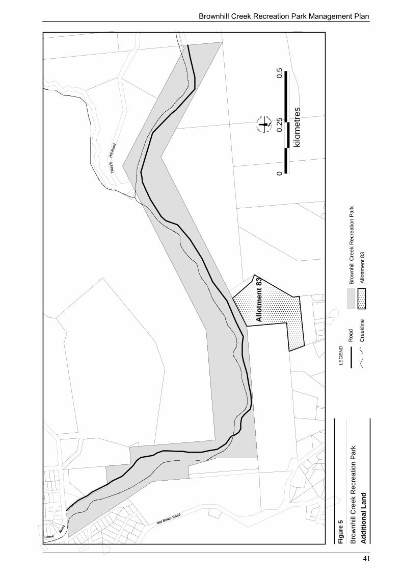
Tille
y’s
Tille
y’s
Tille
y’s
Tille
y’s
Tille
y’s
Tille
y’s
Tille
y’s
Tille
y’s
Tille
y’s
Hill
Roa
dH
illR
oad
Hill
Roa
dH
illR
oad
Hill
Roa
dH
illR
oad
Hill
Roa
dH
illR
oad
Hill
Roa
d
ill Creekill Creekill Creekill Creekill Creekill Creekill Creekill Creekill Creek
Old Belair Road
Old Belair Road
Old Belair Road
Old Belair Road
Old Belair Road
Old Belair Road
Old Belair Road
Old Belair Road
Old Belair Road
Roa
dR
oad
Roa
dR
oad
Roa
dR
oad
Roa
dR
oad
Roa
d
Allo
tmen
t 83
Allo
tmen
t 83
Allo
tmen
t 83
Allo
tmen
t 83
Allo
tmen
t 83
Allo
tmen
t 83
Allo
tmen
t 83
Allo
tmen
t 83
Allo
tmen
t 83
0.5
0.5
0.5
0.5
0.5
0.5
0.5
0.5
0.5
0 0 00 00 0 000.
250.
250.
250.
250.
250.
250.
250.
250.
25
kilo
met
res
kilo
met
res
kilo
met
res
kilo
met
res
kilo
met
res
kilo
met
res
kilo
met
res
kilo
met
res
kilo
met
res
Bro
wnh
ill C
reek
Rec
reat
ion
Par
k
Allo
ttmen
t 83
Roa
d
LEG
EN
DF
igu
re 5
Bro
wnh
ill C
reek
Rec
reat
ion
Par
k
Ad
dit
ion
al L
and
Cre
eklin
e
41
Brownhill Creek Recreation Park Management Plan

Brownhill Creek Recreation Park Management Plan
42
5 SUMMARY OF MANAGEMENT ACTIONSACTION PRIORITY DURATIONZoningDesignate and adopt the zones as shown on Figure 3. High Short
Natural Resources
Geology, Soils and Landform
Assess soil type and properties, including erosion potential, whenplanning for visitor access or undertaking management activitiesand development works.
High Short
Permit bicycle and horse riding on designated tracks only andrestrict access to sensitive areas by erecting appropriate barriers.
High Ongoing
Provide and update interpretive material to encourage visitors to useexisting walking trails and to avoid erosion-prone areas.
Medium Occasional
Identify existing areas of erosion and undertake remedial work thatincludes natural regeneration, revegetation and pest plant removal,in accordance with the Brownhill Creek Recreation Park VegetationManagement Plan (Kinnear et al 2001).
High Occasional
Improve, repair and maintain walking trails to stabilise soil asrequired.
High Ongoing
Hydrology
Participate in regional catchment management programs inpartnership with the PCWMB to minimise negative impacts to theBrownhill Creek catchment.
High Ongoing
Collaborate with the PCWMB to identify and repair existing areasof erosion through coordinated revegetation and pest planteradication programs, in accordance with the Brownhill CreekRecreation Vegetation Management Plan (Kinnear et al 2001).
High Occasional
Continue to encourage and support the involvement of the Friendsof Brownhill Creek and other volunteers in revegetation programsand the monitoring of water quality.
High Ongoing
Continue to support the environmental restoration of BrownhillCreek and manage the terrestrial areas of the reserve in a mannerthat positively contributes to water quality in Brownhill Creek.
High Ongoing
Contribute to and support flood mitigation schemes outlined in theBrownhill Creek and Environs Action Plan - Technical Report No.4Flood Management (PCWMB et al 1998).
High Ongoing

Brownhill Creek Recreation Park Management Plan
43
ACTION PRIORITY DURATION
Native Vegetation
Assess natural regeneration, identify rehabilitation priorities andintegrate weed control programs according to recommendations inthe Brownhill Creek Vegetation Management Plan (Kinnear et al2001).
High Ongoing
Implement the Brownhill Creek Vegetation Management Plan(Kinnear et al 2001) to effectively protect and enhance nativevegetation and species of conservation value.
High Ongoing
Record on a database with GIS capability, the location anddistribution of existing and newly discovered plants or habitats ofconservation significance, monitor their populations and implementspecies management programs if necessary.
Medium Ongoing
Support and encourage the Friends of Brownhill Creek and othervolunteer organisations and individuals, to continue revegetationprograms and to assist with monitoring species of conservationsignificance in collaboration with DEH.
High Ongoing
Encourage and participate in ongoing maintenance of the PCWMBdemonstration site and support the establishment of future sites.
High Ongoing
Native Fauna
Encourage approved volunteer groups and individuals to conductfauna surveys and population monitoring.
Medium Ongoing
Record on a database with GIS capability, animal species andhabitats, including opportunistic sightings of rare and endangeredfauna, and monitor these populations to ensure their conservation.
Medium Ongoing
Identify and protect significant fauna habitats/food requirementsand integrate habitat restoration with native revegetation efforts andweed management programs.
High Ongoing
Investigate opportunistic sightings to verify species identification. Medium Occasional
Introduced Plants
Fulfil the obligations of the Animal and Plant Control (AgriculturalProtection and Other Purposes) Act 1986 within allocatedresources.
High Ongoing
Encourage the development of and contribute to integrated regionalweed control programs that will establish pest plant controlpriorities and actions, and combine weed control with nativerevegetation efforts.
High Ongoing
Implement the Brownhill Creek Recreation Park VegetationManagement Plan (Kinnear et al 2001), which sets long-term,achievable, measurable goals and includes programs forcoordinated pest control, land rehabilitation and revegetation.
High Ongoing
Investigate the replacement of the remaining Seven Sisterscommemorative plantings with seven red gums to commemoratethe Centenary of Federation.
Medium Short

Brownhill Creek Recreation Park Management Plan
44
ACTION PRIORITY DURATIONProvide adequate protection for significant trees and collaboratewith the Heritage branch of DEH, Mitcham City Council and othersto identify trees considered significant under the Development Act1993 and/or the Heritage Act 1993.
High Ongoing
Provide interpretive information on the adverse impacts ofintroduced plants to increase public awareness.
Medium Short
Investigate the potential for alternative funding for weedmanagement.
High Short
Stage the removal of Aleppo Pines (Pinus halepensis) incoordination with revegetation programs using native food speciesDwarf Hakea (Hakea rugosa) and/or Elm-seed Hakea (Hakeacycloptera) for the Yellow-tailed Black Cockatoo.
High Moderate
Introduced Animals
Determine the extent of introduced animal populations and theirrelative impact on native flora and fauna.
Medium Ongoing
Monitor introduced animal populations within the park andundertake pest control programs in accordance with priorities basedon their impact to native wildlife.
Medium Ongoing
If control programs are necessary, work in cooperation withadjoining landowners, Pest Plant and Animal Control Authorities,the City of Mitcham, the Friends of Brownhill Creek and the widercommunity to achieve effective pest animal control programs.
Medium Ongoing
Provide interpretive information on the adverse impacts ofintroduced animals to increase public awareness.
Medium Short
Cultural HeritageConsult Kaurna people who have a traditional association with theland, Native Title Claimants and relevant State and FederalAboriginal heritage authorities, in decisions regarding themanagement of Kaurna cultural heritage.
High Ongoing
Before proceeding with any development works within the reserve,obtain an assessment and clearance from the appropriate authority,under the provisions of the Aboriginal Heritage Act 1988.
High Short
Identify, record, protect, restore and monitor known or relocatedsites and items of archaeological, anthropological, cultural andhistorical significance located in the park, in cooperation with theDepartment for Aboriginal Affairs and Reconciliation, the Heritagebranch of DEH and other relevant authorities and organisations.Kaurna and historic cultural heritage sites require conservationplans to facilitate appropriate management.
High Ongoing
In consultation with the Kaurna community, the Heritage branch ofDEH and other relevant authorities, research and inventory, culturaland historic sites and stories that relate to the park and whereappropriate, develop interpretive material, including culturalheritage themes, to increase public awareness. Interpretive materialmay include brochures, site signage and displays.
Medium Ongoing

Brownhill Creek Recreation Park Management Plan
45
ACTION PRIORITY DURATIONEncourage and support archaeological, anthropological and historicstudies within the park. All sites located should during thesesurveys should be recorded to the standards set by the Heritagebranch of DEH and/or DAARE and submitted for inclusion on theDAARE Central Archive and/or State Heritage Register.
Medium Ongoing
Negotiate with the caravan park lessee to relocate caravan sites thatobscure the Monarch of the Glen.
High Short
Fire ManagementComply with provisions of the Country Fires Act 1989 and theMitcham Bushfire Prevention Plan.
High Ongoing
Continue to conduct annual fire prevention works. High Ongoing
Develop and implement a Fire Management Statement, incollaboration with the Country Fire Service and BushfirePrevention committees that specifies annual fire prevention works,bushfire control procedures and monitoring, to integrate district fireprevention efforts.
Medium Short
Ensure visitors comply with fire restrictions and fire ban seasonbetween December 1 and April 30, by monitoring visitor use.
High Ongoing
Encourage local government to continue regular security patrolsthrough the park at night, to prevent the incidence of fire caused bystolen cars being dumped in the park and burnt out.
High Ongoing
Consider the use of fire as a management tool if research indicatesthat it is necessary for biodiversity conservation.
Medium Occasional
Recreation and Tourism
Vehicle Access
Continue to consult with the City of Mitcham concerning vehicleaccess and road management.
High Ongoing
Negotiate an agreed funding arrangement with the City of Mitchamfor the reconstruction and ongoing maintenance of Brownhill CreekRoad.
High Moderate
Investigate options and implement measures to reduce speeding andimprove safety standards.
High Short
Investigate an alternate access for visitors that complies withcurrent Australian standards.
High Short
Assess the suitability of bollards to prevent off road damage andinvestigate alternative options.
Medium Short
Provide additional carpark facilities where appropriate to supportvisitor numbers.
Medium Moderate

Brownhill Creek Recreation Park Management Plan
46
ACTION PRIORITY DURATION
Walking Trails and Multi-Use Trails
Develop and implement a detailed trail plan for the park thatcomplies with all OHSW issues and policies.
Medium Moderate
Establish a trail maintenance program and provide clearly defined,safe trails for visitors.
Medium Ongoing
In consultation with Bicycle SA and Office for Recreation Sport &Racing, conduct a risk assessment and if deemed feasible;
� investigate options for the development of a multi-use trail thatuses best practice techniques for visitor safety andenvironmental protection.
� designate the eastern end of the Wirraparinga Trail from themanure pits to the car park as part of the proposed multi-usetrail.
Medium Moderate
Develop and incorporate interpretive information at places ofinterest along trails.
Medium Short
Identify appropriate interpretive themes and arrange for thedevelopment of trail-head and trail-side interpretive and directionalsigns where appropriate.
Medium Moderate
Facilitate the connection of internal park trails with the regionaltrail network and liaise with adjoining landowners to investigate thepossibility of future linkages.
Medium Ongoing
Monitor visitor numbers and if necessary provide additional visitorfacilities (eg carparks etc) to accommodate demand.
Medium Ongoing
Horse Riding and Horse Arena
Develop and implement an agreed horse riding code of conductbetween DEH, Office for Recreation Sport & Racing, Horse SA andlocal riders.
High Short
Prohibit horse riding off designated tracks to avoid sensitive areasand minimise environmental impact.
High Short
Monitor the impact of horses on the watercourse and investigate thefeasibility of relocating the horse arena to a more suitable location ifnecessary.
High Moderate
Encourage and support the continued commitment of the Friends ofBrownhill Creek and local riders to minimise the impact of horsesand the horse arena.
High Ongoing
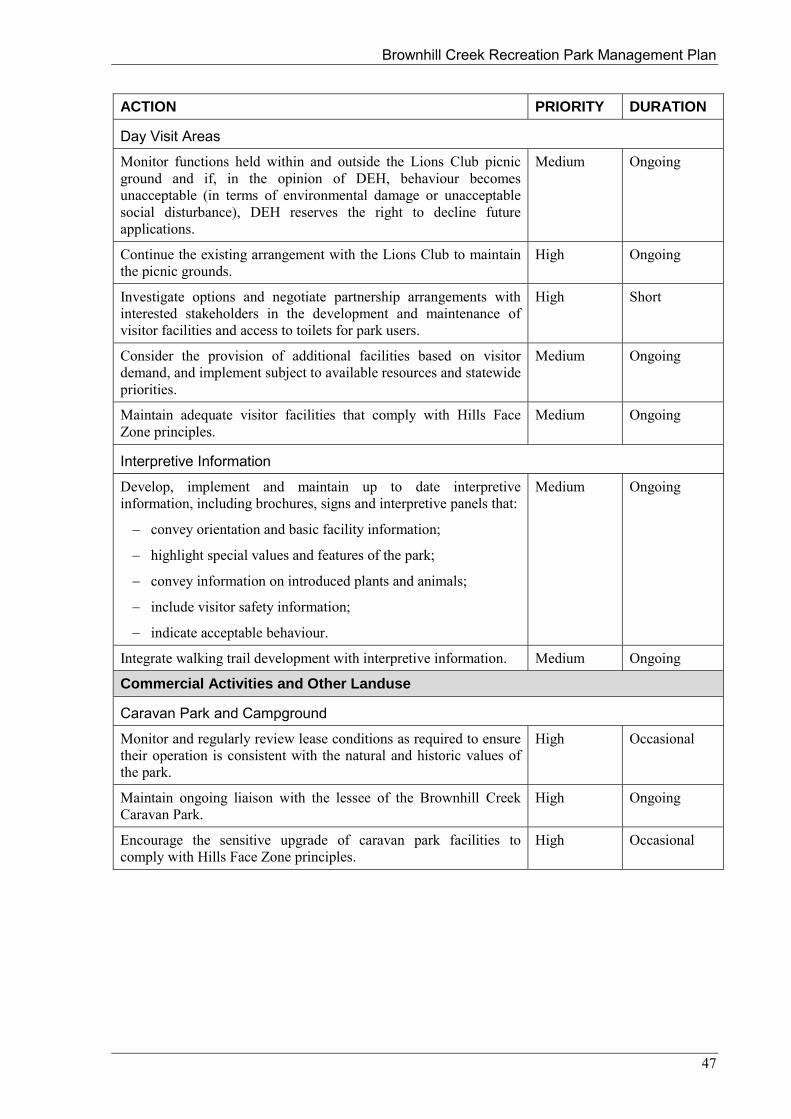
Brownhill Creek Recreation Park Management Plan
47
ACTION PRIORITY DURATION
Day Visit Areas
Monitor functions held within and outside the Lions Club picnicground and if, in the opinion of DEH, behaviour becomesunacceptable (in terms of environmental damage or unacceptablesocial disturbance), DEH reserves the right to decline futureapplications.
Medium Ongoing
Continue the existing arrangement with the Lions Club to maintainthe picnic grounds.
High Ongoing
Investigate options and negotiate partnership arrangements withinterested stakeholders in the development and maintenance ofvisitor facilities and access to toilets for park users.
High Short
Consider the provision of additional facilities based on visitordemand, and implement subject to available resources and statewidepriorities.
Medium Ongoing
Maintain adequate visitor facilities that comply with Hills FaceZone principles.
Medium Ongoing
Interpretive Information
Develop, implement and maintain up to date interpretiveinformation, including brochures, signs and interpretive panels that:
� convey orientation and basic facility information;
� highlight special values and features of the park;
� convey information on introduced plants and animals;
� include visitor safety information;
� indicate acceptable behaviour.
Medium Ongoing
Integrate walking trail development with interpretive information. Medium Ongoing
Commercial Activities and Other Landuse
Caravan Park and Campground
Monitor and regularly review lease conditions as required to ensuretheir operation is consistent with the natural and historic values ofthe park.
High Occasional
Maintain ongoing liaison with the lessee of the Brownhill CreekCaravan Park.
High Ongoing
Encourage the sensitive upgrade of caravan park facilities tocomply with Hills Face Zone principles.
High Occasional

Brownhill Creek Recreation Park Management Plan
48
ACTION PRIORITY DURATION
Electricity, Telecommunication and Water
Maintain accurate records of underground and overhead services tominimise damage through park maintenance and developmentwork.
Medium Ongoing
Maintain liaison with utility companies and periodically reviewmaintenance programs.
Medium Ongoing
Ensure that trees adjacent to power lines are pruned regularly tominimise bushfire risk.
High Ongoing
Investigate the potential for power to be routed exclusivelyunderground, perhaps as part of the road upgrade (see VehicleAccess 4.5.2).
Medium Short
Management Arrangements
Partnerships and Cooperative Management
Continue to consult with the City of Mitcham, the PCWMB, andother relevant bodies to explore the benefits of partnershiparrangements that will support future management decisions onissues of common interest.
High Ongoing
Encourage and contribute to the development of partnershiparrangements, to integrate biodiversity and recreation managementin the Mount Lofty Ranges, with organisations that have an interestin contributing to the sustainable management of the park.
High Ongoing
Involve the Kaurna Heritage Committee as nominated by the StateAboriginal Heritage Committee, in the cooperative management ofthe reserve and their Indigenous cultural heritage.
High Ongoing
Community and Volunteer Involvement
Support and encourage the Friends of Brownhill Creek RecreationPark and other suitable volunteers to continue their voluntarycontribution to park management.
High Ongoing
In consultation with the Friends of Brownhill Creek RecreationPark and other major volunteer groups, review the direction of workactivities based on the initiatives outlined in this plan ofmanagement and the Brownhill Creek Recreation Park VegetationManagement Plan (Kinnear et al 2001).
High Ongoing
In consultation with the Friends of Brownhill Creek, integrateannual work programs of the Friends Group into the proposed DEHmanagement programs for the reserve.
High Ongoing
Provide additional training opportunities for the Friends Groupbased upon a mutual recognition of needs.
High Occasional
Encourage and facilitate the involvement of schools and universitiesin research and volunteer programs.
Medium Ongoing
Encourage neighbouring property owners to coordinate revegetationand weed removal efforts with park programs.
High Ongoing

Brownhill Creek Recreation Park Management Plan
49
ACTION PRIORITY DURATIONFuture Directions
Additional Land
Conduct a CARRS assessment and detailed investigation of thesuitability of including land in allotment 83 in the hundred ofAdelaide, previously included in Brownhill Creek National PleasureResort, but omitted from the dedication of Brownhill CreekRecreation Park.
High Short
Any review for additional land will be based on both strategic andbiodiversity perspective’s.
High Short
Any sections added to the park will be managed in accordance withthis management plan.
High Ongoing
Investigate options for appropriate use of Allotment 83 if strategicand biodiversity assessment determines it is not suitable orinclusion in the park.
High Short

Brownhill Creek Recreation Park Management Plan
50
6 REFERENCES AND BIBLIOGRAPHYCarpenter and Reid (1998), The Status of Native Birds in the Agricultural Areas of South Australia.DEH, unpublished document.
Cockburn R (1984) What’s in a Name – Nomenclature of South Australia, Furguson Publications,Adelaide.
Cooke D & Choate J (1995) (Eds). Weeds of Conservation Concern, Department for Environment andNatural Resources, Animal and Plant Control Commission South Australia.
Environment Australia (2000) Revision of the Interim Biogeographic Regionalisation of Australia(IBRA) and the Development of Version 5.1. - Summary Report. Environment Australia, Canberra.http://www.ea.gov.au/parks/nrs/ibra/version5-1/summary-report/index.html
Gill A M., Groves R.H., and Noble I.R (Eds.) (1981) Fire and the Australian Biota, AustralianAcademy of Science, Canberra.
Gillen J & Gillen J (1986) Trees of Significance in South Australia, National Trust of South Australia,Adelaide
Golder Associates (1998) Brownhill Creek Geotechnical Report, Adelaide.
Jessop J P (1993) (Ed) A List of the Vascular Plants of South Australia, The Botanic Gardens ofAdelaide and State Herbarium.
Kinnear A J, Overton I C, Hyde M J (2001) Brownhill Creek Recreation Park VegetationManagement Plan, National Parks and Wildlife SA, Adelaide.
Lang P J and Kraehenbuehl, D N (2002) (Eds) Plants of Particular Conservation Significance in SouthAustralia, DEHAA, unpublished data base.
Laut P, Heyligers P C, Keig G, Löffler E, Margules C, Scott R M, and Sullivan M E, (1977),Environments of South Australia Province 3 Mt Lofty Block. Division of Land Use ResearchCommonwealth Scientific and Industrial Research Organisation, Canberra.
Long M (1999) A Biological Inventory of the Mt Lofty Ranges, South Australia, National Parks andWildlife SA, Adelaide 3rd edition.
Neagle N (1995) An Update of the Conservation Status of the Major Plant Associations of SouthAustralia, Department of Environment and Natural Resources SA, Adelaide.
Robinson A C, Casperson K D, Hutchinson M N (2000) A List of the Vertebrates of South Australia,DEH, Adelaide.
Thackway R, and Cresswell I D, (1995) (Eds) An Interim Biogeographic Regionalisation forAustralia: a framework for establishing the national reserve system of reserves, Version 4.0.Australian Nature Conservation Agency, Canberra.
Tindale N B (1974) Aboriginal Tribes of Australia, ANU Press, Canberra.
Tonkin B C & Associates (1997) Patawalonga Catchment Water Management Board ComprehensiveCatchment Water Management Plan, PCWMB, Adelaide.
Turner M S (2000) Biodiversity Plan for Metropolitan Adelaide, Urban Forest and BiodiversityProgram, Adelaide.
Personal CommunicationTerry Reardon (2001) Senior Technical Officer Evolutionary Biology, SA Museum. Jason van Weenen (2002) Scientific Officer, Threatened Species, DEH
Heidi Crow (2003) Project Officer, Department for State Aboriginal Affairs and Reconciliation
Leanne Liddle (2003) Aboriginal Parks and Wildlife Co-ordinator, Aboriginal Partnerships, DEH

Brownhill Creek Recreation Park Management Plan
51
APPENDIX A : LEGISLATION, CONVENTIONS AND AGREEMENTS
South Australia
Aboriginal Heritage Act 1988Animal and Plant Control Act (Agricultural Protection and Other Purposes) 1986Biological Control Act 1986Catchment Water Management Act 1995 Coast Protection Act 1972Country Fires Act 1989Equal Opportunity Act 1984Environment Protection Act 1993Development Act 1993Harbors and Navigation Act 1993Heritage Act 1993Historic Shipwrecks Act 1981Mining Act 1971National Trust of South Australia Act 1955Native Title (South Australia) Act 1994Native Vegetation Act 1991Occupational Health, Safety and Welfare Act 1986Petroleum Act 1940Prevention of Cruelty to Animals Act 1985Roads (Opening and Closing) Act 1991Recreational Greenways Act 2000Soil Conservation and Land Care Act 1989Water Resources Act 1997Wilderness Protection Act 1992
Commonwealth
Aboriginal and Torres Straight Islander Heritage Protection Act 1984Disability Discrimination Act 1992Environment Protection and Biodiversity Conservation Act 1999Native Title Act 1993Natural Heritage Trust Act 1996
International
Japan / China Australia Migratory Bird Agreements (JAMBA, CAMBA)Ramsar ConventionWorld Heritage Convention

Brownhill Creek Recreation Park Management Plan
52
APPENDIX B : LAND TENURE HISTORYBrownhill Creek Recreation Park
The recreation area at Brownhill Creek, Mitcham, comprises :-
Section 676, Hundred of Adelaide, described in Crown Record Volume 5758 Folio 609 as "Landdeclared for Recreation Park purposes pursuant to the National Parks and Wildlife Act 1972, known asBrown Hill Creek Recreation Park"; and
Allotment 83 of Filed Plan 150938, the fee simple of which is held under Certificate of Title Volume5843 Folio 173 in the name of "The Minister of the Crown to whom, for the time, the administrationof the National Pleasure Resorts Act 1914 is committed by the Governor".
**********Section 676, Hundred of AdelaideThe Hundred of Adelaide was proclaimed on 29th October 1846.The first survey of the Brown Hill Creek area was made in September 1846 but it was not until thearea was resurveyed in 1858 that land was set aside for reserve along the Brown Hill Creek (DBp.45).
The history of the land which is now Section 676, Hundred of Adelaide, is as follows -
21st March 1889
The unnumbered parcel of land set aside as a reserve along the Brown Hill Creek in 1858 wasdedicated as a Reserve for Public Recreation purposes and placed under the control of the DistrictCouncil of Mitcham by proclamation made under the Crown Lands Act 1888 and the DistrictCouncils Act 1887 (DBp. 45).
11th May 1893
Portion of the Brown Hill Creek Reserve was resumed and dedicated for the purposes ofPublic Swimming Baths (see Plan A).
Land Grant Volume 579 Folio 200 was issued over the resumed land to The District Councilof Mitcham to be used as a site for Public Swimming Baths (cancelled 09/05/1912).
15th March 1894
Blocks B and D were dedicated as additions to the Public Recreation Reserve and placedunder the care control and management of the District Council of Mitcham (see Plan A).
14th September 1911
The Brown Hill Creek Recreation Reserve was resumed from the control of the District Council ofMitcham.
9th May 1912
The Land Grant Volume 579 Folio 200 previously issued to the D.C. Mitcham for PublicSwimming Baths was cancelled.
15th July 1915
The whole of the land which is now Section 676 was granted to the Attorney-General for the purposeof being used by the public as a Pleasure Resort, Park or Recreation Ground by proclamation under theNational Pleasure Resorts Act 1914.
1972
The land comprised in the Brown Hill Creek Pleasure Resort was numbered as Section 676,Hundred of Adelaide.
12th December 1974
Section 676, Hundred of Adelaide was constituted as Brownhill Creek Recreation Park under theprovisions of Section 33(1) of the National Parks and Wildlife Act 1972 (Act 56 of 1972).

Brownhill Creek Recreation Park Management Plan
53
Allotment 83 of Filed Plan 150938.
The Hundred of Adelaide was proclaimed on 29th October 1846.
The parcel of land which is now Allotment 83 of Filed Plan 150938 is made up of parts of originalSections 890 and 1095 that were granted to private people between 1849 and 1859 (see Certificate ofTitle Volume 209 Folio 120).
Allotment 83 of Filed Plan 150938 was part of Sections 890 and 1095 as transferred in 1968 to "TheMinister of the Crown to whom for the time being the administration of the National Pleasure ResortsAct 1914 - 1960 is committed by the Governor" (Certificate of Title Volume 3584 Folio 155).
Disposal of portion of the land caused the issue of a new Certificate of Title Volume 3587 Folio 154which was subsequently cancelled to allow the issue of a computerised certificate of title Volume5843 Folio 173.
Certificate of Title Volume 5843 Folio 173 has been issued in the name of "The Minister of theCrown to whom, for the time, the administration of the National Pleasure Resorts Act 1914 iscommitted by the Governor"
This description requires correction as the National Pleasure Resorts Act was repealed by the passingof Act 56 of 1972 (National Parks and Wildlife Act).
**********
Allotment 83 of Filed Plan 150938 and Section 676, Hundred of Adelaide are within The KaurnaPeople Native Title Claim SG 6001/00.
**********P A Smith
Tenure History Search Unit
30/04/2001
Enclosures
Crown Record Volume 5758 Folio 609
Public Map Hundred of Adelaide 1:005
Survey Diagrams pp. 26, 45 & 63
Certificates of Title Vol.209 Fol.220, Fol. 579 Fol.200, Vol. 3584 Fol.155, Vol. 3587 Fol.154 &
Vol. 5843 Fol. 173
Govt. Gaz. Notices 21/03/1889,11/05/1893,15/03/1894,14/09/1911, 09/05/1912 & 15/07/1915
The National Pleasure Resorts Act (1173 of 1914)
Extract National Parks and Wildlife Act (56 of 1972)
(Report prepared for B Moore Senior Planner Reserve Planning DEH)

Brownhill Creek Recreation Park Management Plan
54
APPENDIX C : BROWNHILL CREEK RECREATION PARK – NATIVE PLANTS Species Common Name Conservation Status
EPBCAct
NP&WAct
SouthernLofty Region
Acacia acinacea Wreath Wattle NAcacia melanoxylon BlackwoodAcacia paradoxa Kangaroo ThornAcacia pyncantha Golden WattleAcacia retinodes var. retinodes (swampform)
Swamp Wattle
Acaena agnipila Downy Sheep's Burr U UAcaena echinata Sheep's BurrAcaena novae-zelandiae Biddy BiddyAcrotriche fasciculiflora Mount Lofty Ground-berry UAllocasuarina verticillata Drooping SheoakAristida behriana Brush Wire-grass UArthropodium strictum Common Vanilla-lilyAsperula conferta Common WoodruffAstroloma humifusum Cranberry HeathBothriochloa macra Red-leg Grass V RBursaria spinosa Sweet BursariaCalystegia sepium Large Bindweed UCarex appressa Tall SedgeCarex bichenoviana Notched Sedge UCarex breviculmis Short-stem SedgeCarex fascicularis Tassel Sedge UCheilanthes austrotenuifolia Annual Rock-fernConvolvulus erubescens Australian BindweedCruciferae sp. Cress FamilyCyperus gymnocaulos Spiny Flat-sedgeCyperus vaginatus Stiff Flat-sedgeDanthonia auriculata Lobed Wallaby-grass NDanthonia caespitosa Common Wallaby-grassDanthonia linkii var. fulva Leafy Wallaby-grass UDanthonia pilosa var. pilosa Velvet Wallaby-grassDanthonia racemosa var. racemosa Slender Wallaby-grassDanthonia setacea var. setacea Small-flower Wallaby-grassDianella longifolia var. grandis Pale Flax-lily R VDianella revoluta var. revoluta Black-anther Flax-lilyDichondra repens Kidney WeedDodonaea viscosa ssp. spatulata Sticky Hop-bushDrosera peltata Pale SundewDrosera whittakeri ssp. whittakeri SundewElymus scabrus var. scabrus Native Wheat-grass

Brownhill Creek Recreation Park Management Plan
55
Species Common Name Conservation StatusEPBC
ActNP&W
ActSouthern
Lofty RegionEnneapogon nigricans Black-head GrassEucalyptus camaldulensis var.camaldulensis
River Red Gum
Eucalyptus leucoxylon ssp. leucoxylon South Australian Blue GumEucalyptus microcarpa Grey Box UEucalyptus viminalis ssp. cygnetensis Rough-bark Manna GumGeranium potentilloides var.potentilloides
Downy Geranium K
Geranium retrorsum Grassland GeraniumGlycine clandestina var. sericea Twining GlycineGoodenia albiflora White Goodenia UGoodenia ovata Hop GoodeniaGoodenia varia Sticky Goodenia KIsolepis cernua Nodding Club-rushIsolepis inundata Swamp Club-rushJuncus bufonius Toad RushJuncus caespiticius Grassy RushJuncus pallidus Pale RushJuncus pauciflorus Loose-flower RushJuncus subsecundus Finger RushLabiatae sp. Mint FamilyLagenifera huegelii Coarse Bottle-daisyLepidosperma laterale s.str. Tall Sword-sedge ULepidosperma viscidum Sticky Sword-sedgeLinum marginale Native FlaxLobelia alata Angled LobeliaLomandra densiflora Soft Tussock Mat-rushLomandra nana Small Mat-rush NLomandra sororia Sword Mat-rush ULycopus australis Australian Gipsywort RLythrum hyssopifolia Lesser LoosestrifeMaireana enchylaenoides Wingless Fissure-plant UOlearia ramulosa Twiggy Daisy-bushOxalis perennans Native SorrelPaspalum distichum Water CouchPersicaria decipiens Slender KnotweedPhragmites australis Common ReedPittosporum phylliraeoides var.microcarpa
Native Apricot R
Pleurosorus rutifolius Blanket Fern UPoa clelandii Matted Tussock-grassPoa labillardieri var. labillardieri Common Tussock-grass

Brownhill Creek Recreation Park Management Plan
56
Species Common Name Conservation StatusEPBC
ActNP&W
ActSouthern
Lofty RegionPrunella vulgaris Self-healPteridium esculentum Bracken FernPultenaea largiflorens Twiggy Bush-peaRanunculus lappaceus Native ButtercupRubus parvifolius Native Raspberry URumex sp. DockSchoenus apogon Common Bog-rushStackhousia monogyna Creamy CandlesStipa curticoma Short-crest Spear-grass UStipa flavescens Coast Spear-grassStipa multispiculis Small-seed Spear-grass R RStipa nodosa Tall Spear-grassStipa puberula Fine-hairy Spear-grass R RStipa scabra Rough Spear-grassStipa scabra ssp. falcata Slender Spear-grassStipa setacea Corkscrew Spear-grass UThelymitra nuda Scented Sun-orchidThemeda triandra Kangaroo GrassTypha domingensis Narrow-leaf BulrushVittadinia cuneata var. cuneataforma cuneata
Fuzzy New Holland Daisy
Wahlenbergia stricta ssp. stricta Tall Bluebell
99 5 27

Brownhill Creek Recreation Park Management Plan
57
APPENDIX D : BROWNHILL CREEK RECREATION PARK – INTRODUCED PLANTS Species Common name ProclaimedAgrostis capillaris var. capillaris Brown-top BentAllium triquetrum Three-cornered GarlicAsclepias rotundifolia Broad-leaf Cotton-bushAster subulatus Aster-weedAvena barbata Bearded OatBrachypodum distachyon False BromeBriza maxima Large Quaking-grassBriza minor Lesser Quaking-grassBromus diandrus Great BromeBromus madritensis Compact BromeBromus rubens Red BromeCallitriche stagnalis Common Water StarwortCarduus tenuiflorus Slender ThistleCarthamus lanatus Saffron ThistleCentaurium tenuiflorum Branched CentauryCeratonia siliqua Carob TreeConyza albida Tall FleabaneCrataegus monogyna HawthornCrataegus sinaica HawthornCritesion murinum ssp. glaucum Blue Barley-grassCynara cardunculus Artichoke Thistle �
Cynodon dactylon CouchCynosurus echinatus Rough Dog's-tail GrassDactylis glomerata CocksfootEchium plantagineum Salvation Jane �
Ehrharta erecta Panic Veldt GrassEhrharta longiflora Annual Veldt GrassEucalyptus citriodora Lemon Scented GumEucalyptus cladocalyx Sugar GumEucalyptus ficifolia Red Flowered GumEuphorbia peplus Petty SpurgeFicus carica Edible FigFicus macrophylla Moreton Bay FigFoeniculum vulgare FennelFraxinus rotundifolia ssp. rotundifolia Desert AshFumaria capreolata ssp. capreolata White-flower FumitoryGalium aparine CleaversGalium divaricatum Slender BedstrawGastridium phleoides Nit-grassGenista monspessulana Montpellier Broom �
Geranium molle var. molle Soft Geranium

Brownhill Creek Recreation Park Management Plan
58
Species Common name ProclaimedGynandriris setifolia Thread IrisHolcus lanatus Yorkshire FogHomeria flaccida One-leaf Cape Tulip �
Hypericum perforatum St John's WortHypochaeris radicata Rough Cat's EarIpomoea indica Purple Morning-gloryJuncus articulatus Jointed RushKickxia elatine ssp. elatine Woolly ToadflaxLactuca serriola Prickly LettuceLathyrus tingitanus Tangier PeaLinum trigynum French FlaxLolium perenne Perennial RyegrassMedicago arabica Spotted MedicMedicago truncatula Barrel MedicMentha x piperita var. x citrata Lemon MintMonadenia bracteata African Weed OrchidMyrsiphyllum asparagoides Bridal Creeper �
Olea europaea ssp. europaea Olive �
Panicum capillare var. brevifolium Witch-grassPaspalum dilatatum PaspalumPennisetum clandestinum KikuyuPhalaris aquatica PhalarisPinus halepensis Aleppo Pine �
Pinus pinea Stone PinePiptatherum miliaceum Rice MilletPlantago lanceolata var. lanceolata RibwortPlantago major Greater PlantainPlatanus x acerifolia London PlanePolygonum aviculare WireweedPopulus nigra Lombardy PoplarPotamogeton crispus Curly PondweedPrunus sp. PlumQuercus robur English OakRanunculus repens Creeping ButtercupRhamnus alaternus Blowfly BushRicinus communis Castor Oil PlantRobinia pseudoacacia White AcaciaRomulea rosea var. australis Common Onion-grassRorippa nasturtium-aquaticum WatercressRosa canina Dog Rose �
Rubus spp. Blackberry �
Rumex crispus Curled Dock

Brownhill Creek Recreation Park Management Plan
59
Species Common name ProclaimedRumex pulcher ssp. pulcher Fiddle DockSalix babylonica Weeping WillowSalix discolor WillowScabiosa atropurpurea PincushionSenecio mikanioides Cape IvySenecio pterophorus var. pterophorus African DaisySetaria verticillata Whorled Pigeon-grassSolanum nigrum Black NightshadeSonchus asper ssp. glaucescens Rough Sow-thistleSonchus oleraceus Common Sow-thistleSparaxis bulbifera SparaxisSporobolus indicus var. capensis Rat-tail GrassTaraxacum officinale DandelionTrifolium angustifolium Narrow-leaf CloverTrifolium arvense var. arvense Hare's-foot CloverTrifolium campestre Hop CloverTrifolium resupinatum Shaftal CloverTropaeolum majus NasturtiumUlmus suber Cork ElmUrospermum picroides False HawkbitVerbascum virgatum Twiggy MulleinVicia sativa ssp. sativa Common VetchVinca major Blue PeriwinkleVulpia myuros FescueWatsonia meriana cv. Bulbillifera Bulbil WatsoniaZantedeschia aethiopica White Arum Lily109 9

Brownhill Creek Recreation Park Management Plan
60
APPENDIX E : BROWNHILL CREEK RECREATION PARK – NATIVE BIRDS Species Common Name Conservation Status
EPBCAct
NP&WAct
Mount LoftyRegion
Acanthiza chrysorrhoa Yellow-rumped ThornbillAcanthiza lineata Striated ThornbillAnas superciliosa Pacific Black DuckAnthochaera carunculata Red WattlebirdAnthochaera chrysoptera Little Wattlebird UCacatua roseicapilla GalahCincloramphus cruralis Brown SonglarkClimacteris picumnus Brown Treecreeper VClyptorhynchus funereus Yellow-tailed Black Cockatoo V VCorvus coronoides Australian RavenCorvus mellori Little RavenDacelo novaeguineae Laughing KookaburraDaphoenositta chrysoptera Varied SittellaEgretta novaehollandiae White-faced HeronFalco berigora Brown FalconGlossopsitta concinna Musk LorikeetGrallina cyanoleuca Magpie-larkGymnorhina tibicen Australian MagpieHirundo neoxena Welcome SwallowLichenostomus penicillatus White-plumed HoneyeaterMalurus cyaneus Superb Fairy-wrenManorina melanocephala Noisy MinerMelithreptus lunatus White-naped HoneyeaterMicroeca fascinans Jacky Winter VNeochima temporalis Red-browed FinchOcyphaps lophotes Crested PigeonPardalotus punctatus Spotted Pardalote UPhylidonyris novaehollandiae New Holland HoneyeaterPlatycercus elegans Crimson RosellaPlatycercus eximius Eastern RosellaPsephotus haematonotus Red-rumped ParrotRhipidura albiscapa Grey FantailRhipidura leucophrys Willie WagtailSericornis frontalis White-browed Scrubwren UStrepera versicolor Grey Currawong UTrichoglossus haematodus Rainbow LorikeetZosterops lateralis Silvereye37 1 7

Brownhill Creek Recreation Park Management Plan
61
APPENDIX F : CONSERVATION STATUS CODES
Australian Conservation Status Codes The following codes are based on the current listing of species under Section 179 of theEnvironmental Protection and Biodiversity Conservation Act 1999.
EX Extinct: there is no reasonable doubt that the last member of the species has died.
EW Extinct in the Wild: known only to survive in cultivation, in captivity or as a naturalisedpopulation well outside its past range; or it has not been recorded in its known and/or expectedhabitat, at appropriate seasons, anywhere in its past range, despite exhaustive surveys over atime frame appropriate to its life cycle and form.
CE Critically Endangered: facing an extremely high risk of extinction in the wild in the immediatefuture, as determined in accordance with the prescribed criteria.
E Endangered: facing a very high risk of extinction in the wild in the near future, as determinedin accordance with the prescribed criteria.
V Vulnerable: facing a high risk of extinction in the wild in the medium-term future, asdetermined in accordance with the prescribed criteria.
CD Conservation Dependent: the species is the focus of a specific conservation program, thecessation of which would result in the species becoming vulnerable, endangered or criticallyendangered within a period of 5 years.
Note: Prescribed criteria as defined under the IUCN Red List of Threatened Species.
South Australian Conservation Status CodesThe following codes are based on the current listing of species under Schedules of the National Parksand Wildlife Act 1972, as amended in 2000.
E Endangered: (Schedule 7) in danger of becoming extinct in the wild.
V Vulnerable: (Schedule 8) at risk from potential or long term threats which could cause thespecies to become endangered in the future.
R Rare: (Schedule 9) low overall frequency of occurrence (may be locally common with a veryrestricted distribution or may be scattered sparsely over a wider area). Not currently exposed tosignificant threats, but warrants monitoring and protective measures to prevent reduction ofpopulation sizes.
Regional Status CodesThe categories below apply to the species distribution at a regional level.
Mammals, Reptiles & AmphibiansThere are no regional conservation status categories developed for mammals, reptiles or amphibians todate (2003).
BirdsRegional conservation status for birds follow Carpenter and Reid (1998) The Status of Native Birds inthe Agricultural Areas of South Australia;
The regions are defined as follows;
ML Mount Lofty MN Mid-North SE South-Eastern KI Kangaroo Island MM Murray Mallee EP Eyre Peninsula YP Yorke Peninsula

Brownhill Creek Recreation Park Management Plan
62
PlantsRegional conservation ratings for plants follow:
Lang, P.J. & Kraehenbuehl, D.N. (2001). Plants of Particular Conservation Significance in SouthAustralia's Agricultural Regions.
June (2003) update of unpublished database: Florlist. Department for Environment and Heritage.
The regions are as defined by the State Herbarium (Plant Biodiversity Centre), illustrated in the backcover of 'A List of the Vascular Plants of South Australia (Edition IV)' (Ed. Jessop, 1993).
NW North-Western FR Flinders Ranges NL Northern Lofty SL Southern Lofty LE Lake Eyre EA Eastern MU Murray KI Kangaroo Island NU Nullarbor EP Eyre Peninsula YP Yorke Peninsula SE South-Eastern GT Gairdner-Torrens
In order of decreasing conservation significance:X Extinct/Presumed extinct: not located despite thorough searching of all known and likely
habitats; known to have been eliminated by the loss of localised population(s); or not recordedfor more than 50 years from an area where substantial habitat modification has occurred.
E Endangered: rare and in danger of becoming extinct in the wild.
T Threatened: (Plants only) likely to be either Endangered or Vulnerable but insufficient dataavailable for more precise assessment.
V Vulnerable: rare and at risk from potential threats or long term threats that could cause thespecies to become endangered in the future.
K Uncertain: likely to be either Threatened or Rare but insufficient data available for a moreprecise assessment.
R Rare: has a low overall frequency of occurrence (may be locally common with a very restricteddistribution or may be scattered sparsely over a wider area). Not currently exposed tosignificant or widespread threats, but warrants monitoring and protective measures to preventreduction of population sizes.
U Uncommon: less common species of interest but not rare enough to warrant special protectivemeasures.
Q Not yet assessed: but flagged as being of possible significance.
N Not of particular significance (Plants only) Also indicated by a blank entry.
C Common (Birds only) Also indicated by a blank entry.
O Occasional Visitor Only (Birds only) Not considered of conservational status.
