browns ferry - tva content/energy/our power... · browns ferry emergency ... inside cover fpo. dear...
TRANSCRIPT

B R O W N S F E R R Y
EMERGENCY INFORMATION: STATE OF ALABAMA, LAUDERDALE COUNTY EMERGENCY MANAGEMENT AGENCY, LAWRENCE COUNTY EMERGENCY MANAGEMENT AGENCY, LIMESTONE COUNTY EMERGENCY MANAGEMENT AGENCY,
MORGAN COUNTY EMERGENCY MANAGEMENT AGENCY AND TENNESSEE VALLEY AUTHORITY
2018
tva.com/prepare

Inside CoverFPO

Dear Browns Ferry Neighbor,
As in the past, the Tennessee Valley Authority, the state of Alabama and your local emergency management agency have provided you with a calendar that contains important information about Browns Ferry Nuclear Plant.
This calendar contains updated information reflecting additions and changes over the past year. This information will help you better understand Browns Ferry and the emergency plans that have been developed for your protection. Please keep the calendar in a convenient place and readily available. Any previous calendars or brochures concerning emergency information or instructions about Browns Ferry should be discarded.
We realize that some Browns Ferry neighbors have needs that would require special assistance in the unlikely event of an emergency at the plant. Therefore, we have included a card for you to fill out and return if such assistance is needed.
For your convenience, the card has been pre-addressed, and the postage has been paid. In order for emergency officials to maintain a current list of persons who would need assistance, this card must be returned immediately, even though you may have sent a card from a previous calendar or brochure.
If you have any questions about this material, please call one of the numbers listed on this page, and we will be glad to answer them for you.
FOR QUESTIONS ABOUT THIS MATERIAL
During emergency operations, additional telephone numbers will be published and broadcast over the Emergency Alert System (EAS).
The Prompt Notification System 2
If you hear the sirens 2
If you are advised to take shelter indoors 3
If you are asked to leave (evacuate) the area 3
Browns Ferry evacuation map, sector descriptions and evacuation routes 4
If you need special help 8
For farmers and home gardeners 8
Emergency supplies checklist 8
General information How emergencies are classified 9 Glossary 10 What is radiation? 10 How Browns Ferry works 11
1
Scott Harris, M.D.Acting State Health OfficerAlabama Department of Public HealthState of Alabama
Brian HastingsDirectorAlabama Emergency Management AgencyState of Alabama
Contents
Lauderdale County Emergency Management Agency256-760-6363
Lawrence County Emergency Management Agency256-974-7641 256-974-7911 (after hours)
Limestone County Emergency Management Agency256-232-2631 256-232-1530 (after hours)
Morgan County Emergency Management Agency256-351-4620 256-350-4613 (after hours)
Tennessee Valley Authority256-729-7698 (inside local calling area) 800-467-1388 (outside calling area)
Alabama EmergencyManagement Agency
(24 hour contact numbers)800-843-0699205-280-2200
For alternate formats of this document, call 865-632-6824 and allow five workdays for processing.
16-215 9/16 BFN
Steve BonoSite Vice PresidentBrowns Ferry Nuclear PlantTennessee Valley Authority

We expect Browns Ferry Nuclear Plant to operate safely. However, if an incident occurs at the plant, TVA will notify state and local officials at once.
In-depth plans have been prepared by TVA, the state of Alabama, and your local emergency management agency to protect your health and safety, and this calendar is a part of those plans. We want you to be prepared, know what the sirens mean and know what you should do if you hear them.
The Prompt Notification System is a means of informing the public with sirens and tone-alert radios, and providing information through local radio and television stations that are a part of the Emergency Alert System (EAS) and through NOAA weather radio messages.
The fixed sirens can be heard within a 10-mile radius of Browns Ferry. If needed, the Prompt Notification System will be activated to quickly inform you and the rest of the public of any potential threat. The sirens and other warning systems are operated by your local emergency management agency. The sirens may be used to warn residents of an emergency other than an incident at Browns Ferry. For example, the sirens may be used to warn the public of floods, tornadoes or other natural or man-made disasters. If you hear a long, steady siren tone, tune in to your local radio or television station for news and instructions, and check on your neighbors.
If there is an emergency, information will be given over local radio and television stations. If emergency information is not being broadcast and sirens are sounding, there may be a problem with the siren system. If you note a problem with one of the sirens, please call your county emergency management agency using the numbers listed on page 1.
2
The Prompt Notification System If you hear the sirens
Check it out – it could be only a test. Siren tests occur in your area on the second Monday of each month at 9:15 a.m. The sirens may not be tested if there is severe weather in your area.
Tune to one of your local radio or television stations and listen for instructions. These local radio and television stations will carry the emergency broadcasts. Initially, information also will be broadcast over the NOAA weather radio system (162.400 and 162.475 MHz). Remember, if you are not sure about the sirens, assume the warning is real.
WZYP-FM (104.3)WDRM-FM (102.1)WWTM-AM (1400)WRJL-FM (99.9)WALW-FM (97.9)
Check on your neighbors.
If the warning involves an incident at Browns Ferry, you might be advised by radio, television or emergency responders’ loudspeakers to go indoors and close all windows, doors and other sources of outside air. If so, stay indoors and turn to page 3 for additional information. If you are asked to leave (evacuate) your area, turn to page 3 for additional information.
Do not use the phone unless absolutely necessary. The phone lines need to be open for emergency workers.
Do not call 911 for information if you hear the sirens.

• Go indoors and stay there.• Close all doors and windows.• Shut off all systems that draw outside air into the house such as
furnaces, air conditioners, fireplace vents and dampers.• Stay tuned to your local EAS radio or television station (see
page 2). These are the best sources for information and instruction.• Prepare to evacuate.• If you must go outside, protect your breathing. Place a damp
cloth or towel over your nose and mouth.• If you are told that it is safe to go outside, try to check on your
neighbors. They may not have heard the announcements.• Do not use the phone unless you have a special emergency and
need help. Leave the lines open for official business.
3
• Stay calm and do not rush. Evacuation can work properly and reduce your risk if you act safely and calmly.
• Take a few items with you. Gather personal items you or your family might need, using the checklist on page 8.
• Turn off lights, appliances and water.• As you leave, lock your house and tie a
white cloth or white towel on your front door to let emergency workers know everyone has left the area.
• Please leave your pets at home (preferably indoors) with plenty of food and water. If you must bring your pet to a reception center, it must be in a pet carrier or other sturdy container. Pets will not be allowed in the public shelters.
• Use your own transportation or, if possible, ride with a neighbor. Keep car windows and air vents closed and listen to a local radio station.
• Use the map on page 4 of this calendar to find the sector in which you live and the evacuation route you should follow. (Write this information in the space provided next to the map.)
• Follow the evacuation routes shown on the map. Go to the nearest reception center and register as an evacuee. If you become separated from your family, ask the locating service at the reception center to help you find your relatives.
• If you have unique needs or experience problems, call 211 for assistance.
• Dial 711 for TTY/Relay Service.• Do not self-evacuate if you do not live
or work in the designated evacuation sector(s).
If an evacuation is underway, members of the public who are NOT directed to evacuate should remain off the roadways to allow the evacuation to proceed.
SchoolchildrenChildren in schools within the 10-mile Emergency Planning Zone will be given top priority during an emergency. Your local school system has an evacuation plan which will be implemented prior to the evacuation of the general public. These plans detail how the students will be transported with supervision to designated locations outside the EPZ. Parents should review their school’s plan to get specific details on where the children will be relocated and when they can be picked up.
Local radio stations will broadcast school information during an emergency.
Where to goIt is important that you follow the evacuation routes shown on the map. These routes are marked with blue-and-white evacuation signs. Go to a reception center within your own county.
Even if you do not plan to stay in a public shelter, you should register as an evacuee. It is important that you register for accountability.
While you are awayLaw enforcement officers will secure the evacuated areas to protect homes and businesses. Homes and buildings with white towels on the front door will be checked often. ONLY authorized persons will be allowed into the evacuated areas.
Officials of the Alabama Department of Public Health will monitor the affected areas, and you will be notified when to return home.
If you are advised to take shelter indoors
If you are asked to leave (evacuate) the area
• Go indoors and stay until further notice.• Lock all doors and windows.• Do not drive unless it is an emergency.• Stay tuned to your local radio or television stations listed on page 2 for more instructions.
If told to “Go Inside – Stay Inside”
If you are advised to monitor and prepare
This is a precautionary action to advise the public within the Emergency Planning Zone (EPZ) that a serious emergency at the nuclear plant exists and you should monitor the situation and prepare for the possibility of evacuation, sheltering in place or taking other protective actions.
A “Restricted Access” protective action decision may be issued to the public. If issued, all persons are restricted from entering any area in Alabama within the two-mile emergency planning zone (EPZ) of the Browns Ferry Nuclear Power Plant except for residents of the two-mile EPZ, authorized radiation emergency workers or Browns Ferry nuclear plant personnel.
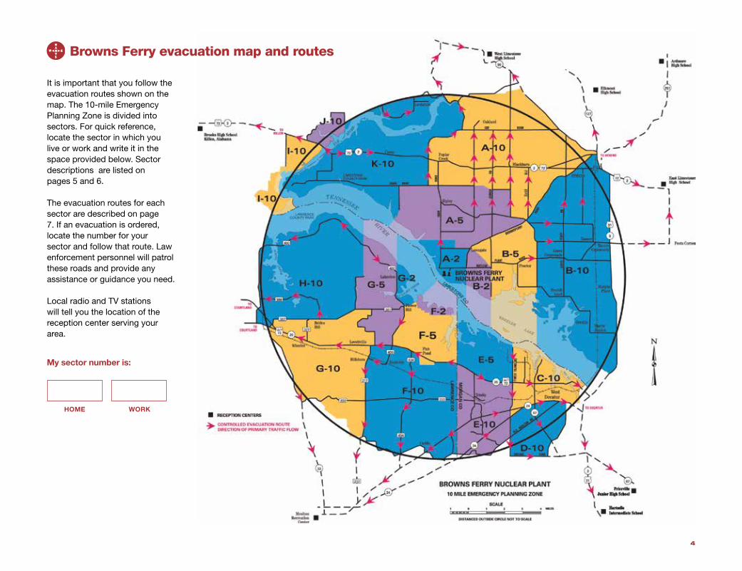
Browns Ferry evacuation map and routes
It is important that you follow the evacuation routes shown on the map. The 10-mile Emergency Planning Zone is divided into sectors. For quick reference, locate the sector in which you live or work and write it in the space provided below. Sector descriptions are listed on pages 5 and 6.
The evacuation routes for each sector are described on page 7. If an evacuation is ordered, locate the number for your sector and follow that route. Law enforcement personnel will patrol these roads and provide any assistance or guidance you need.
Local radio and TV stations will tell you the location of the reception center serving your area.
My sector number is:
HOME WORK
4

TWO-MILE ZONESector A-2 – Limestone CountyBeginning at Poplar Creek and the Tennessee River, proceed east on dirt road past Shaw Road 3/4 mile, south on Mack Road to Lawngate Road, east on Lawngate Road, then south on Brownsferry Road. Continue due south to north bank of the Tennessee River.
Sector B-2 – Limestone CountyFollow power line north from Tennessee River to Cowford Road, then to the intersection of Nuclear Plant Road, continue northwest to intersection of Lawngate and Brownsferry roads, south on Brownsferry Road, then south to the Tennessee River.
Sector F-2 – Lawrence County Beginning on County Road 387 (east of Flower Hill), go southeast along the Wheeler Reservation boundary to the shoreline of the south side of the Tennessee River, then go northwest along the shoreline until it meanders back to the point of beginning at County Road 387.
Sector G-2 – Lawrence CountyBeginning at a point on County Road 400 at Flower Hill at intersection of County Road 387, go east on County Road 387 to the south shoreline of the Tennessee River, then go west along the shoreline to the Mallard Creek Bridge (County Road 400). Proceed north on County Road 400 to power line, continue due north from power line to the south shoreline of the Tennessee River, then go east along the shoreline of the Tennessee River as it meanders around the Mallard Creek Public Use Area, and back to the Mallard Creek Bridge on County Road 400.
FIVE-MILE ZONESector A-5 – Limestone CountyFollow Petty Branch north to intersection of Friend Road and Fielding Road, north on Fielding to Snake Road, then east on Snake Road. Proceed east-southeast to Grubbs Road, then east on Grubbs, south on Blackburn Road to Ripley Road. Proceed east-southeast on Ripley Road to Brownsferry Road, southwest on Brownsferry Road, west on Lawngate Road, then north on Mack Road 1/2 mile, due west to Poplar Creek and the Tennessee River.
Sector B-5 – Limestone CountyFollow power lines from Tennessee River to Cowford Road, north to the intersection of Nuclear Plant Road, northwest across county to intersection of Lawngate and Brownsferry Road. Proceed northeast on Brownsferry Road to Huntsville-Brownsferry Road, south on Huntsville-Brownsferry Road 1 1/4 miles to Neely Road, south on Neely Road. Continue south on Neely Road and then on Settle Road to the mouth of Mud Creek and the Tennessee River.
Sector E-5 – Morgan CountyBeginning at the intersection of Lawrence County line and State Highway 20, go north along the county line to the Limestone County line on the Tennessee River, east along the county line (on water) to Finley Island Road, south on Finley Island Road to State Highway 20, west on Highway 20 to point of beginning.
Sector F-5 – Lawrence CountyBeginning at Flower Hill on County Road 400 go east on County Road 387 to the Wheeler Reservation boundary, then follow the Wheeler Reservation boundary to the Lawrence-Morgan County line. Follow the Lawrence-Morgan County line south to State Highway 20, then go west on State Highway 20 to County Road 432 to the intersection of County Road 433, then west and north on County Road 433 until it intersects again with State Highway 20.
Go west on State Highway 20 to the intersection of County Road 400, then north on County Road 400 to Flower Hill.
Sector G-5 – Lawrence CountyBeginning at Flower Hill proceed south on Mallard Creek Road (County Road 400) to State Highway 20. Go west on State Highway 20 approximately 1 mile to County Road 383, north approximately 3/4 mile to the intersection of County Road 384, then west, north and east along County Road 384. Go back to County Road 383, then north on County Road 383 to the intersection of County Road 387, then west approximately 1 mile on County Road 387 to intersection of County Road 423. Go north and east to the end of County Road 423, then due north to the Lawrence County line on the Tennessee River, then east-southeast along the Lawrence County line to the power line on County Road 400, then south on Mallard Creek Road (County Road 400) back to Flower Hill.
Browns Ferry emergency planning zone sectors
5

TEN-MILE ZONESector A-10 – Limestone CountyStarting at Elk River Mills Dock, follow 10-mile EPZ to Elk River Mills Road east to Big Creek. Follow secondary road north of Big Creek to Buck Island Road, then south on Buck Island Road to Athens, south on Jefferson Street, southwest on Brownsferry Road to Reid, west 1 mile on Reid Road, then north for 1 1/2 miles on Blackburn Road. Proceed west on Grubbs Road, then northwest to Snake Road, north on Gordon Road to New Cut Road; follow New Cut Road to Baker Hill Road, then north on Baker Hill Road; follow Elk River Mills Road to the Elk River Mills Dock.
Sector B-10 – Limestone CountyStarting at a point due south of Mud Creek, go north on Neely Road from Bridgeforth Road to Brownsferry Road, northeast on Brownsferry Road to intersection of Jefferson and Washington streets in Athens, east on Washington Street to Clinton Street. Follow Clinton Street to Highway 72, proceed east on Highway 72 to Highway 31, south on Highway 31 to Highway 20, southeast on Highway 20 to the Tennessee River.
Sector C-10 – Morgan CountyBeginning at Limestone County line and Finley Island Road, go south on Finley Island Road to Woodall Road, south on Woodall Road to State Highway 24, east on Highway 24 to Moulton Street (Highway 24). Go east on Moulton Street to the railroad, north on the railroad to the Tennessee River, northwest on river to Finley Island Road and Limestone County.
Sector D-10 – Morgan CountyBeginning at Woodall Road and Highway 24, go south on Woodall Road (Shady Grove Lane) to Modaus Road, east on Modaus Road to Danville Road, north on Danville Road (Memorial Drive) to Moulton Street, west on Moulton Street (Highway 24) to Woodall Road and Highway 24.
Sector E-10 – Morgan CountyBeginning at intersection of State Highway 20 and
Lawrence County line, go south along county line to State Highway 24, then northeast on Highway 24 to Whitlow Road. Follow Whitlow Road to Hudson Road, go east along Hudson Road to Old Moulton Road, then go northeast on Old Moulton Road to Woodall Road, north on Woodall Road to State Highway 20, west on Highway 20 to Lawrence County line.
Sector F-10 – Lawrence CountyBeginning on State Highway 20 at the Lawrence-Morgan County line, go west on State Highway 20 to County Road 432, then south on 432 to the intersection of County Road 433, then west and north on County Road 433 until it intersects again with State Highway 20. Go west on State Highway 20 to the intersection of County Road 217, then south on County Road 217 to the intersection of County Road 301 at Sulphur Spring. Follow County Road 301 until the road runs into County Road 299, then follow County Road 299 until road runs into County Road 214; remain on County Road 214 east to Lawrence-Morgan County line, then north along the Lawrence-Morgan County line to the point of beginning on State Highway 20.
Sector G-10 – Lawrence CountyBeginning at the intersection of State Highway 20 and County Road 383, go north on County Road 383 to intersection of County Road 384, then north and east along County Road 384 back to County Road 383. Go north on County Road 383 to the intersection of County Road 387, then west on Brides Hill Road (County Road 387) to State Highway 20, then west on State Highway 20 to the intersection of State Highway 33. Proceed south on State Highway 33 to the intersection of County Road 222, then east on County Road 222 to the intersection of County Road 294, then follow a line southeast by Blowing Springs Branch to the intersection of County Road 217 at Sulphur Springs. Go north on County Road 217 to State Highway 20, then east on State 20 to point of beginning.
Sector H-10 – Lawrence CountyBeginning at the intersection of Brides Hill Road (County Road 387) in the vicinity of Terry Heights
subdivision, go east along County Road 387 5.4 miles to County Road 423, then north to the end of County Road 423. Proceed due north to the Lawrence County line at the Tennessee River, then westerly along the county line to a point due north of the TVA Public Use Area, then south to the Spring Creek Road bridge. Follow Spring Creek Road (County Road 400) south to County Road 389, south on County Road 389 to Jefferson Street, then east on Jefferson Street to State Highway 33, to Terry Heights subdivision.
Sector I-10 – Lauderdale CountyBeginning at Elk River Bridge at U.S. Highway 72, go west to County Road 77, south on County Road 77 to Barnett Road, south on Barnett Road to curve in the road, then a southwest angle to the intersection of County Road 632 and County Road 91. Go north on County Road 91 to intersection of Longshore Drive, then south on Longshore Drive into Tennessee River to Lauderdale County line. Follow Lauderdale County line east, then north to beginning point at U.S. 72 at Elk River Bridge.
Sector J-10 – Lauderdale CountyBeginning at Elk River Bridge at U.S. Highway 72, go west on U.S. Highway 72 to County Road 70, north on County Road 70 to the intersection of County Road 70 and County Road 566, then east on County Road 566 to Richter Road at Lauderdale County line. Go south on Richter Road following Lauderdale County line into Elk River and then following Lauderdale County line to beginning point at Elk River Bridge at U.S. Highway 72.
Sector K-10 – Limestone CountyFrom a point on the Tennessee River and TVA Public Use Area to Elk River State Park go north along the Lauderdale County line to the 10-mile EPZ and Lauderdale County line intersection, along 10-mile EPZ line to the Elk River Mills Dock, south on Elk River Mills Road to Baker Hill Road. Proceed southwest on New Cut Road, south on Gordon Road to Snake Road to Friend Road, south on Friend Road to Friend Branch and the Tennessee River.
6

Follow the evacuation routes shown on the map. Traffic may also be directed by emergency workers. Go to the nearest reception center in your county and register as an evacuee.
I-10 Lauderdale CountyTake County Road 91, County Road 70 and County Road 77 to U.S. Highway 72. Proceed west to Brooks High School in Killen.
J-10 Lauderdale CountyTake County Road 70 to U.S. Highway 72 West to Brooks High School in Killen.
F-2, F-5 Lawrence CountyTake shortest route to State Highway 20 (Alternate U.S. 72). Go west on State Highway 20 to County Road 217 to State Highway 24. Go west on State Highway 24 to State Highway 157, south on State Highway 157 to Court Street, west on Court Street. Follow instructions of traffic control personnel to the Moulton Recreation Center.
F-10 Lawrence CountyTravel south to State Highway 24. Go west on State Highway 24 to State Highway 157. Turn south on State Highway 157. Follow instructions of traffic control personnel to the Moulton Recreation Center.
G-2 Lawrence CountyTravel south to State Highway 20. Go west on State Highway 20 to County Road 217, south on County Road 217 to State Highway 24, west on State Highway 24 to State Highway 157. Go south on State Highway 157 to Court Street. Turn west on Court Street to the Moulton Recreation Center.
G-5 Lawrence CountyTake the most direct route to County Road 400, then proceed east on County Road 400 to State Highway 20. Go west on State Highway 20 to County Road 217, south on County Road 217 to State Highway 24, west on State Highway 24 to State Highway 157, where you will be directed to the Moulton Recreation Center.
G-10 Lawrence CountyTravel to State Highway 20. Go west on State Highway 20 to State Highway 33, then south on State Highway 33 to the Moulton Recreation Center.
H-10 Lawrence CountyProceed west to County Road 400, then south on County Road 400 to County Road 389. Go south on County Road 389 to State Highway 20, east on State Highway 20 to State Highway 33, south on State Highway 33 to the Moulton Recreation Center.
A-2 Limestone CountyProceed north and follow the Evacuation Route signs to the Reception Center at West Limestone High School.
A-5 Limestone CountyProceed north and follow the Evacuation Route signs to the Reception Center at West Limestone High School or proceed northeast to the Reception Center at Elkmont High School.
A-10 Limestone CountyProceed north and follow the Evacuation Route signs to the Reception Center at West Limestone High School or proceed northeast to the Reception Center at Elkmont High School.
B-2 Limestone CountyProceed east and follow the Evacuation Route signs to the Reception Center at East Limestone High School.
B-5 Limestone CountyProceed east and follow the Evacuation Route signs to the Reception Center at East Limestone High School or proceed northeast to the Reception Center at Ardmore High School.
B-10 Limestone CountyProceed east and follow the Evacuation Route signs to the Reception Center at East Limestone High School or proceed northeast to the Reception Center at Ardmore High School.
K-10 Limestone CountyTake shortest route to U.S. 72. If located west of Lucy’s Branch Marina head west on U.S. 72 to Brooks High School in Killen. All others head east and follow evacuation route signs to West Limestone High School.
E-5 Morgan CountyTravel south on Finley Island Road or east on State Highway 20 to Woodall Road, then south to Modaus Road. Go east on Modaus Road to State Highway 67, east on State Highway 67 to U.S. Highway 31, south on U.S. 31 to Hartselle Intermediate School.
E-10 Morgan CountyTravel east on State Highway 24 to Woodall Road, south on Woodall Road to Modaus Road, then east to State Highway 67. Go east on State Highway 67 to U.S. Highway 31, then south on U.S. Highway 31 to Hartselle Intermediate School.
C-10 Morgan CountyTravel east on State Highway 20 or 24 to U.S. Highway 31. Go south on Highway 31 to State Highway 67, then east on Highway 67 to Priceville Junior High School.
D-10 Morgan CountyTake shortest route to either Danville Road or Old Moulton Road to State Highway 67. Go east on State Highway 67 to U.S. Highway 31, south on U.S. Highway 31 to Hartselle Intermediate School.
7
Evacuation routes

To help you prepare for any type of emergency, we have provided two lists of supplies. One lists items you may need to keep in your home to aid your response. The second lists supplies to take with you if you are asked to leave the area. Check the supplies you would need and add supplies not listed.
Emergency supplies for your homeo Weather alert radioo First-aid kito Toolboxo Candles and matcheso Portable radio, flashlight, extra batterieso ______________________________________
Evacuation supplieso This calendaro Medicine or any special medicationo Personal health products (shaving cream, toothbrush)o Special diet foodo Blankets and pillowso Cash, checkbook, credit cards, important paperso Items for children (favorite toy, books)o Change of clothingo ______________________________________
If given potassium iodide tablets: During a nuclear emergency, you might be exposed to radiation that could harm your thyroid gland, and public health officials may direct you to take potassium iodide (KI) tablets. The tablets can reduce the amount of radioactive iodine absorbed by your thyroid gland.
The tablets will be given only to those persons from the affected areas who may have been exposed to radioactive iodine. It is important that you know the sector that you evacuated from, and that you read and understand the consent form you will receive prior to taking the tablets. Take the tablets only as directed, when directed, and call your public health office if you have questions.
If you need special help
8
Your health and safety are very important to us. We realize that some of you who live near Browns Ferry Nuclear Plant may have special needs.
To assist and provide care for those of you who are medically disabled or handicapped, we must make certain plans.
If you or someone you know who lives within 10 miles of Browns Ferry needs special help, please fill out and mail one of the two cards provided in this calendar. After you have answered the questions on the card, drop it in a mailbox. The card is pre-addressed, and the postage has been paid. You need to mail this card as soon as possible so proper arrangements can be made.
Please fill out the card and mail it even if you may have previously returned a card. This will enable your emergency officials to maintain a current list of individuals who would need assistance. If you have any questions or need additional cards, please contact one of the emergency management agencies listed here.
Lauderdale County Emergency Management Agency: 256-760-6363
Lawrence County Emergency Management Agency: 256-974-7641
Limestone County Emergency Management Agency: 256-232-2631
Morgan County Emergency Management Agency: 256-351-4620
For farmers and home gardeners
If an incident occurs at Browns Ferry Nuclear Plant, your local emergency management agency will issue directions for contacting your agricultural extension agent for information on how to protect your crops and livestock. For more information, listen to your local radio and TV stations.
Your crops• An unharvested crop is hard to protect.
However, normal harvesting and processing may still be possible if time permits.
• Crops already harvested will be safer if they are stored inside.
• You should wash and peel vegetables and fruits from your garden before use if they were not already harvested.
To protect your livestock• Provide as much shelter as possible. If
you do not have enough space in barns or sheds, use natural shelters such as wooded areas or road underpasses.
• Provide plenty of food and water and make sure shelters are well ventilated.
• Milk animals should be given first priority.• Use stored feed when possible.
Emergency supplies checklist

How emergencies are classifiedIf there is an incident at Browns Ferry Nuclear Plant, it will be placed in one of four categories that have been established by the United States Nuclear Regulatory Commission and adopted by the state of Alabama and TVA.
For your information and reference, here are the four emergency levels in order from least to most severe.
1. A Notification of Unusual Event is the least serious of the four classifications. Because of strict federal regulations, any event out of the ordinary is reported to federal, state and local authorities. The event poses no risk to you or to plant employees. It means that a minor problem exists. Appropriate officials and personnel are notified.
2. An Alert is declared when an event has occurred that could reduce the level of safety of the plant, but backup plant systems are available. Emergency agencies are notified and asked to stay in touch, but no action by the public is necessary.
3. A Site-Area Emergency is declared when there is a problem with plant safety systems and a release of some radioactivity into the air or water is possible. The sirens will be sounded. You should listen to radio and television stations for information and instructions.
4. A General Emergency is declared when an event at the plant has caused a loss of several safety systems that could lead to a release of radiation. State and local authorities will take action to protect the residents living near the plant. People in affected areas will be advised by authorities to stay indoors or to evacuate.
9
General information

10
Glossary
Background radiation – This is radiation from natural sources. It comes from the sun’s rays and it’s in the ground, building materials and the human body.
Core – The central part of a nuclear reactor that contains the uranium fuel.
Fission – The nuclear process in which a heavy atom, such as uranium, splits into fragments.
Fuel assembly – A collection of rods that contain the nuclear fuel pellets. The fuel pellets produce heat to make the steam used to generate electricity.
Fuel pellets – Thimble-sized uranium dioxide pellets used in nuclear power generation. Each pellet contains about the same amount of energy as that produced from burning 1 ton of coal. A modern reactor core may contain up to 17.5 million pellets.
Fuel rods – Hollow tubes that contain stacks of uranium dioxide fuel pellets. These rods are bundled together to form fuel assemblies.
Half-life – The time required for a radioactive substance to lose one-half of its radioactivity. Half-life can vary from minutes to years, depending on the substance.
Radiation is energy traveling in the form of invisible particles or rays after the breakdown of radioactive atoms. Everyone is exposed to small amounts of radiation every day. Air, water, food and sunshine are a few sources of natural background radiation. The dose humans receive from radiation is commonly measured in “millirems.” According to recent studies, the average radiation dose to a member of the public in the United States is about 620 millirems per year.
Radiation also comes from other sources. Color televisions produce about 1 millirem of radiation every year. Medical procedures such as x-rays and diagnostic tests can result in 20 to several thousand millirems of radiation a year, depending on a person’s treatment for disease or injury.
People are concerned about radiation exposure because it can alter or damage human cell structure. That is why workers at nuclear power plants are carefully monitored and trained to limit their exposure to a level that is as low as is reasonably achievable. The Nuclear Regulatory Commission, which issues licenses to all nuclear power plants, has set a maximum safe individual dose of 5,000 millirems a year, measured over the entire body. To avoid
coming even close to this level, TVA work procedures set an administrative limit of 1,000 millirems per year for any worker, with any additional dose requiring written approval.
A nuclear power plant’s containment building, reactor vessel and fuel assemblies are barriers designed to contain radiation and protect plant workers and persons living near the plant from any exposures to elevated levels of radiation. Repeated surveys around TVA’s operating nuclear plants have shown no detectable increase in radiation above normal background levels.
Consumer products 2%Terrestrial (rocks and soil) 3%Cosmic (outer space) 5%Internal (inside human body) 5%Nuclear medicine 12%Medical x-rays 12%CT scans 24%Radon 37%
SOURCES OF RADIATION
What is radiation?

How Browns Ferry works
Browns Ferry operates much like a fossil-fueled power plant. In a fossil plant, coal, oil or gas is burned to make heat. The heat turns water into steam, the steam drives a turbine and the turbine spins an electrical generator, producing electric power.
The operation is the same at Browns Ferry, except the heat is provided by a process called fission, and the fuel is uranium. The uranium is sealed inside long metal tubes, called fuel rods. These rods are placed into the reactor vessel, making up the fuel core.
When a uranium atom is struck by a small particle called a neutron, it can give off heat and more neutrons. Those neutrons can strike other uranium atoms, causing them to continue the chain reaction.The reaction is started and stopped by control rods
that can be moved in and out of the fuel core. These control rods are made of a material that absorbs neutrons. When inserted into the core, they stop the chain reaction.
It is physically IMPOSSIBLE for the nuclear fuel at Browns Ferry to explode like a nuclear bomb. The fuel for Browns Ferry and other similar nuclear power plants is only about 3 percent to 5 percent fissionable uranium. Nuclear weapons have in excess of 90 percent fissionable uranium. The illustration above shows how the heat from the fission process is used to make steam and generate electricity at Browns Ferry.
Water (pink) is pumped through the core and heated by the fuel. The water boils in the reactor to produce
steam. The steam is piped to the turbine, where the force of the expanding steam turns the turbine.
To produce electricity, the turbine turns the generator, which is an electromagnet inside a coil of wire. After the steam passes through the turbine, the steam is cooled back into water by circulating around tubes carrying cool water (blue) from Wheeler Reservoir.
The condensed steam, which is now water, is pumped back to the reactor to repeat the cycle. The condenser cooling water may be passed through the cooling towers before it is returned to the reservoir.
The reactor coolant water is radioactive and is NOT allowed to mix with the condenser cooling water that is returned to the reservoir.
11

DECEMBER2017

SUNDAY MONDAY TUESDAY WEDNESDAY THURSDAY FRIDAY SATURDAY
1 2
3 4 5 6 7 8 9
10 11 12 13 14 15 16
17 18 19 20 21 22 23
24 25 26 27 28 29 30
DECEMBER 2017
NEW YEAR’S EVE CHRISTMAS
FIRST DAY OF WINTER
HANUKKAH BEGINS
HANUKKAH ENDS
S M T W T F S
1 2 3 4 5 67 8 9 10 11 12 1314 15 16 17 18 19 2021 22 23 24 25 26 2728 29 30 31
JANUARY 2018S M T W T F S
1 2 3 45 6 7 8 9 10 1112 13 14 15 16 17 1819 20 21 22 23 24 2526 27 28 29 30
NOVEMBER 2017
31

JANUARY2018

SUNDAY MONDAY TUESDAY WEDNESDAY THURSDAY FRIDAY SATURDAY
1 2 3 4 5 6
7 8 9 10 11 12 13
14 15 16 17 18 19 20
21 22 23 24 25 26 27
28 29 30 31
JANUARY 2018
MARTIN LUTHER KING JR.DAY
S M T W T F S
1 2 34 5 6 7 8 9 1011 12 13 14 15 16 1718 19 20 21 22 23 2425 26 27 28
FEBRUARY 2018S M T W T F S
1 23 4 5 6 7 8 910 11 12 13 14 15 1617 18 19 20 21 22 2324 25 26 27 28 29 3031
DECEMBER 2017
NEW YEAR’S DAY

FEBRUARY2018

SUNDAY MONDAY TUESDAY WEDNESDAY THURSDAY FRIDAY SATURDAY
1 2 3
4 5 6 7 8 9 10
11 12 13 14 15 16 17
18 19 20 21 22 23 24
25 26 27 28
FEBRUARY 2018
S M T W T F S
1 2 3 4 5 67 8 9 10 11 12 1314 15 16 17 18 19 2021 22 23 24 25 26 2728 29 30 31
JANUARY 2018S M T W T F S
1 2 34 5 6 7 8 9 1011 12 13 14 15 16 1718 19 20 21 22 23 2425 26 27 28 29 30 31
MARCH 2018
VALENTINE’S DAYLINCOLN’S BIRTHDAY
PRESIDENTS’ DAY WASHINGTON’S BIRTHDAY
ASH WEDNESDAY

MARCH2018

SUNDAY MONDAY TUESDAY WEDNESDAY THURSDAY FRIDAY SATURDAY
1 2 3
4 5 6 7 8 9 10
11 12 13 14 15 16 17
18 19 20 21 22 23 24
25 26 27 28 29 30 31
MARCH 2018
FIRST DAY OF SPRING
ST. PATRICK’S DAYDAYLIGHT SAVING
TIME BEGINS
S M T W T F S
1 2 34 5 6 7 8 9 1011 12 13 14 15 16 1718 19 20 21 22 23 2425 26 27 28
FEBRUARY 2018S M T W T F S
1 2 3 4 5 6 78 9 10 11 12 13 1415 16 17 18 19 20 2122 23 24 25 26 27 2829 30
APRIL 2018
PASSOVER BEGINS
GOOD FRIDAY

APRIL 2018

SUNDAY MONDAY TUESDAY WEDNESDAY THURSDAY FRIDAY SATURDAY
1 2 3 4 5 6 7
8 9 10 11 12 13 14
15 16 17 18 19 20 21
22 23 24 25 26 27 28
29 30
APRIL 2018
NATIONAL ARBOR DAYADMINISTRATIVE
PROFESSIONALS’ DAYEARTH DAY
S M T W T F S
1 2 34 5 6 7 8 9 1011 12 13 14 15 16 1718 19 20 21 22 23 2425 26 27 28 29 30 31
MARCH 2018
PASSOVER ENDS
S M T W T F S
1 2 3 4 56 7 8 9 10 11 1213 14 15 16 17 18 1920 21 22 23 24 25 2627 28 29 30 31
MAY 2018
EASTER

MAY 2018

SUNDAY MONDAY TUESDAY WEDNESDAY THURSDAY FRIDAY SATURDAY
1 2 3 4 5
6 7 8 9 10 11 12
13 14 15 16 17 18 19
20 21 22 23 24 25 26
27 28 29 30 31
MAY 2018
MEMORIAL DAY
MOTHER’S DAY ARMED FORCES DAY
CINCO DE MAYO
S M T W T F S
1 2 3 4 5 6 78 9 10 11 12 13 1415 16 17 18 19 20 2122 23 24 25 26 27 2829 30
APRIL 2018S M T W T F S
1 23 4 5 6 7 8 910 11 12 13 14 15 1617 18 19 20 21 22 2324 25 26 27 28 29 30
JUNE 2018

JUNE2018

SUNDAY MONDAY TUESDAY WEDNESDAY THURSDAY FRIDAY SATURDAY
1 2
3 4 5 6 7 8 9
10 11 12 13 14 15 16
17 18 19 20 21 22 23
24 25 26 27 28 29 30
JUNE 2018
FLAG DAY
FATHER’S DAY FIRST DAY OF SUMMER
S M T W T F S
1 2 3 4 56 7 8 9 10 11 1213 14 15 16 17 18 1920 21 22 23 24 25 2627 28 29 30 31
MAY 2018S M T W T F S
1 2 3 4 5 6 78 9 10 11 12 13 1415 16 17 18 19 20 2122 23 24 25 26 27 2829 30 31
JULY 2018

JULY 2018

SUNDAY MONDAY TUESDAY WEDNESDAY THURSDAY FRIDAY SATURDAY
1 2 3 4 5 6 7
8 9 10 11 12 13 14
15 16 17 18 19 20 21
22 23 24 25 26 27 28
29 30 31
JULY 2018
S M T W T F S
1 23 4 5 6 7 8 910 11 12 13 14 15 1617 18 19 20 21 22 2324 25 26 27 28 29 30
JUNE 2018S M T W T F S
1 2 3 45 6 7 8 9 10 1112 13 14 15 16 17 1819 20 21 22 23 24 2526 27 28 29 30 31
AUGUST 2018
INDEPENDENCE DAY

AUGUST2018

SUNDAY MONDAY TUESDAY WEDNESDAY THURSDAY FRIDAY SATURDAY
1 2 3 4
5 6 7 8 9 10 11
12 13 14 15 16 17 18
19 20 21 22 23 24 25
26 27 28 29 30 31
AUGUST 2018
S M T W T F S
1 2 3 4 5 6 78 9 10 11 12 13 1415 16 17 18 19 20 2122 23 24 25 26 27 2829 30 31
JULY 2018S M T W T F S
12 3 4 5 6 7 89 10 11 12 13 14 1516 17 18 19 20 21 2223 24 25 26 27 28 2930
SEPTEMBER 2018

SEPTEMBER2018

SUNDAY MONDAY TUESDAY WEDNESDAY THURSDAY FRIDAY SATURDAY
1
2 3 4 5 6 7 8
9 10 11 12 13 14 15
16 17 18 19 20 21 22
23 24 25 26 27 28 29
SEPTEMBER 2018
S M T W T F S
1 2 3 4 5 67 8 9 10 11 12 1314 15 16 17 18 19 2021 22 23 24 25 26 2728 29 30 31
OCTOBER 2018
LABOR DAY
FIRST DAY OF AUTUMN
S M T W T F S
1 2 3 45 6 7 8 9 10 1112 13 14 15 16 17 1819 20 21 22 23 24 2526 27 28 29 30 31
AUGUST 2018
30
ROSH HASHANAH BEGINS ROSH HASHANAH ENDS
YOM KIPPUR BEGINS YOM KIPPUR ENDS

OCTOBER2018

SUNDAY MONDAY TUESDAY WEDNESDAY THURSDAY FRIDAY SATURDAY
1 2 3 4 5 6
7 8 9 10 11 12 13
14 15 16 17 18 19 20
21 22 23 24 25 26 27
28 29 30 31
OCTOBER 2018
HALLOWEEN
COLUMBUS DAY
NATIONAL BOSS’S DAY
S M T W T F S
12 3 4 5 6 7 89 10 11 12 13 14 1516 17 18 19 20 21 2223 24 25 26 27 28 2930
SEPTEMBER 2018S M T W T F S
1 2 34 5 6 7 8 9 1011 12 13 14 15 16 1718 19 20 21 22 23 2425 26 27 28 29 30
NOVEMBER 2018

NOVEMBER2018

SUNDAY MONDAY TUESDAY WEDNESDAY THURSDAY FRIDAY SATURDAY
1 2 3
4 5 6 7 8 9 10
11 12 13 14 15 16 17
18 19 20 21 22 23 24
25 26 27 28 29 30
NOVEMBER 2018
THANKSGIVING
DAYLIGHT SAVING TIME ENDS
VETERANS DAY
S M T W T F S
1 2 3 4 5 67 8 9 10 11 12 1314 15 16 17 18 19 2021 22 23 24 25 26 2728 29 30 31
OCTOBER 2018S M T W T F S
12 3 4 5 6 7 89 10 11 12 13 14 1516 17 18 19 20 21 2223 24 25 26 27 28 2930 31
DECEMBER 2018

DECEMBER2018

SUNDAY MONDAY TUESDAY WEDNESDAY THURSDAY FRIDAY SATURDAY
1
2 3 4 5 6 7 8
9 10 11 12 13 14 15
16 17 18 19 20 21 22
23 24 25 26 27 28 29
DECEMBER 2018
NEW YEAR’S EVE CHRISTMAS
FIRST DAY OF WINTER
HANUKKAH BEGINS
S M T W T F S
1 2 34 5 6 7 8 9 1011 12 13 14 15 16 1718 19 20 21 22 23 2425 26 27 28 29 30
NOVEMBER 2018S M T W T F S
1 2 3 4 56 7 8 9 10 11 1213 14 15 16 17 18 1920 21 22 23 24 25 2627 28 29 30 31
JANUARY 2019
30 31
HANUKKAH ENDS

Tennessee Valley Autho
rityK
noxville, Tennessee 37902-1401
PR
ES
OR
TE
D S
TAN
DA
RD
U.S
. PO
STA
GE
PA
IDT
EN
NE
SS
EE
VALLE
Y
AU
TH
OR
ITY
Keep T
his Calendar
All inform
ation also is available in E
nglish and
Sp
anish on tva.com/p
repare.
Para recib
ir esta información en esp
añol,visite tva.com
/prep
are o llame al 423-843-7839.
tva.c
om
/pre
pare