brummett visions mediterranean
TRANSCRIPT

Visions of the Mediterranean: A Classification
Palmira BrummettUniversity of TennesseeKnoxville, Tennessee
Dr. Samuel Johnson once said, “!e grand object of all travel is to see the shores of the Mediterranean.” So true is this statement that it may be ques-tioned whether all the rest of the world can muster such a combination of mar-velous beauty, fascinating romance, unique scenes and sacred associations.
— D. E. Lorenz, !e Mediterranean Traveller (!"!!)
“#e Mediterranean” is repeated over and over as a concept, a center, a limit, an edge. It forms the basis for classes on civilization and for explorations of economics and identity. It is a space where things come, go, or happen; and it is a hole (into which things disappear), like Central Asia in certain formulations of world history.! #e Mediterranean is seldom simply a sea space; rather (as its name suggests) it is embedded in the land and in the imaginations of land-based peoples. It marks the river’s mouth, the limits of the space in which soldiers can march or ride, the borders of a comfort zone defined by access to food, drinkable water, weapons, and some vestiges of safety or authority. It may be conceived as a whole in the sovereign claims of monarchs and in the front pages of the mapmaker’s atlas. Yet it is more often composed of fragments: separate seas, stretches of coast, zones of liveli-hood, points of departure, and points of arrival. Ships on its waters function as moving pieces of sovereign space, receptacles for goods and their atten-dant expectations, and living platforms for those members of society, and attendant organisms, who, willingly or unwillingly, traverse the water. States claim it but cannot hold it. #e Mediterranean is west of Istanbul, south of the Danube, east of Gibraltar, north of Algiers. It is a line, a block, a chain of ports, a dumping ground — measured in names, coins, wine, recipes, roof types, fishing lines, corpses. It gets things wet. It constitutes the imaginary boundary between Christendom and Islam; and yet it is posed more often
Journal of Medieval and Early Modern Studies 37:1, Winter 2007 DOI !$.!%!&/!$'%"()(-%$$(-$$" © 2007 by Duke University Press

10 Journal of Medieval and Early Modern Studies / 37.1 / 2007
as commercial space than as sacred space or war space. #e Mediterranean begins with the lines and colors of Ptolemy and al-Idr*s* and ends with the microcosms of Fernand Braudel and attendant scholars.% #e Mediterranean, in Western historiography, is presumed to be “ours,” rather then “theirs,” the Afro-Eurasian oikumene of Marshall Hodgson notwithstanding.) It is the space of Odysseus, Marc Anthony, St. Paul, Boccaccio, the Crusaders, the pilgrims, the takers of the Grand Oriental tour (always going “east,” more or less, and returning “west,” if they can). It is the realm of West-ern antiquity, a Roman, Venetian, “Muslim,” Spanish, French, or English lake, bearing goods to and for a space sooner or later called “Europe,” until the “Age of Discovery” — when interest, ambition, and slavery miraculously “shift” to the Atlantic — and until the “colonial” era when the inland sea becomes a conduit to eastern conquests and possessions. It is the old sea, to which seascapes like those of the Atlantic world, the Indian Ocean, and the Pacific rim are added to make an image of the world that seems more global. Its captivity narratives are the stories of we the captives and they the pirates; although the pirates seldom tell their own tales and the captives’ narratives are often sagas of woes on land rather than at sea.
As an Ottomanist historian who has examined seapower in the early modern era, I too have a particular vision of the Mediterranean, one which focuses on the eastern end of the sea and privileges its own set of hegemons.+ Despite the rhetorical claims of the Ottoman sultans to be lords of the two seas, the “Black” and the “White” (Mediterranean), I do not tend to think of the Mediterranean as an integral unit of analysis. For me, that sea is indel-ibly fragmented into its ports, islands, coasts, and their attendant interiors. It is divided into a set of city-linking itineraries, routes for the transmission of ideas, goods, and military forces. If I do imagine the Mediterranean as a whole, it is not a space divided into Christian and Muslim “halves”; rather, it is a space bounded on three sides by the multicultural Ottoman empire, with its large final side, “the West,” controlled by a set of rulers (both Mus-lim and Christian) whom the Ottomans were unable to subordinate. It is not marked by ecological zones but by complex, overlapping, ethnolinguis-tic, commercial, and cultural identities. #e Mediterranean has appending seas, the Black, the Red, the Aegean, and the Adriatic. But the Atlantic is far away; and the direction of significant interest and attachment is, in any case, east not west.
My vision di,ers, sometimes markedly, from a large portion of con-temporary “Western” historiography of the Mediterranean, a historiography which has pronounced the European identity of the inland sea, divided it

Brummett / Visions of the Mediterranean 11
into Christian and Muslim zones along a north-south axis, and argued for a unity (of sorts) based either on the enduring structures of Braudel, the inter-secting microecologies of Horden and Purcell, or the centuries-long eco-nomic logics of world history.& While all of these models eschew an emphasis on political history, they cannot completely avoid the concept of possession (a designation of the peoples, lands, or states to whom the sea “belongs”), an element of analysis which is central to my conceptualization of the Mediter-ranean. Indeed, the use of the terms Mediterranean and Levant, by virtue of their derivation from Latin, conveys a sense of Western possession. Con-versely, both terms also transcend possession, suggesting a bridging or sub-version of nation and sovereignty in order to privilege transnational (trans-ethnic, transcommunal) movement, association, or ecology. Nonetheless, we see that historiographies of the Mediterranean do grant possession: to the Romans, to Philip II, to Christians and Muslims, or to Dutch, French, and English trading companies, with Phoenicians, Jews, and other diasporas, intermediaries, transgressors, and traders moving in and about in between. #ey pose the question, explicit or implicit, “Whose space?” and divide the sea accordingly.
At the eastern end of the sea, the Ottoman Empire, despite its lon-gevity and the scope of its conquests, does not replace the Roman Empire in the majority historiographic Mediterranean paradigm. It remains an ele-phant (a land based military power) rather than a whale, and hence it cannot truly possess the sea, even though no serious scholar debates the supremacy of its fleets in the sixteenth century.( Possession and identity, it would seem, require more than fleets.- #us the city-state of Venice serves as placeholder in the category of “Mediterranean Empire.” On a broader level, the Ottoman polity is “the Turk,” assigned the task of embodying Islam in the late medi-eval and early modern eras, and serving as quintessential rival, opponent, obstacle, and threat to Europe, European ambitions, and the European space called “Christendom.” #is historiographic characterization has isolated Anatolia from the Mediterranean and deflected the Ottoman Empire from serving a more complex set of roles.' It can be a trading partner and a Levan-tine power, but not a truly Mediterranean Empire. #is partitioning-o, of the Ottomans derives in part from the ways in which Ottomanist and Medi-terranean studies have evolved, in part from the association of the Mediter-ranean with Europe (and the concomitant failure to acknowledge the Otto-mans as a European power), and in part from a failure adequately to explore the rhetorics and realities of the early modern Afro-Eurasian world and to distinguish them from historiographic models based on region or faith.

12 Journal of Medieval and Early Modern Studies / 37.1 / 2007
In the interests of pursuing that exploration I propose here to pre-sent a series of historical visions of the Mediterranean to suggest how they may or may not jibe with contemporary historiographic models. Other scholars have grappled with identifying the spatial and temporal limits of the Mediterranean; determining the relevance of its hegemons, empires, cities, and states; measuring change; and distinguishing between maritime history and the histories of societies surrounding the sea." My treatment will instead foreground the idea of mapping. It will begin by presenting eight texts (spanning the fourteenth to the nineteenth century) that map the Mediterranean: the political sociology of Ibn Khaldun; the travel accounts of Ibn Battuta, Evliya Çelebi, and Muhammad as-Sa,.r; and four maps of the Mediterranean or its parts. Ibn Khaldun frames the Mediterranean. #e three travelers illustrate the varying ways that the Mediterranean encounter could be narrated from the perspective of Muslims situated on the southern and eastern shores of the sea. #e maps provide images of space and rhetorics of connectivity and possession (from the perspectives of the northern side of the sea). Having employed these texts to outline Mediterranean space, I will comment briefly on their intersections with contemporary historiographic models, including Braudel’s sixteenth-century Mediterranean world, Hor-den and Purcell’s three-thousand-year-long regional unit, the Afro-Eurasian civilizational paradigm of Marshall Hodgson, and the long-term economic cycles of world history. I conclude by suggesting that an approach to the early modern Mediterranean which foregrounds mapping (privileging itin-erary, visuality, connectivity, and possession in concert) can facilitate a bet-ter understanding of the ways in which early modern peoples envisioned the Mediterranean space. Further, this combination of emphases helps dissolve the still-persistent partitioning of the Mediterranean along Muslim-Christian or European-Asian lines, a division that only partially reflects early mod-ern sensibilities. I do not claim that the Muslim-Christian divide was an inconsequential element in early modern understandings of the Mediter-ranean — far from it. War space and sacred space were crucial to those understandings. By “war space” and “sacred space,” however, I mean more than homogenous, conflictual blocks labeled Christian and Muslim. I mean those territories associated either with war or with religious ritual and iden-tity in all their messy and mixed social, political, economic, and rhetorical contexts. If we begin with the map of the Mediterranean, we find that the Muslim-Christian divide was not an uncomplicated factor in the rhetorics shaping the intricate contours of Mediterranean space and time.
Brummett / Visions of the Mediterranean 13
Knowledge, travel, space
Ptolemy’s Geography suggests a starting point for the mapping of the Mediter-ranean in Western historiography. In the left half of a planisphere, the inner sea appears, embraced on three sides by a series of peninsulas, and sitting, to the south, upon the great, solid, unending landmass of Africa.!$ #ere is no human presence in Ptolemy’s map, only the faces of the twelve winds blow-ing the known world in upon itself. #ese two options, the human and the spatial, remain as enduring qualifiers of the Mediterranean. #ey constitute the poles around which early modern visions of the sea are formed: a socially empty space, or a set of places that move in slide-strip sequence before the eye, important as settings for the moving human drama.!!
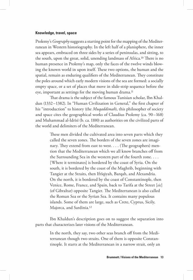
#at drama is the subject of the famous Tunisian scholar, Ibn Khal-dun (!))% – !)'%). In “Human Civilization in General,” the first chapter of his “introduction” to history (the Muqaddimah), this philosopher of society and space cites the geographical works of Claudius Ptolemy (ca. "$ – !(') and Muhammad al-Idr*s* (b. ca. !!$$) as authorities on the civilized parts of the world and delimiters of the Mediterranean.
#ese men divided the cultivated area into seven parts which they called the seven zones. #e borders of the seven zones are imagi-nary. #ey extend from east to west. . . . (#e geographers) men-tion that the Mediterranean which we all know branches o, from the Surrounding Sea in the western part of the fourth zone. . . . [Where it terminates] is bordered by the coast of Syria. On the south, it is bordered by the coast of the Maghrib, beginning with Tangier at the Straits, then Ifrîqiyah, Barqah, and Alexandria. On the north, it is bordered by the coast of Constantinople, then Venice, Rome, France, and Spain, back to Tarifa at the Street [sic] (of Gibraltar) opposite Tangier. #e Mediterranean is also called the Roman Sea or the Syrian Sea. It contains many populous islands. Some of them are large, such as Crete, Cyprus, Sicily, Majorca, and Sardinia.!%
Ibn Khaldun’s description goes on to suggest the separation into parts that characterizes later visions of the Mediterranean.
In the north, they say, two other seas branch o, from the Medi-terranean though two straits. One of them is opposite Constan-tinople. It starts at the Mediterranean in a narrow strait, only an

14 Journal of Medieval and Early Modern Studies / 37.1 / 2007
arrow-shot in width. It flows for a three days’ run and touches Constantinople. #en it attains a width of four miles. It flows in this channel for sixty miles, where it is known as the Straits [sic] of Constantinople. #rough a mouth six miles wide, it then flows into the Black Sea. . . . It passes the land of Heracleia (in Bithynia) and ends at the country of the Khazars, !,)$$ miles from its mouth. Along its two coasts live the Byzantine, the Turk-ish, the Bulgar, and the Russian nations. . . . #e second sea that branches o, from the two straits of the Mediterranean is the Gulf of Venice. It emerges from Byzantine territory at its northern limit. . . . On its two shores live the Venetians, the Byzantines, and other nations. It is called the Gulf of Venice. (Muqaddimah, &!)
Interestingly, in this description, the sea is held in by its coasts and by its peoples. For Ibn Khaldun, the Mediterranean is not just a division of space, it is a realm bordered by peoples, nations, and occupations. He says that the Maghrib and Ifrîqiyah are
on the southern shore of the Mediterranean. Along its southern shore the lands of the Berbers extend from Ceuta to Alexandria and on to Syria. Along its northern shore are the countries of Spain and of European Christians (Franks), the Slavs, and the Byzantines, also extending to Syria. It is called the Byzantine Sea or the Syrian Sea, according to the people who inhabit its shores. #ose who live along the coast and on the shores of both sides of the Mediterranean are more concerned with (maritime) condi-tions than any other maritime nation. (Muqaddimah, %$')
#e Mediterranean is thus, for the author, a sea of two sides, with the southern coasts just as important as the northern. It is anchored by Tangier on the west and south and Constantinople to the east and north. Along its edges, peoples choose the name of their own region or sovereign state to designate the sea, thus projecting a sense of possession out onto the entire body of water. Possession is embodied not only in naming but in war, as the ships of one people traverse the sea to subordinate another people and seize its lands:
#e Byzantines, the European Christians, and the Goths lived on the northern shore of the Mediterranean. Most of their wars and

Brummett / Visions of the Mediterranean 15
most of their commerce was by sea. #ey were skilled in navigat-ing (the Mediterranean) and in naval war. When these people coveted the possession of the southern shore, as the Byzantines (coveted) Ifrîqiyah and as the Goths the Maghrib, they crossed over in their fleets and took possession of it. #us, they achieved superiority over the Berbers and deprived them of their power. #ey had populous cities there, such as Carthage, Sbeitla, Jalûlâ, Murnâq, Cherchel, and Tangier. #e ancient master of Carthage used to fight the master of Rome and to send fleets loaded with armies and equipment to wage war against him. #us, (seafaring) is a custom of the inhabitants of both shores of the Mediterra-nean, which was known in ancient as in modern times. (Muqad-dimah, %$' – ")
Ibn Khaldun traces this maritime model of covetousness, ships bearing armies, and the seizing and building of coastal cities, through all of history up to his own time. #e hegemons change but the will to power does not. Initially, the Arabs had a “Bedouin attitude” and hence no aptitude for the sea. But they learned the sea and its navigation in order to construct ships, fulfill their desire to “wage the holy war by sea,” and send warriors “to fight the unbelievers across the sea” (Muqaddimah, %$").
#e man sometimes called “the father of sociology” thus describes seapower in terms of crafting identities, controlling shores, and intimidat-ing one’s enemy. Seapower passes from the once-strong who weaken to the newly strong; and the author writes, not quite dispassionately, of the alter-nating dominance of Muslim and Christian dynasties:
[In the later tenth and early eleventh centuries] the Christian nations withdrew with their fleets to the north-eastern side of the Mediterranean, to the coastal regions inhabited by the European Christians and Slavs, and to the Aegean islands, and did not go beyond them. #e Muslim fleet had pounced upon them as eagerly as lions upon their prey. #ey covered most of the surface of the Mediterranean with their equipment and numbers and traveled its lanes (on missions both) peaceful and warlike. Not a single Christian board floated on it. Eventually, however, the ‘Ubaydid (Fatimid) and Umayyad dynasties weakened and soft-ened and were a,ected by infirmity. #en, the Christians reached out for the eastern islands of the Mediterranean, such as Sicily,

16 Journal of Medieval and Early Modern Studies / 37.1 / 2007
Crete, and Malta, and took possession of them. #ey pressed on against the shores of Syria during this interval, and took pos-session of Tripoli, Ascalon, Tyre and Acro. #ey gained control over all the seaports of Syria. #ey conquered Jerusalem and built there a church as an outward manifestation of their religion and worship. . . . In the fifth [i.e., eleventh] century, they had the lead in the Mediterranean. (Muqaddimah, %!$ – !!)
Ibn Khaldun crafts a model of the Mediterranean and its region that privi-leges a two-sided division of war space and sacred space inhabited by nations that press out into the sea and up onto its coasts when they have the power to do so. Constantinople, Jerusalem, North African ports, and Mediterra-nean islands are important demarcators and anchors of that space. Warfare is natural and the Muslim-Christian divide is characteristic. Peoples move, but travel is not a central theme.
If one looks at medieval and early modern narratives or maps, how-ever, one is not surprised to find that the Mediterranean is presented in terms of travel: the stages of the journey; the towns, cities, and resting places; rivers crossed; ports approached and departed from. #e Mediterranean is pre-sented as a series of itineraries, each one variously imagined, with more or less content and context, with di,erent scales of measurement, and with attitudes ranging from endurance to adventure, pragmatism, fear, or won-der. In the travel narrative, the reader may learn of important personages, the depredations of bandits, enticing foods, ine,ective remedies, religious rituals, the ways in which women’s dress maps space, or of goods and gifts exchanged. #e sea is more or less present. As suggested by the three Muslim travelers whose accounts are presented below, the sea may appear as a barrier, a theater of war, a mode of existence, or simply as that which lies to one side as one pursues a journey.
#e traveler Ibn Battuta (!)$+ – ca. !)(") has long been joined to Marco Polo in Western historiography as a transcendent figure, mov-ing across (and narrating) continents in ways not necessary or expected in the medieval era. Set alongside those of other travelers, his stories illustrate the roles that personality, training, politics, and socioeconomic context play in the crafting of Mediterranean space. #is scholar from the Maghrib is celebrated for the detail of his travel narrative, which elaborates on monu-ments, histories, notable families, shrines, food, ceremonies, ethnicity, gifts, and goods. But oriented as he was toward cities, their institutions, and their educated elites, Ibn Battuta wrote a Mediterranean that, for the most part,

Brummett / Visions of the Mediterranean 17
wasn’t there. As he wended his way across North Africa to Cairo, Damascus, and Mecca in !)%& – %(, he paid little attention to the sea.!)
Ibn Battuta does begin the tale of his pilgrimage from Tangier with a reference to the sea, noting of the former Marinid king, Ab/ Y/suf Ya‘q/b (!%&' – !%'() that his “squadrons wrought havoc among the worshippers of the Cross” (Travels, !:"). #us, as in so many other craftings of the inland sea, the Mediterranean serves as war space, a space in which fleets divide the sea into Muslim and Christian spheres. Ibn Battuta, however, does not dwell on this seaborne division.!+ Continuing his tale of the ardors of travel and the people he met, he often addresses the sea only by allusion. #e chief qadi (judge) of Tunis was the scion of a family from Valencia; or, departing from Tunis, one followed the “coast road” (!:!+ – !&). Only when he comes to Alexandria does Ibn Battuta feel compelled to face the sea, and briefly describe the city’s magnificent harbor, which he compares to other harbors of the world, and its lighthouse. #e edge of the sea is thus a place where the building talents of mankind are displayed. Ibn Battuta, nonetheless, is more interested in scholarly accomplishments; so, after this brief paean to the ancient harbor, he turns his attention to the learned men and sheykhs of the city.
In that context the sea reappears, in literary form, as “the litany of the sea,” a prayer designed to protect pilgrims crossing the Red Sea. It reads in part:
do thou establish us and succour us, and subject to us this sea as #ou didst subject the sea unto Moses. . . . Subject to us every sea that is #ine on earth and in heaven, in the world of sense and in the invisible world, the sea of this life and the sea of the life to come. . . . Be #ou our Companion in our journey, and guardian of our households in our absence. Blot out the faces of our ene-mies, and transform them into vile creatures in the place where they be; then shall they not be able to go nor to come against us. (Travels, !:%& – %-)
Ibn Battuta provides this long litany without further comment. But it sug-gests his associations with the sea. It is a place that is crafted into literature by scholars, a metaphor for the unknown and for the trials faced by man. Only God controls the sea; and if God wills it, pilgrims will arrive safely at their destinations and men will be protected from their enemies. #e litany does not ask for victory, but for protection, because danger is the watchword

18 Journal of Medieval and Early Modern Studies / 37.1 / 2007
of the sea. #ough an intrepid traveler and struck by wanderlust, Ibn Battuta seems to approach the sea in that vein.
Another prolific travel writer, the Ottoman raconteur and court-ier Evliya Çelebi, whose multivolume Seyahatname (Book of Travels) details the peregrinations of forty years (!(+$ – '$), provides a later set of visions of the sea. Evliya’s Mediterranean is the setting for itineraries, familiar and unfamiliar. It consists of war space, sacred space, commercial space, and historical space — the staging area for a procession of diverse societies, con-tending individuals, and epic feats. Beyond that which he personally wit-nessed (or claimed to have witnessed), Evliya had a theory of the Mediter-ranean (which diverges from that of Ibn Khaldun). #e Mediterranean, he wrote, was an appendage of the Black Sea, source of all the world’s seas. Alexander the Great had “cut open the straits between Istanbul and the Mediterranean,” resulting in a radical diminution of the Black Sea. Further, according to “the histories of the Greeks,” Alexander had also cut a passage at Gibraltar by which the Mediterranean could then flow into the Atlan-tic.!& With that theory of the ancient, expansive, connected sea, Evliya pro-vides a historical ground upon which his own journeys and experiences are acted out.
Like Ibn Battuta, Evliya saw the Mediterranean as a border to his travel. But like Ibn Khaldun, he imagined the sea in terms of seapower; it was a space into which the political and economic ambitions of the land could be extended. #e Mediterranean and its attendant seas were the site of an ongoing struggle among peoples and monarchs for possession of lands, goods, communal allegiance, and prestige. Indeed, the rival ambitions of those who claimed or traversed the Mediterranean were made manifest at sea, on the coasts, and even on the streets of Istanbul. On those streets the various Ottoman guilds, including the sea captains’ guild, contended with one another for precedence in public parades. In one such procession, Evliya tells us, the saddlers attempted to take their place after the bakers, but the ship captains and sea merchants protested.
When Sultan Murad [IV, r. !(%) – +$] got wind of the matter, he consulted with the ulema and the guild shaikhs. #ey all agreed that it made sense for the ship-captains to proceed after the bak-ers, because it was they who transported the wheat, and bakers were dependent on them, and also because Noah was their patron saint.

Brummett / Visions of the Mediterranean 19
#e sultan decided to allow the Black Sea captains to march after the bakers. #at decision, however, did not solve the problem of precedence, because the butchers believed they were then scheduled to march after the Black Sea captains:
when the Mediterranean Sea captains heard about this, they all went before Sultan Murad and said, “My padishah, we have heard that the bloody butchers are to take precedence over us. . . . Because our peers, the Black Sea captains, are Noah’s dancing boys, they were allowed to go ahead in accordance with your decree; but we belong to the same group. We service your Cairo, which is the gate of the Holy Cities. We make Istanbul plentiful and cheap with the goods of Egypt. We transport -$,$$$ Muslim pilgrims annually back and forth. Why is our service valued so little that the butchers should take precedence over us?” (Seyahat-name, '( – '-)
Noting their service as “a band of ghazis and jihad warriors, who engage in sea-battles with the Hell-slated infidels,” the sultan granted the Mediterranean captains a more exalted position in this ordering of men (Seyahatname, '-). So, the Ottoman ruler, in Evliya’s narrative, mapped out precedence in terms of manning sea battles, provisioning the city, access-ing sacred space, and participating in the struggle against the unbelievers. #e Mediterranean directly connected Istanbul, Cairo, and Mecca (major city-nodes of the empire); it was a source of supply and an avenue for the movement of warriors and pilgrims. #ose who sailed the sea projected and defended imperial claims and sultanic power.
#ese functions are echoed in Evliya’s account of his travels in Alba-nia in !((% and !(-$. #e Adriatic (one of Ibn Khaldun’s “branches” of the Mediterranean) bounds these travels to the west. Its waters bear the rival fleets of Venice and the Ottoman Empire as well as the vessels of a transna-tional group of pirates. Its ports serve as commercial emporia in a matrix of land and sea-based trade, and as launching points for raiders:
All the Albanian ghazis [“holy” warriors] from this town [Lezha] cross the sea on their frigates and maraud in Venetian territory and along the coast of Spanish Puglia [Apulia in SE Italy]. #ey then return with their booty and their infidel captives, alive or dead, to the fortress of Lezha where they throw the corpses into the Drin River.!(

20 Journal of Medieval and Early Modern Studies / 37.1 / 2007
Evliya uses fortresses as markers of possession to label territory in the Adriatic as either Venetian or Ottoman, Christian or Muslim.!- But the inhabitants of the land defy that dichotomous classification. #e warriors resident thereabout may fight alternately on the side of Venice or on the side of the sultan. Evliya defines them, often enough, in terms of customs, commerce, and conflict at sea rather than in terms of clear allegiance, either to religion or to sovereign state. For example, in the course of his descrip-tion of the city of Gjirokastër, Evliya repeats a bawdy story which he claims is locally derived. A woman in the throes of sex with her husband, sud-denly recalls the prowess of her “seventeenth husband, who had been killed in a naval battle in the Mediterranean between the Ottoman admiral Jafer Pasha and some English galleys in the year !$+) (!()) – )+ 0.1.)” (Albania, ') – '+). She begins to tear her hair and to lament so vociferously that, not surprisingly, the interlude with her current spouse is ruined. #ough the protagonists are presumably Muslim, Evliya relates their story as part of his commentary on the strange mourning rituals of “the people of Gjirokastër.” He finds those rituals “pointless,” but shrugs them o,, noting that “every country has its own rites and traditions” (')). Evliya thus feels no particular a2nity with these coreligionists and fellow subjects of the sultan; their ritu-als are not his. #e story is no doubt apocryphal, but it suggests the precari-ous nature of existence in the Mediterranean frontier zone, satirizing both the local women and what must have been a very real scenario of loss for women and their seafaring men.
War and sex combine with trade and faith, past and present, in Evliya’s mapping of the Adriatic coast.!' It consists of islands, fortresses, ports, and harbors with their hinterlands and their Mediterranean networks of exchange. Goods flow out from the ports as do brigands for whom the coast is a marker between modes of transport. #e town of Vlora, with its abundance of fruit, gardens, and vineyards, is ruled by the Ottomans but functions as a Venetian emporium. It is “a hidden Egypt,” potential source of great wealth, and its honey is “better than that made in Athens and on the island of Crete” (Albania, !+! – +)). From its harbor sultan Sülei-man (r. !&%$ – (() attacked Venetian Corfu. In this frontier zone, identi-ties are mixed, flexible, and ambiguous. Between Vlora and the sea, Evliya tells us, is a village of one hundred fifty infidel houses, occupied by “dis-solute Christians” who “make their living by fishing and extracting salt,” which is “loaded onto hundreds of ships and exported to Europe” (!+% – +)). #e Adriatic coast, in this narrative, is commercial space lying in between “Europe” and the Ottomans. Its “infidel” connections link it to the lands

Brummett / Visions of the Mediterranean 21
across the sea; but its residents resist attempts at either Ottoman or Vene-tian control. O,shore is the island of Sazan where the Venetian unbelievers spend the winter “greasing their ships”; and southeast of the town is “the region of Dukat with !$$ rebellious Albanian villages. #e inhabitants are black infidels with black heads and black hats, but if you call them infidels, they will kill you” (!++ – +&).
#e young men of Vlora, Evliya adds, are all brigands. #ey live by their own rules and style themselves in ways that are transnational, “Medi-terranean,” and reflective of their participation in a web of commercial and piratic networks:
[#ey] wear short skin-tight clothes, as is the fashion throughout the Mediterranean Archipelago, with bare calves, fezzes on their heads, black Circassian-style shoes on their feet, and white Bed-ouin-style cloaks on their backs. (Albania, !++ – +&)
So Evliya maps the environs of Vlora, which could easily constitute one (or more) of Horden and Purcell’s microecologies. #e city-based circuits of trade invoke those delineated for the thirteenth century “world system” of Janet Abu-Lughod, although Evliya’s are more dense and peopled.!" Unlike Abu-Lughod’s world system (and more like the Islamic world crafted by Marshall Hodgson), Evliya’s pan-Ottoman world encompasses the circula-tion of ideas and fashions as well as that of goods. It is, significantly, a space framed by warfare, conflict, and pilgrimage. As Evliya travels from town to fortress, connectivity is very much in evidence: the movement of goods, cap-tives, or customs through Mediterranean networks of trade; the attachment of fortress to port; and the attempt of centers to possess subjects, cities, and resources. But Evliya has enlivened the view with visions of sexuality, fash-ion, and ambivalent religiosity. Here Muslim and Christian space is di2cult to discern, as is allegiance to faith or monarch. Rulers and their governors are clearly in evidence; but their ability to control those who move from hillside to sea is limited and mutable. #e “ghazi” raiders submit only when forced to do so; and the sea is not a clear divider of religious space.
Quite a different tale, one of contending nations and religious blocks, is found in the itinerary of Muhammad as-Sa,.r, secretary to the Moroccan envoy to France who journeyed from Tetuan to Paris in !'+&. #e era of Muslim seapower was long over, but notions of the seven climes and the terrors of sea voyages were much the same as they had been in the fourteenth century. As-Sa,.r and companions boarded a steamship sent

22 Journal of Medieval and Early Modern Studies / 37.1 / 2007
especially for them from France, and were provided with every sort of com-fort. He tells his readers in his Travels that as he embarked on the voyage to Marseille on the northern shore of the sea he reminded himself: “#ere is no doubt that he who travels by sea is nothing but a worm on a piece of wood, a trifle in the midst of a powerful creation. #e waters play about with him at will, and no one but God can help him.”%$ For as-Sa,.r, the Mediterranean served as a clear dividing line between the land of the believers and the land of the infidels, with God over all. Its southern shore was home and its north-ern shore a place sought only out of duty. It was also a piece of geography to be named and situated:
You should know that this sea is called the Sea of R/m [Rome] because of the great number of countries of R/m along its shores, especially to the north. It used to be called the Sea of Sh.m because it ended in the land of Sh.m [Syria]; also [it was called] the Middle Sea. But today it is known among most people of Morocco as the Small Sea in contrast to the Surrounding [Sea], which we call the Great Sea. It being in the narrow opening between Tangier and Tarifa . . . [and] has no other outlet to the Surrounding Sea than this. #e straits are in the fourth zone [iql*m]. (Travels, -" – '$)
“R/m” was the land of the Christians, but also the space of successive empires: Roman, Byzantine, and Ottoman. #e fact that the Mediterranean had become the “Small Sea” for Morocco suggests a sense of evolving peri-odization with a shift in attention to the broader contexts of the Atlantic Ocean and Atlantic empires.
#e Mediterranean was also a period of interim travel between land-based itineraries. #e traveler approached it unwillingly even when the accommodations were fine.
for four days we traveled in the greatest comfort and luxury. Some-times the waves lifted us up; at other times when the wind subsided and the weather became pleasant, they set us down. As the distance grew shorter our joy increased, for we were in dread of the terrors of the sea and our voyage was in the month of December. But god kept us safe from its trickery, although each of us received a share of its motion. . . . [when we anchored] Our insides settled down and our excitement abated; each of us regained vitality, our dizziness stopped, and we returned to life. (Travels, '& – '()

Brummett / Visions of the Mediterranean 23
#e sea voyage (as in Ibn Battuta’s litany of the sea) is a trial, a suspension of life, and an endeavor that a,ects one’s health and draws one closer to God. What is important is the destination and the fact that one arrives safely. For as-Sa,.r, the Mediterranean also represented a technological and cultural divide. Once in France, he assessed Morocco’s Mediterranean rival in terms of its power, its cultural modes, its technology, and its failures of faith. He marveled at the industry of Parisian businesswomen, the productive capacity of French printing presses, and the fearsome firepower of the French navy, which allowed France to project its power into the sea. He expressed relief that he would return home where dinners were less tedious and faith more abiding. But first he had to endure another seacrossing, a perilous space that only partially divided one state, one king, and one people from another. As-Sa,.r’s Mediterranean presumes a confrontation between Muslim and Christian worlds, but not one that takes place in the historiographic space defined by the designations “East” and “West.” Rather it is a confrontation of power, polity, and culture which juxtaposes South and North across a sea space which includes both Mediterranean and Atlantic.
The Mediterranean in maps
Such travel narratives are intimately related to another type of text, the map — a purposefully visual crafting and circumscribing of space. #us the itinerary of the traveler (a list of places ordered according to stopping or looking places) translates into an isolario or a map sheet, with places ordered, squeezed, and realigned to serve the order and vision of the journey.%! In the isolario, each island is a step in a journey, for example that from Venice to Constantinople. Each step may be accompanied by a description that includes goods produced, distance to the next port of call, and an indica-tion of the sovereign power that controls the space. In the legends of maps (or in the texts surrounding them), noted travelers and historians are cited as authorities to make the maps more authoritative and more marketable. Within this visual matrix, the points of departure and arrival, the modes of seeing, and the rationales for seeing may all be revealed. #e familiar layers of history, the logistics of travel, the claims of monarchs, and the exigencies of pilgrimage and war shape the map just as do the sciences of measurement and the experiences of the witness observer.
Maps, as the early modern era progressed, evolved in their tech-nologies of measurement, but there was no simple progression toward the scientifically “accurate.”%% Maps collapsed time, layered histories without

24 Journal of Medieval and Early Modern Studies / 37.1 / 2007
regard for ground-level political realities, and flaunted scientific depictions in favor of impressionistic ones that better conveyed the messages desired by states, cartographers, and consumers.%) From the early sixteenth century to the later eighteenth century maps changed their conventions of naming, increasingly depicted borders and bounded sovereign states, and adopted the ethnographic vignette to portray the peoples inhabiting the spaces. But the map remained a manifestation of history and imagination as well as of sci-ence and function.%+ It showed the Mediterranean as a space possessed and as a space that escaped possession. Like the Mediterranean of Ibn Khaldun, the Mediterranean of early modern maps could be imagined as a whole, a sea embedded in and crossing through the climes of the known world. But more often it was a sea divided, a set of fragments serving a variety of objectives.
#e Mediterranean is the sea in Piri Reis’s famous early-sixteenth-century Ottoman atlas, Kitab-ı Bahriye (Book of the Sea); it is the central sea, the White Sea — that on which the mariners of the one empire sail and navi-gate.%& A later manuscript edition of the atlas, which was reproduced many times, displays the Mediterranean in a two-page spread, verso and recto of an open book, the center of a “world” which has seas at its edges, and one sea at its center (see fig. !).%( Like the Mediterranean described by Ibn Khal-dun, this central sea has connecting seas, southern and eastern edges, and an irregular mass of land that lies on top of it. It is illuminated, decorated with intersecting lines and compass rosettes, and devoid of a legend (its legend key has not been filled in). #e Mediterranean on these pages is marked by islands and domains (memalik) but not by peoples or cultures.%- #e map suggests unified physical and sovereign space but leaves the boundaries to the imagination or knowledge of the viewer.
Most of !e Book of the Sea, however, is devoted to the pieces of a journey, a set of coastal itineraries by which ships moved from one port or island to the next, stopping periodically to secure fresh water or to load and unload goods. #is Mediterranean consists of connected, traversable spaces, starting with Istanbul and moving around the sea in a counterclock-wise direction. #e drawing of those spaces is both celebratory of the world- protecting power of the Ottoman sultan, and pragmatic, designed to pro-vide concrete images of navigable and nonnavigable space.
Beyond the images of a sea spread across both pages of an open manuscript book, or of a segmented journey around its coasts, the Mediter-ranean was mapped into its parts: the Aegean, the Adriatic, the eastern end, the southern shores. From the sea one viewed coasts or ports, with their ban-ners and fortifications. In the sea were islands; and the Mediterranean was

Brummett / Visions of the Mediterranean 25
the sometimes named and sometimes anonymous context for these lands surrounded by water. Beyond the island, the mapped sea led o, the page to unseen destinations whose distances from the island were sometimes marked, sometimes not.
In wider perspectives, the Mediterranean was shown as a segment of the whole sea, occupying two sides or one corner of the map. It displayed the lands (and sovereignties) adjacent to it and the fleets sailing in its midst. #ese ships might be decorative, or suggestive of encounters, historic or imagined. #ey represented the sovereign ambitions and commercial actions of various lords. Such a map is Lafreri’s !&-$ chart entitled, “Depiction of the Island of Cyprus, with the limits of Caramania, Syria, Judea, and Egypt” (see fig. %).%' #is map shows the eastern end of the Mediterranean, a wide expanse of sea surrounded on three sides by land. #ese surrounding lands, from Anatolia to Egypt, are not, however, the focus of the map. #e sea is a canvas upon which an island, a fleet, and a legend are displayed. #e legend provides the position, ecology, and demographics of the island of Cyprus: its weather, produce, circuit in miles, number of inhabitants. Using the scale of miles, the legend informs the reader, one can see “its situation and the distance to many ports and maritime places of Caramania, Syria, Judea, and Egypt, such as Tripoli of Syria, Ja,a, and Alexandria.” It is the relative location of Cyprus, then (or, beyond that, its connectivity), which is more significant than the image of the island itself.
Arrayed before the island, to the south and west, is a large fleet. Various types of ship are indicated as is the location of the commander’s ves-sel. #e viewer is invited to imagine the formidable Venetian fleet, depicted much larger than scale, sailing in its accustomed order, before Cyprus, a Venetian possession. No naval combat is depicted, as it is in news-maps of the time, and no enemy is designated; but warfare is implicit. #e undes-ignated enemy is the Ottoman state, which, by early January of !&-$, had made public its intentions to take Cyprus.%" While there is no evidence of Ottoman sovereignty on this map, the surrounding lands are almost entirely Ottoman space. Lafreri’s image of a fruitful island, formidable fleet, and implied threat may have been designed to bolster morale or engender sup-port for the defense of the island in the Mediterranean Christian world. His map declared Cyprus as a possession of Venice. Nonetheless the Ottomans seized the island that same year and, in Venice, maps indicating posses-sion were transformed into images of tragedy and loss. For the Ottomans, however, the victory cemented the position of the sultan as hegemon of the eastern Mediterranean.)$ #us Lafreri’s map serves as a vision of a region, a

26 Journal of Medieval and Early Modern Studies / 37.1 / 2007

Brummett / Visions of the Mediterranean 27
Figu
re ".
Piri
Reis,
Kita
b-ı B
ahriy
e. W
alter
s Art
Mus
eum
MS
W.#
$%, f
ols.
#&v-
#'r.
Cou
rtesy
of !
e Wal
ters A
rt M
useu
m, B
altim
ore.

28 Journal of Medieval and Early Modern Studies / 37.1 / 2007

Brummett / Visions of the Mediterranean 29
warning, and a memento of a lost colony. #e produce of Cyprus and the distances to Mediterranean ports remained the same; only the hegemon had changed.
#e divided Mediterranean was sacred space as well as war space in the maps of the early modern era. Across that space, layers of history were displayed, invoked there for the traveler and for the reader of travel literature. Jerusalem, holy city of the Abrahamic faiths, was a primary node in this layering of history. Indelibly connected to the inner sea, it was the end-point for a journey of pil-grimage that crossed the Mediterranean or traversed its surrounding lands. The Englishman #omas Fuller (an Anglican clergyman), in his !()" work Historie of the Holy Warre, illustrated this vision of the Mediterranean.)! For Fuller, the Med-iterranean was the site of a centuries-long battle between Christian kings and the “Turks” for possession of the Holy Land. Saladin is thus a “Turk,” and his seizing of Jerusalem in !!'- is placed in a direct con-tinuum with the Ottoman conquest of that city in !&!(.)% In his own time, Fuller warned, access to Jerusalem was blocked or impeded by a Levant infested with Turks. Christendom, he advised, must not
Figure (.Antonio Lafreri, “Disegno de l’Isola di Cypro con li Con-fini della Caramania, Soria, Giudea et Egitta” (Rome, "$)*). British Library Maps C.).e.(.(")). By permission of the British Library, London.

30 Journal of Medieval and Early Modern Studies / 37.1 / 2007
Figure &.!omas Fuller, #e Historie of the Holy Warre, insert map of Palestine ("#&+). Folger Shakespeare Library, STC ""'#',
copy ". By Permission of the Folger Shakespeare Library, Washington, D.C.

Brummett / Visions of the Mediterranean 31
rest until those Turks were expelled from the Holy Land and the Christian pilgrims again in possession of their sacred sites instead of sub-ject to the humiliations and abuses imposed by Jerusalem’s infidel Muslim overlords.
#e path to the Holy Land in Fuller’s history is both imagined and “real.” #e fron-tispiece of his book portrays the pilgrimage iconographically on a single page, collapsing the journey from “Europe” (depicted as the Church) to Jerusalem (embodied in the “Tem-ple of the Sepulcher”) into a short but hazard-ous overland route.)) Pilgrims face death in the form of violent Turks, fearful disease, and an avenging angel. It is the striving and the des-tination that are important in this map. Inside Fuller’s history, however, one finds a di,erent type of map, one depicting a tranquil Pales-tine at the eastern end of the Mediterranean (see fig. )). #e sea that washes this Holy Land is called “#e Syrian Phenician or Mediterra-nean Sea,” thus evoking both region and his-tory. #e waters a little further to the west are labeled “#e Egyptian Sea,” suggesting that the Mediterranean is divided into segments according to the identity of nearby peoples or lands. Neither the itinerary of the pilgrims nor the dangers they face, nor Jerusalem’s Muslim rulers are envisioned here, just the destination, a Mediterranean destination.
In Historie of the Holy Warre, however, Fuller does characterize the Ottoman overlords of Palestine and elements of what one could call the microecology of Jerusalem.
Good guard is kept about the citie, and no Christians with weapons suf-fered to enter. But the deepest ditch to defend Jerusalem from the West-

32 Journal of Medieval and Early Modern Studies / 37.1 / 2007
ern Christians, is the remotenesse of it; and the strongest wall to fense it, is the Turkish Empire compassing it round about. . . . #e [Padre] Guardian farmeth the Sepulchre of the Turk at a yearly rent: and the Turks which reap no benefit by Christ’s death, receive much profit by his buriall; and not content with their yearly rent, squeeze the Friars here on all occasions, making them pay large summes for little o,enses. (Historie, %-()
Jerusalem is thus embedded in the Ottoman Empire, a small, contained economic system in which pilgrim visitors and resident Christian religious orders serve to fill the co,ers of the sultan.
Beyond Jerusalem, the Ottomans rule a multicontinental empire, one that is Mediterranean and more than Mediterranean.
#e Turkish Empire is the greatest and best-compacted (not excepting the Romane it self in the height thereof) that the sunne ever saw. Take sea and land together (as bones and flesh make up one bodie) and from Buda in West to Tauris in the east, it stretcheth about three thousand miles: little lesse is the extent thereof North and South. It lieth in the heart of the world, like a bold champion bidding defiance to all his borderers, command-ing the most fruitfull countreys of Europe, Asia, and Africa: Only America (not more happie in her rich mines then in her remote-nesse) lieth free from the reach thereof. . . . Nor must we forget the Pirates of Tunis and Algier; which are Turks and no Turks: Sometimes the Grand Signor disclaimeth, renounceth and casteth them o, to stand upon their own bottom; as when those Chris-tian Princes which are confederate with him, complain to him of the wrongs those sea robbers have done them. But though he sen-deth them out to seek their own meat, he can clock them under his wings. (Historie, %'% – '))
In these passages, the Ottoman Empire is a Mediterranean empire, span-ning three continents. (America is the Western “other,” too far away either to be threatened or enmeshed in the struggle for the Holy Land.) As regards possession of the inland sea, the author links the “Turks” of the eastern Mediterranean to those of the western. #e sea is coincident with the “heart of the world” that the Ottomans rule; and its “borderers” must pay attention both to the empire’s imperial might and to the piratic commanders that it
Brummett / Visions of the Mediterranean 33
employs. #ese pirates of the North African city-states extend the power of empire, though they are not truly subordinated to the Ottomans. Fuller’s “Turks and no Turks,” are reminiscent of Evliya’s Adriatic “infidels” who do not like to be called infidels; their identity is ambiguous, and their allegiance to any state is called into question. #ey may be given religious or ethnic tags; but they fail to conform to those labels. Like Evliya’s travel narrative, Fuller’s description of the history of the Holy Land is multidimensional. It highlights empire, faith, the ambiguity of identity, the limits of sovereign authority at sea, and the fragility of dividing lines based only on religion.
Sovereignty and the dividing lines between peoples and regions are also the subject of a later English map produced by William Berry in !('$, and entitled “Asia, Divided into Its Principall Regions” (see fig. +).)+ #is is a secular map, not preoccupied with pilgrims or the Christian-Muslim divide. But even in this map, printed at a time when European cartography was fixing state borders, the “edge” of Europe and the ownership of the Medi-terranean Sea remain ambiguous. Berry’s map shows the Mediterranean in the upper left-hand corner, an arm of water dividing a mostly blank “Part of
Figure '.William Berry, “Asia Divided into Its Principall Regions” (London, "#%*). Newberry
Library, Ayer "&$ B'%. Courtesy of !e Newberry Library, Chicago.

34 Journal of Medieval and Early Modern Studies / 37.1 / 2007
Europe” from Asia. Its western end is cut o,. In that same corner, the map is marked with an elaborate cartouche, the most visible elements of which are the words “Asia,” and “Charles II,” the English king to whom Berry dedi-cated the map. So, to whom do Asia and the Mediterranean belong? Not, apparently, to the Ottoman Empire which still controlled most of the Medi-terranean coasts depicted in the map. Rather the empire has been divided (and reduced) into Anatolia, now called “Turkey in Asia,” and the Greek and Balkan peninsula, labeled “Turkey in Europe.”
#is cartographic product provides ample material for a discussion of the emblems of empire; but I include it here to note, rather, the forms of attachment and division that early modern maps might present. In them, the Mediterranean could be in the east or the west. It could be one body of water, among others attached to “Empires, Monarchies, Kingdoms, and States,” the entities noted in Berry’s cartouche. It could also be the stage for ethnographic mapping of peoples and cities; the centerpiece for con-flicts over belief, authority and land; or one element of the reach of empires (whether those empires were Roman, Ottoman, or English). Such maps pro-vide visual representations of the lands, seas, hegemons, and itineraries pre-sented in accompanying narrative texts.)& #ey allocate and confine space, and label it as owned, contested, and infused with historical or religious significance. #ey reveal, conceal, or obfuscate sovereign space, by project-ing power where it does not exist, neglecting it where it does, or privileging the sovereigns of the past over those of the present.
#is set of maps and travel accounts suggests a classification for the Mediterranean in what we might call the long early modern (or the “eroding medieval”) era, an era extending at least from the thirteenth to the eigh-teenth century.)( #e Mediterranean is a sea situated in history and in geo-graphic space. It is marked by cities and fortresses, with people, ideas, and goods circulating among them. It is indelibly war space and sacred space, though its representations, connections, and identities transcend claims of sovereignty and faith. Christians and Muslims seem to inhabit “sides” of the sea, but those sides are fragmented, unreliable, and do not divide comfort-ably into East and West or North and South. #e Mediterranean is mapped and narrated in terms of travel (employing a set of itineraries that transcend time), and in terms of possession (marked by ships, ports, fortresses, shrines, occupations, customs, the names of kings, and the interventions of gods). It is mapped through its major cities, which capture space and reshape it to suit the imagining of travel, the rhetorics of state, and the demands of faith-based allegiances. #e Mediterranean can be envisioned as a whole, but is more

Brummett / Visions of the Mediterranean 35
readily presented as divided into its parts. In those partial views, the sea may seem to “wash” far into its surrounding lands, attached to Europe, Christen-dom, Egypt, Islam, Mecca, or Rome. Or it may simply form a frontier along the coasts, measuring space in journeys from port to island, from sea’s edge to the object of pilgrimage, or from the point at which goods are seized to the point at which they are fenced. #e Mediterranean is as European, African, or Asian as its mapmakers and narrators want to make it through their craft-ing of regions, city centers, itineraries, sovereignties, and historic pasts. #ere is an Ottoman Mediterranean, in the long early modern era, a power sphere for which Anatolia, North Africa, and the Graeco-Balkan Peninsula are key, linked regions. Its itineraries lead to and from Istanbul, Cairo, and parts east and west. It is identified in maps, sometimes directly, sometimes by allusion, and sometimes not at all, depending on cartographic convention, and on the ideologies and intentions of the mapmakers and their patrons.
Modern historiographic frames and the early modern Mediterranean
#e mapmakers and travelers of the long early modern Mediterranean world crafted war space, commercial space, and sacred space in terms of historically layered itinerary, possession, and connectivity. #ose terms are reflected in contemporary historiography, although the notion of war space has been muted, the visuality of narrative and map has often been lost in historio-graphic translation, and the Muslim-Christian divide has been rendered too literally. Modern scholarship has crafted paradigms of the inland sea as the full and the empty, the united and the divided, debating how and if the region can be seen as a whole.)- Braudel’s master narrative, !e Mediter-ranean, and Horden and Purcell’s meganarrative, !e Corrupting Sea, have in the last half-century set the tone for those debates through their attempts to define the Mediterranean as a unit, for a century, or for three thousand years. Other scholars, like Marshall Hodgson, in !e Venture of Islam, have made the Mediterranean a space across which cultures and cultural arti-facts di,use, defying the boundaries of state and empire. Still others, such as Janet Abu-Lughod, in Before European Hegemony, have privileged the Medi-terranean in their assessments of trade routes and commodities.
Trade, or more broadly “exchange” in all its ramifications, remains the central theme in work produced on the Mediterranean. Beyond that, there are themes or emphases in the contemporary historiography of the Mediterranean that one might designate as relatively “new”: Mediterranean

36 Journal of Medieval and Early Modern Studies / 37.1 / 2007
identities, migration studies, seas in global context, approaches to travel lit-erature that highlight modes of cultural di,erentiation or spaces of trans-gressive sexuality. In the basic strands of its conceptualization, however, the historiography still pursues well-worn tracks. It consists, more or less, of the following overlapping categories: grand attempts at framing and filling in the Mediterranean as a coherent region; essays (philosophic, historical, anthropological, economic, literary) on aspects of the Mediterranean world; historical analyses of trade, travel, sovereignty, empires, nations, relations, commodities, societies, language, and culture in some part or parts of the Mediterranean world; city studies; maritime history; and documentary stud-ies (including those for which the “documents” are not texts).
The Mediterranean in documentary studies is seen through its fragments — its communal relations, its goods, and its trading nations, all of which are often more important than the spaces themselves.)' Notable among them is the work of S. D. Goitein on the Cairo Geniza documents, which situates medieval (tenth- through thirteenth-century) Levantine Jew-ish communities in the Mediterranean as primary setting.)" Goitein’s explo-ration of this rich documentary source assembles a variety of themes (includ-ing merchant diasporas, a “world” economy, daily life, and intercommunal interaction), which are emblematic of the modes by which the region’s archi-val resources have been approached and which also mirror major themes of early modern historiography. #e Mediterranean (or its smaller but equally amorphous segment, “the Levant”) in these sources serves as a stage for examinations of the conduct of trade; the writing of contracts; the inter-actions and modes of existence of Jews, Christians, and Muslims (among others); and the performance of rituals associated with peoples, goods, and authorities. On this stage collections of documents or essays based on those collections divide the Mediterranean into eras; sovereignties; ideologies; or commercial acts, organs, and groups. Society, power, and intellectual net-works are addressed, but trade is the primary prism through which visions called “Mediterranean” are crafted.+$ Numerous other documentary works use the overlapping categories of intercommunal or East-West relations as the frame for their assessments of Mediterranean political, sociocultural, and economic relations.+! In those assessments, the Christian-Muslim (and Jewish) divides may either be privileged or subordinated to transcommunal factors.+%
Beyond these Mediterranean fragments, there is a unified, more enduring Mediterranean, though one still infused with communal identities and notions of possession. Fernand Braudel crammed the Mediterranean

Brummett / Visions of the Mediterranean 37
space full of occupations, material culture, and mentalités to such an extent and in such a way that the debate over his interpretation has been abun-dant and ongoing. #e literature on his contribution and its implications is vast. Elizabeth Clark, for example, has noted that, “In a move calculated to illustrate the demise of event history, Braudel moved the event of Philip II’s death to the concluding pages of !e Mediterranean; the history of kings was here displaced by the history of the sea.”+) Braudel did write a history of the sea, dividing the Mediterranean into component parts (the Archipelago, the Adriatic, the “narrow seas,” etc.) in ways that echo the divisions of early modern cartography.++ #at said, the history of kings (or, for that matter, the history of the Ottoman Empire) is hardly absent from Braudel’s Mediterra-nean. In fact, the inland sea, in volume two of his work, is a ground for the interplay of imperial power politics. Of the battle of Lepanto in !&-!, Braudel wrote that beneath the surface of events “we shall find that the ripples from Lepanto spread silently, inconspicuously, far and wide. #e spell of Turkish supremacy had been broken.”+& #e identity of the hegemon and the divi-sion of the Mediterranean into Christian and Muslim space are, thus, key elements he discerns beneath the surface of events. Kings mobilized fleets, humiliated foes, conducted negotiations, set policy, and (whether Hapsburg or Ottoman) taxed the “two massive invasions” of Atlantic shipping into the Mediterranean between !+&$ – !&&% and after !&-% – -).+( #ose same kings claimed, divided, and mapped the lands and the seas. Philip II, after all, was famous for sponsoring the mapping of Spain, by Pedro de Esquivel and a team of cartographers, in the “Escorial Atlas,” which was completed around !&'$.+- #at act of patronage (like Charles II’s patronage of maps such as Berry’s “Asia Divided” a century later in !('$) was a project at once imperial, “national,” and Mediterranean.
Horden and Purcell, in some ways, may be said to have expanded upon (as well as transformed) Braudel’s project, theorizing a type of Mediter-ranean unity that is apparent in an era stretching at least from the archaic to the medieval.+' #eir work, !e Corrupting Sea, does not directly attend to the early modern era, although it projects its analyses into that time frame.+" Its enormous sweep of time is not undi,erentiated, but it does serve to sub-merge, mute, and homogenize empires, nations, and intellectual, religious, or political markers of time. #eir Mediterranean exceptionalism is geo-graphical rather than imperial-attitudinal. Spatially, the authors have cre-ated a “kaleidoscopic” (their term) landscape of “microecologies,” in which they understate the importance of towns and highlight exchange across localities. Interestingly, their four case studies of larger, “definite places,” the

38 Journal of Medieval and Early Modern Studies / 37.1 / 2007
Biqa in Syria, South Etruria, Cyrenaica, and Melos, confine the Mediterra-nean to its eastern two-thirds.&$ #ey argue that the “distinctiveness of the Mediterranean results . . . from the paradoxical coexistence of a milieu of relatively easy seaborne communications with a quite unusually fragmented topography of microregions in the sea’s coastlands and islands.”&! Seaborne communication thus trumps seaborne power, while the cities so crucial to early modern maps and the cultural production so critical to early modern travelers is muted. #e authors thus provide “some of the ingredients of a distinctively Mediterranean sense of place,” through highlighting the eco-logical while avoiding the exercise of power.&% #ey have captured the sense of movement and mutability within contained spaces, but they do not proj-ect, as maps do, the visuality of the Mediterranean world — what it looks like.&)
Unlike Horden and Purcell, Marshall Hodgson did not write a his-tory of the Mediterranean. And yet, in his synthesizing, comparative cul-tural history of Islamic civilization, Hodgson provided an important set of paradigms by which the Mediterranean can be measured. Bridging the gap between world and regional history, the author of !e Venture of Islam succeeded in proposing a spatial and cultural frame (the Afro-Eurasian oikumene) in which to situate a Mediterranean that faced eastwards.&+ As in the work of Horden and Purcell, connectivity is inherent in this concep-tualization. Hodgson’s oikumene was a “historically developing complex” in which “all the peoples involved came to be historically inter-related to some degree, tied into the trade network and subject to at least the indirect impact of the historical developments that arose in the citied regions in the older agricultural areas.”&& As a result of his primary focus on this vast cultural complex, it is the “citied regions” that are of particular interest to Hodg-son. His concentration on the urban and the literate distinguishes his model from that of Horden and Purcell and approximates it to the constructions of Ibn Khaldun, Ibn Battuta, Evliya Çelebi, and to our early modern maps. Hodgson employs the Mediterranean (without alluding to it) as one end of the oikumene and one of a series of world centers. He maps it in terms of its eastern connections. Islamdom is the central entity, although its borders are ill-defined. Hodgson was an early advocate of the notion of the porosity of borders (intellectual, literary, cultural, and economic).
In terms of periodization, Hodgson, Horden, and Purcell all see the Mediterranean era ending with a technical modern age sometime around the eighteenth or nineteenth century.&( André Raymond, in his classic study of Cairo, moved that ending into the twentieth century, as travellers ceased

Brummett / Visions of the Mediterranean 39
to arrive at Alexandria by sea, and as Egyptian nationalism transformed colonial society.&- For Braudel, however, the Mediterranean lingered on in the “local, permanent, unchanging and much repeated features” of Mediter-ranean history with which he was concerned:
#ey are to be found unchanged in Mediterranean life today: one may stumble across them in a journey, or in the books of Gabriel Audisio, Jean Giono, Carlo Levi, Lawrence Durrell or André Chamson. All western writers who have at some time in their lives encountered the Mediterranean, have been struck with its historical or rather timeless character. Like Audisio and Dur-rell, I believe that antiquity lives on round today’s Mediterranean shores.&'
World historians, with their models of long economic cycles, have generally dispensed with both the journey and the literature invoked by Braudel. Sometimes preserving a division of the Mediterranean into histori-cal power spheres, they have also tended to make individual hegemons irrel-evant. Because the world historical project has been at pains to distance itself both from civilizational models and from a Eurocentric vision of the world, it has, to a large degree, downplayed an emphasis on the Mediterranean.&" #e inland sea has not, for example, been seized upon as an African sea in the course of a reconfiguration of that continent’s role in world history, despite the gauntlet thrown by Martin Bernal.($ World history has homogenized the Mediterranean space, globalizing it, detaching it from Europe, subordi-nating culture to economy, and integrating the sea into world regions, cores, circuits of trade, or even slivers of the universe. It has collapsed temporal frames and highlighted the ecological over the civilizational. In a historio-graphic discourse where grand economic systems, intracultural technology transfer, and contact with “others” of various sorts have been employed in part to break down a triumphalist Western civilizational narrative, the dimi-nution of the Mediterranean is not, perhaps, surprising.(! In a global sense, it is seen as having been, historiographically, too big for its britches. But even in world historical models, the notion of the Mediterranean region as divided into Muslim and Christian halves is an enduring one. #at division reflects both historic realities and conventions of narrative and cartographic representation.
World history has mapped the Mediterranean in ways that violate and transcend divisions based on the hegemony of continent, commune,

40 Journal of Medieval and Early Modern Studies / 37.1 / 2007
or culture. Andre Gunder Frank, argues, for example, challenging both Wallerstein and Braudel, that early modern history “was shaped by a long since operational world economy and not just by the expansion of a Euro-pean world-system.”(% Frank does not speak of the Mediterranean per se (his relevant regional units being Europe and West Asia); and when he maps the sea, it is in broad geographic contexts. His Mediterranean, for the early modern era, appears as a channel for trade coming from the Atlantic world and moving to East Africa and South Asia.() Interestingly, Frank’s maps of trade routes of the Atlantic region (!&$$ – !'$$) and the Afro-West Asian region (!+$$ – !'$$) both emphasize the eastern rather than the western Mediterranean. In the Atlantic map, routes bearing silver and a long list of other commodities pass through the inland sea (just west of Italy) or over-land along its northeastern edge, linking western Europe through the Red Sea and Persian Gulf to points east (see fig. &). In the latter map, those same goods move in two lines, one across the eastern Mediterranean and the other across Anatolia, connecting western Europe to West Asia, East Africa, and
Figure $.From Andre Gunder Frank, ReOrient: Global Economy in the Asian Age (Berkeley:
University of California Press, "++%), #%. Courtesy of the Regents of the University of California.

Brummett / Visions of the Mediterranean 41
India (see fig. (). #is map suggests the possibility of imagining the Medi-terranean as an annex of the Indian Ocean.
Religion, civilization, and the specificity of borders play little or no role in Frank’s general paradigm. His insistence on the connectedness of the Mediterranean eastwards echoes Hodgson. Like Braudel, however, when it comes to the Ottoman Empire, both power spheres and the Mus-lim-Christian divide appear in Frank’s work: “Ottoman Muslims fought, indeed sought to displace, the Christian Europeans in the Balkans and the Mediterranean where economic plums were to be picked.”(+ Religion thus creeps back in as a divider of peoples for whom the Mediterranean is an object in the contest for power.
Somewhat more manageable (and more telling in terms of peri-odization) than Gunder Frank’s economic world model is that of Janet
Figure #.From Andre Gunder Frank, ReOrient, )#. Courtesy of the
Regents of the University of California.
42 Journal of Medieval and Early Modern Studies / 37.1 / 2007
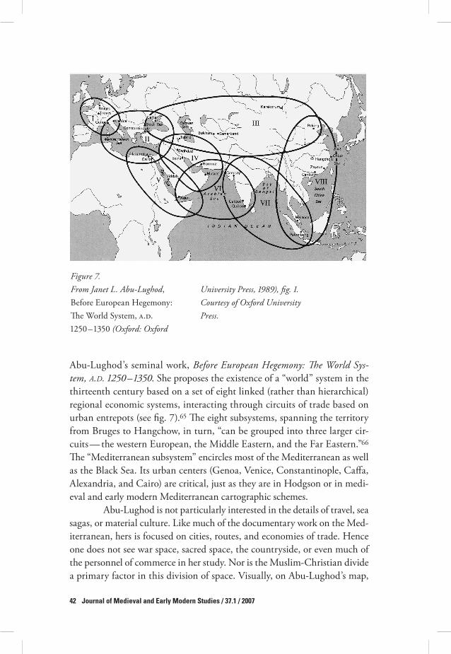
Abu-Lughod’s seminal work, Before European Hegemony: !e World Sys-tem, A.D. "($* – "&$*. She proposes the existence of a “world” system in the thirteenth century based on a set of eight linked (rather than hierarchical) regional economic systems, interacting through circuits of trade based on urban entrepots (see fig. -).(& #e eight subsystems, spanning the territory from Bruges to Hangchow, in turn, “can be grouped into three larger cir-cuits — the western European, the Middle Eastern, and the Far Eastern.”(( #e “Mediterranean subsystem” encircles most of the Mediterranean as well as the Black Sea. Its urban centers (Genoa, Venice, Constantinople, Ca,a, Alexandria, and Cairo) are critical, just as they are in Hodgson or in medi-eval and early modern Mediterranean cartographic schemes.
Abu-Lughod is not particularly interested in the details of travel, sea sagas, or material culture. Like much of the documentary work on the Med-iterranean, hers is focused on cities, routes, and economies of trade. Hence one does not see war space, sacred space, the countryside, or even much of the personnel of commerce in her study. Nor is the Muslim-Christian divide a primary factor in this division of space. Visually, on Abu-Lughod’s map,
Figure ).From Janet L. Abu-Lughod, Before European Hegemony: #e World System, 0.1. !%&$ – !)&$ (Oxford: Oxford
University Press, "+%+), fig. ". Courtesy of Oxford University Press.

Brummett / Visions of the Mediterranean 43
the Mediterranean lies at one end of the world system, and its circuit is rela-tively small. Nonetheless, in her analysis, the Mediterranean is the highly active connector between the European and Middle Eastern systems.(- #is is the space that became the Ottoman Empire, what #omas Fuller, in his Historie of the Holy Warre, called the “heart of the world.” It preserves the eastern orientation that is often subordinated to the Atlantic interface and the western gaze once one crosses the historiographic divide of !&$$.('
While Abu-Lughod’s concentration on commerce violates the stric-tures of the Muslim-Christian divide, other world history paradigms find those bonds di2cult to escape. See for example, Martin Lewis and Karen Wigen, !e Myth of Continents.(" #e authors, like Horden and Purcell, are interested in connectivity, though they are dealing in mega- and not microregions. #ey are also attempting, admirably, to contend with racial and colonial hierarchies of di,erence and to reject the “invisibility” of cul-tural entities that occurs in models such as those of Gunder Frank and Abu-Lughod. In their “enduring cultural regions” scheme, however, religion is the key cultural element. #e Mediterranean thus becomes a boundary region or borderland zone (with hybrid culture), split north to south and east to west (through the Adriatic). Islam and its European Christian “other” (later European colonial “other”) divide the Mediterranean. #e Ottoman Empire, a power sphere which created its own culture, cannot be accommo-dated in this schema.
Dividing and envisioning space: Issues and options
Positioning contemporary historiographies alongside the maps and travelers’ accounts presented here, I see a set of representational issues. First, those his-toriographic divisions of the post-Roman Mediterranean space which take power spheres into account tend to isolate the Ottomans, or confine them to the eastern end of the sea.-$ Second, while the world historical situating of the Mediterranean in more global perspectives (Abu-Lughod and Gunder Frank) tends to level the long early modern playing field, diminishing the hegemony of “Europe,” shifting connectivity eastwards, and making the Ottomans only one economic power among many, it tends to wash out war space and neglect sacred space, two critical elements of the early modern visions of the Mediterranean treated here. Yet the concepts of war space and sacred space provide an alternative to the simple division of the Mediter-ranean into Muslim and Christian blocks. #ird, approaches which either present the Mediterranean as a unit, divide it into its economic fragments, or

44 Journal of Medieval and Early Modern Studies / 37.1 / 2007
place it in global perspective often abjure the visuality that characterizes the travel accounts and maps of the era in question.
Regarding the first point, concepts of historical possession struc-ture the ways in which the Mediterranean region is divided, allocating space according to presumed political or cultural a2nities and spheres of influ-ence. If one looks at the scholarly construction of Mediterranean space, the notions of two “ends” or a separate southern sphere are apparent, as is the default status of European lands as necessarily (or quintessentially) Mediter-ranean. A basic Mediterranean unit is forged around the Roman Empire; but when that unit collapses, Spain, North Africa, and Anatolia each seem to function independently. Spain is attached to the Atlantic, and North Africa to Mecca, while Anatolia loses its ancient Greek and Roman per-sona and floats in an uncomfortable isolation, not quite Europe, not quite the “Middle East.” North Africa is detached and labeled “Muslim,” with the Maghrib and Egypt given separate identities but no territorial clarity.-! Egypt maintains an aura of uniqueness, despite its history as a part of larger, regional political entities like the Ottoman Empire; and, as Roger Bagnall has suggested, Egypt is often singularly invisible in discussions and con-structions of the Mediterranean.-% #e Maghrib, for the medieval period, stands either as an autonomous Muslim foothold at the western end of the sea, or as the southern end of a political and cultural Moroccan/Spanish condominium. For the early modern period, the Maghrib is transformed into a new incarnation of Roman and medieval “Barbary,” a place confront-ing Western Europeans with an alien continent, infidel religion, and piratic predation. And, across the Strait of Gibraltar, despite Braudel and the Medi-terranean-spanning Hapsburg Empire, Spain seems to be indelibly attached to the Atlantic and the possession of the Americas, a Mediterranean power that has gone outside Mediterranean space.-) Indeed, Ricardo Padrón, in his exploration of cartography, literature, and empire in early modern Spain, speaks of the Atlantic, in the writings of Gonzalo Fernández de Oviedo (!+-' – !&&-), as replacing the Mediterranean, a Spanish mare nostrum, with the Strait of Magellan as a new barrier “to transgress,” equivalent to the old Pillars of Hercules.-+
War space and sacred space, along with commercial space, are staples of early modern representation of the Mediterranean. But the economic and transcultural paradigms of some contemporary historiographic approaches have tended to set aside one or both of those spaces in the course of the great civilizational purge. Commerce takes place and economies take shape with-out war and pilgrimage as central themes. #ose themes, however, are inher-

Brummett / Visions of the Mediterranean 45
ent in early modern itineraries and maps. Further, a concentration on war and on sacred space exposes the complex nature of the Muslim-Christian divide. For Ibn Khaldun, the Mediterranean is a sea that has changed hands through conflict and will do so again. Lafreri’s map of Cyprus (a “Christian” space surrounded by a big, undesignated “Muslim” zone) depicts a possessed commercial space, but the ships in its surrounding sea signify the ubiquitous threat of war. #omas Fuller’s mapping of the Mediterranean as a Muslim possession, “the bones” of the Ottoman Empire, the sea that washes the coast of Palestine, and an obstacle to be skirted on the hazardous path to the Holy Land, demonstrates the complexities and variations of early modern rhetorics of space. His Mediterranean is important as historical space and as a bu,er zone bordering the preeminent sacred space which has become war space and requires redemption through prayer and force of arms. Fuller’s audience, by and large, will never visit the Holy Land; rather, they must wit-ness its history and conjure its vision in their minds. #at desire for pilgrim-age and the inclination to witness sacred landscapes frame Fuller’s narrative. #ese are powerful emotions; but they are invisible, as Wigen and Lewis note, in historiographic constructions which privilege the economic.
Finally, the visuality of early modern maps and travel narratives is also set aside in much contemporary historiography. Horden and Purcell, for example, reject as a viable paradigm the “marvelous beauty, fascinat-ing romance, unique scenes and sacred associations” touted by Lorenz in his early-twentieth-century travel guide (as quoted at the beginning of this essay). #ey do not entirely eschew visuality and the cultural tale; indeed their text is laced with the visions of ancient and contemporary observers who provide points of entrance into their microecologies.-& But unlike the tourist, Horden and Purcell tell us they wish to “step a little aside from what we have broadly identified as the Romantic tradition of Mediterranean description, with its seductive but misleading imagery.”-( It is, however, that very “seductive but misleading” imagery that forms the essence of early modern mapping — that and what Barbara Fuchs has called “recirculating past narratives.”-- #e travel narrative and the map restore that visuality (and its layering of the past) in the process disarticulating simple regional or religious divisions of the inland sea.-' #ey o,er us a chance to refo-cus the study of the Mediterranean (back) onto texts, images, personalities, communities of letters, the movement of ideas, and what might be called the new Levantines — shape shifters, the not-so-liminal crossers of frontiers, those who move from one identity to another reflecting or embodying the porosity of physical, ethnolinguistic, religious, and political borders (drago-

46 Journal of Medieval and Early Modern Studies / 37.1 / 2007
men, translators, converts, renegades).-" In the process, borders are prob-lematized and the “divide” between Christendom and Islam made more di,use and mutable, as suggested in the travelogue of Evliya Çelebi.'$ Also, the travel narrative and the map situate the Ottoman Empire in the heart of the Mediterranean world as a land and seaborne imperial power. Its rule spans the long early modern era, and its space houses the cities of Hodgson’s oikumene, from which both cultural influence and military power emanate. In that space numerous sacred sites, beyond the quintessential shared com-munal space of Jerusalem, are situated; and numerous itineraries (spanning Horden and Purcell’s or Frank’s millennia) trace their ways across, around, along, or up from the shores of the Mediterranean. Piri Reis presented this Mediterranean as a rhetorical construction of Ottoman power and space in the atlas he prepared for the sultan. Like Horden and Purcell, having envisioned the Mediterranean as a whole, he broke it down into the pieces of its islands and coasts. It was a sea that one could sail all the way around, sometimes facing west and sometimes facing east.
Notes
#e epigraph is from D. E. Lorenz, !e Mediterranean Traveller: A Handbook of Prac-tical Information, +th ed. (New York: Fleming H. Revell Company, !"!!), ". #is essay is dedicated to Dr. John Voll, with admiration for his work in Islamic and world his-tories. I am also grateful to Valeria Finucci and the journal’s anonymous reviewer for their realignment of this essay.
! #is juxtaposition derives from my discussions with Rob Williams, a graduate stu-dent at the University of Tennessee specializing in the functioning of the boundaries of China and Inner Asia. Sea and steppe, he notes, are both places of new loyalties, hardships, and a nationhood of experience. I want to thank him for his assistance with the research for this project.
% Fernand Braudel, !e Mediterranean and the Mediterranean World in the Age of Phil-lip II, % vols., trans. Siân Reynolds (Berkeley: University of California Press, !""&), is of course the benchmark here, although Braudel’s work is less concerned with pin-ning down Mediterranean borders than is the work of some later scholars. With this text, as with other sources noted in this article, I have cited the English editions when available.
) Marshall Hodgson, !e Venture of Islam: Conscience and History in a World Civiliza-tion, ) vols. (Chicago: University of Chicago Press, !"-+), vol. !, !e Classical Age of Islam, !$" – !$. Hodgson has provided an eloquent assessment of the terms (including Levant, oikumene, and modern) of space and time by which the Mediterranean and Islamic worlds have been divided (!:+' – ()).

Brummett / Visions of the Mediterranean 47
+ Palmira Brummett, Ottoman Seapower and Levantine Diplomacy in the Age of Discov-ery (Albany: State University of New York Press, !""+).
& Peregrine Horden and Nicholas Purcell, !e Corrupting Sea: A Study of Mediterra-nean History (Oxford: Blackwell Publishing, %$$$), +. #is work is envisioned by the authors as the first of two volumes.
( #e florescence of Ottoman seapower is often depicted as temporary, prominent in the early sixteenth century but then relinquished during the reign of Süleiman. #e designations “elephant” and “whale” are taken from William #ompson; for a revi-sion of this idea, see Palmira Brummett, “#e Ottoman Empire, Venice, and the Question of Enduring Rivalries,” in !e Evolution of Great Power Rivalries, ed. Wil-liam #ompson (Columbia: University of South Carolina Press, !"""), %%& – &). See also, Andrew Hess, !e Forgotten Frontier: A History of the Sixteenth-Century Ibero-African Frontier (Chicago: University of Chicago Press, !"-'); and Kate Fleet, ed., !e Ottomans and the Sea (Roma: Istituto per l’Oriente, %$$!).
- Braudel, Mediterranean and the Mediterranean World, !:!!$ – !%. Braudel wrote the Ottomans into his history of the sea; they were both contenders for supremacy and an obstacle to the movement of European traders into the Ottoman end of the Mediter-ranean.
' For alternatives, see Daniel Go,man, !e Ottoman Empire and Early Modern Europe (Cambridge: Cambridge University Press, %$$%), a general synthesis; Leila Fawaz et al., eds., Modernity and Culture: From the Mediterranean to the Indian Ocean (New York: Columbia University Press, %$$%); or Abul-Rahim Abu Husayn, !e View from Istanbul: Lebanon and the Druze Emirate in the Ottoman Chancery Documents, "$'# – ")"" (London: I. B. Tauris, %$$+), which views the Levantine sea states through the prism of Ottoman central administration.
" For maritime history, see Frederic Lane, Venice: A Maritime Republic (Baltimore: Johns Hopkins University Press, !"-)); Alberto Tenenti, Piracy and the Decline of Venice, "$%* – "#"$ (Berkeley: University of California Press, !"(-); John Guilmartin, Gunpowder and Galleys: Changing Technology and Mediterranean Warfare at Sea in the Sixteenth Century (Cambridge: Cambridge University Press, !"'$); and Lawrence Mott, Sea Power in the Medieval Mediterranean: !e Catalan-Aragonese Fleet in the War of the Sicilian Vespers (Gainesville: University Press of Florida, %$$)).
!$ For a late medieval version, see, for example, Claudius Ptolemy, Géographie de Ptolémée: traduction latine de Jacopo d’Angiolo de Florence (Paris: Catala Frères, !"%(), plates ) – + from folios -+v – -&r of Paris, Bibliothèque Nationale, MS lat. +'$% (ca. !+("). Of course Ptolemy begs the question of exactly what constitutes “Western.”
!! See J. B. Harley, !e New Nature of Maps: Essays in the History of Cartography, ed. Paul Laxton (Baltimore: Johns Hopkins University Press, %$$!), ++, (-, "", on the notion of socially empty space.
!% Ibn Khaldun, !e Muqaddimah: An Introduction to History, trans. Franz Rosenthal, ed. N. J. Dawood, %nd ed. (Princeton, N.J.: Princeton University Press, !"(-), &$; further citations are given parenthetically in the text. On Ibn Khaldun, see M. Talbi, “Ibn Khald/n, Wal* al-D*n ‘Abd al-Rahman b. Muhammad b. Muhammad b. Ab* Bakr Muhammad b. al-Hasan,” Encyclopedia of Islam, 31-456 edition v.!.$ (Leiden: Brill, !"""). On Ptolemy and al-Idr*s*, respectively, see O. A. W. Dilke, “#e Cul-

48 Journal of Medieval and Early Modern Studies / 37.1 / 2007
mination of Greek Cartography in Ptolemy,” in J. B. Harley and David Woodward, eds. !e History of Cartography, vol. !, Cartography in Prehistoric, Ancient, and Medi-eval Europe and the Mediterranean (Chicago: University of Chicago Press, !"'-), !-- – %$$; and Gerald R. Tibbets, “#e Balkh* School of Geographers,” in !e History of Cartography, vol. %, book !, Cartography in the Traditional Islamic and South Asian Societies (Chicago: University of Chicago Press, !""%), !$%, !!!, !+% – +), !&+ – && and plate !!.
!) Often he di,erentiates a port city from an inland one only by the brief statement that it is “on the coast.” Ibn Battuta, !e Travels of Ibn Batt,ta, A.D. "&($ – "&$', trans. H. A. R. Gibb, vol. ! (New Delhi: Manoharla Publishers and the Hakluyt Society, !"")), ') – '&, on Acre, Tyre, Sidon, and Beirut. #e author does note that Acre was histori-cally the harbor for the Franks in Syria, “resembling the great city of Constantino-ple.” Further citations of this work are given parenthetically in the text.
!+ Ibid., !:%- – %'. #e conflict between Muslim and Christian does reemerge when he relates secondhand an account of a riot that ensued when the governor of Alexandria favored Christian traders over Muslims.
!& Evliya Çelebi, Seyahatname, quoted by Robert Danko,, An Ottoman Mentality: !e World of Evliya Çelebi (Leiden: Brill, %$$+), !"(. Further citations of the Seyahatname from Danko, ’s work are given parenthetically in the text.
!( Evliya Çelebi, Evliya Çelebi in Albania and Adjacent Regions (Kosovo, Montenegro, Ohrid), trans. and ed. Robert Danko, and Robert Elsie (Leiden: Brill, %$$$), %", &! – &). Further citations, noted as Albania, are given parenthetically in the text. #is vision of piracy can be compared to those found, for example, in Robert Davis, Christian Slaves, Muslim Masters: White Slavery in the Mediterranean, the Barbary Coast, and Italy, "$** – "%** (Basingstoke, Hampshire: Palgrave Macmillan, %$$)); and Nabil Matar, Turks, Moors, and Englishmen in the Age of Discovery (New York: Columbia University Press, !"""). #e captivity narrative has become a quintessen-tially Mediterranean form (often juxtaposed to New World captivities). It highlights the Christian-Muslim divide, the ambiguities of race, and the mythology of the civi-lized versus the barbarous.
!- Evliya, Albania, &!. Of the Montenegrin fortress of Budva he says, “this has been in the hands of the Venetian Franks from the very start.”
!' #ere is no consensus on whether the Mediterranean constitutes a coherent geo-graphic and cultural zone where gender is the topic of analysis, although the notion of a unifying patriarchy has helped subordinate distinctions based on religious dif-ference. See Deniz Kandiyoti, “Islam and Patriarchy: A Comparative Perspective,” in Nikki Keddie and Beth Baron, eds., Women in Middle Eastern History: Shift-ing Boundaries of Sex and Gender (New Haven, Conn.: Yale University Press, !""!), %) – ++. Kandiyoti’s model insists that patriarchy not be made coincident with Islam. For a perspective on Mediterranean masculinity, see Walter G. Andrews and Mehmet Kalpakli, !e Age of Beloveds: Love and Beloved in Early-Modern Ottoman and Euro-pean Culture and Society (Durham, N.C.: Duke University Press, %$$&), )-. Setting aside distinctions based on the Muslim-Christian divide, the authors argue that sexu-ality (and, one might add, the satirical representation of sexuality) links literary com-munities across Europe and Asia.

Brummett / Visions of the Mediterranean 49
!" Janet L. Abu-Lughod, Before European Hegemony: !e World System, A.D. "($* – "&$* (Oxford: Oxford University Press, !"'").
%$ Muhammad as-Sa,.r, Disorienting Encounters: Travels of a Moroccan Scholar in France in "%'$ – "%'#, trans. and ed. Susan Gilson Miller (Berkeley: University of California, !""%), -"; further citations, noted as Travels, are given in the text.
%! See Stephane Yerasimos, Les voyageurs dans l’Empire Ottoman (XIVe – XVIe siècles): bibliographie, itinéraires et inventaire des lieux habités (Ankara: Société turque d’his-toire, !""!). Yerasimos’s work is interesting because not only does it present biblio-graphical information and details concerning translations, it delineates each travel account as an itinerary (a list of cities, ports, monuments, monasteries, ruins, and other sights, seen in a certain order).
%% #e most comprehensive treatment of cartography on the Mediterranean is found in Harley and Woodward, History of Cartography. For a series of cartographic visions of the Mediterranean, see Peter Whitfield, !e Charting of the Oceans: Ten Centu-ries of Maritime Maps (London: British Library, !""(), esp. %! – )!, &% – &), (% – (), '( – '-, "( – "-. For cartography in its broader representational contexts, see Franc-esca Fiorani, !e Marvel of Maps: Art, Cartography, and Politics in Renaissance Italy (New Haven, Conn.: Yale University Press, %$$&); and Benjamin Schmidt, Innocence Abroad: !e Dutch Imagination in the New World, "$)* – "#)* (Cambridge: Cam-bridge University Press, %$$!), (' – !'+. Schmidt’s analysis treats Dutch imagery of the New World, but his model could also be applied to the Mediterranean.
%) On sea charts and imperial cartography, see Alison Sandman, “Mirroring the World: Sea Charts, Navigation, and Territorial Claims in Sixteenth-Century Spain,” in Pamela Smith and Paula Findlen, eds., Merchants and Marvels: Commerce, Science, and Art in Early Modern Europe (New York: Routledge, %$$%), ') – !$'.
%+ For a treatment of these issues, see Palmira Brummett, “Imagining the Early Mod-ern Ottoman Space from Piri Reis to World History,” in Virginia Aksan and Dan-iel Go,man, eds., !e Early Modern Ottomans: Remapping the Empire (Cambridge: Cambridge University Press, %$$(), %+ – (-.
%& On Piri Reis and Ottoman mapmaking, see Svat Soucek, Piri Reis and Turkish Map-making after Columbus: !e Khalili Portolan Atlas (London: Nour Foundation, !""(); also, Ahmet Karamustafa, “Introduction to Ottoman Cartography,” %$( – '; J. M. Rogers, “Itineraries and Town Views in Ottoman Histories,” %%' – &&; and Svat Soucek, “Islamic Charting in the Mediterranean,” %() – "%, all in Harley and Wood-ward, History of Cartography, vol. %, book !.
%( Piri Reis, Kitab-ı Bahriye, Baltimore, Walters Art Museum MS W.(&', fols. ()v – (+r. #e map in this version of Piri Reis has been identified as a seventeenth-century map, but the sta, at the Walters is still attempting to ascertain its date, and Tom Goodrich, in personal communication, has speculated that the atlas may in fact be an eighteenth-century edition.
%- #e other most notable mapmaker of the sixteenth-century Ottoman world, Matrakçı Nasuh, also mapped tranquil, unpeopled, unbordered space, although the texts of his cartographic campaign accounts were full of people and sovereign claims, and the maps themselves suggest society through their portrayal of towns, routes, shrines, and wells. See Kay Ebel, “City Views, Imperial Visions: Cartography and the Visual Cul-

50 Journal of Medieval and Early Modern Studies / 37.1 / 2007
ture of Urban Space in the Ottoman Empire, !+&) – !($),” (Ph.D. diss., University of Texas at Austin, %$$%). Few Ottoman maps survive from the sixteenth century; many more survive from the seventeenth and eighteenth centuries.
%' Antonio Lafreri, “Disegno de l’Isola di Cypro con li Confini della Caramania, Soria, Giudea et Egitta” (Rome, !&-$); London, British Library Maps C.-.e.%.(!-). #e bor-ders of those regions are, in fact, not drawn in.
%" John J. Norwich, Venice: !e Greatness and the Fall (London: Penguin Books, !"'!), %$" – %!.
)$ Bronwen Wilson, !e World in Venice: Print, the City, and Early Modern Identity (Toronto: University of Toronto Press, %$$&), !)) – '&, has written an elegant analysis of the modes by which Venice mapped the Mediterranean and the Ottomans in map, image, and allegory, speaking of war as landscape and including the Venetian gender-ing of that landscape.
)! #omas Fuller, Historie of the Holy Warre (Oxford, !()"), STC !!+(+, Folger Shake-speare Library, Washington, D.C. Further citations are given parenthetically in the text. See W. B. Patterson, “Fuller, #omas (!($-/' – !((!),” in H. Matthew and Brian Harrison, Oxford Dictionary of National Biography, vol. %! (Oxford: Oxford Univer-sity Press, %$$+), !&" – ().
)% For studies of characterizations of the Ottomans in this era, see, for example, Ken Parker, “Reading ‘Barbary’ in Early Modern England, !&&$ – !('&,” in Matthew Birchwood and Matthew Dimmock, eds., Cultural Encounters Between East and West, "'$& – "#++ (Cambridge: Cambridge Scholars Press, %$$&), -( – !$&; Larry Wol,, Venice and the Slavs: !e Discovery of Dalmatia in the Age of Enlightenment (Stanford, Calif.: Stanford University Press, %$$!); Mustafa Soykut, Image of the “Turk” in Italy: A History of the “Other” in Early Modern Europe (Berlin: Klaus Schwarz Verlag, %$$!); and Gerald MacLean, !e Rise of Oriental Travel: English Visitors to the Ottoman Empire, "$%* – ")(* (New York: Palgrave Macmillan, %$$+).
)) #is impressionistic “map” can be compared to Bernardo Salvioni’s !&"- map of Ven-ice, which commemorates, in an inset, the Corpus Christi procession in which Vene-tian senators marched in the company of pilgrims en route to Jerusalem. Fuller’s image is allegorical, Salvioni’s is an impression of a past event. See Wilson, World in Venice, -, !().
)+ William Berry, “Asia Divided into Its Principall Regions,” Chicago, Newberry Library Ayer !)& B+' (London, !('$). #e use of blank (or unmapped) space to sig-nify Europe in maps of Asia is not unique to Berry’s map. #ose spaces on a map which are attached to the primary area depicted may or may not be drawn in.
)& For other schema on mapping, see Christian Jacob, “Mapping in the Mind: #e Earth from Ancient Alexandria,” in Denis Cosgrove, ed., Mappings (London: Reak-tion, %$$!), %+ – +", esp. %& – %-; and Jerry Brotton, Trading Territories: Mapping the Early Modern World (London: Reaktion, !""-).
)( #e notion of the “eroding medieval” comes courtesy of Dr. Joseph C. Miller, an Africanist. It serves to emphasize the continuities between the medieval and early modern eras rather than anticipating the modern.
)- Elizabeth Clark, History, !eory, Text: Historians and the Linguistic Turn (Cambridge, Mass.: Harvard University Press, %$$+), among other scholars, has traced the evolu-

Brummett / Visions of the Mediterranean 51
tion of historiographies, including those of Braudel and the Annalistes, which apply to the crafting of the Mediterranean, with an eye to their application to premodern texts.
)' #e “documentary” is a broad rather than a refined category here. It suggests a large and amorphous group either of collections of documents or studies that may be phil-ological in their orientation and that employ documentary evidence as the primary core upon which their analysis is based.
)" S. D. Goitein, Mediterranean Society: !e Jewish Communities of the Arab World as Portrayed in the Documents of the Cairo Geniza, & vols. (Berkeley: University of Cal-ifornia Press, !"""). University of California Press originally began publication of Goitein’s Geniza in !"(-. #e Geniza, a storeroom attached to a Cairo synagogue, housed thousands of documents.
+$ See, for example, David Abulafia, Commerce and Conquest in the Mediterranean, ""** – "$** (London: Ashgate, !"")); and Dionisius Agius and Ian Netton, Across the Mediterranean Frontiers: Trade, Politics, and Religion, #$* – "'$* (Turnhout: Brepols, !""-). Robert Lopez and Irving Raymond, Medieval Trade in the Mediterranean World (New York: Columbia University Press, !"('), employs documents taken from Latin, Greek, Italian, Provençal, Old French, Catalan, and Arabic. Eliyahu Ashtor, Levant Trade in the Later Middle Ages (Princeton, N.J.: Princeton University Press, !"')), employs chronicles, state documents, and (especially Venetian) ship auctions receipts, customs registers, and petitions. Kate Fleet, European and Islamic Trade in the Early Ottoman State: !e Merchants of Genoa and Turkey (Cambridge: Cambridge University Press, !"""), organizes its material by commodity. Molly Greene, Chris-tians and Muslims in the Early Modern Mediterranean (Princeton, N.J.: Princeton Uni-versity Press, %$$%), combines documentation from Ottoman and Latin languages in her analysis and begins her study with a discussion of the models of Braudel and Pirenne.
+! For example, Benjamin Arbel et al., Latins and Greeks in the Eastern Mediterranean after "(*' (London: Frank Cass, !"'"), which includes, for example, pieces by David Morgan on Mongol interest in the Mediterranean and Elizabeth Zachariadou on Holy War in the Aegean; Benjamin Arbel, ed., Intercultural Contacts in the Medieval Mediterranean: Studies in Honour of David Jacoby (London: Frank Cass, !""(); David Abulafia, Mediterranean Encounters, Economic, Religious, Political, ""** – "$$* (Lon-don: Ashgate, %$$!); Alisa Ginia, ed., Jews, Christians, and Muslims in the Mediter-ranean World after "'+( (London: Frank Cass, !""%), which focuses primarily on the Jewish dimensions of Mediterranean relations; Benjamin Braude and Bernard Lewis, eds., Christians and Jews in the Ottoman Empire: !e Functioning of a Plural Soci-ety, % vols. (Teaneck, N.J.: Holmes and Meier, !"'%); and Ronald Jennings, Chris-tians and Muslims in Ottoman Cyprus and the Mediterranean World, "$)" – "#'* (New York: New York University Press, !"")), which focuses on Ottoman documents and includes a segment on piracy and smuggling.
+% #e Jewish-Muslim or Jewish-Christian divide is not analogous to the Muslim- Christian divide because of its spatial di,erences. Historiography and cartography, for obvious reasons, have not allocated blocks of early modern Mediterranean space as power spheres to the Jews as they have to the Muslims and Christians.

52 Journal of Medieval and Early Modern Studies / 37.1 / 2007
+) Clark, History, !eory, Text, ((.++ Braudel, Mediterranean and the Mediterranean World, !:!$' – )&.+& Ibid., %:!$''. Braudel does go on to define Lepanto’s impact in terms of a transfer
of oarsmen, the reemergence of Christian privateers, and the decay of Ottoman seapower.
+( Ibid., !:($(.+- Richard Kagan, with Fernando Marías, Urban Images of the Hispanic World, "'+& –
")+& (New Haven, Conn.: Yale University Press, %$$$), &( – &-.+' Horden and Purcell, Corrupting Sea, &)$ – (+!, provide a set of rich and extensive bib-
liographic essays on the Mediterranean.+" For interesting critiques of the work, see Ian Morris, “Mediterraneanization,” Medi-
terranean Historical Review !'.% (%$$)): )$ – &&; and Anthony Molho, review of !e Corrupting Sea, by Horden and Purcell, Journal of World History !) (%$$%): +'( – "%. Horden and Purcell, “Four Years of Corruption: A Response to Critics,” in W. V. Harris, ed., Rethinking the Mediterranean (Oxford: Oxford University Press, %$$&), )+' – -&, have not directly included the early modern in articulating the objectives of their work. #is later piece points out the authors’ framework, including fragmented topography, mutable microecology, two-way interaction between humanity and envi-ronment, connectivity, and their contrasting of history “in” and “of” the region ()&().
&$ Horden and Purcell, Corrupting Sea, &! – --. &! Ibid., &.&% Ibid., +$!. &) Ibid., ++), as illustrated in the authors’ discussion of the moving of saints’ bones, for
example.&+ Richard Eaton, “Islamic History as Global History,” in Michael Adas, ed., Islamic
and European Expansion: !e Forging of Global Order (Philadelphia: Temple Univer-sity Press, %$$!), ! – )(, has commented upon Hodgson’s model and contends that “Islam” is the first truly global civilization. See also John Voll, “Islam as a Special World System,” Journal of World History & (!""+): %!) – %(.
&& Hodgson, Venture of Islam, !:!$" – !$.&( Horden and Purcell, Corrupting Sea, +. For a very di,erent periodization, see David
Abulafia, ed., !e Mediterranean in History (Los Angeles: J. Paul Getty Museum, %$$)). In this volume, one gets the impression that the important era of Mediterra-nean history is that which precedes !&$$. Further, the medieval and early modern are divided into Christian and Muslim “halves.”
&- André Raymond, Cairo, trans. Willard Wood (Cambridge, Mass.: Harvard Uni-versity Press, %$$$), !, originally published in French in !""): “Fifty years ago, one still traveled to Egypt by ship, landing first at Alexandria, from which the last vis-ible traces of antiquity have all but disappeared. #e Mediterranean port, rebuilt in the nineteenth century, would lose its Levantine character after the !"&% revolution, and the subsequent departure of the British brought to an end a society that Lawrence Durrell transformed into a literary myth.”
&' Braudel, Mediterranean and the Mediterranean World, %:!%)". Bertram Gordon, “#e Mediterranean as a Tourist Destination from Classical Antiquity to Club Med,” Mediterranean Studies !% (%$$)): %$) – %(, makes Braudel himself an element of peri-

Brummett / Visions of the Mediterranean 53
odization. He uses the publication of Braudel’s La Méditerranée, the popularization of Mediterranean cooking through Elizabeth David’s A Book of Mediterranean Food, and the creation of Club Med (all “events” of the years !"+" – &$) as a trio of markers for a new age in the consumption of the Mediterranean. David Mendelson, “#e Idea of the Mediterranean in Early Nineteenth-Century French Literature,” Mediterranean Historical Review !-.! (%$$%): %& – +', traces the modern idea of the Mediterranean to French writers such as de Staël and Chateaubriand and the “journey to the Ori-ent style” they invented. He speaks in terms of itinerary and visuality. Yaacov Shavit, “Mediterranean History and the History of the Mediterranean: Further Reflections,” Journal of Mediterranean Studies + (!""+): )!) – %", in a piece on ideas of regional his-torical identity in modern Israel, calls the notion of the Mediterranean a “cultural fic-tion,” existing “mainly in the imagination of the ‘outside’ observer” ()%&).
&" Ross Dunn, !e New World History: A Teacher’s Companion (New York: Bedford/St. Martin’s, %$$$), provides a collection of relevant and foundational literature in the world history field, illustrating the rationales behind decentering the West (along with the Mediterranean) and its story. Contributions to the Journal of World History tend not to contain the word Mediterranean in their titles or abstracts, or to focus spe-cifically on that region. Although analyses in the journal do address issues of fram-ing and interpretation that bear on or apply to the Mediterranean region, the inland sea tends not to be either a focus or a basis for comparison. William McNeill (found-ing father for the notion of the rise of the West and later advocate for world history) includes no entry for the “Mediterranean” in the index to his fourth edition of A World History (Oxford: Oxford University Press, !""").
($ Martin Bernal, Black Athena: !e Afroasiatic Roots of Classical Civilization, % vols. (New Brunswick, N.J.: Rutgers University Press, !"'-; repr. !""!).
(! But the themes of Manuel Castells, !e Information Age: Economy, Society, and Cul-ture, %nd ed., ) vols. (Oxford: Blackwell Publishers, %$$$), a popular, wide-ranging, sociological work that assesses the global flows of information, labor, social move-ments, and crime, among other phenomena, echo rather neatly earlier themes by which the Mediterranean has been measured: Levantine communities to match Cas-tells’s transnational identities and financial networks, the acceptance or rejection of state-based identities, the creation of new technical and political urban elites, the variable work force in the urban ghetto, the articulation of umma and jihad in global Islamic sociopolitical movements as a boundary maker between lands and peoples, and the limits of “patriarchalism.”
(% Andre Gunder Frank, ReOrient: Global Economy in the Asian Age (Berkeley: Univer-sity of California Press, !""'), %)$, )%-. See also, Immanuel Wallerstein, !e Modern World System, vol. ! (New York: Academic Books, !"-+).
() Frank, ReOrient, (& – -(. (+ Ibid., '$. (& Abu-Lughod, Before European Hegemony, )+, shows a map depicting the eight circuits
of trade. On this map a ninth circuit might be added comprising the southeastern coast of Africa; and one could easily update this world map to the sixteenth century and draw in circuits which include the Americas.
(( Ibid., )% – )), )&), )(+.

54 Journal of Medieval and Early Modern Studies / 37.1 / 2007
(- Ibid., +&, !!), !%), !+", maps the Mediterranean routes of Genoa and Venice in the Middle Ages, showing the highly complex connections throughout the Mediterra-nean and its connecting seas.
(' See also Geo,rey Gunn, First Globalization: Eurasian Exchange, "$** – "%** (Oxford: Rowman and Littlefield, %$$)). Gunn deals directly with issues of mapping.
(" Martin Lewis and Karen Wigen, !e Myth of Continents: A Critique of Metageography (Berkeley: University of California Press, !""-), &) – &+, !)" – +!, !"".
-$ Braudel, Mediterranean and the Mediterranean World, !:!)& – )-, on the two autono-mous seas, the Spanish and the Turkish. Neither have Ottomanist historians written on an Ottoman Mediterranean, thus impeding the dialogue.
-! For an interesting analysis (which takes both Braudel and Purcell into consideration) of the Maghrib’s connection or lack of connection to the Mediterranean, see Brent Shaw, “A Peculiar Island: Maghrib and Mediterranean,” Mediterranean Historical Review !'.% (%$$)): ") – !%&. Shaw argues for the particular insularity of the Maghrib in the premodern era.
-% Roger Bagnall, “Egypt and the Concept of the Mediterranean,” in Harris, ed., Rethinking the Mediterranean, ))" – +-. However, Abu-Lughod, Before European Hege-mony, %!% – !&, %+% – ++, makes Cairo central to medieval Mediterranean exchange (as do other scholars whose work centers on commercial exchange).
-) A more nuanced vision of Iberia is found in Felipe Fernández-Armesto, Before Colum-bus: Exploration and Colonization from the Mediterranean to the Atlantic, "((+ – "'+( (Philadelphia: University of Pennsylvania Press, !"'-), a study of conquest that por-trays the Mediterranean as one end of a seaborne enterprise, the anchor of empire. He examines the logics, rhetorics, and itineraries through which lands, their goods, and their peoples are subordinated.
-+ Ricardo Padrón, !e Spacious Word: Cartography, Literature, and Empire in Early Modern Spain (Chicago: University of Chicago Press, %$$+), !+-.
-& For an emphasis on the cultural tale, see Predrag Matvejevi7, Mediterranean: A Cul-tural Landscape (Berkeley: University of California Press, !"""), -, )", which focuses on the ways in which Mediterranean peoples’ space was mapped and on the words by which one type of journey (or ship) was distinguished from another. His essay is con-cerned with visuality, ideas, gesture, and material culture. It orders the Mediterranean as an idiosyncratic journey which takes cognizance of sovereign states and peoples but does not dwell upon them.
-( Horden and Purcell, Corrupting Sea, &+; and “Four Years of Corruption,” )+' – -&. #e “Romantic tradition” is embodied in the exhibition “La mer: Terreur et fascina-tion,” Bibliothèque Nationale, http://expositions.bnf.fr/lamer/, which assesses the ways in which humans have represented, named, and tried to manage or master the sea. #at vision presumes the struggle to survive, to understand the sea itself, and to over-come fear. It presumes invocations to the gods or goddesses of the sea and of sailing, much as Horden and Purcell, Corrupting Sea, +)' – +$, have suggested in their treat-ment of “the religion of mobility.” For a contrasting vision, of the pleasures of the sea, see Alain Corbin, !e Lure of the Sea: !e Discovery of the Seaside in the Western World, ")$* – "%'*, trans. Jocelyn Phelps (Berkeley: University of California Press, !""+).
-- Barbara Fuchs, “Rivalry and Rhetoric,” paper presented at the Ottoman and Atlantic

Brummett / Visions of the Mediterranean 55
Empires in the Early Modern World Symposium, Omohundro Institute of Early Ameri-can History and Culture and Bo8aziçi University, Istanbul, October %$$&. For an elo-quent treatment of the workings of the “shades of old images” and ideas in Renaissance maps and texts, see Anthony Grafton, New Worlds, Ancient Texts: !e Power of Tradi-tion and the Shock of Discovery (Cambridge, Mass.: Harvard University Press, !""%). See also John Gillies, Shakespeare and the Geography of Di-erence (Cambridge: Cambridge University Press, !""+), -$. Gilles poses the Globe #eatre as a map of the cosmographic imagination. He notes the poetic nature of geographic constructions.
-' Ivo Kamps and Jyotsna Singh, eds., Travel Knowledge: European “Discoveries” in the Early Modern Period (New York: Palgrave, %$$!); or Kenneth Parker, ed., Early Mod-ern Tales of Orient: A Critical Anthology (London: Routledge, !""").
-" #e bridging of borders is embodied in the classic linguistic work by Henry Kahane, Renée Kahane, and Andreas Tietze, !e Lingua Franca in the Levant: Turkish Nauti-cal Terms of Italian and Greek Origin (Istanbul: ABC Kitabevi, !"&'; repr. !"''). See Danko,, An Ottoman Mentality, '), who employs this expansive seventeenth-century source to provide a vision of the Ottoman world view and “the public values associ-ated with Ottomanness.” See also, Natalie Rothman, “Becoming Venetian: Conver-sion and Transformation in the Seventeenth-Century Mediterranean,” Mediterranean Historical Review (Spring/Summer %$$(), forthcoming; and #omas Burman, Read-ing the Qur’an in Latin Christendom, ""'* – "$#* (Philadelphia: University of Pennsyl-vania Press, %$$-), forthcoming.
'$ David Abulafia, “Introduction: Seven Types of Ambiguity, c. !!$$ – c. !&$$,” in David Abulafia and Nora Brend, eds., Medieval Frontiers: Concepts and Practices (London: Ashgate, %$$%), ! – )+, can serve as a useful launching point for the discussion of bor-ders.
