building an integrated gis transportation network …...building an integrated gis transportation...
TRANSCRIPT
Building an Integrated GIS Transportation Network for Municipality of Anchorage
Charles Barnwell and Dale Avery, Data/GIS Resources Division, Municipality of Anchorage Yushuang Zhou and John Sutton, Cambridge Systematics
Abstract
The Municipality of Anchorage (MOA) is build ing an integrated transportation network called ITS Roadnet in order to meet the transportation GIS data needs of a variety of stakeholder groups includ ing Planning and Public Works, Traffic Engineering, Public Safety, Transit and other business units at the Municipality. The project first initiated as an Intelligent Transportation Systems (ITS) program grant proposal in 2002 to the Federal Highway Administration (FHWA) and State of Alaska. Approval by the State and FHWA in 2003-2004 led to selection of Cambridge Systematics, Inc. (CSI) to provide services for development and co-management of the project. CSI was contracted to design and build the new transportation network in an ArcSDE geodatabase environment. This presentation will describe the development of the new ITS Roadnet Geodatabase includ ing user requirements assessment, data model design, network features and functionality, and the linear referencing techniques being implemented to integrate the variety of MOA transportation data. The Roadnet network is a joint MOA and State of Alaska project, and is designed to comply with the Anchorage Regional ITS Architecture, support the state s ITS projects such as CARS 511 and hazmat vehicle routing, support critical Municipal functions such as public safety and interface with the highway geodatabase being developed at the Alaska State DOT.
Background and Overview
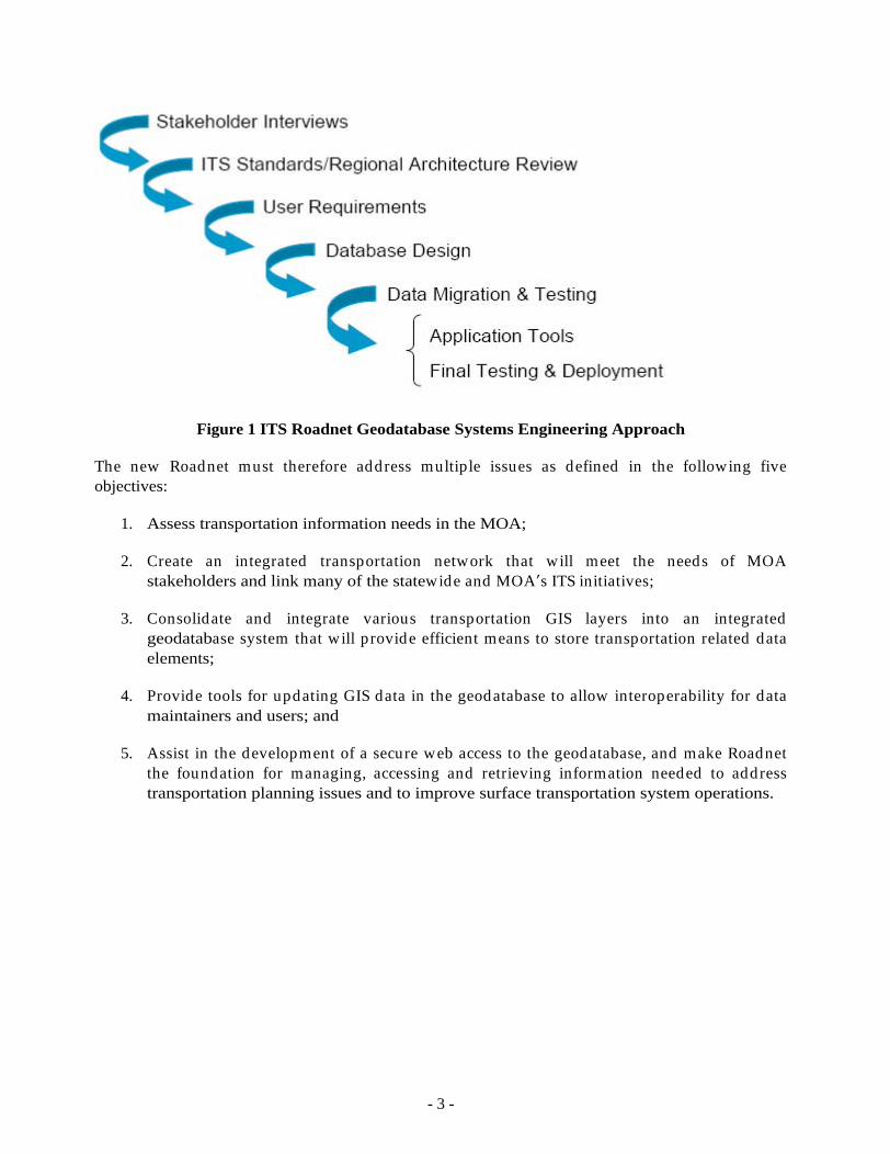
The MOA embarked on a project to integrate the existing road network information system ( Roadnet ) into an integrated geodatabase management system starting in 2002. From the beginning it was envisioned as a multi-user, multi-agency enterprise geodatabase; and single source for roads GIS information in the Municipality, a 2,000 square mile area with a population of 250,000 (see Figure 2). Key to initiation of the project was support by both MOA and State of Alaska transportation officials. Final approval of the grant funding for the project came in 2003 after a lengthy grant proposal and review process by MOA and the State. The State of Alaska has been and continues to be a strong supporter of the ITS Roadnet project.
The goal of ITS Roadnet is to provide a more efficient means to store transportation-related data elements to support a broad constituency of users and needs within the Municipality. The Intelligent Transportation System (ITS) program provides the standards base and philosophical underpinnings for ITS Roadnet. The ITS emphasis on integration and on utilization of current, state of the art technology is a basis for this project. The geodatabase will facilitate data sharing to better understand regional transportation issues, provide better planning capabilities and make sound transportation decisions. This paper describes the development of the new Roadnet network and database and how the geodatabase will be used by the various stakeholders.
- 2 -
The MOA Roadnet was originally designed strictly for the Anchorage Police Department use by their Computer Aided Dispatch (CAD) system called Tiburon. Roadnet is currently stored as a GIS file in ArcInfo coverage and ArcView shapefile formats, depicting road centerlines within the Anchorage area. Roadnet was originally developed from a survey centerline roads coverage, and stores both the public and private roads. Where appropriate, the survey road centerlines are spatially corrected to represent the actual alignment of the existing road . This is accomplished by using aerial photography, rectified site plans and heads up digitizing. As new roads are added to the Roadnet data layer, the combination of recorded survey plats, record drawings, site plans/as-builds or aerial photography are used to best enter the road centerlines into Roadnet. Through this process, the accuracy and currency of Roadnet has been progressively improved and it is considered an excellent foundation for the development of a reference network to support MOA functions including ITS applications.
However, Roadnet is somewhat limited in terms of the number of attributes. Key network information is missing such as the number of lanes, road closures, one-way streets and intersection turn information. There is no integration between the roads and other transportation features such as trails, and railways. In addition, the current layer format is not conducive to locating infrastructure by linear referencing along the roads or supportive to real-time data sharing with ITS stakeholders. Also, it does not contain enough information or is set-up to support various business units within and outside of MOA. Another key issue is that transportation data in Anchorage are not stored in one consolidate database, but in a number of independent systems. One of the main challenges is to enable business units to exchange infor-mation. This typically requires a redundant secondary data collection processes and multip le databases that often contain errors.
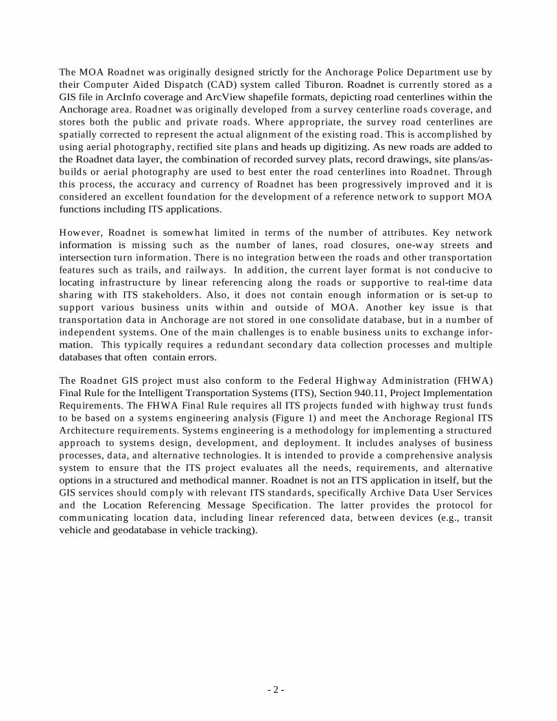
The Roadnet GIS project must also conform to the Federal Highway Administration (FHWA) Final Rule for the Intelligent Transportation Systems (ITS), Section 940.11, Project Implementation Requirements. The FHWA Final Rule requires all ITS projects funded with highway trust funds to be based on a systems engineering analysis (Figure 1) and meet the Anchorage Regional ITS Architecture requirements. Systems engineering is a methodology for implementing a structured approach to systems design, development, and deployment. It includes analyses of business processes, data, and alternative technologies. It is intended to provide a comprehensive analysis system to ensure that the ITS project evaluates all the needs, requirements, and alternative options in a structured and methodical manner. Roadnet is not an ITS application in itself, but the GIS services should comply with relevant ITS standards, specifically Archive Data User Services and the Location Referencing Message Specification. The latter provides the protocol for communicating location data, includ ing linear referenced data, between devices (e.g., transit vehicle and geodatabase in vehicle tracking).
- 3 -
Figure 1 ITS Roadnet Geodatabase Systems Engineering Approach
The new Roadnet must therefore address multiple issues as defined in the following five objectives:
1. Assess transportation information needs in the MOA;
2. Create an integrated transportation network that will meet the needs of MOA stakeholders and link many of the statewide and MOA s ITS initiatives;
3. Consolidate and integrate various transportation GIS layers into an integrated geodatabase system that will provide efficient means to store transportation related data elements;
4. Provide tools for updating GIS data in the geodatabase to allow interoperability for data maintainers and users; and
5. Assist in the development of a secure web access to the geodatabase, and make Roadnet the foundation for managing, accessing and retrieving information needed to address transportation planning issues and to improve surface transportation system operations.
- 4 -
Figure 2. MOA Study Area Showing Road Ownership
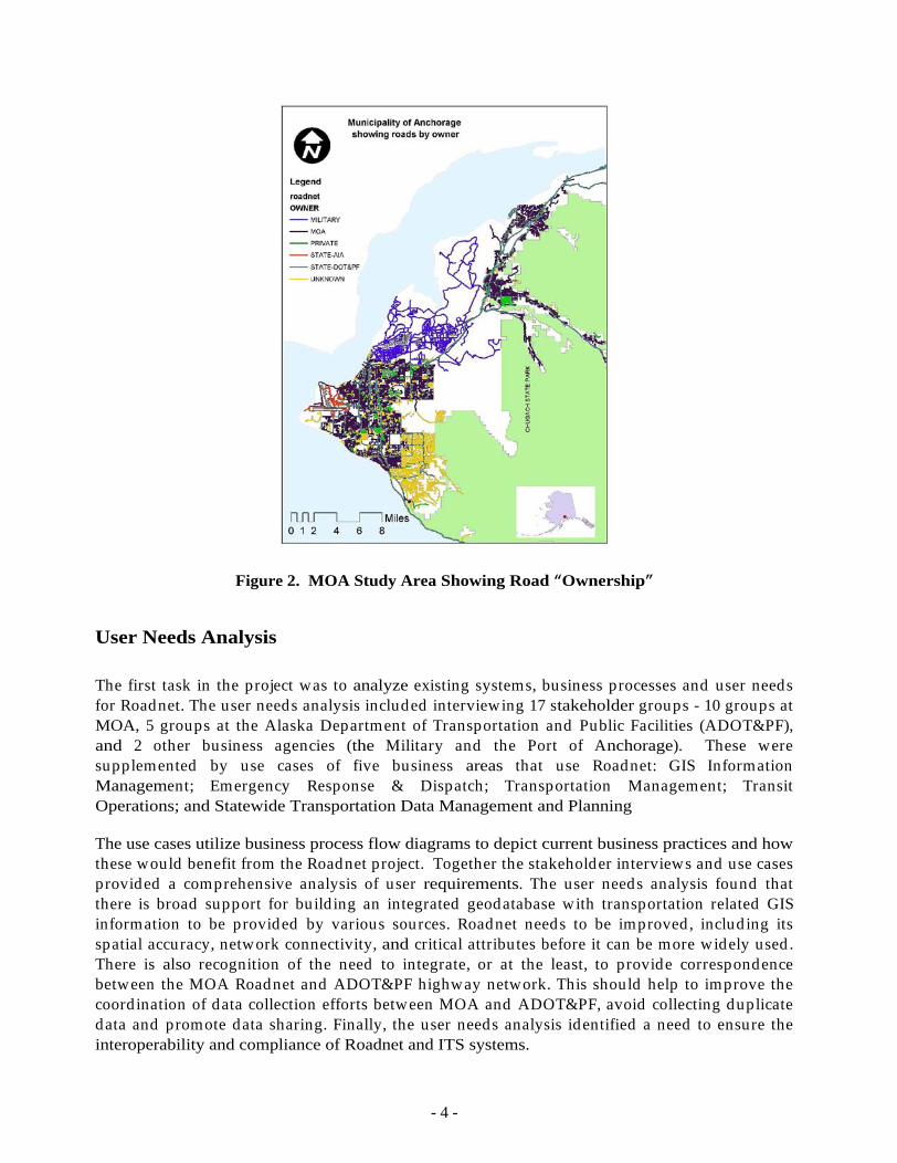
User Needs Analysis
The first task in the project was to analyze existing systems, business processes and user needs for Roadnet. The user needs analysis included interviewing 17 stakeholder groups - 10 groups at MOA, 5 groups at the Alaska Department of Transportation and Public Facilities (ADOT&PF), and 2 other business agencies (the Military and the Port of Anchorage). These were supplemented by use cases of five business areas that use Roadnet: GIS Information Management; Emergency Response & Dispatch; Transportation Management; Transit Operations; and Statewide Transportation Data Management and Planning
The use cases utilize business process flow diagrams to depict current business practices and how these would benefit from the Roadnet project. Together the stakeholder interviews and use cases provided a comprehensive analysis of user requirements. The user needs analysis found that there is broad support for build ing an integrated geodatabase with transportation related GIS information to be provided by various sources. Roadnet needs to be improved , includ ing its spatial accuracy, network connectivity, and critical attributes before it can be more widely used . There is also recognition of the need to integrate, or at the least, to provide correspondence between the MOA Roadnet and ADOT&PF highway network. This should help to improve the coord ination of data collection efforts between MOA and ADOT&PF, avoid collecting duplicate data and promote data sharing. Finally, the user needs analysis identified a need to ensure the interoperability and compliance of Roadnet and ITS systems.

- 5 -
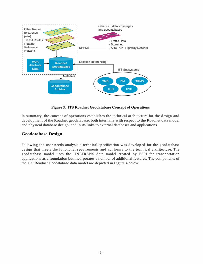
The data needs evaluation and use cases help to determine the requirements for the geodatabase design, data load ing and data extraction application. These requirements are articulated in the concept of operations for the ITS Roadnet Geodatabase is illustrated in Figure 3. The ITS Roadnet Geodatabase comprises the geospatial data (road centerlines, routes, points, and polygon data) together with the attribute data provided by stakeholders from MOA and partner agencies. The geodatabase includes capabilities to manage spatial features, data objects, the relationships between them, as well as business rules. The geodatabase will be managed in Oracle relational database management system with spatial indexing and spatial data management performed by ESRI s ArcSDE platform. ArcSDE and Oracle provide versioning and long-transaction capabilities, so the geodatabase can manage multiple versions of the data, which can be archived for later analysis. The archive will include metadata to support data searches and evaluation of the data sets.
External GIS data, such as MOA s StormNet geodatabase, Traffic Data Collection geodatabase, and ADOT&PF s Highway geodatabase, can be linked to Roadnet via ODBC network protocols. There will be three types of external databases based on their relationship with the Roadnet Geodatabase:
One-way relationships: Roadnet External DBS (e.g., Traffic database)
One-way relationships Roadnet External DBS (e.g., ADOT&PF s road condition reporting systems)
Two-way relationships Roadnet External DBS (e.g., MOA s Trail database)
The external geodatabases are not stored in Roadnet or managed by Roadnet. These databases will be represented in the Roadnet data model as separate objects. Thus, the data can be d isplayed and queried from Roadnet, but it is not topologically integrated . The same situation occurs with the ITS subsystems
traffic management system (TMS), emergency management (EM), traffic operations center (TOC), transit management system (TRMS), and commercial vehicle operations (CVO). The ITS subsystems will have foreign key fields in a subsystem table in the ITS Roadnet Geodatabase, which will contain only key information to identify the database record , its profile and spatial location. Location referencing will be used by the Roadnet GIS team to spatially reference the ITS data in the geodatabase for mapping, analysis, and archiving purposes.
- 6 -
Roadnet Reference Network
Transit Routes
Other Routes (e.g., snow plow)
Other GIS data, coverages,and geodatabases
- Traffic Data- Stormnet- ADOT&PF Highway Network
GeodatabaseArchive
TMS EM TRMS
TOC CVO
ITS Subsystems
Location ReferencingMOAAttribute
Data
Metadata
RDBMs
RoadnetGeodatabase
Figure 3. ITS Roadnet Geodatabase Concept of Operations
In summary, the concept of operations establishes the technical architecture for the design and development of the Roadnet geodatabase, both internally with respect to the Roadnet data model and physical database design, and in its links to external databases and applications.
Geodatabase Design
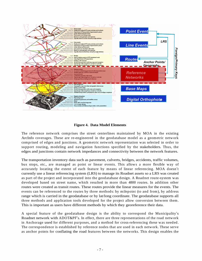
Following the user needs analysis a technical specification was developed for the geodatabase design that meets the functional requirements and conforms to the technical architecture. The geodatabase model uses the UNETRANS data model created by ESRI for transportation applications as a foundation but incorporates a number of additional features. The components of the ITS Roadnet Geodatabase data model are depicted in Figure 4 below.
- 7 -
Figure 4. Data Model Elements
The reference network comprises the street centerlines maintained by MOA in the existing ArcInfo coverages. These are re-engineered in the geodatabase model as a geometric network comprised of edges and junctions. A geometric network representation was selected in order to support routing, modeling and navigation functions specified by the stakeholders. Thus, the edges and junctions contain network impedances and connectivity between the network features.
The transportation inventory data such as pavement, culverts, bridges, accidents, traffic volumes, bus stops, etc., are managed as point or linear events. This allows a more flexible way of accurately locating the extent of each feature by means of linear referencing. MOA doesn t currently use a linear referencing system (LRS) to manage its Roadnet assets so a LRS was created as part of the project and incorporated into the geodatabase design. A Roadnet route-system was developed based on street name, which resulted in more than 4800 routes. In addition other routes were created as transit routes. These routes provide the linear measures for the events. The events can be referenced to the routes by three methods: by milepoint (to and from), by address range which is carried in the geodatabase or by lat/long coordinate. The geodatabase supports all three methods and application tools developed for the project allow conversion between them. This is important as users have different methods by which they georeference their data.
A special feature of the geodatabase design is the ability to correspond the Municipality s Roadnet network with ADOT&PF s. In effect, there are three representations of the road network in Anchorage used for d ifferent purposes, and a method for cross-referencing these was needed . The correspondence is established by reference nodes that are used in each network. These serve as anchor points for conflating the road features between the networks. This design enables the
- 8 -
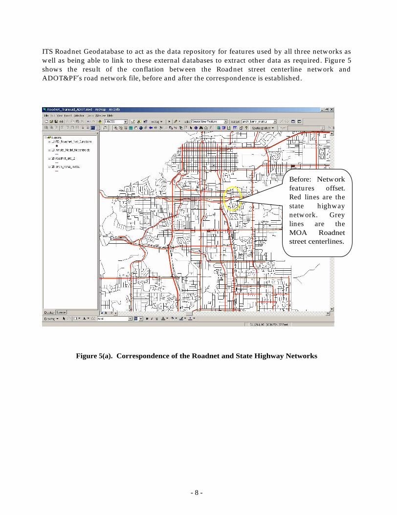
ITS Roadnet Geodatabase to act as the data repository for features used by all three networks as well as being able to link to these external databases to extract other data as required . Figure 5 shows the result of the conflation between the Roadnet street centerline network and ADOT&PF s road network file, before and after the correspondence is established .
Figure 5(a). Correspondence of the Roadnet and State Highway Networks
Before: Network features offset. Red lines are the state highway network. Grey lines are the MOA Roadnet street centerlines.
- 9 -
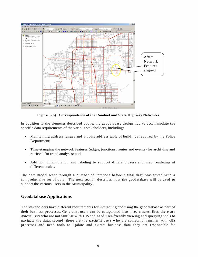
Figure 5 (b). Correspondence of the Roadnet and State Highway Networks
In addition to the elements described above, the geodatabase design had to accommodate the specific data requirements of the various stakeholders, including:
Maintaining address ranges and a point address table of build ings required by the Police Department;
Time-stamping the network features (edges, junctions, routes and events) for archiving and retrieval for trend analyses; and
Addition of annotation and labeling to support d ifferent users and map rendering at different scales.
The data model went through a number of iterations before a final d raft was tested with a comprehensive set of data. The next section describes how the geodatabase will be used to support the various users in the Municipality.
Geodatabase Applications
The stakeholders have different requirements for interacting and using the geodatabase as part of their business processes. Generally, users can be categorized into three classes: first, there are general users who are not familiar with GIS and need user-friend ly viewing and querying tools to navigate the data; second , there are the specialist users who are somewhat familiar with GIS processes and need tools to update and extract business data they are responsible for
After: Network Features aligned
- 10 -
maintaining; and third ly, there are the GIS staff who have to maintain and ed it the features in the geodatabase.
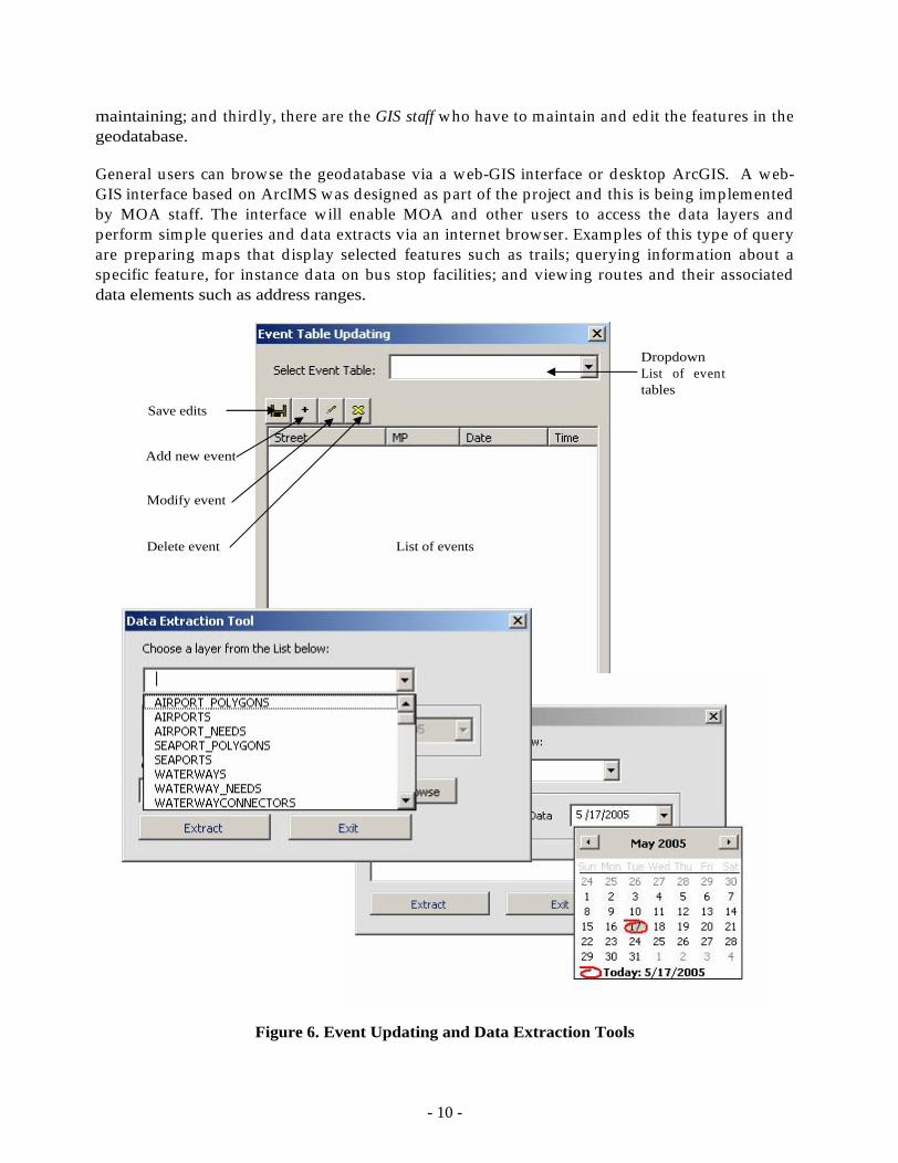
General users can browse the geodatabase via a web-GIS interface or desktop ArcGIS. A web-GIS interface based on ArcIMS was designed as part of the project and this is being implemented by MOA staff. The interface will enable MOA and other users to access the data layers and perform simple queries and data extracts via an internet browser. Examples of this type of query are preparing maps that d isplay selected features such as trails; querying information about a specific feature, for instance data on bus stop facilities; and viewing routes and their associated data elements such as address ranges.
Figure 6. Event Updating and Data Extraction Tools
Save edits
Add new event
Modify event
Delete event
List of events
Dropdown List of event tables
- 11 -
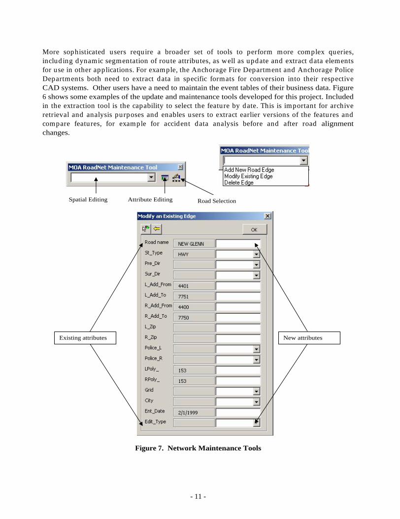
More sophisticated users require a broader set of tools to perform more complex queries, includ ing dynamic segmentation of route attributes, as well as update and extract data elements for use in other applications. For example, the Anchorage Fire Department and Anchorage Police Departments both need to extract data in specific formats for conversion into their respective CAD systems. Other users have a need to maintain the event tables of their business data. Figure 6 shows some examples of the update and maintenance tools developed for this project. Included in the extraction tool is the capability to select the feature by date. This is important for archive retrieval and analysis purposes and enables users to extract earlier versions of the features and compare features, for example for accident data analysis before and after road alignment changes.
Figure 7. Network Maintenance Tools
Spatial Editing
Attribute Editing
Road Selection
Existing attributes
New attributes
- 12 -
For the geodatabase editors, primarily GIS and IT staff, maintenance tools were developed to perform the ed iting of spatial features, attributes, and selection of roads which require ed iting. The tools synchronizes the linear referencing system and the reference network. Figure 7 shows the spatial ed iting tool for modifying an edge and updating the edge attributes. With these tools the geodatabase editors can more efficiently manage the geodatabase and perform updates in a more timely manner than was the case with the old Roadnet data.
Summary
In summary, the ITS Roadnet Geodatabase provides a robust environment for integrating and managing transportation features and business data. The enterprise systems architecture and database design accommodates multip le users and their data requirements includ ing asset management, p lanning, public works, traffic, transit, police, fire, emergency operations, and ITS business users. The ITS Roadnet Geodatabase successfully meets the goals of the ITS program in provid ing an integrated environment using current technology such as ArcGIS 9.x linear referencing. There are some limitations to the geodatabase templates for transportation but the components can be extended through the use of ArcObjects and application tools. There are also some limitations for integrating annotation in the geodatabase. The linear referencing system model and the specification of routes and events proved to be a very effective approach to the transportation database design. Similarly, the geometric network representation was also successful in supporting routing and modeling applications, even if the effort involved in developing the geometric network and connectivity charts is somewhat cumbersome. Hopefully, the new network data set available in ArcGIS 9.1 will address this issue.
Overall the ITS Roadnet Geodatabase is judged a success by the stakeholders and the MOA, and demonstrates the benefits of build ing an integrated transportation network in a GIS and geodatabase environment.
This document was created with Win2PDF available at http://www.daneprairie.com.The unregistered version of Win2PDF is for evaluation or non-commercial use only.