building urban flood resilience
TRANSCRIPT

BUILDING URBAN FLOOD RESILIENCE Integrating Community Perspectives In Kibera Work under the Kibera Public Space Project (2006 ongoing) and consultation under the BUILDING URBAN FLOOD RESILIENCE pro-gram (2014 - ongoing) funded by the Swiss Re Foundation
INTRODUCTION AND PROGRESS TO DATE - OCTOBER 2015
Building Urban Flood Resilience KOUNKUEY DESIGN INITIATIVE

Building Urban Flood Resilience KOUNKUEY DESIGN INITIATIVE
CONTENTS:
1. KIBERA CONTEXT2. KDI IN KIBERA3. URBAN FLOODING ISSUES 4. LEARNING TO DATE5. KPSP LOCAL SOLUTIONS

Building Urban Flood Resilience KOUNKUEY DESIGN INITIATIVE
1. KIBERA CONTEXT

Building Urban Flood Resilience KOUNKUEY DESIGN INITIATIVE
kenya nairobi
kibera
KIBERA LOCATION
Building Urban Flood Resilience KOUNKUEY DESIGN INITIATIVE
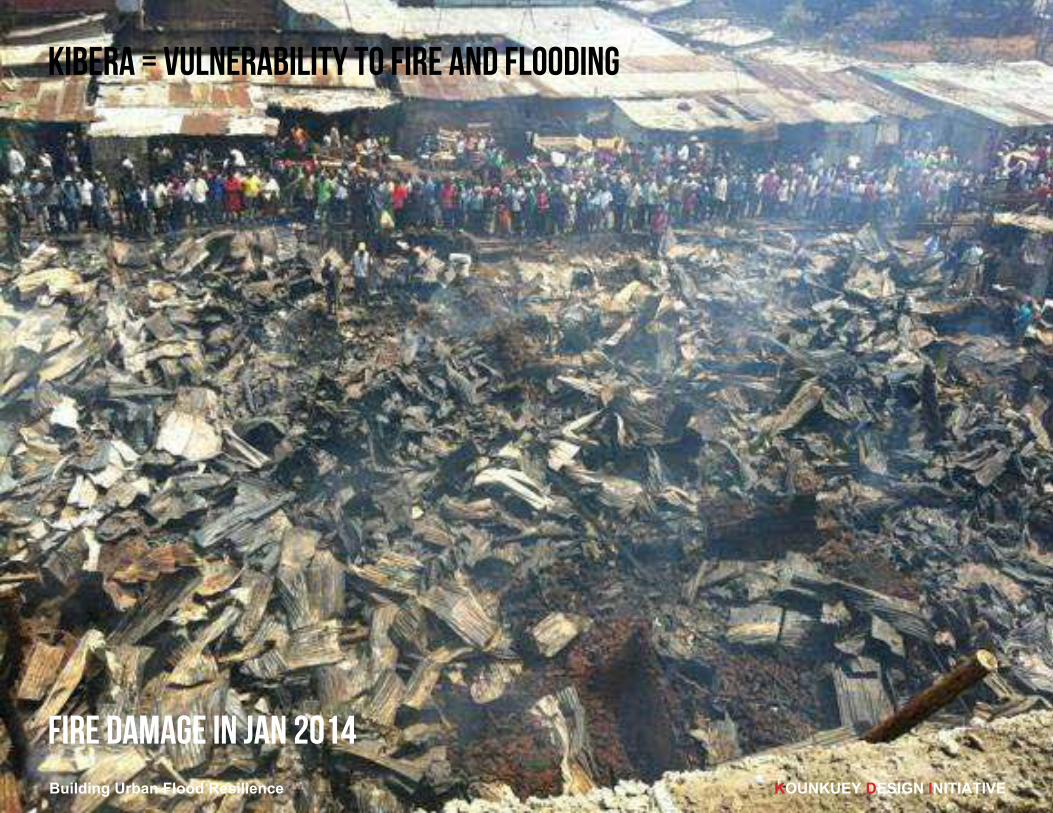
KIBERA = VULNERABILITY TO FIRE AND FLooDING
FIRE damage IN JAN 2014

Building Urban Flood Resilience KOUNKUEY DESIGN INITIATIVE
KIBERA = TOPOGRAPHY

Building Urban Flood Resilience KOUNKUEY DESIGN INITIATIVE
KIBERA = POOR DRAINAGE

KIBERA = NO SOLID WASTE COLLECTION
Building Urban Flood Resilience KOUNKUEY DESIGN INITIATIVE

Building Urban Flood Resilience KOUNKUEY DESIGN INITIATIVE
KIBERA = SOLID WASTE DEPOSITION FROM FLOODING

nairobi
dandora
kibera
central
province
eastern province
rift valley province
mukuru
matharekariobangi
kawangware
nairobi
major slum
Building Urban Flood Resilience KOUNKUEY DESIGN INITIATIVE
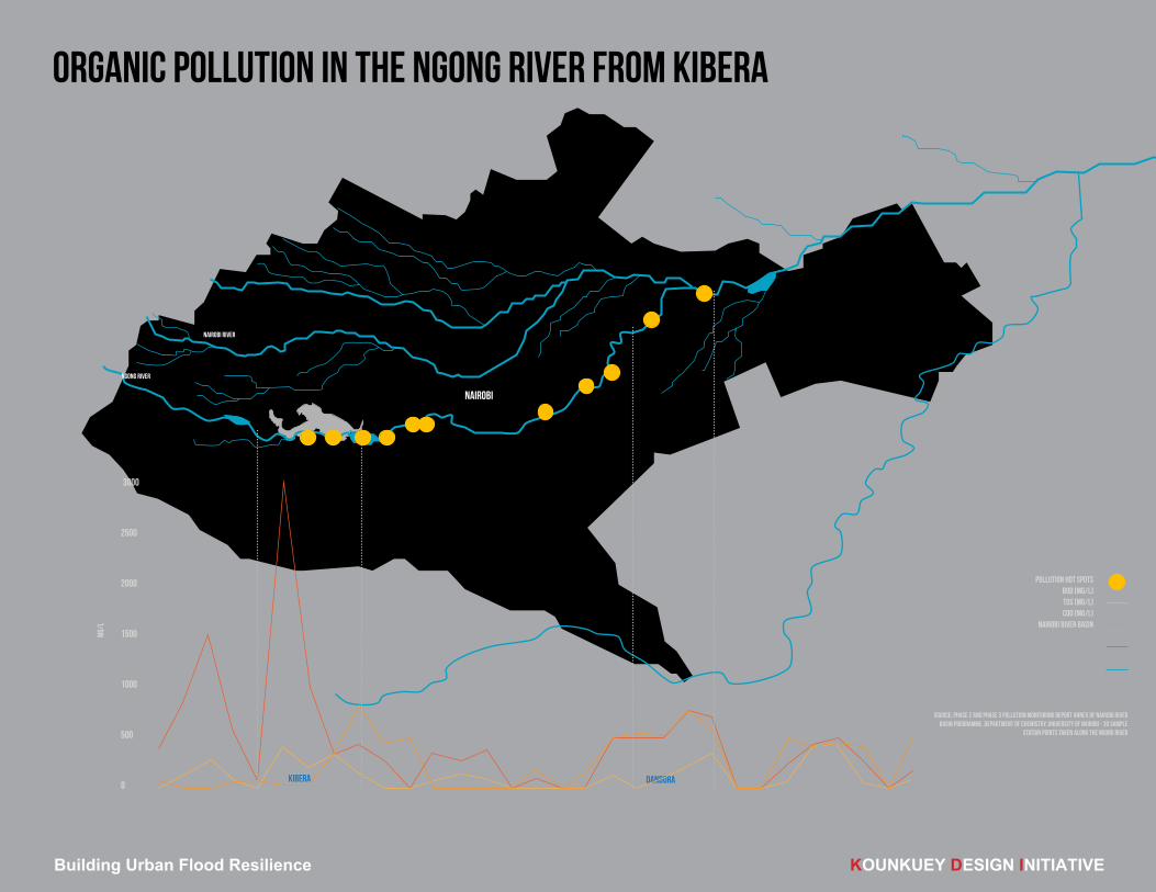
SLUMS AND MAJOR RIVER SYSTEMS OF THE NAIROBI RIVER BASIN
kibera
nairobi
dandora
pollution hot spotsBOD [mg/l]tds [mg/l]cod [mg/l]
nairobi river basin
0
500
1000
1500
2000
2500
3000
Source: phase 2 and Phase 3 Pollution Monitoring Report Annex of Nairobi River Basin Programme, Department of Chemistry, University of Nairobi - 30 sample
station points taken along the ngong river
mg/l
ngong river
nairobi river
Building Urban Flood Resilience KOUNKUEY DESIGN INITIATIVE
ORGANIC POLLUTION IN THE NGONG RIVER FROM KIBERA

Building Urban Flood Resilience KOUNKUEY DESIGN INITIATIVE
2. KDI IN KIBERA

The Kounkuey Timeline
Sp|06 Su|06 F|06 Sp|07 Su|07S|05 F|07 Sp|08W|08 S|08 F|08
Spring 2007
From One
to Many
If affordable and managed
well, community groups can
replicate the process of creat-ing productive public spaces
in existing waste spaces.
As it grows, this network
strengthens the river infra-structure and provides ameni-ties to thousands of residents.
$ $
KIBERA PUBLIC SPACE PROJECT (KPSP) NETWORK: THE VISION IN 2006
Building Urban Flood Resilience KOUNKUEY DESIGN INITIATIVE

productive public space
environmental remediation
pollution reduction
watershed stabilization
access infrastructure
public recreation
public assembly
small enterprise
food security
savings and loans
phys
ical
socia
lec
onom
-
1. transforms an environmental liability into usable public space;
2. is authored and operated by its end-users collaborating with outside groups;
3. integrates income-generating and socially empowering uses;
4. adds value to a space with-out alienating the original community;
5. meets expressed community priorities and links to larger improvement efforts; and
6. uses strong design concepts to create beautiful places.
PRODUCTIVE PUBLIC SPACE CONCEPT
Building Urban Flood Resilience KOUNKUEY DESIGN INITIATIVE

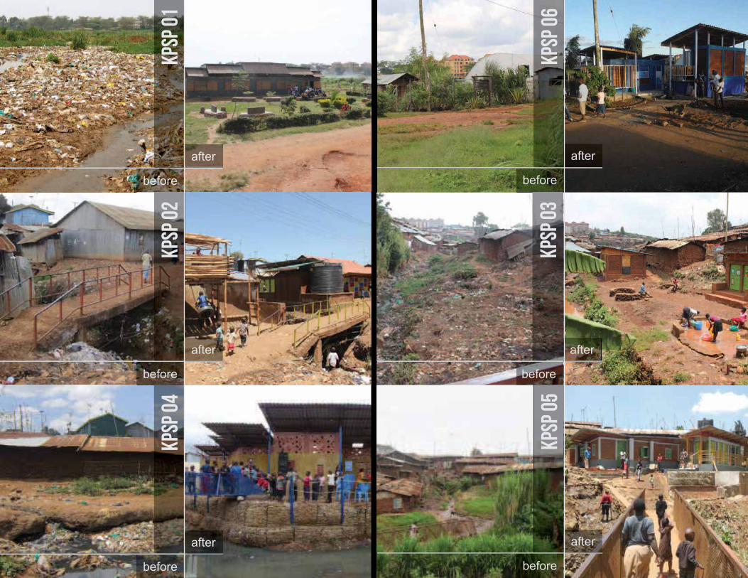
started 2007KPSP01 BEFORE
Building Urban Flood Resilience KOUNKUEY DESIGN INITIATIVE

completed 2010KPSPO1 AFTER
VOCATIONAL SCHOOL
CHURCHCOMPOSTING
BUSINESS SITE OFFICE + WEAVING COOP
PUBLIC PARK
Building Urban Flood Resilience KOUNKUEY DESIGN INITIATIVE

KPSP02 BEFORE started 2009
Building Urban Flood Resilience KOUNKUEY DESIGN INITIATIVE

pps 2 a!er
completed 2010KPSPO2 AFTER
PLAYGROUND WATER KIOSK
SANITATION BLOCK
CHURCH
KIOSKS
FLOOD PROTECTION
Building Urban Flood Resilience KOUNKUEY DESIGN INITIATIVE

KPSP03 BEFORE started 2011
Building Urban Flood Resilience KOUNKUEY DESIGN INITIATIVE

completed 2012KPSPO3 AFTER
SPRING BOX AND LAUNDRY
PAD
KIOSKSTAILOR
PUBLIC PARK
FLOOD PROTECTION
AND DRAINAGE
PRE-SCHOOLCRAFTS
BUSINESS
Building Urban Flood Resilience KOUNKUEY DESIGN INITIATIVE

KPSP04 BEFORE started 2012
Building Urban Flood Resilience KOUNKUEY DESIGN INITIATIVE

KPSPO4 AFTER completed 2013
FLOOD PROTECTION
SANITATION BLOCK
DAYCARECYBER CAFE
PATCH
Building Urban Flood Resilience KOUNKUEY DESIGN INITIATIVE

started JANUARY 2013KPSP05 BEFORE
Building Urban Flood Resilience KOUNKUEY DESIGN INITIATIVE

KPSPO5 AFTER FEBRUARY 2014
SANITATION BLOCK
MULTIPURPOSE STRUCTURE
LAUNDRY PAD
DRAINAGE
SEPTIC SYSTEM
Building Urban Flood Resilience KOUNKUEY DESIGN INITIATIVE

KPSP06 IN DESIGN started APRIL 2013
Building Urban Flood Resilience KOUNKUEY DESIGN INITIATIVE

KPSPO6 AFTER FEBRUARY 2014
COMPOSTING TOILET BLOCK
Building Urban Flood Resilience KOUNKUEY DESIGN INITIATIVE
������ ������
������
�����
������
�����������
�����
������
�����
����� �����

Building Urban Flood Resilience KOUNKUEY DESIGN INITIATIVE
A GROWING SOCIAL AND PHYSICAL NETWORK

KPSP05 2014
KPSP02 2011
KPSP03 2012
KPSP04 2013
KPSP01 2010
KPsp06 2014KPSP07 2015
1km
N
NAIROBI DAM
NGONG RIVER
NAIROBI - KAMPALA RAILWAY LINE
Building Urban Flood Resilience KOUNKUEY DESIGN INITIATIVE
KIBERA PUBLIC SPACE PROJECT (KPSP) NETWORK 2015

KPSP05 2014
KPSP02 2011
KPSP03 2012
KPSP04 2013
KPSP01 2010
KPsp06 2014KPSP07 2015
1km
N
flooding from the Ngong river
flooding from small streams within Kibera
NB: localised flooding due to inadequate drainage EXISTS THROUGHOUT KIBERA
Building Urban Flood Resilience KOUNKUEY DESIGN INITIATIVE
NAIROBI DAM
NGONG RIVER
NAIROBI - KAMPALA RAILWAY LINE
RIVERINE FLOOD AREAS

site
settlement
WATERSHED
WATERWASTEWATER STORMWATER
WATERWASTEWATER STORMWATER
WATERWASTEWATER STORMWATER
RISKBUILDINGSUTILITIES
RISKINFRASTRUCTURESTANDARDS
RISKBOUNDARIESJURISDICTION
50m
5,000m
50,000m
Building Urban Flood Resilience KOUNKUEY DESIGN INITIATIVE
SCALE JUMPING

Building Urban Flood Resilience KOUNKUEY DESIGN INITIATIVE
3. URBAN FLOODING

Building Urban Flood Resilience KOUNKUEY DESIGN INITIATIVE
FLOODING on ngong river april 2013
“The river is associated around here with death and destruction of property”, Rose Odinga, Kibera Resident, April 2013.

KPSP04 2013
1km
N
Building Urban Flood Resilience KOUNKUEY DESIGN INITIATIVE
FLOOD DAMAGE TO PROPERTY AND ASSETS OCCURS TWICE ANNUALLY
FLOOD DAMAGE IN AT THE BOUNDARIES OF LINDI AND LAINI SABA VILLAGES ADJACENT TO KPSP04 IN APRIL 2014. THE INTERNAL ROOMS OF THIS BUILDING WERE FLOODED AND ALL PROPERTY INSIDE RUINED.

FLOOD REPAIRS ARE COSTLY AND TIME CONSUMING
FLOOD REPAIRS WITH IRREGULAR STONEWORK AND WEAK MORTAR. THIS REPAIR WAS WASHED AWAY AGAIN AFTER THE NEXT RAINS.
Building Urban Flood Resilience KOUNKUEY DESIGN INITIATIVE

KIBERA WATER, SANITATION AND RIVERS
SC 1Area= 645 hectares
SC 2Area=135 hectares
SC 3Area=145 hectares
SC 4Area= 121 hectares
SC 5Area=144 hectares
Building Urban Flood Resilience KOUNKUEY DESIGN INITIATIVE
KIBERA CATCHMENTS

Building Urban Flood Resilience KOUNKUEY DESIGN INITIATIVE
NGONG CATCHMENTS

Building Urban Flood Resilience KOUNKUEY DESIGN INITIATIVE
THE CHALLENGES KIBERA CONTEXT
ǵ� 30,000 people living within 30m of the rivers (SDI, 2012; KDI, 2014)ǵ� cheapest rents are found along the rivers and streams where risk of flooding is highest. ǵ� flooding destroys the limited assets of poor and vulnerable households, displaces residents,
halts economic activity, contaminates water supply and can lead to disease outbreaks
NATIONAL POLICY CONTEXT ǵ� The only concrete policy for flood protection that currently exists in Nairobi designates a
blanket, 30m riparian zone within which all structures are deemed illegal. ǵ� In 2009 the National Environmental Management Authority (NEMA) estimated that imple-
menting the policy would require the eviction of 127,000 people along the Mathare, Nairobi, and Ngong rivers at a cost of 1.8 Billion KES (Nation, 2009).
ǵ� This policy has created tensions between residents and implementing agencies, resulted in significant protest, and proved unenforceable.

Building Urban Flood Resilience KOUNKUEY DESIGN INITIATIVE
POLICY/PLANNING GAPS ǵ� There is a clear gap between the scale of the issue and the current knowledge and capac-
ity-to-respond within governmental and nongovernmental organisations. ǵ� This is not exclusive to Kibera abut consistent in many rapidly urbanising cities in the so-
called developing world. ǵ� A consistent challenge is that community perspectives on these issues have rarely
been integrated into planning processes (Baker, 2012). ǵ� This lack of context has led to an over-reliance on poorly planned relocation, causing con-
flict and insecurity in many cases. ǵ� At the same time heavy infrastructural solutions can incur significant cost and have limited
flexibility and robustness in the face of environmental (climate) or social changes.
THE CHALLENGES
There is great potential to consider how lower-cost, non-structural approaches that support local resilience can create an integrated approach to flood risk manage-ment alongside traditional spatial planning and policy responses (Jha et al, 2012).

Building Urban Flood Resilience KOUNKUEY DESIGN INITIATIVE
NEEDS
1) The need to develop an approach to flood modeling and risk-mapping that is applicable in the informal context and integrates community-level information on multiple hazards and risks;
2) The need to demonstrate the validity of a broader menu of flood management options that focus on building social cohesion and resilience, alongside appropriate infrastructural and policy measures;
3) The need to identify and implement social resilience projects (e.g. early warning systems, flood management committees, emergency response centres) that demonstrate the low-cost, high-benefit value of these approaches;
4) The need to build the capacity of institutional stakeholders to undertake integrated flood risk management and implement flood management options in a consultative andcollaborative fashion that incorporates conflict-sensitivity and the social dimensions of resilience.

Building Urban Flood Resilience KOUNKUEY DESIGN INITIATIVE
A RESPONSE? INTEGRATED URBAN FLOOD RISK MANAGEMENT
1. ASSESS VULNERABILITY AND RISK- local perspectives- local vulnerability- MODELING AND MAPPING
2. IDENTIFY SOLUTIONS (STRATEGIC FLOOD RISK ASSESSMENT)- spatial (HARD) and SOCIAL (SOFT) SOLUTIONS
3. COST
4. IMPLEMENT- POLICY REQUIREMENTS

Building Urban Flood Resilience KOUNKUEY DESIGN INITIATIVE
A RESPONSE? SOCIAL RESILIENCE STRATEGIES
INSURANCE
EROSION CONTROLREBUILDING NATURAL
ECOSYSTEMS
URBAN DEVELOPMENT CONTROLS
BUILDING CODES
FLOOD DEFENCES
RESETTLEMENT TO LOWER RISK ZONES
REDUCED SOCIAL VULNERABILITY
EARLY WARNING SYSTEMS
URBAN DRAINAGE SYSTEMS
LOWHIGH
BE
NE
FITS
RE
LATI
VE
TO
COST
S
HIGH
LOW
ROBUSTNESS TO UNCERTAINTIES
Relative costs and benefits of flood mangement options (adapted from Ranger and Garbett-Shields, 2011)
e.g. early warning sys-tems, flood awareness campaigns, flood man-
agement committees and local emergency
response centres

Building Urban Flood Resilience KOUNKUEY DESIGN INITIATIVE
4. LEARNING TO DATE

CONSULTATION STRUCTURE
B u i l d i n g U r b a n F l o o d R e s i l i e n c e i n K i b e r a �
March 2015 KDI 8
2.3 Consultation Framework Consultation framework integrating the principle components and methodologies:
Axes Methodology Information
Level Dem
ogra
phic
s/Li
velih
oods
Haz
ard
Ass
essm
ent
Bro
ad V
ulne
rabi
lity
Vuln
erab
ility
to F
lood
ing
Qua
ntify
ing
Dam
age/
Impa
ct
Dev
elop
ing
resp
onse
s - l
ocal
Dev
elop
ing
resp
onse
s -
inst
itutio
nal
Timescale of Consultation
�
�
1. Hazard Mapping
Remote Data Collection Desk study x x Feb. to March 2015
Field Data Collection Field Measurements
x Long and short rains 2015/2016
2. Vulnerability, Exposure and
Risk Assessment
HH Survey - Pre-rains HH survey x x x x x March 2015 HH Survey - Post-rains HH Survey x x x x x x May 2015
Participatory Vulnerability Analysis/ Community Level
x x x x
March - April 2015 Community Risk Assessment/
x x x x
April - May 2015
DRM Planning
x x x
May ongoing 2015
3. Institutional Mapping
Institutional mapping Desk/Community x x x x Feb. to April 2015
Key Informant Interviews Institutional Level (Local/National)
x x x x March-August 2015
Building Urban Flood Resilience KOUNKUEY DESIGN INITIATIVE

1km
N
flooding from the Ngong river flooding from small streams within Kibera
CONSULTATION AREA
1. HH SURVEY2. COMMUNITY WORKSHOPS3. River measurements
CONSULTATION TYPES:
LINDI - andOlo
SOWETO EAST
LINDI (CONTROL) SILANGA - PCA
GATWEKERA - KPSP03
LINDI - KPSP07
NGONG RIVER
NAIROBI DAM
NAIROBI-KAMPALA RAILWAY
KIBERA
Building Urban Flood Resilience KOUNKUEY DESIGN INITIATIVE
CONSULTATION AND DATA COLLECTION AREAS

Building Urban Flood Resilience KOUNKUEY DESIGN INITIATIVE
COMMUNITY WORKSHOP 01 - SILANGA PCA - VULNERABILITY ANALYSIS26 March 2015

Building Urban Flood Resilience KOUNKUEY DESIGN INITIATIVE
COMMUNITY WORKSHOP 01 - SILANGA PCA - VULNERABILITY ANALYSIS26 March 2015

Building Urban Flood Resilience KOUNKUEY DESIGN INITIATIVE
COMMUNITY WORKSHOP 01 - SILANGA PCA - VULNERABILITY ANALYSIS26 March 2015

WORKSHOP 02,LINDI SITE 07,NEAR MSF,IDENTIFYINGRISK AREAS,28th MARCH
Building Urban Flood Resilience KOUNKUEY DESIGN INITIATIVE

WORKSHOPIDENTIFYINGRISK AREAS
Building Urban Flood Resilience KOUNKUEY DESIGN INITIATIVE
ENUMERATOR TRAINING FOR “PRE-RAINS” HOUSEHOLD SURVEYFEBRUARY 2015

COMPLETE “Pre-rains” HOUSEHOLD SURVEYS - 963 HH
Building Urban Flood Resilience KOUNKUEY DESIGN INITIATIVE
LINDI - SITE 07
LINDI - ANDALO
SOWETO EAST
SILANGA PCALIN DI - CONTROL

PRE-RAINS HH SURVEYS RESULTS - 40% HH FLOODED IN LAST 12 MONTHS
Building Urban Flood Resilience KOUNKUEY DESIGN INITIATIVE

POST-RAINS HH SURVEYS RESULTS (SO FAR) - 60% HH FLOODED IN LAST 3 MONTHS
Building Urban Flood Resilience KOUNKUEY DESIGN INITIATIVE

FLOODING no. 1 REASON FOR HAVING TO LEAVE STRUCTURE
Building Urban Flood Resilience KOUNKUEY DESIGN INITIATIVE

OVER 60% USING UNIMPROVED PIT LATRINES
Building Urban Flood Resilience KOUNKUEY DESIGN INITIATIVE

FLOOD ADAPTATION GEO-TAGGING AND PHOTOS
Building Urban Flood Resilience KOUNKUEY DESIGN INITIATIVE

Building Urban Flood Resilience KOUNKUEY DESIGN INITIATIVE
FIELD OPERATORS TRAINING - LEVEL MEASUREMENTS PROCEDURES - MARCH 2015
FIELD OPERATORS TRAINING - HEALTH AND SAFETY - MARCH 2015

Building Urban Flood Resilience KOUNKUEY DESIGN INITIATIVE
FIELD OPERATORS - RIVER LEVEL MEASUREMENTS - LINDI VILLAGE (SITE 07)APRIL 2015

DATE ORGANISATION KEY RESPONDENT(S)21-May-15 National Disaster Operations Centre (NDOC) COL (KAF-Rtd) Nathan M Kigotho, MBS. “ndc” “psc” (K),
Director, NDOCMinistry of Interior and Coordination of National Gov-
ernment
Dr Edward K. Kiema
22-May-15 National Environment Management Authority
(NEMA)
Sophie N. Mutemi, Environmental Inspector
Marian, Acting NEMA Director22-May-15 Urban Rivers Restoration Programme (URRP) - Min-
istry of Environment, Water and Natural Resources
Erick F. N. Akotsi, Director, URRP
Jeckly Bitok, Programme Officer, URRP29-May-15 Land Reclamation - Ministry of Environment, Water
and Natural Resources
Mr James K. Yatich, Deputy Director, Land Reclamation
02-Jun-15 Ministry of Devolution and Planning, State Depart-
ment of Devolution, Directorate of Special Pro-
grammes
Mr Vincent Matioli, Under secretary
04-Jun-15 Cabinet Secretary - Ministry of Environment, Water
and Natural Resources
Professor Judi Wakhungu Cabinet Secretary
Engineer SAO Alima04-Jun-15 Laini Saba Division Security Committee, Community
Based Organisation
John Maina Waithanji, Chairman
22-Jun-15 Laini Saba Local Authority Patrick Adira, Senior Chief23-Jun-15 Kenya Meteorological Department James Kongoti, CEO
Patrick Masika, Principal Meteorologist
Johnson Maina, Hydrologist24-Jun-15 Water Resources Management Authority, Flooding
Department
Simon Mwangi, Technical Coordination Manager
Building Urban Flood Resilience KOUNKUEY DESIGN INITIATIVE
INSTITUTIONAL MAPPING AND ADVOCACY


Building Urban Flood Resilience KOUNKUEY DESIGN INITIATIVE
5. KPSP - LOCAL SOLUTIONSXT

LOCAL SCALE SOLUTIONS - CONSULT WITH COMMUNITY MEMBERS
Building Urban Flood Resilience KOUNKUEY DESIGN INITIATIVE

LOCAL SCALE SOLUTIONS - BAMBOO PLANTING AT KPSP01: EROSION CONTROL
Building Urban Flood Resilience KOUNKUEY DESIGN INITIATIVE

LOCAL SCALE SOLUTIONS - GABIONS AT KPSP04: FLOOD CONTROL
Building Urban Flood Resilience KOUNKUEY DESIGN INITIATIVE

LOCAL SCALE SOLUTIONS - GABIONS AT KPSP04: FLOOD CONTROL
Building Urban Flood Resilience KOUNKUEY DESIGN INITIATIVE

Building Urban Flood Resilience KOUNKUEY DESIGN INITIATIVE
MODEL

BUILD - LANDSCAPE DRIVEN SOLUTIONSLIVE STAKING
0 . 9 m
S O U T H B A N K
N O R T HB A N K
2 . 3 m
0 . 5 5 m 0 . 7 5 m0 . 5 m
2 . 7 m
0 .1 5 m
1 .1 m
0 . 5 m
8 m
4 m 4 m
5 . 3 m
Tr a s h s o i l
C o m p o s t
C o m p o s t
M u r r a m
C o m p a c t e d M u d
C o m p a c t e d M u d
B l a c k s o i l
3 m
0 . 2 m
0 . 2 m
Design Flow
1 . 7 m
C R O S S _ S E C T I O N DES I G N PR O P O S A L A _ R i p ra p w i t h l i v e s t a ke p l a n t in gKPSP01 _ Kibera Streambank Stabilization
R i p ra p( d = 0 .3- 0 .5m )
C o ns o l i d a t i o n p l a n t in g
L i v e s t a ke( F i g / p e p p e r t re e )
G e o t ex t i l e f a b r i c
S t a ke t o h o l d d o w n g e o t ex t i l e
Building Urban Flood Resilience KOUNKUEY DESIGN INITIATIVE

ADVOCATE
Building Urban Flood Resilience KOUNKUEY DESIGN INITIATIVE

MANAGE CHANGE!
Building Urban Flood Resilience KOUNKUEY DESIGN INITIATIVE

nairobi river basin program - NAIROBI 2030 VISION
Building Urban Flood Resilience KOUNKUEY DESIGN INITIATIVE

“Good development practice facilitates emergence; it builds on what we’ve got and with it goes to scale… in order to do something big—to think globally and act globally— one starts with something small and one starts where it counts.”
NABEEL HAMDI, SMALL CHANGE
Building Urban Flood Resilience KOUNKUEY DESIGN INITIATIVE

THANKS from the KDI team!
Building Urban Flood Resilience KOUNKUEY DESIGN INITIATIVE