building web applications using web services
TRANSCRIPT

California State University, San Bernardino California State University, San Bernardino
CSUSB ScholarWorks CSUSB ScholarWorks
Theses Digitization Project John M. Pfau Library
2008
Building web applications using web services Building web applications using web services
Keerthi Nannapaneni
Follow this and additional works at: https://scholarworks.lib.csusb.edu/etd-project
Part of the Databases and Information Systems Commons, and the Software Engineering Commons
Recommended Citation Recommended Citation Nannapaneni, Keerthi, "Building web applications using web services" (2008). Theses Digitization Project. 3490. https://scholarworks.lib.csusb.edu/etd-project/3490
This Project is brought to you for free and open access by the John M. Pfau Library at CSUSB ScholarWorks. It has been accepted for inclusion in Theses Digitization Project by an authorized administrator of CSUSB ScholarWorks. For more information, please contact [email protected].

BUILDING WEB APPLICATION USING WEB SERVICES
A Project
Presented to the
Faculty ofCalifornia State University,
San Bernardino
In Partial Fulfillmentof the Requirements for the Degree
Master of Sciencein
Computer Science
byKeerthi Nannapaneni
December 2008
BUILDING WEB APPLICATION USING WEB SERVICES
A Project
Presented to the
Faculty ofCalifornia State University,
San Bernardino
byKeerthi Nannapaneni
December 2008
Approved by:
Computer Science

ABSTRACT
This project was performed to get hands on experience on the implementation of web services. During this project
execution, significant time was spent researching about
existing web services and various programming environments
that can be used for building the application. The
following technologies were used to build this web application - AJAX, JavaScript, Java, Java Server Pages, HTML, and CSS. Existing data content from the following web service resources were used in this application-
Google API, ArcWebServices, Weather XML data feed. The
purpose of this application is to show the map location
along with the weather of the place selected by a user.Using this application, the user will also have the ability to get driving directions and current traffic information.‘This application can be easily integrated
with university web pages to give easy access to weather*and place information for students and staff in California
State University at San Bernardino (CSUSB). Through the
course of this project information about how to find and evaluate existing web services, technologies and methods
of integrating various web services into one application
were gathered. All the important steps that were followed
during the implementation were documented in the order of
iii

execution. This documentation will help programmers find
useful information when building a web services based application.
iv
ACKNOWLEDGMENTS
This project was carried out with the guidance and
assistance of my project committee. First, I would like to
thank my advisor Ernesto Gomez, for his continuous support
and for .providing me with an opportunity to undertake a
project in web services. I would also like to thank Dr.
Tong Lai Yu for providing valuable suggestions during the
course -of this project and also for assisting me during my independent study. I also want to express my sincere
gratitude to Dr. Kerstin Voigt for her guidance,
understanding, and for valuable'advice.
Besides my Project committee, I would like to thank
the rest of computer science department faculty and staff, Dr. Josephine Mendoza, graduate advisor, for guiding me throughout my masters program. I thank my parents for
supporting me throughout my life and encouraging me to
pursue my interests. I also thank my husband Rama K Atluri for his great help and support in finishing this project.
v

TABLE OF CONTENTS
ABSTRACT............................................ illACKNOWLEDGMENTS ..................................... vLIST OF TABLES....................................... viiiLIST OF FIGURES....... ixCHAPTER. ONE: INTRODUCTION........................... 1
1.1 Purpose.................................... 21.2 Scope...................................... 31.3 Significance..... 41.4 Limitations ................................ 51.5 Definitions of Terms ....................... 6
CHAPTER TWO: REVIEW OF RELATED LITERATURE2.1 Web Services............................... 102.2 Initial Research ........................... 13
2.2.1 Identify Existing Web Services ...... 142.3 Identification of Programming
Environment................................ 192.3.1 Java Language....................... 202.3.2 Java Web Technologies............... 222.3.3 Web Server.......................... 242.3.4 Simple Object Access Protocol
Implementation ...................... 252.3.5 Asynchronous JavaScript Library ..... 27
CHAPTER THREE: METHODOLOGY3.1 Setting Up the Development Environment ..... 31
3.1.1 Software Environment ................ 31
vi

3.1.2 Hardware Environment ................ 333.2 Setting up the Project..................... 33
3.2.1 Configure Java in Eclipse........... 343.2.2 Configure Apache Tomcat Web Server
in Eclipse........... 353.2.3 Create PlaceFinderProject in
Eclipse............................. 383.2.4 Configure Apache Axis to Project .... 40
3.3 Implementation of the Project.............. 443.3.1 Place Finder........................ 443.3.2 Google Maps......................... 503.3.3 Accessing Weather XML Data Feed..... 533.3.4 Directions and-Traffic .............. 60
3.4 Integration................................ 623.5 Demonstration and Enhancements............. 65
CHAPTER FOUR: MAINTENANCE4.0 Application Results ........................ 67
CHAPTER FIVE: CONCLUSIONS AND RECOMMENDATIONS5.1. Conclusions................................ 735.2 Recommendations............................ 75
APPENDIX A: JAVA ARCHIVE FILES...................... 77APPENDIX B: J2EE MODULE DEPENDENCIES ................ 79REFERENCES . ......................... 81
vii

LIST OF TABLES
Table 1. List of Java Dependencies.................. 35
Table 2. List of Tomcat Dependencies................ 38Table 3. List of Apache Axis Dependencies........... 42Table 4. Current Condition Data from Weather
Extensible Markup Language Data Feed ....... 54Table 5. Forecast Data from Weather Extensible
Markup Language Data Feed.................. 55Table 6. Weather Data Parsing Dependencies .......... 59
viii

LIST OF FIGURES
Figure 1. Web Service Components ................... 11Figure 2. Service Oriented Architecture
Approach................................. 13Figure 3. Requirements and Design .................. 14Figure 4. ArcWeb Place Finder Search ............... 16Figure 5. Identify Development Environment .......... 19Figure 6. How Java Works........................... 22Figure 7. How does Java Server Pages Work.......... 23Figure 8. How does Tomcat Work..................... 25Figure 9. Axis Architecture........................ 27Figure 10. Classic and Asynchronous JavaScript
Communication Models ..................... 29Figure 11. Java Dependencies in Eclipse............. 34Figure 12. Tomcat Configuration ..................... 36Figure 13. Tomcat Dependencies ...................... 37Figure 14. Place Finder Project Folder .............. 40Figure 15. Apache Axis Jars......................... 41Figure'16. Setting Environmental Variable for
Apache Axis.............................. 43Figure 17 Place Finder Classes ..................... 45Figure 18. Place Finder Class Diagram ................ 46Figure 19. Code Snippet of the Place Finder........... 47Figure 20. Scriptaculous Libraries .................. 47Figure 21. Asynchronous JavaScript Auto
Completer................................ 4 9Figure 22. Place Names Interception ................. 49
ix

Figure 23. Adding Google Maps to Page............... 50Figure 24. Accessing Google Map Functions ........... 51Figure 25. Classes for Parsing Weather .............. 57Figure 26. Class Diagram for Parsing Weather
Data...... 58Figure 27. Accessing Weather Data .................. 60Figure 28. Accessing Methods to Get Weather
Data .......... 63Figure 29. Flow Diagram'of Application ............. 64Figure 30. Introduction Page........................ 67Figure 31. Place Finder and Weather Conditions ..... 68Figure 32. Place Name............................... 69Figure 33. List of Place Names................... 70Figure 34. Weather Conditions ...................... 71Figure 35. Directions and Traffic .................. 72
x

CHAPTER ONE
INTRODUCTION
The need for distributed computers to communicate with each other via a network led Web service to evolve. A Web service is an application that can communicate with
other applications over a network by using a set of
standardized protocols.As part of my graduate requirement, I choose to work
on a project concerning Web services. With the help of my graduate advisor Dr. Ernesto Gomez, identified the
requirements during the project proposal phase. The goal
of this project is to use technologies that have
flexibility to be easily customized and configured to meet any new requirements.
This project uses services and data content from various third party Web services. During the initial phase of the project significant research was conducted to find
suitable web sources. The final phase of the project time
was spent to figure out the best way to integrate these to
create a more meaningful application that can be used by
the university community.
1

1.1 PurposeBy doing this project, an attempt was made to
demonstrate the advantages of using existing web services
to provide useful content by not investing significant
resources to acquire and maintain data, software and hardware. The development environment and tools used in this project are available for free of cost from various
organizations.
Various services have been chosen and integrated into one cohesive application to provide a customized and
valuable solution to the university staff and students. Users simply enter the place of interest, and will have
the ability to select from a candidate list of matches.
After the place is selected the application will show the
current and forecast weather conditions of that place.
Though there are some individual services which show the city and weather separately there is no application which provides these services based on a common place name. In this project, these services are integrated making it much
easier to a user to just type the common place name, for
example: when a user inputs 'white house', the application
will return the location as well as the weather
information of that location and the ability to look up directions to this place and traffic information.
2

1.2 ScopeFor the sake of timely completion of this project I
have defined the scope of the project to sufficiently
demonstrate the core concepts of web services by using the software engineering principles that I learned during the
course of my masters program.
The scope of project is to create an easy to use web
application for the university staff and students to
access the following information.
• Current Weather Conditions and Forecast
• Place Name and its Map Location
® Driving Directions
• Traffic Information
This information is assumed to be used frequently bythe university staff and students and is available in few different portals but not in one web application. Also, to complete the project in a timely manner it was agreed upon to include only the above mentioned services. These services will sufficiently demonstrate the use and
implementation of web services and will serve the purpose
of this project.
3

1.3 SignificanceThe need to exchange data between distributed
applications written in various programming languages led
web services to evolve. Web services exchange data between
systems with the help of open protocols and standards like the internet. There are vast amounts of valuable information that is available both freely and as paid service throughout the internet. It is up to us to find
the resources and make use of them to select appropriate
content and serve them in a form that makes sense to us. For example, getting access to imagery and weather information from a satellite is not possible for a normal
user. There are specialized companies that already do this
work and publish the data as a web service to be accessed
by subscribers. By accessing these web services, information can be accessed by making a request to the web service. The web service provider will define the format for sending a request and reading the response the service will generate. The client program makes a request for the web services across the network. The web service performs
action, and sends the response back to the program. The
use of web services in this project is to provide the
functionality which can make a request to a program running on another server to simplify the project.
4

Through this project I have integrated various unique
web services and content which were complimentary to each
other. Through this integration I was able to create a
rich solution that provides more information than an individual service would provide when used as is.
1.4 LimitationsAs with any application, this project also has some
technology, data and schedule limitations. The whole
concept of web services at its core is to consume a service that is hosted by some organization out of our control. This means that the application will only work if
the web services are functional and you are totally
counting on the service to be up and running and the
infrastructure to access 'Internetf is available to access
the web service.There are also many other limitations like the
richness of the data content. For example, the weather web service will only provide weather information for about 7,900 places in the world, so you may not be able find the
current weather conditions for some places of your
interest. Unless the service provider adds weather
information for those places there is nothing that this
application can do to show the weather. Similarly, the
5

data coverage and attribute completeness of street data in
Google Maps for many cities of the developing and under
developed countries is not sufficient enough to provide driving directions.
1.5 Definitions of TermsThis section has a list of terms and its definitions
that are referred in the body of this document. Asynchronous JavaScript and XML (AJAX), is a group of
interrelated web development techniques used for creating interactive web applications or content rich Internet applications. With AJAX, web applications
can retrieve data from the server asynchronously in
the background without interfering with the display
and behavior of the existing page. [24]
Extensible Markup Language (XML) is a standard, simple, self-describing way of encoding both text and data so that content can be processed with relatively little human intervention and exchanged across diverse hardware, operating systems, and applications. [18]
Cascading Style Sheets (CSS) is a style sheet language
used to describe the presentation of structured
documents written in a markup language like XML and
HTML. [26]
6
Hypertext Markup Language (HTML) is the predominant markup
language for Web pages and provides a means to describe the structure of text-based information in a document. [27]
Java Server Pages (JSP) is the Java platform technology for delivering dynamic content to web clients in a
portable, secure and well-defined way. [15]
Web Service Definition Language (WSDL) is an XML grammar that defines the functionality offered by a Web service and the format of messages sent and received by the Web service" [33]
World Wide Web Consortium (W3C) is the main international
standards organization for the World Wide Web. [28]
Simple Object Access Protocol (SOAP) is an XML-based messaging protocol that defines a set of rules for structuring messages that can be used for simple one-way messaging. [17]
Application Programming Interface (API) is a set of functions, procedures, methods or classes that an
operating system, library or service provides to
support requests made by computer programs. [29]
Environmental Systems Research Institute (ESRI) is the world leader in geographic information system modeling and mapping software and technology. [6]
7
Really Simple Syndication (RSS) is a format for delivering regularly changing web content by retrieving the
latest content from the sites. [16]
Java Development Kit (JDK) is bundle of software that you
can use to develop Java based software. [11]
Java Runtime Kit (JRE) is an implementation of the Java Virtual Machine which actually executes Java
programs. [11]Java Archive (JAR) is a platform-independent file format
that bundles classes, images, and other files into
one compressed file, speeding download time. [9]
Object Oriented Programming (OOPs) is a programming paradigm that uses "objects" and their interactions
to design applications and computer programs. [30]Service Oriented Architecture (SOA) is a new architecture
for the development of loosely coupled distributed applications. [14]
Web services Inspection Language, also known as WS-Inspection (WSIL) is an XML-based specification
about how to locate Web services. [20]
Universal Description, Discovery, and Integration (UDDI)
is both a client-side API and a SOAP-based server
implementation that can be used to store and retrieve
8

information on service providers and Web services.
[20]
Hypertext Transport Protocol (HTTP) is a communications
protocol used for the transfer of information on the
Internet. [31]
9

CHAPTER TWO
REVIEW OF RELATED LITERATURE
Before identifying the topic for the project,
significant time was spent conducting research reading various books and materials on the web. Major research
included evaluation and identification of various technologies and tools that were open source and had good documentation.
The section below explains what web services are and how they work.
2.1 Web ServicesWeb services are self-contained and dynamic
applications that require no additional software to
integrate with other applications. They use XML messages for communication to send requests and get the responses which makes it system and platform independent. The basic platforms for Web services are HTTP and XML.
The architecture of web service consists of three modules service provider, service broker and service
requester as illustrated in the Figure 1 below.
10

Figure 1. Web Service Components [20]
.The service provider implements and hosts the service and .publishes the access methods to service broker.
Service broker acts as an interface and provides the
access information to the service requestor. It acts as a
centralized directory of all the services. The service requestor with the help of the service broker discovers the various access methods to the service and sends in the request to the service provider.
This architecture is based on Service OrientedArchitecture which is a collection of services and the communication between them. The components used in the communication are Simple Object Access Protocol, Universal
Description, Discovery and Integration and Web services Description Language.
The Web services Description Language is the basis
for web services. It describes and specifies the location
11

and operations the web service exposes. It uses XML to
define the messages which enclose the data in tags. So
that the consumer locate the data based on the tag ’
information rather than the order. The service provider
describes its service using WSDL and publishes to service broker who uses Universal Description, Discovery, and Integration. It acts a directory or registry to which all the services are published.
. The service consumer looks up the service in the directory. The WDSL document is passed to the client who describes the methods and variables needed to access the service. All the messages are sent by SOAP between the
various components in the architecture.
It is a platform and language independent communication protocol used for communication between
applications via internet. The consumer builds a request based on the WDSL and sends it to service provider over HTTP and receives a response in the format mentioned in WDSL.
A detailed relationship between the various elements
of web services is provided in the Figure 2 below.
12

Rckircnccs to scjvSm riascdpoora
Refers to \V$DL doctifwm®
'♦•■*■"■ Origin^ cs Irofn
Figure 2. Service Oriented Architecture Approach [20]
2.2 Initial ResearchThe initial research started out by looking for
appropriate web services delivering the information
identified in section 1.2. The following sections provide more detailed overview of this process.
The flow diagram in Figure 3 below illustrates the
high level steps during initial phase of the project.
13

Figure 3. Requirements and Design
2.2.1 Identify Existing Web ServicesSince one of the primary purposes of this project is
to use existing web services, extensive research was done on identifying suitable web services that meet the
requirements.The following sub tasks were performed as part of
this task.
14

Initially research started with the search for
existing web services that provide the capability to
locate millions of places in the world such as a city, a
river, or an airport. Along with the places it should also
determine the x, y coordinates of a place which can be
used to locate the place on a map using a different service.
The following place finder services were evaluated
for these purposes.
• Place Finder Web Service from Arc Web services
provided by ESRI
• OpenStreetMap Name Finder by Free Wiki World MapOut of the above mentioned two, Place Finder web
service from ArcWeb services by Environmental Systems Research Institute (ESRI) has the best features and
availability of the other one. There was also sufficient
information on its website on how to use the service which made the implementation easy. Figure 4 below shows an example of the options it gives when a user types London.
15

Figure 4. ArcWeb Place Finder Search
The Arc web services provided from ESRI has a sample
web service place finder which does not require any authentication steps and can be freely accessed once the license agreement is accepted. This service takes a‘ place name as an argument and returns a list of locations for
places that match this argument and also returns the
location co-ordinates (x-coordinate, y-coordinate).The next important step is the identification of
existing map service that has coverage for the entire world which can be used to show the map location of a
place selected by the user. The following map services are
evaluated:
• Yahoo
16

• Map Quest
• Arc Web services
Of the above mentioned map services, Google map service was selected for the following reasons.
• Most current data up to 1 to 3 years old
• Better coverage for the entire world
• Better performance than others
• Good documentation and reliability of service
• Availability of other useful services like Traffic and Driving Directions along with the mapping service.
• Supports most of the browsers
Google maps are a web based mapping service created by Google to facilitate developers to integrate maps in their own web site. By requesting an API key and agreeing to its their terms of use, a map is embedded into the page. JavaScript functions are available for manipulating and adding content to the map which can be populated on
the client side and passed in along with the request.
Once the place finder and map services are identified, the next task was to find a suitable weather
service that can be easily integrated. The following weather services were evaluated for these purposes.
17

Netweather from Accuweather
• Weatherbug' from Weather
• Weather XML Data Feed from Weather
• XML RSS Feed from National Weather Service
(NOAA)
• Global Weather Web Service from Webservicex
Out of all, weather XML data feed service from weather.com was the best source for this information for the following reasons.
• Better documentation
• Provides global weather based on Location ID
• Information available in XML format and free to use
• Current weather and forecast for the week data available
This weather service provides current weather conditions which are updated approximately every hour and
include information such as temperature, humidity, wind, pressure, and cloud cover. It provides the current conditions for over 30,000 U.S. and over 7,900
international Location IDs which are updated every hour.
It also provides four day forecast which is updated at
least three times a day as per weather.com.
18

2.3' Identification of. Programming EnvironmentAfter identifying the most suitable web services
providing necessary content the next task was to select the programming environment.■The flow chart in Figure 5
below identifies the important steps of this process.
t Have the „ application -3 < Reviewed <
Figure 5. Identify Development Environment
19

There are many programming languages like Java, .Net
and C++ that we can chose from. Out of all Java was selected for the following reasons.
• Being familiar with Java programming I could
start coding without spending time on research.
• It has extensive libraries like XML data
parsing.
o Most of the web services are written in Java so integration with my application will be easy.
2.3.1 Java LanguageJava programming language is a high-level language
which can be characterized by the following
characteristics. [12]
• Simple: Very easier to learn and understand for developer.
• Object Oriented: Treats everything as objects having properties and behavior.
• Distributed: Can access code on a remote machine
by objects.
• Multi Threaded: Executes multiple processes
independently and concurrently.
20

• Dynamic: Loads all the non compiled classes
required for a class to compile by the compiler
at runtime.
• Architecture neutral: Compiler generates object
files based on bytes codes which can run on any
machine.
• Portable: Can be developed for many cross
platform systems.
• High performance: The java file can be compiled
to byte's code on fly.
• Robust: Allocating and freeing the memory for
the objects will be done runtime machine
aut omat i ca1ly.
• Secure: Secures all the files in the system.To briefly explain how Java works, the source code ,is
written in text•with .Java extension. The compiler
compiles the .Java into .class files which contains bytes codes. Bytes codes are machine language of Java Virtual Machine (JVM) which is machine independent. An instance of
JVM runs the .class file which provides the required
results. Figure 6 represents the steps explained above.
21

Figure 6. How Java Works [12]
The following are some of the advantages that Java offers.
1. Java Programs can be compiled once and run
anywhere irrespective of the operating system used like Linux, Microsoft Windows etc.
2. There are many integration libraries available
which can be used for Database operations, manipulation of remote objects and web application API.
3. Simpler, easier to read programs and more* efficient reuse of code
2.3.2 Java Web TechnologiesSince this is a Java based application, it is
required to use a Java based web technology. Used Java Server Pages (JSP) because of the following reasons.
1. It is easier to write a JSP page since it
contains HTML tags and Java code thus taking
22

care of presentation and business logic in one
file.
2. Once loaded into the web server it takes less
time to load the page on every request.
Once the server installs the JSP page the request is
sent to the JSP container which translates the HTML and
Java code into a Java file. Then the JVM compiles the file
into .class file known as JSP implementation class. JSP's are built on servlet API, so all the methods and objects provided by servlet API can be used implicitly without any initialization. The request from the client is being
processed by the page object and sends back the response
to the client page. Figure 7 represents the steps
explained above.
23

2.3.3 Web ServerSince this application contains Java Server Pages
which requires a web server to run the pages. After
considering various web servers, Tomcat web server was
used in this project. Apache Tomcat is a Servlet container
that implements the Java Servlet and the Java Server Pages
(JSP) and provides a "pure Java" HTTP web server environment for Java code to run.[13]
On the startup of the server it creates an instance of the server and port name the default being 8080 for tomcat. The service module groups up the connector with
the engine component. The engine component processes the
request from the web browser and maps it to the corresponding context or host. On parsing the request the context passes back the response to the web browser with the help of connectors. Figure 8 represents the steps explained above.
24

Figure 8. How does Tomcat Work [13]
2.3.4 Simple Object Access Protocol ImplementationTo consume a web service we need a SOAP engine which
will construct a client and a server and encode and decode data in SOAP format.
After performing analysis, decided to use Apache Axis
because of the following reasons.
• Easily integrated with Tomcat web server
• Support for Web Service Description Language
• Integration with Java is easyApache Axis is an open source toolkit for creating and
consuming Web services. [1]
25

It accepts the request from the service requester and
sends the response from the service provider, thus
shielding the developer from the logic to decode the
messages between communications. It has two utilities
Java2WSDL and WSDL2Java which are used to generate a WSDL
file from java file and vice versa.The Axis engine runs when the service consumer
invokes an operation on the service provider, a SOAP
message are built. It traverses through service handler chains which process the message to the format of
specification. The global handler chains process the
message for the Axis engine runtime. After being processed
it is sent to the service provider through transport layer. After the SOAP message is decoded data in the
message is converted to java objects which access the
service methods and produce a result. The result or
response is again passed back through the Axis engine to the service consumer'. The Figure 9 below shows the architecture of Axis engine.
26

2.3.5 Asynchronous JavaScript LibraryUsually a response is sent back from the server when
the user submits the page and the server processes the
information and rebuilds the page. The user has to wait for the page to load until then thus wasting the time. Due to a pursuit for more interactive and faster web pages AJAX programming was born. It is used to create a more
user friendly and interactive web application by
retrieving the data from the server without actually refreshing or submitting the page. Thus, making the web
application more user friendly and interactive.
With AJAX enabled web applications, all the requests to the server are handled by the AJAX engine which is
written in JavaScript language. This engine instantiates
27

the XMLHttpRequest object which allows sending, receiving
and processing HTTP requests to and from the server. So
when a request in the form of JavaScript variables is sent
to the engine it makes a call to the server asynchronously
and sends a response in XML format. The AJAX engine processes the server data and updates that section of the
page without refreshing the entire page.
The Figure 10 below shows how AJAX's calls are sent to the server.
28

Classic web application communication modelr _____ i\T
HTTP request (all client requests) )
Web Browser
(^Server response: JS+HTML+CSS
HTTP request (firstclientrequest/^
(^Serverresponse:JS+HTML+CSS
“~Web"”’ "SlHWF""' (+ scripting language & database
server)
HTML + CSS (
JavaScript calls___ \HTTP request) ““V
( Server data\l V-
AJAX application communication model
Figure 10. Classic and Asynchronous JavaScript
Communication Models [8]
Use of AJAX libraries reduces creation of browser specific JavaScript code for sending the request and
handling the response back.
After evaluating some libraries Scriptaculous library
was determined right for this, application because of the
following reasons.
• Support handling results as XML
29

• Distinct separation between client and server
code
• Easier implementation and documentation
• Integrated with several libraries
Scriptaculous library helps to develop visual, cross
browser and easy to use JavaScript libraries which adhere
to Web 2.0 programming. [32] The use of this library is to reuse code for common functions for AJAX.
After all the necessary services and software environment was finalized, I initially worked on the place finder web service to help define or refine requirements,
to prove or demonstrate capability of intended
functionality, and to learn more on the best implementation approach.
30

CHAPTER THREE
METHODOLOGY
The following sections outline the methodology of the implementation of the final application that meets the
functional requirements as identified in section 2. The
flexibility of the technology adopted as part of the
proposed solution offers numerous architecture deployment and configuration options.
3.1 Setting Up the Development EnvironmentThe programming platform has been discussed in the
above sections. To develop with all the above
technologies, an Integrated Development Platform Eclipse
was used.Eclipse software platform was used for building
integrated web and application development in this
proj ect.
This section provides the details of the software and hardware environment used in this project.
3.1.1 Software EnvironmentThe following software was installed in the order
listed below.
31
Java 6.0 Installation:
1. Downloaded SDK from http://Java.sun.com/Javase/
downloads/index.jsp under C:\Program Files\Java.
2. It will download 2 files in the folder C:\Program Files\Java\jrel.6.0_03 and C:\Program Files\Java\jdkl.6.0_03
Tomcat 5.5 Installation:
1. Downloaded the binary distribution file named
jakarata-tomcat-5.5.0.zip from Jakarta Apache home http://tomcat.apache.org/ download-55.cgi website.
3. Created a new folder Tomcat 5.5 under C:\keerthi_software\Tomcat 5.5 and unzip the
downloaded file.
Apache Axis 1.4 Installation:4. Downloaded the axis-bin-l_4.zip file from
http://ws.apache.org/axis/.5. Created a new folder axis-l_4 under
C:\keerthi_software\Downloads\axis-l_4 and unzip
the downloaded file.
Scriptaculous Framework 1.6 Installation:6. - Downloaded the scriptaculous-js-1.8.1.zip file
from http://script.aculo.us/downloads.
32

7. Unzipped the file into
C:\keerthi_software\Scriptaculous folder.
Eclipse 3.3 Installation-:
8. Downloaded the .zip file from Eclipse home from http://download.eclipse.org/eclipse/downloads/
drops/R-3.3.2-200802211800/
9. Created a new folder C:\keerthi_software\eclipse.
3.1.2 Hardware EnvironmentPerformed the development on 32 bit Dell Windows
Vista Business operating system laptop with 3 GB of memory. The model used is Vostro 1500 with Intel(R)
Core(TM)2 Duo CPU 1.40GHz of processor speed.
3.2 Setting up the ProjectThis section provides the details of configuring the
project in Eclipse and adding all the dependencies required.
By clicking on eclipse.exe under C:\keerthi_software\eclipse, Eclipse is launched.
Initially it shows a welcome screen with tutorials, help,
overview and workbench options. Click on the workbench
options and follow the configuration steps below.
33

3.2.1 Configure Java in EclipseThis section details the steps used to configure Java
in Eclipse.
1. Go to windows/preferences
2. Expand the Java option on the left window and
click on Installed JREs.3. Configure JRE by clicking on Add.4. Attached a screen shot of the configuration of
Java and click OK.
5. Go to Build Path under Java option and configure
the JRE library and click Apply and OK.
The Figure 11 below shows all the Java Dependencies
added in Eclipse.
t> C:\Program Files\Java\jrel.6.0_03\lib\resources,jar[> C:\Program Files\Java\jrel.6.0_03\lib\rt.jar[> jaS C:\Program File5\Java\jrel.6.0_03\lib\jsse.jar> C:\Program Files\Java\jrd,.6.0_03\lib\jce.jart> C:\Program Frle5\Java\Jrel.6.0_03\lib\char5etsjart> G\Program Files\Java\jrel,6.0_03\lib\ext\dnsn5.jart> C:\Program Files\Java\jrel.6.0_03\lib\ext\localedata.jar> C:\Program File5\Java\jrel,6.0_03\Iib\cxt\sunjce_providc-rJar[> $ C:\Program Files\Java\jrel,6.0_03\[ib\ext\5unmscapi.jar[> C:\Program Files\Java\jrel,6.0_03\Iib\ext\sunpkcsll.jar
Figure 11. Java Dependencies in Eclipse
Details of the above dependencies are explained in
Table 1 below:
34

Table 1. List of Java Dependencies
Rt.jar Include all the Java packages used to run JDK
Resources.jar Support the static web resources
Jsse.jar Enable secure internet communications
Jce.j ar Framework for encryption, key generation and key agreement.
Charsets.jar Mapping between Unicode characters and bytes
Dnsns.jar Wrapper for JNDI dns provider
Localedata.jar Used for locale specific messages
Sunjce provider.jar Used for cryptography
Sunmscapi.j ar Cryptography for windows based applications
Sunpkcsll.jar Standards for encryption
3.2.2 Configure Apache Tomcat Web Server in Eclipse
This section details the steps used to configure
Tomcat web server in Eclipse.1. To configure tomcat server in Eclipse go to
windows/preferences.
2. Open Server option and select Installed
Runtimes.
3. Add Tomcat home to installation home and click
Finish.
35

The Figure 12 below shows how to configure Tomcat in
Eclipse.
Figure 12. Tomcat Configuration
The Figure 13 below shows all the Java Dependencies
added in Tomcat.
36
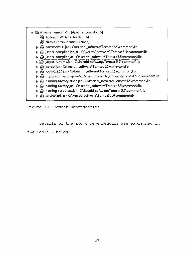
d Apache Tomcat v5.5 [Apache Tomcat v5.5]Us Access rules: No rules defined
Native library location: (None)> fl commons-el jar - C:\keerthi_software\Tomcat 5.5\common\lib0 fl jasper-compiler-jdtJar - C:\keerthhsoftware\Tomcat55\common\lib> fl jasper-compiler.jar - C:\keerthi_software\Tomcat55\common\libf> |fl jasp er- runtimeJar 7 CAkeerthLsoftware\To mcat 5>5\cpm mon\lib j[> fl jsp-api.jar - C:\keerthi_software\Tomcat 5.5\common\lib0 fl Iog4j-1.2.14jar - CAkeerthi_software\Tomcat55\common\lib> fl mysql-connector-java-5.03Jar- CAkeerthi_software\Tomcat5.5\common\libb fl n□ ming-factory-dbcpJar- C:\keerthi_software\Tomcat55\common\lib[> fl namtng-factoryjar- C:\keerthi_software\Tomcat55\common\libt> fl naming-resources Jar- C:\keerthi_software\Tomcat5.5\common\lib0 fl servlet-apijar - C:\keerthr_software\Tomcat55\common\lib
Figure 13. Tomcat Dependencies
Details of the above dependencies are explained in
the Table 2 below:
37

Table 2. List of Tomcat Dependencies
Commons-el.jar Provides an interpreter for expression language
Jasper-compiler-j dt.j ar Support eclipse to compile JSP Java source code
Jasper-compiler.j ar Compiles JSP class
Jasper-runtime.j ar Helps to run the JSP class file
Jsp-api.j ar Classes for JSP API
Log4j-1.2.14.j ar Enable logging at runtime for debugging
Mysql-connector-Java- 5.0.5.j ar
Helps to build database applications
Naming-factory-dbcp.j arNaming-factory.jar Contains factories used by
naming resources
Naming-resources.j ar Manages the naming resources associated with JNDI context
Servlet-api.jar Contracts between servlet class and runtime environment
3.2.3 Create PlaceFinderProject in EclipseThis section details the high level steps followed
for creating the Place Finder application.
• Create a new Java project PlaceFinderProject
under File/New/Other.
• Now a project is created with source and web
Content folders.
38

• Under Open File/New/Other Server, select Tomcat
v5.5 Server and click finish.
• Under Windows/Show View select Servers. A window
is opened with server tomcat configured in it
with start, stop and debugging options.
• Right click on the tomcat server and open Add
and Remove Project. Add the PlaceFinderProject jar file to tomcat. Now the project is configured with the server.
• Select Window/Open Perspective/other and select Java EE Option. The following views are opened with Project Explorer, Server, Console and
Progress options.
• Right Click on the project PlaceFinderProject
and properties. The structure of the PlaceFinderProject will have the following files.
The Java Resources: src folder should have all the Java class files. The Web Content folder will have all the JSP files, HTML files, image files and configuration files
like web.xml. The Server folder will have all the server
configuration files like server.xml where the port address
39

is mapped. The Figure 14 below -show the place finder
project folder.
a PlaceFinderProJect|4 Deployment Descripton PlaceFinderPrqfect
> Filter Mapping t> ^0 Filters> Listener> Referencesl> Securityt> Servlet Mappingst> o Servlets
(> Java Resources: src* £> build
t> & classesl> WebContent
j Servers4 (2> Tomcat v5.5 Server at localhost-config
| “ EzP
Q catalina.policyH’ catalina.properties [x] server.xml[ft tomcat-users.xm I fxj webjcml
Figure 14. Place Finder Project Folder
3.2.4 Configure Apache Axis to ProjectTo configure Apache Axis, added the following Jar
files to the Java build path of the project. Click on Add
External JARs and browse to C:\keerthi software\Downloads\
axis-l_4\lib and select all the jar files.
Also added activation.jar, mail.jar, xerces.jar from
downloading from internet.
40

Added all the jars listed in the Figure 15 below to
the project.
> activation.jar - C:\keerthLsoftware\Downloads\quickstartJarfflds.jar-G\keerthLsoftware\Download5\axis-ljl\lit>
> fYI axis-ant,jar - Q\keerthLsoftware\Downloads\axis-l_4\lib
> jS commons-discovery-0.2jar - C:\keertlij_software\Download5\axi5-l_4\tib
> commons-logging-l.04.jar- C:\keerthi_software\Downloads\axis-l_4\lib
> jaxrpc jar - C:\keerthi_software\Downloads\axis-l_4\Iib
> log4j-1.2.8jar-C:\keerthi_software\Downloads\axis-l_4\lib> mail.jar - G\keerthi_software\Downloads\quickstartlar> saajjar- C:\keerthi_software\Downloads\axis-l_4\lib
> wsdI4j-1.51 jar - G\keerthi_software\Downloads\axis-l_4\lib[> xercesjar-G\keerthi_software\Downloads\quickstartJar
Figure 15. Apache Axis Jars
The basic functionality of these jars is shown inTable 3 below.
41
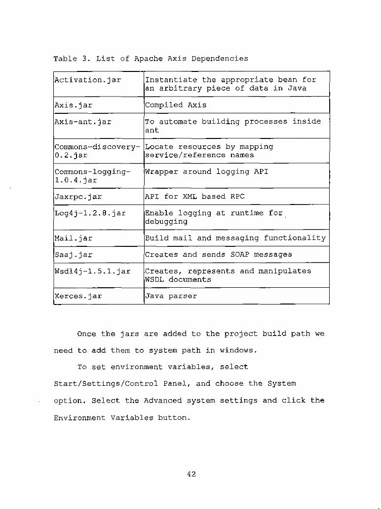
Table 3. List of Apache Axis Dependencies
Activation.jar Instantiate the appropriate bean for an arbitrary piece of data in Java
Axis.j ar Compiled Axis
Axis-ant.jar To automate building processes inside ant
Commons-discovery-0.2.jar
Locate resources by mapping service/reference names
Commons-logging-1.0.4.jar
Wrapper around logging API
Jaxrpc.j ar API for XML based RPCLog4j-1.2.8.jar Enable logging at runtime for
debugging
Mail.jar Build mail and messaging functionality
Saaj.jar Creates and sends SOAP messages
Wsdl4j-1.5.1.jar Creates, represents and manipulates WSDL documents
Xerces.jar Java parser
Once the jars are added to the project build path we need to add them to system path in windows.
To set environment variables, selectStart/Settings/Control Panel, and choose the System
option. Select the Advanced system settings and click the
Environment Variables button.
42

Add %AXIS_HOME% to system variables so that every
user has access to it, click the New button then enter
AXIS_HOME as the variable name, and enter the directory
where Apache Axis was installed as the value.
Figure 16. Setting Environmental Variable for Apache Axis
Also add AXISCLASSPATH as variable and add all the
jar files to the class path.
Variable Name: AXISCLASSPATH
43

Variable Value:
%AXIS_HOME%\axis.jar;%AXIS_HOME%\jaxrpc.jar;
%AXIS_HOME%\saaj.jar;
%AXIS_HOME%\commons-logging-l.0.4.jar; %AXIS_HOME%\commons-discovery-0.2.jar;
%AXIS_HOME%\wsdl4j-1.5.1.j ar;
C:\keerthi_software\Downloads\quickstartJar\activation.jar;
C:\keerthi_software\Downloads\quickstartJar\mail.jar;C:\keerthi_software\Downloads\quickstartJar\xerces.jar;
3.3 Implementation of the ProjectThis section explains the high level steps that were
executed during the implementation of the each individual
component.
3.3.1 Place FinderTo consume the place finder service of ESRI, we need
a WSDL document which describes the web services and the methods to access it. Below is a link to the document
location.http://arcweb.esri.com/services/v2/PlaceFinderSample.WSDL.
To access all the methods of the web service we need to run WSDL2Java tool against the WSDL location in the command prompt. Include AXISCLASSPATH which contains all
the jars to solve all the dependencies.
44

C:> Java -cp %AXISCLASSPATH% org.apache.axis.wsdl.WSDL2Java
http://arcweb.esri.com/services/v2/PlaceFinderSample.WSDL -p
esri.arcwebservices -v
It creates a new package named esri/arcwebservces/v2
which contains all the methods required to access this
service. Copy these files into eclipse project in a new package com.placefinder. Given below in Figure 17 is the list of all the classes generated by WSDL location.
* Java Resources: srcj com.placefinder
|> JjQ CoordinateSystem.javat> Envelopejavat> jl] IPIaceFinderSample_PortTypejava> IPIaceFinderSampIeStub.javat> J7] KeyValuejava> J^) Location.java> Locationinfo java> JJ] PiaceFinderOptions.java> [J) PlaceFinderSample.java> jg] PlaceFinderSampleLocatorjava> Point .java
Figure 17 Place Finder Classes
By understanding the WSDL file the methods and parameters needed to access these classes to get the data
is understood.
45

Below is the Figure 18 showing UML class diagram of
all the classes, methods and relationship between them.
Figure 18. Place Finder Class Diagram
Created an Implementplace.Java class in com.project
package which takes in the place name and return list of
place names and coordinates. The Figure 19 below shows a
code snippet on how to access the methods of the place finder web service and retrieve the list of matching place names and coordinates.
46

public List<String> placeFinder(Srring placeName) throws Remo teException, ServiceException {
List<String> placeOptions = new ArrayLisc<String>(); PlaceFinderSampleLocator locator = new PlaceFinderSampleLocator () ; IPlaceFinderSample_PortType pfs = locator.getlPlaceFinderSample(); PlaceFinderOptions placeFinderOptions = new PlaceFinderOptions(); placeFinderOptions.setDataSource("ESRI.Gazetteer.World"); Locationinfo loclnfo = pfs.findPlace(placeName, placeFinderOptions); if (loclnfo != null) {
Location[] S^ocatxon = loclnfo.getCandidates ();if (location != null) {
for (Location loc : j^aticm) { placeOptions.add(loc.getDescriptionl() + ":"
+ loc.getPoint() .getX() ++ loo.getPoint () . getY()) ;
J}
Jreturn placeoptions;
$r
Figure 19. Code Snippet of the Place Finder
Created a testFinder.jsp in WebContent folder page
added 3 input fields for place name, x-coordinate and
y-coordinate.Created js folder in WebContent of the project and
add scriptaculous library.The Figure 20 below shows the Scriptaculous libraries
are added to the jsp page.
<script src="js/prototype.js” type="text/javascript"X/script><scripc src="js/scriptaGUlous/effects.js" type="text/javascript”x/script>^script src—"js/scx|ipraculous/conrrQls . js" type="text/javascript”x/script>. <sczipt src*="js/scriptaculous/scriptaculous.js" type="text/javascript"X/script>
Figure 20. Scriptaculous Libraries
47

Instead of the user typing in the full place name and
submitting the form for the list I implemented
Ajax.AutoCompleter method for the place name for auto
completing the place name.
The Autocompleter method needs some parameters to be
passed in at the time of request.
• Name of the parameter typed on the
autocompletion field.
• Update element id used to populate the list of the results.
• Url of the page which converts the XML data to HTML tags.
• Value of the parameter to be passed in the jsp
page.
• Minimum number of characters that must be entered in the input field before an AJAX request can be made.
• While the request is processed by the server
this element can be shown.
Figure 21 below shows the implementation of the
Ajax.Autocompleter with all the parameters defined.
48

<inpac type“',texu" id-"placename" name="placename" sizen"55" autocQ^J^te-naff’' value="<%= placet>B /><span id«"indicator!" styie=nd.isplay: nene; color: if A52A2A; "Ximg src“,’ircages/ajax:_proces32.gif" alca"Working............." height=‘’’20pxn />Please Wait..........</span><dlv class=nautocomplete'’ id“"sugge5tionsBoxnx/div><input type=nsubmit’’ value="SubMt" name="accion"X3cript
type="text/j avascript’’>var myAutoCompleter = new Ajax.Autocompleter ('placename', 'suggestiansBox','updatelist.jsp', {parameters: {name : 'placename'}, ninChars : 4, indicator : 'indicator!.1}
' ); \ ' " '
</script X/td>
Figure 21. Asynchronous JavaScript Auto Completer
The results of AJAX are in XML format so in order to display to the user we need to convert it into HTML data. Updatelist.jsp removes the XML tags and displays the results in the form of a list. Below in Figure 22 is the
code snippet of how the results from the web service are
intercepted to a list.
Imp! rmpnterPl ace implementerPlace “ new ImplementerPlace () ; placelist = implementerPlace.placeFinder (name);
%><%@page import=njava.util. Arrayl*istw%> <ul>
<% if(placelist.size() = 0 ]| placelist = null) { %> <li>No Results Found</li><%} else {for (String s : placelist) @ %>■cli<%
_ '} ......... 1 -T...... .. r ,,T.L . "..... :...................... 1 .. ........~ }'™"%>
</ul>
Figure 22. Place Names Interception
49

To add color and display to the results included a
css file to the jsp page.3.3.2 Google Maps
With the place finder web service locating a place
along with coordinates, we need to implement Google maps
which will show the map location of the place in a nice
map.For accessing Google maps API go to
http://code.google.com/apis/maps/. Sign up for Google Maps API by agreeing to terms and conditions to their site and providing the URL of the application.
Login to the website using your Google account login
and password. Once logged in we get access to the key and
the JavaScript methods used to get the map. Add the map to testFinder.jsp with a <script> tag as shown in Figure 23.
<script src="http://maps.google.com/maps?file=api&v=2&
;key=ABQIAAAAUviqLvpFV2xOFpymSvHlBBSEwHm_qL4TlW-2- tntSIcYoqMV7xSJGJihbuIniJnyG_ZTV_Psn7xRBg"
type="text/Javascript"></script>
Figure 23; Adding Google Maps to Page
The parameters passed in to the maps.google are the
version of the API used and the unique key to access the
50

map. The basic function to get the map and manipulating
the coordinates is shown below in Figure 24.
var map;function load() {
if (GBrowserlsCompatible()) {map = new GMap2(document.getElementByld("map")); map.setCenter(new GLatLng(<%= <%— y%>), 13);map■setMapType (G_NORMAL_1-IA.P) ;var marker — setMarker(); map.addOverlay(marker);map.addControl(new GLargeMapControl()) ; map.addControl(new GScaleControl()); map.addControl(new GMapTypeControl()); map.addControl(new GOverviewMapCohtrol());
}}
function setMarkerf) {x = <%= x%>;y = <%= y%>;var mar = new GMarker(new GLatLng(x, y)); return mar;}
Figure 24. Accessing Google Map Functions
The value of x and y in the code are x-coordinate and y-coordinate from the place finder web service which is
mapped as longitude and latitude.
Create a map object in the map. Create an OnLoad()
event on the body of the page to load the map. In
JavaScript define the load function. Initialize the map by creating GMap2 object passing in the div id of the map
51

element. A new instance of the map is created. The map
object can be initialized by invoking setCenter() method.
The method takes in GLatLng object which passes in the longitude, latitudes and zoom level. The mapType() method
takes a map type which are defined below.
• G_NORMAL_MAP- the default view
® G_SATELLITE_MAP - showing Google Earth satellite
images
• G_HYBRID_MAP - showing a mixture of normal and
satellite views
• G_DEFAULT_MAP_TYPES - an array of these three
types, useful for iterative processing
Used NORMAL_MAP parameter in this application as the
default view. A new marker object is created to mark the result on the map based on the longitude and latitude. The marker icon can be customized for each map. Also, used the DEFAULT—ICON to display the marker provided by the Google
API. The marker is added by overlay() method. Now more control is added to the map that helps in user navigation
and changing the map view.
• GLargeMapControl() is added to the map to
facilitate the zoom level to the map.
52

• GScaleControl() is added to the map to show the scale control.
• GMapTypeControl() is added to the map to give an
option to the user to select the map type.
• GOverviewMapControl() is added to the map to
give a small overview of the map.
3.3.3 Accessing Weather XML Data FeedWith the map and place finder implemented, the
weather service is accessed using Weather XML Data Feed by
clicking http://www.weather.com/services/xmloap.html.
Registering up for the service can be done by
creating a user profile with providing name, password and email address. XML partner ID and License key are sent in
email on registration access the data from weather.com we need sent in the email.
PartnerlD = "1072042464"
LicenceKey = "ea6c74f0fa4072bf"Also included in the email is a zip file which
consists of terms and conditions surrounding the use of the Service, graphical icons that are necessary to
represent the sky conditions associated with our current
conditions and forecast data, and weather logo.
In the XML data feed following data in Table 4 can be
intercepted for Current Conditions.
53

Table 4. Current Condition Data from Weather Extensible
Markup Language Data Feed
Location Id Wind Gust
City name (mixed case) to be displayed
Direction Wind is blowing
Time and date of observation Wind Direction Phrase
Observation Station Name Relative humidity
Temperature Visibility
"Feels Like" Temperature UV Index
Weather Description Phrase UV Index Description
Weather Icon Code Dew point
Barometric Pressure Sunrise
Wind Speed Sunset
Moon Phase Description Moon Icon Code
The following data in Table 5 is included for
Five-Day Forecast.
54

Table 5. Forecast Data from Weather Extensible Markup
Language Data Feed
Location Id Daypart Day Code (day or night)
City name (mixed case) to be displayed
Weather Icon Code
Time and date of last update Weather Description Phrase
Day Number of forecast Weather Description Short
Day of Week Phrase
Date Wind Speed
Forecast High Temperature Wind Gust
Forecast Low Temperature Wind Direction
Sunrise Wind Direction Phrase
Sunset Chance of Precipitation
Humidity
The entire request can be made to access the XML feed
over the internet through invoking this hostname
xoap.weather.com.With the place finder web service we get the name of
the place we are looking for. But Weather data must be requested for a specific location by a valid locID. The
XML Feed works with two types of LocIDs, Type 1 locations
are city identifiers and Type 4 locations are 5-digit U.S.
postal codes. Since my application looks for places all
55

over the world the Type 4 locations with postal codes does
not work. So used the Type 1 locations which get the
location ID based on the city name. The location Id can be
looked up using this search function at this URL
-http://xoap.weather.com/search/search.
After the location ID is retrieved, this ID is sent to weather.com with partner ID and license key to access the current weather conditions and a five-day forecast.
The XML Feed will appear as follows:
http://xoap.weather.com/weather/local/[locID]?cc
=*&dayf=5&link=xoap&prod=xoap&par=[PartnerlD]&key
=[LicenseKey] where dayf is 5-day forecast, [PartnerlD] is the unique Partner ID and [LicenseKey]
is the unique License Key.The weather data gives us back a XML document which we
need' to parse to get the data. It is tedious to parse the response for every request so used Java classes which were provided by www.DeveloperLife.com. Add these classes to PlaceFinderProject in com.weather.convert,
com.weather.convert.locationdatamodel and
com.weather.convert.weatherdatamodel packages
respectively. All the classes used for the weather data
conversion is shown in Figure 25 below.
56

a com.weather.convertb [7| DefaultWeatherConfigurationBeanjava& [7] Utilsjavab JJ] Weather_20_XMLParserjavab [7) WeatherConfigurationIFjavab [7] WeatherErrorjavab J~7] WeatherGatewayjava
j com.weathenconvert.locationdatamode!b (T) Search Location.javat> [7| SearchLocationsjava
jl jj] c o m.weath er, con vert.weatherd ata modell> [j) BarometricPressurejavab [7] CurrentConditions.java> 0 Day.javab [J| DayPartjavaj> [jh Error javab [7] Forecastjava0 |T| Headerjavab [7| Locationjavab [7| UltraVioletjavab IT] WeatherReport.javab 171 Windjava
Figure 25. Classes for Parsing Weather
So now the data is transformed into a set of Java beans which can be easily integrated with my application.
Since I am parsing the XML data into methods there are few dependencies that the code will require to work. Along
with the zip file are the jar files which need to be added
to the project for compiling the project. Below is the Figure 26 showing UML class diagram of all the classes,
methods and relationship between them.
57

Figure 26. Class Diagram for Parsing Weather Data
Below in Table 6 is a list of Jar files added to the
project to resolve errors.
58

Table 6. Weather Data Parsing Dependencies
jdom.jar Used as a XML parser to parse the XML document
commons-codec-1.3.jar Used to encode the request parameters
commons-httpclient-3.0.1.j ar Used to perform the HTTP communications
commons-io-1.2.jar Used to provide collection of I/O utilities
commons-lang-2.2.jar Used to provide extra functionality for Java classes
j axen-core.j ar Used to treat JDOM trees as compiled Java byte code
jaxen-jdom.jar Used to provide navigation for JDOM trees
saxpath.j ar Used as a event based parser and handle XPath expressions
taskapi.jar Used to manage multiple tasks
Create a method getWeather() in implementerPlace.Java class. Below in Figure 27 is the code used to access the weather data based on the place name.
59

WeatherReport weather = new WeatherReport();WeatherGateway gateway = WeatherGateway.getDefanltlnstahce() ; SearchLocations ^Lq^'tidns’ = gateway.searchForLocations(where); if (Sochti^is.getSearchLocations().size() = 0) {
if (! stateNarae. equals ("")) {locations! = gateway, searchForLocations (stateName +
+ CountryName);}
>if (iLocatidns.getSearchLocations () .size () = 0) <
~ gateway. searchForLocations (Count ryName) ;}
if (iocatlons. getSearchLocations () . size () 1= 0) {String locationlD = Ippatlot^-get SearchLocations () .get(Q) .getldQ;WeatherConfigurationIF config = new DefaultWeatherConfigurationBean(
DefaultWeatherConfigurationBean.defaultFeatherServer, partnerlD, licenseKey) ;
WeatherGateway gaWeatherGateway = new WeatherGateway(config);if (gaWeatherGateway 1= null) {
weather = gaWeatherGateway.getFullForecast(locationlD, 5);}
}return weather;
Figure 27. Accessing Weather Data
3.3.4 Directions and TrafficCreate a new directions.jsp page for adding
directions and traffic conditions. Follow the steps in section 3.3.2 to add a map on the page using the same map
key. For the directions add new GDirections() object which
takes in the map and id of the div element that has to be
populated with the directions.
gdir = new GDirections (map, document.getElementByld("directions"));
Load the GDirections method with from and to - addresses.gdir.load("from: " + fromAddress + " to: " + toAddress);
60

Create a form with two input fields fromAddress and
toAddress which on submit load the GDirectiohs() method
passing these values.<form action^"#" onsubmit="setDirections(this.from.value,
this.to.value); return false"><table align="center" border="2" bordercolor="#A52A2A"
width="75%" height="70">
<tr><td colspan="2" align=" center "Xlabel style="font-size: 18px"xb>Enter Directions</bx/label><trXtdXspan>From: </span><input type="text" size="45" id="fromAddress" name="from" value="<%= placename%>"/x/td>
<tdXspan>To: </span>
<input type="text" size="45" id="toAddress" name="to" value="<%= placename%>"/>
</tdx/tr><trXtd align=" right">Cinput name="submit" type="submit" value="Get Directions"
/X/tdXtd>
To add traffic to the map create a GTrafficOverlay()
object and pass in the traffic options with incidents.
addOverlay() method add a new layer to map with the traffic updates.
var trafficoptions = {incidents:true};
61
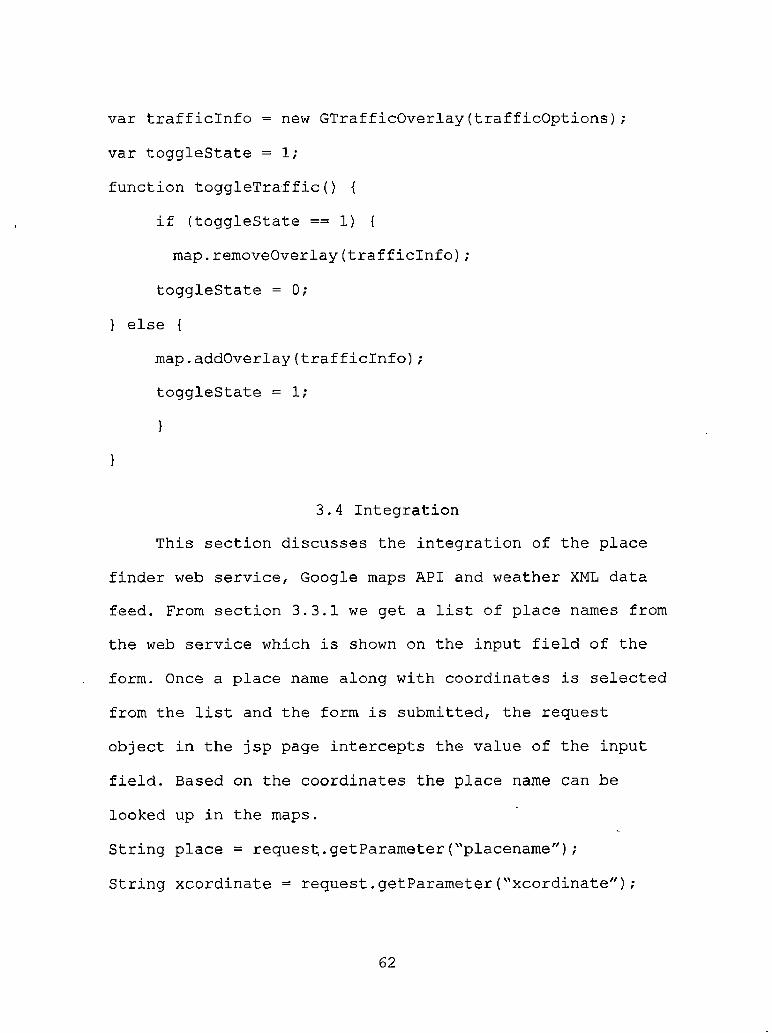
var trafficinfo = new GTrafficOverlay(trafficoptions);
var togglestate = 1;
function toggleTraffic() {
if (togglestate == 1) {
map.removeOverlay(trafficinfo) ;
togglestate = 0;
} else {
map.addOverlay(trafficinfo);togglestate = 1;
}
}
3.4 IntegrationThis section discusses the integration of the place
finder web service, Google maps API and weather XML data feed. From section 3.3.1 we get a list of place names from the web service which is shown on the input field of the
form. Once a place name along with coordinates is selected
from the list and the form is submitted, the request object in the jsp page intercepts the value of the input
field. Based on the coordinates the place name can be
looked up in the maps.
String place = request.getParameter("placename");
String xcordinate = request.getParameter("xcordinate");
62
String ycordinate = request.getParameter("ycordinate");
String action = request.getParameter("action");
Based on the request the place name is formatted to
three substrings place name, x-coordinate, y-coordinate.
placename = place.substring(0, place.indexOf(':'));
y = place.substring(place.indexOf) + 1, place.lastlndexOf(':'));x = place.substring(place.lastlndexOf(':') +
1,place.length());
Once the place name is found out the value is passed
into the weather report to get the report.weatherReport = implementerPlace.getWeather(placename) ;
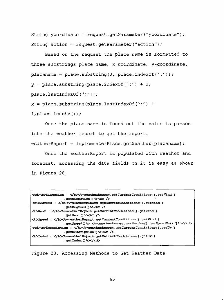
Once the weatherReport is populated with weather and forecast, accessing the data fields on it is easy as shown in Figure 28.
<tdXb>Direction : </bX%=weatherReport. getCur rent Conditions () . getWind (). getDirection()%xbr />
<b>Degrees : </bX%=weatherReport. getCurrentConditions (} . getWind (). getDegrees () %xbr />
•CbXSust : </bx%=weatiierReport. get Cur rent Conditions () . getWind (). getGust () %Xbr />
<b>Speed : </bx%=weatherReport. getCur rent Conditions J) . getWind (). getSpeed () %> <%=weatherReport. getHeader () . getSpeedUnit () %x/td>
<tdXb>De script ion : </bX%=-weatherReport.getCurrentCanditions () . getDvQ. getDescription()%Xbr />
<b>Index : </bx%=weatherReport. getCurrentConditions () . getUv (). getlndexQ %x/td>
Figure 28. Accessing Methods to Get Weather Data
63

For mapping on the map the latitude and longitude are
populated with x coordinate and y coordinate.
function setMarkerQ {
x = <%= x%>;y = <%= y%>;
var mar = new GMarker(new GLatLng(x, y));
return mar;
}The flow diagram below in Figure 29 shows how
information is passed from one service to the other.
testHnder.isp ; imptementer Ptacejava < ■Weather^rver
S-
Ajax request sending place^L, I
fuidPlace^hcename, placcFindcrOptions)
ht tpr//arcwcb.csri.com/v2
List of places and coordinates
9
e-
ii
i i
Passing in tl>c map methods with the x-coordinate and y-coordinate■ - ~~ " "/
ht tp: //maps .google.com? file=ap i&a mp; kcy=
Google map with marked place nameMap)
Passing in the place iiainc-http://xoapIwcathcrcom/Rcarch?wlicre=
LocatiooID of the place name
http://xoap.weather.cam/weathcr/local /
(rCurrentconditions and Forecast
er'
Figure 29. Flow Diagram of Application
64
To integrate the directions traffic page to the place
finder page, place name is passed in the url to the
directions and traffic page which is intercepted with the
request object on the page.
3.5 Demonstration and EnhancementsIn the first demonstration to my advisor Dr. Gomez,
suggested some minor enhancements listed below that were implemented in the final application.
1. Add a help page to the application to guide the
users on how to use the application.
2. Allow users to input Latitude (X), Longitude (Y)
co-ordinates and find the location on the map.
3. Default the place name that has been looked up in the map by the user to find directions and traffic page so as to provide continuity to the
application.Dr. Yu also suggested the following enhancements that have been implemented in the final application.
1. When a user types in the place name and as the matching place names are being fetched by AJAX
request, display a message that the request is
being processed by the application to convey the
65

user to wait until the candidate place names are retrieved and displayed for selection.
66

CHAPTER FOUR
MAINTENANCE
4.0 Application ResultsThere are three web pages in this application.1.2.
Introduction to the application pagePlace finder, weather conditions and forecast
page
3. Directions and traffic conditions page
The first web page briefly explains the purpose,
features and technologies used in the project. It consists of links to the project proposal and application. Figure 30 below is a screenshot of the introduction page.
Place Finder & Weather Using Web SendeesBt Kerrthi Nuuupraeni
ABSTRACT:
The sccjre of the Place Finder and Weather Using Web Services project is to assist people to search for a place name anywhere in the wmM and to show the’
weather of the selected place. This project will integrate both the place finder and weather web services into a single cBeat and build on to a single webpage, t tins application risers will ako have the ability to get driving directions and current traffic sitaatioa in the current map extent. The following technologies were use
■ to buildthis application- Webservices, AJAX, JavaScript, Java, Java Server Pages, HTML, and CSS. Existing data content from the following sources were.u in this application-Google API, ArcWebServices, Weather XML feed. " 1 :
■For Application Click Here....Project Proposal ” ■’
Proposed Ccmmitee
ADVISOR: Dr.Ernesto Gomez
MEMBERS: Dr. Tong Lai Yu
t . t. Dr. Kerstin Voigt -
Figure 30. Introduction Page
67

To go to the application, please click on the For
Application link, this takes the user to the place finder
and weather'conditions page as shown in Figure 31 below.
The default location selected is San Bernardino,
California, United States. On the right hand side are the
coordinates (latitude, longitude) populated for this
place. The current weather conditions, forecast and the
map location are shown bottom of the-page. By clicking on the 'Get Directions and Traffic' link user will go to Directions and traffic conditions page.
Place Finder & Weather Conditions Application
'Enter a Place Name:I jSan Bernardino. California. United Statesr........ ■' '[■■■i-" ■ T" <
it Directions ^. Traffic | Home
jCoScflilohj?1 f<>r, SariTfierriardlnoJ'CAIM^B
j Fairunrise Time: 6:56 AM UnsetTime : 6:13 PM:
Temperature: 66 F FeelsLIke : 66 F DcwPoiut: 29 F Visibility: 10.0 mi Humidity : 25 %
Ireclion: CALM egrees:0 ust: N/A peed: calm mph -
Description : Low Index: 0
rend : rising " {Pressure: 30.02 in
| [_Submrt |
t •• _______ iY- Co o rdlnatezM 1 7.2E55^
1I
X-Coordlnate: .34.141149 ;
I'i) K&U uEsan^d ill .
Hybrid
Figure 31. Place Finder and Weather Conditions
A help icon is located near the search text. When a
user clicks on it a window pops up with instructions on
how to use the application.
68

Enter the first 4 characters of a place name box as
shown in Figure 32 below and wait for AJAX to show a list
of place name that match the first 4 characters.
Figure 32. Place Name
The user can scroll through the list by pressing down
arrow or scroll down as shown in Figure 33 below. Once a
place name is selected hit submit and the weather and map location will change to the place entered in the place
name box.
69

Enter a Place Name:X-Coordinate: ‘34.141149 : Y-Coordlnate: M17.2855redial [(Submit)
>i
Red Lane, Virginia, United States:-77.84972:37,54667
Red Lane, Wyoming, United States:- 108.20528:43.67861
Redland, Arkansas, United States:-93.2775:33.80667
Redland, Florida, United States: -80.49056:25.52806
Redland, Georgia, United 5tates;-81.95444:31.63972
n
Map ] Satellite | Hybrid |
4 4
j ’.;! ;
■Ut* L
i'lBemardino’pscras czmS
Redland (Evangeline Parish), Louisiana, United States:- 92.39806:30.56778
Redland (Bossier Parish), Louisiana, United States;- 93.615:32.95611
Redland, Maryland, United States:- 77.148726:39.132905
Redland, North Carolina, United States:- 80.47278:35.98778
Redland (Sequoyah County), Oklahoma, United States:- n 94.62417:35.30472 “
■it ‘
■llylR 11 "I fl-E Inwood Def ^-DeLRosa’S
Figure 33. List of Place Names
For the place name selected, current and forecast
weather conditions will be displayed as shown in Figure 34 below.
70

. Weather Condtiians for San Bernardirio, CA
CloudySunrise Time : 6:46 AM Sunset Time: 6:28 PM
Temperature : 68 F l , FeelsLike : 68 FDewPoint: 58 FVisibility: 6.0.miHumidity: 70 %
(jSJHraDirection : W . :Degrees : 28D %.Gust: 18Speed: 11 mph
Description : Low Index: 2
Trend : steady ||Pressure : 29.85 in
Figure 34. Weather Conditions
To get driving directions, click on get Directions
and traffic link. Change the destination or origination accordingly and click on the Directions button. A detailed textual direction along with a highlighted route is shown on the map space on the page. To get traffic update click
on Check Traffic button and the current traffic conditions
are shown on the current map extent as shown in Figure 35 below.
71

Directions & TrafficFrom: ’{Mne.CA..... ......... : To:. I San Bernardino, CA ...... 1
I Directions L Check Traffic j--------- 1 ........ ;i
Place Finder & Weather I Home
X. Head northwest on Alton Pkwy toward comsilk
2. Turn right at Jamboree Rd 2.4 mi I’Puer
3. Continue on CA-261N (signs for State Hwy 6.8 mi 261N/Riverside)
■’ Ton road: ■■
[7] Glendora "S'C iSSi
53.8 mi (about.56 mins)
2.7 mi
/a&wJ, rn 1SKAv^C-'ij-j- ■‘da*
BoxSprrgs ’ iSttoirish
ShSt.Rirwwvs: >
* —Ectyonont^
JjUr«. Vt3
Figure 35. Directions and Traffic
To go back to introduction page or place finder page
click on Home or place finder and weather respectively.
72

CHAPTER FIVE
CONCLUSIONS AND RECOMMENDATIONS
This section describes various conclusions as a
result of completing the project and also provides some
recommendations.
5.1 ConclusionsThrough this project I tried to demonstrate how to
research and find appropriate web service and easily make use of them. With the availability of Internet and rich
data content that is served through Web services, users
can leverage these existing services and tailor them to
meet the needs of any particular user segment.
Through my application I tried to validate the following main advantages of using web services to provide valuable information to users by investing minimal resources.
• Outsourced - There is no need to store and maintain data, software and hardware infrastructure. The data used in the project is
hosted by various companies and the software used to develop this application was minimal and
free of cost.
73

• Built on Industry Standards - Web services are
built using industry standards which makes it
easy to build and create other dependent
applications and find any help to support
development efforts.
• Platform and Language Independent -Can be hosted
or used by users from any OS platform or programming language making it transparent to
the end user.
• Works of an Internet Connection - With internet penetration more than 70% in US and fast increasing around the world, Web services with
rich content are accessible to users around the
world.With the above mentioned benefits come some risks as
well. Since web services involve entities out of our control there is a risk of unavailability of service because of a network outage, server problems or even when
there are minor changes in specifications of the web
service components.
There has to be sufficient notification and communication mechanism between the service providers and consumers to quickly react to the changes made to the components so that the service is not interrupted.
74

Fortunately we have really reliable services that are available 24/7 and with good help resources to take
advantage of the rich content and functionality. There is
also a need to easily respond to the ever changing needs
by making the Web services easy to configure and use.
5.2 RecommendationsThis project is a good start for a novice programmer
interested in Web services on how to start the research and implement web services. The documentation in this project can also help developers to choose the right tools
and data resources. This project has been only limited to
demonstrate a few important common tasks (Place Name, Weather, Driving Directions, etc). This application can be
extended further very easily by adding features that complement the existing application. For example, the project can be extended to include fire alerts, flash
flooding, air quality, road closures, etc. The code is
provided with good documentation and is intended to be understood easily by a programmer with basic understanding
of programming principles.Based on the experience of implementing this project,
I would like to recommend that the University create a
list of topics or tools that they would like to be
75

supported from the student community. This will allow
students to match their interests and strengths with this
list and to choose a topic of his or her interest. It is
always very motivating to tackle an existing real
requirement than a hypothetical situation.
By building this mechanism it is going to mutually
benefit both the students and the university.
76

APPENDIX A
JAVA ARCHIVE FILES
77

Below is the screen shot of all the Jar Files that were used for setting up of this application.
jS Properties forPiaceF inderProject
Java Build Path
Source J J riects
type filter text
ResourceBeaninfo PathBuildersJ2EE Module Dependencies
pava Build Path j
Java Code Style Java Compiler Java EditorJavadoc LocationJSP FragmentMavenProfile Compliance and Valtr Project FacetsProject References Refactoring History Run/Debug Settings ServerTargeted RuntimesTask RepositoryTask TagsValidationWeb Content Settings Web Project Settings XDoclet
Libraries ] Order and Export!
JARs and class folders on the build path;
& [53 artrvab'onjar - G\keerthi_software\Dawn!oads\r}uickstartJaraxis.Jar - C:\keerthi_software\Downfoads\axis-i_4Vib
t> gj mds-antjar - G\keerthi_software\DownJoads\axrs-l_4\tibp £J commons-codec-1.3jar- C:\keerthi_softwate\DawiloadAquiekstartJar\weather_service\sourceMib
commons-discovery-0.2,jar - C:\keerthi_sofhvare\Downloads\axis-l_4\lih5. S commons-httpdient-3J}J.jar - G\keerthi_software\Downtoads\quickstartJar\weather_service\source\lib !> aj comm o ns - io-12.jss - G\keerthi_software\D cwntoa ds\qulckst a rtl a Aweath er_servfce\source\1 ib> com mo ns- lang -22Jar * G\keerthLsoftware\Downloads\qulckstartJaAweathet_service\source\libt> commons-togging-ljOA.Jar - G\keerthi_software\Dcwnloads\axis-l_4\libt> gj jaxen-core.jar- G\keerthi_software\DcwnfoadAquickstartJaAweather_serviceXsource\L'bp jaxen-jdom.jar - G\keerthi_software\Dovmloads\quickstartJaAwe3ther_service\source\tibp £3 jaxrpcjar - G\keerthi_software\Downloads\a»s-l_4MibP iSJ jdomjar - G\keerthi_software\Dcwntoads\quickstartJaAweatherjervice\source\libj> j^i Iog4j-12B Jar - G\keerthr_software\Down!oads\axjs-l_4\libp Jai maiLjar-C:\keerlhtjsoftware\DownloadAquickstartJarp saajjar - C:\keerthi_software\Dovrnioads\axIs-l_4\libt> saxpathjar - GXkeerthi_software\Downtoads\qulckstartJaAweBther_service\source\(ib> taskapljar - G\keerthi_software\Down!oads\qukkstartJar\weather_service\source\llb> wsd!4j-15.1jar-C:\keerthi_softwa re\0owntoads\axis-l_4\libp xercesjar - G\keerthi_software\Dcwnloads\quickstart)arP Hit Apache Tomcat v55 [Apache Tomcat v55]!> EAR Libraries> EJi JRE System Library [jrel.6D_03]> Web App Libraries
78

APPENDIX BJ2EE MODULE DEPENDENCIES
79
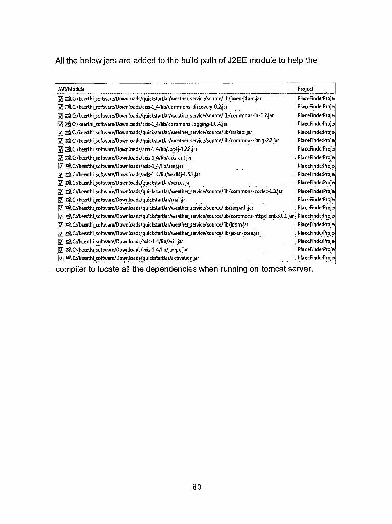
All the below jars are added to the build path of J2EE module to help the
JAR/Module[7] ^C:/keerthi_software/Downloads/quickstart)ar/weather_service/soiirce/lib/jaxen-jdomJar[7] E& C:/keerthi_5oftware/0ownloa ds/axis-l_4/lib/commons-discovery-02Ja r[7j EA G/keerthi_software/Downloads/quickstartlar/weather_service/source/lib/common5-io-12.jarj7| S”iC:/keerthi_software/Downloads/axis-l_4/lib/common5-logging-1.0.4,jar
^G/keerthi_software/Download5/quickstartJar/weather_service/source/lib/taskapijar 0 g^C:/keerthL50ftware/Downloads/quick5tart]ar/weather_service/source/lib/comrnons-lang-22.jar[7] E&G/keerthi_software/Downloads/axis-l_4/lib/log4j-12.8.jar[71 eA G/keerthi_5cftware/Downloads/axi5-l_4/lib/axi5-ant.jar[7] EAQ/keerthi_sQftware/Downloads/axis-l_4/Iib/saajjar[7] E& G/keerthi_software/Downloads/axis-l_4/libAvsd!4j-1.51 .jar® G/keerthi_software/Downloads/quickstartlar/'xerce5.jar|7j E&C:/keerthi_5oftware/Downloads/quickstartJar/weather_servicefsource/lib/common5-codec-1.3.jar
ProjectPlaceFinderProjei PlaceFinderProjei PlaceFinderProjei PlaceFinderProjei PlaceFinderProjei
i PlaceFinderProjei PlaceFinderProjei
| PlaceFinderProjeiPlaceFinderProjei
‘ PlaceFinderProjei ■ PlaceFinderProjei ! PlaceFinderProjei
PlaceFinderProjei i PlaceFinderProjei
[7] EjA G/keerthi_software/Downloads/quiclc5tartJar/mail.jar|§] I^G/keerthi-Software/Downloads/quickstartJar/weatherjervice/source/lib/saxpath.jar[7] G/keerthi_software/DownIoads/quickstartJar/weatheLservice/source/lib/commons-httpclient-3.0J,jar; PlaceFinderProjei[7] ^G/keerthi_5oftware/Downloads/quickstartlar/weather_service/5OUrce/fib/jdom.jar
M G/keerthLsoftware/Downloads/quicksta rtJar/weather_service/so Lirce/lib/jaxen-core.ja r[7] EA Q/keerthi_software/Downloads/axis-l_4/lib/aM5.jarj7| g-A C'/keerthLsoftware/Downloads/axis-ljt/lib/jaxrpc.jar[7] EA C:/keerthi_software/Downloads/quickstartJar/activation.jar
; PlaceFinderProjei ' PlaceFinderProjei
PlaceFinderProjei’ PlaceFinderProjei ' PlaceFinderProjei
compiler to locate all the dependencies when running on tomcat server.
80

REFERENCES
[1] Apache Web services (2008, Oct). About Web services - Axis. Apache, USA. [Online]. Available:http://ws.apache.org/axis/Java/user-guide.html
[2] Barry Burd, John (2005). Eclipse For Dummies, Wiley & Sons.
[3] Chris Ullman and Lucinda Dykes (2007). Ajax Resources—Frameworks and Libraries- Appendix B, Beginning Ajax, Wrox Press.
[4] CodeHaus (2008, Oct) . Jaxex: Universal Java XPath Engine. CodeHaus, USA. [Online]. Available:http://jaxen.codehaus.org/
[5] Eclipse. (2008, Oct). Eclipse Home. Eclipse, USA. [Online]. Available: http://www.eclipse.org/
[6] ESRI. (2008, Oct). About ESRI- The GIS Software Leader, USA. [Online]. Available:http://www.esri.com/
[7] Google Maps. (2008, Oct). About Google Maps API. Google, USA. [Online]. Available:http://code.google.com/apis/maps/
[8] Interaktonline (2005, Nov). AJAX: Asynchronously Moving Forward. Interaktonline, Romania. [Online]. Available:http://www.interaktonline.com/Support/Artic les/
[9] Java Home (2008, Oct). Glossary of Java Sun home, USA. [Online]. Available: http://Java.sun.com/ products/jIf/ed2/book/HIG.Glossary.html
[10] Java Home. (2008, Oct). About the Java Technology. Sun Java Home, USA. [Online]. Available:https://Java.sun.com/docs/books/tutorial/getStarted/i ntro/definition.html
[11] Java-Tips (2008, Oct). What is the difference between JDK and JRE, USA. [Online]. Available:http://www.Java-tips.org/Java-se-tips/Java.lang/what- is-the-difference-between-j dk-and-j re.html
81
[12] Kevin Mukhar, Chris Zelenak, James L. Weaver and Jim Crume. (2005, Oct). Beginning Java EE 5: From Novice to Professional
[13] Matthew Moodie (2005). Pro Jakarta Tomcat 5, Appress.[14] Raghavan. ('2008, Sep) . What is Service-Oriented
Architecture?. Roselndia, India. [Online]. Available: http://www.roseIndia.net/webservices/ what_is_service_oriented_architecture.shtml
[15] Rose India (2008, Jun). Tutorials on Java Server Pages Tutorial. Roseindia, India. [Online]. Available: http://www.roseindia.net/jsp/ Javaserverpagestutorial.shtml
[16] RSS Feed. (2007, Jul). What is RSS? RSS Explained, USA. [Online]. Available: http://www.whatisrss.com/
[17] SoapUser. (2001, Mar). SOAP Basics. SoapUser, USA. [Online]. Available:http://www.soapuser.com/basicsl.html
[18] Software AG. (2000, Jun). XML Basics. SoftwareAG, USA. [Online]. Available:http://www.softwareag.com/xml/about/starters.htm
[19] Tomcat. (2008, Oct). Apache Tomcat Home. Apache, USA. [Online]. Available: http://tomcat.apache.org/
[20] Ueli Wahli. (2006, Sep). Web Services Handbook For WebSphere Application Server 6.1, IBM Redbooks.
[21] W3Schools (2008, Oct). CSS Tutorial. W3schools, USA. [Online]. Available: http://www.w3schools.com/css/
[22] W3Schools (2008, Oct). HTML Tutorial. W3schools, USA. [Online]. Available:http://www.w3schools.com/html/default.asp
[23] Weather (2008, Oct). About Weather XML Data Feed. Weather.com, USA. [Online]. Available:http://www.weather.com/services/xmloap.html
82

[24] Wikipedia. (2008, Oct). About Ajax Programming. Wikipedia, USA. [Online]. Available:http://en.wikipedia.org/wiki/AJAX
[25] Wikipedia. (2008, Oct). About Apache Tomcat. Wikipedia, USA. [Online]. Available:http://en.wikipedia.org/wiki/Apache_Tomcat
[26] Wikipedia. (2008, Oct). About Cascading Style Sheets. Wikipedia, USA. [Online]. Available:http://en.wikipedia.org/wiki/Cascading_Style_Sheets
[27] Wikipedia. (2008, Oct). About HTML. Wikipedia, USA. [Online]. Available:http://en.wikipedia.org/wiki/HTML
[28] Wikipedia. (2008, Oct). World Wide Web Consortium. Wikipedia, USA. [Online]. Available:http://en.wikipedia.org/wiki/World_Wide_Web_Consortiu m
[29] Wikipedia. (2008, Oct). About Application Programming Interface. Wikipedia, USA. [Online]. Available: http://en.wikipedia.org/wiki/API
[30] Wikipedia. (2008, Oct). About Object-oriented programming. Wikipedia, USA. [Online]. Available: . http://en.wikipedia.org/wiki/Obj ect_oriented
[31] Wikipedia. (2008, Oct). About HTTP. Wikipedia, USA. [Online]. Available:http://en.wikipedia.org/wiki/HTTP
[32] Wikipedia. (2008, Oct). About Script.aculo.us. Wikipedia, USA. [Online]. Available:http://en.wikipedia.org/wiki/Script.aculo.us
[33] Windows Live Developer Center (2008, Oct). What is WSDL?. MSDN, USA. [Online]. Available:http://msdn.microsoft.com/en-us/library/bbl26207.aspx
83